winter shorebird survey - flshorebirdalliance.org coordinating surveys with people surveying...
TRANSCRIPT
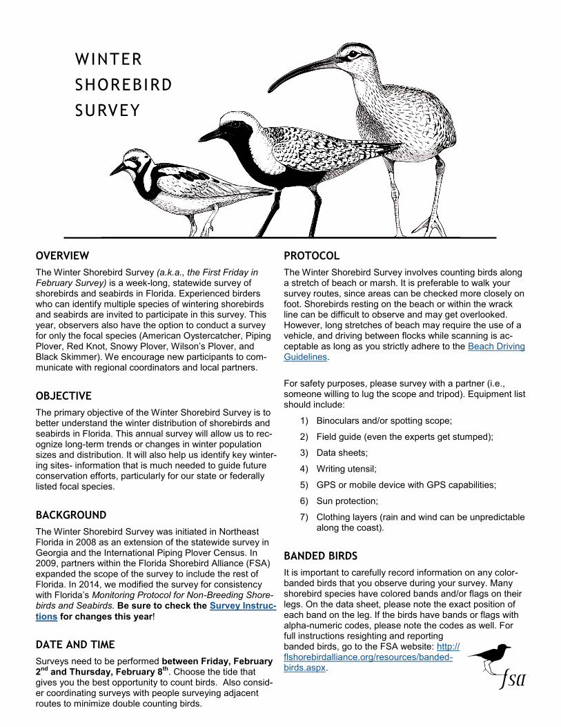
WINTER
SHOREBIRD
SURVEY
OVERVIEW
The Winter Shorebird Survey (a.k.a., the First Friday in February Survey) is a week-long, statewide survey of shorebirds and seabirds in Florida. Experienced birders who can identify multiple species of wintering shorebirds and seabirds are invited to participate in this survey. This year, observers also have the option to conduct a survey for only the focal species (American Oystercatcher, Piping Plover, Red Knot, Snowy Plover, Wilson’s Plover, and Black Skimmer). We encourage new participants to com-municate with regional coordinators and local partners.
OBJECTIVE
The primary objective of the Winter Shorebird Survey is to better understand the winter distribution of shorebirds and seabirds in Florida. This annual survey will allow us to rec-ognize long-term trends or changes in winter population sizes and distribution. It will also help us identify key winter-ing sites- information that is much needed to guide future conservation efforts, particularly for our state or federally listed focal species.
BACKGROUND
The Winter Shorebird Survey was initiated in Northeast Florida in 2008 as an extension of the statewide survey in Georgia and the International Piping Plover Census. In 2009, partners within the Florida Shorebird Alliance (FSA) expanded the scope of the survey to include the rest of Florida. In 2014, we modified the survey for consistency with Florida’s Monitoring Protocol for Non-Breeding Shore-birds and Seabirds. Be sure to check the Survey Instruc-
tions for changes this year!
DATE AND TIME
Surveys need to be performed between Friday, February 2
nd and Thursday, February 8
th. Choose the tide that
gives you the best opportunity to count birds. Also consid-er coordinating surveys with people surveying adjacent routes to minimize double counting birds.
PROTOCOL
The Winter Shorebird Survey involves counting birds along a stretch of beach or marsh. It is preferable to walk your survey routes, since areas can be checked more closely on foot. Shorebirds resting on the beach or within the wrack line can be difficult to observe and may get overlooked. However, long stretches of beach may require the use of a vehicle, and driving between flocks while scanning is ac-ceptable as long as you strictly adhere to the Beach Driving Guidelines.
For safety purposes, please survey with a partner (i.e., someone willing to lug the scope and tripod). Equipment list should include:
1) Binoculars and/or spotting scope;
2) Field guide (even the experts get stumped);
3) Data sheets;
4) Writing utensil;
5) GPS or mobile device with GPS capabilities;
6) Sun protection;
7) Clothing layers (rain and wind can be unpredictable along the coast).
BANDED BIRDS
It is important to carefully record information on any color-banded birds that you observe during your survey. Many shorebird species have colored bands and/or flags on their legs. On the data sheet, please note the exact position of each band on the leg. If the birds have bands or flags with alpha-numeric codes, please note the codes as well. For full instructions resighting and reporting banded birds, go to the FSA website: http://flshorebirdalliance.org/resources/banded-birds.aspx.
NEW THIS YEAR
We have made some changes to the Instructions for the Winter Shorebird Survey. Please read through each step to fa-miliarize yourself with the new survey instructions.
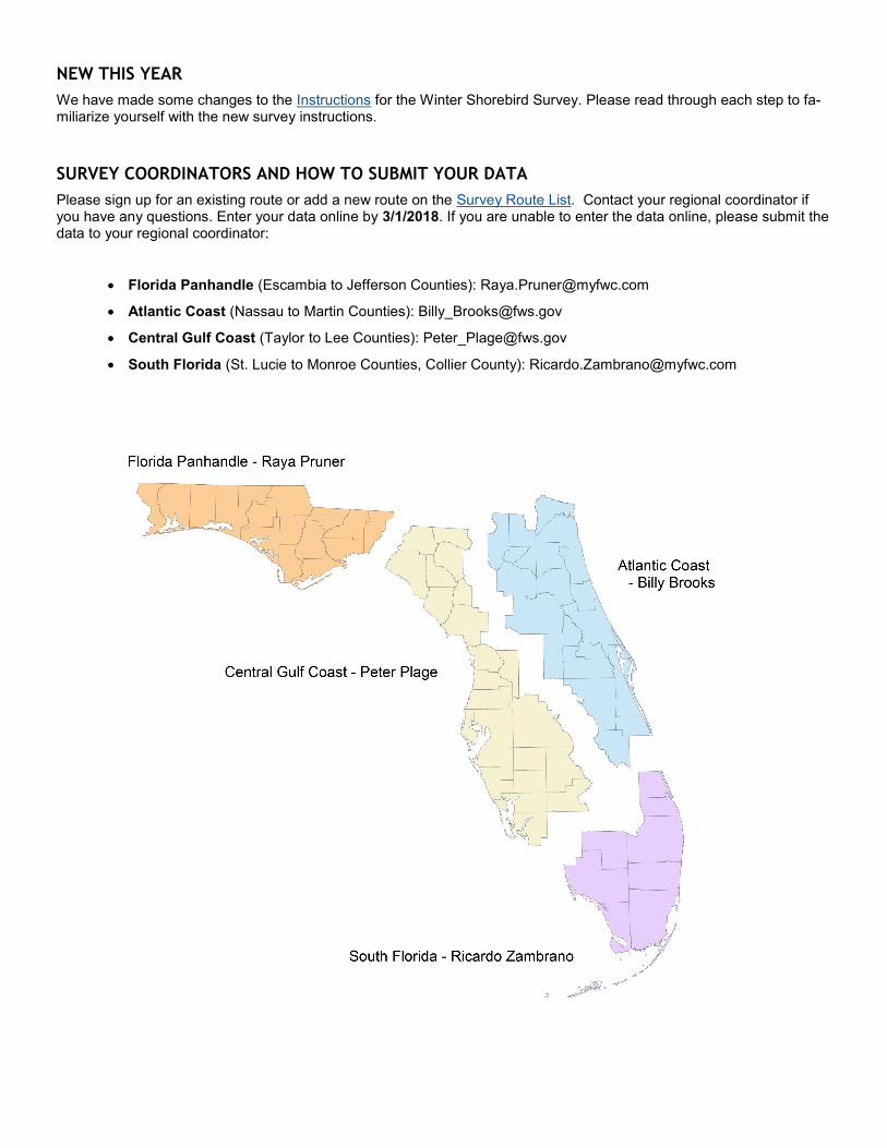
SURVEY COORDINATORS AND HOW TO SUBMIT YOUR DATA
Please sign up for an existing route or add a new route on the Survey Route List. Contact your regional coordinator if you have any questions. Enter your data online by 3/1/2018. If you are unable to enter the data online, please submit the data to your regional coordinator:
• Florida Panhandle (Escambia to Jefferson Counties): [email protected]
• Atlantic Coast (Nassau to Martin Counties): [email protected]
• Central Gulf Coast (Taylor to Lee Counties): [email protected]
• South Florida (St. Lucie to Monroe Counties, Collier County): [email protected]
Winter Shorebird Survey- Instructions
STEP 1 – Select or add a survey route. We have a list of routes names as-
sociated with past winter survey routes. Please visit the Survey Route List to sign up for the route you would like to survey. If someone has already selected your route, please coordinate with that individual to see how you can work together to cover the area. If you would like to add a survey route not included on the list please add it to the bottom of the list. Please indi-cate any adjustments to current routes on your data sheets.
STEP 2 – Coordinate your survey(s) with other local efforts to ensure all im-
portant areas are covered. Visit the Survey Route List for your region to determine where help may be needed.
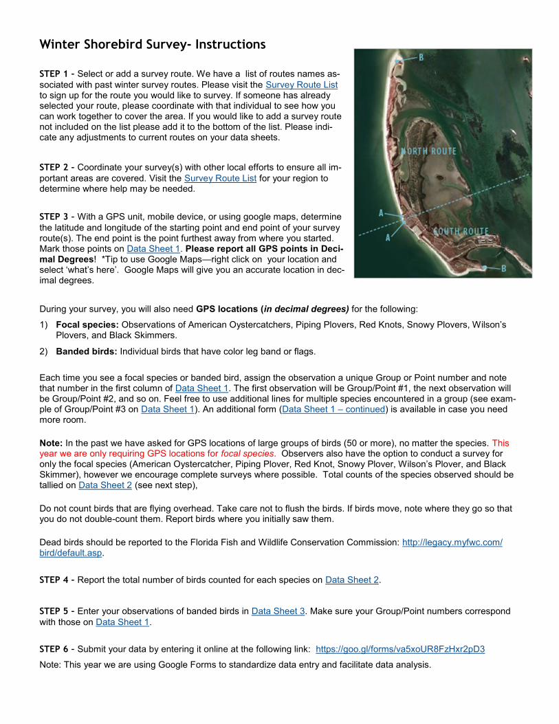
STEP 3 – With a GPS unit, mobile device, or using google maps, determine
the latitude and longitude of the starting point and end point of your survey route(s). The end point is the point furthest away from where you started. Mark those points on Data Sheet 1. Please report all GPS points in Deci-mal Degrees! *Tip to use Google Maps—right click on your location and select ‘what’s here’. Google Maps will give you an accurate location in dec-imal degrees.
During your survey, you will also need GPS locations (in decimal degrees) for the following:
1) Focal species: Observations of American Oystercatchers, Piping Plovers, Red Knots, Snowy Plovers, Wilson’s Plovers, and Black Skimmers.
2) Banded birds: Individual birds that have color leg band or flags.
Each time you see a focal species or banded bird, assign the observation a unique Group or Point number and note that number in the first column of Data Sheet 1. The first observation will be Group/Point #1, the next observation will be Group/Point #2, and so on. Feel free to use additional lines for multiple species encountered in a group (see exam-ple of Group/Point #3 on Data Sheet 1). An additional form (Data Sheet 1 – continued) is available in case you need more room.
Note: In the past we have asked for GPS locations of large groups of birds (50 or more), no matter the species. This year we are only requiring GPS locations for focal species. Observers also have the option to conduct a survey for only the focal species (American Oystercatcher, Piping Plover, Red Knot, Snowy Plover, Wilson’s Plover, and Black Skimmer), however we encourage complete surveys where possible. Total counts of the species observed should be tallied on Data Sheet 2 (see next step),
Do not count birds that are flying overhead. Take care not to flush the birds. If birds move, note where they go so that you do not double-count them. Report birds where you initially saw them.
Dead birds should be reported to the Florida Fish and Wildlife Conservation Commission: http://legacy.myfwc.com/bird/default.asp.
STEP 4 – Report the total number of birds counted for each species on Data Sheet 2.
STEP 5 – Enter your observations of banded birds in Data Sheet 3. Make sure your Group/Point numbers correspond
with those on Data Sheet 1.
STEP 6 – Submit your data by entering it online at the following link: https://goo.gl/forms/va5xoUR8FzHxr2pD3
Note: This year we are using Google Forms to standardize data entry and facilitate data analysis.
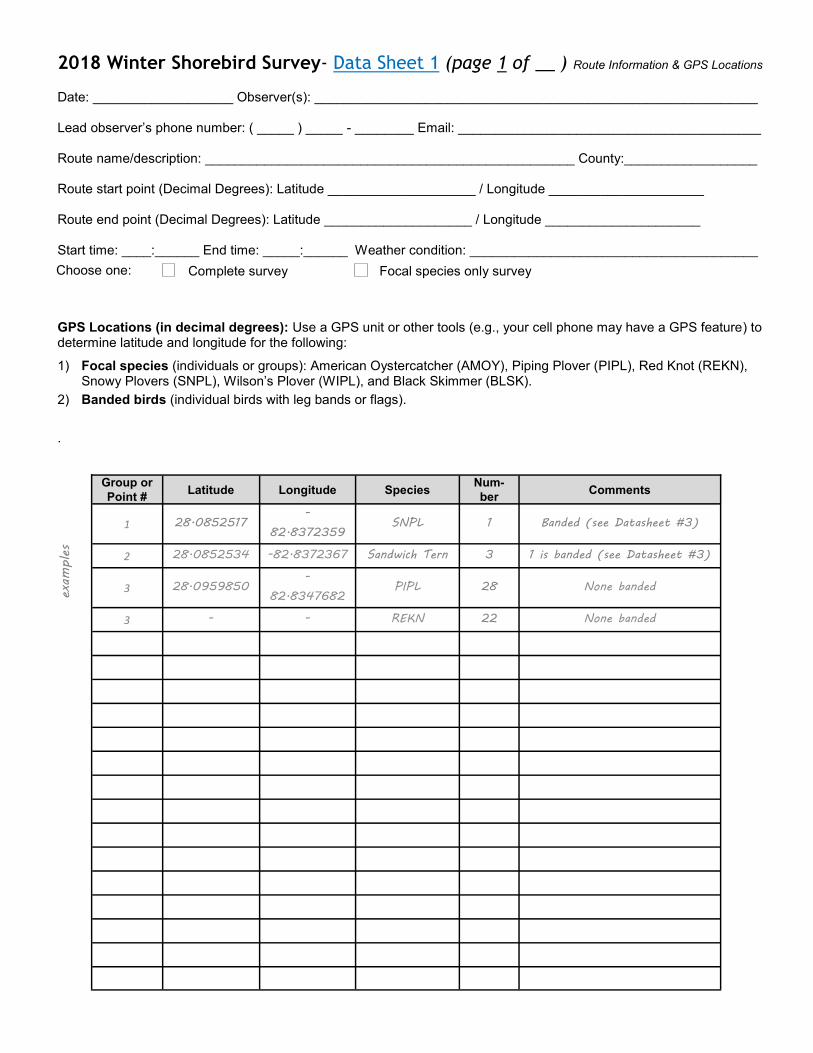
2018 Winter Shorebird Survey- Data Sheet 1 (page 1 of __ ) Route Information & GPS Locations
Date: ___________________ Observer(s): ____________________________________________________________ Lead observer’s phone number: ( _____ ) _____ - ________ Email: _________________________________________ Route name/description: __________________________________________________ County:__________________ Route start point (Decimal Degrees): Latitude ____________________ / Longitude _____________________ Route end point (Decimal Degrees): Latitude ____________________ / Longitude _____________________ Start time: ____:______ End time: _____:______ Weather condition: _______________________________________
GPS Locations (in decimal degrees): Use a GPS unit or other tools (e.g., your cell phone may have a GPS feature) to determine latitude and longitude for the following:
1) Focal species (individuals or groups): American Oystercatcher (AMOY), Piping Plover (PIPL), Red Knot (REKN), Snowy Plovers (SNPL), Wilson’s Plover (WIPL), and Black Skimmer (BLSK).
2) Banded birds (individual birds with leg bands or flags).
.
examples
Group or
Point # Latitude Longitude Species
Num-
ber Comments
1 28.0852517 -
82.8372359 SNPL 1 Banded (see Datasheet #3)
2 28.0852534 -82.8372367 Sandwich Tern 3 1 is banded (see Datasheet #3)
3 28.0959850 -
82.8347682 PIPL 28 None banded
3 - - REKN 22 None banded
Complete survey Focal species only survey Choose one:
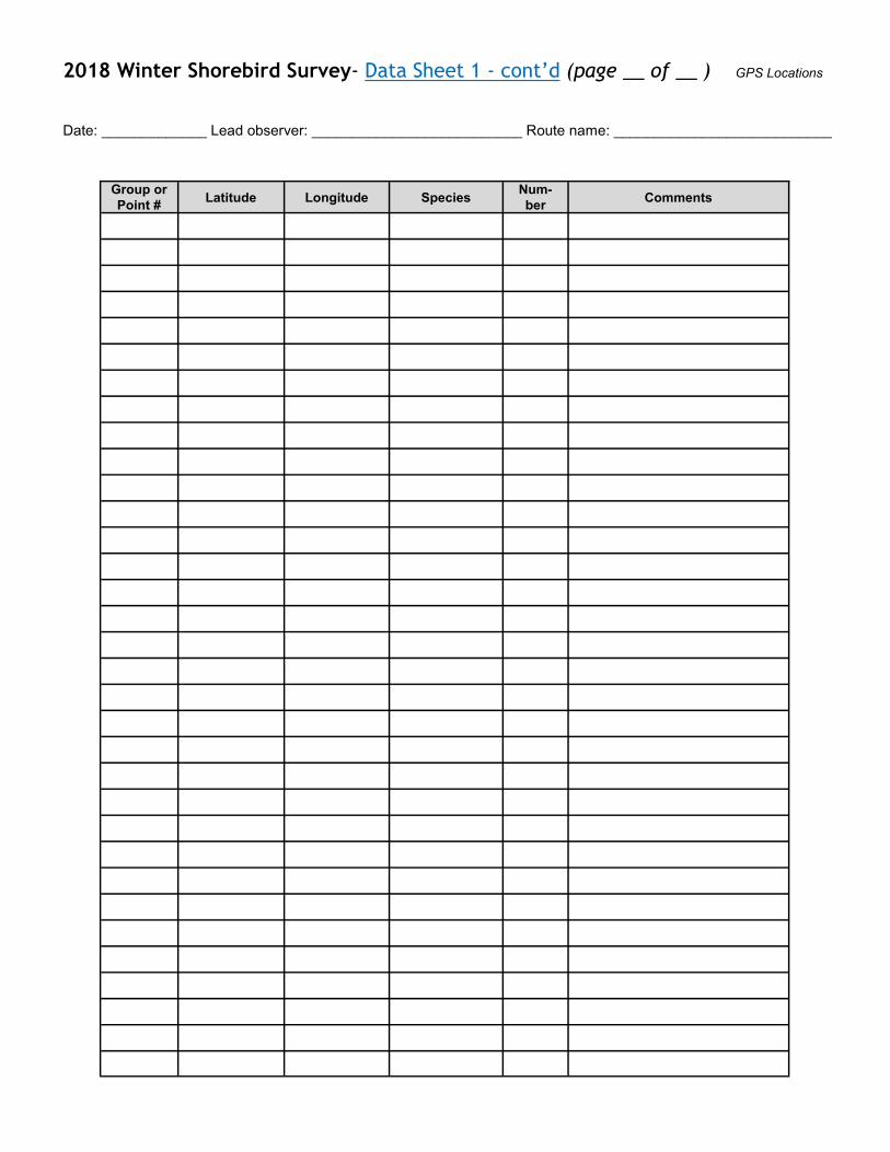
2018 Winter Shorebird Survey- Data Sheet 1 - cont’d (page __ of __ ) GPS Locations
Date: _____________ Lead observer: __________________________ Route name: ___________________________
Group or
Point # Latitude Longitude Species
Num-
ber Comments
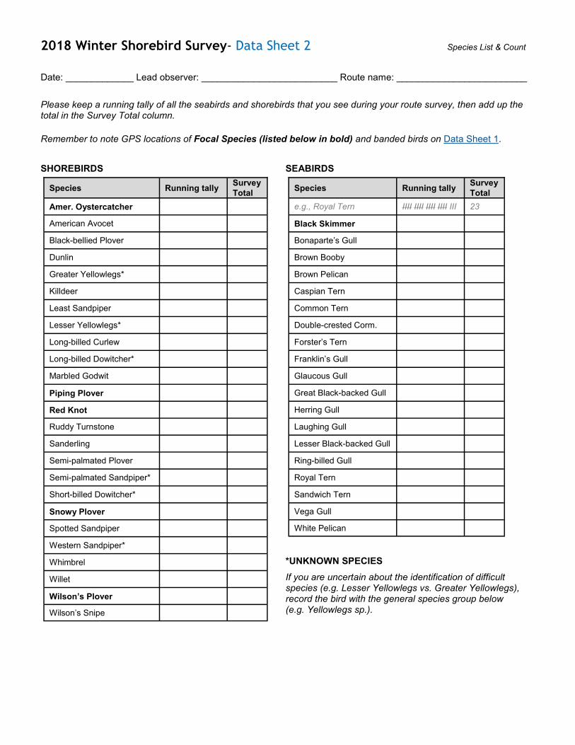
2018 Winter Shorebird Survey- Data Sheet 2 Species List & Count
Date: _____________ Lead observer: __________________________ Route name: _________________________
Please keep a running tally of all the seabirds and shorebirds that you see during your route survey, then add up the total in the Survey Total column.
Remember to note GPS locations of Focal Species (listed below in bold) and banded birds on Data Sheet 1.
SHOREBIRDS
SEABIRDS
*UNKNOWN SPECIES
If you are uncertain about the identification of difficult species (e.g. Lesser Yellowlegs vs. Greater Yellowlegs), record the bird with the general species group below (e.g. Yellowlegs sp.).
Species Running tally Survey
Total
Amer. Oystercatcher
American Avocet
Black-bellied Plover
Dunlin
Greater Yellowlegs*
Killdeer
Least Sandpiper
Lesser Yellowlegs*
Long-billed Curlew
Long-billed Dowitcher*
Marbled Godwit
Piping Plover
Red Knot
Ruddy Turnstone
Sanderling
Semi-palmated Plover
Semi-palmated Sandpiper*
Short-billed Dowitcher*
Snowy Plover
Spotted Sandpiper
Western Sandpiper*
Whimbrel
Willet
Wilson’s Plover
Wilson’s Snipe
Species Running tally Survey
Total
e.g., Royal Tern IIII IIII IIII IIII III 23
Black Skimmer
Bonaparte’s Gull
Brown Booby
Brown Pelican
Caspian Tern
Common Tern
Double-crested Corm.
Forster’s Tern
Franklin’s Gull
Glaucous Gull
Great Black-backed Gull
Herring Gull
Laughing Gull
Lesser Black-backed Gull
Ring-billed Gull
Royal Tern
Sandwich Tern
Vega Gull
White Pelican
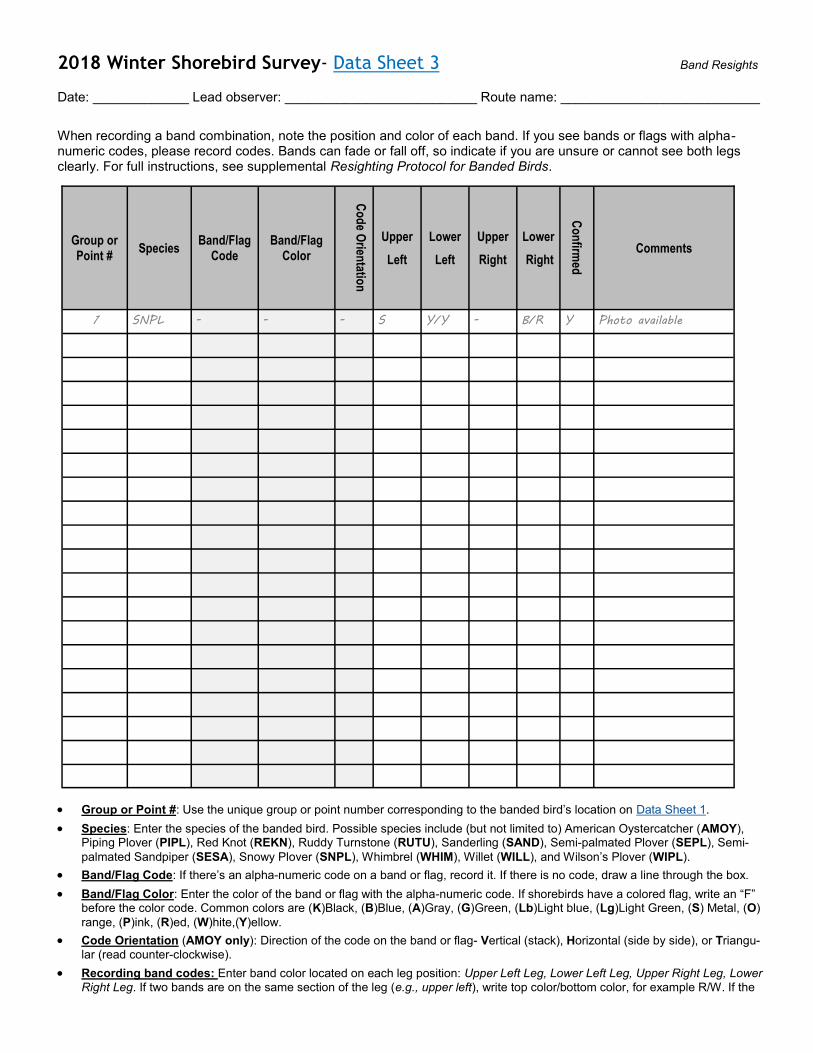
2018 Winter Shorebird Survey- Data Sheet 3 Band Resights
Date: _____________ Lead observer: __________________________ Route name: ___________________________
When recording a band combination, note the position and color of each band. If you see bands or flags with alpha-numeric codes, please record codes. Bands can fade or fall off, so indicate if you are unsure or cannot see both legs clearly. For full instructions, see supplemental Resighting Protocol for Banded Birds.
• Group or Point #: Use the unique group or point number corresponding to the banded bird’s location on Data Sheet 1.
• Species: Enter the species of the banded bird. Possible species include (but not limited to) American Oystercatcher (AMOY), Piping Plover (PIPL), Red Knot (REKN), Ruddy Turnstone (RUTU), Sanderling (SAND), Semi-palmated Plover (SEPL), Semi-
palmated Sandpiper (SESA), Snowy Plover (SNPL), Whimbrel (WHIM), Willet (WILL), and Wilson’s Plover (WIPL).
• Band/Flag Code: If there’s an alpha-numeric code on a band or flag, record it. If there is no code, draw a line through the box.
• Band/Flag Color: Enter the color of the band or flag with the alpha-numeric code. If shorebirds have a colored flag, write an “F” before the color code. Common colors are (K)Black, (B)Blue, (A)Gray, (G)Green, (Lb)Light blue, (Lg)Light Green, (S) Metal, (O)
range, (P)ink, (R)ed, (W)hite,(Y)ellow.
• Code Orientation (AMOY only): Direction of the code on the band or flag- Vertical (stack), Horizontal (side by side), or Triangu-
lar (read counter-clockwise).
• Recording band codes: Enter band color located on each leg position: Upper Left Leg, Lower Left Leg, Upper Right Leg, Lower
Right Leg. If two bands are on the same section of the leg (e.g., upper left), write top color/bottom color, for example R/W. If the
Group or Point #
Species Band/Flag
Code Band/Flag
Color
Co
de O
rientatio
n
Upper
Left
Lower
Left
Upper
Right
Lower
Right
Co
nfirm
ed
Comments
1 SNPL - - - S Y/Y - B/R Y Photo available
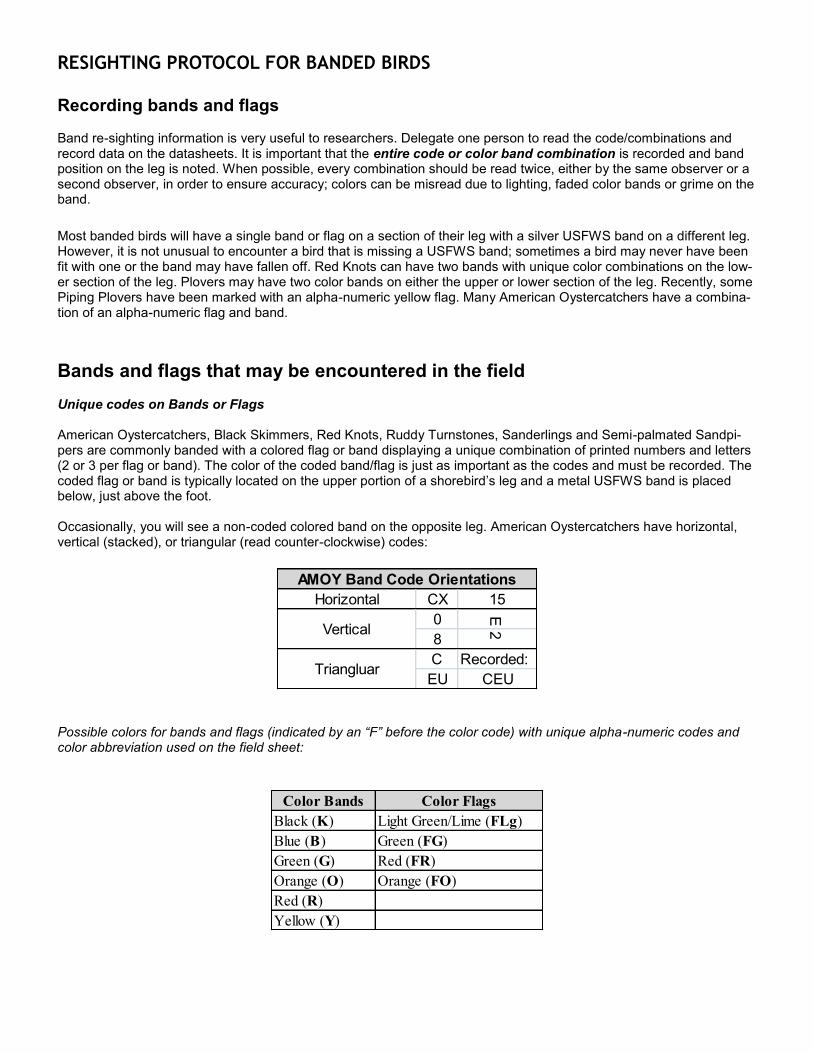
RESIGHTING PROTOCOL FOR BANDED BIRDS Recording bands and flags Band re-sighting information is very useful to researchers. Delegate one person to read the code/combinations and record data on the datasheets. It is important that the entire code or color band combination is recorded and band position on the leg is noted. When possible, every combination should be read twice, either by the same observer or a second observer, in order to ensure accuracy; colors can be misread due to lighting, faded color bands or grime on the band.
Most banded birds will have a single band or flag on a section of their leg with a silver USFWS band on a different leg. However, it is not unusual to encounter a bird that is missing a USFWS band; sometimes a bird may never have been fit with one or the band may have fallen off. Red Knots can have two bands with unique color combinations on the low-er section of the leg. Plovers may have two color bands on either the upper or lower section of the leg. Recently, some Piping Plovers have been marked with an alpha-numeric yellow flag. Many American Oystercatchers have a combina-tion of an alpha-numeric flag and band.
Bands and flags that may be encountered in the field Unique codes on Bands or Flags American Oystercatchers, Black Skimmers, Red Knots, Ruddy Turnstones, Sanderlings and Semi-palmated Sandpi-pers are commonly banded with a colored flag or band displaying a unique combination of printed numbers and letters (2 or 3 per flag or band). The color of the coded band/flag is just as important as the codes and must be recorded. The coded flag or band is typically located on the upper portion of a shorebird’s leg and a metal USFWS band is placed below, just above the foot.
Occasionally, you will see a non-coded colored band on the opposite leg. American Oystercatchers have horizontal, vertical (stacked), or triangular (read counter-clockwise) codes:
Possible colors for bands and flags (indicated by an “F” before the color code) with unique alpha-numeric codes and color abbreviation used on the field sheet:
Horizontal CX 15
0
E
8
2
C Recorded:
EU CEU
Vertical
AMOY Band Code Orientations
Triangluar
Color Bands Color Flags
Black (K) Light Green/Lime (FLg)
Blue (B) Green (FG)
Green (G) Red (FR)
Orange (O) Orange (FO)
Red (R)
Yellow (Y)
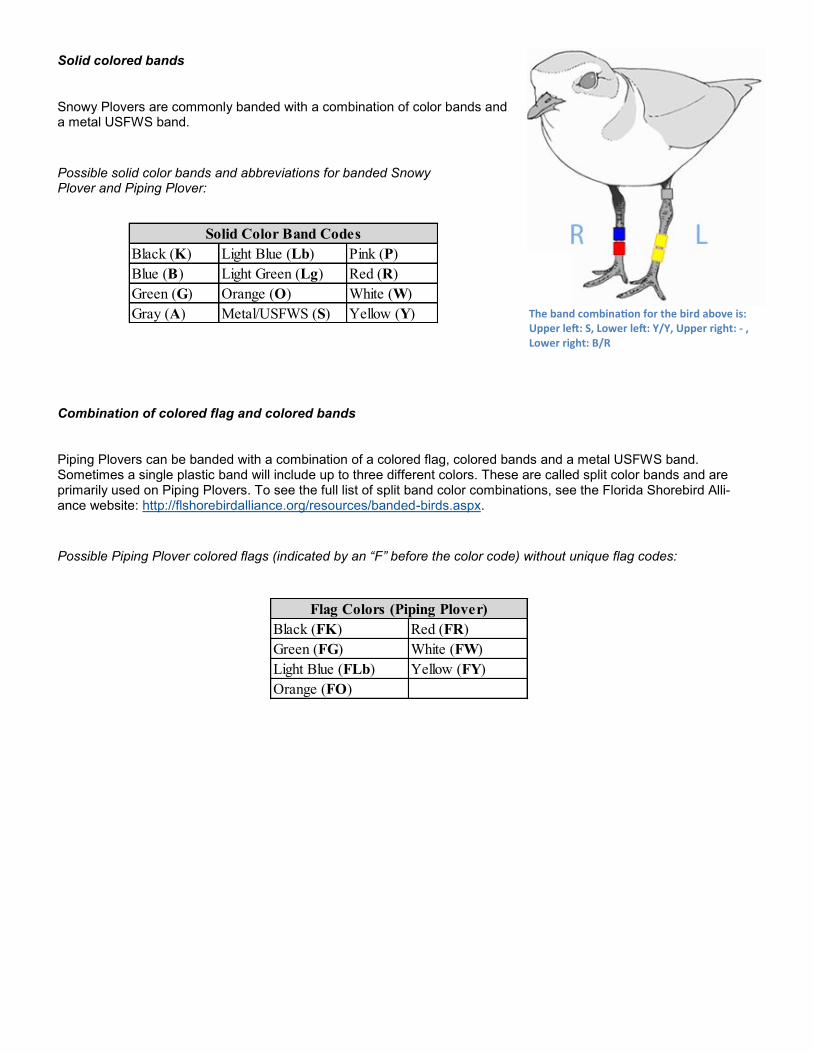
Solid colored bands
Snowy Plovers are commonly banded with a combination of color bands and a metal USFWS band.
Possible solid color bands and abbreviations for banded Snowy Plover and Piping Plover:
Combination of colored flag and colored bands
Piping Plovers can be banded with a combination of a colored flag, colored bands and a metal USFWS band. Sometimes a single plastic band will include up to three different colors. These are called split color bands and are primarily used on Piping Plovers. To see the full list of split band color combinations, see the Florida Shorebird Alli-ance website: http://flshorebirdalliance.org/resources/banded-birds.aspx.
Possible Piping Plover colored flags (indicated by an “F” before the color code) without unique flag codes:
Black (K) Light Blue (Lb) Pink (P)
Blue (B) Light Green (Lg) Red (R)
Green (G) Orange (O) White (W)
Gray (A) Metal/USFWS (S) Yellow (Y)
Solid Color Band Codes
Black (FK) Red (FR)
Green (FG) White (FW)
Light Blue (FLb) Yellow (FY)
Orange (FO)
Flag Colors (Piping Plover)
The band combination for the bird above is: Upper left: S, Lower left: Y/Y, Upper right: - , Lower right: B/R