wingecarribee biodiversity 120603
TRANSCRIPT
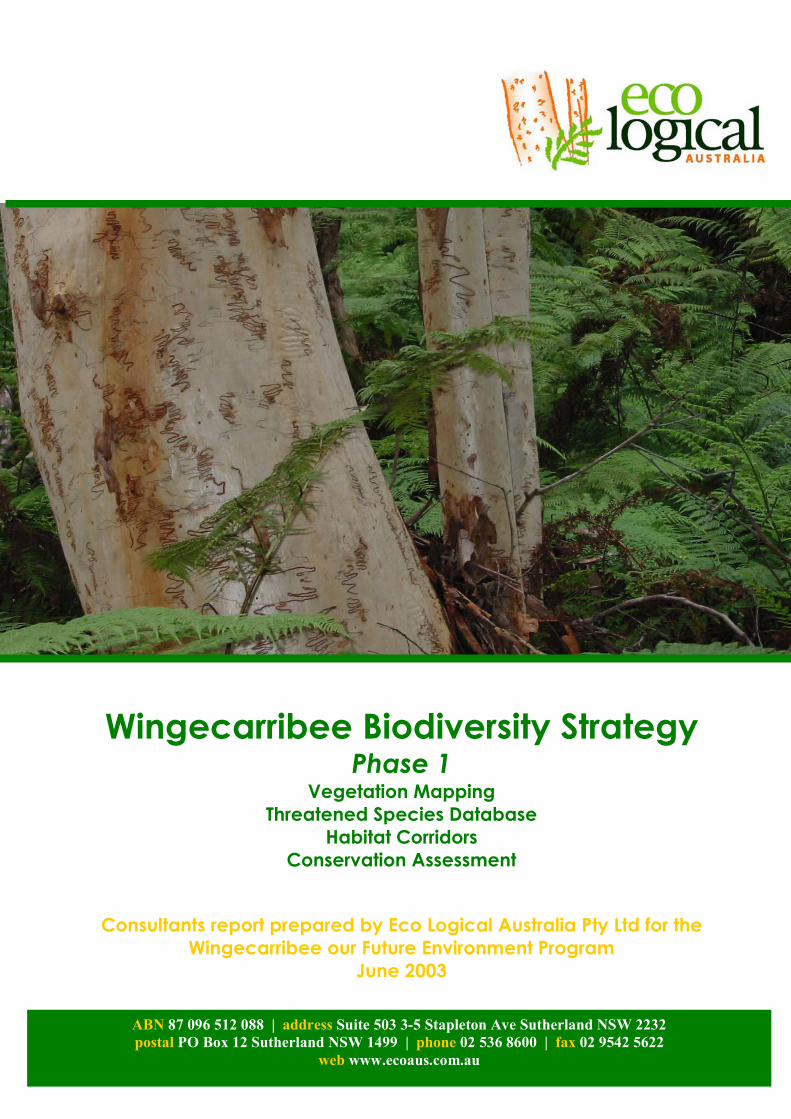
Wingecarribee Biodiversity Strategy
Phase 1 Vegetation Mapping
Threatened Species Database Habitat Corridors
Conservation Assessment
Consultants report prepared by Eco Logical Australia Pty Ltd for the Wingecarribee our Future Environment Program
June 2003 ABN 87 096 512 088 | address Suite 503 3-5 Stapleton Ave Sutherland NSW 2232
postal PO Box 12 Sutherland NSW 1499 | phone 02 536 8600 | fax 02 9542 5622 web www.ecoaus.com.au
Wingecarribee Biodiversity Strategy
Eco Logical Australia (02) 8536 8600 Phone i PO Box 12 (02) 9542 5622 Fax Sutherland NSW 1499 www.ecoaus.com.au
Document Tracking
Item Detail Signature
Project Name Wingecarribee Biodiversity Strategy – Phase 1
Project Number 16-01
Prepared by Cate Gillies
Prepared by Steven House
Approved by Steven House
Status Final
Version Number
1
File location Z:\current_projects\wsc\june03\report\Wingecarribee biodiversity 120603.doc
Date 27 June 2003
Disclaimer This document may only be used for the purpose for which it was commissioned and in accordance with the contract between Eco Logical Australia Pty Ltd and Wingecarribee Shire Council. The scope of services was defined in consultation with the Wingecarribee Shire Council, by time and budgetary constraints imposed by the Wingecarribee Shire Council, and the availability of reports and other data on the biodiversity values of Wingecarribee Shire. Changes to available information, legislation and schedules are made on an ongoing basis and readers should obtain up to date information. Eco Logical Australia Pty Ltd accepts no liability or responsibility whatsoever for or in respect of any use of or reliance upon this report and its supporting material by any third party. Information provided is not intended to be a substitute for site specific assessment or legal advice in relation to any matter. Unauthorised use of this report in any form is prohibited.
Eco Logical Australia Phone. (02) 8536 8600 ii
Acknowledgements Eco Logical Australia has undertaken this project on behalf of Wingecarribee Shire Council as part of the Wingecarribee Our Future Environment Program. This project could not have been completed without the assistance and contribution of numerous individuals and organisations. We particularly wish to thank:
�� Staff of Wingecarribee Shire Council
�� Mark Tozer, David Keith and Dan Tindall of the NSW National Parks and Wildlife Service for specialist advice and field work
�� Daniel Connolly and technical staff of the Central Ditectorate office of the NSW National Parks and Wildife Service for the provision of Woronora Vegetation Mapping data
�� Staff at the Southern Directorate office of the NSW National Parks and Wildlife Service for specialist input to threatened species models
�� Department of Land and Water Conservation, Wollongong Office
�� Sydney Catchment Authority for supply of aerial photos
�� The many property owners that allowed access to their land to undertake vegetation surveys
This project has drawn on existing data from numerous data sources and their input is appreciated and acknowledged. In particular:
�� Atlas of NSW Wildlife
�� Royal Botanic Gardens Hawkesbury Nepean Vegetation Mapping Series
�� Southern Comprehensive Regional Assessment
�� Native Vegetation of the Woronora, O’Hares and Metropolitan Catchments, joint project between the NPWS and the Sydney Catchment Authority, September 2002
This report was prepared by Steven House of Eco Logical Australia Pty Ltd, with assistance from Cate Gillies of Eco Logical Australia.
Eco Logical Australia Phone. (02) 8536 8600 iii
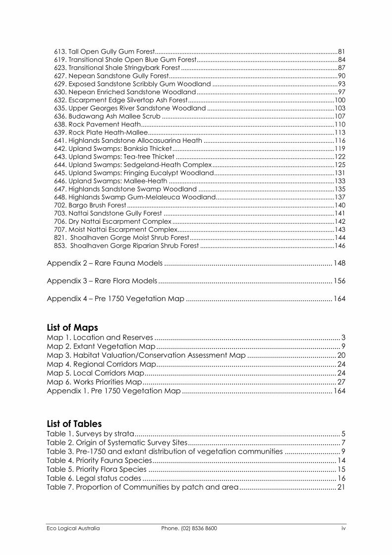
Contents Acknowledgements .................................................................................................................ii 1 Introduction........................................................................................................................ 1 2 Project Aims ....................................................................................................................... 2 3 Vegetation Mapping........................................................................................................ 3
3.1 Review of Existing Information.................................................................................................3 3.2 Preparation of Modelling Database......................................................................................4 3.3 Mapping of Extant Vegetation...............................................................................................4 3.4 Floristic Surveys ...........................................................................................................................4 3.5 Vegetation Classification and Modelling.............................................................................7 3.6 Discussion ....................................................................................................................................8 3.7 Vegetation Mapping Limitations..........................................................................................11
4 Threatened Species Database ..................................................................................... 12 5 Flora and Fauna Habitat Models .................................................................................. 13
5.1 Methods ....................................................................................................................................13 5.2 Results ........................................................................................................................................13 5.3 Habitat Model Limitations......................................................................................................16
6 Conservation Assessment .............................................................................................. 17 6.1 Policy Framework for Conservation Assessment ...............................................................17 6.2 Assessing the Conservation Values of Wingecarribee Shire ...........................................19 6.3 Results of Conservation Assessment ....................................................................................20
7 Habitat Corridors ............................................................................................................. 22 7.1 Mapping Corridors within Wingecarribee Shire.................................................................23
8 Prioritisation of Conservation Works.............................................................................. 24 8.1 Principles for Undertaking Biodiversity Conservation Works ............................................24 8.2 Priority Areas for Implementing Biodiversity Conservation Works...................................25
9 Glossary ............................................................................................................................ 27 10 References................................................................................................................... 28 Appendix 1 – Vegetation Community Profiles ......................................................................... 29
1. Hawkesbury Sandstone Woodland ...............................................................................................30 2. Bundanoon Sandstone Woodland................................................................................................32 3. Sydney Sandstone Gully Forest.......................................................................................................34 4. Mittagong Sandstone Woodland ..................................................................................................36 5. Wingecarribee Mallee .....................................................................................................................38 6. Scribbly Gum Open Woodland......................................................................................................40 7. Sandstone Wet Heath/Sedge.........................................................................................................42 8. Swamp (including Peat Swamp) ...................................................................................................44 9. Riparian Casuarina Forest................................................................................................................46 10. Wingecarribee Woodland ............................................................................................................47 11. Burragorang Ironbark Woodland.................................................................................................50 12. Bindook Porphyry Moist Woodland .............................................................................................52 13. Bindook Porphyry Dry Woodland.................................................................................................54 14. Robertson Basalt Rainforest...........................................................................................................57 15. Shoalhaven Gorge Tall Open Forest ..........................................................................................59 16. Robertson Basalt Tall Open Forest................................................................................................60 17. Southern Highlands Shale Woodland..........................................................................................62 18. Joadja Tall Open Forest .................................................................................................................64 19. Upper Shoalhaven Tall Open Forest ............................................................................................66 20. Mt Gibraltar Forest...........................................................................................................................68 21. Warm Temperate Rainforest .........................................................................................................70 604. Sandstone Riparian Scrub ...........................................................................................................72 608. Moist Gully Gum Forest ................................................................................................................75 609. Nepean Gorge Moist Forest........................................................................................................78
Eco Logical Australia Phone. (02) 8536 8600 iv
613. Tall Open Gully Gum Forest.........................................................................................................81 619. Transitional Shale Open Blue Gum Forest.................................................................................84 623. Transitional Shale Stringybark Forest ..........................................................................................87 627. Nepean Sandstone Gully Forest.................................................................................................90 629. Exposed Sandstone Scribbly Gum Woodland ........................................................................93 630. Nepean Enriched Sandstone Woodland.................................................................................97 632. Escarpment Edge Silvertop Ash Forest....................................................................................100 635. Upper Georges River Sandstone Woodland .........................................................................103 636. Budawang Ash Mallee Scrub ...................................................................................................107 638. Rock Pavement Heath...............................................................................................................110 639. Rock Plate Heath-Mallee...........................................................................................................113 641. Highlands Sandstone Allocasuarina Heath ...........................................................................116 642. Upland Swamps: Banksia Thicket.............................................................................................119 643. Upland Swamps: Tea-tree Thicket ...........................................................................................122 644. Upland Swamps: Sedgeland-Heath Complex......................................................................125 645. Upland Swamps: Fringing Eucalypt Woodland.....................................................................131 646. Upland Swamps: Mallee-Heath ...............................................................................................133 647. Highlands Sandstone Swamp Woodland ..............................................................................135 648. Highlands Swamp Gum-Melaleuca Woodland....................................................................137 702. Bargo Brush Forest .......................................................................................................................140 703. Nattai Sandstone Gully Forest ..................................................................................................141 706. Dry Nattai Escarpment Complex .............................................................................................142 707. Moist Nattai Escarpment Complex..........................................................................................143 821. Shoalhaven Gorge Moist Shrub Forest...................................................................................144 853. Shoalhaven Gorge Riparian Shrub Forest .............................................................................146
Appendix 2 – Rare Fauna Models ..................................................................................... 148 Appendix 3 – Rare Flora Models ........................................................................................ 156 Appendix 4 – Pre 1750 Vegetation Map .......................................................................... 164 List of Maps Map 1. Location and Reserves .............................................................................................. 3 Map 2. Extant Vegetation Map............................................................................................. 9 Map 3. Habitat Valuation/Conservation Assessment Map ............................................. 20 Map 4. Regional Corridors Map........................................................................................... 24 Map 5. Local Corridors Map................................................................................................. 24 Map 6. Works Priorities Map.................................................................................................. 27 Appendix 1. Pre 1750 Vegetation Map ............................................................................ 164 List of Tables Table 1. Surveys by strata........................................................................................................ 5 Table 2. Origin of Systematic Survey Sites............................................................................. 7 Table 3. Pre-1750 and extant distribution of vegetation communities ............................ 9 Table 4. Priority Fauna Species............................................................................................. 14 Table 5. Priority Flora Species ............................................................................................... 15 Table 6. Legal status codes .................................................................................................. 16 Table 7. Proportion of Communities by patch and area................................................. 21
Wingecarribee Biodiversity Strategy
Eco Logical Australia Phone. (02) 8536 8600 1
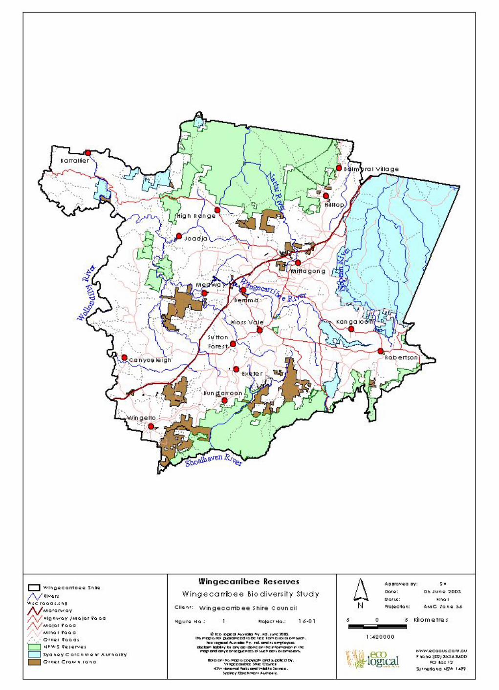
1 Introduction Wingecarribee Shire exhibits a wealth of biodiversity values. This is largely due to the variations in climatic and geographic characteristics across the Shire, from the warm temperate rainforest on the edge of the Illawarra Escarpment to the tall forests and woodlands of the Southern Highlands and the spectacular sandstone gorge country of the Nattai Plateau. The vegetation within Wingecarribee Shire has evolved over time into the diverse range of communities present today. Many of these communities have evolved on soils and under climatic conditions that are not found outside the Shire. Consequently, there are several vegetation communities that are endemic to the Southern Highlands area. Of these a number are located on fertile basalt or shale based soils. These same soils are also the most productive for agriculture and in many locations the vegetation has been substantially cleared. In some instances clearing has occurred to such an extent that the vegetation communities are at risk of extinction and have been listed as ‘Endangered Ecological Communities’ under the Threatened Species Conservation Act (1995). In addition, these communities are often host to a number of plants and animals that rely on them for habitat. Consequently, the Shire is home to a number of species that are under threat of extinction, are restricted in distribution or are at the limit of their known range. This project, through a scientifically robust methodology, has identified the type and location of species and communities and has interpreted this information into a series of maps designed to help planners and landholders manage their land for optimal biodiversity. It provides a blueprint for ecologically sustainable development (ESD) and environmental management in the Shire. It also provides opportunities to increase the biodiversity values of the Shire through targeted habitat improvement initiatives and to contribute to the maintenance of the wealth of biodiversity within Australia. This report accompanies a series of Geographic Information System (GIS) layers that will be utilised by Council for future planning and management. Specifically, the following information has been provided to Council:
�� Pre 1750 Vegetation Community Map �� Extant Vegetation Community Map �� Threatened Species Database �� Threatened Species Habitat Association Models �� Habitat Corridors �� Conservation Significance Assessment
Eco Logical Australia Phone. (02) 8536 8600 2
2 Project Aims The overall aim of the project is:
‘To establish and implement measures to effectively conserve, protect, enhance and rehabilitate the biodiversity within our Shire’.
This project fulfils Phase 1 of the overall biodiversity strategy, whose specific goal is:
‘To provide quality, reliable and practical information, as required, on the distribution of significant flora and fauna within the Shire for the purposes of Local environmental planning, biodiversity conservation and enhancement'.
The specific objectives of Phase 1 are:
�� To develop a Vegetation Map of Wingecarribee Shire at an appropriate scale incorporating data on regionally and locally significant species, and significant plant associations, including vegetation types and corridors in report and digital format incorporated onto Council’s Geographic Information System (GIS).
�� To develop a series of indicative qualitative maps at an appropriate scale showing the locations and potential habitat of threatened species of flora and fauna, significant plant associations and areas important for regionally and locally significant flora and fauna species. Records provided in report and digital format to be incorporated onto Council’s GIS.
�� To use the vegetation map, in association with other information, to provide indicative qualitative information on the likely distribution of flora and fauna species. This information can be used for local environmental planning, biodiversity conservation and enhancement, preparation of Threatened Species management plans, State of the Environment Reporting and other specialised management plans (eg. riparian zone, habitat, wildlife corridor protection or weed control).
�� To develop a prioritised program, which will effectively define and guide the implementation of related “on the ground” works to be completed under the Wingecarribee Our Future Environment (WOFE) Program.
�� To structure Phase 1 of the project logically and effectively within the bounds of available resources, and in such a manner as to maximise potential for future project funding opportunities, and for the further development of the flora and fauna qualitative distributional maps, threatened species information and a Biodiversity Strategy.
Eco Logical Australia Phone. (02) 8536 8600 3
3 Vegetation Mapping The vegetation mapping component of this project uses mapping techniques developed by the New South Wales National Parks and Wildlife Service (NPWS) (Keith and Bedward, 1999; NPWS, 2000). The technique combines mapped landscape variables (eg. soils, rainfall, and topography) with statistical analysis of species recorded at vegetation survey sites to identify vegetation communities. The distribution of the vegetation communities is then modeled using the landscape variables. This technique has been used in a number of high profile projects including:
�� Eden Vegetation Mapping (Keith and Bedward, 1999)
�� Native Vegetation Maps of the Cumberland Plain, Western Sydney (NPWS, 2000a)
�� Vegetation Mapping of the Lower Hunter and Central Coast (NPWS, LHCCREMS, 2000b)
�� Southern CRA Forest Ecosystems Mapping Project (NPWS, 2000c)
�� Native Vegetation of the Woronora, O’Hares and Metropolitan Catchments, joint project between the NPWS and the Sydney Catchment Authority, September 2002
3.1 Review of Existing Information An audit of existing data was undertaken. This was to ensure that previous survey effort was not replicated, thus maximising the benefit of this projects’ survey program, and to ensure consistency with existing vegetation datasets. The following key data sources were reviewed:
�� Royal Botanic Gardens Hawkesbury Nepean Series Vegetation Mapping
�� NPWS Vegetation Survey Database (this included existing NPWS and RBG survey sites)
�� Sydney Catchment Authority Vegetation Surveys
�� Comprehensive Regional Assessment (CRA) Mapping The survey program was undertaken in close consultation with the NPWS, NSW Department of Land and Water Conservation (DLWC) and Sydney Catchment Authority (SCA) who were all undertaking various survey programs within the Shire. Effective integration of this project with these other survey programs has facilitated maximum data availability between all projects.
Eco Logical Australia Phone. (02) 8536 8600 4
3.2 Preparation of Modelling Database A spatial database was prepared within the Arcview GIS system to provide the basis for the stratification of field sites and to undertake predictive modelling of vegetation communities and priority species habitat. The information was collated from existing NPWS data sources that had been prepared for the Comprehensive Regional Assessment (CRA) process. As Wingecarribee Shire sits across 2 of the CRA study areas (Southern and Sydney Basin), data had to be collated form both of these areas and ‘stitched’ together to provide single layers covering the entire Shire. The following information was collated:
�� Geology �� Soil landscapes �� Mean Annual Rainfall �� Mean Annual Temperature �� Digital Elevation Model (DEM) �� Wetness �� Slope �� Aspect �� Hillshade �� Existing Vegetation Mapping
3.3 Mapping of Extant Vegetation Extant (remaining) vegetation was mapped within the Arcview GIS system from 1:40,000 scale digital aerial photos flown in late 2001. These photos were provided by the Sydney Catchment Authority. Digitising was performed manually ‘on-screen’ to delineate vegetation remnants 0.5 hectares or larger, cleared land, water bodies, pine plantations, swamps and mined swamps. Vegetation remnants were only mapped if the crown canopy coverage of a remnant was at least 10%. Vegetation condition has not been mapped and there is no discrimination between thinned and natural cover. Consequently vegetation in poor condition is included in the vegetation map and will contribute to extant figures shown in Table 2. The result is that areas comprised merely of remnant canopy trees, often with poor condition or no understorey have been mapped and included in subsequent analysis.
3.4 Floristic Surveys A stratified systematic floristic survey program was undertaken which identified the cover-abundance of all species recorded within a 20 x 20 metre plot (0.04 hectares). Plot locations were determined through an environmental stratification of the study area. The stratification process combined rainfall, soil and temperature information to produce a total of 36 environmental units, or strata, that broadly reflect the environmental variations likely to influence vegetation. To ensure that the full range of environmental variation across the Shire was surveyed, sites were selected across strata and included variations in aspect and terrain (eg. ridge top, hill slope, valley floor).
Eco Logical Australia Phone. (02) 8536 8600 5
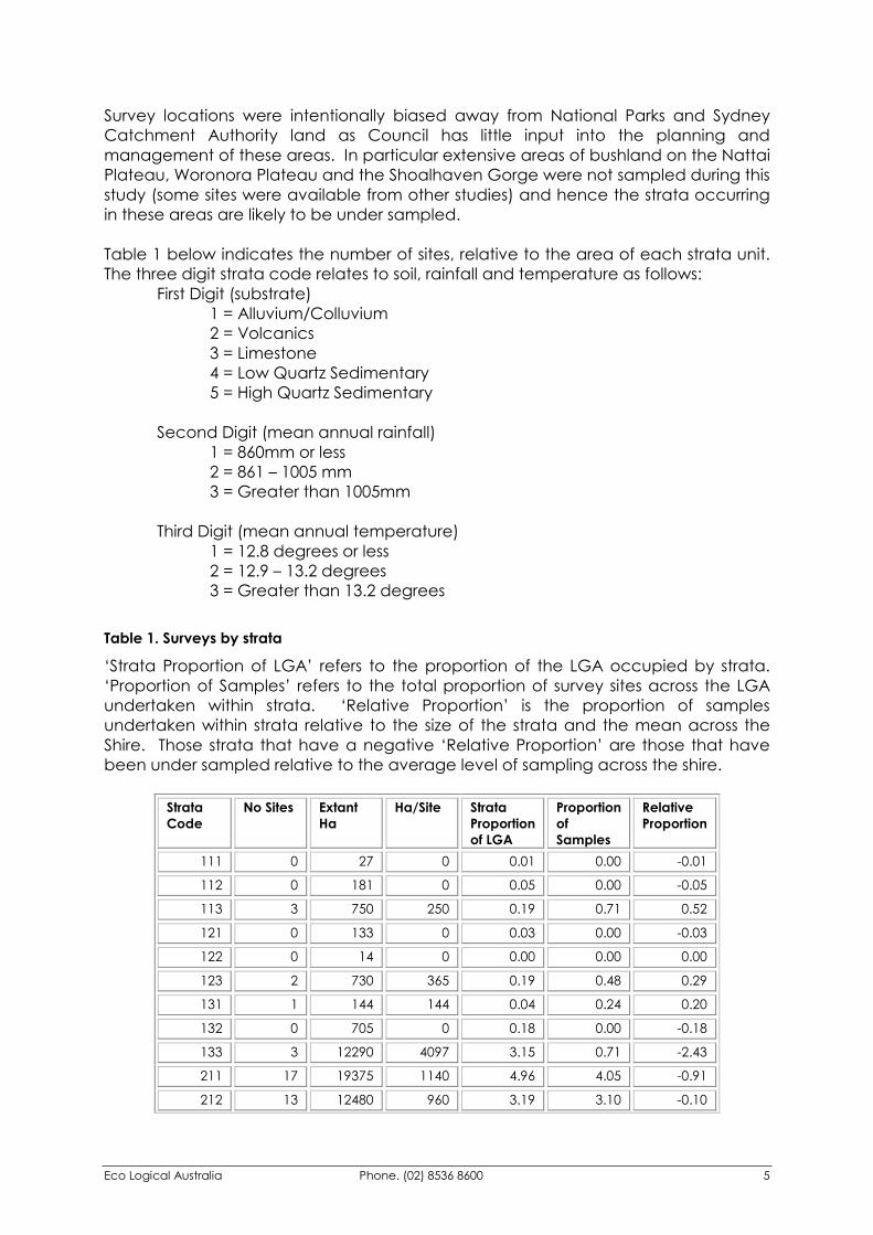
Survey locations were intentionally biased away from National Parks and Sydney Catchment Authority land as Council has little input into the planning and management of these areas. In particular extensive areas of bushland on the Nattai Plateau, Woronora Plateau and the Shoalhaven Gorge were not sampled during this study (some sites were available from other studies) and hence the strata occurring in these areas are likely to be under sampled. Table 1 below indicates the number of sites, relative to the area of each strata unit. The three digit strata code relates to soil, rainfall and temperature as follows: First Digit (substrate) 1 = Alluvium/Colluvium 2 = Volcanics 3 = Limestone 4 = Low Quartz Sedimentary 5 = High Quartz Sedimentary Second Digit (mean annual rainfall) 1 = 860mm or less 2 = 861 – 1005 mm 3 = Greater than 1005mm Third Digit (mean annual temperature) 1 = 12.8 degrees or less 2 = 12.9 – 13.2 degrees 3 = Greater than 13.2 degrees Table 1. Surveys by strata
‘Strata Proportion of LGA’ refers to the proportion of the LGA occupied by strata. ‘Proportion of Samples’ refers to the total proportion of survey sites across the LGA undertaken within strata. ‘Relative Proportion’ is the proportion of samples undertaken within strata relative to the size of the strata and the mean across the Shire. Those strata that have a negative ‘Relative Proportion’ are those that have been under sampled relative to the average level of sampling across the shire.
Strata Code
No Sites Extant Ha
Ha/Site Strata Proportion of LGA
Proportion of Samples
Relative Proportion
111 0 27 0 0.01 0.00 -0.01
112 0 181 0 0.05 0.00 -0.05
113 3 750 250 0.19 0.71 0.52
121 0 133 0 0.03 0.00 -0.03
122 0 14 0 0.00 0.00 0.00
123 2 730 365 0.19 0.48 0.29
131 1 144 144 0.04 0.24 0.20
132 0 705 0 0.18 0.00 -0.18
133 3 12290 4097 3.15 0.71 -2.43
211 17 19375 1140 4.96 4.05 -0.91
212 13 12480 960 3.19 3.10 -0.10

Eco Logical Australia Phone. (02) 8536 8600 6
Strata Code
No Sites Extant Ha
Ha/Site Strata Proportion of LGA
Proportion of Samples
Relative Proportion
213 36 31429 873 8.05 8.57 0.53
221 6 8023 1337 2.05 1.43 -0.63
222 0 325 0 0.08 0.00 -0.08
223 0 365 0 0.09 0.00 -0.09
231 22 1340 61 0.34 5.24 4.89
232 5 385 77 0.10 1.19 1.09
233 3 15415 5138 3.95 0.71 -3.23
311 0 165 0 0.04 0.00 -0.04
312 2 124 62 0.03 0.48 0.44
313 0 79 0 0.02 0.00 -0.02
411 22 30119 1369 7.71 5.24 -2.47
412 17 14182 834 3.63 4.05 0.42
413 37 23405 633 5.99 8.81 2.82
421 12 13077 1090 3.35 2.86 -0.49
422 5 2196 439 0.56 1.19 0.63
423 25 22474 899 5.75 5.95 0.20
431 2 1625 812 0.42 0.48 0.06
432 13 3907 301 1.00 3.10 2.10
433 33 31399 951 8.04 7.86 -0.18
511 11 5692 517 1.46 2.62 1.16
512 12 8713 726 2.23 2.86 0.63
513 3 13827 4609 3.54 0.71 -2.83
521 16 9691 606 2.48 3.81 1.33
522 13 9657 743 2.47 3.10 0.62
523 15 27149 1810 6.95 3.57 -3.38
531 3 1049 350 0.27 0.71 0.45
532 16 8862 554 2.27 3.81 1.54
533 52 59135 1137 15.14 12.38 -2.76
Total 420 390634 100 100 0
Average 930
Additional information collected at each site included location (AMG coordinates, using AGD 66 datum), terrain, stratum height, dominant species, disturbance, drainage, geology and soils. The methodology used was identical to that implemented by the NPWS. All data obtained during the course of the surveys was entered into the NPWS systematic survey database. By using a consistent methodology and including this information on a central database, the future use of this data will be maximised and the NPWS will be responsible for maintaining taxonomic changes. Field surveys were carried out by NPWS botanists in conjunction with Eco Logical Australia staff. Thus ensuring
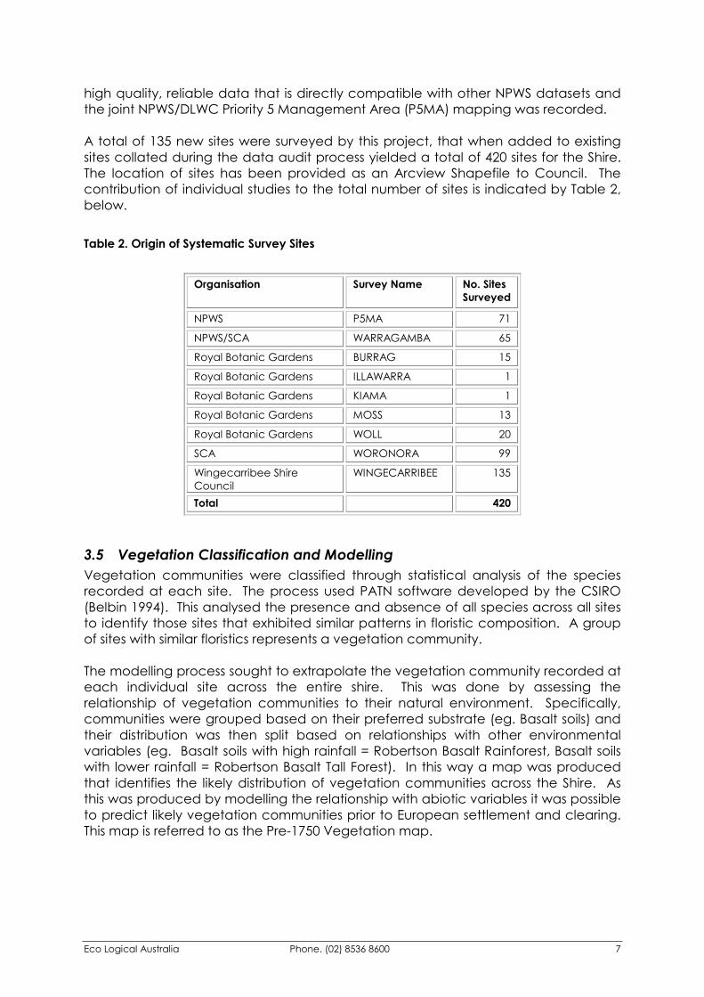
Eco Logical Australia Phone. (02) 8536 8600 7
high quality, reliable data that is directly compatible with other NPWS datasets and the joint NPWS/DLWC Priority 5 Management Area (P5MA) mapping was recorded. A total of 135 new sites were surveyed by this project, that when added to existing sites collated during the data audit process yielded a total of 420 sites for the Shire. The location of sites has been provided as an Arcview Shapefile to Council. The contribution of individual studies to the total number of sites is indicated by Table 2, below. Table 2. Origin of Systematic Survey Sites
Organisation Survey Name No. Sites
Surveyed
NPWS P5MA 71
NPWS/SCA WARRAGAMBA 65
Royal Botanic Gardens BURRAG 15
Royal Botanic Gardens ILLAWARRA 1
Royal Botanic Gardens KIAMA 1
Royal Botanic Gardens MOSS 13
Royal Botanic Gardens WOLL 20
SCA WORONORA 99
Wingecarribee Shire Council
WINGECARRIBEE 135
Total 420
3.5 Vegetation Classification and Modelling Vegetation communities were classified through statistical analysis of the species recorded at each site. The process used PATN software developed by the CSIRO (Belbin 1994). This analysed the presence and absence of all species across all sites to identify those sites that exhibited similar patterns in floristic composition. A group of sites with similar floristics represents a vegetation community. The modelling process sought to extrapolate the vegetation community recorded at each individual site across the entire shire. This was done by assessing the relationship of vegetation communities to their natural environment. Specifically, communities were grouped based on their preferred substrate (eg. Basalt soils) and their distribution was then split based on relationships with other environmental variables (eg. Basalt soils with high rainfall = Robertson Basalt Rainforest, Basalt soils with lower rainfall = Robertson Basalt Tall Forest). In this way a map was produced that identifies the likely distribution of vegetation communities across the Shire. As this was produced by modelling the relationship with abiotic variables it was possible to predict likely vegetation communities prior to European settlement and clearing. This map is referred to as the Pre-1750 Vegetation map.
Eco Logical Australia Phone. (02) 8536 8600 8
As a result of the low survey effort applied to the Nattai Plateau and Shoalhaven Gorge, there are extensive areas of bushland that have had no systematic surveys undertaken. Consequently the vegetation communities in these areas could not be identified through the PATN analysis. However, previous mapping undertaken by the Comprehensive Regional Assessment (CRA) and the Royal Botanic Gardens has mapped the vegetation communities in these areas. In the absence of other data, it was considered prudent to include this existing mapping in these areas. Additionally, the SCA and NPWS were concurrently undertaking a joint mapping project of the Woronora Plateau using a combination of systematic surveys and high resolution aerial photo interpretation. Rather than re-map the same area it was considered to be of far greater benefit to incorporate this information directly into the Wingecarribee mapping. As a result a consistent map of the Woronora Plateau will be used by Council, NPWS and the SCA.
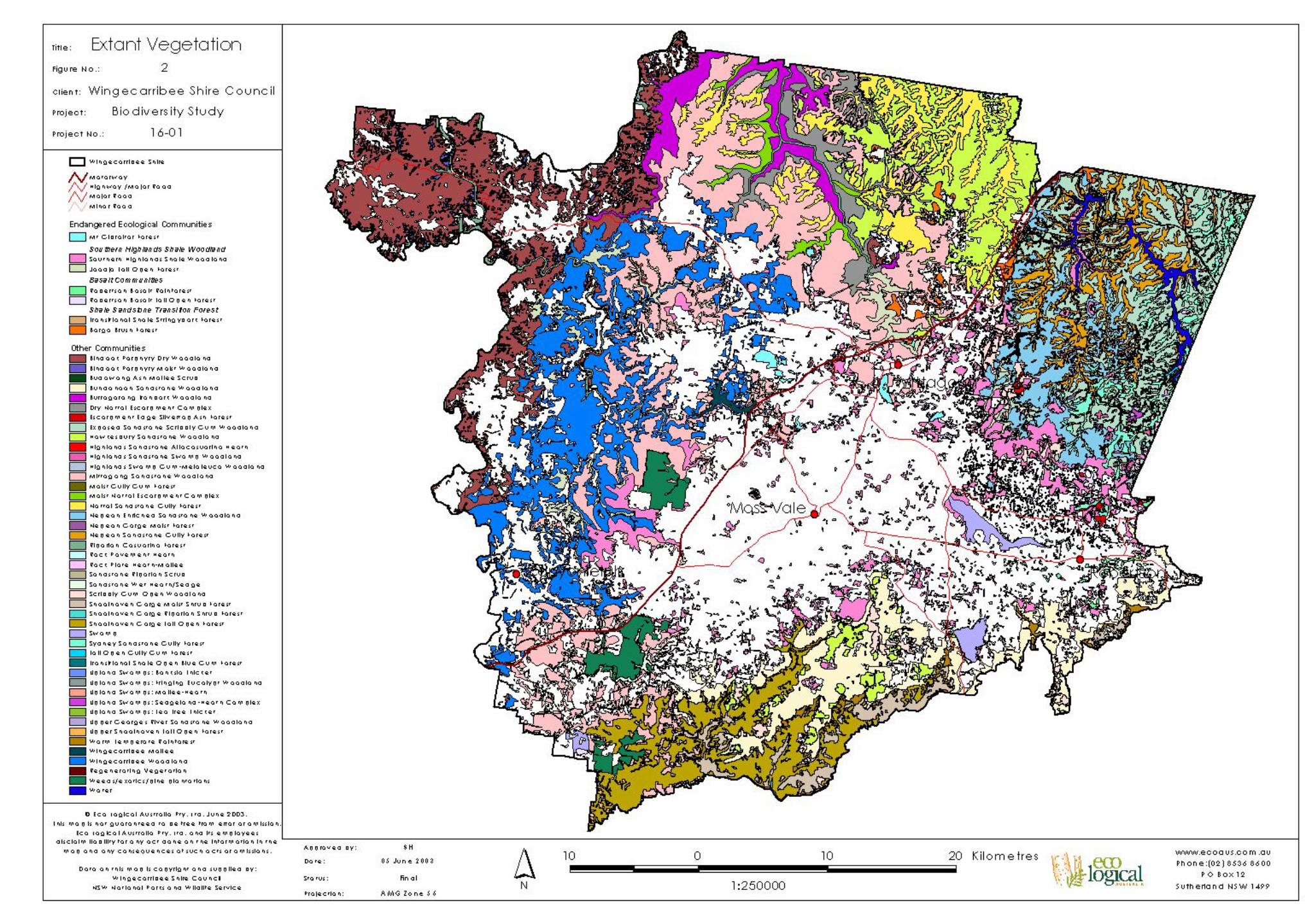
3.6 Discussion The Pre-1750 vegetation map was combined with the current vegetation presence/absence map to produce an extant vegetation community map. A total of 49 vegetation communities have been identified and mapped, including 5 Endangered Ecological Communities (EEC’s), listed under the Threatened Species Conservation Act, 1995;
�� Robertson Basalt Rainforest �� Robertson Basalt Tall Open Forest �� Southern Highlands Shale Woodland �� Mount Gibraltar Forest �� Shale/Sandstone Transition Forest
Based on similarly of floristic composition, Southern Highlands Shale Woodland has been divided into two sub-communities:
�� Southern Highlands Shale Woodland �� Joadja Tall Open Forest
Whilst Shale/Sandstone Transition Forest has been divided into the following two sub-communities by the NPWS (2002):
�� Transitional Shale Stringybark Forest �� Bargo Brush Forest
An additional 4 map units have been identified:
�� Water �� Mined Peat Swamp �� Regenerating Vegetation �� Weeds/exotics/pine plantations
All vegetation communities have been given a unique identifying code. Communities identified by the PATN analysis are coded 1 – 21. Communities mapped by the NPWS/SCA Woronora mapping (NPWS 2002) range from 604 – 648, the second 2 digits corresponding to those allocated by the NPWS. Communities 701 – 707 are from the Royal Botanic Gardens Burragorang 1 : 100 000 sheet (Fisher et. al., 1995), whilst map units 821 and 853 are from the Southern CRA mapping (NPWS 2000c). Detailed vegetation community descriptions are included as Appendix 1.
Eco Logical Australia Phone. (02) 8536 8600 9
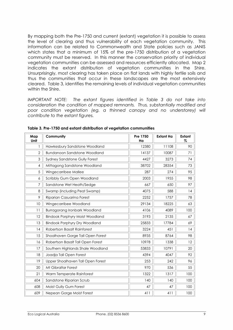
By mapping both the Pre-1750 and current (extant) vegetation it is possible to assess the level of clearing and thus vulnerability of each vegetation community. This information can be related to Commonwealth and State policies such as JANIS which states that a minimum of 15% of the pre-1750 distribution of a vegetation community must be reserved. In this manner the conservation priority of individual vegetation communities can be assessed and resources efficiently allocated. Map 2 indicates the extant distribution of vegetation communities in the Shire. Unsurprisingly, most clearing has taken place on flat lands with highly fertile soils and thus the communities that occur in these landscapes are the most extensively cleared. Table 3, identifies the remaining levels of individual vegetation communities within the Shire. IMPORTANT NOTE: The extant figures identified in Table 3 do not take into consideration the condition of mapped remnants. Thus, substantially modified and poor condition vegetation (eg. a thinned canopy and no understorey) will contribute to the extant figures. Table 3. Pre-1750 and extant distribution of vegetation communities
Map Unit
Community Pre 1750 Ha
Extant Ha Extant %
1 Hawkesbury Sandstone Woodland 12380 11108 90
2 Bundanoon Sandstone Woodland 14137 10087 71
3 Sydney Sandstone Gully Forest 4427 3273 74
4 Mittagong Sandstone Woodland 38702 28354 73
5 Wingecarribee Mallee 287 274 95
6 Scribbly Gum Open Woodland 2003 1955 98
7 Sandstone Wet Heath/Sedge 667 650 97
8 Swamp (including Peat Swamp) 4075 588 14
9 Riparian Casuarina Forest 2252 1757 78
10 Wingecarribee Woodland 29134 18225 63
11 Burragorang Ironbark Woodland 4106 4089 100
12 Bindook Porphyry Moist Woodland 3193 2135 67
13 Bindook Porphyry Dry Woodland 25833 17784 69
14 Robertson Basalt Rainforest 3224 451 14
15 Shoalhaven Gorge Tall Open Forest 8935 8764 98
16 Robertson Basalt Tall Open Forest 10978 1338 12
17 Southern Highlands Shale Woodland 53833 10791 20
18 Joadja Tall Open Forest 4394 4047 92
19 Upper Shoalhaven Tall Open Forest 253 242 96
20 Mt Gibraltar Forest 970 536 55
21 Warm Temperate Rainforest 1322 1317 100
604 Sandstone Riparian Scrub 140 140 100
608 Moist Gully Gum Forest 47 47 100
609 Nepean Gorge Moist Forest 411 411 100
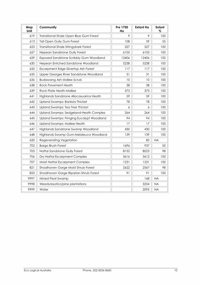
Eco Logical Australia Phone. (02) 8536 8600 10
Map Unit
Community Pre 1750 Ha
Extant Ha Extant %
619 Transitional Shale Open Blue Gum Forest 9 9 100
613 Tall Open Gully Gum Forest 108 59 55
623 Transitional Shale Stringybark Forest 327 327 100
627 Nepean Sandstone Gully Forest 6105 6105 100
629 Exposed Sandstone Scribbly Gum Woodland 12406 12406 100
630 Nepean Enriched Sandstone Woodland 5238 5238 100
632 Escarpment Edge Silvertop Ash Forest 117 117 100
635 Upper Georges River Sandstone Woodland 31 31 100
636 Budawang Ash Mallee Scrub 10 10 100
638 Rock Pavement Heath 38 38 100
639 Rock Plate Heath-Mallee 373 373 100
641 Highlands Sandstone Allocasuarina Heath 59 59 100
642 Upland Swamps: Banksia Thicket 78 78 100
643 Upland Swamps: Tea Tree Thicket 6 6 100
644 Upland Swamps: Sedgeland-Heath Complex 264 264 100
645 Upland Swamps: Fringing Eucalypt Woodland 94 94 100
646 Upland Swamps: Mallee-Heath 17 17 100
647 Highlands Sandstone Swamp Woodland 430 430 100
648 Highlands Swamp Gum-Melaleuca Woodland 139 139 100
650 Regenerating Vegetation 82 NA
702 Bargo Brush Forest 1696 937 55
703 Nattai Sandstone Gully Forest 8152 8023 98
706 Dry Nattai Escarpment Complex 3616 3612 100
707 Moist Nattai Escarpment Complex 1231 1231 100
821 Shoalhaven Gorge Moist Shrub Forest 2622 2567 98
853 Shoalhaven Gorge Riparian Shrub Forest 91 91 100
9997 Mined Peat Swamp 168 NA
9998 Weeds/exotics/pine plantations 3254 NA
9999 Water 2095 NA
Wingecarribee Biodiversity Strategy
Eco Logical Australia Phone. (02) 8536 8600 11
3.7 Vegetation Mapping Limitations Although this project has used the most up-to-date techniques and data available to produce both the pre-1750 and extant vegetation maps, there will always be degrees of error in the mapping and subsequent limitations in how it can be used. The identification of extant vegetation from digital orthorectified aerial photographs has reduced many of the errors associated with distortion and topographic variation traditionally encountered during aerial photo interpretation. Additionally, having used photos that were flown in 2001 reduces many of the potential temporal problems associated with using old or inconsistently dated photos. However, the data is limited by:
�� The accuracy of the aerial photographs �� Potential observer bias in identifying remnant vegetation. This has been
reduced by using a single observer to identify all vegetation and subsequent cross checking, thereby producing consistent information
�� Lack of information on vegetation condition. There has been no discrimination between good condition vegetation and vegetation that may only comprise canopy trees and an exotic or non-existent understorey
�� Mistaken identification of non-native vegetation. The photos used were at a scale of 1:40,000, making it difficult to discriminate between native remnants and exotic plantings
The modelling of vegetation communities is limited by:
�� Producing a map based on a limited sample of sites across a very large area. The result is reduced reliability in areas where sites are restricted (typically sandstone plateaus within protected tenures) and a greater mapping reliability in environments with a greater site density (the Basalt and Shale areas of the Southern Highlands)
�� Producing a pre1750 map based on extant vegetation. It is possible that some communities which existed prior to European settlement have been completely cleared and thus are not identified
�� The accuracy of other data used to base the model on, for example the resolution of the soils landscapes layer is 1:100 000
�� Defining a distinct linear boundary between vegetation communities when, on the ground, there is usually a gradual transition between communities
�� Extrapolating samples across areas that have not been surveyed It must be noted that comprehensive survey of every remnant of vegetation was not undertaken for this project. The mapping provides sufficient detail for strategic planning and assessment works, but cannot replace individual site inspection as part of the development assessment process. The community descriptions in this report (Appendix 1) contain information that will assist developers, consultants, Council and the public to identify vegetation communities in the field.
Eco Logical Australia Phone. (02) 8536 8600 12
4 Threatened Species Database A key component of this study is the production of a database of threatened species locations for inclusion into Council’s GIS. Data from the following databases were examined:
�� NPWS Atlas of NSW Wildlife
�� NPWS Systematic Vegetation Survey Database (YETI)
�� Royal Botanic Gardens
�� Australian Museum Records from these databases were readily available in digital format and importantly included map grid references for easy inclusion in a GIS. In conjunction with the audit of existing databases, hardcopy reports held by Council were reviewed and information on threatened species recorded into a tabular database. Flora and fauna records have been provided to Council as an Arcview Shapefile, suitable for inclusion in Council’s GIS. The current legal status (under the TSC Act) (eg. Threatened, Protected, Vulnerable) has also been included, although this status can change over time. It is recommended that this information is regularly reviewed and updated as required. The audit of existing information revealed a paucity of rare flora and fauna information within the Shire. Data has been collected in an ad-hoc manner with limited information on technique, spatial accuracy and the reliability of species identification. This problem is particularly prevalent for fauna data where it is clear that very limited survey work has been undertaken within the Shire. This lack of work combined with no clear standards for data recording resulted in the data audit program being limited in its effectiveness. This could be improved in the future through the adoption of flora and fauna assessment guidelines and the incorporation of resultant information into a central database such as the Atlas of NSW Wildlife. Of the databases assessed, there was significant overlap between the Atlas of NSW Wildlife and the RBG and Museum records as this information had been transferred between the databases previously. To avoid duplication only records from the Wildlife Atlas were used as they already contained the information available in the RBG and Museum databases. Additionally, the accuracy and currency of records was often poor. In many cases the accuracy was to within 1km or was a species list for an entire map sheet. Many of the records were historic species lists dating back to the late 1800s or early 1900s. Whilst such data paints a valuable historical picture of species distribution, its contemporary uses are limited.

Eco Logical Australia Phone. (02) 8536 8600 13
5 Flora and Fauna Habitat Models
5.1 Methods All flora and fauna species recorded were assessed in relation to legal status (under the TSC Act), regional significance, habitat preference, number of records and degree of vulnerability within the Shire. This produced a list of priority species for developing habitat models. This list was assessed by officers from the NPWS Southern Directorate Threatened Species Unit and their comments incorporated. Of all species identified as being of high priority, only Telopea mongaensis is not currently listed on the TSC Act. This species was included as Wingecarribee Shire is the northern limit of this species distribution. The project sought to use current statistical modelling techniques, in particular Generalised Additive Models (GAMs) to produce quantitative distributional maps of species habitat across the Shire. GAMs require a minimum of 10 positive observations and require data to be spread across the study area to reduce errors associated with spatial autocorrelation. However, due to a lack of appropriate data for the vast majority of species and spatial bias in the distribution of these records it was not possible to produce reliable models using this technique. Consequently qualitative expert models were prepared for priority species, with the exception of bats, where information was insufficient to prepare reliable models. These models identify species habitat associations, based on the habitat potential of different vegetation types. This information has been subject to peer review, in particular by NPWS Southern Directorate officers.
5.2 Results As little threatened species survey work has been undertaken within the Shire there was a limited amount of data upon which to base the development of habitat association models. However, the high quality descriptive information on vegetation communities produced by this project was sufficient to identify those communities likely to contain habitat for the species indicated in the table below. These habitat association models show the potential for the occurrence of a species and should be used to flag potential issues at a site and as the basis for targeted survey work. It must be highlighted that potential habitat is subject to a number of factors including condition, size and connectivity of a remnant. Consequently field survey should be undertaken with any development assessment process to validate the habitat models. With regards to fauna habitat, the nature of the models indicates that there is potential for the occurrence of at least 2 threatened species in every vegetation community. Dry Nattai Escarpment Forest has been identified as having potential habitat for as may as 15 of the fauna species listed below.
Eco Logical Australia Phone. (02) 8536 8600 14
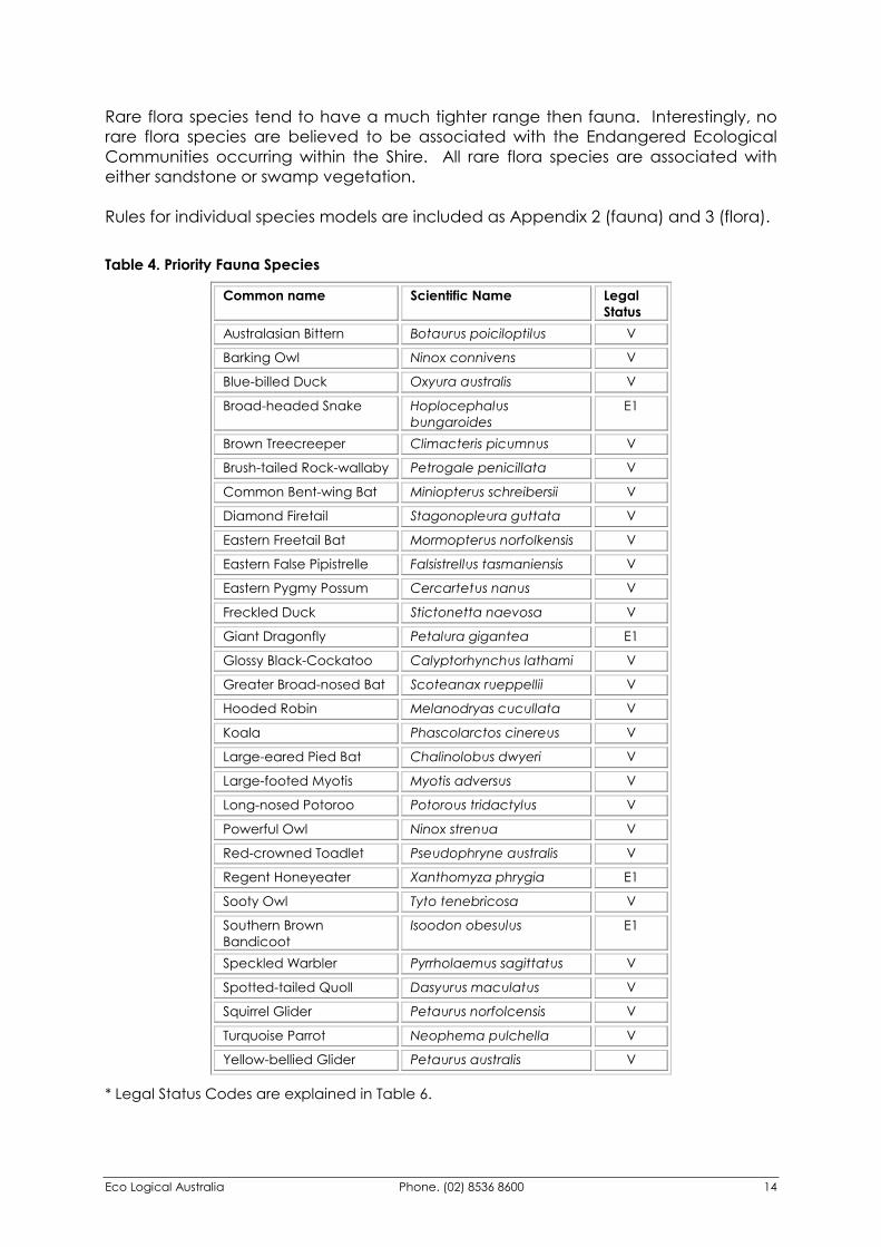
Rare flora species tend to have a much tighter range then fauna. Interestingly, no rare flora species are believed to be associated with the Endangered Ecological Communities occurring within the Shire. All rare flora species are associated with either sandstone or swamp vegetation. Rules for individual species models are included as Appendix 2 (fauna) and 3 (flora). Table 4. Priority Fauna Species
Common name Scientific Name Legal Status
Australasian Bittern Botaurus poiciloptilus V
Barking Owl Ninox connivens V
Blue-billed Duck Oxyura australis V
Broad-headed Snake Hoplocephalus bungaroides
E1
Brown Treecreeper Climacteris picumnus V
Brush-tailed Rock-wallaby Petrogale penicillata V
Common Bent-wing Bat Miniopterus schreibersii V
Diamond Firetail Stagonopleura guttata V
Eastern Freetail Bat Mormopterus norfolkensis V
Eastern False Pipistrelle Falsistrellus tasmaniensis V
Eastern Pygmy Possum Cercartetus nanus V
Freckled Duck Stictonetta naevosa V
Giant Dragonfly Petalura gigantea E1
Glossy Black-Cockatoo Calyptorhynchus lathami V
Greater Broad-nosed Bat Scoteanax rueppellii V
Hooded Robin Melanodryas cucullata V
Koala Phascolarctos cinereus V
Large-eared Pied Bat Chalinolobus dwyeri V
Large-footed Myotis Myotis adversus V
Long-nosed Potoroo Potorous tridactylus V
Powerful Owl Ninox strenua V
Red-crowned Toadlet Pseudophryne australis V
Regent Honeyeater Xanthomyza phrygia E1
Sooty Owl Tyto tenebricosa V
Southern Brown Bandicoot
Isoodon obesulus E1
Speckled Warbler Pyrrholaemus sagittatus V
Spotted-tailed Quoll Dasyurus maculatus V
Squirrel Glider Petaurus norfolcensis V
Turquoise Parrot Neophema pulchella V
Yellow-bellied Glider Petaurus australis V
* Legal Status Codes are explained in Table 6.
Eco Logical Australia Phone. (02) 8536 8600 15
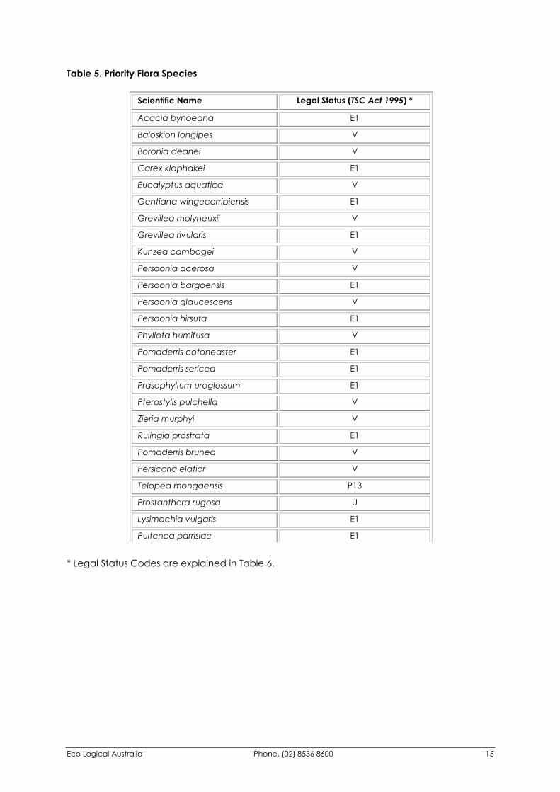
Table 5. Priority Flora Species
* Legal Status Codes are explained in Table 6.
Scientific Name Legal Status (TSC Act 1995) *
Acacia bynoeana E1
Baloskion longipes V
Boronia deanei V
Carex klaphakei E1
Eucalyptus aquatica V
Gentiana wingecarribiensis E1
Grevillea molyneuxii V
Grevillea rivularis E1
Kunzea cambagei V
Persoonia acerosa V
Persoonia bargoensis E1
Persoonia glaucescens V
Persoonia hirsuta E1
Phyllota humifusa V
Pomaderris cotoneaster E1
Pomaderris sericea E1
Prasophyllum uroglossum E1
Pterostylis pulchella V
Zieria murphyi V
Rulingia prostrata E1
Pomaderris brunea V
Persicaria elatior V
Telopea mongaensis P13
Prostanthera rugosa U
Lysimachia vulgaris E1
Pultenea parrisiae E1
Eco Logical Australia Phone. (02) 8536 8600 16
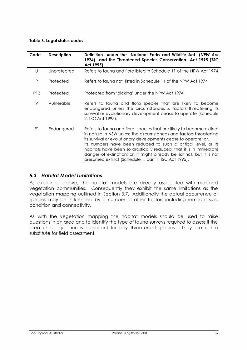
Table 6. Legal status codes
Code Description Definition under the National Parks and Wildlife Act (NPW Act
1974) and the Threatened Species Conservation Act 1995 (TSC Act 1995)
U Unprotected Refers to fauna and flora listed in Schedule 11 of the NPW Act 1974
P Protected Refers to fauna not listed in Schedule 11 of the NPW Act 1974
P13 Protected Protected from ‘picking’ under the NPW Act 1974
V Vulnerable Refers to fauna and flora species that are likely to become endangered unless the circumstances & factors threatening its survival or evolutionary development cease to operate (Schedule 2, TSC Act 1995).
E1 Endangered Refers to fauna and flora species that are likely to become extinct in nature in NSW unless the circumstances and factors threatening its survival or evolutionary developments cease to operate; or, Its numbers have been reduced to such a critical level, or its habitats have been so drastically reduced, that it is in immediate danger of extinction; or, it might already be extinct, but it is not presumed extinct (Schedule 1, part 1, TSC Act 1995).
5.3 Habitat Model Limitations As explained above, the habitat models are directly associated with mapped vegetation communities. Consequently they exhibit the same limitations as the vegetation mapping outlined in Section 3.7. Additionally the actual occurrence of species may be influenced by a number of other factors including remnant size, condition and connectivity. As with the vegetation mapping the habitat models should be used to raise questions in an area and to identify the type of fauna surveys required to assess if the area under question is significant for any threatened species. They are not a substitute for field assessment.
Eco Logical Australia Phone. (02) 8536 8600 17
6 Conservation Assessment There have been a number of projects undertaken at national, state, regional and local levels that have assessed biodiversity conservation values with a view to identifying conservation priorities. Such information can be useful in setting goals or targets for conservation and can provide context to landuse planning decisions as well as providing an indication of areas that should be targeted for management or rehabilitation.
6.1 Policy Framework for Conservation Assessment There are many documents and policies that refer to principles and objectives for biodiversity management but few have set concrete measurable targets. The relevant Commonwealth and State frameworks for the development of biodiversity conservation targets are outlined below. Wingecarribee Council should, as a minimum, adopt the targets identified in the Commonwealth and State frameworks. Commonwealth In June 2001 Environment Australia published a comprehensive set of ‘National Objectives and Targets for Biodiversity Conservation’ that were endorsed by State and Territory Governments. Of particular note for Wingecarribee Shire are the targets provided for native vegetation and terrestrial ecosystems. These state that by 2003 Australia will have:
“Clearing controls in place that prevent clearance of ecological communities with an extant below 30% of that present pre-1750”, and “Native vegetation restoration programs to recover ecological communities that are below 10% of that present pre-1750 or are nationally listed as critically endangered”.
The Commonwealth Government, in their National Forest Policy Statement (NFPS), provides an undertaking to manage Australia’s forests to conserve biological diversity. In order to achieve this it was agreed that a comprehensive, adequate and representative reserve (CAR) system be created (JANIS). Relevant numerical targets for a CAR system include in reserves: �� 15% of pre-1750 distribution of forest ecosystems; �� at least 60% of vulnerable ecosystems, and; �� 100% of rare and endangered forest ecosystems. A vulnerable ecosystem is defined as one “approaching a reduction in spatial extent of 70% within a bioregional context and which remains subject to threatening processes; or not depleted but subject to continuing and significant threatening processes which may reduce its extent”.
Eco Logical Australia Phone. (02) 8536 8600 18
A rare ecosystem is defined as having: �� a total range generally less that 10,000 hectares, �� a total area of generally less than 1,000 hectares, or �� patch sizes of generally less than 100 hectares (where such patches do not
aggregate to form significant areas). An endangered ecosystem is described as one where: �� its distribution has contracted to less than 10% of the pre-1750 distribution (former
range), �� the total area has contracted to less than 10% of its former area, or �� 90% of its area is in small patches which are subject to threatening processes and
unlikely to persist. Other criteria raised in the JANIS process that could be considered relevant to this project include: �� Reserved areas should be representative of the entire geographic range. �� Maximise the area of high quality habitat for all known elements of biodiversity. �� Reserves should be large enough to sustain the viability, quality and integrity of
populations. �� Sample the full range of biological variation within each forest ecosystem. �� In fragmented landscapes, remnants that contribute to sampling the full range of
biodiversity are vital parts of a forest reserve system. The NFPS recognises the need to promote the management of forests on private land to meet the conservation goals. It is important to stress that its focus is on forests and not other communities such as heath, grassland, wetlands etc. State The principles of a CAR system have been endorsed at both the Commonwealth and State level. The NSW Biodiversity Strategy provides a considerable list of ‘strategic goals’, ‘core objectives’, principles and targets which can be used to establish a framework for biodiversity conservation. The recent government initiative, ‘Plan First’ aims to provide opportunities to consolidate many regional plans and strategies to provide a single instrument. Areas identified through a targeted regional conservation assessment process may be identified in a revised regional instrument. The NSW Threatened Species Conservation Act, 1995 (TSC Act) contains provisions for the preparation of Recovery Plans for threatened species, endangered populations and endangered ecological communities. Recovery plans may develop specific numerical targets. The NPWS Southern Directorate Office is currently producing recovery plans for the endangered ecological communities found within Wingecarribee Shire. The Native Vegetation Conservation Act, 1997 (NVC Act) provides for the development of Regional Vegetation Management Plans (RVMPs). The process may
Eco Logical Australia Phone. (02) 8536 8600 19
incorporate targets in the conservation assessment and specify clearing controls for various categories of land in the instrument, eg. Lands of high environmental significance. There are a wide range of other documents and instruments (plans, strategies and reports) available to Council that can assist in biodiversity conservation. These include Catchment Management Plans, Regional Environment Plans (REPs), State Environmental Planning Policies (SEPPs), Local Environment Plans (LEPs), Development Control Plans (DCPs), State of Environment Reports and community land Plans of Management. The habitat values within Wingecarribee Shire have been assessed using principles adopted by the Western Sydney Recovery Plan (NPWS, in prep.). This process seeks to identify:
�� areas of core habitat;
�� areas that play an important role in supporting core habitat;
�� areas that play a role in connecting habitat, and;
�� areas that have reduced biodiversity value. In a planning sense this information can be used to identify the level of assessment required for developments, to identify priority areas for conservation works and to identify options for innovative planning mechanisms. Such options and mechanisms include tradeable development rights and offsets as well as identifying key “no go” areas where removal of vegetation is likely to result in a significant reduction in biodiversity.
6.2 Assessing the Conservation Values of Wingecarribee Shire A key component of this project is to assess the conservation values of remaining vegetation within the Shire. This has been undertaken by:
�� Ranking vegetation communities in a manner consistent with current National policy, and;
�� Applying the Western Sydney Recovery Plan (NPWS in prep.) principles to identify the conservation value of individual remnants
1. Conservation status of vegetation communities Vegetation communities have been classified according to JANIS policy as:
�� Vulnerable,
�� Rare,
�� Endangered, or
�� Other. 2. Conservation status of remnant vegetation This section of the assessment identifies the conservation value of each vegetation remnant, based on the community present, the size and connectivity to other
Eco Logical Australia Phone. (02) 8536 8600 20
remnants. It is based on the principles used in the Western Sydney Recovery Plan (NPWS, in prep.) and adjusted to take into consideration the lack of vegetation condition information for Wingecarribee Shire. The decision rules for the process are outlined below. Core Habitat
�� Remnants > 10 hectares
�� Endangered ecosystems (JANIS Definition) Core Support All remnants less than 10 hectares in size are categorised as core support. However, it is appropriate to rank this remaining vegetation as there is considerable variation in conservation value. This has been undertaken through examining the vegetation community present, size and connectivity of the remnant. Four categories of core support have been identified:
�� High �� Moderate �� Medium �� Low
The basis for inclusion in one of these categories is identified in the matrix below. Additionally, all remnants, regardless of size or connectivity, containing rare or vulnerable communities as identified by JANIS have been classified as ‘high’ value.
Size < 2 ha 2-6 ha 6-10 ha 0-500m Medium Moderate High
Connectivity 500 - 1.0km Low Moderate High 1.0 -1.5km Low Medium Moderate > 1.5 km Low Medium Medium
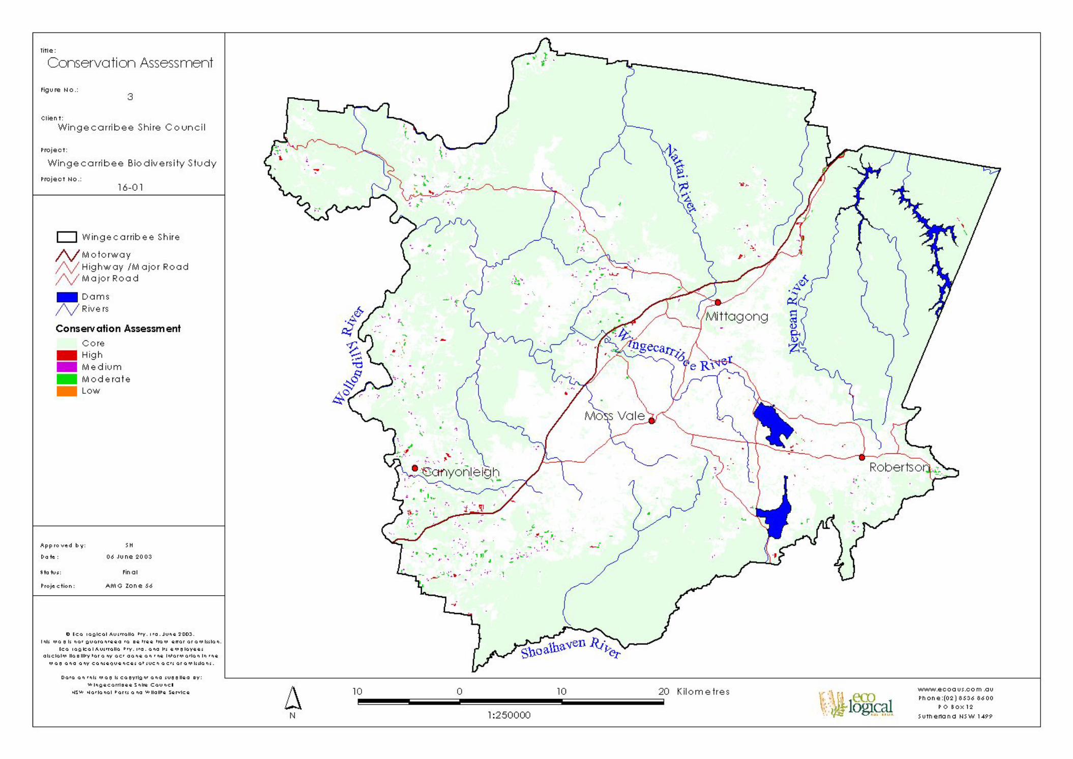
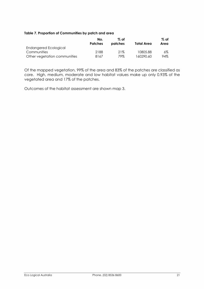
6.3 Results of Conservation Assessment Some 63.6% of the Shire is presently vegetated. The main vegetation communities present are Mittagong Sandstone Woodland, Hawkesbury Sandstone Woodland, Wingecarribee Woodland and Bindook Porphyry Dry Woodland and communities of the Woronora Plateau. These communities account for over half of the remnant vegetation in the Shire and cover more than a third of the Shire. The five Endangered Ecological Communities found in the Shire are Mt Gibraltar Forest, Robertson Basalt Rainforest, Robertson Basalt Tall Open Forest, Southern Highlands Shale Woodland and Shale/Sandstone Transition Forest. Between them they cover nearly 11,000 hectares. However, they are highly fragmented, making up 21% of the vegetation patches but only 6% of the area of the Shire, as shown in Table 7.
Eco Logical Australia Phone. (02) 8536 8600 21
Table 7. Proportion of Communities by patch and area
No.
Patches% of
patches Total Area % of
Area Endangered Ecological Communities 2188 21% 10805.88 6% Other vegetation communities 8167 79% 160290.60 94%
Of the mapped vegetation, 99% of the area and 83% of the patches are classified as core. High, medium, moderate and low habitat values make up only 0.93% of the vegetated area and 17% of the patches. Outcomes of the habitat assessment are shown map 3.
Eco Logical Australia Phone. (02) 8536 8600 22
7 Habitat Corridors Corridors are landscape features that connect two or more large patches, allowing movement and gene-flow among native flora and fauna, thereby contributing to maintenance of biodiversity. Increased size of habitat area enhances available resources and allows more ecosystem niches and may support more species and larger populations. Corridors may range in structure from remnant patches of intact vegetation to standing remnant canopy. Animals often rely upon corridors because they have an obligate relationship with natural vegetation and cannot move through inhospitable degraded environments. Partial linking of large habitat patches can also occur through ‘stepping stones’ of habitat, which can facilitate movement of more mobile species. Stepping stone linkages occur where a number of remnants are closely located providing a pathway between two or more larger remnants. Corridor provision is a very important component of biodiversity enhancement. Corridors promote opportunities for species movement and long-term viability in an urban or rural bushland setting. There is also more chance of species surviving events that might otherwise lead to local extinction, such as land clearing, wildfires, fluctuating food supply, changes in birth and death rates, or human-induced habitat changes. If an event causes local extinction or reduction of the population, complete or partial (stepping stone) connectivity of patches will facilitate replenishment and re-establishment of the species. Connections between fragmented habitats can also allow for restoration of the heterogeneity that was present in the landscape but which has been lost from small, isolated fragments. The establishment of corridors and the reduced isolation of habitat patches are hence crucial to successful long-term management of remnant bushland. The process whereby plant and animal species gain access to areas of suitable habitat through corridors can be referred to as corridor movement. Corridor movement is important because it allows species to range through different areas. This encourages diversity and sustainability within ecosystems. Small remnants of bushland are difficult to manage in a landscape where the bushland is exposed along its edges to other land uses. Remnant size can be assessed in relation to the “edge to area” ratio, and it is best to minimise this so that there is less edge habitat and more quality core habitat available for flora and fauna. Linking adjacent remnants with corridors can increase the effective size of remnants. Furthermore, broad short corridors will themselves have a lower edge to area ratio than narrow, long corridors, and will hence be more effective in facilitating corridor movement. The design of corridors should be dependant upon which species the corridor aims to assist, otherwise it could fail to achieve its goals. For example small birds may prefer a corridor dominated by shrub species whereas larger birds may prefer canopy species.
Eco Logical Australia Phone. (02) 8536 8600 23
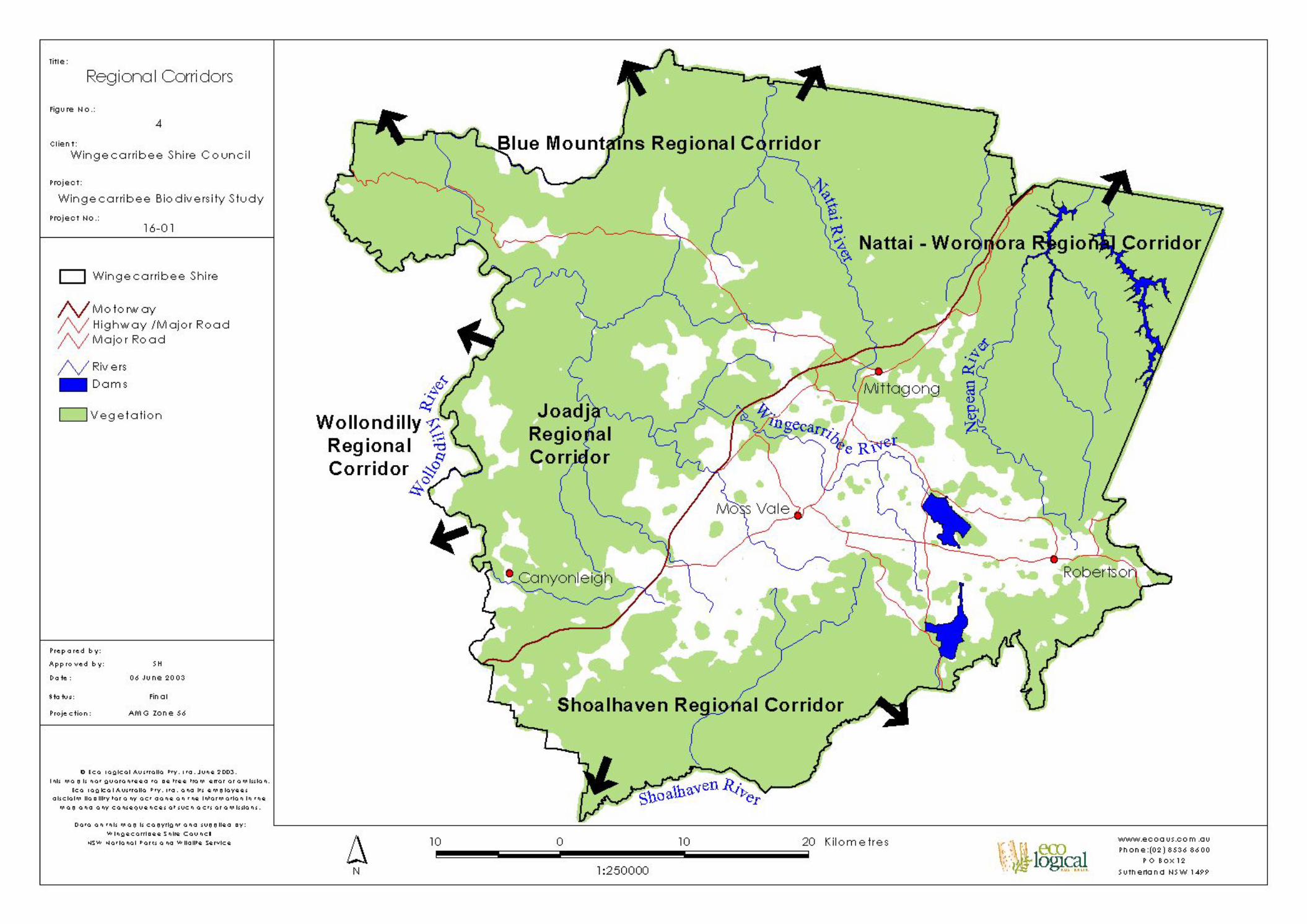
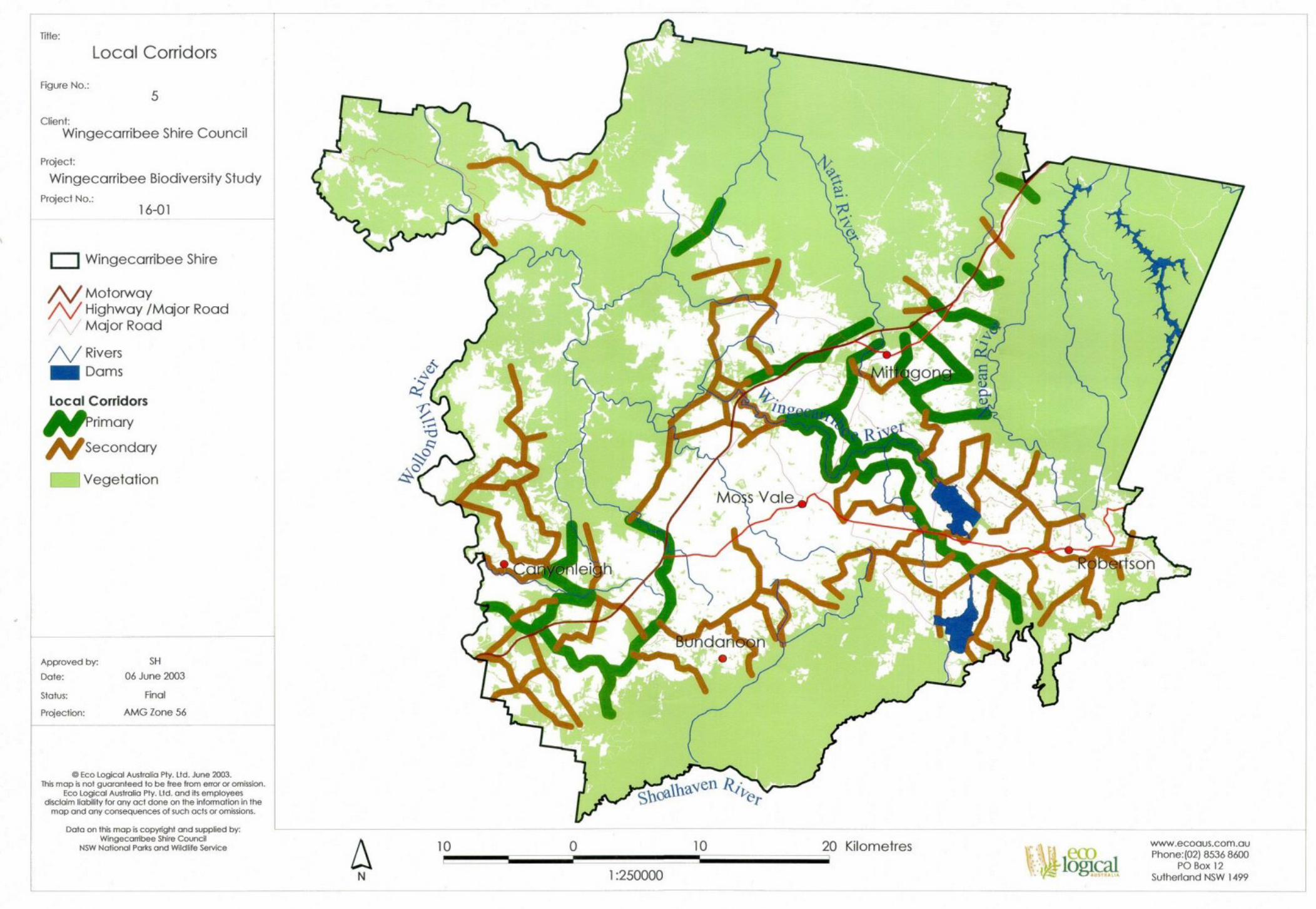
7.1 Mapping Corridors within Wingecarribee Shire There are a range of available styles and approaches to map corridors within Wingecarribee Shire. The chosen approach gives preference to corridors through higher quality vegetation, even if they are longer. The rationale being that areas of good condition vegetation provide little impediment to the movement of species whereas substantially cleared areas provide significant barriers to movement. This analysis was undertaken within the Arcview GIS using the ‘cost distance’ and ‘least cost path’ algorithms. The output is a map indicating the relative ease for fauna movement across the Shire. This information has then been used to produce the ‘stylised’ corridor system shown in Figure 4. Additionally the following important regional corridors have been identified:
�� Nattai – Woronora �� Blue Mountains �� Wollondilly �� Joadja �� Shoalhaven
These corridors play an important role in linking large areas of contiguous vegetation and are of particular importance to migratory and nomadic species and during times where environmental pressures (eg. drought, fire) prompt the movement of species. Generally they represent extensive areas of vegetation that have not been subject to disturbances such as clearing or grazing. The stylised corridor system is a more localised version of corridors and identifies important small scale links. Such links can have a pronounced influence on the effectiveness of regional corridors as they often occur in heavily fragmented country or operate as stepping stones between regional corridors. These local corridors have been classified as either primary or secondary in order to focus conservation works so as to maximise the benefits to biodiversity (see chapter 8). Additionally, the condition of these corridors varies. In some cases a corridor may be a linear feature following a creek line, ridge top or significant roadside verge. In other cases a corridor may be composed of a series of stepping stones that are not directly linked. In such cases rehabilitation or regeneration of bushland to provide linkage between these stepping stones must be seen as a high priority. The location of regional corridors within Wingecarribee Shire is indicated by Map 4. Map 5 indicates the location of local corridors.
Eco Logical Australia Phone. (02) 8536 8600 24
8 Prioritisation of Conservation Works Wingecarribee Shire is faced with many challenges to maintain and enhance the biodiversity of its unique environs. As is generally the case with environmental initiatives, there is an insufficient level of funding to undertake all conservation works at the one time. Consequently, it is necessary to prioritise works based on cost-benefit principles. This involves assessment of the key conservation values within the Shire and identification of areas where maximum benefits can be achieved at minimal cost. Additionally, the implementation of biodiversity conservation works will have considerable influences on other components of the environment including:
�� Improved water quality �� Soil stability and maintenance of soils processes �� Reducing salinity threats �� Wind breaks �� Reduction of greenhouse gases �� Improving visual amenity �� Recreation and educational opportunities
The format of this chapter of the study includes two distinct, yet complimentary components:
�� Principles for undertaking biodiversity conservation works �� Priority areas for implementing biodiversity conservation works
8.1 Principles for Undertaking Biodiversity Conservation Works To maximise biodiversity conservation benefits, consideration should be given to the following:
�� When carrying out rehabilitation or regeneration works, use species that are consistent with vegetation communities that would have existed prior to clearing – these can be identified from pre-1750 vegetation mapping and the vegetation community profiles in Appendix 1
�� Ensuring that a variety of species are used including trees, shrubs, grasses and groundcovers
�� Using locally sourced native plant species – species that are genetically adapted to Southern Highlands conditions and that would benefit local native fauna
�� Consideration should be given to establishing a community nursery or contracting local nurseries to harvest local seed and propagate local plants. Use of non-local plant stock should be avoided
�� Focusing on augmenting, buffering or connecting existing bushland rather than revegetation in historically cleared areas – there is a greater chance of a native seed bank existing and of increasing the viability of existing vegetation
Eco Logical Australia Phone. (02) 8536 8600 25
�� Fencing of key remnants, particularly Endangered Ecological Communities in rural areas
�� The establishment and support of new and existing Bushcare and Landcare groups
�� The use of trained bush regeneration supervisors with such groups
�� The encouragement of landholder and community participation in biodiversity conservation works
�� The identification of landholders that are amenable to undertaking revegetation works on their property
�� Implementation of a landholder incentive scheme such as rate relief for landholders undertaking biodiversity conservation works
�� Maximising the links at State and Federal Government levels, in particular the NPWS through their recovery plans and DLWC through Regional Vegetation Management Plans (RVMPs)
�� Identifying and applying for external grants and funding
�� Monitoring performance
�� Research of conservation works
8.2 Priority Areas for Implementing Biodiversity Conservation Works The main priority areas for biodiversity conservation works are those associated with the heavily cleared basalt and shale areas of the Southern Highlands. This region was once predominantly covered by vegetation communities that are now listed as Endangered Ecological Communities (EECs) under the TSC Act. These communities are at risk of extinction as they have been so extensively cleared that remaining vegetation remnants may be too small to be viable in the long term, are heavily fragmented or isolated or are at risk of further reduction in their extent through continued clearing. Additionally, the bulk of land that once supported these vegetation communities is under private ownership and is used for either agricultural or residential purposes. A well directed landholder survey is seen as paramount to the success of biodiversity conservation works. As key areas are generally under private ownership, considerable community support will be required to achieve effective biodiversity conservation works. It is recommended that a study be conducted in key areas to identify landholders interested in undertaking biodiversity conservation works on their property. In conjunction with this, a range of incentives including provision of expertise and support should be introduced. Financial incentives are likely to significantly increase the level of interest in private land biodiversity conservation and should be seriously considered. Additionally, there are a number of landholdings that are owned by Council or other government agencies. These areas represent the simplest locations for initiation of biodiversity conservation works, and action should be undertaken immediately where the locations are consistent with priority areas.
Eco Logical Australia Phone. (02) 8536 8600 26
Key areas that have been identified as potential areas for Endangered Ecological Community restoration and that and would increase habitat connectivity include:
�� Wingecarribee River downstream from Wingecarribee Reservoir �� Cockatoo Hill – Gibbergunyah Creek to Nattai River. An extensive corridor
that would provide both north-south and east-west movement and could be undertaken in a number of stages
�� Nattai – Woronora Corridors. A major fauna movement area with significant barriers formed by clearing and the Southern Freeway
�� High Range Corridor. Only one corridor has been marked, ideally two corridors could be constructed either side of the cleared High Range area
�� Joadja – Nattai. An eastern version of the High Range Corridor will have the additional benefit of linking EEC remnants
�� Robertson Corridor. An important corridor linking the EECs of the Robertson area. Currently composed of a series of island remnants, this corridor would benefit from buffering and linking remnants
�� Canyonleigh – Penrose Corridors. This area is a major north-south fauna corridor; however some significant barriers to fauna movement have been constructed near the Hume Highway and Canyonleigh Road. Further clearing in this area should be avoided and the impacts of fauna movement barriers ameliorated
Generally, any revegetation works undertaken on the extensively cleared Highlands are likely to benefit biodiversity in the long term. However the greatest short term benefits will be through consolidating or buffering existing areas of value by either increasing the area of vegetation, the quality of the vegetation (fencing and weed removal) or the connectivity of the vegetation (revegetation in identified corridor areas). Priorities for conservation works are identified in Map 6. Additionally there are a number of projects being undertaken by State Government agencies that could augment any works being undertaken by Council. These include:
�� Sydney Catchment Authority – currently undertaking Strategic Land and Water Capability Assessments. Regional Action Plans identifying on ground management practices should be developed following the Assessments. It is likely that the SCA would be amenable to a catchment based approach or the buffering of riparian areas, particularly where there is a tangible link between works and the quality of drinking water catchments.
�� The NPWS (Southern Directorate) – currently preparing recovery plans for the Endangered Ecological Communities of the Southern Highlands. It is likely that there will be recommendations for revegetation. Specific target areas may be identified and State Government support may be available.
�� The Department of Land and Water Conservation – are required to prepare Regional Vegetation Management Plans (RVMPs). Under the Native Vegetation Conservation Act these will outline permissible clearing and set targets for protection and retention of vegetation. They may also include targets for revegetation of critical communities.

Eco Logical Australia Phone. (02) 8536 8600 27
9 Glossary CAR Comprehensive, Adequate and Representative reserve system
CRA Comprehensive Regional Assessment. Forestry assessments undertaken by State and Federal Governments to develop Regional Forestry Agreements (RFAs)
DCP Development Control Plan
DLWC New South Wales Department of Land and Water Conservation
EEC Endangered Ecological Community listed under the NSW TSC Act
EPBC Act Commonwealth Environment Protection and Biodiversity Conservation Act, 1999
ESD Ecologically Sustainable Development
Extant Remaining vegetation
GAM Generalised Additive Model – Statistical application for distribution modelling
GIS Geographic Information System
JANIS A report by the Joint ANZECC / MCFFA National Forest Policy Statement Implementation Sub-committee
LEP Local Environment Plan
NFPS National Forest Policy Statement
NPWS New South Wales National Parks and Wildlife Service
NVC Act NSW Native Vegetation Conservation Act, 1997. Administered by DLWC
P5MA Priority 5 Management Area. Part of the DLWC state-wide vegetation mapping project. The priority 5 area covers the NSW South Coast and Southern Highlands
Pre1750 Nominal date for measuring vegetation distribution prior to European settlements
RBG New South Wales Royal Botanic Gardens
REP Regional Environment Plan
RVMP Regional Vegetation Management Plan. Prepared and administered by DLWC
SCA Sydney Catchment Authority
SEPP State Environmental Planning Policy
TSC Act NSW Threatened Species Conservation Act, 1995
WOFE “Wingecarribee Our Future Environment” Program
Eco Logical Australia Phone. (02) 8536 8600 28
10 References Belbin, L. (1994) PATN Pattern Analysis Package. CSIRO Canberra Fisher, M., Ryan, K. & Lembit, R. (1995) The natural vegetation of the Burragorang 1:100 000 map sheet. Cunninghamia 4(2): 143-215 (includes 1:100 000 map) # Hawkesbury-Nepean Catchment Studies- Draft Explanatory Notes for the Wollongong 1:100 000 Vegetation Map Sheet. Ecology Section, Royal Botanic Gardens, Sydney Keith, D.A. & Bedward, M. (1999) Native Vegetation of the South East Forests region, Eden, New South Wales. Cunninghamia 6(1):1-218 NPWS (2000a) The Native Vegetation of the Cumberland Plain, Western Sydney – Technical Report. NPWS, Hurstville NPWS (2000b) Vegetation Survey, Classification and Mapping for the Lower Hunter and Central Coast Region. A project undertaken for the Lower Hunter and Central Coast Regional Environmental Strategy, Version 1.2. NPWS (2000c) Forest Ecosystem Classification and Mapping for the Southern CRA Region: A report undertaken for the NSW CRA/RFA Steering Committee. Project Number NS08EH NPWS 2002. Native Vegetation of the Woronora, O’Hare’s and Metropolitan Catchments. NPWS in prep. Western Sydney Recovery Plan Royal Botanic Gardens unpub. Native Vegetation of the Wollongong 1: 100 000 map sheet. Unpublished draft mapping.
Eco Logical Australia Phone. (02) 8536 8600 29
Appendix 1 – Vegetation Community Profiles Profiles for individual vegetation communities have been prepared for all communities identified through the PATN analysis and mapped by Eco Logical Australia. Additionally, those communities that have been mapped through other projects, notably the Woronora Vegetation Mapping project undertaken jointly by the NPWS and SCA and the Southern CRA Vegetation Mapping project have been included. An explanation of some of the terms used follows: Sites: eg., AVN08, BRG03 These are the unique site codes allocated for each systematic survey site. A variety of standards have been implemented by the different survey projects that have taken place. Some examples are as follows:
AVN07 – AVN relates to the Avon Catchment Survey undertaken by the SCA. 07 is the seventh site in this survey MITT01 – MITT relates to the Mittagong 1 : 100 000 survey sheet. These surveys were undertaken by the Royal Botanic Gardens. 01 is the first site in this survey Bun001hq – This is the coding used by the Wingecarribee and P5MA surveys. The first three letters relate to the 1 : 25 000 map sheet that this survey occurred on (in this case ‘Bundanoon). 001 is the first site on this map sheet. The last letter relate to the substrate at the site: hq = high quartz sedimentary lq = low quartz sedimentary b = basalt a = alluvium
Diagnostic Species:
Stratum The layer or stratum in which the species is most likely to occur
Scientific Name Species scientific name
Group score Average presence or absence of the species in the community
Group frequency The frequency of recordings for surveys sites undertaken within the community
Non-group score Average presence of absence of the species in all other communities
Non-group frequencyThe frequency of recordings for survey sites undertaken in all other communities
Fidelity Class The contribution the species makes towards delineating the community
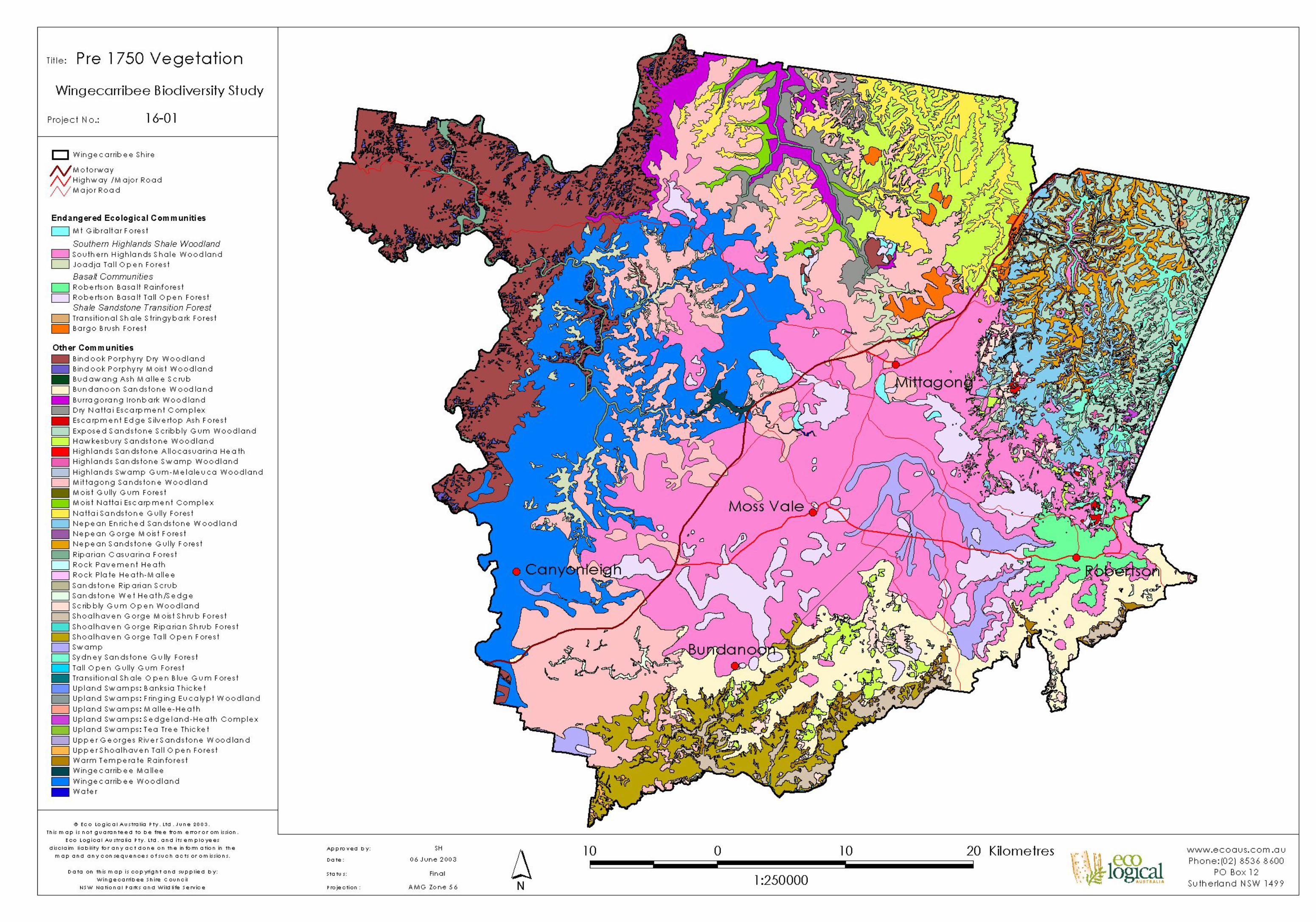
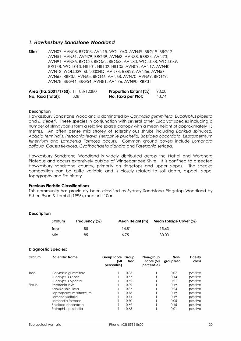
Eco Logical Australia Phone. (02) 8536 8600 30
1. Hawkesbury Sandstone Woodland
Sites: AVN07, AVN08, BRG03, AVN15, WOLL040, AVN49, BRG19, BRG17, AVN51, AVN61, AVN79, BRG39, AVN63, AVN88, RBR34, AVN73, AVN91, AVN85, BRG40, BRG52, BRG53, AVN80, WOLL038, WOLL039, BRG48, WOLL013, HILL01, HILL02, HILL05, AVN09, AVN17, AVN40, AVN13, WOLL029, BUN030HQ, AVN74, RBR29, AVN56, AVN57, AVN67, RBR37, AVN65, BRG46, AVN68, AVN70, AVN69, BRG49, AVN78, BRG44, BRG54, AVN81, AVN76, AVN90, RBR31 Area (ha, 2001/1750): 11108/12380 Proportion Extant (%) 90.00 No. Taxa (total): 328 No. Taxa per Plot: 43.74 Description Hawkesbury Sandstone Woodland is dominated by Corymbia gummifera, Eucalyptus piperita and E. sieberi. These species in conjunction with several other Eucalypt species including a number of stringybarks form a relative sparse canopy with a mean height of approximately 15 metres. An often dense mid strorey of sclerohyllous shrubs including Banksia spinulosa, Acacia terminalis, Persoonia leavis, Petrophile pulchella, Bossiaea obcordata, Leptospermum trinervium and Lambertia Formosa occurs. Common ground covers include Lomandra obliqua, Caustis flexuosa, Cyathochaeta diandra and Patersonia sericea. Hawkesbury Sandstone Woodland is widely distributed across the Nattai and Woronora Plateaus and occurs extensively outside of Wingecarribee Shire. It is confined to dissected Hawkesbury sandstone country, primarily on ridgetops and upper slopes. The species composition can be quite variable and is closely related to soil depth, aspect, slope, topography and fire history. Previous Floristic Classifications This community has previously been classified as Sydney Sandstone Ridgetop Woodland by Fisher, Ryan & Lembit (1995), map unit 10ar.
Description
Stratum Frequency (%) Mean Height (m) Mean Foliage Cover (%) Tree 85 14.81 15.63 Mid 85 6.75 30.00
Diagnostic Species: Stratum Scientific Name Group score Group Non-group Non- Fidelity (50 freq score (50 group freq class percentile) percentile)
Tree Corymbia gummifera 1 0.85 1 0.07 positive Eucalyptus sieberi 1 0.57 1 0.14 positive Eucalyptus piperita 1 0.52 1 0.21 positive Shrub Persoonia levis 1 0.89 1 0.19 positive Banksia spinulosa 1 0.87 1 0.24 positive Leptospermum trinervium 1 0.78 1 0.19 positive Lomatia silaifolia 1 0.74 1 0.19 positive Lambertia formosa 1 0.70 1 0.05 positive Bossiaea obcordata 1 0.69 1 0.15 positive Petrophile pulchella 1 0.65 1 0.01 positive
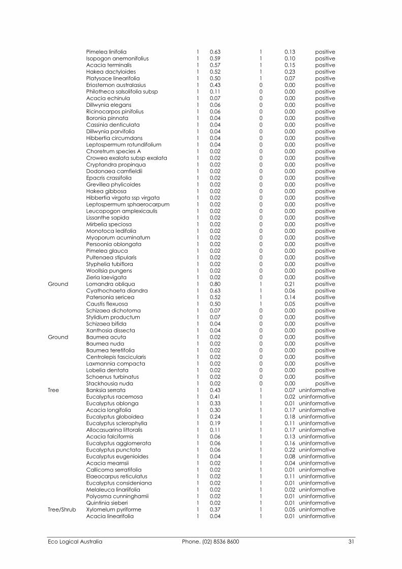
Eco Logical Australia Phone. (02) 8536 8600 31
Pimelea linifolia 1 0.63 1 0.13 positive Isopogon anemonifolius 1 0.59 1 0.10 positive Acacia terminalis 1 0.57 1 0.15 positive Hakea dactyloides 1 0.52 1 0.23 positive Platysace linearifolia 1 0.50 1 0.07 positive Eriostemon australasius 1 0.43 0 0.00 positive Philotheca salsolifolia subsp 1 0.11 0 0.00 positive Acacia echinula 1 0.07 0 0.00 positive Dillwynia elegans 1 0.06 0 0.00 positive Ricinocarpos pinifolius 1 0.06 0 0.00 positive Boronia pinnata 1 0.04 0 0.00 positive Cassinia denticulata 1 0.04 0 0.00 positive Dillwynia parvifolia 1 0.04 0 0.00 positive Hibbertia circumdans 1 0.04 0 0.00 positive Leptospermum rotundifolium 1 0.04 0 0.00 positive Choretrum species A 1 0.02 0 0.00 positive Crowea exalata subsp exalata 1 0.02 0 0.00 positive Cryptandra propinqua 1 0.02 0 0.00 positive Dodonaea camfieldii 1 0.02 0 0.00 positive Epacris crassifolia 1 0.02 0 0.00 positive Grevillea phylicoides 1 0.02 0 0.00 positive Hakea gibbosa 1 0.02 0 0.00 positive Hibbertia virgata ssp virgata 1 0.02 0 0.00 positive Leptospermum sphaerocarpum 1 0.02 0 0.00 positive Leucopogon amplexicaulis 1 0.02 0 0.00 positive Lissanthe sapida 1 0.02 0 0.00 positive Mirbelia speciosa 1 0.02 0 0.00 positive Monotoca ledifolia 1 0.02 0 0.00 positive Myoporum acuminatum 1 0.02 0 0.00 positive Persoonia oblongata 1 0.02 0 0.00 positive Pimelea glauca 1 0.02 0 0.00 positive Pultenaea stipularis 1 0.02 0 0.00 positive Styphelia tubiflora 1 0.02 0 0.00 positive Woollsia pungens 1 0.02 0 0.00 positive Zieria laevigata 1 0.02 0 0.00 positive Ground Lomandra obliqua 1 0.80 1 0.21 positive Cyathochaeta diandra 1 0.63 1 0.06 positive Patersonia sericea 1 0.52 1 0.14 positive Caustis flexuosa 1 0.50 1 0.05 positive Schizaea dichotoma 1 0.07 0 0.00 positive Stylidium productum 1 0.07 0 0.00 positive Schizaea bifida 1 0.04 0 0.00 positive Xanthosia dissecta 1 0.04 0 0.00 positive Ground Baumea acuta 1 0.02 0 0.00 positive Baumea nuda 1 0.02 0 0.00 positive Baumea teretifolia 1 0.02 0 0.00 positive Centrolepis fascicularis 1 0.02 0 0.00 positive Laxmannia compacta 1 0.02 0 0.00 positive Lobelia dentata 1 0.02 0 0.00 positive Schoenus turbinatus 1 0.02 0 0.00 positive Stackhousia nuda 1 0.02 0 0.00 positive Tree Banksia serrata 1 0.43 1 0.07 uninformative Eucalyptus racemosa 1 0.41 1 0.02 uninformative Eucalyptus oblonga 1 0.33 1 0.01 uninformative Acacia longifolia 1 0.30 1 0.17 uninformative Eucalyptus globoidea 1 0.24 1 0.18 uninformative Eucalyptus sclerophylla 1 0.19 1 0.11 uninformative Allocasuarina littoralis 1 0.11 1 0.17 uninformative Acacia falciformis 1 0.06 1 0.13 uninformative Eucalyptus agglomerata 1 0.06 1 0.16 uninformative Eucalyptus punctata 1 0.06 1 0.22 uninformative Eucalyptus eugenioides 1 0.04 1 0.08 uninformative Acacia mearnsii 1 0.02 1 0.04 uninformative Callicoma serratifolia 1 0.02 1 0.01 uninformative Elaeocarpus reticulatus 1 0.02 1 0.11 uninformative Eucalyptus consideniana 1 0.02 1 0.01 uninformative Melaleuca linariifolia 1 0.02 1 0.02 uninformative Polyosma cunninghamii 1 0.02 1 0.01 uninformative Quintinia sieberi 1 0.02 1 0.01 uninformative Tree/Shrub Xylomelum pyriforme 1 0.37 1 0.05 uninformative Acacia linearifolia 1 0.04 1 0.01 uninformative
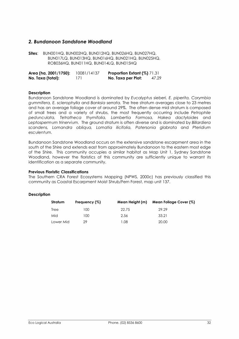
Eco Logical Australia Phone. (02) 8536 8600 32
2. Bundanoon Sandstone Woodland Sites: BUN001HQ, BUN002HQ, BUN012HQ, BUN026HQ, BUN027HQ, BUN017LQ, BUN013HQ, BUN016HQ, BUN021HQ, BUN025HQ, ROB036HQ, BUN011HQ, BUN014LQ, BUN015HQ Area (ha, 2001/1750): 10081/14137 Proportion Extant (%) 71.31 No. Taxa (total): 171 No. Taxa per Plot: 47.29 Description Bundanoon Sandstone Woodland is dominated by Eucalyptus sieberi, E. piperita, Corymbia gummifera, E. sclerophylla and Banksia serrata. The tree stratum averages close to 23 metres and has an average foliage cover of around 29%. The often dense mid stratum is composed of small trees and a variety of shrubs, the most frequently occurring include Petrophile pedunculata, Tetratheca thymifolia, Lambertia Formosa, Hakea dactyloides and Leptospermum trinervium. The ground stratum is often diverse and is dominated by Billardiera scandens, Lomandra obliqua, Lomatia ilicifolia, Patersonia glabrata and Pteridium esculentum. Bundanoon Sandstone Woodland occurs on the extensive sandstone escarpment area in the south of the Shire and extends east from approximately Bundanoon to the eastern most edge of the Shire. This community occupies a similar habitat as Map Unit 1, Sydney Sandstone Woodland, however the floristics of this community are sufficiently unique to warrant its identification as a separate community. Previous Floristic Classifications The Southern CRA Forest Ecosystems Mapping (NPWS, 2000c) has previously classified this community as Coastal Escarpment Moist Shrub/Fern Forest, map unit 137.
Description
Stratum Frequency (%) Mean Height (m) Mean Foliage Cover (%) Tree 100 22.75 29.29 Mid 100 2.56 33.21 Lower Mid 29 1.08 20.00
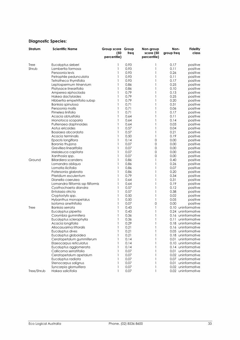
Eco Logical Australia Phone. (02) 8536 8600 33
Diagnostic Species: Stratum Scientific Name Group score Group Non-group Non- Fidelity (50 freq score (50 group freq class percentile) percentile)
Tree Eucalyptus sieberi 1 0.93 1 0.17 positive Shrub Lambertia formosa 1 0.93 1 0.11 positive Persoonia levis 1 0.93 1 0.26 positive Petrophile pedunculata 1 0.93 1 0.11 positive Tetratheca thymifolia 1 0.93 1 0.17 positive Leptospermum trinervium 1 0.86 1 0.25 positive Platysace linearifolia 1 0.86 1 0.10 positive Amperea xiphoclada 1 0.79 1 0.13 positive Hakea dactyloides 1 0.79 1 0.25 positive Hibbertia empetrifolia subsp 1 0.79 1 0.20 positive Banksia spinulosa 1 0.71 1 0.31 positive Persoonia mollis 1 0.71 1 0.06 positive Pimelea linifolia 1 0.71 1 0.17 positive Acacia obtusifolia 1 0.64 1 0.11 positive Monotoca scoparia 1 0.64 1 0.14 positive Pultenaea daphnoides 1 0.64 1 0.03 positive Aotus ericoides 1 0.57 1 0.04 positive Bossiaea obcordata 1 0.57 1 0.21 positive Acacia terminalis 1 0.50 1 0.19 positive Epacris longiflora 1 0.14 0 0.00 positive Boronia thujona 1 0.07 0 0.00 positive Grevillea linearifolia 1 0.07 0 0.00 positive Melaleuca capitata 1 0.07 0 0.00 positive Xanthosia spp. 1 0.07 0 0.00 positive Ground Billardiera scandens 1 0.86 1 0.40 positive Lomandra obliqua 1 0.86 1 0.26 positive Lomatia ilicifolia 1 0.86 1 0.07 positive Patersonia glabrata 1 0.86 1 0.20 positive Pteridium esculentum 1 0.79 1 0.34 positive Dianella caerulea 1 0.64 1 0.31 positive Lomandra filiformis ssp filiformis 1 0.64 1 0.19 positive Cyathochaeta diandra 1 0.57 1 0.12 positive Entolasia stricta 1 0.57 1 0.38 positive Cryptostylis spp. 1 0.50 1 0.02 positive Hybanthus monopetalus 1 0.50 1 0.05 positive Isotoma anethifolia 1 0.07 0 0.00 positive Tree Banksia serrata 1 0.43 1 0.10 uninformative Eucalyptus piperita 1 0.43 1 0.24 uninformative Corymbia gummifera 1 0.36 1 0.16 uninformative Eucalyptus sclerophylla 1 0.36 1 0.11 uninformative Acacia longifolia 1 0.29 1 0.18 uninformative Allocasuarina littoralis 1 0.21 1 0.16 uninformative Eucalyptus dives 1 0.21 1 0.05 uninformative Eucalyptus globoidea 1 0.21 1 0.18 uninformative Ceratopetalum gummiferum 1 0.14 1 0.01 uninformative Elaeocarpus reticulatus 1 0.14 1 0.10 uninformative Eucalyptus agglomerata 1 0.14 1 0.14 uninformative Callicoma serratifolia 1 0.07 1 0.01 uninformative Ceratopetalum apetalum 1 0.07 1 0.02 uninformative Eucalyptus radiata 1 0.07 1 0.07 uninformative Stenocarpus salignus 1 0.07 1 0.01 uninformative Syncarpia glomulifera 1 0.07 1 0.02 uninformative Tree/Shrub Hakea salicifolia 1 0.07 1 0.02 uninformative
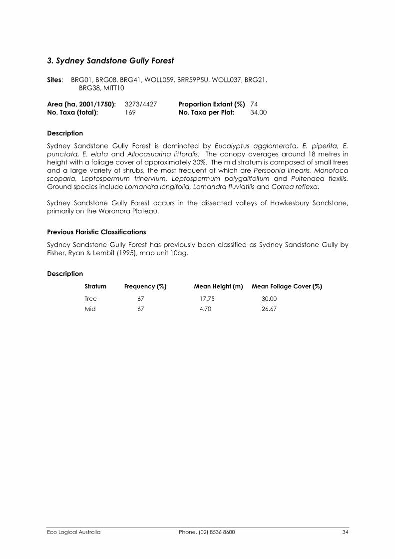
Eco Logical Australia Phone. (02) 8536 8600 34
3. Sydney Sandstone Gully Forest Sites: BRG01, BRG08, BRG41, WOLL059, BRR59P5U, WOLL037, BRG21, BRG38, MITT10 Area (ha, 2001/1750): 3273/4427 Proportion Extant (%) 74 No. Taxa (total): 169 No. Taxa per Plot: 34.00
Description
Sydney Sandstone Gully Forest is dominated by Eucalyptus agglomerata, E. piperita, E. punctata, E. elata and Allocasuarina littoralis. The canopy averages around 18 metres in height with a foliage cover of approximately 30%. The mid stratum is composed of small trees and a large variety of shrubs, the most frequent of which are Persoonia linearis, Monotoca scoparia, Leptospermum trinervium, Leptospermum polygalifolium and Pultenaea flexilis. Ground species include Lomandra longifolia, Lomandra fluviatilis and Correa reflexa. Sydney Sandstone Gully Forest occurs in the dissected valleys of Hawkesbury Sandstone, primarily on the Woronora Plateau.
Previous Floristic Classifications
Sydney Sandstone Gully Forest has previously been classified as Sydney Sandstone Gully by Fisher, Ryan & Lembit (1995), map unit 10ag.
Description
Stratum Frequency (%) Mean Height (m) Mean Foliage Cover (%) Tree 67 17.75 30.00 Mid 67 4.70 26.67
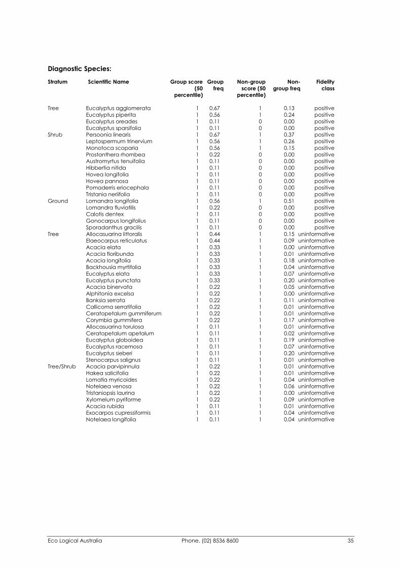
Eco Logical Australia Phone. (02) 8536 8600 35
Diagnostic Species: Stratum Scientific Name Group score Group Non-group Non- Fidelity (50 freq score (50 group freq class percentile) percentile)
Tree Eucalyptus agglomerata 1 0.67 1 0.13 positive Eucalyptus piperita 1 0.56 1 0.24 positive Eucalyptus oreades 1 0.11 0 0.00 positive Eucalyptus sparsifolia 1 0.11 0 0.00 positive Shrub Persoonia linearis 1 0.67 1 0.37 positive Leptospermum trinervium 1 0.56 1 0.26 positive Monotoca scoparia 1 0.56 1 0.15 positive Prostanthera rhombea 1 0.22 0 0.00 positive Austromyrtus tenuifolia 1 0.11 0 0.00 positive Hibbertia nitida 1 0.11 0 0.00 positive Hovea longifolia 1 0.11 0 0.00 positive Hovea pannosa 1 0.11 0 0.00 positive Pomaderris eriocephala 1 0.11 0 0.00 positive Tristania neriifolia 1 0.11 0 0.00 positive Ground Lomandra longifolia 1 0.56 1 0.51 positive Lomandra fluviatilis 1 0.22 0 0.00 positive Calotis dentex 1 0.11 0 0.00 positive Gonocarpus longifolius 1 0.11 0 0.00 positive Sporadanthus gracilis 1 0.11 0 0.00 positive Tree Allocasuarina littoralis 1 0.44 1 0.15 uninformative Elaeocarpus reticulatus 1 0.44 1 0.09 uninformative Acacia elata 1 0.33 1 0.00 uninformative Acacia floribunda 1 0.33 1 0.01 uninformative Acacia longifolia 1 0.33 1 0.18 uninformative Backhousia myrtifolia 1 0.33 1 0.04 uninformative Eucalyptus elata 1 0.33 1 0.07 uninformative Eucalyptus punctata 1 0.33 1 0.20 uninformative Acacia binervata 1 0.22 1 0.05 uninformative Alphitonia excelsa 1 0.22 1 0.00 uninformative Banksia serrata 1 0.22 1 0.11 uninformative Callicoma serratifolia 1 0.22 1 0.01 uninformative Ceratopetalum gummiferum 1 0.22 1 0.01 uninformative Corymbia gummifera 1 0.22 1 0.17 uninformative Allocasuarina torulosa 1 0.11 1 0.01 uninformative Ceratopetalum apetalum 1 0.11 1 0.02 uninformative Eucalyptus globoidea 1 0.11 1 0.19 uninformative Eucalyptus racemosa 1 0.11 1 0.07 uninformative Eucalyptus sieberi 1 0.11 1 0.20 uninformative Stenocarpus salignus 1 0.11 1 0.01 uninformative Tree/Shrub Acacia parvipinnula 1 0.22 1 0.01 uninformative Hakea salicifolia 1 0.22 1 0.01 uninformative Lomatia myricoides 1 0.22 1 0.04 uninformative Notelaea venosa 1 0.22 1 0.06 uninformative Tristaniopsis laurina 1 0.22 1 0.00 uninformative Xylomelum pyriforme 1 0.22 1 0.09 uninformative Acacia rubida 1 0.11 1 0.01 uninformative Exocarpos cupressiformis 1 0.11 1 0.04 uninformative Notelaea longifolia 1 0.11 1 0.04 uninformative
Eco Logical Australia Phone. (02) 8536 8600 36
4. Mittagong Sandstone Woodland
Sites: BAR001HQ, HAN007LQ, HAN005HQ, BRR06H8C, BRR21P1M, BRR20P3U, MIT017HQ, MIT030HQ, HAN008HQ, HIL020HQ, HIL015LQ, HIL009HQ, HIL013HQ, HLL01N1U, HLL06W6M, HLL07H1U, HIL017LQ, HLL03H3U, HLL04H8M, HAN013HQ, HLL10H2L, BRG02, CAN006LQ, WIN001LQ, WIN004HQ, BRR07H4U, HAN009HQ, MIT001HQ, MITT01, MITT02, HIL016LQ, MIT009HQ, MITT04, MITT09, HIL018HQ, HIL019HQ, HIL026HQ, MIT014HQ, MIT020HQ Area (ha, 2001/1750): 28354/38702 Proportion Extant (%) 75.27 No. Taxa (total): 282 No. Taxa per Plot: 44.49
Description Mittagong Sandstone Woodland is dominated by Eucalyptus agglomerata, E. punctata, E. sieberi, E.piperita and Allocasuarina littoralis. It has an average height of over 18 metres and a mean foliage cover of around 27%. The Mid stratum averages a height of around 4.6 metres and includes a variety of small trees and shrubs. Dominant mid stratum species include Persoonia linearis, Persoonia levis, Tetratheca thymifolia, Banksia spinulosa, Bossiaea obcordata, Hibbertia empetrifolia and Leptospermum trinervium. The ground stratum is variable and often gives way to a lower-mid straum with an average height of around 1.6 metres. Common species include Entolasia stricta, Goodenia hederacea, Patersonia glabrata, Phyllanthus hirtellus, Pomax umbellate, Dampiera purpurea, Billardiera scandens, Lomandra oblique and Lomandra cylindrical. Mittagong Sandstone Woodland occurs on Hawkesbury and Narrabeen Sandstone from Penrose, through Belanglo and onto the southern portion of the Nattai Plateau. There is considerable variation in the structure and species composition throughout its range related in part to variations in soil depth, slope, aspect and drainage.
Previous Floristic Classifications Fisher, Ryan & Lembit (1995), have previously classified this community as Mittagong Sandstone Woodland. This nomencalture has been retained. The Southern CRA Forest Ecosystems Mapping (NPWS, 2000c) classified this community as Hinterland Heath Shrub Dry Forest.
Description
Stratum Frequency (%) Mean Height (m) Mean Foliage Cover (%) Tree 90 18.44 26.71 Mid 90 4.64 20.57 Lower Mid 33 1.66 23.08
Eco Logical Australia Phone. (02) 8536 8600 37
Diagnostic Species: Stratum Scientific Name Group score Group Non-group Non- Fidelity (50 freq score (50 group freq class percentile) percentile)
Tree Eucalyptus agglomerata 1 0.62 1 0.10 positive Eucalyptus punctata 1 0.59 1 0.16 positive Shrub Persoonia linearis 1 0.92 1 0.32 positive Persoonia levis 1 0.82 1 0.22 positive Tetratheca thymifolia 1 0.74 1 0.14 positive Hibbertia empetrifolia subsp 1 0.72 1 0.17 positive Bossiaea obcordata 1 0.69 1 0.17 positive Lomatia silaifolia 1 0.69 1 0.21 positive Leptospermum trinervium 1 0.64 1 0.23 positive Podolobium ilicifolium 1 0.62 1 0.08 positive Acacia terminalis 1 0.56 1 0.16 positive Banksia spinulosa 1 0.54 1 0.30 positive Petrophile pedunculata 1 0.54 1 0.09 positive Boronia algida 1 0.03 0 0.00 positive Crowea saligna 1 0.03 0 0.00 positive Hakea constablei 1 0.03 0 0.00 positive Leucopogon appressus 1 0.03 0 0.00 positive Petrophile spp. 1 0.03 0 0.00 positive Rhytidosporum prostratum 1 0.03 0 0.00 positive Ground Patersonia glabrata 1 0.77 1 0.16 positive Entolasia stricta 1 0.74 1 0.35 positive Goodenia hederacea 1 0.74 1 0.29 positive Pomax umbellata 1 0.74 1 0.16 positive Phyllanthus hirtellus 1 0.72 1 0.21 positive Lomandra obliqua 1 0.67 1 0.24 positive Billardiera scandens 1 0.64 1 0.39 positive Dampiera purpurea 1 0.62 1 0.14 positive Gonocarpus teucrioides 1 0.56 1 0.20 positive Lomandra cylindrica 1 0.54 1 0.13 positive Stypandra glauca 1 0.51 1 0.08 positive Billardiera versicolor 1 0.03 0 0.00 positive Glossodia major 1 0.03 0 0.00 positive Polycarpaea corymbosa var 1 0.03 0 0.00 positive Pteris tremula 1 0.03 0 0.00 positive Tree Allocasuarina littoralis 1 0.46 1 0.13 uninformative Eucalyptus sieberi 1 0.46 1 0.17 uninformative Acacia longifolia 1 0.28 1 0.17 uninformative Angophora costata 1 0.28 1 0.01 uninformative Eucalyptus piperita 1 0.28 1 0.24 uninformative Elaeocarpus reticulatus 1 0.26 1 0.08 uninformative Eucalyptus sclerophylla 1 0.26 1 0.10 uninformative Eucalyptus globoidea 1 0.21 1 0.18 uninformative Banksia serrata 1 0.18 1 0.10 uninformative Corymbia gummifera 1 0.13 1 0.17 uninformative Acacia falciformis 1 0.10 1 0.12 uninformative Acacia floribunda 1 0.03 1 0.02 uninformative Acacia irrorata 1 0.03 1 0.01 uninformative Angophora floribunda 1 0.03 1 0.02 uninformative Eucalyptus consideniana 1 0.03 1 0.01 uninformative Eucalyptus elata 1 0.03 1 0.08 uninformative Eucalyptus radiata 1 0.03 1 0.07 uninformative Eucalyptus sideroxylon 1 0.03 1 0.01 uninformative Eucalyptus smithii 1 0.03 1 0.04 uninformative Tree Pittosporum undulatum 1 0.03 1 0.10 uninformative Tree/Shrub Xylomelum pyriforme 1 0.31 1 0.07 uninformative Acacia parvipinnula 1 0.03 1 0.02 uninformative Exocarpos cupressiformis 1 0.03 1 0.04 uninformative Lomatia myricoides 1 0.03 1 0.04 uninformative Notelaea venosa 1 0.03 1 0.07 uninformative
Eco Logical Australia Phone. (02) 8536 8600 38
5. Wingecarribee Mallee Sites: HIL010HQ, MIT018HQ, MIT022HQ, MIT023HQ, HIL021HQ, MITT03, MOSS002, MITT06, ROB037HQ, MITT08, MOSS003 Area (ha, 2001/1750): 274/287 Proportion Extant (%) 95.00 No. Taxa (total):232 No. Taxa per Plot: 50.27
Description
Wingecarribee Mallee is dominated by Eucalyptus sclerophylla, E. mannifera, and E. piperita with E. rossii occurring less frequently. An often dense mid storey occurs with Hakea dactyloides, Amperea xiphoclada, Banksia spinulosa, Leptospermum trinervium, Bossiaea heterophylla, Isopogon anemonifolius and Leptospermum polygalifolium. The ground stratum is frequently composed of Goodenia hederacea, Cheilanthes sieberi, Lomandra cylindrica, Lomandra longifolia, Lomandra multiflora ssp multiflora, Patersonia glabrata and Patersonia sericea.
This community occurs adjacent to the Wingecarribee River on sandstone outcrops on the edge of the Southern Highlands. It is highly restricted in its distribution, a few small areas that were not mappable were observed during field survey occurring on sandstone outcrops in the deeply dissected Joadja country. The community is floristically diverse with an average of over 50 species per plot. This diversity also provides for a variety of habitat and food resources for animals, particularly nectar-eating birds and mammals.
Previous Floristic Classifications
Fisher, Ryan & Lembit (1995), have previously classified this community as Wingecarribee Mallee. This nomencalture has been retained.
Structure
Stratum Frequency (%) Mean Height (m) Mean Foliage Cover (%) Tree 55 10.08 26.50 Mid 55 1.77 31.67 Lower Mid 9 1.00 40.00
Eco Logical Australia Phone. (02) 8536 8600 39
Diagnostic Species: Stratum Scientific Name Group score Group Non-group Non- Fidelity (50 freq score (50 group freq class percentile) percentile)
Tree Eucalyptus sclerophylla 1 0.73 1 0.10 positive Callitris endlicheri 1 0.09 0 0.00 positive Callitris muelleri 1 0.09 0 0.00 positive Shrub Hakea dactyloides 1 1.00 1 0.25 positive Amperea xiphoclada 1 0.91 1 0.13 positive Banksia spinulosa 1 0.82 1 0.31 positive Leptospermum trinervium 1 0.82 1 0.25 positive Bossiaea heterophylla 1 0.55 1 0.10 positive Isopogon anemonifolius 1 0.55 1 0.16 positive Leptospermum arachnoides 1 0.55 1 0.02 positive Leptospermum polygalifolium 1 0.55 1 0.17 positive Lomatia silaifolia 1 0.55 1 0.25 positive Kunzea parvifolia 1 0.36 0 0.00 positive Allocasuarina diminuta ssp mimica 1 0.18 0 0.00 positive Kunzea cambagei 1 0.18 0 0.00 positive Leptospermum parvifolium 1 0.09 0 0.00 positive Leucopogon attenuatus 1 0.09 0 0.00 positive Leucopogon muticus 1 0.09 0 0.00 positive Persoonia cornifolia 1 0.09 0 0.00 positive Persoonia glaucescens 1 0.09 0 0.00 positive Persoonia myrtilloides 1 0.09 0 0.00 positive Pseudanthus divaricatissimus 1 0.09 0 0.00 positive Ground Goodenia hederacea 1 0.73 1 0.32 positive Cheilanthes sieberi 1 0.64 1 0.19 positive Lomandra cylindrica 1 0.64 1 0.15 positive Lomandra longifolia 1 0.64 1 0.51 positive Lomandra multiflora ssp multiflora 1 0.64 1 0.35 positive Patersonia glabrata 1 0.64 1 0.21 positive Patersonia sericea 1 0.64 1 0.18 positive Dianella revoluta 1 0.55 1 0.22 positive Entolasia stricta 1 0.55 1 0.38 positive Schoenoplectus mucronatus 1 0.18 0 0.00 positive Caustis pentandra 1 0.09 0 0.00 positive Micrantheum hexandrum 1 0.09 0 0.00 positive Thelionema umbellatum 1 0.09 0 0.00 positive Vine Parsonsia lanceolata 1 0.09 0 0.00 positive Tree Eucalyptus mannifera 1 0.45 1 0.04 uninformative Eucalyptus piperita 1 0.27 1 0.25 uninformative Allocasuarina littoralis 1 0.18 1 0.16 uninformative Eucalyptus rossii 1 0.18 1 0.01 uninformative Acacia parramattensis 1 0.09 1 0.06 uninformative Banksia serrata 1 0.09 1 0.11 uninformative Corymbia gummifera 1 0.09 1 0.17 uninformative Eucalyptus agglomerata 1 0.09 1 0.15 uninformative Eucalyptus dives 1 0.09 1 0.06 uninformative Eucalyptus elata 1 0.09 1 0.07 uninformative Eucalyptus eugenioides 1 0.09 1 0.07 uninformative Eucalyptus oblonga 1 0.09 1 0.05 uninformative Eucalyptus radiata 1 0.09 1 0.07 uninformative Eucalyptus sieberi 1 0.09 1 0.20 uninformative Tree/Shrub Xylomelum pyriforme 1 0.18 1 0.09 uninformative Acacia dealbata 1 0.09 1 0.01 uninformative Acacia rubida 1 0.09 1 0.01 uninformative Tree/Shrub Lomatia myricoides 1 0.09 1 0.04 uninformative
Eco Logical Australia Phone. (02) 8536 8600 40
6. Scribbly Gum Open Woodland
Sites: AVN53, AVN77, AVN54, AVN55, AVN66, BRG32, WOLL010, AVN82, RBR49, RBR33, RBR43, MOS002LQ, RBR51, RBR52, WOLL009, WOLL064, WOLL032 Area (ha, 2001/1750): 1995/2003 Proportion Extant (%) 98.00 No. Taxa (total): 186 No. Taxa per Plot: 29.76
Description This community is dominated by Eucalyptus racemosa and E. sclerophylla with E. parramattensis occurring less frequently. A sparse mid stratum is dominated by young trees and shrubs to a height of around 7 metres. The most frequently recorded spcecies are Hakea dactyloides, Banksia spinulosa, Banksia oblongifolia, Isopogon anemonifolius and Pultenaea elliptica. The ground cover grades into a dense lower mid-stratum up to 1.5 metres high, the most common species include Dampiera stricta, Goodenia bellidifolia, Lindsaea linearis, Mitrasacme polymorpha, Lepyrodia scariosa and Cyathochaeta diandra. The community occurs on relatively deep sandy soils on sandstone. It has been recorded on the Woronora Plateau and the Southern Sandstone Escarpment east from Bundanoon.
Previous Floristic Classifications The Southern CRA Forest Ecosystems Mapping (NPWS, 2000) has previously classified this community as Northern Coastal Hinterland Heath Shrub Dry Forest, map unit 139.
Structure
Stratum Frequency (%) Mean Height (m) Mean Foliage Cover (%) Tree 65 16.33 45.00 Mid 47 7.20 10.00 Lower Mid 6 1.50 40.00
Eco Logical Australia Phone. (02) 8536 8600 41
Diagnostic Species: Stratum Scientific Name Group score Group Non-group Non- Fidelity (50 freq score (50 group freq class percentile) percentile)
Tree Eucalyptus parramattensis 1 0.06 0 0.00 positive Shrub Hakea dactyloides 1 1.00 1 0.23 positive Banksia spinulosa 1 0.76 1 0.30 positive Banksia oblongifolia 1 0.65 1 0.03 positive Pultenaea elliptica 1 0.65 1 0.03 positive Grevillea sericea 1 0.53 1 0.01 positive Isopogon anemonifolius 1 0.53 1 0.15 positive Allocasuarina diminuta ssp 1 0.12 0 0.00 positive Grevillea parviflora 1 0.12 0 0.00 positive Baeckea diosmifolia 1 0.06 0 0.00 positive Mirbelia pungens 1 0.06 0 0.00 positive Pultenaea ferruginea 1 0.06 0 0.00 positive Ground Dampiera stricta 1 0.94 1 0.11 positive Goodenia bellidifolia 1 0.82 1 0.09 positive Lindsaea linearis 1 0.71 1 0.06 positive Mitrasacme polymorpha 1 0.71 1 0.04 positive Lepyrodia scariosa 1 0.65 1 0.07 positive Cyathochaeta diandra 1 0.59 1 0.11 positive Entolasia stricta 1 0.59 1 0.38 positive Austrostipa pubescens 1 0.53 1 0.08 positive Patersonia sericea 1 0.53 1 0.18 positive Amphipogon strictus var strictus 1 0.12 0 0.00 positive Hybanthus vernonii 1 0.12 0 0.00 positive Amphibromus nervosus 1 0.06 0 0.00 positive Lepidosperma forsythii 1 0.06 0 0.00 positive Lepidosperma neesii 1 0.06 0 0.00 positive Mitrasacme paludosa 1 0.06 0 0.00 positive Tricoryne simplex 1 0.06 0 0.00 positive Xyris gracilis 1 0.06 0 0.00 positive Tree Eucalyptus racemosa 1 0.41 1 0.06 uninformative Eucalyptus sclerophylla 1 0.29 1 0.11 uninformative Eucalyptus globoidea 1 0.12 1 0.19 uninformative Eucalyptus oblonga 1 0.12 1 0.05 uninformative Acacia longifolia 1 0.06 1 0.19 uninformative Acacia melanoxylon 1 0.06 1 0.09 uninformative Eucalyptus radiata 1 0.06 1 0.07 uninformative Melaleuca linariifolia 1 0.06 1 0.02 uninformative
Eco Logical Australia Phone. (02) 8536 8600 42
7. Sandstone Wet Heath/Sedge
Sites: BUN003SW, RBR50, MIT024SW, BUN009HQ, MOSS011, WOLL033
Area (ha, 2001/1750): 650/667 Proportion Extant (%) 97.00 No. Taxa (total): 104 No. Taxa per Plot: 27.67
Description
Sandstone Wet Heath/Sedge is dominated by Baeckea linifolia, Leptospermum juniperinum, Leptospermum grandifolium, Epacris paludosa and Epacris microphylla. This typically forms a dense shrub layer with an emergent sparse, tree layer comprised of Eucalyptus camphora, Acacia longifolia, E. macarthurii, E. mannifera and E. ovata often present. A dense lower stratum dominated by Empodisma minus, Lepidosperma limicola, Xyris operculata, Gymnoschoenus sphaerocephalus and Gleichenia dicarpa completes this community.
Sandstone Wet/Heath Sedge occurs along drainage lines on the upper slopes of the Woronora Plateau and the Southern Escarpment. It generally occurs on sandy soils often forming near impenetrable thickets.
Previous Floristic Classifications The Southern CRA Forest Ecosystems Mapping (NPWS, 2000) has previously classified this community as Northern Coast (and Escarpment) Wet Heath/Sedge, map unit 141.
Structure
Stratum Frequency (%) Mean Height (m) Mean Foliage Cover (%) Upper 33 2.50 80.00 Lower 33 2.50 47.50 Emerging 17 3.50 5.00
Eco Logical Australia Phone. (02) 8536 8600 43
Diagnostic Species: Stratum Scientific Name Group score Group Non-group Non- Fidelity (50 freq score (50 group freq class percentile) percentile)
Tree Eucalyptus camphora 1 0.17 0 0.00 positive Shrub Baeckea linifolia 1 0.67 1 0.02 positive Leptospermum juniperinum 1 0.67 1 0.03 positive Epacris microphylla 1 0.50 1 0.06 positive Epacris paludosa 1 0.50 1 0.01 positive Leptospermum grandifolium 1 0.50 1 0.00 positive Pultenaea divaricata 1 0.50 1 0.00 positive Boronia barkeriana 1 0.17 0 0.00 positive Melaleuca squarrosa 1 0.17 0 0.00 positive Symphionema paludosum 1 0.17 0 0.00 positive Ground Empodisma minus 1 1.00 1 0.02 positive Lepidosperma limicola 1 0.83 1 0.01 positive Xyris operculata 1 0.83 0 0.00 positive Gleichenia dicarpa 1 0.67 1 0.03 positive Gymnoschoenus sphaerocephalus 1 0.67 1 0.00 positive Baloskion fimbriatum 1 0.50 0 0.00 positive Chorizandra sphaerocephala 1 0.50 0 0.00 positive Lepyrodia anarthria 1 0.50 0 0.00 positive Selaginella uliginosa 1 0.50 1 0.03 positive Xyris ustulata 1 0.50 0 0.00 positive Patersonia fragilis 1 0.33 0 0.00 positive Sphagnum cristatum 1 0.33 0 0.00 positive Baloskion australe 1 0.17 0 0.00 positive Baumea articulata 1 0.17 0 0.00 positive Caladenia carnea 1 0.17 0 0.00 positive Goodenia paniculata 1 0.17 0 0.00 positive Goodenia stelligera 1 0.17 0 0.00 positive Lepyrodia muelleri 1 0.17 0 0.00 positive Lycopodiella lateralis 1 0.17 0 0.00 positive Plinthanthesis paradoxa 1 0.17 0 0.00 positive Schoenus brevifolius 1 0.17 0 0.00 positive Villarsia exaltata 1 0.17 0 0.00 positive Tree Acacia longifolia 1 0.17 1 0.18 uninformative Eucalyptus macarthurii 1 0.17 1 0.01 uninformative Eucalyptus mannifera 1 0.17 1 0.05 uninformative Eucalyptus ovata 1 0.17 1 0.01 uninformative Tree/Shrub Acacia rubida 1 0.17 1 0.01 uninformative
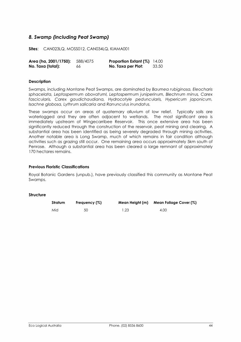
Eco Logical Australia Phone. (02) 8536 8600 44
8. Swamp (including Peat Swamp) Sites: CAN023LQ, MOSS012, CAN034LQ, KIAMA001
Area (ha, 2001/1750): 588/4075 Proportion Extant (%) 14.00 No. Taxa (total): 66 No. Taxa per Plot: 33.50
Description
Swamps, including Montane Peat Swamps, are dominated by Baumea rubiginosa, Eleocharis sphacelata, Leptospermum obovatumI, Leptospermum juniperinum, Blechnum minus, Carex fascicularis, Carex gaudichaudiana, Hydrocotyle peduncularis, Hypericum japonicum, Isachne globosa, Lythrum salicaria and Ranunculus inundatus.
These swamps occur on areas of quaternary alluvium of low relief. Typically soils are waterlogged and they are often adjacent to wetlands. The most significant area is immediately upstream of Wingecarribee Reservoir. This once extensive area has been significantly reduced through the construction of the reservoir, peat mining and clearing. A substantial area has been identified as being severely degraded through mining activities. Another notable area is Long Swamp, much of which remains in fair condition although activities such as grazing still occur. One remaining area occurs approximately 5km south of Penrose. Although a substantial area has been cleared a large remnant of approximately 170 hectares remains.
Previous Floristic Classifications
Royal Botanic Gardens (unpub.), have previously classified this community as Montane Peat Swamps.
Structure
Stratum Frequency (%) Mean Height (m) Mean Foliage Cover (%) Mid 50 1.23 4.00
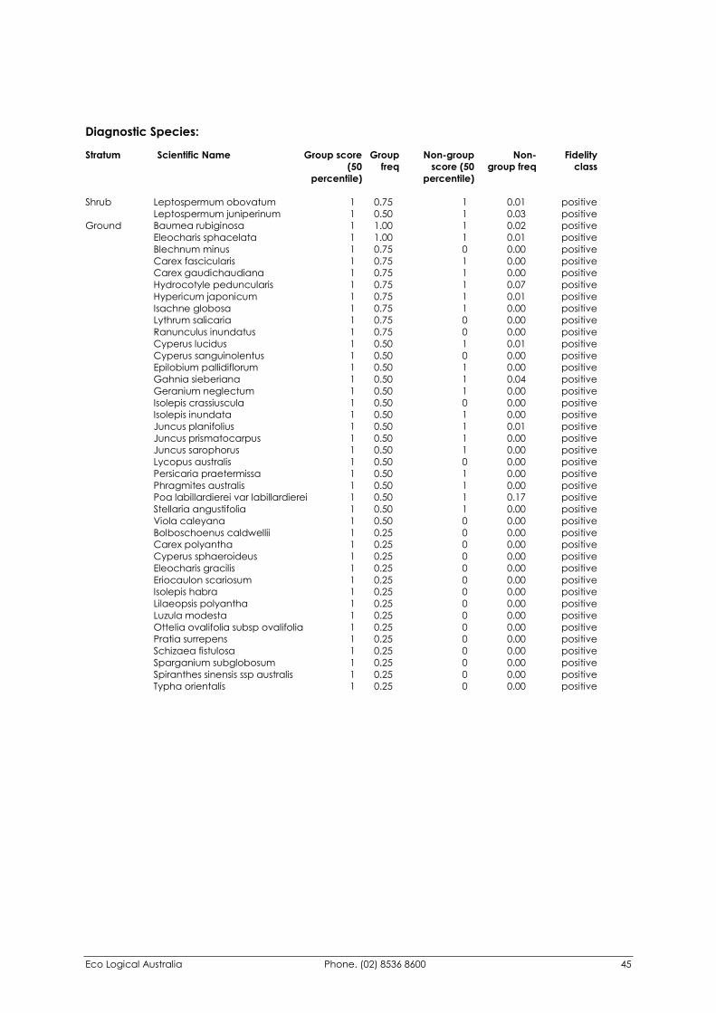
Eco Logical Australia Phone. (02) 8536 8600 45
Diagnostic Species: Stratum Scientific Name Group score Group Non-group Non- Fidelity (50 freq score (50 group freq class percentile) percentile)
Shrub Leptospermum obovatum 1 0.75 1 0.01 positive Leptospermum juniperinum 1 0.50 1 0.03 positive Ground Baumea rubiginosa 1 1.00 1 0.02 positive Eleocharis sphacelata 1 1.00 1 0.01 positive Blechnum minus 1 0.75 0 0.00 positive Carex fascicularis 1 0.75 1 0.00 positive Carex gaudichaudiana 1 0.75 1 0.00 positive Hydrocotyle peduncularis 1 0.75 1 0.07 positive Hypericum japonicum 1 0.75 1 0.01 positive Isachne globosa 1 0.75 1 0.00 positive Lythrum salicaria 1 0.75 0 0.00 positive Ranunculus inundatus 1 0.75 0 0.00 positive Cyperus lucidus 1 0.50 1 0.01 positive Cyperus sanguinolentus 1 0.50 0 0.00 positive Epilobium pallidiflorum 1 0.50 1 0.00 positive Gahnia sieberiana 1 0.50 1 0.04 positive Geranium neglectum 1 0.50 1 0.00 positive Isolepis crassiuscula 1 0.50 0 0.00 positive Isolepis inundata 1 0.50 1 0.00 positive Juncus planifolius 1 0.50 1 0.01 positive Juncus prismatocarpus 1 0.50 1 0.00 positive Juncus sarophorus 1 0.50 1 0.00 positive Lycopus australis 1 0.50 0 0.00 positive Persicaria praetermissa 1 0.50 1 0.00 positive Phragmites australis 1 0.50 1 0.00 positive Poa labillardierei var labillardierei 1 0.50 1 0.17 positive Stellaria angustifolia 1 0.50 1 0.00 positive Viola caleyana 1 0.50 0 0.00 positive Bolboschoenus caldwellii 1 0.25 0 0.00 positive Carex polyantha 1 0.25 0 0.00 positive Cyperus sphaeroideus 1 0.25 0 0.00 positive Eleocharis gracilis 1 0.25 0 0.00 positive Eriocaulon scariosum 1 0.25 0 0.00 positive Isolepis habra 1 0.25 0 0.00 positive Lilaeopsis polyantha 1 0.25 0 0.00 positive Luzula modesta 1 0.25 0 0.00 positive Ottelia ovalifolia subsp ovalifolia 1 0.25 0 0.00 positive Pratia surrepens 1 0.25 0 0.00 positive Schizaea fistulosa 1 0.25 0 0.00 positive Sparganium subglobosum 1 0.25 0 0.00 positive Spiranthes sinensis ssp australis 1 0.25 0 0.00 positive Typha orientalis 1 0.25 0 0.00 positive
Eco Logical Australia Phone. (02) 8536 8600 46
9. Riparian Casuarina Forest Sites: HAN032A
Area (ha, 2001/1750): 1757/2252 Proportion Extant (%) 78.00 No. Taxa (total): 14 No. Taxa per Plot: 35.00
Description
Riparian Casuarina Forest is dominated by Casuarina cunninghamiana which averages a height of around 5 metres. The lower stratum is comprised of juvenile trees, shrubs and groundcovers including Callistemon sieberi, Alternanthera denticulate, Centipeda cunninghamii, Eleocharis acuta, Glycine species A, Hydrocotyle peduncularis, Juncus usitatus, Persicaria decipiens, Persicaria hydropiper, Persicaria prostrata, Schoenoplectus validus, Typha domingensis and Xanthium italicum.
Riparian Casuarina Forest occurs on rivers flats particularly along the Wollondilly, Nattai and Wingecarribee Rivers. The soils are derived from quaternary alluvium and range from fine sands to small, rounded boulders.
Previous Floristic Classifications
Fisher, Ryan & Lembit (1995), have previously classified this community as River Oak Forest (Map Unit 9x). The Southern CRA Forest Ecosystems Project (NPWS 2000c) classified this community as Riparian Acacia Shrub/Grass/Herb Forest (Map Unit 53).
Structure
Stratum Frequency (%) Mean Height (m) Mean Foliage Cover (%) Tree 100 5.00 2.00 Mid 100 1.50 30.00
Diagnostic Species: Stratum Scientific Name Group score Group Non-group Non- Fidelity (50 freq score (50 group freq class percentile) percentile)
Tree Casuarina cunninghamiana ssp 1 1.00 1 0.02 positive Shrub Callistemon sieberi 1 1.00 1 0.00 positive Ground Alternanthera denticulata 1 1.00 1 0.00 positive Centipeda cunninghamii 1 1.00 0 0.00 positive Eleocharis acuta 1 1.00 1 0.00 positive Glycine species A 1 1.00 1 0.02 positive Hydrocotyle peduncularis 1 1.00 1 0.08 positive Juncus usitatus 1 1.00 1 0.02 positive Persicaria decipiens 1 1.00 1 0.00 positive Persicaria hydropiper 1 1.00 1 0.00 positive Persicaria prostrata 1 1.00 0 0.00 positive Schoenoplectus validus 1 1.00 0 0.00 positive Typha domingensis 1 1.00 0 0.00 positive Xanthium italicum 1 1.00 0 0.00 positive
Eco Logical Australia Phone. (02) 8536 8600 47
10. Wingecarribee Woodland Sites: BAR004HQ, CAN001LQ, CAN005HQ, CAN012LQ, CAN002HQ, HAN021LQ, BAR005LQ, MIT008HQ, HAN004HQ, BAR009LQ, HAN023HQ, CAN003HQ, MIT021HQ, HAN002HQ, HAN016HQ, HAN018HQ, WIN008HQ, WIN009HQ, BAR021LQ, HIL008LQ, CAN004HQ, CAN024HQ, CAN022LQ, CAN025LQ, CAN027LQ, CAN028LQ, AN014LQA, CAN019LQ, CAN015LQ, CAN020HQ, HAN022HQ, CAN030HQ, CAN016LQ, CAN029LQ, CAN036LQ, HIL004HQ, HLL02W5R, HIL006LQ, HIL011HQ, HLL05W7M, MIT099, CAN021LQ, WIN012HQ, WIN013HQ, CAN032LQ, HAN020LQ Area (ha, 2001/1750): 18225/29134 Proportion Extant (%) 63.00 No. Taxa (total): 344 No. Taxa per Plot: 46.98
Description Wingecarribee Woodland is dominated by Eucalyptus globoidea, E.punctata, E. mannifera, Allocasuarina littoralis, Acacia longifolia and A. falciformis. A wide variety of other eucalypt species are present in low frequencies which represent the variable nature of the canopy associated with this community. The shrub stratum is variable, with Persoonia linearis, Hibbertia obtusifolia and Olearia viscidula being the most frequently recorded species. A diverse ground stratum plays an important role in the floristic identification of this community, with Goodenia hederacea, Microlaena stipoides, Billardiera scandens, Dianella revoluta, Lomandra multiflora ssp multiflora and Opercularia diphylla being recorded in high frequencies. This community occurs on moderately fertile soils derived from low quartz sedimentary geologies including Shale, Siltstone, Mudstone and Conglomerates. There is a high level of variation in this community due to the influences of the above on soil characteristics as well as topographic influences such as aspect, slope and topographic position. This community occurs on the slopes and ridges throughout the Belanglo, Canyonleigh and Joadja areas.
Previous Floristic Classifications Fisher, Ryan & Lembit (1995), have previously classified two communities that cover the same geographic range as this community. These communities are Wingecarribee Forest (Map Unit 9w) and Joadja Stringybark Woodland (Map Unit 10w). Floristic analysis of sites within these communities indicated that they were not sufficiently different enough to warrant classification of two separate communities. The Southern CRA Forest Ecosystems Project (NPWS 2000c) classified this community as Central and Northeast Tablelands Dry Shrub Forest (Map Unit 15).
Structure
Stratum Frequency (%) Mean Height (m) Mean Foliage Cover (%) Tree 98 18.71 31.27 Mid 89 3.44 14.02 Lower Mid 9 1.56 3.25
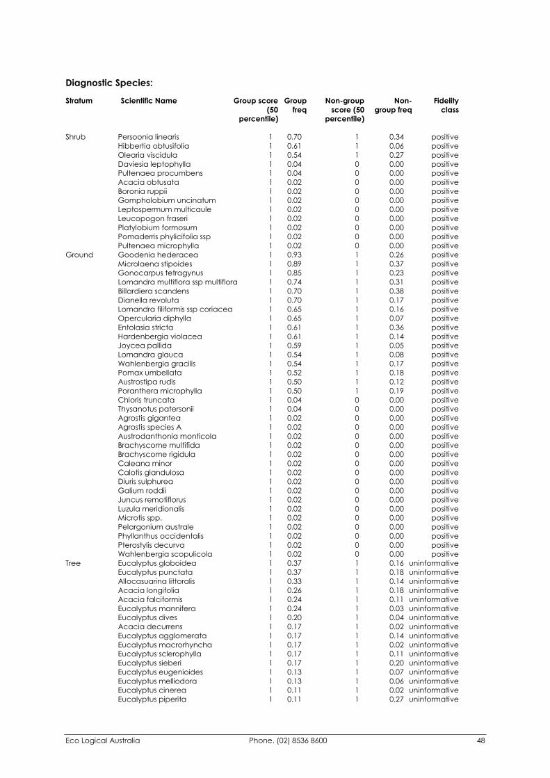
Eco Logical Australia Phone. (02) 8536 8600 48
Diagnostic Species: Stratum Scientific Name Group score Group Non-group Non- Fidelity (50 freq score (50 group freq class percentile) percentile)
Shrub Persoonia linearis 1 0.70 1 0.34 positive Hibbertia obtusifolia 1 0.61 1 0.06 positive Olearia viscidula 1 0.54 1 0.27 positive Daviesia leptophylla 1 0.04 0 0.00 positive Pultenaea procumbens 1 0.04 0 0.00 positive Acacia obtusata 1 0.02 0 0.00 positive Boronia ruppii 1 0.02 0 0.00 positive Gompholobium uncinatum 1 0.02 0 0.00 positive Leptospermum multicaule 1 0.02 0 0.00 positive Leucopogon fraseri 1 0.02 0 0.00 positive Platylobium formosum 1 0.02 0 0.00 positive Pomaderris phylicifolia ssp 1 0.02 0 0.00 positive Pultenaea microphylla 1 0.02 0 0.00 positive Ground Goodenia hederacea 1 0.93 1 0.26 positive Microlaena stipoides 1 0.89 1 0.37 positive Gonocarpus tetragynus 1 0.85 1 0.23 positive Lomandra multiflora ssp multiflora 1 0.74 1 0.31 positive Billardiera scandens 1 0.70 1 0.38 positive Dianella revoluta 1 0.70 1 0.17 positive Lomandra filiformis ssp coriacea 1 0.65 1 0.16 positive Opercularia diphylla 1 0.65 1 0.07 positive Entolasia stricta 1 0.61 1 0.36 positive Hardenbergia violacea 1 0.61 1 0.14 positive Joycea pallida 1 0.59 1 0.05 positive Lomandra glauca 1 0.54 1 0.08 positive Wahlenbergia gracilis 1 0.54 1 0.17 positive Pomax umbellata 1 0.52 1 0.18 positive Austrostipa rudis 1 0.50 1 0.12 positive Poranthera microphylla 1 0.50 1 0.19 positive Chloris truncata 1 0.04 0 0.00 positive Thysanotus patersonii 1 0.04 0 0.00 positive Agrostis gigantea 1 0.02 0 0.00 positive Agrostis species A 1 0.02 0 0.00 positive Austrodanthonia monticola 1 0.02 0 0.00 positive Brachyscome multifida 1 0.02 0 0.00 positive Brachyscome rigidula 1 0.02 0 0.00 positive Caleana minor 1 0.02 0 0.00 positive Calotis glandulosa 1 0.02 0 0.00 positive Diuris sulphurea 1 0.02 0 0.00 positive Galium roddii 1 0.02 0 0.00 positive Juncus remotiflorus 1 0.02 0 0.00 positive Luzula meridionalis 1 0.02 0 0.00 positive Microtis spp. 1 0.02 0 0.00 positive Pelargonium australe 1 0.02 0 0.00 positive Phyllanthus occidentalis 1 0.02 0 0.00 positive Pterostylis decurva 1 0.02 0 0.00 positive Wahlenbergia scopulicola 1 0.02 0 0.00 positive Tree Eucalyptus globoidea 1 0.37 1 0.16 uninformative Eucalyptus punctata 1 0.37 1 0.18 uninformative Allocasuarina littoralis 1 0.33 1 0.14 uninformative Acacia longifolia 1 0.26 1 0.18 uninformative Acacia falciformis 1 0.24 1 0.11 uninformative Eucalyptus mannifera 1 0.24 1 0.03 uninformative Eucalyptus dives 1 0.20 1 0.04 uninformative Acacia decurrens 1 0.17 1 0.02 uninformative Eucalyptus agglomerata 1 0.17 1 0.14 uninformative Eucalyptus macrorhyncha 1 0.17 1 0.02 uninformative Eucalyptus sclerophylla 1 0.17 1 0.11 uninformative Eucalyptus sieberi 1 0.17 1 0.20 uninformative Eucalyptus eugenioides 1 0.13 1 0.07 uninformative Eucalyptus melliodora 1 0.13 1 0.06 uninformative Eucalyptus cinerea 1 0.11 1 0.02 uninformative Eucalyptus piperita 1 0.11 1 0.27 uninformative
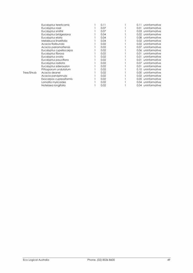
Eco Logical Australia Phone. (02) 8536 8600 49
Eucalyptus tereticornis 1 0.11 1 0.11 uninformative Eucalyptus rossii 1 0.07 1 0.01 uninformative Eucalyptus smithii 1 0.07 1 0.03 uninformative Eucalyptus bridgesiana 1 0.04 1 0.02 uninformative Eucalyptus elata 1 0.04 1 0.08 uninformative Melaleuca linariifolia 1 0.04 1 0.02 uninformative Acacia floribunda 1 0.02 1 0.02 uninformative Acacia parramattensis 1 0.02 1 0.07 uninformative Eucalyptus cypellocarpa 1 0.02 1 0.06 uninformative Eucalyptus fibrosa 1 0.02 1 0.01 uninformative Eucalyptus ovata 1 0.02 1 0.01 uninformative Eucalyptus pauciflora 1 0.02 1 0.01 uninformative Eucalyptus radiata 1 0.02 1 0.07 uninformative Eucalyptus sideroxylon 1 0.02 1 0.01 uninformative Pittosporum undulatum 1 0.02 1 0.10 uninformative Tree/Shrub Acacia deanei 1 0.02 1 0.00 uninformative Acacia parvipinnula 1 0.02 1 0.02 uninformative Exocarpos cupressiformis 1 0.02 1 0.05 uninformative Lomatia myricoides 1 0.02 1 0.04 uninformative Notelaea longifolia 1 0.02 1 0.04 uninformative
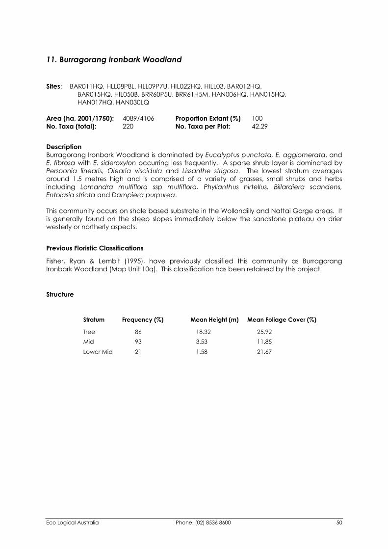
Eco Logical Australia Phone. (02) 8536 8600 50
11. Burragorang Ironbark Woodland Sites: BAR011HQ, HLL08P8L, HLL09P7U, HIL022HQ, HILL03, BAR012HQ, BAR015HQ, HIL050B, BRR60P5U, BRR61H5M, HAN006HQ, HAN015HQ, HAN017HQ, HAN030LQ Area (ha, 2001/1750): 4089/4106 Proportion Extant (%) 100 No. Taxa (total): 220 No. Taxa per Plot: 42.29
Description Burragorang Ironbark Woodland is dominated by Eucalyptus punctata, E. agglomerata, and E. fibrosa with E. sideroxylon occurring less frequently. A sparse shrub layer is dominated by Persoonia linearis, Olearia viscidula and Lissanthe strigosa. The lowest stratum averages around 1.5 metres high and is comprised of a variety of grasses, small shrubs and herbs including Lomandra multiflora ssp multiflora, Phyllanthus hirtellus, Billardiera scandens, Entolasia stricta and Dampiera purpurea. This community occurs on shale based substrate in the Wollondilly and Nattai Gorge areas. It is generally found on the steep slopes immediately below the sandstone plateau on drier westerly or northerly aspects.
Previous Floristic Classifications
Fisher, Ryan & Lembit (1995), have previously classified this community as Burragorang Ironbark Woodland (Map Unit 10q). This classification has been retained by this project.
Structure
Stratum Frequency (%) Mean Height (m) Mean Foliage Cover (%) Tree 86 18.32 25.92 Mid 93 3.53 11.85 Lower Mid 21 1.58 21.67
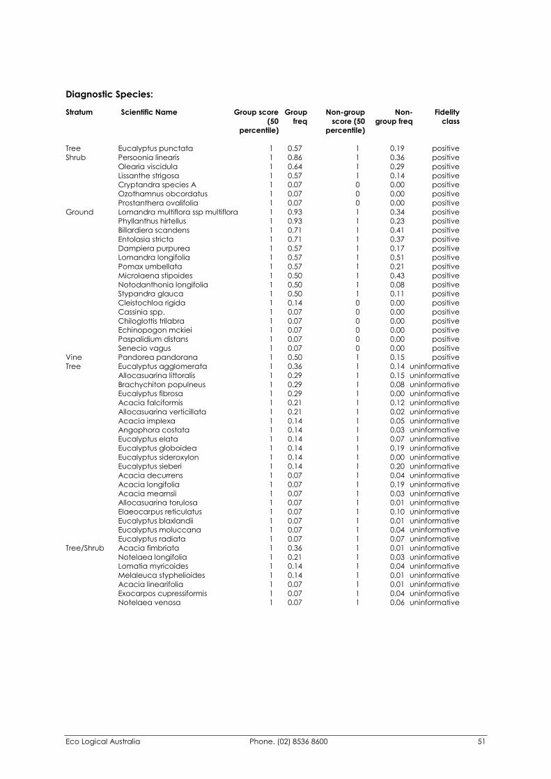
Eco Logical Australia Phone. (02) 8536 8600 51
Diagnostic Species: Stratum Scientific Name Group score Group Non-group Non- Fidelity (50 freq score (50 group freq class percentile) percentile)
Tree Eucalyptus punctata 1 0.57 1 0.19 positive Shrub Persoonia linearis 1 0.86 1 0.36 positive Olearia viscidula 1 0.64 1 0.29 positive Lissanthe strigosa 1 0.57 1 0.14 positive Cryptandra species A 1 0.07 0 0.00 positive Ozothamnus obcordatus 1 0.07 0 0.00 positive Prostanthera ovalifolia 1 0.07 0 0.00 positive Ground Lomandra multiflora ssp multiflora 1 0.93 1 0.34 positive Phyllanthus hirtellus 1 0.93 1 0.23 positive Billardiera scandens 1 0.71 1 0.41 positive Entolasia stricta 1 0.71 1 0.37 positive Dampiera purpurea 1 0.57 1 0.17 positive Lomandra longifolia 1 0.57 1 0.51 positive Pomax umbellata 1 0.57 1 0.21 positive Microlaena stipoides 1 0.50 1 0.43 positive Notodanthonia longifolia 1 0.50 1 0.08 positive Stypandra glauca 1 0.50 1 0.11 positive Cleistochloa rigida 1 0.14 0 0.00 positive Cassinia spp. 1 0.07 0 0.00 positive Chiloglottis trilabra 1 0.07 0 0.00 positive Echinopogon mckiei 1 0.07 0 0.00 positive Paspalidium distans 1 0.07 0 0.00 positive Senecio vagus 1 0.07 0 0.00 positive Vine Pandorea pandorana 1 0.50 1 0.15 positive Tree Eucalyptus agglomerata 1 0.36 1 0.14 uninformative Allocasuarina littoralis 1 0.29 1 0.15 uninformative Brachychiton populneus 1 0.29 1 0.08 uninformative Eucalyptus fibrosa 1 0.29 1 0.00 uninformative Acacia falciformis 1 0.21 1 0.12 uninformative Allocasuarina verticillata 1 0.21 1 0.02 uninformative Acacia implexa 1 0.14 1 0.05 uninformative Angophora costata 1 0.14 1 0.03 uninformative Eucalyptus elata 1 0.14 1 0.07 uninformative Eucalyptus globoidea 1 0.14 1 0.19 uninformative Eucalyptus sideroxylon 1 0.14 1 0.00 uninformative Eucalyptus sieberi 1 0.14 1 0.20 uninformative Acacia decurrens 1 0.07 1 0.04 uninformative Acacia longifolia 1 0.07 1 0.19 uninformative Acacia mearnsii 1 0.07 1 0.03 uninformative Allocasuarina torulosa 1 0.07 1 0.01 uninformative Elaeocarpus reticulatus 1 0.07 1 0.10 uninformative Eucalyptus blaxlandii 1 0.07 1 0.01 uninformative Eucalyptus moluccana 1 0.07 1 0.04 uninformative Eucalyptus radiata 1 0.07 1 0.07 uninformative Tree/Shrub Acacia fimbriata 1 0.36 1 0.01 uninformative Notelaea longifolia 1 0.21 1 0.03 uninformative Lomatia myricoides 1 0.14 1 0.04 uninformative Melaleuca styphelioides 1 0.14 1 0.01 uninformative Acacia linearifolia 1 0.07 1 0.01 uninformative Exocarpos cupressiformis 1 0.07 1 0.04 uninformative Notelaea venosa 1 0.07 1 0.06 uninformative
Eco Logical Australia Phone. (02) 8536 8600 52
12. Bindook Porphyry Moist Woodland Sites: BAR016AV, HAN029LQ, BAR020B, HIL002B, IL007BLQ, BRR38D3V, BRR49D1V, BRR08A1V, BRR17A0F, BRR54D8V, BRR69Q8V, HILL04, WOLL017 Area (ha, 2001/1750): 2135/3193 Proportion Extant (%) 67.00 No. Taxa (total): 197 No. Taxa per Plot: 45.83
Description Bindook Porphyry Moist Woodland is comprised of a low tree layer that is dominated by Pittosporum undulatum, Brachychiton populneus, Backhousia myrtifolia and Acacia parramattensis. Eucalyptus tereticornis often occurs with the low tree layer or as an emergent, as do E. moluccana and E. punctata, although in lower frequencies. A shrub stratum regularly occurs with the most frequent species including Hymenanthera dentata, Olearia viscidula and juvenile individuals of the upper stratum. Although the mean foliage cover of the upper stratum averages around 33% isolated patches can form a closed canopy, particularly in the more sheltered areas where a dense canopy of Backhousia myrtifolia takes on a rainforest appearance. In addition a number of rainforest species are often found including Ficus rubiginosa, Acacia melanoxylon, Ficus coronata, Rapanea howittiana and Pandorea pandorana. This community occurs along creeklines and sheltered aspects on soils associated with the Bindook Porphyries. It comprises the moister end of the spectrum of the Bindook Porphyry complex.
Previous Floristic Classifications Fisher, Ryan & Lembit (1995), have previously classified this community as ‘Porphyry Box Woodland’ (Map Unit 10pw) although no discrimination was made between the moist and dry communities in this area.
Structure
Stratum Frequency (%) Mean Height (m) Mean Foliage Cover (%) Tree 77 13.80 33.00 Mid 62 4.53 28.13 Emerging 8 25.00 2.00
Eco Logical Australia Phone. (02) 8536 8600 53
Diagnostic Species: Stratum Scientific Name Group score Group Non-group Non- Fidelity (50 freq score (50 group freq class percentile) percentile)
Tree Pittosporum undulatum 1 0.54 1 0.08 positive Eucalyptus hypostomatica 1 0.08 0 0.00 positive Notelaea microcarpa 1 0.08 0 0.00 positive Shrub Hymenanthera dentata 1 0.69 1 0.09 positive Olearia viscidula 1 0.54 1 0.29 positive Deeringia amaranthoides 1 0.08 0 0.00 positive Myoporum floribundum 1 0.08 0 0.00 positive Swainsona galegifolia 1 0.08 0 0.00 positive Ground Microlaena stipoides 1 0.85 1 0.42 positive Dichondra repens 1 0.69 1 0.31 positive Geitonoplesium cymosum 1 0.69 1 0.13 positive Lomandra longifolia 1 0.69 1 0.51 positive Sigesbeckia orientalis ssp orientalis 1 0.69 1 0.02 positive Urtica incisa 1 0.69 1 0.05 positive Asplenium flabellifolium 1 0.54 1 0.15 positive Pellaea falcata 1 0.54 1 0.07 positive Bromus molliformis 1 0.08 0 0.00 positive Doodia australis 1 0.08 0 0.00 positive Euphorbia spp. 1 0.08 0 0.00 positive Parietaria debilis 1 0.08 0 0.00 positive Sicyos australis 1 0.08 0 0.00 positive Sisymbrium irio 1 0.08 0 0.00 positive Vine Pandorea pandorana 1 0.54 1 0.15 positive Epiphyte Cymbidium suave 1 0.08 0 0.00 positive Tree Eucalyptus tereticornis 1 0.46 1 0.10 uninformative Brachychiton populneus 1 0.38 1 0.08 uninformative Backhousia myrtifolia 1 0.31 1 0.03 uninformative Acacia parramattensis 1 0.23 1 0.06 uninformative Casuarina cunninghamiana ssp 1 0.23 1 0.02 uninformative Ficus rubiginosa 1 0.23 1 0.01 uninformative Acacia implexa 1 0.15 1 0.05 uninformative Acacia longifolia 1 0.15 1 0.19 uninformative Acacia melanoxylon 1 0.15 1 0.09 uninformative Clerodendrum tomentosum 1 0.15 1 0.00 uninformative Eucalyptus moluccana 1 0.15 1 0.03 uninformative Eucalyptus punctata 1 0.15 1 0.20 uninformative Ficus coronata 1 0.15 1 0.01 uninformative Acacia decurrens 1 0.08 1 0.04 uninformative Acacia falciformis 1 0.08 1 0.12 uninformative Acacia floribunda 1 0.08 1 0.02 uninformative Acacia mearnsii 1 0.08 1 0.03 uninformative Allocasuarina verticillata 1 0.08 1 0.03 uninformative Angophora floribunda 1 0.08 1 0.02 uninformative Melaleuca linariifolia 1 0.08 1 0.02 uninformative Stenocarpus salignus 1 0.08 1 0.01 uninformative Tree/Shrub Melaleuca styphelioides 1 0.23 1 0.01 uninformative Claoxylon australe 1 0.15 1 0.00 uninformative Rapanea howittiana 1 0.15 1 0.04 uninformative Acacia penninervis 1 0.08 1 0.00 uninformative Hedycarya angustifolia 1 0.08 1 0.02 uninformative Notelaea longifolia 1 0.08 1 0.04 uninformative
Eco Logical Australia Phone. (02) 8536 8600 54
13. Bindook Porphyry Dry Woodland Sites: BRR09D1M, BRR19D7L, BRR39C5L, BRR10D5M, BRR13D1M, BRR12D7M, BRR55D5U, BRR24D8M, BRR50D5M, BRR51D7U, BRR48D7M, BRR56O7L, BRR64D5L, BRR65D1L, BRR67D7M, BRR66D1M, BRR68D3M, BRR11D3M, BRR18D3M, BRR34D3M, BRR40C4V, BRR42D3M, BRR25D3M, BRR26D1M, BRR36D4M, BRR37D1M, BRR28D4U, BRR29D6M, BRR35D5M, BRR27D5U, BRR41D1M, BRR43D5M, BRR46D6M, BRR44D8L, BRR45D8U, BRR47D6M, BRR57O3L, BRR58D3U, RIC04D7M, RIC01D5M, RIC02D5U, RIC03A7V, CAN013G, HAN031LQ, HAN034LQ, HAN033LQ, HAN026HQ, HAN028HQ, HAN027HQ, HAN001LQ, MIT004LQ, MIT005B, MIT007LQ, CAN017HQ, HAN025HQ, CAN031HQ, CAN033HQ, HAN024LQ Area (ha, 2001/1750): 17784/25833 Proportion Extant (%) 69.00 No. Taxa (total): 335 No. Taxa per Plot: 48.38
Description The upper stratum of Bindook Porphyry Dry Woodland averages a height of around 15.5 metres and is dominated by Eucalyptus tereticornis, Brachychiton populneus, E. melliodora and E. eugenioides. E. albens, E. moluccana and E. punctata occur less frequently. A sparse mid stratum often occurs and a lower mid stratum is present at around 36% of sites. The most frequently occurring species in these strata are Olearia viscidula, Lissanthe strigosa and Bursaria spinosa with Dichondra repens, Cheilanthes sieberi, Desmodium varians and Lomandra longifolia being the most common ground species. This community occurs on the volcanic soils of the Bindook Porphry complex. Of the two commuities identified on this geology in the study area this community is the most common occurring on ridges, upper slopes and open aspects.
Previous Floristic Classifications Fisher, Ryan & Lembit (1995), have previously classified this community as ‘Porphyry Box Woodland’ (Map Unit 10pw) although no discrimination was made between the moist and dry communities in this area.
Structure
Stratum Frequency (%) Mean Height (m) Mean Foliage Cover (%) Tree 98 15.57 20.05 Mid 93 4.34 12.74 Lower Mid 36 1.60 21.33 Emerging 2 8.50 1.00
Eco Logical Australia Phone. (02) 8536 8600 55
Diagnostic Species: Stratum Scientific Name Group score Group Non-group Non- Fidelity (50 freq score (50 group freq class percentile) percentile)
Tree Eucalyptus tereticornis 1 0.53 1 0.04 positive Eucalyptus albens 1 0.05 0 0.00 positive Acacia binervia 1 0.02 0 0.00 positive Tree/Shrub Acacia chalkeri 1 0.03 0 0.00 positive Shrub Olearia viscidula 1 0.91 1 0.20 positive Lissanthe strigosa 1 0.55 1 0.10 positive Bursaria spinosa 1 0.53 1 0.08 positive Myoporum montanum 1 0.21 0 0.00 positive Cassinia arcuata 1 0.03 0 0.00 positive Amyema miquelii 1 0.02 0 0.00 positive Eremophila debilis 1 0.02 0 0.00 positive Pomaderris angustifolia 1 0.02 0 0.00 positive Pultenaea subternata 1 0.02 0 0.00 positive Senna odorata 1 0.02 0 0.00 positive Solanum brownii 1 0.02 0 0.00 positive Solanum campanulatum 1 0.02 0 0.00 positive Ground Dichondra repens 1 0.91 1 0.22 positive Cheilanthes sieberi 1 0.79 1 0.10 positive Desmodium varians 1 0.74 1 0.12 positive Lomandra longifolia 1 0.69 1 0.49 positive Elymus scabrus 1 0.64 1 0.03 positive Dichelachne micrantha 1 0.62 1 0.08 positive Lomandra multiflora ssp multiflora 1 0.62 1 0.31 positive Aristida ramosa 1 0.57 1 0.06 positive Veronica plebeia 1 0.55 1 0.16 positive Microlaena stipoides 1 0.53 1 0.41 positive Arthropodium milleflorum 1 0.50 1 0.02 positive Cheilanthes distans 1 0.50 1 0.01 positive Hydrocotyle laxiflora 1 0.50 1 0.14 positive Adiantum atroviride 1 0.10 0 0.00 positive Paspalidium criniforme 1 0.05 0 0.00 positive Arthropodium species B 1 0.03 0 0.00 positive Arthropodium spp. 1 0.03 0 0.00 positive Carex incomitata 1 0.03 0 0.00 positive Chamaesyce dallachyana 1 0.03 0 0.00 positive Cynoglossum spp. 1 0.03 0 0.00 positive Dichanthium sericeum 1 0.03 0 0.00 positive Digitaria brownii 1 0.03 0 0.00 positive Luzula densiflora 1 0.03 0 0.00 positive Plectranthus graveolens 1 0.03 0 0.00 positive Pleurosorus rutifolius 1 0.03 0 0.00 positive Rhodanthe anthemoides 1 0.03 0 0.00 positive Schoenus maschalinus 1 0.03 0 0.00 positive Sigesbeckia australiensis 1 0.03 0 0.00 positive Sporobolus africanus 1 0.03 0 0.00 positive Austrostipa semibarbata 1 0.02 0 0.00 positive Austrostipa setacea 1 0.02 0 0.00 positive Calotis hispidula 1 0.02 0 0.00 positive Calotis spp. 1 0.02 0 0.00 positive Capillipedium parviflorum 1 0.02 0 0.00 positive Chenopodium pumilio 1 0.02 0 0.00 positive Cymbonotus spp. 1 0.02 0 0.00 positive Dendrobium linguiforme 1 0.02 0 0.00 positive Dichanthium spp. 1 0.02 0 0.00 positive Doodia caudata 1 0.02 0 0.00 positive Echinopogon spp. 1 0.02 0 0.00 positive Enneapogon gracilis 1 0.02 0 0.00 positive Gastrodia sesamoides 1 0.02 0 0.00 positive Leptinella filicula 1 0.02 0 0.00 positive Mentha satureioides 1 0.02 0 0.00 positive Microtis unifolia 1 0.02 0 0.00 positive Pellaea paradoxa 1 0.02 0 0.00 positive
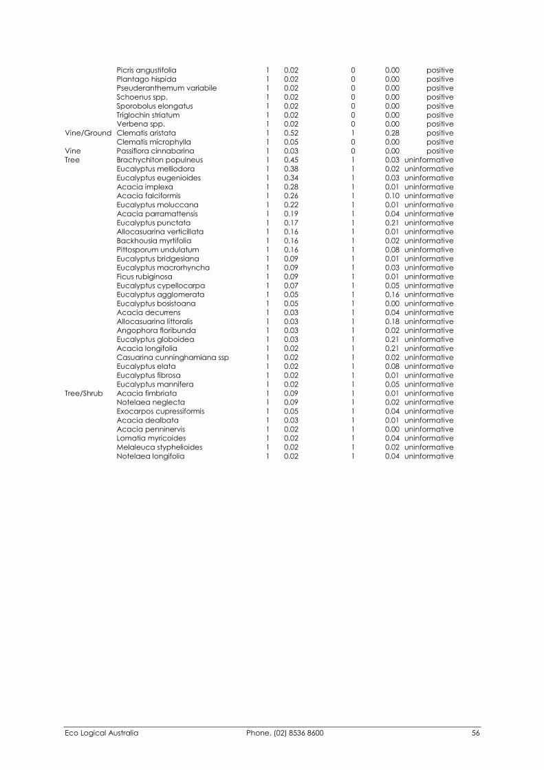
Eco Logical Australia Phone. (02) 8536 8600 56
Picris angustifolia 1 0.02 0 0.00 positive Plantago hispida 1 0.02 0 0.00 positive Pseuderanthemum variabile 1 0.02 0 0.00 positive Schoenus spp. 1 0.02 0 0.00 positive Sporobolus elongatus 1 0.02 0 0.00 positive Triglochin striatum 1 0.02 0 0.00 positive Verbena spp. 1 0.02 0 0.00 positive Vine/Ground Clematis aristata 1 0.52 1 0.28 positive Clematis microphylla 1 0.05 0 0.00 positive Vine Passiflora cinnabarina 1 0.03 0 0.00 positive Tree Brachychiton populneus 1 0.45 1 0.03 uninformative Eucalyptus melliodora 1 0.38 1 0.02 uninformative Eucalyptus eugenioides 1 0.34 1 0.03 uninformative Acacia implexa 1 0.28 1 0.01 uninformative Acacia falciformis 1 0.26 1 0.10 uninformative Eucalyptus moluccana 1 0.22 1 0.01 uninformative Acacia parramattensis 1 0.19 1 0.04 uninformative Eucalyptus punctata 1 0.17 1 0.21 uninformative Allocasuarina verticillata 1 0.16 1 0.01 uninformative Backhousia myrtifolia 1 0.16 1 0.02 uninformative Pittosporum undulatum 1 0.16 1 0.08 uninformative Eucalyptus bridgesiana 1 0.09 1 0.01 uninformative Eucalyptus macrorhyncha 1 0.09 1 0.03 uninformative Ficus rubiginosa 1 0.09 1 0.01 uninformative Eucalyptus cypellocarpa 1 0.07 1 0.05 uninformative Eucalyptus agglomerata 1 0.05 1 0.16 uninformative Eucalyptus bosistoana 1 0.05 1 0.00 uninformative Acacia decurrens 1 0.03 1 0.04 uninformative Allocasuarina littoralis 1 0.03 1 0.18 uninformative Angophora floribunda 1 0.03 1 0.02 uninformative Eucalyptus globoidea 1 0.03 1 0.21 uninformative Acacia longifolia 1 0.02 1 0.21 uninformative Casuarina cunninghamiana ssp 1 0.02 1 0.02 uninformative Eucalyptus elata 1 0.02 1 0.08 uninformative Eucalyptus fibrosa 1 0.02 1 0.01 uninformative Eucalyptus mannifera 1 0.02 1 0.05 uninformative Tree/Shrub Acacia fimbriata 1 0.09 1 0.01 uninformative Notelaea neglecta 1 0.09 1 0.02 uninformative Exocarpos cupressiformis 1 0.05 1 0.04 uninformative Acacia dealbata 1 0.03 1 0.01 uninformative Acacia penninervis 1 0.02 1 0.00 uninformative Lomatia myricoides 1 0.02 1 0.04 uninformative Melaleuca styphelioides 1 0.02 1 0.02 uninformative Notelaea longifolia 1 0.02 1 0.04 uninformative
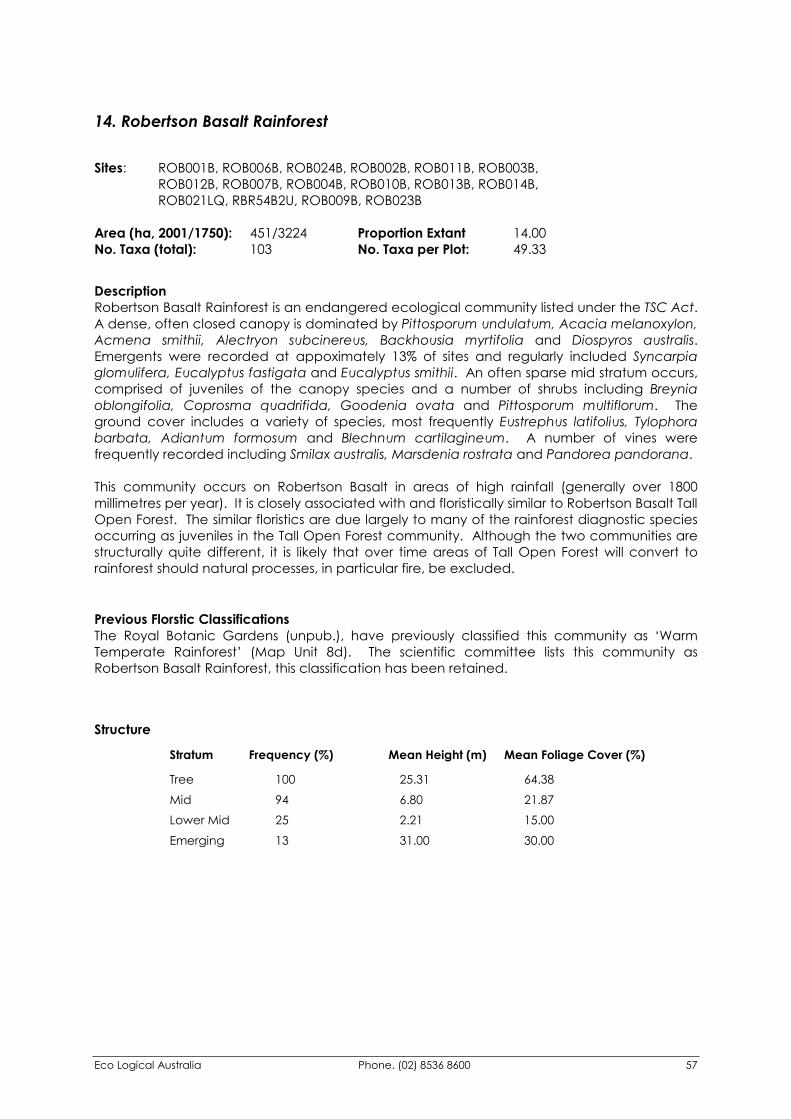
Eco Logical Australia Phone. (02) 8536 8600 57
14. Robertson Basalt Rainforest
Sites: ROB001B, ROB006B, ROB024B, ROB002B, ROB011B, ROB003B, ROB012B, ROB007B, ROB004B, ROB010B, ROB013B, ROB014B, ROB021LQ, RBR54B2U, ROB009B, ROB023B Area (ha, 2001/1750): 451/3224 Proportion Extant 14.00 No. Taxa (total): 103 No. Taxa per Plot: 49.33
Description Robertson Basalt Rainforest is an endangered ecological community listed under the TSC Act. A dense, often closed canopy is dominated by Pittosporum undulatum, Acacia melanoxylon, Acmena smithii, Alectryon subcinereus, Backhousia myrtifolia and Diospyros australis. Emergents were recorded at appoximately 13% of sites and regularly included Syncarpia glomulifera, Eucalyptus fastigata and Eucalyptus smithii. An often sparse mid stratum occurs, comprised of juveniles of the canopy species and a number of shrubs including Breynia oblongifolia, Coprosma quadrifida, Goodenia ovata and Pittosporum multiflorum. The ground cover includes a variety of species, most frequently Eustrephus latifolius, Tylophora barbata, Adiantum formosum and Blechnum cartilagineum. A number of vines were frequently recorded including Smilax australis, Marsdenia rostrata and Pandorea pandorana. This community occurs on Robertson Basalt in areas of high rainfall (generally over 1800 millimetres per year). It is closely associated with and floristically similar to Robertson Basalt Tall Open Forest. The similar floristics are due largely to many of the rainforest diagnostic species occurring as juveniles in the Tall Open Forest community. Although the two communities are structurally quite different, it is likely that over time areas of Tall Open Forest will convert to rainforest should natural processes, in particular fire, be excluded.
Previous Florstic Classifications The Royal Botanic Gardens (unpub.), have previously classified this community as ‘Warm Temperate Rainforest’ (Map Unit 8d). The scientific committee lists this community as Robertson Basalt Rainforest, this classification has been retained.
Structure
Stratum Frequency (%) Mean Height (m) Mean Foliage Cover (%) Tree 100 25.31 64.38 Mid 94 6.80 21.87 Lower Mid 25 2.21 15.00 Emerging 13 31.00 30.00
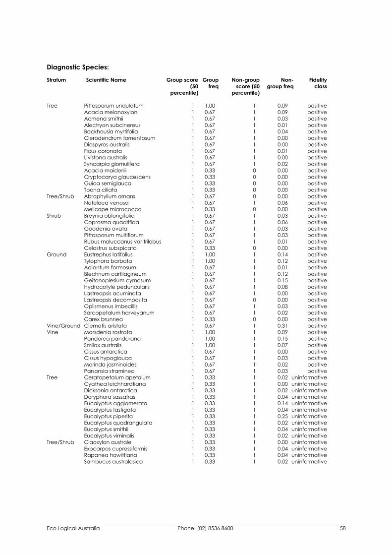
Eco Logical Australia Phone. (02) 8536 8600 58
Diagnostic Species: Stratum Scientific Name Group score Group Non-group Non- Fidelity (50 freq score (50 group freq class percentile) percentile)
Tree Pittosporum undulatum 1 1.00 1 0.09 positive Acacia melanoxylon 1 0.67 1 0.09 positive Acmena smithii 1 0.67 1 0.03 positive Alectryon subcinereus 1 0.67 1 0.01 positive Backhousia myrtifolia 1 0.67 1 0.04 positive Clerodendrum tomentosum 1 0.67 1 0.00 positive Diospyros australis 1 0.67 1 0.00 positive Ficus coronata 1 0.67 1 0.01 positive Livistona australis 1 0.67 1 0.00 positive Syncarpia glomulifera 1 0.67 1 0.02 positive Acacia maidenii 1 0.33 0 0.00 positive Cryptocarya glaucescens 1 0.33 0 0.00 positive Guioa semiglauca 1 0.33 0 0.00 positive Toona ciliata 1 0.33 0 0.00 positive Tree/Shrub Abrophyllum ornans 1 0.67 0 0.00 positive Notelaea venosa 1 0.67 1 0.06 positive Melicope micrococca 1 0.33 0 0.00 positive Shrub Breynia oblongifolia 1 0.67 1 0.03 positive Coprosma quadrifida 1 0.67 1 0.06 positive Goodenia ovata 1 0.67 1 0.03 positive Pittosporum multiflorum 1 0.67 1 0.03 positive Rubus moluccanus var trilobus 1 0.67 1 0.01 positive Celastrus subspicata 1 0.33 0 0.00 positive Ground Eustrephus latifolius 1 1.00 1 0.14 positive Tylophora barbata 1 1.00 1 0.12 positive Adiantum formosum 1 0.67 1 0.01 positive Blechnum cartilagineum 1 0.67 1 0.12 positive Geitonoplesium cymosum 1 0.67 1 0.15 positive Hydrocotyle peduncularis 1 0.67 1 0.08 positive Lastreopsis acuminata 1 0.67 1 0.00 positive Lastreopsis decomposita 1 0.67 0 0.00 positive Oplismenus imbecillis 1 0.67 1 0.03 positive Sarcopetalum harveyanum 1 0.67 1 0.02 positive Carex brunnea 1 0.33 0 0.00 positive Vine/Ground Clematis aristata 1 0.67 1 0.31 positive Vine Marsdenia rostrata 1 1.00 1 0.09 positive Pandorea pandorana 1 1.00 1 0.15 positive Smilax australis 1 1.00 1 0.07 positive Cissus antarctica 1 0.67 1 0.00 positive Cissus hypoglauca 1 0.67 1 0.03 positive Morinda jasminoides 1 0.67 1 0.02 positive Parsonsia straminea 1 0.67 1 0.03 positive Tree Ceratopetalum apetalum 1 0.33 1 0.02 uninformative Cyathea leichhardtiana 1 0.33 1 0.00 uninformative Dicksonia antarctica 1 0.33 1 0.02 uninformative Doryphora sassafras 1 0.33 1 0.04 uninformative Eucalyptus agglomerata 1 0.33 1 0.14 uninformative Eucalyptus fastigata 1 0.33 1 0.04 uninformative Eucalyptus piperita 1 0.33 1 0.25 uninformative Eucalyptus quadrangulata 1 0.33 1 0.02 uninformative Eucalyptus smithii 1 0.33 1 0.04 uninformative Eucalyptus viminalis 1 0.33 1 0.02 uninformative Tree/Shrub Claoxylon australe 1 0.33 1 0.00 uninformative Exocarpos cupressiformis 1 0.33 1 0.04 uninformative Rapanea howittiana 1 0.33 1 0.04 uninformative Sambucus australasica 1 0.33 1 0.02 uninformative
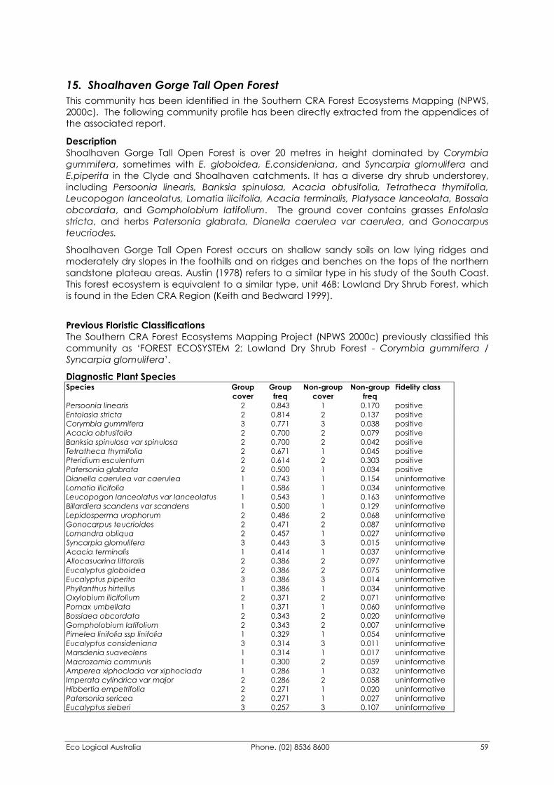
Eco Logical Australia Phone. (02) 8536 8600 59
15. Shoalhaven Gorge Tall Open Forest This community has been identified in the Southern CRA Forest Ecosystems Mapping (NPWS, 2000c). The following community profile has been directly extracted from the appendices of the associated report.
Description Shoalhaven Gorge Tall Open Forest is over 20 metres in height dominated by Corymbia gummifera, sometimes with E. globoidea, E.consideniana, and Syncarpia glomulifera and E.piperita in the Clyde and Shoalhaven catchments. It has a diverse dry shrub understorey, including Persoonia linearis, Banksia spinulosa, Acacia obtusifolia, Tetratheca thymifolia, Leucopogon lanceolatus, Lomatia ilicifolia, Acacia terminalis, Platysace lanceolata, Bossaia obcordata, and Gompholobium latifolium. The ground cover contains grasses Entolasia stricta, and herbs Patersonia glabrata, Dianella caerulea var caerulea, and Gonocarpus teucriodes.
Shoalhaven Gorge Tall Open Forest occurs on shallow sandy soils on low lying ridges and moderately dry slopes in the foothills and on ridges and benches on the tops of the northern sandstone plateau areas. Austin (1978) refers to a similar type in his study of the South Coast. This forest ecosystem is equivalent to a similar type, unit 46B: Lowland Dry Shrub Forest, which is found in the Eden CRA Region (Keith and Bedward 1999).
Previous Floristic Classifications The Southern CRA Forest Ecosystems Mapping Project (NPWS 2000c) previously classified this community as ‘FOREST ECOSYSTEM 2: Lowland Dry Shrub Forest - Corymbia gummifera / Syncarpia glomulifera’.
Diagnostic Plant Species Species Group
cover Group
freq Non-group
cover Non-group
freq Fidelity class
Persoonia linearis 2 0.843 1 0.170 positive Entolasia stricta 2 0.814 2 0.137 positive Corymbia gummifera 3 0.771 3 0.038 positive Acacia obtusifolia 2 0.700 2 0.079 positive Banksia spinulosa var spinulosa 2 0.700 2 0.042 positive Tetratheca thymifolia 2 0.671 1 0.045 positive Pteridium esculentum 2 0.614 2 0.303 positive Patersonia glabrata 2 0.500 1 0.034 positive Dianella caerulea var caerulea 1 0.743 1 0.154 uninformative Lomatia ilicifolia 1 0.586 1 0.034 uninformative Leucopogon lanceolatus var lanceolatus 1 0.543 1 0.163 uninformative Billardiera scandens var scandens 1 0.500 1 0.129 uninformative Lepidosperma urophorum 2 0.486 2 0.068 uninformative Gonocarpus teucrioides 2 0.471 2 0.087 uninformative Lomandra obliqua 2 0.457 1 0.027 uninformative Syncarpia glomulifera 3 0.443 3 0.015 uninformative Acacia terminalis 1 0.414 1 0.037 uninformative Allocasuarina littoralis 2 0.386 2 0.097 uninformative Eucalyptus globoidea 2 0.386 2 0.075 uninformative Eucalyptus piperita 3 0.386 3 0.014 uninformative Phyllanthus hirtellus 1 0.386 1 0.034 uninformative Oxylobium ilicifolium 2 0.371 2 0.071 uninformative Pomax umbellata 1 0.371 1 0.060 uninformative Bossiaea obcordata 2 0.343 2 0.020 uninformative Gompholobium latifolium 2 0.343 2 0.007 uninformative Pimelea linifolia ssp linifolia 1 0.329 1 0.054 uninformative Eucalyptus consideniana 3 0.314 3 0.011 uninformative Marsdenia suaveolens 1 0.314 1 0.017 uninformative Macrozamia communis 1 0.300 2 0.059 uninformative Amperea xiphoclada var xiphoclada 1 0.286 1 0.032 uninformative Imperata cylindrica var major 2 0.286 2 0.058 uninformative Hibbertia empetrifolia 2 0.271 1 0.020 uninformative Patersonia sericea 2 0.271 1 0.027 uninformative Eucalyptus sieberi 3 0.257 3 0.107 uninformative
Eco Logical Australia Phone. (02) 8536 8600 60
16. Robertson Basalt Tall Open Forest Sites: BUN007LQ, MIT097B, ROB017B, ROB016B, ROB018LQ, BUN028B, MOS001B, RBR42 Area (ha, 2001/1750): 1338/10978 Proportion Extant (%) 12.00 No. Taxa (total): 138 No. Taxa per Plot: 45.00
Description Robertson Basalt Tall Open Forest is an Endangered Ecological Communities listed under the TSC Act. As its name suggest it is the upper stratum is quite tall, averaging close to 30 metres. Dominant canopy species include Eucalyptus cypellocarpa, E. fastigata and Acacia melanoxylon. A distinct mid stratum occurs and averages close to 6 metres in height. The most frequent species include Rubus parvifolius, Coprosma quadrifida and Senecio linearifolius. Occassionally a dense lower mid stratum of ferns dominated by Pteridium esculentum occurs. Other species frequently recorded in either the ground or lower mid stratum include Eustrephus latifolius, Microlaena stipoides, Stellaria flaccida, Tylophora barbata and Smilax australis. This community occurs on Robertson Basalt in lower rainfall areas (generally below 1800 millimetres per year) or on exposed aspects. Many of the species contained in the lower stratum are consistent with Robertson Basalt Rainforest with which this community is closely associated.
Previous Floristic Classifications The Royal Botanic Gardens (unpub.), have previously classified this community as ‘Robertson Basalt Tall Forest’ (Map Unit 6k). The scientific committee lists this community as Robertson Basalt Tall Forest, this classification has been retained.
Structure
Stratum Frequency (%) Mean Height (m) Mean Foliage Cover (%) Tree 100 28.54 34.29 Mid 100 5.73 23.14 Lower Mid 25 2.45 8.50
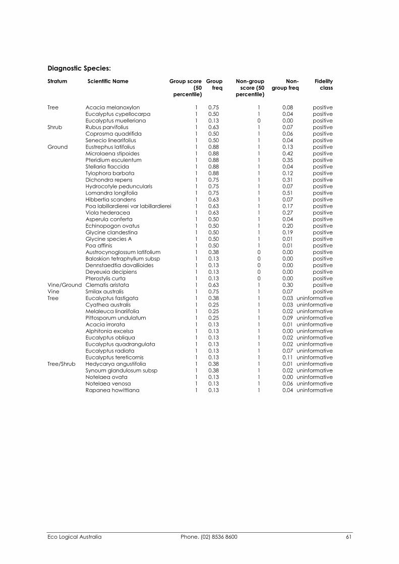
Eco Logical Australia Phone. (02) 8536 8600 61
Diagnostic Species: Stratum Scientific Name Group score Group Non-group Non- Fidelity (50 freq score (50 group freq class percentile) percentile)
Tree Acacia melanoxylon 1 0.75 1 0.08 positive Eucalyptus cypellocarpa 1 0.50 1 0.04 positive Eucalyptus muelleriana 1 0.13 0 0.00 positive Shrub Rubus parvifolius 1 0.63 1 0.07 positive Coprosma quadrifida 1 0.50 1 0.06 positive Senecio linearifolius 1 0.50 1 0.04 positive Ground Eustrephus latifolius 1 0.88 1 0.13 positive Microlaena stipoides 1 0.88 1 0.42 positive Pteridium esculentum 1 0.88 1 0.35 positive Stellaria flaccida 1 0.88 1 0.04 positive Tylophora barbata 1 0.88 1 0.12 positive Dichondra repens 1 0.75 1 0.31 positive Hydrocotyle peduncularis 1 0.75 1 0.07 positive Lomandra longifolia 1 0.75 1 0.51 positive Hibbertia scandens 1 0.63 1 0.07 positive Poa labillardierei var labillardierei 1 0.63 1 0.17 positive Viola hederacea 1 0.63 1 0.27 positive Asperula conferta 1 0.50 1 0.04 positive Echinopogon ovatus 1 0.50 1 0.20 positive Glycine clandestina 1 0.50 1 0.19 positive Glycine species A 1 0.50 1 0.01 positive Poa affinis 1 0.50 1 0.01 positive Austrocynoglossum latifolium 1 0.38 0 0.00 positive Baloskion tetraphyllum subsp 1 0.13 0 0.00 positive Dennstaedtia davallioides 1 0.13 0 0.00 positive Deyeuxia decipiens 1 0.13 0 0.00 positive Pterostylis curta 1 0.13 0 0.00 positive Vine/Ground Clematis aristata 1 0.63 1 0.30 positive Vine Smilax australis 1 0.75 1 0.07 positive Tree Eucalyptus fastigata 1 0.38 1 0.03 uninformative Cyathea australis 1 0.25 1 0.03 uninformative Melaleuca linariifolia 1 0.25 1 0.02 uninformative Pittosporum undulatum 1 0.25 1 0.09 uninformative Acacia irrorata 1 0.13 1 0.01 uninformative Alphitonia excelsa 1 0.13 1 0.00 uninformative Eucalyptus obliqua 1 0.13 1 0.02 uninformative Eucalyptus quadrangulata 1 0.13 1 0.02 uninformative Eucalyptus radiata 1 0.13 1 0.07 uninformative Eucalyptus tereticornis 1 0.13 1 0.11 uninformative Tree/Shrub Hedycarya angustifolia 1 0.38 1 0.01 uninformative Synoum glandulosum subsp 1 0.38 1 0.02 uninformative Notelaea ovata 1 0.13 1 0.00 uninformative Notelaea venosa 1 0.13 1 0.06 uninformative Rapanea howittiana 1 0.13 1 0.04 uninformative
Eco Logical Australia Phone. (02) 8536 8600 62
17. Southern Highlands Shale Woodland Sites: MIT002HQ, MIT003B, ROB030LQ, ROB031LQ, ROB033HQ, ROB034LQ, BRG50, ROB015LQ Area (ha, 2001/1750): 10791/53833 Proportion Extant (%) 20.00 No. Taxa (total): 138 No. Taxa per Plot: 38.63
Description Southern Highlands Shale Woodland is an Endangered Ecological Community listed under the TSC Act. The upper canopy averages a height of around 30 metres and is dominated by Eucalyptus dives, E. elata, E. piperita, E. cypellocarpa, E. fastigata, Elaeocarpus reticulatus and Acacia melanoxylon. A mid stratum of approximately 3.5 metres was recorded at all sites, dominant shrub species including Leucopogon lanceolatus, Notelaea venosa, Coprosma quadrifida, Helichrysum elatum and Tristaniopsis collina. A lower mid or Ground stratum typically includes Dianella caerulea, Pteridium esculentum, Billardiera scandens, Lomandra longifolia and Tylophora barbata. This community occurs on Bringelly Shale and extends across the Southern Highlands from Robertson to the Belanglo and Joadja areas. It has been significantly cleared and many of the remnants identified in the mapping are only composed of remnant trees with little or no understorey. It is likely that there is considerable variation in this community given the rainfall gradient across which it has been mapped. Floristically this community is closely related to Robertson Basalt Tall Forest and Mount Gibraltar Forest.
Previous Floristic Classifications Fisher, Ryan & Lembit (1995), have previously classified this community as ‘Southern Highlands Shale Woodlands’ (Map Unit 10x). The Scientific Committee has listed this community as ‘Southern Highlands Shale Woodlands’ and this terminology has been retained for this report.
Structure Stratum Frequency (%) Mean Height (m) Mean Foliage Cover (%) Tree 100 30.19 34.71 Mid 100 3.56 23.71 Lower Mid 13 1.25 15.00
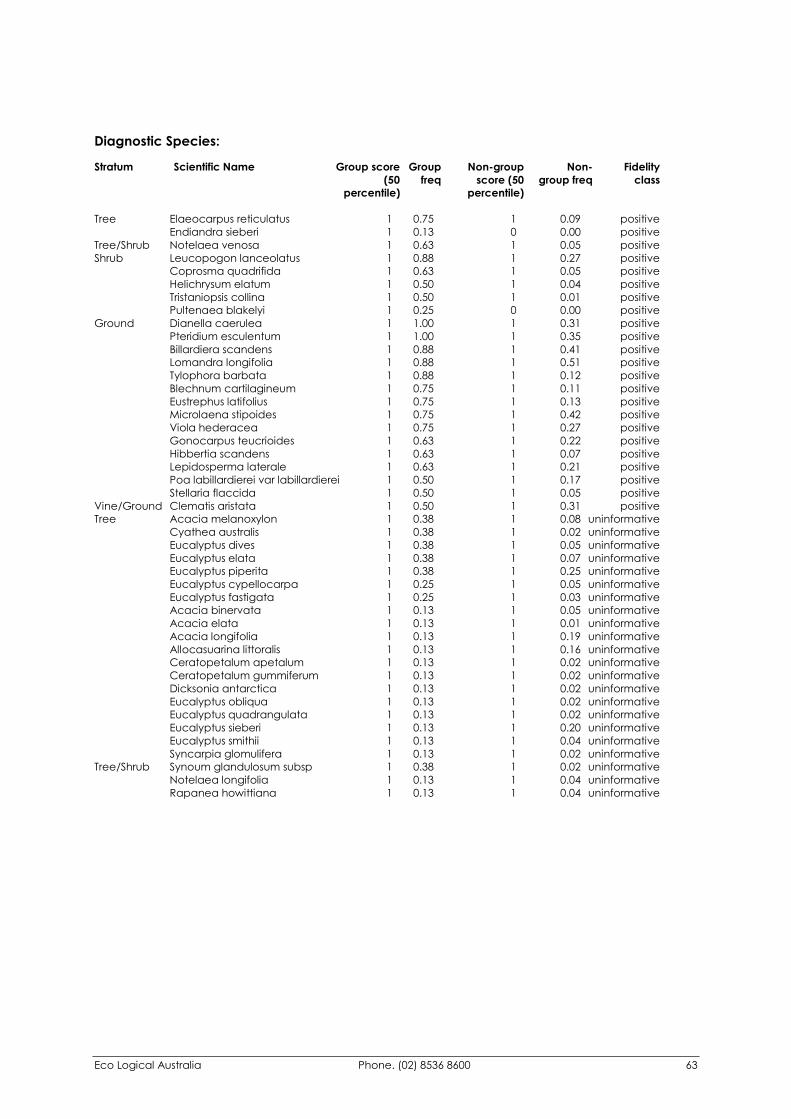
Eco Logical Australia Phone. (02) 8536 8600 63
Diagnostic Species: Stratum Scientific Name Group score Group Non-group Non- Fidelity (50 freq score (50 group freq class percentile) percentile)
Tree Elaeocarpus reticulatus 1 0.75 1 0.09 positive Endiandra sieberi 1 0.13 0 0.00 positive Tree/Shrub Notelaea venosa 1 0.63 1 0.05 positive Shrub Leucopogon lanceolatus 1 0.88 1 0.27 positive Coprosma quadrifida 1 0.63 1 0.05 positive Helichrysum elatum 1 0.50 1 0.04 positive Tristaniopsis collina 1 0.50 1 0.01 positive Pultenaea blakelyi 1 0.25 0 0.00 positive Ground Dianella caerulea 1 1.00 1 0.31 positive Pteridium esculentum 1 1.00 1 0.35 positive Billardiera scandens 1 0.88 1 0.41 positive Lomandra longifolia 1 0.88 1 0.51 positive Tylophora barbata 1 0.88 1 0.12 positive Blechnum cartilagineum 1 0.75 1 0.11 positive Eustrephus latifolius 1 0.75 1 0.13 positive Microlaena stipoides 1 0.75 1 0.42 positive Viola hederacea 1 0.75 1 0.27 positive Gonocarpus teucrioides 1 0.63 1 0.22 positive Hibbertia scandens 1 0.63 1 0.07 positive Lepidosperma laterale 1 0.63 1 0.21 positive Poa labillardierei var labillardierei 1 0.50 1 0.17 positive Stellaria flaccida 1 0.50 1 0.05 positive Vine/Ground Clematis aristata 1 0.50 1 0.31 positive Tree Acacia melanoxylon 1 0.38 1 0.08 uninformative Cyathea australis 1 0.38 1 0.02 uninformative Eucalyptus dives 1 0.38 1 0.05 uninformative Eucalyptus elata 1 0.38 1 0.07 uninformative Eucalyptus piperita 1 0.38 1 0.25 uninformative Eucalyptus cypellocarpa 1 0.25 1 0.05 uninformative Eucalyptus fastigata 1 0.25 1 0.03 uninformative Acacia binervata 1 0.13 1 0.05 uninformative Acacia elata 1 0.13 1 0.01 uninformative Acacia longifolia 1 0.13 1 0.19 uninformative Allocasuarina littoralis 1 0.13 1 0.16 uninformative Ceratopetalum apetalum 1 0.13 1 0.02 uninformative Ceratopetalum gummiferum 1 0.13 1 0.02 uninformative Dicksonia antarctica 1 0.13 1 0.02 uninformative Eucalyptus obliqua 1 0.13 1 0.02 uninformative Eucalyptus quadrangulata 1 0.13 1 0.02 uninformative Eucalyptus sieberi 1 0.13 1 0.20 uninformative Eucalyptus smithii 1 0.13 1 0.04 uninformative Syncarpia glomulifera 1 0.13 1 0.02 uninformative Tree/Shrub Synoum glandulosum subsp 1 0.38 1 0.02 uninformative Notelaea longifolia 1 0.13 1 0.04 uninformative Rapanea howittiana 1 0.13 1 0.04 uninformative
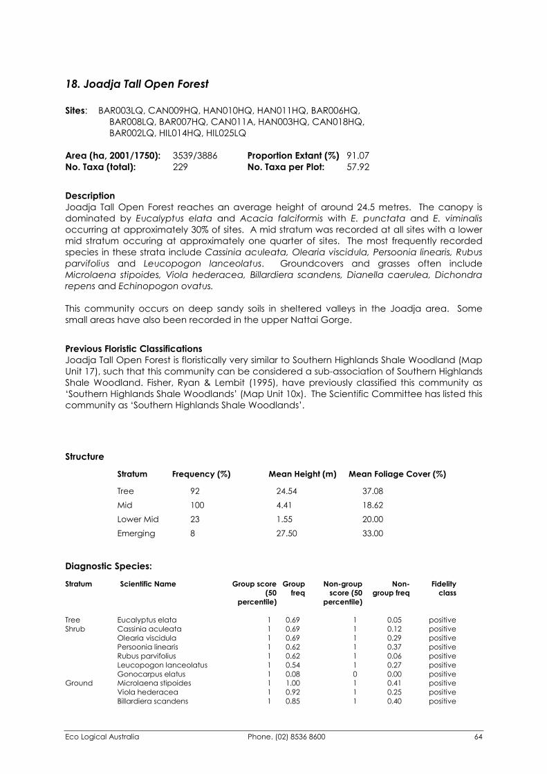
Eco Logical Australia Phone. (02) 8536 8600 64
18. Joadja Tall Open Forest Sites: BAR003LQ, CAN009HQ, HAN010HQ, HAN011HQ, BAR006HQ, BAR008LQ, BAR007HQ, CAN011A, HAN003HQ, CAN018HQ, BAR002LQ, HIL014HQ, HIL025LQ Area (ha, 2001/1750): 3539/3886 Proportion Extant (%) 91.07 No. Taxa (total): 229 No. Taxa per Plot: 57.92
Description Joadja Tall Open Forest reaches an average height of around 24.5 metres. The canopy is dominated by Eucalyptus elata and Acacia falciformis with E. punctata and E. viminalis occurring at approximately 30% of sites. A mid stratum was recorded at all sites with a lower mid stratum occuring at approximately one quarter of sites. The most frequently recorded species in these strata include Cassinia aculeata, Olearia viscidula, Persoonia linearis, Rubus parvifolius and Leucopogon lanceolatus. Groundcovers and grasses often include Microlaena stipoides, Viola hederacea, Billardiera scandens, Dianella caerulea, Dichondra repens and Echinopogon ovatus. This community occurs on deep sandy soils in sheltered valleys in the Joadja area. Some small areas have also been recorded in the upper Nattai Gorge.
Previous Floristic Classifications Joadja Tall Open Forest is floristically very similar to Southern Highlands Shale Woodland (Map Unit 17), such that this community can be considered a sub-association of Southern Highlands Shale Woodland. Fisher, Ryan & Lembit (1995), have previously classified this community as ‘Southern Highlands Shale Woodlands’ (Map Unit 10x). The Scientific Committee has listed this community as ‘Southern Highlands Shale Woodlands’.
Structure Stratum Frequency (%) Mean Height (m) Mean Foliage Cover (%) Tree 92 24.54 37.08 Mid 100 4.41 18.62 Lower Mid 23 1.55 20.00 Emerging 8 27.50 33.00
Diagnostic Species: Stratum Scientific Name Group score Group Non-group Non- Fidelity (50 freq score (50 group freq class percentile) percentile)
Tree Eucalyptus elata 1 0.69 1 0.05 positive Shrub Cassinia aculeata 1 0.69 1 0.12 positive Olearia viscidula 1 0.69 1 0.29 positive Persoonia linearis 1 0.62 1 0.37 positive Rubus parvifolius 1 0.62 1 0.06 positive Leucopogon lanceolatus 1 0.54 1 0.27 positive Gonocarpus elatus 1 0.08 0 0.00 positive Ground Microlaena stipoides 1 1.00 1 0.41 positive Viola hederacea 1 0.92 1 0.25 positive Billardiera scandens 1 0.85 1 0.40 positive
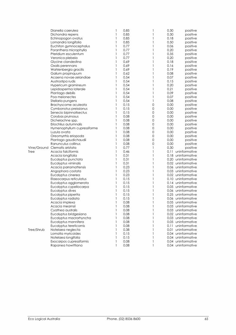
Eco Logical Australia Phone. (02) 8536 8600 65
Dianella caerulea 1 0.85 1 0.30 positive Dichondra repens 1 0.85 1 0.30 positive Echinopogon ovatus 1 0.85 1 0.18 positive Lomandra longifolia 1 0.85 1 0.50 positive Euchiton gymnocephalus 1 0.77 1 0.06 positive Poranthera microphylla 1 0.77 1 0.20 positive Pteridium esculentum 1 0.77 1 0.35 positive Veronica plebeia 1 0.77 1 0.20 positive Glycine clandestina 1 0.69 1 0.18 positive Oxalis perennans 1 0.69 1 0.16 positive Wahlenbergia gracilis 1 0.69 1 0.19 positive Galium propinquum 1 0.62 1 0.08 positive Acaena novae-zelandiae 1 0.54 1 0.07 positive Austrostipa rudis 1 0.54 1 0.15 positive Hypericum gramineum 1 0.54 1 0.20 positive Lepidosperma laterale 1 0.54 1 0.21 positive Plantago debilis 1 0.54 1 0.09 positive Poa meionectes 1 0.54 1 0.07 positive Stellaria pungens 1 0.54 1 0.08 positive Brachyscome aculeata 1 0.15 0 0.00 positive Cymbonotus preissianus 1 0.15 0 0.00 positive Senecio bipinnatisectus 1 0.15 0 0.00 positive Corybas pruinosus 1 0.08 0 0.00 positive Dichelachne spp. 1 0.08 0 0.00 positive Eriochilus autumnalis 1 0.08 0 0.00 positive Hymenophyllum cupressiforme 1 0.08 0 0.00 positive Luzula ovata 1 0.08 0 0.00 positive Oreomyrrhis eriopoda 1 0.08 0 0.00 positive Plantago gaudichaudii 1 0.08 0 0.00 positive Ranunculus collinus 1 0.08 0 0.00 positive Vine/Ground Clematis aristata 1 0.77 1 0.30 positive Tree Acacia falciformis 1 0.46 1 0.11 uninformative Acacia longifolia 1 0.31 1 0.18 uninformative Eucalyptus punctata 1 0.31 1 0.20 uninformative Eucalyptus viminalis 1 0.31 1 0.02 uninformative Acacia parramattensis 1 0.23 1 0.06 uninformative Angophora costata 1 0.23 1 0.03 uninformative Eucalyptus cinerea 1 0.23 1 0.02 uninformative Elaeocarpus reticulatus 1 0.15 1 0.10 uninformative Eucalyptus agglomerata 1 0.15 1 0.14 uninformative Eucalyptus cypellocarpa 1 0.15 1 0.05 uninformative Eucalyptus dives 1 0.15 1 0.06 uninformative Eucalyptus piperita 1 0.15 1 0.25 uninformative Eucalyptus radiata 1 0.15 1 0.06 uninformative Acacia implexa 1 0.08 1 0.05 uninformative Acacia mearnsii 1 0.08 1 0.03 uninformative Cyathea australis 1 0.08 1 0.03 uninformative Eucalyptus bridgesiana 1 0.08 1 0.02 uninformative Eucalyptus macrorhyncha 1 0.08 1 0.03 uninformative Eucalyptus mannifera 1 0.08 1 0.05 uninformative Eucalyptus tereticornis 1 0.08 1 0.11 uninformative Tree/Shrub Notelaea neglecta 1 0.38 1 0.01 uninformative Lomatia myricoides 1 0.15 1 0.04 uninformative Notelaea longifolia 1 0.15 1 0.04 uninformative Exocarpos cupressiformis 1 0.08 1 0.04 uninformative Rapanea howittiana 1 0.08 1 0.04 uninformative
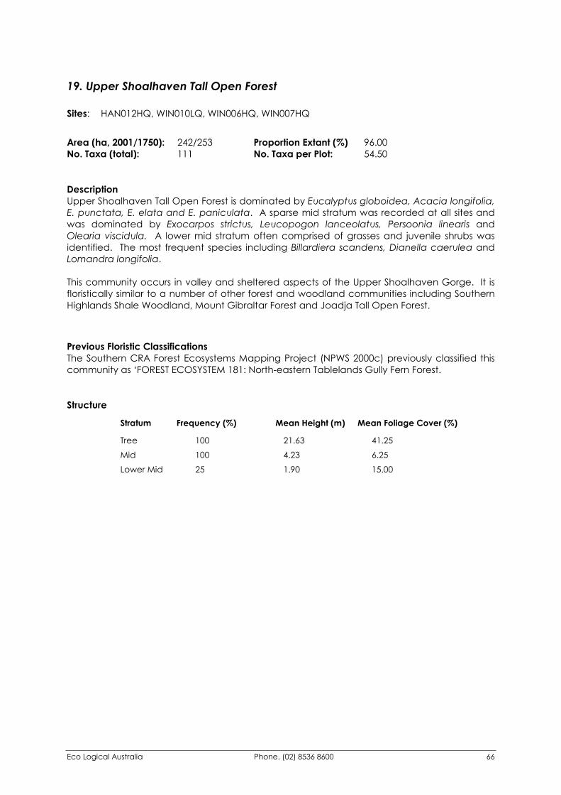
Eco Logical Australia Phone. (02) 8536 8600 66
19. Upper Shoalhaven Tall Open Forest Sites: HAN012HQ, WIN010LQ, WIN006HQ, WIN007HQ
Area (ha, 2001/1750): 242/253 Proportion Extant (%) 96.00 No. Taxa (total): 111 No. Taxa per Plot: 54.50
Description Upper Shoalhaven Tall Open Forest is dominated by Eucalyptus globoidea, Acacia longifolia, E. punctata, E. elata and E. paniculata. A sparse mid stratum was recorded at all sites and was dominated by Exocarpos strictus, Leucopogon lanceolatus, Persoonia linearis and Olearia viscidula. A lower mid stratum often comprised of grasses and juvenile shrubs was identified. The most frequent species including Billardiera scandens, Dianella caerulea and Lomandra longifolia. This community occurs in valley and sheltered aspects of the Upper Shoalhaven Gorge. It is floristically similar to a number of other forest and woodland communities including Southern Highlands Shale Woodland, Mount Gibraltar Forest and Joadja Tall Open Forest.
Previous Floristic Classifications The Southern CRA Forest Ecosystems Mapping Project (NPWS 2000c) previously classified this community as ‘FOREST ECOSYSTEM 181: North-eastern Tablelands Gully Fern Forest.
Structure Stratum Frequency (%) Mean Height (m) Mean Foliage Cover (%) Tree 100 21.63 41.25 Mid 100 4.23 6.25 Lower Mid 25 1.90 15.00
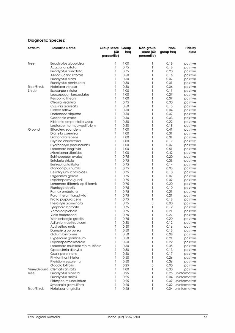
Eco Logical Australia Phone. (02) 8536 8600 67
Diagnostic Species: Stratum Scientific Name Group score Group Non-group Non- Fidelity (50 freq score (50 group freq class percentile) percentile)
Tree Eucalyptus globoidea 1 1.00 1 0.18 positive Acacia longifolia 1 0.75 1 0.18 positive Eucalyptus punctata 1 0.75 1 0.20 positive Allocasuarina littoralis 1 0.50 1 0.16 positive Eucalyptus elata 1 0.50 1 0.07 positive Eucalyptus paniculata 1 0.50 1 0.01 positive Tree/Shrub Notelaea venosa 1 0.50 1 0.06 positive Shrub Exocarpos strictus 1 1.00 1 0.11 positive Leucopogon lanceolatus 1 1.00 1 0.27 positive Persoonia linearis 1 1.00 1 0.37 positive Olearia viscidula 1 0.75 1 0.30 positive Cassinia aculeata 1 0.50 1 0.13 positive Correa reflexa 1 0.50 1 0.04 positive Dodonaea triquetra 1 0.50 1 0.07 positive Goodenia ovata 1 0.50 1 0.03 positive Hibbertia empetrifolia subsp 1 0.50 1 0.22 positive Leptospermum polygalifolium 1 0.50 1 0.18 positive Ground Billardiera scandens 1 1.00 1 0.41 positive Dianella caerulea 1 1.00 1 0.31 positive Dichondra repens 1 1.00 1 0.31 positive Glycine clandestina 1 1.00 1 0.19 positive Hydrocotyle peduncularis 1 1.00 1 0.07 positive Lomandra longifolia 1 1.00 1 0.51 positive Microlaena stipoides 1 1.00 1 0.42 positive Echinopogon ovatus 1 0.75 1 0.20 positive Entolasia stricta 1 0.75 1 0.38 positive Eustrephus latifolius 1 0.75 1 0.14 positive Gonocarpus humilis 1 0.75 1 0.03 positive Helichrysum scorpioides 1 0.75 1 0.10 positive Lagenifera gracilis 1 0.75 1 0.09 positive Lepidosperma gunnii 1 0.75 1 0.09 positive Lomandra filiformis ssp filiformis 1 0.75 1 0.20 positive Plantago debilis 1 0.75 1 0.10 positive Pomax umbellata 1 0.75 1 0.21 positive Poranthera microphylla 1 0.75 1 0.21 positive Pratia purpurascens 1 0.75 1 0.16 positive Pterostylis acuminata 1 0.75 0 0.00 positive Tylophora barbata 1 0.75 1 0.12 positive Veronica plebeia 1 0.75 1 0.21 positive Viola hederacea 1 0.75 1 0.27 positive Wahlenbergia gracilis 1 0.75 1 0.20 positive Adiantum aethiopicum 1 0.50 1 0.12 positive Austrostipa rudis 1 0.50 1 0.16 positive Dampiera purpurea 1 0.50 1 0.18 positive Galium binifolium 1 0.50 1 0.06 positive Hypericum gramineum 1 0.50 1 0.21 positive Lepidosperma laterale 1 0.50 1 0.22 positive Lomandra multiflora ssp multiflora 1 0.50 1 0.35 positive Opercularia diphylla 1 0.50 1 0.13 positive Oxalis perennans 1 0.50 1 0.17 positive Phyllanthus hirtellus 1 0.50 1 0.26 positive Pteridium esculentum 1 0.50 1 0.36 positive Goodia lotifolia 1 0.25 0 0.00 positive Vine/Ground Clematis aristata 1 1.00 1 0.30 positive Tree Eucalyptus piperita 1 0.25 1 0.25 uninformative Eucalyptus smithii 1 0.25 1 0.04 uninformative Pittosporum undulatum 1 0.25 1 0.09 uninformative Syncarpia glomulifera 1 0.25 1 0.02 uninformative Tree/Shrub Notelaea longifolia 1 0.25 1 0.04 uninformative
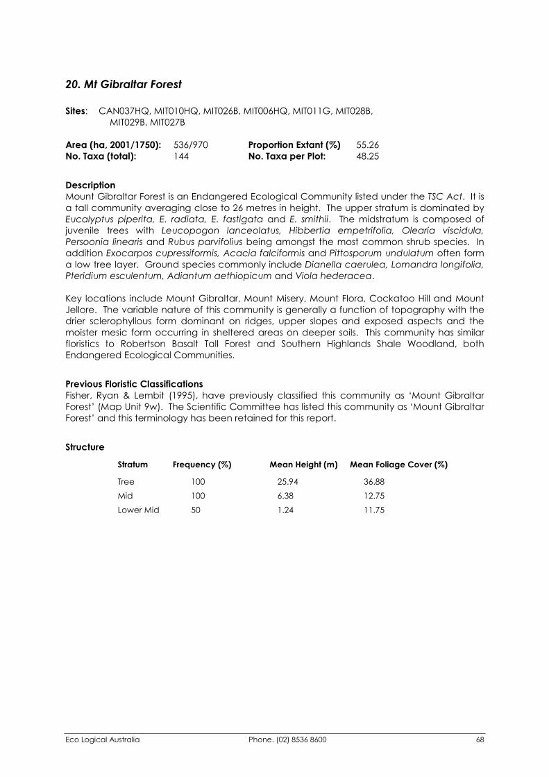
Eco Logical Australia Phone. (02) 8536 8600 68
20. Mt Gibraltar Forest Sites: CAN037HQ, MIT010HQ, MIT026B, MIT006HQ, MIT011G, MIT028B, MIT029B, MIT027B Area (ha, 2001/1750): 536/970 Proportion Extant (%) 55.26 No. Taxa (total): 144 No. Taxa per Plot: 48.25
Description Mount Gibraltar Forest is an Endangered Ecological Community listed under the TSC Act. It is a tall community averaging close to 26 metres in height. The upper stratum is dominated by Eucalyptus piperita, E. radiata, E. fastigata and E. smithii. The midstratum is composed of juvenile trees with Leucopogon lanceolatus, Hibbertia empetrifolia, Olearia viscidula, Persoonia linearis and Rubus parvifolius being amongst the most common shrub species. In addition Exocarpos cupressiformis, Acacia falciformis and Pittosporum undulatum often form a low tree layer. Ground species commonly include Dianella caerulea, Lomandra longifolia, Pteridium esculentum, Adiantum aethiopicum and Viola hederacea. Key locations include Mount Gibraltar, Mount Misery, Mount Flora, Cockatoo Hill and Mount Jellore. The variable nature of this community is generally a function of topography with the drier sclerophyllous form dominant on ridges, upper slopes and exposed aspects and the moister mesic form occurring in sheltered areas on deeper soils. This community has similar floristics to Robertson Basalt Tall Forest and Southern Highlands Shale Woodland, both Endangered Ecological Communities.
Previous Floristic Classifications Fisher, Ryan & Lembit (1995), have previously classified this community as ‘Mount Gibraltar Forest’ (Map Unit 9w). The Scientific Committee has listed this community as ‘Mount Gibraltar Forest’ and this terminology has been retained for this report.
Structure Stratum Frequency (%) Mean Height (m) Mean Foliage Cover (%) Tree 100 25.94 36.88 Mid 100 6.38 12.75 Lower Mid 50 1.24 11.75
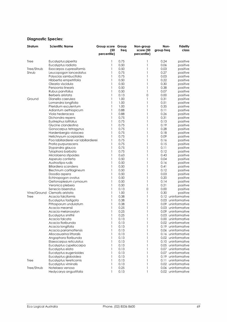
Eco Logical Australia Phone. (02) 8536 8600 69
Diagnostic Species: Stratum Scientific Name Group score Group Non-group Non- Fidelity (50 freq score (50 group freq class percentile) percentile)
Tree Eucalyptus piperita 1 0.75 1 0.24 positive Eucalyptus radiata 1 0.50 1 0.06 positive Tree/Shrub Exocarpos cupressiformis 1 0.50 1 0.03 positive Shrub Leucopogon lanceolatus 1 0.75 1 0.27 positive Polyscias sambucifolia 1 0.75 1 0.03 positive Hibbertia empetrifolia 1 0.50 1 0.22 positive Olearia viscidula 1 0.50 1 0.30 positive Persoonia linearis 1 0.50 1 0.38 positive Rubus parvifolius 1 0.50 1 0.07 positive Berberis aristata 1 0.13 0 0.00 positive Ground Dianella caerulea 1 1.00 1 0.31 positive Lomandra longifolia 1 1.00 1 0.51 positive Pteridium esculentum 1 1.00 1 0.35 positive Adiantum aethiopicum 1 0.88 1 0.11 positive Viola hederacea 1 0.88 1 0.26 positive Dichondra repens 1 0.75 1 0.31 positive Eustrephus latifolius 1 0.75 1 0.13 positive Glycine clandestina 1 0.75 1 0.19 positive Gonocarpus tetragynus 1 0.75 1 0.28 positive Hardenbergia violacea 1 0.75 1 0.18 positive Helichrysum scorpioides 1 0.75 1 0.09 positive Poa labillardierei var labillardierei 1 0.75 1 0.16 positive Pratia purpurascens 1 0.75 1 0.15 positive Stypandra glauca 1 0.75 1 0.11 positive Tylophora barbata 1 0.75 1 0.12 positive Microlaena stipoides 1 0.63 1 0.43 positive Asperula conferta 1 0.50 1 0.04 positive Austrostipa rudis 1 0.50 1 0.16 positive Billardiera scandens 1 0.50 1 0.41 positive Blechnum cartilagineum 1 0.50 1 0.12 positive Doodia aspera 1 0.50 1 0.03 positive Echinopogon ovatus 1 0.50 1 0.20 positive Geitonoplesium cymosum 1 0.50 1 0.14 positive Veronica plebeia 1 0.50 1 0.21 positive Senecio biserratus 1 0.13 0 0.00 positive Vine/Ground Clematis aristata 1 1.00 1 0.30 positive Tree Acacia falciformis 1 0.38 1 0.12 uninformative Eucalyptus fastigata 1 0.38 1 0.03 uninformative Pittosporum undulatum 1 0.38 1 0.09 uninformative Acacia mearnsii 1 0.25 1 0.03 uninformative Acacia melanoxylon 1 0.25 1 0.09 uninformative Eucalyptus smithii 1 0.25 1 0.03 uninformative Acacia falcata 1 0.13 1 0.00 uninformative Acacia floribunda 1 0.13 1 0.02 uninformative Acacia longifolia 1 0.13 1 0.19 uninformative Acacia parramattensis 1 0.13 1 0.06 uninformative Allocasuarina littoralis 1 0.13 1 0.16 uninformative Angophora floribunda 1 0.13 1 0.02 uninformative Elaeocarpus reticulatus 1 0.13 1 0.10 uninformative Eucalyptus cypellocarpa 1 0.13 1 0.05 uninformative Eucalyptus elata 1 0.13 1 0.07 uninformative Eucalyptus eugenioides 1 0.13 1 0.07 uninformative Eucalyptus globoidea 1 0.13 1 0.19 uninformative Tree Eucalyptus tereticornis 1 0.13 1 0.11 uninformative Eucalyptus viminalis 1 0.13 1 0.02 uninformative Tree/Shrub Notelaea venosa 1 0.25 1 0.06 uninformative Hedycarya angustifolia 1 0.13 1 0.02 uninformative
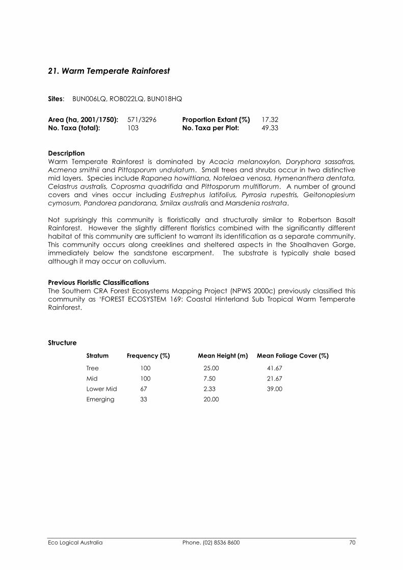
Eco Logical Australia Phone. (02) 8536 8600 70
21. Warm Temperate Rainforest Sites: BUN006LQ, ROB022LQ, BUN018HQ
Area (ha, 2001/1750): 571/3296 Proportion Extant (%) 17.32 No. Taxa (total): 103 No. Taxa per Plot: 49.33
Description Warm Temperate Rainforest is dominated by Acacia melanoxylon, Doryphora sassafras, Acmena smithii and Pittosporum undulatum. Small trees and shrubs occur in two distinctive mid layers. Species include Rapanea howittiana, Notelaea venosa, Hymenanthera dentata, Celastrus australis, Coprosma quadrifida and Pittosporum multiflorum. A number of ground covers and vines occur including Eustrephus latifolius, Pyrrosia rupestris, Geitonoplesium cymosum, Pandorea pandorana, Smilax australis and Marsdenia rostrata. Not suprisingly this community is floristically and structurally similar to Robertson Basalt Rainforest. However the slightly different floristics combined with the significantly different habitat of this community are sufficient to warrant its identification as a separate community. This community occurs along creeklines and sheltered aspects in the Shoalhaven Gorge, immediately below the sandstone escarpment. The substrate is typically shale based although it may occur on colluvium.
Previous Floristic Classifications The Southern CRA Forest Ecosystems Mapping Project (NPWS 2000c) previously classified this community as ‘FOREST ECOSYSTEM 169: Coastal Hinterland Sub Tropical Warm Temperate Rainforest.
Structure Stratum Frequency (%) Mean Height (m) Mean Foliage Cover (%) Tree 100 25.00 41.67 Mid 100 7.50 21.67 Lower Mid 67 2.33 39.00 Emerging 33 20.00
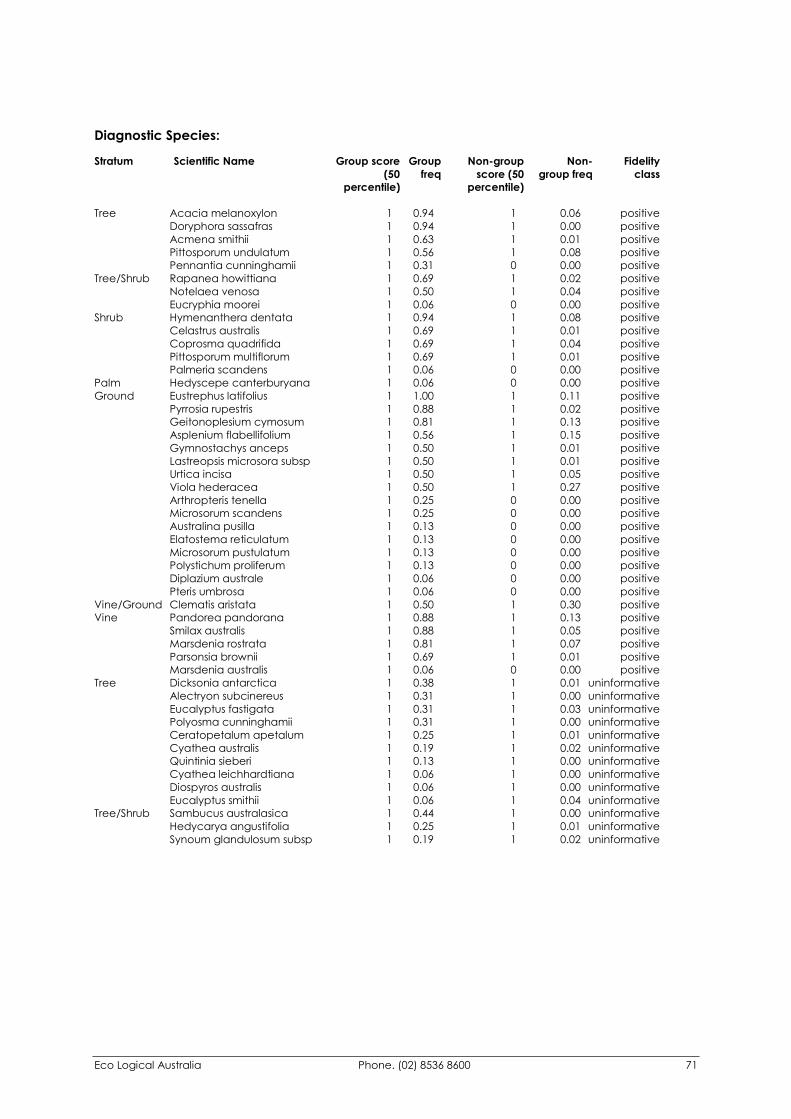
Eco Logical Australia Phone. (02) 8536 8600 71
Diagnostic Species: Stratum Scientific Name Group score Group Non-group Non- Fidelity (50 freq score (50 group freq class percentile) percentile)
Tree Acacia melanoxylon 1 0.94 1 0.06 positive Doryphora sassafras 1 0.94 1 0.00 positive Acmena smithii 1 0.63 1 0.01 positive Pittosporum undulatum 1 0.56 1 0.08 positive Pennantia cunninghamii 1 0.31 0 0.00 positive Tree/Shrub Rapanea howittiana 1 0.69 1 0.02 positive Notelaea venosa 1 0.50 1 0.04 positive Eucryphia moorei 1 0.06 0 0.00 positive Shrub Hymenanthera dentata 1 0.94 1 0.08 positive Celastrus australis 1 0.69 1 0.01 positive Coprosma quadrifida 1 0.69 1 0.04 positive Pittosporum multiflorum 1 0.69 1 0.01 positive Palmeria scandens 1 0.06 0 0.00 positive Palm Hedyscepe canterburyana 1 0.06 0 0.00 positive Ground Eustrephus latifolius 1 1.00 1 0.11 positive Pyrrosia rupestris 1 0.88 1 0.02 positive Geitonoplesium cymosum 1 0.81 1 0.13 positive Asplenium flabellifolium 1 0.56 1 0.15 positive Gymnostachys anceps 1 0.50 1 0.01 positive Lastreopsis microsora subsp 1 0.50 1 0.01 positive Urtica incisa 1 0.50 1 0.05 positive Viola hederacea 1 0.50 1 0.27 positive Arthropteris tenella 1 0.25 0 0.00 positive Microsorum scandens 1 0.25 0 0.00 positive Australina pusilla 1 0.13 0 0.00 positive Elatostema reticulatum 1 0.13 0 0.00 positive Microsorum pustulatum 1 0.13 0 0.00 positive Polystichum proliferum 1 0.13 0 0.00 positive Diplazium australe 1 0.06 0 0.00 positive Pteris umbrosa 1 0.06 0 0.00 positive Vine/Ground Clematis aristata 1 0.50 1 0.30 positive Vine Pandorea pandorana 1 0.88 1 0.13 positive Smilax australis 1 0.88 1 0.05 positive Marsdenia rostrata 1 0.81 1 0.07 positive Parsonsia brownii 1 0.69 1 0.01 positive Marsdenia australis 1 0.06 0 0.00 positive Tree Dicksonia antarctica 1 0.38 1 0.01 uninformative Alectryon subcinereus 1 0.31 1 0.00 uninformative Eucalyptus fastigata 1 0.31 1 0.03 uninformative Polyosma cunninghamii 1 0.31 1 0.00 uninformative Ceratopetalum apetalum 1 0.25 1 0.01 uninformative Cyathea australis 1 0.19 1 0.02 uninformative Quintinia sieberi 1 0.13 1 0.00 uninformative Cyathea leichhardtiana 1 0.06 1 0.00 uninformative Diospyros australis 1 0.06 1 0.00 uninformative Eucalyptus smithii 1 0.06 1 0.04 uninformative Tree/Shrub Sambucus australasica 1 0.44 1 0.00 uninformative Hedycarya angustifolia 1 0.25 1 0.01 uninformative Synoum glandulosum subsp 1 0.19 1 0.02 uninformative
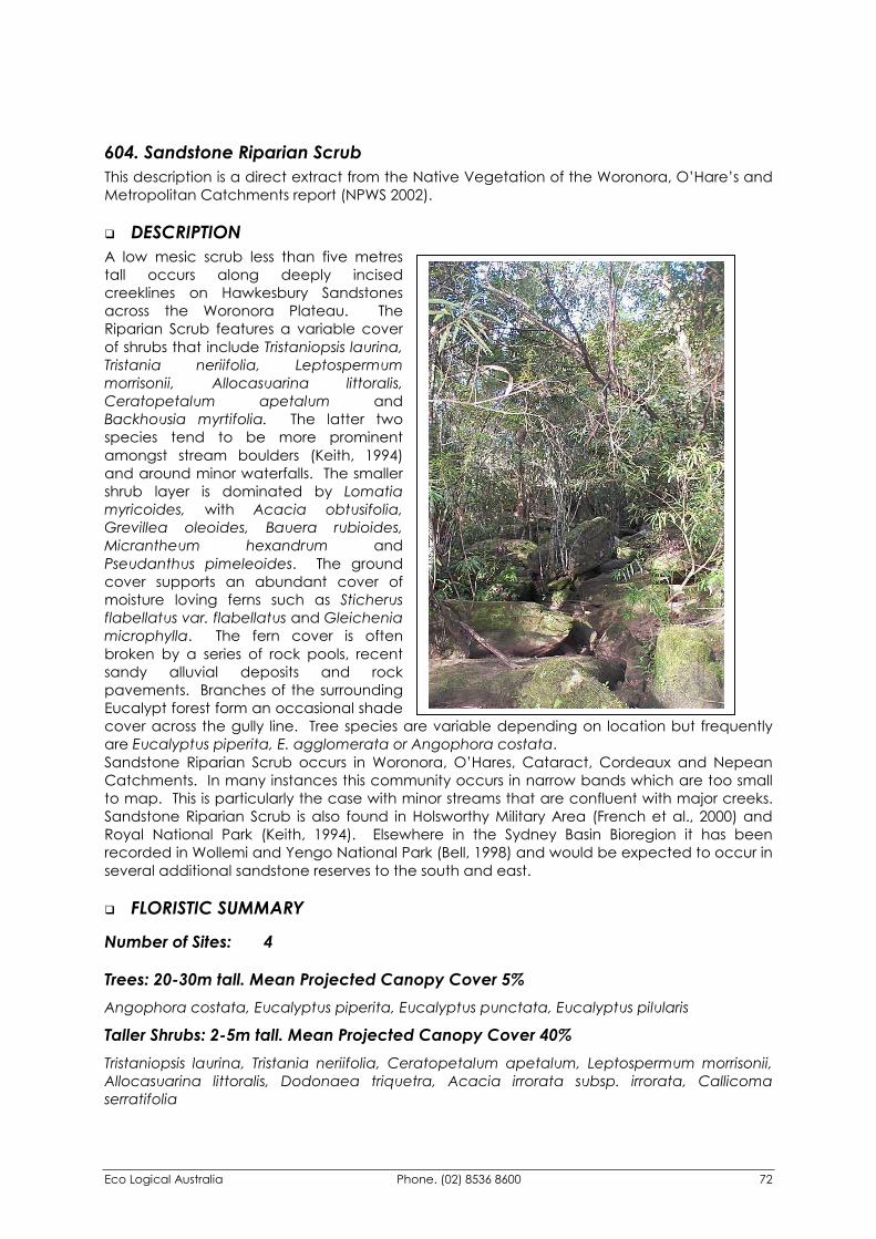
Eco Logical Australia Phone. (02) 8536 8600 72
604. Sandstone Riparian Scrub This description is a direct extract from the Native Vegetation of the Woronora, O’Hare’s and Metropolitan Catchments report (NPWS 2002).
�� DESCRIPTION A low mesic scrub less than five metres tall occurs along deeply incised creeklines on Hawkesbury Sandstones across the Woronora Plateau. The Riparian Scrub features a variable cover of shrubs that include Tristaniopsis laurina, Tristania neriifolia, Leptospermum morrisonii, Allocasuarina littoralis, Ceratopetalum apetalum and Backhousia myrtifolia. The latter two species tend to be more prominent amongst stream boulders (Keith, 1994) and around minor waterfalls. The smaller shrub layer is dominated by Lomatia myricoides, with Acacia obtusifolia, Grevillea oleoides, Bauera rubioides, Micrantheum hexandrum and Pseudanthus pimeleoides. The ground cover supports an abundant cover of moisture loving ferns such as Sticherus flabellatus var. flabellatus and Gleichenia microphylla. The fern cover is often broken by a series of rock pools, recent sandy alluvial deposits and rock pavements. Branches of the surrounding Eucalypt forest form an occasional shade cover across the gully line. Tree species are variable depending on location but frequently are Eucalyptus piperita, E. agglomerata or Angophora costata. Sandstone Riparian Scrub occurs in Woronora, O’Hares, Cataract, Cordeaux and Nepean Catchments. In many instances this community occurs in narrow bands which are too small to map. This is particularly the case with minor streams that are confluent with major creeks. Sandstone Riparian Scrub is also found in Holsworthy Military Area (French et al., 2000) and Royal National Park (Keith, 1994). Elsewhere in the Sydney Basin Bioregion it has been recorded in Wollemi and Yengo National Park (Bell, 1998) and would be expected to occur in several additional sandstone reserves to the south and east.
�� FLORISTIC SUMMARY
Number of Sites: 4
Trees: 20-30m tall. Mean Projected Canopy Cover 5% Angophora costata, Eucalyptus piperita, Eucalyptus punctata, Eucalyptus pilularis
Taller Shrubs: 2-5m tall. Mean Projected Canopy Cover 40% Tristaniopsis laurina, Tristania neriifolia, Ceratopetalum apetalum, Leptospermum morrisonii, Allocasuarina littoralis, Dodonaea triquetra, Acacia irrorata subsp. irrorata, Callicoma serratifolia
Eco Logical Australia Phone. (02) 8536 8600 73
Shrubs: 0.5-1.5 m tall. Mean Projected Canopy Cover 30% Lomatia myricoides, Acacia obtusifolia, Grevillea oleoides, Bauera rubioides, Micrantheum hexandrum, Prostanthera linearis, Hakea salicifolia
Ground covers: 0.5-1m tall. Mean Projected Canopy Cover 35% Sticherus flabellatus var. flabellatus, Gleichenia microphylla, Schoenus melanostachys, Lepidosperma laterale, Lomandra fluviatilis, Lomandra longifolia, Entolasia stricta
�� KEY IDENTIFYING FEATURES
Easily recognisable features to assist in identifying this map unit are: �� Gully line habitat on Hawkesbury Sandstone. Rock pools, waterfalls, rock platforms and
sandy banks are regularly observed along creek lines.
�� Water gums (Tristaniopsis laurina, Tristania neriifolia) are the prominent feature of this community. They are generally low in height although where there is greater shelter, the community is slightly taller and includes Coachwood (Ceratopetalum apetalum) and Grey myrtle (Backhousia myrtifolia).
�� Dense cover of ferns including the Umbrella fern (Sticherus flabellatus var. flabellatus) and the Scrambling coral fern (Gleichenia microphylla).
�� EXAMPLE LOCATIONS O’Hares Creek, Stokes Creek (O’Hares Catchment); Cataract Creek (Cataract Catchment), Flat Rock Crossing (Woronora Catchment)
�� CONSERVATION STATUS
BIOREGIONAL STATUS
Total Area within Sydney
Basin Bioregion (ha)
Proportion of Bioregional Area
within NPWS Reserve (%)
Area within Catchment
(ha)
Proportion of Bioregional Area
within Catchment (%)
>1500 65 531.01 35.4 CONDITION ASSESSMENT
Disturbance Class
Area (ha) Proportion Extant (%)
A Light 530.58 99.9 B Moderate 0 0 C Heavy 0.43 0.1 Scattered trees 0 0 Total 531.01 100
�� THREATENED PLANT SPECIES Grevillea longifolia (2R)
Eco Logical Australia Phone. (02) 8536 8600 74
�� DIAGNOSTIC SPECIES Species Name Group
Score Group Freq
Non Group Score
Non Group Freq
Fidelity Class
Acacia obtusifolia 4 1.00 2 0.12 positive Allocasuarina littoralis 2 0.50 1 0.14 positive Austromyrtus tenuifolia 2 0.17 0 0.00 positive Bauera rubioides 2 0.67 2 0.07 positive Beyeria lasiocarpa 1 0.17 0 0.00 positive Dodonaea triquetra 3 0.50 2 0.12 positive Gleichenia microphylla 4 0.50 3 0.04 positive Grevillea oleoides 2 0.83 2 0.24 positive Guringalia dimorpha 2 0.83 2 0.07 positive Leptospermum morrisonii 2 0.83 1 0.01 positive Lomandra fluviatilis 3 0.83 1 0.02 positive Lomatia myricoides 3 1.00 1 0.03 positive Ludwigia peploides subsp. montevidensis 1 0.17 0 0.00 positive Micrantheum hexandrum 4 0.50 0 0.00 positive Philydrum lanuginosum 1 0.17 0 0.00 positive Pseudanthus pimeleoides 2 0.83 1 0.01 positive Sticherus flabellatus var. flabellatus 4 0.67 2 0.04 positive Tristania neriifolia 3 0.83 1 0.01 positive Tristaniopsis laurina 3 0.83 3 0.02 positive Corymbia gummifera 0 0.00 2 0.52 negative Entolasia stricta 2 0.67 2 0.53 constant
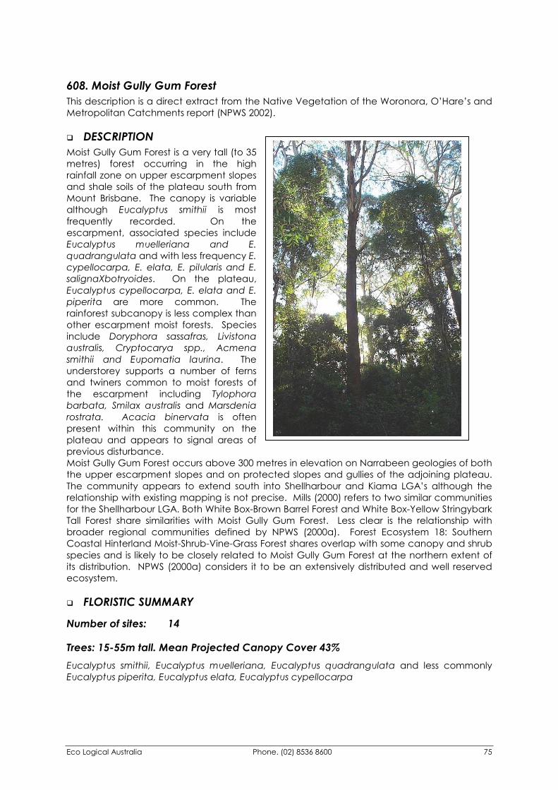
Eco Logical Australia Phone. (02) 8536 8600 75
608. Moist Gully Gum Forest This description is a direct extract from the Native Vegetation of the Woronora, O’Hare’s and Metropolitan Catchments report (NPWS 2002).
�� DESCRIPTION Moist Gully Gum Forest is a very tall (to 35 metres) forest occurring in the high rainfall zone on upper escarpment slopes and shale soils of the plateau south from Mount Brisbane. The canopy is variable although Eucalyptus smithii is most frequently recorded. On the escarpment, associated species include Eucalyptus muelleriana and E. quadrangulata and with less frequency E. cypellocarpa, E. elata, E. pilularis and E. salignaXbotryoides. On the plateau, Eucalyptus cypellocarpa, E. elata and E. piperita are more common. The rainforest subcanopy is less complex than other escarpment moist forests. Species include Doryphora sassafras, Livistona australis, Cryptocarya spp., Acmena smithii and Eupomatia laurina. The understorey supports a number of ferns and twiners common to moist forests of the escarpment including Tylophora barbata, Smilax australis and Marsdenia rostrata. Acacia binervata is often present within this community on the plateau and appears to signal areas of previous disturbance. Moist Gully Gum Forest occurs above 300 metres in elevation on Narrabeen geologies of both the upper escarpment slopes and on protected slopes and gullies of the adjoining plateau. The community appears to extend south into Shellharbour and Kiama LGA’s although the relationship with existing mapping is not precise. Mills (2000) refers to two similar communities for the Shellharbour LGA. Both White Box-Brown Barrel Forest and White Box-Yellow Stringybark Tall Forest share similarities with Moist Gully Gum Forest. Less clear is the relationship with broader regional communities defined by NPWS (2000a). Forest Ecosystem 18: Southern Coastal Hinterland Moist-Shrub-Vine-Grass Forest shares overlap with some canopy and shrub species and is likely to be closely related to Moist Gully Gum Forest at the northern extent of its distribution. NPWS (2000a) considers it to be an extensively distributed and well reserved ecosystem.
�� FLORISTIC SUMMARY
Number of sites: 14
Trees: 15-55m tall. Mean Projected Canopy Cover 43% Eucalyptus smithii, Eucalyptus muelleriana, Eucalyptus quadrangulata and less commonly Eucalyptus piperita, Eucalyptus elata, Eucalyptus cypellocarpa
Eco Logical Australia Phone. (02) 8536 8600 76
Subcanopy Trees and shrubs: 2-20m tall. Mean Projected Canopy Cover 32% Synoum glandulosum subsp. glandulosum, Livistona australis, Acacia binervata, Acmena smithii, Cryptocarya glaucescens, Doryphora sassafras, Clerodendrum tomentosum, Notelaea venosa
Ground Covers: 0-1m tall. Mean Projected Canopy Cover 37% Lomandra longifolia, Hibbertia dentata, Oplismenus imbecillis, Pteridium esculentum, Microlaena stipoides var. stipoides, Pseuderanthemum variabile, Goodenia ovata, Dianella caerulea
Vines & Climbers: Eustrephus latifolius, Smilax australis, Tylophora barbata, Pandorea pandorana subsp. pandorana, Morinda jasminoides
�� KEY IDENTIFYING FEATURES
Easily recognisable features to assist in identifying this map unit are: �� A tall forest canopy and the presence of Gully gum (Eucalyptus smithii) and Yellow
stringybark (E. muelleriana).
�� A mesic subcanopy tree-layer including Scentless rosewood (Synoum glandulosum subsp. glandulosum), Sassafras (Doryphora sassafras), Two-veined hickory (Acacia binervata), Lilly pilly (Acmena smithii), Jackwood (Cryptocarya glaucescens) and Smooth mock olive (Notelaea venosa).
�� An understorey containing species such as Spiny matt-rush (Lomandra longifolia), Hibbertia dentata, Bracken fern (Pteridium esculentum) and Goodenia ovata.
�� EXAMPLE LOCATIONS Mount Brisbane; Kembla Heights; Kembla State Forest; Bong Bong Pass; Macquarie Pass.
�� CONSERVATION STATUS
BIOREGIONAL STATUS
Total Area within Sydney
Basin Bioregion (ha)
Proportion of Bioregional Area
within NPWS Reserve (%)
Area within Catchment
(ha)
Proportion of Bioregional Area
within Catchment (%)
>2736 46 1202.29 43.9
CONDITION ASSESSMENT
Disturbance Class
Area (ha) Proportion Extant (%)
A Light 821.49 68.3 B Moderate 291.04 24.2 C Heavy 61.40 5.1 Scattered trees 28.36 2.4 Total 1202.29 100
Eco Logical Australia Phone. (02) 8536 8600 77
�� THREATENED PLANT SPECIES None recorded
�� DIAGNOSTIC SPECIES Species Name Group
Score Group Freq
Non Group Score
Non Group Freq
Fidelity Class
Acmena smithii 4 1.00 2 0.44 positive Asplenium flabellifolium 2 0.63 2 0.36 positive Beyeria lasiocarpa 1 0.13 0 0.00 positive Cissus hypoglauca 3 0.75 2 0.17 positive Clerodendrum tomentosum 2 1.00 1 0.40 positive Cryptocarya glaucescens 4 0.88 4 0.25 positive Cryptocarya microneura 4 0.50 3 0.29 positive Doodia aspera 3 0.63 3 0.46 positive Doryphora sassafras 4 0.63 4 0.28 positive Eucalyptus muelleriana 5 0.50 5 0.03 positive Eucalyptus quadrangulata 4 0.75 4 0.21 positive Eucalyptus smithii 4 0.88 4 0.02 positive Eupomatia laurina 2 1.00 2 0.30 positive Lastreopsis decomposita 3 0.88 3 0.18 positive Livistona australis 2 1.00 3 0.46 positive Morinda jasminoides 3 0.88 2 0.33 positive Palmeria scandens 3 0.63 2 0.17 positive Poa labillardieri var. labillardieri 2 0.50 3 0.27 positive Sarcochilus olivaceus 1 0.13 0 0.00 positive Smilax australis 2 0.88 2 0.44 positive Synoum glandulosum subsp. glandulosum 4 0.88 2 0.38 positive Tylophora barbata 2 0.88 2 0.32 positive Geitonoplesium cymosum 1 0.75 2 0.63 negative Eustrephus latifolius 2 0.75 2 0.66 constant Marsdenia rostrata 2 0.88 2 0.54 constant Pandorea pandorana subsp. pandorana 2 0.81 2 0.62 constant Pseuderanthemum variabile 2 0.88 3 0.58 constant
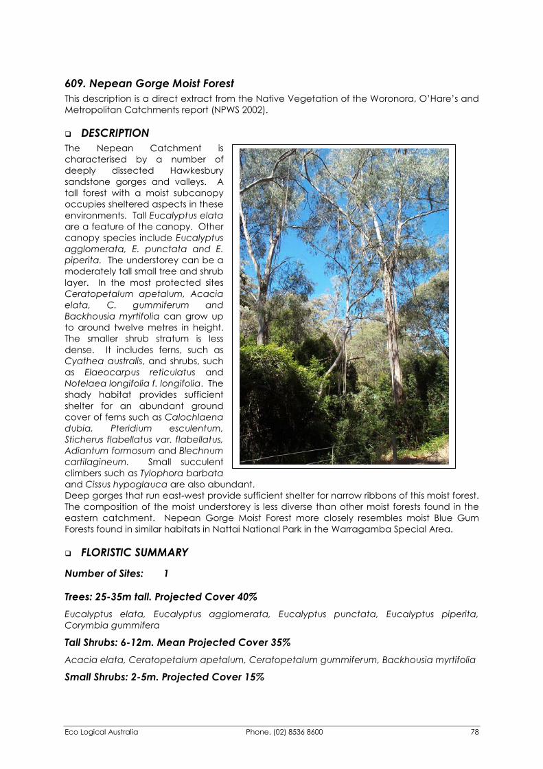
Eco Logical Australia Phone. (02) 8536 8600 78
609. Nepean Gorge Moist Forest This description is a direct extract from the Native Vegetation of the Woronora, O’Hare’s and Metropolitan Catchments report (NPWS 2002).
�� DESCRIPTION The Nepean Catchment is characterised by a number of deeply dissected Hawkesbury sandstone gorges and valleys. A tall forest with a moist subcanopy occupies sheltered aspects in these environments. Tall Eucalyptus elata are a feature of the canopy. Other canopy species include Eucalyptus agglomerata, E. punctata and E. piperita. The understorey can be a moderately tall small tree and shrub layer. In the most protected sites Ceratopetalum apetalum, Acacia elata, C. gummiferum and Backhousia myrtifolia can grow up to around twelve metres in height. The smaller shrub stratum is less dense. It includes ferns, such as Cyathea australis, and shrubs, such as Elaeocarpus reticulatus and Notelaea longifolia f. longifolia. The shady habitat provides sufficient shelter for an abundant ground cover of ferns such as Calochlaena dubia, Pteridium esculentum, Sticherus flabellatus var. flabellatus, Adiantum formosum and Blechnum cartilagineum. Small succulent climbers such as Tylophora barbata and Cissus hypoglauca are also abundant. Deep gorges that run east-west provide sufficient shelter for narrow ribbons of this moist forest. The composition of the moist understorey is less diverse than other moist forests found in the eastern catchment. Nepean Gorge Moist Forest more closely resembles moist Blue Gum Forests found in similar habitats in Nattai National Park in the Warragamba Special Area.
�� FLORISTIC SUMMARY
Number of Sites: 1
Trees: 25-35m tall. Projected Cover 40% Eucalyptus elata, Eucalyptus agglomerata, Eucalyptus punctata, Eucalyptus piperita, Corymbia gummifera
Tall Shrubs: 6-12m. Mean Projected Cover 35% Acacia elata, Ceratopetalum apetalum, Ceratopetalum gummiferum, Backhousia myrtifolia
Small Shrubs: 2-5m. Projected Cover 15%
Eco Logical Australia Phone. (02) 8536 8600 79
Cyathea australis, Breynia oblongifolia, Elaeocarpus reticulatus, Persoonia linearis, Pultenaea flexilis, Leptospermum polygalifolium subsp. polygalifolium, Leucopogon lanceolatus var. lanceolatus, Tristaniopsis collina
Ground covers: 0-0.5 m tall. Mean Projected Canopy Cover 70% Calochlaena dubia, Pteridium esculentum, Dianella caerulea, Lomandra longifolia, Lepidosperma laterale, Entolasia marginata, Billardiera scandens, Viola hederacea, Clematis aristata
�� KEY IDENTIFYING FEATURES
Easily recognisable features to assist in identifying this map unit are: �� Deeply dissected gorges and valleys of the Mittagong and Hawkesbury Sandstones in the
western Metropolitan Catchment.
�� A tall forest supporting River peppermint (Eucalyptus elata), Grey gum (E. punctata) and Blue-leaved stringybark (E. agglomerata).
�� Small trees such as Mountain cedar wattle (Acacia elata), Christmas bush (Ceratopetalum gummiferum), Coachwood (C. apetalum) and Grey myrtle (Backhousia myrtifolia).
�� A shrubby understorey of Blueberry ash (Elaeocarpus reticulatus), Tea-tree (Leptospermum polygalifolium subsp. polygalifolium), Bearded heath (Leucopogon lanceolatus var. lanceolatus) and Native olive (Notelaea longifolia f. longifolia).
�� The groundcover has a prominent cover of Common ground fern (Calochlaena dubia) Bracken (Pteridium esculentum), Spiny-headed mat-rush (Lomandra longifolia) and Snowgrass (Poa sieberiana var. sieberiana).
�� EXAMPLE LOCATIONS Avon Dam Road, Nepean Catchment, Burke River Gorge
�� EXAMPLE LOCATIONS Avon Dam Road, Nepean Catchment; Gullyline below Fire Trail 3D, Nepean Catchment
�� CONSERVATION STATUS
BIOREGIONAL STATUS
Total Area within Sydney
Basin Bioregion (ha)
Proportion of Bioregional Area
within NPWS Reserve (%)
Area within Catchment
(ha)
Proportion of Bioregional Area
within Catchment (%)
3000 50 417.48 13.9
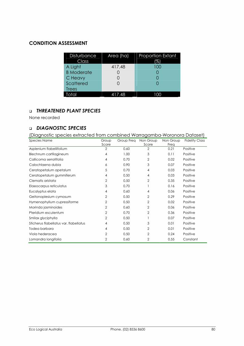
Eco Logical Australia Phone. (02) 8536 8600 80
CONDITION ASSESSMENT
Disturbance Class
Area (ha) Proportion Extant (%)
A Light 417.48 100 B Moderate 0 0 C Heavy 0 0 Scattered Trees
0 0
Total 417.48 100
�� THREATENED PLANT SPECIES None recorded
�� DIAGNOSTIC SPECIES (Diagnostic species extracted from combined Warragamba-Woronora Dataset) Species Name Group
Score Group Freq Non Group
Score Non Group
Freq Fidelity Class
Asplenium flabellifolium 2 0.60 2 0.21 Positive Blechnum cartilagineum 4 1.00 3 0.11 Positive Callicoma serratifolia 4 0.70 2 0.02 Positive Calochlaena dubia 6 0.90 3 0.07 Positive Ceratopetalum apetalum 5 0.70 4 0.03 Positive Ceratopetalum gummiferum 4 0.50 4 0.03 Positive Clematis aristata 2 0.50 2 0.35 Positive Elaeocarpus reticulatus 3 0.70 1 0.16 Positive Eucalyptus elata 4 0.60 4 0.06 Positive Geitonoplesium cymosum 2 0.50 2 0.29 Positive Hymenophyllum cupressiforme 2 0.50 2 0.02 Positive Morinda jasminoides 2 0.60 2 0.06 Positive Pteridium esculentum 2 0.70 2 0.36 Positive Smilax glyciphylla 2 0.50 1 0.07 Positive Sticherus flabellatus var. flabellatus 4 0.50 3 0.01 Positive Todea barbara 4 0.50 2 0.01 Positive Viola hederacea 2 0.50 2 0.24 Positive Lomandra longifolia 2 0.60 2 0.55 Constant
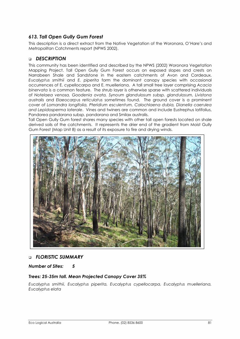
Eco Logical Australia Phone. (02) 8536 8600 81
613. Tall Open Gully Gum Forest This description is a direct extract from the Native Vegetation of the Woronora, O’Hare’s and Metropolitan Catchments report (NPWS 2002).
�� DESCRIPTION This community has been identified and described by the NPWS (2002) Woronora Vegetation Mapping Project. Tall Open Gully Gum Forest occurs on exposed slopes and crests on Narrabeen Shale and Sandstone in the eastern catchments of Avon and Cordeaux. Eucalyptus smithii and E. piperita form the dominant canopy species with occasional occurrences of E. cypellocarpa and E. muelleriana. A tall small tree layer comprising Acacia binervata is a common feature. The shrub layer is otherwise sparse with scattered individuals of Notelaea venosa, Goodenia ovata, Synoum glandulosum subsp. glandulosum, Livistona australis and Elaeocarpus reticulatus sometimes found. The ground cover is a prominent cover of Lomandra longifolia, Pteridium esculentum, Calochlaena dubia, Dianella caerulea and Lepidosperma laterale. Vines and twiners are common and include Eustrephus latifolius, Pandorea pandorana subsp. pandorana and Smilax australis. Tall Open Gully Gum forest shares many species with other tall open forests located on shale derived soils of the catchments. It represents the drier end of the gradient from Moist Gully Gum Forest (Map Unit 8) as a result of its exposure to fire and drying winds.
�� FLORISTIC SUMMARY
Number of Sites: 5
Trees: 25-35m tall. Mean Projected Canopy Cover 35% Eucalyptus smithii, Eucalyptus piperita, Eucalyptus cypellocarpa, Eucalyptus muelleriana, Eucalyptus elata
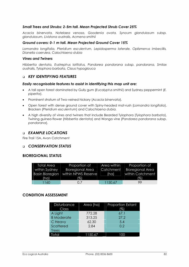
Eco Logical Australia Phone. (02) 8536 8600 82
Small Trees and Shrubs: 2-5m tall. Mean Projected Shrub Cover 25% Acacia binervata, Notelaea venosa, Goodenia ovata, Synoum glandulosum subsp. glandulosum, Livistona australis, Acmena smithii
Ground covers: 0-1 m tall. Mean Projected Ground Cover 15% Lomandra longifolia, Pteridium esculentum, Lepidosperma laterale, Oplismenus imbecillis, Dianella caerulea, Calochlaena dubia
Vines and Twiners Hibbertia dentata, Eustrephus latifolius, Pandorea pandorana subsp. pandorana, Smilax australis, Tylophora barbata, Cissus hypoglauca
�� KEY IDENTIFYING FEATURES
Easily recognisable features to assist in identifying this map unit are: �� A tall open forest dominated by Gully gum (Eucalyptus smithii) and Sydney peppermint (E.
piperita).
�� Prominent stratum of Two-veined hickory (Acacia binervata).
�� Open forest with dense ground cover with Spiny-headed mat-rush (Lomandra longifolia), Bracken (Pteridium esculentum) and Calochlaena dubia.
�� A high diversity of vines and twiners that include Bearded Tylophora (Tylophora barbata), Twining guinea-flower (Hibbertia dentata) and Wonga vine (Pandorea pandorana subsp. pandorana).
�� EXAMPLE LOCATIONS Fire Trail 15A, Avon Catchment
�� CONSERVATION STATUS
BIOREGIONAL STATUS
Total Area within Sydney
Basin Bioregion (ha)
Proportion of Bioregional Area
within NPWS Reserve (%)
Area within Catchment
(ha)
Proportion of Bioregional Area
within Catchment (%)
1160 0.7 1150.67 99
CONDITION ASSESSMENT
Disturbance Class
Area (ha) Proportion Extant (%)
A Light 772.28 67.1 B Moderate 313.25 27.2 C Heavy 62.30 5.4 Scattered Trees
2.84 0.2
Total 1150.67 100
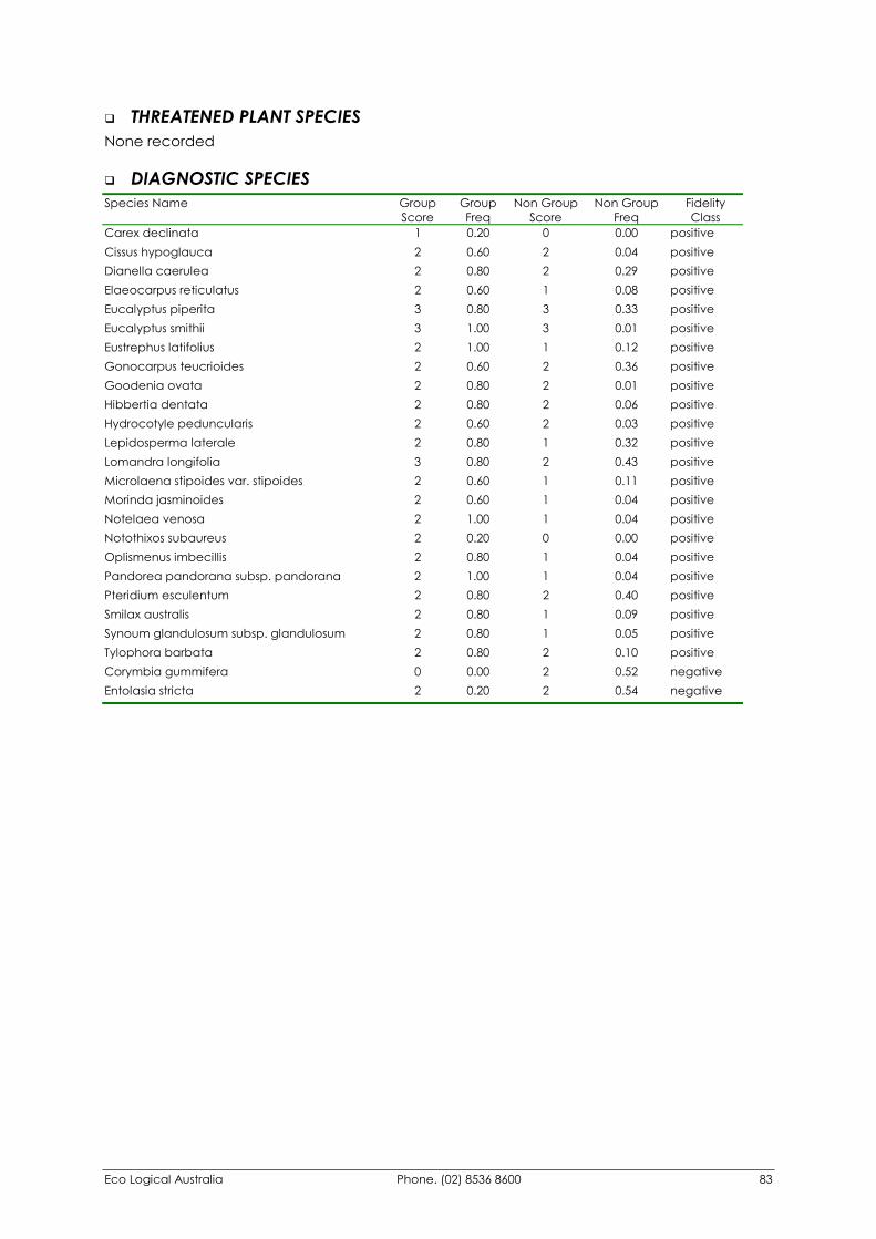
Eco Logical Australia Phone. (02) 8536 8600 83
�� THREATENED PLANT SPECIES None recorded
�� DIAGNOSTIC SPECIES Species Name Group
Score Group Freq
Non Group Score
Non Group Freq
Fidelity Class
Carex declinata 1 0.20 0 0.00 positive Cissus hypoglauca 2 0.60 2 0.04 positive Dianella caerulea 2 0.80 2 0.29 positive Elaeocarpus reticulatus 2 0.60 1 0.08 positive Eucalyptus piperita 3 0.80 3 0.33 positive Eucalyptus smithii 3 1.00 3 0.01 positive Eustrephus latifolius 2 1.00 1 0.12 positive Gonocarpus teucrioides 2 0.60 2 0.36 positive Goodenia ovata 2 0.80 2 0.01 positive Hibbertia dentata 2 0.80 2 0.06 positive Hydrocotyle peduncularis 2 0.60 2 0.03 positive Lepidosperma laterale 2 0.80 1 0.32 positive Lomandra longifolia 3 0.80 2 0.43 positive Microlaena stipoides var. stipoides 2 0.60 1 0.11 positive Morinda jasminoides 2 0.60 1 0.04 positive Notelaea venosa 2 1.00 1 0.04 positive Notothixos subaureus 2 0.20 0 0.00 positive Oplismenus imbecillis 2 0.80 1 0.04 positive Pandorea pandorana subsp. pandorana 2 1.00 1 0.04 positive Pteridium esculentum 2 0.80 2 0.40 positive Smilax australis 2 0.80 1 0.09 positive Synoum glandulosum subsp. glandulosum 2 0.80 1 0.05 positive Tylophora barbata 2 0.80 2 0.10 positive Corymbia gummifera 0 0.00 2 0.52 negative Entolasia stricta 2 0.20 2 0.54 negative
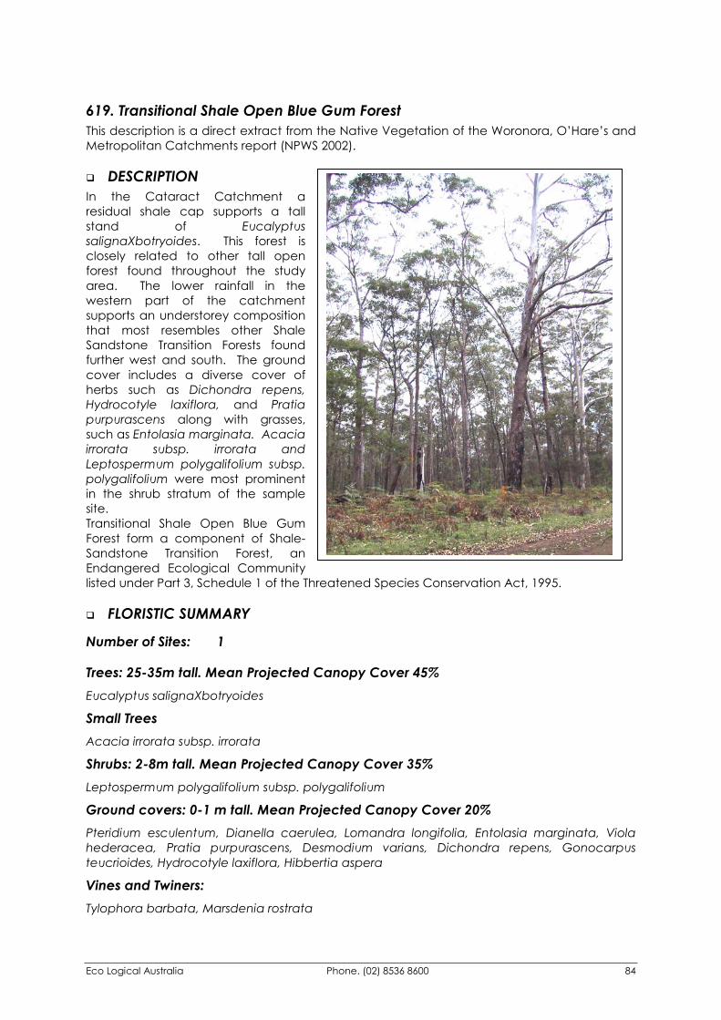
Eco Logical Australia Phone. (02) 8536 8600 84
619. Transitional Shale Open Blue Gum Forest This description is a direct extract from the Native Vegetation of the Woronora, O’Hare’s and Metropolitan Catchments report (NPWS 2002).
�� DESCRIPTION In the Cataract Catchment a residual shale cap supports a tall stand of Eucalyptus salignaXbotryoides. This forest is closely related to other tall open forest found throughout the study area. The lower rainfall in the western part of the catchment supports an understorey composition that most resembles other Shale Sandstone Transition Forests found further west and south. The ground cover includes a diverse cover of herbs such as Dichondra repens, Hydrocotyle laxiflora, and Pratia purpurascens along with grasses, such as Entolasia marginata. Acacia irrorata subsp. irrorata and Leptospermum polygalifolium subsp. polygalifolium were most prominent in the shrub stratum of the sample site. Transitional Shale Open Blue Gum Forest form a component of Shale-Sandstone Transition Forest, an Endangered Ecological Community listed under Part 3, Schedule 1 of the Threatened Species Conservation Act, 1995.
�� FLORISTIC SUMMARY
Number of Sites: 1
Trees: 25-35m tall. Mean Projected Canopy Cover 45% Eucalyptus salignaXbotryoides
Small Trees Acacia irrorata subsp. irrorata
Shrubs: 2-8m tall. Mean Projected Canopy Cover 35% Leptospermum polygalifolium subsp. polygalifolium
Ground covers: 0-1 m tall. Mean Projected Canopy Cover 20% Pteridium esculentum, Dianella caerulea, Lomandra longifolia, Entolasia marginata, Viola hederacea, Pratia purpurascens, Desmodium varians, Dichondra repens, Gonocarpus teucrioides, Hydrocotyle laxiflora, Hibbertia aspera
Vines and Twiners: Tylophora barbata, Marsdenia rostrata
Eco Logical Australia Phone. (02) 8536 8600 85
�� KEY IDENTIFYING FEATURES
Easily recognisable features to assist in identifying this map unit are: �� Isolated location on Fire Trail 8.
�� Tall straight trees usually Sydney blue gum (Eucalyptus salignaXbotyriodes).
�� EXAMPLE LOCATIONS Fire Trail 8 Cataract Catchment, Cataract Dam Picnic Area (now mostly cleared).
�� CONSERVATION STATUS Listed as an Endangered Ecological Community under Part 3 of Schedule 1 of the Threatened Species Conservation Act (1995), as part of Shale-Sandstone Transition Forest.
BIOREGIONAL STATUS
Total Area within Sydney
Basin Bioregion (ha)
Proportion of Bioregional Area
within NPWS Reserve (%)
Area within Catchment
(ha)
Proportion of Bioregional Area
within Catchment (%)
3324 0.5 44.71 1.3
CONDITION ASSESSMENT
Disturbance Class
Area (ha) Proportion Extant (%)
A Light 44.71 100 B Moderate 0 0 C Heavy 0 0 Scattered Trees 0 0 Total 44.71 100
�� THREATENED PLANT SPECIES None recorded
Eco Logical Australia Phone. (02) 8536 8600 86
�� DIAGNOSTIC SPECIES (Note that only one sample site has been used to develop the diagnostic species list below) Species Name Group
Score Group Freq
Non Group Score
Non Group Freq
Fidelity Class
Desmodium varians 2 1 2 0.05 positive Dianella caerulea 2 1 2 0.29 positive Dichondra repens 3 1 2 0.07 positive Entolasia marginata 3 1 2 0.23 positive Eucalyptus saligna 4 1 3 0.04 positive Galium propinquum 2 1 2 0.04 positive Geranium homeanum 2 1 1 0.02 positive Glycine clandestina 2 1 1 0.13 positive Glycine tabacina 2 1 2 0.04 positive Gonocarpus teucrioides 3 1 2 0.36 positive Helichrysum elatum 2 1 1 0.04 positive Hibbertia diffusa 2 1 1 0.02 positive Hydrocotyle laxiflora 2 1 2 0.04 positive Hydrocotyle peduncularis 2 1 2 0.03 positive Lagenifera stipitata 2 1 2 0.09 positive Leptospermum polygalifolium subsp. polygalifolium 2 1 2 0.18 positive Leucopogon juniperinus 2 1 1 0.02 positive Marsdenia rostrata 2 1 2 0.05 positive Microlaena stipoides var. stipoides 2 1 2 0.11 positive Opercularia diphylla 2 1 2 0.07 positive Oplismenus aemulus 2 1 2 0.01 positive Poranthera microphylla 2 1 2 0.07 positive Pratia purpurascens 3 1 2 0.10 positive Pteridium esculentum 4 1 2 0.40 positive Senecio linearifolius 2 1 1 0.01 positive Solanum prinophyllum 2 1 1 0.02 positive Tylophora barbata 2 1 2 0.10 positive Veronica plebeia 2 1 1 0.02 positive Corymbia gummifera 0 0 2 0.52 negative Entolasia stricta 0 0 2 0.53 negative

Eco Logical Australia Phone. (02) 8536 8600 87
623. Transitional Shale Stringybark Forest This description is a direct extract from the Native Vegetation of the Woronora, O’Hare’s and Metropolitan Catchments report (NPWS 2002).
�� DESCRIPTION Transitional Shale Stringybark Forest forms part of the Transitional Shale Sandstone Forest and Woodland Complex in dry environments along the western boundary of the catchments. It is a moderately tall forest of Eucalyptus globoidea and other closely associated stringybarks (E. eugenioides and E. oblonga). Eucalyptus punctata is a regular associate species along with a wide variety of other Eucalypts that mark the transition with greater shale influence (eg. E. crebra and E. fibrosa) to that of greater sandstone influence (Corymbia gummifera, E. piperita and E. sclerophylla). Understorey is similarly variable as a result of the changes in soil. Most commonly the ground cover is a combination of grasses such as Entolasia stricta, E. marginata and Aristida ramosa with Lomandra longifolia often present. A shrubby understorey species such as Banksia spinulosa var. spinulosa, Acacia terminalis, Kunzea ambigua are found in combination with taller species such as Leptospermum polygalifolium subsp. polygalifolium. Transitional Shale Stringybark Forest is usually distributed on the margins of residual shale caps as the forest slowly grades into open sandstone woodlands. The forest is lower in height than the adjoining shale forest (eg. Map Unit 22) and supports a less open understorey. Floristic composition may change with slight changes in elevation and rainfall. Transitional Shale Stringybark Forest forms a component of Shale Sandstone Transition Forest listed on Part 3 of Schedule 1 of the NSW Threatened Species Act (1995).
�� FLORISTIC SUMMARY
Number of Sites: 6
Trees: 18-25m tall. Mean Projected Canopy Cover 25% Eucalyptus globoidea, Eucalyptus eugenioides, Eucalyptus punctata, Corymbia gummifera, Eucalyptus crebra, Eucalyptus piperita, Eucalyptus sclerophylla
Shrubs: 2-3m tall. Mean Projected Canopy Cover 25% Banksia spinulosa var. spinulosa, Persoonia linearis, Persoonia levis, Kunzea ambigua, Daviesia squarrosa
Ground covers: 0.5-1 m tall. Mean Projected Canopy Cover 50% Cyathochaeta diandra, Lomandra longifolia, Aristida vagans, Aristida ramosa, Entolasia stricta, Themeda australis, Joycea pallida

Eco Logical Australia Phone. (02) 8536 8600 88
�� KEY IDENTIFYING FEATURES
Easily recognisable features to assist in identifying this map unit are: �� Small areas of Stringybarks (Eucalyptus eugenioides and E. globoidea) dominant forest
that mark the transition between sandstone woodlands (Map Unit 29 and 30) and other shale forests.
�� A shrubby understorey that supports a mix of Banksias, Tea-trees (Leptospermum spp.) and Geebungs (Persoonia spp.).
�� Drier areas of the western catchments.
�� EXAMPLE LOCATIONS Fire Trail 8, Cataract Catchment; Intersection of 6B and 6, Avon Catchment, Old Hume Highway, Yerrinbool
�� CONSERVATION STATUS Listed as an Endangered Ecological Community under Part 3 of Schedule 1 of the Threatened Species Conservation Act (1995) as part of Shale-Sandstone Transition Forest.
BIOREGIONAL STATUS
Total Area within Sydney
Basin Bioregion (ha)
Proportion of Bioregional Area
within NPWS Reserve (%)
Area within Catchment
(ha)
Proportion of Bioregional Area
within Catchment (%)
8706 2.5 614.92 7.1
CONDITION ASSESSMENT
Disturbance Class
Area (ha) Proportion Extant (%)
A Light 604.38 98.3 B Moderate 10.54 1.7 C Heavy 0 0 Scattered Trees 0 0 Total 614.92 100
�� THREATENED PLANT SPECIES Epacris purpurascens var. purparsecens (V)
Eco Logical Australia Phone. (02) 8536 8600 89
�� DIAGNOSTIC SPECIES Species Name Group
Score Group Freq
Non Group Score
Non Group Freq
Fidelity Class
Aristida ramosa 2 1.00 1 0.02 positive Aristida vagans 2 0.83 1 0.04 positive Arthropodium minus 1 0.17 0 0.00 positive Austrostipa pubescens 2 0.50 2 0.15 positive Banksia spinulosa var. spinulosa 2 0.50 2 0.45 positive Brachycome angustifolia 2 0.67 2 0.02 positive Brachyscome angustifolia 2 0.67 2 0.02 positive Brunoniella pumilio 2 0.50 2 0.03 positive Cyathochaeta diandra 2 0.67 2 0.32 positive Daviesia genistifolia 1 0.17 0 0.00 positive Daviesia squarrosa 3 0.33 0 0.00 positive Desmodium varians 2 0.67 2 0.04 positive Dianella longifolia 2 1.00 2 0.06 positive Dichondra repens 2 0.50 2 0.06 positive Echinopogon caespitosus var. caespitosus 2 0.50 2 0.04 positive Entolasia marginata 2 0.50 2 0.23 positive Eucalyptus crebra 2 0.50 3 0.01 positive Eucalyptus globoidea 3 0.67 2 0.11 positive Glycine clandestina 2 0.83 1 0.12 positive Gonocarpus tetragynus 2 1.00 2 0.14 positive Goodenia hederacea subsp. hederacea 2 0.83 2 0.10 positive Helichrysum scorpioides 2 0.50 1 0.03 positive Hibbertia aspera subsp. aspera 2 0.50 2 0.13 positive Hibbertia diffusa 2 0.67 2 0.01 positive Hypericum gramineum 2 0.67 1 0.04 positive Imperata cylindrica var. major 2 0.83 1 0.11 positive Joycea pallida 3 0.67 2 0.03 positive Lagenifera stipitata 2 0.67 2 0.09 positive Lepidosperma gunnii 2 0.67 2 0.04 positive Lepidosperma laterale 2 0.50 1 0.32 positive Lissanthe strigosa 2 1.00 1 0.08 positive Lomandra longifolia 2 0.50 2 0.43 positive Lomandra multiflora subsp. multiflora 2 1.00 2 0.22 positive Opercularia diphylla 2 1.00 2 0.06 positive Persoonia linearis 2 0.50 2 0.23 positive Phyllanthus hirtellus 2 0.83 2 0.22 positive Plantago varia 2 0.17 0 0.00 positive Poa sieberiana var. sieberiana 2 0.50 2 0.02 positive Pratia purpurascens 2 0.50 2 0.10 positive Themeda australis 3 0.67 2 0.08 positive Corymbia gummifera 2 0.50 2 0.52 constant Entolasia stricta 2 1.00 2 0.53 constant
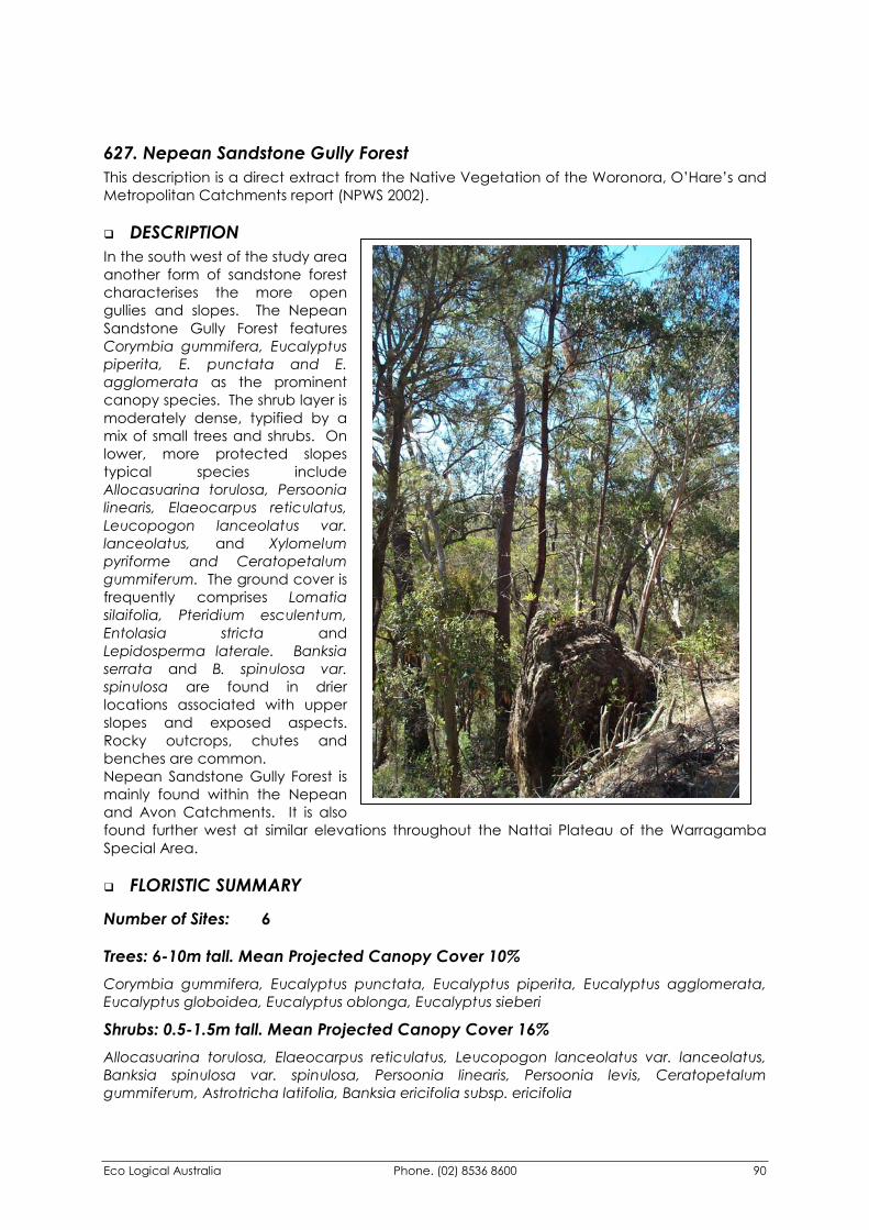
Eco Logical Australia Phone. (02) 8536 8600 90
627. Nepean Sandstone Gully Forest This description is a direct extract from the Native Vegetation of the Woronora, O’Hare’s and Metropolitan Catchments report (NPWS 2002).
�� DESCRIPTION In the south west of the study area another form of sandstone forest characterises the more open gullies and slopes. The Nepean Sandstone Gully Forest features Corymbia gummifera, Eucalyptus piperita, E. punctata and E. agglomerata as the prominent canopy species. The shrub layer is moderately dense, typified by a mix of small trees and shrubs. On lower, more protected slopes typical species include Allocasuarina torulosa, Persoonia linearis, Elaeocarpus reticulatus, Leucopogon lanceolatus var. lanceolatus, and Xylomelum pyriforme and Ceratopetalum gummiferum. The ground cover is frequently comprises Lomatia silaifolia, Pteridium esculentum, Entolasia stricta and Lepidosperma laterale. Banksia serrata and B. spinulosa var. spinulosa are found in drier locations associated with upper slopes and exposed aspects. Rocky outcrops, chutes and benches are common. Nepean Sandstone Gully Forest is mainly found within the Nepean and Avon Catchments. It is also found further west at similar elevations throughout the Nattai Plateau of the Warragamba Special Area.
�� FLORISTIC SUMMARY
Number of Sites: 6
Trees: 6-10m tall. Mean Projected Canopy Cover 10% Corymbia gummifera, Eucalyptus punctata, Eucalyptus piperita, Eucalyptus agglomerata, Eucalyptus globoidea, Eucalyptus oblonga, Eucalyptus sieberi
Shrubs: 0.5-1.5m tall. Mean Projected Canopy Cover 16% Allocasuarina torulosa, Elaeocarpus reticulatus, Leucopogon lanceolatus var. lanceolatus, Banksia spinulosa var. spinulosa, Persoonia linearis, Persoonia levis, Ceratopetalum gummiferum, Astrotricha latifolia, Banksia ericifolia subsp. ericifolia
Eco Logical Australia Phone. (02) 8536 8600 91
Ground covers: 0-1 m tall. Mean Projected Canopy Cover 25% Pteridium esculentum, Entolasia stricta, Dianella caerulea, Lepidosperma laterale, Lomatia silaifolia, Blechnum cartilagineum
�� KEY IDENTIFYING FEATURES Easily recognisable features to assist in identifying this map unit are: �� Slopes and open gullies on sandstone in the south-west of the Metropolitan Catchment.
�� Open forest dominated by Grey gum (Eucalyptus punctata).
�� Stands of Forest oak (Allocasuarina torulosa) in the small tree layer. A diverse shrub layer that includes Banksias (B. spinulosa var. spinulosa), Geebungs (Persoonia linearis and P. levis) and Blueberry ash (Elaeocarpus reticulatus).
�� EXAMPLE LOCATIONS Minor gullies off the Nepean River, below Fire Trail 3a and Fire Trail No 2.
�� CONSERVATION STATUS
BIOREGIONAL STATUS
Total Area within Sydney
Basin Bioregion (ha)
Proportion of Bioregional Area
within NPWS Reserve (%)
Area within Catchment
(ha)
Proportion of Bioregional Area
within Catchment (%)
>15000 53 7312.95 48.8
CONDITION ASSESSMENT
Disturbance Class
Area (ha) Proportion Extant (%)
A Light 7288.76 99.7 B Moderate 17.18 0.2 C Heavy 0 0 Scattered trees 7.01 0.1 Total 7312.95 100
�� THREATENED PLANT SPECIES Hibbertia nitida (2R), Lissanthe sapida (3R)
Eco Logical Australia Phone. (02) 8536 8600 92
�� DIAGNOSTIC SPECIES Species Name Group
Score Group Freq
Non Group Score
Non Group Freq
Fidelity Class
Lomatia silaifolia 2 0.88 2 0.24 positive Phyllanthus hirtellus 2 0.85 2 0.27 positive Corymbia gummifera 4 0.81 4 0.11 positive Gonocarpus teucrioides 3 0.77 2 0.15 positive Pteridium esculentum 3 0.77 2 0.35 positive Elaeocarpus reticulatus 2 0.77 1 0.15 positive Entolasia stricta 2 0.77 2 0.35 positive Eucalyptus punctata 2 0.77 3 0.33 positive Billardiera scandens var. scandens 1 0.77 1 0.32 uninformative Dianella caerulea 2 0.73 2 0.34 positive Clematis aristata 2 0.69 2 0.34 positive Eucalyptus piperita 4 0.65 4 0.14 positive Eucalyptus agglomerata 4 0.62 4 0.13 positive Astrotricha latifolia 2 0.62 2 0.08 positive Dampiera purpurea 2 0.62 2 0.16 positive Lepidosperma laterale 2 0.62 2 0.25 positive Leucopogon lanceolatus var. lanceolatus 2 0.62 2 0.27 positive Xylomelum pyriforme 2 0.62 2 0.06 positive Blechnum cartilagineum 3 0.58 3 0.10 positive Smilax glyciphylla 2 0.54 1 0.07 positive Banksia spinulosa var. spinulosa 2 0.50 2 0.21 positive Pandorea pandorana subsp. pandorana 2 0.50 2 0.25 positive
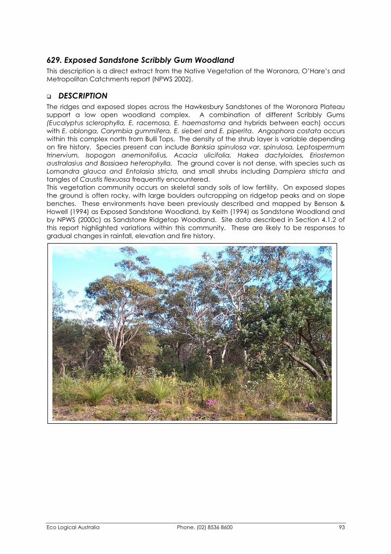
Eco Logical Australia Phone. (02) 8536 8600 93
629. Exposed Sandstone Scribbly Gum Woodland This description is a direct extract from the Native Vegetation of the Woronora, O’Hare’s and Metropolitan Catchments report (NPWS 2002).
�� DESCRIPTION The ridges and exposed slopes across the Hawkesbury Sandstones of the Woronora Plateau support a low open woodland complex. A combination of different Scribbly Gums (Eucalyptus sclerophylla, E. racemosa, E. haemastoma and hybrids between each) occurs with E. oblonga, Corymbia gummifera, E. sieberi and E. piperita. Angophora costata occurs within this complex north from Bulli Tops. The density of the shrub layer is variable depending on fire history. Species present can include Banksia spinulosa var. spinulosa, Leptospermum trinervium, Isopogon anemonifolius, Acacia ulicifolia, Hakea dactyloides, Eriostemon australasius and Bossiaea heterophylla. The ground cover is not dense, with species such as Lomandra glauca and Entolasia stricta, and small shrubs including Dampiera stricta and tangles of Caustis flexuosa frequently encountered. This vegetation community occurs on skeletal sandy soils of low fertility. On exposed slopes the ground is often rocky, with large boulders outcropping on ridgetop peaks and on slope benches. These environments have been previously described and mapped by Benson & Howell (1994) as Exposed Sandstone Woodland, by Keith (1994) as Sandstone Woodland and by NPWS (2000c) as Sandstone Ridgetop Woodland. Site data described in Section 4.1.2 of this report highlighted variations within this community. These are likely to be responses to gradual changes in rainfall, elevation and fire history.
Eco Logical Australia Phone. (02) 8536 8600 94
�� FLORISTIC SUMMARY
Number of Sites: 82
Trees: 10-15m tall. Mean Projected Canopy Cover 15% Eucalyptus sclerophylla, Eucalyptus racemosa, Eucalyptus haemastoma, Corymbia gummifera, Eucalyptus oblonga, Eucalyptus sieberi, Eucalyptus piperita, Angophora costata
Shrubs: 2-8m tall. Mean Projected Canopy Cover 35% Banksia spinulosa var. spinulosa, Leptospermum trinervium, Platysace linearifolia, Dillwynia retorta, Petrophile sessilis, Eriostemon australasius, Isopogon anemonifolius, Phyllanthus hirtellus, Lambertia formosa, Hakea sericea, Persoonia levis
Ground Covers: 0-1 m tall. Mean Projected Canopy Cover 20% Entolasia stricta, Lomandra obliqua, Cyathochaeta diandra, Lepyrodia scariosa, Dampiera stricta, Lepidosperma laterale
�� KEY IDENTIFYING FEATURES
Easily recognisable features to assist in identifying this map unit are: �� Exposed slopes and ridgetops on sandstone plateau above escarpment.
�� A low heathy woodland dominated by Scribbly gums (Eucalyptus sclerophylla, E. racemosa) with Red bloodwood (Corymbia gummifera), Narrow-leaved stringybark (E. oblonga) and Silvertop ash (E. sieberi).
�� A diverse heath understorey marked by Banksia spp., Tea-tree (Leptospermum trinervium) and Broad-leaved hakea (Hakea dactyloides).
�� EXAMPLE LOCATIONS Dharawal State Recreation Area; Bulli Tops
�� CONSERVATION STATUS
BIOREGIONAL STATUS
Total Area within Sydney
Basin Bioregion (ha)
Proportion of Bioregional Area
within NPWS Reserve (%)
Area within Catchment
(ha)
Proportion of Bioregional Area
within Catchment (%)
37022 9 36172.08 98
Eco Logical Australia Phone. (02) 8536 8600 95
CONDITION ASSESSMENT
Disturbance Class
Area (ha) Proportion Extant (%)
A Light 35852.21 99.1 B Moderate 185.71 0.5 C Heavy 18.35 0.1 Scattered trees 115.81 0.3 Total 36172.08 100
�� THREATENED PLANT SPECIES Epacris purpurascens var. purpurascens (V), Leucopogon exolasius (V), Pultenaea aristata (V), Darwinia grandiflora (2R), Eucalyptus luehmanniana (2R), Grevillea longifolia (2R), Hibbertia nitida (2R), Eucalyptus apiculata (3R)
�� DIAGNOSTIC SPECIES Species Name Group
Score Group Freq
Non Group Score
Non Group Freq
Fidelity Class
Acacia myrtifolia 2 0.72 2 0.15 positive Acacia suaveolens 2 0.76 2 0.26 positive Acacia ulicifolia 2 0.52 1 0.20 positive Actinotus minor 2 0.62 2 0.24 positive Banksia ericifolia subsp. ericifolia 2 0.59 3 0.30 positive Banksia serrata 2 0.76 2 0.30 positive Banksia spinulosa var. spinulosa 2 0.66 2 0.44 positive Boronia anethifolia 1 0.02 0 0.00 positive Bossiaea heterophylla 2 0.79 2 0.23 positive Bossiaea obcordata 2 0.50 2 0.13 positive Caustis flexuosa 2 0.57 2 0.20 positive Choretrum species A 1 0.02 0 0.00 positive Corymbia gummifera 2 0.91 2 0.48 positive Cryptostylis leptochila 1 0.02 0 0.00 positive Cyathochaeta diandra 2 0.55 2 0.28 positive Dampiera stricta 2 0.71 2 0.33 positive Darwinia biflora 2 0.05 0 0.00 positive Dichelachne micrantha 1 0.02 0 0.00 positive Entolasia stricta 2 0.53 2 0.48 positive Epacris crassifolia 2 0.02 0 0.00 positive Eucalyptus racemosa 2 0.53 2 0.17 positive Eucalyptus sieberi 2 0.71 2 0.21 positive Eucalyptus sparsifolia 3 0.02 0 0.00 positive Gompholobium pinnatum 1 0.02 0 0.00 positive Grevillea triternata 2 0.07 0 0.00 positive Hakea dactyloides 2 0.88 2 0.33 positive Hibbertia virgata subsp. virgata 1 0.02 0 0.00 positive Isopogon anemonifolius 2 0.93 2 0.30 positive Lambertia formosa 2 0.90 2 0.30 positive Laxmannia compacta 1 0.02 0 0.00 positive Leptospermum trinervium 2 0.97 2 0.37 positive Lepyrodia scariosa 2 0.69 2 0.34 positive Lomandra confertifolia subsp. pallida 2 0.02 0 0.00 positive
Eco Logical Australia Phone. (02) 8536 8600 96
Species Name Group Score
Group Freq
Non Group Score
Non Group Freq
Fidelity Class
Lomandra obliqua 2 0.84 2 0.39 positive Lomatia silaifolia 2 0.66 2 0.38 positive Monotoca scoparia 2 0.64 1 0.24 positive Ophioglossum lusitanicum 1 0.02 0 0.00 positive Patersonia glabrata 2 0.55 2 0.22 positive Persoonia levis 2 0.86 1 0.42 positive Persoonia oblongata 3 0.02 0 0.00 positive Petrophile canescens 2 0.02 0 0.00 positive Petrophile pulchella 2 0.52 2 0.29 positive Phyllota grandiflora 1 0.02 0 0.00 positive Pimelea linifolia subsp. linifolia 2 0.57 2 0.24 positive Platysace linearifolia 2 0.72 2 0.34 positive Plinthanthesis paradoxa 1 0.02 0 0.00 positive Sphaerolobium minus 1 0.02 0 0.00 positive
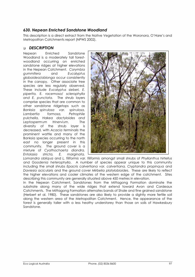
Eco Logical Australia Phone. (02) 8536 8600 97
630. Nepean Enriched Sandstone Woodland This description is a direct extract from the Native Vegetation of the Woronora, O’Hare’s and Metropolitan Catchments report (NPWS 2002).
�� DESCRIPTION Nepean Enriched Sandstone Woodland is a moderately tall forest-woodland occurring on enriched sandstone ridges at higher elevations in the Nepean Catchment. Corymbia gummifera and Eucalyptus globoidea/oblonga occur consistently in the canopy. Other associate tree species are less regularly observed. These include Eucalyptus sieberi, E. piperita, E. racemosa/ sclerophylla and E. punctata. The shrub layers comprise species that are common to other sandstone ridgetops such as Banksia spinulosa var. spinulosa, Lambertia formosa, Petrophile pulchella, Hakea dactyloides and Leptospermum trinervium. The diversity of the shrub layer is decreased, with Acacia terminalis the prominent wattle and many of the Banksia species occurring to the north east no longer present in this community. The ground cover is a mixture of Cyathochaeta diandra, Entolasia stricta, E. marginata, Lomandra obliqua and L. filiformis var. filiformis amongst small shrubs of Phyllanthus hirtellus and Goodenia heterophylla. A number of species appear unique to this community including the small shrubs Epacris calvertiana var. calvertiana, Cryptandra propinqua and Daviesia acicularis and the ground cover Mirbelia platylobioides. These are likely to reflect the higher elevations and cooler climates of the western edge of the catchment. Sites describing this community are generally situated above 450 metres in elevation. In the Nepean Catchment, Sandstones from the Mittagong Formation dominate the substrate along many of the wide ridges that extend toward Avon and Cordeaux Catchments. The Mittagong Formation alternates bands of Shale and fine grained sandstone (Herbert et al. 1980). These sandstones are also likely to provide a slightly more fertile soil along the western area of the Metropolitan Catchment. Hence, the appearance of the forest is generally taller with a less heathy understorey than those on soils of Hawkesbury Sandstone.
Eco Logical Australia Phone. (02) 8536 8600 98
�� FLORISTIC SUMMARY
Number of Sites: 27
Trees: 25-35m tall. Mean Projected Canopy Cover 45% Corymbia gummifera, Eucalyptus globoidea, Eucalyptus oblonga, (including hybrids), Eucalyptus eugenioides, Eucalyptus piperita, Eucalyptus sieberi, Eucalyptus punctata (in localised patches only)
Shrubs: 2-8m tall. Mean Projected Canopy Cover 35% Banksia spinulosa var. spinulosa, Persoonia levis, Lomatia silaifolia, Leptospermum trinervium, Acacia terminalis, Acacia myrtifolia, Acacia longifolia subsp. longifolia, Hakea dactyloides, Petrophile pulchella, Pimelea linifolia subsp. linifolia, Lambertia formosa, Hibbertia aspera
Ground covers: 0-1 m tall. Mean Projected Canopy Cover 20% Cyathochaeta diandra, Patersonia sericea, Entolasia stricta, Entolasia marginata, Lomandra obliqua, Lomandra filiformis var. filiformis, Dianella longifolia, Phyllanthus hirtellus
�� KEY IDENTIFYING FEATURES
Easily recognisable features to assist in identifying this map unit are: �� Located primarily within the Nepean Catchment on broad Sandstone ridges and
exposed slopes at elevations greater than 450 metres.
�� The colour of the underlying soil tends to be red-orange and rock outcrops are infrequent to absent.
�� The forest canopy has Red bloodwood (Corymbia gummifera) and White stringybark (Eucalyptus globoidea) as a common thread. Several other tree species co-occur including Scribbly gum (E. racemosa), Silvertop ash (E. sieberi) and Sydney peppermint (E. piperita). At times the community may be dominated by White stringybark and Red bloodwood alone, indicating a slightly stronger shale influence in the soil.
�� The shrub understorey has a slightly different visual appearance to other exposed sandstone vegetation. Banksia serrata is not present in this assemblage, while elsewhere it is conspicuous. Sunshine wattle (Acacia terminalis) is more commonly recorded in this community.
�� the ground cover tends to be grassy with a dominance of Entolasia marginata, E. stricta and Austrostipa pubescens.
�� EXAMPLE LOCATIONS Fire Trail 1A, Nepean Catchment
�� CONSERVATION STATUS
BIOREGIONAL STATUS
Total Area within Sydney
Basin Bioregion (ha)
Proportion of Bioregional Area
within NPWS Reserve (%)
Area within Catchment
(ha)
Proportion of Bioregional Area
within Catchment (%)
>5291 0 5290.97 100
Eco Logical Australia Phone. (02) 8536 8600 99
CONDITION ASSESSMENT
Disturbance Class
Area (ha) Proportion Extant (%)
A Light 5287.68 99.9 B Moderate 0 0 C Heavy 0 0 Scattered trees 3.29 0.1 Total 5290.97 100
�� THREATENED PLANT SPECIES Hibbertia nitida (2R), Lissanthe sapida (3R)
�� DIAGNOSTIC SPECIES Species Name Group
Score Group Freq
Non Group Score
Non Group Freq
Fidelity Class
Austrostipa pubescens 2 0.59 2 0.13 positive Austrostipa verticillata 1 0.11 0 0.00 positive Banksia spinulosa var. spinulosa 2 1.00 2 0.42 positive Billardiera scandens 2 0.56 1 0.27 positive Bossiaea obcordata 2 0.89 2 0.10 positive Corymbia gummifera 2 0.89 2 0.50 positive Cryptandra propinqua 2 0.04 0 0.00 positive Cryptandra spinescens 2 0.04 0 0.00 positive Cyathochaeta diandra 2 0.85 2 0.30 positive Daviesia acicularis 1 0.04 0 0.00 positive Dianella longifolia 2 0.56 2 0.05 positive Epacris calvertiana var. calvertiana 1 0.04 0 0.00 positive Eucalyptus racemosa 2 0.70 2 0.28 positive Eucalyptus sieberi 2 0.59 2 0.23 positive Euchiton sphaericus 1 0.04 0 0.00 positive Goodenia bellidifolia subsp. bellidifolia 2 0.59 2 0.12 positive Goodenia hederacea subsp. hederacea 2 0.63 2 0.09 positive Grevillea phylicoides 1 0.04 0 0.00 positive Hibbertia aspera subsp. aspera 2 0.56 2 0.11 positive Lambertia formosa 2 0.56 2 0.37 positive Leptospermum trinervium 2 0.67 2 0.47 positive Lomandra filiformis subsp. filiformis 2 0.67 2 0.17 positive Lomandra obliqua 2 0.78 2 0.43 positive Lomatia silaifolia 2 0.89 1 0.38 positive Mirbelia platylobioides 1 0.11 0 0.00 positive Patersonia sericea 2 0.78 1 0.24 positive Persoonia levis 2 0.81 1 0.46 positive Petrophile pulchella 2 0.59 2 0.29 positive Phyllanthus hirtellus 2 0.67 2 0.20 positive Pimelea glauca 2 0.04 0 0.00 positive Pimelea linifolia subsp. linifolia 2 0.59 2 0.19 positive Tetratheca thymifolia 2 0.63 1 0.02 positive Entolasia stricta 2 0.81 2 0.52 constant
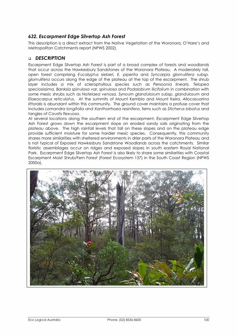
Eco Logical Australia Phone. (02) 8536 8600 100
632. Escarpment Edge Silvertop Ash Forest This description is a direct extract from the Native Vegetation of the Woronora, O’Hare’s and Metropolitan Catchments report (NPWS 2002).
�� DESCRIPTION Escarpment Edge Silvertop Ash Forest is part of a broad complex of forests and woodlands that occur across the Hawkesbury Sandstones of the Woronora Plateau. A moderately tall, open forest comprising Eucalyptus sieberi, E. piperita and Syncarpia glomulifera subsp. glomulifera occurs along the edge of the plateau at the top of the escarpment. The shrub layer includes a mix of sclerophyllous species such as Persoonia linearis, Telopea speciosissima, Banksia spinulosa var. spinulosa and Podolobium ilicifolium in combination with some mesic shrubs such as Notelaea venosa, Synoum glandulosum subsp. glandulosum and Elaeocarpus reticulatus. At the summits of Mount Kembla and Mount Keira, Allocasuarina littoralis is abundant within this community. The ground cover maintains a profuse cover that includes Lomandra longifolia and Xanthorrhoea resinifera, ferns such as Sticherus lobatus and tangles of Caustis flexuosa. At several locations along the southern end of the escarpment, Escarpment Edge Silvertop Ash Forest grows down the escarpment slope on eroded sandy soils originating from the plateau above. The high rainfall levels that fall on these slopes and on the plateau edge provide sufficient moisture for some hardier mesic species. Consequently, this community shares more similarities with sheltered environments in drier parts of the Woronora Plateau and is not typical of Exposed Hawkesbury Sandstone Woodlands across the catchments. Similar floristic assemblages occur on ridges and exposed slopes in south eastern Royal National Park. Escarpment Edge Silvertop Ash Forest is also likely to share some similarities with Coastal Escarpment Moist Shrub/Fern Forest (Forest Ecosystem 137) in the South Coast Region (NPWS 2000a).
Eco Logical Australia Phone. (02) 8536 8600 101
�� FLORISTIC SUMMARY
Number of Sites: 3
Trees: 20-25m tall. Mean Projected Canopy Cover 30% Eucalyptus sieberi, Eucalyptus piperita, Syncarpia glomulifera subsp. glomulifera, Corymbia gummifera
Shrubs: 2-4m tall. Mean Projected Canopy Cover 30% Allocasuarina littoralis, Persoonia linearis, Persoonia levis, Elaeocarpus reticulatus, Leptospermum rotundifolium, Cassinia trinerva, Platysace lanceolata, Lomatia silaifolia
Ground Covers: 0-1m tall. Mean Projected Canopy Cover 35% Lomandra longifolia, Caustis flexuosa, Lomandra filiformis var. filiformis, Patersonia glabrata, Lepidosperma laterale
�� KEY IDENTIFYING FEATURES
Easily recognisable features to assist in identifying this map unit are: �� Escarpment slopes and plateau edge on sandy soils.
�� Moderately tall open forest dominated by Silvertop ash (Eucalyptus sieberi), Turpentine (Syncarpia glomulifera subsp. glomulifera) and Sydney peppermint (E. piperita).
�� Combinations of typical sandstone shrub species and hardy mesic species occurring in exposed locations.
�� EXAMPLE LOCATIONS Macquarie Pass National Park; Mount Kembla and Mount Keira Summits
�� CONSERVATION STATUS
BIOREGIONAL STATUS
Total Area within Sydney
Basin Bioregion (ha)
Proportion of Bioregional Area
within NPWS Reserve (%)
Area within Catchment
(ha)
Proportion of Bioregional Area
within Catchment (%)
14953 60 633.01 4.2
CONDITION ASSESSMENT
Disturbance Class
Area (ha) Proportion Extant (%)
A Light 486.60 98.7 B Moderate 1.80 0.4 C Heavy 4.51 0.9 Scattered trees 0 0 Total 633.01 100
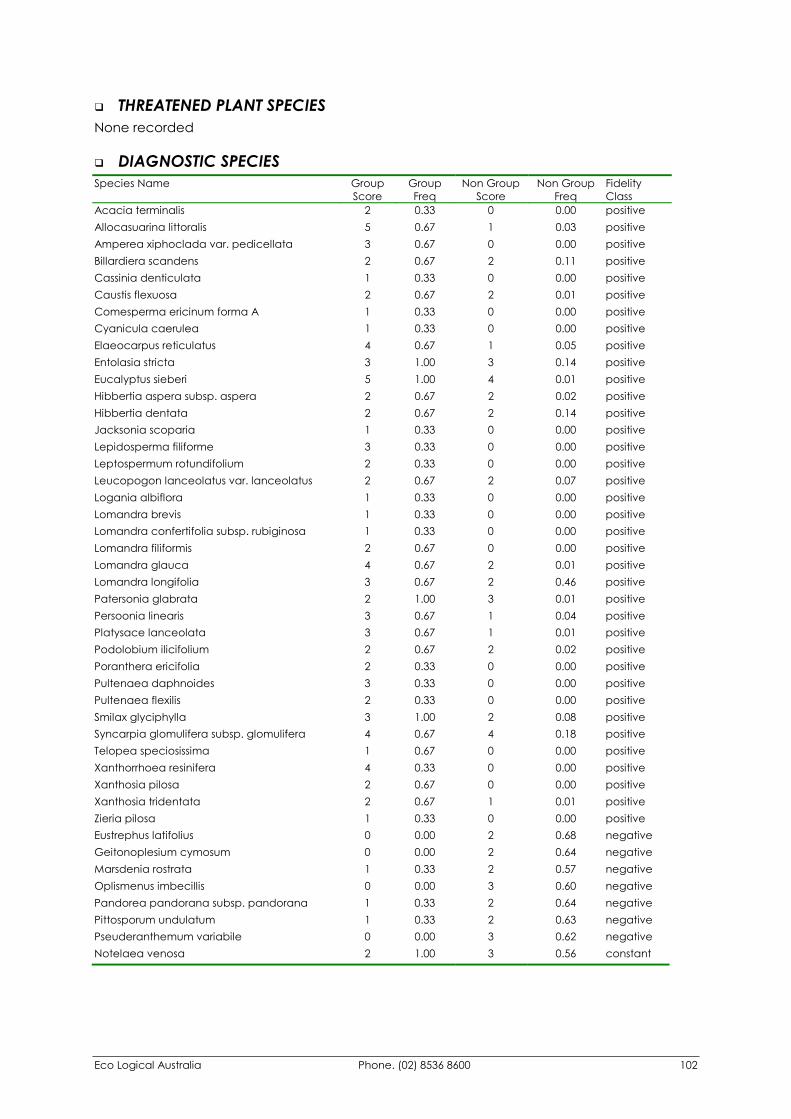
Eco Logical Australia Phone. (02) 8536 8600 102
�� THREATENED PLANT SPECIES None recorded
�� DIAGNOSTIC SPECIES Species Name Group
Score Group Freq
Non Group Score
Non Group Freq
Fidelity Class
Acacia terminalis 2 0.33 0 0.00 positive Allocasuarina littoralis 5 0.67 1 0.03 positive Amperea xiphoclada var. pedicellata 3 0.67 0 0.00 positive Billardiera scandens 2 0.67 2 0.11 positive Cassinia denticulata 1 0.33 0 0.00 positive Caustis flexuosa 2 0.67 2 0.01 positive Comesperma ericinum forma A 1 0.33 0 0.00 positive Cyanicula caerulea 1 0.33 0 0.00 positive Elaeocarpus reticulatus 4 0.67 1 0.05 positive Entolasia stricta 3 1.00 3 0.14 positive Eucalyptus sieberi 5 1.00 4 0.01 positive Hibbertia aspera subsp. aspera 2 0.67 2 0.02 positive Hibbertia dentata 2 0.67 2 0.14 positive Jacksonia scoparia 1 0.33 0 0.00 positive Lepidosperma filiforme 3 0.33 0 0.00 positive Leptospermum rotundifolium 2 0.33 0 0.00 positive Leucopogon lanceolatus var. lanceolatus 2 0.67 2 0.07 positive Logania albiflora 1 0.33 0 0.00 positive Lomandra brevis 1 0.33 0 0.00 positive Lomandra confertifolia subsp. rubiginosa 1 0.33 0 0.00 positive Lomandra filiformis 2 0.67 0 0.00 positive Lomandra glauca 4 0.67 2 0.01 positive Lomandra longifolia 3 0.67 2 0.46 positive Patersonia glabrata 2 1.00 3 0.01 positive Persoonia linearis 3 0.67 1 0.04 positive Platysace lanceolata 3 0.67 1 0.01 positive Podolobium ilicifolium 2 0.67 2 0.02 positive Poranthera ericifolia 2 0.33 0 0.00 positive Pultenaea daphnoides 3 0.33 0 0.00 positive Pultenaea flexilis 2 0.33 0 0.00 positive Smilax glyciphylla 3 1.00 2 0.08 positive Syncarpia glomulifera subsp. glomulifera 4 0.67 4 0.18 positive Telopea speciosissima 1 0.67 0 0.00 positive Xanthorrhoea resinifera 4 0.33 0 0.00 positive Xanthosia pilosa 2 0.67 0 0.00 positive Xanthosia tridentata 2 0.67 1 0.01 positive Zieria pilosa 1 0.33 0 0.00 positive Eustrephus latifolius 0 0.00 2 0.68 negative Geitonoplesium cymosum 0 0.00 2 0.64 negative Marsdenia rostrata 1 0.33 2 0.57 negative Oplismenus imbecillis 0 0.00 3 0.60 negative Pandorea pandorana subsp. pandorana 1 0.33 2 0.64 negative Pittosporum undulatum 1 0.33 2 0.63 negative Pseuderanthemum variabile 0 0.00 3 0.62 negative Notelaea venosa 2 1.00 3 0.56 constant
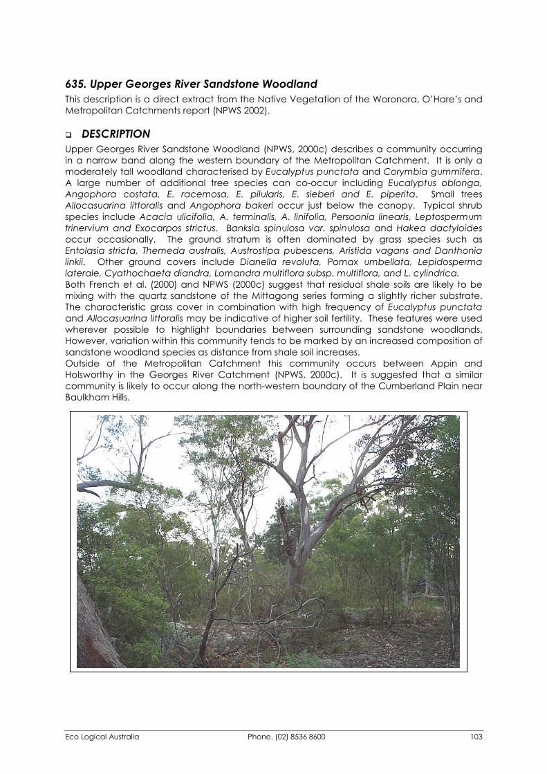
Eco Logical Australia Phone. (02) 8536 8600 103
635. Upper Georges River Sandstone Woodland This description is a direct extract from the Native Vegetation of the Woronora, O’Hare’s and Metropolitan Catchments report (NPWS 2002).
�� DESCRIPTION Upper Georges River Sandstone Woodland (NPWS, 2000c) describes a community occurring in a narrow band along the western boundary of the Metropolitan Catchment. It is only a moderately tall woodland characterised by Eucalyptus punctata and Corymbia gummifera. A large number of additional tree species can co-occur including Eucalyptus oblonga, Angophora costata, E. racemosa, E. pilularis, E. sieberi and E. piperita. Small trees Allocasuarina littoralis and Angophora bakeri occur just below the canopy. Typical shrub species include Acacia ulicifolia, A. terminalis, A. linifolia, Persoonia linearis, Leptospermum trinervium and Exocarpos strictus. Banksia spinulosa var. spinulosa and Hakea dactyloides occur occasionally. The ground stratum is often dominated by grass species such as Entolasia stricta, Themeda australis, Austrostipa pubescens, Aristida vagans and Danthonia linkii. Other ground covers include Dianella revoluta, Pomax umbellata, Lepidosperma laterale, Cyathochaeta diandra, Lomandra multiflora subsp. multiflora, and L. cylindrica. Both French et al. (2000) and NPWS (2000c) suggest that residual shale soils are likely to be mixing with the quartz sandstone of the Mittagong series forming a slightly richer substrate. The characteristic grass cover in combination with high frequency of Eucalyptus punctata and Allocasuarina littoralis may be indicative of higher soil fertility. These features were used wherever possible to highlight boundaries between surrounding sandstone woodlands. However, variation within this community tends to be marked by an increased composition of sandstone woodland species as distance from shale soil increases. Outside of the Metropolitan Catchment this community occurs between Appin and Holsworthy in the Georges River Catchment (NPWS, 2000c). It is suggested that a similar community is likely to occur along the north-western boundary of the Cumberland Plain near Baulkham Hills.
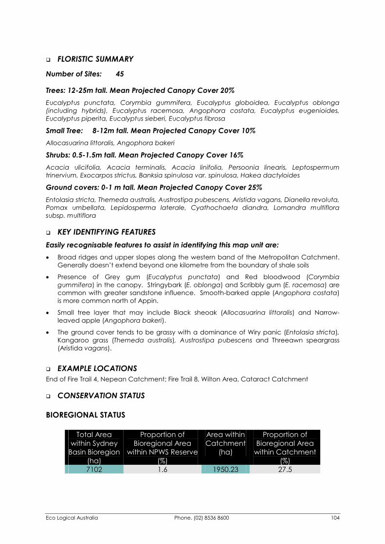
Eco Logical Australia Phone. (02) 8536 8600 104
�� FLORISTIC SUMMARY
Number of Sites: 45
Trees: 12-25m tall. Mean Projected Canopy Cover 20% Eucalyptus punctata, Corymbia gummifera, Eucalyptus globoidea, Eucalyptus oblonga (including hybrids), Eucalyptus racemosa, Angophora costata, Eucalyptus eugenioides, Eucalyptus piperita, Eucalyptus sieberi, Eucalyptus fibrosa
Small Tree: 8-12m tall. Mean Projected Canopy Cover 10% Allocasuarina littoralis, Angophora bakeri
Shrubs: 0.5-1.5m tall. Mean Projected Canopy Cover 16% Acacia ulicifolia, Acacia terminalis, Acacia linifolia, Persoonia linearis, Leptospermum trinervium, Exocarpos strictus, Banksia spinulosa var. spinulosa, Hakea dactyloides
Ground covers: 0-1 m tall. Mean Projected Canopy Cover 25% Entolasia stricta, Themeda australis, Austrostipa pubescens, Aristida vagans, Dianella revoluta, Pomax umbellata, Lepidosperma laterale, Cyathochaeta diandra, Lomandra multiflora subsp. multiflora
�� KEY IDENTIFYING FEATURES Easily recognisable features to assist in identifying this map unit are: �� Broad ridges and upper slopes along the western band of the Metropolitan Catchment.
Generally doesn’t extend beyond one kilometre from the boundary of shale soils
�� Presence of Grey gum (Eucalyptus punctata) and Red bloodwood (Corymbia gummifera) in the canopy. Stringybark (E. oblonga) and Scribbly gum (E. racemosa) are common with greater sandstone influence. Smooth-barked apple (Angophora costata) is more common north of Appin.
�� Small tree layer that may include Black sheoak (Allocasuarina littoralis) and Narrow-leaved apple (Angophora bakeri).
�� The ground cover tends to be grassy with a dominance of Wiry panic (Entolasia stricta), Kangaroo grass (Themeda australis), Austrostipa pubescens and Threeawn speargrass (Aristida vagans).
�� EXAMPLE LOCATIONS End of Fire Trail 4, Nepean Catchment; Fire Trail 8, Wilton Area, Cataract Catchment
�� CONSERVATION STATUS
BIOREGIONAL STATUS
Total Area within Sydney
Basin Bioregion (ha)
Proportion of Bioregional Area
within NPWS Reserve (%)
Area within Catchment
(ha)
Proportion of Bioregional Area
within Catchment (%)
7102 1.6 1950.23 27.5
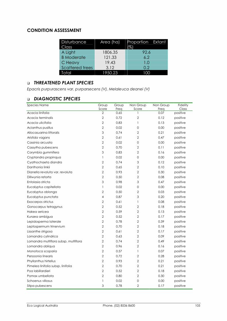
Eco Logical Australia Phone. (02) 8536 8600 105
CONDITION ASSESSMENT
Disturbance Class
Area (ha) Proportion Extant (%)
A Light 1806.35 92.6 B Moderate 121.33 6.2 C Heavy 19.43 1.0 Scattered trees 3.12 0.2 Total 1950.23 100
�� THREATENED PLANT SPECIES Epacris purpurascens var. purparsecens (V), Melaleuca deanei (V)
�� DIAGNOSTIC SPECIES Species Name Group
Score Group Freq
Non Group Score
Non Group Freq
Fidelity Class
Acacia linifolia 2 0.65 1 0.07 positive Acacia terminalis 2 0.72 2 0.12 positive Acacia ulicifolia 2 0.83 1 0.13 positive Acianthus pusillus 2 0.02 0 0.00 positive Allocasuarina littoralis 3 0.74 2 0.21 positive Aristida vagans 2 0.61 2 0.47 positive Cassinia arcuata 2 0.02 0 0.00 positive Cassytha pubescens 2 0.70 2 0.11 positive Corymbia gummifera 3 0.83 2 0.16 positive Cryptandra propinqua 1 0.02 0 0.00 positive Cyathochaeta diandra 2 0.74 3 0.12 positive Danthonia linkii 2 0.65 2 0.10 positive Dianella revoluta var. revoluta 2 0.93 2 0.30 positive Dillwynia retorta 2 0.50 2 0.08 positive Entolasia stricta 3 0.98 3 0.47 positive Eucalyptus capitellata 1 0.02 0 0.00 positive Eucalyptus oblonga 2 0.50 2 0.03 positive Eucalyptus punctata 4 0.87 3 0.20 positive Exocarpos strictus 2 0.61 1 0.08 positive Gonocarpus tetragynus 2 0.52 2 0.18 positive Hakea sericea 2 0.59 2 0.13 positive Kunzea ambigua 2 0.52 2 0.17 positive Lepidosperma laterale 2 0.78 2 0.39 positive Leptospermum trinervium 2 0.70 2 0.18 positive Lissanthe strigosa 2 0.61 2 0.17 positive Lomandra cylindrica 2 0.63 2 0.09 positive Lomandra multiflora subsp. multiflora 2 0.74 2 0.49 positive Lomandra obliqua 2 0.96 2 0.16 positive Monotoca scoparia 2 0.57 1 0.07 positive Persoonia linearis 2 0.72 2 0.28 positive Phyllanthus hirtellus 2 0.93 2 0.21 positive Pimelea linifolia subsp. linifolia 2 0.70 2 0.21 positive Poa labillardieri 2 0.52 2 0.18 positive Pomax umbellata 2 0.80 2 0.30 positive Schoenus villosus 1 0.02 0 0.00 positive Stipa pubescens 3 0.78 2 0.17 positive
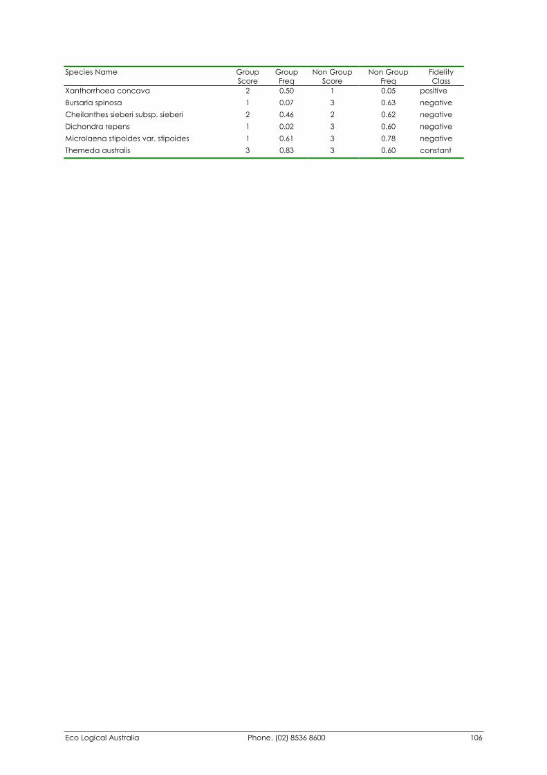
Eco Logical Australia Phone. (02) 8536 8600 106
Species Name Group Score
Group Freq
Non Group Score
Non Group Freq
Fidelity Class
Xanthorrhoea concava 2 0.50 1 0.05 positive Bursaria spinosa 1 0.07 3 0.63 negative Cheilanthes sieberi subsp. sieberi 2 0.46 2 0.62 negative Dichondra repens 1 0.02 3 0.60 negative Microlaena stipoides var. stipoides 1 0.61 3 0.78 negative Themeda australis 3 0.83 3 0.60 constant
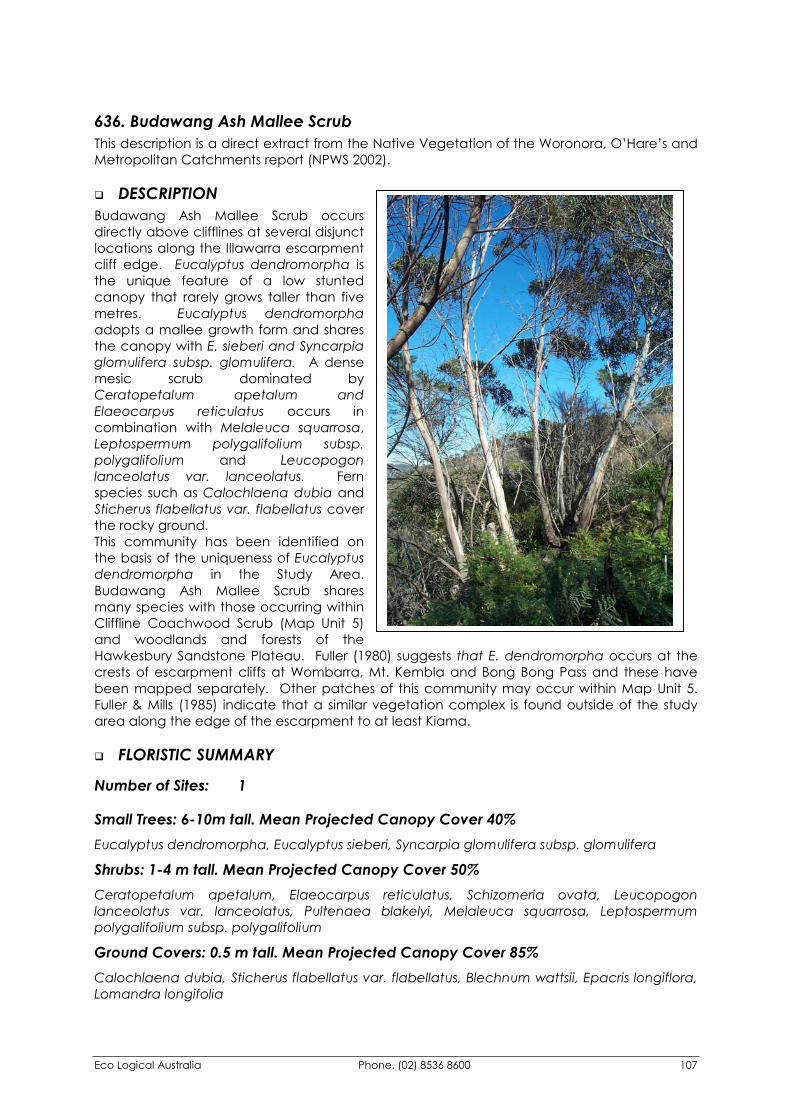
Eco Logical Australia Phone. (02) 8536 8600 107
636. Budawang Ash Mallee Scrub This description is a direct extract from the Native Vegetation of the Woronora, O’Hare’s and Metropolitan Catchments report (NPWS 2002).
�� DESCRIPTION Budawang Ash Mallee Scrub occurs directly above clifflines at several disjunct locations along the Illawarra escarpment cliff edge. Eucalyptus dendromorpha is the unique feature of a low stunted canopy that rarely grows taller than five metres. Eucalyptus dendromorpha adopts a mallee growth form and shares the canopy with E. sieberi and Syncarpia glomulifera subsp. glomulifera. A dense mesic scrub dominated by Ceratopetalum apetalum and Elaeocarpus reticulatus occurs in combination with Melaleuca squarrosa, Leptospermum polygalifolium subsp. polygalifolium and Leucopogon lanceolatus var. lanceolatus. Fern species such as Calochlaena dubia and Sticherus flabellatus var. flabellatus cover the rocky ground. This community has been identified on the basis of the uniqueness of Eucalyptus dendromorpha in the Study Area. Budawang Ash Mallee Scrub shares many species with those occurring within Cliffline Coachwood Scrub (Map Unit 5) and woodlands and forests of the Hawkesbury Sandstone Plateau. Fuller (1980) suggests that E. dendromorpha occurs at the crests of escarpment cliffs at Wombarra, Mt. Kembla and Bong Bong Pass and these have been mapped separately. Other patches of this community may occur within Map Unit 5. Fuller & Mills (1985) indicate that a similar vegetation complex is found outside of the study area along the edge of the escarpment to at least Kiama.
�� FLORISTIC SUMMARY
Number of Sites: 1
Small Trees: 6-10m tall. Mean Projected Canopy Cover 40% Eucalyptus dendromorpha, Eucalyptus sieberi, Syncarpia glomulifera subsp. glomulifera
Shrubs: 1-4 m tall. Mean Projected Canopy Cover 50% Ceratopetalum apetalum, Elaeocarpus reticulatus, Schizomeria ovata, Leucopogon lanceolatus var. lanceolatus, Pultenaea blakelyi, Melaleuca squarrosa, Leptospermum polygalifolium subsp. polygalifolium
Ground Covers: 0.5 m tall. Mean Projected Canopy Cover 85% Calochlaena dubia, Sticherus flabellatus var. flabellatus, Blechnum wattsii, Epacris longiflora, Lomandra longifolia
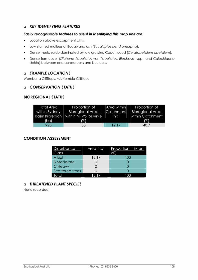
Eco Logical Australia Phone. (02) 8536 8600 108
�� KEY IDENTIFYING FEATURES
Easily recognisable features to assist in identifying this map unit are: �� Location above escarpment cliffs.
�� Low stunted mallees of Budawang ash (Eucalyptus dendromorpha).
�� Dense mesic scrub dominated by low growing Coachwood (Ceratopetalum apetalum).
�� Dense fern cover (Sticherus flabellatus var. flabellatus, Blechnum spp., and Calochlaena dubia) between and across rocks and boulders.
�� EXAMPLE LOCATIONS Wombarra Clifftops; Mt. Kembla Clifftops
�� CONSERVATION STATUS
BIOREGIONAL STATUS
Total Area within Sydney
Basin Bioregion (ha)
Proportion of Bioregional Area
within NPWS Reserve (%)
Area within Catchment
(ha)
Proportion of Bioregional Area
within Catchment (%)
>25 35 12.17 48.7
CONDITION ASSESSMENT
Disturbance Class
Area (ha) Proportion Extant (%)
A Light 12.17 100 B Moderate 0 0 C Heavy 0 0 Scattered trees 0 0 Total 12.17 100
�� THREATENED PLANT SPECIES None recorded
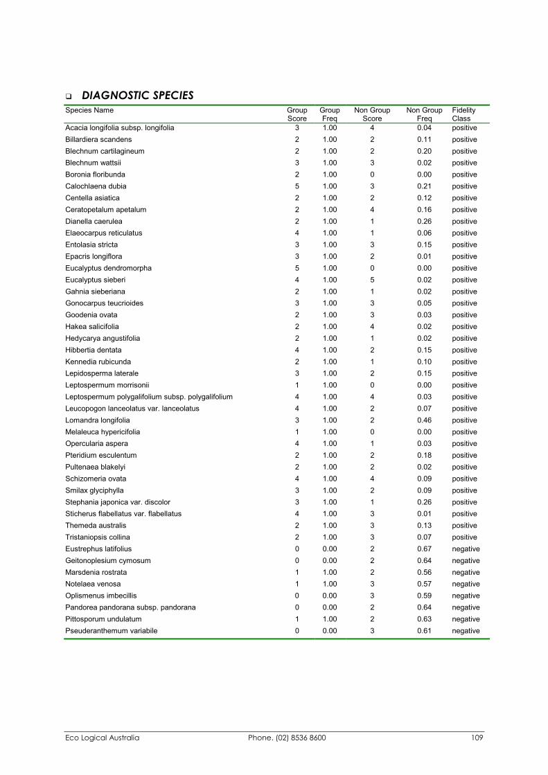
Eco Logical Australia Phone. (02) 8536 8600 109
�� DIAGNOSTIC SPECIES Species Name Group
Score Group Freq
Non Group Score
Non Group Freq
Fidelity Class
Acacia longifolia subsp. longifolia 3 1.00 4 0.04 positive Billardiera scandens 2 1.00 2 0.11 positive Blechnum cartilagineum 2 1.00 2 0.20 positive Blechnum wattsii 3 1.00 3 0.02 positive Boronia floribunda 2 1.00 0 0.00 positive Calochlaena dubia 5 1.00 3 0.21 positive Centella asiatica 2 1.00 2 0.12 positive Ceratopetalum apetalum 2 1.00 4 0.16 positive Dianella caerulea 2 1.00 1 0.26 positive Elaeocarpus reticulatus 4 1.00 1 0.06 positive Entolasia stricta 3 1.00 3 0.15 positive Epacris longiflora 3 1.00 2 0.01 positive Eucalyptus dendromorpha 5 1.00 0 0.00 positive Eucalyptus sieberi 4 1.00 5 0.02 positive Gahnia sieberiana 2 1.00 1 0.02 positive Gonocarpus teucrioides 3 1.00 3 0.05 positive Goodenia ovata 2 1.00 3 0.03 positive Hakea salicifolia 2 1.00 4 0.02 positive Hedycarya angustifolia 2 1.00 1 0.02 positive Hibbertia dentata 4 1.00 2 0.15 positive Kennedia rubicunda 2 1.00 1 0.10 positive Lepidosperma laterale 3 1.00 2 0.15 positive Leptospermum morrisonii 1 1.00 0 0.00 positive Leptospermum polygalifolium subsp. polygalifolium 4 1.00 4 0.03 positive Leucopogon lanceolatus var. lanceolatus 4 1.00 2 0.07 positive Lomandra longifolia 3 1.00 2 0.46 positive Melaleuca hypericifolia 1 1.00 0 0.00 positive Opercularia aspera 4 1.00 1 0.03 positive Pteridium esculentum 2 1.00 2 0.18 positive Pultenaea blakelyi 2 1.00 2 0.02 positive Schizomeria ovata 4 1.00 4 0.09 positive Smilax glyciphylla 3 1.00 2 0.09 positive Stephania japonica var. discolor 3 1.00 1 0.26 positive Sticherus flabellatus var. flabellatus 4 1.00 3 0.01 positive Themeda australis 2 1.00 3 0.13 positive Tristaniopsis collina 2 1.00 3 0.07 positive Eustrephus latifolius 0 0.00 2 0.67 negative Geitonoplesium cymosum 0 0.00 2 0.64 negative Marsdenia rostrata 1 1.00 2 0.56 negative Notelaea venosa 1 1.00 3 0.57 negative Oplismenus imbecillis 0 0.00 3 0.59 negative Pandorea pandorana subsp. pandorana 0 0.00 2 0.64 negative Pittosporum undulatum 1 1.00 2 0.63 negative Pseuderanthemum variabile 0 0.00 3 0.61 negative
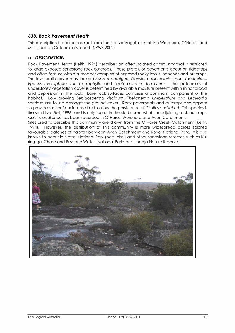
Eco Logical Australia Phone. (02) 8536 8600 110
638. Rock Pavement Heath This description is a direct extract from the Native Vegetation of the Woronora, O’Hare’s and Metropolitan Catchments report (NPWS 2002).
�� DESCRIPTION Rock Pavement Heath (Keith, 1994) describes an often isolated community that is restricted to large exposed sandstone rock outcrops. These plates, or pavements occur on ridgetops and often feature within a broader complex of exposed rocky knolls, benches and outcrops. The low heath cover may include Kunzea ambigua, Darwinia fascicularis subsp. fascicularis, Epacris microphylla var. microphylla and Leptospermum trinervium. The patchiness of understorey vegetation cover is determined by available moisture present within minor cracks and depression in the rock. Bare rock surfaces comprise a dominant component of the habitat. Low growing Lepidosperma viscidum, Thelionema umbellatum and Lepyrodia scariosa are found amongst the ground cover. Rock pavements and outcrops also appear to provide shelter from intense fire to allow the persistence of Callitris endlicheri. This species is fire sensitive (Bell, 1998) and is only found in the study area within or adjoining rock outcrops. Callitris endlicheri has been recorded in O’Hares, Woronora and Avon Catchments. Sites used to describe this community are drawn from the O’Hares Creek Catchment (Keith, 1994). However, the distribution of this community is more widespread across isolated favourable patches of habitat between Avon Catchment and Royal National Park. It is also known to occur in Nattai National Park (pers. obs.) and other sandstone reserves such as Ku-ring-gai Chase and Brisbane Waters National Parks and Joadja Nature Reserve.
Eco Logical Australia Phone. (02) 8536 8600 111
�� FLORISTIC SUMMARY
Number of Sites: 4
Shrubs: 2-5m tall. Mean Projected Canopy Cover 35% Kunzea ambigua, Dillwynia fascicularis subsp. fascicularis, Leptospermum trinervium, Epacris microphylla var microphylla, Banksia ericifolia subsp. ericifolia, Monotoca ledifolia, Hakea sericea, Oxylobium cordifolium
Ground covers: 0.5-1 m tall. Mean Projected Canopy Cover 9% Lepidosperma viscidum, Thelionema umbellatum, Lepyrodia scariosa, Hypolaena fastigata
�� KEY IDENTIFYING FEATURES
Easily recognisable features to assist in identifying this map unit are: �� Large exposed sandstone rock pavements.
�� Low shrub cover of Tick bush (Kunzea ambigua) and Darwinia fascicularis subsp. fascicularis.
�� EXAMPLE LOCATIONS End of Fire Trail No. 9, Woronora Catchment; North East of Stockyard Swamp on Flat Plateau
�� CONSERVATION STATUS
BIOREGIONAL STATUS
Total Area within Sydney
Basin Bioregion (ha)
Proportion of Bioregional Area
within NPWS Reserve (%)
Area within Catchment
(ha)
Proportion of Bioregional Area
within Catchment (%)
>80 5.3 78.96 98.7
CONDITION ASSESSMENT
Disturbance Class
Area (ha) Proportion Extant (%)
A Light 78.96 100 B Moderate 0 0 C Heavy 0 0 Scattered trees 0 0 Total 78.96 100
�� THREATENED PLANT SPECIES Monotoca ledifolia (3R)
Eco Logical Australia Phone. (02) 8536 8600 112
�� DIAGNOSTIC SPECIES Species Name Group
Score Group Freq
Non Group Score
Non Group Freq
Fidelity Class
Callitris endlicheri 4 0.33 0 0.00 positive Darwinia fascicularis subsp. fascicularis 4 0.67 2 0.04 positive Epacris microphylla var. microphylla 3 1.00 2 0.20 positive Kunzea ambigua 5 1.00 1 0.06 positive Lepidosperma viscidum 4 0.67 1 0.02 positive Lepyrodia scariosa 4 0.67 2 0.34 positive Leucopogon microphyllus var. microphyllus 2 0.67 1 0.14 positive Monotoca ledifolia 3 0.67 2 0.00 positive Oxylobium cordifolium 1 0.33 0 0.00 positive Prasophyllum brevilabre 1 0.33 0 0.00 positive Thelionema umbellatum 2 0.67 1 0.00 positive Corymbia gummifera 1 0.33 2 0.52 negative Entolasia stricta 0 0.00 2 0.54 negative
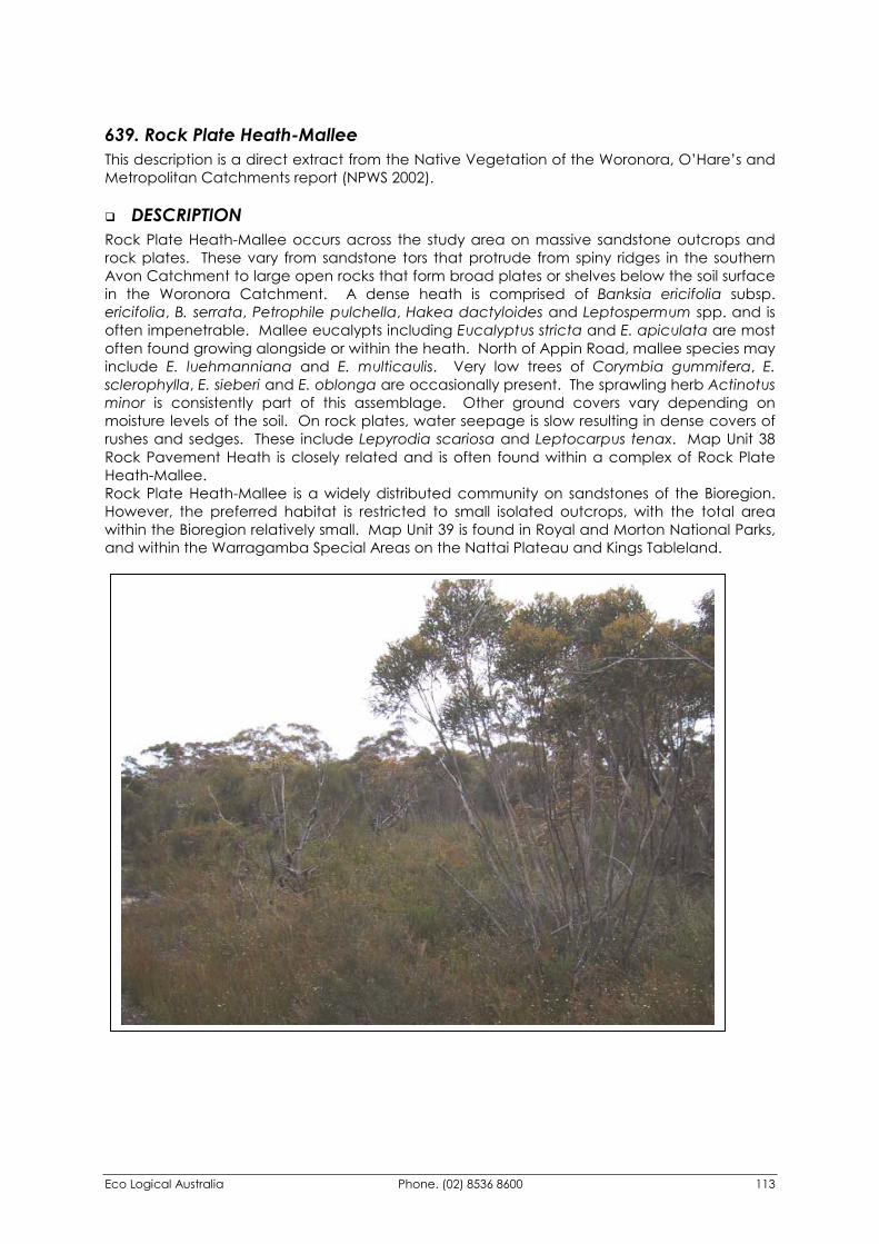
Eco Logical Australia Phone. (02) 8536 8600 113
639. Rock Plate Heath-Mallee This description is a direct extract from the Native Vegetation of the Woronora, O’Hare’s and Metropolitan Catchments report (NPWS 2002).
�� DESCRIPTION Rock Plate Heath-Mallee occurs across the study area on massive sandstone outcrops and rock plates. These vary from sandstone tors that protrude from spiny ridges in the southern Avon Catchment to large open rocks that form broad plates or shelves below the soil surface in the Woronora Catchment. A dense heath is comprised of Banksia ericifolia subsp. ericifolia, B. serrata, Petrophile pulchella, Hakea dactyloides and Leptospermum spp. and is often impenetrable. Mallee eucalypts including Eucalyptus stricta and E. apiculata are most often found growing alongside or within the heath. North of Appin Road, mallee species may include E. luehmanniana and E. multicaulis. Very low trees of Corymbia gummifera, E. sclerophylla, E. sieberi and E. oblonga are occasionally present. The sprawling herb Actinotus minor is consistently part of this assemblage. Other ground covers vary depending on moisture levels of the soil. On rock plates, water seepage is slow resulting in dense covers of rushes and sedges. These include Lepyrodia scariosa and Leptocarpus tenax. Map Unit 38 Rock Pavement Heath is closely related and is often found within a complex of Rock Plate Heath-Mallee. Rock Plate Heath-Mallee is a widely distributed community on sandstones of the Bioregion. However, the preferred habitat is restricted to small isolated outcrops, with the total area within the Bioregion relatively small. Map Unit 39 is found in Royal and Morton National Parks, and within the Warragamba Special Areas on the Nattai Plateau and Kings Tableland.
Eco Logical Australia Phone. (02) 8536 8600 114
�� FLORISTIC SUMMARY
Number of Sites: 6
Small Trees: 6-10m tall. Mean Projected Canopy Cover 40% Eucalyptus stricta, Eucalyptus apiculata, Eucalyptus multicaulis, Eucalyptus sclerophylla, Eucalyptus sieberi, Corymbia gummifera, Eucalyptus oblonga
Shrubs: 1-4 m tall. Mean Projected Canopy Cover 50% Banksia oblongifolia, Banksia ericifolia subsp. ericifolia, Banksia serrata, Acacia suaveolens, Hakea dactyloides, Angophora hispida, Hakea teretifolia, Petrophile pulchella, Leptospermum polygalifolium subsp. polygalifolium, Isopogon anemonifolius, Allocasuarina distyla, Acacia myrtifolia, Lambertia formosa, Grevillea sphacelata, Kunzea capitata, Platysace linearifolia, Darwinia fascicularis subsp. fascicularis
Ground Covers: 0.5 m tall. Mean Projected Canopy Cover 85% Leptocarpus tenax, Lepyrodia scariosa, Lepidosperma filiforme, Lindsaea linearis, Lomandra obliqua, Patersonia sericea, Cassytha glabella forma glabella
�� KEY IDENTIFYING FEATURES
Easily recognisable features to assist in identifying this map unit are: �� Low stunted thin multistemmed trees known as mallees. Typical mallee species include
Mallee ash (E. stricta, E.apiculata) and Whipstick ash (E. multicaulis).
�� Ridgetops on Sandstone Rocky outcrops, tors or broad rock plates.
�� Dense heath of Banksias and Tea-trees dominated by Banksia ericifolia subsp. ericifolia and Leptospermum polygalifolium subsp. polygalifolium.
�� Damp to moist ground cover supporting sedges and rush species such as Lepyrodia scariosa and Leptocarpus tenax.
�� EXAMPLE LOCATIONS Fire Trail 1, East of Road amongst massive sandstone outcrops.
�� CONSERVATION STATUS
BIOREGIONAL STATUS
Total Area within Sydney
Basin Bioregion (ha)
Proportion of Bioregional Area
within NPWS Reserve (%)
Area within Catchment
(ha)
Proportion of Bioregional Area
within Catchment (%)
>1530 46 822.07 53.7
Eco Logical Australia Phone. (02) 8536 8600 115
CONDITION ASSESSMENT
Disturbance Class
Area (ha) Proportion Extant (%)
A Light 822.07 100 B Moderate 0 0 C Heavy 0 0 Scattered trees 0 0 Total 822.07 100
�� THREATENED PLANT SPECIES Eucalyptus apiculata (3R)
�� DIAGNOSTIC SPECIES Species Name Group
Score Group Freq Non Group
Score Non Group
Freq Fidelity Class
Allocasuarina distyla 2 0.71 1 0.04 positive Angophora hispida 2 0.71 2 0.05 positive Banksia ericifolia subsp. ericifolia 4 1.00 2 0.34 positive Darwinia fascicularis subsp. fascicularis 2 0.71 2 0.03 positive Epacris microphylla var. microphylla 2 0.86 2 0.20 positive Guringalia dimorpha 2 0.71 2 0.07 positive Hakea dactyloides 2 0.57 2 0.38 positive Hakea teretifolia 2 1.00 2 0.22 positive Kunzea capitata 2 0.71 2 0.06 positive Lepidosperma filiforme 3 0.57 2 0.09 positive Leptospermum squarrosum 2 0.71 2 0.10 positive Corymbia gummifera 1 0.14 2 0.52 negative Entolasia stricta 1 0.14 2 0.54 negative
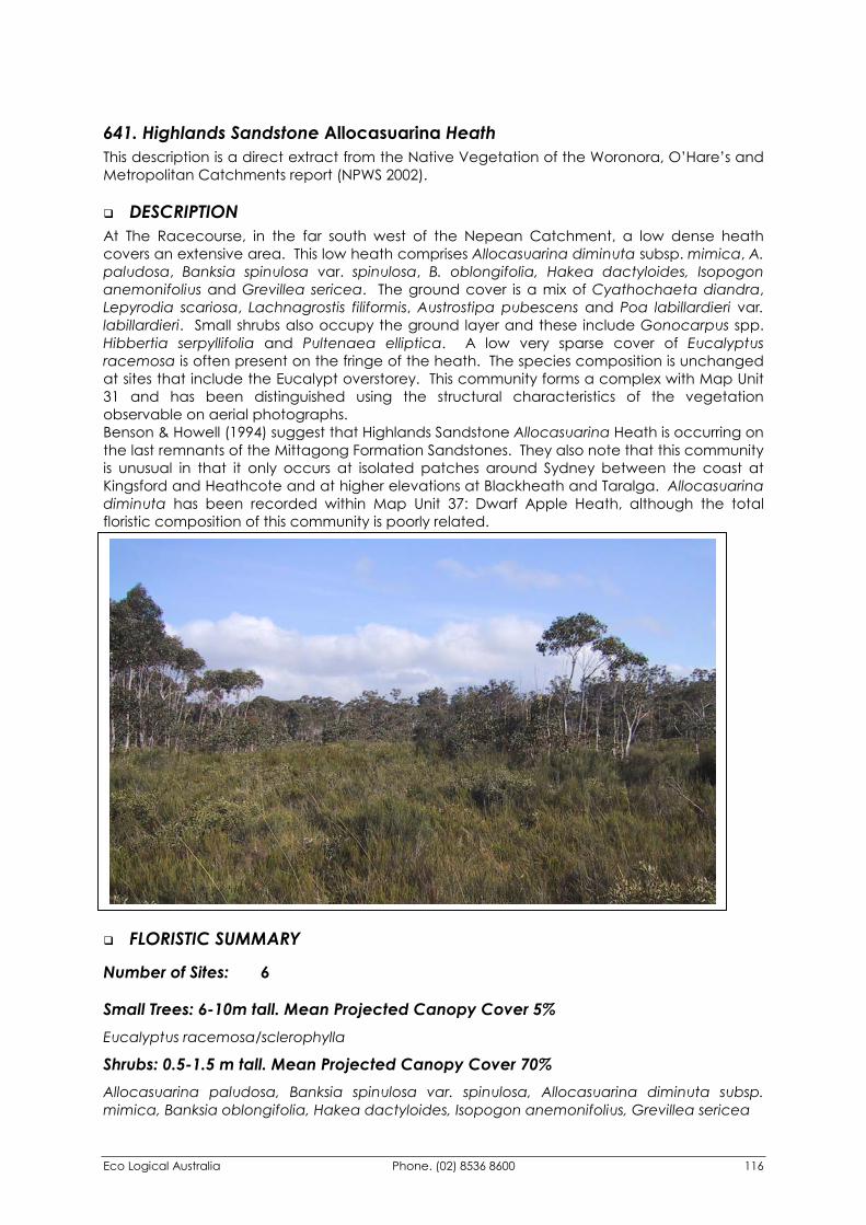
Eco Logical Australia Phone. (02) 8536 8600 116
641. Highlands Sandstone Allocasuarina Heath This description is a direct extract from the Native Vegetation of the Woronora, O’Hare’s and Metropolitan Catchments report (NPWS 2002).
�� DESCRIPTION At The Racecourse, in the far south west of the Nepean Catchment, a low dense heath covers an extensive area. This low heath comprises Allocasuarina diminuta subsp. mimica, A. paludosa, Banksia spinulosa var. spinulosa, B. oblongifolia, Hakea dactyloides, Isopogon anemonifolius and Grevillea sericea. The ground cover is a mix of Cyathochaeta diandra, Lepyrodia scariosa, Lachnagrostis filiformis, Austrostipa pubescens and Poa labillardieri var. labillardieri. Small shrubs also occupy the ground layer and these include Gonocarpus spp. Hibbertia serpyllifolia and Pultenaea elliptica. A low very sparse cover of Eucalyptus racemosa is often present on the fringe of the heath. The species composition is unchanged at sites that include the Eucalypt overstorey. This community forms a complex with Map Unit 31 and has been distinguished using the structural characteristics of the vegetation observable on aerial photographs. Benson & Howell (1994) suggest that Highlands Sandstone Allocasuarina Heath is occurring on the last remnants of the Mittagong Formation Sandstones. They also note that this community is unusual in that it only occurs at isolated patches around Sydney between the coast at Kingsford and Heathcote and at higher elevations at Blackheath and Taralga. Allocasuarina diminuta has been recorded within Map Unit 37: Dwarf Apple Heath, although the total floristic composition of this community is poorly related.
�� FLORISTIC SUMMARY
Number of Sites: 6
Small Trees: 6-10m tall. Mean Projected Canopy Cover 5% Eucalyptus racemosa/sclerophylla
Shrubs: 0.5-1.5 m tall. Mean Projected Canopy Cover 70% Allocasuarina paludosa, Banksia spinulosa var. spinulosa, Allocasuarina diminuta subsp. mimica, Banksia oblongifolia, Hakea dactyloides, Isopogon anemonifolius, Grevillea sericea
Eco Logical Australia Phone. (02) 8536 8600 117
Ground covers: 0.5-1m tall. Mean Projected Canopy Cover 85% Cyathochaeta diandra, Lepyrodia scariosa, Dampiera stricta
�� KEY IDENTIFYING FEATURES
Easily recognisable features to assist in identifying this map unit are: �� Single location at The Racecourse in Nepean Catchment. Low Heath (less than two
metres) dominated by Allocasuarina paludosa and A. diminuta subsp. mimica.
�� EXAMPLE LOCATIONS Fire Trail 2H, Nepean Catchment
�� CONSERVATION STATUS
BIOREGIONAL STATUS
Total Area within Sydney
Basin Bioregion (ha)
Proportion of Bioregional Area
within NPWS Reserve (%)
Area within Catchment
(ha)
Proportion of Bioregional Area
within Catchment (%)
>59 0 59.41 100
CONDITION ASSESSMENT
Disturbance Class
Area (ha) Proportion Extant (%)
A Light 59.41 100 B Moderate 0 0 C Heavy 0 0 Scattered trees 0 0 Total 59.41 100
�� THREATENED PLANT SPECIES None recorded
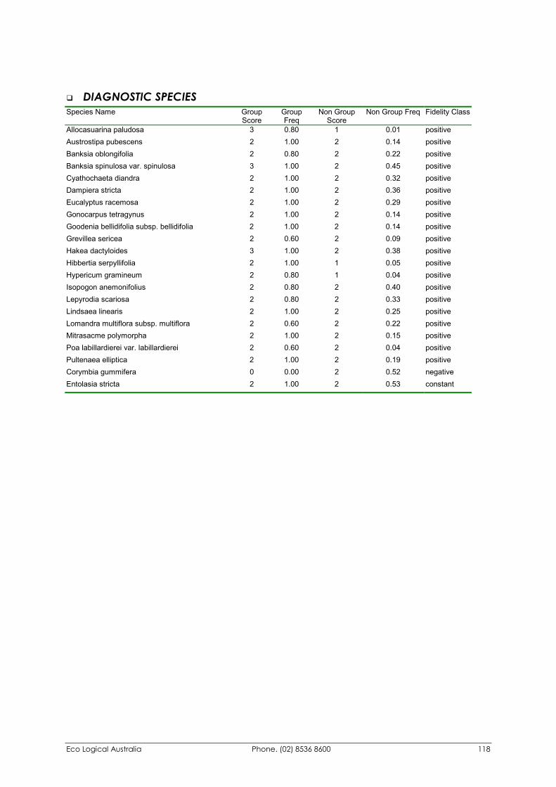
Eco Logical Australia Phone. (02) 8536 8600 118
�� DIAGNOSTIC SPECIES Species Name Group
Score Group Freq
Non Group Score
Non Group Freq Fidelity Class
Allocasuarina paludosa 3 0.80 1 0.01 positive Austrostipa pubescens 2 1.00 2 0.14 positive Banksia oblongifolia 2 0.80 2 0.22 positive Banksia spinulosa var. spinulosa 3 1.00 2 0.45 positive Cyathochaeta diandra 2 1.00 2 0.32 positive Dampiera stricta 2 1.00 2 0.36 positive Eucalyptus racemosa 2 1.00 2 0.29 positive Gonocarpus tetragynus 2 1.00 2 0.14 positive Goodenia bellidifolia subsp. bellidifolia 2 1.00 2 0.14 positive Grevillea sericea 2 0.60 2 0.09 positive Hakea dactyloides 3 1.00 2 0.38 positive Hibbertia serpyllifolia 2 1.00 1 0.05 positive Hypericum gramineum 2 0.80 1 0.04 positive Isopogon anemonifolius 2 0.80 2 0.40 positive Lepyrodia scariosa 2 0.80 2 0.33 positive Lindsaea linearis 2 1.00 2 0.25 positive Lomandra multiflora subsp. multiflora 2 0.60 2 0.22 positive Mitrasacme polymorpha 2 1.00 2 0.15 positive Poa labillardierei var. labillardierei 2 0.60 2 0.04 positive Pultenaea elliptica 2 1.00 2 0.19 positive Corymbia gummifera 0 0.00 2 0.52 negative Entolasia stricta 2 1.00 2 0.53 constant
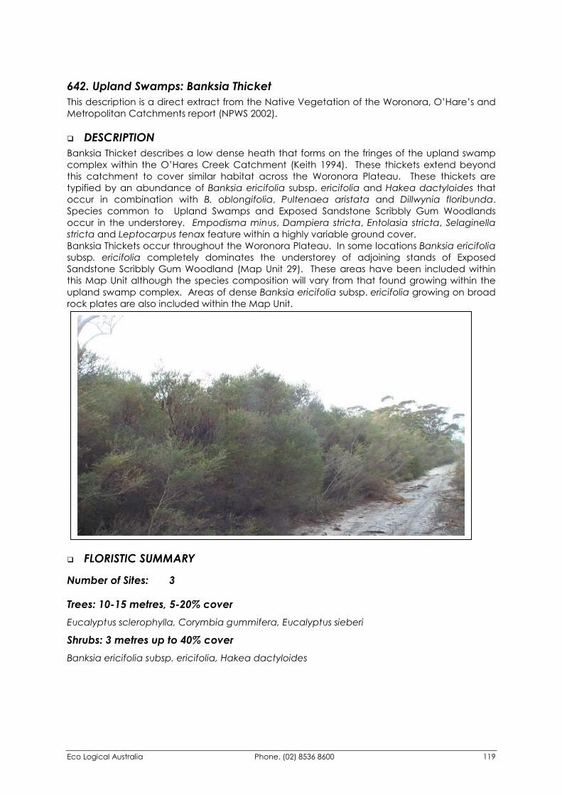
Eco Logical Australia Phone. (02) 8536 8600 119
642. Upland Swamps: Banksia Thicket This description is a direct extract from the Native Vegetation of the Woronora, O’Hare’s and Metropolitan Catchments report (NPWS 2002).
�� DESCRIPTION Banksia Thicket describes a low dense heath that forms on the fringes of the upland swamp complex within the O’Hares Creek Catchment (Keith 1994). These thickets extend beyond this catchment to cover similar habitat across the Woronora Plateau. These thickets are typified by an abundance of Banksia ericifolia subsp. ericifolia and Hakea dactyloides that occur in combination with B. oblongifolia, Pultenaea aristata and Dillwynia floribunda. Species common to Upland Swamps and Exposed Sandstone Scribbly Gum Woodlands occur in the understorey. Empodisma minus, Dampiera stricta, Entolasia stricta, Selaginella stricta and Leptocarpus tenax feature within a highly variable ground cover. Banksia Thickets occur throughout the Woronora Plateau. In some locations Banksia ericifolia subsp. ericifolia completely dominates the understorey of adjoining stands of Exposed Sandstone Scribbly Gum Woodland (Map Unit 29). These areas have been included within this Map Unit although the species composition will vary from that found growing within the upland swamp complex. Areas of dense Banksia ericifolia subsp. ericifolia growing on broad rock plates are also included within the Map Unit.
�� FLORISTIC SUMMARY
Number of Sites: 3
Trees: 10-15 metres, 5-20% cover Eucalyptus sclerophylla, Corymbia gummifera, Eucalyptus sieberi
Shrubs: 3 metres up to 40% cover Banksia ericifolia subsp. ericifolia, Hakea dactyloides
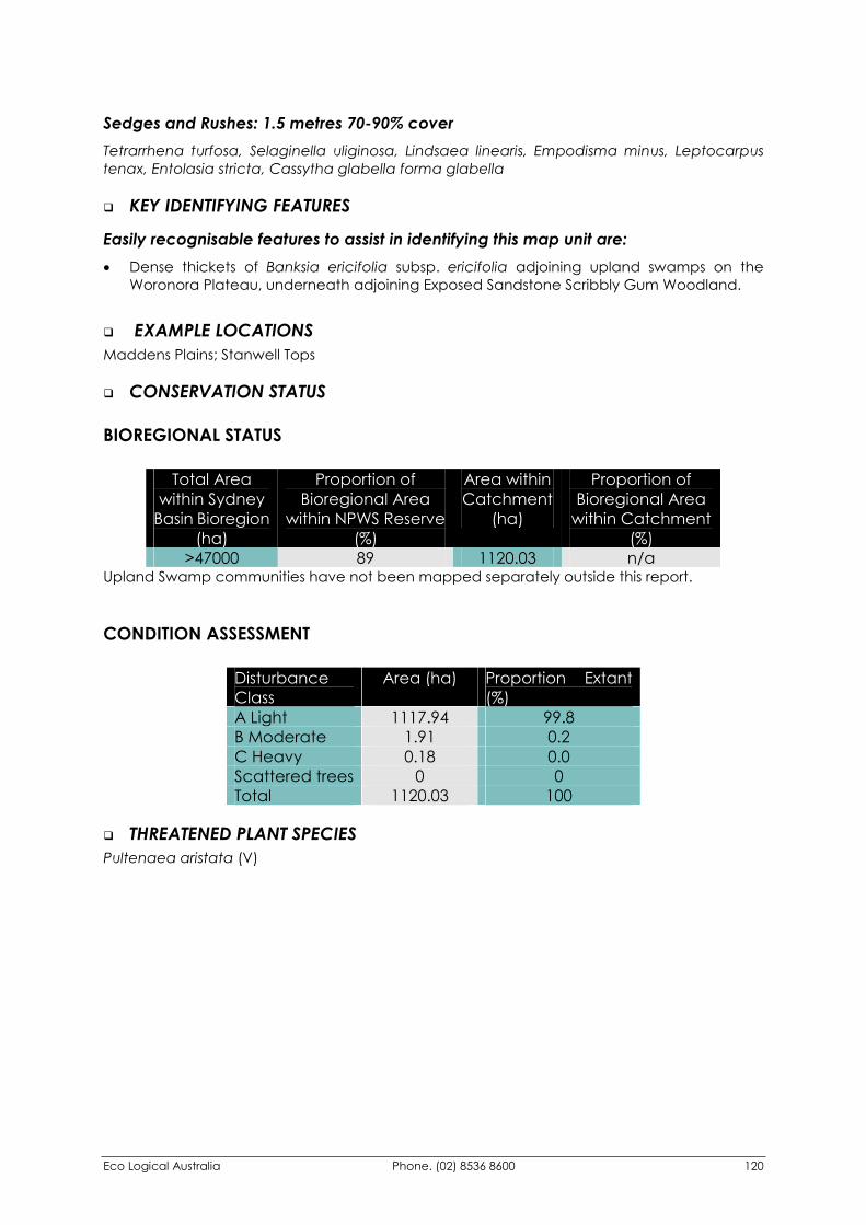
Eco Logical Australia Phone. (02) 8536 8600 120
Sedges and Rushes: 1.5 metres 70-90% cover Tetrarrhena turfosa, Selaginella uliginosa, Lindsaea linearis, Empodisma minus, Leptocarpus tenax, Entolasia stricta, Cassytha glabella forma glabella
�� KEY IDENTIFYING FEATURES
Easily recognisable features to assist in identifying this map unit are: �� Dense thickets of Banksia ericifolia subsp. ericifolia adjoining upland swamps on the
Woronora Plateau, underneath adjoining Exposed Sandstone Scribbly Gum Woodland.
�� EXAMPLE LOCATIONS Maddens Plains; Stanwell Tops
�� CONSERVATION STATUS
BIOREGIONAL STATUS
Total Area within Sydney
Basin Bioregion (ha)
Proportion of Bioregional Area
within NPWS Reserve (%)
Area within Catchment
(ha)
Proportion of Bioregional Area
within Catchment (%)
>47000 89 1120.03 n/a Upland Swamp communities have not been mapped separately outside this report.
CONDITION ASSESSMENT
Disturbance Class
Area (ha) Proportion Extant (%)
A Light 1117.94 99.8 B Moderate 1.91 0.2 C Heavy 0.18 0.0 Scattered trees 0 0 Total 1120.03 100
�� THREATENED PLANT SPECIES Pultenaea aristata (V)
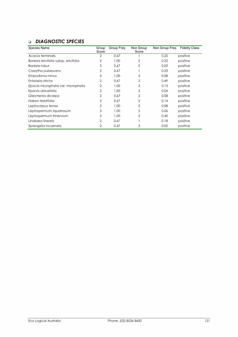
Eco Logical Australia Phone. (02) 8536 8600 121
�� DIAGNOSTIC SPECIES Species Name Group
Score Group Freq Non Group
Score Non Group Freq Fidelity Class
Acacia terminalis 2 0.67 1 0.25 positive Banksia ericifolia subsp. ericifolia 5 1.00 2 0.22 positive Banksia robur 3 0.67 2 0.02 positive Cassytha pubescens 2 0.67 1 0.23 positive Empodisma minus 3 1.00 2 0.08 positive Entolasia stricta 2 0.67 2 0.49 positive Epacris microphylla var. microphylla 2 1.00 2 0.13 positive Epacris obtusifolia 2 1.00 2 0.04 positive Gleichenia dicarpa 2 0.67 2 0.08 positive Hakea teretifolia 3 0.67 2 0.14 positive Leptocarpus tenax 2 1.00 2 0.08 positive Leptospermum squarrosum 3 1.00 2 0.06 positive Leptospermum trinervium 2 1.00 2 0.40 positive Lindsaea linearis 2 0.67 1 0.18 positive Sprengelia incarnata 2 0.67 2 0.02 positive
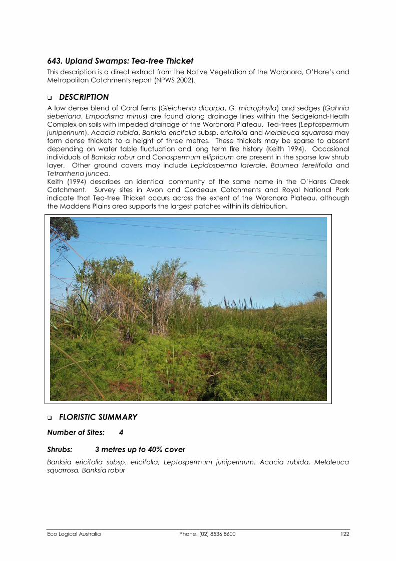
Eco Logical Australia Phone. (02) 8536 8600 122
643. Upland Swamps: Tea-tree Thicket This description is a direct extract from the Native Vegetation of the Woronora, O’Hare’s and Metropolitan Catchments report (NPWS 2002).
�� DESCRIPTION A low dense blend of Coral ferns (Gleichenia dicarpa, G. microphylla) and sedges (Gahnia sieberiana, Empodisma minus) are found along drainage lines within the Sedgeland-Heath Complex on soils with impeded drainage of the Woronora Plateau. Tea-trees (Leptospermum juniperinum), Acacia rubida, Banksia ericifolia subsp. ericifolia and Melaleuca squarrosa may form dense thickets to a height of three metres. These thickets may be sparse to absent depending on water table fluctuation and long term fire history (Keith 1994). Occasional individuals of Banksia robur and Conospermum ellipticum are present in the sparse low shrub layer. Other ground covers may include Lepidosperma laterale, Baumea teretifolia and Tetrarrhena juncea. Keith (1994) describes an identical community of the same name in the O’Hares Creek Catchment. Survey sites in Avon and Cordeaux Catchments and Royal National Park indicate that Tea-tree Thicket occurs across the extent of the Woronora Plateau, although the Maddens Plains area supports the largest patches within its distribution.
�� FLORISTIC SUMMARY
Number of Sites: 4
Shrubs: 3 metres up to 40% cover Banksia ericifolia subsp. ericifolia, Leptospermum juniperinum, Acacia rubida, Melaleuca squarrosa, Banksia robur
Eco Logical Australia Phone. (02) 8536 8600 123
Sedges and Rushes: 1.5 metres 70-90% cover Gleichenia microphylla, Gleichenia dicarpa, Gahnia sieberiana, Empodisma minus, Lepyrodia anarthria, Blechnum nudum
�� KEY IDENTIFYING FEATURES
Easily recognisable features to assist in identifying this map unit are: �� A ribbon of Tea-tree (Leptospermum spp.) thickets, Banksia ericifolia subsp. ericifolia within
upland swamps on the Woronora Plateau.
�� Dense scramble of Coral ferns (Gleichenia spp.) and sedges, including Gahnia sieberiana.
�� EXAMPLE LOCATIONS Maddens Plains; Bulli Tops
�� CONSERVATION STATUS
BIOREGIONAL STATUS
Total Area within Sydney
Basin Bioregion (ha)
Proportion of Bioregional Area
within NPWS Reserve (%)
Area within Catchment
(ha)
Proportion of Bioregional Area
within Catchment (%)
>47000 89 170.46 n/a Upland Swamp communities have not been mapped separately outside this report.
CONDITION ASSESSMENT
Disturbance Class
Area (ha) Proportion Extant (%)
A Light 170.46 100 B Moderate 0 0 C Heavy 0 0 Scattered trees 0 0 Total 170.46 100
�� THREATENED PLANT SPECIES None recorded
Eco Logical Australia Phone. (02) 8536 8600 124
�� DIAGNOSTIC SPECIES Species Name Group
Score Group Freq
Non Group Score
Non Group Freq
Fidelity Class
Acacia elongata 2 0.50 1 0.01 positive Banksia ericifolia subsp. ericifolia 5 1 2 0.22 positive Banksia oblongifolia 2 1 2 0.15 positive Bauera rubioides 3 0.50 2 0.05 positive Blechnum indicum 2 0.50 1 0.01 positive Bossiaea stephensonii 3 0.50 1 0.01 positive Callistemon citrinus 2 0.50 1 0.01 positive Eurychorda complanata 2 0.50 2 0.03 positive Gahnia sieberiana 2 1 2 0.07 positive Gleichenia dicarpa 5 0.50 2 0.08 positive Gleichenia microphylla 3 0.50 3 0.03 positive Hakea dactyloides 3 0.50 2 0.30 positive Hakea teretifolia 2 1 2 0.10 positive Lepidosperma laterale 2 1 1 0.34 positive Leptocarpus tenax 2 0.50 2 0.08 positive Leptospermum juniperinum 3 1 2 0.03 positive Leptospermum polygalifolium subsp. polygalifolium 2 0.50 2 0.13 positive Melaleuca squarrosa 2 0.50 2 0.01 positive Platysace linearifolia 2 0.50 2 0.29 positive Schoenus brevifolius 3 1 1 0.02 positive Selaginella uliginosa 2 0.50 2 0.08 positive
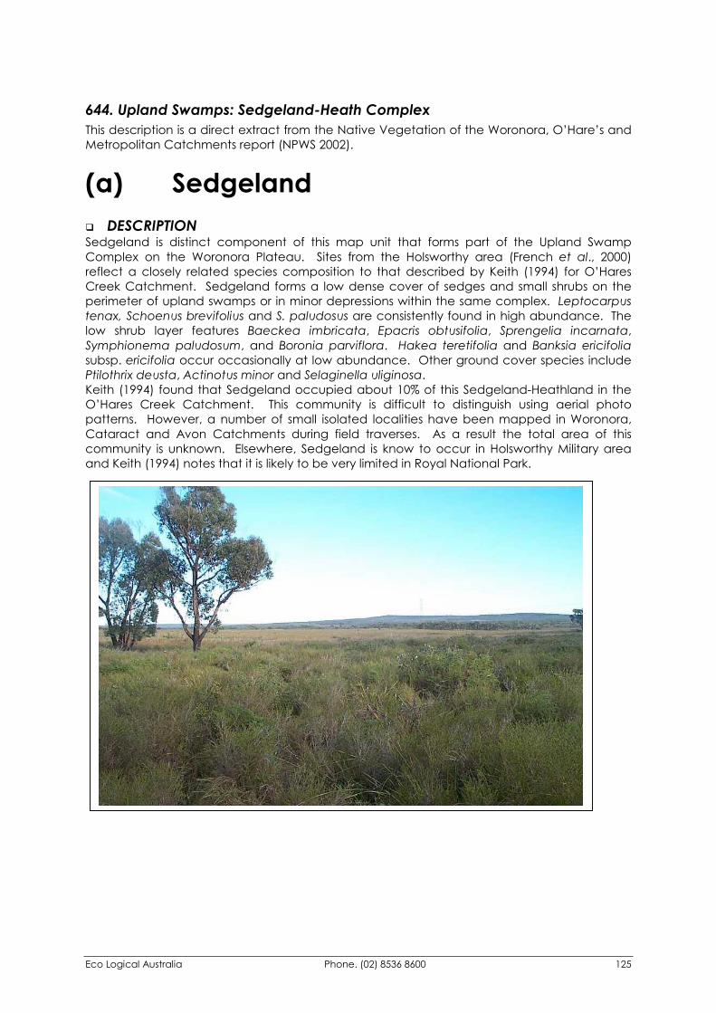
Eco Logical Australia Phone. (02) 8536 8600 125
644. Upland Swamps: Sedgeland-Heath Complex This description is a direct extract from the Native Vegetation of the Woronora, O’Hare’s and Metropolitan Catchments report (NPWS 2002).
(a) Sedgeland �� DESCRIPTION Sedgeland is distinct component of this map unit that forms part of the Upland Swamp Complex on the Woronora Plateau. Sites from the Holsworthy area (French et al., 2000) reflect a closely related species composition to that described by Keith (1994) for O’Hares Creek Catchment. Sedgeland forms a low dense cover of sedges and small shrubs on the perimeter of upland swamps or in minor depressions within the same complex. Leptocarpus tenax, Schoenus brevifolius and S. paludosus are consistently found in high abundance. The low shrub layer features Baeckea imbricata, Epacris obtusifolia, Sprengelia incarnata, Symphionema paludosum, and Boronia parviflora. Hakea teretifolia and Banksia ericifolia subsp. ericifolia occur occasionally at low abundance. Other ground cover species include Ptilothrix deusta, Actinotus minor and Selaginella uliginosa. Keith (1994) found that Sedgeland occupied about 10% of this Sedgeland-Heathland in the O’Hares Creek Catchment. This community is difficult to distinguish using aerial photo patterns. However, a number of small isolated localities have been mapped in Woronora, Cataract and Avon Catchments during field traverses. As a result the total area of this community is unknown. Elsewhere, Sedgeland is know to occur in Holsworthy Military area and Keith (1994) notes that it is likely to be very limited in Royal National Park.

Eco Logical Australia Phone. (02) 8536 8600 126
�� FLORISTIC SUMMARY
Number of Sites: 3
Shrubs: 0.5-1m. Mean Projected Cover 30% Baeckea imbricata, Epacris obtusifolia, Epacris microphylla var. microphylla, Sprengelia incarnata, Symphionema paludosum, Boronia parviflora, Hakea teretifolia, Banksia ericifolia subsp. ericifolia, Pimelea linifolia subsp. linifolia, Dillwynia floribunda
Ground covers: 0-0.5 m tall. Mean Projected Canopy Cover 70% Leptocarpus tenax, Schoenus brevifolius, Schoenus paludosus, Lepyrodia scariosa, Ptilothrix deusta, Dampiera stricta, Stylidium graminifolium
�� KEY IDENTIFYING FEATURES
Easily recognisable features to assist in identifying this map unit are: �� A low treeless plain dominated by sedges and rushes, such as Leptocarpus tenax and
Schoenus brevifolius.
�� EXAMPLE LOCATIONS Forest Walk, Darkes Forest; Dharawal State Recreation Area; Woronora Catchment
�� DIAGNOSTIC SPECIES Species Name Group
Score Group Freq Non Group
Score Non Group
Freq Fidelity Class
Boronia parviflora 2 0.67 1 0.01 positive Dillwynia floribunda 3 0.67 1 0.06 positive Drosera spatulata 2 0.67 2 0.04 positive Epacris microphylla var. microphylla 2 1.00 2 0.20 positive Epacris obtusifolia 4 0.67 2 0.06 positive Haemodorum corymbosum 2 0.67 1 0.07 positive Hakea teretifolia 2 0.67 2 0.23 positive Leptocarpus tenax 4 1.00 2 0.13 positive Lepyrodia scariosa 2 0.67 2 0.34 positive Lycopodiella lateralis 2 0.33 0 0.00 positive Ptilothrix deusta 2 1.00 2 0.14 positive Schoenus brevifolius 4 1.00 1 0.04 positive Schoenus paludosus 2 0.67 0 0.00 positive Selaginella uliginosa 4 0.67 2 0.13 positive Sprengelia incarnata 4 0.67 2 0.03 positive Stylidium graminifolium 2 1.00 1 0.10 positive Symphionema paludosum 3 0.67 1 0.01 positive Corymbia gummifera 0 0.00 2 0.52 negative Entolasia stricta 1 0.33 2 0.53 negative
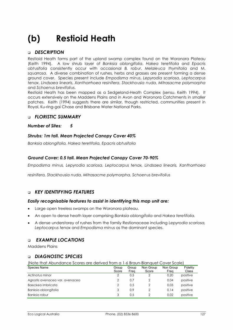
Eco Logical Australia Phone. (02) 8536 8600 127
(b) Restioid Heath �� DESCRIPTION Restioid Heath forms part of the upland swamp complex found on the Woronora Plateau (Keith 1994). A low shrub layer of Banksia oblongifolia, Hakea teretifolia and Epacris obtusifolia consistently occur with occasional B. robur, Melaleuca thymifolia and M. squarrosa. A diverse combination of rushes, herbs and grasses are present forming a dense ground cover. Species present include Empodisma minus, Lepyrodia scariosa, Leptocarpus tenax, Lindsaea linearis, Xanthorrhoea resinifera, Stackhousia nuda, Mitrasacme polymorpha and Schoenus brevifolius. Restioid Heath has been mapped as a Sedgeland-Heath Complex (sensu. Keith 1994). It occurs extensively on the Maddens Plains and in Avon and Woronora Catchments in smaller patches. Keith (1994) suggests there are similar, though restricted, communities present in Royal, Ku-ring-gai Chase and Brisbane Water National Parks.
�� FLORISTIC SUMMARY
Number of Sites: 5
Shrubs: 1m tall. Mean Projected Canopy Cover 40% Banksia oblongifolia, Hakea teretifolia, Epacris obtusifolia
Ground Cover: 0.5 tall. Mean Projected Canopy Cover 70-90% Empodisma minus, Lepyrodia scariosa, Leptocarpus tenax, Lindsaea linearis, Xanthorrhoea
resinifera, Stackhousia nuda, Mitrasacme polymorpha, Schoenus brevifolius
�� KEY IDENTIFYING FEATURES
Easily recognisable features to assist in identifying this map unit are: �� Large open treeless swamps on the Woronora plateau.
�� An open to dense heath layer comprising Banksia oblongifolia and Hakea teretifolia.
�� A dense understorey of rushes from the family Restionaceae including Lepyrodia scariosa, Leptocarpus tenax and Empodisma minus as the dominant species.
�� EXAMPLE LOCATIONS Maddens Plains
�� DIAGNOSTIC SPECIES (Note that Abundance Scores are derived from a 1-6 Braun-Blanquet Cover Scale) Species Name Group
Score Group Freq
Non Group Score
Non Group Freq
Fidelity Class
Actinotus minor 2 0.5 2 0.20 positive Agrostis avenacea var. avenacea 2 0.7 2 0.04 positive Baeckea imbricata 2 0.5 2 0.03 positive Banksia oblongifolia 3 0.9 2 0.14 positive Banksia robur 3 0.5 2 0.02 positive
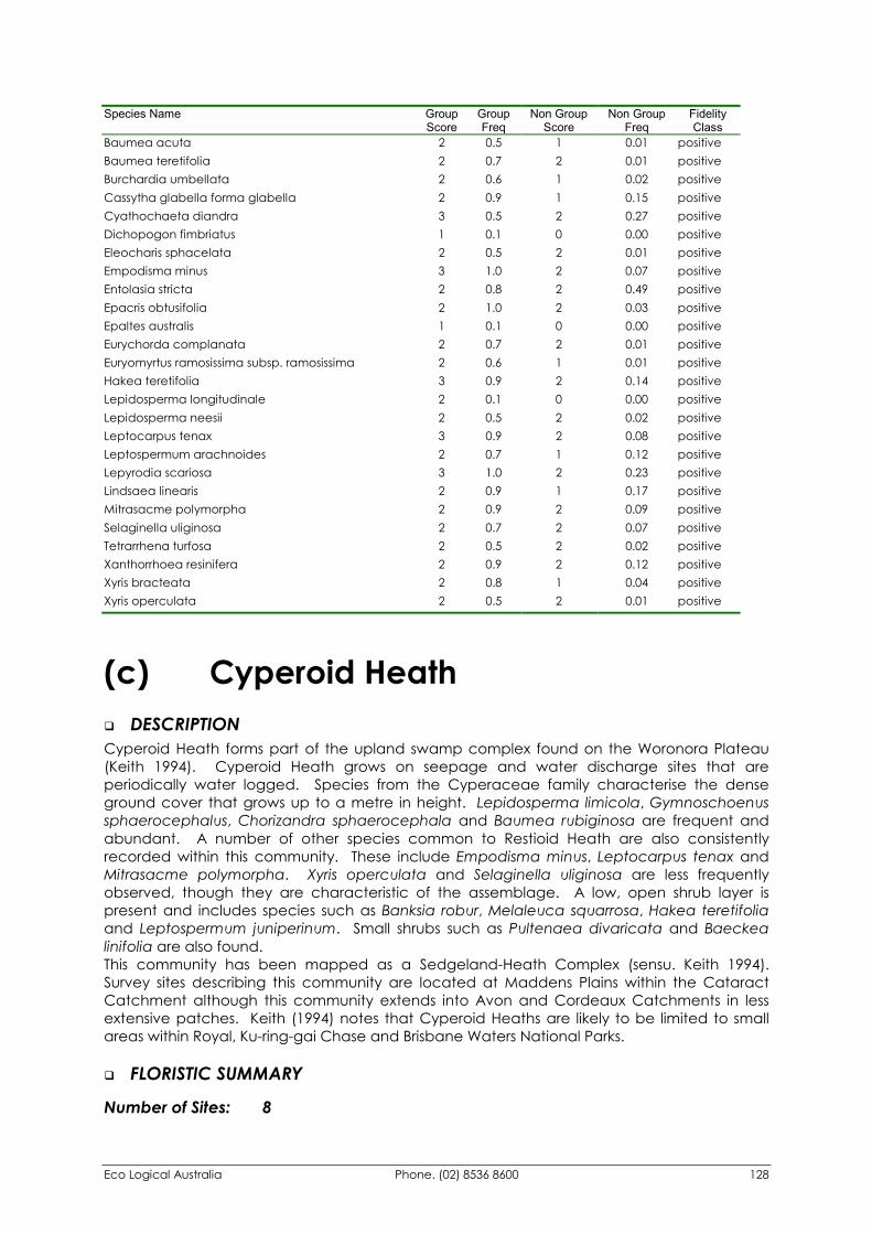
Eco Logical Australia Phone. (02) 8536 8600 128
Species Name Group Score
Group Freq
Non Group Score
Non Group Freq
Fidelity Class
Baumea acuta 2 0.5 1 0.01 positive Baumea teretifolia 2 0.7 2 0.01 positive Burchardia umbellata 2 0.6 1 0.02 positive Cassytha glabella forma glabella 2 0.9 1 0.15 positive Cyathochaeta diandra 3 0.5 2 0.27 positive Dichopogon fimbriatus 1 0.1 0 0.00 positive Eleocharis sphacelata 2 0.5 2 0.01 positive Empodisma minus 3 1.0 2 0.07 positive Entolasia stricta 2 0.8 2 0.49 positive Epacris obtusifolia 2 1.0 2 0.03 positive Epaltes australis 1 0.1 0 0.00 positive Eurychorda complanata 2 0.7 2 0.01 positive Euryomyrtus ramosissima subsp. ramosissima 2 0.6 1 0.01 positive Hakea teretifolia 3 0.9 2 0.14 positive Lepidosperma longitudinale 2 0.1 0 0.00 positive Lepidosperma neesii 2 0.5 2 0.02 positive Leptocarpus tenax 3 0.9 2 0.08 positive Leptospermum arachnoides 2 0.7 1 0.12 positive Lepyrodia scariosa 3 1.0 2 0.23 positive Lindsaea linearis 2 0.9 1 0.17 positive Mitrasacme polymorpha 2 0.9 2 0.09 positive Selaginella uliginosa 2 0.7 2 0.07 positive Tetrarrhena turfosa 2 0.5 2 0.02 positive Xanthorrhoea resinifera 2 0.9 2 0.12 positive Xyris bracteata 2 0.8 1 0.04 positive Xyris operculata 2 0.5 2 0.01 positive
(c) Cyperoid Heath �� DESCRIPTION Cyperoid Heath forms part of the upland swamp complex found on the Woronora Plateau (Keith 1994). Cyperoid Heath grows on seepage and water discharge sites that are periodically water logged. Species from the Cyperaceae family characterise the dense ground cover that grows up to a metre in height. Lepidosperma limicola, Gymnoschoenus sphaerocephalus, Chorizandra sphaerocephala and Baumea rubiginosa are frequent and abundant. A number of other species common to Restioid Heath are also consistently recorded within this community. These include Empodisma minus, Leptocarpus tenax and Mitrasacme polymorpha. Xyris operculata and Selaginella uliginosa are less frequently observed, though they are characteristic of the assemblage. A low, open shrub layer is present and includes species such as Banksia robur, Melaleuca squarrosa, Hakea teretifolia and Leptospermum juniperinum. Small shrubs such as Pultenaea divaricata and Baeckea linifolia are also found. This community has been mapped as a Sedgeland-Heath Complex (sensu. Keith 1994). Survey sites describing this community are located at Maddens Plains within the Cataract Catchment although this community extends into Avon and Cordeaux Catchments in less extensive patches. Keith (1994) notes that Cyperoid Heaths are likely to be limited to small areas within Royal, Ku-ring-gai Chase and Brisbane Waters National Parks.
�� FLORISTIC SUMMARY
Number of Sites: 8
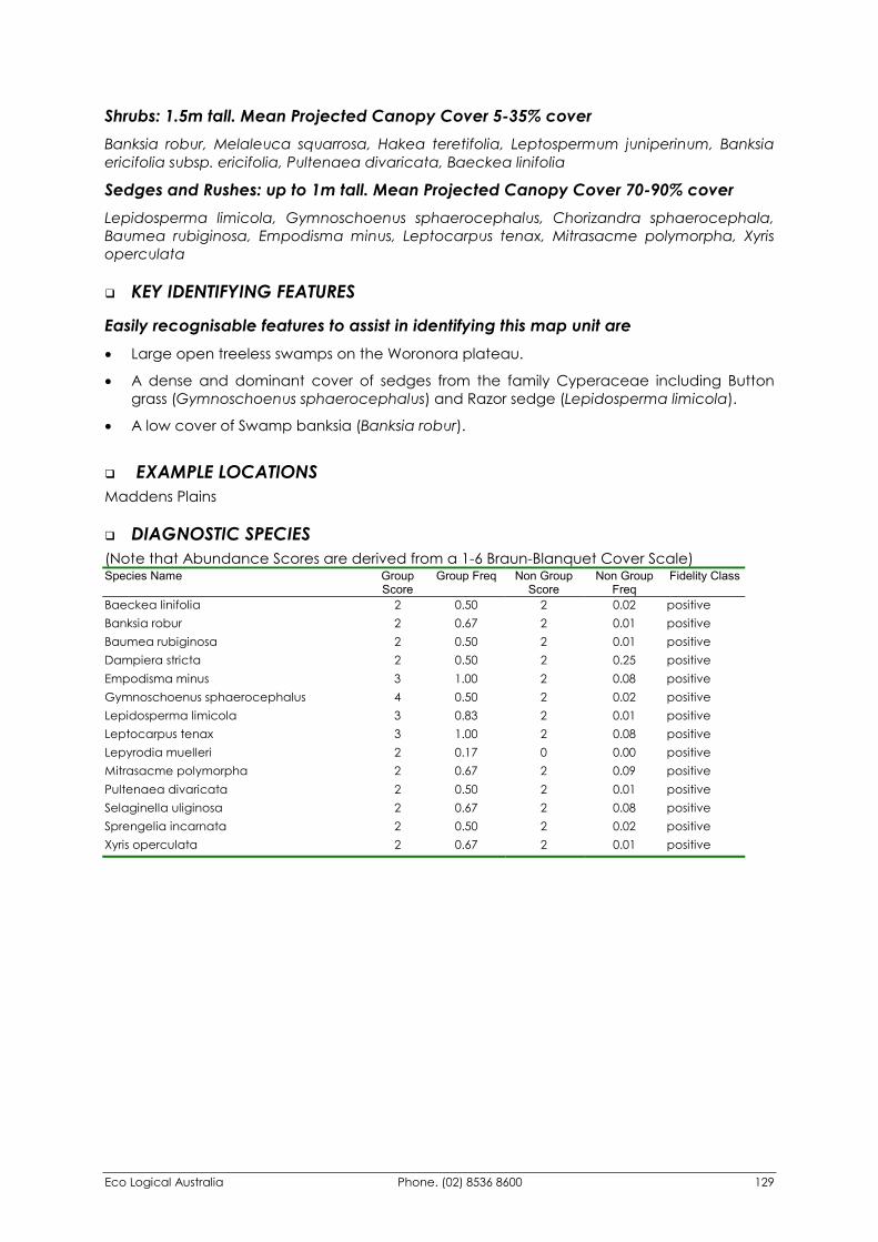
Eco Logical Australia Phone. (02) 8536 8600 129
Shrubs: 1.5m tall. Mean Projected Canopy Cover 5-35% cover Banksia robur, Melaleuca squarrosa, Hakea teretifolia, Leptospermum juniperinum, Banksia ericifolia subsp. ericifolia, Pultenaea divaricata, Baeckea linifolia
Sedges and Rushes: up to 1m tall. Mean Projected Canopy Cover 70-90% cover Lepidosperma limicola, Gymnoschoenus sphaerocephalus, Chorizandra sphaerocephala, Baumea rubiginosa, Empodisma minus, Leptocarpus tenax, Mitrasacme polymorpha, Xyris operculata
�� KEY IDENTIFYING FEATURES
Easily recognisable features to assist in identifying this map unit are �� Large open treeless swamps on the Woronora plateau.
�� A dense and dominant cover of sedges from the family Cyperaceae including Button grass (Gymnoschoenus sphaerocephalus) and Razor sedge (Lepidosperma limicola).
�� A low cover of Swamp banksia (Banksia robur).
�� EXAMPLE LOCATIONS Maddens Plains
�� DIAGNOSTIC SPECIES (Note that Abundance Scores are derived from a 1-6 Braun-Blanquet Cover Scale) Species Name Group
Score Group Freq Non Group
Score Non Group
Freq Fidelity Class
Baeckea linifolia 2 0.50 2 0.02 positive Banksia robur 2 0.67 2 0.01 positive Baumea rubiginosa 2 0.50 2 0.01 positive Dampiera stricta 2 0.50 2 0.25 positive Empodisma minus 3 1.00 2 0.08 positive Gymnoschoenus sphaerocephalus 4 0.50 2 0.02 positive Lepidosperma limicola 3 0.83 2 0.01 positive Leptocarpus tenax 3 1.00 2 0.08 positive Lepyrodia muelleri 2 0.17 0 0.00 positive Mitrasacme polymorpha 2 0.67 2 0.09 positive Pultenaea divaricata 2 0.50 2 0.01 positive Selaginella uliginosa 2 0.67 2 0.08 positive Sprengelia incarnata 2 0.50 2 0.02 positive Xyris operculata 2 0.67 2 0.01 positive
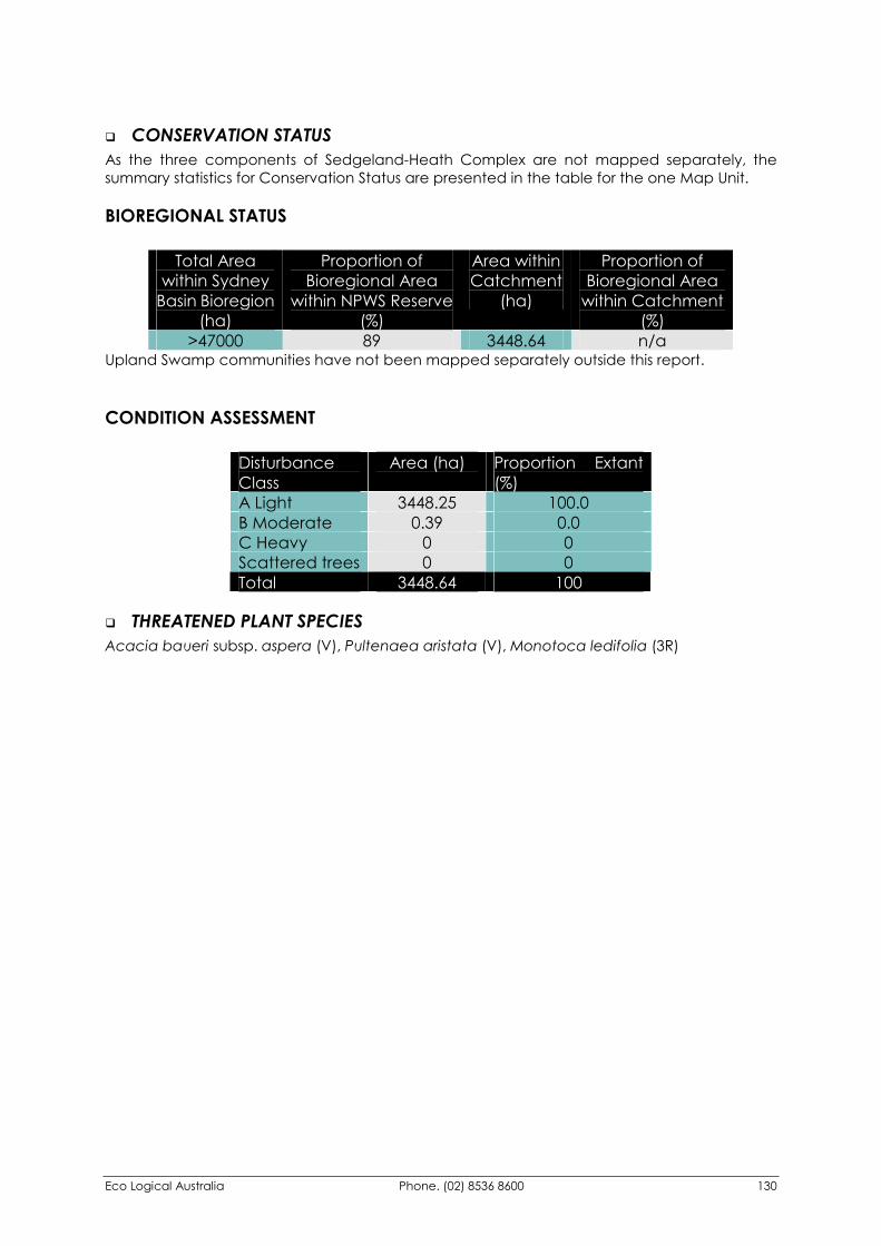
Eco Logical Australia Phone. (02) 8536 8600 130
�� CONSERVATION STATUS As the three components of Sedgeland-Heath Complex are not mapped separately, the summary statistics for Conservation Status are presented in the table for the one Map Unit.
BIOREGIONAL STATUS
Total Area within Sydney
Basin Bioregion (ha)
Proportion of Bioregional Area
within NPWS Reserve (%)
Area within Catchment
(ha)
Proportion of Bioregional Area
within Catchment (%)
>47000 89 3448.64 n/a Upland Swamp communities have not been mapped separately outside this report.
CONDITION ASSESSMENT
Disturbance Class
Area (ha) Proportion Extant (%)
A Light 3448.25 100.0 B Moderate 0.39 0.0 C Heavy 0 0 Scattered trees 0 0 Total 3448.64 100
�� THREATENED PLANT SPECIES Acacia baueri subsp. aspera (V), Pultenaea aristata (V), Monotoca ledifolia (3R)
Eco Logical Australia Phone. (02) 8536 8600 131
645. Upland Swamps: Fringing Eucalypt Woodland This description is a direct extract from the Native Vegetation of the Woronora, O’Hare’s and Metropolitan Catchments report (NPWS 2002).
�� DESCRIPTION Fringing Eucalypt Woodland has been delineated to highlight the ecotone between the Upland Swamps communities and the surrounding Sandstone Woodlands. The transition between the two can be either abrupt or very gradual. In the case of the latter, a very open woodland with a canopy cover less than ten percent supports widely spaced Eucalyptus racemosa, E. oblonga or E. sieberi. The understorey characteristics are transitional, with some sites sharing greater similarity with the drier components of Restioid Heaths (Map Unit 44b) than Exposed Sandstone Scribbly Gum Woodland (Map Unit 29).
�� FLORISTIC SUMMARY
Number of Sites: 8
Trees: 5-12m tall: Projected Canopy Cover 5-15% Eucalyptus racemosa/haemastoma/sclerophylla, Eucalyptus oblonga, Eucalyptus sieberi
Shrubs: 1.5m tall. Projected Canopy Cover 15-30% cover Banksia ericifolia subsp. ericifolia, Banksia oblongifolia, Hakea dactyloides, Hakea teretifolia
Sedges and Rushes: up to 1m tall. Projected Canopy Cover 50-70% cover Leptocarpus tenax, Sprengelia incarnata, Lindsaea linearis, Mitrasacme polymorpha, Empodisma minus
�� KEY IDENTIFYING FEATURES
Easily recognisable features to assist in identifying this map unit are �� Widely spaced Eucalypts marking the transition between sandstone woodland and
treeless heath and sedgelands.
�� EXAMPLE LOCATIONS Maddens Plains; Fire Trail 9 Woronora Catchment.
�� CONSERVATION STATUS
BIOREGIONAL STATUS
Total Area within Sydney
Basin Bioregion (ha)
Proportion of Bioregional Area
within NPWS Reserve (%)
Area within Catchment
(ha)
Proportion of Bioregional Area
within Catchment (%)
>47000 89 1579.95 n/a Upland Swamp communities have not been mapped separately outside this report.
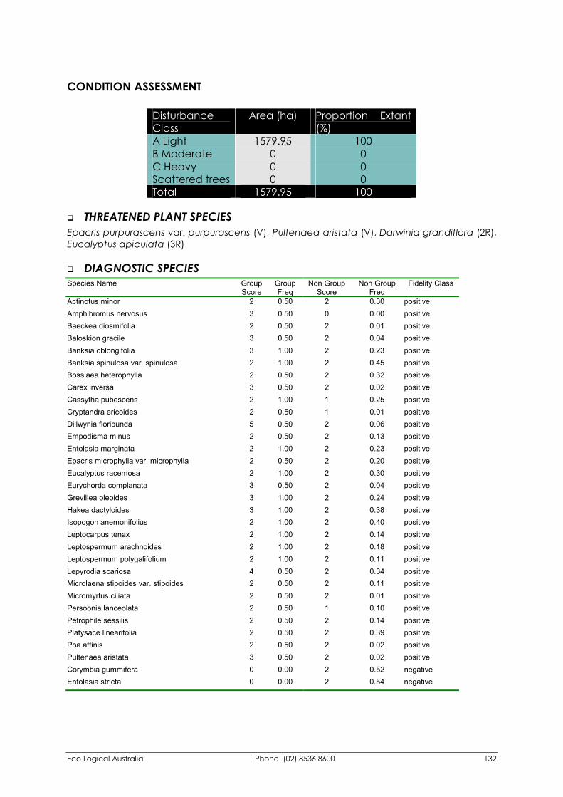
Eco Logical Australia Phone. (02) 8536 8600 132
CONDITION ASSESSMENT
Disturbance Class
Area (ha) Proportion Extant (%)
A Light 1579.95 100 B Moderate 0 0 C Heavy 0 0 Scattered trees 0 0 Total 1579.95 100
�� THREATENED PLANT SPECIES Epacris purpurascens var. purpurascens (V), Pultenaea aristata (V), Darwinia grandiflora (2R), Eucalyptus apiculata (3R)
�� DIAGNOSTIC SPECIES Species Name Group
Score Group Freq
Non Group Score
Non Group Freq
Fidelity Class
Actinotus minor 2 0.50 2 0.30 positive Amphibromus nervosus 3 0.50 0 0.00 positive Baeckea diosmifolia 2 0.50 2 0.01 positive Baloskion gracile 3 0.50 2 0.04 positive Banksia oblongifolia 3 1.00 2 0.23 positive Banksia spinulosa var. spinulosa 2 1.00 2 0.45 positive Bossiaea heterophylla 2 0.50 2 0.32 positive Carex inversa 3 0.50 2 0.02 positive Cassytha pubescens 2 1.00 1 0.25 positive Cryptandra ericoides 2 0.50 1 0.01 positive Dillwynia floribunda 5 0.50 2 0.06 positive Empodisma minus 2 0.50 2 0.13 positive Entolasia marginata 2 1.00 2 0.23 positive Epacris microphylla var. microphylla 2 0.50 2 0.20 positive Eucalyptus racemosa 2 1.00 2 0.30 positive Eurychorda complanata 3 0.50 2 0.04 positive Grevillea oleoides 3 1.00 2 0.24 positive Hakea dactyloides 3 1.00 2 0.38 positive Isopogon anemonifolius 2 1.00 2 0.40 positive Leptocarpus tenax 2 1.00 2 0.14 positive Leptospermum arachnoides 2 1.00 2 0.18 positive Leptospermum polygalifolium 2 1.00 2 0.11 positive Lepyrodia scariosa 4 0.50 2 0.34 positive Microlaena stipoides var. stipoides 2 0.50 2 0.11 positive Micromyrtus ciliata 2 0.50 2 0.01 positive Persoonia lanceolata 2 0.50 1 0.10 positive Petrophile sessilis 2 0.50 2 0.14 positive Platysace linearifolia 2 0.50 2 0.39 positive Poa affinis 2 0.50 2 0.02 positive Pultenaea aristata 3 0.50 2 0.02 positive Corymbia gummifera 0 0.00 2 0.52 negative Entolasia stricta 0 0.00 2 0.54 negative
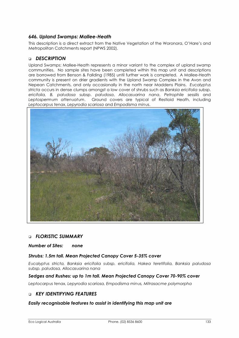
Eco Logical Australia Phone. (02) 8536 8600 133
646. Upland Swamps: Mallee-Heath This description is a direct extract from the Native Vegetation of the Woronora, O’Hare’s and Metropolitan Catchments report (NPWS 2002).
�� DESCRIPTION Upland Swamps: Mallee-Heath represents a minor variant to the complex of upland swamp communities. No sample sites have been completed within this map unit and descriptions are borrowed from Benson & Fallding (1985) until further work is completed. A Mallee-Heath community is present on drier gradients with the Upland Swamp Complex in the Avon and Nepean Catchments, and only occasionally in the north near Maddens Plains. Eucalyptus stricta occurs in dense clumps amongst a low cover of shrubs such as Banksia ericifolia subsp. ericifolia, B. paludosa subsp. paludosa, Allocasuarina nana, Petrophile sessilis and Leptospermum attenuatum. Ground covers are typical of Restioid Heath, including Leptocarpus tenax, Lepyrodia scariosa and Empodisma minus.
�� FLORISTIC SUMMARY
Number of Sites: none
Shrubs: 1.5m tall. Mean Projected Canopy Cover 5-35% cover Eucalyptus stricta, Banksia ericifolia subsp. ericifolia, Hakea teretifolia, Banksia paludosa subsp. paludosa, Allocasuarina nana
Sedges and Rushes: up to 1m tall. Mean Projected Canopy Cover 70-90% cover Leptocarpus tenax, Lepyrodia scariosa, Empodisma minus, Mitrasacme polymorpha
�� KEY IDENTIFYING FEATURES
Easily recognisable features to assist in identifying this map unit are
Eco Logical Australia Phone. (02) 8536 8600 134
�� Emergent Mallee ash (Eucalyptus stricta) above a shrub layer of Banksias, Hakeas and Tea-trees (Leptospermum spp.).
�� Within broad upland swamp complexes in southern catchments near escarpment edge.
�� EXAMPLE LOCATIONS Fire Trail 15, Avon Catchment; No 1 Fire Trail at Stockyard Swamp
�� CONSERVATION STATUS
BIOREGIONAL STATUS
Total Area within Sydney
Basin Bioregion (ha)
Proportion of Bioregional Area
within NPWS Reserve (%)
Area within Catchment
(ha)
Proportion of Bioregional Area
within Catchment (%)
>47000 89 124.49 n/a Upland Swamp communities have not been mapped separately outside this report.
CONDITION ASSESSMENT
Disturbance Class
Area (ha) Proportion Extant (%)
A Light 124.49 100 B Moderate 0 0 C Heavy 0 0 Scattered trees 0 0 Total 124.49 100
�� THREATENED PLANT SPECIES Eucalyptus apiculata (3R)
�� DIAGNOSTIC SPECIES No Diagnostic Species List available as no survey sites were undertaken in this community.
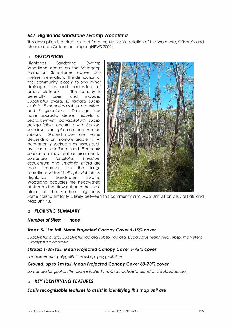
Eco Logical Australia Phone. (02) 8536 8600 135
647. Highlands Sandstone Swamp Woodland This description is a direct extract from the Native Vegetation of the Woronora, O’Hare’s and Metropolitan Catchments report (NPWS 2002).
�� DESCRIPTION Highlands Sandstone Swamp Woodland occurs on the Mittagong Formation Sandstones above 500 metres in elevation. The distribution of the community closely follows minor drainage lines and depressions of broad plateaux. The canopy is generally open and includes Eucalyptus ovata, E. radiata subsp. radiata, E mannifera subsp. mannifera and E. globoidea. Drainage lines have sporadic dense thickets of Leptospermum polygalifolium subsp. polygalifolium occurring with Banksia spinulosa var. spinulosa and Acacia rubida. Ground cover also varies depending on moisture gradient. At permanently soaked sites rushes such as Juncus continuus and Eleocharis sphacelata may feature prominently. Lomandra longifolia, Pteridium esculentum and Entolasia stricta are more common on the fringe sometimes with Mirbelia platylobioides. Highlands Sandstone Swamp Woodland occupies the headwaters of streams that flow out onto the shale plains of the southern highlands. Some floristic similarity is likely between this community and Map Unit 24 on alluvial flats and Map Unit 48.
�� FLORISTIC SUMMARY
Number of Sites: none
Trees: 5-12m tall. Mean Projected Canopy Cover 5-15% cover Eucalyptus ovata, Eucalyptus radiata subsp. radiata, Eucalyptus mannifera subsp. mannifera, Eucalyptus globoidea
Shrubs: 1-3m tall. Mean Projected Canopy Cover 5-45% cover Leptospermum polygalifolium subsp. polygalifolium
Ground: up to 1m tall. Mean Projected Canopy Cover 60-70% cover Lomandra longifolia, Pteridium esculentum, Cyathochaeta diandra, Entolasia stricta
�� KEY IDENTIFYING FEATURES
Easily recognisable features to assist in identifying this map unit are
Eco Logical Australia Phone. (02) 8536 8600 136
�� Low open woodland occurring on minor drainage flats and channels on Mittagong sandstone at elevations above 500 metres.
�� EXAMPLE LOCATIONS Fire Trail 3, minor creek crossing south of Chain of ponds Creek
�� CONSERVATION STATUS
BIOREGIONAL STATUS
Total Area within Sydney
Basin Bioregion (ha)
Proportion of Bioregional Area
within NPWS Reserve (%)
Area within Catchment
(ha)
Proportion of Bioregional Area
within Catchment (%)
>440 0 439.60 100
CONDITION ASSESSMENT
Disturbance Class
Area (ha) Proportion Extant (%)
A Light 439.60 100 B Moderate 0 0 C Heavy 0 0 Scattered trees 0 0 Total 439.60 100
�� THREATENED PLANT SPECIES Eucalyptus apiculata (3R)
�� DIAGNOSTIC SPECIES No Diagnostic Species List available as no survey sites were undertaken in this community.
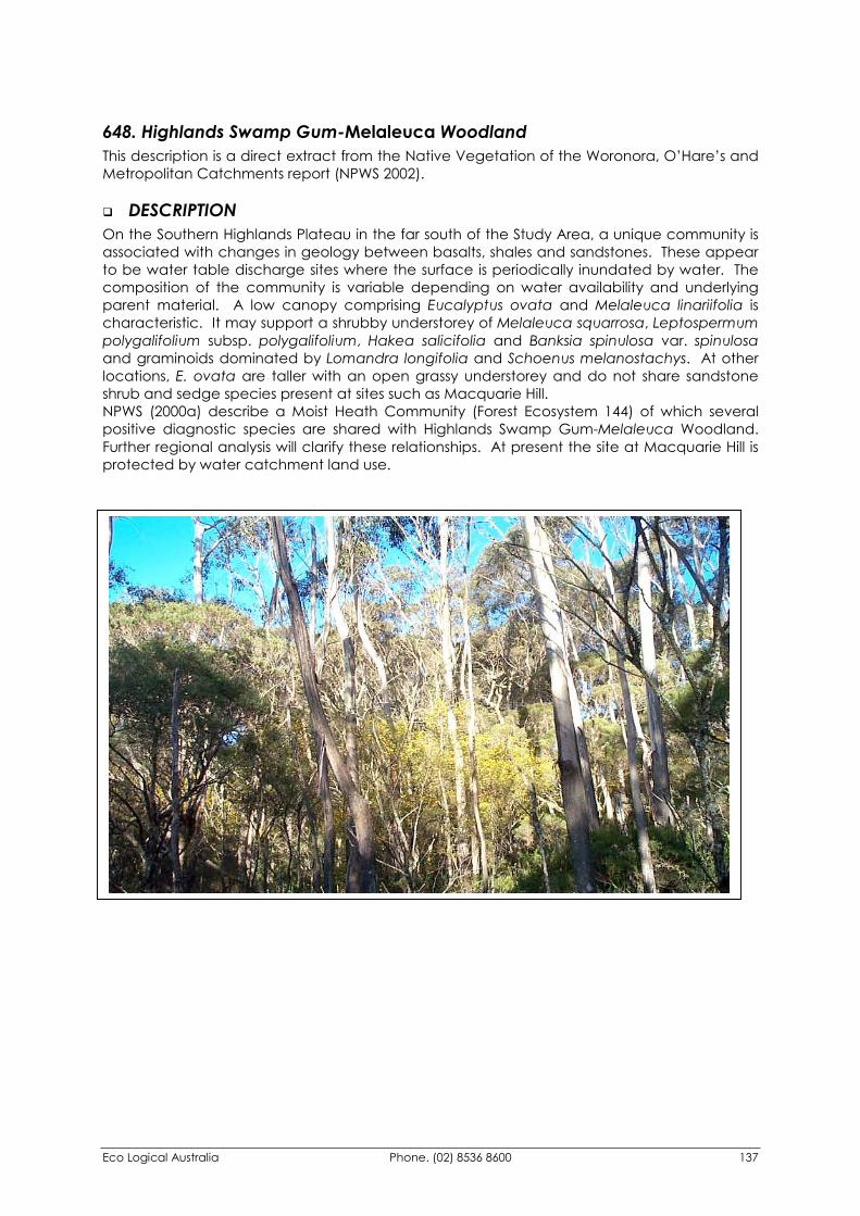
Eco Logical Australia Phone. (02) 8536 8600 137
648. Highlands Swamp Gum-Melaleuca Woodland This description is a direct extract from the Native Vegetation of the Woronora, O’Hare’s and Metropolitan Catchments report (NPWS 2002).
�� DESCRIPTION On the Southern Highlands Plateau in the far south of the Study Area, a unique community is associated with changes in geology between basalts, shales and sandstones. These appear to be water table discharge sites where the surface is periodically inundated by water. The composition of the community is variable depending on water availability and underlying parent material. A low canopy comprising Eucalyptus ovata and Melaleuca linariifolia is characteristic. It may support a shrubby understorey of Melaleuca squarrosa, Leptospermum polygalifolium subsp. polygalifolium, Hakea salicifolia and Banksia spinulosa var. spinulosa and graminoids dominated by Lomandra longifolia and Schoenus melanostachys. At other locations, E. ovata are taller with an open grassy understorey and do not share sandstone shrub and sedge species present at sites such as Macquarie Hill. NPWS (2000a) describe a Moist Heath Community (Forest Ecosystem 144) of which several positive diagnostic species are shared with Highlands Swamp Gum-Melaleuca Woodland. Further regional analysis will clarify these relationships. At present the site at Macquarie Hill is protected by water catchment land use.
Eco Logical Australia Phone. (02) 8536 8600 138
�� FLORISTIC SUMMARY
Number of Sites: 1
Trees: 8-12m tall. Mean Projected Canopy Cover 25% Eucalyptus ovata, Melaleuca linariifolia
Shrubs: 4-8m tall. Mean Projected Canopy Cover 60% Melaleuca linariifolia, Melaleuca squarrosa, Leptospermum polygalifolium subsp. polygalifolium, Pultenaea blakelyi
Ground Cover: 0-1m tall. Mean Projected Canopy Cover 90% Lomandra longifolia, Schoenus melanostachys
�� KEY IDENTIFYING FEATURES
Easily recognisable features to assist in identifying this map unit are: �� Low dense scrub with dense shrubs of Melaleuca linariifolia.
�� Dense ground cover of Schoenus melanostachys.
�� Low cover of Swamp gums (Eucalyptus ovata).
�� EXAMPLE LOCATIONS Macquarie Hill, on Fire Trail 15a; Fire Trail 1, Molly Morgan Gully
�� CONSERVATION STATUS
BIOREGIONAL STATUS
Total Area within Sydney
Basin Bioregion (ha)
Proportion of Bioregional Area
within NPWS Reserve (%)
Area within Catchment
(ha)
Proportion of Bioregional Area
within Catchment (%)
>144 0.1 144.23 100
CONDITION ASSESSMENT
Disturbance Class
Area (ha) Proportion Extant (%)
A Light 119.44 82.8 B Moderate 10.80 7.5 C Heavy 0 0 Scattered trees 13.99 9.7 Total 144.23 100
�� THREATENED PLANT SPECIES None recorded
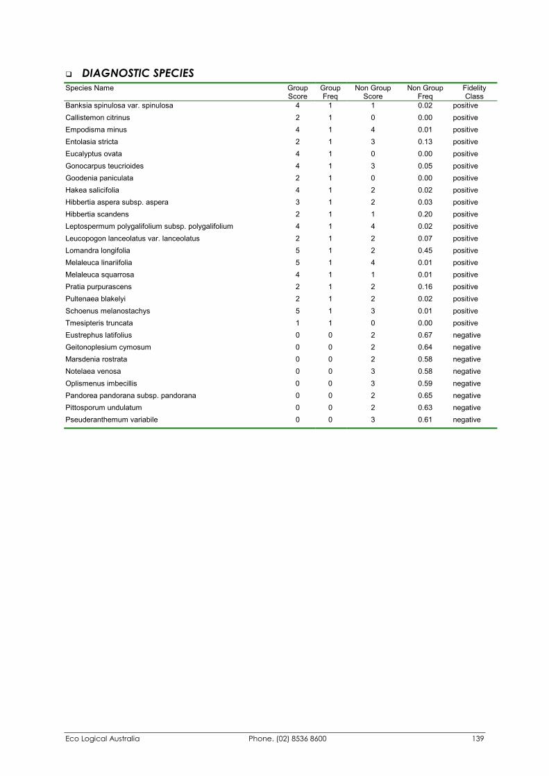
Eco Logical Australia Phone. (02) 8536 8600 139
�� DIAGNOSTIC SPECIES Species Name Group
Score Group Freq
Non Group Score
Non Group Freq
Fidelity Class
Banksia spinulosa var. spinulosa 4 1 1 0.02 positive Callistemon citrinus 2 1 0 0.00 positive Empodisma minus 4 1 4 0.01 positive Entolasia stricta 2 1 3 0.13 positive Eucalyptus ovata 4 1 0 0.00 positive Gonocarpus teucrioides 4 1 3 0.05 positive Goodenia paniculata 2 1 0 0.00 positive Hakea salicifolia 4 1 2 0.02 positive Hibbertia aspera subsp. aspera 3 1 2 0.03 positive Hibbertia scandens 2 1 1 0.20 positive Leptospermum polygalifolium subsp. polygalifolium 4 1 4 0.02 positive Leucopogon lanceolatus var. lanceolatus 2 1 2 0.07 positive Lomandra longifolia 5 1 2 0.45 positive Melaleuca linariifolia 5 1 4 0.01 positive Melaleuca squarrosa 4 1 1 0.01 positive Pratia purpurascens 2 1 2 0.16 positive Pultenaea blakelyi 2 1 2 0.02 positive Schoenus melanostachys 5 1 3 0.01 positive Tmesipteris truncata 1 1 0 0.00 positive Eustrephus latifolius 0 0 2 0.67 negative Geitonoplesium cymosum 0 0 2 0.64 negative Marsdenia rostrata 0 0 2 0.58 negative Notelaea venosa 0 0 3 0.58 negative Oplismenus imbecillis 0 0 3 0.59 negative Pandorea pandorana subsp. pandorana 0 0 2 0.65 negative Pittosporum undulatum 0 0 2 0.63 negative Pseuderanthemum variabile 0 0 3 0.61 negative
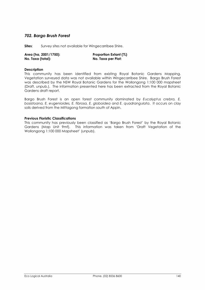
Eco Logical Australia Phone. (02) 8536 8600 140
702. Bargo Brush Forest Sites: Survey sites not available for Wingecarribee Shire. Area (ha, 2001/1750): Proportion Extant (%) No. Taxa (total): No. Taxa per Plot:
Description This community has been identified from existing Royal Botanic Gardens Mapping. Vegetation surveyed data was not available within Wingecarribee Shire. Bargo Brush Forest was described by the NSW Royal Botanic Gardens for the Wollongong 1:100 000 mapsheet (Draft, unpub.). The information presented here has been extracted from the Royal Botanic Gardens draft report. Bargo Brush Forest is an open forest community dominated by Eucalyptus crebra, E. bosistoana, E. eugenioides, E. fibrosa, E. globoidea and E. quadrangulata. It occurs on clay soils derived from the Mittagong formation south of Appin.
Previous Floristic Classifications This community has previously been classified as ‘Bargo Brush Forest’ by the Royal Botanic Gardens (Map Unit 9mf). This information was taken from ‘Draft Vegetation of the Wollongong 1:100 000 Mapsheet’ (unpub).
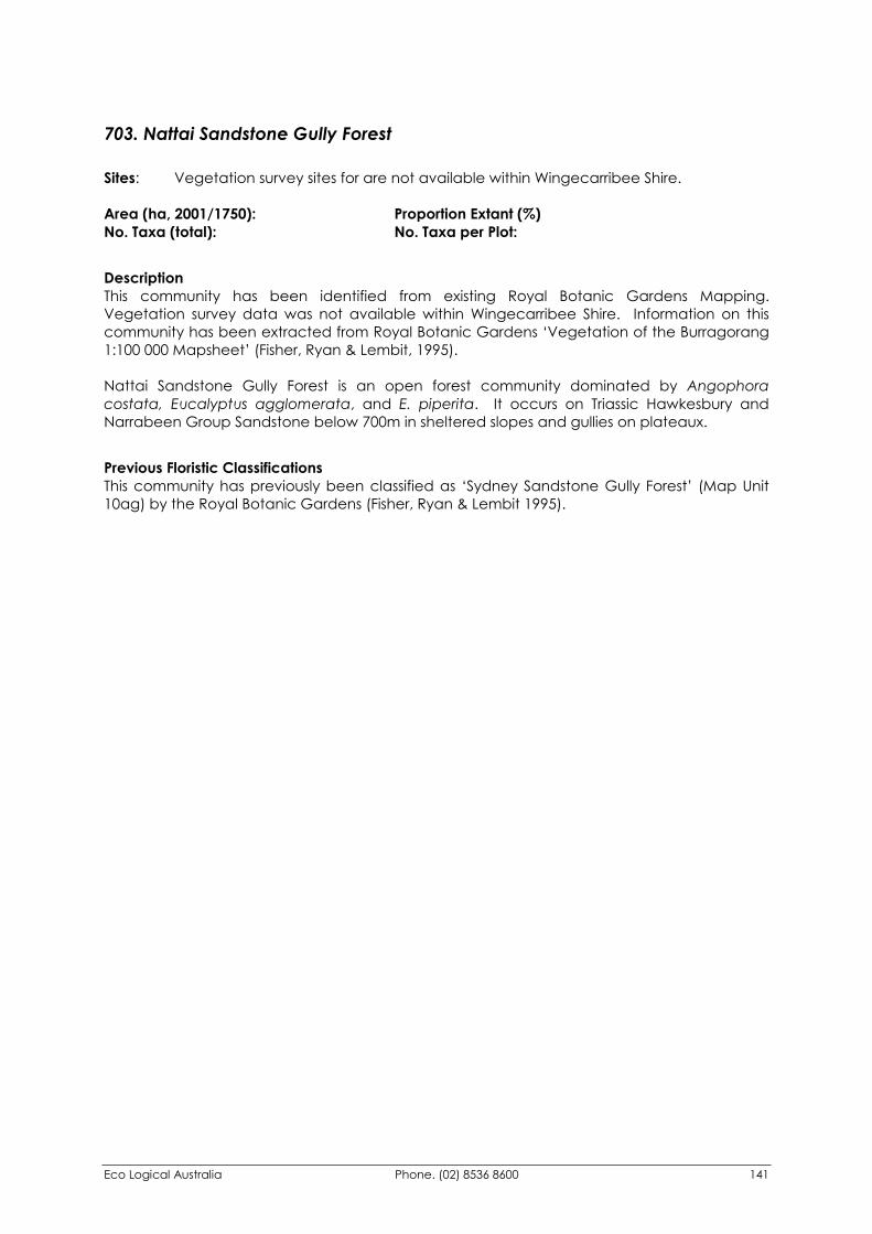
Eco Logical Australia Phone. (02) 8536 8600 141
703. Nattai Sandstone Gully Forest Sites: Vegetation survey sites for are not available within Wingecarribee Shire. Area (ha, 2001/1750): Proportion Extant (%) No. Taxa (total): No. Taxa per Plot:
Description This community has been identified from existing Royal Botanic Gardens Mapping. Vegetation survey data was not available within Wingecarribee Shire. Information on this community has been extracted from Royal Botanic Gardens ‘Vegetation of the Burragorang 1:100 000 Mapsheet’ (Fisher, Ryan & Lembit, 1995). Nattai Sandstone Gully Forest is an open forest community dominated by Angophora costata, Eucalyptus agglomerata, and E. piperita. It occurs on Triassic Hawkesbury and Narrabeen Group Sandstone below 700m in sheltered slopes and gullies on plateaux.
Previous Floristic Classifications This community has previously been classified as ‘Sydney Sandstone Gully Forest’ (Map Unit 10ag) by the Royal Botanic Gardens (Fisher, Ryan & Lembit 1995).
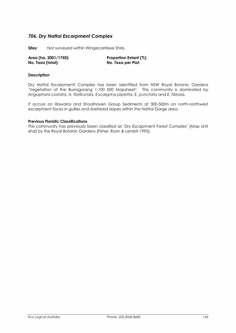
Eco Logical Australia Phone. (02) 8536 8600 142
706. Dry Nattai Escarpment Complex Sites: Not surveyed within Wingecarribee Shire. Area (ha, 2001/1750): Proportion Extant (%) No. Taxa (total): No. Taxa per Plot:
Description Dry Nattai Escarpmentt Complex has been identified from NSW Royal Botanic Gardens ‘Vegetation of the Burragorang 1:100 000 Mapsheet’. This community is dominated by Angophora costata, A. floribunda, Eucalyptus piperita, E. punctata and E. fibrosa. It occurs on Illawarra and Shoalhaven Group Sediments at 300-500m on north-northwest escarpment faces in gullies and sheltered slopes within the Nattai Gorge area.
Previous Floristic Classifications This community has previously been classified as ‘Dry Escaprment Forest Complex’ (Map Unit 6hd) by the Royal Botanic Gardens (Fisher, Ryan & Lembit 1995).
Eco Logical Australia Phone. (02) 8536 8600 143
707. Moist Nattai Escarpment Complex Sites: Not surveyed within Wingecarribee Shire. Area (ha, 2001/1750): Proportion Extant (%) No. Taxa (total): No. Taxa per Plot:
Description Moist Nattai Escarpmentt Complex has been identified from NSW Royal Botanic Gardens ‘Vegetation of the Burragorang 1:100 000 Mapsheet’. This community is dominated by Eucalyptus Agglomerata, E. crebra, E. deanei, E. eugenioides, E. piperita, E. punctata, E. hypostomatica and Syncarpia glomulifera. It occurs on Illawarra and Shoalhaven Group Sediments at 300-500m on south-southeast escarpment faces in gullies and sheltered slopes
Previous Floristic Classifications This community has previously been classified as ‘Dry Escaprment Forest Complex’ (Map Unit 6hm) by the Royal Botanic Gardens (Fisher, Ryan & Lembit 1995).
Eco Logical Australia Phone. (02) 8536 8600 144
821. Shoalhaven Gorge Moist Shrub Forest This community has been identified in the Southern CRA Forest Ecosystems Mapping (NPWS, unpub.). The following community profile has been directly extracted from the appendices of the associated report.
Description Shoalhaven Gorge Moist Shrub Forest is a tall forest over 30 metres tall comprising a variable tree canopy. In the southern end of its range Corymbia maculata and Eucalyptus pilularis dominate the tree canopy whereas in the north Syncarpia glomulifera and E. saligna (composite) tend to be more dominant. An intermediate tree layer comprises Synoum glandulosum, Elaeocarpus reticulatus, Notolea longifolia, Acacia mabelliae, and Persoonia linearis. An intermediate shrub layer contains Macrozamia communis, Hibbertia aspera, and Breynia oblongifolia. A variable ground cover of sedges Gahnia melanocarpa, Lomandra longifolia, and Lepidosperma urophorum, is intertwined with vines Smilax australis, Parsonsia straminea, Clematis aristata, Pandorea pandorana and Morinda jasminoides. Ferns such as Calochlaena dubia and Doodia aspera form small patches in amongst the rest of the ground cover.
This forest ecosystem is found on sheltered slopes on Ordovician sediments in the rolling coastal foothills in the Clyde-Kioloa area. Further to the North, it is found in sheltered gullies and slopes on the Permian mudstone escarpment and in the lower Shoalhaven and Kangaroo Valley valleys. It is found mainly between 20 and 250 metres in elevation on deep clay soils.
Previous Floristic Classifications The Southern CRA Forest Ecosystems Mapping Project previously classified this community as ‘FOREST ECOSYSTEM 21: Northern Foothills Moist Shrub Forest - C. maculata / E. pilularis’.
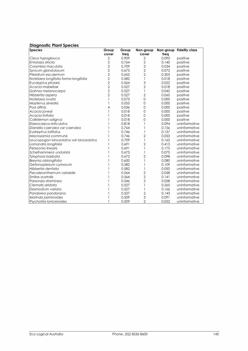
Eco Logical Australia Phone. (02) 8536 8600 145
Diagnostic Plant Species Species Group
cover Group
freq Non-group
cover Non-group
freq Fidelity class
Cissus hypoglauca 2 0.909 2 0.093 positive Entolasia stricta 2 0.764 2 0.140 positive Corymbia maculata 3 0.709 3 0.034 positive Synoum glandulosum 2 0.673 2 0.072 positive Pteridium esculentum 2 0.655 2 0.303 positive Notelaea longifolia forma longifolia 2 0.582 1 0.018 positive Eucalyptus pilularis 2 0.564 3 0.022 positive Acacia mabellae 2 0.527 2 0.018 positive Gahnia melanocarpa 2 0.527 1 0.042 positive Hibbertia aspera 2 0.527 2 0.065 positive Notelaea ovata 1 0.073 0 0.000 positive Maytenus silvestris 1 0.055 0 0.000 positive Poa affinis 4 0.036 0 0.000 positive Acacia jonesii 1 0.018 0 0.000 positive Acacia linifolia 1 0.018 0 0.000 positive Callistemon salignus 1 0.018 0 0.000 positive Elaeocarpus reticulatus 1 0.818 1 0.094 uninformative Dianella caerulea var caerulea 1 0.764 1 0.156 uninformative Eustrephus latifolius 1 0.746 1 0.137 uninformative Macrozamia communis 1 0.746 2 0.053 uninformative Leucopogon lanceolatus var lanceolatus 1 0.709 1 0.162 uninformative Lomandra longifolia 1 0.691 2 0.413 uninformative Persoonia linearis 1 0.691 1 0.175 uninformative Schelhammera undulata 1 0.673 1 0.075 uninformative Tylophora barbata 1 0.673 2 0.098 uninformative Breynia oblongifolia 1 0.600 1 0.080 uninformative Geitonoplesium cymosum 1 0.582 1 0.109 uninformative Hibbertia dentata 1 0.582 1 0.050 uninformative Pseuderanthemum variabile 1 0.564 2 0.058 uninformative Smilax australis 1 0.564 2 0.141 uninformative Parsonsia straminea 1 0.546 2 0.058 uninformative Clematis aristata 1 0.527 1 0.265 uninformative Desmodium varians 1 0.527 1 0.166 uninformative Pandorea pandorana 1 0.527 2 0.143 uninformative Morinda jasminoides 1 0.509 3 0.091 uninformative Psychotria loniceroides 1 0.509 2 0.052 uninformative
Eco Logical Australia Phone. (02) 8536 8600 146
853. Shoalhaven Gorge Riparian Shrub Forest This community has been identified in the Southern CRA Forest Ecosystems Mapping (NPWS, unpub.). The following community profile has been directly extracted from the appendices of the associated report.
Description
Riparian Acacia Shrub/Grass/Herb Forest is a tall forest up to 30 metres tall, dominated by Casuarina cunninghamiana. As it is a widespread vegetation type, it may have variable shrub and ground cover layers. In the South Coast section of the Southern CRA Region, it may contain a tall shrub layer of Hymenanthera dentata, Acacia mearnsii, and Acacia floribunda. The ground cover may be an open to dense cover of grasses such as Microlaena stipoides, Echinopogon ovatus, Entolasia marginata, and Oplismenus aemulus, with forbs and graminoids, such as Carex appressa, Carex longebrachiata, Dichondra repens, and Geranium solanderi var solanderi.
Riparian Acacia Shrub/Grass/Herb Forest is widespread riparian community occuring from near sea level up to 750 metres in elevation. The western patches of this assemblage may contain different ground cover elements and have not been extensively sampled.
Previous Floristic Classifications The Southern CRA Forest Ecosystems Mapping Project previously classified this community as ‘FOREST ECOSYSTEM 53: Riparian Acacia Shrub/Grass/Herb Forest - Casuarina cunninghamiana’.
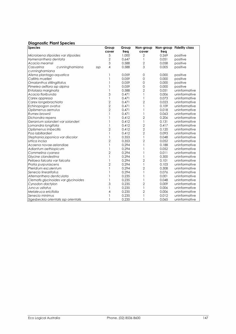
Eco Logical Australia Phone. (02) 8536 8600 147
Diagnostic Plant Species Species Group
cover Group
freq Non-group
cover Non-group
freq Fidelity class
Microlaena stipoides var stipoides 3 1.000 2 0.269 positive Hymenanthera dentata 2 0.647 1 0.051 positive Acacia mearnsii 3 0.588 2 0.058 positive Casuarina cunninghamiana ssp cunninghamiana
4 0.588 3 0.005 positive
Alisma plantago-aquatica 1 0.059 0 0.000 positive Callitris muelleri 1 0.059 0 0.000 positive Omalanthus stillingiifolius 1 0.059 0 0.000 positive Pimelea axiflora ssp alpina 1 0.059 0 0.000 positive Entolasia marginata 1 0.588 2 0.051 uninformative Acacia floribunda 3 0.471 1 0.006 uninformative Carex appressa 1 0.471 1 0.073 uninformative Carex longebrachiata 2 0.471 2 0.023 uninformative Echinopogon ovatus 2 0.471 1 0.109 uninformative Oplismenus aemulus 2 0.471 1 0.018 uninformative Rumex brownii 1 0.471 1 0.063 uninformative Dichondra repens 1 0.412 2 0.206 uninformative Geranium solanderi var solanderi 1 0.412 1 0.131 uninformative Lomandra longifolia 1 0.412 2 0.417 uninformative Oplismenus imbecillis 2 0.412 2 0.120 uninformative Poa labillardieri 1 0.412 2 0.093 uninformative Stephania japonica var discolor 1 0.353 1 0.048 uninformative Urtica incisa 2 0.353 2 0.052 uninformative Acaena novae-zelandiae 1 0.294 1 0.188 uninformative Adiantum aethiopicum 1 0.294 1 0.052 uninformative Commelina cyanea 2 0.294 1 0.011 uninformative Glycine clandestina 1 0.294 1 0.300 uninformative Pellaea falcata var falcata 1 0.294 2 0.101 uninformative Pratia purpurascens 2 0.294 1 0.103 uninformative Pteridium esculentum 1 0.294 2 0.308 uninformative Senecio linearifolius 1 0.294 1 0.076 uninformative Alternanthera denticulata 1 0.235 1 0.001 uninformative Clematis glycinoides var glycinoides 1 0.235 1 0.048 uninformative Cynodon dactylon 3 0.235 2 0.009 uninformative Juncus usitatus 1 0.235 1 0.006 uninformative Melaleuca ericifolia 4 0.235 2 0.006 uninformative Senecio minimus 1 0.235 1 0.012 uninformative Sigesbeckia orientalis ssp orientalis 1 0.235 1 0.065 uninformative
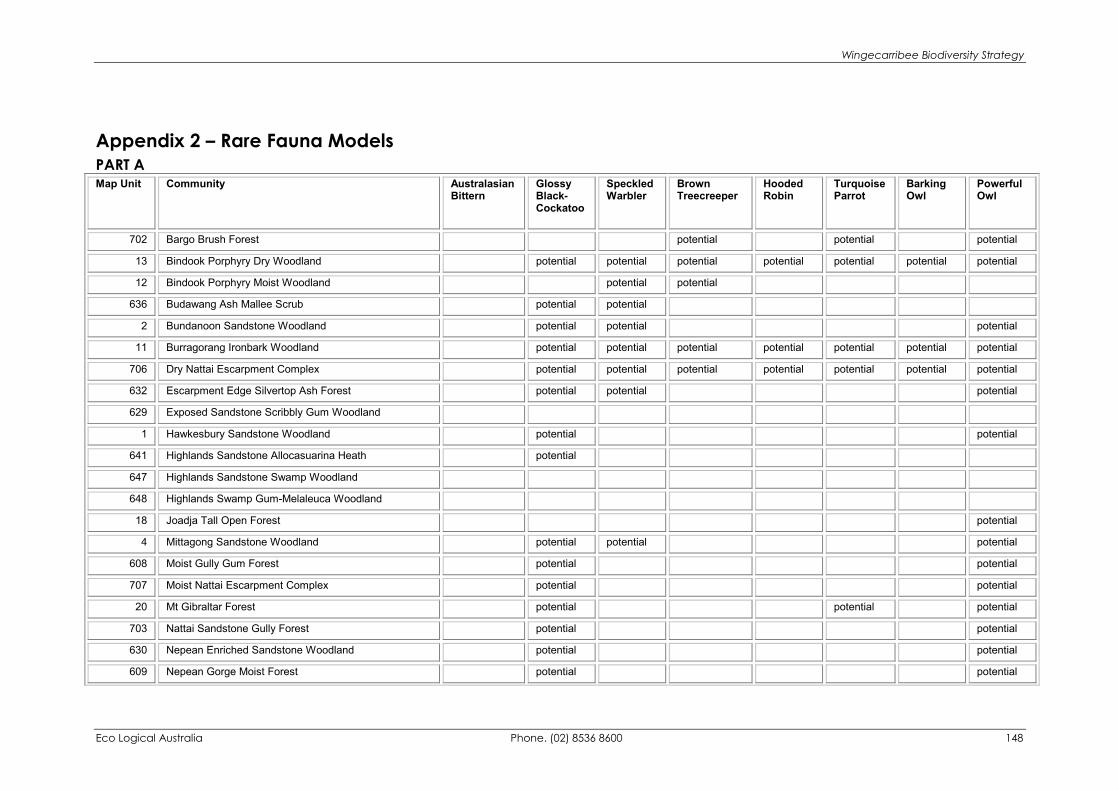
Wingecarribee Biodiversity Strategy
Eco Logical Australia Phone. (02) 8536 8600 148
Appendix 2 – Rare Fauna Models PART A Map Unit Community Australasian
Bittern Glossy Black-Cockatoo
Speckled Warbler
Brown Treecreeper
Hooded Robin
Turquoise Parrot
Barking Owl
Powerful Owl
702 Bargo Brush Forest potential potential potential
13 Bindook Porphyry Dry Woodland potential potential potential potential potential potential potential
12 Bindook Porphyry Moist Woodland potential potential
636 Budawang Ash Mallee Scrub potential potential
2 Bundanoon Sandstone Woodland potential potential potential
11 Burragorang Ironbark Woodland potential potential potential potential potential potential potential
706 Dry Nattai Escarpment Complex potential potential potential potential potential potential potential
632 Escarpment Edge Silvertop Ash Forest potential potential potential
629 Exposed Sandstone Scribbly Gum Woodland
1 Hawkesbury Sandstone Woodland potential potential
641 Highlands Sandstone Allocasuarina Heath potential
647 Highlands Sandstone Swamp Woodland
648 Highlands Swamp Gum-Melaleuca Woodland
18 Joadja Tall Open Forest potential
4 Mittagong Sandstone Woodland potential potential potential
608 Moist Gully Gum Forest potential potential
707 Moist Nattai Escarpment Complex potential potential
20 Mt Gibraltar Forest potential potential potential
703 Nattai Sandstone Gully Forest potential potential
630 Nepean Enriched Sandstone Woodland potential potential
609 Nepean Gorge Moist Forest potential potential
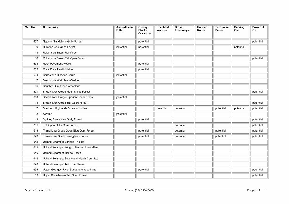
Eco Logical Australia Phone. (02) 8536 8600 Page 149
Map Unit Community Australasian Bittern
Glossy Black-Cockatoo
Speckled Warbler
Brown Treecreeper
Hooded Robin
Turquoise Parrot
Barking Owl
Powerful Owl
627 Nepean Sandstone Gully Forest potential potential
9 Riparian Casuarina Forest potential potential potential
14 Robertson Basalt Rainforest
16 Robertson Basalt Tall Open Forest potential
638 Rock Pavement Heath potential
639 Rock Plate Heath-Mallee potential
604 Sandstone Riparian Scrub potential
7 Sandstone Wet Heath/Sedge
6 Scribbly Gum Open Woodland
821 Shoalhaven Gorge Moist Shrub Forest potential
853 Shoalhaven Gorge Riparian Shrub Forest potential
15 Shoalhaven Gorge Tall Open Forest potential
17 Southern Highlands Shale Woodland potential potential potential potential potential
8 Swamp potential
3 Sydney Sandstone Gully Forest potential potential
701 Tall Open Gully Gum Forest potential potential
619 Transitional Shale Open Blue Gum Forest potential potential potential potential
623 Transitional Shale Stringybark Forest potential potential potential potential
642 Upland Swamps: Banksia Thicket
645 Upland Swamps: Fringing Eucalypt Woodland
646 Upland Swamps: Mallee-Heath
644 Upland Swamps: Sedgeland-Heath Complex
643 Upland Swamps: Tea Tree Thicket
635 Upper Georges River Sandstone Woodland potential potential
19 Upper Shoalhaven Tall Open Forest potential
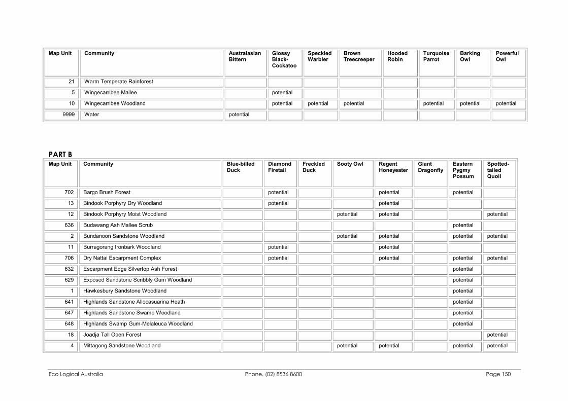
Eco Logical Australia Phone. (02) 8536 8600 Page 150
Map Unit Community Australasian Bittern
Glossy Black-Cockatoo
Speckled Warbler
Brown Treecreeper
Hooded Robin
Turquoise Parrot
Barking Owl
Powerful Owl
21 Warm Temperate Rainforest
5 Wingecarribee Mallee potential
10 Wingecarribee Woodland potential potential potential potential potential potential
9999 Water potential
PART B Map Unit Community Blue-billed
Duck Diamond Firetail
Freckled Duck
Sooty Owl Regent Honeyeater
Giant Dragonfly
Eastern Pygmy Possum
Spotted-tailed Quoll
702 Bargo Brush Forest potential potential potential
13 Bindook Porphyry Dry Woodland potential potential
12 Bindook Porphyry Moist Woodland potential potential potential
636 Budawang Ash Mallee Scrub potential
2 Bundanoon Sandstone Woodland potential potential potential potential
11 Burragorang Ironbark Woodland potential potential
706 Dry Nattai Escarpment Complex potential potential potential potential
632 Escarpment Edge Silvertop Ash Forest potential
629 Exposed Sandstone Scribbly Gum Woodland potential
1 Hawkesbury Sandstone Woodland potential
641 Highlands Sandstone Allocasuarina Heath potential
647 Highlands Sandstone Swamp Woodland potential
648 Highlands Swamp Gum-Melaleuca Woodland potential
18 Joadja Tall Open Forest potential
4 Mittagong Sandstone Woodland potential potential potential potential
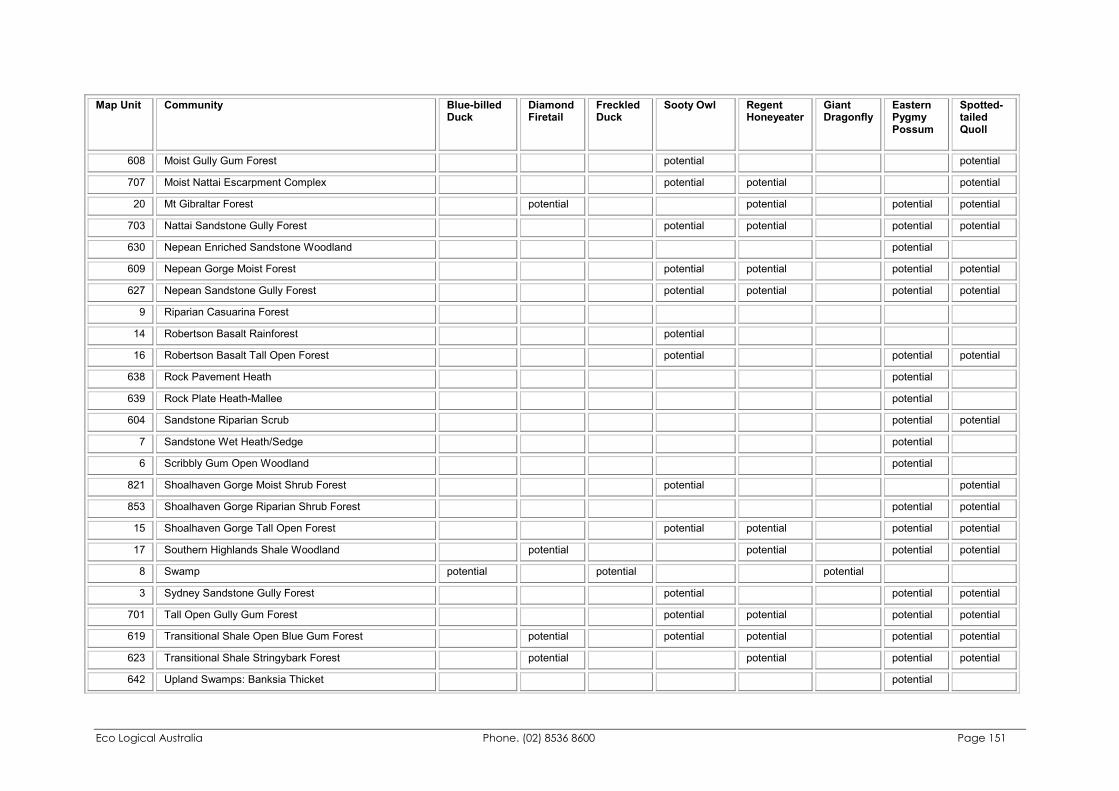
Eco Logical Australia Phone. (02) 8536 8600 Page 151
Map Unit Community Blue-billed Duck
Diamond Firetail
Freckled Duck
Sooty Owl Regent Honeyeater
Giant Dragonfly
Eastern Pygmy Possum
Spotted-tailed Quoll
608 Moist Gully Gum Forest potential potential
707 Moist Nattai Escarpment Complex potential potential potential
20 Mt Gibraltar Forest potential potential potential potential
703 Nattai Sandstone Gully Forest potential potential potential potential
630 Nepean Enriched Sandstone Woodland potential
609 Nepean Gorge Moist Forest potential potential potential potential
627 Nepean Sandstone Gully Forest potential potential potential potential
9 Riparian Casuarina Forest
14 Robertson Basalt Rainforest potential
16 Robertson Basalt Tall Open Forest potential potential potential
638 Rock Pavement Heath potential
639 Rock Plate Heath-Mallee potential
604 Sandstone Riparian Scrub potential potential
7 Sandstone Wet Heath/Sedge potential
6 Scribbly Gum Open Woodland potential
821 Shoalhaven Gorge Moist Shrub Forest potential potential
853 Shoalhaven Gorge Riparian Shrub Forest potential potential
15 Shoalhaven Gorge Tall Open Forest potential potential potential potential
17 Southern Highlands Shale Woodland potential potential potential potential
8 Swamp potential potential potential
3 Sydney Sandstone Gully Forest potential potential potential
701 Tall Open Gully Gum Forest potential potential potential potential
619 Transitional Shale Open Blue Gum Forest potential potential potential potential potential
623 Transitional Shale Stringybark Forest potential potential potential potential
642 Upland Swamps: Banksia Thicket potential
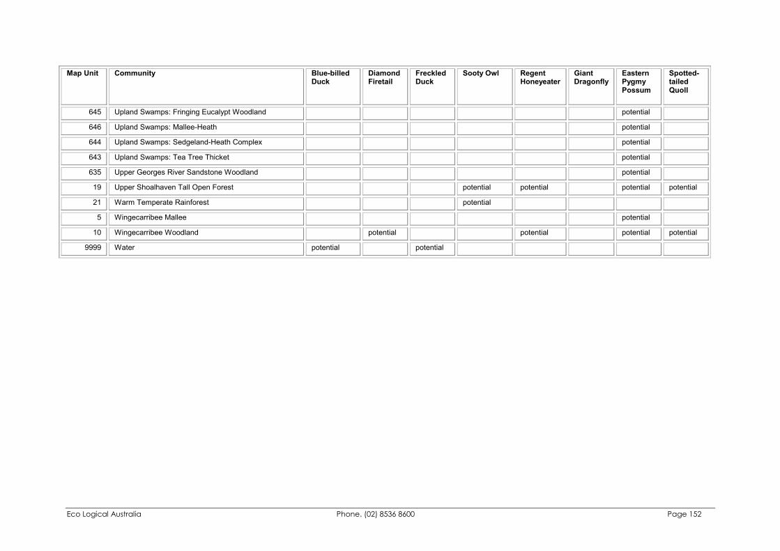
Eco Logical Australia Phone. (02) 8536 8600 Page 152
Map Unit Community Blue-billed Duck
Diamond Firetail
Freckled Duck
Sooty Owl Regent Honeyeater
Giant Dragonfly
Eastern Pygmy Possum
Spotted-tailed Quoll
645 Upland Swamps: Fringing Eucalypt Woodland potential
646 Upland Swamps: Mallee-Heath potential
644 Upland Swamps: Sedgeland-Heath Complex potential
643 Upland Swamps: Tea Tree Thicket potential
635 Upper Georges River Sandstone Woodland potential
19 Upper Shoalhaven Tall Open Forest potential potential potential potential
21 Warm Temperate Rainforest potential
5 Wingecarribee Mallee potential
10 Wingecarribee Woodland potential potential potential potential
9999 Water potential potential
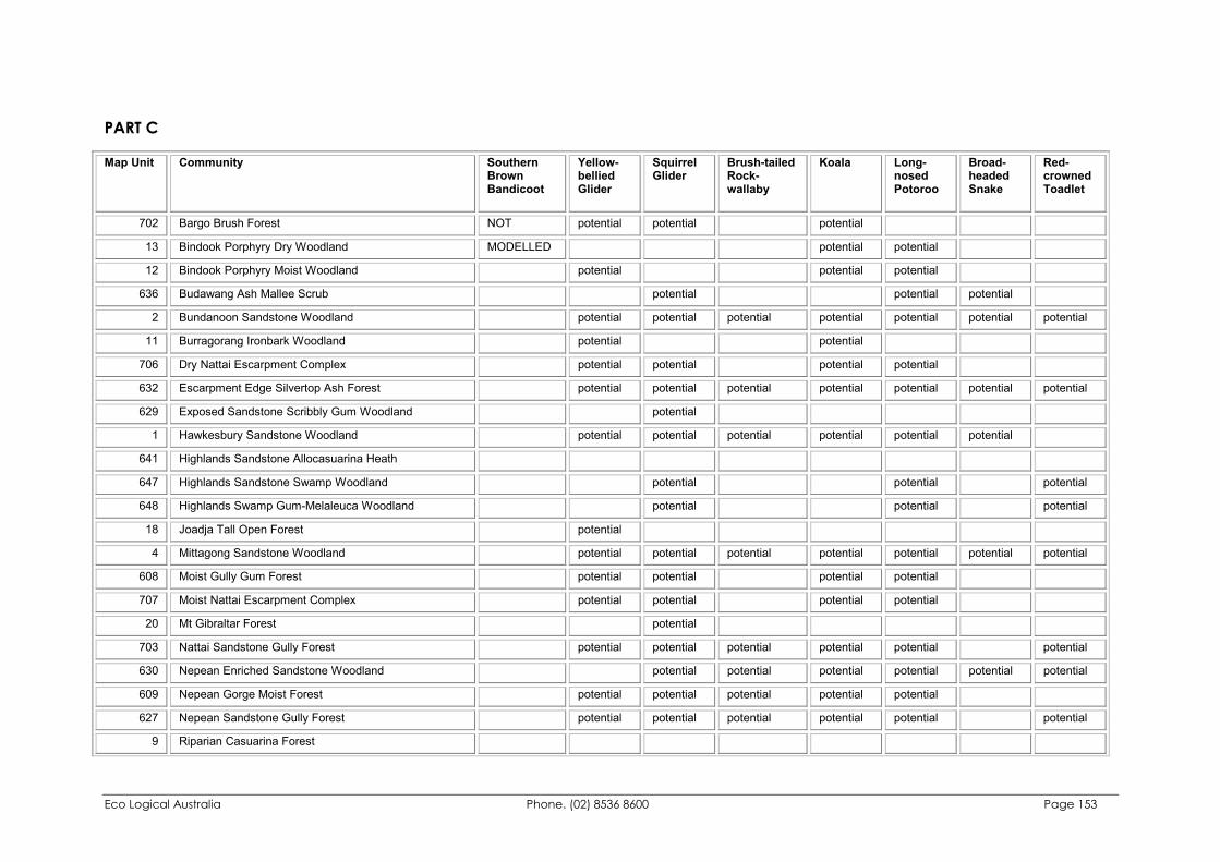
Eco Logical Australia Phone. (02) 8536 8600 Page 153
PART C Map Unit Community Southern
Brown Bandicoot
Yellow-bellied Glider
Squirrel Glider
Brush-tailed Rock-wallaby
Koala Long-nosed Potoroo
Broad-headed Snake
Red-crowned Toadlet
702 Bargo Brush Forest NOT potential potential potential
13 Bindook Porphyry Dry Woodland MODELLED potential potential
12 Bindook Porphyry Moist Woodland potential potential potential
636 Budawang Ash Mallee Scrub potential potential potential
2 Bundanoon Sandstone Woodland potential potential potential potential potential potential potential
11 Burragorang Ironbark Woodland potential potential
706 Dry Nattai Escarpment Complex potential potential potential potential
632 Escarpment Edge Silvertop Ash Forest potential potential potential potential potential potential potential
629 Exposed Sandstone Scribbly Gum Woodland potential
1 Hawkesbury Sandstone Woodland potential potential potential potential potential potential
641 Highlands Sandstone Allocasuarina Heath
647 Highlands Sandstone Swamp Woodland potential potential potential
648 Highlands Swamp Gum-Melaleuca Woodland potential potential potential
18 Joadja Tall Open Forest potential
4 Mittagong Sandstone Woodland potential potential potential potential potential potential potential
608 Moist Gully Gum Forest potential potential potential potential
707 Moist Nattai Escarpment Complex potential potential potential potential
20 Mt Gibraltar Forest potential
703 Nattai Sandstone Gully Forest potential potential potential potential potential potential
630 Nepean Enriched Sandstone Woodland potential potential potential potential potential potential
609 Nepean Gorge Moist Forest potential potential potential potential potential
627 Nepean Sandstone Gully Forest potential potential potential potential potential potential
9 Riparian Casuarina Forest
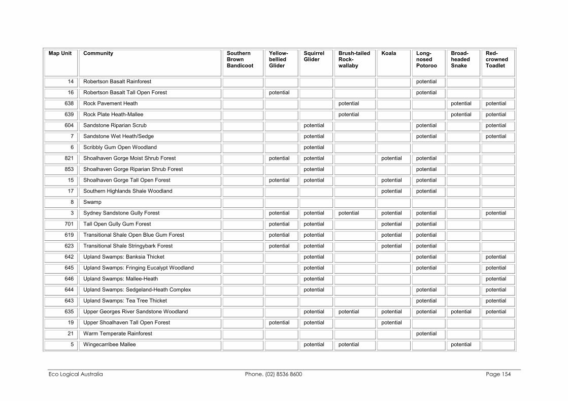
Eco Logical Australia Phone. (02) 8536 8600 Page 154
Map Unit Community Southern Brown Bandicoot
Yellow-bellied Glider
Squirrel Glider
Brush-tailed Rock-wallaby
Koala Long-nosed Potoroo
Broad-headed Snake
Red-crowned Toadlet
14 Robertson Basalt Rainforest potential
16 Robertson Basalt Tall Open Forest potential potential
638 Rock Pavement Heath potential potential potential
639 Rock Plate Heath-Mallee potential potential potential
604 Sandstone Riparian Scrub potential potential potential
7 Sandstone Wet Heath/Sedge potential potential potential
6 Scribbly Gum Open Woodland potential
821 Shoalhaven Gorge Moist Shrub Forest potential potential potential potential
853 Shoalhaven Gorge Riparian Shrub Forest potential potential
15 Shoalhaven Gorge Tall Open Forest potential potential potential potential
17 Southern Highlands Shale Woodland potential potential
8 Swamp
3 Sydney Sandstone Gully Forest potential potential potential potential potential potential
701 Tall Open Gully Gum Forest potential potential potential potential
619 Transitional Shale Open Blue Gum Forest potential potential potential potential
623 Transitional Shale Stringybark Forest potential potential potential potential
642 Upland Swamps: Banksia Thicket potential potential potential
645 Upland Swamps: Fringing Eucalypt Woodland potential potential potential
646 Upland Swamps: Mallee-Heath potential potential
644 Upland Swamps: Sedgeland-Heath Complex potential potential potential
643 Upland Swamps: Tea Tree Thicket potential potential
635 Upper Georges River Sandstone Woodland potential potential potential potential potential potential
19 Upper Shoalhaven Tall Open Forest potential potential potential
21 Warm Temperate Rainforest potential
5 Wingecarribee Mallee potential potential potential
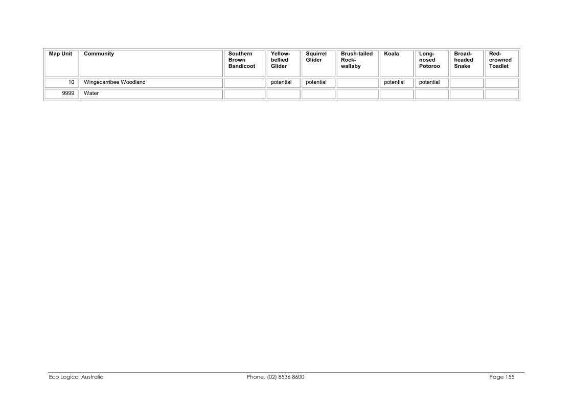
Eco Logical Australia Phone. (02) 8536 8600 Page 155
Map Unit Community Southern Brown Bandicoot
Yellow-bellied Glider
Squirrel Glider
Brush-tailed Rock-wallaby
Koala Long-nosed Potoroo
Broad-headed Snake
Red-crowned Toadlet
10 Wingecarribee Woodland potential potential potential potential
9999 Water
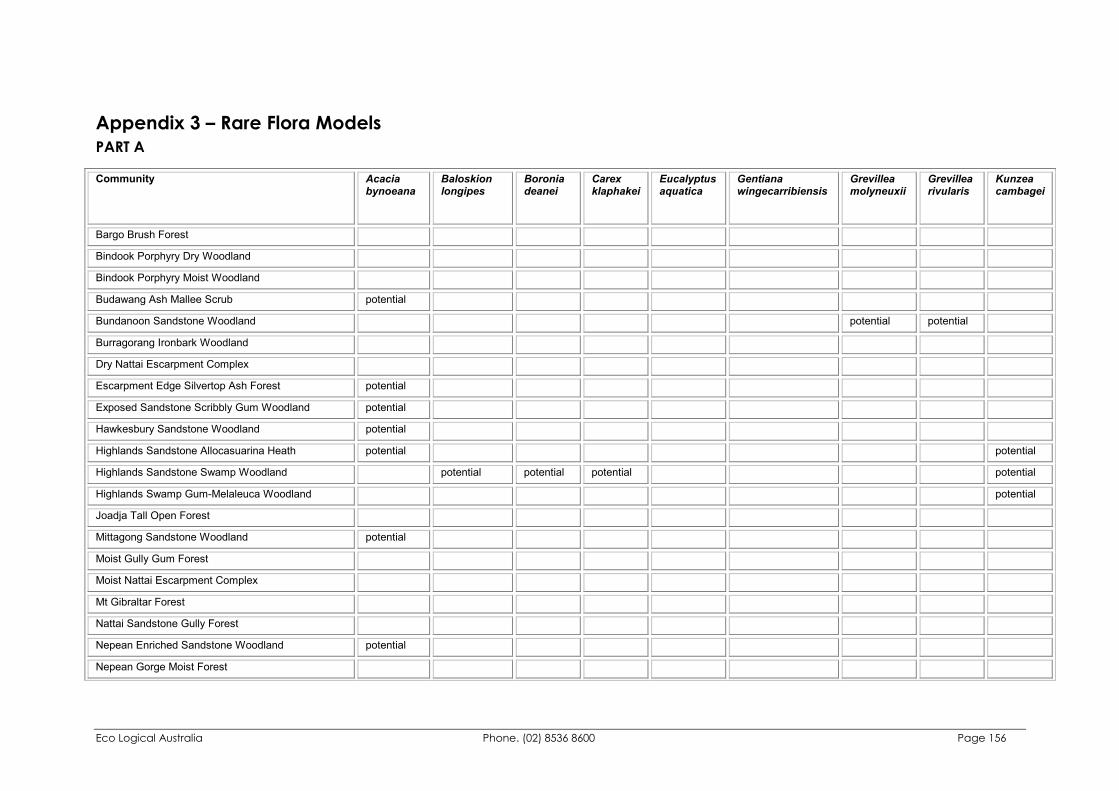
Eco Logical Australia Phone. (02) 8536 8600 Page 156
Appendix 3 – Rare Flora Models PART A Community Acacia
bynoeana Baloskion longipes
Boronia deanei
Carex klaphakei
Eucalyptus aquatica
Gentiana wingecarribiensis
Grevillea molyneuxii
Grevillea rivularis
Kunzea cambagei
Bargo Brush Forest
Bindook Porphyry Dry Woodland
Bindook Porphyry Moist Woodland
Budawang Ash Mallee Scrub potential
Bundanoon Sandstone Woodland potential potential
Burragorang Ironbark Woodland
Dry Nattai Escarpment Complex
Escarpment Edge Silvertop Ash Forest potential
Exposed Sandstone Scribbly Gum Woodland potential
Hawkesbury Sandstone Woodland potential
Highlands Sandstone Allocasuarina Heath potential potential
Highlands Sandstone Swamp Woodland potential potential potential potential
Highlands Swamp Gum-Melaleuca Woodland potential
Joadja Tall Open Forest
Mittagong Sandstone Woodland potential
Moist Gully Gum Forest
Moist Nattai Escarpment Complex
Mt Gibraltar Forest
Nattai Sandstone Gully Forest
Nepean Enriched Sandstone Woodland potential
Nepean Gorge Moist Forest
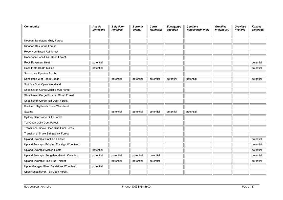
Eco Logical Australia Phone. (02) 8536 8600 Page 157
Community Acacia bynoeana
Baloskion longipes
Boronia deanei
Carex klaphakei
Eucalyptus aquatica
Gentiana wingecarribiensis
Grevillea molyneuxii
Grevillea rivularis
Kunzea cambagei
Nepean Sandstone Gully Forest
Riparian Casuarina Forest
Robertson Basalt Rainforest
Robertson Basalt Tall Open Forest
Rock Pavement Heath potential potential
Rock Plate Heath-Mallee potential potential
Sandstone Riparian Scrub
Sandstone Wet Heath/Sedge potential potential potential potential potential potential
Scribbly Gum Open Woodland
Shoalhaven Gorge Moist Shrub Forest
Shoalhaven Gorge Riparian Shrub Forest
Shoalhaven Gorge Tall Open Forest
Southern Highlands Shale Woodland
Swamp potential potential potential potential potential
Sydney Sandstone Gully Forest
Tall Open Gully Gum Forest
Transitional Shale Open Blue Gum Forest
Transitional Shale Stringybark Forest
Upland Swamps: Banksia Thicket potential
Upland Swamps: Fringing Eucalypt Woodland potential
Upland Swamps: Mallee-Heath potential potential
Upland Swamps: Sedgeland-Heath Complex potential potential potential potential potential
Upland Swamps: Tea Tree Thicket potential potential potential potential
Upper Georges River Sandstone Woodland potential
Upper Shoalhaven Tall Open Forest
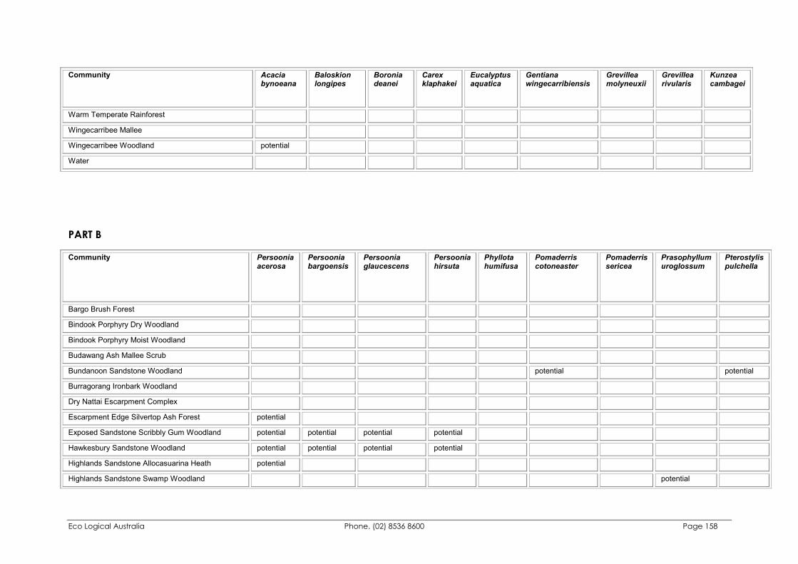
Eco Logical Australia Phone. (02) 8536 8600 Page 158
Community Acacia bynoeana
Baloskion longipes
Boronia deanei
Carex klaphakei
Eucalyptus aquatica
Gentiana wingecarribiensis
Grevillea molyneuxii
Grevillea rivularis
Kunzea cambagei
Warm Temperate Rainforest
Wingecarribee Mallee
Wingecarribee Woodland potential
Water
PART B Community Persoonia
acerosa Persoonia bargoensis
Persoonia glaucescens
Persoonia hirsuta
Phyllota humifusa
Pomaderris cotoneaster
Pomaderris sericea
Prasophyllum uroglossum
Pterostylis pulchella
Bargo Brush Forest
Bindook Porphyry Dry Woodland
Bindook Porphyry Moist Woodland
Budawang Ash Mallee Scrub
Bundanoon Sandstone Woodland potential potential
Burragorang Ironbark Woodland
Dry Nattai Escarpment Complex
Escarpment Edge Silvertop Ash Forest potential
Exposed Sandstone Scribbly Gum Woodland potential potential potential potential
Hawkesbury Sandstone Woodland potential potential potential potential
Highlands Sandstone Allocasuarina Heath potential
Highlands Sandstone Swamp Woodland potential
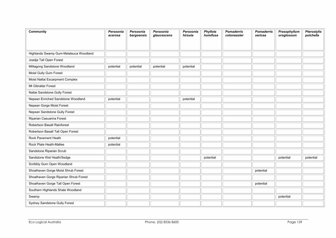
Eco Logical Australia Phone. (02) 8536 8600 Page 159
Community Persoonia acerosa
Persoonia bargoensis
Persoonia glaucescens
Persoonia hirsuta
Phyllota humifusa
Pomaderris cotoneaster
Pomaderris sericea
Prasophyllum uroglossum
Pterostylis pulchella
Highlands Swamp Gum-Melaleuca Woodland
Joadja Tall Open Forest
Mittagong Sandstone Woodland potential potential potential potential
Moist Gully Gum Forest
Moist Nattai Escarpment Complex
Mt Gibraltar Forest
Nattai Sandstone Gully Forest
Nepean Enriched Sandstone Woodland potential potential
Nepean Gorge Moist Forest
Nepean Sandstone Gully Forest
Riparian Casuarina Forest
Robertson Basalt Rainforest
Robertson Basalt Tall Open Forest
Rock Pavement Heath potential
Rock Plate Heath-Mallee potential
Sandstone Riparian Scrub
Sandstone Wet Heath/Sedge potential potential potential
Scribbly Gum Open Woodland
Shoalhaven Gorge Moist Shrub Forest potential
Shoalhaven Gorge Riparian Shrub Forest
Shoalhaven Gorge Tall Open Forest potential
Southern Highlands Shale Woodland
Swamp potential
Sydney Sandstone Gully Forest
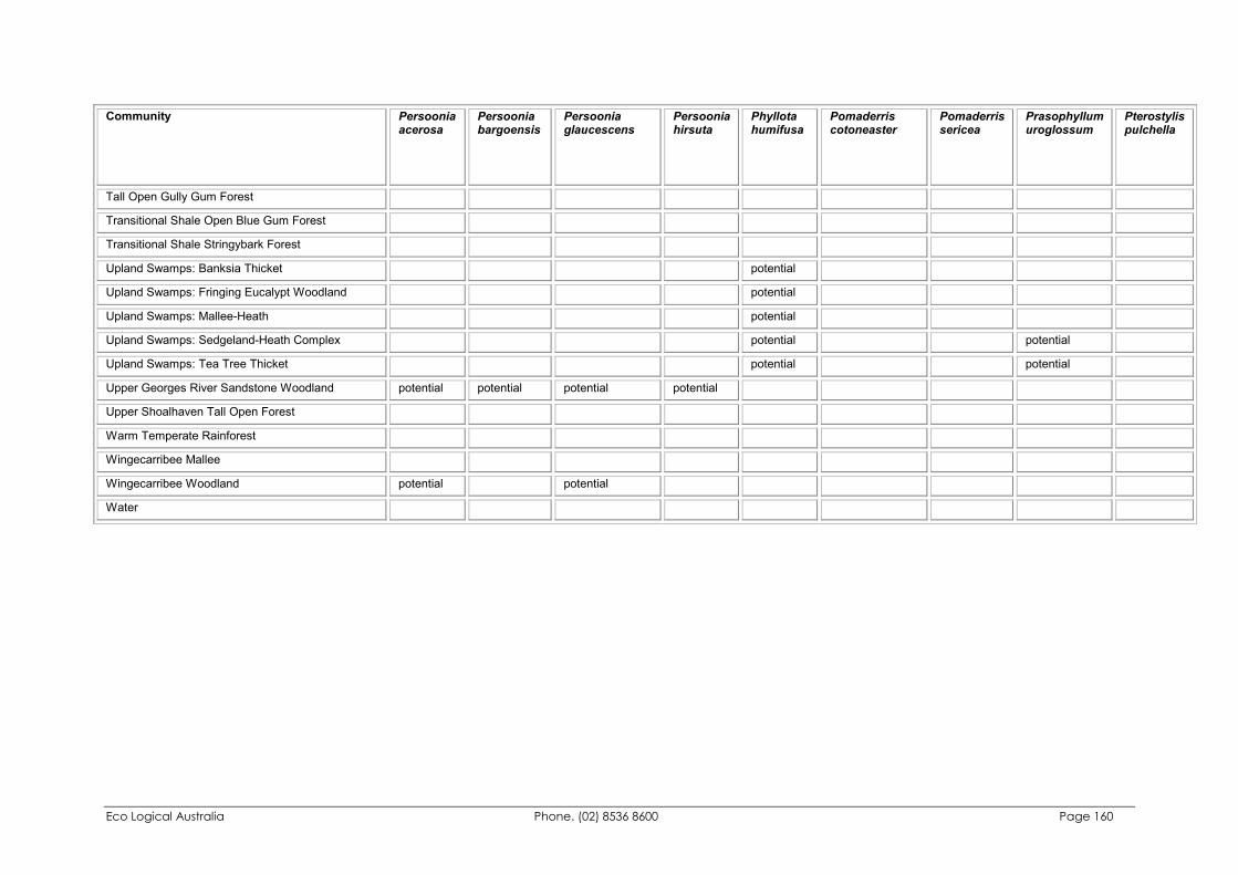
Eco Logical Australia Phone. (02) 8536 8600 Page 160
Community Persoonia acerosa
Persoonia bargoensis
Persoonia glaucescens
Persoonia hirsuta
Phyllota humifusa
Pomaderris cotoneaster
Pomaderris sericea
Prasophyllum uroglossum
Pterostylis pulchella
Tall Open Gully Gum Forest
Transitional Shale Open Blue Gum Forest
Transitional Shale Stringybark Forest
Upland Swamps: Banksia Thicket potential
Upland Swamps: Fringing Eucalypt Woodland potential
Upland Swamps: Mallee-Heath potential
Upland Swamps: Sedgeland-Heath Complex potential potential
Upland Swamps: Tea Tree Thicket potential potential
Upper Georges River Sandstone Woodland potential potential potential potential
Upper Shoalhaven Tall Open Forest
Warm Temperate Rainforest
Wingecarribee Mallee
Wingecarribee Woodland potential potential
Water
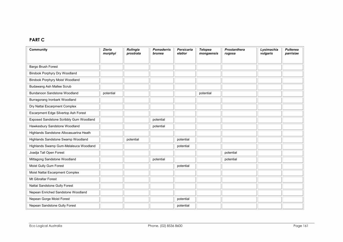
Eco Logical Australia Phone. (02) 8536 8600 Page 161
PART C Community Zieria
murphyi Rulingia prostrata
Pomaderris brunea
Persicaria elatior
Telopea mongaensis
Prostanthera rugosa
Lysimachia vulgaris
Pultenea parrisiae
Bargo Brush Forest
Bindook Porphyry Dry Woodland
Bindook Porphyry Moist Woodland
Budawang Ash Mallee Scrub
Bundanoon Sandstone Woodland potential potential
Burragorang Ironbark Woodland
Dry Nattai Escarpment Complex
Escarpment Edge Silvertop Ash Forest
Exposed Sandstone Scribbly Gum Woodland potential
Hawkesbury Sandstone Woodland potential
Highlands Sandstone Allocasuarina Heath
Highlands Sandstone Swamp Woodland potential potential
Highlands Swamp Gum-Melaleuca Woodland potential
Joadja Tall Open Forest potential
Mittagong Sandstone Woodland potential potential
Moist Gully Gum Forest potential
Moist Nattai Escarpment Complex
Mt Gibraltar Forest
Nattai Sandstone Gully Forest
Nepean Enriched Sandstone Woodland
Nepean Gorge Moist Forest potential
Nepean Sandstone Gully Forest potential
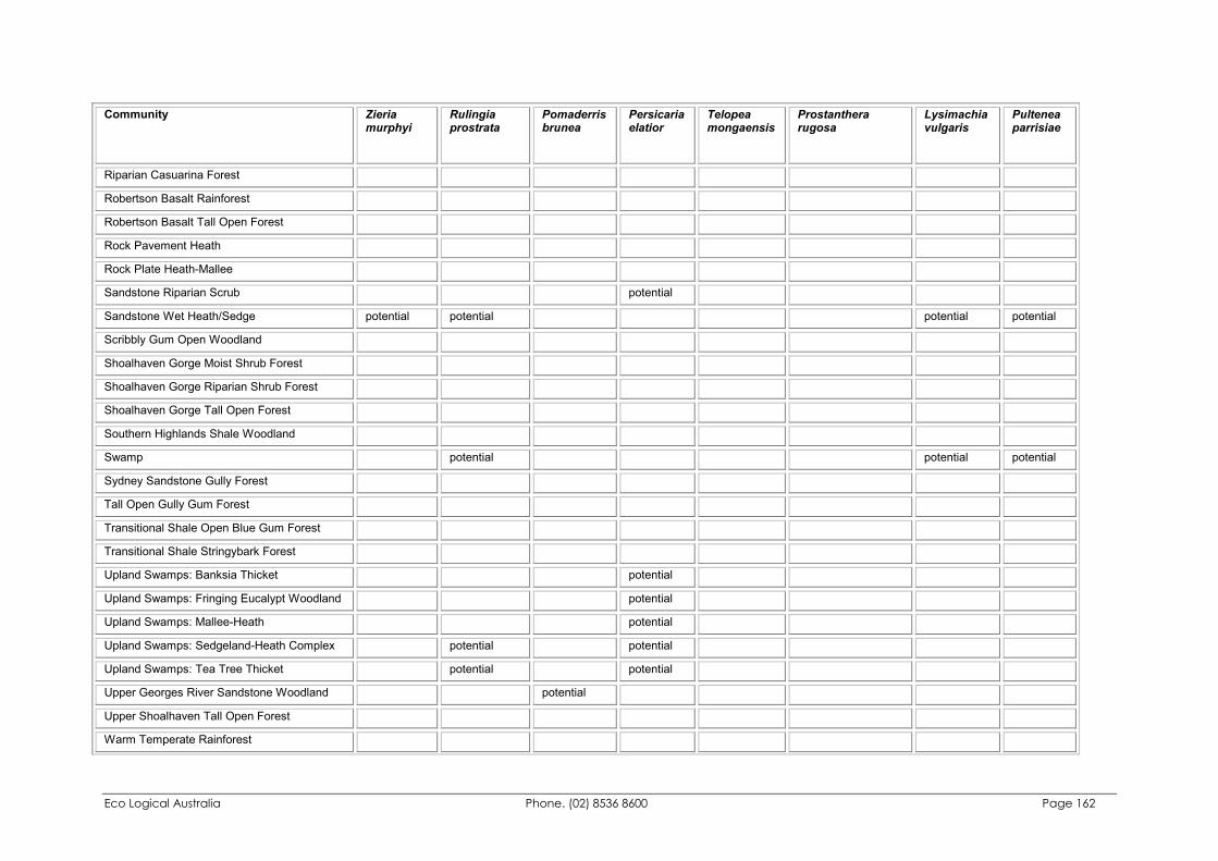
Eco Logical Australia Phone. (02) 8536 8600 Page 162
Community Zieria murphyi
Rulingia prostrata
Pomaderris brunea
Persicaria elatior
Telopea mongaensis
Prostanthera rugosa
Lysimachia vulgaris
Pultenea parrisiae
Riparian Casuarina Forest
Robertson Basalt Rainforest
Robertson Basalt Tall Open Forest
Rock Pavement Heath
Rock Plate Heath-Mallee
Sandstone Riparian Scrub potential
Sandstone Wet Heath/Sedge potential potential potential potential
Scribbly Gum Open Woodland
Shoalhaven Gorge Moist Shrub Forest
Shoalhaven Gorge Riparian Shrub Forest
Shoalhaven Gorge Tall Open Forest
Southern Highlands Shale Woodland
Swamp potential potential potential
Sydney Sandstone Gully Forest
Tall Open Gully Gum Forest
Transitional Shale Open Blue Gum Forest
Transitional Shale Stringybark Forest
Upland Swamps: Banksia Thicket potential
Upland Swamps: Fringing Eucalypt Woodland potential
Upland Swamps: Mallee-Heath potential
Upland Swamps: Sedgeland-Heath Complex potential potential
Upland Swamps: Tea Tree Thicket potential potential
Upper Georges River Sandstone Woodland potential
Upper Shoalhaven Tall Open Forest
Warm Temperate Rainforest
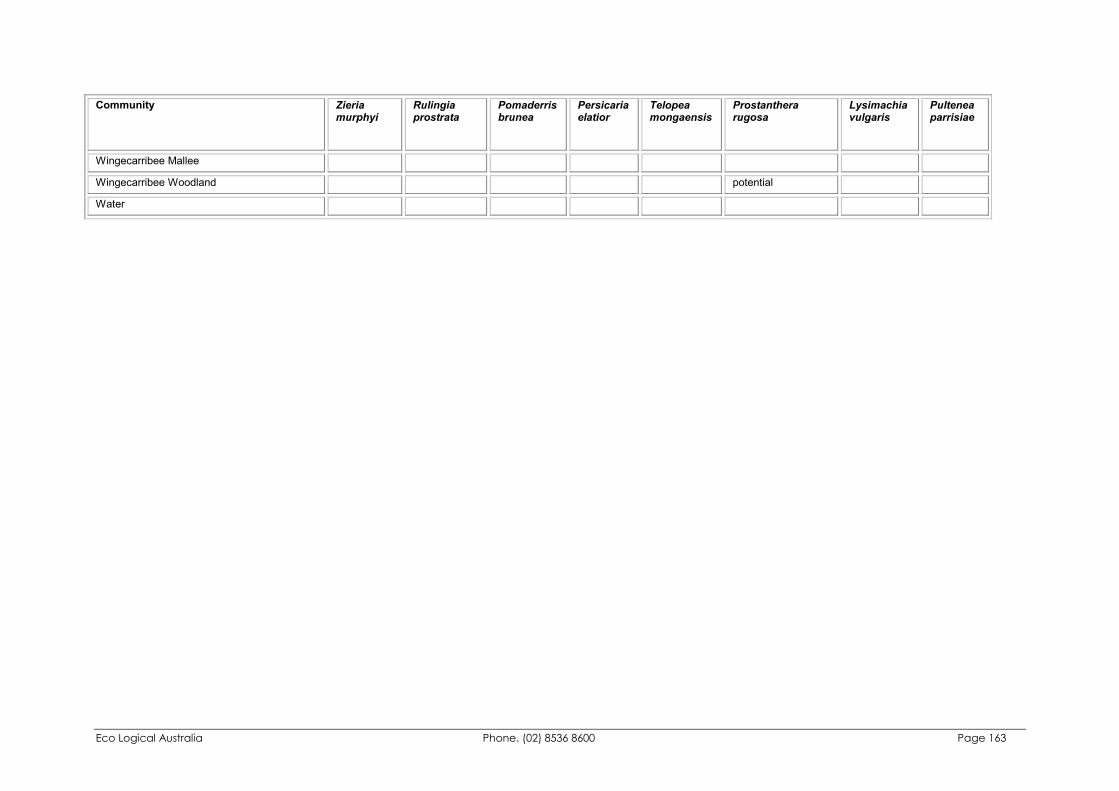
Eco Logical Australia Phone. (02) 8536 8600 Page 163
Community Zieria murphyi
Rulingia prostrata
Pomaderris brunea
Persicaria elatior
Telopea mongaensis
Prostanthera rugosa
Lysimachia vulgaris
Pultenea parrisiae
Wingecarribee Mallee
Wingecarribee Woodland potential
Water