windpower plants lake vänern, sweden - rewind … · exploratory fishing (modins biologi) impacts...
TRANSCRIPT

Windpower plants Lake Vänern, Sweden
Tore Wizelius & Åke Pettersson Frykberg
ReWind Offshore AB
Karlstad, Sweden

Åke Pettersson Frykberg
CEO of ReWind Offshore AB since 2009, Karlstad, Sweden
Initiated and managed the project Vindpark Vänern. Green party politician and City commisioner/vice Mayor of Karlstad from 2002-2010.
Board chairman of municipal utility Karlstad Energi, etc.

Tore Wizelius
Writer Developing Wind Power
Projects, etc.
Teacher Gotland University 1998-
2008 SLU University of
Agricultural Science 2010-11
Entrepreneur ReWind Offshore AB Vindform AB WindCap Fond AB Boge Vindbruk AB, etc.

Introduction
Vindpark Vänern – overview
Vindpark Stenkalle – overview
Environment Impact Assessments
– Scope and Contents

Lake Vänern
Lake Vänern is the largest lake in the EU and covers an area of 5,655 km2 (2,183 sq mi).

Great Lakes vs Lake Vänern
Lake Superior
31,700 sq mi (82,100 km2)
Lake Michigan
22,300 sq mi (58,000 km2)
Lake Huron
23,000 sq mi (59,600 km2)
Lake Erie
9,940 sq mi (25,744 km2)
Lake Ontario
7,340 sq mi(18,960 km2)
Lake Vänern
2,183 sq mi (5,655 km2)
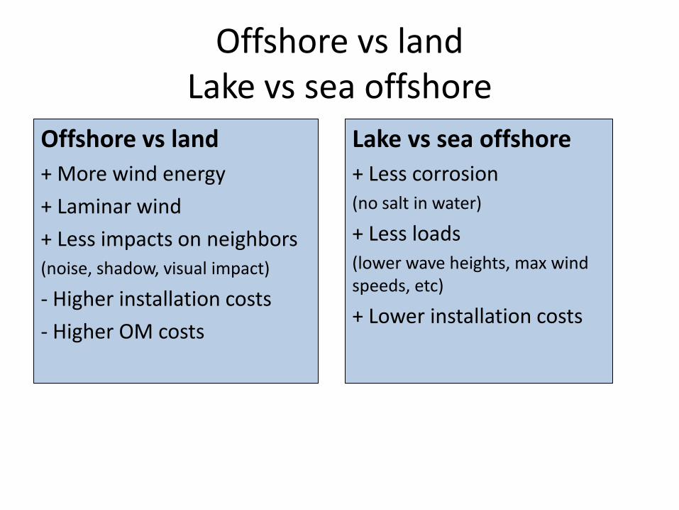
Offshore vs land Lake vs sea offshore
Offshore vs land + More wind energy
+ Laminar wind
+ Less impacts on neighbors (noise, shadow, visual impact)
- Higher installation costs
- Higher OM costs
Lake vs sea offshore + Less corrosion (no salt in water)
+ Less loads (lower wave heights, max wind speeds, etc)
+ Lower installation costs

Windpower plants in Lake Vänern
Vindpark Vänern
Vindpark Stenkalle

VINDPARK VÄNERN 10 WIND TURBINES
30 MW
90 GWh/year
Electricity for 20 000 households
90 m hub height
100 m rotor diameter
Total weight 220 ton
Operating since 2010

Stenkalles grund
ReWind Offshore AB
Application incl. EIA submitted in June 2011 to Swedish Environment Court. Hearing in October 2012. Decision expected before end of year. The project area is within an area in Vänern defined as: • National interest for
windpower • Windpower area in
Municipal Comprehensive Plan for Karlstad

Stenkalle EIA: Contents
Siting
Siting evaluation, A, B, C, 0
Seabottom conditions (prof. Tom Flodén)
Flora och fauna
Impacts on aquatic life (ÅF)
Hard bottom inventory
(Tronerud Miljö & Natur)
Exploratory fishing (Modins Biologi)
Impacts on bird life (JP Fågelvind)
Impacts on bats (Ecocom)
Environment impacts on Natura2000-areas (ÅF)
Grid connection to land (Cleps)
Impacts on Natura2000-area Klarälvsdeltat (consultant)
Cultural environment
Checks of indications in cable routes
(consultant)
Marine archeological check
(Bohusläns muséum)
Sound propagation
Sound immission (ÅF)
Visual impact
Photo montages
Visualisation zones

Options for current project
Three options were studied: 1. Densification of Vindpark Vänern 2. Stenkalles grund 3. Alfhilds grund
These three siting options have been evaluated using the following criteria: • Wind resources • Distance to houses • Impacts on landscape • Nature & Cultural environment • Fishery & Shipping • Recreational environment • Distance to power grid • Noice • Security • Technical and economic preconditions
2. Stenkalles grund
1. Gässlingegrund
3. Alfhilds grund

Project design december 2010
1. Densification of Vindpark Vänern
+ 5 wind turbines (blue symbols).
2. Stenkalles grund
New WPP with 16-20 wind turbines
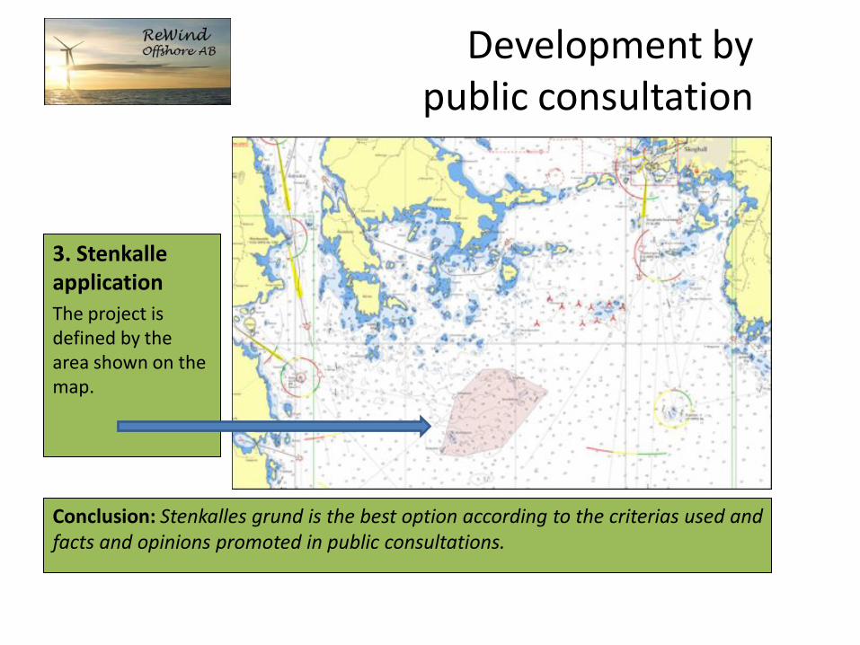
Development by
public consultation
3. Stenkalle application The project is defined by the area shown on the map.
Conclusion: Stenkalles grund is the best option according to the criterias used and
facts and opinions promoted in public consultations.

Geological survey to identify possible wind turbine sites
Trajectories for side-scan sonar mapping of sea bottom and bottom profiles

Protected areas
Nature reserves Bird protection areas
National interests: Nature
Recreation Fishery
Shipping Windpower
Natura 2000-areas Vänerskärgården
Klarälvsdeltat

1
1
Nature reserves
1. Värmlands-skärgården 2. Getgars Udde 3. Segerstads skärgård
3
2
Vindpark Vänern
ReWind Vänern

1
2
3
4
7
6
5
8
9
10
11
12
13
14
Bird protection areas
ReWind Vänern
Vindpark Vänern
1. Gåsskären 2. SÖ Guppaholmen 3. Äggskären 4. Gösskär, Pråmskär, Lövöskär 5. Rudsviksholmen 6. Sandskär 7. Rundholmen 8. Vaholmen 9. Ruskskär, Bäröskären 10. Östra Grisen 11. Skallholmarna 12. Balsen 13. Fulholmen 14. Bratten

Windpower areas

Nature areas
3
1. Segerstads skärgård 2. Fiskvik 3. Klarälvsdeltat ReWind
Vänern
2
1
Vindpark Vänern

Recreation areas
ReWind Vänern
Vindpark Vänern

Farleden till Skoghall
Farleden till Grums/Älvenäs
Shipping
ReWind Vänern
Vindpark Vänern

Natura 2000
Vindpark Vänern
ReWind Vänern
Klarälvsdeltat
Natura 2000
Vänerskärgården Vänerskärgården
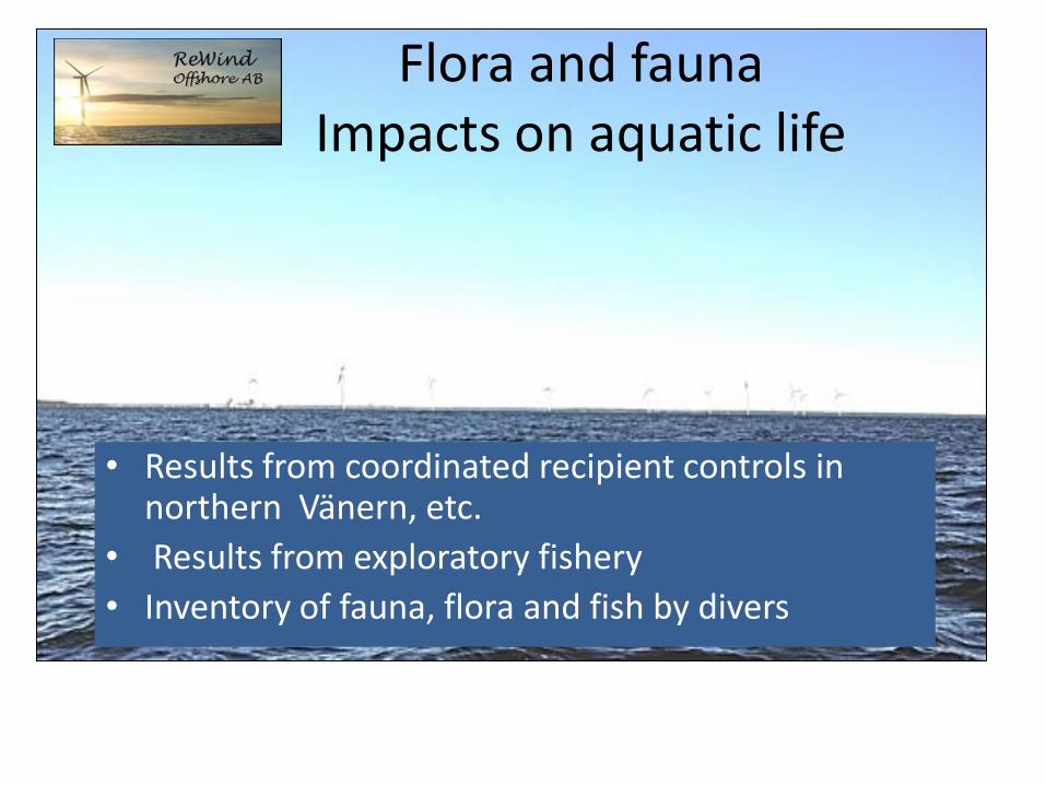
Flora and fauna Impacts on aquatic life
• Results from coordinated recipient controls in northern Vänern, etc.
• Results from exploratory fishery • Inventory of fauna, flora and fish by divers

Exploratory fishery; results
Exploratory fishery was conducted during one night in september 2010 at Stenkalles grund with 8 seabottom nets.
Results: few fish species with low population densities and biomass. Catch dominated by perch. Other species: Roach, ruffe, common whitefish, vendace.
The ecological status of the area was classified according to the index EQR8 as unsatisfactory.
Results were compared with exploratory fishery from 1999 and 2005, which confirmed the results.
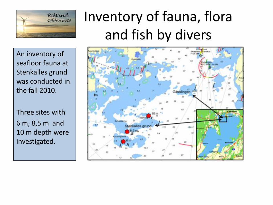
Inventory of fauna, flora and fish by divers
An inventory of seafloor fauna at Stenkalles grund was conducted in the fall 2010.
Three sites with
6 m, 8,5 m and 10 m depth were investigated.
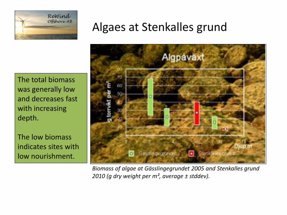
Algaes at Stenkalles grund
The total biomass was generally low and decreases fast with increasing depth. The low biomass indicates sites with low nourishment.
Biomass of algae at Gässlingegrundet 2005 and Stenkalles grund
2010 (g dry weight per m², average ± stddev).

Seafloor fauna
Seafloor fauna biomass was very low; ca 2 ton per km² (dry weight) for the whole project area.

Spawning grounds for vendace (Coregonus albula)
Stenkalles grund borders to a fishing area for vendace. Fishing starts in mid-october and ends mid-december, during the spawning season which can continue until january.
Spawning and fishing areas for vendance
in lake Vänern. Stenkalles grund

Foundations as artificial reefs
Around the foundations at the operating Vindpark Vänern at Gässlingegrundet a lot of small fishes have been observed. The foundations attract fish, just like rocks and small islands. Fish look for shadow and lee from vind, waves and streams. On the upper parts of the foundations close to the surface a lot of algae have grown which give nutrition to fish and marine fauna.
European bullhead (Cottus
gobio)

Impacts on environment during building phase
Impacts from opacification
Impacts will be very limited in time and space due to the hydrodynamic conditions in the area where particles will be diluted very fast. As a precautionary measure, these kinds of work can be done outside the spawning seasons of vendace and pikeperch.
Installation of electric cables
No blastings will be used. The cable will be buried to protect it from mechanical wear, ice etc. and to minimize impact close to shore. In shallow waters the cables will be buried by milling, proughing or drilling.
Effects on sea bottom fauna and vegetation
It will be noticeable in areas where digging takes place. A recolonization can however be expected within a few years. Impacts on phyto- and zoo- plankton is assessed as negligeable.

Ecological effects Fish Opacification is a natural process which happens every time the wind blows hard. Fish are generally relatively insensitive to suspended particular materials (SPM) and also have the ability to move away from areas with high concentrations of particles. Fish larvae These are often more sensitive to SPM than eggs and adult individuals , but also for these concentrations have to be high to reduce survival rates. Mortality for fish eggs can increase if they are covered by a layer of sediment. This can be avoided if work that causes opacification is done outside the spawning seasons of these fish species.

Fishery
Lake Vänern is classified as a national interest for fishery. There are 73 licenses for professional fishery for lake Vänern, which is adapted to the fish stocks of the lake. Commercial species are vendace, salmon, pikeperch, common whitefish, pike,
burbot och eel. Fishery is conducted with fishing nets. Trawl fishing is prohibited in Vänern. Ten licensed fishers use fishing waters in northern Vänern. The assessment of the County administration is that the windpower project does not have any substantial impacts on the national interest for fishery.

Fishermen
Map made in dialogue with local fishermen.
Fishery is conducted outside the black line.
During the project development a consultation with the fishermen has been held. In this dialogue it was stated that almost no professional fishery was conducted within the project area, see map. In this area there is a rather intensive fishery for vendace, which swim from deep waters to the spawning ground in shallower waters near the coast. They are caught on the way from deep to shallow waters. The project area has been modified to avoid conficts with this fishery. Later the area was modified another time to increase the distance to certain small islands with nesting birds.

Impacts on fishery
The availability to the fishing area for vendance will not be restricted by the windpower plant, except during the building phase. There will be no major impacts on fishery. After the application had been submitted, the fishermens association claimed that the windpower plant would indeed restrict their fishing seriously, and claimed compensation for this. They argued that restrictions to anchor as well as restrictions of access to the area during the building phase would cause problems (economic losses) for them.

Access restrictions
During the building phase access to the area will be forbidden due to security. However, only max ten turbines can be installed during one year, which means that only half of the area will have restricted access for fishery. The installation will be made during summer, when no vendace fishing occurs. The project area is 11,5 km2. The wind turbines will be very big, and thus the distance between foundations and cables long. Access restrictions will be applied only to those areas were work actually takes place.

Restricted work area
Definition of work area 1. Circle with 150 m radius
around each foundation
2. Rectangle with 200 m width along cable routes.

Area with restricted anchoring
Within the area where a windpower plant is operating, there will be restrictions for anchoring, to protect the cables. ReWind Vänern has proposed that the same model as for work areas could be used, so that not all of the 11,5 km2 area will have anchoring restrictions, but only the areas along cable routes, which will minimize impacts on fisheries.

Impacts on bird life
• There are no bird habitats far offshore
• The windpower plant could have some impact on migrating birds
• The main concern is impacts on ”red-listed”, i.e. protected bird species.
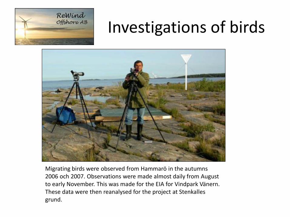
Investigations of birds
Migrating birds were observed from Hammarö in the autumns 2006 och 2007. Observations were made almost daily from August to early November. This was made for the EIA for Vindpark Vänern. These data were then reanalysed for the project at Stenkalles grund.

Direction of migration routes
The average direction of migrating birds is 206 degrees. Only 3 % of the birds take a route west of 245 degrees, and would pass over or through the windpower plant.
Direction of migration routes in autumn.
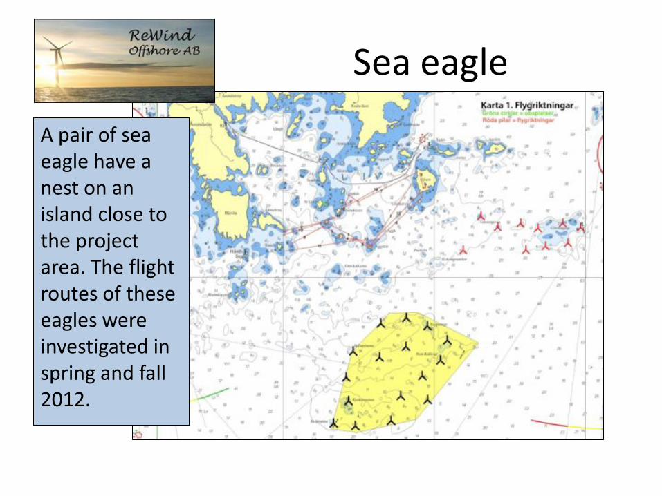
Sea eagle
A pair of sea eagle have a nest on an island close to the project area. The flight routes of these eagles were investigated in spring and fall 2012.

Bats
The presence of bats was investigated in july and september 2010 by the consultant Ecocom

Observation of bats
Observations of bats in northwestern part of lake
Vänern. Black boxes: autmatic registrations, red circles:
manual observations.
The investigation showed that there is some bat activity at sea, but that it is far less than at the coasts. At the point closest to the Rewind offshore project, only two observations (recordings) were made, both of Nordic bat. This sepcies is not endagered in Sweden. No indications of migration routes within the area were observed.
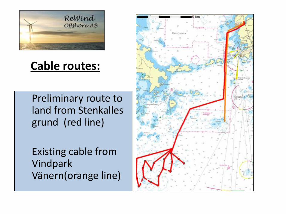
Cable routes:
Preliminary route to land from Stenkalles grund (red line)
Existing cable from Vindpark Vänern(orange line)

Cable connection to land and power grid
The cable will be installed at least 70 cm below ground level. The area on land is a so called Natura 2000 area. This is an EU-classification to protect valuable nature areas. Some extra investigations have to be made to get permission to exploit such areas.

Power line Gravel road
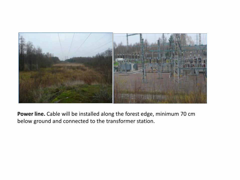
Power line. Cable will be installed along the forest edge, minimum 70 cm below ground and connected to the transformer station.

Cultural heritage
The coastal area around the Lake is an old cultural district. In the coastal area and Islands around the planned windpower plant there are about 150 registrered ancient remains on land from the iron age and later. On the bottom of the lake there are many wrecks.

Wreck indications
Wreck indications according to Swedish Maritime Museums are shown with blue symbols, indica-tions from Bohuslän’s museum are shown with brown symbols.

Mitigating measures
All marine archeological remains have been mapped. Wind turbines and cables will be installed so that these remains are avoided. The work area will have a buffer zone of min 100 m to the indicated remains.

Conclusion
Impacts on wrecks and other marine archeological remains can be avoided.
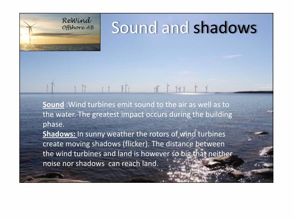
Sound and shadows
Sound :Wind turbines emit sound to the air as well as to the water. The greatest impact occurs during the building phase. Shadows: In sunny weather the rotors of wind turbines create moving shadows (flicker). The distance between the wind turbines and land is however so big that neither noise nor shadows can reach land.

Sound propagation
Calculations have been made for: 1. Windpower plant at Stenkalles grund
20 wind turbines Hub height 100 m
Sound effect 107,5 dBA. 2. Vindpark Vänern
3. Stenkalle + Vindpark Vänern total sound emission from both windpower plants
Calculation model: Nord2000

Sound immission
on land
Conclusion For all dwellings and noise sensitive areas the sound immission falls well below the recommended value of 40 dBA.
Beräknings- punkt X (m) Y (m)
Ekvivalent ljudnivå [Situation] Leq (dBA)
VPV SK VPV+
SK A - Örö Kl fritidsomr/småbåtshamn 397497 6553633 11 13 15
B - Gäddevik fritidsomr/småbåtshamn 394120 6564542 14 20 21
C - Arnäs udde 402666 6573299 26 23 28
D - Ö Korsön 409209 6576087 25 18 26
E - Takene, Hammarön bostad 414070 6571700 25 15 26
F - Hammarö Skage - Bostäder 414589 6569433 24 16 25

Obstruction lights
Light sources Light sources adapt the intensity (lumen) to the surrounding light, In the nighttime the obstruction lights will hardly be visible from land.

Visual impact

Visualisations
A
C D
E
B
F
Photo montages have been made from these view points: A. Skoghall, Hammarö kommun B. Hammarö sydspets, Hammarö kommun C. Axelön, Segerstads skärgård, Karlstad kommun D. Gubbskären, Segerstads skärgård, Karlstad kommun
E. Gäddnäs, Värmlandsnäs, Säffle kommun
F. Örö hamn, Värmlandsnäs, Säffle kommun

Hammarö sydspets
Fotomontage:
20 st G128 wind turbines
120 m hub height
128 m rotor diameter

Axelön
Fotomontage:
20 st G128
120 m hub height
128 m rotor diameter

Axelön
Fotomontage:
20 st G128
120 m hub height
128 m rotor diameter
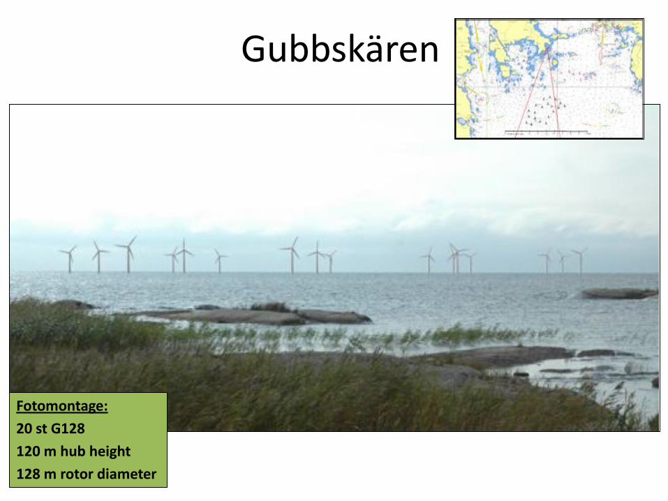
Gubbskären
Fotomontage:
20 st G128
120 m hub height
128 m rotor diameter
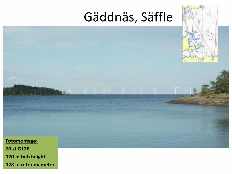
Gäddnäs, Säffle
Fotomontage:
20 st G128
120 m hub height
128 m rotor diameter

Örö, Säffle
Fotomontage:
20 st G128
120 m hub height
128 m rotor diameter

Visibility zones
In the Danish report Fremtidens Havvindmölleplaceringer 2025 the following zoning criteria are used for wind turbines with total heights of 160 m and 187,5 m:
Total height
Near zone Middle zone Distant zone
Max visibility
160 m 0-11 km 11-25 km >25 km 50 km
187,5 m 0-13 km 13-28 km >28 km 53 km

Visbility zones, definitions
Near zone: Wind turbines are clearly visible. Middle zone: Wind turbine towers and rotors blend and lose their shape and turbines seem to be far away. Distant zone: Hard to distinguish individual turbines and they partly disappear below the horizon. Impact on landscape is negligible. Max visibility: A distance of 55 km is an upper limit for the visibility of wind turbines.

Gäddnäs, Örö, Säffle From Gäddnäs, the wind turbines at Stenkalles grund will be in the near zone, and Vindpark Vänern in the middle zone. From Örö hamn both Stenkalles grund and Vindpark Vänern are in the middle zone.

Conclusions on visibility
The visual impact from the windpower plant at Stenkalles grund will be less than from Vindpark Vänern. The windpower plant at Stenkalles grund will be invisible during significant parts of the year from these view points, due to sight conditions, air humidity and long distances.

Environment policy
There are environment policy targets on several levels: National (Parliament, government) • 17 Environment quality targets • Generation target
Regional (County administration) • Environment quality norms • Environment and Climate strategy
Local (Municipality) • Policies for a sustainable municipality • Environment and Climate strategy ReWind has to prove that the proposed windpower plant promotes these policies

Environment impact
A windpower plant at Stenkalles grund will anually reduce emissions harmful for the environment with: A windpower plant at Stenkalles grund will thus have a significant positive impact on the environment This will promote all national, regional and local environment policies
Carbon dioxide 186 000 ton
SOx 200 ton
NOx 160 ton
Dust 22 ton
Ashes 1444 ton
Thank you