willoughton character appraisal - west-lindsey.gov.uk
TRANSCRIPT
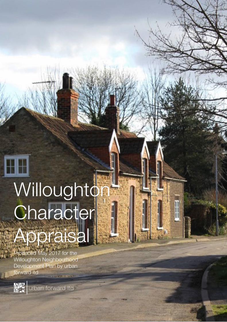
WilloughtonCharacterAppraisal
urban forward ltd
Produced May 2017 for the Willoughton Neighbourhood Development Plan by urban forward ltd

This report was produced in May 2017 for the Willoughton Neighbourhood Development Plan. It was produced by urban forward ltd. All graphics were produced in-house by urban forward ltd unless otherwise credited.
All content is © urban forward, but are free to reproduce. If you do, please cite your source.
Willoughton Character Appraisal
Section 1: About this document Purpose of this document Structure The study area Section 2: Village character About this section Relationship with the landscape ViewsontoandfromtheCliff Existing built up area Settlement Pattern Change over time Evolution of the village Dwelling types Orientation and solar gain Common design and detailing Green Lanes Keyfindingsandrecommendations Section 3: Character appraisal About this section Streets and spaces Vicarage Road North Lane / Church Road TemplefieldRoad/MiddleStreet TemplefieldRoad/HollowgateHill LongLane/HollowgateHill
Part 5: Appendices Appendix I: General design principles Appendix II: Manual for Streets Appendix III: Building for Life 12 Appendix Iv: Glossary of terms
Contents
123
7911131519212325272931
33353739414345
49596163
urban forward ltd

Willoughton Character Appraisal

urban forward ltd
1About this document
The purpose of this documentThis document has been produced to support the spatial strategy and design policies in the Willoughton Neighbourhood Development Plan. It should be read in conjunction with the Plan document, along with the documents outlined in the appendices.
Theintentionofthisdocumentistoenabledesignteamstomaketheirproposalsspecificto Willoughton, and to help avoid some of the common pitfalls associated with new development. The guidance within this document is not exhaustive, and we encourage design teams to undertake further studies should they wish to develop schemes within the village.
ThedistinctivelandscapeinthePlanareaisakeydefiningcharacteristicthatstronglyinformsthesenseofplacethatpeoplehavewhenvisitingthearea.Howthislandscapeinforms the character of the settlements is set out in this document.
It also provides guidance as to how to manage change in the village, including how the existing built form and green spaces can inform new development should it come forward.
Finally,anappendicesisincludedthatsetsoutgeneraldesignguidancethatreflectsbest practice and national policy, with key principles that all development should follow established.
1
Willoughton Character Appraisal
StructureThe document is set out in the following sections:
Section 1 sets out how to use the document, introduces the Plan area and explains the rationale behind the information contained within this Guide.
Section 2 explores the form of the settlement as a whole, looking at the way landscape influencesitsmorphology,howitissetout,howithaschangedovertime,anddesigndetails that are common throughout the village.
Section 3 looks at the character of the village, examining the aspects that make up its character and identity. This analysis is then translated into useful principles for future development, suggesting ways in which designers can ensure their proposals support rather than erode local distinctiveness.
Section 4 provides appendices, setting out suggested further reading and providing aglossaryofusefultermsanddefinitions.Italsoincludesgeneraldesignprinciples.Itlooks at nationally accepted place making design best practice, and established design approaches that should apply to all places, with some Plan area-wide recommendations. It also demonstrates how design is embedded in national policy and guidance, giving weight to the need to secure high quality design through the planning process.
urban forward ltd
2
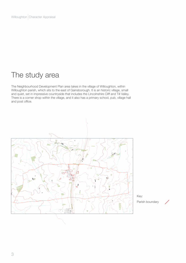
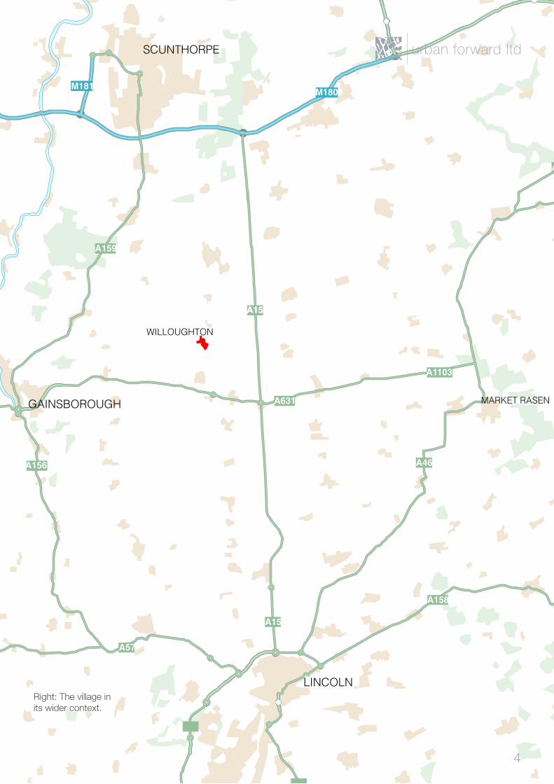
The study areaThe Neighbourhood Development Plan area takes in the village of Willoughton, within Willoughton parish, which sits to the east of Gainsborough. It is an historic village, small andquiet,setinimpressivecountrysidethatincludestheLincolnshireCliffandTillValley.There is a corner shop within the village, and it also has a primary school, pub, village hall andpostoffice.
Parish boundary
Key:
3
Willoughton Character Appraisal
M180
A1173
A46
A1103
A631
A15
A46
A15
A158
A57
A156
A159
A15
M180
M181
GAINSBOROUGH
LINCOLN
SCUNTHORPE
MARKET RASEN
WILLOUGHTON
Right: The village in its wider context.
urban forward ltd
4

Willoughton Character Appraisal

urban forward ltd
2 Village character
About this sectionThis section of the study aims to understand how the general character and identity of the village is formed. To do this, we examine how the village relates to its’ landscape setting, howtheextentofthebuiltupareacanbedefined,andwhatpatternthevillagehasformed. We then examine how the village has changed over time, and chart the evolution of the built environment of Willoughton.
We map the type and distribution of dwellings throughout the village, and then examine how dwellings sit in relation to passive solar gain. Finally, we examine village-wide design elements, common materials, and detailing.
This section is arranged as follows:
• Relationship with the landscape.
• Views onto and from theCliff
• Existing built up area.• Settlement pattern.• Change over time.• Evolution of the village.• Dwelling types.• Orientation and solar
gain.• Common design and
detailing.• Green lanes.
7
Willoughton Character Appraisal
urban forward ltd
8
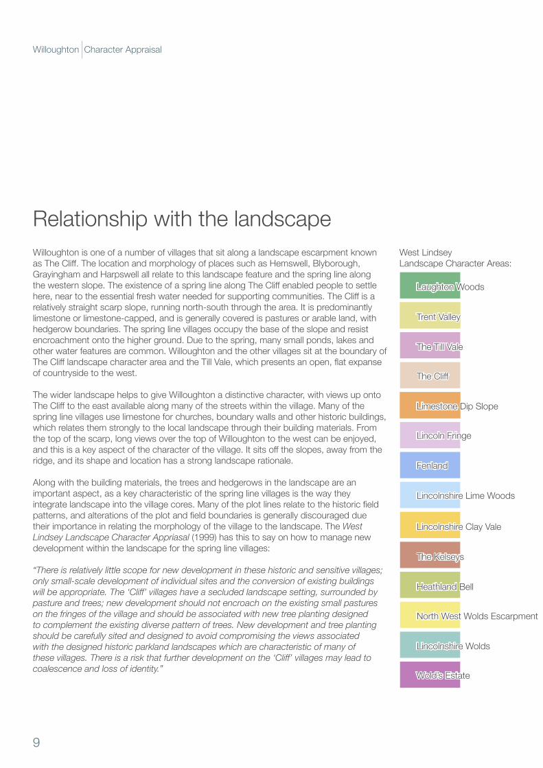
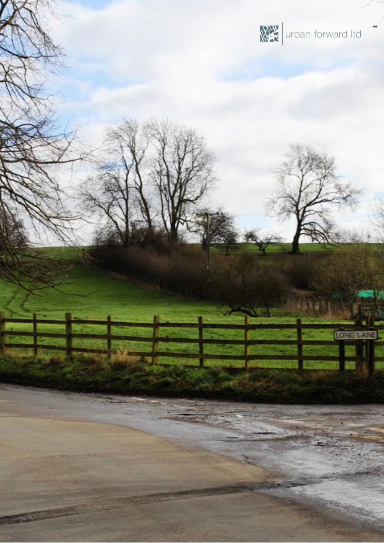
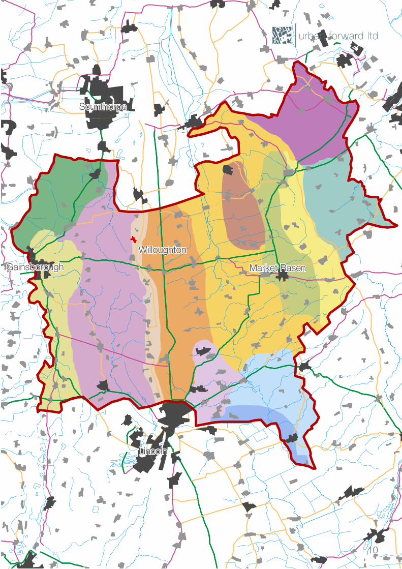
Willoughton is one of a number of villages that sit along a landscape escarpment known asTheCliff.ThelocationandmorphologyofplacessuchasHemswell,Blyborough,GrayinghamandHarpswellallrelatetothislandscapefeatureandthespringlinealongthewesternslope.TheexistenceofaspringlinealongTheCliffenabledpeopletosettlehere,neartotheessentialfreshwaterneededforsupportingcommunities.TheCliffisarelatively straight scarp slope, running north-south through the area. It is predominantly limestone or limestone-capped, and is generally covered is pastures or arable land, with hedgerow boundaries. The spring line villages occupy the base of the slope and resist encroachment onto the higher ground. Due to the spring, many small ponds, lakes and other water features are common. Willoughton and the other villages sit at the boundary of TheClifflandscapecharacterareaandtheTillVale,whichpresentsanopen,flatexpanseof countryside to the west.
The wider landscape helps to give Willoughton a distinctive character, with views up onto TheClifftotheeastavailablealongmanyofthestreetswithinthevillage.Manyofthespring line villages use limestone for churches, boundary walls and other historic buildings, which relates them strongly to the local landscape through their building materials. From the top of the scarp, long views over the top of Willoughton to the west can be enjoyed, andthisisakeyaspectofthecharacterofthevillage.Itsitsofftheslopes,awayfromtheridge, and its shape and location has a strong landscape rationale.
Along with the building materials, the trees and hedgerows in the landscape are an important aspect, as a key characteristic of the spring line villages is the way they integratelandscapeintothevillagecores.Manyoftheplotlinesrelatetothehistoricfieldpatterns,andalterationsoftheplotandfieldboundariesisgenerallydiscouragedduetheir importance in relating the morphology of the village to the landscape. The West Lindsey Landscape Character Appriasal (1999) has this to say on how to manage new development within the landscape for the spring line villages:
“There is relatively little scope for new development in these historic and sensitive villages; only small-scale development of individual sites and the conversion of existing buildings will be appropriate. The ‘Cliff’ villages have a secluded landscape setting, surrounded by pasture and trees; new development should not encroach on the existing small pastures on the fringes of the village and should be associated with new tree planting designed to complement the existing diverse pattern of trees. New development and tree planting should be carefully sited and designed to avoid compromising the views associated with the designed historic parkland landscapes which are characteristic of many of these villages. There is a risk that further development on the ‘Cliff’ villages may lead to coalescence and loss of identity.”
Relationship with the landscape
Laughton Woods
Trent Valley
The Till Vale
TheCliff
Limestone Dip Slope
Lincoln Fringe
Fenland
Lincolnshire Lime Woods
Lincolnshire Clay Vale
The Kelseys
HeathlandBell
North West Wolds Escarpment
Lincolnshire Wolds
Wold’s Estate
West Lindsey Landscape Character Areas:
9
Willoughton Character Appraisal
Laughton Woods
Trent Valley
The Till Vale
TheCliff
Limestone Dip Slope
Lincoln Fringe
Fenland
Lincolnshire Lime Woods
Lincolnshire Clay Vale
The Kelseys
HeathlandBell
North West Wolds Escarpment
Lincolnshire Wolds
Wold’s Estate
urban forward ltd
10
Gainsborough
Lincoln
Market Rasen
Willoughton
Scunthorpe
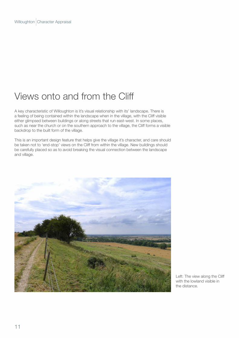
A key characteristic of Willoughton is it’s visual relationship with its’ landscape. There is afeelingofbeingcontainedwithinthelandscapewheninthevillage,withtheCliffvisibleeither glimpsed between buildings or along streets that run east-west. In some places, suchasnearthechurchoronthesouthernapproachtothevillage,theCliffformsavisiblebackdrop to the built form of the village.
This is an important design feature that helps give the village it’s character, and care should betakennotto‘end-stop’viewsontheClifffromwithinthevillage.Newbuildingsshouldbe carefully placed so as to avoid breaking the visual connection between the landscape and village.
ViewsontoandfromtheCliff
Left:TheviewalongtheCliffwith the lowland visible in the distance.
11
Willoughton Character Appraisal
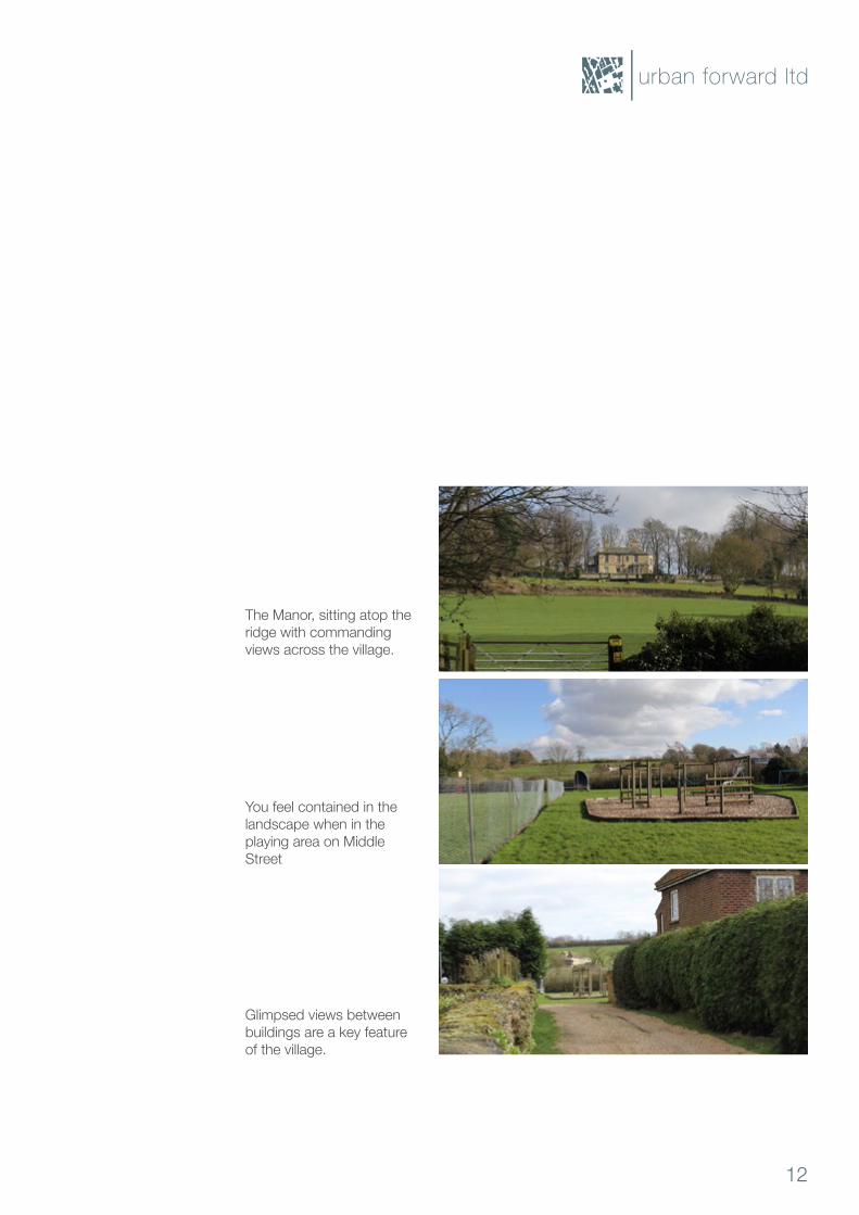
The Manor, sitting atop the ridge with commanding views across the village.
You feel contained in the landscape when in the playing area on Middle Street
Glimpsed views between buildings are a key feature of the village.
urban forward ltd
12
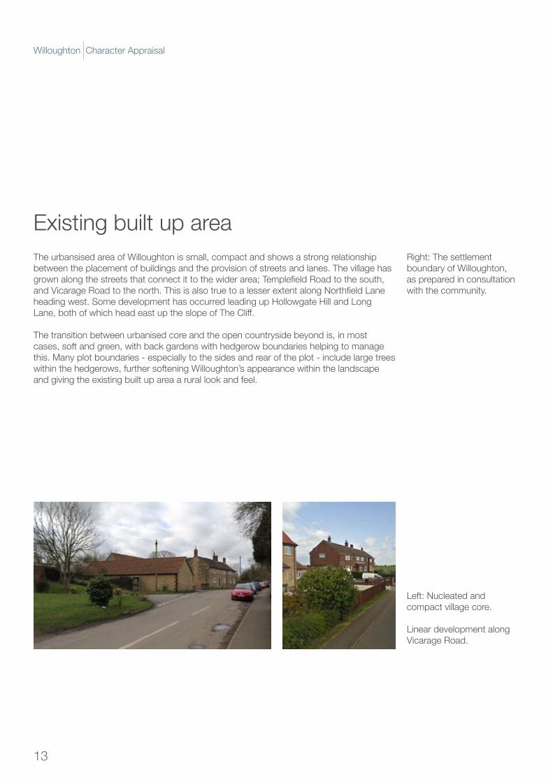
The urbansised area of Willoughton is small, compact and shows a strong relationship between the placement of buildings and the provision of streets and lanes. The village has grownalongthestreetsthatconnectittothewiderarea;TemplefieldRoadtothesouth,andVicarageRoadtothenorth.ThisisalsotruetoalesserextentalongNorthfieldLaneheadingwest.SomedevelopmenthasoccurredleadingupHollowgateHillandLongLane,bothofwhichheadeastuptheslopeofTheCliff.
The transition between urbanised core and the open countryside beyond is, in most cases, soft and green, with back gardens with hedgerow boundaries helping to manage this. Many plot boundaries - especially to the sides and rear of the plot - include large trees within the hedgerows, further softening Willoughton’s appearance within the landscape and giving the existing built up area a rural look and feel.
Existing built up areaRight: The settlement boundary of Willoughton, as prepared in consultation with the community.
Left: Nucleated and compact village core.
Linear development along Vicarage Road.
13
Willoughton Character Appraisal
urban forward ltd
14
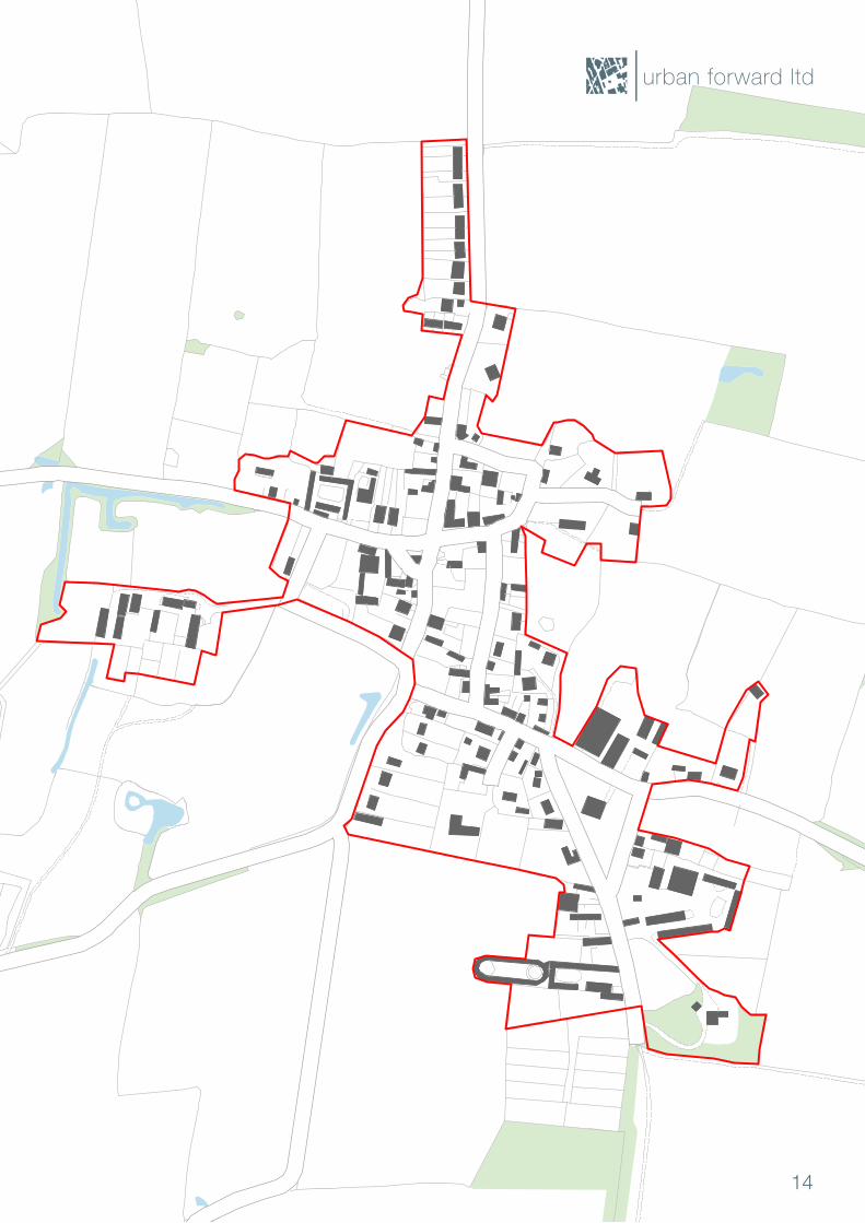
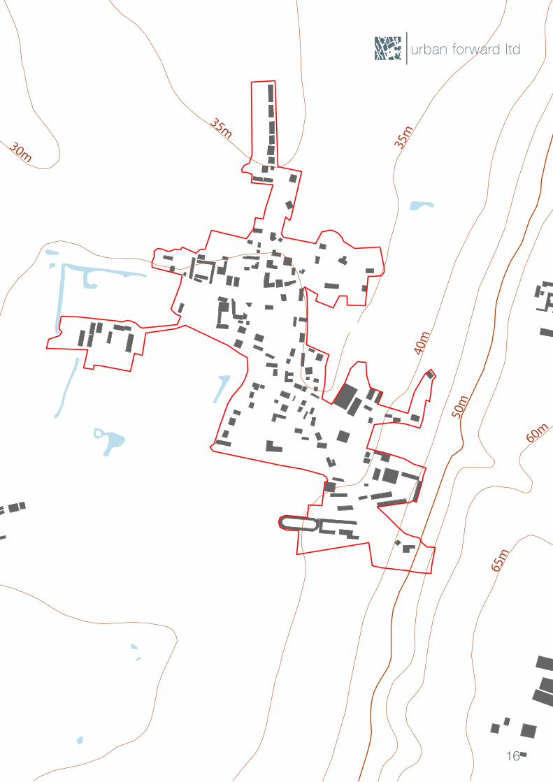
HistoricWilloughtonisapredominatelynucleatedsettlementanditsshapehasastrongrelationship with the underlying topography of the area. The main streets within the village, suchasTemplefieldRoadandMiddleStreet,runalongthelocalridgelines,paralleltoTheCliff.Wherestreetsrunagainstthetopography,theydosoperpendiculartotheslope.ChurchStreet,HollowgateHillandLongLaneallrundirectlyuptheslopetowardstheridge line, allowing for long and uninterrupted views to the high ground. These views and the way streets allow for them is an important characteristic of the village, giving it a rural feel with visual likes to the wider countryside.
The settlement pattern is essentially compact, with development clustered around the key junctionssuchaswhereTemplefieldRoadmeetswithHollowgateHillorwhereChurchStreet,NorthfieldLaneandVicarageRoadconvergeneartothewarmemorial.Somelinear development has occurred in the village, especially along Vicarage Road heading north towards Blyborough, but this is unusual and can be seen as a break from the historic and characteristic pattern. Note how the development here is very noticeable on the plan (opposite).
Beyond the main streets are small lanes that run along local ridges, which generates a distinctive relationship between the orientation of the streets and the local landforms. This relationship also allows for the formation of a deformed grid of interconnecting streets. Dead ends are uncommon in Willoughton, and this is an important lesson should future development require the formation of new streets and lanes.
Thefiguregrounddiagram(right)showsthatmoststreetsarewell‘constituted’bybuildings,withthelinesofthestreetsdiscerniblefromhowthebuildingsdefinetheiredges. This is an important lesson for new development should it occur; buildings having adiscerniblerelationshipwiththeirstreetisakeyfeatureofthevillage.However,therelationship between the buildings and streets in detail is complex, with many buildings not fronting onto streets in the traditional manner. This aspect is explored in more detail later in this section.
Settlement patternRight:A‘figureground’of Willoughton, showing buildings, topography and the settlement boundary.
15
Willoughton Character Appraisal
35m
30m
35m
35m30m
50m
40m
60m
65m
urban forward ltd
16
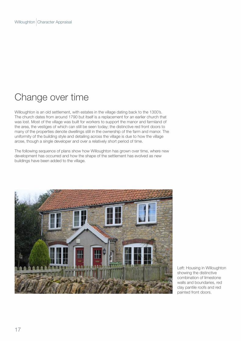
Willoughton is an old settlement, with estates in the village dating back to the 1300’s. The church dates from around 1790 but itself is a replacement for an earlier church that was lost. Most of the village was built for workers to support the manor and farmland of the area, the vestiges of which can still be seen today; the distinctive red front doors to many of the properties denote dwellings still in the ownership of the farm and manor. The uniformity of the building style and detailing across the village is due to how the village arose, though a single developer and over a relatively short period of time.
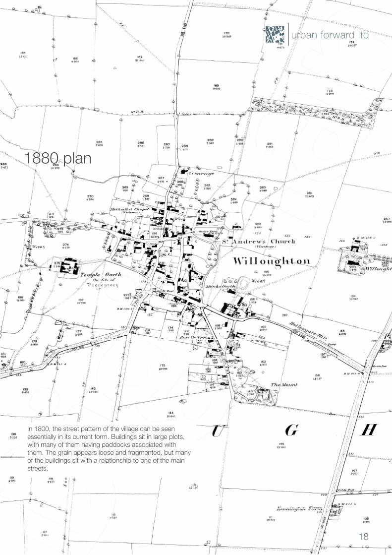
The following sequence of plans show how Willoughton has grown over time, where new development has occurred and how the shape of the settlement has evolved as new buildings have been added to the village.
Change over time
Left:HousinginWilloughtonshowing the distinctive combination of limestone walls and boundaries, red clay pantile roofs and red painted front doors.
17
Willoughton Character Appraisal
0 20 40 60 80 100 120 140 160 180 200 m
Mar 21, 2017 11:06Garry HallUniversity of Northampton
Projection: Brit ish National Grid
Scale 1:2500
© Landmark Information Group Ltd and Crown copyright 2017. FOR EDUCATIONAL USE ONLY.
In 1800, the street pattern of the village can be seen essentially in its current form. Buildings sit in large plots, with many of them having paddocks associated with them. The grain appears loose and fragmented, but many of the buildings sit with a relationship to one of the main streets.
1880 plan
urban forward ltd
18
0 20 40 60 80 100 120 140 160 180 200 m
Mar 21, 2017 11:09Garry HallUniversity of Northampton
Projection: Brit ish National Grid
Scale 1:2500
© Landmark Information Group Ltd and Crown copyright 2017. FOR EDUCATIONAL USE ONLY.
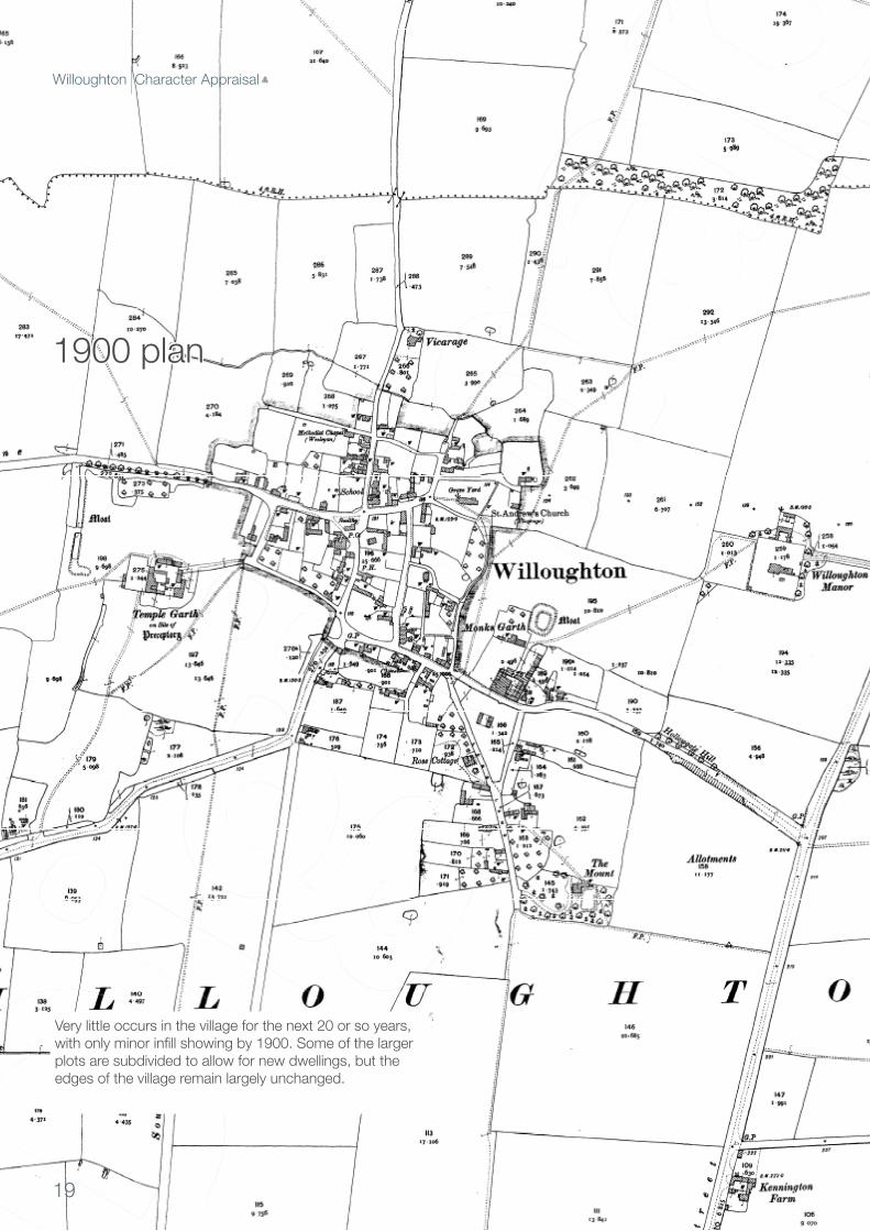
Very little occurs in the village for the next 20 or so years, withonlyminorinfillshowingby1900.Someofthelargerplots are subdivided to allow for new dwellings, but the edges of the village remain largely unchanged.
1900 plan
19
Willoughton Character Appraisal
0 20 40 60 80 100 120 140 160 180 200 m
Mar 21, 2017 11:09Garry HallUniversity of Northampton
Projection: Brit ish National Grid
Scale 1:2500
© Landmark Information Group Ltd and Crown copyright 2017. FOR EDUCATIONAL USE ONLY.
Garry HallUniversity of Northampton
0 50 100 150 200 250 300 350 400 450 500 mMay 13, 2017 16:23
Projection: Brit ish National Grid
Scale 1:7500
© Landmark Information Group Ltd and Crown copyright 2017. FOR EDUCATIONAL USE ONLY.
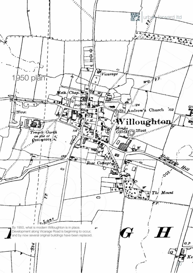
By 1950, what is modern Willoughton is in place. Development along Vicarage Road is beginning to occur, and by now several original buildings have been replaced.
1950 plan
urban forward ltd
20
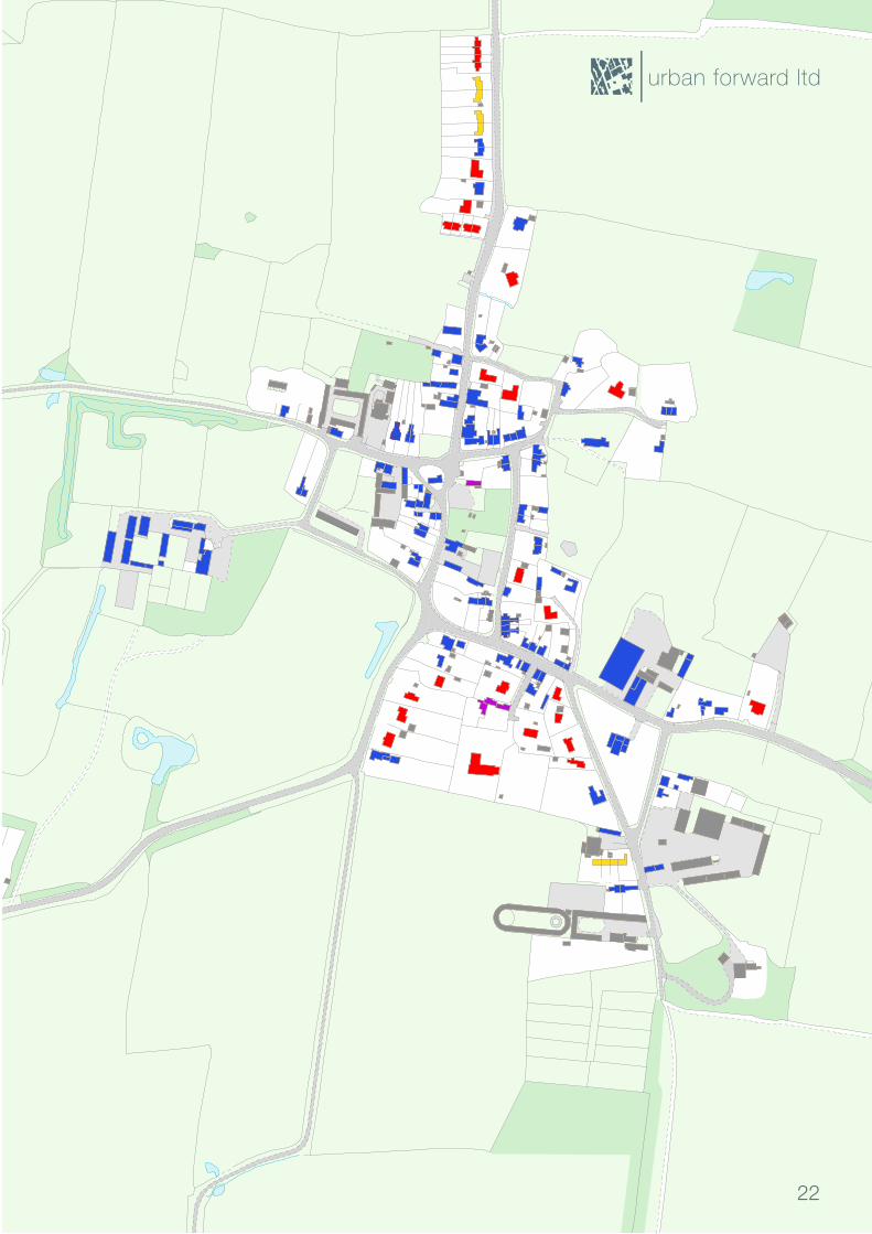
When tracking the evolution of Willoughton over time, a pattern starts to emerge; most ofthedevelopmenthasoccurredwithinthehistoricconfinesoftheoriginalvillage.Manyofthenewerbuildingsinthevillageareeitherreplacementsofpreviousonesorinfilldevelopment, occurring through plot sub-division.
Some of the recent additions to the village do not adhere to this approach. Some newer dwellings form the distinct spur to the north, where the village form becomes more linear along Vicarage Road. This is a noticeable break from the close, densely nucleated core of the village and is out of character in terms of growth patterns.
Thispatternofdensificationandinfillgivesimportantcluesastohowtomanageanyfuturegrowth in the village. New development should, where possible, be contained within the existing village curtilage. Past linear development has damaged the urban morphology of the village, and introduced alterations to the settlement pattern that are not in keeping with villages of this nature. Spring line villages have tight, nucleated patterns and this forms an essential part of their character.
Note: The plan opposite shows where new development was added to the village within a particulartimeperiod.However,someofthesebuildingshavebeenreplacedonthesameplot, making the buildings themselves newer than shown here.
Evolution of the village
1800
Key:
1900
1950
from 1950
Misc
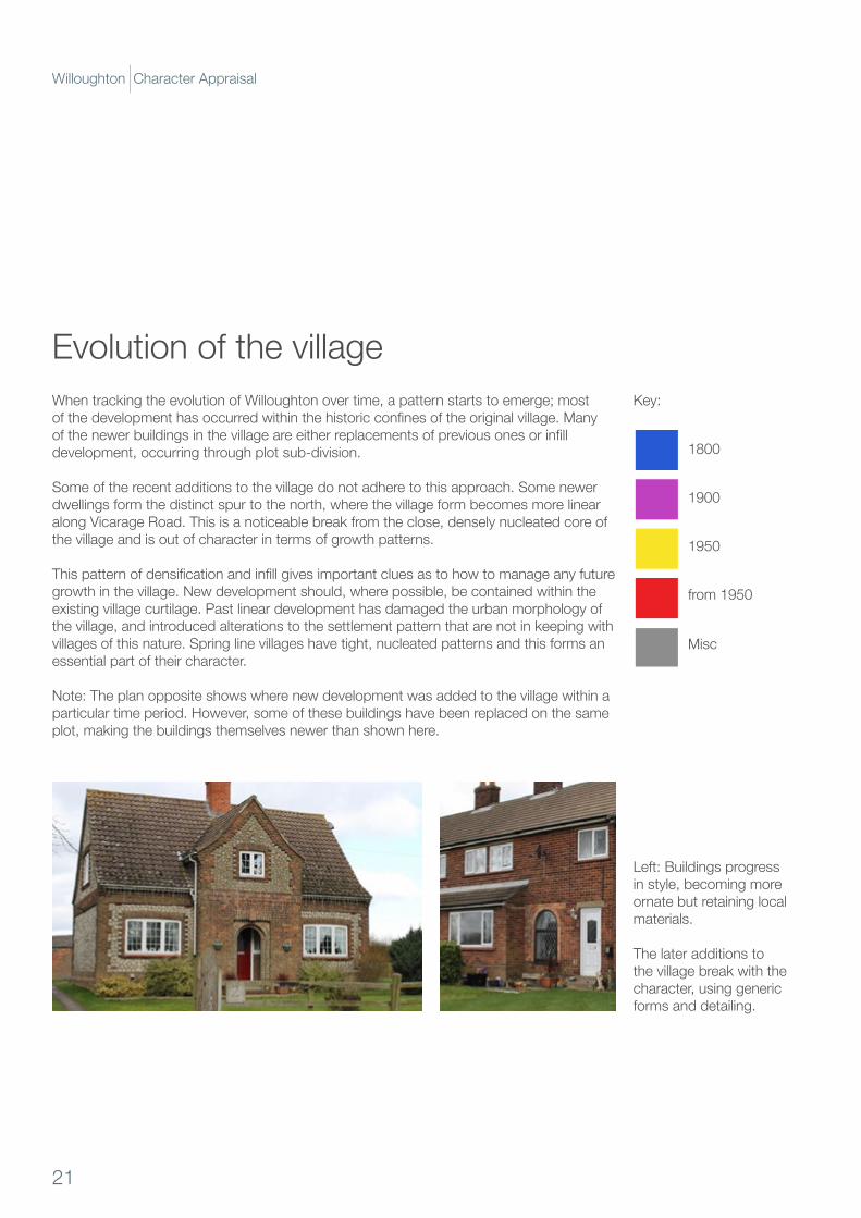
Left: Buildings progress in style, becoming more ornate but retaining local materials.
The later additions to the village break with the character, using generic forms and detailing.
21
Willoughton Character Appraisal
urban forward ltd
22

Dwelling typesThe type and distribution of dwellings within Willoughton is another key element to the character of the village. Many of the buildings within Willoughton are detached, sitting in large plots that often feature outbuildings. Semi-detached dwellings typify development from around the 1950’s, with replacement buildings in the village core subdividing plots to add more homes, or with linear development running to the north using this type.
A small number of terraces are present within the village, and these tend to be short - around three or four homes - and are mainly clustered around the village core.
ShouldnewdevelopmentoccurwithinWilloughton,densificationandbacklanddevelopment is arguably the most appropriate approach. Modern terraces and semi-detached units should be avoided, and instead the design should echo the proportions of the existing terraces, which tend to use wide-frontage units and low eves heights.
Semi-detached
Terraced
Detached
Non-domestic
Left: Semi-detached dwellings, possibly added through subdivision.
Detached properties commonplace from all eras.
23
Willoughton Character Appraisal
urban forward ltd
24
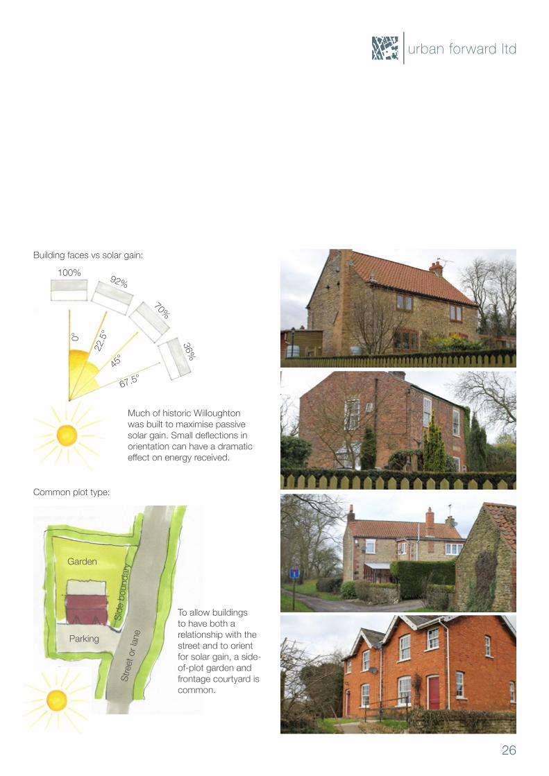
Orientation and solar gainAkeydefiningfeatureofWilloughtonisthewaybuildingsoccupytheirplots.Manybuildings use side-of-plot gardens, and present their building faces to internal courtyards rather than directly addressing the street (see photos, overleaf). This is almost certainly due to buildings being oriented to maximise passive solar gain.
Passive solar gain is process by which buildings use the sun’s energy to heat or cool their internalspaces.Historically,amajorcostofhomeownershipwouldhavebeentheheatingofbuildings,andsospecificdesignsweredevelopedthatharvestasmuchofthesunsenergyasispossibletoreducetheneedforextraheating.Typically,youfindthefollowingapproaches to enable this:
• For north-south streets, buildings use a deep plan and a narrow frontage, so that the room to the east gets some morning sun, and the room to the west catches the evening sun.
• For east-west streets, buildings use a shallow plan and a wide frontage, so that the longest edge of the building is always oriented to take advantage of solar heating.
Modern methods of construction and new heating technology have meant that, for several decades now, such careful attention to detail has not been necessary. Instead, building types are often deployed that do not respond to orientation, and this gives rise to the very uniformarrangementofplotsyouoftenfindinnewerdevelopment.
In Willoughton, many of the buildings are shallow plan, with a wide frontage that takes advantage of solar gain. This gives rise to a distinctive pattern of building and plot relationships, and any new development should seek to emulate this as it helps to generate the character of the settlement.
25
Willoughton Character Appraisal
100% 92%
70%
36%
0°
22.5
°
45°
67.5°
Building faces vs solar gain:
Common plot type:
Stre
et o
r lan
e
Side
bou
ndar
y
Parking
Garden
Much of historic Willoughton was built to maximise passive solargain.Smalldeflectionsinorientation can have a dramatic effectonenergyreceived.
To allow buildings to have both a relationship with the street and to orient for solar gain, a side-of-plot garden and frontage courtyard is common.
urban forward ltd
26
Common design and detailingThere are several design elements that combine to give Willoughton its’ character and identity. We have already discussed the way the village relates to its landscape setting, and how buildings sit within their plots.
At the more detailed level, the way boundaries are formed, the materials used and certain forms are commonalities within the village, helping to establish an overarching character to Willoughton.
The streets tend to be rural and informal in composition, with only the main streets having formalised footpaths, often only to one side. More common are green verges, with many of thebacklaneshavingsignificantvergestotheiredges.Thesurfacetreatmentsaresimpleand uncluttered, with few if any lines or marking.
Forboundaries,itiscommontofindeitherrubblestonewallsinlimestone,redbrick,orhedgerows with trees planted within them. These can range in height, but many of the green boundaries are tall and full. The walls tend to be around 1m in height.
Building forms vary considerably, but most use pitched roofs with a pitch of between 30° and 45°. Dormer type houses are common, giving an overall height of around 1.5 stories with accommodation in the roof space. Quoins and window surrounds in contrasting materials do feature, but are not always used. Most buildings have chimneys placed at the gable end of the roof with the stack integral to the end wall or centrally.
Limestonerubblewalls,withblockslaidflatincoursesarecommon,andthesecourses run to the corners and window surrounds of many dwellings. Red pantile is the predominantroofingmaterial,althoughsomenewerpropertieshaveslateorconcreteformed roof tiles. The pantile shape is a distinctive ‘fenland’, with an asymmetric single ridge and lip.
The colour palette is restrained, with white window frames, mainly red front doors and only very occasional render buildings.
27
Willoughton Character Appraisal
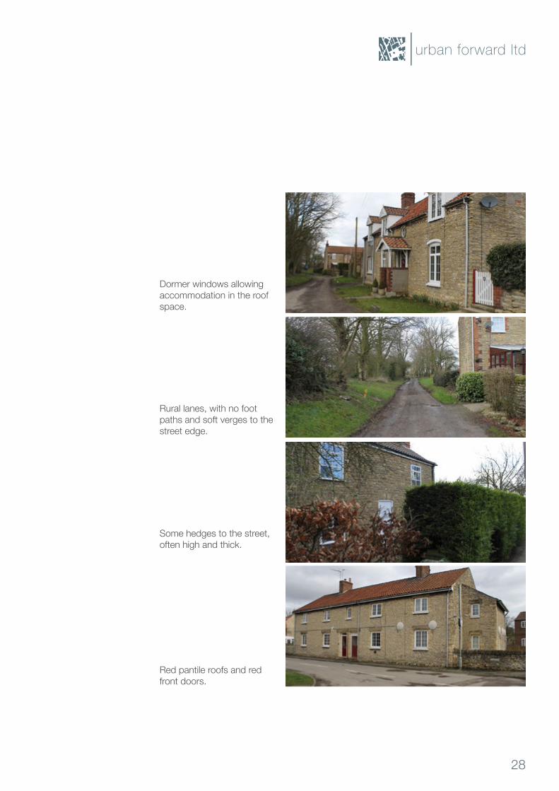
Dormer windows allowing accommodation in the roof space.
Rural lanes, with no foot paths and soft verges to the street edge.
Some hedges to the street, often high and thick.
Red pantile roofs and red front doors.
urban forward ltd
28
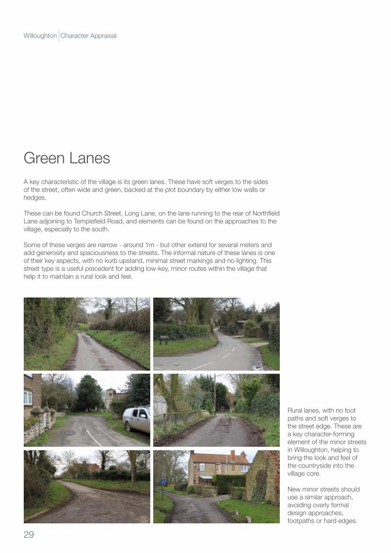
Green LanesA key characteristic of the village is its green lanes. These have soft verges to the sides of the street, often wide and green, backed at the plot boundary by either low walls or hedges.
ThesecanbefoundChurchStreet,LongLane,onthelanerunningtotherearofNorthfieldLaneadjoiningtoTemplefieldRoad,andelementscanbefoundontheapproachestothevillage, especially to the south.
Some of these verges are narrow - around 1m - but other extend for several meters and add generosity and spaciousness to the streets. The informal nature of these lanes is one of their key aspects, with no kurb upstand, minimal street markings and no lighting. This street type is a useful precedent for adding low-key, minor routes within the village that help it to maintain a rural look and feel.
Rural lanes, with no foot paths and soft verges to the street edge. These are a key character-forming element of the minor streets in Willoughton, helping to bring the look and feel of the countryside into the village core.
New minor streets should use a similar approach, avoiding overly formal design approaches, footpaths or hard edges.
29
Willoughton Character Appraisal
urban forward ltd
30
Willoughton Character Appraisal
HowWilloughtonrelatestoitswider landscape setting is key to understanding its character and identity.ItisoneofanumberofCliff‘springline’villages,whichhaveadistinctiverelationshipwiththelandforms.WilloughtonisplacedontheCliffslope,away from the ridge line. The pastures and trees within the village are important landscape character elements, giving the overall village its rural look and feel. Views into and across the landscape are an important part of the character of Willoughton, and should be maintained and enhanced.
The built up area has a strong relationship with the landscape, with the village nucleated around a core of interconnecting streets. Where new development in a linear form has been introduced, this has weakened the character of the village. New development should be confined to within the existing urbanised area and development lining the streets leading from the village into the countryside should be resisted. Views from and onto the Cliff need careful management, and new development should be arranged in a way that helps maintain visual connectivity between the village and landscape beyond.
Willoughton has a distinctive pattern of development over time, with plot subdivision and backland development more common than linearisation along main streets. This helps keep the village compact and walkable, and is a good precedent for adding new development should it be needed. Infill development is recommended rather than new estates, and these should be carefully placed so as not to compromise views and erode the rural look and feel of the lanes and streets.
Most of the buildings within the village are detached or semi-detached, with only a modest number of terraces. There is only a modest pattern of distribution, so any new development should avoid overly concentrating one type of building in any one area. Buildings sit on their plots in a way that relates to orientation to solar gain, and this gives the roofscape and plot distribution a characteristic that help define Willoughton. New development should be mindful of this factor, and plots and buildings should be oriented to help maximise passive solar gain.
Finally, a narrow range of materials, building detailing and boundary treatments help to give the village an overarching character. Limestone helps to give the character of the built form a relationship with the underlying landscape. Brick is less common, especially for the boundaries, but does feature on quoins and banding as well as on some later dwellings. Render is uncommon and where it is used, it appears out of character. Boundaries are hedges or walls, and mature garden trees are a key part of the village experience. Lanes with green boundaries or streets with soft verges are also important, and provide a useful precedent should designers look to add new streets to the village.
Keyfindingsandrecommendations

urban forward ltd
3 Characterappraisal
About this sectionThis section of the study aims to understand how the various elements that make up settlementscombinetoformabuiltenvironmentofdifferentcharacters.Muchismadeof the value of settlement character and identity, and a criticism often levelled at new development is that it lacks a distinctive character and does not speak ‘of its place’, instead looking much like anywhere else. Character and identity informs our experience of differentplacesandhelpsustodifferentiateonefromanother.Thevariouselementsthatmake up this image of a place are often shared between settlements, but with subtle but important variation. Variation within a settlement helps us to understand how a place is put together, which parts might be of interest for social and economic activities, which for moreprivatelivingetcandaffectsthequalityofexperiencewhenmovingbetweeneach.
As previously discussed, at the larger scale, settlement character is informed primarily by the landform and the landscape setting in which it sits. Topography, watercourse and other naturalelementshelpdefinetheshapeofthesettlements,andhowsettlementsinteractwiththeseelementsisakey‘firststep’indevelopingadistinctivecharacter.Howlinesof movement relate to underlaying natural features is the next ‘morphological layer’ that definescharacter.Howstreets,lanesandlineargreenelementsworkwithoragainstthelandform changes between places and can generate distinctiveness.
Commonalities in design between places exist at all levels, with shared spatial and detailing relationships giving a feeling of familiarity and ‘readability’ even for new places. At the scale of plots and buildings this is especially true, but boundary detailing, materials, architectural styles and ‘special’ spaces all combine to distinguish one place from another, or more commonly, one region of the country from another. Local materials and detailing areespeciallyimportantinthisregard,withvernacularelementsusuallydefinedbylocallysourcedbuildingmaterialsanddesignflourishesatthebuildinglevel.
The areas within village have features which distinguish them from one another and the aim of this section is to distil those to enable new development to maintain and enhance the feeling of character. To do this, each of the streets is analysed to break down its character-forming elements, so that new development can draw inspiration from local types and forms to embed the character of Willoughton into their design approach.
The analysis in this document has been prepared as a result of consultation with the Steering Group, and is set out to cover the following:
• Vicarage Road• North Lane / Church
Street• TemplefieldRoad/
Middle Street• TemplefieldRoad/
HollowgateHill• LongLane/Hollowgate
Hill
33
Willoughton Character Appraisal
urban forward ltd
34
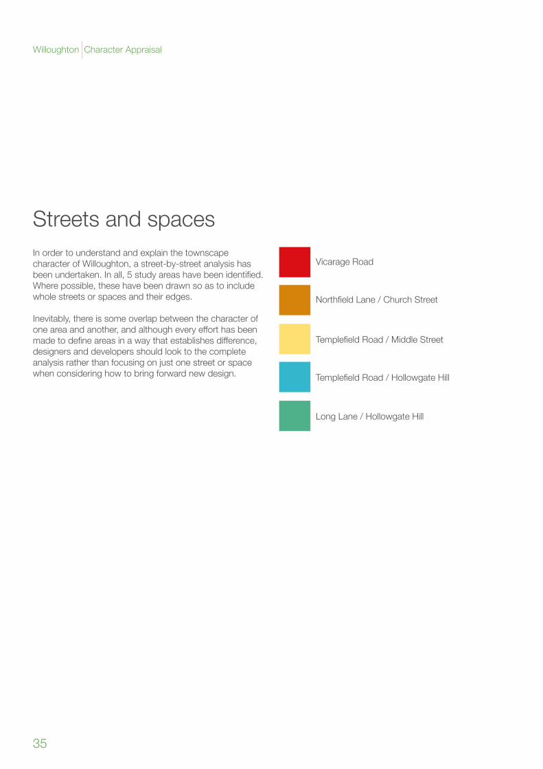
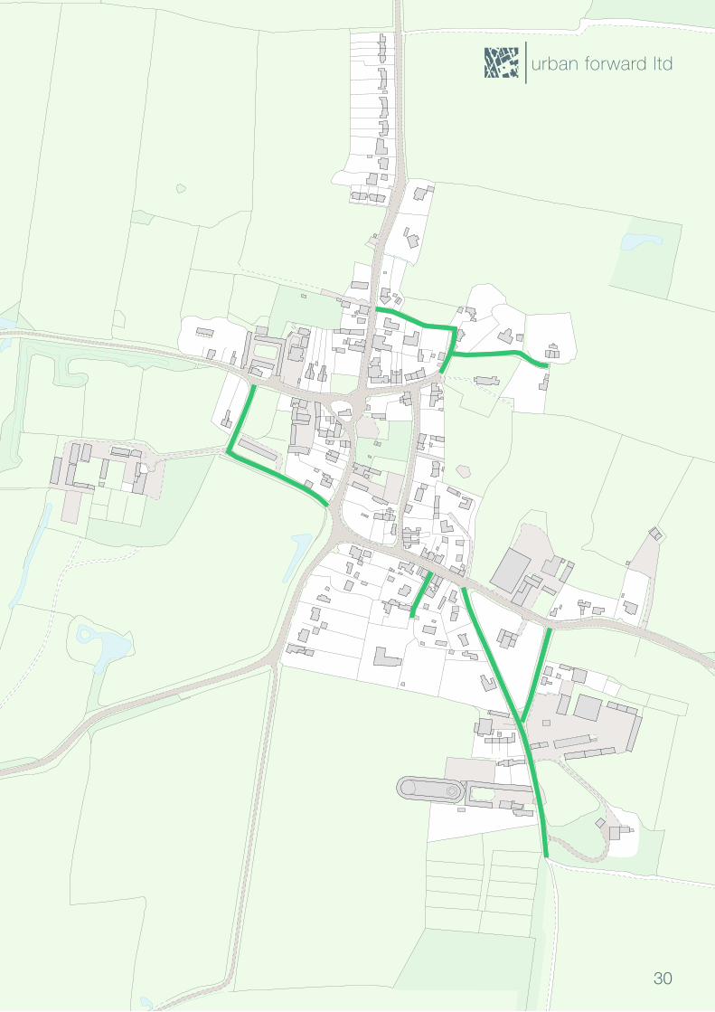
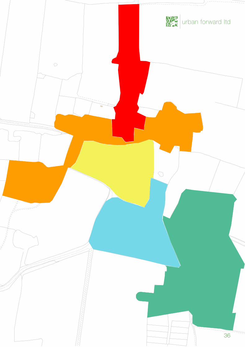
Streets and spacesIn order to understand and explain the townscape character of Willoughton, a street-by-street analysis has beenundertaken.Inall,5studyareashavebeenidentified.Where possible, these have been drawn so as to include whole streets or spaces and their edges.
Inevitably, there is some overlap between the character of oneareaandanother,andalthougheveryefforthasbeenmadetodefineareasinawaythatestablishesdifference,designers and developers should look to the complete analysis rather than focusing on just one street or space when considering how to bring forward new design.
Vicarage Road
NorthfieldLane/ChurchStreet
TemplefieldRoad/MiddleStreet
TemplefieldRoad/HollowgateHill
LongLane/HollowgateHill
35
Willoughton Character Appraisal
urban forward ltd
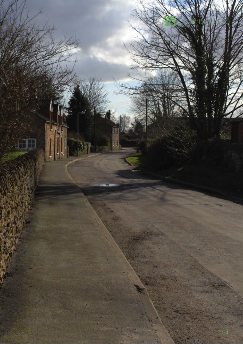
36
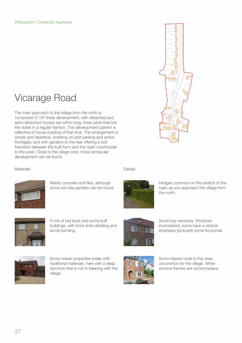
Vicarage RoadThe main approach to the village from the north is comprised of 19th linear development, with detached and semi-detached houses set within long, linear plots that line the street in a regular fashion. This development pattern is reflectiveofhousebuildingofthattime.Thearrangementissimple and repetitive, enabling on-plot parking and active frontages,andwithgardenstotherearofferingasofttransition between the built form and the open countryside to the west. Close to the village core, more vernacular development can be found.
Materials Details
Mainly concrete roof tiles, although some red clay pantiles can be found.
Some newer properties break with traditional materials, here with a deep red brick that is not in keeping with the village.
Amixofredbrickandsomebuffbuildings, with brick lintel detailing and some banding.
Hedgescommononthisstretchoftheroad, as you approach the village from the north.
Some hipped roofs in this area, uncommon for the village. White window frames are commonplace.
Some bay windows. Windows inconsistent; some have a vertical emphasis (pictured) some horizontal.
37
Willoughton Character Appraisal
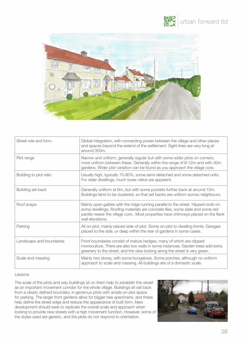
Street role and form. Global integration, with connecting power between the village and other places and spaces beyond the extend of the settlement. Sight lines are very long at around 300m.
Plot range Narrow and uniform, generally regular but with some wider plots on corners; more uniform between these. Generally within the range of 8-12m and with 30m gardens. Wider plot variation can be found as you approach the village core.
Building to plot ratio Usually high, typically 70-80%, some semi-detached and some detached units. For older dwellings, much lower ratios are apparent.
Building set back Generally uniform at 6m, but with some pockets further back at around 10m. Buildings tend to be clustered, so that set backs are uniform across neighbours.
Roof scape Mainlyopengableswiththeridgerunningparalleltothestreet.Hippedroofsonsomedwellings.Roofingmaterialsareconcretetiles,someslateandsomeredpantilenearerthevillagecore..Mostpropertieshavechimneysplacedontheflankwall elevations.
Parking All on-plot, mainly placed side-of-plot. Some on-plot to dwelling fronts. Garages placed to the side, or deep within the rear of gardens in some cases.
Landscape and boundaries Front boundaries consist of mature hedges, many of which are clipped monoculture. There are also low walls in some instances. Garden trees add extra greenery to the street, and the view looking along the street is very green.
Scale and massing Mainly two storey, with some bungalows. Some porches, although no uniform approach to scale and massing. All buildings are of a domestic scale.
Lessons
The scale of the plots and way buildings sit on them help to establish this street as an important movement corridor for the whole village. Buildings sit set back fromaclearlydefinedboundary,ingenerousplotswithampleon-plotspacefor parking. The larger front gardens allow for bigger tree specimens, and these helpdefinethestreetedgeandreducetheappearanceofbuiltform.Newdevelopment should seek to replicate the overall scale and approach when lookingtoprovidenewstreetswithahighmovementfunction.However,someofthe styles used are generic, and the plots do not respond to orientation.
urban forward ltd
38
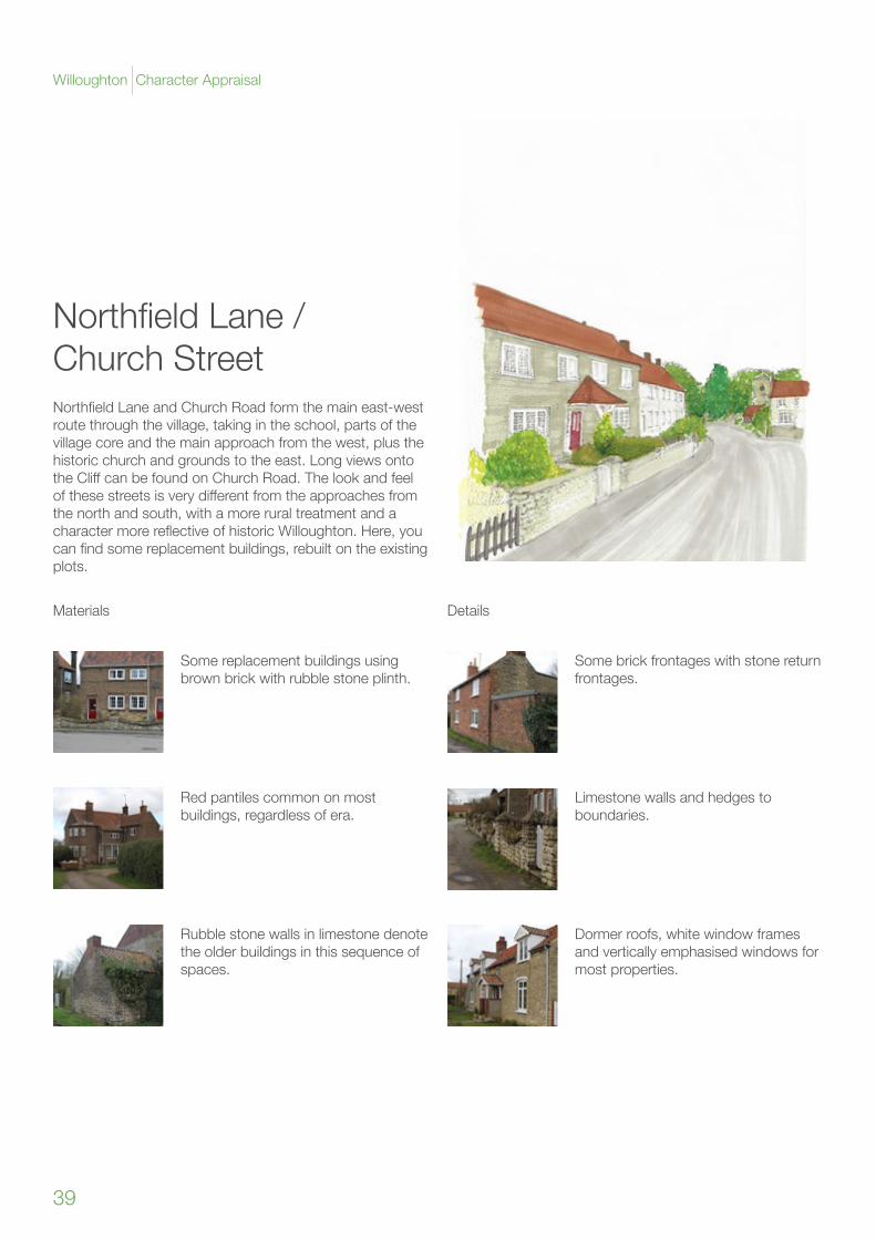
NorthfieldLane/Church StreetNorthfieldLaneandChurchRoadformthemaineast-westroute through the village, taking in the school, parts of the village core and the main approach from the west, plus the historic church and grounds to the east. Long views onto theCliffcanbefoundonChurchRoad.Thelookandfeelofthesestreetsisverydifferentfromtheapproachesfromthe north and south, with a more rural treatment and a charactermorereflectiveofhistoricWilloughton.Here,youcanfindsomereplacementbuildings,rebuiltontheexistingplots.
Materials Details
Some replacement buildings using brown brick with rubble stone plinth.
Red pantiles common on most buildings, regardless of era.
Rubble stone walls in limestone denote the older buildings in this sequence of spaces.
Some brick frontages with stone return frontages.
Dormer roofs, white window frames and vertically emphasised windows for most properties.
Limestone walls and hedges to boundaries.
39
Willoughton Character Appraisal
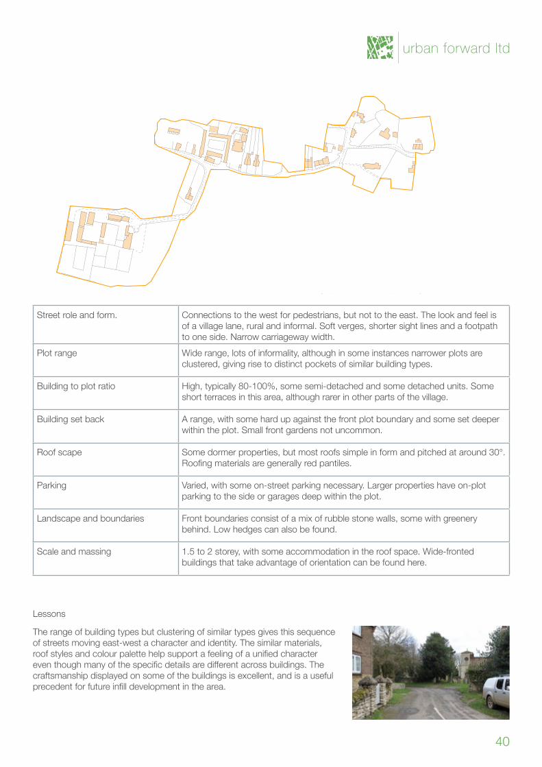
Street role and form. Connections to the west for pedestrians, but not to the east. The look and feel is of a village lane, rural and informal. Soft verges, shorter sight lines and a footpath to one side. Narrow carriageway width.
Plot range Wide range, lots of informality, although in some instances narrower plots are clustered, giving rise to distinct pockets of similar building types.
Building to plot ratio High,typically80-100%,somesemi-detachedandsomedetachedunits.Someshort terraces in this area, although rarer in other parts of the village.
Building set back A range, with some hard up against the front plot boundary and some set deeper within the plot. Small front gardens not uncommon.
Roof scape Some dormer properties, but most roofs simple in form and pitched at around 30°. Roofingmaterialsaregenerallyredpantiles.
Parking Varied, with some on-street parking necessary. Larger properties have on-plot parking to the side or garages deep within the plot.
Landscape and boundaries Front boundaries consist of a mix of rubble stone walls, some with greenery behind. Low hedges can also be found.
Scale and massing 1.5 to 2 storey, with some accommodation in the roof space. Wide-fronted buildings that take advantage of orientation can be found here.
Lessons
The range of building types but clustering of similar types gives this sequence of streets moving east-west a character and identity. The similar materials, roofstylesandcolourpalettehelpsupportafeelingofaunifiedcharactereventhoughmanyofthespecificdetailsaredifferentacrossbuildings.Thecraftsmanship displayed on some of the buildings is excellent, and is a useful precedentforfutureinfilldevelopmentinthearea.
urban forward ltd
40
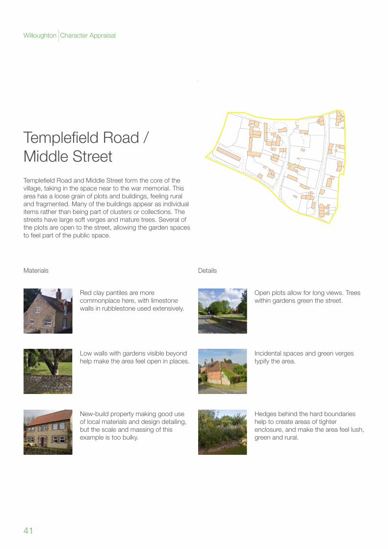
TemplefieldRoad/Middle StreetTemplefieldRoadandMiddleStreetformthecoreofthevillage, taking in the space near to the war memorial. This area has a loose grain of plots and buildings, feeling rural and fragmented. Many of the buildings appear as individual items rather than being part of clusters or collections. The streets have large soft verges and mature trees. Several of the plots are open to the street, allowing the garden spaces to feel part of the public space.
Materials Details
Red clay pantiles are more commonplace here, with limestone walls in rubblestone used extensively.
Low walls with gardens visible beyond help make the area feel open in places.
New-build property making good use of local materials and design detailing, but the scale and massing of this example is too bulky.
Open plots allow for long views. Trees within gardens green the street.
Hedgesbehindthehardboundarieshelp to create areas of tighter enclosure, and make the area feel lush, green and rural.
Incidental spaces and green verges typify the area.
41
Willoughton Character Appraisal
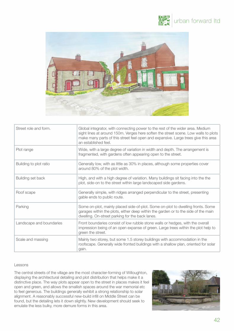
Street role and form. Global integrator, with connecting power to the rest of the wider area. Medium sight lines at around 150m. Verges here soften the street scene. Low walls to plots make many parts of this street feel open and expansive. Large trees give this area an established feel.
Plot range Wide, with a large degree of variation in width and depth. The arrangement is fragmented, with gardens often appearing open to the street.
Building to plot ratio Generally low, with as little as 30% in places, although some properties cover around 80% of the plot width.
Building set back High,andwithahighdegreeofvariation.Manybuildingssitfacingintothetheplot, side-on to the street within large landscaped side gardens.
Roof scape Generally simple, with ridges arranged perpendicular to the street, presenting gable ends to public route.
Parking Some on-plot, mainly placed side-of-plot. Some on-plot to dwelling fronts. Some garages within the plots, either deep within the garden or to the side of the main dwelling. On-street parking for the back lanes.
Landscape and boundaries Front boundaries consist of low rubble stone walls or hedges, with the overall impression being of an open expanse of green. Large trees within the plot help to green the street.
Scale and massing Mainly two storey, but some 1.5 storey buildings with accommodation in the roofscape. Generally wide fronted buildings with a shallow plan, oriented for solar gain.
Lessons
The central streets of the village are the most character-forming of Willoughton, displaying the architectural detailing and plot distribution that helps make it a distinctive place. The way plots appear open to the street in places makes it feel open and green, and allows the smallish spaces around the war memorial etc to feel generous. The buildings generally exhibit a strong relationship to solar alignment.Areasonablysuccessfulnew-buildinfillonMiddleStreetcanbefound, but the detailing lets it down slightly. New development should seek to emulate the less bulky, more demure forms in this area.
urban forward ltd
42
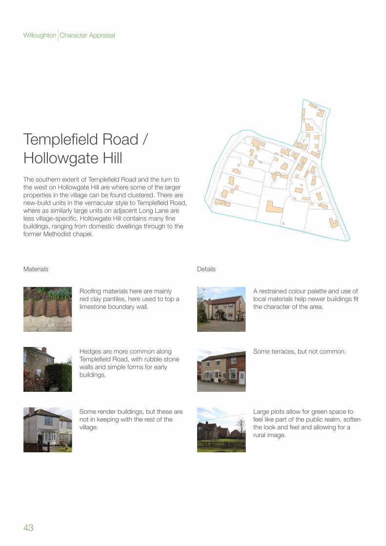
TemplefieldRoad/HollowgateHillThesouthernextentofTemplefieldRoadandtheturntothewestonHollowgateHillarewheresomeofthelargerproperties in the village can be found clustered. There are new-buildunitsinthevernacularstyletoTemplefieldRoad,where as similarly large units on adjacent Long Lane are lessvillage-specific.HollowgateHillcontainsmanyfinebuildings, ranging from domestic dwellings through to the former Methodist chapel.
Materials Details
Roofingmaterialsherearemainlyred clay pantiles, here used to top a limestone boundary wall.
HedgesaremorecommonalongTemplefieldRoad,withrubblestonewalls and simple forms for early buildings.
Some render buildings, but these are not in keeping with the rest of the village.
A restrained colour palette and use of localmaterialshelpnewerbuildingsfitthe character of the area.
Large plots allow for green space to feel like part of the public realm, soften the look and feel and allowing for a rural image.
Some terraces, but not common.
43
Willoughton Character Appraisal
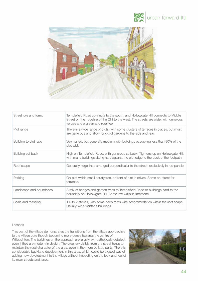
Street role and form. TemplefieldRoadconnectstothesouth,andHollowgateHillconnectstoMiddleStreetontheridgelineoftheClifftothewest.Thestreetsarewide,withgenerousverges and a green and rural feel.
Plot range There is a wide range of plots, with some clusters of terraces in places, but most are generous and allow for good gardens to the side and rear.
Building to plot ratio Very varied, but generally medium with buildings occupying less than 80% of the plot width.
Building set back HighonTemplefieldRoad,withgeneroussetback.TightensuponHollowgateHill,with many buildings sitting hard against the plot edge to the back of the footpath.
Roof scape Generally ridge lines arranged perpendicular to the street, exclusively in red pantile.
Parking On-plot within small courtyards, or front of plot in drives. Some on-street for terraces.
Landscape and boundaries AmixofhedgesandgardentreestoTemplefieldRoadorbuildingshardtotheboundaryonHollowgateHill.Somelowwallsinlimestone.
Scale and massing 1.5 to 2 stories, with some deep roofs with accommodation within the roof scape. Usually wide-frontage buildings.
Lessons
This part of the village demonstrates the transitions from the village approaches to the village core though becoming more dense towards the centre of Willoughton. The buildings on the approach are largely sympathetically detailed, even if they are modern in design. The greenery visible from the street helps to maintain the rural character of the area, even in the more built up parts. There is considerable backland development in this area, which could be a good way of adding new development to the village without impacting on the look and feel of its main streets and lanes.
urban forward ltd
44
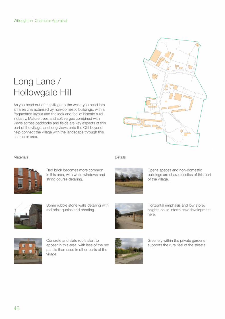
Long Lane / HollowgateHillAs you head out of the village to the west, you head into an area characterised by non-domestic buildings, with a fragmented layout and the look and feel of historic rural industry. Mature trees and soft verges combined with viewsacrosspaddocksandfieldsarekeyaspectsofthispartofthevillage,andlongviewsontotheCliffbeyondhelp connect the village with the landscape through this character area.
Materials Details
Red brick becomes more common in this area, with white windows and string course detailing.
Some rubble stone walls detailing with red brick quoins and banding.
Concrete and slate roofs start to appear in this area, with less of the red pantile than used in other parts of the village.
Opens spaces and non-domestic buildings are characteristics of this part of the village.
Greenery within the private gardens supports the rural feel of the streets.
Horizontalemphasisandlowstoreyheights could inform new development here.
45
Willoughton Character Appraisal
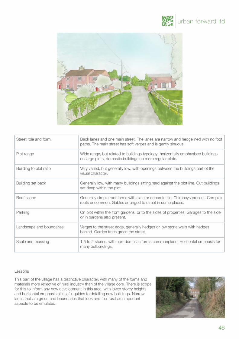
Street role and form. Back lanes and one main street. The lanes are narrow and hedgelined with no foot paths. The main street has soft verges and is gently sinuous.
Plot range Wide range, but related to buildings typology; horizontally emphasised buildings on large plots, domestic buildings on more regular plots.
Building to plot ratio Very varied, but generally low, with openings between the buildings part of the visual character.
Building set back Generally low, with many buildings sitting hard against the plot line. Out buildings set deep within the plot.
Roof scape Generally simple roof forms with slate or concrete tile. Chimneys present. Complex roofs uncommon. Gables arranged to street in some places.
Parking On plot within the front gardens, or to the sides of properties. Garages to the side or in gardens also present.
Landscape and boundaries Verges to the street edge, generally hedges or low stone walls with hedges behind. Garden trees green the street.
Scale and massing 1.5to2stories,withnon-domesticformscommonplace.Horizontalemphasisformany outbuildings.
Lessons
This part of the village has a distinctive character, with many of the forms and materialsmorereflectiveofruralindustrythanofthevillagecore.Thereisscopefor this to inform any new development in this area, with lower storey heights and horizontal emphasis all useful guides to detailing new buildings. Narrow lanes that are green and boundaries that look and feel rural are important aspects to be emulated.
urban forward ltd
46

Willoughton Character Appraisal

urban forward ltd
4 Appendices
Appendix I: The importance of good designAlthough the primary purpose of this document is to examine the character and identity of Willoughton Village, it is important that any new development, should it occur, addresses every aspect of design best practice.
Good design is about more than just aesthetics; well-designed places let people have better lives by making places safe, easy to move through, economically and socially vibrant, and robust against climate change. Although this document focuses primarily on landscape in terms of how it informs local distinctiveness, all elements of good design best practice should be considered together.
Designhasaroletoplayinallaspectsofhowaplacefunctions;itinfluencesthemovement economy (the economic activities that rely on footfall and passing trade), the level of walking and cycling, the way in which people can meet and socialise, where people can take recreation and leisure activities and the levels of crime within any given area.
Howaneighbourhoodisconnectedtoitssurroundingsisanextremelyimportantfactorwhen determining the likelihood of residents from that area walking and cycling. Research has shown that poorly connected neighbourhoods have far lower walking and cycling trips than those that integrate well with local shops and other facilities, which in turn leads to moretraffic,poorerairqualityandhigherhealthproblemsforpeoplelivingthere.
Designs that incorporate natural and existing site features into their layout help retain character and identity as well as helping to maintain ecology and biodiversity. If managed welland‘designedin’,floodpreventionmeasurescanbeofrealamenityvaluetolocalpeople and a habitat for wildlife.
Buildingsthatdonotproperlymanagepublicandprivatespaceofferpoorerqualitylivingenvironments for residents, and cannot provide the levels of overlooking needed to make public spaces safe to use. Public spaces which are not overlooked are often sites of antisocial behaviour and are not usable for play and leisure.
However,welldesignedopenspaceincreasespeople’slevelsofexerciseandgivespeoplespaces to meet and socialise. Embedding character into new development helps an area as a whole be more recognisable, and helps to maintain links to a place’s history.
Getting things wrong is extremely costly, as many design mistakes last a very long time, having impacts that extend for decades and which can be expensive to rectify. That is why it is critical to embed good design from the outset and to make sure that all new development follows urban design best practice.
49
Willoughton Character Appraisal
Good quality design is an integral part of sustainable development. The National Planning Policy Framework recognises that design quality matters and that planning should drive up standards across all forms of development. As a core planning principle, plan-makers and decision takers should always seek to secure high quality design.
Source: PPG: Design (2015)
“
”
urban forward ltd
50
Working with the siteWorking with what you have on site enables new developments to make the most of their setting, embedding existing landscape and other natural features into the design in a way that helps maintain links to the history of the area whilst retaining the character of the site.
New development in the Plan area should seek to work with the landscape, retaining importanttreesandotherecologicalfeaturesandusingthetopographytoinfluencethealignment of streets.
Existing trees and vegetation should, where practical, be retained in such a way as to add visual amenity and ecological value to the development. Existing trees and hedges cangivenewdevelopmentamaturelookandfeel,andthisaddsvalue.However,difficultto maintain or manage greenery should be avoided, as this has the potential to cause problems in the future.
Surface water should be managed in a way that enhances the public realm and provides habitat for wildlife. Sustainable Urban Drainage (SUDs) have the potential to add extra character and amenity to developments but must be considered at the outset along with thedesignofstreetsandotherspacesratherthanretrofittedasanadd-on.
A system of open and green spaces that respect natural features and are easily accessible can be a valuable local resource and helps create successful places. A high quality landscape, including trees and semi-natural habitats where appropriate, makes an important contribution to the quality of an area.
Source: PPG: Design (2015)
“
”
51
Willoughton Character Appraisal
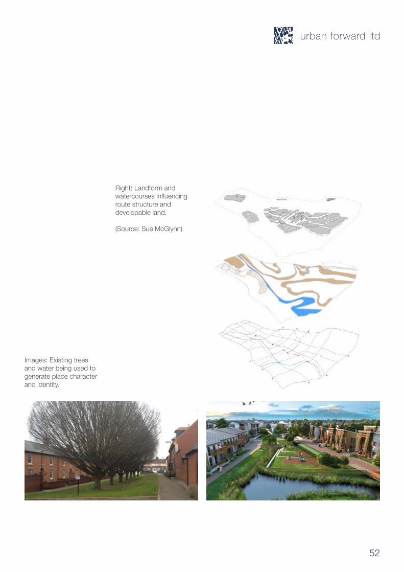
Right: Landform and watercoursesinfluencingroute structure and developable land. (Source: Sue McGlynn)
Images: Existing trees and water being used to generate place character and identity.
urban forward ltd
52
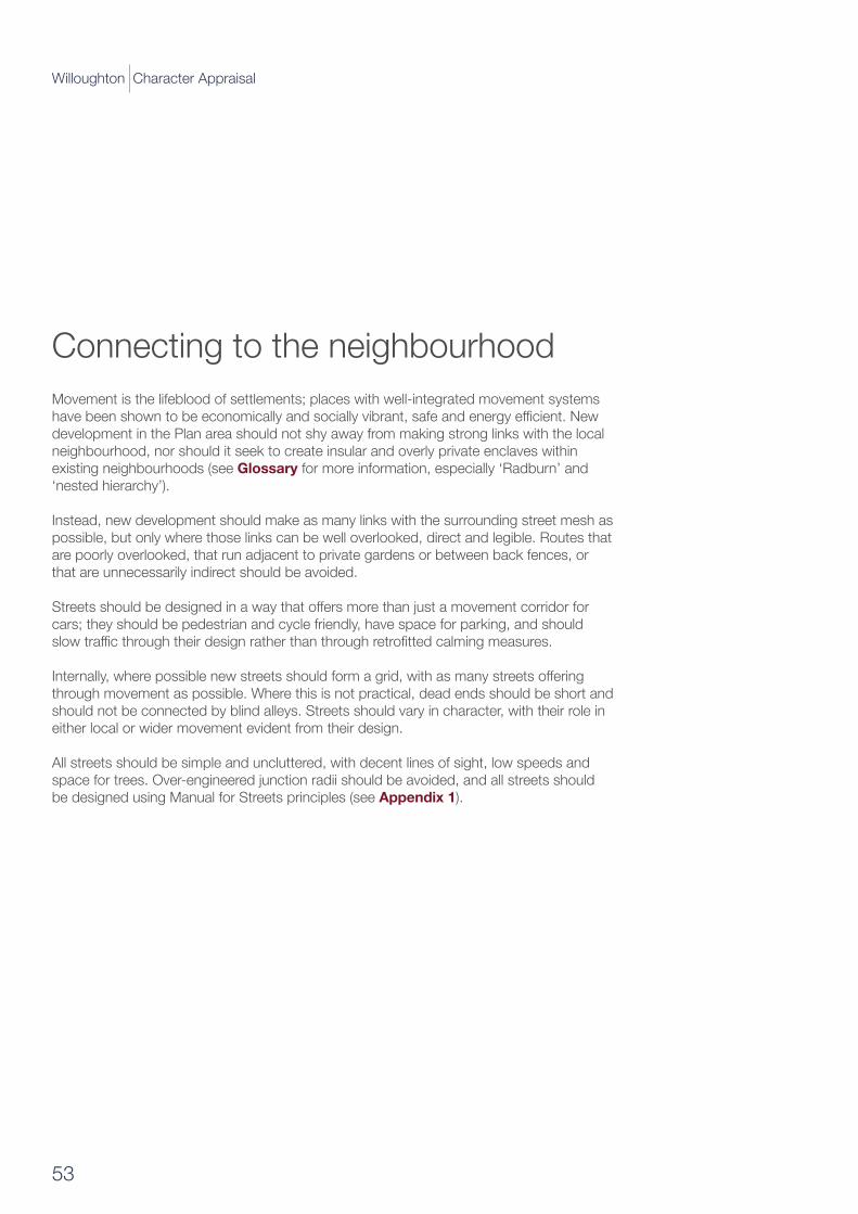
Connecting to the neighbourhoodMovement is the lifeblood of settlements; places with well-integrated movement systems havebeenshowntobeeconomicallyandsociallyvibrant,safeandenergyefficient.Newdevelopment in the Plan area should not shy away from making strong links with the local neighbourhood, nor should it seek to create insular and overly private enclaves within existing neighbourhoods (see Glossary for more information, especially ‘Radburn’ and ‘nested hierarchy’).
Instead, new development should make as many links with the surrounding street mesh as possible, but only where those links can be well overlooked, direct and legible. Routes that are poorly overlooked, that run adjacent to private gardens or between back fences, or that are unnecessarily indirect should be avoided.
Streetsshouldbedesignedinawaythatoffersmorethanjustamovementcorridorforcars; they should be pedestrian and cycle friendly, have space for parking, and should slowtrafficthroughtheirdesignratherthanthroughretrofittedcalmingmeasures.
Internally,wherepossiblenewstreetsshouldformagrid,withasmanystreetsofferingthrough movement as possible. Where this is not practical, dead ends should be short and should not be connected by blind alleys. Streets should vary in character, with their role in either local or wider movement evident from their design.
All streets should be simple and uncluttered, with decent lines of sight, low speeds and space for trees. Over-engineered junction radii should be avoided, and all streets should be designed using Manual for Streets principles (see Appendix 1).
“
53
Willoughton Character Appraisal
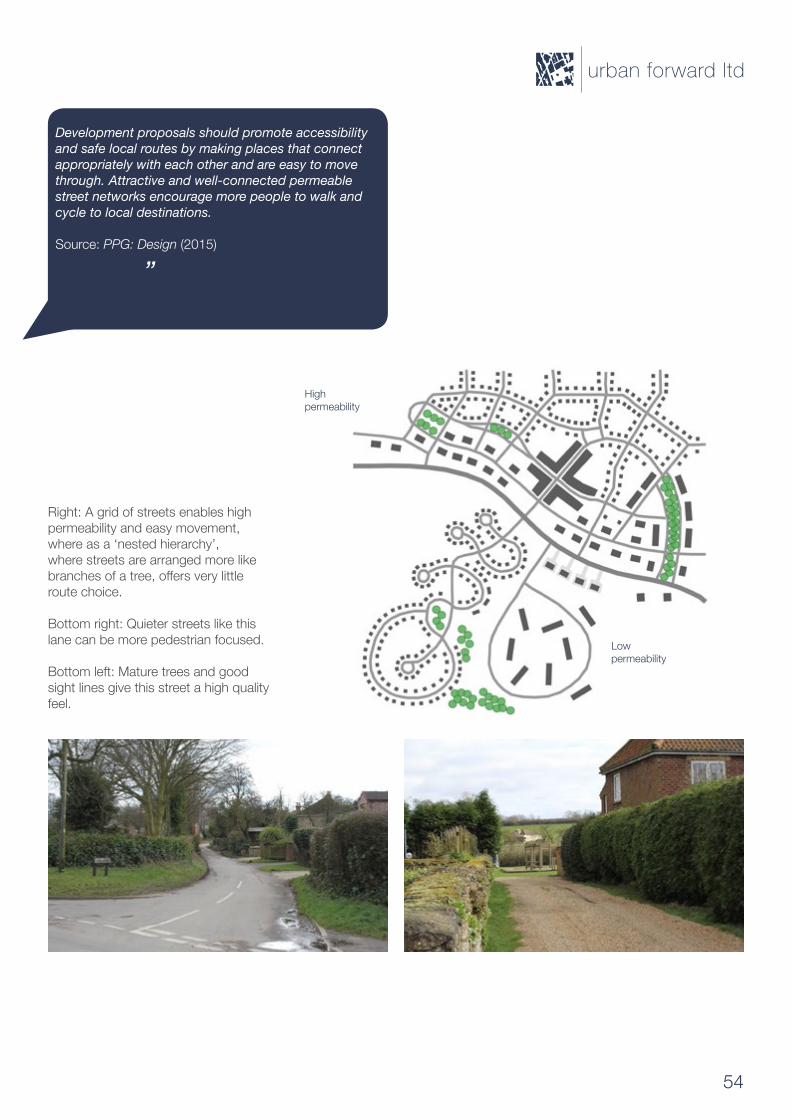
Development proposals should promote accessibility and safe local routes by making places that connect appropriately with each other and are easy to movethrough. Attractive and well-connected permeable street networks encourage more people to walk and cycle to local destinations.
Source: PPG: Design (2015)
”
Right: A grid of streets enables high permeability and easy movement, where as a ‘nested hierarchy’, where streets are arranged more like branchesofatree,offersverylittleroute choice.
Bottom right: Quieter streets like this lane can be more pedestrian focused.
Bottom left: Mature trees and good sight lines give this street a high quality feel.
Highpermeability
Low permeability
urban forward ltd
54
Making a place
Development should seek to promote character in townscape and landscape by responding to and reinforcing locally distinctive patterns of development, local man-made and natural heritage and culture, while not preventing or discouraging appropriate innovation.
Source: PPG: Design (2015)
All new development in the Plan area should seek to promote local character and identity, because through doing so it is possible to protect and enhance what is already there for existing residents, and provide community and social cohesion for those new to the area.
A criticism often levelled at new development is that it ‘lacks character’, with many new developments looking generic despite the wide range of building types and materials used. Often this is due to overly standardised approaches to streets and spaces, where verylittleroomisgivenforthetypesofinnovationthatallowoneplacetobedifferentfromanother. Also, too wide a range of materials and styles can confuse the identity of new development, with the lack of a coherent approach weakening the overall visual quality and diluting the overall character.
Tomaintainlocaldistinctiveness,newdevelopmentshouldbereflectiveoflocalaspectssuch as:
• the local landform and the way development sits upon it• the local pattern of streets, blocks and the dimension of plots• development style and vernacular• built forms, massing, details and materials (including street furniture and boundaries)
Developers should demonstrate how they have embedded local character in their Design and Access Statement.
“
”
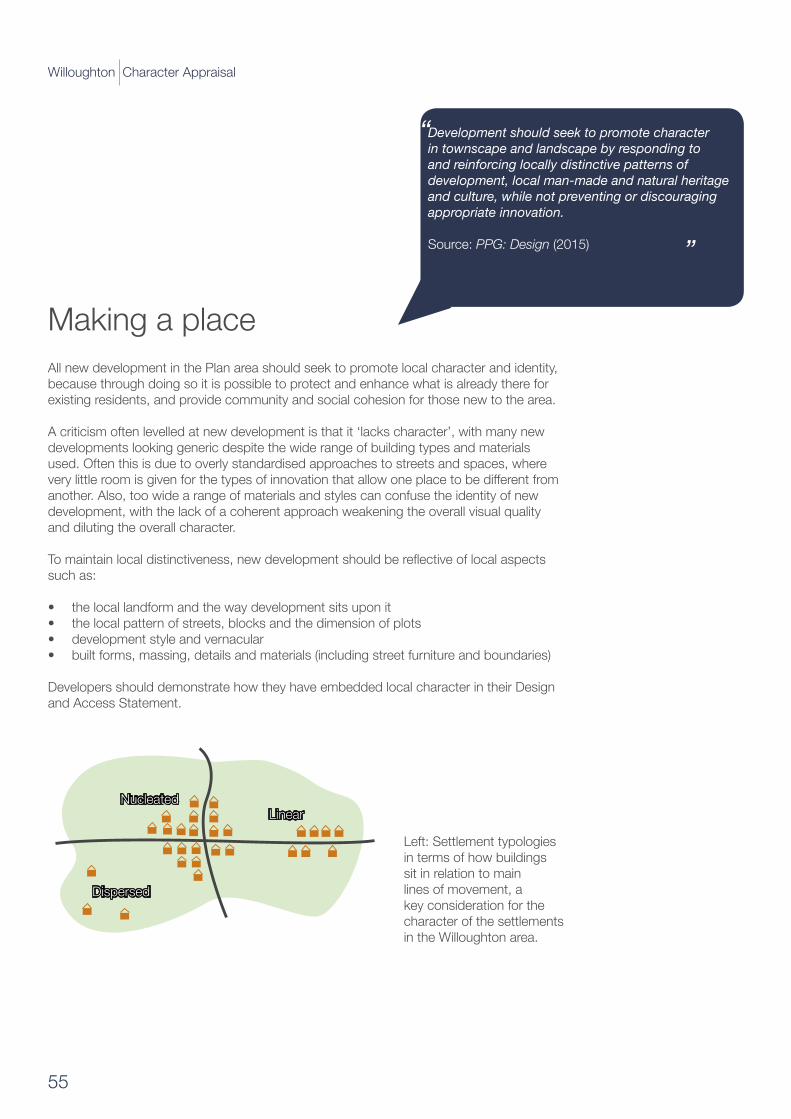
Left: Settlement typologies in terms of how buildings sit in relation to main lines of movement, a key consideration for the character of the settlements in the Willoughton area.
NucleatedLinear
Dispersed
55
Willoughton Character Appraisal
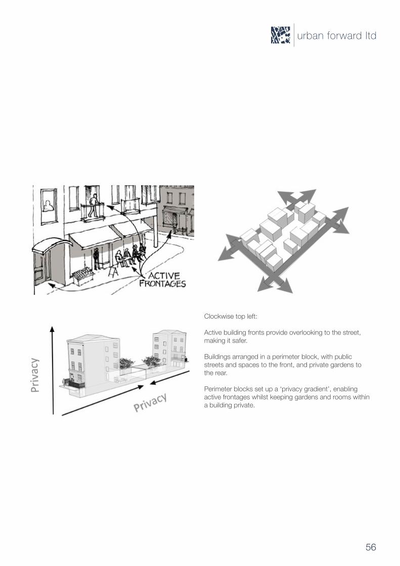
Clockwise top left:
Active building fronts provide overlooking to the street, making it safer.
Buildings arranged in a perimeter block, with public streets and spaces to the front, and private gardens to the rear.
Perimeter blocks set up a ‘privacy gradient’, enabling active frontages whilst keeping gardens and rooms within a building private.
urban forward ltd
56

Good design checklist
The Government attaches great importance to the design of the built environment. Good design is a key aspect of sustainable development, is indivisible from good planning, and should contribute positively to making places better for people.
Source: National Planning Policy Framework (2012)
“
”
Below is a simple checklist to help designers when thinking about how to bring a site forward. It may also be helpful for other stakeholders looking at a development proposal, prompting examination of the design elements that are often left until too late in the design process or overlooked all together. A more comprehensive checklist can be found in Building for Life 12 (see Appendix 2).
Are there existing site features of note? Can these be integrated into the development to add character and preserve site identity?
Howcannewroutes into and out of the development help link with existing areas and makefindingyourway around easy? Howshouldtheycross the site?
Where should vehicles come into and out of the development?
Arethereanytrafficissues to manage?
Where should pedestrians access the site?
Are there any existing rights of way to consider?
Are streets designed to be pedestrian friendly so as to encourage walking?
Are vehicle speeds low and are there places to meet and socialise?
What are the needs of cyclists in the area and how have you accommodated these?
Is there enough parking for bikes?
Are buildings and spaces designed to be safe? Do buildings face the street and are their gardens secure?Are public spaces well overlooked and do they have a clear use?
Howarebinsandrecycling to be dealt with?
Where are bins stored? Can people put bins away after waste has been collected?
57
Willoughton Character Appraisal
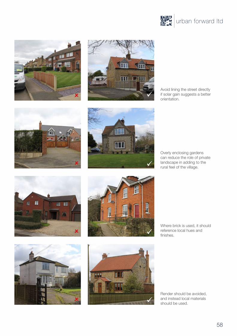
Avoid lining the street directly if solar gain suggests a better orientation.
Overly enclosing gardens can reduce the role of private landscape in adding to the rural feel of the village.
Where brick is used, it should reference local hues and finishes.
Render should be avoided, and instead local materials should be used.
urban forward ltd
58

Appendix II: Manual for StreetsManualforStreets(MfS)replacesDesignBulletin32,firstpublishedin1977,anditscompanion guide Places, Streets and Movement.
It puts well-designed residential streets at the heart of sustainable communities. For too long the focus has been on the movement function of residential streets. The result has often been places that are dominated by motor vehicles to the extent that they fail to make a positive contribution to the quality of life.
MfSdemonstratesthebenefitsthatflowfromgooddesignandassignsahigherprioritytopedestrians and cyclists, setting out an approach to residential streets that recognises their role in creating places that work for all members of the community. MfS refocuses on the place function of residential streets, giving clear guidance on how to achieve well-designed streets and spaces that serve the community in a range of ways.
MfS updates the link between planning policy and residential street design. It challenges some established working practices and standards that are failing to produce good-quality outcomes,andasksprofessionalstothinkdifferentlyabouttheirroleincreatingsuccessfulneighbourhoods.
It places particular emphasis on the importance of collaborative working and coordinated decision-making, as well as on the value of strong leadership and a clear vision of design quality at the local level.
Research carried out in the preparation of Manual for Streets indicated that many of the criteria routinely applied in street design are based on questionable or outdated practice.
For example, it showed that, when long forward visibility is provided and generous carriagewaywidthisspecified,drivingspeedstendtoincrease.Thisdemonstratesthatdriverbehaviourisnotfixed;rather,itcanbeinfluencedbytheenvironment.
MfS addresses these points, recommending revised key geometric design criteria to allow streets to be designed as places in their own right while still ensuring that road safety is maintained.
59
Willoughton Character Appraisal
Manual for Streets, TFL
urban forward ltd
60
Building for Life 12 is the industry standard, endorsed by government for well-designed homes and neighbourhoods that local communities, local authorities and developers are encouraged to use to help stimulate conversations about creating good places to live.
The12questionsreflectourvisionofwhatnewhousingdevelopmentsshouldbe:attractive, functional and sustainable places. Redesigned in 2012, BfL12 is based on the National Planning Policy Framework and the government’s commitment to not only build more homes, but better homes - whilst also encouraging local communities to participate in the place making process.
The questions are designed to help structure discussions between local communities, local planning authorities, developers and other stakeholders.
BfL12 is also designed to help local planning authorities assess the quality of proposed andcompleteddevelopments;itcanbeusedforsite-specificbriefsandcanalsohelptostructure design codes and local design policies.
BfL12 comprises of 12 easy to understand questions that are designed to be used as a way of structuring discussions about a proposed development. There are four questions in each of the three chapters:
• Integrating into the neighbourhood • Creating a place• Street and home
Basedonasimple‘trafficlight’system(red,amberandgreen)werecommendthatproposed new developments aim to:
• Secure as many ‘greens as possible,• Minimise the number of ‘ambers’ and; • Avoid ‘reds’.
The more ‘greens’ that are achieved, the better a development will be. A red light gives warning that a particular aspect of a proposed development needs to be reconsidered.
Appendix III: Building for Life 12
61
Willoughton Character Appraisal
Building for Life 12, the BfL Partnership
urban forward ltd
62
Appendix IV: Glossary of termsShortened extracts from By Design (ODPM/CABE, 2000) and The Dictionary of Urbanism (Streetwise Press, 2003)
accessibility The ease with which a building, place or facility can be reached by people and/or goods and services. Accessibility can be shown on a plan or described in terms of pedestrian and vehicle movements, walking distance from public transport, travel time or population distribution.
adaptability The capacity of a building or space to respond to changing social, technological, economic and market conditions.
amenity Something that contributes to an area’s environmental, social, economic or cultural needs. The term’s meaning is a matter for the exercise of planners’ discretion, ratherthanbeingdefinedinlaw.
appearance Combination of the aspects of a place or building that determine the visual impression it makes.
area appraisal An assessment of an area’s land uses, built and natural environment, and social and physical characteristics.
authenticity The quality of a place where things are what they seem: where buildings that lookoldareold,andwherethesocialandculturalvaluesthattheplaceseemstoreflectdid actually shape it.
background building A building that is not a distinctive landmark.
backland development The development of sites at the back of existing development, such as back gardens.
barrier An obstacle to movement.
best value The process through which local authorities work for continuous improvement in the services they provide. Local authorities are required to challenge why a particular service is needed; compare performance across a range of indicators; consult on the setting of new performance targets; and show that services have been procured through a competitive process. Councils are subject to independent best value audits by the Best ValueInspectorate,anoffshootoftheAuditCommission.
blockTheareaboundedbyasetofstreetsandundividedbyanyothersignificantstreets.
63
Willoughton Character Appraisal
block The space in between the streets, usually used for development, but can also be used for parkland and open space. The shape can be regular (square) or rectilinear (longer and shorter sides).
brief Thisguidereferstosite-specificbriefsasdevelopmentbriefs.Site-specificbriefsare also called a variety of other names, including design briefs, planning briefs and development frameworks.
building element A feature (such as a door, window or cornice) that contributes to the overall design of a building.
building line The line formed by the frontages of buildings along a street. The building line can be shown on a plan or section.
building shoulder height The top of a building’s main facade.
built environment The entire ensemble of buildings, neighbourhoods and cities with their infrastructure.
built form Buildings and structures.
bulkThecombinedeffectofthearrangement,volumeandshapeofabuildingorgroupofbuildings. Also called massing.
character appraisalTechniques(particularlyasdevelopedbyEnglishHeritage)forassessing the qualities of conservation areas.
character areaAnareawithadistinctcharacter,identifiedassuchsothatitcanbeprotected or enhanced by planning policy. The degree of protection is less strong than in a conservation area.
character assessment An area appraisal emphasising historical and cultural associations.
conservation area character appraisalApublisheddocumentdefiningthespecialarchitectural or historic interest that warranted the area being designated.
conservation area One designated by a local authority under the Town and Country Planning (Listed Buildings and Conservation Areas) Act 1990 as possessing special architectural or historical interest. The council will seek to preserve or enhance the character and appearance of such areas.
urban forward ltd
64
context (or site and area) appraisal A detailed analysis of the features of a site or area (including land uses, built and natural environment, and social and physical characteristics) which serves as the basis for an urban design framework, development brief, design guide, or other policy or guidance.
context The setting of a site or area.
countryside design summary A descriptive analysis explaining the essential design relationship between the landscape, settlement patterns and buildings. From this analysis the document draws principles that can be applied to development in the area and sets out the implications of the choices open to designers. As supplementary planning guidance prepared by a local authority, the summary can encourage a more regionally and locally based approach to design and planning. It can also provide the context for individual communities to prepare village design statements.
defensible space Public and semi-public space that is ‘defensible’ in the sense that it is surveyed, demarcated or maintained by somebody. Derived form Oscar Newman’s 1973 study of the same name, and an important concept in securing public safety in urban areas, defensible space is also dependent upon the existence of escape routes and the level of anonymity which can be anticipated by the users of space.
density Themassorfloorspaceofabuildingorbuildingsinrelationtoanareaofland.Density can be expressed in terms of plot ratio (for commercial development); homesor habitable rooms per hectare (for residential development); site coverage plus the numberoffloorsoramaximumbuildingheight;spacestandards;oracombinationofthese.
design code A document (usually with detailed drawings or diagrams) setting out with some precision the design and planning principles that will apply to developmentin a particular place.
design guidance A generic term for documents providing guidance on how development can be carried out in accordance with the planning and design policies of a local authority or other organisation.
design guideDesignguidanceonaspecifictopicsuchasshopfrontsorhouseextensions,orrelatingtoallkindsofdevelopmentinaspecificarea.
design policy Relates to the form and appearance of development, rather than the land use.
design principle An expression of one of the basic design ideas at the heart of an urban design framework, design guide, development brief or design code. Each such planning tool should have its own set of design principles.
65
Willoughton Character Appraisal
design statement A developer can make a pre-application design statement to explain the design principles on which a development proposal in progress is based. It enables the local authority to give an initial response to the main issues raised by the proposal. An applicant for planning permission can submit a planning application design statement with the application, setting out the design principles adopted in relation to the site and its wider context. Government advice (Planning Policy Guidance Note 1) encourages an applicant for planning permission to submit such a written statement to the local authority.
design-led development (or regeneration) Development whose form is largely shaped by strong design ideas.
desire lineAnimaginarylinelinkingfacilitiesorplaceswhichpeoplewouldfinditconvenient to travel between easily.
development appraisal A structured assessment of the characteristics of a site and an explanation of how they have been taken into account in drawing up development principles.
development brief Adocumentprovidingguidanceonhowaspecificsiteofsignificantsize or sensitivity should be developed in line with the relevant planning and design policies.Itwillusuallycontainsomeindicative,butflexible,visionoffuturedevelopmentform. A development brief usually covers a site most of which is likely to be developed in the near future. The terms ‘planning brief’ and ‘design brief’ are also sometimes used. These came into use at a time when government policy was that planning and design should be kept separate in design guidance. The term ‘development brief’ avoids that unworkable distinction.development control The process through which a local authority determines whether (and with what conditions) a proposal for development should be granted planning permission.
development plan Prepared by a local authority to describe the intended use of land in an area and provide a basis for considering planning applications. Every area is covered either by a unitary development plan or by a development plan comprising more than one document (a structure plan and a local plan, and sometimes also other plans relating to minerals and waste). The development plan sets out the policies and proposals againstwhich planning applications will be assessed. Its context is set by national and regional planning policy guidance.
development StatutorilydefinedundertheTownandCountryPlanningAct1990as‘thecarrying out of building, engineering, mining or other operation in, on, over or under land, or the making of any material change in the use of any building or other land’. Most forms of development require planning permission.
urban forward ltd
66
eyes on the street People whose presence in adjacent buildings or on the street make it feel safer.
facade The principal face of a building.
fenestration The arrangement of windows on a facade.
figure/ground(orfigureandgrounddiagram)Aplanshowingtherelationshipbetweenbuilt form and publicly accessible space (including streets and the interiors of public buildings such as churches) by presenting the former in black and the latter as a white background, or the other way round.
fine grain The quality of an area’s layout of building blocks and plots having small and frequent subdivisions.
form The layout (structure and urban grain), density, scale (height and massing), appearance (materials and details)and landscape of development.
grid (street pattern) A street system in which streets connect at both ends with other streets to form a grid-like pattern. Grids can be regular or deformed; regular grids have junctionsthatmeetatcrossroads,whereasdeformedgridshavetheirjunctionsoffsetfromone another.
in-curtilage parking Parking within a building’s site boundary, rather than on a public street or space.
landmark A building or structure that stands out from the background buildings.
landscape The appearance of land, including its shape, form, colours and elements, the way these (including those of streets) components combine in a way that is distinctive to particular localities, the way they are perceived, and an area’s cultural and historical associations.
layout The way buildings, routes and open spaces are placed in relation to each other.
legibility The degree to which a place can be easily understood by its users and the clarity of the image it presents to the wider world.
live edge Provided by a building or other feature whose use is directly accessible from the streetorspacewhichitfaces;theoppositeeffecttoablankwall.
67
Willoughton Character Appraisal
local distinctiveness The positive features of a place and its communities which contribute to its special character and sense of place.
massing Thecombinedeffectofthearrangement,volumeandshapeofabuildingorgroup of buildings. This is also called bulk.
mixed uses A mix of complementary uses within a building, on a site or within a particular area.‘Horizontal’mixedusesaresidebyside,usuallyindifferentbuildings.‘Vertical’mixedusesareondifferentfloorsofthesamebuilding.
movement People and vehicles going to and passing through buildings, places and spaces.
natural surveillance (or supervision) The discouragement to wrong-doing by the presence of passers-by or the ability of people to see out of windows. Also known as passive surveillance (or supervision).
nested hierarchy (layout) A type of layout common from around 1950 that, instead of traditional interconnecting grids of streets, uses a tiered order of streets, each with only one function (commonly distributor road, access road, cul-de-sac).
node A place where activity and routes are concentrated.performance criterion/criteria A means of assessing the extent to which a development achieves a particular.
‘Radburn’ (layout) a type of layout developed in America for a scheme in New jersey which used a segregated footpath network to separate cars from pedestrians. Commonly usedintheUKinthe1960’s,thesetypesoflayoutsareidentifiablebytheirgarageparkingto the rear of properties, often maze-like network of footpaths running along back fences and between buildings, and areas of ‘left over’ space with no obvious use.
urban forward ltd
68

Willoughton Character Appraisal
urban forward ltd is a multidisciplinary planning, design and urban design consultancy dedicated to quality outcomes forthebuiltenvironment.Weofferacomprehensiverangeofservicesdesignedtodeliverthebestpossibleresultsforanyproject,fromnewdevelopmentstopolicyandresearch.Ourteamareleadersinthefield,withawealthofpracticalexperience to help you realise the potential of your project. We work with both private and public sector clients as well as with community groups and those in the third sector.
urban forward ltdThe Studio122 NewlandWitneyOxon OX28 3JQ
w: www.urbanforward.co.uke: [email protected]: +44 7980 743523 @urbanforward
urban forward ltd