williams operating corporation 2-20586 1 · williams operating corporation '6eol06/cal...
TRANSCRIPT

WILLIAMS OPERATING CORPORATION Williams Mine Diamond Drill Hole Survey Data
2-20586 PAGE: 1 OF 1 j
DRILL HOLE No.
DIRECTION (Azimuth)
INCLINATION (Dip)
DEPTH (Metres)
CORE SIZE:
Date Started Drilling:
Date Finished Drilling:
o s Ho
1H B)
00inoM
m0o
raen H 0
T-QO-rtV/^5" 0
~^f^ 0
/'Xo m\2-O.O m
//G?5^-7/00SBPT. l/oo
ACID TESTSDepth
12-ft
^7^
/i vw
/ol^\loJL&SR
Azim.
^^x^'
^
^^
Incl'n.
-M**"-^ur-^.o*^5*
^f(?.5"
Comments
Ufej-tfa
(}(^jdvA~0{- Jtrf^ewJ&tA.
dfC vkL^
(Design)
(Actual)
Northing
Easting
Elevation
Grid
LAYOUT :
^7o^^77^2^
/O? o tc-z+s/urfr
1
1
; ; ;' ; : t; : ;' s : ;- h-vv; ; : : ':.y Survey (P/U):- B-Zone Grid
Northing
Easting
Elevation
*l4.*.v\fe*r: 52(17261 N ,p^ Northing(TO 122.1382,^ OSll^lV E ^ JL-
^,o o* r Easting^V
Elevation
TRO-PARI TESTSDepth
2&K/1
Azim.
/57.7Incl'n.
-#5~flComments
Surveyors Pick-up DataDepth Azim. Incl'n. Comments
C-ZoneGrid- "-fflQ28^ tyiis(G.^es
SURVEY ENTRY DATA SETDepth
0 ^/-z. -?6 ~4-7- K,
TL *,CG^ t**~
7 'f 4 'f'fvA.
Azim.(Grid?)
C-Z**-X57-7 0/S7-7 J(57,7 "/S7.7 "/^7'7/57. 7 '/57*7 "
Incl'n.
- **^-3 "
*^,0 "
""-^3.. 2-"
~. ^3*3- f .c? "^^^5 J-*fo,^ "
NtUtlv
GEOi
C FP ** ii ?wfui t u t
CIENCE ASSE OFFICE
Comments
Vi ^? C * *
Trl tft- *^--
/Sf^^^ - J l
^^ C/^tf *"/
^ '
4 '4 1
^ED--J88 -
SSMENT
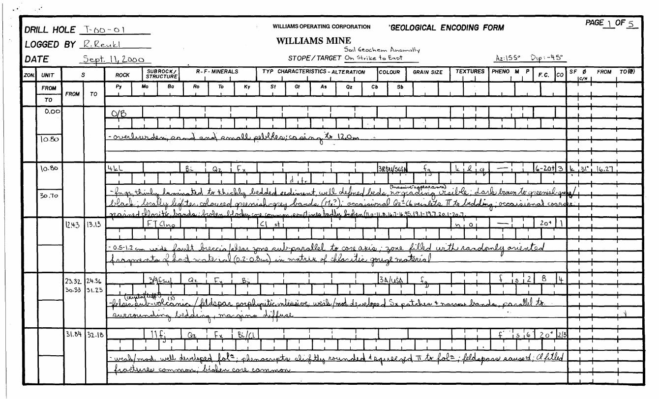
DRILLHOLE T- bo- o l WILLIAMS OPERATING CORPORATION GEOLOGICAL ENCODING FORM
LOGGED
DATE
ZON. UNIT
FROM
TO
O.oo
lo.go
\0-6o
Jo .To
oy c? p. u WILLIAMS MINEDi r-- ' l'- S- 1-* t- l ^
Doll <ae.cxiWe.irw f-\i^oi~~^i\^
5e.pt 1 A, Z-OOO STORE/TARGET O* sv.te io E~*t kr\S el ' " ' ' ' .
S
FROM
IZ*3
23. 32. io.33
MM
TO
13.15
m.stM.23
OO/N, SUBROCK/ R- F- MINERALS TYP CHARACTERISTICS - ALTERATION COLOUR \ GRAIN SIZE TEXTURES ROCK STRUCTURE , , 1 1 1 l 1 |Py Mo So Ro To Ky St Gt As Q* Ci Sb
i i i i i i i i i l i i i ™^^L^—
p.
PHEA/0 M P 1 1
rx/cz, ' ' i i | i l il O/D ii l l i l 1 i| 1 ' P 1 ' 1 1 1 ' 1 1 1 1
1 1 1 1 1 1 1 1 1 1 ' 1 1 1 1 1
1
,
-On**A*JU*^t^ 0~ __ l ^^ 0 ____ .ftJL^oUj^^'C^^Iyw "Jtlr 12.0^' O-W^ f*M ; -^
F. C.
1
o
CO
"" l™"
1
,, ,
1 1 1 III ' I /" til
^fV\- 6 i- i Q z. i Tx i i i 3I&U/544M T^ U JZ i c*1 1 1 1 1 1 1 1 1 1 1 1 J 1 - | -J 1 ir"
1 1 1 i 1 1 1 l d l f r i 1 l 1 1 i l
— ! j k-iot, i 1 i
•^ l I A (^r\n,^tVyftfJtJ*f^J^(^f^J^jOLff fA-y fi /\ A . ^
3
-fj/u^hficUrlL ", XtKlOLWLL-V JuAA\ioA t CJtttjCHj AtLftl nflQO/y^* * U j-cV?^ Jfj-ClsfuhtL, f My - )/ CtCrrs xxi^o-yL^i/ Q?--CL ts**u*JljLAAj fi Ab ^C**yLJj*^* ' 0-C.CO.^Lo X A-waui CJyoJX^
!Y? ^TXA xT-vQ r4 Cy\v /V7J( "TLT i JlVC yv-oL-Qj r ^(r^y*n) rA. , J/ t-V /VCMAA*- fyvMl . Covtv^-wv^^w i Ojyt^fl A i/v^JLo. •UtK^JJLM* j^tiil-4/yv l U.O ~ li .ft. l(o i H* it ."O. i * -l~ \" . 1 , t O. l " 7.O i"l .
' 1 f T /-l ' ' ' XI ! ! ' 1 " 1 ' 1 1 1 '11-TcUo i i a *TI ii il 1 ^oi1 1 1 1 1 1 1 1 I 1 1 1 1 11 1 1 1 1 1 1 1 1 1 1 1 . 1 1 1
— IJ
- 0.5-\.2 ^ ^^ f^jJA JUx^'v, 1^^ -YWXO ^JU-,D^ruJjy ^v co^iia^Q. - -v^L IJ^U uy^L /UL^oUwXa ^D 4- 0 fi A \- (\ x' o "OL \ - ' -f - /l /l 3 ~-i - -4- ' /l ^ A, /i/^^rtx-yv^a ^-^Jvxv ne JoLo-oiA -v^-f-iJJ?/ v x-jJi (O. Z- O.Ot^L) AXV- 'yv^-oLMJU1/. 0^ C&JCAx? Jt^AJUf j OfrbL^-Jc "VvLo-JW/Lixi l/\ 1 \ ^ ' r y rf
il j 1 1 i 1 ' ^~^
i .1. i.'\ i i i ill i i i ill i i iS !
,(jjOYX*i"4r ''. Cf) . /nil n (h n/ 1 1
1 , , 7 -^*-^~^Y J jjxj- ^ -^r ^ ^ ^ ^ ^- ^
]
,
ZQ-*
| ,
1
^^^J
s [z,
81 ;
H-
,jy ;k.
o y o TT
i-\ r. A ' r ' R.- //i ' ' ' ' ii1 \-i-i Qx l l- * 1 Du/fA i i i
! l! 1 lil! ! 1 111 1111•f 1
,.
-uxA./™^, u^L (UA^WijA LJ^*- ^Du^^vcA-ifd&u Q^'4Jt3 /um^ Jn^ ^^Q^^ TT Xv AvP^ - JahL****** a**.L^O^ijUL^^ C^^^VX^. ' j'h^l!^ cl^ C^ ___ ^^.r^ ^
5|fe-
,•cai 'a j
?o 4
f 1CAJ&
2/5
W
BAGEjJ3F 5
S F 0 FROM TO (WC/H |
j
jt. 51* It. 21*
ft/J*fT
———— 1 —— ^
M ——— 1 ———
^
i J

DRILL HOLE T-oo-oi
LOGGED
DATE
ZON. UNIT
FROM
TO
3o.7o
31-85
yi.85
41.11
mm
41.2)1
BY i? Ke^Ll
Se.pT. Looo
S
FROM
'VIA!
TO
36.00
4-5.10
ROCK
P,
TT^kl—^-^^^—
.SUBROCK/ STRUCTURE
Moi
So
R- F- MINERALS 1 1
Ro i
1
1
6, !I
- -XO-wJL. 0& ,aJL/UU-n^o>L<\J-eJ Jj-TXfc
To Kx i
WILLIAMS OPERATING CORPORATION "GEOLOGICAL ENCODING FORM
WILLIAMS MINE
STOPE/ TARGET
TYP CHARACTERISTICS - ALTERATION COLOUR GRAIN SIZE TEXTURES 1 1 1 1 1
Sf Gf As Qi Cb Sbi i i 1 l l i i
PHENO M P
l
(H ! Fxr i ,
III! S-W6& c*i ' i 'i i iii i i i i i1
l
F. C. CO
1
lUU, Jui^ ' -w^v^JJ^ ol co^ cxv^o;^L^ ail ooirtJ^^ o^vJi/CM, xW^Aouu fr^x-o^ ^3—— '
O- "^ ft 9 - "3, V [ f\ ' 0
32. 26- Sl.H3-.Qi
!
-c~^
yvw^liA ai^&jiA&'T' JU
LC1
4 M"1
" 1 1
1
* -x/rvJL u^^il
1 1
,
*Jl -v^
1 U \ '1 ' 1) '
xy^oLo^n Tt . Av^-^AMJw-jL-y CK\jki^~-AdJl CJL CL-^^^ wZ-Cb JLlJLxJLrl -t-^J^-^•X<Jy1_^aJ Ox^v^SU-xl ixw -J'-O"-'
j^,'^ - ai.5o: 0iUo^ *Lj P c .JU^^/^e^w^ c^f^Lo-^ Lt^*Lv^t at**!**,
,
! ! ! ! " s-W 'L "1 ,i i i j i i i i j i1 l ill i 1 1 i 1
l
i
oi lL4jo l^uJU cww-^ /(jdtJi 'i y (j J
^f
1 1
1
COO
iP'1
(p'
rxi
* 0-
1
^rfx
1
q
L.Ixlfi^
(?),
~-
^U&o
j-XUA2X1^.
1
Ji aa^)j
HUl,
u^li a
JL.JQ
,
JVAJ
lA^v^JlXiA
,.
uxMiJL1
F,-.**j /Y
Vqi
ib, i
1WMjJl Tis' JLo-'A/Nj^
,
Do 1
j
j /fe1 TK-l ipnJtx^in
^ftl-,^ pJ^Jk,
"\ . .y. l
UCs
,
11
1 1
Gil 1
,
^J^J
vJLj 0-1l)
Qz !T
[\__t_ .Q V J J^ ^"
L V) 1 /*Ljd^S~*
1 1
1
P*1
1
C ' r ' 1 ' C -,,A r \ ' i ' -* vi i b p ^ i i | o-l&SA. Ira. L L Qi i i i i i 1 j V i i i i i i.i i i
! !i
•0 \ '4-^ "nv^-'H b O 17 0
.^^lU A.-^ Qz-6. JlUkJ J^^Lu^i^j pl^4 - S^lrt^^j p^JL,
r^ lir/At. wl 1 1 i H-3P^U -f f, t. L H,
I i i i i i i i i j ' " i i i i , i . i iLo^x-5Ll XJ^jdi O-'.Jft-O'i. ( p^oJilU aniS^w Cxr"L*MJiy^Lol J! ^ x-Ti x nJL jA-^oJUyfl) oL \rjh
1 1
1
1c. oJUhiAr^ Jl rv-^rt^JLu O'VJULxvsJ'i-r-l ' CXXS-AJ&' C^oQ-O-uJV /Uk^w^jiLo /u X*- HVJ ftaJi'i O-yvj 'KXV-CiSo fljiljijl. (
0 '
1
- ^-oc^J^L,, /JPjJlA. o^V^u. ' AW, ;
Ol( Wt 1 1 1 vO~ Itl^ASVl *^*\ A1 1 1 1 1 1 1 -1 r
1 1 1 1 1 1 1 1
[\ l- /w. X ' A - -w,/ -A ' ft f\0 JLaA^-o^axy^Xj tXiLAQxu ( tiAJU-o' ' Tr/At, - l cwya^jai ~A iLft-offj '-iiX.rt-Tjr fl-
1
5-lZ.
i-^t^j cX-AJ2fl
ytfetx.
1 1
1
1
* f Mr
•l e.
C ' ' 7
1
3-JUoA^
i i
T—
J-rv.
,
2-3.
i
1-3
Zo
1rys 1
15
'18s)
L
*v-sj ,
If.
} ^jLll^c
RAGE 2. OF 5
SF 0 FROM TO(8J c/w l
v
.^
'
\ 02** li t rt "j Vi f^^ \\ ^ j
—M ——— 1 ——1 1 1

DRILL HOLE T-oo-o\
LOGGED
DATE
ZO(V. UNIT
FROM
TO
41.32.
^.?,2
^Sti. PC/?
^j(0 , Oo
5t.6t
fcz.iS
^.15
cs.ni
By tf.eeuia5epT. 2ooo"™ r
s
FROM
55.11
TO
5S.H-0
ROCK
Py
^2/a p
1
|
SUBROCK/ STRUCTURE
Mo
lr
~ 'CL/O-'Wsl- 1 VAxM^
XjtrtXxlLu --wo^
Soi
R- F- MINERALS
Ro
,
To
\ | Qr 1 FY. i;
A Oocu 'V-cv:Cl2Jl
J^r-1 ' aDkfV- ^U^-i
1
Lh^-c^l.5cj!i oJ 5o.*,0.5f.7Y, S/, 37 r AJL^.
1 1 1 i \ t^i
i
~Qjo^i
.
o^c^ o*./
1
1
Sk i
v^JA cM--CjvAi-)4-f*
Qi. \
,ip A3 /i-^-u
KY
WILLIAMS OPERATING CORPORATION '6EOL06/CAL ENCODING FORM
WILLIAMS MINE
STOPE/ TARGET
TYP CHARACTERISTICS - ALTERATION COLOUR GRAIN SIZE TEXTURES 1 1 1 1 1
St Gt A3 Ox Cb Sbi i i 1 l l i 1 i
PHENO M P
i
(rJU\
^I'll f
'I'lllll 1 ' 1 ' J ^ sj
"f 1
iV f\ n |\ rt _ L 1 1 ,1
xJ^ruvu^ /'u^JkL MuJL J\ JrtJrtU-niib J^jJi)^ -x^^.^^v^O y^^xJu^V.I) ^ l\ ' 1 ' /l/l'-d
^,
! ! " ! ! H-sptul 'f, " w 'LIII 1 i U
II ill 1 1 1 i 1
F
4 1 2-
,
-.c. CO
2 -lo
-J-^tJJi/lQ- -4
^'o' Cusi
! lr^^^ i
v^jLXiJLujf rL jj mn )^6
\
^
Vi
t
/CxxJleHi.
t~9#EP
3-5
i
1
Ab
^^^™
1
-cxcx- d^
1
1
ILXX^Jlix
/i-fi
a, ii i
-d oj) rmj-4- ' XJ^
^ |
1
Jf^ j ^Vi
W&u
;
BL O 1 ' ' 1 b/ci, '-'^* v/i i i l 4-G^A ^o ^, ,
; l ; l ; ; \ \ \ \^ y *-C '
1^^ iKrtAiU Jli^jjJir^x^ , ^ ^
si*
i
2-5
i
4-
t
ox)-ovJL A ^JV^-^^A
^k/yv-^i 17 ,rt ^V
O-CyCXXjl^Vlr
HU11
^o'v'ft*
ioOuwo
1^ !
!
CX tfiAflXUXjFWKXlicA/
F , Q * *. - I OL-^"^T"™^
t
V (W^
y , ^
wJ 0 14-1,0 \ /i-^
1
a^AJ AX v*^
*4 ^hr
1
i t.*.k' i ^t !: i :
^ jL^c^W oJUo4.
oJU-O-^k i^.-JuwJLt
^w' 1 1 1- " . f, . ' '
^ ^.l l l i H-56tWS6jA A a i
lli l 1 i 1 1 i 1 l l 1
1 11
,ki . \[\0 'n 0 wxy J-^'/-/-* 0 /X'jk Xrt-a J pJLa /i r-n xut/wft (^axijfc JCrL^ru^TsjVoy^ ccrOSUJZ. -tsiiL/i xX^-vJ^ Xx-arKAJ^. CoOHXAfW taflJLffsri
if ' i i r^ -^ o•i-*- 1 v 5 — t "'CxyV^- VA/Tj^vJ? y^ R~l J J-O-^l-^l j^ J*A—/^ ot /^ 0 -X* JL/.A'/'J
Pv1
n*. w i i i i k-ip^u/s^i i1 1 1 1 1 . 1 1 1 11 1 1 1 1 1 1 ill 1 1
J1
(.z.aS-GS.es-a^A oa^JOu^^L-v^^^y^H^ 5ck^ JtWJ ik^Ju ( JJ(A,IJ1*?VX^L -c
a^.uJtU^^db.uULa, /JJ^tJo*. 6^ tv^JU^ lAo^^/^^ XJ^O^CA^ wwvv^, Tf^^i^v^J^Jo. J
l i
,JL-'YTi
J^
1 1
1
J -5
"M
f.
1L^
patJo*
3JiUrt AJA
H-lo |i
l ;iA^Jt^o^
R46E3 OF 5
S F 0 FROM TOCS; lc/w
— M —— 1 ——— HH ——— 1 ————M —— i ——
7?" Si ^1J i^i^ 1 - 5 ! i ———•j
S*"*-— ——— 1 ——*
e:
je 2T- 63^
l J l

DRILLHOLE T-oo-oi
LOGGED
DATE
ZON. UNIT
FROM
TO
G.5/M
r -, f^p.
ai.sn
""
(A. 51
10.63
"U/M
flV # f?e.oik-lU t Is*- *-C-V-*it-i
5e.pt. looOrs
FROM
fei .11
TO
ROCK
Py
3/^t
,~- Q^oj CM
t
SUBROCK/ STRUCTURE
Moi
Bo
R- F- MINERALS 1 1
Ro i
rj^x.,
Qz. !
IA fAftw^rx^t
To
F* li i
- ^^^t.'
KK
WILLIAMS OPERATING CORPORATION
WILLIAMS MINE
STOPE/ TARGET
GEOLOGICAL ENCODING FORM
TYP CHARACTERISTICS -ALTERATION ~~j lilt
COLOUR
St Gf As 02 Cb i i i 1 l
Bo
l
56
GR/J/W S/ZE
1 1 1 1 l ei i i i ( i 1 i l i
^y^-^-o^LXA^TV-o-X ^OV-oJCx^JLA^ (P-cO^C rtP \ ' H * ""^ T"
vi *
Kit t1
-0-6S A
JUW
,JLo^^Xj*
1 Cxi^W^-N/V
i 1
fci. !
y r. a rtJM c*-©-AX
Qt ii i
-V'
P* 1 1 1 1 1 1 1 l
1 1 ' ' ' 1 ' i). , .li ,
,
l
SaL.J *
1
1
TE/KTURES l
PHEA/0 M P
i
. 1 iJ
i
F. C.
1 ,
CO
n 1 1V IS li
1 1
i-lf
| ,
H-
u . __ -UU^JL^ JLa>o4JU^:^ ;
i+P^u/Sul ^
1 ll-ufc*! ,
Kwv ! QT. !
; 1
— * X f 6 ' * "it~~
ai
, 1 II 1U V-4 1 1 l l
, i . , i i il, i
i^^JW L 3U A^UL^,- o^Ju -w-U
1
^ j^ja1 J
'•*^1i
W L1 1
1 ,
4-7
1 ;3
JLvfr^.TW*
H-5i
krtX
1 1
kl~.
L Ao^r f
?jLfr\(lJLJl iJ
. i——
1 111
i
^uMMi^&^^J
——
J |
L--
Z-3
J4'
0 Q
LL l \ * \tl1
|
-fl'j^
•VU&.AAA-U
1
A^ ^V V * A^
Wit Ha Git 1
str/jll-S
-JL^o
1
^,jcaAjV1 l t^vys. "YX.Q
(
0 . i iD d i Q -j i
l
i^k***^*
i ^o^WJl n.u yvWA*\
,
1
-A DAAAJ
u. ojit/u"
bi j t^ 11
^ XJO.V, Jtt,
&A; ^RoSL^
1
^^ 1 1 1 l 1 1 1 liii i i i i
i 1 , , i
. yv. * ^A * ^ ' i ^ n
o*A^ t) "1
ati iM ' ' 'j 1 i l i '
i i ill i
vjCvA
ivt,
•J p^iyVl^
-y-MJS-A
H-5^Ml
,f
,
wvlft^J
yUt^-i^/vfoi j
k L1 1
1
lA Ift^hr^ Jitj**^
o
*lro"SlKw\e- ^ ^ .
VM^^lAt^j^D^ c ___ )^ ,^-b^^p^, CC^W^^VX3U^ ^*^A oJLc
uJ^l,,^ ^C^S l ^V 5 0L.crAxk X^Xc I^^A^vxi - aJC6A- OLQJ XA
0 U' .i/^^jrfy-i— /'ft-Pt^'W-E' 0,-Q^ Jy^ilr fv^- JhAjb**'
i
,
j1
oJHu^l.6cn '
V--^L^^-.
1 1
|
/f
1 i3
oo^oJlllfiJL "tr V-:
I J -
i 1 l
-v~\. . ..JL
Mtl*
^n\
^
/UU^ OtJiJ
*^
SF
——
RAGE 14. OF 5
0 c/w
FROM TOft?;
'
-4-H ——H — 1 — 1 ———
if——
111 i
i i i(.fH"0;;l0^JLJLy C/xWLaoAJ

DRILLHOLE T-OO-OL
LOGGED DATE
ZON. UNIT
FROM
TO
USl
101.15
102.15
li o.oo
llo.oo
BY 1?. t2e^Ll5ept, Zooo
s
FROM TO
iH-.fcfi
1
ROCK
Py
——j——.
*sue ROC K/STRUCTURE
Mo so
WILLIAMS OPERATING CORPORATION
WILLIAMS MINE
STOPE/ TARGET
R- F- MINERALS 1 1
Ro
ETUklJ !i , i
4 JL - i ~jt
•Jt-~lS , i
To i
KY
T/P CHARACTERISTICS - ALTERATION 1 1 1 1
Sfi
1 l
il
IX/M-nl /.J
rvjLt^
,
tt. !j
Gf
1
1
As
11
11
Qz1
1 1
1
Cb
ii
GEOLOG/CAL
COLOUR
1
VSfcU1 1
V^ijyk ckL^w^Jt^A'^ OjU^,Tt,~JU^^ frVW-'U ___
J^^^ ^^^^^' l 0 '
H^!
~ VwdKxixa
li I
a z. j
xljfj ^aXA, fiL^MaiL ^\ i
Fx. i,
JUw^,
Bt.,
ii i
n}0i . vnLcfcj^
^V V5"
11
1
A*- K.
1 1
1
fcjJtSLci, c
i JU.4i iii
HffJ^
0
1
co-TJL JU
ENCODING FORM
6RA/W S/2E
1
TEXTURES PHENO M P
l
^ /vfc,
\
*-
, !Tt f\ A 7AJvO^JU L.
-^JtfiJ
t-
-^
0
i
c ,.^ z
- Jmfll
J?
t
F. C.
1 ,
CO
1 i
i l
4JUIJ JOUL
oJ^Ja)
l
Zo*
| (
\^ . Jt W J
5k,
J
"/o
E "^ /V\Aa
J 1 J
kJuQAA-^-e
a !———
\ i
i
s | 2.
i
l -Z
l ;1^
Ji cv,juu, aV'i (\-L*~\ -^o*ul^™^. . , ^
j
-QO-^vJ, 0
Hx^tvq^I l ,
1
DO |
(
M,uo^ JWnjJbU oX*V
|
,
rt.
62!
rio, !K
l
1 1
11
1
1
i i1 1 1
,1
U/vf
1 l
,j J
1l
i 1
j i i | !
3
^Lktt*|
-^^^J/*A±a
Q2V
L^^t* .
JUb
E^ci,
Lcaai
o^
^i
1l l
,• -i. -o
J-^-^A pj?3 -AAjCi\A /Q-Xj
Wole.
b,irx^ 1
,
1 l
l
l
'-O^fllt&.A -
i
i*( A* jQX
ea ru !: i r
1
11
1
4." 62Z /o
l 7 1 - -f i .Xi/ttrtl 7 /JLl^ XAAJto/M v fPCX-^OUOQA A^v^n
1 1
1
5e.pV.
i iI 1 !
IS, looo
ii
1 1
1i
uiJLjb^
i l
i
111
J^ ^^
1
*-^\JL* CXV-r^
1 1
Wvk-V J
1
^lo'^.c
t J? hr-__ 1
1
^ _ o^aJL'L'l^
1 l 1
i
3L,aTA
2-a1
b- -
^ CTVVV^ ^..^^jtJI fl z cKi^QJU ' " '41 1
11 l
11 1 .
1
i l
1
i i 1 1
f!77i ^ A-'^.-CVO1 ~y^v^-'*-s\ ** y**-*-"—
SF
HH
PAGE 5 OF 5^
0 c/w
——
FROM TO (Q)
————— i ————— 1
/'
^i bf 18 Zt
^ 2^0 w*
, j
42C13SW2003 2.20586 WABIKOBA LAKE 020
CERTIFICATE OF QUALIFICATIONS
I, Robert Joseph Reukl, of 21 Falcon Avenue, Manitouwadge, Ontario do certify as follows concerning my diamond drill hole log, T-00-01, submitted for assessment credit that,
1. I have been employed by the Williams Operating Corporation as a geological technician in the Engineering/Geology Department since 1994,
2. I am a graduate of Lakehead University in Thunder Bay, Ontario holding a Bachelor of Science degree received in 1984,
3. I have practiced continuously in exploration, development and production mining from that time until the present,
4. I am a member in good standing of the Prospector's and Developer's Association of Canada,
5. The information presented is based on my personal observations of the diamond drill core as well as my exploration and mining experience in the Hemlo area and specifically the Williams Mine,
6. I have no interest, either direct or indirect, nor do I expect to receive any such interest in the property on which this work was completed.
September 25,2000 Hemlo, Ontario
Robert J. Reukl, B. Se. Geological Technician
OOrGO O

(1)EFFECTIVE JANUARY l, 1989
GEOLOGY LEGEND Revised October 1988
ZONE Used for highlighting information
MZ1 S FW FZ-1 N FWMZ2 FZ-2MZ3 N HW FZ-3 S FWS
FROM - TO Defines the interval over which a particular rock type or characteristic occurs.
f
ROCK TYPE Includes geological and structural units. Mayalso include textural designations and/or minerals.
A GEOLOGICAL UNITS AND SUBUNITS
REFER TO APPENDIX I AND IA
1) Mafic metavolcanic rocks2) Intermediate metavolcanic/volcaniclastic rocks3) Felsic metavolcanic/volcaniclastic rocks4) Metasedimentary rocks5) Baritic rocks (^ 25% Barite)6) Massive to Foliated Feldspathic Rock7) Biotitic rocks - includes schists and fragmentals8) Muscovite schist9) Felsic porphyritic intrusive rocks
10) Felsic intrusive rocks11) Intermediate intrusive rocks12) Mafic intrusive rocks13) Diabase dykes14) Lamprophyre dykes15) Breccia pipe
RECEIVEDSEP 2*2000
GEOSCIENCE ASSESSMENT ____OFFICE
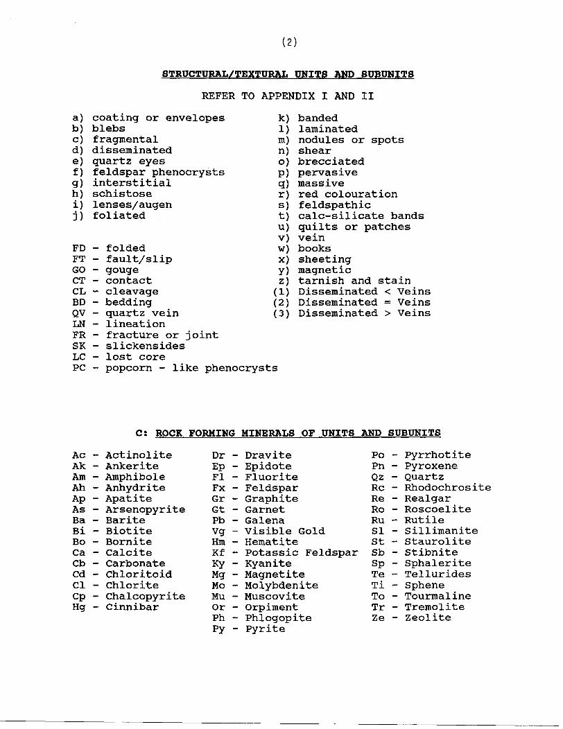
(2)
STRUCTURAL/TEXTURAL UNITS AND SUBUNITS
REFER TO APPENDIX I AND II
a) coating or envelopesb) blebsc) fragmentald) disseminatede) quartz eyesf) feldspar phenocrystsg) interstitialh) schistosei) lenses/augenj) foliated
FD - foldedFT - fault/slipGO - gougeCT - contactCL - cleavageBD - beddingQV - quartz veinLN - lineationFR - fracture or jointSK - slickensidesLG - lost corePC - popcorn - like phenocrysts
k)1) m)n) o) P)q)r) s) t)
v) w) x) Y) z)
(1)(2)(3)
bandedlaminatednodules or spotsshearbrecciatedpervasivemassivered colourationfeldspathiccalc-silicate bandsquilts or patchesveinbookssheetingmagnetictarnish and stainDisseminated < VeinsDisseminated = VeinsDisseminated > Veins
CS ROCK FORMING MINERALS OF UNITS AND SUBUNITS
Ac - Actinolite Ak - Ankerite Am - Amphibole Ah - Anhydrite Ap - Apatite As - Arsenopyrite Ba - Barite Bi - Biotite Bo - Bornite Ga - Calcite Cb - Carbonate Cd - Chloritoid Ci - Chlorite Cp - Chalcopyrite Hg - Cinnibar
Dr - Dravite PoEp - Epidote PnFI - Fluorite QzFx - Feldspar ReGr - Graphite ReGt - Garnet RoPb - Galena RuVg - Visible Gold SiHm - Hematite St Kf - Potassic Feldspar SbKy - Kyanite SpMg - Magnetite TeMo - Molybdenite TiMu - Muscovite ToOr - Orpiment TrPh - Phlogopite Ze Py - Pyrite
PyrrhotitePyroxeneQuartzRhodochrositeRealgarRoscoeliteRutileSillimaniteStauroliteStibniteSphaleriteTelluridesSpheneTourmalineTremoliteZeolite
(3)
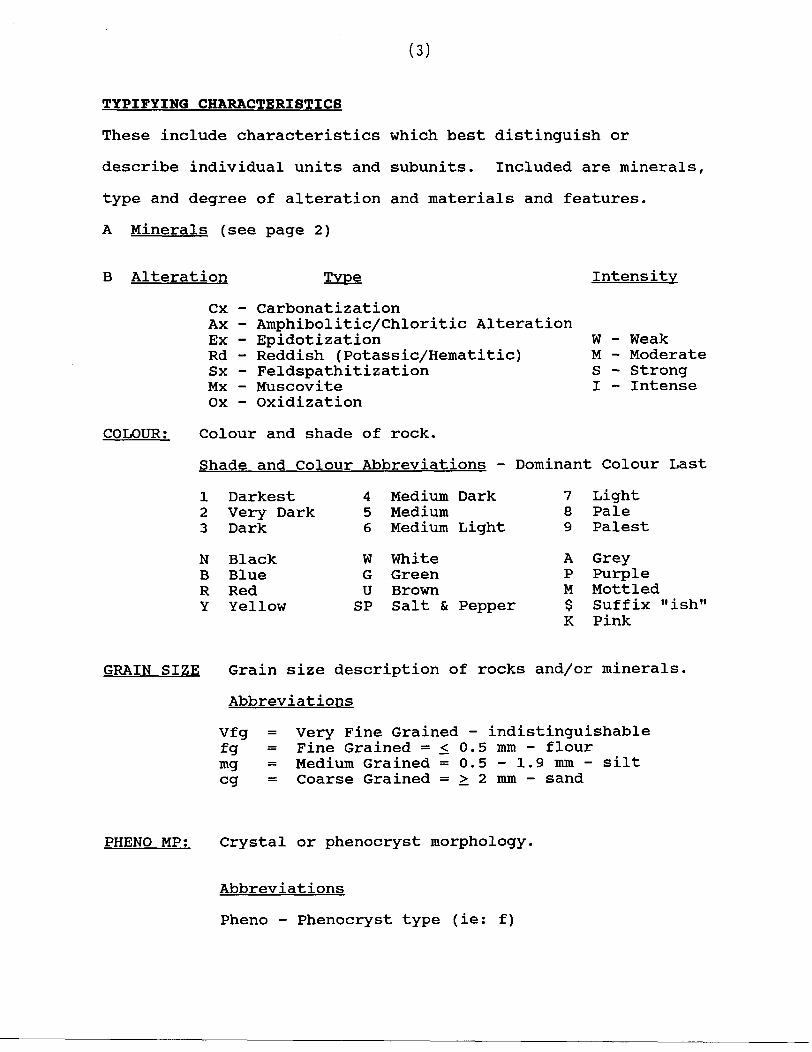
TYPIFYING CHARACTERISTICS
These include characteristics which best distinguish or
describe individual units and subunits. Included are minerals,
type and degree of alteration and materials and features.
A Minerals (see page 2)
B Alteration
Cx Ax Ex Rd Sx MXOX
Type
CarbonatizationAmphibolitic/Chloritic AlterationEpidotizationReddish (Potassic/Hematitic)FeldspathitizationMuscoviteOxidization
Intensity
W - Weak M - Moderate S - Strong I - Intense
COLOUR: Colour and shade of rock.
Shade and Colour Abbreviations - Dominant Colour Last
1 Darkest2 Very Dark3 Dark
N BlackB BlueR RedY Yellow
4 Medium Dark5 Medium6 Medium Light
W WhiteG GreenU BrownSP Salt St Pepper
7 Light8 Pale9 Palest
A GreyP PurpleM Mottled$ Suffix "ish"K Pink
GRAIN SIZE Grain size description of rocks and/or minerals.
Abbreviations
Vfg = Very Fine Grained - indistinguishablef g = Fine Grained ^ ^ 0.5 mm - flourmg = Medium Grained ss 0.5 -1.9 mm- silteg = Coarse Grained = ^ 2 mm - sand
PHENO MP; Crystal or phenocryst morphology,
Abbreviations
Pheno - Phenocryst type (ie: f)
(4)
REFER TO APPENDIX I
M - Mode of OccurrenceE - Euhedral CrystalsS - Subhedral CrystalsA - Anhedral CrystalsP - Maximum particle size (use mm)
FC; Fracture count; defined as the average number of fractures in 1m of core for any particular unit.
CO; Competence scale; rock competency described using a scale from l to 5 with l being the most competent and 5 being the least competent.
SF: Description and dip angle of STRUCTURAL FEATURE(S) in a unit. Dip is measured from a plane perpendicular to the core axis (core normal angle).
FROM -TO (@) Range or location (metres) of a structural feature use "@" for location of a single planar feature.
MINERALOGY
Observed minerals described by mode of occurrence/texture and percentage of the total rock. Use the same guide as Part B: Rock Names (refer to Appendix I and II)
STRUCTURAL FEATURES
Description and dip angle of structural features in a unit. Dip is measured from a plane perpendicular to the core axis (core normal angle). Refer to Part B: Rock names (Appendix I and II)
(5)
APPENDIX I
ROCKNAMES
Mafic(1) Metavolcanic Rocks - composed of Amphibole
(actinolite, hornblende, tremolite) - dark green (darker than
intermediate rocks)
Intermediate(2) Metavolcanic/Volcaniclastic - composed mostly of feldspar,
biotite and quartz- generally equigranular/massive or banded/laminated
- has greater % of disseminated carbonate than the metasediments
- biotite is the indicator mineral
Felsic(3) Metavolcanic/Volcaniclastic Rocks light colored felsic
rock with a porphyritic texture defined by quartz eyes and/or Feldspar phenocrysts and/or fragments
- composed of Feldspar, Quartz and Muscovite- can be foliated, variable intensities of feldspathic
alteration
(4) Metasedimentary Rocks generally a banded/or laminated rock primarily composed of Qtz, Biotite and Feldspar usually containing calc-silicate (green) bands. Usually a purplish-grey-green to brownish color and fine to medium grained.
- in H.W. sediments above the main zone the primary metamorphic minerals include Kyanite, Garnets, Staurolite and minor arsenopyrite.
(5) Baritic Rocks - > 25% Barite
(6) Feldspathic Rocks - massive or brecciated; fine grained;light - medium colored unit (microcline rich rock)
- composed mainly of Feldspars, Muscovite- commonly contains Barite, Pyrite, Molybdenite and Vanadium rich mica
- Moly is the best indicator to determine grade
- Pyrite is the most common sulphidemineralization followed by Molybdenite, Stibnite and Realgar

(6)
(7) Biotite - Rich Rocks - similar to (2) unitmineralogically
- biotitic matrix- often used for thin highly altered or deformed intermediate units; often schistose of indeterminate origin
- used for Biotite intermediate fragmental unit @ east end of A Zone
(8) Muscovite Schist - Muscovite rich and schistose- parts readily along foliation; light coloured
- often schistose; altered 3 units (felsic volcanic)
(9) Felsic Porphyry - felsic intrusive rock with Feldsparphenocrysts
- light coloured- most common - Fx/Qz/Bi
(10) Felsic Intrusive - same as (9) except no phenocrysts9^0f
- normally med - fine grained
(11) Intermediate Intrusive - could be porphyritic- medium to dark grey- biotite rich matrix
(12) Mafic Intrusive - dark grey to black to green- Amphibole rich or contains Amphibole alteration products ie. Chlorite schist bands
(13) Diabase - composed of Amphiboles and Feldspar- cross cutting to foliation- generally massive and equigranular
(14) Lamprophyre - composed of Carbonates, felted Biotite,Magnetite and Pyroxenes
- cross cutting to foliation as well
(15) Breccia - rock made up of highly angular, coarse fragments lying in a fine to medium grained mafic matrix

(7)
APPENDIX IA COMBINED ROCK NAMES
If the unit being logged corresponds to the description then the rock forming minerals can be omitted.
When units are mixed or inseparable or transitional, combined rock names are used.
The first number is the most dominant followed by others in the order of abundance.
(6-5) unit - indicates 20-45% of the unit is bariticrock which is composed of 25% Barite
(6Ba) unit - indicates less than 20* Barite but stilla significant component
(3-8) unit - indicates between 20-45% MuscoviteSchist
(3Mu) unit - indicates less than 203, MuscoviteSchist
Apply these percentages to other combined units as well. (Sediments 4; 4-8; 4Mu etc.)
Modifiers, minerals and textures can be used for further- description of units.
(8)
APPENDIX IISTRUCTURAL/TEXTURAL DEFINITIONS
(a) coating or envelopes - ie. Biotite
(b) blebs - non circular occurences
(c) fragmental - describe the size (mm), composition, contacts of the fragments; compare fragment composition to the matrix composition
- % - how often they occur- broken material moved from place of origin
(d) disseminated - mineral grains scattered throughout the matrixin a non uniform manner, compared to pervasive which is evenly dispersed throughout the unit
(e) quartz eyes - note size (mm) and %
(f) feldspar phenocrysts - note size (mm) and %
(g) interstitial - occurs between grains
(h) Schistose - parts readily along foliationie. (8) unit
(i) lenses/augen/eyes - note size (mm) and %
(j) foliated - minerals are random in one plane, but doesnot necessarily part that way
- most obvious for mica minerals
(k) banded - > l cm thick bands- alternating layers of different composition
(1) laminated - < l cm thick bands
(m) nodules/spots - circular or near circular occurrences.
(9)
(n) shear - incremental displacement
(step like displacement)
- ductile movement- usually mud/or clay- movement taken up by parallel planes as in displacement of a deck of cards
(o) brecciated - fragments usually are sharp, angular and coarse- fragments/matrix are of 2 different compositions
or textures- fragments are in a matrix which is a later
intrusive or has been disrupted by later mineralization or tectonic activity
(p) pervasive - uniformly disseminated throughout the unit- not necessarily referring to a mineral could
be pervasive alteration/weathering etc.
(q) massive - ie. dykes may be massive, homogeneous unitthat lacks any linear features
- usually equigranular
(r) red colouration - ie. 3er - red in colour (visually)- red colouration due to Hematite dusting
in Feldspar crystals
(s) feldspathic - containing feldspar as the principal group ofminerals (Orthoclase, Microcline, Plagioclase, Albite, Anorthite)
- refers to abnormally hard, often lighter colored sections of a unit, where the alteration is due to feldspathitization and/or silicification. It is generally not possible to visually distinguish between these two alterations.
(t) calc-silicate bands - high % of carbonates- commonly found in metasediments- fine to medium grain, green in color
(u) quilts/or patches - similar to a bleb but with transitionalcontacts

(10)
(v) vein - a tabular or sheet-like body of minerals which has been intruded into a joint or fissure, or system of joints and fissures, in rocks, often irregular and discontinuing
(w) books - ie: Biotite; Muscovite- layering of a mineral (stack)
(x) sheeting - a mineral that occurs along slip surfaces(ie: Moly or Mica)
(y) tarnish or stain - very thin coating or discolouration on asurface
(1) Disseminated < Veins Refers to Ore Zone(2) Disseminated = Veins For example: Pyrite may occur(3) Disseminated > Veins as fine veins throughout the ore
but disseminated as well. Determine which occurrence is greater.
CONTINUED TO STRUCTURAL FEATURES

(11)
APPENDIX III OTHER STRUCTURAL FEATURES
FT - fault or slip - observable displacement between 2surfaces; clean/brittle break
- smooth joint or crack whereas the strata has moved upon each ohter
- may have gouge infilling and/or brecciation
GO - gouge - Milling of fragments between 2 fault surfaces - usually fragments and mud
DY - dyke - a tabular body of igneous rock (that cuts across the structure of adjacent or massive rocks)
CT - contact - place or surface where two (rock types) meet
CL - cleavage - for a mineral - the splitting or tendencyto split along the planes determined by the crystal structure
- for a unit - tendency to split along definite parallel, closely spaced planes
BD - bedding - alternating layers of different composition- original composition lain down by water- primary structure
FO - foliation - Refer to foliated
LN - lineation - alignment of minerals such that all the grainsare pointed in the same direction
- any linear structure within a unitie. alignment of dark minerals, intersection of foliation and jointing.
FR - fracture/joint - a break or crack in a rock due to stress,folding or faulting, may be "no" observable displacement
SK - slickensides - polished and scratched or striated surfacesthat result from friction along a fault plane

/"\.*kJ.**i*! Aunt3no Ministry ol Northern C and Mines
Declaration of Assessment Work Performed on Mining Land
Mlnfrto Act. Subsection 65(2) and 66(3), R.S.0.1990
Transaction Number (office use)
sessment Files Research Imaging
:tlons 65(2) and 66(3) of the Mining Act. Under section 8 of the Mining Act, lent work and correspond with the mining land holder. Questions about this i Development and Mines, 3rd Floor, 933 Ramsey Lake Road, Sudbury,
42C13SW2003 2.20586 WABIKOBA LAKE 900
Instructions: - For work performed on Crown Lands before recording a claim, use forniiBMQ* ^ \/ O cS O - Please type or print in ink.
1 . Recorded holder(s) (Attach a list if necessary)Name TECK CORPORATIONAddress 200 Burrard Street, Suite 600
Vancouver, BC V6C 3L9Name HOMESTAKE CANADA INC.Address P.O. Box 11115, 1100 - 1055 West Georgia Street
Vancouver, BC, V6E 3P3
Client Number 200408Telephone Number 705-474-5500Fax Number 705-474-4053Client Number 121110Telephone Number 604-684-2345Fax Number 604-684-9831
2. Type of work performed: Check (*0 and report on only ONE of the following groups for this declaration.
Geotechnical: prospecting, surveys, assays and work under section 18 (regs)
Physical: drilling stripping, trenching and associated assays
Rehabilitation
Work Type
Diamond Drilling
Dates Work From 06 09 2000 To 18 09 2000Performed Day | Month | Year Day | Month | Year
Global Positioning System Data (if available) Township/Area Wabikoba Lake.M or G-Plan Number G -0620
Office UseCommodity
Total S Value of , Work Claimed /y rf ?y
NTS Reference
Mining Division sif. . /, ; r\ 1 flJJjtfCllAJ MAmf'
Resident Geologist ^ ' V
Please remember to: - obtain a work permit from the Ministry of Natural Resources as required;- provide proper notice to surface rights holders before starting work;- complete and attach a Statement of Costs, form 0212;- provide a map showing contiguous mining lands that are linked for assigning work;- include two copies of your technical report.
3. Person or companies who prepared the technical report (Attach a list if necessary)Name TECK EXPLORATION LTD. (Gerry O'Connell)Address R.R. #5, 19 Legault Street North Bay, ON P1B 8Z4Name
Address
Name
Address
Telephone Number 705-474-5500Fax Number 705-474-4053Telephone Number
Fax Number
Telephone Number
Fax Number
4. Certification by Recorded Holder or Agentl, Gerry O'Connell, do hereby certify that l have personal knowledge of the facts set forth in
(Print Name)This Declaration of Assessment Work having caused the work to be performed or witnessed the same during or after its Completion and, to the best of my knowledge, the annexed report is true.Signature of Recorded Holder or Agent Date
September 27. 2000Agent's AddressR.R. #5,19 Legault Street. North Bay, ON P1B 8Z4
Telephone Number 705-474-5500
Fax Number
0241 (03/97)
SEP 28 ::::GEOSCIENCE ASSESSMENT
OFFICE

09 28/00 THt 13:29 FAI 705 474 4053 J tl.ll tAfLUKA l i
•V* 5. Work to bs recorded and distributed. Work can only be assigned to cl contigudui (adjfeinlng) to the miningland where work was performed, at the time work was performed. A map showing the contiguous link must accompany th's form
f, J -rt fi t/2. /M35-3LMining Claim Number. Or If work was done on other eligible mining land, show In this
column the location number indicated on the dalm map.i
2
3
4
5
S
7
e9
10
1112
13
14
15
16
17
16
TB1227332
TB1227333
Column Totals
Number of Claim Unit*. For other mining land, Hal hectares.
9
5
Value of work performed on this claim or other mining land.
14.074
14,074
Value of work ~~ applied lo tt:* cislnv ^^^2
1.600
^.oco
JTeoo
Value of work assigned to otherrsjro 5
3000- -*.
2.000
Bank. Value o* worn tafyisMf*:
6,474
6.474
l, Gerry O'Connell. do nereby certify that the above work credits are eligible under(MrlFutNlIM)
Subsection 7 (1) of the Assessment Work Regulation 6/96 for assignment to contiguous claims or for application to the claim
where the work was done.
Signature of Recorded Hi in Writing DateSeptember 27,2000
7
6. Instructions for cutting back credits that are not approved.
Some of the credits claimed in this declaration may be cut back. Please check (-0 in the boxes below to show how you wish to prioritize the deletion of credits:
O 1. Credits are to be cut back from the Bank first, followed by option 2 or 3 or 4 as indicated.
O 2. Credits are to be cut back starting with the claims listed last, working backwards; orQ 3. Credits are to be cut back equally over all claims listed In this declaration; orO 4. Credits are to be cut back as prioritized on the attached appendix or as follows (describe):
Note: If you have not indicated how your credits are to be deleted, credits will be cut back from the Bank first, followed by option number 2 if necessary.
Fer Office Use Only——^———^———^———-^—-Received Stamp
1 (QM7)
Deemed Approved Date
Date Approved
Date Notification Sent
Total Value of Credit Approved
[^RECEIVED-SEP 28 :::3
QEOSCIENCE ASSESSMENT _____OfflO*
Approved ter Recording by Mining Recorder (Signature)
SEP 23 '00 16=36 705 474 4053 PAGE.02
For Office Use OnlyReceived Stamp
0241 (03/97)
Deemed Approved Date
Date Approved
Date Notification Sent
Total Value of Credit Approved
Approved for Recording by Mining Recorder (Signature)
RECEIVEDSEP 2 8 :::3
GEOSCIENCE ASSESSMENT _____OFFICE
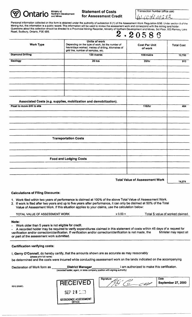
Ontario Ministry ofNorthern Developmentand Mines
Statement of Costs for Assessment Credit
Transaction Number (office use)
Personal information collected on this form is obtained under the authority of subsection 6 (1) of the Assessment Work Regulation 6/96. Under section e of the Mining Act, this information is a public record. This information will be used to review the assessment work and correspond with the mining land holder. Questions about this collection should be directed to a Provincial Mining Recorder, Ministry of Northern Development and Mines, 3rd Floor, 933 Ramsey Lake Road, Sudbury, Ontario, P3E 6B5. f\ ^ ^ -^. .^. -^O 5 8 o
Work Type
Diamond Drilling
Geology
Units of workDepending on the type of work, list the number of hours/days worked, metres of drilling, kilometres of grid line, number of samples, etc.
120 metres
26hrs
Associated Costs (e.g. supplies, mobilization and demobilization).Float to move drill to site
Transportation Costs
Food and Lodging Costs
Cost Per Unit of work
106/metre
35/hr
116/hr
Total Value of Assessment Work
Total Cost
12,700
910
464
14,074
Calculations of Filing Discounts:
1. Work filed within two years of performance is claimed at 10007o of the above Total Value of Assessment Work.2. If work is filed after two years and up to five years after performance, it can only be claimed at 500Xo of the Total
Value of Assessment Work. If this situation applies to your claims, use the calculation below:
TOTAL VALUE OF ASSESSMENT WORK f. 0.50 = Total S value of worked claimed.
Note:- Work older than 5 years is not eligible for credit.- A recorded holder may be required to verify expenditures claimed in this statement of costs within 45 days of a request for verification and/or correction/clarification. If verification and/or correction/clarification is not made, the Minister may reject all or part of the assessment work submitted.
Certification verifying costs:
l, Gerry O'Connell, do hereby certify, that the amounts shown are as accurate as may reasonably(please print full name)
be determined and the costs were incurred while conducting assessment work on the lands indicated on the accompanying
Declaration of Work form as District Manager. l am authorized to make this certification.(recorded holder, agent, or state company position with signing authority)
0212 (03/97)RECEIVED
SEP 28 :.:3GEOSCIENCE ASSESSMENT
OfFICE_____
Signature DateSeptember 27,2000

Ministry of Ministere duNorthern Development Developpement du Nordand Mines et des Mines Ontario
Geoscience Assessment Office 933 Ramsey Lake Road
October 24, 2000 6th FloorSudbury, Ontario
TECK CORPORATION P3E 6B5SUITE 600, 200 BURRARD STREETVANCOUVER, B.C. Telephone: (888) 415-9845V6C-3L9 Fax: (877)670-1555
Visit our website at: www.gov.on.ca/MNDM/MINES/LANDS/mlsmnpge.htm
Dear Sir or Madam: Submission Number: 2.20586
Status Subject: Transaction Number(s): W0040.00252 Approval
We have reviewed your Assessment Work submission with the above noted Transaction Number(s). The attached summary page(s) indicate the results of the review. WE RECOMMEND YOU READ THIS SUMMARY FOR THE DETAILS PERTAINING TO YOUR ASSESSMENT WORK.
If the status for a transaction is a 45 Day Notice, the summary will outline the reasons for the notice, and any steps you can take to remedy deficiencies. The 90-day deemed approval provision, subsection 6(7) of the Assessment Work Regulation, will no longer be in effect for assessment work which has received a 45 Day Notice. Allowable changes to your credit distribution can be made by contacting the Geoscience Assessment Office within this 45 Day period, otherwise assessment credit will be cut back and distributed as outlined in Section #6 of the Declaration of Assessment work form.
Please note any revisions must be submitted in DUPLICATE to the Geoscience Assessment Office, by the response date on the summary.
If you have any questions regarding this correspondence, please contact LUCILLE JEROME by e-mail at [email protected] or by telephone at (705) 670-5858.
Yours sincerely,
ORIGINAL SIGNED BYSteve B. BeneteauActing Supervisor, Geoscience Assessment OfficeMining Lands Section
Correspondence ID: 15371 Copy for: Assessment Library
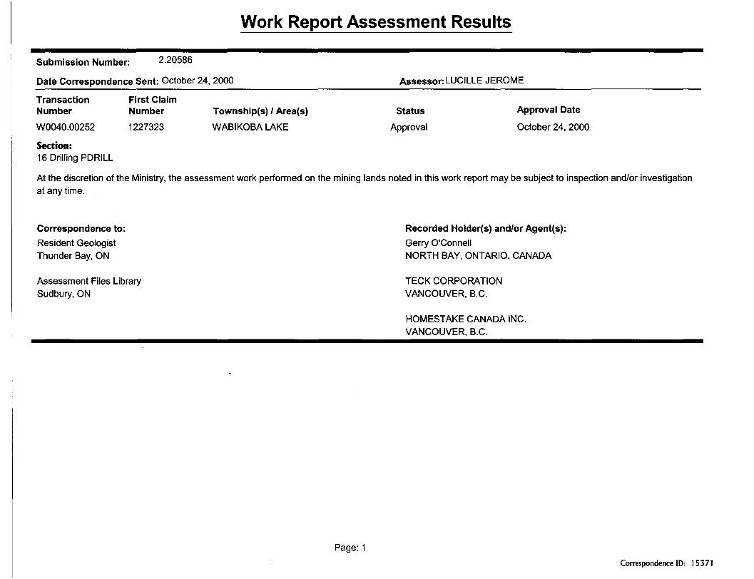
Work Report Assessment Results
Submission Number: 2.20586
Date Correspondence Sent: October 24, 2000______________________Assessor:LUCILLE JEROME^^—-^^^^-—^^^^^——
Transaction First ClaimNumber Number Township(s) l Area(s) Status Approval Date
W0040.00252 1227323 WABIKOBA LAKE Approval October 24,2000
Section:16 Drilling PDRILL
At the discretion of the Ministry, the assessment work performed on the mining lands noted in this work report may be subject to inspection and/or investigation at any time.
Correspondence to: Recorded Holder(s) and/or Agent(s):Resident Geologist Gerry O'ConnellThunder Bay, ON NORTH BAY, ONTARIO, CANADA
Assessment Files Library TECK CORPORATION Sudbury, ON VANCOUVER, B.C.
HOMESTAKE CANADA INC. VANCOUVER, B.C.
Page: 1Correspondence ID: 15371

REFERENCESAREAS WITHDRAWN FROM
M.H.O. - MINING RIGHTS ONLY IRQ - SURFACE RIGHTS ONLY
. - MINING AND SURfACE RIGHTS
Rj)l onds subject to *csament for tellings dlapoial twp. lcndroll)
^ Surface and mining right* from staking order W 33/85, J8/IH/85.
@ Suriac* right* withdrawn from slaking order W 28 /B3, 20/10/83.
@ Surface rights withdrawn from slaking ordnrW22^4.
^ Surface rhjhtt wllMrqwn from stqKIng order W IO/B5, 02/10/65.
Surfqea rlqhte wtthdrqnn from ordar WTfletx94NWn 04/IG/I4
drying@ or s a 9ub]*c) To flooding and other riflhls undw oaiBirmnt NBb-lt 5*c whila IqRn ne ri h landfall.
MMN6 RWHT5 WTHOMWN f ROM STAKINS.FROM fORFFfTUFE FBOM
PENDING APPLICATION UNDER THEAGGREGATF aesOUR^EB ACT 11^05/9* (TfLL)
c. 35 W-LL P1504/99 OUT 12/05/99 M A S
BLACK RIVER G-580 1239868 1239874•4*00 II' i*' t?' •e' 11' •o' 4 f J . 4T' k* 1
ftl'
ttO)m io
4*
Ztt o
Aft
O
o44'
Ultt-c-lfAD OflC
48" 43'Orf-
1238040r.
hr.-v*;.^ k l l h.--r"-: -r--|-^h- ,J
^^ali^ 1, l_^l^^4--rL-^feL-!h ,.u-—^-^b^-i—H ii^s * i f x' i r^i"-™' is\ I ' l .^ l J-VA-r^ ' ' h l——1
IJ96646
i t—— — — — — .
- i I 1*1 ™ L, l— t--r-^—---- H-
At*
St'
B D'
4 r
4T'
46'
MIDl
O
O.
Ill^Jw
a (rtUl
UJ
w
a
8 43'00"
86 "Oil"
BOMBY TWP. G-3173 BROTHERS TWP. G-3172
LEGENDHIGHWAY AND ftOUTf Ho.OTHER ROADSTKAU.SSURVEYED kiNti.
lOWNfiHIPfi BASt C!NES. ETC.LOTS. MINING CLAIMS. PAH CELfi, ETC --
NSLJftVEYFD LINES LOT
MINING CLAIMS rrcRAILWAY AND RIGHT OF WAVUTIHTY LINESHON PERENNIAL STREAMFLOODING OR FLOODINGSUBDIVISION DA COMPOSITE PLANNtSEHVATIQNSORIGINAL SHORELINEMARSH OR MUSKEGW WESTRAVFRSf HONUMtNT
OISPOSmOM OF CROWN UN Of
TYPE OF DOCUMENT SYMBOLPATENT. SURFACE fc MINING EIGHTS -....... ...... .. vi
.SUBFACE RICHTSONLY--————- -. 6" .MINING RIGHTS ONLY-—. ... . O
LEAM.SURFACE * MINING BIGHTS—------. B" ,4URFACt RfGMTSDNLY—-. . B " . MINING BIGHTS ONLY———,. ——...........B
LICENCE OF OCCUPATION .... ..——.. ——... . VOftDEfl-IH COUNCIL ...—.———... .-, .. ... OCRESERVATION .....,——— . .. , .-. JDCANCfLLCD __.... . ............... - *fiANDIi GRAVEL ———..—....~...,._. . .....- f)y
LAND l* mwiTt FDH CCNMEROM. TOliHUH. OUTPUT CMTB x/ nant- Miiumn nifiHT* m mntH-* r ATtNTin 'Pirin TU M** *.
1*11. VHTCD IH QHiaiMAI f*fIWT(i IV Inf fuiL Ifuutoc AC i pia.a. i*". CHAT 3M, 'tc ti. bjurc i
SCALE; 1 INCH ' W CHAINS
a ionMtTHlS
1HM 11 l-M'
Q8C WVJBAW WIMET TOflOOPIW TD ELEWfim
L*i*t liinMri*^ lv T* MwW( w* -~- hk Mt Iii*vw* *H4a
* * * * *
RECEIVEDSEP 2 8 2COO
6EOSCIENCEASSESSMEWT
Thd biformatloii that qppaurs un l|)|s mop hot boort compllwl from various *OUTCBI and accuracy li not guaranteed. Thusn wbWrq la stake MINING CLAIMS should consult wHh Ih* MINING RECORDER MlnJatry of Norlhern Deveiopmwit and Mine* for additional Informqtian or the stalin ol Ilin lands shown hsreon.
o x 8AREA
WABIKOBA UKEMN H. A01BIKISTBATIVE DIITBICT
TERRACE BAYMlNIMC DIVISION
THUNDER BAYLAND TITLES/ BI6IITKV DIVItlDN
THUNDER BAYMinistry of Natural Man*t*flxnt
BranchOntario
Dlt * AUGUST IM4
Oct. 28^94-
• ••111
G-620
42C13SW2003 2.20586 WABIKOBA LAKE 200

LOCATION MAP FOR DRILL HOLE T-OOOI - CLAIM TBI227332ALL LOCATIONS IN TRUNCATED UTM GRID (98000 N* 5398000 N)
(77000 Ns 0577000 N)
2 -20586
98000 N
HOMESTAKE
97000 N
TILINGS POND ULTIMATE LIMIT
WABIKOBA TWP96000 N
BOMBY TWPLECOURS TWP
WILLIAMS
Scale: mO 500
42C13SW2003 2.20586 WABIKOBA LAKE
ea IP
10350.0 2
10325,0 Z
10300.0 Z
10275,0 Z
10250.0 Z
Io:
q,
10350,0 2
10325,0 Z
10300 O Z
10275.0 Z
10250.0 2
10225.02 10225.0 2
0200.0 Z 10200,0 Z
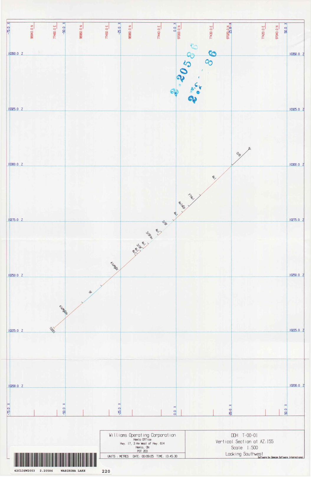
Wi 11 lams Operaiing Corporal ionHemlo Office
Hwy. 17, 3 Km Wtest of Hwy. 614hfemlo, ON
POT 2EO
UNITS : I-ETRES DATE: 00/09/25
DDH T-00-01 Vent leal Section at AZ;155
Scale 1:500 Looking Southwest
_________________________Snftucre tit Genmm Softijre InJampHmoL
42C13SW2003 2.2058G WABIKOBA LAKE 220
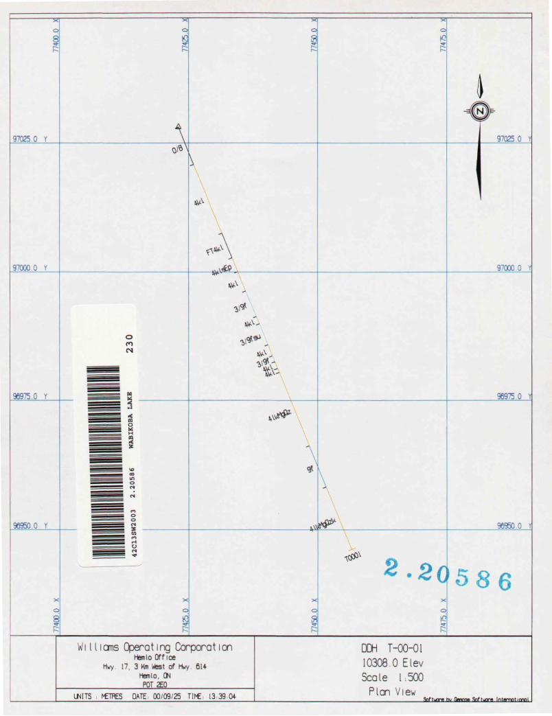
970250 Y A 97025.0 Y
97000 O r 97000.0 Y
96975.0 Y
96950.0 Y
o m CN
96975.0 1
96950.0 1
2.20 586
l orns Opera 11 ng Corpora 11 onHen lo Office
Hwy 17. 3 Km West of Mwy 6U-Hemlo, GN
PQT2EOIMTS I^TRES DATE 00/09/25 Tll^E. 13:39 04
DDH T-00-0110308.0 E levScale 1:500
Plan ViewIntamoticnoL