wilderness inventory unit: sourdough mountain or … inventory unit index of documents sourdough...
TRANSCRIPT

Wilderness Inventory Unit Index of Documents Sourdough Mountain OR-034-030, 29 total pages
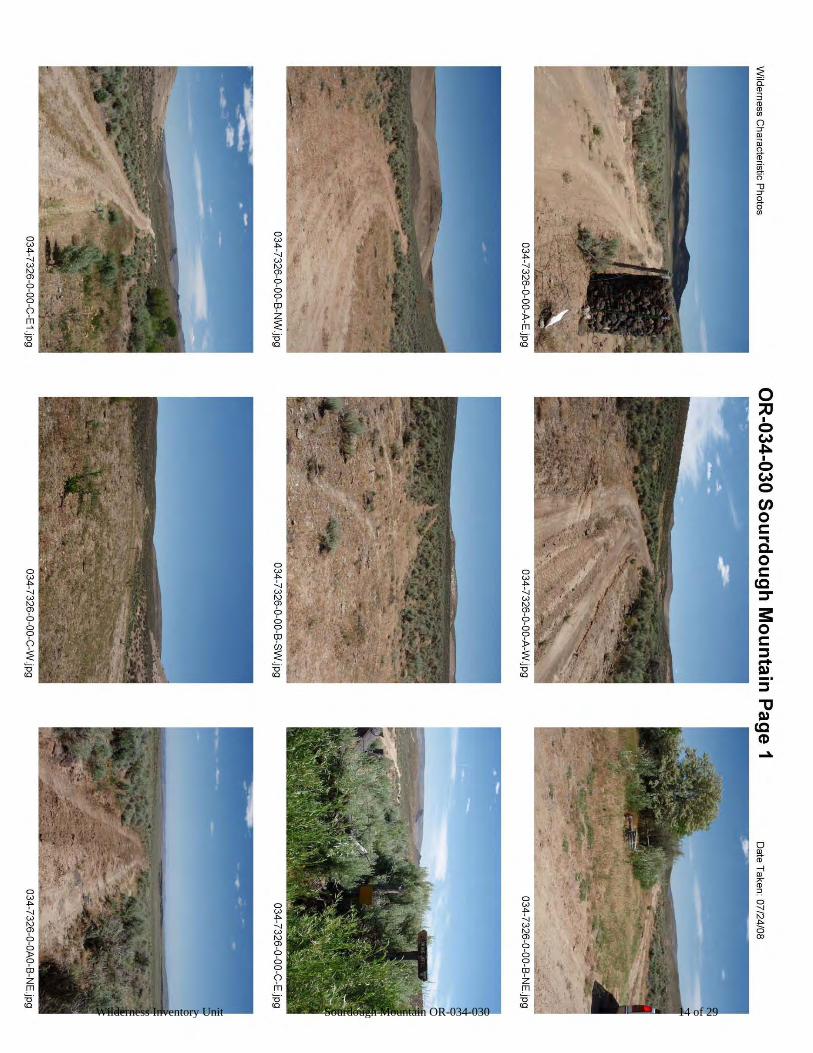
Page 1: Index Cover Sheet Page 2: Form 1 – Documentation of BLM Wilderness Inventory: Findings on Record Page 5: Form 2 – Documentation of Current Wilderness Inventory Conditions Pages 10: Form 2 – Summary of Findings and Conclusion Page 11: Wilderness Characteristics Overview – Sourdough Mountain OR-034-030 Map 1 of 2 Page 12: Wilderness Characteristics-Land Treatments-Sourdough Mountain OR-034-030 Map 2 of 2 Page 13: Wilderness Characteristics – BLM Photo Points – Sourdough Mountain Map & Log Page 14: OR-034-030 Sourdough Mountain BLM Photos
Page 17: H-6300-1-Wilderness Inventory Maintenance in BLM Oregon/Washington
Appendix C – Road* Analysis: BLM 7326-0-000
Page 21: H-6300-1-Wilderness Inventory Maintenance in BLM Oregon/Washington
Appendix C – Road* Analysis: BLM 7322-0-100
Page 26: H-6300-1-Wilderness Inventory Maintenance in BLM Oregon/Washington
Appendix C – Road* Analysis: BLM 7326-0-0A0
Prepared by: U.S. Department of the Interior Bureau of Land Management
Vale District Office 100 Oregon Street
Vale, Oregon 97918
Wilderness Inventory Unit Sourdough Mountain OR-034-030 1 of 29

Form 1 – Documentation of BLM Wilderness Inventory: Findings on Record 1 of 3
H-6300-1-WILDERNESS INVENTORY MAINTENANCE IN BLM OREGON/WASHINGTON
APPENDIX B – INVENTORY AREA EVALUATION
Evaluation of Current Conditions: 1) Document and review the existing BLM wilderness inventory findings on file, if available, regarding the presence or absence of individual wilderness characteristics, using Form 1, below.
2) Consider relevant information regarding current conditions available in the office to identify and describe any changes to the existing information (use interdisciplinary (ID) team knowledge, aerial photographs, field observations, maps, etc.), and document your findings on Form 2, below. When Citizen Information has been submitted regarding wilderness characteristics, document the submitted materials including: date of Submission; Name of District(s) and Field Office(s) Affected; Type of material Submitted (e.g. narrative, map, photo). Evaluate any submitted citizen information regarding the validity of proposed boundaries of the unit(s), the existence of roads and other boundary features, the size of the unit(s), and the presence or absence of wilderness characteristics based on relevant information available in the office (prior BLM inventories, ID team knowledge, aerial photographs, field observations, maps, etc.) Conduct field reviews as necessary to verify information and to ascertain current conditions. Reach conclusions on current conditions including boundaries, size of areas and presence or absence of wilderness characteristics. Fully explain the basis for each conclusion on form 2, including any critical differences between BLM and citizen information. Document your findings regarding current conditions for each inventoried area. Describe how the present conditions are similar to, or have changed from, the conditions documented in the original wilderness inventory. Document your findings on Form 2 for each inventory area. Cite to or attach data considered, including photographs, maps, GIS layers, field trip notes, project files, etc.
Wilderness Inventory Unit Sourdough Mountain OR-034-030 2 of 29

Form 1 – Documentation of BLM Wilderness Inventory: Findings on Record 2 of 3
Year: __2009_ Unit Number/Name:
OR-034-030 -- Sourdough Mountain___
FORM 1
Yes
-- DOCUMENTATION OF BLM WILDERNESS INVENTORY FINDINGS ON RECORD
1. Is there existing BLM wilderness inventory information on all or part of this area?
No __X__ (If yes, and if more than one unit is within the area, list the names of those units.): ____
A.) Inventory Source(s) -- (X) Denotes all applicable BLM Inventory files, printed maps, or published BLM Decision documents with information pertaining to this unit.
Wilderness Inventories
(X) 1978-1980 --- BLM Wilderness Inventory Unit OR-03-04-04 Sourdough Mountain 3-310 (unpublished BLM documents, District files location is presently unknown)
(X) April 1979 – Wilderness -- Proposed Initial Inventory – Roadless Areas and Islands Which Clearly Do Not have Wilderness Characteristics, Oregon and Washington
Wilderness Decision Documents
(X) August 1979 – Wilderness Review – Initial Inventory, Final Decision on Public Lands Obviously Lacking Wilderness Characteristics and Announcement of Public Lands to be Intensively Inventoried for Wilderness Characteristics, Oregon and Washington (green document)
( ) October 1979 – Wilderness Review – Intensive Inventory - Oregon, Proposed Decision on the Intensive Wilderness Inventory of Selected Areas (grey document).
( ) March 1980 – Wilderness Review – Intensive Inventory; Final Decisions on 30 Selected Units in Southeast Oregon and Proposed Decisions on Other Intensively Inventoried Units in Oregon and Washington (orange document)
( ) November 1980 - Wilderness Inventory – Oregon and Washington, Final Intensive Inventory Decisions (brown document)
( ) November 1981 Stateline Intensive Wilderness Inventory Final Decision, Oregon, Idaho, Nevada, Utah (tan document).
B.) Inventory Unit Name(s)/Number(s)
BLM OR-03-04-04, Sourdough Mountain 3-310
Wilderness Inventory Unit Sourdough Mountain OR-034-030 3 of 29
Form 1 – Documentation of BLM Wilderness Inventory: Findings on Record 3 of 3
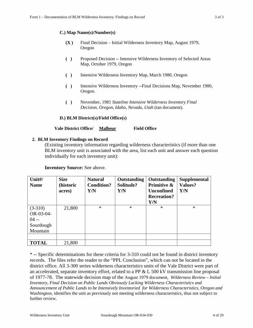
C.) Map Name(s)/Number(s)
(X ) Final Decision – Initial Wilderness Inventory Map, August 1979, Oregon
( ) Proposed Decision -- Intensive Wilderness Inventory of Selected Areas Map, October 1979, Oregon
( ) Intensive Wilderness Inventory Map, March 1980, Oregon
( ) Intensive Wilderness Inventory --Final Decisions Map, November 1980, Oregon.
( ) November, 1981 Stateline Intensive Wilderness Inventory Final Decision, Oregon, Idaho, Nevada, Utah (tan document).
D.) BLM District(s)/Field Office(s)
Vale District Office/ Field Office Malheur
2. BLM Inventory Findings on Record
(Existing inventory information regarding wilderness characteristics (if more than one BLM inventory unit is associated with the area, list each unit and answer each question individually for each inventory unit): Inventory Source: See above.
Unit#/ Name
Size (historic acres)
Natural Condition? Y/N
Outstanding Solitude? Y/N
Outstanding Primitive & Unconfined Recreation? Y/N
Supplemental Values? Y/N
(3-310) OR-03-04-04 --Sourdough Mountain
21,800 * * * *
TOTAL 21,800 * -- Specific determinations for these criteria for 3-310 could not be found in district inventory records. The files refer the reader to the “PPL Conclusion”, which can not be located in the district office. All 3-300 series wilderness characteristics units of the Vale District were part of an accelerated, separate inventory effort, related to a PP & L 500 kV transmission line proposal of 1977-78. The statewide decision map of the August 1979 document, Wilderness Review – Initial Inventory, Final Decision on Public Lands Obviously Lacking Wilderness Characteristics and Announcement of Public Lands to be Intensively Inventoried for Wilderness Characteristics, Oregon and Washington, identifies the unit as previously not meeting wilderness characteristics, thus not subject to further review.
Wilderness Inventory Unit Sourdough Mountain OR-034-030 4 of 29
Form 2 – Documentation of Current Wilderness Inventory Conditions 1 of 5
H-6300-1-WILDERNESS INVENTORY MAINTENANCE IN BLM OREGON/WASHINGTON
APPENDIX B – INVENTORY AREA EVALUATION
Evaluation of Current Conditions: 1) Document and review the existing BLM wilderness inventory findings on file, if available, regarding the presence or absence of individual wilderness characteristics, using Form 1, below.
2) Consider relevant information regarding current conditions available in the office to identify and describe any changes to the existing information (use interdisciplinary (ID) team knowledge, aerial photographs, field observations, maps, etc.), and document your findings on Form 2, below. When Citizen Information has been submitted regarding wilderness characteristics, document the submitted materials including: date of Submission; Name of District(s) and Field Office(s) Affected; Type of material Submitted (e.g. narrative, map, photo). Evaluate any submitted citizen information regarding the validity of proposed boundaries of the unit(s), the existence of roads and other boundary features, the size of the unit(s), and the presence or absence of wilderness characteristics based on relevant information available in the office (prior BLM inventories, ID team knowledge, aerial photographs, field observations, maps, etc.) Conduct field reviews as necessary to verify information and to ascertain current conditions. Reach conclusions on current conditions including boundaries, size of areas and presence or absence of wilderness characteristics. Fully explain the basis for each conclusion on form 2, including any critical differences between BLM and citizen information. Document your findings regarding current conditions for each inventoried area. Describe how the present conditions are similar to, or have changed from, the conditions documented in the original wilderness inventory. Document your findings on Form 2 for each inventory area. Cite to or attach data considered, including photographs, maps, GIS layers, field trip notes, project files, etc.
Wilderness Inventory Unit Sourdough Mountain OR-034-030 5 of 29
Form 2 – Documentation of Current Wilderness Inventory Conditions 2 of 5
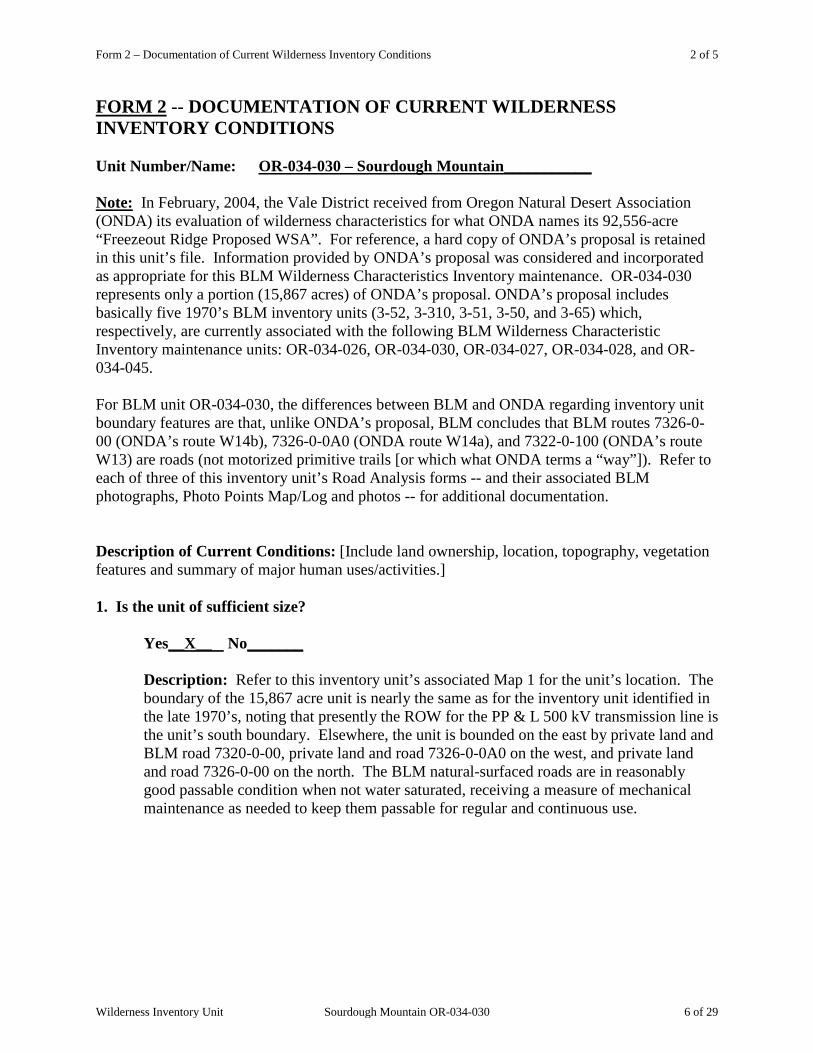
FORM 2 -- DOCUMENTATION OF CURRENT WILDERNESS INVENTORY CONDITIONS Unit Number/Name: OR-034-030 – Sourdough Mountain___________ Note: In February, 2004, the Vale District received from Oregon Natural Desert Association (ONDA) its evaluation of wilderness characteristics for what ONDA names its 92,556-acre “Freezeout Ridge Proposed WSA”. For reference, a hard copy of ONDA’s proposal is retained in this unit’s file. Information provided by ONDA’s proposal was considered and incorporated as appropriate for this BLM Wilderness Characteristics Inventory maintenance. OR-034-030 represents only a portion (15,867 acres) of ONDA’s proposal. ONDA’s proposal includes basically five 1970’s BLM inventory units (3-52, 3-310, 3-51, 3-50, and 3-65) which, respectively, are currently associated with the following BLM Wilderness Characteristic Inventory maintenance units: OR-034-026, OR-034-030, OR-034-027, OR-034-028, and OR-034-045. For BLM unit OR-034-030, the differences between BLM and ONDA regarding inventory unit boundary features are that, unlike ONDA’s proposal, BLM concludes that BLM routes 7326-0-00 (ONDA’s route W14b), 7326-0-0A0 (ONDA route W14a), and 7322-0-100 (ONDA’s route W13) are roads (not motorized primitive trails [or which what ONDA terms a “way”]). Refer to each of three of this inventory unit’s Road Analysis forms -- and their associated BLM photographs, Photo Points Map/Log and photos -- for additional documentation. Description of Current Conditions: [Include land ownership, location, topography, vegetation features and summary of major human uses/activities.] 1. Is the unit of sufficient size?
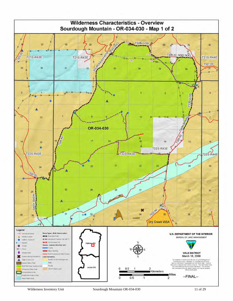
Yes__X__ No_______ Description: Refer to this inventory unit’s associated Map 1 for the unit’s location. The
boundary of the 15,867 acre unit is nearly the same as for the inventory unit identified in the late 1970’s, noting that presently the ROW for the PP & L 500 kV transmission line is the unit’s south boundary. Elsewhere, the unit is bounded on the east by private land and BLM road 7320-0-00, private land and road 7326-0-0A0 on the west, and private land and road 7326-0-00 on the north. The BLM natural-surfaced roads are in reasonably good passable condition when not water saturated, receiving a measure of mechanical maintenance as needed to keep them passable for regular and continuous use.
Wilderness Inventory Unit Sourdough Mountain OR-034-030 6 of 29

Form 2 – Documentation of Current Wilderness Inventory Conditions 3 of 5
2. Is the unit in a natural condition? Yes___X____ No_______ N/A_______ Description: The broad, gradually sloped upper features of Sourdough Mountain and its
notably more incised drainages are the central geographic focus of this unit. Elevations range from the mountain’s top of 4,747 feet to about 3,220 feet along the unit’s east boundary. The prominent Negro Rock igneous spire is in the unit’s northeast corner. Vegetation consists of typical native high desert shrub and both native and non-native grass species.
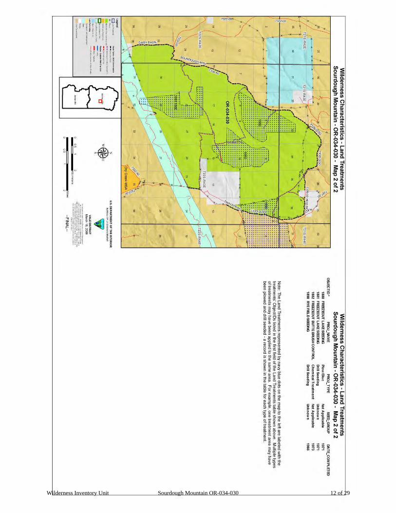
Refer to this inventory unit’s associated Map 1 and Map 2 for human imprints in the unit. They include 7.3 miles of rangeland fence, two small fenced enclosures, 4 developed springs, 6 earthen reservoirs, 2.0 miles of buried water pipeline with 2 associated troughs, 15.9 miles of 9 motorized primitive trails (MPTs), a quarter mile of an abandoned vehicle route, a site of remnant mineral exploration surface disturbance (near middle of section 35; not displayed on Map 1 or Map 2), and an artesian well in the southeast 1/4 of section 35 (not displayed on Map 1 or Map 2). There remains no visual evidence today of vegetation treatments which occurred between 1966 and 1973 (plow/disc drill seedings and a chemical treatment). When considered individually and collectively relative to the unit’s size and given the broad distribution and nominal extent and nature of these imprints, the unit appears to be affected primarily by the forces of nature with the imprint of humans being substantially unnoticeable to the average visitor. BLM documents the presence of 4 MPTs within this unit for which no ONDA documentation is provided. Except for ONDA’s stated vehicle routes, its proposal does not quantify or indicate the location of other known man-made features of the Association’s proposed WSA while concluding that the unit appears primarily affected by the forces of nature with the imprint of man’s work substantially unnoticeable. For comparative reference, refer to the BLM Map1, Map 2 and to ONDA’s proposal, all located in this unit’s inventory file folder.
3. Does the unit have outstanding opportunities for solitude? Yes____X___ No_______ N/A_______ Description: The unit’s width and length vary throughout the unit, ranging respectively
between approximately 1.5 to 4.5 miles wide (east-west) and from less than a mile to approximately 6 miles long. Vegetation provides for no screening of visitors of the unit. The unit’s western half (an extensive area of the unit’s higher elevations) has slight to moderate topographic gradients. There is notably steep terrain associated within the eastern half of the unit, although a portion of it is excluded by a 1,280 acre private parcel and which constitutes part of the unit’s east boundary. With these features -- the unit’s higher and isolated extensive and somewhat gentler terrain in its west combined with the steep, incised nature of multiple drainages in its east – the unit’s topographic diversity relative to its configuration and size provides outstanding opportunities for solitude.
Wilderness Inventory Unit Sourdough Mountain OR-034-030 7 of 29
Form 2 – Documentation of Current Wilderness Inventory Conditions 4 of 5
ONDA states that its substantially larger “Freezeout Ridge Proposed WSA” possesses outstanding opportunities for solitude. Based on the current results of BLM’s wilderness characteristics inventory maintenance, BLM does not have an inventory unit that approaches the size of ONDA’s in this general area. While drawing no conclusion regarding solitude within ONDA’s proposal, BLM recognizes that a unit of the general size, configuration and topography as ONDA’s proposal may possess attributes which may result in providing for outstanding opportunities of solitude.
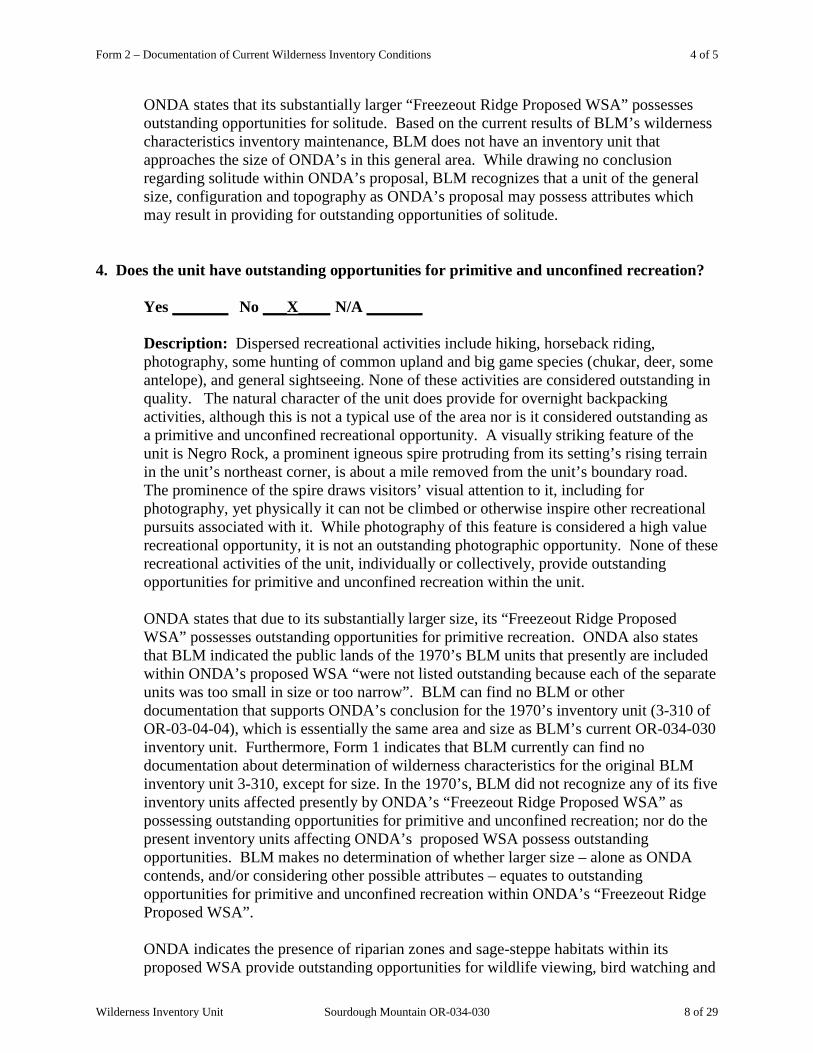
4. Does the unit have outstanding opportunities for primitive and unconfined recreation?
Yes _______ No ___X____ N/A _______
Description: Dispersed recreational activities include hiking, horseback riding, photography, some hunting of common upland and big game species (chukar, deer, some antelope), and general sightseeing. None of these activities are considered outstanding in quality. The natural character of the unit does provide for overnight backpacking activities, although this is not a typical use of the area nor is it considered outstanding as a primitive and unconfined recreational opportunity. A visually striking feature of the unit is Negro Rock, a prominent igneous spire protruding from its setting’s rising terrain in the unit’s northeast corner, is about a mile removed from the unit’s boundary road. The prominence of the spire draws visitors’ visual attention to it, including for photography, yet physically it can not be climbed or otherwise inspire other recreational pursuits associated with it. While photography of this feature is considered a high value recreational opportunity, it is not an outstanding photographic opportunity. None of these recreational activities of the unit, individually or collectively, provide outstanding opportunities for primitive and unconfined recreation within the unit. ONDA states that due to its substantially larger size, its “Freezeout Ridge Proposed WSA” possesses outstanding opportunities for primitive recreation. ONDA also states that BLM indicated the public lands of the 1970’s BLM units that presently are included within ONDA’s proposed WSA “were not listed outstanding because each of the separate units was too small in size or too narrow”. BLM can find no BLM or other documentation that supports ONDA’s conclusion for the 1970’s inventory unit (3-310 of OR-03-04-04), which is essentially the same area and size as BLM’s current OR-034-030 inventory unit. Furthermore, Form 1 indicates that BLM currently can find no documentation about determination of wilderness characteristics for the original BLM inventory unit 3-310, except for size. In the 1970’s, BLM did not recognize any of its five inventory units affected presently by ONDA’s “Freezeout Ridge Proposed WSA” as possessing outstanding opportunities for primitive and unconfined recreation; nor do the present inventory units affecting ONDA’s proposed WSA possess outstanding opportunities. BLM makes no determination of whether larger size – alone as ONDA contends, and/or considering other possible attributes – equates to outstanding opportunities for primitive and unconfined recreation within ONDA’s “Freezeout Ridge Proposed WSA”. ONDA indicates the presence of riparian zones and sage-steppe habitats within its proposed WSA provide outstanding opportunities for wildlife viewing, bird watching and
Wilderness Inventory Unit Sourdough Mountain OR-034-030 8 of 29
Form 2 – Documentation of Current Wilderness Inventory Conditions 5 of 5
hunting. BLM does not concur that the presence of these habitats equates to outstanding opportunities for wildlife viewing, bird watching or hunting within OR-034-030. While recognizing the presence of varying wildlife/bird habitat niche settings within the BLM inventory unit for viewing and hunting, (e.g., a major ridgeline, rolling terrain, some substantially nearly flat area, and spring sites), BLM has determined the unit’s habitats and animal species present are not so unique or otherwise possess features – individually or in combination -- which result in these recreation activity opportunities being outstanding within the inventory unit.
5. Does the unit have supplemental values?
Yes ___X___ No _______ N/A ______ Description: Two separate small sites of Biddle’s lupine, a BLM special status plant species, are located adjacent to two boundary roads of the inventory unit. BLM has documentation of 3 sage grouse leks in the inventory unit. Sage grouse is a BLM special status animal species. ONDA states that it’s proposed WSA may provide habitat for the Mojave Black-collared Lizard, Desert Horned Lizard, Ground Snake, Ferruginous Hawk, Pygmy Rabbit, and White-tailed Antelope Squirrel, which ONDA’s February 2004 submission to the Vale District declares are listed as “sensitive species” by the State of Oregon. As of 2009, the Mohave Black-collard Lizard, Desert Horned Lizard, Ground Snake and the White-tailed Antelope Squirrel were not considered sensitive by either the state of Oregon, U.S. Fish and Wildlife Service or BLM. Although not sensitive species, BLM has documented the presence of Mojave Black-collared Lizard and Desert Horned Lizard within this proposed unit. BLM acknowledges that habitat requirements may exist for the Ground Snake, Ferruginous Hawk, Pygmy Rabbit, and White-tailed Antelope Squirrel; however, neither ONDA nor any other entity has provided BLM official documentation confirming the presence of these species within this inventory unit.
Wilderness Inventory Unit Sourdough Mountain OR-034-030 9 of 29

Form 2 – Summary of Findings and Conclusion 1 of 1
Summary of Findings and Conclusion
Unit Name and Number:_ OR-034-030 – Sourdough Mountain______________ Summary Results of Analysis:
1. Does the area meet any of the size requirements? __X___Yes ______No 2. Does the area appear to be natural? __X___Yes ______No 3. Does the area offer outstanding opportunities for solitude or a primitive and unconfined type of recreation? ___X___Yes ______No ______NA
4. Does the area have supplemental values? ___X___Yes ______No ______NA
Conclusion -- check one: ___X__ The area, or a portion of the area, has wilderness character. ______ The area does not have wilderness character.
Wilderness Inventory Unit Sourdough Mountain OR-034-030 10 of 29
Form 2 – Summary of Findings and Conclusion 2 of 6
Wilderness Inventory Unit Sourdough Mountain OR-034-030 11 of 29
Form 2 – Summary of Findings and Conclusion 3 of 6
Wilderness Inventory Unit Sourdough Mountain OR-034-030 12 of 29
Form 2 – Summary of Findings and Conclusion 4 of 6
Wilderness Inventory Unit Sourdough Mountain OR-034-030 13 of 29
Form 2 – Summary of Findings and Conclusion 5 of 6
Wilderness Inventory Unit Sourdough Mountain OR-034-030 14 of 29

Form 2 – Summary of Findings and Conclusion 6 of 6
Wilderness Inventory Unit Sourdough Mountain OR-034-030 15 of 29

Form 2 – Summary of Findings and Conclusion 7 of 6
Wilderness Inventory Unit Sourdough Mountain OR-034-030 16 of 29

Appendix C – Road* Analysis: BLM 7326-0-00 1 of 4
H-6300-1-WILDERNESS INVENTORY MAINTENANCE IN BLM OREGON/WASHINGTON
APPENDIX C – ROAD* ANALYSIS
(Factors to consider when determining whether a route is a road for wilderness inventory purposes.)
Wilderness Inventory Unit Name/Number: OR-034-030 – Sourdough Mountain
NOTE: This unit is affected by ONDA’s Freezeout Ridge proposed WSA. Route Name and/or Identifier (Include Transportation Plan Identifier, if known; include route number supplied by citizen information when available): BLM 7326-0-00 (alias 034-7326-0-00). (This route is identified by ONDA on its Road Log as its “W14b und”, for which ONDA provides no descriptive of what “und” means or represents. That said, ONDA’s map for its proposal depicts its W14b as partially a “road” and partially as “subunit boundary”.) I. LOCATION: Refer to attached map (is the north boundary of this BLM inventory unit).
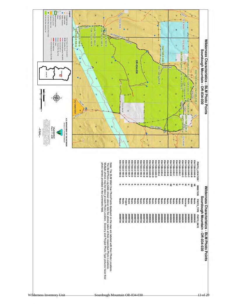
List photo point references (if applicable): Refer to this BLM inventory unit’s associated hard copy of its BLM Photo Points map, and affiliated Photo Log and photos -- retained in this unit’s permanent hard copy file, and electronically retained under this unit’s subfolder Final Findings/GIS Products. Any applicable ONDA photos and affiliated Photo Log are electronically retained under Wilderness Characteristics/S/Citizen Proposals.
II. CURRENT PURPOSE OF ROUTE: (Examples: Rangeland/Livestock Improvements (stock tank, developed spring, reservoir, fence, corral), Inholdings (ranch, farmhouse), Mine Site, Concentrated Use Site (camp site), Utilities (transmission line, telephone, pipeline), Administrative (project maintenance, communication site, vegetation treatment).)
Describe: This is a route used regularly in conjunction with BLM 7326-0-0A0 for access to certain rangeland/livestock improvements (earthen reservoirs) within this inventory unit and for additional livestock developments associated with abutting BLM inventory units OR-034-026, OR-034-027 for management of livestock, maintenance of the projects, and monitoring of associated activities. This route also provides connective access to the abutting private land (and which also serves as a feature of this unit’s boundary). This route provides connective access for 7326-0-0A0 which -- during much of the calendar year – gains access to popular dispersed camping areas associated with the Sourdough Ridge area.
Wilderness Inventory Unit Sourdough Mountain OR-034-030 17 of 29
Appendix C – Road* Analysis: BLM 7326-0-00 2 of 4
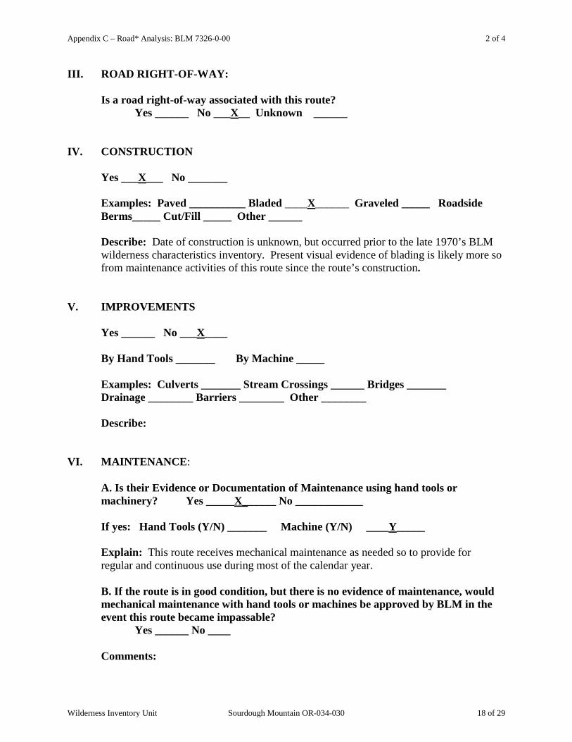
III. ROAD RIGHT-OF-WAY:
Is a road right-of-way associated with this route? Yes ______ No ___X__ Unknown ______
IV. CONSTRUCTION
Yes ___X___ No _______
Examples: Paved __________ Bladed ____X______ Graveled _____ Roadside Berms_____ Cut/Fill _____ Other ______
Describe: Date of construction is unknown, but occurred prior to the late 1970’s BLM wilderness characteristics inventory. Present visual evidence of blading is likely more so from maintenance activities of this route since the route’s construction.
V. IMPROVEMENTS
Yes ______ No ___X____
By Hand Tools _______ By Machine _____ Examples: Culverts _______ Stream Crossings ______ Bridges _______ Drainage ________ Barriers ________ Other ________
Describe: VI. MAINTENANCE:
A. Is their Evidence or Documentation of Maintenance using hand tools or machinery? Yes _____X______ No ____________
If yes: Hand Tools (Y/N) _______ Machine (Y/N) ____Y_____
Explain: This route receives mechanical maintenance as needed so to provide for regular and continuous use during most of the calendar year. B. If the route is in good condition, but there is no evidence of maintenance, would mechanical maintenance with hand tools or machines be approved by BLM in the event this route became impassable?
Yes ______ No ____
Comments:
Wilderness Inventory Unit Sourdough Mountain OR-034-030 18 of 29

Appendix C – Road* Analysis: BLM 7326-0-00 3 of 4
VII. REGULAR AND CONTINUOUS USE:
Yes ___X____ No _______
Describe evidence (vehicle tracks observed) and other rationale for whether use has occurred and will continue to occur on a relatively regular basis: BLM personnel and permittees use this route many times throughout the summer to maintain projects (developed springs and earthen reservoirs on public and private lands), administer grazing, and to access other areas. This route provides connective access for 7326-0-0A0 which -- during much of the calendar year – gains access to popular dispersed camping areas associated the with Sourdough Ridge area.
VIII. CONCLUSION: To meet the definition of a road, items IV or V, and VI-A or B, and VII must be checked yes. Road: Yes ___X_____ No ______
Explanation: Meets criteria for road, as described and explained, above.
-------------------------------------------------------------------------------------------------------
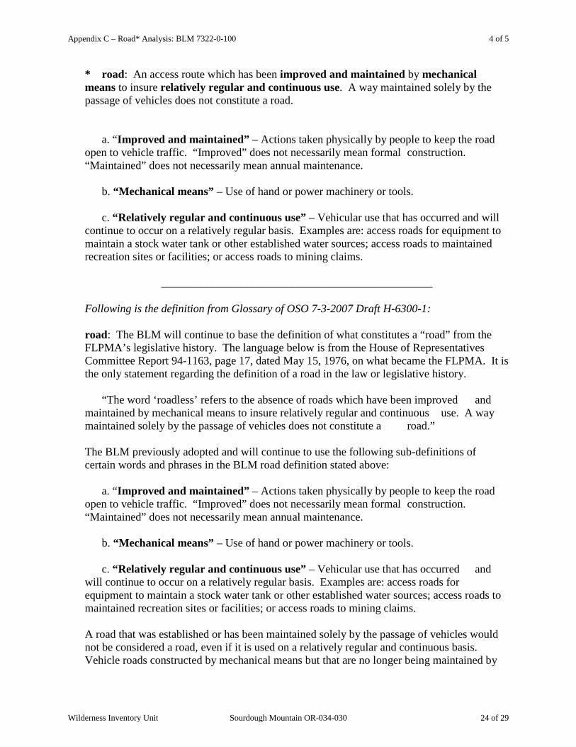
* road: An access route which has been improved and maintained by mechanical means to insure relatively regular and continuous use. A way maintained solely by the passage of vehicles does not constitute a road. a. “Improved and maintained” – Actions taken physically by people to keep the road open to vehicle traffic. “Improved” does not necessarily mean formal construction. “Maintained” does not necessarily mean annual maintenance. b. “Mechanical means” – Use of hand or power machinery or tools.
Wilderness Inventory Unit Sourdough Mountain OR-034-030 19 of 29
Appendix C – Road* Analysis: BLM 7326-0-00 4 of 4
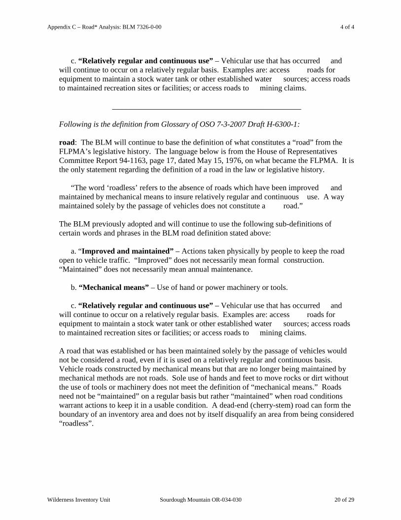
c. “Relatively regular and continuous use” – Vehicular use that has occurred and will continue to occur on a relatively regular basis. Examples are: access roads for equipment to maintain a stock water tank or other established water sources; access roads to maintained recreation sites or facilities; or access roads to mining claims.
________________________________________________ Following is the definition from Glossary of OSO 7-3-2007 Draft H-6300-1: road: The BLM will continue to base the definition of what constitutes a “road” from the FLPMA’s legislative history. The language below is from the House of Representatives Committee Report 94-1163, page 17, dated May 15, 1976, on what became the FLPMA. It is the only statement regarding the definition of a road in the law or legislative history. “The word ‘roadless’ refers to the absence of roads which have been improved and maintained by mechanical means to insure relatively regular and continuous use. A way maintained solely by the passage of vehicles does not constitute a road.” The BLM previously adopted and will continue to use the following sub-definitions of certain words and phrases in the BLM road definition stated above: a. “Improved and maintained” – Actions taken physically by people to keep the road open to vehicle traffic. “Improved” does not necessarily mean formal construction. “Maintained” does not necessarily mean annual maintenance. b. “Mechanical means” – Use of hand or power machinery or tools. c. “Relatively regular and continuous use” – Vehicular use that has occurred and will continue to occur on a relatively regular basis. Examples are: access roads for equipment to maintain a stock water tank or other established water sources; access roads to maintained recreation sites or facilities; or access roads to mining claims. A road that was established or has been maintained solely by the passage of vehicles would not be considered a road, even if it is used on a relatively regular and continuous basis. Vehicle roads constructed by mechanical means but that are no longer being maintained by mechanical methods are not roads. Sole use of hands and feet to move rocks or dirt without the use of tools or machinery does not meet the definition of “mechanical means.” Roads need not be “maintained” on a regular basis but rather “maintained” when road conditions warrant actions to keep it in a usable condition. A dead-end (cherry-stem) road can form the boundary of an inventory area and does not by itself disqualify an area from being considered “roadless”.
Wilderness Inventory Unit Sourdough Mountain OR-034-030 20 of 29

Appendix C – Road* Analysis: BLM 7322-0-100 1 of 5
H-6300-1-WILDERNESS INVENTORY MAINTENANCE
IN BLM OREGON/WASHINGTON
APPENDIX C – ROAD* ANALYSIS (Factors to consider when determining whether a route is a road for wilderness inventory purposes.)
Wilderness Inventory Unit Name/Number: OR-034-030 – Sourdough Mountain
NOTE: This unit is affected by ONDA’s Freezeout Ridge proposed WSA. Route Name and/or Identifier (Include Transportation Plan Identifier, if known; include route number supplied by citizen information when available): BLM 7322-0-100
(This route is identified by ONDA as its “W13” route, for which ONDA provides no descriptive in its Road Log for its WSA proposal, and is depicted on its WSA map as “subunit boundary”.) IX. LOCATION: Refer to attached map (is the Southwest corner boundary of this BLM
inventory unit). List photo point references (if applicable): Refer to this BLM inventory unit’s associated hard copy of its BLM Photo Points map, and affiliated Photo Log and photos -- retained in this unit’s permanent hard copy file, and electronically retained under this unit’s subfolder Final Findings/GIS Products. Any applicable ONDA map, photos and affiliated Photo Log are electronically retained under Wilderness Characteristics/Citizen Proposals.
X. CURRENT PURPOSE OF ROUTE:
(Examples: Rangeland/Livestock Improvements (stock tank, developed spring, reservoir, fence, corral), Inholdings (ranch, farmhouse), Mine Site, Concentrated Use Site (camp site), Utilities (transmission line, telephone, pipeline), Administrative (project maintenance, communication site, vegetation treatment).)
Describe: This is a route extending south from BLM 7326-0-0A0 and some maps indicate it also as part of 7322-0-100, with both being the same physical route. In conjunction with 7326-0-0A0, this route is used for access to some of this unit’s rangeland/livestock improvements (earthen reservoirs) and for additional livestock developments associated with abutting BLM inventory units OR-034-026, and OR-034-027 and OR-034-028 for management of livestock, maintenance of the projects, and monitoring of associated activities. This route is access to a private parcel on its southern end and an associated 2007 issued pipeline ROW between the spring and a reservoir located on public land to the north. This route also provides important access to the existing PP & L 500 kV transmission line ROW.
Wilderness Inventory Unit Sourdough Mountain OR-034-030 21 of 29
Appendix C – Road* Analysis: BLM 7322-0-100 2 of 5
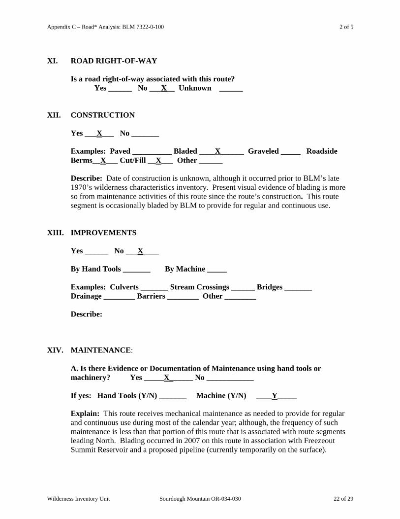
XI. ROAD RIGHT-OF-WAY
Is a road right-of-way associated with this route? Yes ______ No ___X__ Unknown ______
XII. CONSTRUCTION
Yes ___X___ No _______
Examples: Paved __________ Bladed ____X______ Graveled _____ Roadside Berms__X___ Cut/Fill __X___ Other ______
Describe: Date of construction is unknown, although it occurred prior to BLM’s late 1970’s wilderness characteristics inventory. Present visual evidence of blading is more so from maintenance activities of this route since the route’s construction. This route segment is occasionally bladed by BLM to provide for regular and continuous use.
XIII. IMPROVEMENTS
Yes ______ No ___X____
By Hand Tools _______ By Machine _____ Examples: Culverts _______ Stream Crossings ______ Bridges _______ Drainage ________ Barriers ________ Other ________
Describe: XIV. MAINTENANCE:
A. Is there Evidence or Documentation of Maintenance using hand tools or machinery? Yes _____X______ No ____________
If yes: Hand Tools (Y/N) _______ Machine (Y/N) ____Y_____
Explain: This route receives mechanical maintenance as needed to provide for regular and continuous use during most of the calendar year; although, the frequency of such maintenance is less than that portion of this route that is associated with route segments leading North. Blading occurred in 2007 on this route in association with Freezeout Summit Reservoir and a proposed pipeline (currently temporarily on the surface).
Wilderness Inventory Unit Sourdough Mountain OR-034-030 22 of 29
Appendix C – Road* Analysis: BLM 7322-0-100 3 of 5
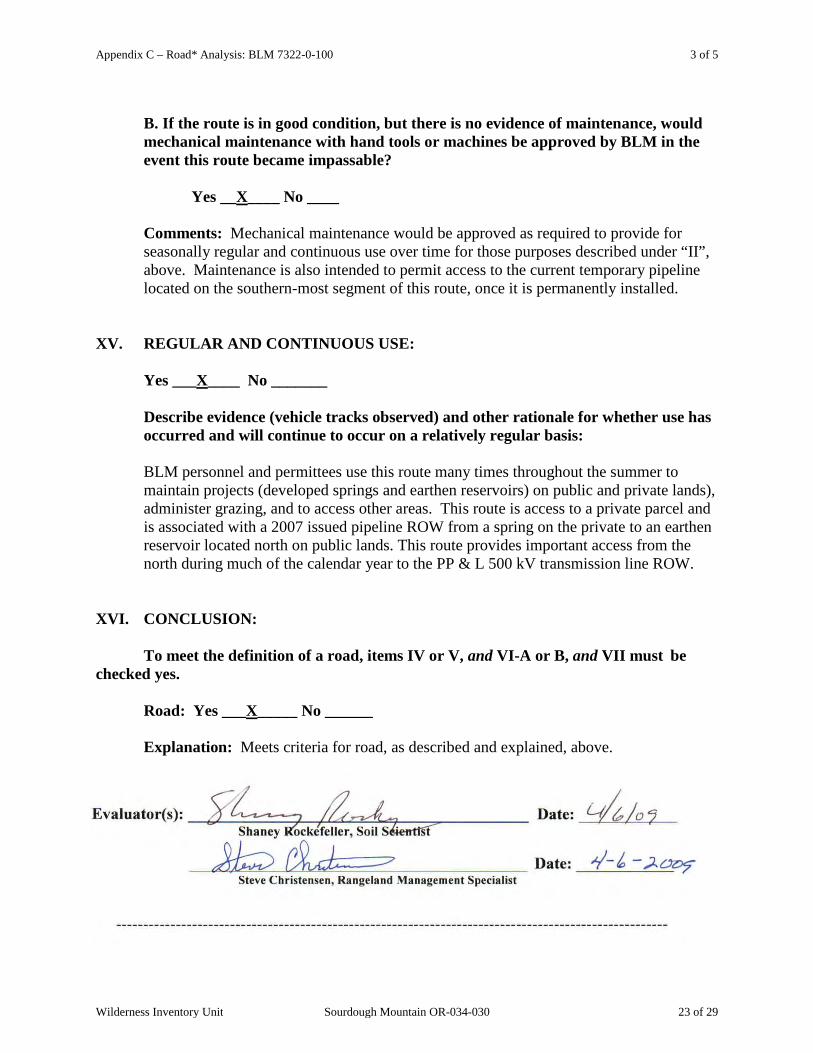
B. If the route is in good condition, but there is no evidence of maintenance, would mechanical maintenance with hand tools or machines be approved by BLM in the event this route became impassable?
Yes __X____ No ____
Comments: Mechanical maintenance would be approved as required to provide for seasonally regular and continuous use over time for those purposes described under “II”, above. Maintenance is also intended to permit access to the current temporary pipeline located on the southern-most segment of this route, once it is permanently installed.
XV. REGULAR AND CONTINUOUS USE:
Yes ___X____ No _______
Describe evidence (vehicle tracks observed) and other rationale for whether use has occurred and will continue to occur on a relatively regular basis: BLM personnel and permittees use this route many times throughout the summer to maintain projects (developed springs and earthen reservoirs) on public and private lands), administer grazing, and to access other areas. This route is access to a private parcel and is associated with a 2007 issued pipeline ROW from a spring on the private to an earthen reservoir located north on public lands. This route provides important access from the north during much of the calendar year to the PP & L 500 kV transmission line ROW.
XVI. CONCLUSION: To meet the definition of a road, items IV or V, and VI-A or B, and VII must be checked yes. Road: Yes ___X_____ No ______
Explanation: Meets criteria for road, as described and explained, above.
Wilderness Inventory Unit Sourdough Mountain OR-034-030 23 of 29
Appendix C – Road* Analysis: BLM 7322-0-100 4 of 5
* road: An access route which has been improved and maintained by mechanical means to insure relatively regular and continuous use. A way maintained solely by the passage of vehicles does not constitute a road. a. “Improved and maintained” – Actions taken physically by people to keep the road open to vehicle traffic. “Improved” does not necessarily mean formal construction. “Maintained” does not necessarily mean annual maintenance. b. “Mechanical means” – Use of hand or power machinery or tools. c. “Relatively regular and continuous use” – Vehicular use that has occurred and will continue to occur on a relatively regular basis. Examples are: access roads for equipment to maintain a stock water tank or other established water sources; access roads to maintained recreation sites or facilities; or access roads to mining claims.
________________________________________________ Following is the definition from Glossary of OSO 7-3-2007 Draft H-6300-1: road: The BLM will continue to base the definition of what constitutes a “road” from the FLPMA’s legislative history. The language below is from the House of Representatives Committee Report 94-1163, page 17, dated May 15, 1976, on what became the FLPMA. It is the only statement regarding the definition of a road in the law or legislative history. “The word ‘roadless’ refers to the absence of roads which have been improved and maintained by mechanical means to insure relatively regular and continuous use. A way maintained solely by the passage of vehicles does not constitute a road.” The BLM previously adopted and will continue to use the following sub-definitions of certain words and phrases in the BLM road definition stated above: a. “Improved and maintained” – Actions taken physically by people to keep the road open to vehicle traffic. “Improved” does not necessarily mean formal construction. “Maintained” does not necessarily mean annual maintenance. b. “Mechanical means” – Use of hand or power machinery or tools. c. “Relatively regular and continuous use” – Vehicular use that has occurred and will continue to occur on a relatively regular basis. Examples are: access roads for equipment to maintain a stock water tank or other established water sources; access roads to maintained recreation sites or facilities; or access roads to mining claims. A road that was established or has been maintained solely by the passage of vehicles would not be considered a road, even if it is used on a relatively regular and continuous basis. Vehicle roads constructed by mechanical means but that are no longer being maintained by
Wilderness Inventory Unit Sourdough Mountain OR-034-030 24 of 29

Appendix C – Road* Analysis: BLM 7322-0-100 5 of 5
mechanical methods are not roads. Sole use of hands and feet to move rocks or dirt without the use of tools or machinery does not meet the definition of “mechanical means.” Roads need not be “maintained” on a regular basis but rather “maintained” when road conditions warrant actions to keep it in a usable condition. A dead-end (cherry-stem) road can form the boundary of an inventory area and does not by itself disqualify an area from being considered “roadless”.
Wilderness Inventory Unit Sourdough Mountain OR-034-030 25 of 29

Appendix C – Road* Analysis: BLM 7326-0-0A0 1 of 4
H-6300-1-WILDERNESS INVENTORY MAINTENANCE
IN BLM OREGON/WASHINGTON
APPENDIX C – ROAD* ANALYSIS (Factors to consider when determining whether a route is a road for wilderness inventory purposes.)
Wilderness Inventory Unit Name/Number: OR-034-030 – Sourdough Mountain__
NOTE: This unit is affected by ONDA’s Freezeout Ridge proposed WSA.
Route Name and/or Identifier (Include Transportation Plan Identifier, if known; include route number supplied by citizen information when available): BLM 7326-0-0A0 (This route is identified by ONDA as its “W14a way” (i.e., MPT) within its proposed “Freezeout Ridge proposed WSA.) XVII. LOCATION: Refer to the attached map (is the route associated with the BLM inventory
unit’s segment of the west boundary which abuts BLM’s unit OR-034-027 Broken Rim). List photo point references (if applicable): Refer to this BLM inventory unit’s associated hard copy of its BLM Photo Points map, and affiliated Photo Log and photos -- retained in this unit’s permanent hard copy file, and electronically retained under this unit’s subfolder Final Findings/GIS Products. Any applicable ONDA map, photos and affiliated Photo Log are electronically retained under Wilderness Characteristics/Citizen Proposals.
XVIII. CURRENT PURPOSE OF ROUTE:
(Examples: Rangeland/Livestock Improvements (stock tank, developed spring, reservoir, fence, corral), Inholdings (ranch, farmhouse), Mine Site, Concentrated Use Site (camp site), Utilities (transmission line, telephone, pipeline), Administrative (project maintenance, communication site, vegetation treatment).) Describe: This route provides needed ongoing and regular access to rangeland/livestock improvements (fences and earthen reservoir developments) by allotment permittees and the BLM for management of livestock, maintenance of the projects, and BLM monitoring of associated activities. Also, this route provides for regular and continuous use for concentrated recreational camping activities associated with the Sourdough area.
Wilderness Inventory Unit Sourdough Mountain OR-034-030 26 of 29
Appendix C – Road* Analysis: BLM 7326-0-0A0 2 of 4
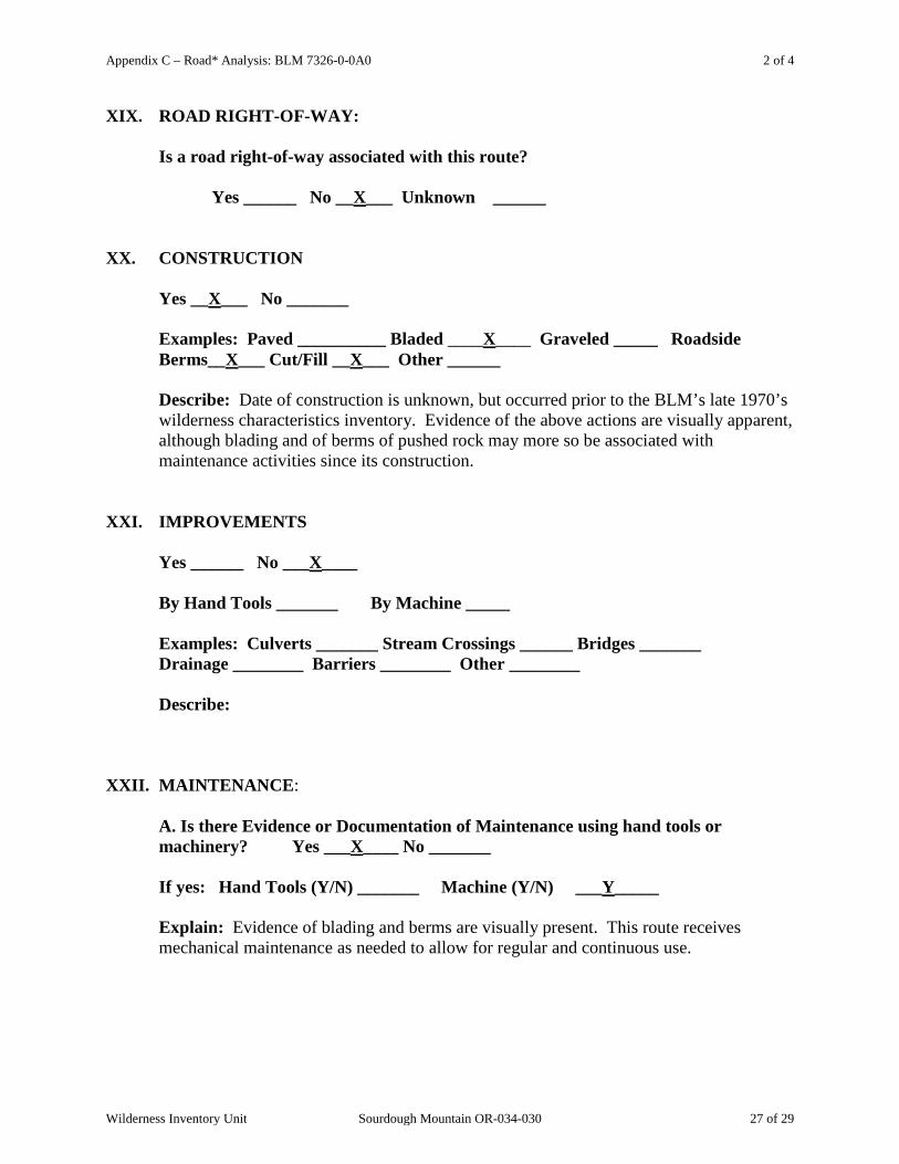
XIX. ROAD RIGHT-OF-WAY: Is a road right-of-way associated with this route? Yes ______ No __X___ Unknown ______
XX. CONSTRUCTION
Yes __X___ No _______
Examples: Paved __________ Bladed ____X____ Graveled _____ Roadside Berms__X___ Cut/Fill __X___ Other ______
Describe: Date of construction is unknown, but occurred prior to the BLM’s late 1970’s wilderness characteristics inventory. Evidence of the above actions are visually apparent, although blading and of berms of pushed rock may more so be associated with maintenance activities since its construction.
XXI. IMPROVEMENTS
Yes ______ No ___X____
By Hand Tools _______ By Machine _____ Examples: Culverts _______ Stream Crossings ______ Bridges _______ Drainage ________ Barriers ________ Other ________
Describe: XXII. MAINTENANCE:
A. Is there Evidence or Documentation of Maintenance using hand tools or machinery? Yes ___X____ No _______
If yes: Hand Tools (Y/N) _______ Machine (Y/N) ___Y_____
Explain: Evidence of blading and berms are visually present. This route receives mechanical maintenance as needed to allow for regular and continuous use.
Wilderness Inventory Unit Sourdough Mountain OR-034-030 27 of 29

Appendix C – Road* Analysis: BLM 7326-0-0A0 3 of 4
B. If the route is in good condition, but there is no evidence of maintenance, would mechanical maintenance with hand tools or machines be approved by BLM in the event this route became impassable?
Yes __X____ No ____
Comments: This route is recognized by the BLM as a primary access route to a number of range improvement projects and is recognized as a significant access route for rangeland administration and public access.
XXIII. REGULAR AND CONTINUOUS USE:
Yes ___X____ No _______
Describe evidence (vehicle tracks observed) and other rationale for whether use has occurred and will continue to occur on a relatively regular basis: BLM personnel and permittees use this route throughout the summer as one of two access routes for projects on public and private, to administer grazing, and for access to other areas (e.g. Sourdough). This route provides access during various portions of the year to concentrated camping sites associated with the Sourdough area.
XXIV. CONCLUSION: To meet the definition of a road, items IV or V, and VI-A or B, and VII must be checked yes. Road: Yes ___X_____ No ______ Explanation: Meets criteria for road, as described and explained, above.
-------------------------------------------------------------------------------------------------------
* road: An access route which has been improved and maintained by mechanical means to insure relatively regular and continuous use. A way maintained solely by the passage of vehicles does not constitute a road.
Wilderness Inventory Unit Sourdough Mountain OR-034-030 28 of 29

Appendix C – Road* Analysis: BLM 7326-0-0A0 4 of 4
a. “Improved and maintained” – Actions taken physically by people to keep the road open to vehicle traffic. “Improved” does not necessarily mean formal construction. “Maintained” does not necessarily mean annual maintenance. b. “Mechanical means” – Use of hand or power machinery or tools. c. “Relatively regular and continuous use” – Vehicular use that has occurred and will continue to occur on a relatively regular basis. Examples are: access roads for equipment to maintain a stock water tank or other established water sources; access roads to maintained recreation sites or facilities; or access roads to mining claims.
________________________________________________ Following is the definition from Glossary of OSO 7-3-2007 Draft H-6300-1: road: The BLM will continue to base the definition of what constitutes a “road” from the FLPMA’s legislative history. The language below is from the House of Representatives Committee Report 94-1163, page 17, dated May 15, 1976, on what became the FLPMA. It is the only statement regarding the definition of a road in the law or legislative history. “The word ‘roadless’ refers to the absence of roads which have been improved and maintained by mechanical means to insure relatively regular and continuous use. A way maintained solely by the passage of vehicles does not constitute a road.” The BLM previously adopted and will continue to use the following sub-definitions of certain words and phrases in the BLM road definition stated above: a. “Improved and maintained” – Actions taken physically by people to keep the road open to vehicle traffic. “Improved” does not necessarily mean formal construction. “Maintained” does not necessarily mean annual maintenance. b. “Mechanical means” – Use of hand or power machinery or tools. c. “Relatively regular and continuous use” – Vehicular use that has occurred and will continue to occur on a relatively regular basis. Examples are: access roads for equipment to maintain a stock water tank or other established water sources; access roads to maintained recreation sites or facilities; or access roads to mining claims. A road that was established or has been maintained solely by the passage of vehicles would not be considered a road, even if it is used on a relatively regular and continuous basis. Vehicle roads constructed by mechanical means but that are no longer being maintained by mechanical methods are not roads. Sole use of hands and feet to move rocks or dirt without the use of tools or machinery does not meet the definition of “mechanical means.” Roads need not be “maintained” on a regular basis but rather “maintained” when road conditions warrant actions to keep it in a usable condition. A dead-end (cherry-stem) road can form the boundary of an inventory area and does not by itself disqualify an area from being considered “roadless”.
Wilderness Inventory Unit Sourdough Mountain OR-034-030 29 of 29