wickham boat beach area - foreshore management plan · wickham boat beach area foreshore management...
TRANSCRIPT
1WICKHAM BOAT BEACH AREA FORESHORE MANAGEMENT PLAN
wickham boat beach area - foreshore management plan november 2016

2
Note: This report should be printed at A3 / Double sided / Short edge / Open to left
DOCUMENT REGISTER
REV Version Date Amendments Prepared byD 9/11/2016 Amendments as per City of Karratha comments UDLA
C Council Endorsement 12/05/2016 Amendments as per City of Karratha comments UDLA
B Final DRAFT FMP 12/04/2016 Amendments as per City of Karratha comments UDLA
A DRAFT for City of Karratha comment 5/02/2016 Amendments as per City of Karratha comments UDLA
- DRAFT for City of Karratha Council Review 28/04/2016 Amendments as per City of Karratha comments UDLA
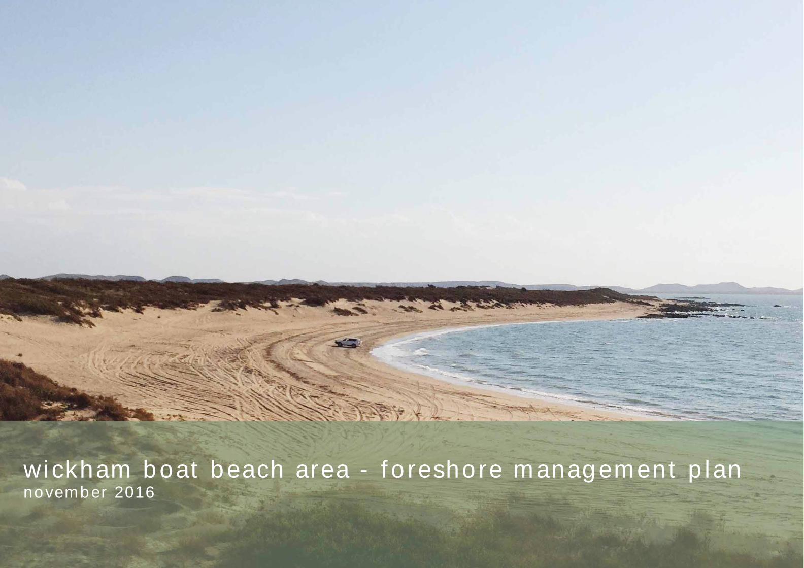
Cover image. Wickham Boat Beach (UDLA)
3WICKHAM BOAT BEACH AREA FORESHORE MANAGEMENT PLAN
1 // executive summar y 4
2 // introduct ion 6
2.1 purpose and objectives 7
2.2 subject area 7
2.3 engagement methodology 8
2.3.1 aim 8
2.3.2 approach 8
2.4 report outline 9
3 // background, context analysis and stakeholder engagement 10
3.1 location 11
3.2 planning context 11
3.2.1 Draft City of Karratha Coastal Planning Strategy 11
3.2.2 Draft City of Karratha Local Planning Strategy 11
3.2.3 Town Planning Scheme No. 8 and Amendment No. 27 11
3.2.4 City of Karratha, Draft Storm Surge Risk Area, Local Planning Policy 12
3.2.5 State Planning Policy 2.6: State Coastal Planning Policy 12
3.2.6 State Planning Policy 4.1: State Industrial Buffer 12
3.3 land use and tenure 12
3.3.1 tenure 12
3.3.2 current management practises 14
3.4 cultural heritage 15
3.4.1 aboriginal 15
3.4.2 european 15
table of contents
3.5 environmental values 16
3.5.1 geomorphology, land system and land form 16
3.5.2 coastal processes 19
3.5.3 fl ora and fauna 21
3.6 social values, uses and perception 22
4 // key themes 24
4.1 key themes 25
5 // management plan and management act ions 34
5.1 management plan 35
5.2 regeneration plan 36
5.3 boat beach amenity node 37
5.4 management actions 38
6 // conclusion 42
7 // references 44
8 // appendix 46
appendix 1. nature map species report 47
appendix 2. city of karratha online survey results 48
appendix 3. indicative costings for landscape works, april 2016 (supplied by essential environmental and city of karratha) 54

444444444
1 // executive summar y
5WICKHAM BOAT BEACH AREA FORESHORE MANAGEMENT PLAN
from the community
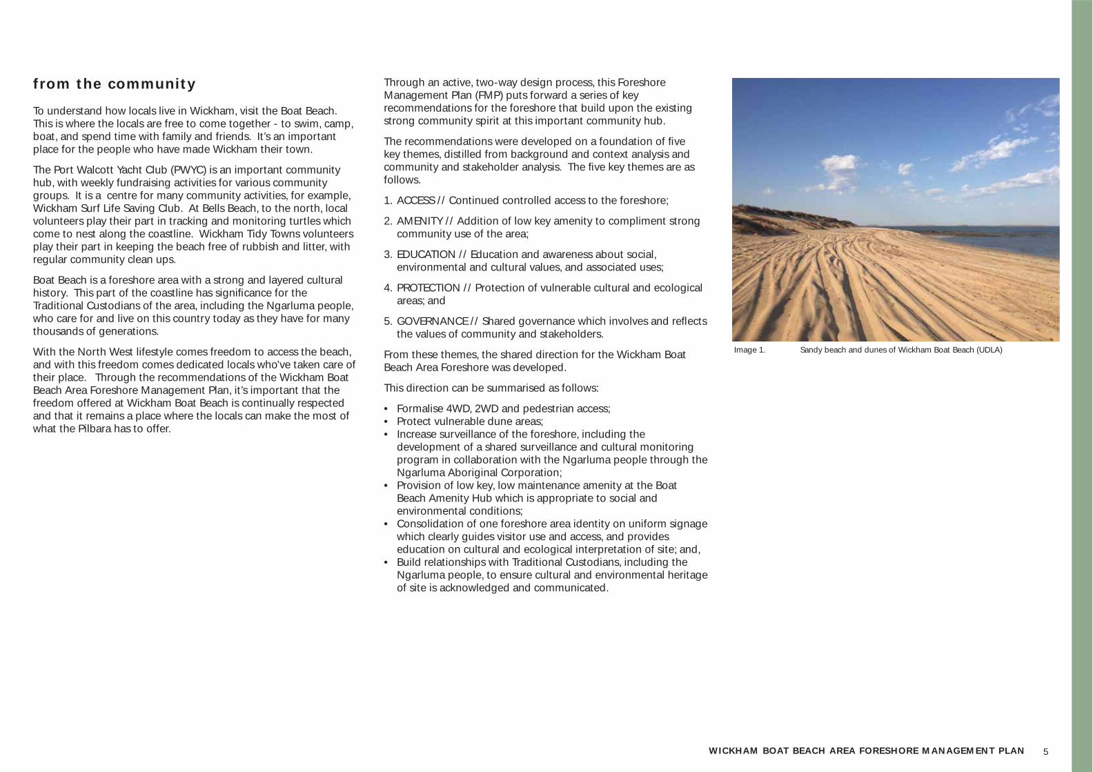
To understand how locals live in Wickham, visit the Boat Beach. This is where the locals are free to come together - to swim, camp, boat, and spend time with family and friends. It’s an important place for the people who have made Wickham their town.
The Port Walcott Yacht Club (PWYC) is an important community hub, with weekly fundraising activities for various community groups. It is a centre for many community activities, for example, Wickham Surf Life Saving Club. At Bells Beach, to the north, local volunteers play their part in tracking and monitoring turtles which come to nest along the coastline. Wickham Tidy Towns volunteers play their part in keeping the beach free of rubbish and litter, with regular community clean ups.
Boat Beach is a foreshore area with a strong and layered cultural history. This part of the coastline has signifi cance for the Traditional Custodians of the area, including the Ngarluma people, who care for and live on this country today as they have for many thousands of generations.
With the North West lifestyle comes freedom to access the beach, and with this freedom comes dedicated locals who’ve taken care of their place. Through the recommendations of the Wickham Boat Beach Area Foreshore Management Plan, it’s important that the freedom offered at Wickham Boat Beach is continually respected and that it remains a place where the locals can make the most of what the Pilbara has to offer.
Image 1. Sandy beach and dunes of Wickham Boat Beach (UDLA)
Through an active, two-way design process, this Foreshore Management Plan (FMP) puts forward a series of key recommendations for the foreshore that build upon the existing strong community spirit at this important community hub.
The recommendations were developed on a foundation of fi ve key themes, distilled from background and context analysis and community and stakeholder analysis. The fi ve key themes are as follows.
1. ACCESS // Continued controlled access to the foreshore;
2. AMENITY // Addition of low key amenity to compliment strong community use of the area;
3. EDUCATION // Education and awareness about social, environmental and cultural values, and associated uses;
4. PROTECTION // Protection of vulnerable cultural and ecological areas; and
5. GOVERNANCE // Shared governance which involves and refl ects the values of community and stakeholders.
From these themes, the shared direction for the Wickham Boat Beach Area Foreshore was developed.
This direction can be summarised as follows:
• Formalise 4WD, 2WD and pedestrian access;• Protect vulnerable dune areas;• Increase surveillance of the foreshore, including the
development of a shared surveillance and cultural monitoring program in collaboration with the Ngarluma people through the Ngarluma Aboriginal Corporation;
• Provision of low key, low maintenance amenity at the Boat Beach Amenity Hub which is appropriate to social and environmental conditions;
• Consolidation of one foreshore area identity on uniform signage which clearly guides visitor use and access, and provides education on cultural and ecological interpretation of site; and,
• Build relationships with Traditional Custodians, including the Ngarluma people, to ensure cultural and environmental heritage of site is acknowledged and communicated.
666666666
2 // introduct ion
7WICKHAM BOAT BEACH AREA FORESHORE MANAGEMENT PLAN
2.1 purpose and objectives
The purpose of the Wickham Boat Beach Area Foreshore Management Plan (FMP) is to provide a framework that guides the ongoing use and management of the foreshore area. This FMP aims to uphold a sustainable, quadruple bottom line approach to planning for place, with regard to developing:
• Social capital;• Environmental leadership;• Economic diversity; and,• Good governance.
The Wickham Boat Beach Area FMP aims to:
• Uphold and contribute to the implementation of local and regional planning objectives and coastal strategies;
• Facilitate community engagement and build community capacity and ownership of the area through shared responsibility between the City of Karratha, key stakeholders and local community; and,
• Foster the sustainable recreational use and management of the area through a plan that:
- Enhances amenity; - Recognises and incorporates the environmental and social
values of the area; - Manages access arrangements; and, - Allows for long term infrastructure provision.
2.2 subject area
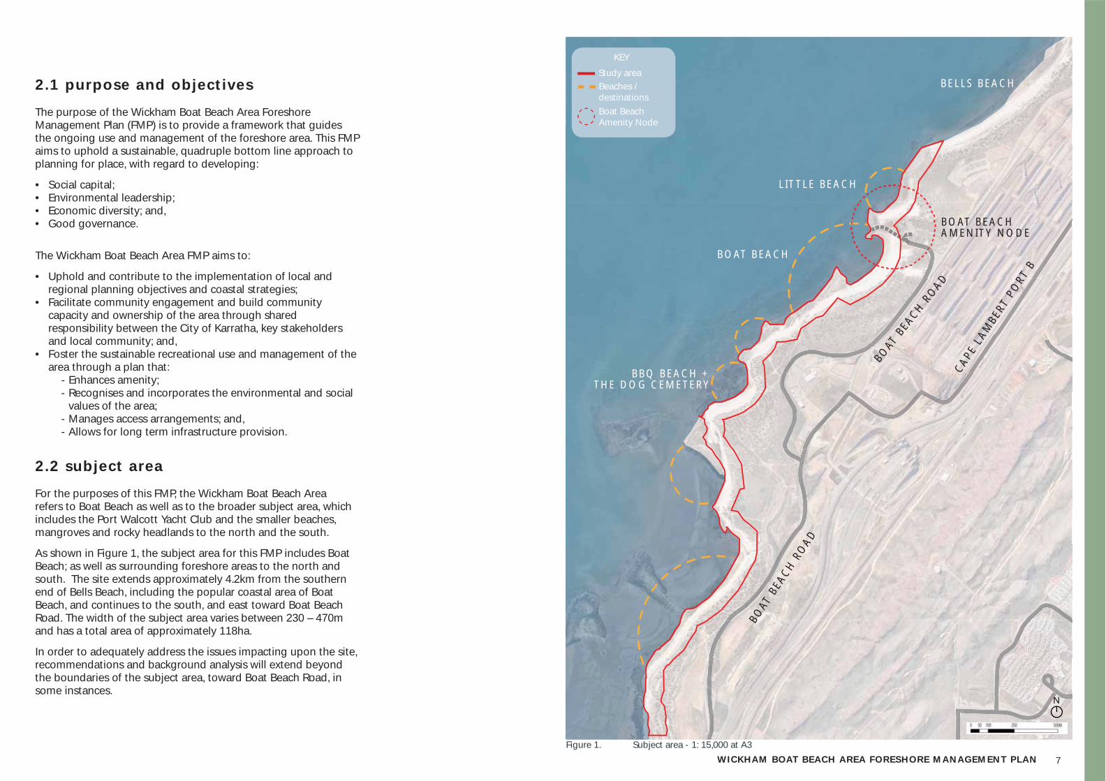
For the purposes of this FMP, the Wickham Boat Beach Area refers to Boat Beach as well as to the broader subject area, which includes the Port Walcott Yacht Club and the smaller beaches, mangroves and rocky headlands to the north and the south.
As shown in Figure 1, the subject area for this FMP includes Boat Beach; as well as surrounding foreshore areas to the north and south. The site extends approximately 4.2km from the southern end of Bells Beach, including the popular coastal area of Boat Beach, and continues to the south, and east toward Boat Beach Road. The width of the subject area varies between 230 – 470m and has a total area of approximately 118ha.
In order to adequately address the issues impacting upon the site, recommendations and background analysis will extend beyond the boundaries of the subject area, toward Boat Beach Road, in some instances.
BOAT
BEA
CH ROAD
BOAT
BEA
CH R
OAD
CAPE
LAM
BERT
PO
RT B
Figure 1. Subject area - 1: 15,000 at A3
BOAT BEACH
BBQ BEACH + THE DOG CEMETERY
BELLS BEACH
LITTLE BEACH
BOAT BEACH AMENITY NODE
Study area
KEY
Beaches / destinationsBoat Beach Amenity Node
N
8
2.3 engagement methodology
2.3.1 aimThe aim of the community engagement for the Wickham Boat Beach Area FMP was to collaborate and engage with the Wickham community and stakeholders through an active listening process. To achieve this, the following objectives were undertaken:
• Involve the Wickham community and stakeholders in decision making and setting a shared direction for their foreshore;
• Actively listen to any issues or feedback the Wickham community and stakeholders may have about the Wickham Boat Beach Area FMP;
• Provide a quick and effective response to any queries, which arise throughout the process and to incorporate and address issues which may arise in a timely and respectful manner;
• Create a collective team of community members, stakeholders and the City of Karratha who can work toward a shared responsibility for the Wickham Boat Beach Area Foreshore; and,
• Collectively guide the developing social capacity of Wickham community / stakeholders.
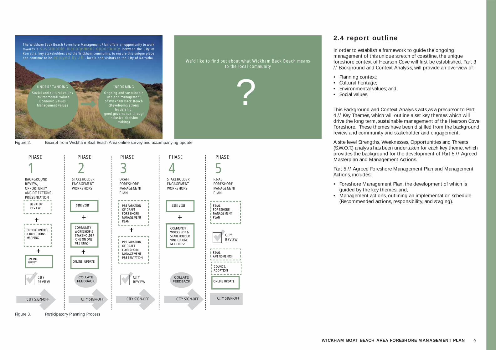
As shown in Figure 3, the collaborative design process included fi ve key phases:
• Phase 1 | Background Review and Context Analysis • Phase 2 | Stakeholder Engagement• Phase 3 | Draft FMP• Phase 4 | Stakeholder Engagement• Phase 5 | Final FMP
2.3.2 approachIt is recognised that the Wickham Boat Beach Area has signifi cant recreational value for the local community, as well as visitors and tourists alike. Therefore to ensure that the FMP appropriately refl ects the high value that is associated with the site, a number of tools have been used to engage people in the process including the following:
• Online survey;• Community workshops; and,• ‘One-on-one’ meetings with key stakeholders.
The following is a list of the key stakeholders / community representatives that who were involved in the design process:
• City of Karratha• Rio Tinto;• Department of Transport (DoT);• Port Walcott Yacht Club (PWYC);• Ngarluma Aboriginal Corporation (NAC);• Wickham chaplain;• Port Walcott Surf Life Saving Club;• West Pilbara Turtle Program (Rio Tinto, DPaW and the Wickham
community);• Department of Parks and Wildlife (DPaW); and,• Wickham community.
Onl ine sur vey and updates
To ensure the wider community had the opportunity to provide input into the management plan, an online survey was incorporated into the City of Karratha’s website, at karratha.wa.gov.au/foreshore-management-plans. The purpose of this was to:
• Inform the wider community and stakeholders about the Wickham Boat Beach Area FMP and associated project objectives;
• Understand the range of users who visit the foreshore, how often and the types of activities that are associated with the foreshore;
• Understand the values, themes and key issues that are associated with the foreshore; and,
• Provide opportunity for interested participants to be involved in Community / Stakeholder Workshops, and provide two way input.
An except from the online survey and update contents is provided in Figure 2.
Community workshops
As part of the collaborative design process, UDLA facilitated two Community / Stakeholder Workshops.
These workshops provided an opportunity for two-way education and shared understanding in the proposed planning and management objectives that eventuated into an agreed direction.
The two workshops included discussion on:
• Opportunities and Directions (Workshop 1); and,• Draft FMP (Workshop 2).
One-on-one meetings with key stakeholders
One-one-one meetings allowed the opportunity for targeted discussion and two way communication on key issues, and were undertaken with the following groups over Workshops 1 and 2.
• Ngarluma Aboriginal Corporation (NAC); • West Pilbara Turtle Program (Rio Tinto, DPaW and the Wickham
community); and• Port Walcott Yacht Club (PWYC).
9WICKHAM BOAT BEACH AREA FORESHORE MANAGEMENT PLAN
2.4 repor t outl ine
In order to establish a framework to guide the ongoing management of this unique stretch of coastline, the unique foreshore context of Hearson Cove will fi rst be established. Part 3 // Background and Context Analysis, will provide an overview of:
• Planning context;• Cultural heritage;• Environmental values; and,• Social values.
This Background and Context Analysis acts as a precursor to Part 4 // Key Themes, which will outline a set key themes which will drive the long term, sustainable management of the Hearson Cove Foreshore. These themes have been distilled from the background review and community and stakeholder and engagement.
A site level Strengths, Weaknesses, Opportunities and Threats (S.W.O.T.) analysis has been undertaken for each key theme, which provides the background for the development of Part 5 // Agreed Masterplan and Management Actions.
Part 5 // Agreed Foreshore Management Plan and Management Actions, includes:
• Foreshore Management Plan, the development of which is guided by the key themes; and,
• Management actions, outlining an implementation schedule (Recommended actions, responsibility, and staging).
Figure 2. Excerpt from Wickham Boat Beach Area online survey and accompanying update
DESKTOP REVIEW
PREPARATION OF DRAFT FORESHORE MANAGEMENT PLAN
FINAL FORESHORE MANAGEMENT PLAN
FINAL AMENDMENTS
COUNCIL ADOPTION
PREPARATION OF DRAFT FORESHORE MANAGEMENT PRESENTATION
++
+ +
+ +
OPPORTUNITIES & DIRECTIONS MAPPING
BACKGROUND REVIEW, OPPORTUNITY AND DIRECTIONS PRESENTATION
STAKEHOLDER ENGAGEMENT WORKSHOPS
FINAL FORESHORE MANAGEMENT PLAN
DRAFT FORESHORE MANAGEMENT PLAN
COLLATE FEEDBACK
COLLATE FEEDBACK
STAKEHOLDER ENGAGEMENT WORKSHOPS
CITY SIGN-OFF
PHASE PHASE PHASE PHASE PHASE
1 3 4 5
CITY REVIEW
CITY REVIEW
CITY REVIEW
SITE VISIT SITE VISIT
COMMUNITY WORKSHOP & STAKEHOLDER ‘ONE ON ONE MEETINGS’
COMMUNITY WORKSHOP & STAKEHOLDER ‘ONE ON ONE MEETINGS’
ONLINE SURVEY ONLINE UPDATE
ONLINE UPDATE
2
CITY SIGN-OFF CITY SIGN-OFF CITY SIGN-OFFCITY SIGN-OFF
UNDERSTANDINGSoc ia l and cu l tu ra l va lues
Env i ronmenta l va luesEconomic va lues
Management va lues
Ongo ing and sus ta inab le use and management
o f Wickham Back Beach(Deve lop ing s t rong
leadersh ip , good governance th rough
inc lus ive dec is ion mak ing)
INFORMING
The Wickham Back Beach Foreshore Management P lan o f fe rs an oppor tun i ty to work towards a sus ta inab le management oppor tun i ty be tween the C i ty o f Kar ra tha , key s takeho lders and the Wickham communi ty, to ensure th is un ique p lace can con t inue to be en joyed by a l l - loca ls and v is i to rs to the C i ty o f Kar ra tha
Figure 3. Participatory Planning Process
We’d l i ke to f ind ou t about what Wickham Back Beach means to the loca l communi ty
?
101010100000
3 // background, context analysis and stakeholder engagement
11WICKHAM BOAT BEACH AREA FORESHORE MANAGEMENT PLAN
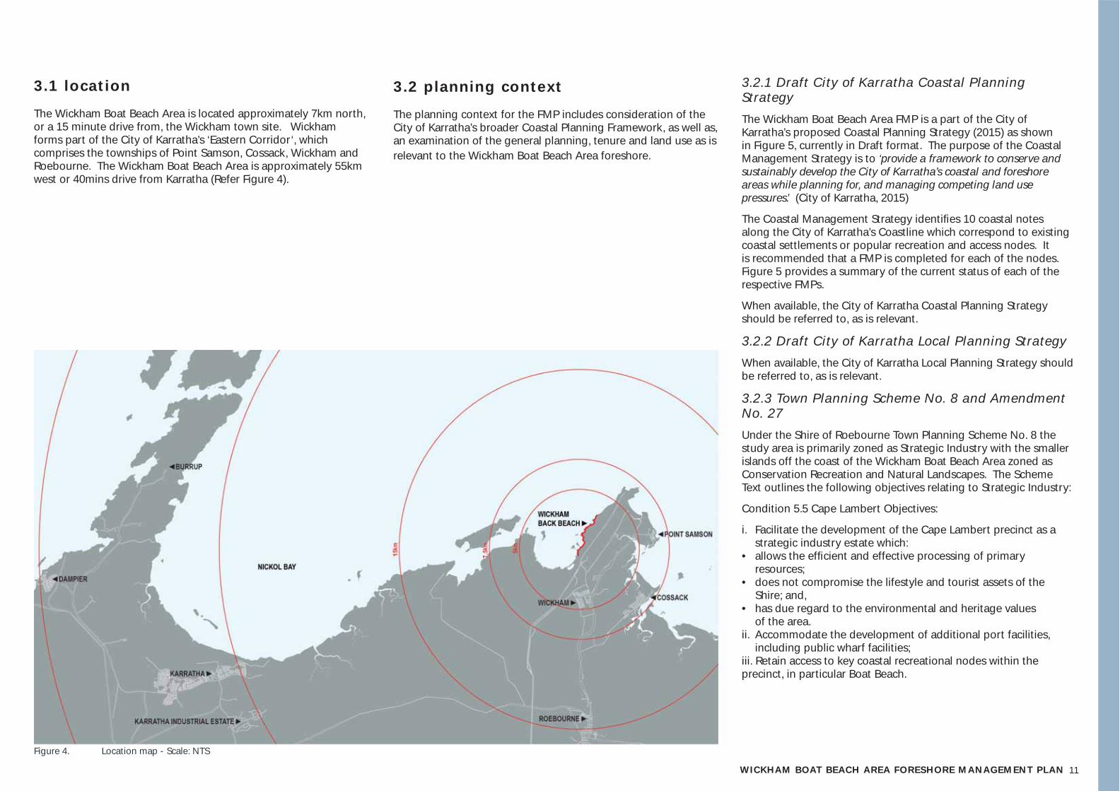
3.1 location
The Wickham Boat Beach Area is located approximately 7km north, or a 15 minute drive from, the Wickham town site. Wickham forms part of the City of Karratha’s ‘Eastern Corridor‘, which comprises the townships of Point Samson, Cossack, Wickham and Roebourne. The Wickham Boat Beach Area is approximately 55km west or 40mins drive from Karratha (Refer Figure 4).
Figure 4. Location map - Scale: NTS
3.2 planning context
The planning context for the FMP includes consideration of the City of Karratha’s broader Coastal Planning Framework, as well as, an examination of the general planning, tenure and land use as is relevant to the Wickham Boat Beach Area foreshore.
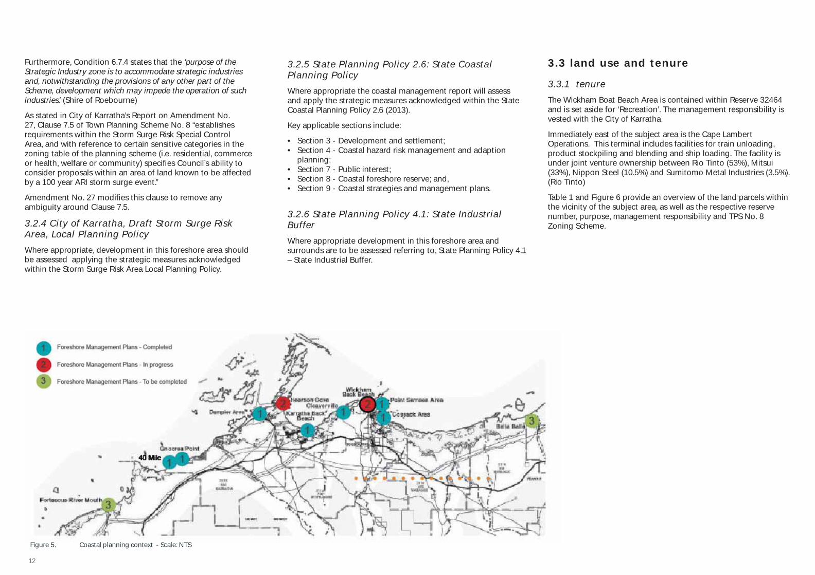
3.2.1 Draft City of Karratha Coastal Planning StrategyThe Wickham Boat Beach Area FMP is a part of the City of Karratha’s proposed Coastal Planning Strategy (2015) as shown in Figure 5, currently in Draft format. The purpose of the Coastal Management Strategy is to ‘provide a framework to conserve and sustainably develop the City of Karratha’s coastal and foreshore areas while planning for, and managing competing land use pressures.’ (City of Karratha, 2015)
The Coastal Management Strategy identifi es 10 coastal notes along the City of Karratha’s Coastline which correspond to existing coastal settlements or popular recreation and access nodes. It is recommended that a FMP is completed for each of the nodes. Figure 5 provides a summary of the current status of each of the respective FMPs.
When available, the City of Karratha Coastal Planning Strategy should be referred to, as is relevant.
3.2.2 Draft City of Karratha Local Planning Strategy When available, the City of Karratha Local Planning Strategy should be referred to, as is relevant.
3.2.3 Town Planning Scheme No. 8 and Amendment No. 27Under the Shire of Roebourne Town Planning Scheme No. 8 the study area is primarily zoned as Strategic Industry with the smaller islands off the coast of the Wickham Boat Beach Area zoned as Conservation Recreation and Natural Landscapes. The Scheme Text outlines the following objectives relating to Strategic Industry:
Condition 5.5 Cape Lambert Objectives:
i. Facilitate the development of the Cape Lambert precinct as a strategic industry estate which:
• allows the effi cient and effective processing of primary resources;
• does not compromise the lifestyle and tourist assets of the Shire; and,
• has due regard to the environmental and heritage values of the area.
ii. Accommodate the development of additional port facilities, including public wharf facilities;
iii. Retain access to key coastal recreational nodes within the precinct, in particular Boat Beach.
12
3.3 land use and tenure
3.3.1 tenureThe Wickham Boat Beach Area is contained within Reserve 32464 and is set aside for ‘Recreation’. The management responsibility is vested with the City of Karratha.
Immediately east of the subject area is the Cape Lambert Operations. This terminal includes facilities for train unloading, product stockpiling and blending and ship loading. The facility is under joint venture ownership between Rio Tinto (53%), Mitsui (33%), Nippon Steel (10.5%) and Sumitomo Metal Industries (3.5%). (Rio Tinto)
Table 1 and Figure 6 provide an overview of the land parcels within the vicinity of the subject area, as well as the respective reserve number, purpose, management responsibility and TPS No. 8 Zoning Scheme.
Figure 5. Coastal planning context - Scale: NTS
Furthermore, Condition 6.7.4 states that the ‘purpose of the Strategic Industry zone is to accommodate strategic industries and, notwithstanding the provisions of any other part of the Scheme, development which may impede the operation of such industries.’ (Shire of Roebourne)
As stated in City of Karratha’s Report on Amendment No. 27, Clause 7.5 of Town Planning Scheme No. 8 “establishes requirements within the Storm Surge Risk Special Control Area, and with reference to certain sensitive categories in the zoning table of the planning scheme (i.e. residential, commerce or health, welfare or community) specifi es Council’s ability to consider proposals within an area of land known to be affected by a 100 year ARI storm surge event.”
Amendment No. 27 modifi es this clause to remove any ambiguity around Clause 7.5.
3.2.4 City of Karratha, Draft Storm Surge Risk Area, Local Planning PolicyWhere appropriate, development in this foreshore area should be assessed applying the strategic measures acknowledged within the Storm Surge Risk Area Local Planning Policy.
3.2.5 State Planning Policy 2.6: State Coastal Planning PolicyWhere appropriate the coastal management report will assess and apply the strategic measures acknowledged within the State Coastal Planning Policy 2.6 (2013).
Key applicable sections include:
• Section 3 - Development and settlement;• Section 4 - Coastal hazard risk management and adaption
planning;• Section 7 - Public interest;• Section 8 - Coastal foreshore reserve; and,• Section 9 - Coastal strategies and management plans.
3.2.6 State Planning Policy 4.1: State Industrial BufferWhere appropriate development in this foreshore area and surrounds are to be assessed referring to, State Planning Policy 4.1 – State Industrial Buffer.
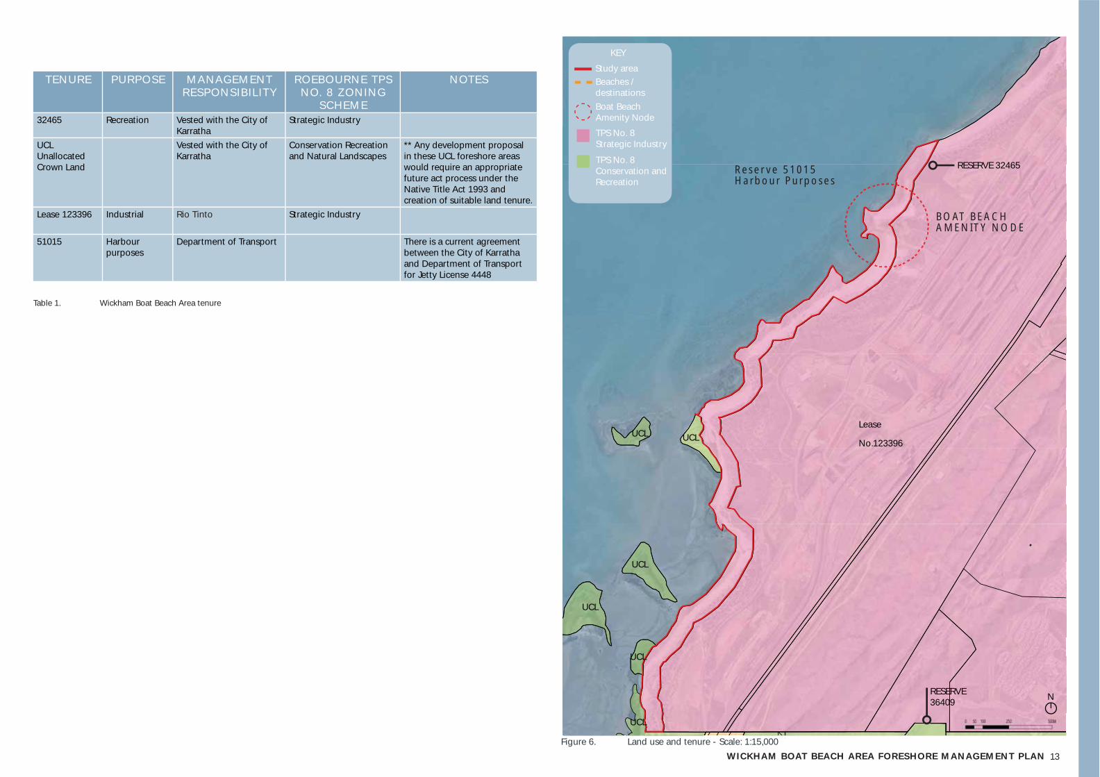
13WICKHAM BOAT BEACH AREA FORESHORE MANAGEMENT PLANFigure 6. Land use and tenure - Scale: 1:15,000
UCL
TENURE PURPOSE MANAGEMENT RESPONSIBILITY
ROEBOURNE TPS NO. 8 ZONING
SCHEME
NOTES
32465 Recreation Vested with the City of Karratha
Strategic Industry
UCL Unallocated Crown Land
Vested with the City of Karratha
Conservation Recreation and Natural Landscapes
** Any development proposal in these UCL foreshore areas would require an appropriate future act process under the Native Title Act 1993 and creation of suitable land tenure.
Lease 123396 Industrial Rio Tinto Strategic Industry
51015 Harbour purposes
Department of Transport There is a current agreement between the City of Karratha and Department of Transport for Jetty License 4448
Table 1. Wickham Boat Beach Area tenure
RESERVE 32465
UCLUCL
UCL
UCL
UCL
RESERVE 36409
Lease
No.123396
BOAT BEACH AMENITY NODE
Reser ve 51015 Harbour Purposes
Study area
KEY
Boat Beach Amenity Node
Beaches / destinations
TPS No. 8 Strategic Industry
TPS No. 8 Conservation and Recreation
N
14
3.3.2 current management practisescity of karratha
As stated above, the Wickham Boat Beach Area is set aside as an area for ‘Recreation’, which is vested in and managed by the City of Karratha.
At present, the City of Karratha management regime is minimal and low impact. The Parks and Gardens team responds to specifi c events and attendance at the foreshore is largely reactionary, for example, for the removal of broken glass and large debris.
The City of Karratha Ranger Team attend the Wickham Boat Beach Foreshore Area on a regular basis, on a fortnightly schedule, and more regularly in response to specifi c events. The Ranger Team largely attend to manage community and visitor use of the area. Issues noted by the City of Karratha Ranger team include:
• Long term camping on the foreshore, • Use of quad bikes and trail bikes and the fl ow on effect of this
on dune health.
The City of Karratha Waste Management team does not attend the foreshore area at present.
r io t into
Rio Tinto has management obligations around Bells Beach with key tasks including:
• Minimising light spill impacts on nesting turtles and hatchlings;• Reducing pest predator density. This is undertaken via a feral
animal management program on land managed by Rio Tinto, with contractors undertaking trapping of foxes and cats during the start of the nesting and peak nesting periods;
• Protecting the integrity of the dune system to minimise washouts and erosion on the beach;
• Preventing vehicle access on the beach. The rock wall adjacent to the Yacht Club car park and the rock wall at the southern end of Bells Beach were put in place to keep vehicles out as part of Rio Tinto’s environmental approvals for Cape Lambert around 2007; and,
• Installation of signage to increase awareness around beach driving. This has been installed through the West Pilbara Turtle Program partnerships. (Rio Tinto)
Rio Tinto has highlighted the following management opportunities:
• Opportunity to improve education around driving on the beach. Recognising that Wickham Boat Beach Area is a highly valued and popular beach, there’s opportunity to encourage people to either not drive on the beach during nesting season (Nov – April) or if they do, drive on the hard sand.
• Opportunity to increase awareness about lighting fi res in depression on the beach, which threaten turtle nesting and cause increased maintenance efforts e.g. discolouration of the sand, rubbish etc.
wickham community
The Wickham Boat Beach Foreshore Area is a community hub. At present, much community and visitor use of the foreshore is self moderated.
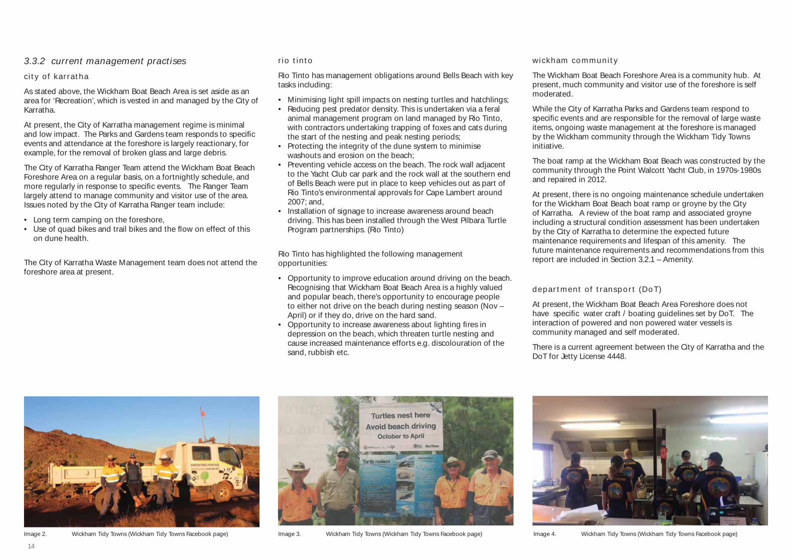
While the City of Karratha Parks and Gardens team respond to specifi c events and are responsible for the removal of large waste items, ongoing waste management at the foreshore is managed by the Wickham community through the Wickham Tidy Towns initiative.
The boat ramp at the Wickham Boat Beach was constructed by the community through the Point Walcott Yacht Club, in 1970s-1980s and repaired in 2012.
At present, there is no ongoing maintenance schedule undertaken for the Wickham Boat Beach boat ramp or groyne by the City of Karratha. A review of the boat ramp and associated groyne including a structural condition assessment has been undertaken by the City of Karratha to determine the expected future maintenance requirements and lifespan of this amenity. The future maintenance requirements and recommendations from this report are included in Section 3.2.1 – Amenity.
depar tment of transpor t (DoT)
At present, the Wickham Boat Beach Area Foreshore does not have specifi c water craft / boating guidelines set by DoT. The interaction of powered and non powered water vessels is community managed and self moderated.
There is a current agreement between the City of Karratha and the DoT for Jetty License 4448.
Image 2. Wickham Tidy Towns (Wickham Tidy Towns Facebook page) Image 3. Wickham Tidy Towns (Wickham Tidy Towns Facebook page) Image 4. Wickham Tidy Towns (Wickham Tidy Towns Facebook page)
15WICKHAM BOAT BEACH AREA FORESHORE MANAGEMENT PLAN
3.4 cultural heritage
3.4.1 aboriginalAs stated in the City of Karratha Indigenous Engagement Strategy (2016), ‘the City of Karratha recognises Aboriginal people as the Traditional Custodians of this land who have a deep historical and spiritual connection to Country, waterways, rivers and seas within our region.” This FMP acknowledges the Traditional Custodians of the Wickham Boat Beach Foreshore Area.
The Wickham Boat Beach Area (exclusive of the foreshore reserve which is vested with the City) is covered under the Native Title Determination WCD2005/001 – Ngarluma / Yindjibarndi, 2005 under the corporate entities of Yindjibarndi Aboriginal Corporation RNTBC and Ngarluma Aboriginal Corporation (DAA 2015 & National Native Title Tribunal 2014).
The Ngarluma Aboriginal Corporation states that ‘the Ngarluma people are the original inhabitants of the coastal areas around Roebourne (West Pilbara WA). Archaeological surveys reveal that continuous occupation and ancestry stretches back more than 30,000 years, and important cultural sites such as the rock art on the Burrup Peninsula (Karratha) show a deep historical and spiritual connection to the land, waterways and rivers and the sea’ (NAC, 2015).
A search on the Department of Aboriginal Affairs Aboriginal Heritage Inquiry System (AHIS) has found that there are six registered Aboriginal Sites located within the study area (DAA, 2015).
This FMP recognises these registered sites as a starting point, however it is recognised that the DAA is a static and sometimes inaccurate data depository that has limitations in representing an integrated living cultural landscape.
Ngarluma Aboriginal Corporation note that coastal lands such as the Wickham Boat Beach Foreshore Area are of particular Dreaming and archaeological signifi cance for the Ngarluma people, with the likelihood of Ancestor burial sites in sand dunes. Respecting and retaining the Ngarluma people’s strong connection and relationship to Country is an essential consideration, including involving Traditional Owners and Custodians in the future use and management of the foreshore. Refer Part 5 // Agreed Management Plan and Management Actions for further information and management actions on how the cultural signifi cance of this area may be acknowledged and managed.
3.4.2 europeanThere is strong European heritage associated with the township of Wickham and its foreshore area. The town was named after the Captain of the HMS Beagle, John C. Wickham, who surveyed the North West Coast in 1840 (Karratha Visitor Centre).
Following this, European settlement commenced in the 1860s predominantly associated with pastoral leases, with Roebourne being the fi rst gazetted town site in 1866 (Eliot et al 2013).
The post war resources boom resulted in expanded development across the region including the establishment of the Wickham town site in 1970 by Cliffs Robe River Iron Associates. The town was established as a services town to house employees, on the back of creating a processing plant for the iron ore mined at nearby Pannawonica, a port at Cape Lambert to ship the materials.
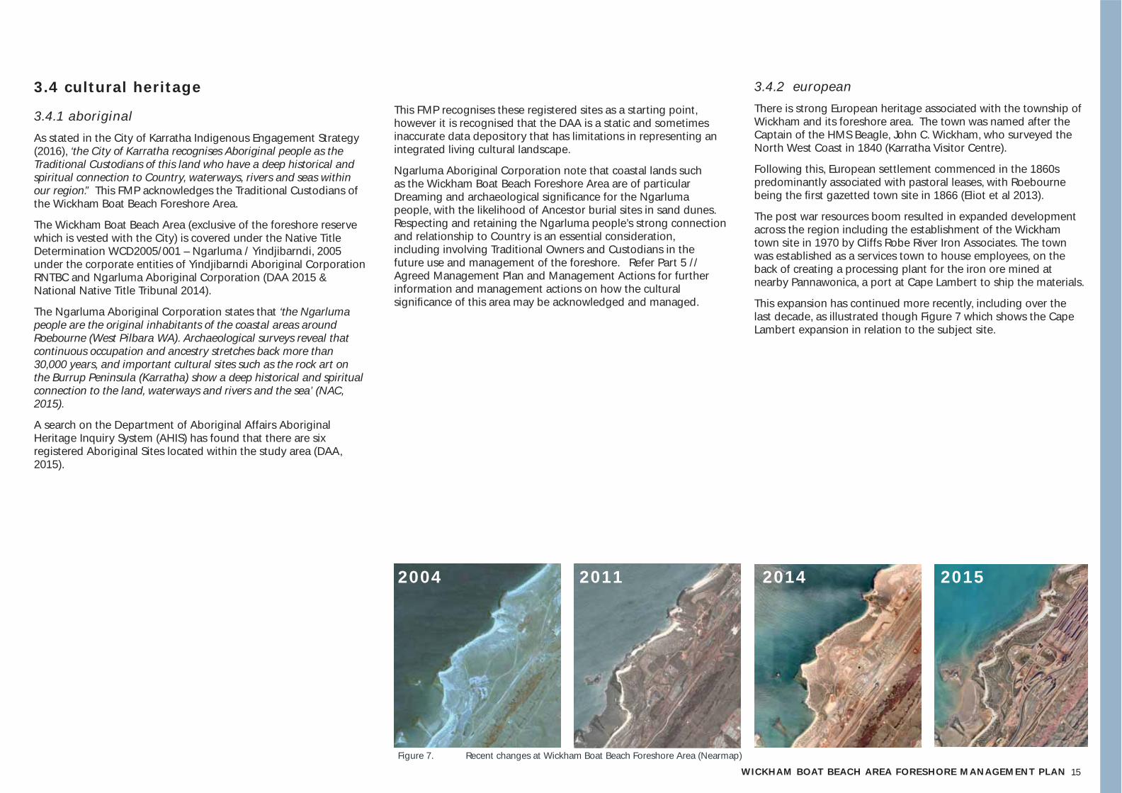
This expansion has continued more recently, including over the last decade, as illustrated though Figure 7 which shows the Cape Lambert expansion in relation to the subject site.
2004 2011 2014 2015
Figure 7. Recent changes at Wickham Boat Beach Foreshore Area (Nearmap)

16
Figure 8. Aerial photography of Cleaverville - Anketell Coast 1949 - 2007 (Adapted from Elliot et al, 2013)
3.5 envi ronmenta l va lues 3.5.1 geomorphology, land system and land formGeomorphology
The Wickham Boat Beach Area is located on the eastern side of Nickol Bay. Nickol Bay is located between two ancient granite ridges, the Burrup Peninsula (Murujuga) and Anketell Point / Cape Lambert.
The Cleaverville and Anketell Coast is a northern expression of a Precambrian formation, running in a north east direction (Eliot et al, 2013). The area between Anketell to Cape Lambert is an embayment, which possesses an extensive terrace, which may be intertidal or subtidal.
As shown in Figure 8, note that coastal land forms perched on this terrace vary according to the width, with perched beach and coastal dune where the terrace is wider, and perched pocket beaches or rock cliff where the terrace is narrow. The naturally occurring rocky outcrops allows for the development of beaches, where sand disposition occurs fi lling the area with marine sands and silts. Conversely, tidal networks including small tidal creeks have been established in sections where the rock formation is low.
This geomorphology is illustrated in Figure 8. Observation of aerial imagery reveals that limited change has occurred on the protected rock controlled coast. This is relevant for majority of the subject site which is perched coast on rock platform, however also restricted due to human interventions by major reclamation works and fl oodplain modifi cation associated with the Cape Lambert development (Cardno, 2015).
In the southern area of the embayment, observed change has identifi ed localised sand deposition (spit growth), modifi cation of subtidal channels and tidal creeks, see Figure 8. These low lying areas are subject to tidal fl ows and have capacity for signifi cant coastal change (Eliot et al, 2013).
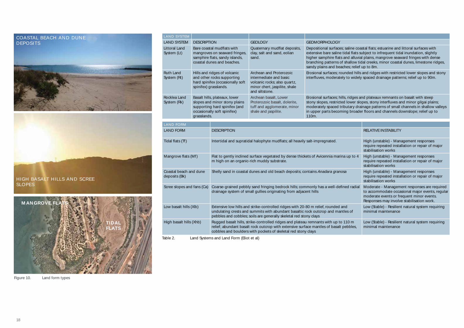
land systems and land form
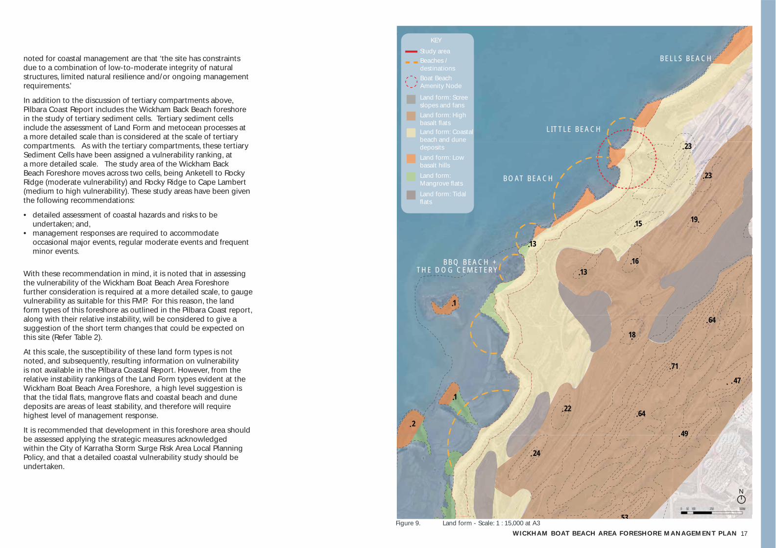
To understand the land form that comprises the Wickham Boat Beach Area and its relationship to the wider Cleaverville and Anketell Coast context at a broader scale, this FMP has drawn on the content of the Geology, Geomorphology and Vulnerability of the Pilbara Coast Report (Eliot et al, 2013).
This report classifi es the major morphological areas present on the Wickham Boat Beach Area study as Land Systems. The report states that the Cleaverville and Anketell Coast is primarily defi ned by rocky coastline - the Ruth Land System (Rt) and Rocklea Land System (Rk) - and tidal lowlands - the Littoral Land System (Lit). These Land System types and their qualities are outlined in Table 1, as excerpted from the Pilbara Coast Report.
The geomorphology of the Wickham Boat Beach Area can be considered at a further level of detail through the division of this landscape in specifi c Land Form types, as follows:
• High basalt hills;• Low basalt hills;• Scree slopes and fans;• Coastal beach and dune deposits; • Mangrove fl ats; and• Tidal fl ats.
Tidal Flats (Tf) and Mangrove Flats (Mf) can be found in low lying areas by the coast, coastal beach and dune deposits (Bk) in beachside and dunal areas, and scree slopes and fans (Ca) and Low basalt hills (Xlb) as the topography rises and moves inland. Figure 9 shows a plan view of this Land Form confi guration across the subject area and surrounding context. The Land Form types and their qualities are outlined in Table 1, as excerpted from the Pilbara Coast Report.
coastal vulnerabi l i ty
The Pilbara Coast Report provides an analysis of the instability and susceptibility of the Land Forms of the Pilbara Coast, in order to assess the vulnerability of each area. Instability is defi ned as the level to which Land Forms are responsive to short term environmental variability, or change. Susceptibility makes note of natural structures, and considers capacity for coastal change to reach a tipping point - a consideration of long term change. Together, instability and susceptibility provide a holistic vulnerability ranking.
As scales considered in this report differ, so will the defi nition of coastal vulnerability. Using the method in the Pilbara Coastal Report, we fi nd the Wickham Boat Beach Area Foreshore within the ‘tertiary compartment’ or study area of Cleaverville Creek to Cape Lambert. This compartment is defi ned as an area of Moderate Vulnerability. This level of Moderate Vulnerability is an area in which it is stated that ‘Coastal risk may present a moderate constraint to coastal management’. The constraints
1949
2007
17WICKHAM BOAT BEACH AREA FORESHORE MANAGEMENT PLAN
23
23
1915
1613
24
53
22
49
47
71
18
64
64
13
1
1
2
noted for coastal management are that ‘the site has constraints due to a combination of low-to-moderate integrity of natural structures, limited natural resilience and/or ongoing management requirements.’
In addition to the discussion of tertiary compartments above, Pilbara Coast Report includes the Wickham Back Beach foreshore in the study of tertiary sediment cells. Tertiary sediment cells include the assessment of Land Form and metocean processes at a more detailed scale than is considered at the scale of tertiary compartments. As with the tertiary compartments, these tertiary Sediment Cells have been assigned a vulnerability ranking, at a more detailed scale. The study area of the Wickham Back Beach Foreshore moves across two cells, being Anketell to Rocky Ridge (moderate vulnerability) and Rocky Ridge to Cape Lambert (medium to high vulnerability). These study areas have been given the following recommendations:
• detailed assessment of coastal hazards and risks to be undertaken; and,
• management responses are required to accommodate occasional major events, regular moderate events and frequent minor events.
With these recommendation in mind, it is noted that in assessing the vulnerability of the Wickham Boat Beach Area Foreshore further consideration is required at a more detailed scale, to gauge vulnerability as suitable for this FMP. For this reason, the land form types of this foreshore as outlined in the Pilbara Coast report, along with their relative instability, will be considered to give a suggestion of the short term changes that could be expected on this site (Refer Table 2).
At this scale, the susceptibility of these land form types is not noted, and subsequently, resulting information on vulnerability is not available in the Pilbara Coastal Report. However, from the relative instability rankings of the Land Form types evident at the Wickham Boat Beach Area Foreshore, a high level suggestion is that the tidal fl ats, mangrove fl ats and coastal beach and dune deposits are areas of least stability, and therefore will require highest level of management response.
It is recommended that development in this foreshore area should be assessed applying the strategic measures acknowledged within the City of Karratha Storm Surge Risk Area Local Planning Policy, and that a detailed coastal vulnerability study should be undertaken.
Study area
KEY
Land form: Scree slopes and fansLand form: High basalt fl atsLand form: Coastal beach and dune depositsLand form: Low basalt hillsLand form: Mangrove fl ats
Land form: Tidal fl ats
BOAT BEACH
BBQ BEACH + THE DOG CEMETERY
BELLS BEACH
LITTLE BEACH
Beaches / destinations
Figure 9. Land form - Scale: 1 : 15,000 at A3
Boat Beach Amenity Node
N
18
LAND SYSTEM
LAND SYSTEM DESCRIPTION GEOLOGY GEOMORPHOLOGYLittoral Land System (Lt)
Bare coastal mudfl ats with mangroves on seaward fringes, samphire fl ats, sandy islands, coastal dunes and beaches.
Quaternary mudfl at deposits, clay, salt and sand, eolian sand.
Depositional surfaces; saline coastal fl ats; estuarine and littoral surfaces with extensive bare saline tidal fl ats subject to infrequent tidal inundation, slightly higher samphire fl ats and alluvial plains, mangrove seaward fringes with dense branching patterns of shallow tidal creeks, minor coastal dunes, limestone ridges, sandy plains and beaches; relief up to 8m.
Ruth Land System (Rt)
Hills and ridges of volcanic and other rocks supporting hard spinifex (occasionally soft spinifex) grasslands.
Archean and Proterozoic intermediate and basic volcanic rocks; also quartz, minor chert, jaspilite, shale and siltstone.
Erosional surfaces; rounded hills and ridges with restricted lower slopes and stony interfl uves, moderately to widely spaced drainage patterns; relief up to 90m.
Rocklea Land System (Rk)
Basalt hills, plateaux, lower slopes and minor stony plains supporting hard spinifex (and occasionally soft spinifex) grasslands.
Archean basalt, Lower Proterozoic basalt, dolerite, tuff and agglomerate, minor shale and jaspilite.
Erosional surfaces; hills, ridges and plateaux remnants on basalt with steep stony slopes, restricted lower slopes, stony interfl uves and minor gilgai plains; moderately spaced tributary drainage patterns of small channels in shallow valleys in upper parts becoming broader fl oors and channels downslope; relief up to 110m.
LAND FORM
LAND FORM DESCRIPTION RELATIVE INSTABILITY
Tidal fl ats (Tf) Intertidal and supratidal halophyte mudfl ats; all heavily salt-impregnated. High (unstable) - Management responses require repeated installation or repair of major stabilisation works
Mangrove fl ats (Mf) Flat to gently inclined surface vegetated by dense thickets of Avicennia marina up to 4 m high on an organic-rich muddy substrate.
High (unstable) - Management responses require repeated installation or repair of major stabilisation works
Coastal beach and dune deposits (Bk)
Shelly sand in coastal dunes and old beach deposits; contains Anadara granosa High (unstable) - Management responses require repeated installation or repair of major stabilisation works
Scree slopes and fans (Ca) Coarse-grained pebbly sand fringing bedrock hills; commonly has a well-defi ned radial drainage system of small gullies originating from adjacent hills
Moderate - Management responses are required to accommodate occasional major events, regular moderate events or frequent minor events. Responses may involve stabilisation work.
Low basalt hills (Xlb) Extensive low hills and strike-controlled ridges with 20-80 m relief, rounded and undulating crests and summits with abundant basaltic rock outcrop and mantles of pebbles and cobbles; soils are generally skeletal red stony clays
Low (Stable) - Resilient natural system requiring minimal maintenance
High basalt hills (Xhb) Rugged basalt hills, strike-controlled ridges and plateau remnants with up to 110 m relief; abundant basalt rock outcrop with extensive surface mantles of basalt pebbles, cobbles and boulders with pockets of skeletal red stony clays
Low (Stable) - Resilient natural system requiring minimal maintenance
Table 2. Land Systems and Land Form (Eliot et al)
TIDAL FLATS
MANGROVE FLATS
HIGH BASALT HILLS AND SCREE SLOPES
COASTAL BEACH AND DUNE DEPOSITS
Figure 10. Land form types
19WICKHAM BOAT BEACH AREA FORESHORE MANAGEMENT PLAN
3.5.2 coastal processesAligned with the wider coastal area of the Pilbara, the Wickham Boat Beach Area is part of a complex natural system, that comprises multiple uses and is subject to varying impacts (environmental, social/cultural, development etc.). The coastal processes of Wickham Boat Beach Area Foreshore are considered within the broader context of the Cleaverville and Anketell Coast as well as the wider Nickol Bay.
The City of Karratha Draft Coastal Management Strategy (City of Karratha, 2015) notes the factors impacting coastal processes are as follows:
• Weather and climate;• Waves;• Sea level and tides; and• Currents.
These factors will be explored in further detail, below.
weather and cl imate
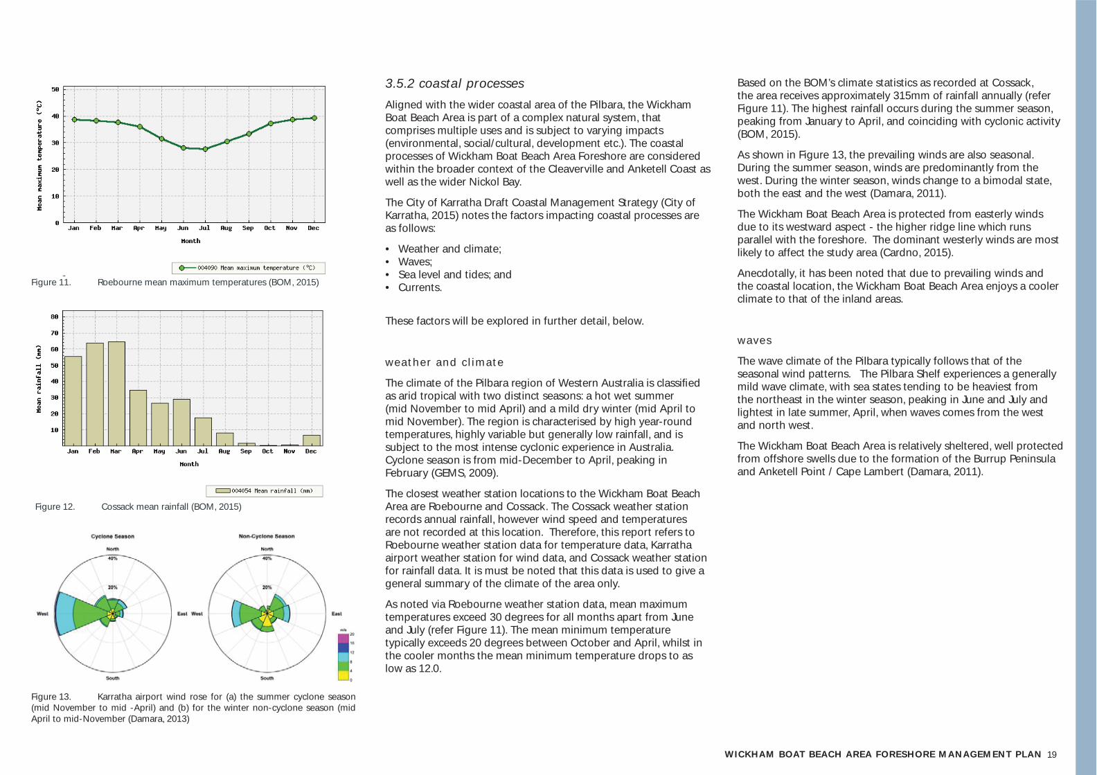
The climate of the Pilbara region of Western Australia is classifi ed as arid tropical with two distinct seasons: a hot wet summer (mid November to mid April) and a mild dry winter (mid April to mid November). The region is characterised by high year-round temperatures, highly variable but generally low rainfall, and is subject to the most intense cyclonic experience in Australia. Cyclone season is from mid-December to April, peaking in February (GEMS, 2009).
The closest weather station locations to the Wickham Boat Beach Area are Roebourne and Cossack. The Cossack weather station records annual rainfall, however wind speed and temperatures are not recorded at this location. Therefore, this report refers to Roebourne weather station data for temperature data, Karratha airport weather station for wind data, and Cossack weather station for rainfall data. It is must be noted that this data is used to give a general summary of the climate of the area only.
As noted via Roebourne weather station data, mean maximum temperatures exceed 30 degrees for all months apart from June and July (refer Figure 11). The mean minimum temperature typically exceeds 20 degrees between October and April, whilst in the cooler months the mean minimum temperature drops to as low as 12.0.
Based on the BOM’s climate statistics as recorded at Cossack, the area receives approximately 315mm of rainfall annually (refer Figure 11). The highest rainfall occurs during the summer season, peaking from January to April, and coinciding with cyclonic activity (BOM, 2015).
As shown in Figure 13, the prevailing winds are also seasonal. During the summer season, winds are predominantly from the west. During the winter season, winds change to a bimodal state, both the east and the west (Damara, 2011).
The Wickham Boat Beach Area is protected from easterly winds due to its westward aspect - the higher ridge line which runs parallel with the foreshore. The dominant westerly winds are most likely to affect the study area (Cardno, 2015).
Anecdotally, it has been noted that due to prevailing winds and the coastal location, the Wickham Boat Beach Area enjoys a cooler climate to that of the inland areas.
waves
The wave climate of the Pilbara typically follows that of the seasonal wind patterns. The Pilbara Shelf experiences a generally mild wave climate, with sea states tending to be heaviest from the northeast in the winter season, peaking in June and July and lightest in late summer, April, when waves comes from the west and north west.
The Wickham Boat Beach Area is relatively sheltered, well protected from offshore swells due to the formation of the Burrup Peninsula and Anketell Point / Cape Lambert (Damara, 2011).
Figure 11. Roebourne mean maximum temperatures (BOM, 2015)
Figure 12. Cossack mean rainfall (BOM, 2015)
Figure 13. Karratha airport wind rose for (a) the summer cyclone season (mid November to mid -April) and (b) for the winter non-cyclone season (mid April to mid-November (Damara, 2013)
20
Highest Astronomical Tide (HAT) 6.21m
Mean High Water Springs (MHWS) 5.48m
Mean High Water Neaps (MHWN) 3.85m
Mean Low Water Neaps (MLWN) 2.68m
Mean Low Water Springs (MLWS) 0.85m
Lowest Astronomical Tide (LAT) 0.05m
Table 3. Cape Lambert (Point Samson) Submergence Curve (Cardno, 2015)
Table 4. Monthly sea levels at Cape Lambert (BOM, 2015)
Subject site
Approx80m
A
A
Hig
h t
ide
Bo
at B
each
Rd
Cap
e La
mb
ert
Rd
Low
tid
e
Inter-t idal f lats Coastal beach and dune deposits
t ides, sea level and storm surge
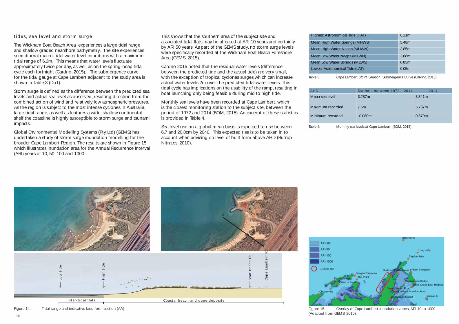
The Wickham Boat Beach Area experiences a large tidal range and shallow graded nearshore bathymetry. The site experiences semi diurnal macro-tidal water level conditions with a maximum tidal range of 6.2m. This means that water levels fl uctuate approximately twice per day, as well as on the spring-neap tidal cycle each fortnight (Cardno, 2015). The submergence curve for the tidal gauge at Cape Lambert adjacent to the study area is shown in Table 3 (DoT).
Storm surge is defi ned as the difference between the predicted sea levels and actual sea level as observed, resulting direction from the combined action of wind and relatively low atmospheric pressures. As the region is subject to the most intense cyclones in Australia, large tidal range, as well as features a wide, shallow continental shelf the coastline is highly susceptible to storm surge and tsunami impacts.
Global Environmental Modelling Systems (Pty Ltd) (GEMS) has undertaken a study of storm surge inundation modelling for the broader Cape Lambert Region. The results are shown in Figure 15 which illustrates inundation area for the Annual Recurrence Interval (ARI) years of 10, 50, 100 and 1000.
This shows that the southern area of the subject site and associated tidal fl ats may be affected at ARI 10 years and certainly by ARI 50 years. As part of the GEMS study, no storm surge levels were specifi cally recorded at the Wickham Boat Beach Foreshore Area (GEMS, 2015).
Cardno 2015 noted that the residual water levels (difference between the predicted tide and the actual tide) are very small, with the exception of tropical cyclones surges which can increase actual water levels 2m over the predicted tidal water levels. This tidal cycle has implications on the usability of the ramp, resulting in boat launching only being feasible during mid to high tide.
Monthly sea levels have been recorded at Cape Lambert, which is the closest monitoring station to the subject site, between the period of 1972 and 2014 (BOM, 2015). An excerpt of these statistics is provided in Table 4.
Sea level rise on a global mean basis is expected to rise between 6.7 and 20.8cm by 2040. This expected rise is to be taken in to account when advising on level of built form above AHD (Burrup Nitrates, 2010).
Figure 14. Tidal range and indicative land form section (AA) Figure 15. Overlay of Cape Lambert inundation zones, ARI 10 to 1000 (Adapted from GEMS, 2015)
AHD Stat ist ic between 1972 - 2014 2014
Mean sea level 3.287m 3.341m
Maximum recorded 7.5m 5.737m
Minimum recorded -0.080m 0.570m
21WICKHAM BOAT BEACH AREA FORESHORE MANAGEMENT PLAN
3.5.3 flora and faunaAs described in Part 3.5.1 // Geomorphology, the subject site comprises unique land form types:
• High basalt hills;• Low basalt hills;• Scree slopes and fans;• Coastal beach and dune deposits; • Mangrove fl ats; and• Tidal fl ats.
These land form types in turn provide a unique habitat for the fl ora and fauna of this site. Generally the study area features a shallowly graded intertidal zone behind which, are coastal dunes with a typical height of above 10m.
f lora
At a more detailed level, Cardno (2015) observed during a site survey that typically the dunes are vegetated with coastal grasses and shrubs generally lower than 0.5m, with dune vegetation that is sparse and missing in some places.
An initial search on the Department of Environment and Conservation’s NatureMap database shows that Priority 1 fl ora can be found within a 2km radius of PWYC. Typical species include:
• Ipomoea pes-caprae subsp. Brasiliensis | Beach Morning Glory• Spinifex longifolius | Beach Spinifex • Themeda sp. Mt Barricade (M.E. Trudgen 2471)• Trianthema portulacastrum | Giant Pigweed
fauna
This FMP recognises that the Wickham coastal ecosystem has a signifi cant role in providing habitat for coastal fauna. A search the Department of Environment and Conservation’s Nature Map database found that three fauna species occur in the subject area that are classifi ed as threatened, meaning rare or likely to become extinct. These include:
• Natator depressus | Flatback Turtle;• Lerista nevinae | Slider Skink; and• Dasyurus hallucatus | Northern Quoll.
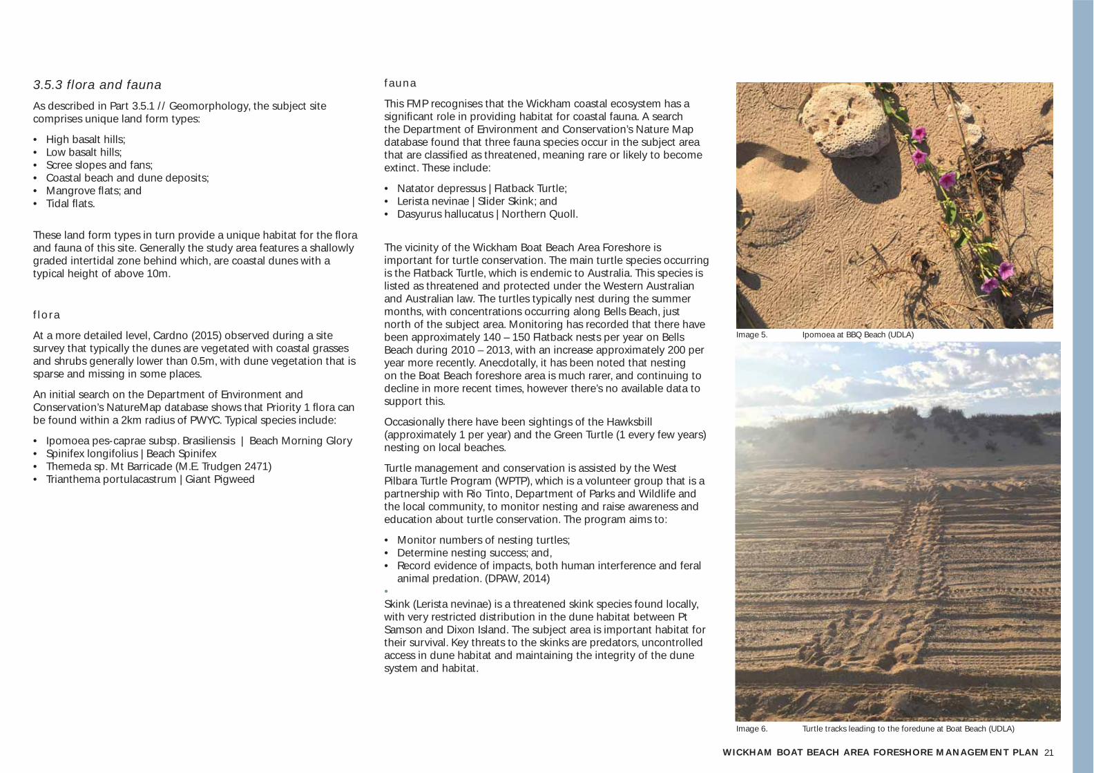
The vicinity of the Wickham Boat Beach Area Foreshore is important for turtle conservation. The main turtle species occurring is the Flatback Turtle, which is endemic to Australia. This species is listed as threatened and protected under the Western Australian and Australian law. The turtles typically nest during the summer months, with concentrations occurring along Bells Beach, just north of the subject area. Monitoring has recorded that there have been approximately 140 – 150 Flatback nests per year on Bells Beach during 2010 – 2013, with an increase approximately 200 per year more recently. Anecdotally, it has been noted that nesting on the Boat Beach foreshore area is much rarer, and continuing to decline in more recent times, however there’s no available data to support this.
Occasionally there have been sightings of the Hawksbill (approximately 1 per year) and the Green Turtle (1 every few years) nesting on local beaches.
Turtle management and conservation is assisted by the West Pilbara Turtle Program (WPTP), which is a volunteer group that is a partnership with Rio Tinto, Department of Parks and Wildlife and the local community, to monitor nesting and raise awareness and education about turtle conservation. The program aims to:
• Monitor numbers of nesting turtles;• Determine nesting success; and,• Record evidence of impacts, both human interference and feral
animal predation. (DPAW, 2014) • Skink (Lerista nevinae) is a threatened skink species found locally, with very restricted distribution in the dune habitat between Pt Samson and Dixon Island. The subject area is important habitat for their survival. Key threats to the skinks are predators, uncontrolled access in dune habitat and maintaining the integrity of the dune system and habitat.
Image 6. Turtle tracks leading to the foredune at Boat Beach (UDLA)
Image 5. Ipomoea at BBQ Beach (UDLA)
22
3.6 social values, uses and perception
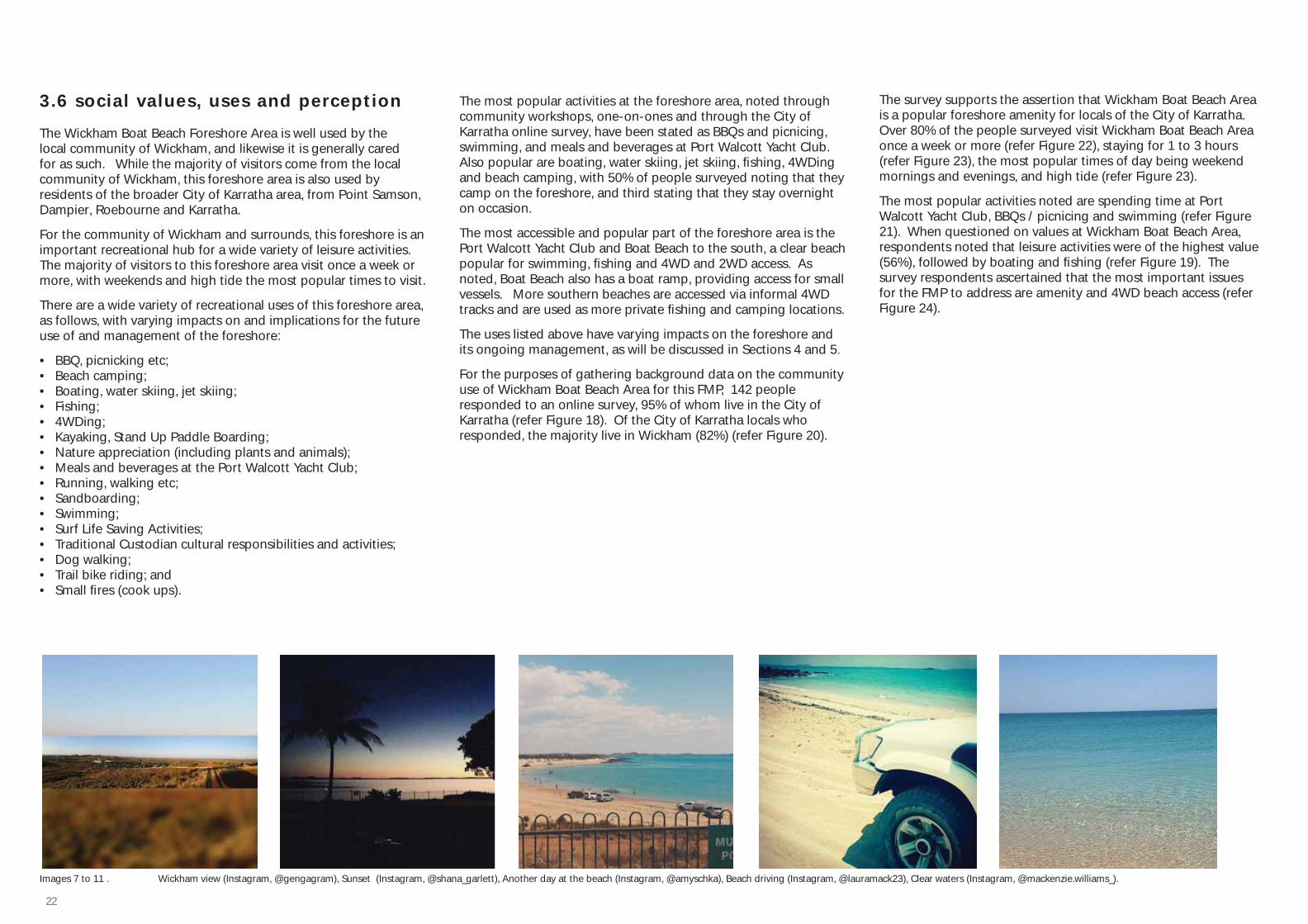
The Wickham Boat Beach Foreshore Area is well used by the local community of Wickham, and likewise it is generally cared for as such. While the majority of visitors come from the local community of Wickham, this foreshore area is also used by residents of the broader City of Karratha area, from Point Samson, Dampier, Roebourne and Karratha.
For the community of Wickham and surrounds, this foreshore is an important recreational hub for a wide variety of leisure activities. The majority of visitors to this foreshore area visit once a week or more, with weekends and high tide the most popular times to visit.
There are a wide variety of recreational uses of this foreshore area, as follows, with varying impacts on and implications for the future use of and management of the foreshore:
• BBQ, picnicking etc;• Beach camping;• Boating, water skiing, jet skiing;• Fishing;• 4WDing;• Kayaking, Stand Up Paddle Boarding;• Nature appreciation (including plants and animals);• Meals and beverages at the Port Walcott Yacht Club; • Running, walking etc;• Sandboarding;• Swimming;• Surf Life Saving Activities;• Traditional Custodian cultural responsibilities and activities;• Dog walking;• Trail bike riding; and• Small fi res (cook ups).
The most popular activities at the foreshore area, noted through community workshops, one-on-ones and through the City of Karratha online survey, have been stated as BBQs and picnicing, swimming, and meals and beverages at Port Walcott Yacht Club. Also popular are boating, water skiing, jet skiing, fi shing, 4WDing and beach camping, with 50% of people surveyed noting that they camp on the foreshore, and third stating that they stay overnight on occasion.
The most accessible and popular part of the foreshore area is the Port Walcott Yacht Club and Boat Beach to the south, a clear beach popular for swimming, fi shing and 4WD and 2WD access. As noted, Boat Beach also has a boat ramp, providing access for small vessels. More southern beaches are accessed via informal 4WD tracks and are used as more private fi shing and camping locations.
The uses listed above have varying impacts on the foreshore and its ongoing management, as will be discussed in Sections 4 and 5.
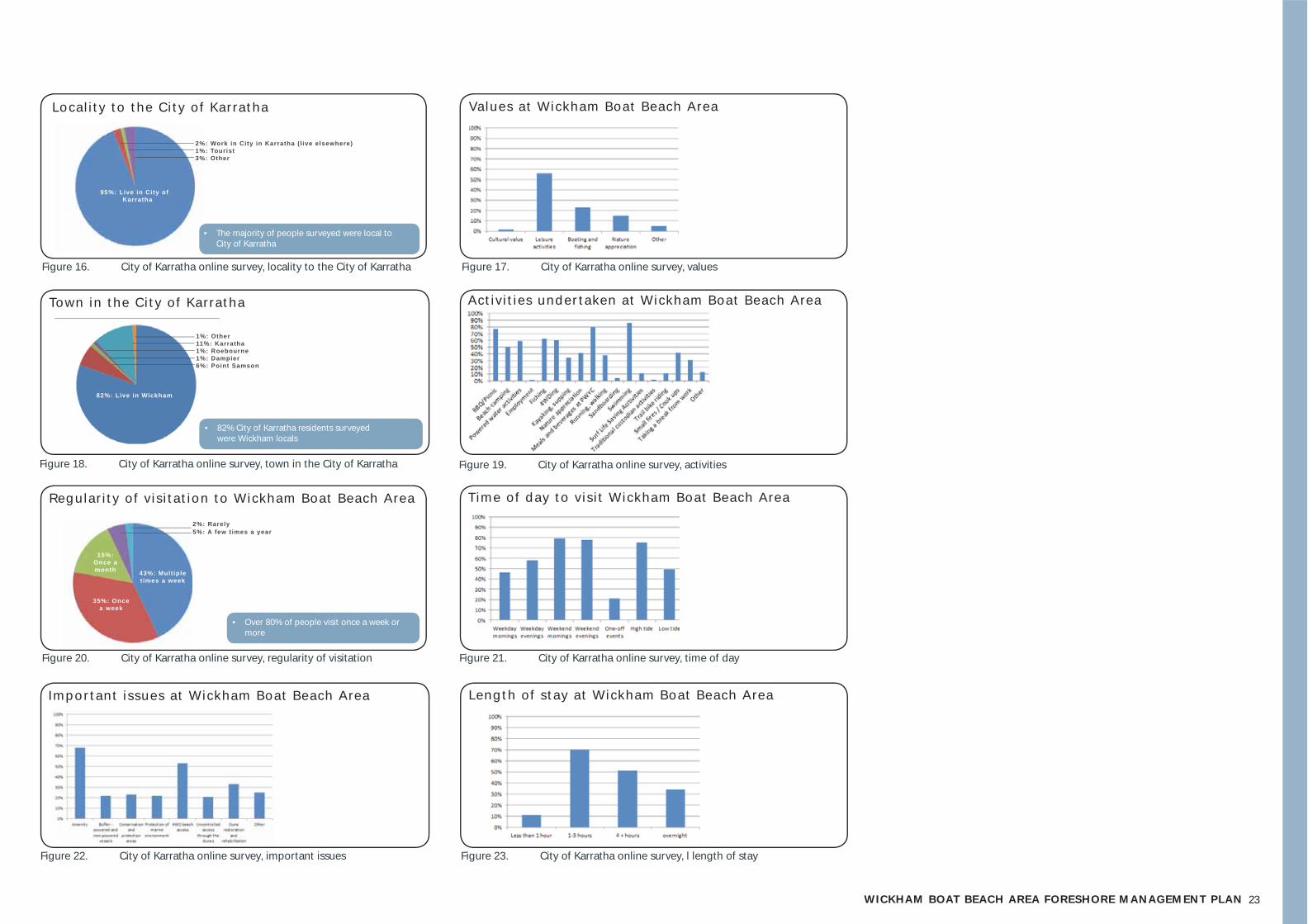
For the purposes of gathering background data on the community use of Wickham Boat Beach Area for this FMP, 142 people responded to an online survey, 95% of whom live in the City of Karratha (refer Figure 18). Of the City of Karratha locals who responded, the majority live in Wickham (82%) (refer Figure 20).
Images 7 to 11 . Wickham view (Instagram, @gengagram), Sunset (Instagram, @shana_garlett), Another day at the beach (Instagram, @amyschka), Beach driving (Instagram, @lauramack23), Clear waters (Instagram, @mackenzie.williams_).
The survey supports the assertion that Wickham Boat Beach Area is a popular foreshore amenity for locals of the City of Karratha. Over 80% of the people surveyed visit Wickham Boat Beach Area once a week or more (refer Figure 22), staying for 1 to 3 hours (refer Figure 23), the most popular times of day being weekend mornings and evenings, and high tide (refer Figure 23).
The most popular activities noted are spending time at Port Walcott Yacht Club, BBQs / picnicing and swimming (refer Figure 21). When questioned on values at Wickham Boat Beach Area, respondents noted that leisure activities were of the highest value (56%), followed by boating and fi shing (refer Figure 19). The survey respondents ascertained that the most important issues for the FMP to address are amenity and 4WD beach access (refer Figure 24).
23WICKHAM BOAT BEACH AREA FORESHORE MANAGEMENT PLAN
• The majority of people surveyed were local to City of Karratha
• 82% City of Karratha residents surveyed were Wickham locals
• Over 80% of people visit once a week or more
2%: Work in City in Karratha ( l ive elsewhere)1%: Tourist3%: Other
2%: Rarely5%: A few times a year
1%: Other11%: Karratha1%: Roebourne1%: Dampier6%: Point Samson
95%: Live in City of Karratha
82%: Live in Wickham
82%: Wickham
35%: Once a week
43%: Multiple t imes a week
Figure 16. City of Karratha online survey, locality to the City of Karratha Figure 17. City of Karratha online survey, values
Figure 18. City of Karratha online survey, town in the City of Karratha Figure 19. City of Karratha online survey, activities
Figure 20. City of Karratha online survey, regularity of visitation Figure 21. City of Karratha online survey, time of day
Values at Wickham Boat Beach Area
Impor tant issues at Wickham Boat Beach Area
Town in the City of Karratha
Regular i ty of v is i tat ion to Wickham Boat Beach Area
Local i ty to the City of Karratha
Activ i t ies under taken at Wickham Boat Beach Area
Time of day to vis i t Wickham Boat Beach Area
15%: Once a month
Figure 22. City of Karratha online survey, important issues Figure 23. City of Karratha online survey, l length of stay
Length of stay at Wickham Boat Beach Area
242424244442422
4 // key themes
25WICKHAM BOAT BEACH AREA FORESHORE MANAGEMENT PLAN
4.1 key themes
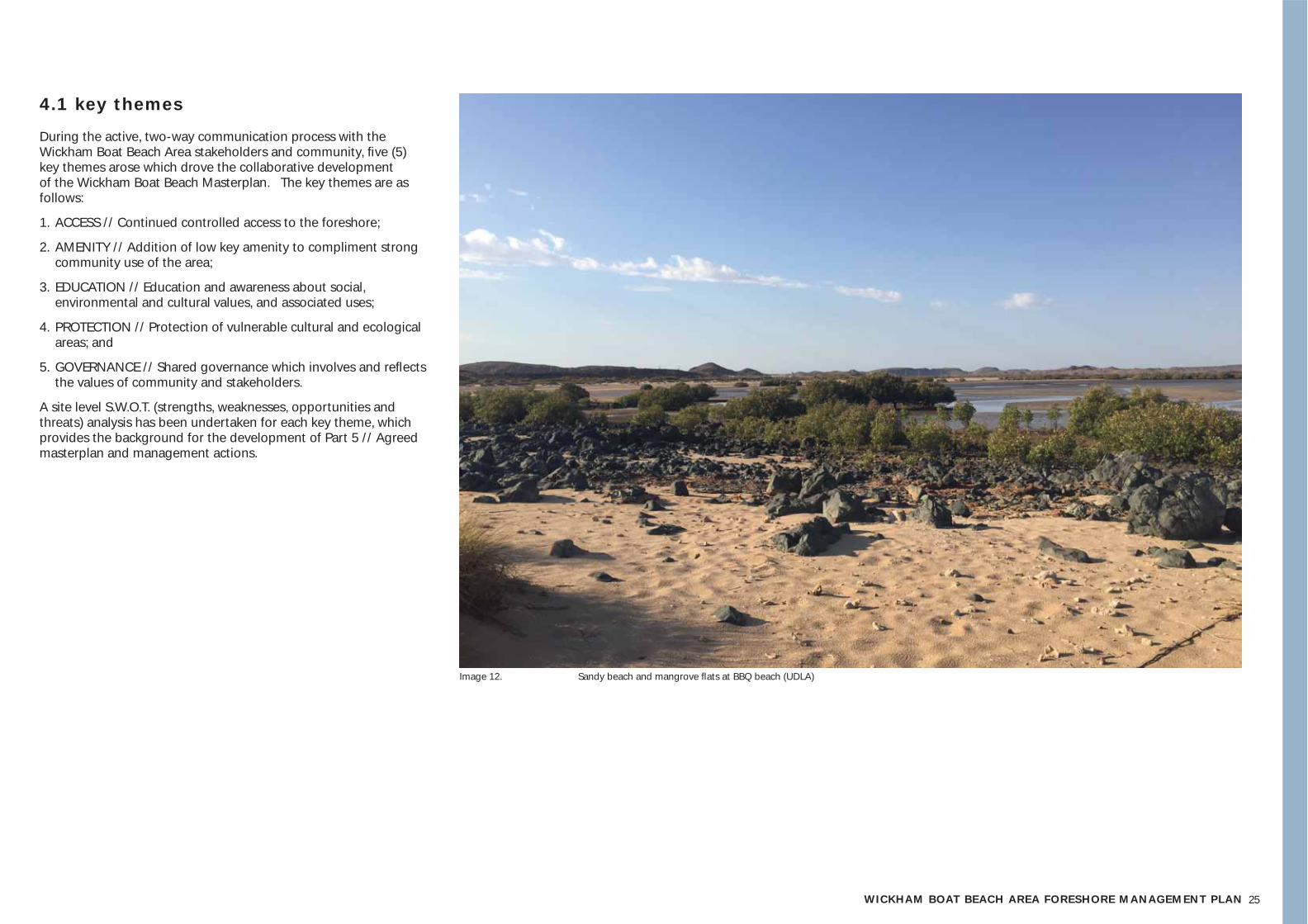
During the active, two-way communication process with the Wickham Boat Beach Area stakeholders and community, fi ve (5) key themes arose which drove the collaborative development of the Wickham Boat Beach Masterplan. The key themes are as follows:
1. ACCESS // Continued controlled access to the foreshore;
2. AMENITY // Addition of low key amenity to compliment strong community use of the area;
3. EDUCATION // Education and awareness about social, environmental and cultural values, and associated uses;
4. PROTECTION // Protection of vulnerable cultural and ecological areas; and
5. GOVERNANCE // Shared governance which involves and refl ects the values of community and stakeholders.
A site level S.W.O.T. (strengths, weaknesses, opportunities and threats) analysis has been undertaken for each key theme, which provides the background for the development of Part 5 // Agreed masterplan and management actions.
Image 12. Sandy beach and mangrove fl ats at BBQ beach (UDLA)
26
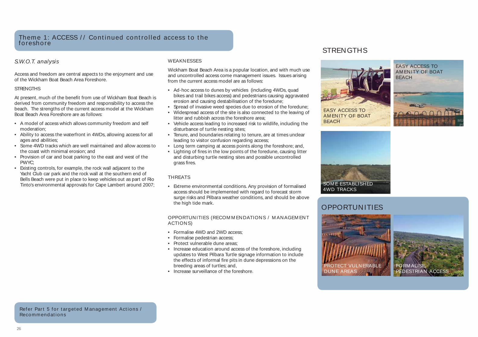
Theme 1: ACCESS // Continued control led access to the foreshore
STRENGTHS
EASY ACCESS TO AMENITY OF BOAT BEACH
EASY ACCESS TO AMENITY OF BOAT BEACH
SOME ESTABLISHED 4WD TRACKS
Access and freedom are central aspects to the enjoyment and use of the Wickham Boat Beach Area Foreshore.
STRENGTHS
At present, much of the benefi t from use of Wickham Boat Beach is derived from community freedom and responsibility to access the beach. The strengths of the current access model at the Wickham Boat Beach Area Foreshore are as follows:
• A model of access which allows community freedom and self moderation;
• Ability to access the waterfront in 4WDs, allowing access for all ages and abilities;
• Some 4WD tracks which are well maintained and allow access to the coast with minimal erosion; and
• Provision of car and boat parking to the east and west of the PWYC;
• Existing controls, for example, the rock wall adjacent to the Yacht Club car park and the rock wall at the southern end of Bells Beach were put in place to keep vehicles out as part of Rio Tinto’s environmental approvals for Cape Lambert around 2007;
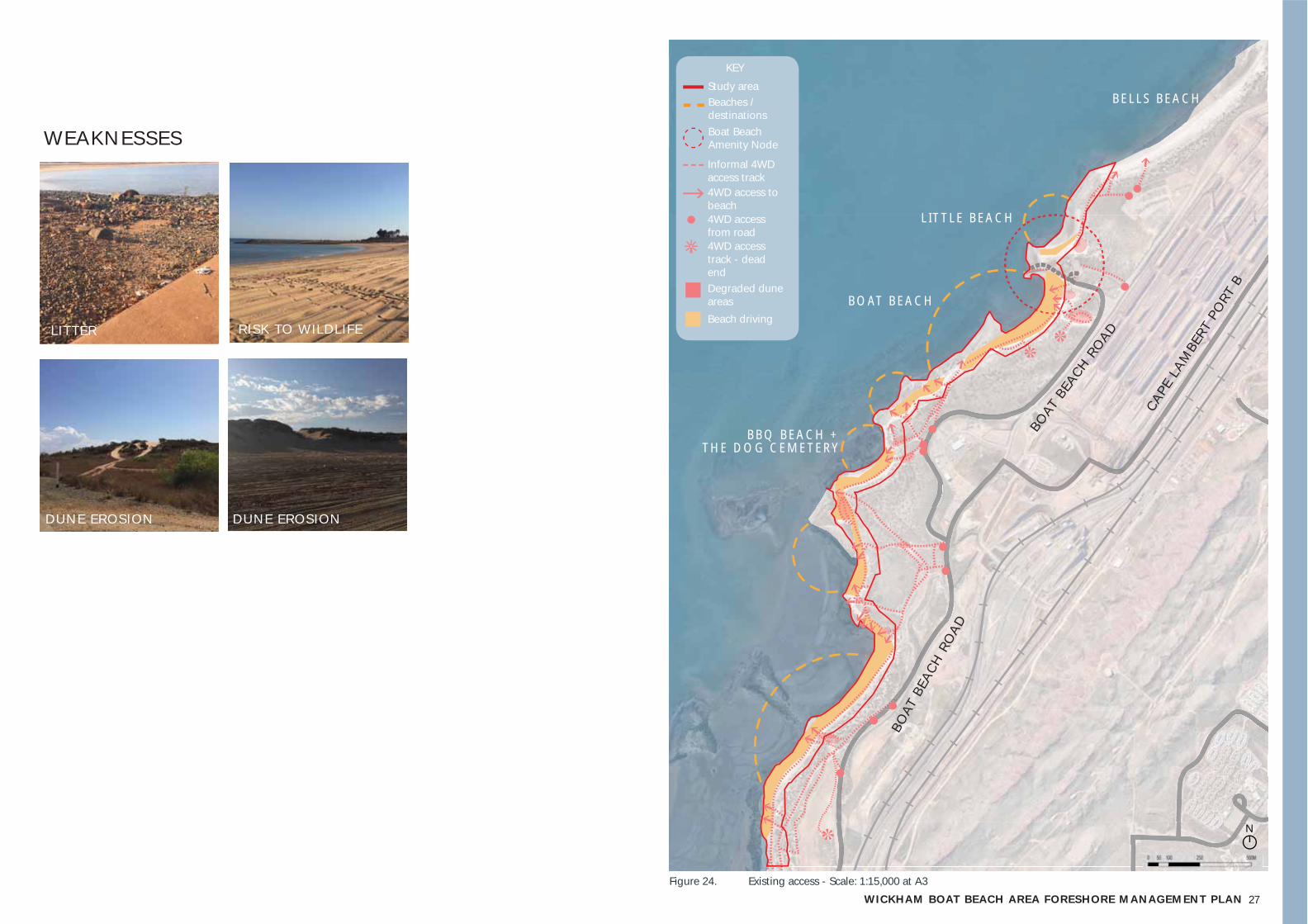
WEAKNESSES
Wickham Boat Beach Area is a popular location, and with much use and uncontrolled access come management issues. Issues arising from the current access model are as follows:
• Ad-hoc access to dunes by vehicles (including 4WDs, quad bikes and trail bikes access) and pedestrians causing aggravated erosion and causing destabilisation of the foredune;
• Spread of invasive weed species due to erosion of the foredune;• Widespread access of the site is also connected to the leaving of
litter and rubbish across the foreshore area;• Vehicle access leading to increased risk to wildlife, including the
disturbance of turtle nesting sites;• Tenure, and boundaries relating to tenure, are at times unclear
leading to visitor confusion regarding access;• Long term camping at access points along the foreshore; and,• Lighting of fi res in the low points of the foredune, causing litter
and disturbing turtle nesting sites and possible uncontrolled grass fi res.
THREATS
• Extreme environmental conditions. Any provision of formalised access should be implemented with regard to forecast storm surge risks and Pilbara weather conditions, and should be above the high tide mark.
OPPORTUNITIES (RECOMMENDATIONS / MANAGEMENT ACTIONS)
• Formalise 4WD and 2WD access;• Formalise pedestrian access;• Protect vulnerable dune areas;• Increase education around access of the foreshore, including
updates to West Pilbara Turtle signage information to include the effects of informal fi re pits in dune depressions on the breeding areas of turtles; and,
• Increase surveillance of the foreshore.
OPPORTUNITIES
S.W.O.T. analysis
PROTECT VULNERABLE DUNE AREAS
FORMALISE PEDESTRIAN ACCESS
Refer Par t 5 for targeted Management Act ions / Recommendations
27WICKHAM BOAT BEACH AREA FORESHORE MANAGEMENT PLAN
WEAKNESSES
LITTER
DUNE EROSION DUNE EROSION
RISK TO WILDLIFE
Figure 24. Existing access - Scale: 1:15,000 at A3
BOAT BEACH
BOAT
BEA
CH RO
AD
BELLS BEACH
LITTLE BEACH
Study area
KEY
Beaches / destinationsBoat Beach Amenity Node
Informal 4WD access track4WD access to beach4WD access from road4WD access track - dead endDegraded dune areasBeach driving
N
BOAT
BEA
CH R
OAD
CAPE
LAM
BERT
PO
RT B
BBQ BEACH + THE DOG CEMETERY

28
Theme 2: AMENITY // Addit ion of low key amenity to compliment community use of the area
S.W.O.T. analysis
Coastal amenity at the Wickham Boat Beach Area Foreshore is largely focused around the Port Walcott Yacht Club (PWYC), Boat Beach and the associated boat ramp. PWYC is situated north of Boat Beach, overlooking the boat ramp and providing prominent views to the ocean and across Nickol Bay.
Key amenity within this facility includes:
• Clubhouse with kitchen, bar, toilets and showers;• Large open lawn area and shade structures;• Provision of meals and beverages to the public on designated
days for community fundraising purposes;• Facility can be hired for private events; and,• Carpark.
Aside from the facilities provided by the PWYC, amenity provision at the Wickham Boat Beach Area Foreshore is minimal, with no current offi cial provision of public toilets, shade structures, or picnic facilities.
At a southern beach, named by some locals as ‘BBQ Beach’, there has been community construction of a BBQ on a concrete slab.
Community use of the Wickham Boat Beach Area Foreshore, centred around the popular Boat Beach, continues to rise, for example, with the recent development of the Port Walcott Surf Life Saving Club. Provision of low key amenity is necessary to support the sustainability of this important community hub.
STRENGTHS
Much of the existing amenity at Wickham Boat Beach Area Foreshore is centred around PWYC, or is informal and derived from current freedoms which allow community members to ‘bring their own’ via 4WD access of the beach.
• A central, well situated community hub, the Port Walcott Yacht Club, which provides access to amenity as well as a meeting point and hub;
• A foreshore which allows visitors to access the beach and create their own amenity at the foreshore; and,
• An existing boat ramp which allows access for small vessels.
WEAKNESSES
• A reliance on the amenities provided by PWYC - Wide-spread access to the PWYC is not sustainable, with a forecast move to members only access;
• Wickham Boat Beach is a popular and accessible foreshore location which has not yet capitalised on the high visitor numbers and community importance of this site;
• Community have noted vandalism and dumping of rubbish at present amenity node, the Boat Beach boat ramp;
• High natural amenity value leads to high access rates, leading to a need for continued yet controlled access (See Theme 1: Access); and,
• The need for improvements to the Boat Beach boat ramp.
THREATS
The ongoing management of access to the Wickham Boat Beach Area Foreshore should be undertaken with the following threats in mind:
• Isolated location. The Wickham Boat Beach Area Foreshore is relatively separated from the Wickham Town site, with little passive surveillance beyond that of the PWYC, community visitors to the site and scheduled visitation by the City of Karratha Ranger team. Provision of additional amenity would be alongside a shared, community approach increased surveillance of the site.
• Extreme environmental conditions. Any provision of amenity must be sited with regard to forecast storm surge risks, be cyclone proof and be above the high tide mark, and with regard to coastal vulnerability.
OPPORTUNITIES (RECOMMENDATIONS / MANAGEMENT ACTIONS)
• Provision of low key, low maintenance amenity at the Boat Beach Amenity Hub which is appropriate to social and environmental conditions;
• Provide low key improvements to the Boat Beach boat ramp;• Formalise 4WD and 2WD access; and,• Formalise pedestrian access.
STRENGTHS
OPPORTUNITIES
21
SHELTERS AND SEATING (4 MILE CREEK , ONSLOW)
‘CATWALK ALONGSIDE BOAT RAMP (ONSLOW)
PWYC AMENITY BOAT RAMP
Refer Par t 5 for targeted Management Act ions / Recommendations

29WICKHAM BOAT BEACH AREA FORESHORE MANAGEMENT PLAN
3
1
2
Figure 26. Existing amenity - Scale: 1:15.000 at A3
BOAT BEACH AMENITY NODE (refer F ig . 20)
BOAT BEACH
BELLS BEACH
LITTLE BEACH
BBQ BEACH + THE DOG CEMETERY
Figure 25. Boat Beach Amenity Node // 1:5,000 at A3
BOAT BEACH
Study area
Car access
Boat ramp
Amenity node
Car and boat parking
PWYC
KEY
Study area
KEY
Beaches / destinationsBoat Beach Amenity Node
2
1
1
2
BOAT RAMP - CONDITION AND MANAGEMENT SUMMARYCardno (2015) have undertaken a review of the boat ramp including a structural condition assessment and associated groyne to determine the expected future maintenance requirements and lifespan. The following points are noted:
• The Boat Ramp was constructed in the 1970s or 1980s as part of the PWYC development;• Due to the unique coastal process of the region it is diffi cult to provide continuous functionality
of the boat ramp, therefore the existing ramp does not allow for boat launching during low water levels;
• The original boat ramp was 43m long and included a single lane concrete slab and re-used railway lines for an edge protection;
• In 2012 the ramp was repaired and extended to 102m. The original profi le was covered by a 175mm layer of concrete over the original profi le
• The existing ramp would require several upgrades to meet the AS 3962-2001 Guidelines• Specifi c concerns include: Ocean access is limited to high tide time, as there is no natural or
dredged channel access from the deep water (low tide mark), however this is common problem for macro tidal environments, and, the ramp slope isn’t uniform and includes a central area which is almost fl at which has possibly been caused by differential settlement. This causes water to pond and silt up when the tide recedes.
Following their review, Cardno did not recommend relocating the boat ramp to another location. It was noted that relocation would require further construction of wave protection and at this point in time, a better position could not be identifi ed. Furthermore, Cardno noted that they do not recommend further extension of the ramp and groyne due to the sites coastal processes, this would not guarantee improved functionality of the ramp. Cardno recommends short and long term maintenance recommendations, to be undertaken over the next 12 months. These recommendations are supported by this FMP, and are outlined in management objectives.
N
BOAT
BEA
CH RO
AD
BOAT
BEA
CH R
OAD
CAPE
LAM
BERT
PO
RT B
30
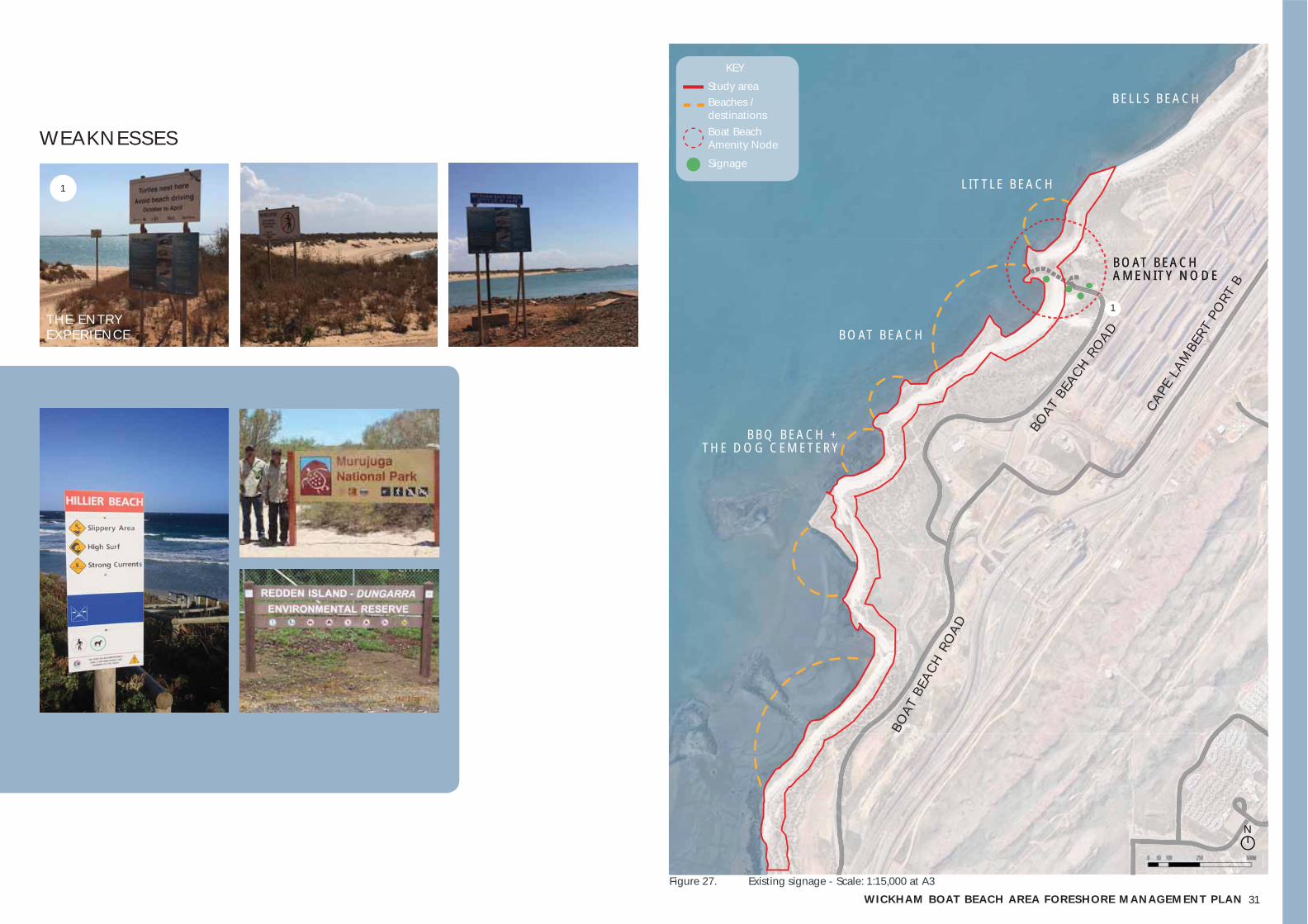
Theme 3: EDUCATION // Educat ion and awareness about environmental , social and cultural values, and associated uses
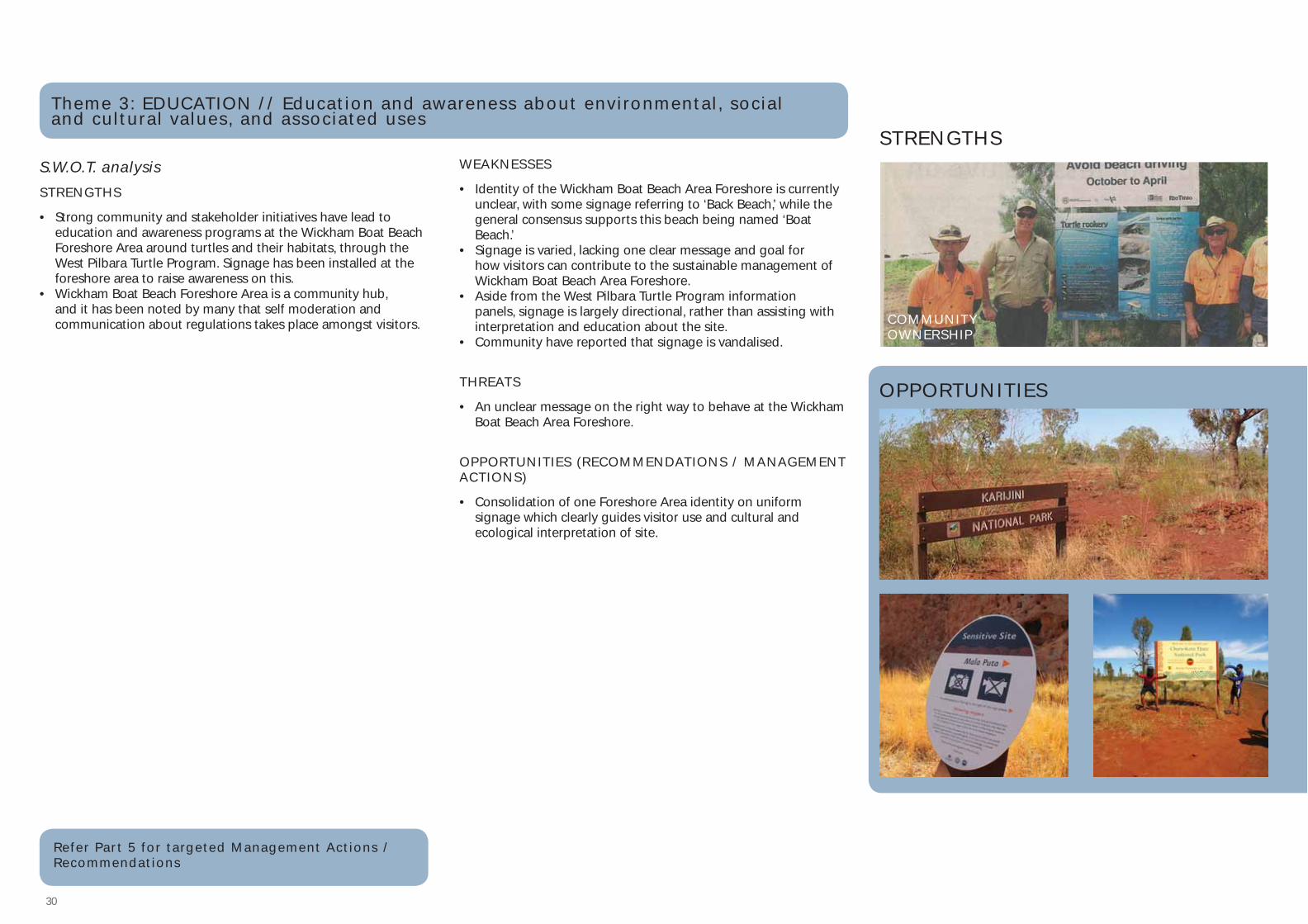
S.W.O.T. analysisSTRENGTHS
• Strong community and stakeholder initiatives have lead to education and awareness programs at the Wickham Boat Beach Foreshore Area around turtles and their habitats, through the West Pilbara Turtle Program. Signage has been installed at the foreshore area to raise awareness on this.
• Wickham Boat Beach Foreshore Area is a community hub, and it has been noted by many that self moderation and communication about regulations takes place amongst visitors.
WEAKNESSES
• Identity of the Wickham Boat Beach Area Foreshore is currently unclear, with some signage referring to ‘Back Beach,’ while the general consensus supports this beach being named ‘Boat Beach.’
• Signage is varied, lacking one clear message and goal for how visitors can contribute to the sustainable management of Wickham Boat Beach Area Foreshore.
• Aside from the West Pilbara Turtle Program information panels, signage is largely directional, rather than assisting with interpretation and education about the site.
• Community have reported that signage is vandalised.
THREATS
• An unclear message on the right way to behave at the Wickham Boat Beach Area Foreshore.
OPPORTUNITIES (RECOMMENDATIONS / MANAGEMENT ACTIONS)
• Consolidation of one Foreshore Area identity on uniform signage which clearly guides visitor use and cultural and ecological interpretation of site.
STRENGTHS
1
OPPORTUNITIES
COMMUNITY OWNERSHIP
Refer Par t 5 for targeted Management Act ions / Recommendations
31WICKHAM BOAT BEACH AREA FORESHORE MANAGEMENT PLAN
WEAKNESSES
THE ENTRY EXPERIENCE
1
Figure 27. Existing signage - Scale: 1:15,000 at A3
BOAT BEACH AMENITY NODE
Study area
KEY
Beaches / destinationsBoat Beach Amenity Node
Signage
1
BOAT BEACH AMENITY NODE
BOAT BEACH
BELLS BEACH
LITTLE BEACH
BBQ BEACH + THE DOG CEMETERY
N
BOAT
BEA
CH RO
AD
BOAT
BEA
CH R
OAD
CAPE
LAM
BERT
PO
RT B
32
Theme 4: PROTECTION // Protect ion of vulnerable cultural and ecological areas
S.W.O.T. analysisSTRENGTHS
• The Wickham Boat Beach Area Foreshore is an area of both cultural and ecological signifi cance.
• Current signage and community involvement of the WPTP which communicates the importance of the foreshore area as an important habitat, and increases community eduction about protection of vulnerable areas.
• Existing community and stakeholder groups committed to protection of fl ora and fauna, in particular, the West Pilbara Turtle Program.
WEAKNESSES
• Currently only Department of Aboriginal Affairs (DAA) data exists for the site, which is not adequate to map and therefore protect the Aboriginal cultural signifi cance of this place. It has been noted by Ngarluma Aboriginal Corporation (NAC) that the foredune of coastal lands such as the Wickham Boat Beach Foreshore Area are of particular Dreaming and archaeological signifi cance for the Ngarluma people.
• A vulnerable ecological system, the foredune, is currently under threat due to uncontrolled access by pedestrians and vehicles (See Theme 1: Access).
• Uncontrolled grass fi res from open fi re pits/BBQs,• Beyond the existing WPTP there is little on site to provide
education around protection of cultural and ecological sites.
THREATS
• Continued uncontrolled access leading to further degradation of the foredune
• A lack of eduction and communication on about the ecological and cultural signifi cance of this site (See Theme 2: Education)
OPPORTUNITIES (RECOMMENDATIONS)
• Build relationships with Traditional Custodians, including Ngarluma Aboriginal Corporation;
• Formalise 4WD and 2WD access; • Formalise pedestrian access; and,• Protect and revegetate vulnerable dune areas.
Figure 28. Protection - Scale - 15:000 at A3
Study area
KEY
Beaches / destinationsBoat Beach Amenity Node
Degraded dune areas
Beach and foredune DAA registered sites
Refer Par t 5 for targeted Management Act ions / Recommendations
N
BOAT
BEA
CH RO
AD
BOAT
BEA
CH R
OAD
CAPE
LAM
BERT
PO
RT B
BOAT BEACH
BELLS BEACH
LITTLE BEACH
BBQ BEACH + THE DOG CEMETERY
33WICKHAM BOAT BEACH AREA FORESHORE MANAGEMENT PLAN
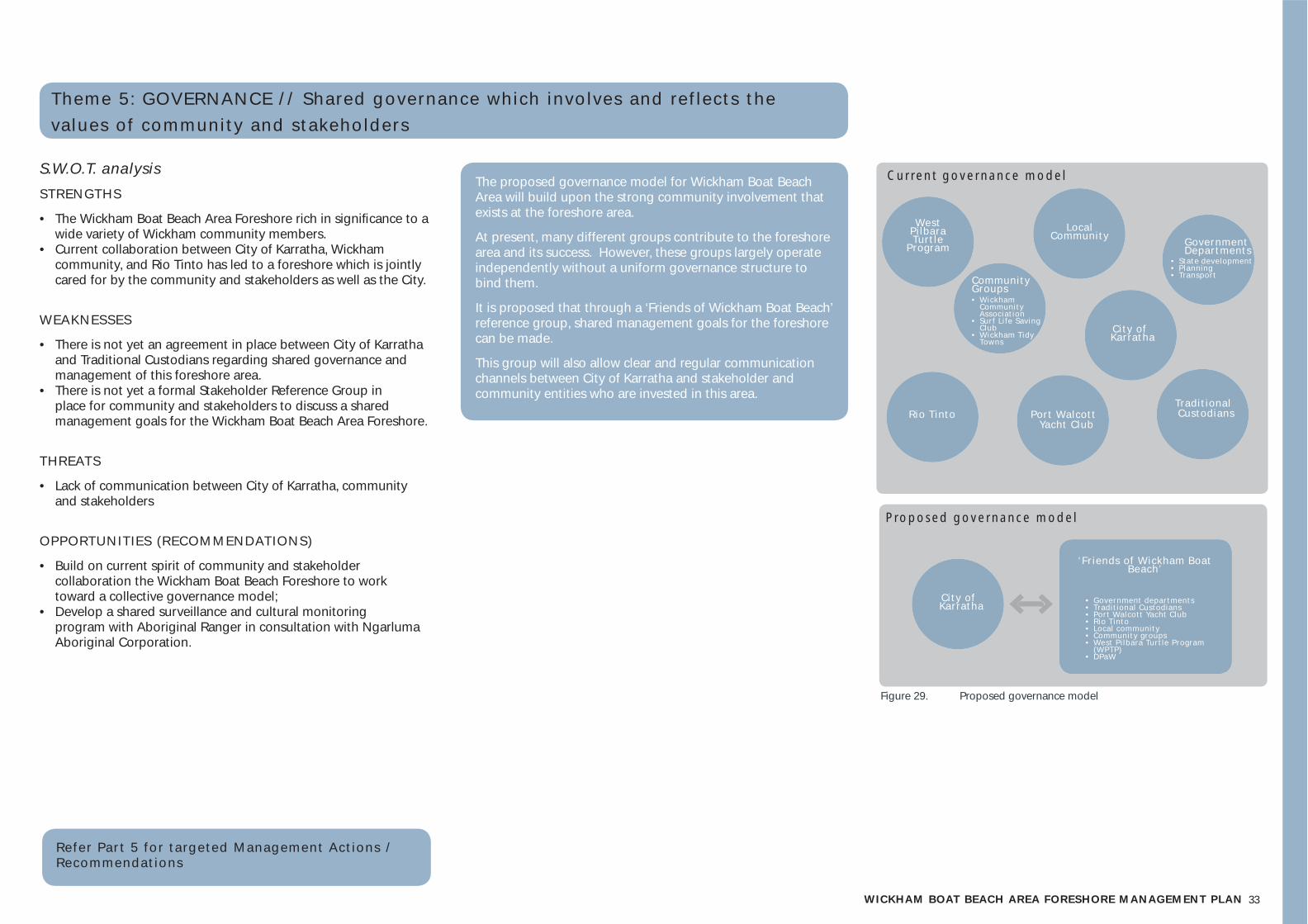
Theme 5: GOVERNANCE // Shared governance which involves and ref lects the values of community and stakeholders
S.W.O.T. analysisSTRENGTHS
• The Wickham Boat Beach Area Foreshore rich in signifi cance to a wide variety of Wickham community members.
• Current collaboration between City of Karratha, Wickham community, and Rio Tinto has led to a foreshore which is jointly cared for by the community and stakeholders as well as the City.
WEAKNESSES
• There is not yet an agreement in place between City of Karratha and Traditional Custodians regarding shared governance and management of this foreshore area.
• There is not yet a formal Stakeholder Reference Group in place for community and stakeholders to discuss a shared management goals for the Wickham Boat Beach Area Foreshore.
THREATS
• Lack of communication between City of Karratha, community and stakeholders
OPPORTUNITIES (RECOMMENDATIONS)
• Build on current spirit of community and stakeholder collaboration the Wickham Boat Beach Foreshore to work toward a collective governance model;
• Develop a shared surveillance and cultural monitoring program with Aboriginal Ranger in consultation with Ngarluma Aboriginal Corporation.
Tradit ional Custodians
• State development• P lanning• Transport
C i ty of Karratha
City of Karratha
Local Community
West P i lbara Turt le
Program
Port Walcott Yacht C lub
Rio T into
Community Groups
Government Departments
• Wickham Community Associat ion
• Surf L i fe Saving C lub
• Wickham Tidy Towns
‘Fr iends of Wickham Boat Beach’
• Government departments• Tradit ional Custodians• Port Walcott Yacht C lub• Rio T into• Local community• Community groups• West P i lbara Turt le Program
(WPTP)• DPaW
Current governance model
Proposed governance model
Figure 29. Proposed governance model
Refer Par t 5 for targeted Management Act ions / Recommendations
The proposed governance model for Wickham Boat Beach Area will build upon the strong community involvement that exists at the foreshore area.
At present, many different groups contribute to the foreshore area and its success. However, these groups largely operate independently without a uniform governance structure to bind them.
It is proposed that through a ‘Friends of Wickham Boat Beach’ reference group, shared management goals for the foreshore can be made.
This group will also allow clear and regular communication channels between City of Karratha and stakeholder and community entities who are invested in this area.
343434344443433
5 // management plan and management act ions

35WICKHAM BOAT BEACH AREA FORESHORE MANAGEMENT PLAN
5.1 management plan
The Wickham Boat Beach Area Foreshore management Plan has been derived from extensive background research and stakeholder and community engagement.
The management plan, and associated actions / recommendations, have been developed from the themes noted in Part 4 // Key Themes, and as listed below.
1. ACCESS // Continued controlled access to the foreshore;
2. AMENITY // Addition of low key amenity to compliment strong community use of the area;
3. EDUCATION // Education and awareness about social, environmental and cultural values, and associated uses;
4. PROTECTION // Protection of vulnerable cultural and ecological areas; and,
5. GOVERNANCE // Shared governance which involves and refl ects the values of community and stakeholders.
This management plan ensures that the current hard work and engagement of the community at the Wickham Boat Beach Area will be acknowledged and built upon to ensure the long term sustainability of this important community hub.
Note: All provision of foreshore infrastructure and low key amenity structures must be in conjunction with a Coastal Vulnerability study as per information provided on page 17, placement of structures should be undertaken in line with land capability information.
Figure 30. Agreed management plan, overview - Scale: 1:15,000 at A3
BOAT BEACH AMENITY NODE
BOAT BEACH
BELLS BEACH
LITTLE BEACH
BBQ BEACH + THE DOG CEMETERY
Study area
KEY
Beaches / destinations
4wd track to retain and formalise
Rio Tinto access to retain
Dune barrierAsphalt road
Boat Beach Amenity Node
New entry signage
Improved educational signage
New directional signage
Regeneration area
PRECEDENT: REGENERATION AREA
4WD TRACK TO RETAIN AND FORMALISE
EDUCATIONAL SIGNAGE TO RETAIN AND IMPROVE
PRECEDENT: DIRECTIONAL SIGNAGE
PRECEDENT: ENTRY SIGNAGE
PRECEDENT: DUNE BARRIER
N
36
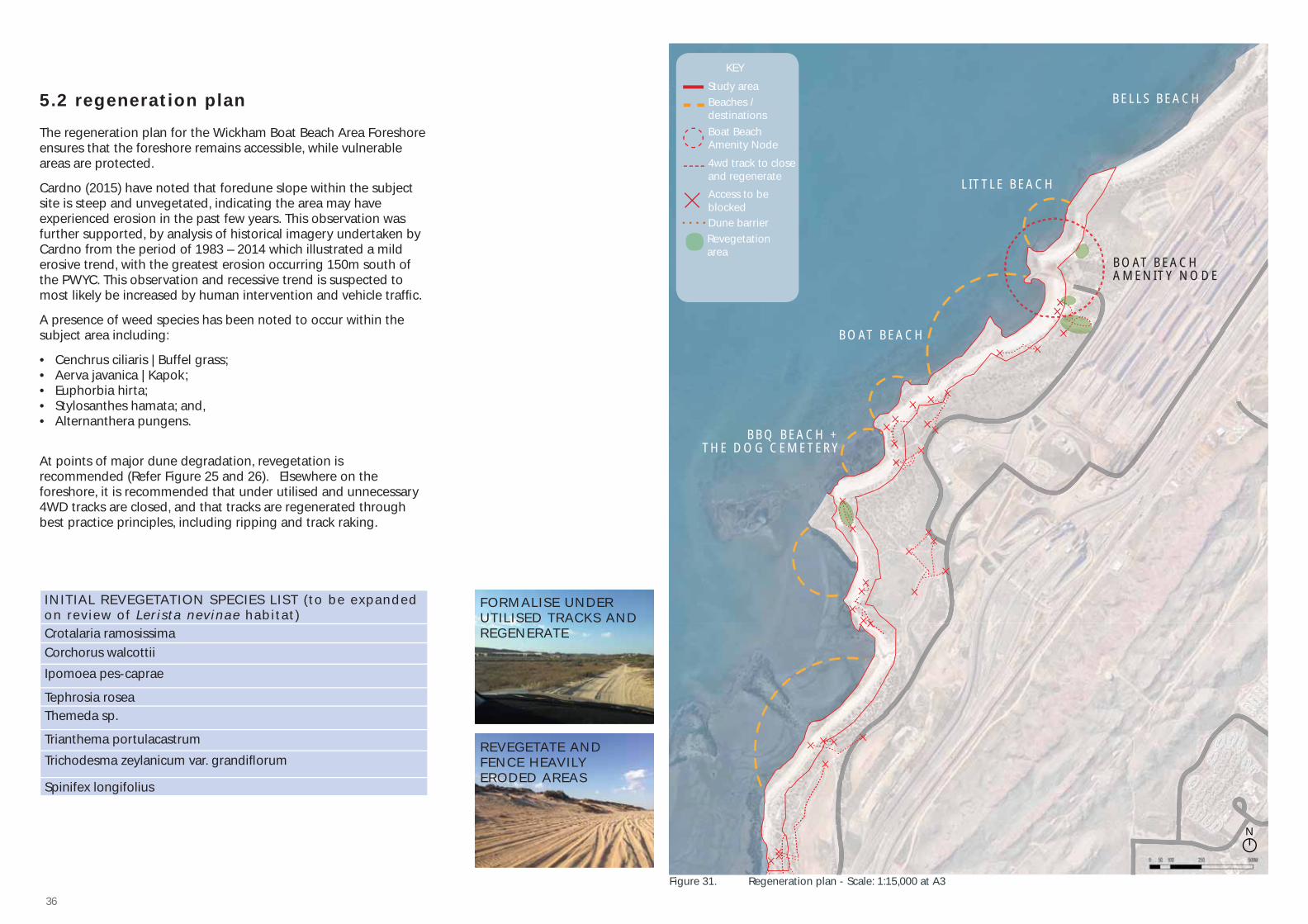
5.2 regeneration plan
The regeneration plan for the Wickham Boat Beach Area Foreshore ensures that the foreshore remains accessible, while vulnerable areas are protected.
Cardno (2015) have noted that foredune slope within the subject site is steep and unvegetated, indicating the area may have experienced erosion in the past few years. This observation was further supported, by analysis of historical imagery undertaken by Cardno from the period of 1983 – 2014 which illustrated a mild erosive trend, with the greatest erosion occurring 150m south of the PWYC. This observation and recessive trend is suspected to most likely be increased by human intervention and vehicle traffi c.
A presence of weed species has been noted to occur within the subject area including:
• Cenchrus ciliaris | Buffel grass;• Aerva javanica | Kapok;• Euphorbia hirta;• Stylosanthes hamata; and, • Alternanthera pungens.
At points of major dune degradation, revegetation is recommended (Refer Figure 25 and 26). Elsewhere on the foreshore, it is recommended that under utilised and unnecessary 4WD tracks are closed, and that tracks are regenerated through best practice principles, including ripping and track raking.
Figure 31. Regeneration plan - Scale: 1:15,000 at A3
BOAT BEACH AMENITY NODE
BOAT BEACH
BELLS BEACH
LITTLE BEACH
BBQ BEACH + THE DOG CEMETERY
Study area
KEY
Beaches / destinations
4wd track to close and regenerate
Access to be blockedDune barrier
Boat Beach Amenity Node
Revegetation area
FORMALISE UNDER UTILISED TRACKS AND REGENERATE
REVEGETATE AND FENCE HEAVILY ERODED AREAS
INITIAL REVEGETATION SPECIES LIST (to be expanded on review of Lerista nevinae habitat)Crotalaria ramosissimaCorchorus walcottiiIpomoea pes-caprae
Tephrosia roseaThemeda sp.
Trianthema portulacastrumTrichodesma zeylanicum var. grandifl orum
Spinifex longifolius
N
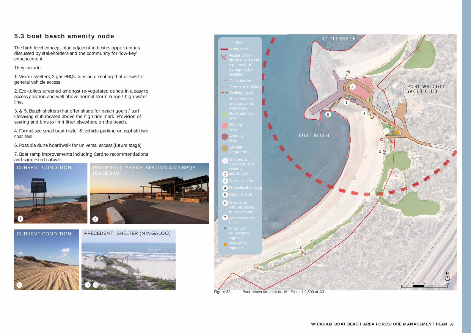
37WICKHAM BOAT BEACH AREA FORESHORE MANAGEMENT PLAN
BOAT BEACH
LITTLE BEACH
Study area
KEY
Access to be blocked and ‘Dune regeneration’ signage to be installed
Dune barrierFormalise bollardsWalking track
Revegetation area
Revegetation area (previous 4WD track)
Parking areaAmenity area
Asphalt (long term)
Shelters, 2 gas BBQs, and seatingEco-toilets
Beach shelters
Formalised parking
Beach shelter
Boat ramp with proposed improvementsAccess ramp to beach
PRECEDENT: SHADE, SEATING AND BBQS (ONSLOW)
1
1
1
2
3
4
5
6
7
2
3
4
5
PORT WALCOTTYACHT CLUB
6 8
CURRENT CONDITION
1
CURRENT CONDITION CURRENT CONDITION
3
PRECEDENT: SHELTER (NINGALOO)
3 5
Figure 32. Boat beach amenity node - Scale: 1:2,500 at A3
N
25 50 100
Improved educational signageNew entry signage
5.3 boat beach amenity node
The high level concept plan adjacent indicates opportunities discussed by stakeholders and the community for ‘low-key’ enhancement.
They include:
1. Visitor shelters, 2 gas BBQs, bins an d seating that allows for general vehicle access
2. Eco-toilets screened amongst re-vegetated dunes, in a easy to access position and well above normal storm surge / high water line.
3. & 5. Beach shelters that offer shade for beach goers / surf lifesaving club located above the high tide mark. Provision of seating and bins to limit litter elsewhere on the beach.
4. Formalised small boat trailer & vehicle parking on asphalt/two coat seal.
6. Possible dune boardwalk for universal access (future stage)
7. Boat ramp improvements including Cardno recommendations and suggested catwalk.
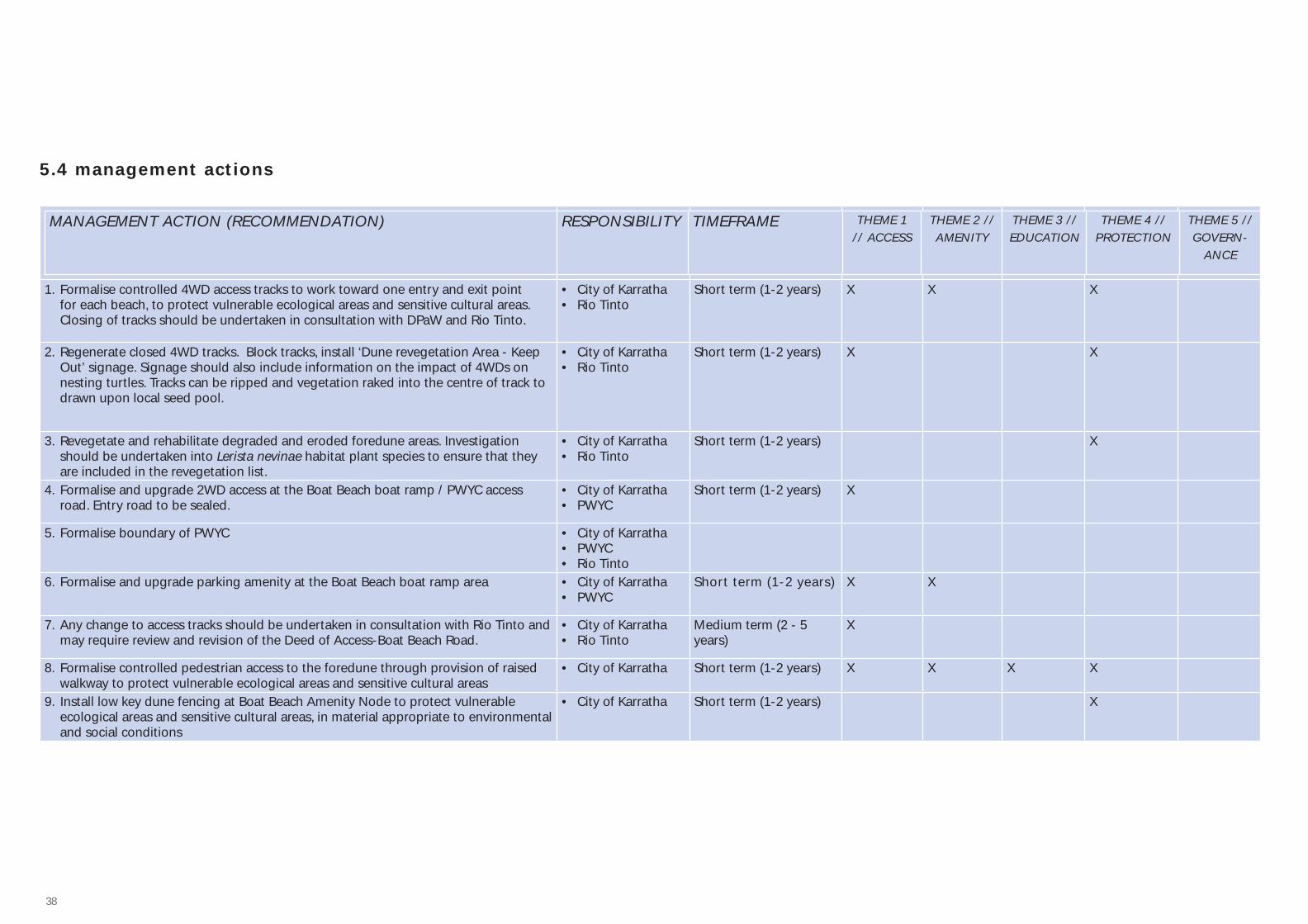
38
MANAGEMENT ACTION (RECOMMENDATION) RESPONSIBILITY TIMEFRAME THEME 1 // ACCESS
THEME 2 // AMENITY
THEME 3 // EDUCATION
THEME 4 // PROTECTION
THEME 5 // GOVERN-
ANCE
1. Formalise controlled 4WD access tracks to work toward one entry and exit point for each beach, to protect vulnerable ecological areas and sensitive cultural areas. Closing of tracks should be undertaken in consultation with DPaW and Rio Tinto.
• City of Karratha• Rio Tinto
Short term (1-2 years) X X X
2. Regenerate closed 4WD tracks. Block tracks, install ‘Dune revegetation Area - Keep Out’ signage. Signage should also include information on the impact of 4WDs on nesting turtles. Tracks can be ripped and vegetation raked into the centre of track to drawn upon local seed pool.
• City of Karratha• Rio Tinto
Short term (1-2 years) X X
3. Revegetate and rehabilitate degraded and eroded foredune areas. Investigation should be undertaken into Lerista nevinae habitat plant species to ensure that they are included in the revegetation list.
• City of Karratha• Rio Tinto
Short term (1-2 years) X
4. Formalise and upgrade 2WD access at the Boat Beach boat ramp / PWYC access road. Entry road to be sealed.
• City of Karratha• PWYC
Short term (1-2 years) X
5. Formalise boundary of PWYC • City of Karratha• PWYC• Rio Tinto
6. Formalise and upgrade parking amenity at the Boat Beach boat ramp area • City of Karratha• PWYC
Short term (1-2 years) X X
7. Any change to access tracks should be undertaken in consultation with Rio Tinto and may require review and revision of the Deed of Access-Boat Beach Road.
• City of Karratha• Rio Tinto
Medium term (2 - 5 years)
X
8. Formalise controlled pedestrian access to the foredune through provision of raised walkway to protect vulnerable ecological areas and sensitive cultural areas
• City of Karratha Short term (1-2 years) X X X X
9. Install low key dune fencing at Boat Beach Amenity Node to protect vulnerable ecological areas and sensitive cultural areas, in material appropriate to environmental and social conditions
• City of Karratha Short term (1-2 years) X
5.4 management actions
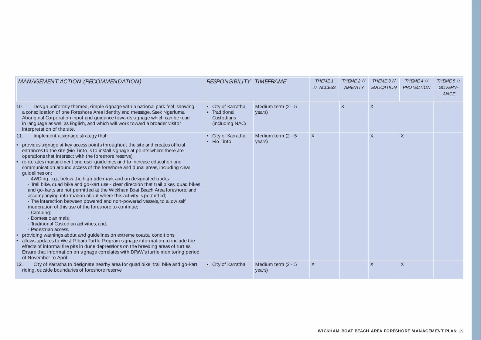
39WICKHAM BOAT BEACH AREA FORESHORE MANAGEMENT PLAN
MANAGEMENT ACTION (RECOMMENDATION) RESPONSIBILITY TIMEFRAME THEME 1 // ACCESS
THEME 2 // AMENITY
THEME 3 // EDUCATION
THEME 4 // PROTECTION
THEME 5 // GOVERN-
ANCE
10. Design uniformly themed, simple signage with a national park feel, showing a consolidation of one Foreshore Area identity and message. Seek Ngarluma Aboriginal Corporation input and guidance towards signage which can be read in language as well as English, and which will work toward a broader visitor interpretation of the site.
• City of Karratha• Traditional
Custodians (including NAC)
Medium term (2 - 5 years)
X X
11. Implement a signage strategy that:
• provides signage at key access points throughout the site and creates offi cial entrances to the site (Rio Tinto is to install signage at points where there are operations that intersect with the foreshore reserve);
• re-iterates management and user guidelines and to increase education and communication around access of the foreshore and dunal areas, including clear guidelines on:
- 4WDing, e.g., below the high tide mark and on designated tracks - Trail bike, quad bike and go-kart use - clear direction that trail bikes, quad bikes
and go-karts are not permitted at the Wickham Boat Beach Area foreshore, and accompanying information about where this activity is permitted; - The interaction between powered and non-powered vessels, to allow self
moderation of this use of the foreshore to continue; - Camping; - Domestic animals; - Traditional Custodian activities; and, - Pedestrian access.
• providing warnings about and guidelines on extreme coastal conditions;• allows updates to West Pilbara Turtle Program signage information to include the
effects of informal fi re pits in dune depressions on the breeding areas of turtles. Ensure that information on signage correlates with DPaW’s turtle monitoring period of November to April.
• City of Karratha• Rio Tinto
Medium term (2 - 5 years)
X X X
12. City of Karratha to designate nearby area for quad bike, trail bike and go-kart riding, outside boundaries of foreshore reserve
• City of Karratha Medium term (2 - 5 years)
X X X
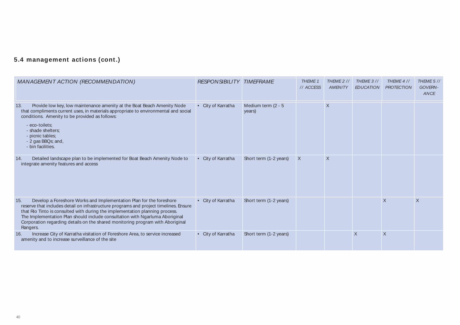
40
MANAGEMENT ACTION (RECOMMENDATION) RESPONSIBILITY TIMEFRAME THEME 1 // ACCESS
THEME 2 // AMENITY
THEME 3 // EDUCATION
THEME 4 // PROTECTION
THEME 5 // GOVERN-
ANCE
13. Provide low key, low maintenance amenity at the Boat Beach Amenity Node that compliments current uses, in materials appropriate to environmental and social conditions. Amenity to be provided as follows:
- eco-toilets; - shade shelters; - picnic tables; - 2 gas BBQs; and, - bin facilities.
• City of Karratha Medium term (2 - 5 years)
X
14. Detailed landscape plan to be implemented for Boat Beach Amenity Node to integrate amenity features and access
• City of Karratha Short term (1-2 years) X X
15. Develop a Foreshore Works and Implementation Plan for the foreshore reserve that includes detail on infrastructure programs and project timelines. Ensure that Rio Tinto is consulted with during the implementation planning process. The Implementation Plan should include consultation with Ngarluma Aboriginal Corporation regarding details on the shared monitoring program with Aboriginal Rangers.
• City of Karratha Short term (1-2 years) X X
16. Increase City of Karratha visitation of Foreshore Area, to service increased amenity and to increase surveillance of the site
• City of Karratha Short term (1-2 years) X X
5.4 management actions (cont.)
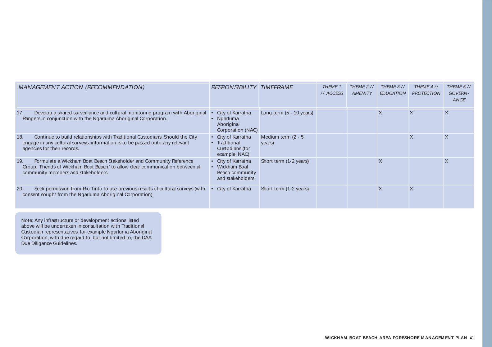
41WICKHAM BOAT BEACH AREA FORESHORE MANAGEMENT PLAN
MANAGEMENT ACTION (RECOMMENDATION) RESPONSIBILITY TIMEFRAME THEME 1 // ACCESS
THEME 2 // AMENITY
THEME 3 // EDUCATION
THEME 4 // PROTECTION
THEME 5 // GOVERN-
ANCE
17. Develop a shared surveillance and cultural monitoring program with Aboriginal Rangers in conjunction with the Ngarluma Aboriginal Corporation.
• City of Karratha• Ngarluma
Aboriginal Corporation (NAC)
Long term (5 - 10 years) X X X
18. Continue to build relationships with Traditional Custodians. Should the City engage in any cultural surveys, information is to be passed onto any relevant agencies for their records.
• City of Karratha• Traditional
Custodians (for example, NAC)
Medium term (2 - 5 years)
X X
19. Formulate a Wickham Boat Beach Stakeholder and Community Reference Group, ‘Friends of Wickham Boat Beach,’ to allow clear communication between all community members and stakeholders.
• City of Karratha• Wickham Boat
Beach community and stakeholders
Short term (1-2 years) X X
20. Seek permission from Rio Tinto to use previous results of cultural surveys (with consent sought from the Ngarluma Aboriginal Corporation)
• City of Karratha Short term (1-2 years) X X
Note: Any infrastructure or development actions listed above will be undertaken in consultation with Traditional Custodian representatives, for example Ngarluma Aboriginal Corporation, with due regard to, but not limited to, the DAA Due Diligence Guidelines.
4242424242222242422242422
6 // conclusion

43WICKHAM BOAT BEACH AREA FORESHORE MANAGEMENT PLAN
The Wickham Boat Beach Area is an important place for the community of Wickham and the broader area, with many intersecting values and uses. By building on the existing strengths of the foreshore, and by addressing the weaknesses as arising from background analysis and stakeholder and community engagement, this FMP provides a framework for the ongoing use and management of the foreshore area. This Foreshore Management Plan recommends that the existing, strong community and stakeholder involvement at the Wickham Boat Beach Area is built upon and used as a foundation for the future management of this recreational hub.
The issues of access and protection are key to the sustainable use of this foreshore area. Through a formalisation of 4WD and 2WD access of the foreshore area, many of the associated issues will be addressed. Under-utilised and unnecessary tracks will be closed, and culturally sensitive and ecologically vulnerable foredune areas will be rehabilitated and protected, with designated pedestrian walking tracks also prescribed.
Amenity is also a central theme. At present, amenity provision at the foreshore largely depends upon the Port Walcott Yacht Club. It has been noted that this continued use of PWYC is unsustainable. The provision of low-key and publicly accessible foreshore amenity as put forward in this FMP will provide a program of activity at the foreshore that is suitable for the current and increasing popularity of the area.
Improvements to education will also play a central role in future improvements at this foreshore area. The use of the Wickham Boat Beach Area Foreshore will be further enhanced by the design and installation of a clear signage strategy which outlines the guidelines on visitor use for this foreshore area and promotes one, uniform identity for the Boat Beach Area. At present, guidelines on how to behave at the foreshore area are not clearly designated. Clear guidelines will enhance the current model of City of Karratha Ranger management, with contributions from a self moderating community who are keen to ‘do the right thing’.
As noted, community and stakeholder involvement at the Wickham Boat Beach Area. This FMP has found that there is an opportunity to build upon this through a shared governance model, to continue to collectively work toward future goals for this foreshore area. The shared governance model provides opportunities for shared management between City of Karratha and Ngarluma Aboriginal Corporation as representatives of the Traditional Custodians, with long term options for cultural monitoring of the foreshore area and cultural heritage and ecological surveys.
The key issues of access, amenity, protection, education and governance have been addressed to provide an approach to the ongoing management of this foreshore area, whilst acknowledging and responding to current community uses. Though this approach, the current value embedded within this foreshore area is respected, while the sustainable and ongoing use of this important foreshore amenity is ensured.
4444444444444444444444444
7 // references
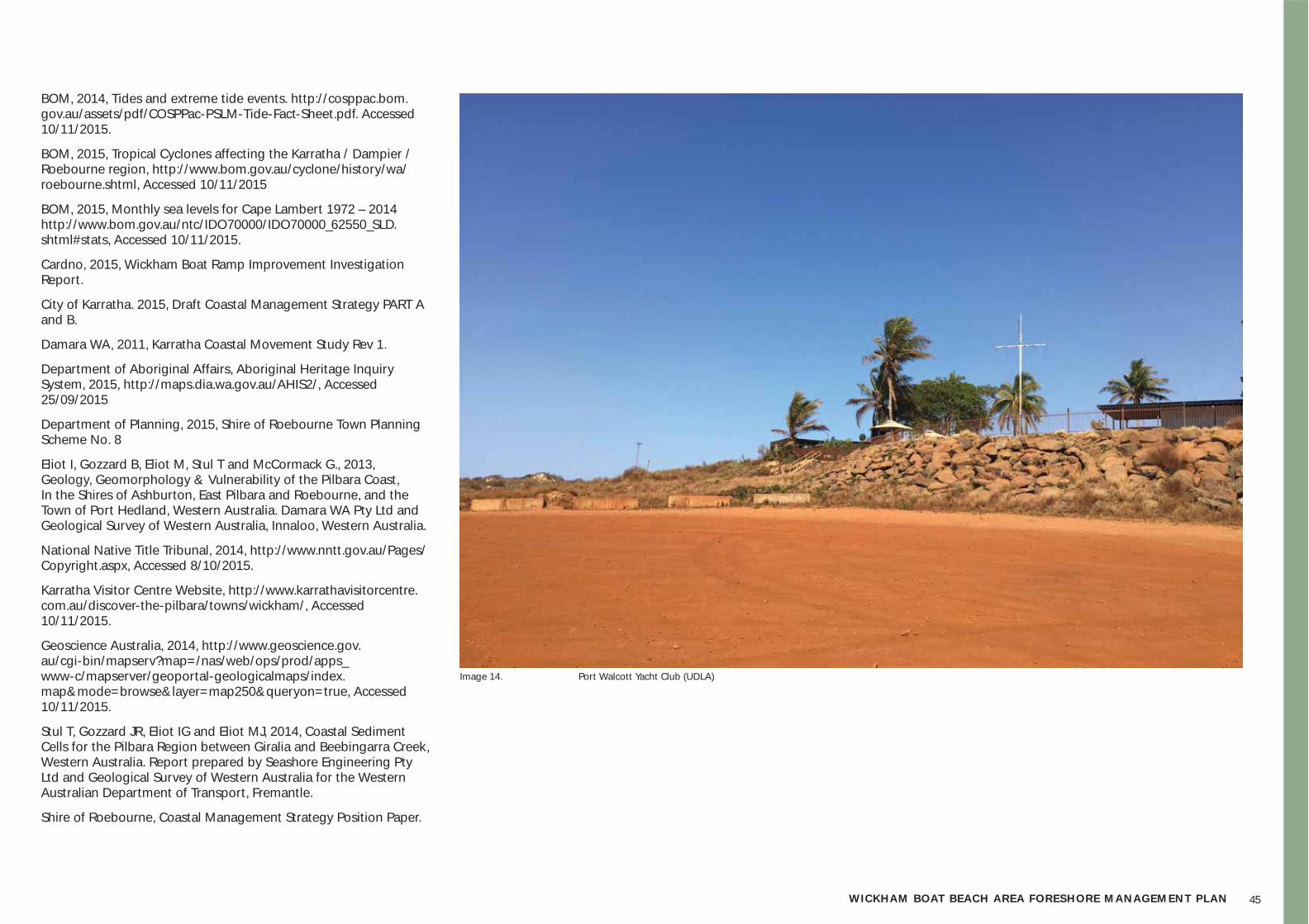
45WICKHAM BOAT BEACH AREA FORESHORE MANAGEMENT PLAN
BOM, 2014, Tides and extreme tide events. http://cosppac.bom.gov.au/assets/pdf/COSPPac-PSLM-Tide-Fact-Sheet.pdf. Accessed 10/11/2015.
BOM, 2015, Tropical Cyclones affecting the Karratha / Dampier / Roebourne region, http://www.bom.gov.au/cyclone/history/wa/roebourne.shtml, Accessed 10/11/2015
BOM, 2015, Monthly sea levels for Cape Lambert 1972 – 2014 http://www.bom.gov.au/ntc/IDO70000/IDO70000_62550_SLD.shtml#stats, Accessed 10/11/2015.
Cardno, 2015, Wickham Boat Ramp Improvement Investigation Report.
City of Karratha. 2015, Draft Coastal Management Strategy PART A and B.
Damara WA, 2011, Karratha Coastal Movement Study Rev 1.
Department of Aboriginal Affairs, Aboriginal Heritage Inquiry System, 2015, http://maps.dia.wa.gov.au/AHIS2/, Accessed 25/09/2015
Department of Planning, 2015, Shire of Roebourne Town Planning Scheme No. 8
Eliot I, Gozzard B, Eliot M, Stul T and McCormack G., 2013, Geology, Geomorphology & Vulnerability of the Pilbara Coast, In the Shires of Ashburton, East Pilbara and Roebourne, and the Town of Port Hedland, Western Australia. Damara WA Pty Ltd and Geological Survey of Western Australia, Innaloo, Western Australia.
National Native Title Tribunal, 2014, http://www.nntt.gov.au/Pages/Copyright.aspx, Accessed 8/10/2015.
Karratha Visitor Centre Website, http://www.karrathavisitorcentre.com.au/discover-the-pilbara/towns/wickham/, Accessed 10/11/2015.
Geoscience Australia, 2014, http://www.geoscience.gov.au/cgi-bin/mapserv?map=/nas/web/ops/prod/apps_www-c/mapserver/geoportal-geologicalmaps/index.map&mode=browse&layer=map250&queryon=true, Accessed 10/11/2015.
Stul T, Gozzard JR, Eliot IG and Eliot MJ, 2014, Coastal Sediment Cells for the Pilbara Region between Giralia and Beebingarra Creek, Western Australia. Report prepared by Seashore Engineering Pty Ltd and Geological Survey of Western Australia for the Western Australian Department of Transport, Fremantle.
Shire of Roebourne, Coastal Management Strategy Position Paper.
Image 14. Port Walcott Yacht Club (UDLA)
4646464646666646466646466
8 // appendix
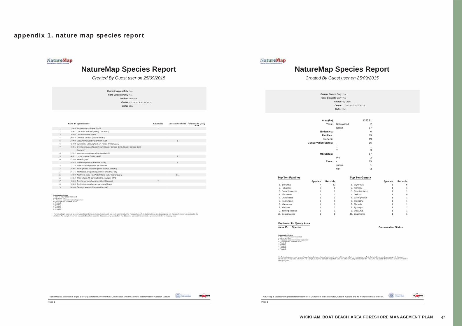
47WICKHAM BOAT BEACH AREA FORESHORE MANAGEMENT PLAN
appendix 1. nature map species repor t
Page 1
NatureMap Species ReportCreated By Guest user on 25/09/2015
Current Names Only
Core Datasets Only
Method
Centre
Buffer
Yes
Yes
'By Circle'
117°08' 30'' E,20°37' 41'' S
2km
Name ID Species Name Naturalised Conservation Code 1Endemic To QueryArea
1. 2646 Aerva javanica (Kapok Bush) Y
2. 4867 Corchorus walcottii (Woolly Corchorus)
3. 19398 Crotalaria ramosissima
4. 25073 Ctenotus saxatilis (Rock Ctenotus)
5. 24093 Dasyurus hallucatus (Northern Quoll) T
6. 42402 Diporiphora vescus (Northern Pilbara Tree Dragon)
7. 43381 Eremiascincus pallidus (Western Narrow-banded Skink, Narrow-banded Sand
Swimmer)
8. 11312 Ipomoea pes-caprae subsp. brasiliensis
9. 30921 Lerista nevinae (slider, skink) T
10. 25184 Menetia greyii
11. 25344 Natator depressus (Flatback Turtle) T
12. 13178 Scaevola amblyanthera var. centralis
13. 24207 Tachyglossus aculeatus (Short-beaked Echidna)
14. 24175 Taphozous georgianus (Common Sheathtail-bat)
15. 41920 Tephrosia rosea var. Port Hedland (A.S. George 1114) P1
16. 17819 Themeda sp. Mt Barricade (M.E. Trudgen 2471)
17. 2830 Trianthema portulacastrum (Giant Pigweed) Y
18. 13559 Trichodesma zeylanicum var. grandiflorum
19. 24248 Zyzomys argurus (Common Rock-rat)
Conservation CodesT - Rare or likely to become extinctX - Presumed extinctIA - Protected under international agreementS - Other specially protected fauna1 - Priority 12 - Priority 23 - Priority 34 - Priority 45 - Priority 5
1 For NatureMap's purposes, species flagged as endemic are those whose records are wholely contained within the search area. Note that only those records complying with the search criterion are included in the
calculation. For example, if you limit records to those from a specific datasource, only records from that datasource are used to determine if a species is restricted to the query area.
NatureMap is a collaborative project of the Department of Environment and Conservation, Western Australia, and the Western Australian Museum.
Page 1
NatureMap Species ReportCreated By Guest user on 25/09/2015
Current Names Only
Core Datasets Only
Method
Centre
Buffer
Yes
Yes
'By Circle'
117°08' 30'' E,20°37' 41'' S
2km
Area (ha) 1255.81
Taxa: Naturalised 2
Native 17
Endemics: 0
Families: 15
Genera: 19
Conservation Status: - 15
1 1
T 3
MS Status: - 17
PN 2
Rank: - 15
subsp. 1
var. 3
Top Ten Families Top Ten GeneraSpecies Records Species Records
1. Scincidae 4 12 1. Tephrosia 1 5
2. Fabaceae 2 6 2. Ipomoea 1 1
3. Convolvulaceae 1 1 3. Eremiascincus 1 1
4. Aizoaceae 1 1 4. Lerista 1 9
5. Cheloniidae 1 1 5. Tachyglossus 1 1
6. Dasyuridae 1 1 6. Crotalaria 1 1
7. Malvaceae 1 1 7. Menetia 1 1
8. Muridae 1 2 8. Zyzomys 1 2
9. Tachyglossidae 1 1 9. Dasyurus 1 1
10. Boraginaceae 1 1 10. Trianthema 1 1
1
Endemic To Query AreaName ID Species Conservation Status
Conservation CodesT - Rare or likely to become extinctX - Presumed extinctIA - Protected under international agreementS - Other specially protected fauna1 - Priority 12 - Priority 23 - Priority 34 - Priority 45 - Priority 5
1 For NatureMap's purposes, species flagged as endemic are those whose records are wholely contained within the search area. Note that only those records complying with the search
criterion are included in the calculation. For example, if you limit records to those from a specific datasource, only records from that datasource are used to determine if a species is restrictedto the query area.
NatureMap is a collaborative project of the Department of Environment and Conservation, Western Australia, and the Western Australian Museum.
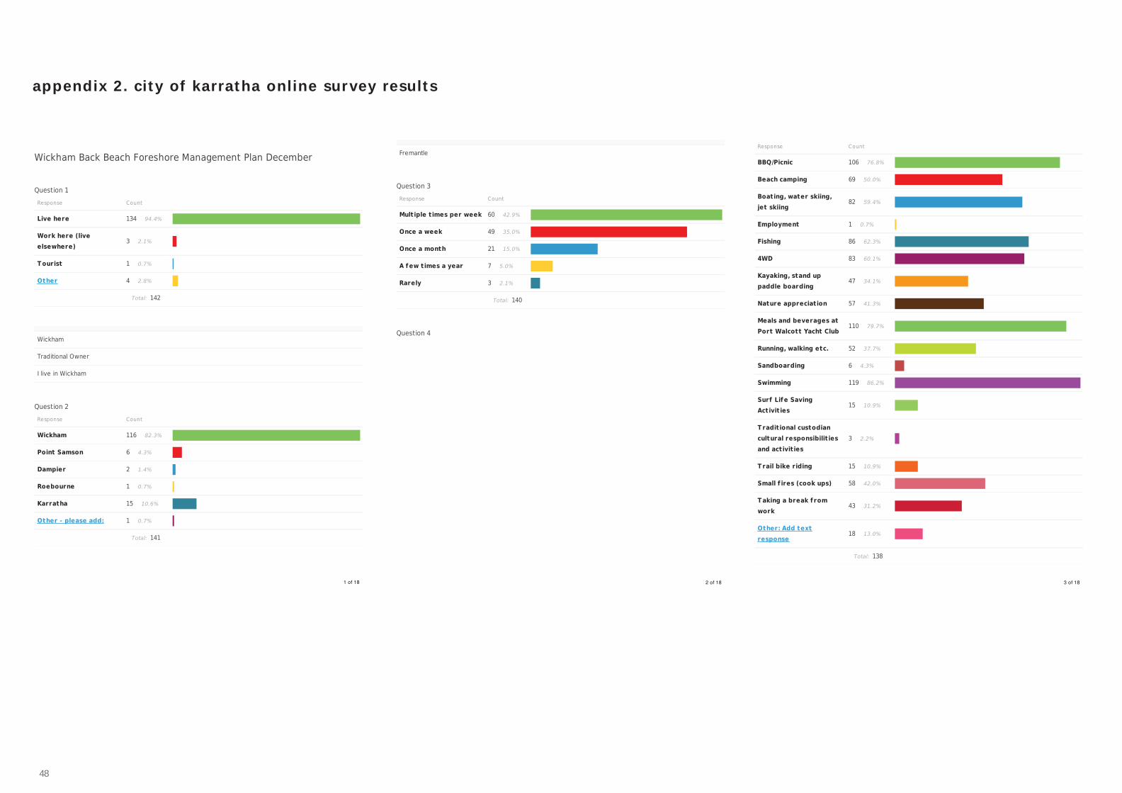
48
appendix 2. c ity of karratha onl ine sur vey results
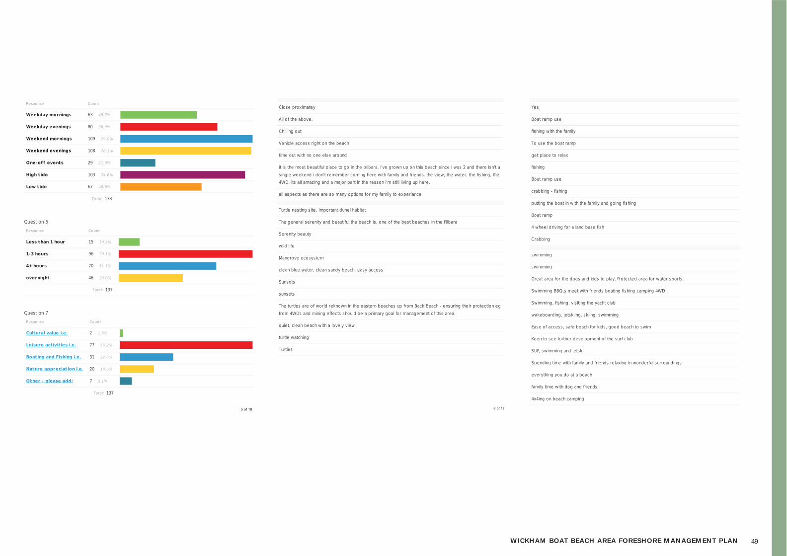
49WICKHAM BOAT BEACH AREA FORESHORE MANAGEMENT PLAN

50
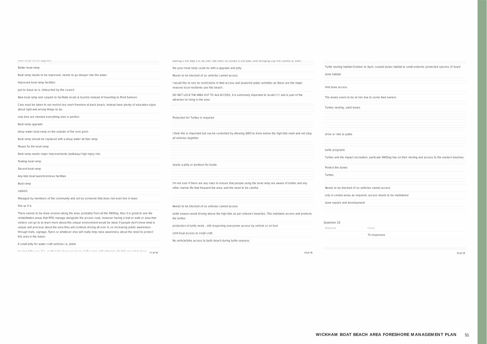
51WICKHAM BOAT BEACH AREA FORESHORE MANAGEMENT PLAN
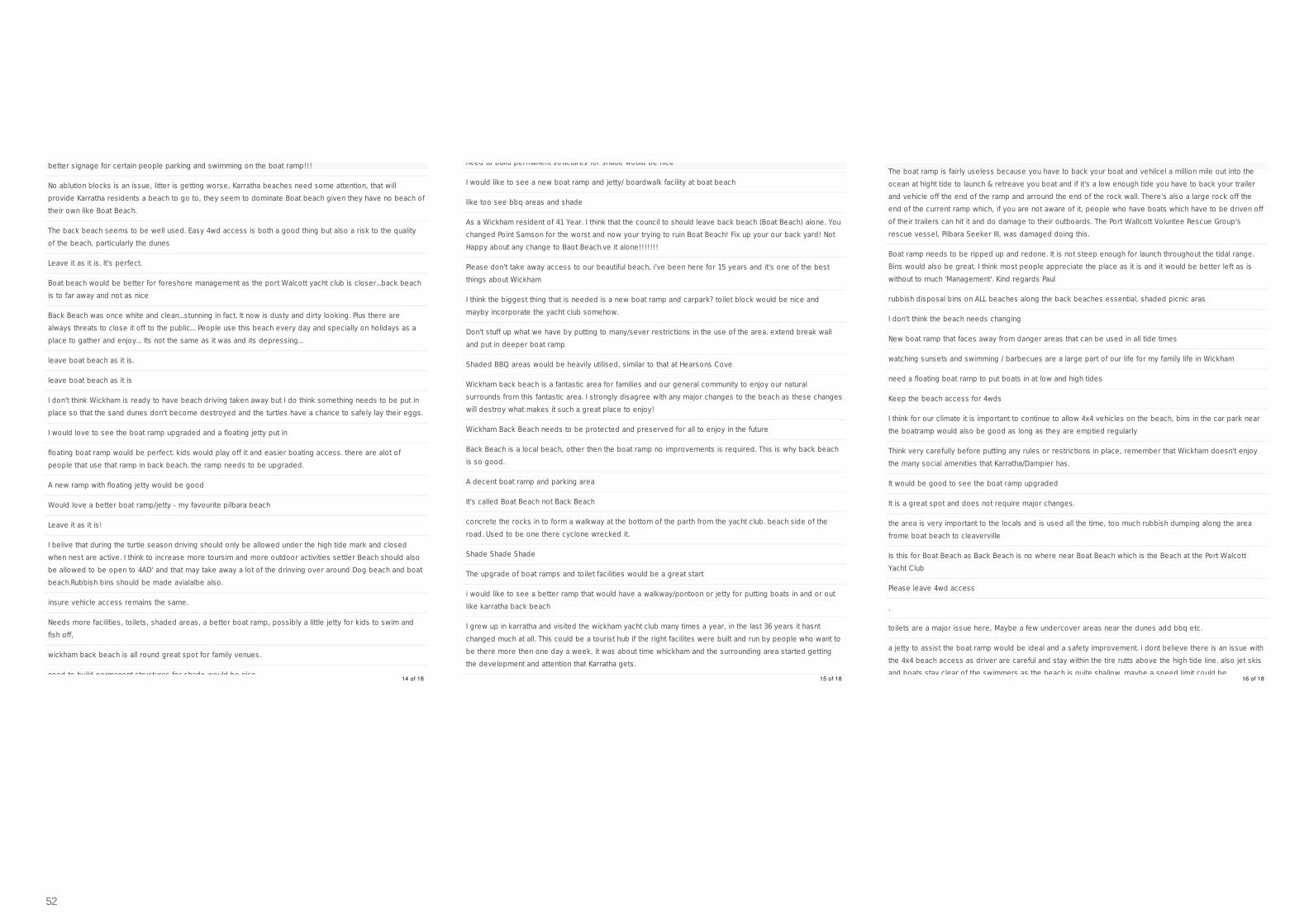
52
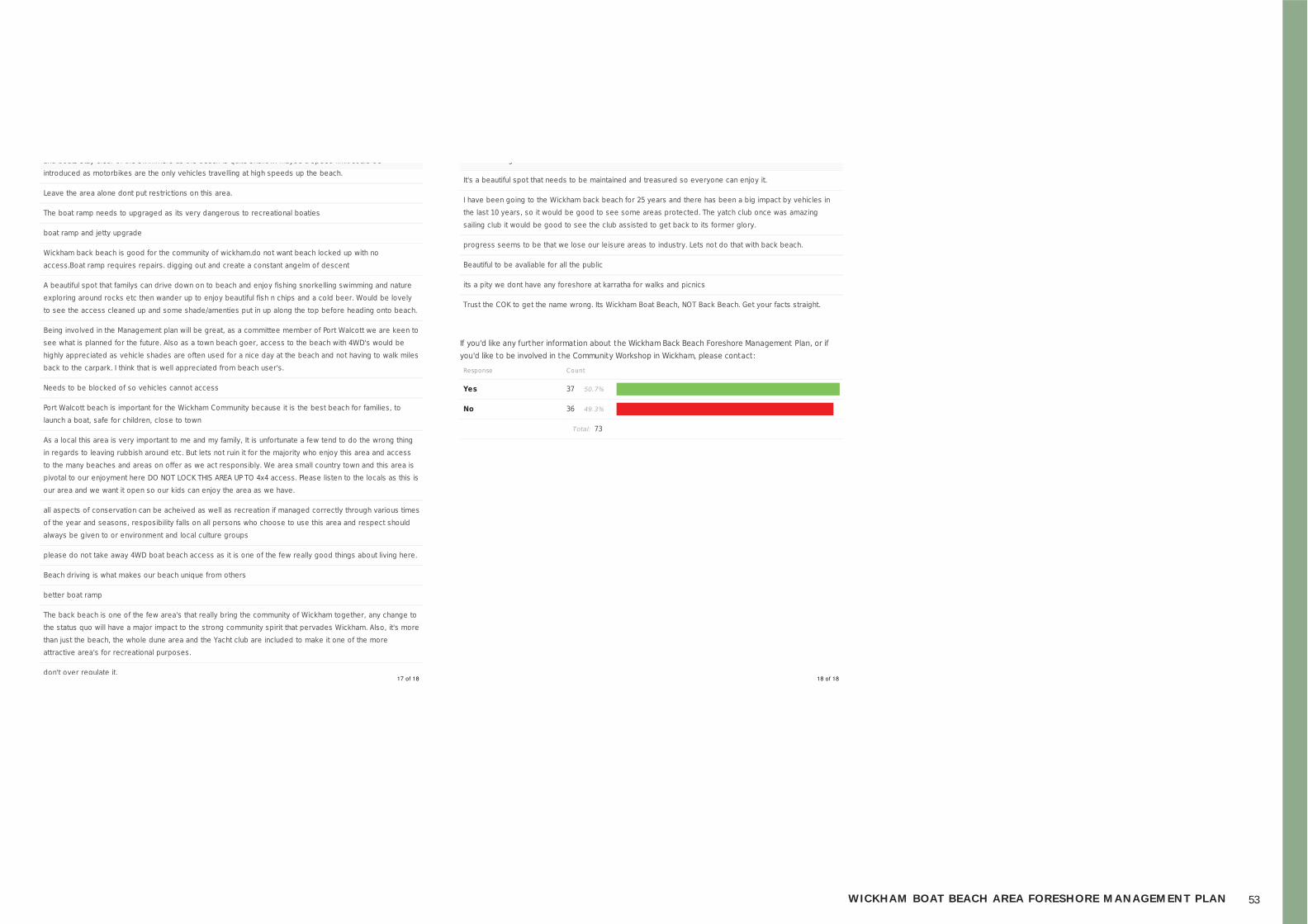
53WICKHAM BOAT BEACH AREA FORESHORE MANAGEMENT PLAN
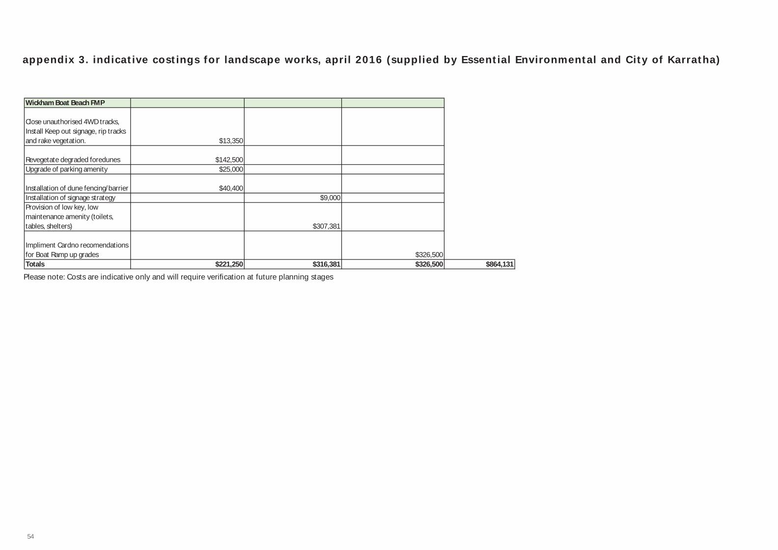
54
appendix 3. indicative costings for landscape works, apri l 2016 (supplied by Essential Environmental and City of Karratha)
Wickham Boat Beach FMP
Close unauthorised 4WD tracks,Install Keep out signage, rip tracksand rake vegetation. $13,350
Revegetate degraded foredunes $142,500Upgrade of parking amenity $25,000
Installation of dune fencing/barrier $40,400Installation of signage strategy $9,000Provision of low key, lowmaintenance amenity (toilets,tables, shelters) $307,381
Impliment Cardno recomendationsfor Boat Ramp up grades $326,500Totals $221,250 $316,381 $326,500 $864,131
Please note: Costs are indicative only and will require verifi cation at future planning stages
55WICKHAM BOAT BEACH AREA FORESHORE MANAGEMENT PLAN