why i teach: a statement of teaching …dmthieme/thieme_teachphil.pdf · 2012-02-19 · 3 and...
TRANSCRIPT
WHY I TEACH: A STATEMENT OF TEACHING PHILOSOPHY
Donald M. Thieme, Ph.D
As a working scientist teaching young minds to think scientifically, I am very
fortunate to be entering my field at a time when scientific knowledge and computer
literacy are at a premium among university students, particularly in the United States and
other countries of the developed world. New knowledge and technology continually
expand the content which we deliver and the skills we impart in college science classes.
My early efforts at teaching have benefited from access to the latest instructional
technology and from fresh content acquired by attending scientific meetings and
reviewing new textbooks and instructional materials. I have made use of my own
research results to teach some topics, and I involve students in my research whenever that
is practical and beneficial to their education.
Even while flush with new scientific knowledge, I have always emphasized
certain fundamental principles of scientific method and critical thinking, which have deep
roots in human intellectual history and were introduced to me early in my own
undergraduate education. The deep intellectual roots of earth science methods seem
particularly significant to me now that I have acquired some experience with how my
students learn and sometimes fail to learn the content, skills, and values that I am trying
to teach. What I most want students to learn from my teaching is not the particular
knowledge tested on quizzes and exams but how to think more scientifically about the
2
various problems and concerns they will encounter as more advanced students or as
citizens of the rapidly changing world that we all live in.
SCIENCE AND CRITICAL THINKING
While scientific research is by no means the only way in which people collect
information and form opinions about the world they inhabit, I do believe that our core
scientific principles and values are universal and form a basis for critical and rational
discussion. Recent texts listing values of critical thinking (Bassham et al., 2005; Moore
and Parker, 2007; Niewohner, 2006; Paul, 1993; Paul and Elder, 2000) are quite
comprehensive and encompass all that I had arrived at myself through perusal of many
philosophical systems, including some authored by thinkers from Asia, Africa, and other
areas not traditionally considered to be sources of "rational" thought (e.g. Hayward and
Varela, 1992; Wiredu, 1998; Zajonc, 2004). For teaching, integrity is perhaps the highest
priority. Students learn values and habits of thought by example, and to refuse to
entertain questions of value and human purpose merely inspires our students to do
likewise. With respect to environmental, medical, and other concerns that are particularly
close to the special interest of working scientists, refusing to pass judgment also leaves
those issues to be decided by those who lack current information or have narrow
perspectives (Stevenson, 1954).
Given that we cannot and ought not to avoid ethics and politics while teaching
science, my approach is to tolerate a wide diversity of opinion among my students while
encouraging them to empathize with those holding opposite positions. Empathy and fair-
mindedness are intellectual virtues that we cultivate in critical thinking (Paul, 1993; Paul
3
and Elder, 2000) while at the same time we continually challenge superficial or hasty
answers in ethics and politics, just as we do in natural science. Nearly 100 years ago, this
virtue of humility intrinsic to the scientific method was remarked by the great American
pragmatist, John Dewey (1916, p. 189). We suspend judgment and subject our opinions
to rational discussion just as in the scientific method we subject our hypotheses to
experimental testing We do so having confidence that reason and logical argument are
universal skills and faculties, even though they may not in fact be equally distributed
among students in a class or citizens of a community or a nation.
Philosophically, I have always been comfortable addressing theoretical questions
or ethical and political topics in my science classes. It has taken me several years as a
temporary or part-time faculty member since obtaining my Ph.D to develop teaching
strategies that challenge students to think critically and express their opinions in logical
arguments. When teaching larger classes of 50 students or more, I prefer to use an
interactive format in which students are assigned to small discussion groups. Both group
discussion and writing assignments develop respect for reason as well as autonomy, a
virtue which is not always nurtured by science education as much as it is by liberal arts.
Rather than simply ask for a "term paper," I typically assign several shorter
writing assignments that require careful reading and logical argument for or against an
opinion or hypothesis. I do use computer-graded multiple choice tests to assess
foundational material, but I also include reasoning problems and essays in my
examinations. In my laboratory sections, I typically design or select exercises that
challenge students to apply concepts and write out their interpretation of a map feature,
bedrock structure, petrographic texture, and so forth. I grade the laboratory reports based

4
upon logic and following procedure as much as getting the right answer. Foundational
material is valuable only if the students retain it for several semesters, and the sort of
short-term memory recall tested in multiple choice tests is not nearly as important for a
successful science career as is perserverance in the face of difficulties, obstacles, and
frustrations. For challenging students to persevere and show courage in their thinking, I
have had best results using take-home essay examinations or examinations taken in class
on essay topics assigned several days prior.
As was pointed out as early as the first decade of the 20th century (Mead, 1906),
modern colleges and universities encourage specialization rather than integration among
the sciences. Whether in terms of academic departments, courses offered, or topics
presented in an introductory course, we tend to introduce our students to science "through
one door at a time (Mead, 1906)." Students need and deserve a different approach, one
that exposes them to the big picture of scientific understanding, what Mead awkwardly
referred to as science's "complex interrelation with a mass of other things (Mead, 1906)."
Part of what I enjoy about teaching environmental geology or environmental science is
the opportunity to demonstrate practical applications in the community where students
live. Environmental problems also have ethical and political dimensions which challenge
students' critical thinking skills and attract many who would not otherwise take much
science (Busse et al., 2007).
FUNDAMENTAL IDEAS ABOUT EARTH SCIENCE
For geology or geography majors, it may not be as important to experience
Mead's "mass of other things" as it is to be taught, as Whitehead (1929) would have it, a
5
few, important "main ideas" about earth science. These main ideas or underlying
principles that give science structure (Bruner, 1960, p. 31; Matthews, 2003) will be not
only the most important to remember but also the most useful to students in their future
education and careers. Personally, most of what I know and teach about in geology can
be boiled down to four fundamental ideas, all of which are related to some extent to ideas
which are also used in physics, chemistry, or biology. The most fundamental idea,
particularly for teaching earth science as an integrated field, is that of lithospheric plates
formed at midocean ridges and subducted in trenches (Cox and Hart, 1986). At least as
fundamental to doing geology today is the exponential decay of a radioactive isotope to
its daughter product(s) at a constant rate (Dickin, 1995; Faure, 1986). In fact, it took
dating the rates of seafloor spreading by decay of potassium to argon to actually prove
plate tectonic theory. Without isotopic dating methods, earth history would be based
upon relative rather than absolute dating and we would be teaching a very different
course in historical geology.
Two remaining fundamental ideas relate more specifically to my own areas of
research. One of these is the conservation of matter and energy, intimately related to
geomorphological principles such as Darcy's law for calculating groundwater discharge
(Fetter, 2001; Hubbert, 1969) or the "quasi-equilibrium" adjustment between channel
dimensions, gradient, discharge, and sediment supply in river channels (Knighton, 1998;
Schumm, 1977). The more advanced student will of course learn that the picture is not
really as simple as suggested in these classical models. In order to account for conditions
of pressurized flow, for example, we must supplement the simple mechanical calculations
of energy and force in fluids by using the Navier-Stokes equations which include terms
6
for viscous forces acting inside a fluid (Allen, 1997). Mechanical models of physical
processes and balanced equations for chemical reactions are used throughout earth
science, serving as vehicles which carry forward the uniformitarian research project
begun by James Hutton, the father of geology (Dean, 1992; Grant, 1979; Hutton, 1795;
Playfair, 1822).
A final fundamental idea which plays a central role in both my teaching and my
research is that soils are "functions" determined by the state of five factors - climate,
organic matter, parent material, relief, and time (Birkeland, 1999; Jenny, 1941). Jenny's
state factor model is an early statement of many of the objectives which we continue to
pursue in soil "biogeochemical" studies. The challenge is always to hold as many factors
as we can constant while observing variations in one of the others, as is done for example
in soil "chronosequence," "toposequence," or "climosequence" studies (Birkeland, 1999).
While few of my current students have an opportunity to conduct such detailed studies,
I do cover the different soils found in Georgia and other parts of the world in sufficient
detail that they understand principles of classification and how profiles develop in
response to changes in each factor. Current field and laboratory methods applied to
modern soils, particularly the examination of soil thin sections under the microscope (soil
micromorphology), can also be used to study paleosols, soils that formed under
landscapes of the past (Retallack, 1990). Once again, the specialized research serves as a
vehicle advancing the general project of understanding the present as a key to the past
(Geike, 1905, p. 299; Hutton, 1795; Lyell, 1830).

7
BOLD HYPOTHESES ABOUT THE EARTH
What most captures the popular imagination is not the slow, daily workings of
planet Earth, nor is that what typically prompts an undergraduate student to take their
first geology course. Bold hypotheses about cosmology, deep time, extraterrestrial life,
and mass extinctions are presented in nearly all earth science and environmental science
textbooks with only cursory mention of the detailed empirical studies that have
convinced leading scientists of their plausibility. It is the job of a college science teacher
not merely to titillate or entertain young minds with the sorts of outrageous hypotheses
that have proliferated since they were advocated so strongly by William Morris Davis
(1926). We must also try to provide enough detail so that students can determine for
themselves whether the scientific consensus in support of a hypothesis is based upon the
detailed "examination of the present state of things" advocated by Hutton (1795).
Learning to think critically becomes extremely important when considering the
evidence for and against such bold geological hypotheses as: a snowball Earth caused by
global glaciation during the Precambrian (Hoffman and Schrag, 2002; Hoffman et al.,
1998; Kirschvink, 1992), salinity crises and other sudden changes in the chemistry of the
oceans (Berner et al., 1983; Hsü, 1983; Stanley, 2000; Stanley and Hardie, 1998, 1999),
mass extinction events - the demise of dinosaurs at the Cretaceous/Tertiary boundary and
the earlier Permo-Triassic event (Alvarez, 1997; Alvarez et al., 1980; Benton, 2003;
Erwin, 2006; Ward, 2000), meteorite impacts - the recently discovered Chesapeake Bay
crater of late Eocene age (Poag, 1999; Poag et al., 1994), the Ries crater of probable
Miocene age (Dennis, 1971; Horn, 1972; Shoemaker and Chao, 1961), and the Chixculub
crater identified as the cause for K/T mass extinction by Alvarez et al. (1980),
8
supervolcano eruptions responsible for the Millbrig and Kinnekulle ashfalls of
Ordovician age (Bergström et al., 2004) as well as the Pleistocene ash from calderas in
Yellowstone and other locations throughout Mexico and the western United States
(Lowenstern et al., 2006; Sarna-Wojcicki and Davis, 1991), megafloods in the channeled
scabland of eastern Washington state (Baker, 1987; Bretz, 1923, 1928), global cooling
episodes such as the relatively recent Younger Dryas event approximately 11 thousand
years ago (Alley, 2000; Broecker et al., 1989; Peteet, 1995), or the rapid evolution of
Homo sapiens when the first hominids migrated out of Africa (Stringer, 2003; Tattersall,
1995; Cann et al., 1987).
Textbook explanations of the scientific method read like a simple recipe in a
cookbook and are not very helpful when we are actually trying to come up with a good
hypothesis or decide between several competing hypotheses for a single geological
feature or phenomenon. In his classic paper which should be read by every advanced
student of geology, Chamberlin (1890) admonishes earth scientists to entertain multiple
working hypotheses rather than rushing to favor a single "ruling hypothesis." Even when
we have considered multiple hypotheses and designed appropriate tests for each using
actual field observations or laboratory experiments, however, there is no guarantee that
we will accept a true hypothesis rather than claim to have successfully rejected it. The
great American geologist Grove Karl Gilbert was wrong at least once, for example.
Gilbert rejected the meteorite impact explanation for Arizona's Meteor Crater based upon
volume calculations and a magnetic survey (Gilbert, 1896; Schumm, 1991, p. 23). In
Gilbert's case, it may have been an overly stringent uniformitarian approach characteristic
of 19th and 20th century geology that biased him against accepting a correct hypothesis.

9
I keep an open mind with respect to the role of rapid, even "catastrophic" events
in Earth history, encouraging my students to do likewise. I think that we remain true to
the spirit of Hutton and the other founding earth scientists as long as we use direct
observation to test the latest hypotheses whenever possible. Stratigraphy does provide us
with a record consisting primarily of gaps, fits, and starts rather than continuous
sedimentation governed by slow, gradual processes (Ager, 1973; Anders et al., 1987;
Sadler, 1981). Some role for extreme environments and rapid rates of change is
consistent with uniformitarianism as practiced by Hutton, who is otherwise well known
for describing angular unconformities that slice up the layered sedimentary and
metamorphic rocks of his native Scotland.
DIRECT OBSERVATION AND ENVIRONMENTAL PRAXIS
Geology shares with botany and zoology an ontogeny in that cluttered cabinet of
"natural history" which lives on in small regional museums and the collections of
amateur naturalists of every stripe. Like practitioners of these other "field sciences"
(Allen, 1978; Kohler, 2002), geologists give priority to direct observation and description
of nature's diversity. By contrast, these are not typical research priorities in physics or
chemistry and are dismissed as "merely intuitive" understanding in mathematical
research (Davis and Hersh, 1998, p. 391-399). Fieldtrips are essential for teaching
geology and, from a pedagogic perspective, they are a good opportunity to challenge
students with strong aptitudes for visual, tactile, and kinesthetic learning (Dunn, 1996;
Dunn and Dunn, 1993; Tate, 2006). Field experience does more than simply provide
examples of objects and concepts that are taught in lectures and labs, it makes concepts

10
tangible and allows students to envision how objects are formed by fundamental earth
processes (Compton, 1985, p. 25-27; Frodeman, 2003, p. 95-115; Skinner et al., 2004, p.
5).
In presenting her list of fieldtrips that every geologist should take in their lifetime,
Rossbacher (1990, 2005) emphasizes the powerful influence of field experience on one's
success as a teacher of geology. Students find a teacher's firsthand experience inspiring,
particularly those students who may have less aptitude for purely verbal delivery of
foundational material. Fieldtrips do need to be structured so as to make an effective use
of time away from the classroom or from student work and study responsibilities outside
of class. Although I typically prepare a worksheet with questions about outcrops or
landscape elements that we observe in the field, I also like to ask some more open-ended
questions which challenge students to display critical thinking and creativity (Bartley,
2007; Busse et al., 2007; Padilla, 1991).
In teaching advanced classes, I build upon students' previous field experience and
I begin to make them aware of the limited visibility of the rock record in natural
outcrops, highway and railroad cuts, or quarries and mines (Nichols, 1999, p. 290-298;
Skinner et al., 2004, p. 5). Rocks that are not exposed at the Earth's surface can be
sampled through various methods of subsurface investigation, with drilling and deep
excavation giving us the most direct observations. Rarely is a complete core recovered by
drilling, however, and subsurface structural features and stratigraphic contacts are always
more difficult to reconstruct. To supplement fieldtrips, and particularly when it is not
possible to introduce students to drilling equipment first hand, I teach through
preparation of stratigraphic logs and fence diagrams, physical models made out of folded

11
paper or modeling clay, or interactive computer graphics (Libarkin and Brick, 2002).
What is most important in the design of laboratory and homework exercises, I think, is
that students be rewarded for following procedures and keys correctly even if they do not
arrive at the correct answer or result. I also believe strongly in using real data wherever
possible and teaching procedures that are only slightly simplified from those which are
standard in current research.
When teaching hand sample identification, outcrop description, and basic field
mapping we always emphasize direct observation. In both industry and academic
research, however, geologists also observe rocks indirectly by means of various
geophysical instruments (Keys, 1990; Milsom, 2003). Whether the instrument is lowered
into a borehole, making contact with the land surface, or mounted on a remote platform
the result is the same. Properties are observed that are different from what can be sensed
directly, and many of the properties that would be recorded in outcrop can only be
inferred. In the case of a few methods such as seismic monitoring and ground-penetrating
radar, techniques have been developed to filter the geophysical data so that we can
actually obtain an image of subsurface features and stratigraphic contacts (Conyers,
2004; Milsom, 2003). We may not be able to determine the exact composition or detailed
properties of the rocks, however, unless we are able to "ground truth" the geophysical
results.
Geology actually makes use of many other methods of "indirect" observation that
most of us take for granted. We look at rocks through hand lenses or simple binocular
microscopes and then move up to petrographic and scanning electron microscopes. For
mineral identification we use x-ray diffractometers, and for chemical and isotope
12
analyses we use various spectrometers. The scientific study of the Earth and Earth
materials is built upon direct observation but also ventures far beyond it. I think that it is
important for students to understand that technology continually gives us new
experiences, "new" not only the sense of more (quantity) but in the sense of "different"
and more diverse (quality). For example, there is the exciting venture known as
"planetary geology," in which robotic platforms were recently sent to Mars equipped with
sophisticated versions of several instruments that geologists commonly employ in the
study of the Earth and Earth materials (Squyres et al., 2003).
As a field science, geology demands a combination of theory and practice which
some philosophers and social scientists have referred to as "praxis" (Habermas, 1973).
The theory includes "first principles" of physics and chemistry, but our hypotheses
always refer to specific Earth materials and events in Earth history. We sometimes test
those hypotheses under controlled conditions, such as the flumes used to model natural
rivers. More often than not, however, we work by comparing objects and events with one
another and with their surrounding environment. We use the physics and chemistry to
explain the state of an object or to gauge the rate for a sequence of events. Following the
direction set for geochemistry by Forbes (1868) back in the 19th century, the chemistry
and physics are most valuable when they give an explanation or an insight into a
geological problem experienced in the field (Brock, 1978).
In addition to fieldtrips, stratigraphy projects, and remote sensing exercises, Earth
science educational praxis is greatly advanced by experiments with simple devices such
as stream tables (Lillquist and Kinner, 2002), groundwater simulators (Gates et al., 1996;
Trop et al., 2000), and seismic shaking models (FEMA and AGU, 1994). Students see
13
that scientific knowledge can be used to diagnose and sometimes to solve environmental
problems. Environmental science and environmental geology classes are currently
popular with students, emphasizing the "practice" aspect of the praxis paradigm (Fawcett
et al., 2002). I think of praxis as a general approach or philosophy, applicable to teaching
physical geology, stratigraphy, or geomorphology as well as environmental and
hydrogeology courses.
TEACHING AND LEARNING IN THE DIGITAL AGE
The practice of education has been evolving at a rapid rate in recent decades,
thanks to our increasing use of electronic devices for communicating and for storing and
processing information. In terms of teaching philosophy, our goals in education remain
more constant than do our means of achieving those goals. Nonetheless, our concept of
what it means to be an educated person today certainly does involve familiarity with
computers and other technology which we all now use to read, write, calculate, and
visualize. This would not have been true fifty years ago, when film and television media
were already spreading throughout the civilized world but were primarily used for
entertainment, advertising, and politics.
Much teaching is actually done today through computers on the internet, as
"distance learning" (Keegan, 1990). Even for those of us who still deliver lectures to
students in a classroom, however, computers are commonly available to project textual
and visual material during our lectures. Students also commonly bring computers,
programmable calculators, cellphones, and other digital devices to class, some of which
they even purchase specifically for college. I have been using Microsoft Powerpoint® to

14
prepare and deliver lectures since I started teaching geology at Georgia Perimeter College
in the fall of 2002, and I used technology when presenting talks at meetings prior to that
beginning in 1996. For me, this has been a trial and error process with many of my
lectures now having been developed to a stage where I only make a few changes each
semester. I use the distance learning program VistaWebCT as well, providing my
students with syllabi, course schedules, grades, and all of my lectures through the internet
as either Microsoft Powerpoint® or Adobe PDF® files. My familiarity, experience, and
investment in educational technology is fairly typical for a junior faculty member today, I
think.
Faculty and students do vary with respect to the use of technology for learning,
particularly with respect to their use of visual materials. Geologists often opine that ours
is a "visual" science in that maps, cross-sections, photographs, photomicrographs, and
data plots are used to explain our methods as well as to illustrate key concepts (Rudwick,
1976). The power of a strong visual presentation has long been recognized in other
scientific fields as well, although many teachers and publishers for elementary and
secondary school students question the need for visual materials. One survey of studies of
children learning to read found, for example, that "pictures used as adjunct aids to the
printed text, do not facilitate comprehension (Samuels, 1970)."
Whether in print or in a Powerpoint® lecture, the design of visual materials and of
the text or speech that they accompany contributes significantly to their effectiveness. As
Peeck (1994) concluded in her study of 45 college students at Utrecht University, very
little of the instructional potential of illustrations is generally realized in daily educational
practice. Drawing upon psychological theories of visual and multimedia learning (Clark
and Paivio, 1991; Kulhavy et al., 1985; Leavitt, 2007; Mayer, 2005; Schnotz et al., 1994),
I select, create, and utilize my visual materials with the goal of enabling my students to
construct a mental model or "schema" of whatever concept or procedure I am trying to
15
teach. This approach to visual learning is one to which I was first introduced by the
authors and editors of the Wiley "Visualizing" series, for whom I served on several
faculty focus groups. During the fall of 2006, some students in my Physical Geology
(GEOL 1121) class at Georgia Perimeter College also read and submitted online reviews
of the Visualizing Geology textbook (Murck et al., 2008).
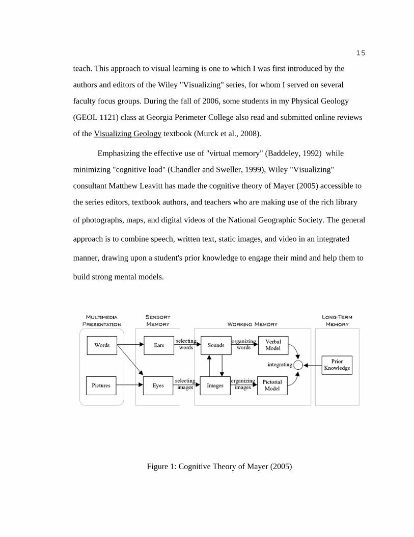
Emphasizing the effective use of "virtual memory" (Baddeley, 1992) while
minimizing "cognitive load" (Chandler and Sweller, 1999), Wiley "Visualizing"
consultant Matthew Leavitt has made the cognitive theory of Mayer (2005) accessible to
the series editors, textbook authors, and teachers who are making use of the rich library
of photographs, maps, and digital videos of the National Geographic Society. The general
approach is to combine speech, written text, static images, and video in an integrated
manner, drawing upon a student's prior knowledge to engage their mind and help them to
build strong mental models.
Figure 1: Cognitive Theory of Mayer (2005)
16
The figure from Mayer (2005) on the previous page represents the intended
integration, which will of course be achieved differently when delivering a spoken
lecture as opposed to a written handout, textbook, or research paper. As teachers, we can
minimize extraneous cognitive load by choosing textbooks and teaching materials which
contain precisely those concepts and examples which we plan to emphasize in our own
lectures. In spite of the contributions which the Wiley "Visualizing" series has made to
my own teaching philosophy, therefore, I maintain relationships with other publishers
and continue to use several other textbooks, particularly for my advanced courses on
geomorphology or stratigraphy. Computer programs can also be extremely useful both
for teaching and for familiarizing students with methods and procedures they will need to
use in professional scientific research. When choosing software to use in teaching, some
important considerations which I keep in mind are:
(1) How much time must I myself and my students spend learning the program
before it starts delivering the promised content (i.e. Does the program contain
"extraneous cognitive load."
(2) How much does it cost?
(3) Are other colleges and universities using the software?
(4) Is the software used by government and/or private industry?
Few computer programs would receive a strong positive score in all of the above
areas. Geographical information systems such as ArcGIS® (ESRI, 2006), for example,
require considerable time investment on the part of the user before they begin to provide

17
independent educational rewards. Nonetheless, ArcGIS® and the other ESRI products are
widely used by both government and private industry. Students recognize the career
opportunities afforded by GIS training, and many faculty themselves obtain grants from
ESRI for research projects that involve their students and enable them to apply newfound
geographical knowledge (Sanders et al., 2001). I have personally used ArcGIS® in my
consulting for archaeologists, and I plan to do so for future research projects in which my
students are involved.
There are several other computer programs which are "industry standards" for
professional geologists. AQTESOLVE® (Hydrosolve, 2007), a program for
hydrogeological modeling of groundwater aquifers, is now distributed with a leading
hydrogeology textbook (Fetter, 2001). For making most of the ternary plots used by
igneous petrologists, there is IgPet (Carr, 2005); and for creating x-ray diffraction
patterns similar to those that result from scanning slides prepared with specific clay
minerals or with mixed-layered samples there is NEWMOD (Reynolds and Reynolds,
2005). I would not introduce students to any of these programs until after they had
already mastered certain of the calculations and graphing techniques so that they can
verify and interpret the program output using their own data.
In many cases, computers do enable us to save time in making calculations,
perform operations consistently on large data sets, and check student work before
proceeding to present or publish research results. Plotting strike and dip measurements
and other structural data on a lower hemisphere projection is particularly time-consuming
and difficult for many students to perform consistently. Computer programs such as
Stereonet (Almendinger, 2003) are consequently indispensable for structural geologists
18
and geophysicists dealing with orientation data, and such stereoplot programs can also be
helpful to advanced geology students conducting their own research projects. Although
typically beyond the budget of college geology departments, Rockware (2006) provides
an entire RockworksTM suite of programs which organize well logs and field descriptions,
correlate stratigraphic columns, balance sections, and even perform "backstripping"
based upon structural evidence for compression, folding, and faulting. WinFence
(GAEA, 2007) is a more affordable program for accomplishing many of the same tasks.
WinFence also takes up less server memory and is easier for students to learn than the
equivalent programs in the RockWorksTM suite.
Structural geology is one of the more challenging subjects to teach college
students, and visual learning materials such as computer animations are often helpful in
showing the structure of objects and their relationships to other objects (e.g. Dwyer,
1994, p. 384). I currently use short Macromedia Flash® animations embedded within my
Powerpoint® presentations. There are also programs such as Geo3D (Kali and Orion
1996; Kali et al., 1997) which have been specifically designed by geologists
collaborating with software designers to teach students structure concepts. While it is
intended for high school or even middle school students in Israel, Geo3D progresses from
simple cross-sections of anticlines and synclines to complex folds offset by normal
faulting on the Menasheh Plateau and the Judean Mountains.
Most of us who were educated prior to the widespread availability of computers
and other electronic devices in classrooms, dorms, and home offices tend to regard
graphics, videos, and computer animations as "aids" to use in teaching concepts that can
be independently articulated in written or spoken language. Several more ambitious

19
thinkers have instead proposed that we aspire to a uniquely "visual literacy" (Debes,
1969; Seels, 1994), an ability to communicate with images and perform various uniquely
visual scientific tasks. To some extent, this is already taking place in specific fields. An
early example would be the use of flight simulators to train pilots, and graphic work
stations and computer images are now widely used for remote sensing and advanced
microscopy. "Virtual reality" models which enable students to rotate geological maps and
view them from any direction are currently being actively developed by Stephen
Reynolds of Arizona State University. Virtual reality experiences enable a student to see
how geology relates to topography, cities, and other features on the land surface
(Reynolds, 2007), possibly extending their knowledge above and beyond what can be
taught through written or spoken language.
Student (and faculty) enchantment with the power of visual presentation, visual
experience, and perhaps even visual "language" must not be allowed to take the place of
thorough education in science fundamentals. As was recognized more than a decade ago
in national surveys (Paulos, 1988; Snyder, 1990), many students beginning college
education today in the United States lack the basic numerical literacy that they need to be
able to grasp Earth science concepts without a certain amount of remedial instruction. I
begin with units of measure, using examples of both very large and very small objects
and introducing our geological "deep time" perspective on the Earth and the universe as a
whole. As we move on to study rocks and minerals, alert students are sometimes able to
recall the angstrom (Å) unit when I discuss the radii of the cations and anions in common
molecules. A select few may even remember which way to move the decimal place in
20
scaling down from the angstrom to the currently popular nanometer of the "nanoscience"
world.
Geologists share with chemists and atomic physicists an interest in the very small
objects which are the building blocks of matter, but we also share with astronomers a
cozy familiarity with large numbers. Although Carl Sagan may never have uttered the
words "billions and billions" on his television program Cosmos, he did introduce us to a
vast universe populated with around 100 billion galaxies and 10 billion trillion (1022)
stars (Sagan, 1997). Large numbers can be used for time as well as space, and there at
least 4.6 billion (4.6 x 10⁹) years between today's events and the events which created the
Earth and other solid planetary bodies in our solar system (Dalrymple, 2004). Using the
Systeme Internationale (SI) unit for time, we humans all live around two billion seconds
(deGrasse Tyson, 2000; Taylor, 1995).
Puzzles about measurement and unit conversions not only entertain the easily
bored undergraduate, they demonstrate the common numerical basis of all scientific
inquiry and the importance of numerical literacy for processing information in a modern
scientific culture. Many of our descriptive terms in scientific fields are essentially
shorthand for the values of fundamental dimensions such as mass (M), length (L), and
time (T). In geology, for example, an intrusive igneous rock body which has an area
greater than 100 km2 (L2) is referred to as a "batholith" while a smaller intrusion would
be a stock.. Stone Mountain, familiar to all students in the Atlanta suburbs where I
currently teach, qualifies as a stock but not a batholith.
Some memorization of constants and unit conversions is necessary for geology as
for most scientific fields, but numerical literacy is really a matter of feeling comfortable
21
with numbers and knowing how to enter them and interpret them correctly as values for
variables in equations (Bridgman, 1922). Most students have heard of a light year, for
example, but few are able to explain how the constant speed of light, 186,000 miles per
second (L/T), makes it possible to calculate a constant distance, about 6 trillion miles,
which light travels in one year (Moseley, 2001). I find that students with severe "math
anxiety" sometimes benefit from solving problems with other students in small
discussion groups. I also take advantage of students' familiarity and interest in using both
computer spreadsheet programs such as Microsoft Excel® and programmable calculators
to develop numerical literacy and quantitative skills that are crucial for more advanced
college work in geology and other scientific fields.
For non-traditional students who are not as familiar with digital technology, there
are good reference works on Excel® (e.g. Conmy et al., 2006) in addition to Microsoft's
online help. Many colleges and universities also now introduce students to Excel® in a
one credit hour course on computer concepts or "digital literacy." I have developed
several exercises myself which emphasize sorting columns of data, calculating with
simple formulas, and producing x-y scatter plot graphs. One such exercise is a simple
calculation of the linear increase in lithostatic pressure with depth in the Earth's crust. An
interesting application of the "balance sheet" design of Excel® is to have students work as
a group to develop a quantitative model of all the reservoirs in the hydrological cycle
(Rose, 1997). In the Historical Geology laboratory course at Georgia Perimeter College
(GPC), we teach grain size analysis using an exercise in which the mean grain size,
sorting, skewness, and kurtosis are all calculated in an Excel® spreadsheet by the students
themselves (Anderson, 2005). In my Environmental Science class at GPC, I have taught

22
descriptive statistics for several years now using data on water chemistry from wells in
both the Piedmont and the Coastal Plain of Georgia, much of it obtained from U.S.G.S.
websites. I also encourage students to use Excel® to complete the flood frequency
analysis I assign of 30 years of record from the Conestoga River at Lancaster,
Pennsylvania.
My choice to use Microsoft Excel® to teach quantitative methods is consistent
with my teaching philosophy, in that it makes use of a tool with which many of my
students are already familiar and will continue to use when they are no longer my
students. Errors have been found in some of the Excel® formulas for statistical functions
(Burns, 2006; Goldwater, 2007; Simonoff, 2006), and spreadsheet calculations should be
checked carefully before using the results in academic research. Furthermore, some
quantitative methods which are fundamental to geology are not easily adapted to either
spreadsheets or programmable calculators. I have students plot chemical data on basalt
compositions in an AFM ternary plot, for example. They can use Excel® to calculate the
"A," "F," and "M" percents of total oxides, but they really need to plot the data by hand
to understand how a ternary plot works. For more advanced students than I currently
teach, the program IgPet (Carr, 2005) does an excellent job with ternary plots. Concepts
of exponential growth (population) and decay (radioactive isotopes) are also difficult to
simplify for Excel® or calculator exercises. I do find that the students who have had
calculus are often able to solve very advanced problems on calculators, but I plan to
develop a complete tutorial on exponents with examples drawn from the subjects which I
teach.

23
At most colleges and universities, we are typically provided with computer
operating systems and basic software for text, data, and graphics from Microsoft® and
Apple®. If we are fortunate, we may also be able to obtain dedicated software for
teaching Earth Science or conducting geological research. For teaching students how to
do geology and environmental science using computers and calculators with which most
of them are already familiar, I have been very impressed with the software and exercises
available from both Texas Instruments® and Vernier®, a company which makes sensors
for field and laboratory measurement. The Vernier® sensors output data directly to a TI
calculator or a laptop computer, and both Texas Instruments® and Vernier® are also
supporting their hardware and software with excellent webpages where students and
teachers can share their data and interpretations of results from both field studies and
laboratory experiments.
Although sharing data and interpretations are an important and exciting part of
scientific research, students also need to be made aware of the difference between sound
research use of other scientists' results and plagiarism. As defined for an instructional
setting by the Council of Writing Program Adminstrators (2003), plagiarism occurs
"when a writer deliberately uses someone else's language, ideas, or other original (not
common-knowledge) material without acknowledging its source." The two important
steps for both students and faculty to take in guarding against plagiarism are thus:
(1) Determine whether the material to be used in your paper or presentation is
common-knowledge within your discipline or is an original idea, wording,
illustration, etc... of the author or source that you are reading.
24
(2) Acknowledge your source using a citation with a consistent and accepted
style whenever you think that it might not be common knowledge within your
discipline.
A "digital" solution to the problem of plagiarism, Turnitin, is widely used now in
freshman composition classes and as a method of checking student papers in any
discipline for plagiarized material. Turnitin is completely web-based, and the students
submit their papers directly to the program on the internet. Turnitin can actually collect
the student papers electronically, edit them online by inserting electronic comments into
the document, and return them electronically to students. I have tried Turnitin out a
couple of times, but I am still working out a complete strategy for preventing plagiarism
as part of my overall instruction in scientific writing. For courses in which I only assign
one final term paper, I typically do not fail a student based purely upon plagiarism but
instead require a complete rewrite that shows little or no plagiarism. Papers that misuse a
citation style, incorrectly use quotation marks, or fail to include some copied material
within their citations are graded down with a warning. These are not actually considered
to be plagiarism according to the Council of Writing Program Adminstrators (2003). In
an ideal academic setting, I would assign a series of short writing assignments in which I
would expect to see progressive improvement in terms of originality or require a series of
drafts if I assign a longer term paper.
Parallel and equally serious problems arise in our digital age regarding the use of
visual materials such as maps, dataplots, photographs, and video clips. Draft guidelines
for image digitization prepared for the Conference on Fair Use (CONFU), for example,

25
suggest that a "secure electronic network" should always be used to display and provide
access to digital images (Lehman, 1996). While it may not be exactly what is intended in
these guidelines, a distance learning program such as Blackboard® or Vista WebCT® is
secure in the sense that students must log in to the web server using their identification
number and password.
Many faculty, myself included, feel that it is actually our job to supplement the
image banks provided by textbook publishers with our own visual materials. In my case,
many of my materials are my own creative products while others are from published
literature and the digital archives of other scientists. I do acknowledge the sources for
most images, although my primary objective is to deliver educational content to my
students rather than to report on specific scientific findings. With respect to the possible
copyright issues, the Society for American Archivists (1997) has actually questioned the
need to restrict display to a secure network if the purpose is educational.
Structured internet platforms such as Blackboard® or Vista WebCT® enable the
best and the worst of the "distance learning" phenomenon. As documented by Keegan
(1990) and others (Maglogiannis and Karpouzis, 2007; Zapalska and Brozik, 2007),
distance learning has come about as a result of several social, economic, and educational
trends, not all of which are positive from the standpoint of science education. While
separation of teacher and learner is never of much benefit to the learner, in reality this
occurs throughout higher education given the commitment by most faculty to both
teaching and research. In my limited experience in distance education, I have endeavored
to maintain discussion, teamwork, and continuous communication with my students
using the structured platform just as I have in the past through informal emails and office-

26
hour sessions. Indeed, these platforms make it quite convenient to set up workgroups and
use peer interactions as well as textual and visual materials to reinforce the knowledge
students have acquired, motivating them to learn new things together and experience the
world more fully.
Students do vary with respect to aptitude and preferences as well as preparation
for college-level science instruction. One tool which I have used in the past to help
identify student preferences for particular teaching approaches is the VARK (Visual,
Auditory, Read/Write, and Kinesthetic) questionaire developed at Lincoln University
(Fleming, 1995; Fleming and Baume, 2006). The questionaire is short (13 questions) and
seems to provide information useful to both student and teacher. As mentioned above, a
preference for visual learning and strong visual abilities can be extremely helpful in
studying Earth science. Testing students who have trouble with maps and other spatial
representations, Ishikawa and Kastens (2005) found a strong contrast between those with
high verbal (R) and low spatial (V) preferences versus those with low verbal (R) and high
spatial (V) preferences. There also may be an association with gender, since Vandenberg
and Kuse (1978) report that women tend to have lower abilities and preferences for
spatial or visual learning. These findings are preliminary, and more research on visual
tasks specific to Earth science is needed. Results using the GEOSAT test of student
ability to comprehend geological structures developed by Kali and Orion (1996) could be
directly cross-tabulated against VARK questionaire results, for example. As a cautionary
aside, it must be mentioned that Clark and Feldon (2005) found little if any evidence to
support the belief that learning is improved when instruction is specifically designed to
accomodate the sort of preferences elicited using the VARK questionaire.

27
The range of aptitudes and preferences for individuals in the traditional "college
age" population is determined by random genetic variation as well as perhaps by gender.
In addition to this more or less random variation, there are some population-specific
changes that are occurring as "non-traditional" students are coming to make up more and
more of the student body on campus and in distance learning enrollment (Cross, 1981;
Knowles, 1970). Aging does diminish certain sensory-motor abilities (eyesight, hearing,
reaction time, etc.) but intelligence abilities (decision-making skills, reasoning,
vocabulary, etc.) tend to improve. My own experience is consistent with Cross's
observation that adult learners prefer a teacher with relevant job experience in the subject
being taught who is well organized and yet sensitive to the learning goals of individual
students. I think that the "andragogy" concept of Knowles (1970) is a bit overstated,
however, in that we are generally teaching mixed classes which sometimes even include
high school "joint enrollment" students as well as adult learners and the traditional
college-age group. I have taught more than one generation of the same family, for
example. Unless one is teaching at a senior center or advising an elder hostel group, the
abilities and preferences of the adult learners do not seem so radically different as to
overshadow individual and cultural differences.
Cultural differences are rarely mentioned in the science education literature,
although it has been observed by Kawachi et al. (2005) that Asian students generally
expect teachers to command attention and exert authority. I have noticed lower grades on
essays compared to multiple choice tests among some students from Asian countries, but
it is hard to determine how much is due to their intellectual traditions and upbringing and
how much simply to language difficulties. I know that the understanding of sensory

28
perception among Buddhists and some other Asian religious traditions is quite different
from that of the empiricist philosophers who contributed so much to our basic scientific
approach in the English-speaking world. As the Dalai Lama has explained so clearly
(Hayward and Varela, 1992, p. 47), contemplative or "yogic" direct perception provides
theoretical insight rather than simple sense data.
I sometimes use specific case studies and field examples to attract the interest of
particular cultural subgroups within a class of students. Furman and Merritt (2000) went
so far as to specifically design one course to attract students from a particular ethnic
background who might not otherwise take an Earth science course. They teach a course
on African climate in which the enrollment averages 45 percent African-American, of
whom over 75 percent are female. Such a proactive approach to course development
should hopefully help to reverse both the gender bias and ethnic bias of private and
public sector employment in Earth science. A course on Latin America with a strong
Earth science component might also be well received at many public universities.
The teaching and learning environment in which we find ourselves today is very
different from that in which our fundamental principles of scientific method and critical
thinking were first developed. Nonetheless, I do believe that those same principles and
values apply in our current digital age, when our classroom may not have four walls and
there may be considerable distance between teacher and student. The design of even the
introductory Earth science courses has changed, but we still have quite similar learning
outcomes in terms of both science fundamentals and a grasp of general concepts. Both
student and teacher are ultimately assessed based upon how well students achieve those

29
outcomes, whether the assessment is in a traditional "blue book" examination or
administered in a testing center on a computer.
While challenging, proactive use of educational technology and curriculum
design manifests our integrity as we make the systems approach to teaching Earth science
work. Our own new experiences as teachers in the digital age will ultimately provide
richer experiences of the Earth for our students. Perhaps this was all foreshadowed back
in the 5th-century BCE when the philosopher Lao-Tse penned his famous saying:
"If you tell me, I will listen. If you show me, I will see. But if you let me experience, I
will learn" (quoted in Ranjan, 1994)

30
REFERENCES
Ager, Derek V., 1973, The Nature of the Stratigraphical Record. New York: Macmillan.
Allen, David Elliston, 1978, The lost limb: geology and natural history. In Images of theEarth: Essays in the History of the Environmental Sciences, edited by L. J. Jordanova andRoy S. Porter, p. 200-212. Fleet, England: British Society for the History of Science.
Allen, Philip A., 1997, Earth Surface Processes. Oxford: Blackwell Science.
Alley, Richard, 2000, The Younger Dryas cold interval as viewed from centralGreenland. Quaternary Science Reviews 19: 213-226.
Almendinger, Richard W., 2002, Stereonet for Windows. Currently available online athttp://www.geo.cornell.edu/geology/faculty/RWA/programs.html.
Alvarez, Walter, 1997, T. rex and the Crater of Doom. Princeton, N. J.: PrincetonUniversity Press.
Alvarez, Luis W., Alvarez, Walter A., Asaro, Frank, and Michel, Helen V., 1980,Extraterrestrial Cause for the Cretaceous-Tertiary Extinction. Science 208: 1095-1108.
Anders, Mark H., Krueger, Scott W., and Sadler, Peter M. A new look at sedimentationrates and the completeness of the stratigraphic record. Journal of Geology 95: 1-14.
Anderson, J. R., 2005, Sand Sieve Analysis. Laboratory 7 in online Historical GeologyLaboratory Manual at Georgia Perimeter College:http://www.gpc.edu/~pgore/geology/historical_lab/contents.php
Baddeley, Alan D., 1992, Working memory. Science 255: 556-559.
Baker, Victor, R., 1987, The Spokane Flood debate and its legacy. In GeomorphicSystems of North America, edited by W. L. Graf, p. 416-423. Boulder, Colo.: GeologicalSociety of America.
Bartley, Julie K., 2007, Teaching Stratigraphy by POGIL (Process-Oriented GuidedInquiry Learning. Georgia Journal of Science 65(1): 43.

31
Bassham, Gregory, Irwin, William, Nordane, Henry, and Wallace, James M., 2005,Critical Thinking. New York: McGraw-Hill.
Benton, Michael J., 2003, When Life Nearly Died: The Greatest Mass Extinction of AllTime, London: Thames and Hudson.
Bergström, Stig M., Huff, Warren D., Saltzman, Matthew R., Kolata, Dennis R., andLeslie, Stephen A., 2004, The Greatest Volcanic Ash Falls in the Phanerozoic: Trans-Atlantic Relations of the Ordovician Millbrig and Kinnekulle K-Bentonites. TheSedimentary Record 2(4): 4-8.
Berner, Robert A., Lasaga, Antonio C., and Garrels, Robert M., 1983, The carbonate-silicate geochemical cycle and its effect on atmospheric carbon dioxide over the past 100million years. American Journal of Science 283: 641-683.
Birkeland, Peter W., 1999, Soils and Geomorphology. New York: Oxford UniversityPress.
Bretz, J. Harlan, 1923, The Channeled Scabland of the Columbia Plateau. Journal ofGeology 31: 617-649.
Bretz, J. Harlan, 1928, The Channeled Scabland of eastern Washington, GeographicalReview 18: 446-477.
Bridgman, Percy W., 1922, Dimensional Analysis. New Haven, Conn.: Yale UniversityPress.
Brock, William Hodson, 1978, Chemical geology or geological chemistry. In Images ofthe Earth: Essays in the History of the Environmental Sciences, edited by L. J. Jordanovaand Roy S. Porter, p. 147-170. Fleet, England: British Society for the History of Science.
Broecker, Walter S., Kennett, James P., Flower, Benjamin P., Teller, James T.,Trumbore, Sue, Bonani, Georges, and Wolfli, Willy, 1989, Routing of Meltwater fromthe Laurentide Ice Sheet During the Younger Dryas Cold Episode. Nature 341: 318-321.
Bruner, Jerome S., 1960, The Process of Education. New York: Random House.
Bunge, Mario, 1984, What is pseudoscience? The Skeptical Inquirer 9: 36-46.
Burns, Patrick, 2006, Spreadsheet addiction. Currently available online at:http://www.burns-stat.com/pages/Tutor/spreadsheet_addiction.html

32
Busse, Ellie, Manning, Ashley, Tietjen, Mark, and Bartley, Julie, 2007, A StudentPerspective - "Geologic: Breaking Ground between Philosophy and the Earth Sciences,"Georgia Journal of Science 65(1): 49.
Butler, Eric M., and Bierman, Paul R., 2003, Investigation-Stimulated DiscussionSections Make Geoscience More Relevant in Large Lecture Class. EOS 47(25): 517-522.
Cann, Rebecca L., Stoneking, Mark, and Wilson, Allan C., 1987, Mitochondrial DNAand human evolution, Nature 325: 31-36.
Carr, Michael J., 2005, Igpet for Windows. Somerset, N. J.: Terra Softa, Inc.
Chamberlin, Thomas C., 1890, The method of multiple working hypotheses. Science 15:92-96.
Chandler, Paul, and Sweller, John, 1991, Cognitive load theory and the format ofinstruction. Cognition and Instruction 8: 293-332.
Clark, Richard E., and Feldon, David F., 2005, Five common but questionable principlesof multimedia learning. In The Cambridge Handbook of Multimedia Learning, edited byR, E. Mayere, p. 97-115.
Clark, James M., and Palvio, Allan, 1991, Dual coding theory and education. EducationalPsychology Review 3(3): 149-210.
Compton, Robert R., 1985, Geology in the field. New York: Wiley.
Conmy, Colleen, Hazlett, Bill, Jelen, Bill, and Soucy, Adrienne, 2006, Excel forTeachers. Uniontown, Ohio: Holy Macro! Books.
Conyers, Lawrence B., 2004, Ground-Penetrating Radar for Archaeology. Walnut Creek,Calif.: Altamira Press.
Council of Writing Program Administrators (CWPA), 2003, Defining and AvoidingPlagiarism: The WPA Statement on Best Practices. Currently available online at:http://www.wpacouncil.org/positions/plagiarism.html
33
Cox, Allan, and Hart, Robert Brian, 1986, Plate Tectonics: How It Works. Cambridge:Blackwell Science.
Cross, K. Patricia, 1981, Adults as Learners. San Francisco, Calif.: Jossey-Bass.
Dalrymple, G. Brent, 2004, Ancient Earth, Ancient Skies: The Age of Earth and itsCosmic Surroundings. Stanford, Calif. Stanford University Press.:
Davis, Philip J., and Hersh, Reuben, 1998, The Mathematical Experience. New York:Houghton Mifflin.
Davis, William Morris, 1926, The Value of Outrageous Geological Hypotheses. Science63: 465-468.
Dean, Dennis R., 1992, James Hutton and the History of Geology. Ithaca: CornellUniversity Press.
Debes, Jack, 1969, The loom of visual literacy. Audiovisual Instruction 14(8): 25-27.
Dennis, John G., 1971, Ries structure, southern Germany, a review; Journal ofGeophysical Research 76 (23): 5394-5406.
Dewey, John, 1916, Democracy and Education. New York: Macmillan.
Dickin, Alan P., 1995, Radiogenic Isotope Geology. Cambridge: Cambridge UniversityPress.
Dunn, Rita, 1996, How to Implement and Supervise a Learning Style Program.Alexandria, Va.: Association for Supervision and Curriculum Development.
Dunn, Rita, and Dunn, Kenneth, 1993, Teaching secondary students through theirindividual learning styles. Boston: Allyn and Bacon.
Dwyer, Francis M., 1994, One Dimension of Visual Research - A Paradigm and ItsImplementation. In Visual Literacy - A Spectrum of Visual Learning, edited by David M.Moore and Francis M. Dwyer. Englewowod Cliffs, N. J.: Educational TechnologyPublications.
Erwin, Douglas, 2006, Extinction - How life on earth nearly ended 250 million years ago.Princeton, N.J.: Princeton University Press.
ESRI, 2006, ArcGIS. Redlands, Calif.: Environmental Systems Research Institute, Inc.
Faure, Gunter, 1986, Principles of Isotope Geology. New York: Wiley.

34
Fawcett, Leesa, Russell, Constance L., and Bell, Anne C., 2002, Guiding OurEnvironmental Praxis: Teaching and Learning for Sustainable Environmental Justice. InTeaching Sustainability at Universities –– Towards Curriculum Greening, edited by W.L. Filho, p. 223-238. London: Peter Lang Scientific Publishers
Federal Emergency Management Administration (FEMA) and American GeophysicalUnion (AGU), 1994, Seismic Sleuths - Earthquakes - A Teacher's Package onEarthquakes for Grades 7-12. Washington, D.C.: Federal Emergency ManagementAdministration.
Fetter, Charles W., 2001, Applied Hydrogeology. Upper Saddle River, N.J.: Prentice-Hall.
Fleming, Neil D., 1995, I'm different, not dumb: Modes of presentation (V.A.R.K.) in thetertiary classroom In Research and Development in Higher Education: Proceedings of the1995 Annual Conference of the Higher Education and Research Development Society ofAustralasia (HERDSA), edited by A. Zelmer, p. 308-313.
Fleming, Neil D., and Baume, David, 2006, Learning Styles Again: VARKing up theright tree! Educational Developments 7(4): 4-7.
Forbes, David, 1868, On chemical geology. Journal of the Chemical Society 21: 214-221.
Frodeman, Robe rt, 2003, Geo-logic: Breaking Ground between Philosophy and the EarthSciences. Albany: State University of New York Press.
Furman, Tanya, and Merritt, Eileen, 2000, A Data-Intensive Approach to StudyingClimate and Climate Change in Africa. Journal of Geoscience Education 48: 464.
GAEA, 2007, WinFence. Whitby, Canada: GAEA Technologies, Ltd.
Gates, Alexander E., Langford, Richard P., Hodgson, Richard M., and Driscoll, John J.III, 1996, Ground-water simulation apparatus for introductory and advanced courses inenvironmental geology, Journal of Geoscience Education 44 , p. 559-564.
Geike, Archibald, 1905, Founders of geology. London: Macmillan.

35
Gilbert, Grove Karl, 1896, The origin of hypotheses, illustrated by the discussion of atopographic problem. Science 3: 1-13.
Goldwater, Eva, 2007, Using Excel for Statistical Data Analysis - Caveats. Currentlyavailable online at http://www-unix.oit.umass.edu/~evagold/excel.html
Grant, R., 1979, Hutton's Theory of the earth. In Images of the Earth: Essays in theHistory of the Environmental Sciences, edited by L. J. Jordanova and Roy S. Porter, p.23-38.
Habermas, Jurgen, 1973, Theory and Practice. Boston: Beacon Press.
Hayward, Jeremy, and Varela, Francisco J., 1992, Gentle bridges: conversations with theDalai Lama on the sciences of mind. Boston, Mass.: Shambala.
Hoffman, Paul F., Kaufman, Alan J., Halverson, Galen P., and Schrag, Daniel P., 1998, ANeoproterozoic Snowball Earth, Science 281: 1342-1346.
Hoffman, Paul F., and Schrag, Daniel P., 2002, The snowball Earth hypothesis: testingthe limits of global change. Terra Nova 14: 129-155.
Horn, Peter, 1972, The Ries Kessel, Germany; An Example of Meteorite Impact as aTerrestrial Geological Process; Geoforum 12: 91-95.
Hsü, Kenneth J., 1983, The Mediterranean Was a Desert. Princeton, N.J.: PrincetonUniversity Press.
Hubbert, Marion King, 1969, The Theory of Ground-water motion and related papers.New York: Hafner.
Hutton, James, 1795, Theory of the Earth, with proofs and illustrations. London: Messrs.Cadell, Jr., and Edingurgh: William Creech.
Hydrosolve, Inc., 2007, Aqtesolv for Windows v 4.0. Reston, Va.: Hydrosolve.
Ishikawa, Toru, and Kastens, Kim A., 2005, Why Some Students Have Trouble withMaps and Other Spatial Representations. Journal of Geoscience Education 53(2): 184-197
Jenny, Hans, 1941, Factors of soil formation. New York: McGraw-Hill.
Kali, Yael, and Orion, Nir, 1996, Spatial Abilities of High-School Students in thePerception of Geologic Structures. Journal of Research in Science Teaching 33(4): 369-391.

36
Kali, Yael, Orion, Nir, Mazor, Emanuel, 1997, Software for assisting high-schoolstudents in the spatial perception of geological structures, Journal of GeoscienceEducation 45: 10-21.
Kawachi, Paul, Sharma, Ramesh C., and Mishra, Sanjaya, 2005, Developing Materialsand Choosing Media. Asian Journal of Distance Education 3(2): 1-3.
Keegan, Desmond, 1990, Foundations of Distance Education. New York: Routledge.
Keys, W. Scott, 1990, Borehole Geophysics Applied to Ground-Water Investigations. In Techniques of Water-Resources Investigation, Book 2, Chapter 2, Washington, D.C.:U. S. Geological Survey.
Kirschvink, Joseph L., 1992, Late Proterozoic Low-Latitude Global Glaciation: theSnowball Earth. In The Proterozoic Biosphere: A Multidisciplinary Study, edited by J.W. Schopf and C. Klein, p. 51-52. Cambridge: Cambridge University Press.
Knighton, David, 1998, Fluvial Forms and Processes: A New Perspective. London:Arnold.
Knowles, Malcolm S., 1970, The Modern Practice of Adult Education: AndragogyVersus Pedagogy. New York: Association Press.
Kohler, Robert E., 2002, Landscapes and Labscapes: Exploring the Lab-Field Border inBiology. Chicago: University of Chicago Press.
Kulhavy, Raymond W., Lee, J. B., and Caterino, Linda C., 1985, Conjoint retention ofmaps and related discourse. Contemporary Educational Psychology 10: 28-37.
Leavitt, Matthew, 2007, Using Visuals in the Classroom. Special Introduction toVisualizing Environmental Science, by Linda R. Berg and Mary Catherine Hager. NewYork: Wiley.
Lehman, Bruce, 1996, The Conference on Fair Use, An Interim Report to theCommissioner. Wasthington, D.C.: United States Patent and Trademark Office,Department of Commerce.
Libarkin, Julie, C., and Brick, Christine, 2002, Research Methodologies in ScienceEducation: Visualization and the Geosciences. Journal of Geoscience Education 50(4):449-455.

37
Lillquist, Karl, and Kinner, Patricia W., 2002, Stream Tables and WatershedGeomorphology Education. Journal of Geoscience Education 50(5): 583-593.
Lowenstern, Jacob B., Smith, Robert B., and Hill, David P., 2006, Monitoring super-volcanoes: geophysical and geochemical signals at Yellowstone and other large calderasystems. Philosophical Transactions of the Royal Society A 364: 2055-2072.
Lyell, Charles, 1830, Principles of Geology, Being an Attempt to Explain the FormerChanges of the Earth's Surface by Reference to Causes Now in Operation, Volume 1.London: J. Murray.
Maglogiannis, Ilias, Karpouzis, Kostas, 2007, Combining Synchronous andAsynchronous Distance Learning for Adult Traininng in Military Environments. InGlobal Cases in E-Learning Practices: Successes and Pitfalls, edited by S. Mishra, p. 22-34. Hershey, Pa.: Idea Group Publishers, 2006
Matthews, Michael R., 2003, Teaching Science. In A Companion to the Philosophy ofEducation, edited by Randall Curran, pp. 342-348. Oxford: Blackwell.
Mayer, Richard E., 2005, Cognitive theory of multimedia learning. In The CambridgeHandbook of Multimedia Learning, edited by Richard E. Mayer, p. 31-48. New York:Cambridge University Press.
Mead, George Herbert, 1906, The Teaching of Science in College. Science 24: 390-397.
Milsom, John, 2003, Field Geophysics. New York: Wiley.
Moore, Brooke Neal, and Parker, Richard, 2007, Critical Thinking. New York: McGraw-Hill.
Moseley, Caroline, 2001, Faculty team serves up a slice of the universe. PrincetonWeekly Bulletin 90(27). Princeton, N.J.: Office of Communications, PrincetonUniversity.
Murck, Barbara W., Skinner, Brian J., and Mackenzie, Dana, 2008. Visualizing Geology.New York: Wiley.
Newsome, Cathy, 1997, A Teacher's Guide to Fair Use and Copyright. Privatelypublished.
Nichols, Gary, 1999, Sedimentology and Stratigraphy. Oxford: Blackwell.
Niewoehner, Robert J., 2006, Applying a critical thinking model for engineeringeducation. World Transactions on Engineering and Technology Education 5(2): 341-344.

38
Padilla, Michael J., 1991, Science Activities, Process Skills, and Thinking. In ThePsychology of Learning Science, edited by Shawn M. Glynn, Russell H. Yeanyi, andBruce K. Britton, p. 205-217. Hillsdale, N.J.: Lawrence Erlbaum Associates.
Paul, Richard, 1993, Critical thinking: how to prepare students for a rapidly changingworld. Santa Rosa, Calif.: Foundation for Critical Thinking.
Paul, Richard, and Elder, Linda, 2000, Critical Thinking: Tools for Taking Charge ofYour Learning and Your Life. Sonoma, Calif.: Foundation for Critical Thinking.
Paulos, John Allen, 1988, Innumeracy - Mathematical Illiteracy and its Consequences.New York: Hill and Wang.
Peeck, Joan, 1994, Enhancing Graphic-Effects in Instructional Texts: InfluencingLearning Activities. In Comprehension of Graphics, edited by Wolfgang Schnotz andRaymond Kulhavy, p. 291-301.
Peteet, Dorothy, 1995, Global Younger Dryas? Quaternary International 28: 93-104.
Playfair, John, 1822, The works of John Playfair with a memoir of the author. Edinburgh:A. Constable.
Poag, C. Wylie, 1999, Chesapeake Invader: Discovering America's Giant MeteoriteCrater. Princeton, N.J.: Princeton University Press.
Poag, C. Wylie, Powars, David S., Poppe, Larence J., Mixon, Robert B., 1994, Meteoroidmayhem in Ole Virginny: Source of the North American tektite strewn field: Geology 22:691-694.
Ranjan, Neena, 1994, Multimedia Projects: A Curtain Raiser. Vihangama, The IGNCANewsletter 1(2).
Retallack, Gregory J., 1990, Soils of the past: An introduction to paleopedology. Boston:Unwin Hyman.
Reynolds, Robert C., Jr., and Reynolds, Robert III, 1995, NEWMOD for Windows - TheCalculation of One-Dimensional Diffraction Patters of Mixed Layered Clay Minerals.Currently available online at http://www.angelfire.com/md/newmod/index.html.
Reynolds, Stephen J., 2007, Structural Geology Animations available online athttp://reynolds.asu.edu/virtual_reality.htm.
Rockware, 2006, RockWorks2006TM. Golden, Colo.: Rockware, Inc.

39
Rose, Seth, 1997, A Spreadsheet Approach to the Hydrological Cycle. Journal ofGeoscience Education 45: 369-372.
Rossbacher, Lisa, 1990, The Geologist's Lifetime Field List. Geotimes 35(4).
Rossbacher, Lisa, 2005, Seventeen Places. Geotimes 50(9).
Rudwick, Martin, 1976, The emergence of visual language for geological science, 1760-1840. History of Science 14: 149-195.
Sadler, Peter M., 1981, Sediment accumulation rates and the completeness ofstratigraphic sections. Journal of Geology 89: 569-584.
Sagan, Carl, 1997, Billions and Billions - Thoughts on Life and Death at the Brink of theMillennium. New York: Random House.
Samuels, S. Jay, 1970, Effects of pictures on learning to read, comprehension, andattitudes. Journal of Educational Psychology 76: 647-658.
Sanders, Raymond L., Jr, Kajs, Lawrence T, Crawford, Caroline M, 2001, Electronicmapping in education: the use of geographic information systems. Journal of Research onTechnology in Education 34: 121-129.
Sarna-Wojcicki, Andrei M., and Jonathan O. Davis, 1991, Quaternary tephrochronology,in Quaternary nonglacial geology, conterminous U.S., edited by R.B. Morrison, pp. 93-116, Boulder, Colo.: Geological Society of America.
Schnotz, Wolfgang, Picard, Emmanuel, and Henninger, Michael, 1994, The Use ofGraphics and Texts in Constructing Mental Models. In Comprehension of Graphics,edited by Wolfgang Schnotz and Raymond Kulhavy, p. 185-205.
Schumm, Stanley A., 1977, The Fluvial System. New York: Wiley.
Schumm, Stanley A., 1991, To Interpret the Earth: Ten ways to be wrong. New York:Cambridge University Press.
Seels, Barbara A., 1994, Visual Literacy - The Definition Problem. In Visual Literacy - ASpectrum of Visual Learning, edited by David M. Moore and Francis M. Dwyer.Englewood Cliffs, N. J.: Educational Technology Publications.

40
Shoemaker, E. M., and Chao, Edward C. T., 1961; New evidence for the impact origin ofthe Ries Basin, Bavaria, Germany, Journal of Geophysical Research 66: 3371-3378.
Simonoff, Jeffrey S., 2006, Statistical analysis using Microsoft Excel. Currently availableonline at http://pages.stern.nyu.edu/~jsimonof/classes/1305/pdf/excelreg.pdf
Skinner, Brian J., Porter, Stephen C., and Park, Jeffrey, 2004, Dynamic Earth - AnIntroduction to Physical Geology. New York: Wiley.
Snyder, Benson R., 1990, Literacy and Numeracy: Two Ways of Knowing. Daedalus119(2): 233-256.
Society of American Archivists, 1995, Educational Fair Use Guidelines for DigitalImages: Response of The Society of American Archivists to the Draft GuidelinesDeveloped by the Conference on Fair Use. Chicago, Ill.: Society of American Archivists.
Squyres, Steven W., Arvidson, Raymond E., Baumgartner, Eric T., Bell, James F., III,Christensen, Paul R., Gorevan, Stephen, Herkenhoff, Kenneth E., Klingelhoefer, Gustar,Madsen, Morten B., Morris, Richard V., Rieder, Rudi, Romero, Raul A., Athena Marsrover science investigation, Journal of Geophysical Research 108(E12): 8062
Stanley, Steven M., 2000, Ocean Circulation: Conveyor of Past and Future Climate. InThe Earth Around Us, edited by Jill S. Schneiderman, p. 308-321. New York: W. H.Freeman.
Stanley, Steven, and Hardie, Laurence A., 1998, Secular Oscillation in the CarbonateMineralogy of Reef-Building and Sediment-Producing Organisms Driven byTectnoically Forced Shifts in Seawater Chemistry. Paleogeography, Paleoclimatology,Paleoecology 144: 3-19.
Stanley, Steven, and Hardie, Laurence A., 1999, Hypercalcification: Paleontology LinksPlate Tectonics and Geochemistry to Sedimentology. GSA Today 9(2): 1-7.
Stevenson, Charles L., 1954, The scientist's role and the aims of education, HarvardEducation Review 24: 231-238.
Stringer, Chris, 2003, Human Evolution: Out of Ethiopia. Nature 423: 692-695.
Tate, Marcia L., 2006, Learning Styles. In The Praeger Handbook of Learning and theBrain, edited by Sheryl Feinstein, p. 286-289. Westport, Conn.: Praeger.
Tattersall, Ian, 1995, The Fossil Trail: How We Know What We Think We Know aboutHuman Evolution. New York: Oxford University Press.

41
Taylor, Barry N., 1995, Guide for the Use of the International System of Units.Washington, D.C.: National Institute of Standards and Technology, United StatesDepartment of Commerce.
Trop, Jeffrey M., Krockover, Gerald H., and Ridgway, Kenneth D., 2000, Integration ofField Observations with Laboratory Modeling for Understanding Hydrologic Processesin an Undergraduate Earth-Science Course. Journal of Geoscience Education 48: 514-521.
Tyson, Neil de Grasse, 2000, Telling the Story - Astronomy's Place in the Scope ofNatural History. Natural History, February issue, p. 48.
Tyson, Neil deGrasse, 2001, Audio Tour Narration for Rose Center for Earth and Space:I. Overview; II. Scaling Walk, III. Cosmic Pathway; IV. Hall of the Universe
Vandenberg, Steven G., and Kuse, Allan R., 1978, Mental rotations, a group test of three-dimensional spatial visualization. Perceptual and Motor Skills 47: 599-604.
Ward, Peter D., 2000, Rivers in Time: The Search for Clues to Earth's Mass Extinctions.New York: Columbia University Press.
Ward, Peter D., and Brownlee, Donald, 2004, Rare Earth: Why Complex Life IsUncommon in the Universe. New York: Copernicus.
Whitehead, Alfred North, 1929, The Aims of Education and Other Essays. New York:Macmillan.
Wiredu, Kwasi, 1998, Toward decolonizing African philosophy and religion.. AfricanStudies Quarterly 1(4) <http://web.africa.ufl.edu/asq/v1/4/3.htm> Accessed January15,2007.
Zajonc, Arthur, 2004, The New Physics and Cosmology: Dialogues with the Dalai Lama.New York: Oxford University Press.
Zapalska, Alina M., and Brozik, Dallas, 2007, Online Learning with the Use of WebCTVista. In Global Cases in E-Learning Practices: Successes and Pitfalls, edited by S.Mishra, p. 13-21. Hershey, Pa.: Idea Group Publishers.