why explore the ocean - noaa ocean explorer...
TRANSCRIPT
9
The NOAA Ship Okeanos Explorer Education Materials Collection oceanexplorer.noaa.gov
Section 1: Background Informationfor Volume 1: Why Do We Explore?Section 1: Background Informationfor Volume 1: Why Do We Explore?
Ocean Explorationand Research
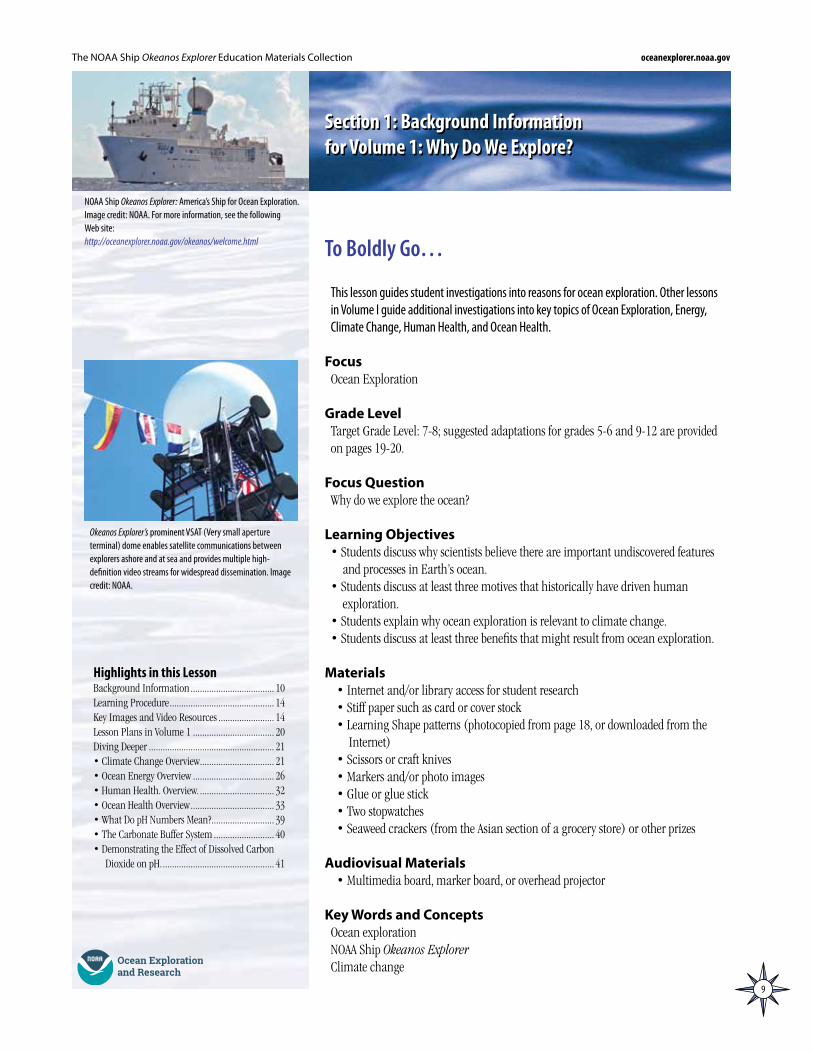
NOAA Ship Okeanos Explorer: America’s Ship for Ocean Exploration. Image credit: NOAA. For more information, see the following Web site:http://oceanexplorer.noaa.gov/okeanos/welcome.html
This lesson guides student investigations into reasons for ocean exploration. Other lessons in Volume I guide additional investigations into key topics of Ocean Exploration, Energy, Climate Change, Human Health, and Ocean Health.
FocusOcean Exploration
Grade LevelTarget Grade Level: 7-8; suggested adaptations for grades 5-6 and 9-12 are provided on pages 19-20.
Focus QuestionWhy do we explore the ocean?
Learning Objectives• Students discuss why scientists believe there are important undiscovered features
and processes in Earth’s ocean.• Students discuss at least three motives that historically have driven human
exploration.• Students explain why ocean exploration is relevant to climate change.• Students discuss at least three benefits that might result from ocean exploration.
Materials• Internet and/or library access for student research• Stiff paper such as card or cover stock• Learning Shape patterns (photocopied from page 18, or downloaded from the
Internet)• Scissors or craft knives• Markers and/or photo images• Glue or glue stick • Two stopwatches• Seaweed crackers (from the Asian section of a grocery store) or other prizes
Audiovisual Materials• Multimedia board, marker board, or overhead projector
Key Words and ConceptsOcean explorationNOAA Ship Okeanos ExplorerClimate change
To Boldly Go…
Highlights in this LessonBackground Information .................................... 10Learning Procedure ............................................. 14Key Images and Video Resources ........................ 14 Lesson Plans in Volume 1 ................................... 20Diving Deeper ...................................................... 21• Climate Change Overview ................................ 21• Ocean Energy Overview ................................... 26• Human Health. Overview. ................................ 32• Ocean Health Overview .................................... 33• What Do pH Numbers Mean? ........................... 39• The Carbonate Buffer System .......................... 40• Demonstrating the Effect of Dissolved Carbon
Dioxide on pH. ................................................ 41
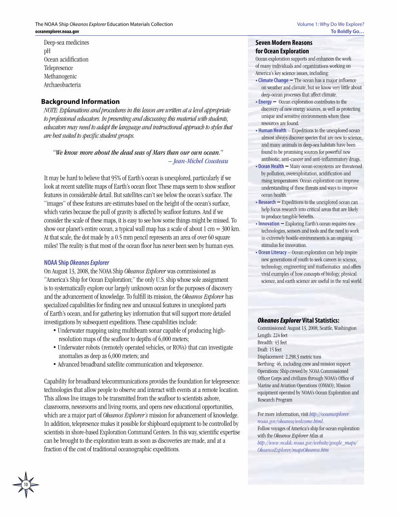
Okeanos Explorer’s prominent VSAT (Very small aperture terminal) dome enables satellite communications between explorers ashore and at sea and provides multiple high-definition video streams for widespread dissemination. Image credit: NOAA.
10
Volume 1: Why Do We Explore?To Boldly Go…
The NOAA Ship Okeanos Explorer Education Materials Collectionoceanexplorer.noaa.gov
Deep-sea medicinespHOcean acidificationTelepresenceMethanogenicArchaeobacteria
Background InformationNOTE: Explanations and procedures in this lesson are written at a level appropriate to professional educators. In presenting and discussing this material with students, educators may need to adapt the language and instructional approach to styles that are best suited to specific student groups.
“We know more about the dead seas of Mars than our own ocean.” – Jean-Michel Cousteau
It may be hard to believe that 95% of Earth’s ocean is unexplored, particularly if we look at recent satellite maps of Earth’s ocean floor. These maps seem to show seafloor features in considerable detail. But satellites can’t see below the ocean’s surface. The “images” of these features are estimates based on the height of the ocean’s surface, which varies because the pull of gravity is affected by seafloor features. And if we consider the scale of these maps, it is easy to see how some things might be missed. To show our planet’s entire ocean, a typical wall map has a scale of about 1 cm = 300 km. At that scale, the dot made by a 0.5 mm pencil represents an area of over 60 square miles! The reality is that most of the ocean floor has never been seen by human eyes.
NOAA Ship Okeanos ExplorerOn August 13, 2008, the NOAA Ship Okeanos Explorer was commissioned as “America’s Ship for Ocean Exploration;” the only U.S. ship whose sole assignment is to systematically explore our largely unknown ocean for the purposes of discovery and the advancement of knowledge. To fulfill its mission, the Okeanos Explorer has specialized capabilities for finding new and unusual features in unexplored parts of Earth’s ocean, and for gathering key information that will support more detailed investigations by subsequent expeditions. These capabilities include:
• Underwater mapping using multibeam sonar capable of producing high-resolution maps of the seafloor to depths of 6,000 meters;
• Underwater robots (remotely operated vehicles, or ROVs) that can investigate anomalies as deep as 6,000 meters; and
• Advanced broadband satellite communication and telepresence.
Capability for broadband telecommunications provides the foundation for telepresence: technologies that allow people to observe and interact with events at a remote location. This allows live images to be transmitted from the seafloor to scientists ashore, classrooms, newsrooms and living rooms, and opens new educational opportunities, which are a major part of Okeanos Explorer’s mission for advancement of knowledge. In addition, telepresence makes it possible for shipboard equipment to be controlled by scientists in shore-based Exploration Command Centers. In this way, scientific expertise can be brought to the exploration team as soon as discoveries are made, and at a fraction of the cost of traditional oceanographic expeditions.
Seven Modern Reasons for Ocean ExplorationOcean exploration supports and enhances the work of many individuals and organizations working on America’s key science issues, including:• Climate Change – The ocean has a major influence
on weather and climate, but we know very little about deep-ocean processes that affect climate.
• Energy – Ocean exploration contributes to the discovery of new energy sources, as well as protecting unique and sensitive environments where these resources are found.
• Human Health – Expeditions to the unexplored ocean almost always discover species that are new to science, and many animals in deep-sea habitats have been found to be promising sources for powerful new antibiotic, anti-cancer and anti-inflammatory drugs.
• Ocean Health – Many ocean ecosystems are threatened by pollution, overexploitation, acidification and rising temperatures. Ocean exploration can improve understanding of these threats and ways to improve ocean health.
• Research – Expeditions to the unexplored ocean can help focus research into critical areas that are likely to produce tangible benefits.
• Innovation – Exploring Earth’s ocean requires new technologies, sensors and tools and the need to work in extremely hostile environments is an ongoing stimulus for innovation.
• Ocean Literacy – Ocean exploration can help inspire new generations of youth to seek careers in science, technology, engineering and mathematics and offers vivid examples of how concepts of biology, physical science, and earth science are useful in the real world.
Okeanos Explorer Vital Statistics:Commissioned: August 13, 2008; Seattle, WashingtonLength: 224 feetBreadth: 43 feetDraft: 15 feetDisplacement: 2,298.3 metric tonsBerthing: 46, including crew and mission supportOperations: Ship crewed by NOAA Commissioned Officer Corps and civilians through NOAA’s Office of Marine and Aviation Operations (OMAO); Mission equipment operated by NOAA’s Ocean Exploration and Research Program
For more information, visit http://oceanexplorer.noaa.gov/okeanos/welcome.html.Follow voyages of America’s ship for ocean exploration with the Okeanos Explorer Atlas at http://www.ncddc.noaa.gov/website/google_maps/OkeanosExplorer/mapsOkeanos.htm
11
Volume 1: Why Do We Explore? To Boldly Go…
The NOAA Ship Okeanos Explorer Education Materials Collectionoceanexplorer.noaa.gov
Many Reasons to ExploreHistorically, explorers have been driven by a variety of motives. For some, the primary reason to explore was to expand their knowledge of the world. For others, economic interests provided powerful incentives, and many expeditions have launched on such missions as finding a sea route to access the spices of Asia, or quests for gold, silver, and precious stones. Political power and the desire to control large empires motivated other explorations, as did the desire to spread religious doctrines. In the case of space exploration, additional reasons have been offered, including understanding our place in the cosmos, gaining knowledge about the origins of our solar system and about human origins, providing advancements in science and technology, providing opportunities for international collaboration, and keeping pace with other nations involved in developing space technology. The first ocean exploration for the specific purpose of scientific research is often considered to be the voyage of the HMS Challenger, conducted between 1872-1876 (visit http://oceanexplorer.noaa.gov/explorations/03mountains/background/challenger/challenger.html and http://www.coexploration.org/hmschallenger/html/AbouttheProject.htm for more information about the Challenger expedition and comparisons with modern oceanographic exploration).
Curiosity, desire for knowledge, and quest for adventure continue to motivate modern explorers. But today, there are additional reasons to explore Earth’s ocean, including climate change, energy, human health, ocean health, innovation, research and ocean literacy.
Climate ChangeEarth’s average temperature is warmer than it has been at any time since at least 1400 AD. While debate continues about the causes of climate change and the relative importance of long-term climate cycles, greenhouse gases, and other factors, it is clear that: • Mountain glaciers are melting; • Polar ice is decreasing; • Springtime snow cover has been reduced; • Ground temperature has been increasing in many areas; • Sea level has risen by several inches in the last 100 years.
Potential impacts of global climate include weakening the deep-ocean thermohaline circulation (THC), which plays an important role in transporting heat, dissolved oxygen and nutrients, accelerating the widespread decline of coral reefs, extinction of species such as the polar bear, and year-round access to sea routes through the Arctic. Ocean exploration can provide some of the essential knowledge about ocean-atmosphere interactions that is needed to understand, predict, and respond to these impacts. For additional discussion about climate change and the THC, please see the Diving Deeper section starting on page 21.
Energy “For kicks, oceanographer William P. Dillon likes to surprise visitors to
his lab by taking ordinary-looking ice balls and setting them on fire. ‘They’re easy to light. You just put a match to them and they will go,’ says Dillon, a researcher with the U.S. Geological Survey (USGS) in Woods Hole, Mass. If the truth be told, this is not typical ice. The prop in Dillon’s show is a curious and poorly known structure called methane hydrate.”
from “The Mother Lode of Natural Gas” by Rich Monasterskyhttp://www.sciencenews.org/sn_arch/11_9_96/bob1.htm
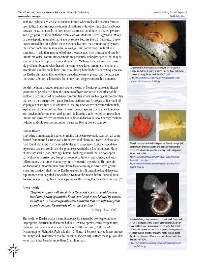
The black and white photograph of Muir Glacier taken on August 13, 1941; the color photograph was taken from the same vantage on August 31, 2004. Between 1941 and 2004 the glacier retreated more than 12 kilometers (seven miles) and thinned by more than 800 meters (875 yards). Ocean water has filled the valley, replacing the ice of Muir Glacier; the end of the glacier has retreated out of the field of view. The glacier’s absence reveals scars where glacier ice once scraped high up against the hillside. In 2004, trees and shrubs grew thickly in the foreground, where in 1941 there was only bare rock. Image credit: National Snow and Ice Data Center, W. O. Field, B. F. Molnia. http://nsidc.org/data/glacier_photo/repeat_photography.html
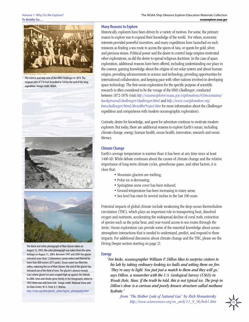
The science and ship crew of the HMS Challenger in 1874. The original crew of 216 had dwindled to 144 by the end of the long expedition. Image credit: NOAA.
12
Volume 1: Why Do We Explore?To Boldly Go…
The NOAA Ship Okeanos Explorer Education Materials Collectionoceanexplorer.noaa.gov
Methane hydrates are ice-like substances formed when molecules of water form an open lattice that surrounds molecules of methane without forming chemical bonds between the two materials. In deep-ocean sediments, conditions of low temperature and high pressure allow methane hydrate deposits to form. There is growing interest in these deposits as an alternative energy source, because the U.S. Geological Survey has estimated that on a global scale, methane hydrates may contain roughly twice the carbon contained in all reserves of coal, oil, and conventional natural gas combined. In addition, methane hydrates are associated with unusual and possibly unique biological communities containing previously-unknown species that may be sources of beneficial pharmaceutical materials. Methane hydrates may also cause big problems, because when heated they can release large amounts of methane, a greenhouse gas that could have (and may already have had) major consequences to the Earth’s climate. At the same time, a sudden release of pressurized methane gas may cause submarine landslides that in turn can trigger catastrophic tsunamis.
Besides methane hydrates, regions such as the Gulf of Mexico produce significant quantities of petroleum. Often, the presence of hydrocarbons at the surface of the seafloor is accompanied by cold-seep communities which are biological communities that derive their energy from gases (such as methane and hydrogen sulfide) and oil seeping out of sediments. In addition to locating new sources of hydrocarbon fuels, exploration of these communities frequently reveals species that are new to science and provides information on ecology and biodiversity that is needed to protect these unique and sensitive environments. For additional discussion about energy, methane hydrates and cold-seep communities, please see Diving Deeper, page 26.
Human HealthImproving human health is another motive for ocean exploration. Almost all drugs derived from natural sources come from terrestrial plants. But recent explorations have found that some marine invertebrates such as sponges, tunicates, ascidians, bryozoans, and octocorals can also produce powerful drug-like substances. Many of these are sessile (non-moving), bottom-dwelling animals that do not appear particularly impressive; yet, they produce more antibiotic, anti-cancer, and anti-inflammatory substances than any group of terrestrial organisms. The potential for discovering important new drugs from deep-ocean organisms is even greater when one considers that most of Earth’s seafloor is still unexplored, and deep-sea explorations routinely find species that have never been seen before. For additional discussion about drugs from the sea, please see the Diving Deeper section on page 32.
Ocean Health “Anyone familiar with the state of the world’s oceans would have a
hard time feeling optimistic. From coral reefs overwhelmed by coastal runoff to tiny but ecologically-vital plankton that are suffering from climate change, the diversity of sea life is fading.”
(Allsopp, et al., 2007)
The health of Earth’s ocean is simultaneously threatened by over-exploitation of large species, destruction of benthic habitats, invasive species, rising temperatures, pollution, and ocean acidification ( Jackson, 2008). On June 5, 2008, NOAA Oceanographer Richard A. Feely told the U.S. House of Representatives Subcommittee on Energy and Environment that by the end of the century, surface ocean pH could be lower than it has been for more than 20 million years.
Though they may be visually unimpressive, Forcepia sponges (left) are the source of the lasonolides and tunicates (right) are the source of ecteinascidin, potential new drugs for treating cancer. Image credit: NOAA.http://oceanexplorer.noaa.gov/explorations/03bio/logs/hirez/lasonolide1_hirez.jpghttp://oceanexplorer.noaa.gov/explorations/03bio/logs/hirez/figure4_hirez.jpg
Limacina helicina, a free-swimming planktonic snail. These snails, known as pteropods, form a calcium carbonate shell and are an important food source in many marine food webs. As levels of dissolved CO2 in seawater rise, skeletal growth rates of pteropods and other calcium-secreting organisms will be reduced due to the effects of dissolved CO2 on ocean acidity. Image credit: Russ Hopcroft, UAF/NOAA.http://www.noaanews.noaa.gov/stories2006/images/pteropod-limacina-helicina.jpg
A marine worm, Hesiocaeca methanicola, on the surface of an orange gas hydrate. A variety of animals use methane hydrates as a source of energy. Image credit: Ian MacDonald.http://oceanexplorer.noaa.gov/explorations/deepeast01/logs/sep23/media/icewormsmed_600.jpg
13
Volume 1: Why Do We Explore? To Boldly Go…
The NOAA Ship Okeanos Explorer Education Materials Collectionoceanexplorer.noaa.gov
“Life will find a way,” according to chaos theorist Ian Malcolm in Jurassic Park (Crichton, 1990). But the question is, “Which life?” Deep-sea explorers often find biological organisms thriving in conditions that would be extremely hostile to humans. But his does not mean that species can simply adapt to stresses from falling pH, rising sea levels and temperatures, pollution and overfishing. We urgently need to learn more about ocean ecosystems and how they affect the rest of our planet. This is one of the most important modern reasons for ocean exploration. Without a doubt, human curiosity, the desire to understand our world, and the excitement of discovery are still among the reasons we explore Earth’s ocean; but we also explore to survive.
For more information about ocean health issues, please see page 33 in Diving Deeper.
ResearchIt is important to note that expeditions to the unexplored ocean can help focus research into critical geographic and subject areas that are likely to produce tangible benefits. Telepresence technology aboard the Okeanos Explorer allows many explorers to participate at a fraction of the cost of traditional expeditions, as well as opportunities for students and the general public to have a first-hand look at the processes of scientific exploration.
Technological InnovationThe challenges of working in the extremely hostile environments of the deep ocean are an ongoing stimulus for technology innovation and development.
Science Education and Ocean LiteracyOcean exploration can help inspire new generations of youth to seek careers in science, technology, engineering and mathematics, and offers vivid examples of how concepts of biology, physical science, and Earth science are useful in the real world. Similarly, the challenges of exploring the deep ocean can provide the basis for problem-solving instruction in technology and engineering. Ocean exploration also provides an engaging context for improving ocean literacy, understanding how the ocean influences our lives, and how we influence the ocean. Widespread ocean literacy is increasingly vital as we confront issues such as ocean health and climate change.
Note that many of the topics discussed above apply to more than one reason to explore. Methane hydrates, for example, are relevant to climate change as a potential source of a greenhouse gas that could accelerate trends toward warmer temperatures. Similarly, pH changes discussed under ocean health are also linked to climate change since increased dissolved carbon dioxide in the ocean is the result of increased carbon dioxide in the atmosphere that may be partially responsible for observed changes in Earth’s climate. The same issues are also relevant to drugs from the sea, since warmer temperatures and changes in ocean circulation patterns are among the stressors that threaten some of the marine organisms that produce pharmacologically-active substances.
The key point is that the ocean processes do not operate in isolation; they interact and affect each other in ways that we are just beginning to understand. We separate these topics as individual examples of reasons to explore, and for improved clarity in an introductory discussion; but it is important to realize that the ocean is an integrated system—individual organisms and processes always interact with many others, and the whole is much more complex than the sum of the parts.
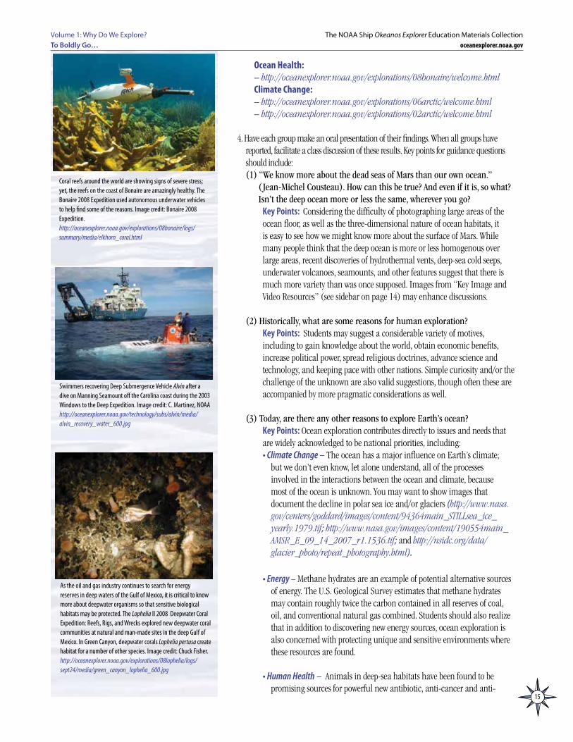
Bathymetric map of the Magic Mountain area on Explorer Ridge, part of the Submarine Ring of Fire. Visit http://oceanexplorer.noaa.gov/explorations/02fire/logs/magicmountain/welcome.html for a virtual tour of the Magic Mountain site. Image credit: NOAA.http://oceanexplorer.noaa.gov/explorations/02fire/logs/hirez/magic-hires.jpg
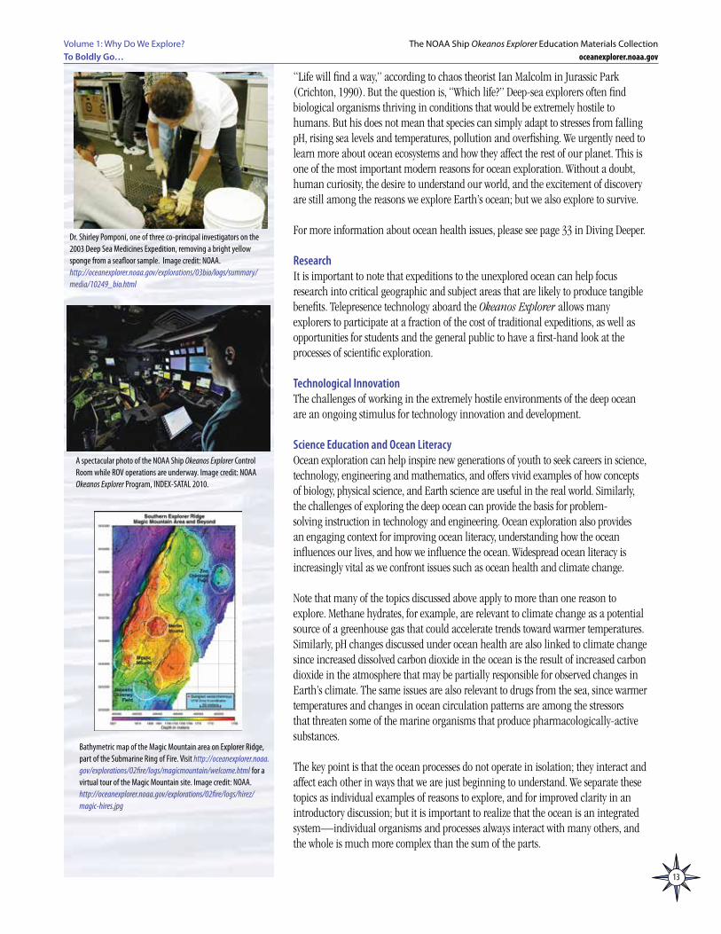
Dr. Shirley Pomponi, one of three co-principal investigators on the 2003 Deep Sea Medicines Expedition, removing a bright yellow sponge from a seafloor sample. Image credit: NOAA.http://oceanexplorer.noaa.gov/explorations/03bio/logs/summary/media/10249_bio.html
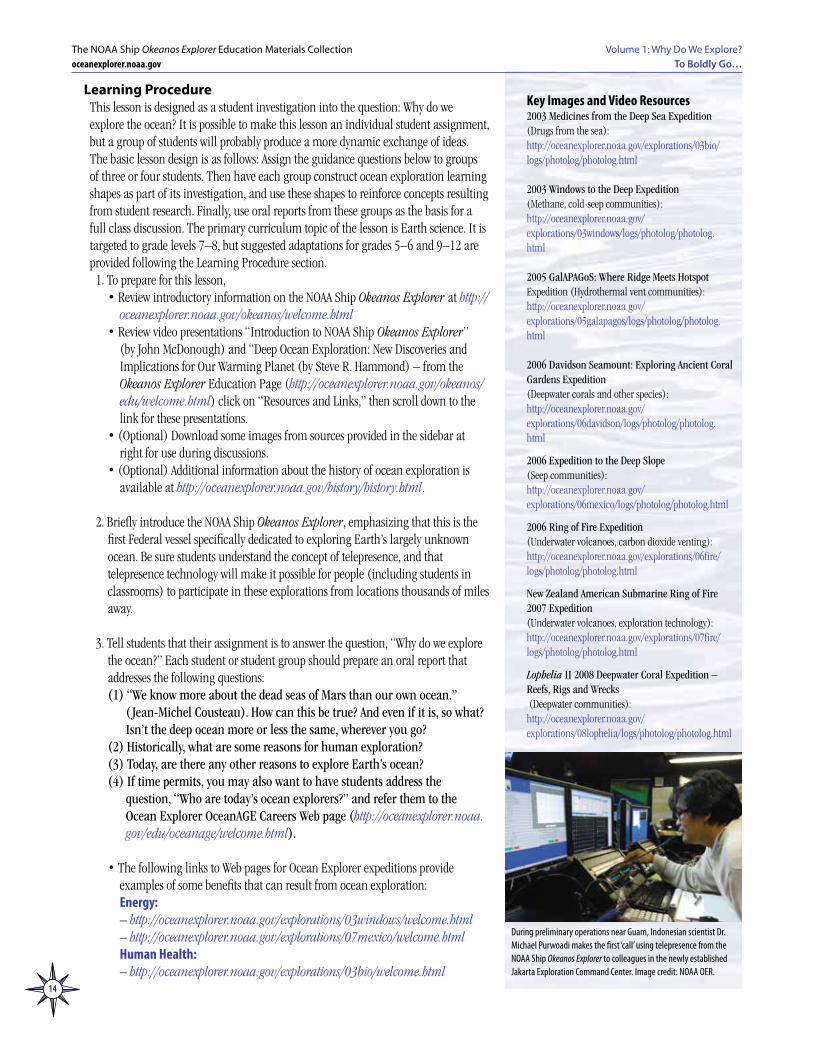
A spectacular photo of the NOAA Ship Okeanos Explorer Control Room while ROV operations are underway. Image credit: NOAA Okeanos Explorer Program, INDEX-SATAL 2010.
14
Volume 1: Why Do We Explore?To Boldly Go…
The NOAA Ship Okeanos Explorer Education Materials Collectionoceanexplorer.noaa.gov
Learning ProcedureThis lesson is designed as a student investigation into the question: Why do we explore the ocean? It is possible to make this lesson an individual student assignment, but a group of students will probably produce a more dynamic exchange of ideas. The basic lesson design is as follows: Assign the guidance questions below to groups of three or four students. Then have each group construct ocean exploration learning shapes as part of its investigation, and use these shapes to reinforce concepts resulting from student research. Finally, use oral reports from these groups as the basis for a full class discussion. The primary curriculum topic of the lesson is Earth science. It is targeted to grade levels 7–8, but suggested adaptations for grades 5–6 and 9–12 are provided following the Learning Procedure section.
1. To prepare for this lesson, • Review introductory information on the NOAA Ship Okeanos Explorer at http://
oceanexplorer.noaa.gov/okeanos/welcome.html• Review video presentations “Introduction to NOAA Ship Okeanos Explorer”
(by John McDonough) and “Deep Ocean Exploration: New Discoveries and Implications for Our Warming Planet (by Steve R. Hammond) – from the Okeanos Explorer Education Page (http://oceanexplorer.noaa.gov/okeanos/edu/welcome.html) click on “Resources and Links,” then scroll down to the link for these presentations.
• (Optional) Download some images from sources provided in the sidebar at right for use during discussions.
• (Optional) Additional information about the history of ocean exploration is available at http://oceanexplorer.noaa.gov/history/history.html.
2. Briefly introduce the NOAA Ship Okeanos Explorer, emphasizing that this is the first Federal vessel specifically dedicated to exploring Earth’s largely unknown ocean. Be sure students understand the concept of telepresence, and that telepresence technology will make it possible for people (including students in classrooms) to participate in these explorations from locations thousands of miles away.
3. Tell students that their assignment is to answer the question, “Why do we explore the ocean?” Each student or student group should prepare an oral report that addresses the following questions:(1) “We know more about the dead seas of Mars than our own ocean.”
( Jean-Michel Cousteau). How can this be true? And even if it is, so what? Isn’t the deep ocean more or less the same, wherever you go?
(2) Historically, what are some reasons for human exploration?(3) Today, are there any other reasons to explore Earth’s ocean?(4) If time permits, you may also want to have students address the
question, “Who are today’s ocean explorers?” and refer them to the Ocean Explorer OceanAGE Careers Web page (http://oceanexplorer.noaa.gov/edu/oceanage/welcome.html).
• The following links to Web pages for Ocean Explorer expeditions provide examples of some benefits that can result from ocean exploration:Energy:– http://oceanexplorer.noaa.gov/explorations/03windows/welcome.html– http://oceanexplorer.noaa.gov/explorations/07mexico/welcome.htmlHuman Health:– http://oceanexplorer.noaa.gov/explorations/03bio/welcome.html
Key Images and Video Resources2003 Medicines from the Deep Sea Expedition (Drugs from the sea): http://oceanexplorer.noaa.gov/explorations/03bio/logs/photolog/photolog.html
2003 Windows to the Deep Expedition(Methane, cold-seep communities): http://oceanexplorer.noaa.gov/explorations/03windows/logs/photolog/photolog.html
2005 GalAPAGoS: Where Ridge Meets Hotspot Expedition (Hydrothermal vent communities): http://oceanexplorer.noaa.gov/explorations/05galapagos/logs/photolog/photolog.html
2006 Davidson Seamount: Exploring Ancient Coral Gardens Expedition (Deepwater corals and other species):http://oceanexplorer.noaa.gov/explorations/06davidson/logs/photolog/photolog.html
2006 Expedition to the Deep Slope (Seep communities): http://oceanexplorer.noaa.gov/explorations/06mexico/logs/photolog/photolog.html
2006 Ring of Fire Expedition (Underwater volcanoes, carbon dioxide venting): http://oceanexplorer.noaa.gov/explorations/06fire/logs/photolog/photolog.html
New Zealand American Submarine Ring of Fire 2007 Expedition (Underwater volcanoes, exploration technology): http://oceanexplorer.noaa.gov/explorations/07fire/logs/photolog/photolog.html
Lophelia II 2008 Deepwater Coral Expedition – Reefs, Rigs and Wrecks (Deepwater communities): http://oceanexplorer.noaa.gov/explorations/08lophelia/logs/photolog/photolog.html
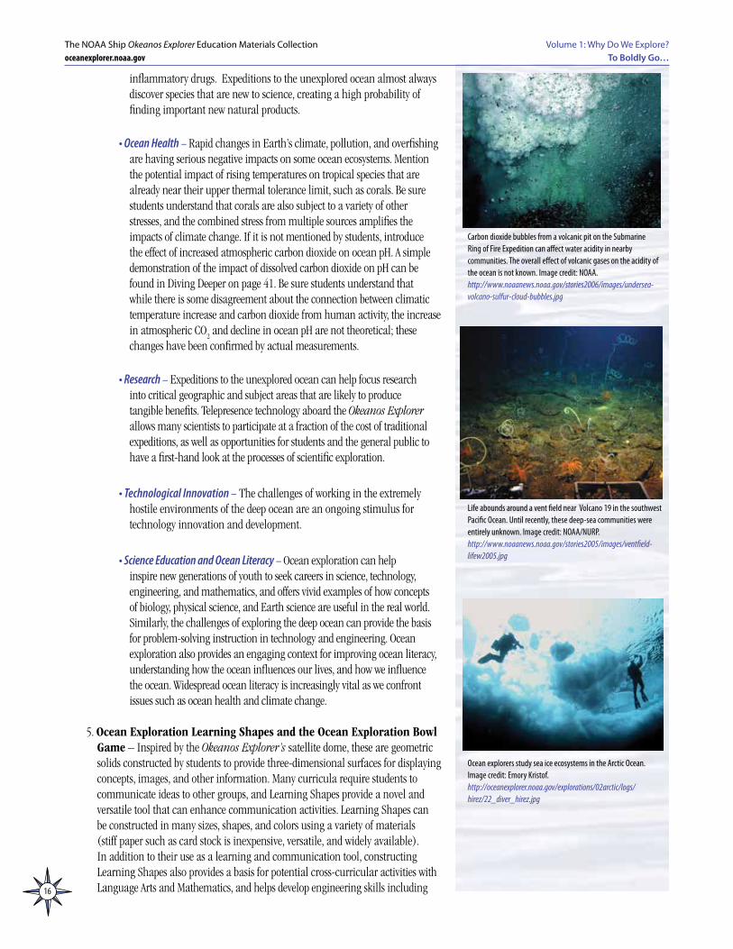
During preliminary operations near Guam, Indonesian scientist Dr. Michael Purwoadi makes the first ‘call’ using telepresence from the NOAA Ship Okeanos Explorer to colleagues in the newly established Jakarta Exploration Command Center. Image credit: NOAA OER.
15
Volume 1: Why Do We Explore? To Boldly Go…
The NOAA Ship Okeanos Explorer Education Materials Collectionoceanexplorer.noaa.gov
Ocean Health:– http://oceanexplorer.noaa.gov/explorations/08bonaire/welcome.htmlClimate Change:– http://oceanexplorer.noaa.gov/explorations/06arctic/welcome.html – http://oceanexplorer.noaa.gov/explorations/02arctic/welcome.html
4. Have each group make an oral presentation of their findings. When all groups have reported, facilitate a class discussion of these results. Key points for guidance questions should include:(1) “We know more about the dead seas of Mars than our own ocean.”
( Jean-Michel Cousteau). How can this be true? And even if it is, so what? Isn’t the deep ocean more or less the same, wherever you go?
Key Points: Considering the difficulty of photographing large areas of the ocean floor, as well as the three-dimensional nature of ocean habitats, it is easy to see how we might know more about the surface of Mars. While many people think that the deep ocean is more or less homogenous over large areas, recent discoveries of hydrothermal vents, deep-sea cold seeps, underwater volcanoes, seamounts, and other features suggest that there is much more variety than was once supposed. Images from “Key Image and Video Resources” (see sidebar on page 14) may enhance discussions.
(2) Historically, what are some reasons for human exploration? Key Points: Students may suggest a considerable variety of motives,
including to gain knowledge about the world, obtain economic benefits, increase political power, spread religious doctrines, advance science and technology, and keeping pace with other nations. Simple curiosity and/or the challenge of the unknown are also valid suggestions, though often these are accompanied by more pragmatic considerations as well.
(3) Today, are there any other reasons to explore Earth’s ocean? Key Points: Ocean exploration contributes directly to issues and needs that
are widely acknowledged to be national priorities, including:• Climate Change – The ocean has a major influence on Earth’s climate;
but we don’t even know, let alone understand, all of the processes involved in the interactions between the ocean and climate, because most of the ocean is unknown. You may want to show images that document the decline in polar sea ice and/or glaciers (http://www.nasa.gov/centers/goddard/images/content/94364main_STILLsea_ice_yearly.1979.tif; http://www.nasa.gov/images/content/190554main_AMSR_E_09_14_2007_r1.1536.tif; and http://nsidc.org/data/glacier_photo/repeat_photography.html).
• Energy – Methane hydrates are an example of potential alternative sources of energy. The U.S. Geological Survey estimates that methane hydrates may contain roughly twice the carbon contained in all reserves of coal, oil, and conventional natural gas combined. Students should also realize that in addition to discovering new energy sources, ocean exploration is also concerned with protecting unique and sensitive environments where these resources are found.
• Human Health – Animals in deep-sea habitats have been found to be promising sources for powerful new antibiotic, anti-cancer and anti-
Coral reefs around the world are showing signs of severe stress; yet, the reefs on the coast of Bonaire are amazingly healthy. The Bonaire 2008 Expedition used autonomous underwater vehicles to help find some of the reasons. Image credit: Bonaire 2008 Expedition.http://oceanexplorer.noaa.gov/explorations/08bonaire/logs/summary/media/elkhorn_coral.html
Swimmers recovering Deep Submergence Vehicle Alvin after a dive on Manning Seamount off the Carolina coast during the 2003 Windows to the Deep Expedition. Image credit: C. Martinez, NOAAhttp://oceanexplorer.noaa.gov/technology/subs/alvin/media/alvin_recovery_water_600.jpg
As the oil and gas industry continues to search for energy reserves in deep waters of the Gulf of Mexico, it is critical to know more about deepwater organisms so that sensitive biological habitats may be protected. The Lophelia II 2008 Deepwater Coral Expedition: Reefs, Rigs, and Wrecks explored new deepwater coral communities at natural and man-made sites in the deep Gulf of Mexico. In Green Canyon, deepwater corals Lophelia pertusa create habitat for a number of other species. Image credit: Chuck Fisher.http://oceanexplorer.noaa.gov/explorations/08lophelia/logs/sept24/media/green_canyon_lophelia_600.jpg
16
Volume 1: Why Do We Explore?To Boldly Go…
The NOAA Ship Okeanos Explorer Education Materials Collectionoceanexplorer.noaa.gov
inflammatory drugs. Expeditions to the unexplored ocean almost always discover species that are new to science, creating a high probability of finding important new natural products.
• Ocean Health – Rapid changes in Earth’s climate, pollution, and overfishing are having serious negative impacts on some ocean ecosystems. Mention the potential impact of rising temperatures on tropical species that are already near their upper thermal tolerance limit, such as corals. Be sure students understand that corals are also subject to a variety of other stresses, and the combined stress from multiple sources amplifies the impacts of climate change. If it is not mentioned by students, introduce the effect of increased atmospheric carbon dioxide on ocean pH. A simple demonstration of the impact of dissolved carbon dioxide on pH can be found in Diving Deeper on page 41. Be sure students understand that while there is some disagreement about the connection between climatic temperature increase and carbon dioxide from human activity, the increase in atmospheric CO
2 and decline in ocean pH are not theoretical; these
changes have been confirmed by actual measurements.
• Research – Expeditions to the unexplored ocean can help focus research into critical geographic and subject areas that are likely to produce tangible benefits. Telepresence technology aboard the Okeanos Explorer allows many scientists to participate at a fraction of the cost of traditional expeditions, as well as opportunities for students and the general public to have a first-hand look at the processes of scientific exploration.
• Technological Innovation – The challenges of working in the extremely hostile environments of the deep ocean are an ongoing stimulus for technology innovation and development.
• Science Education and Ocean Literacy – Ocean exploration can help inspire new generations of youth to seek careers in science, technology, engineering, and mathematics, and offers vivid examples of how concepts of biology, physical science, and Earth science are useful in the real world. Similarly, the challenges of exploring the deep ocean can provide the basis for problem-solving instruction in technology and engineering. Ocean exploration also provides an engaging context for improving ocean literacy, understanding how the ocean influences our lives, and how we influence the ocean. Widespread ocean literacy is increasingly vital as we confront issues such as ocean health and climate change.
5. Ocean Exploration Learning Shapes and the Ocean Exploration Bowl
Game – Inspired by the Okeanos Explorer’s satellite dome, these are geometric solids constructed by students to provide three-dimensional surfaces for displaying concepts, images, and other information. Many curricula require students to communicate ideas to other groups, and Learning Shapes provide a novel and versatile tool that can enhance communication activities. Learning Shapes can be constructed in many sizes, shapes, and colors using a variety of materials (stiff paper such as card stock is inexpensive, versatile, and widely available). In addition to their use as a learning and communication tool, constructing Learning Shapes also provides a basis for potential cross-curricular activities with Language Arts and Mathematics, and helps develop engineering skills including
Life abounds around a vent field near Volcano 19 in the southwest Pacific Ocean. Until recently, these deep-sea communities were entirely unknown. Image credit: NOAA/NURP.http://www.noaanews.noaa.gov/stories2005/images/ventfield-lifew2005.jpg
Carbon dioxide bubbles from a volcanic pit on the Submarine Ring of Fire Expedition can affect water acidity in nearby communities. The overall effect of volcanic gases on the acidity of the ocean is not known. Image credit: NOAA. http://www.noaanews.noaa.gov/stories2006/images/undersea-volcano-sulfur-cloud-bubbles.jpg
Ocean explorers study sea ice ecosystems in the Arctic Ocean. Image credit: Emory Kristof.http://oceanexplorer.noaa.gov/explorations/02arctic/logs/hirez/22_diver_hirez.jpg
17
Volume 1: Why Do We Explore? To Boldly Go…
The NOAA Ship Okeanos Explorer Education Materials Collectionoceanexplorer.noaa.gov
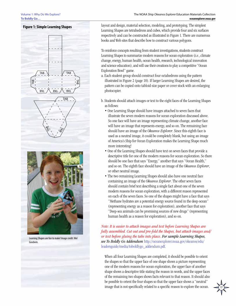
layout and design, material selection, modeling, and prototyping. The simplest Learning Shapes are tetrahedrons and cubes, which provide four and six surfaces respectively and can be constructed as illustrated in Figure 1. There are numerous books and Web sites that describe how to construct various polygons.
To reinforce concepts resulting from student investigations, students construct
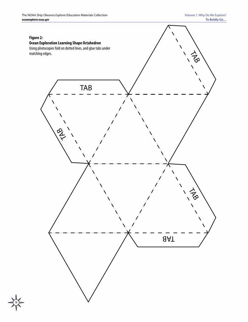
Learning Shapes to summarize modern reasons for ocean exploration (i.e., climate change, energy, human health, ocean health, research, technological innovation and science education), and will use their creations to play a competitive “Ocean Exploration Bowl” game.a. Each student group should construct four octahedrons using the pattern
illustrated in Figure 2 (page 18). If larger Learning Shapes are desired, the pattern can be copied onto tabloid-size paper or cover stock with an enlarging photocopier.
b. Students should attach images or text to the eight faces of the Learning Shapes as follows: • One Learning Shape should have images attached to seven faces that
illustrate the seven modern reasons for ocean exploration discussed above. So one face will have an image representing climate change, another face will have an image that represents energy, and so on. The remaining face should have an image of the Okeanos Explorer. Since this eighth face is used as a neutral image, it could be completely blank, but using an image of America’s Ship for Ocean Exploration makes the Learning Shape much more interesting!
• One of the Learning Shapes should have text on seven faces that provide a descriptive title for one of the modern reasons for ocean exploration. So there should be one face that says “Energy,” another that says “Ocean Health,” and so on. The eighth face should have an image of the Okeanos Explorer, or other neutral image.
• The two remaining Learning Shapes should also have one neutral face containing an image of the Okeanos Explorer. The other seven faces should contain brief text describing a single fact about one of the seven modern reasons for ocean exploration, with a different reason represented on each of the seven faces. So one of the shapes might have a face that says “Methane hydrates are a potential energy source found in the deep ocean” (representing energy as a reason for exploration), another face that says “Deep-sea animals can be promising sources of new drugs” (representing human health as a reason for exploration), and so on.
Note: It is easier to attach images and text before Learning Shapes are
fully assembled. Cut out and pre-fold the Shapes, but attach images and/or text before gluing the tabs into place. For sample Learning Shapes, see To Boldly Go Addendum http://oceanexplorer.noaa.gov/okeanos/edu/leadersguide/media/toboldlygo_addendum.pdf.
When all four Learning Shapes are completed, it should be possible to orient the shapes so that the upper face of one shape shows a picture representing one of the modern reasons for ocean exploration, the upper face of another shape shows a descriptive title stating the reason in words, and the upper faces of the remaining two shapes shows facts relevant to that reason. It should also be possible to orient the four shapes so that the upper face shows a “neutral” image that is not specifically related to a specific reason to explore the ocean.
TAB TABTAB
TAB TAB
TAB
TAB
TABTAB
TAB
TAB TABTAB
TAB TAB
TAB
TAB
TABTAB
TAB
Figure 1: Simple Learning Shapes
Learning Shapes are fun to make! Image credit: Mel Goodwin.
18
Volume 1: Why Do We Explore?To Boldly Go…
The NOAA Ship Okeanos Explorer Education Materials Collectionoceanexplorer.noaa.gov
TABTAB
TABTAB
TAB
Figure 2: Ocean Exploration Learning Shape OctahedronUsing photocopies fold on dotted lines, and glue tabs under matching edges.
19
Volume 1: Why Do We Explore? To Boldly Go…
The NOAA Ship Okeanos Explorer Education Materials Collectionoceanexplorer.noaa.gov
c. Now it’s time to play “Ocean Exploration Bowl!” The object of this game is for student groups to correctly associate, in the shortest possible time, descriptive titles and relevant facts with an image representing a reason for exploration. Groups compete one at a time, and when all groups have competed, one round has been completed. When a group has finished, ask members of other groups to verify that the selected title and facts correctly match the image. Students have to pay attention to make this verification, and because play proceeds rapidly from group to group, there is minimal down time during which students may become distracted.
Assign two students to act as timekeepers. Since groups compete one at a time, timekeepers can be members of other competing groups. Provide each timekeeper with a stopwatch. Have one group arrange their four Learning Shapes on a desk or table so that the image of Okeanos Explorer (or other neutral image) shows on the upper face of each Learning Shape.
You (the educator) should pick up the Learning Shape that has images attached, hold it out of students’ sight, and orient the Learning Shape so that one of the images representing a reason for ocean exploration is facing the palm of your hand. Put the Learning Shape back onto the table, and say “Boldly Go!” as you remove your hand. The timekeepers should start their stopwatches as soon as you say “Boldly Go!”, and students in the group should orient the remaining three cubes as quickly as possible so that the appropriate descriptive title and two relevant facts are facing upward. As soon as they have done this, the group should say “Discovery!” which is the signal for the timekeepers to stop their stopwatches. Have group members state their reason for ocean exploration, and the relevant facts. Record the average from the two stopwatches on a score sheet for the competing group.
Repeat this process for the remaining groups. At least three rounds should be
completed to cover all seven reasons and a good selection of relevant facts. When the winning group has been determined (by the shortest average time over all rounds), award prizes such as small bags of seaweed crackers, or other ocean-related items. Be sure every group receives something, but it’s fine if the winner’s share is larger!
If time is short, you may want to have groups construct only the first Learning Shape with images, then have group members state as many relevant facts as possible when a particular image is turned face up. This eliminates the need for timekeepers, but you should probably have several rounds since student research is likely to yield more facts for some reasons than others.
Adaptations for Other Grade LevelsConsiderations for Grades 5-6 – Some students may not be familiar with hydrothermal vents, deep-sea cold seeps, underwater volcanoes, and seamounts that have been relatively recently discovered, so be sure to have images of these habitats available to show after receiving students’ comments on the Cousteau quotation. Similarly, students may not be aware of the potential for new medicines or alternative energy sources from deep-sea ecosystems. Depending upon their existing knowledge, you may want to focus primarily upon these potentials as contemporary reasons for ocean exploration, since the relationship between deep-ocean processes and climate change may be difficult to understand at this grade level. In addition, students may be intrigued by how little is known about the deep ocean, and may feel that this is sufficient justification for exploration. Be sure students understand that the Okeanos Explorer is the first U.S. ship to be dedicated specifically to exploring the largely unknown ocean.
Ocean exploration requires ongoing technological innovation. Situational Awareness is one such innovation used in Autonomous Underwater Vehicles (AUVs) to provide the ability to sense their surroundings and avoid obstacles. Image credit: NOAA.http://oceanexplorer.noaa.gov/explorations/08auvfest/background/hires/auv_concept_hires.jpg
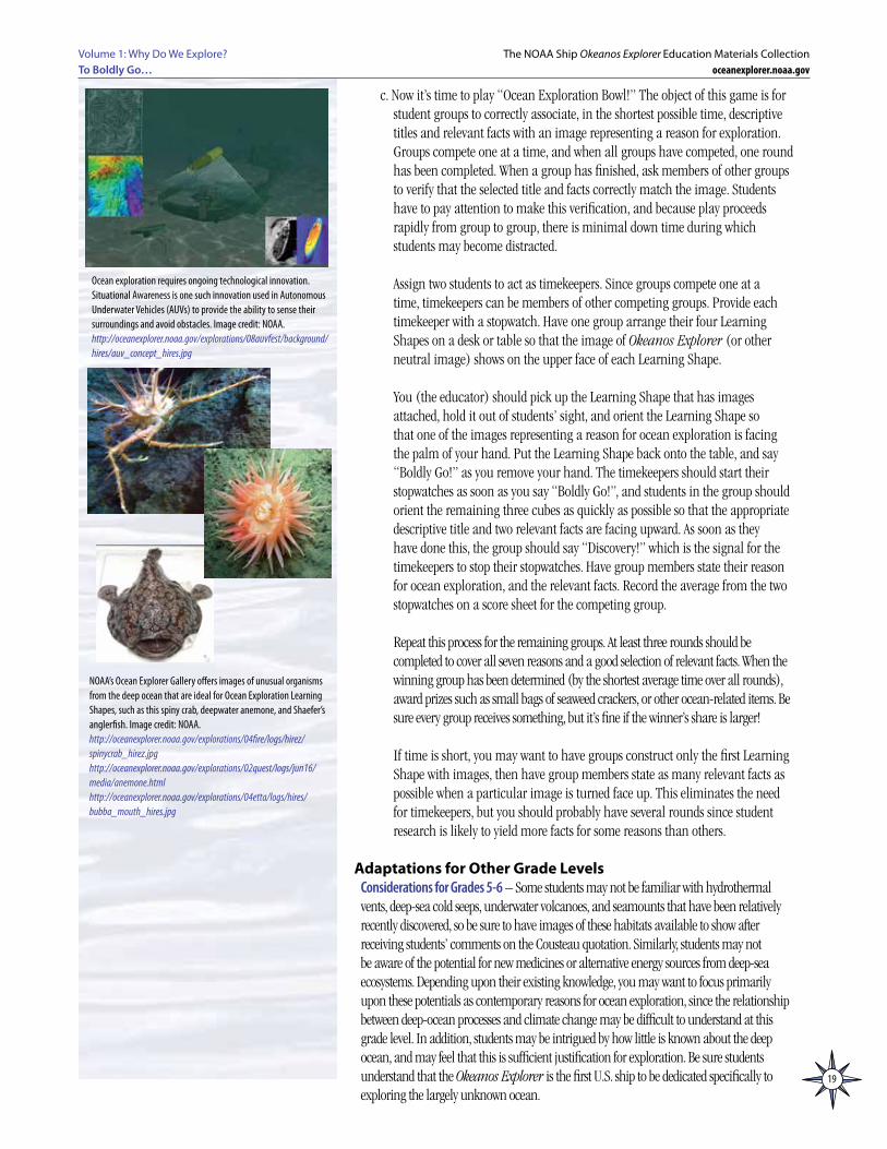
NOAA’s Ocean Explorer Gallery offers images of unusual organisms from the deep ocean that are ideal for Ocean Exploration Learning Shapes, such as this spiny crab, deepwater anemone, and Shaefer’s anglerfish. Image credit: NOAA.http://oceanexplorer.noaa.gov/explorations/04fire/logs/hirez/spinycrab_hirez.jpghttp://oceanexplorer.noaa.gov/explorations/02quest/logs/jun16/media/anemone.htmlhttp://oceanexplorer.noaa.gov/explorations/04etta/logs/hires/bubba_mouth_hires.jpg

20
Volume 1: Why Do We Explore?To Boldly Go…
The NOAA Ship Okeanos Explorer Education Materials Collectionoceanexplorer.noaa.gov
Considerations for Grades 9-12 – Ocean acidification, pH, buffers, carbon dioxide sources and sinks, methane hydrates, deep-sea medicines, and deep-ocean habitats (hydrothermal vents, deep-sea cold seeps, underwater volcanoes, and seamounts) can all be explored in greater detail. Consider assigning these topics to individual student groups prior to beginning a discussion focused on ocean exploration. When groups have completed their reports, lead a discussion to address the Guidance Questions and invite appropriate groups to present relevant information from their reports in the context of “why explore.”
The BRIDGE Connectionwww.vims.edu/bridge/ – In the navigation menu on the left side of the Web page, click “Ocean Science Topics,” then “Human Activities,” then “Technology” for links to information and activities involved with ocean exploration, including satellites, underwater robots, and deep-sea medicines.
The “Me” ConnectionHave students write a brief essay about what ocean life might be like in the second half of the 21st century, and how ocean exploration might affect that future.
Connections to Other SubjectsEnglish/Language Arts, Mathematics, Social Studies
AssessmentWritten reports may be required as part of Learning Procedure Step 3. These reports, discussions and/or the Ocean Exploration Bowl game provide a basis for assessment.
Multimedia Discovery Missions http://www.oceanexplorer.noaa.gov/edu/learning/welcome.html Click on the links to Lessons 3, 5, 12, 13, and 15 for interactive multimedia presentations and Learning Activities on Deep-Sea Corals, Chemosynthesis and Hydrothermal Vent Life, Food, Water, and Medicine from the Sea, Ocean Pollution, and Seamounts.
Lesson Plans in Volume 1 As these lessons were originally developed for Online Professional Development they are accessible online at http://oceanexplorer.noaa.gov/okeanos/edu/welcome.html.
Other ResourcesSee page 217 for Other Resources.
Next Generation Science StandardsLesson plans developed for Volume 1 are correlated with Ocean Literacy EssentialPrinciples and Fundamental Concepts as indicated in the back of this book.Additionally, a separate online document illustrates individual lesson support forthe Performance Expectations and three dimensions of the Next Generation ScienceStandards and associated Common Core State Standards for Mathematics and forEnglish Language Arts & Literacy. This information is provided to educators asa context or point of departure for addressing particular standards and does notnecessarily mean that any lesson fully develops a particular standard, principleor concept. Please see: http://oceanexplorer.noaa.gov/okeanos/edu/collection/wdwe_ngss.pdf.
Send Us Your FeedbackWe value your feedback on this lesson, including how you use it in your formal/informal education settings.Please send your comments to: [email protected]
For More InformationPaula Keener, Director, Education ProgramsNOAA Office of Ocean Exploration and ResearchHollings Marine Laboratory331 Fort Johnson Road, Charleston SC 29412843.762.8818 843.762.8737 (fax)[email protected]
AcknowledgmentsProduced by Mel Goodwin, PhD, Marine Biologist and Science Writer, Charleston, SC. Design/layout: Coastal Images Graphic Design, Charleston, SC. If reproducing this lesson, please cite NOAA as the source, and provide the following URL: http://oceanexplorer.noaa.gov
The Next Generation Science StandardsThe Next Generation Science Standards integrate three dimensions within each standard: Science and Engineering Practices, Disciplinary Core Ideas, and Crosscutting Concepts. The standards are written as student performance expectations and each combines Science and Engineering Practices, Disciplinary Core Ideas, and Crosscutting Concepts as described in A Framework for K-12 Science Education: Practices, Crosscutting Concepts, and Core Ideas (National Research Council, 2012). While specific performance expectations may emphasize only a few of the practice categories, teachers are encouraged to utilize several practices in any instruction. Similarly, only a few crosscutting concepts may be emphasized, but this is not intended to limit instruction.
21
Volume 1: Why Do We Explore? To Boldly Go…
The NOAA Ship Okeanos Explorer Education Materials Collectionoceanexplorer.noaa.gov
Overview of Some Key Data Concerning Global Climate ChangeSince the middle of the 1800’s, Earth’s average temperature has warmed by about 1°F. This doesn’t sound like much of a change, but it is important to realize that Earth’s average temperature is now warmer than it has been at any time since at least 1400 AD. We say “at least” because 1400 AD is as far back as scientists have good estimates of temperatures. Other evidence suggests that Earth’s temperature is warmer now than it has been in many thousands of years, maybe nearly 100,000 years. It is also important to remember that most averages include numbers that are higher and lower than the “average” value. So the warming in some areas can be much higher than 1°F, while other areas may actually be cooler. Debate continues about the causes of climate change and the relative importance of long-term climate cycles, greenhouse gases, and other factors; but it is clear that:
• Mountain glaciers are melting;• Polar ice is decreasing;• Springtime snow cover has been reduced;• Ground temperature has been increasing in many areas; and• Sea level has risen by several inches in the last 100 years.
You may have heard statements such as “Earth’s temperature has been dropping for the last ten years.” These statements are based on the fact that 1998 was abnormally hot due to the strongest El Nino event in the last century. However, the 2000’s were the warmest decade on record and the average global temperature in 2010 tied 2005 as the warmest year since reliable records began in 1880. In the State of the Climate in 2009 report (Arndt, Baringer, and Johnson, 2010), an international team of climate scientists concluded, “Each of the last three decades was warmer than all earlier decades in the instrumental record and each set a new and statistically significant record.” Several years following 1998 were indeed cooler than 1998, but the long-term trend still shows continued warming. There are many factors that affect global temperatures in a single year, and it is not surprising that one year might be cooler than the preceding year. But the global warming trend is a matter of decades, not just one or two years. The long-term trend is still clear: Seven of the eight warmest years on record have occurred since 2001, and the ten warmest years on record have all occurred since 1995.
Within the world scientific community, there is a broad consensus that:• Global warming is unequivocal and primarily human-induced.• Climate changes are underway in the United States and are projected to grow.• Widespread climate-related impacts are occurring now and are expected to
increase.• Climate change will stress water resources.• Crop and livestock production will be increasingly challenged.• Coastal areas are at increasing risk from sea-level rise and storm surge.• Risks to human health will increase.• Climate change will interact with many social and environmental stresses.• Thresholds will be crossed, leading to large changes in climate and ecosystems.• Future climate change and its impacts depend on choices made today.(source: Karl, Melillo, and Peterson, 2009).
Diving Deeper:Additional Information about Key Topics
This section provides additional details and discussion of selected topics mentioned in “Background Information.”
22
Volume 1: Why Do We Explore?To Boldly Go…
The NOAA Ship Okeanos Explorer Education Materials Collectionoceanexplorer.noaa.gov
The scientific consensus on these points is supported by a huge amount of data from many places on Earth. Following is a brief review of a few key points.
Cause of the Observed Warming Earth’s climate is affected by a number of factors, including changes in Earth’sorbit, solar variability, volcanoes, and the greenhouse effect. But the only factorthat coincides with the warming trend of the last century is the observed increasein greenhouse gases, particularly carbon dioxide. There is no credible scientific debate about this: Since the start of the Industrial Revolution, atmospheric carbon dioxideconcentrations have increased from 280 parts per million (ppm) to 380 ppm. Today,the global concentration of carbon dioxide is significantly higher than the naturalrange over the last 800,000 years of 170 – 300 ppm.
Cause of Increasing Atmospheric Carbon DioxideThere is also no scientific debate about the source of increased atmospheric carbon dioxide. Humans burning fossil fuels release billions of tons of carbon into the atmosphere every year, and the quantity of fuels burned has been increasing for over 150 years (see, for example, http://cdiac.ornl.gov/trends/emis/tre_glob.html).
What about volcanoes? Scientists estimate that volcanoes (including underwater volcanoes) emit 145-255 million tons of carbon dioxide into the atmosphere each year. Emissions of carbon dioxide from human activities are estimated at about 30 billion tons per year. So, the amount of carbon dioxide from human activities is more than 100 times greater than the amount of carbon dioxide emitted by volcanoes (http://volcano.oregonstate.edu/education/gases/man.html). Further, if volcanoes had a significant impact, we should see “spikes” on graphs of atmospheric carbon dioxide every time a volcano erupts; but such spikes are not present on these graphs.
What about increases in atmospheric carbon dioxide that happened during pre-human times? It is true that carbon dioxide rose and fell by over 100 ppm at various times in Earth’s history, but these rises took place over 5,000 to 20,000 years; the present increase of 100 ppm has happened in only 150 years. Additional evidence implicating human activities comes from isotope analyses of the carbon and oxygen atoms that make up atmospheric carbon dioxide molecules. These analyses show that the oxygen atoms in some of these molecules are much younger than the carbon atoms in the same molecule. Older carbon could only come from fossil fuel deposits, and the only way these deposits could become airborne is through combustion. Note that the amount of methane released by natural seepage as described below is much less than the amount of carbon released by combustion of fossil fuel, so natural seepage cannot account for the presence of older carbon.
Effect of Continued Increase in Atmospheric Carbon Dioxide Global Temperature IncreaseIf atmospheric carbon dioxide concentrations continue to increase and nothing is done to reduce carbon dioxide emissions, global temperatures are projected to increase by 1.1° to 6.4°C (2° to 11.5°F) by 2100 (Meehl, et al., 2007). So, the minimum expected temperature increase under these conditions is nearly three times twice the increase that has already been observed. The actual increase could be much greater, depending upon the influence of feedbacks. For example, decreasing ice and snow in polar regions means that less solar radiation will be reflected away from Earth’s surface. This would result in more radiation being absorbed at the surface, and increased warming.
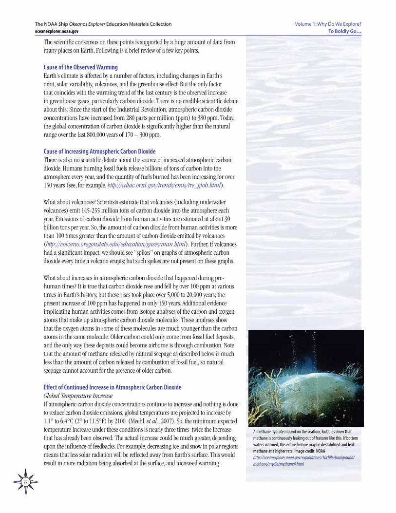
A methane hydrate mound on the seafloor; bubbles show that methane is continuously leaking out of features like this. If bottom waters warmed, this entire feature may be destabilized and leak methane at a higher rate. Image credit: NOAAhttp://oceanexplorer.noaa.gov/explorations/10chile/background/methane/media/methane4.html
23
Volume 1: Why Do We Explore? To Boldly Go…
The NOAA Ship Okeanos Explorer Education Materials Collectionoceanexplorer.noaa.gov
Methane HydratesWarmer temperatures in the Arctic could also trigger another feedback process. Methane hydrates are a type of ice that contains methane molecules surrounded by a cage of frozen water molecules. Most methane hydrates are believed to exist in ocean sediments, but some are also found in high latitude soils called permafrost as well as in tropical wetlands. Increasing temperatures may cause methane hydrates to melt and release methane gas to the atmosphere. Since methane is a powerful greenhouse gas, and decomposes to form carbon dioxide, increased atmospheric methane could result in an increased greenhouse effect and additional warming of Earth’s climate. Brook et al. (2008) report that a sudden, rapid release of methane is very unlikely to occur within 100 years; but it is very likely that warming will increase the rate of chronic methane emission from these sources, and that this additional methane could increase the rate of global temperature rise.
Ocean TemperatureA warmer atmosphere could also mean warmer temperatures in Earth’s ocean. Since the solubility of carbon dioxide decreases as temperature rises, warmer temperatures could decrease carbon dioxide absorption by the ocean creating yet another feedback mechanism. Temperature has an opposite effect on the atmosphere’s capacity for water vapor: Warmer air can hold more water vapor that evaporates from the ocean and land surface. Increased atmospheric water vapor has been observed from satellites, and is primarily due to human influences (Santer, et al., 2007). Water vapor is the most important and abundant greenhouse gas, and increased atmospheric water vapor can strengthen the greenhouse effect and result in additional warming. This effect may be counterbalanced to some extent if increased atmospheric water vapor causes increased cloud cover that reduces the amount of solar radiation reaching Earth’s surface.
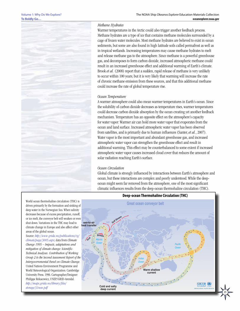
Ocean CirculationGlobal climate is strongly influenced by interactions between Earth’s atmosphere and ocean, but these interactions are complex and poorly understood. While the deep-ocean might seem far removed from the atmosphere, one of the most significant climatic influences results from the deep-ocean thermohaline circulation (THC).
���� �
�����
����
������
�������������������������
������������������������������������
��� �� ����������������
�����������������
��������������������������
������������
�����������
�������������
� � � �� � � � � � � ����
�� ���������������������������������������������� ����������� �������������������������������� ����������������������� ��������� ������������������� ���������� ����� ��������������������������������������������������������������������������� � ���� �����������
World ocean thermohaline circulation (THC) is driven primarily by the formation and sinking of deep water in the Norwegian Sea. When salinity decreases because of excess precipitation, runoff, or ice melt, the conveyor belt will weaken or even shut down. Variations in the THC may lead to climate change in Europe and also affect other areas of the global ocean.Source: http://www.grida.no/publications/vg/climate/page/3085.aspx; data from Climate Change 1995 – Impacts, adaptations and mitigation of climate change: Scientific-Technical Analyses. Contribution of Working Group 2 to the Second Assessment Report of the Intergovernmental Panel on Climate Change. United Nations Environment Programme and World Meteorological Organization. Cambridge University Press. 1996. Cartographer/Designer: Philippe Rekacewicz, UNEP/GRID-Arendal.http://maps.grida.no/library/files/storage/31new.pdf
Deep-ocean Thermohaline Circulation (THC)
24
Volume 1: Why Do We Explore?To Boldly Go…
The NOAA Ship Okeanos Explorer Education Materials Collectionoceanexplorer.noaa.gov
The THC is driven by changes in seawater density. Two factors affect the density of seawater: temperature (the “thermo” part) and salinity (the “haline” part). Major features of the THC include:
• In the Northeastern Atlantic Ocean, atmospheric cooling increases the density of surface waters. Decreased salinity due to freshwater influx partially offsets this increase (since reduced salinity lowers the density of seawater), but temperature has a greater effect, so there is a net increase in seawater density. The formation of sea ice may also play a role as freezing removes water but leaves salt behind causing the density of the unfrozen seawater to increase. The primary locations of dense water formation in the North Atlantic are the Greenland-Iceland-Nordic Seas and the Labrador Sea.
• The dense water sinks into the Atlantic to depths of 1,000 m and below, and flows south along the east coasts of North and South America.
• As the dense water sinks, it is replaced by warm water flowing north in the Gulf Stream and its extension, the North Atlantic Drift (note that the Gulf Stream is primarily a wind driven current, but portions of its circulation—the North Atlantic Drift—are also part of the THC).
• The deep south-flowing current combines with cold, dense waters formed near Antarctica, and flows from west to east in the Deep Circumpolar Current. Some of the mass deflects to the north to enter the Indian and Pacific Oceans.
• Some of the cold water mass is warmed as it approaches the equator, causing density to decrease. Upwelling of deep waters is difficult to observe, and is believed to occur in many places, particularly in the Southern Ocean in the region of the Antarctic Circumpolar Current.
• In the Indian Ocean, the water mass gradually warms and turns in a clockwise direction until it forms a west-moving surface current that moves around the southern tip of Africa into the South Atlantic Ocean.
• In the Pacific, the deepwater mass flows to the north on the western side of the Pacific basin. Some of the mass mixes with warmer water, warms, and dissipates in the North Pacific. The remainder of the mass continues a deep, clockwise circulation. A warm, shallow current also exists in the Pacific, which moves south and west, through the Indonesian archipelago, across the Indian Ocean, around the southern tip of Africa, and into the South Atlantic.
• Evaporation increases the salinity of the current, which flows toward the northwest, joins the Gulf Stream, and flows toward the Arctic regions where it replenishes dense sinking water to begin the cycle again.
The processes outlined above are greatly simplified. In reality, the deep-ocean THC is much more complex, and is not fully understood. Our understanding of the connections between the deep-ocean THC and Earth’s ecosystems is similarly incomplete, but most scientists agree that:
• The THC affects almost all of the world’s ocean (and for this reason, it is often called the “global conveyor belt”);
• The THC plays an important role in transporting dissolved oxygen and nutrients from surface waters to biological communities in deep water; and
• The THC is at least partially responsible for the fact that countries in northwestern Europe (Britain and Scandinavia) are about 9°C warmer than other locations at similar latitudes.
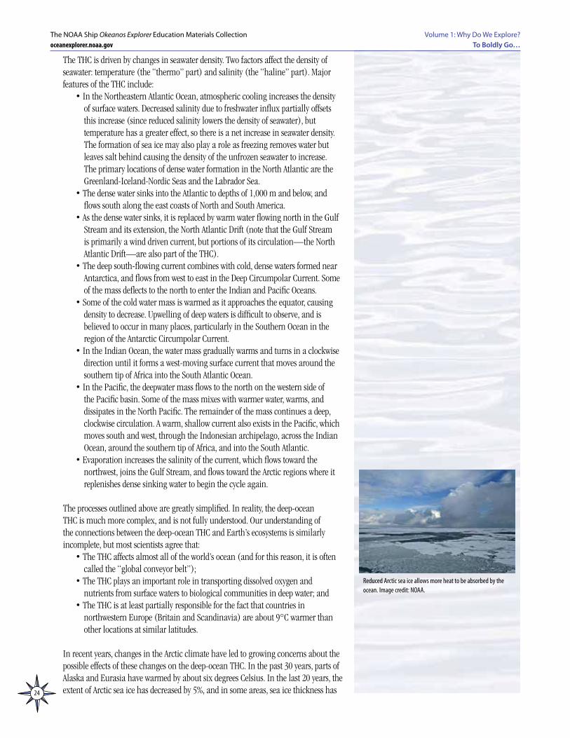
In recent years, changes in the Arctic climate have led to growing concerns about the possible effects of these changes on the deep-ocean THC. In the past 30 years, parts of Alaska and Eurasia have warmed by about six degrees Celsius. In the last 20 years, the extent of Arctic sea ice has decreased by 5%, and in some areas, sea ice thickness has
Reduced Arctic sea ice allows more heat to be absorbed by the ocean. Image credit: NOAA.
25
Volume 1: Why Do We Explore? To Boldly Go…
The NOAA Ship Okeanos Explorer Education Materials Collectionoceanexplorer.noaa.gov
decreased by 40%. Overall, the Arctic climate is warming more rapidly than elsewhere on Earth. Reasons for this include:
• When snow and ice are present, as much as 80% of solar energy that reaches Earth’s surface is reflected back into space. As snow and ice melt, surface reflectivity (called “albedo”) is reduced, so more solar energy is absorbed by Earth’s surface;
• Less heat is required to warm the atmosphere over the Arctic because the Arctic atmosphere is thinner than elsewhere http://oceanexplorer.noaa.gov/explorations/06arctic/logs/leg1_summary/media/slideshow/slideshow.html;
• With less sea ice, the heat absorbed by the ocean in summer is more easily transferred to the atmosphere in winter.
Dense water sinking in the North Atlantic Ocean is one of the principal forces that drives the circulation of the global conveyor belt. Since an increase in freshwater inflow (such as from melting ice) or warmer temperatures in these areas would weaken the processes that cause seawater density to increase, these changes could also weaken the global conveyor belt.
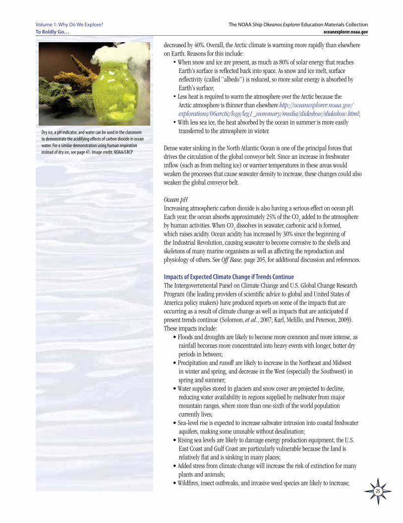
Ocean pHIncreasing atmospheric carbon dioxide is also having a serious effect on ocean pH. Each year, the ocean absorbs approximately 25% of the CO
2 added to the atmosphere
by human activities. When CO2 dissolves in seawater, carbonic acid is formed,
which raises acidity. Ocean acidity has increased by 30% since the beginning of the Industrial Revolution, causing seawater to become corrosive to the shells and skeletons of many marine organisms as well as affecting the reproduction and physiology of others. See Off Base, page 205, for additional discussion and references.
Impacts of Expected Climate Change if Trends ContinueThe Intergovernmental Panel on Climate Change and U.S. Global Change Research Program (the leading providers of scientific advice to global and United States of America policy makers) have produced reports on some of the impacts that are occurring as a result of climate change as well as impacts that are anticipated if present trends continue (Solomon, et al., 2007; Karl, Melillo, and Peterson, 2009). These impacts include:
• Floods and droughts are likely to become more common and more intense, as rainfall becomes more concentrated into heavy events with longer, hotter dry periods in between;
• Precipitation and runoff are likely to increase in the Northeast and Midwest in winter and spring, and decrease in the West (especially the Southwest) in spring and summer;
• Water supplies stored in glaciers and snow cover are projected to decline, reducing water availability in regions supplied by meltwater from major mountain ranges, where more than one-sixth of the world population currently lives;
• Sea-level rise is expected to increase saltwater intrusion into coastal freshwater aquifers, making some unusable without desalination;
• Rising sea levels are likely to damage energy production equipment; the U.S. East Coast and Gulf Coast are particularly vulnerable because the land is relatively flat and is sinking in many places;
• Added stress from climate change will increase the risk of extinction for many plants and animals;
• Wildfires, insect outbreaks, and invasive weed species are likely to increase;
Dry ice, a pH indicator, and water can be used in the classroom to demonstrate the acidifying effects of carbon dioxide in ocean water. For a similar demonstration using human respiration instead of dry ice, see page 41. Image credit: NOAA/CRCP
26
Volume 1: Why Do We Explore?To Boldly Go…
The NOAA Ship Okeanos Explorer Education Materials Collectionoceanexplorer.noaa.gov
• Increasing atmospheric carbon dioxide concentration is causing an increase in ocean acidity, which reduces the ability of shellfish, corals and other sea life to build shells and skeletons out of calcium carbonate, and also interferes with reproduction in other marine organisms.
Ocean Energy OverviewEarth’s ocean contains enormous energy resources in its waters, in the adjacent atmosphere, and in the mantle and crust beneath the seafloor. Ocean energy resources include non-renewable sources such as oil and gas, as well as renewable sources, such as the energy of offshore winds, waves, and ocean currents. With the exception of oil and gas, ocean energy resources have not been extensively utilized in the United States, primarily because many of the technologies are not well-developed, nor have they been economically competitive with fossil fuels and nuclear power.
Underutilized ocean energy resources, though, are receiving increasing attention as technologies improve, prices of traditional energy sources continue to increase, and political considerations become more problematic. The following overview includes energy sources that are already being used in commercial-scale projects, as well as sources for which harvest technologies are still in the early stages of development.
Note: “Ocean energy” is sometimes used as a term that includes only forms of renewable energy that may be derived from the sea. The following discussion also includes non-renewable methane hydrates, because of the enormous quantity of energy that is potentially available from these substances, and the widespread occurrence of methane hydrates in deep-sea environments.
Salinity Gradient (Osmotic) EnergyWhen fresh water and salt water are separated by a semipermeable membrane, water will move through the membrane into the salt solution (only water molecules can pass through a semipermeable membrane). This water movement is driven by a force called osmotic pressure, which is defined as the pressure that would have to be applied to the salt water solution to prevent the influx of water through the semipermeable membrane. Influx of fresh water will increase the volume of the salt water. If the salt water is in a closed container, the volume cannot increase because water is essentially incompressible, and the pressure in the container will rise until it equals the osmotic pressure. If the pressure in the container is released, it can be used to drive a turbine to generate electricity. This method for utilizing salinity gradient energy is called Pressure Retarded Osmosis.
Reverse Electrodialysis is another salinity gradient technique that uses a series of anion and cation exchange membranes (negatively charged ions can pass through anion exchange membranes; positively charged ions can pass through cation exchange membranes). When fresh water and salt water are separated by an anion exchange membrane, negatively charged ions will move from the salt water into the fresh water until the concentration on both sides of the membrane are equal. Similarly, when fresh water and salt water are separated by an cation exchange membrane, positively charged ions will move from the salt water into the fresh water until the concentration on both sides of the membrane are equal. A reverse electrodialysis cell is essentially a salt battery with alternating containers of fresh water and salt water separated by an alternating series of anion and cation exchange membranes. If electrodes are placed at opposite ends of the cell and connected to an electric circuit, a voltage will be produced in the circuit.
27
Volume 1: Why Do We Explore? To Boldly Go…
The NOAA Ship Okeanos Explorer Education Materials Collectionoceanexplorer.noaa.gov
Development of salinity gradient energy technology is still in its infancy, though the potential energy is large in locations where rivers mix with salt water.
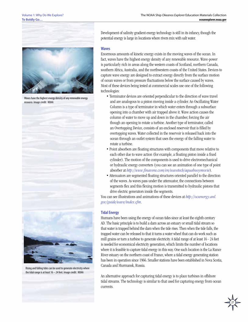
WavesEnormous amounts of kinetic energy exists in the moving waves of the ocean. In fact, waves have the highest energy density of any renewable resource. Wave-power is particularly rich in areas along the western coasts of Scotland, northern Canada, southern Africa, Australia, and the northwestern coasts of the United States. Devices to capture wave energy are designed to extract energy directly from the surface motion of ocean waves or from pressure fluctuations below the surface caused by waves. Most of these devices being tested at commercial scales use one of the following technologies:
• Terminator devices are oriented perpendicular to the direction of wave travel and are analogous to a piston moving inside a cylinder. An Oscillating Water Column is a type of terminator in which water enters through a subsurface opening into a chamber with air trapped above it. Wave action causes the column of water to move up and down in the chamber, forcing the air though an opening to rotate a turbine. Another type of terminator, called an Overtopping Device, consists of an enclosed reservoir that is filled by overtopping waves. Water collected in the reservoir is released back into the ocean through an outlet system that uses the energy of the falling water to rotate a turbine.
• Point absorbers are floating structures with components that move relative to each other due to wave action (for example, a floating piston inside a fixed cylinder). The motion of the components is used to drive electromechanical or hydraulic energy converters (you can see an animation of one type of point absorber at http://www.finavera.com/en/wavetech/aquabuoymovie).
• Attenuators are segmented floating structures oriented parallel to the direction of the waves. As waves pass under the attenuator, the connections between segments flex and this flexing motion is transmitted to hydraulic pistons that drive electric generators inside the segments.
You can see illustrations and animations of these devices at http://ocsenergy.anl.gov/guide/wave/index.cfm.
Tidal EnergyHumans have been using the energy of ocean tides since at least the eighth century AD. The basic principle is to build a dam across an estuary or small tidal stream so that water is trapped behind the dam when the tide rises. Then when the tide falls, the trapped water can be released to that it turns a water wheel that can do work such as mill grains or turn a turbine to generate electricity. A tidal range of at least 16 - 24 feet is needed for economical electricity generation, which limits the number of locations where it is feasible to capture tidal energy in this way. One such location is the La Rance River estuary on the northern coast of France, where a tidal energy generating station has been in operation since 1966. Smaller stations have been established in Nova Scotia, Canada and Murmansk, Russia.
An alternative approach for capturing tidal energy is to place turbines in offshore tidal streams. The technology is similar to that used for capturing energy from ocean currents.
Waves have the highest energy density of any renewable energy resource. Image credit: NOAA
Rising and falling tides can be used to generate electricity where the tidal range is at least 16 – 24 feet. Image credit: NOAA
28
Volume 1: Why Do We Explore?To Boldly Go…
The NOAA Ship Okeanos Explorer Education Materials Collectionoceanexplorer.noaa.gov
Current EnergyOcean currents, such as the Gulf Stream, Florida Straits Current, and California Current, are driven by wind, solar heating, and density variations of large ocean water masses. These currents are relatively constant and flow in one direction only, while the velocity of tidal currents closer to shore varies constantly and their direction changes several times each day. Ocean currents contain an enormous amount of energy; for example, it has been estimated that all of Florida’s electrical needs could be met by capturing less than 1% of the available energy in the Gulf Stream.
Technology to capture ocean current energy is presently in the early stages of development, and there are no commercial scale turbines producing electricity for regular distribution. Experimental projects include submerged water turbines similar to wind turbines, as well as doughnut-shaped turbines with blades resembling those seen in jet engines (see http://ocsenergy.anl.gov/guide/current/index.cfm for illustrations).
Thermal EnergyI owe all to the ocean; it produces electricity, and electricity gives heat,
light, motion, and, in a word, life to the Nautilus.— Jules Verne, 1870
Captain Nemo’s explanation of engineering aboard the Nautilus in 20,000 Leagues Under the Sea provides the first documented reference to the use of ocean chemistry to produce electricity. A decade later, French Engineer Jacques D’Arsonval suggested the possibility of using ocean temperature differences to produce electricity.
This idea is based on the fact that Earth’s ocean covers slightly more than 70 percent of the Earth’s surface, making the ocean Earth’s largest collector and storage system for solar energy. On an average day, 60 million square kilometers (23 million square miles) of tropical seas absorb an amount of solar radiation equal in heat content to about 250 billion barrels of oil (in 2008, the world daily consumption of oil is estimated to have been 84.5 million barrels). So, harvesting even a very small fraction of the radiant energy absorbed by Earth’s ocean could have a significant impact on human energy needs.
Ocean Thermal Energy Conversion (OTEC) is a technology to convert solar radiation absorbed by the ocean into electric power. The basis for this concept is that surface ocean waters receive most solar radiation and consequently are warmer than deeper waters. Where the temperature difference between surface water and deep water is about 20°C (36°F), an OTEC system can produce a significant amount of power.
D’Arsonval’s original idea was to pump warm seawater through a heat exchanger to vaporize a fluid with a low boiling point (such as ammonia), and then use the expanding vapor to turn an electricity-generating turbine. Cold seawater would be pumped through a second heat exchanger to condense the vapor back into a liquid, which would be recycled through the system. This type of OTEC is called a closed-cycle system. Pilot-scale closed-cycle OTEC systems have been successful in producing electric power.
Open-cycle OTEC systems use warm seawater that boils when it is placed in a low-pressure container. The expanding steam drives an electricity-generating turbine. Cold seawater is used to condense the steam back to water. This water is almost

29
Volume 1: Why Do We Explore? To Boldly Go…
The NOAA Ship Okeanos Explorer Education Materials Collectionoceanexplorer.noaa.gov
pure fresh water, since the salt is left behind in the low-pressure container when the seawater boils. Experimental open-cycle OTEC plants have also successfully produced electric power, in some cases with energy conversion efficiencies as high as 97%.Hybrid OTEC systems combine some features of both closed-cycle and open-cycle systems: Warm seawater enters a vacuum chamber where it is evaporated into steam (similar to the open-cycle evaporation process) that is used to vaporize a low-boiling-point fluid (as in closed-cycle system) that drives a turbine to produce electricity.
Another type of thermal energy comes from the earth itself. This geothermal energy is produced in Earth’s core by the decay of radioactive particles. Earth’s core consists of an inner mass of solid iron and an outer core of melted rock called magma. The outer core is surrounded by Earth’ s crust, which is 3 - 5 miles thick under the oceans and 15 - 35 miles thick under the continents. Volcanoes occur where magma comes close to the surface of the crust. In some areas, water enters cracks in the crust, comes close to hot magma, and turns into boiling hot water or steam. The heated water may emerge at the surface of Earth’s crust as a hot spring, or may erupt into the air as a geyser. Geothermally heated water has been used for centuries to heat buildings, for bathing, and for cooking, and more recently to generate electricity.
Most geothermal activity in the world occurs along the boundaries of tectonic plates encircling the Pacific Ocean, in an area called the Ring of Fire. This area has been the subject of Ocean Explorer expeditions from 2002 through 2007, which documented numerous underwater volcanoes, hydrothermal vent fields and other geothermal features, many of which were unexplored prior to these expeditions. Technology for capturing geothermal energy from these sources is in the early stages of development, but pilot projects are planned or underway in several locations including the Azores, Northern Mariana Islands, and Cascades Mountains of the Pacific Northwest; and at least one system has been proposed to directly harvest energy from deep-sea hydrothermal vents.
SolarEnergy from the sun is the primary energy source for all photosynthetic ecosystems, and also drives winds, waves, and deep-ocean currents. In fact, energy from wind, waves, currents, and OTEC could be considered as indirect forms of solar energy (similarly, tidal current energy could be considered as an indirect form of gravitational energy, since tidal currents are driven by gravitational forces between Earth, its moon, and the sun). Solar energy technologies that are presently used in land-based installations may also be developed for offshore use.
Concentrating Solar Power (CSP) technology concentrates the sun’s rays to produce steam to drive turbines or other devices to generate electricity. In the United States, CSP plants have been operating reliably for more than 15 years. CSP installations typically are one of three types:
• Trough systems consist of long mirrors that are curved to form parabolas with oil-filled pipes running along the long axis of the mirror at the focal point of the parabola. The mirrors focus sunlight onto the pipes and heat the oil up to 750°F. The hot oil is used to make steam that drives a steam turbine to produce electricity.
• Power towers (also called central receivers) have many large, flat mirrors that track the sun and focus its rays onto a receiver that is on top of a tall tower. The concentrated sunlight heats a fluid, which is used to make steam or is stored for later use (this allows electricity to be produced even if the sun is not
Geothermal energy has been used for centuries. Most of Earth’s geothermal activity occurs along the Ring of Fire, which has been investigated by Ocean Explorer expeditions since 2002.Image credit: NOAA and NSF
Energy from the sun is the primary energy source for photosynthesis, winds, waves, and deep-ocean currents. Image credit: NOAA Okeanos Explorer Program, INDEX-SATAL 2010
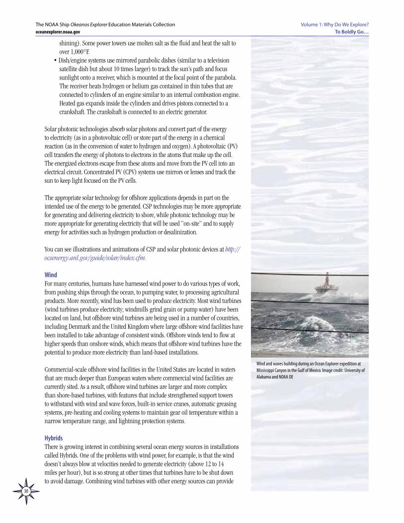
30
Volume 1: Why Do We Explore?To Boldly Go…
The NOAA Ship Okeanos Explorer Education Materials Collectionoceanexplorer.noaa.gov
shining). Some power towers use molten salt as the fluid and heat the salt to over 1,000°F.
• Dish/engine systems use mirrored parabolic dishes (similar to a television satellite dish but about 10 times larger) to track the sun’s path and focus sunlight onto a receiver, which is mounted at the focal point of the parabola. The receiver heats hydrogen or helium gas contained in thin tubes that are connected to cylinders of an engine similar to an internal combustion engine. Heated gas expands inside the cylinders and drives pistons connected to a crankshaft. The crankshaft is connected to an electric generator.
Solar photonic technologies absorb solar photons and convert part of the energy to electricity (as in a photovoltaic cell) or store part of the energy in a chemical reaction (as in the conversion of water to hydrogen and oxygen). A photovoltaic (PV) cell transfers the energy of photons to electrons in the atoms that make up the cell. The energized electrons escape from these atoms and move from the PV cell into an electrical circuit. Concentrated PV (CPV) systems use mirrors or lenses and track the sun to keep light focused on the PV cells.
The appropriate solar technology for offshore applications depends in part on the intended use of the energy to be generated. CSP technologies may be more appropriate for generating and delivering electricity to shore, while photonic technology may be more appropriate for generating electricity that will be used “on-site” and to supply energy for activities such as hydrogen production or desalinization.
You can see illustrations and animations of CSP and solar photonic devices at http://ocsenergy.anl.gov/guide/solar/index.cfm.
WindFor many centuries, humans have harnessed wind power to do various types of work, from pushing ships through the ocean, to pumping water, to processing agricultural products. More recently, wind has been used to produce electricity. Most wind turbines (wind turbines produce electricity; windmills grind grain or pump water) have been located on land, but offshore wind turbines are being used in a number of countries, including Denmark and the United Kingdom where large offshore wind facilities have been installed to take advantage of consistent winds. Offshore winds tend to flow at higher speeds than onshore winds, which means that offshore wind turbines have the potential to produce more electricity than land-based installations.
Commercial-scale offshore wind facilities in the United States are located in waters that are much deeper than European waters where commercial wind facilities are currently sited. As a result, offshore wind turbines are larger and more complex than shore-based turbines, with features that include strengthened support towers to withstand with wind and wave forces, built-in service cranes, automatic greasing systems, pre-heating and cooling systems to maintain gear oil temperature within a narrow temperature range, and lightning protection systems.
HybridsThere is growing interest in combining several ocean energy sources in installations called Hybrids. One of the problems with wind power, for example, is that the wind doesn’t always blow at velocities needed to generate electricity (above 12 to 14 miles per hour), but is so strong at other times that turbines have to be shut down to avoid damage. Combining wind turbines with other energy sources can provide
Wind and waves building during an Ocean Explorer expedition at Mississippi Canyon in the Gulf of Mexico. Image credit: University of Alabama and NOAA OE
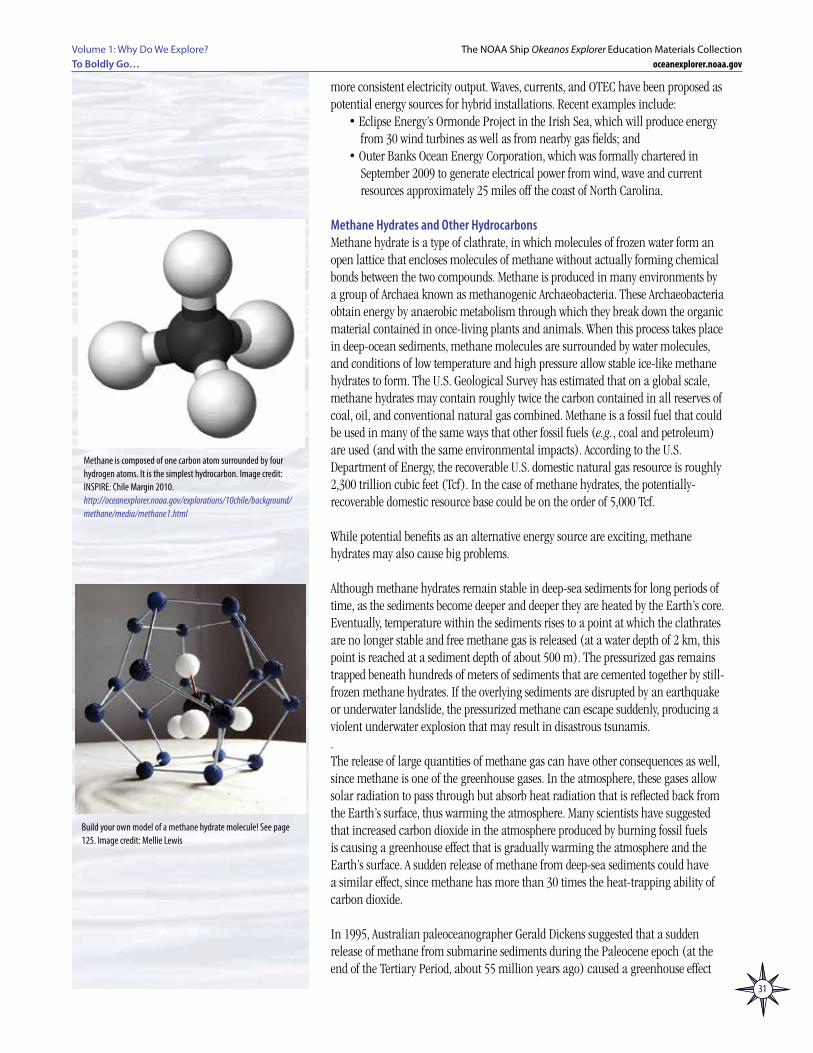
31
Volume 1: Why Do We Explore? To Boldly Go…
The NOAA Ship Okeanos Explorer Education Materials Collectionoceanexplorer.noaa.gov
more consistent electricity output. Waves, currents, and OTEC have been proposed as potential energy sources for hybrid installations. Recent examples include:
• Eclipse Energy’s Ormonde Project in the Irish Sea, which will produce energy from 30 wind turbines as well as from nearby gas fields; and
• Outer Banks Ocean Energy Corporation, which was formally chartered in September 2009 to generate electrical power from wind, wave and current resources approximately 25 miles off the coast of North Carolina.
Methane Hydrates and Other HydrocarbonsMethane hydrate is a type of clathrate, in which molecules of frozen water form an open lattice that encloses molecules of methane without actually forming chemical bonds between the two compounds. Methane is produced in many environments by a group of Archaea known as methanogenic Archaeobacteria. These Archaeobacteria obtain energy by anaerobic metabolism through which they break down the organic material contained in once-living plants and animals. When this process takes place in deep-ocean sediments, methane molecules are surrounded by water molecules, and conditions of low temperature and high pressure allow stable ice-like methane hydrates to form. The U.S. Geological Survey has estimated that on a global scale, methane hydrates may contain roughly twice the carbon contained in all reserves of coal, oil, and conventional natural gas combined. Methane is a fossil fuel that could be used in many of the same ways that other fossil fuels (e.g., coal and petroleum) are used (and with the same environmental impacts). According to the U.S. Department of Energy, the recoverable U.S. domestic natural gas resource is roughly 2,300 trillion cubic feet (Tcf). In the case of methane hydrates, the potentially-recoverable domestic resource base could be on the order of 5,000 Tcf.
While potential benefits as an alternative energy source are exciting, methane hydrates may also cause big problems.
Although methane hydrates remain stable in deep-sea sediments for long periods of time, as the sediments become deeper and deeper they are heated by the Earth’s core. Eventually, temperature within the sediments rises to a point at which the clathrates are no longer stable and free methane gas is released (at a water depth of 2 km, this point is reached at a sediment depth of about 500 m). The pressurized gas remains trapped beneath hundreds of meters of sediments that are cemented together by still-frozen methane hydrates. If the overlying sediments are disrupted by an earthquake or underwater landslide, the pressurized methane can escape suddenly, producing a violent underwater explosion that may result in disastrous tsunamis.. The release of large quantities of methane gas can have other consequences as well, since methane is one of the greenhouse gases. In the atmosphere, these gases allow solar radiation to pass through but absorb heat radiation that is reflected back from the Earth’s surface, thus warming the atmosphere. Many scientists have suggested that increased carbon dioxide in the atmosphere produced by burning fossil fuels is causing a greenhouse effect that is gradually warming the atmosphere and the Earth’s surface. A sudden release of methane from deep-sea sediments could have a similar effect, since methane has more than 30 times the heat-trapping ability of carbon dioxide.
In 1995, Australian paleoceanographer Gerald Dickens suggested that a sudden release of methane from submarine sediments during the Paleocene epoch (at the end of the Tertiary Period, about 55 million years ago) caused a greenhouse effect
Methane is composed of one carbon atom surrounded by four hydrogen atoms. It is the simplest hydrocarbon. Image credit: INSPIRE: Chile Margin 2010.http://oceanexplorer.noaa.gov/explorations/10chile/background/methane/media/methane1.html
Build your own model of a methane hydrate molecule! See page 125. Image credit: Mellie Lewis
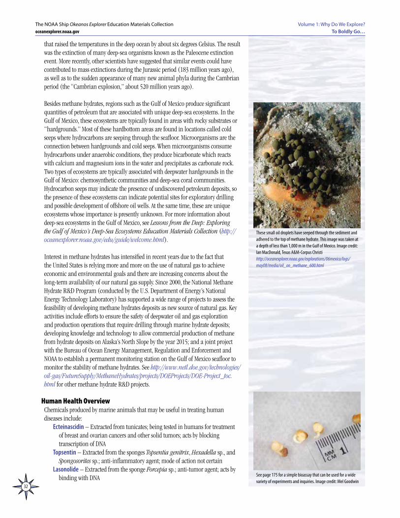
32
Volume 1: Why Do We Explore?To Boldly Go…
The NOAA Ship Okeanos Explorer Education Materials Collectionoceanexplorer.noaa.gov
that raised the temperatures in the deep ocean by about six degrees Celsius. The result was the extinction of many deep-sea organisms known as the Paleocene extinction event. More recently, other scientists have suggested that similar events could have contributed to mass extinctions during the Jurassic period (183 million years ago), as well as to the sudden appearance of many new animal phyla during the Cambrian period (the “Cambrian explosion,” about 520 million years ago).
Besides methane hydrates, regions such as the Gulf of Mexico produce significant quantities of petroleum that are associated with unique deep-sea ecosystems. In the Gulf of Mexico, these ecosystems are typically found in areas with rocky substrates or “hardgrounds.” Most of these hardbottom areas are found in locations called cold seeps where hydrocarbons are seeping through the seafloor. Microorganisms are the connection between hardgrounds and cold seeps. When microorganisms consume hydrocarbons under anaerobic conditions, they produce bicarbonate which reacts with calcium and magnesium ions in the water and precipitates as carbonate rock. Two types of ecosystems are typically associated with deepwater hardgrounds in the Gulf of Mexico: chemosynthetic communities and deep-sea coral communities. Hydrocarbon seeps may indicate the presence of undiscovered petroleum deposits, so the presence of these ecosystems can indicate potential sites for exploratory drilling and possible development of offshore oil wells. At the same time, these are unique ecosystems whose importance is presently unknown. For more information about deep-sea ecosystems in the Gulf of Mexico, see Lessons from the Deep: Exploring the Gulf of Mexico’s Deep-Sea Ecosystems Education Materials Collection (http://oceanexplorer.noaa.gov/edu/guide/welcome.html).
Interest in methane hydrates has intensified in recent years due to the fact that the United States is relying more and more on the use of natural gas to achieve economic and environmental goals and there are increasing concerns about the long-term availability of our natural gas supply. Since 2000, the National Methane Hydrate R&D Program (conducted by the U.S. Department of Energy’s National Energy Technology Laboratory) has supported a wide range of projects to assess the feasibility of developing methane hydrates deposits as new source of natural gas. Key activities include efforts to ensure the safety of deepwater oil and gas exploration and production operations that require drilling through marine hydrate deposits; developing knowledge and technology to allow commercial production of methane from hydrate deposits on Alaska’s North Slope by the year 2015; and a joint project with the Bureau of Ocean Energy Management, Regulation and Enforcement and NOAA to establish a permanent monitoring station on the Gulf of Mexico seafloor to monitor the stability of methane hydrates. See http://www.netl.doe.gov/technologies/oil-gas/FutureSupply/MethaneHydrates/projects/DOEProjects/DOE-Project_toc.html for other methane hydrate R&D projects.
Human Health OverviewChemicals produced by marine animals that may be useful in treating human diseases include:
Ecteinascidin – Extracted from tunicates; being tested in humans for treatment of breast and ovarian cancers and other solid tumors; acts by blocking transcription of DNA
Topsentin – Extracted from the sponges Topsentia genitrix, Hexadella sp., and Spongosorites sp.; anti-inflammatory agent; mode of action not certain
Lasonolide – Extracted from the sponge Forcepia sp.; anti-tumor agent; acts by binding with DNA See page 175 for a simple bioassay that can be used for a wide
variety of experiments and inquiries. Image credit: Mel Goodwin
These small oil droplets have seeped through the sediment and adhered to the top of methane hydrate. This image was taken at a depth of less than 1,000 m in the Gulf of Mexico. Image credit: Ian MacDonald, Texas A&M-Corpus Christi http://oceanexplorer.noaa.gov/explorations/06mexico/logs/may08/media/oil_on_methane_600.html
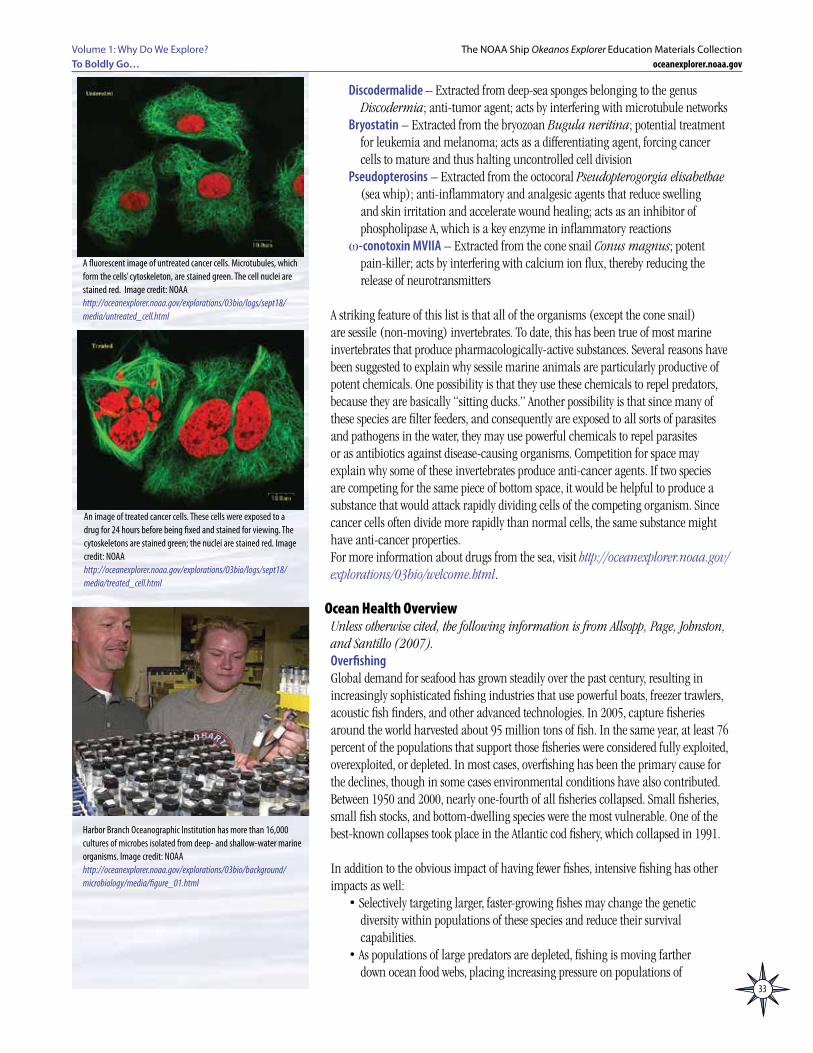
33
Volume 1: Why Do We Explore? To Boldly Go…
The NOAA Ship Okeanos Explorer Education Materials Collectionoceanexplorer.noaa.gov
Discodermalide – Extracted from deep-sea sponges belonging to the genus Discodermia; anti-tumor agent; acts by interfering with microtubule networks
Bryostatin – Extracted from the bryozoan Bugula neritina; potential treatment for leukemia and melanoma; acts as a differentiating agent, forcing cancer cells to mature and thus halting uncontrolled cell division
Pseudopterosins – Extracted from the octocoral Pseudopterogorgia elisabethae (sea whip); anti-inflammatory and analgesic agents that reduce swelling and skin irritation and accelerate wound healing; acts as an inhibitor of phospholipase A, which is a key enzyme in inflammatory reactions
w-conotoxin MVIIA – Extracted from the cone snail Conus magnus; potent pain-killer; acts by interfering with calcium ion flux, thereby reducing the release of neurotransmitters
A striking feature of this list is that all of the organisms (except the cone snail) are sessile (non-moving) invertebrates. To date, this has been true of most marine invertebrates that produce pharmacologically-active substances. Several reasons have been suggested to explain why sessile marine animals are particularly productive of potent chemicals. One possibility is that they use these chemicals to repel predators, because they are basically “sitting ducks.” Another possibility is that since many of these species are filter feeders, and consequently are exposed to all sorts of parasites and pathogens in the water, they may use powerful chemicals to repel parasites or as antibiotics against disease-causing organisms. Competition for space may explain why some of these invertebrates produce anti-cancer agents. If two species are competing for the same piece of bottom space, it would be helpful to produce a substance that would attack rapidly dividing cells of the competing organism. Since cancer cells often divide more rapidly than normal cells, the same substance might have anti-cancer properties.For more information about drugs from the sea, visit http://oceanexplorer.noaa.gov/explorations/03bio/welcome.html.
Ocean Health OverviewUnless otherwise cited, the following information is from Allsopp, Page, Johnston, and Santillo (2007).OverfishingGlobal demand for seafood has grown steadily over the past century, resulting in increasingly sophisticated fishing industries that use powerful boats, freezer trawlers, acoustic fish finders, and other advanced technologies. In 2005, capture fisheries around the world harvested about 95 million tons of fish. In the same year, at least 76 percent of the populations that support those fisheries were considered fully exploited, overexploited, or depleted. In most cases, overfishing has been the primary cause for the declines, though in some cases environmental conditions have also contributed. Between 1950 and 2000, nearly one-fourth of all fisheries collapsed. Small fisheries, small fish stocks, and bottom-dwelling species were the most vulnerable. One of the best-known collapses took place in the Atlantic cod fishery, which collapsed in 1991.
In addition to the obvious impact of having fewer fishes, intensive fishing has other impacts as well:
• Selectively targeting larger, faster-growing fishes may change the genetic diversity within populations of these species and reduce their survival capabilities.
• As populations of large predators are depleted, fishing is moving farther down ocean food webs, placing increasing pressure on populations of
Harbor Branch Oceanographic Institution has more than 16,000 cultures of microbes isolated from deep- and shallow-water marine organisms. Image credit: NOAAhttp://oceanexplorer.noaa.gov/explorations/03bio/background/microbiology/media/figure_01.html
A fluorescent image of untreated cancer cells. Microtubules, which form the cells’ cytoskeleton, are stained green. The cell nuclei are stained red. Image credit: NOAAhttp://oceanexplorer.noaa.gov/explorations/03bio/logs/sept18/media/untreated_cell.html
An image of treated cancer cells. These cells were exposed to a drug for 24 hours before being fixed and stained for viewing. The cytoskeletons are stained green; the nuclei are stained red. Image credit: NOAAhttp://oceanexplorer.noaa.gov/explorations/03bio/logs/sept18/media/treated_cell.html
34
Volume 1: Why Do We Explore?To Boldly Go…
The NOAA Ship Okeanos Explorer Education Materials Collectionoceanexplorer.noaa.gov
smaller, shorter-lived fishes and resulting in simplified food webs. These webs are less able to compensate for changes caused by climate shifts or other environmental factors.
• Overfishing herbivorous species can result in excessive growth of algae and other marine plants. This is a significant problem in coral reef ecosystems where removal of herbivorous fishes is resulting in corals being displaced by algae.
• Depletion of traditional fisheries is causing modern fishing vessels to move onto the high seas where there is little or no fisheries regulation or management.
• In addition to harvesting fishes that are valuable as food, industrial fishing is also targeting other species for conversion into fishmeal or fish oil. Since many of the latter species are low in ocean food webs, overfishing of these stocks can have serious impacts on many other species.
• Substantial numbers of seabirds, marine mammals, and sea turtles become entangled or hooked accidentally by fishing gear, causing further disruption to ocean food webs.
• Overcapacity in the world’s fishing fleets (i.e., too many boats, not enough fish) is causing an increase in illegal, unregulated, and unreported (IUU) fishing, which may account for as much as 20 percent of the global fishery harvest. IUU fishing includes bottom trawling and other methods that cause severe damage to marine ecosystems, and threaten marine diversity, the livelihood of local fishing communities, and the food security of coastal countries.
Because overfishing is a global problem, scientists and policymakers in many countries have begun to cooperate on a new approach to manage ocean resources. This approach has protecting entire marine ecosystems as its primary objective, and emphasizes a precautionary approach (in contrast to approaches that focus on maximum extraction of resources). A key element of this approach is establishing networks of marine protected areas that protect entire ecosystems and allow biodiversity to recover and flourish. Outside these reserves, the ecosystem approach emphasizes interaction between species, rather than focusing on individual species that are targeted for harvest. The precautionary aspect of the ecosystem approach requires those who want to use ocean resources to show that their activities will not harm the marine environment, instead of requiring resource managers to establish maximum limits for resource use. As Allsopp et al. (2007) point out, current approaches that favor freedom to fish and freedom OF the seas will need to be replaced with the new concept of freedom FOR the seas to continue to exist as we know them. In the U.S., programs for stewardship of living marine resources through science-based conservation and management of healthy ecosystems are overseen by NOAA Fisheries Service (see http://www.nmfs.noaa.gov/ for more information).
As the global demand for seafood continues to increase, there has been a rapid expansion in aquaculture over the past 30 years. Aquaculture produced about 40% of all fish harvested in 2005, consumes more than a third of the worldwide production of fishmeal, and is the fastest-growing animal-food production sector in the world. Like many other intensive food-producing industries that require high inputs, large-scale aquaculture may have negative environmental impacts, such as: net food loss (when the mass of fishmeal required to grow a species is greater than the mass of food that is produced); depletion of wild stocks for seed; habitat loss; nutrient pollution; or invasive species. Aquaculture has the potential to reduce harvest pressure on natural populations. Countries that use an ecosystem approach to marine resource management may also include aquaculture as part of their overall strategy,
35
Volume 1: Why Do We Explore? To Boldly Go…
The NOAA Ship Okeanos Explorer Education Materials Collectionoceanexplorer.noaa.gov
along with measures to avoid negative impacts (see http://aquaculture.noaa.gov/welcome.html for more information).
Habitat DestructionNearshore marine habitats are susceptible to damage or destruction by coastal development, but perhaps the greatest damage for the ocean as a whole comes from bottom trawling, a fishing method that uses a weighted net that is dragged along the seafloor. The result is that almost everything is removed from the ocean floor, and the bottom is converted to mud that forms a plume behind the trawlers. Bottom trawling is analogous to clearcutting in old growth forests. Bottom trawling causes severe habitat destruction, particularly in deep-ocean coral reefs and seamounts that provide habitats for many species. Photographs of seafloor habitats off the coasts of Norway and the United Kingdom show trawl scars up to four kilometers long, some of which have destroyed reefs that were 4,500 years old. Off the Atlantic coast of Florida, an estimated 90–99 percent of reefs formed by the deepwater coral Oculina have been destroyed. Many countries have banned bottom trawling in some areas, but this practice is still unregulated over many parts of Earth’s ocean, including areas that contain sea mounts and deepwater coral ecosystems. In 2006, NOAA Fisheries designated more than 150,000 square miles off the U.S. West Coast as Essential Fish Habitat, which prohibited destructive fishing methods. Oculina habitats off the coast of Florida were closed to fishing in 1984. In 2001, part of the Ocean Explorer Islands in the Stream Expedition included experimental efforts to restore some damaged areas on the Oculina Banks (see http://oceanexplorer.noaa.gov/explorations/islands01/log/sep2/sep2.html for more information).
Ecosystem-based approaches to marine resource management may include similar restoration efforts (for other examples, see http://www.habitat.noaa.gov/rc_awards11mcoastalproject.html).
Invasive SpeciesInvasive species are non-native species that have been introduced to a region, have established thriving reproductive populations, and are expanding their range. Invasive species often have no natural predators in their new environment, and can successfully compete with and possibly replace native species. Invasive species are usually introduced accidentally or deliberately by humans. A particularly dangerous example is the Mediterranean clone of Caulerpa taxifolia, a marine alga containing a toxin that is lethal to some species and may interfere with the eggs of some marine mammals. C. taxifolia was accidentally introduced into the Mediterranean by a marine aquarium, and is now forming dense mats that displace invertebrates, fish, and native algae from the seafloor. Until recently, C. taxifolia was a popular species in aquarium stores. The European Green Crab (Carcinus maenas) is another invasive species, introduced to the U.S. over 150 years ago in the ballast and heavily fouled outer hulls of wooden ships coming from Europe. These crabs feed on a variety of organisms, including clams, oysters, mussels, marine worms and small crustaceans, and are a serious potential competitor for native fish and bird species. At the turn of the century, European green crabs almost destroyed the soft clam industry of Maine and surrounding waterways, and is at least partially responsible for the decline of scallop populations on Martha’s Vineyard. In California, the green crab has caused the loss of as much as 50 percent of Manila clam stocks and declines in other crab populations. Lionfish (Pterois volitans) are native to the Indo-Pacific from Australia north to southern Japan and south to Micronesia, but have recently been seen along the Atlantic coast of the United States and in the Caribbean; probably introduced in
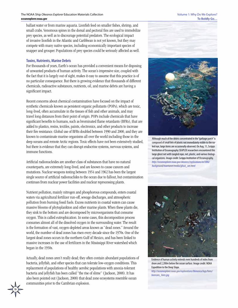
36
Volume 1: Why Do We Explore?To Boldly Go…
The NOAA Ship Okeanos Explorer Education Materials Collectionoceanexplorer.noaa.gov
ballast water or from marine aquaria. Lionfish feed on smaller fishes, shrimp, and small crabs. Venomous spines in the dorsal and pectoral fins are used to immobilize prey species, as well as to discourage potential predators. The ecological impact of invasive lionfish in the Atlantic and Caribbean is not yet known, but they may compete with many native species, including economically important species of snapper and grouper. Populations of prey species could be seriously affected as well.
Toxins, Nutrients, Marine DebrisFor thousands of years, Earth’s ocean has provided a convenient means for disposing of unwanted products of human activity. The ocean’s impressive size, coupled with the fact that it is largely out of sight, makes it easy to assume that this practice is of no particular consequence. But there is growing evidence that thousands of different chemicals, radioactive substances, nutrients, oil, and marine debris are having a significant impact.
Recent concerns about chemical contamination have focused on the impact of synthetic chemicals known as persistent organic pollutants (POPs), which are toxic, long-lived, often accumulate in the tissues of fish and other animals, and may travel long distances from their point of origin. POPs include chemicals that have significant benefits to humans, such as brominated flame retardants (BFRs), that are added to plastics, resins, textiles, paints, electronics, and other products to increase their fire resistance. Global use of BFRs doubled between 1990 and 2000, and they are known to contaminate marine organisms all over the world including those in the deep oceans and remote Arctic regions. Toxic effects have not been extensively studied, but there is evidence that they can disrupt endocrine systems, nervous systems, and immune functions.
Artificial radionucleides are another class of substances that have no natural counterparts, are extremely long-lived, and are known to cause cancers and mutations. Nuclear weapons testing between 1954 and 1962 has been the largest single source of artificial radionuclides to the ocean due to fallout, but contamination continues from nuclear power facilities and nuclear reprocessing plants.
Nutrient pollution, mainly nitrogen and phosphorous compounds, enters coastal waters via agricultural fertilizer run-off, sewage discharges, and atmospheric pollution from burning fossil fuels. Excess nutrients in coastal waters can cause massive blooms of phytoplankton and other marine plants. When these plants die, they sink to the bottom and are decomposed by microorganisms that consume oxygen. This is called eutrophication. In some cases, this decomposition process consumes almost all of the dissolved oxygen in the surrounding water. The result is the formation of vast, oxygen-depleted areas known as “dead zones.” Around the world, the number of dead zones has risen every decade since the 1970s. One of the largest dead zones occurs in the northern Gulf of Mexico, and has been linked to massive increases in the use of fertilizers in the Mississippi River watershed which began in the 1950s.
Actually, dead zones aren’t really dead; they often contain abundant populations of bacteria, jellyfish, and other species that can tolerate low-oxygen conditions. This replacement of populations of healthy aerobic populations with anoxia-tolerant bacteria and jellyfish has been called “the rise of slime” ( Jackson, 2008). It has also been pointed out ( Jackson, 2008) that dead zone ecosystems resemble ocean communities prior to the Cambrian explosion.
Evidence of human activity extends even hundreds of miles from shore and 2,200m below the ocean surface. Image credit: NOAA Expedition to the Deep Slope.http://oceanexplorer.noaa.gov/explorations/06mexico/logs/hires/beercans_hires.jpg
Although much of the debris concentrated in the “garbage patch” is composed of small bits of plastic not immediately visible to the na-ked eye, large items are occasionally observed. On Aug. 11, Scripps Institution of Oceanography SEAPLEX researchers encountered this large ghost net with tangled rope, net, plastic, and various biologi-cal organisms. Image credit: Scripps Institution of Oceanography.http://oceanexplorer.noaa.gov/okeanos/explorations/ex1006/background/mantanet/media/ghost_net.html
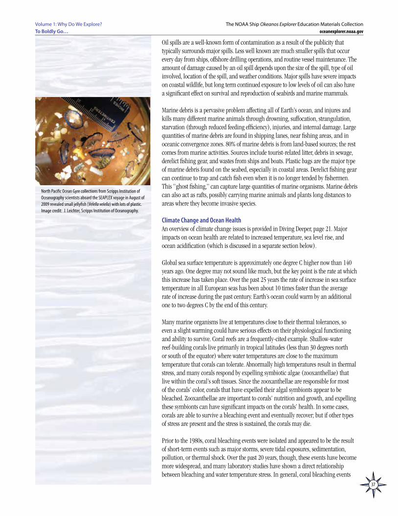
37
Volume 1: Why Do We Explore? To Boldly Go…
The NOAA Ship Okeanos Explorer Education Materials Collectionoceanexplorer.noaa.gov
Oil spills are a well-known form of contamination as a result of the publicity that typically surrounds major spills. Less well known are much smaller spills that occur every day from ships, offshore drilling operations, and routine vessel maintenance. The amount of damage caused by an oil spill depends upon the size of the spill, type of oil involved, location of the spill, and weather conditions. Major spills have severe impacts on coastal wildlife, but long term continued exposure to low levels of oil can also have a significant effect on survival and reproduction of seabirds and marine mammals.
Marine debris is a pervasive problem affecting all of Earth’s ocean, and injures and kills many different marine animals through drowning, suffocation, strangulation, starvation (through reduced feeding efficiency), injuries, and internal damage. Large quantities of marine debris are found in shipping lanes, near fishing areas, and in oceanic convergence zones. 80% of marine debris is from land-based sources; the rest comes from marine activities. Sources include tourist-related litter, debris in sewage, derelict fishing gear, and wastes from ships and boats. Plastic bags are the major type of marine debris found on the seabed, especially in coastal areas. Derelict fishing gear can continue to trap and catch fish even when it is no longer tended by fishermen. This “ghost fishing,” can capture large quantities of marine organisms. Marine debris can also act as rafts, possibly carrying marine animals and plants long distances to areas where they become invasive species.
Climate Change and Ocean HealthAn overview of climate change issues is provided in Diving Deeper, page 21. Major impacts on ocean health are related to increased temperature, sea level rise, and ocean acidification (which is discussed in a separate section below).
Global sea surface temperature is approximately one degree C higher now than 140 years ago. One degree may not sound like much, but the key point is the rate at which this increase has taken place. Over the past 25 years the rate of increase in sea surface temperature in all European seas has been about 10 times faster than the average rate of increase during the past century. Earth’s ocean could warm by an additional one to two degrees C by the end of this century.
Many marine organisms live at temperatures close to their thermal tolerances, so even a slight warming could have serious effects on their physiological functioning and ability to survive. Coral reefs are a frequently-cited example. Shallow-water reef-building corals live primarily in tropical latitudes (less than 30 degrees north or south of the equator) where water temperatures are close to the maximum temperature that corals can tolerate. Abnormally high temperatures result in thermal stress, and many corals respond by expelling symbiotic algae (zooxanthellae) that live within the coral’s soft tissues. Since the zooxanthellae are responsible for most of the corals’ color, corals that have expelled their algal symbionts appear to be bleached. Zooxanthellae are important to corals’ nutrition and growth, and expelling these symbionts can have significant impacts on the corals’ health. In some cases, corals are able to survive a bleaching event and eventually recover; but if other types of stress are present and the stress is sustained, the corals may die.
Prior to the 1980s, coral bleaching events were isolated and appeared to be the result of short-term events such as major storms, severe tidal exposures, sedimentation, pollution, or thermal shock. Over the past 20 years, though, these events have become more widespread, and many laboratory studies have shown a direct relationship between bleaching and water temperature stress. In general, coral bleaching events
North Pacific Ocean Gyre collections from Scripps Institution of Oceanography scientists aboard the SEAPLEX voyage in August of 2009 revealed small jellyfish (Velella velella) with lots of plastic. Image credit: J. Leichter, Scripps Institution of Oceanography.
38
Volume 1: Why Do We Explore?To Boldly Go…
The NOAA Ship Okeanos Explorer Education Materials Collectionoceanexplorer.noaa.gov
often occur in areas where the sea surface temperature rises one degree C or more above the normal maximum temperature.
It is possible that corals’ physiology might change to allow them to become acclimated to higher temperatures, or that populations might adapt if individual corals’ ability to tolerate higher temperatures provided a survival advantage that allowed these corals to become more numerous. There is no indication, however, that either of these possibilities is actually happening. It is important to remember that the impacts of rising ocean temperatures are not confined to corals; corals happen to be very conspicuous and have been the subject of scientific research for many years, so changes are likely to be noticed. Similar impacts are almost certainly taking place in many other species that are less-studied or are presently unknown to science.
Even when individual species are able to tolerate increased temperatures, they may still be affected by changes within their food webs. For example, warmer waters in northwestern Europe have caused clams (Macoma balthica) to spawn earlier in the year, but blooms of phytoplankton on which the clams feed do not happen until later in the spring. Clam larvae also face increased predation from shrimp whose abundance has increased in early spring due to warmer temperatures.
Sea-level rise is caused by the expansion of sea water as it warms, as well as melting of ice on land (melting sea ice doesn’t increase sea level, as you can demonstrate with ice cubes in a glass of water). For at least 2,000 years prior to 1900, sea-level changed very little. During the last century, however, sea-level rose by roughly 20 cm (8 inches) and is expected to continue rising for at least several decades. The amount of additional rise will depend largely on how much melting occurs at the polar ice caps. Even if greenhouse gas concentrations were stabilized immediately, sea level will continue to rise from thermal expansion, and ice sheets will continue to melt. Increased sea level will have significant impacts on low-lying coastal areas and on species whose habitats are in these areas.
Increased influx of fresh water from melting ice sheets coupled with warmer ocean temperatures may also cause changes in ocean currents, that are driven by temperature and salinity differences between large masses of seawater. Potential changes to the deep-ocean thermohaline circulation (“The Great Ocean Conveyor Belt”) are described on page 23.
Some of the most rapid warming is taking place in Earth’s polar regions. Continued loss of sea ice is expected to have negative impacts on species that depend upon the sea ice habitat, such as fishes, birds, seals, whales, and polar bears. These are discussed in The Good, The Bad and The Arctic, a lesson plan from the Ocean Explorer 2005 Hidden Ocean Expedition (http://oceanexplorer.noaa.gov/explorations/05arctic/background/edu/media/arctic05_goodandbad.pdf).
Ocean AcidificationOcean acidification is “the other carbon dioxide problem,” additional to the problem of carbon dioxide as a greenhouse gas. For many years, carbon dioxide in Earth’s atmosphere has been increasing. Regardless of the reasons for this increase and the possible connection with climate change, dissolved carbon dioxide in the ocean has increased along with atmospheric CO
2. More dissolved carbon dioxide means a
lower ocean pH. This, in turn, leads to a decrease in carbonate ions that are essential to the process of calcification through which many organisms produce shells and other skeletal structures. Corals, shellfish, echinoderms, and many marine plankton

39
Volume 1: Why Do We Explore? To Boldly Go…
The NOAA Ship Okeanos Explorer Education Materials Collectionoceanexplorer.noaa.gov
build body parts through calcification. Pteropods are planktonic snails that are an important component of food chains in high-latitude regions, and have been shown to have pitted or partially dissolved shells in waters where carbonate ions are depleted.On June 5, 2008, NOAA Oceanographer Richard A. Feely told the U.S. House of Representatives Subcommittee on Energy and Environment that the ocean currently absorbs 22 million tons of carbon dioxide daily, and that scientists estimate the pH of ocean surface waters has fallen by about 0.11 units from an average of about 8.21 to 8.10 since the beginning of the industrial revolution. Feely also said that if carbon dioxide emissions continue according to predictions, the surface water pH will decrease to about 7.8 – 7.9 by the end of the century. “To put this in historical perspective, the resulting surface ocean pH would be lower than it has been for more than 20 million years,” he said.
Ocean acidification is a result of increased CO2 emissions, and is not directly related
to climate change. There are many uncertainties about the causes, extent, and impacts of global climate change; but these do not apply to ocean acidification which can be observed happening right now and is highly predictable into the future. Measures to reduce global temperatures or the concentration of other greenhouse gases will have no effect on ocean acidification. Only a reduction in atmospheric CO
2
concentrations will affect the acidification problem.
Research is just beginning on the impacts of ocean acidification on marine organisms and ecosystems (more than 60% of the research papers on this subject have been published since 2004). Impacts have been observed in many species, however, and range from interference with calcification processes to reduced resistance to other environmental stresses such as increasing temperatures and pollution.
Where Do We Go From Here?Ocean Health issues revolve around two points: 1) Earth’s ocean is about systems; everything is connected. 2) Human activities have global impacts on Earth’s ocean.
It’s very easy to be overwhelmed by the magnitude of ocean health problems, and just assume we can do nothing. The reality is that these problems did not arise through a single, deliberate action. They are the result of numerous individual actions that took place without any consideration for their collective impacts on Earth’s ecosystems. And another reality is that effective solutions to these problems will not occur in a single, global action, but rather will involve numerous individual actions that by themselves seem insignificant, but collectively can have global impacts. Individually, we are all insignificant on a global scale. Collectively, we have global impacts. The root cause of many ocean health problems is the cumulative impact of individual actions; and many solutions to these problems also depend upon the cumulative impact of individual actions.
What Do pH Numbers Mean?An “acid” is commonly defined as a chemical that releases hydrogen ions (abbreviated H+ ). The pH (which stands for “power of hydrogen”) of a solution is defined as the negative logarithm of the hydrogen ion concentration in moles per liter. So, pH = – log [H+]
where brackets are understood to mean “concentration.”
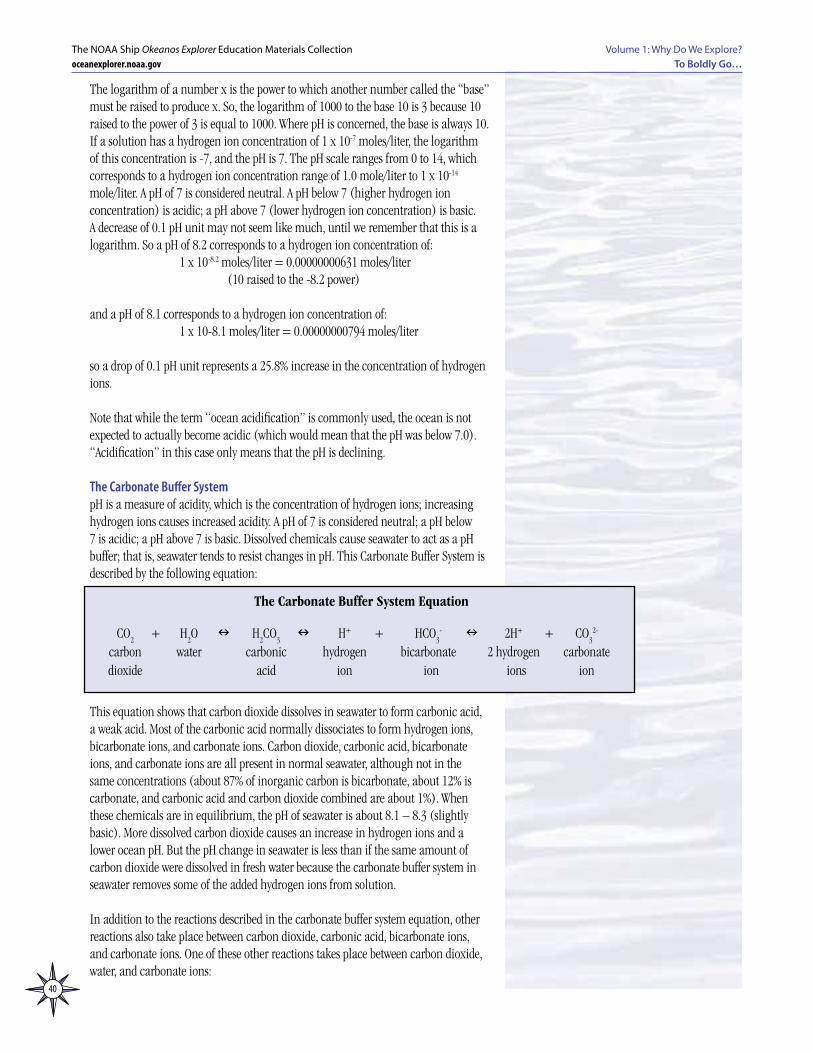
40
Volume 1: Why Do We Explore?To Boldly Go…
The NOAA Ship Okeanos Explorer Education Materials Collectionoceanexplorer.noaa.gov
The logarithm of a number x is the power to which another number called the “base” must be raised to produce x. So, the logarithm of 1000 to the base 10 is 3 because 10 raised to the power of 3 is equal to 1000. Where pH is concerned, the base is always 10.If a solution has a hydrogen ion concentration of 1 x 10⁻⁷ moles/liter, the logarithm of this concentration is -7, and the pH is 7. The pH scale ranges from 0 to 14, which corresponds to a hydrogen ion concentration range of 1.0 mole/liter to 1 x 10-14 mole/liter. A pH of 7 is considered neutral. A pH below 7 (higher hydrogen ion concentration) is acidic; a pH above 7 (lower hydrogen ion concentration) is basic.A decrease of 0.1 pH unit may not seem like much, until we remember that this is a logarithm. So a pH of 8.2 corresponds to a hydrogen ion concentration of: 1 x 10-8.2 moles/liter = 0.00000000631 moles/liter (10 raised to the -8.2 power)
and a pH of 8.1 corresponds to a hydrogen ion concentration of: 1 x 10-8.1 moles/liter = 0.00000000794 moles/liter
so a drop of 0.1 pH unit represents a 25.8% increase in the concentration of hydrogen ions.
Note that while the term “ocean acidification” is commonly used, the ocean is not expected to actually become acidic (which would mean that the pH was below 7.0). “Acidification” in this case only means that the pH is declining.
The Carbonate Buffer SystempH is a measure of acidity, which is the concentration of hydrogen ions; increasing hydrogen ions causes increased acidity. A pH of 7 is considered neutral; a pH below 7 is acidic; a pH above 7 is basic. Dissolved chemicals cause seawater to act as a pH buffer; that is, seawater tends to resist changes in pH. This Carbonate Buffer System is described by the following equation:
This equation shows that carbon dioxide dissolves in seawater to form carbonic acid, a weak acid. Most of the carbonic acid normally dissociates to form hydrogen ions, bicarbonate ions, and carbonate ions. Carbon dioxide, carbonic acid, bicarbonate ions, and carbonate ions are all present in normal seawater, although not in the same concentrations (about 87% of inorganic carbon is bicarbonate, about 12% is carbonate, and carbonic acid and carbon dioxide combined are about 1%). When these chemicals are in equilibrium, the pH of seawater is about 8.1 – 8.3 (slightly basic). More dissolved carbon dioxide causes an increase in hydrogen ions and a lower ocean pH. But the pH change in seawater is less than if the same amount of carbon dioxide were dissolved in fresh water because the carbonate buffer system in seawater removes some of the added hydrogen ions from solution.
In addition to the reactions described in the carbonate buffer system equation, other reactions also take place between carbon dioxide, carbonic acid, bicarbonate ions, and carbonate ions. One of these other reactions takes place between carbon dioxide, water, and carbonate ions:
The Carbonate Buffer System Equation
CO2 + H
2O n H
2CO
3 n H+ + HCO
3- n 2H+ + CO
32-
carbon water carbonic hydrogen bicarbonate 2 hydrogen carbonate dioxide acid ion ion ions ion
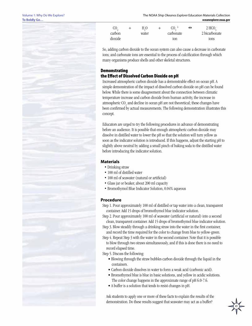
41
Volume 1: Why Do We Explore? To Boldly Go…
The NOAA Ship Okeanos Explorer Education Materials Collectionoceanexplorer.noaa.gov
CO2 + H
2O + CO
3 2- n 2 HCO
3-
carbon water carbonate 2 bicarbonate dioxide ion ions
So, adding carbon dioxide to the ocean system can also cause a decrease in carbonate ions; and carbonate ions are essential to the process of calcification through which many organisms produce shells and other skeletal structures.
Demonstrating the Effect of Dissolved Carbon Dioxide on pH
Increased atmospheric carbon dioxide has a demonstrable effect on ocean pH. A simple demonstration of the impact of dissolved carbon dioxide on pH can be found below. While there is some disagreement about the connection between climatic temperature increase and carbon dioxide from human activity, the increase in atmospheric CO
2 and decline in ocean pH are not theoretical; these changes have
been confirmed by actual measurements. The following demonstration illustrates this concept.
Educators are urged to try the following procedures in advance of demonstrating before an audience. It is possible that enough atmospheric carbon dioxide may dissolve in distilled water to lower the pH so that the solution will turn yellow as soon as the indicator solution is introduced. If this happens, adjust the starting pH to slightly above neutral by adding a small pinch of baking soda to the distilled water before introducing the indicator solution.
Materials• Drinking straw • 100 ml of distilled water• 100 ml of seawater (natural or artificial)• Glass jar or beaker, about 200 ml capacity• Bromothymol Blue Indicator Solution, 0.04% aqueous
ProcedureStep 1. Pour approximately 100 ml of distilled or tap water into a clean, transparent
container. Add 15 drops of bromothymol blue indicator solution.Step 2. Pour approximately 100 ml of seawater (artificial or natural) into a second
clean, transparent container. Add 15 drops of bromothymol blue indicator solution.Step 3. Blow steadily through a drinking straw into the water in the first container,
and record the time required for the color to change from blue to yellow-green.Step 4. Repeat Step 3 with the water in the second container. Note that it is possible
to blow through two straws simultaneously, and if this is done there is no need to record elapsed time.
Step 5. Discuss the following:• Blowing through the straw bubbles carbon dioxide through the liquid in the
containers.• Carbon dioxide dissolves in water to form a weak acid (carbonic acid).• Bromothymol blue is blue in basic solutions, and yellow in acidic solutions.
The color change happens in the approximate range of pH 6.0-7.6.• A buffer is a solution that tends to resist changes in pH.
Ask students to apply one or more of these facts to explain the results of the
demonstration. Do these results suggest that seawater may act as a buffer?

42
Notes: