whitemarsh park master plan - city of bowie
TRANSCRIPT

1August 2011
Whitemarsh Park Master Plan, City of Bowie, MD
Whitemarsh Park Master PlanAugust 2011
Prepared by:Lardner/Klein Landscape Architects, P.C.
in association with Burgess & Niple
Prepared for:City of Bowie, MD

2 August 2011
Whitemarsh Park Master Plan, City of Bowie, MD
ACKNOWLEDGMENTSBowie City Council
Mayor G. Frederick RobinsonMayor Pro Tem James MarcosDennis BradyDiane PolanginIsaac TrouthTodd TurnerGeraldine Valentino - Smith
Steering CommitteeJoe Bechtel, Commissioner, Bowie Boys & Girls Club Baseball (Paul Meador, alternate)Peter Cipolla, Sport Fit Bowie, Programming and Facilities ManagerAnnette Esterheld, Bowie Playhouse Manager, Department of Community Services, City of Bowie, MDAlan Forney, Engineering Assistant, Department of Public Works, City of Bowie, MDDwayne Grey, Commissioner, Bowie Boys & Girls Club Football, (Jason Craddock, alternate)Gary Hahn, Commissioner, Bowie Boys & Girls Club LacrosseEd Hall, Superintendent - Parks and Grounds, Department of Community Services, City of Bowie, MDSally Hein, Assistant Director, Department Of Community Services, City of Bowie, MDMatthew Reno, Project/Facility Manager, Department of Community Services, City of Bowie, MDDan Servi, Commissioner, Grace Christian BaseballRay Smith, Commissioner, St. Pius X CYO BaseballNick Spurgeon, Park Operations Manager, Department of Community Services, City of Bowie, MDFrank Stevens, AICP, Senior Planner, Department of Planning and Economic Development, City of Bowie, MDHarlan Tucker, Chairman, Community Recreation Committee, City of Bowie, MD, (Charlie Jacobs, alternate)Mark Villee, Kickball League of BowieLeslie Wood Mummert, Member, Environmental Advisory Committee, City of Bowie, MD (John Gabel,
alternate)
Consultant Team
Lardner/Klein Landscape ArchitectsElisabeth Lardner, ASLA, AICP Jacob Clark, RLA, LEED AP
Burgess & Niple, Inc Melvin F. Willis, VP
Approved the the Bowie City Council on August 1, 2011

iAugust 2011
Whitemarsh Park Master Plan, City of Bowie, MD
TABLE OF CONTENTSCHAPTER 1: EXECUTIVE SUMMARY Introduction 1 What is the Park today? 2 Why Plan Whitemarsh Park? 3 Purpose 4 Process 5 Outreach 5 Inventory and Analysis 5 Concept Alternates 5 Recommended Master Plan 6 Master Plan 7 Phasing and Costing Considerations 8 CHAPTER 2: PUBLIC INVOLVEMENT Participants 9 Players 9 Community Meetings 9 Process 10 Meeting Sequence 10 Council Worksession 10 Community Meeting 10
CHAPTER 3: SITE INFORMATION History 11 Site Conditions 13 Park Location 13 Topographic Features 13 Surrounding Land Use 14 Natural Resources and Environmental Concerns 14 Cultural Resources 15 Circulation and Site Access 16 Site Utilities 17 Built Facilities 17 Site Users 18 Past Studies and Prior Master Plans 19 Prior Master Plans 19
CHAPTER 4: ACTIVITIES AND FACILITIES ASSESSMENT Condition of Existing Facilities 25 Bowie Playhouse 25 Sport Fit Bowie 25 Athletic Fields 26 Restrooms 28 Recreation Area 28 Natural Area of the Park 29 Circulation and Parking 30
CHAPTER 5: SITE SUMMARY Issues and Opportunities 35 Zones 36

ii August 2011
Whitemarsh Park Master Plan, City of Bowie, MD
CHAPTER 6: PROGRAM NEEDS AND DESIGN CONSIDERATIONS Program Needs 37 Design Considerations 37 Pedestrian Focus 37 Accessibility Standards 38 Circulation and Parking 38 Protection and Enhancement of Environmentally Sensitive Areas 38 Stormwater Management 39 Current Park Management Practices 39 Suggested Materials to Reduce Long-term Maintenance Costs 42 Green Design to Reduce Costs 42 Program Inventory 42 Plan Elements 43 Bowie Playhouse 43 Sport Fit Bowie 43 Athletic Fields 44 Restrooms 46 Recreation Area 47 Cultural Resources 48 Natural Area of the Park 48 Circulation and Parking 48 CHAPTER 7: MASTER PLAN Vision 51 Master Planning Goals 52 Master Plan Elements 53 Bowie Playhouse 53 Sport Fit Bowie 53 Athletic Fields 53 Restrooms and Concessions 55 Recreation Area 55 Park Storage 56 Natural Area of the Park 56 Circulation and Parking 56 Partially Paved Pedestrian Corridor 58 Phasing and Cost Estimating 58 Fiscal Year (FY) Projections 58 City-wide Elements 58 Preliminary Statement of Probable Costs 59

iiiAugust 2011
Whitemarsh Park Master Plan, City of Bowie, MD
List of FiguresFigure 1 Whitemarsh Park (aerial map) 1Figure 2 White Marsh Branch 2Figure 3 Existing athletic fields at Whitemarsh Park 3Figure 4 Improved trail in the natural area of the Park 5Figure 5 Master Plan concept diagram 6Figure 6 Master Plan 7Figure 7 Phasing and Fiscal Year potential for 8 ImprovementsFigure 8 Process diagram 9Figure 9 Steering Committee meeting 10Figure 10 Williams Plains house - 1980 11Figure 11 Williams Plains house - present day 11Figure 12 1861 Martenet map 12Figure 13 1938 Aerial photograph 12Figure 14 1965 Aerial photograph 12Figure 15 Location of Whitemarsh Park 13Figure 16 15% - 30% slopes 13Figure 17 Sport Fit Bowie facility visitor count sample 16Figure 18 Original Plan for Whitemarsh Park by T.D. Donovan and Associates, dated 1969 20Figure 19 1979 Master Plan for Whitemarsh Park 20Figure 20 Bowie Playhouse 25Figure 21 Sport Fit Bowie facility 25Figure 22 BBGC Football storage structure 26Figure 23 Drainage ditch near storage facility 27Figure 24 Baseball field 27Figure 25 Children’s play area 28Figure 26 Fire Circle 28Figure 27 Pavilion 1 (Family Pavilion) 29Figure 28 Pavilion 2 (Whitemarsh Pavilion) 29Figure 29 Informal picnic area 29Figure 30 Circulation analysis 30Figure 31 Park access from Crain Highway (MD Route 3) 31Figure 32 Park access to the Park from Spur Way (west) 32Figure 33 Parking near Sport Fit Bowie facility 32Figure 34 Gravel parking are for general use and by Bowie Playhouse patrons 32Figure 35 Parking perpendicular to White Marsh Park Drive 32Figure 36 Paved trail with bench, trash can, and sign marker 33Figure 37 Pedestrian trail bridge 33Figure 38 Issues and Opportunities Diagram 35Figure 39 Zones of use within the Park 36Figure 40a User Matrix generated by Steering Committee members (left side) 40Figure 40b User Matrix generated by Steering Committee members (left side) 41Figure 41 White Marsh Park Drive 51Figure 42 Whitemarsh Park Master Plan 52Figure 43 New parking near Bowie Playhouse 53Figure 44 New synthetic turf field and lower practice field 54 Figure 45 Baseball field location, shown as grassy 54Figure 46 Potential to expand grassy area 54Figure 47 Area of tree cover adversely affected by Master Plan proposals 55Figure 48 New location of Fire Circle 55Figure 49 Athletic team storage/pressbox/bleachers 56Figure 50 Location of park operations facility southwest of the multi-use field 56Figure 51 Potential acceleration and deceleration lanes 57Figure 52 Potential parking location at entry to Whitemarsh Park indicated by blue circle 57

iv August 2011
Whitemarsh Park Master Plan, City of Bowie, MD
Figure 53 Blue dashed line indicates new trail connection between Sport Fit Bowie and western end of Park 57Figure 54 Pedestrian corridor 58
APPENDIX
BIBLIOGRAPHY 68PLATES Figure 1 Traffic Volume 8/12/10 - 8/18/10 76Figure 2 Traffic Volume 8/19/10 - 8/25/10 77Figure 3 Traffic Volume 8/26/10 78Figure 4 Traffic Volume 8/26/10 - 9/1/10 79Figure 5 Traffic Volume 9/2/10 - 9/7/10 80Figure 6 Traffic Volume 10/4/10 - 10/11/10 81Figure 7 Traffic Volume 10/12/10 - 10/18/10 82Figure 8 Alternatives Elements 84Figure 9 Concept Alternative A 87Figure 10 Concept Alternative A diagram 87Figure 11 Concept Alternative B 88Figure 12 Concept Alternative B diagram 88 Plate 1 Existing Resources - Natural Resources 70Plate 2 Existing Resources - Cultural Resources 71Plate 3 Existing Resources - Circulation 72Plate 4 Existing Resources - Utilities 73Plate 5 Existing Resources - Built Facilities 74Plate 6 Soils 75Plate 7 Issues and Opportunities Diagram 76Plate 8 Concept A 89Plate 9 Concept B 90Plate 10 Concept A and B Sections 91Plate 11 Concept A1 Sections 92Plate 12 Concept A1 - close-up 93Plate 13 Concept A1 94Plate 14 Final Concept (on aerial of existing Park) 95Plate 15 Final Concept (w/potential field diagrams) 96Plate 16 Final Concept Master Plan 97

1August 2011
Whitemarsh Park Master Plan, City of Bowie, MD
CHAPTER 1
EXECuTIvE SuMMAry
Figure 1 - Whitemarsh Park, in yellow, with active recreation area within red circle
IntroductionWhitemarsh Park is a 200-acre, relatively undeveloped property that contains a small but intensely developed area for active recreation. The Park is located directly off of Crain Highway (MD Route 3) on the eastern edge of the City of Bowie.
Recommendations for the entire Park are made in this Master Plan. However, the developed portion of the Park is the focus of this Plan. The City of Bowie solicited a proposal with the intent of addressing the following questions focused on the 30-acre portion of the Park.
• Should uses stay in their current location?
• Should some uses be removed?• Should other uses be inserted or be
transformed to year-round activity?• How can the existing facilities better
share infrastructure investments such as parking and restrooms?
These questions, and others related to costing, phasing, and alternate access points for vehicles and pedestrians were considered in the planning process, with the focus being on the heavily used 30-acre area that is home to active recreation, the Bowie Playhouse, the historic Williams Plains house and Sport Fit Bowie, a private athletic club. (See Figure 1.)
Current athletic fields, their shape, size and use patterns by various groups were evaluated in conjunction with the Steering Committee. An assessment of future needs, seasonal and year-
round, was completed and results in the recommended plan layout for park improvements. Similar assessments were made of the current parking situation and single point of vehicular access. The Master Plan recommends improvements for better vehicular and pedestrian flow. A site for restrooms was identified in an earlier study and is incorporated in the Master Plan, reflecting the need to use a septic system vs. public sewer. Similarly, the playground and picnic facilities were assessed and their potential expansion evaluated. Group picnic facility rentals provide a needed service to the greater community and a revenue stream to the City. Expansion opportunities for all activities were evaluated in terms of how much the site infrastructure could support.
There is an increasing challenge in an urbanized area to retain and expand the deciduous tree canopy. Preserving natural corridors and sites in perpetuity, while removing invasive species and eliminating pressures to use natural areas as future development sites for more formal
Chapter 1 Executive Summary
Cra
in H
ighw
ay (M
D R
oute
3)
Whitemarsh Park

2 August 2011
Whitemarsh Park Master Plan, City of Bowie, MDChapter 1 Executive Summary
recreation activities are means to meet these challenges. Yet, active recreation is an important component and is also underserved. The balance between thetwo and their stewardship is a challenge and one that this Master Plan addresses.
What is the Park Today?Whitemarsh Park is the largest active park within the City of Bowie. It provides residents with an unsurpassed opportunity to interact with nature, while providing them with a venue for sports, culture and exercise. With over 1.5 miles of improved and unimproved trails throughout, the Park encompasses approximately 196 acres with over 85 percent of that acreage comprised as natural woodlands. The Park is home to the Bowie Boys & Girls Club, Inc. (BBGC) football, lacrosse, and baseball programs, the Kickball League of Bowie, St. Pius X CYO and Grace Christian baseball programs, the Bowie Playhouse and Sport Fit Bowie.
LArGE WOODLAND TrACT Much of the Park is wooded and natural. One of the discussions in the master planning process, heavily reinforced at the community meeting held in December 2010, was how to best manage
Figure 2 - White Marsh Branch
the woodland area and reduce or eliminate any encroachments into it for other park improvements. Whitemarsh Park provides one of the largest contiguous wooded natural areas within the City of Bowie.
CuLTurAL BASE WITh PLAyhOuSEServed by a long linear access drive and small parking area, and located deep within the Park is the Bowie Playhouse, a 150-seat theatrical facility that is often sold out on weekends.
The Bowie Playhouse was constructed in 1975. Originally named the Theater in the Woods, it is owned and operated by the City of Bowie. The Playhouse is currently home to three local theatre companies that host productions year-round.
ACTIvE SPOrTS CENTEr Sport Fit Bowie leases property within the park for a full service health and sports club. It is a significant park user, with a membership of approximately 11,000 at its peak. Most of the daily activities on the site are concentrated in a small area surrounding the indoor athletic and aquatic facility operated by Sport Fit Bowie.
Lighted athletic fields, picnic pavilions, and a playground vie for space and parking accommodations with the privately operated facility. Use of the Park is heavily driven by the private vendor operating the indoor athletic and aquatic facility and leasing the Williams Plains house as additional space. This use, with the addition of park users for ballfields, picnicking, and hiking stresses the existing infrastructure to an extreme. How these very concentrated uses could be better placed on-site, with an evaluation and reconfiguration of entry roads, parking facilities and ballfields and the type and seasonal use of athletic fields formed the basis of the planning effort.
hISTOrIC PrOPErTyThe Park is also home to the Historic Williams Plains house, located in the center of the Park. The nearly five-acre parcel it sits on is currently leased by the

3August 2011
Whitemarsh Park Master Plan, City of Bowie, MD Chapter 1 Executive Summary
City of Bowie to Sport Fit Bowie. The surrounding lands once served as the setting for the house and its working farmland, most recently as tobacco fields. An old tobacco barn and stripping shed, included in early park master plans as a potential environmental education center and location for restrooms, no longer exist.
The existing two-and-a-half story brick home, know as the Williams Plains house, was constructed between 1811 and 1813 for the Honorable John Johnson. The home was a private residence until 2004 when it was purchased by Sport Fit Bowie who transferred the ownership to the City of Bowie. The home has been on the National Register of Historic Places since 1980 and is currently leased to Sport Fit Bowie for use as administrative offices.
Why Plan Whitemarsh Park?This Master Plan provides a coherent approach to phasing and funding improvements to Whitemarsh Park in a fiscally responsible manner. The Park is challenged by aging infrastructure, limited vehicular access, and a heavy demand for its facilities. Surrounded by residential neighborhoods on three sides and a divided highway on the fourth, the developable portion of the park is isolated and relatively small.
Five issues in particular make current planning efforts for Whitemarsh Park important.
1. INADEquATE ACCESS AND PArKINGInadequate parking and vehicular access continue to challenge park users. The Park is served by a single access driveway off of Crain Highway (MD Route 3), a divided four-lane high speed highway on the eastern edge of the property. Access to the Park is a challenge for northbound drivers. Necessary u-turns are indicated by signs directing travelers to the park. Park users traveling on northbound lanes of MD Route 3 must turn left at the crossover opposite Sylvan Drive before heading south
to access the park entrance. A paved crossover of Crain Highway at Forest Drive is located immediately to the south. The single ingress-egress point has proven to be inadequate, leading to long queues during high use periods. The lack of a secondary, emergency access point is particularly evident when an accident occurs on Crain Highway (MD Route 3).
Traffic counts on White Marsh Park Drive were taken during three different periods of time in the late summer and fall of 2010. The counts supported the perception that vehicular traffic is heaviest during the 6 PM hour (counts ranged from 200-300 vehicles) entering the Park and the 8 PM hour (similar to 6 PM counts) exiting the Park during the work week. Saturday mornings had the highest counts for weekend vehicular traffic. Traffic count data is included in the Appendix. 2. hEAvy DEMAND FOr ThE EXISTING AThLETIC FIELDSFields at Whitemarsh Park are heavily used, with a single game field suitable for football and two partial practice fields used by football, lacrosse and kickball. The demand for additional field time from football and men’s and women’s lacrosse puts pressure on the existing field
Figure 3 - Existing athletic fields at Whitemarsh Park

4 August 2011
Whitemarsh Park Master Plan, City of Bowie, MDChapter 1 Executive Summary
Existing On-Site Parking at Whitemarsh Park
Sport Fit BowieGated Employee Spaces 7Handicapped Spaces 7Aquatic Physical Therapy Parking 2Marked Asphalt Spaces 163 (some on Williams Plains parcel)
Athletic FieldsMarked Asphalt, signed for Playhouse use 40Gravel and Unmarked Asphalt 259Overflow (on Williams Plains parcel) 65
Play AreaUnmarked Gravel 15
Playhouse Handicapped Spaces 4
TOTAL EXISTING SPACES 562
capacity. Field expansion for football and men’s and women’s lacrosse would be beneficial for those athletic teams.
At one time, the Park had a softball and baseball field. The softball field was converted to a partial practice field for football and lacrosse. The singular baseball field remains and is used both for practice and games.
3. LACK OF INFrASTruCTurEWhitemarsh Park is served by temporary restroom facilities (portable toilets) located near the ballfields and picnic pavilions. The Park is served by public water, but not public sewer. Any restroom facilities will require the installation of a septic system and drainfield.
Based upon the current level of use by Park patrons, parking is inadequate. A review of the circulation patterns and parking was the first priority of the master planning process. Parking on evenings is extremely limited when Sport Fit Bowie is active, practice fields are filled with youngsters, and the Bowie Playhouse is holding a performance. On those occasions, an informal overflow lot adjacent to the Williams Plains house is used.
As activities are added to the Park, an increase in infrastructure such as parking, restrooms, etc. will be required to support each new addition. There is a danger of over programming the Park by placing too many activities with associated infrastructure requirements on the site.
4. PrESErvATION OF ThE EXTENSIvE NATurAL ArEAEighty-five percent of the Park has been designated for passive use and contains four primitive hiking trails, the Discovery Nature Trail, and 1.5 miles of improved trail connecting the site to the adjoining neighborhoods to the north and west. Deep stream valleys bisect the western section of the Park, making all but pedestrian access prohibitively expensive. Grade changes exceed seventy feet in some portions of the White Marsh Branch stream valleys.
5. DEvELOPMENT OF A PhASED CAPITAL BuDGETThe making of improvements to the Park in an orderly, transparent, and responsible manner will be assisted by the development of an overall Park Master Plan that articulates necessary upgrades and Park adjustments with their associated costs and choreography.
PurposeThis is a master planning exercise and is not intended to serve as a design or engineering document. The Master Plan articulates the best way to configure the space in Whitemarsh Park. The Plan is presented graphically and with written strategies as to how best to implement the recommendations over the next five- to ten-year period in a cost-effective and thoughtful manner.
The focus of the planning effort was on the active recreational areas of the Park due to growing pressure from the athletic community for field and supportive infrastructure expansion. The large natural area of the Park was intentionally reserved and assumed to remain in passive use.
5August 2011
Whitemarsh Park Master Plan, City of Bowie, MD Chapter 1 Executive Summary
ProcessOutreachThe Master Plan was developed in conjunction with a Steering Committee, appointed by the City of Bowie. Representatives from the organized sports activities currently using the Park, representatives from City committees, and City staff met with the consultant team over the course of the Master Plan’s development.
Four Steering Committee meetings were held over the summer of 2010. A Council Worksession was held in November of 2010, with a follow-up community meeting in December 2010. The Council Worksession was broadcast over the City’s cable station. All Steering Committee meeting minutes and graphics were placed on the City of Bowie’s web page for public access.
Inventory and AnalysisThe Park was evaluated in terms of cultural and natural resources, circulation and vehicular access, utilities, built facilities, and current user activity.
A high priority had been to identify a second point of vehicular access. Four potential points of access were explored. After analysis, none of the four proved to be viable as secondary access points.Due to the severe topography, stream valleys, and environmental constraints, opportunities for additional vehicular access from the northern (Spur Way) and western (MD Route 450) sides of the Park were prohibitively expensive economically and ecologically. Access from the south (Forest Drive) was prohibited by an annexation agreement. Improved access from Crain Highway (MD Route 3) was limited by long-term plans the State Highway Administration (SHA) has for the MD Route 3/301 corridor.
Concept AlternativesPrior to determining that no additional points for vehicular access were viable, two alternative master plans, Concept A and Concept B, were developed to show different ways to achieve an expanded program for the site. Each included an investigation of alternative points for vehicular access, expanded fields for athletic activities, additional infrastructure, such as year-round restrooms, and reconfigured and expanded parking.
Other than the potential points for additional vehicular access - Concept A included a new road from the south and Concept B considered a new road from the west - minimal encroachment was made to the existing woodlands. Parking was increased from 562 (includes the spaces in the grass ‘overflow’ lot on the Williams Plains property) to 625 spaces in each concept, without encroaching on the 4.98-acre Williams Plains property. Of the total, parking for approximately fifty vehicles was provided in each concept alternative for the Bowie Playhouse, but in different locations.
Each concept alternative included permanent restrooms. Concept A included
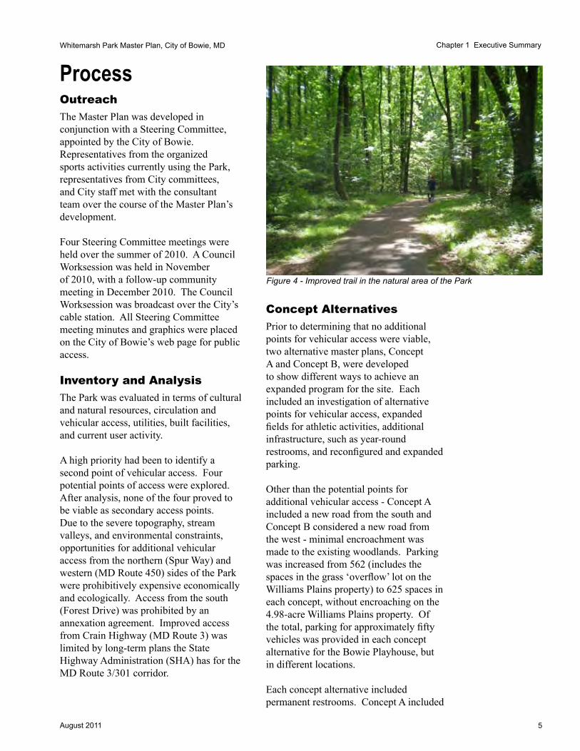
Figure 4 - Improved trail in the natural area of the Park

6 August 2011
Whitemarsh Park Master Plan, City of Bowie, MDChapter 1 Executive Summary
a single building adjacent to the current football game field and Concept B included two smaller buildings: one near the football game field; and the second near the existing picnic facility in the woods. Concept B included a greater expansion of athletic fields, with an additional game-sized field football and women’s and men’s lacrosse. All fields were shown as being lighted.Schemes for both alternatives included a press box, concession stand, storage area, and a scoreboard.
The existing tree canopy remained untouched for the majority of the site. The concept alternatives adversely affected between four and nine acres of woodlands. Each of the concepts’ proposed elements avoided steep slopes for construction and assumed that stream restoration would be a part of the Master Plan, although the improvements may be initiated by a different City department and program.
Existing trails are to remain as they are, with recommended improvements to signs and interpretive panels. The existing campfire circle, Fire Circle, was relocated in Concept B to be near the existing picnic pavilion in the woods, southwest of the multi-use field.
Concept A removed the existing parking between the athletic fields and replaced it with a pedestrian area that contains a playground, concession stand, and restroom. Concept B retained the parking between the fields, but reorganized it.
Recommended Master PlanThe recommended Master Plan was developed from comments received by the Steering Committee and at the City Council Worksession. Additional comments were received prior to, during, and following the community meeting. These comments have been addressed in the Master Plan.
Figure 5 - Master Plan concept diagram (red circle indicates location of the Williams Plains house)
Whitemarsh Park
Cra
in H
ighw
ay (M
D R
oute
3)

7August 2011
Whitemarsh Park Master Plan, City of Bowie, MD Chapter 1 Executive Summary
Master PlanThe Master Plan for Whitemarsh Park delineates a vision for improvements and upgrades to the park over the course of the next five to ten years. Given the limits to vehicular access, no additional active recreation programming was added to the Park. Instead, minimal expansion of the athletic fields and the parking areas within the center of the Park was recommended.
It is a modest plan, focusing on how best to stage upgrades of existing features and infrastructure over time rather than focusing on the addition of new uses and programs to the site. For example, the overall parking count for the Park does not change significantly, but the locations and design (surface materials, stormwater infiltration opportunities, etc.) of the parking areas do change. Similarly, field expansion has been limited due to the restrictions for vehicular
access to the Park and the limitations on parking, but the western athletic fields are reorganized to better make use of the existing treeless areas of the Park.
The most significant feature of the Park is the extensive natural wooded area. Comprising 85 percent of the property and located for the most part on the northern and western portions of the Park, this area will remain unchanged. Approximately four acres of existing woodlands will be removed for the installation of athletic field extensions, driveways and parking areas. A Natural Resources Inventory and Tree Conservation Plan will be developed to document this significant resource prior to any construction or renovation of existing features. By concentrating the active recreation uses of the Park in the center core, generations to come will be able to enjoy much of the Park as a natural woodland.
BOWIE PLAYHOUSE
RELOCATED FIRE CIRCLE
HISTORIC WILLIAMS PLAINS PROPERTY
PAVILION #2
SYNTHETIC TURF
(200’ X 415’)
SPORT FIT COMPLEX
GAME SEATING WITH RAISED PRESSBOX AND STORAGE BELOW
RESTROOMS & CONCESSIONS
NEW LOCATION FOR PAVILION #1
CHILDREN’S PLAY AREA (2 AGE GROUPS)
LACROSSE REBOUNDING WALL
A1 A2
B1
B2
D1F1
F2
F3
F4 F5 F6
F7
F8
FOREST DRIVE
CR
AIN
HW
Y
WHITE MARSH PARK DRIVE
TENNIS COURTS (2)
FUTURE BOWIE SPORT FIT EXPANSION
POOL S
YLVA
N D
RIV
E
E2
EXISTING PARK TRAIL (TYP)
POTENTIAL FUTURE PARKING
ADDITIONAL PARKING FOR BOWIE PLAYHOUSE
PAVED PEDESTRIAN CORRIDOR
SCOREBOARD TO REMAIN
WHITEMARSH PARK MASTER PLANFINAL CONCEPT
NATURAL TURF(220’ X 380’)
B3
B4
B5
PLAY AREA
ADDITIONAL PARKING FOR BOWIE PLAYHOUSE
LOT ID # SPACESA1 44A2 50B1 32B2 42B3 91B4 46B5 7C 77D1 4E1 17E2 33F1 54F2 7F3 24F4 42F5 19F6 17F7 2F8 14G1 32G2 16
TOTAL 670
PARKING SUMMARY FINAL CONCEPT
UNVERIFIED PROPERTY LINE
0 50 100 200
CR
AIN
HW
Y
CR
AIN
HW
Y
SPUR WAY
SAFETY TURN
WHITEMARSH PARK DR
FOREST DR
FOREST PLBRUNSWICK LN
STO
NE
YB
RO
OK
DR
.
ANNAPOLIS RD
RACE TRACK RD
NATURAL TURF (150’ X 200’)
WHITEMARSH PARK BOUNDARY (TYP)
LEGEND
EXISTING STRUCTURE
PROPOSED STRUCTURE
EXISTING ROADS/PARKING
PROPOSED ROADS/PARKING
EXISTING ATHLETIC FIELD
EXPANDED ATHLETIC FIELD
PROPOSED WALKS/PAVING
POTENTIAL TRAIL CONNECTION
EXISTING PARK TRAIL
GREEN INFRASTRUCTURE PLAN REGULATED AREA
E1
G1
G2
WHITEMARSH PARK MASTER PLAN
Lardner/Klein Landscape Architects, P.C.Planning • Urban Design • Landscape Architecture
CITY OF BOWIE, MARYLAND - MARCH 2011
SANITARY DRAIN FIELD
POTENTIAL EXTENDED ACCEL & DECEL LANES AT EXISTING ENTRANCEPOTENTIAL
CONNECTIONS TO EXISTING TRAILS AND
PAVILION (TYP)
PARK STORAGE AREA
C
OVERALL LOCATION MAP
WHITEMARSH PARK BOUNDARY (TYP)
PARK BOUNDARY
RO
UT
E 3
OLD TOBACCO BARN (APPROXIMATE LOCATION)
Figure 6 - Master Plan
LOT ID # SPACESA1 44A2 50B1 32B2 42B3 91B4 46B5 7C 77D1 4E1 17E2 33F1 54F2 7F3 24F4 42F5 19F6 17F7 2F8 14G1 32G2 16
TOTAL 670
PARKING SUMMARY FINAL CONCEPT
LEGEND
EXISTING STRUCTURE
PROPOSED STRUCTURE
EXISTING ROADS/PARKING
PROPOSED ROADS/PARKING
EXISTING ATHLETIC FIELD
EXPANDED ATHLETIC FIELD
PROPOSED WALKS/PAVING
POTENTIAL TRAIL CONNECTION
EXISTING PARK TRAIL
GREEN INFRASTRUCTURE PLAN REGULATED AREA
PARK BOUNDARY

8 August 2011
Whitemarsh Park Master Plan, City of Bowie, MDChapter 1 Executive Summary
The Master Plan calls for the ultimate relocation of the existing baseball field, once a suitable and a lighted facility is identified at another property. Ultimately, when the baseball activity has been relocated, the field will be transformed to a nonlined natural turf grassy open area available for unstructured play and athletic practices. A second lacrosse (men’s and women’s) and football regulation-sized natural turf field will be developed on the site of the existing multi-use field and former home to a softball field. The existing football game field will be replaced with a synthetic turf field lined for football and men’s and women’s lacrosse. Kickball will continue to share the fields with lacrosse, football and baseball.
The existing access point via White Marsh Park Drive remains, with no recommended improvements to its intersection with MD Route 3 other than the development of acceleration and deceleration lanes on MD Route 3. These improvements will be subject to the approval of the Maryland State Highway Administration (SHA).
Phasing and Costing ConsiderationsPreliminary costs have been developed for each element discussed in the Master Plan.
All phasing and Fiscal Year (FY) allocations are dependent upon City Council appropriations and direction.
Figure 7 - Phasing and Fiscal Year potential for improvements; dependent upon available funding and Council approval
Fy 2012One-quarter of the funds needed to construct the synthetic turf field are included in the fiscal year budget. The dimensions of the synthetic turf field will accommodate football and women’s and men’s lacrosse, and work within the existing lighting layout, building configuration and grading. In addition, funds to complete a Natural Resource Inventory, Tree Conservation Plan Type 2, and other potential required studies are included.
PhASE 1 (Fy13)Remaining funding needed for synthetic turf construction and the installation of the synthetic turf field is included in Phase 1.
PhASE 2 (Fy15)Architecture and Engineering design work for the permanent restroom, design work for the natural turf field, and design work for parking lots A, B,and E is included in Phase 2.
PhASE 3 (Fy 16)Permitting and construction of the permanent restroom is included in Phase 3.
PhASE 4 (Fy 17)Permitting and construction for parking lot E and design for lacrosse rebounding wall is included in Phase 4.
PhASE 5 (BEyOND Fy 17)Remaining Master Plan improvements are placed in Phase 5 and beyond.

9August 2011
Whitemarsh Park Master Plan, City of Bowie, MD
CHAPTER 2
PuBLIC INvOLvEMENTParticipantsThe Whitemarsh Park master planning effort used an appointed Steering Committee as the primary vehicle for public involvement, with a public Community Meeting and a Council Worksession.
PlayersSTEErING COMMITTEEThe planning effort was overseen by the Steering Committee. Representatives from entities that could best provide the City of Bowie with the information necessary to understand the Park’s current levels of use and needs for active recreation were invited to participate. Members included the representatives of the listed organizations below.
Athletic Organizations (currently using athletic fields at Whitemarsh Park)
• BBGC- Football, Lacrosse, Baseball
• St. Pius X CYO Baseball• Grace Christian Baseball• Kickball League of Bowie
Other Park Users• Bowie Playhouse• Sport Fit Bowie
City Citizen Advisory Committees
• Community Recreation Committee (CRC)
• Environmental Advisory Committee (EAC)
City of Bowie Staff• Matt Reno, Project
Manager, Department of Community Services (DCS)
• Sally Hein, Assistant Director, DCS
• Ed Hall, Parks & Grounds Superintendant, DCS
• Nick Spurgeon, Park Operations Manager, DCS
• Annette Esterheld, Arts Specialist, DCS
• Frank Stevens, Senior Planner, Department of Planning and Economic Development
• Alan Forney, Engineering Assistant, Department of Public Works
This group met four times over the course of the project to identify issues, discuss alternative concepts, and to make recommendations for inclusion in the final master plan as presented in the City Council Worksession.
Community MeetingsOne community meeting and a Council Worksession were conducted during the process. The City contacted surrounding property owners and invited them to the community meeting. Direct mail invitations were sent to residents within a 500-foot radius for attendance at the
Chapter 2 Public Involvement
Figure 8 - Process diagram shared at Community Meeting
10 August 2011
Whitemarsh Park Master Plan, City of Bowie, MDChapter 2 Public Involvement
community meeting. Notices were placed on the City message boards, the City’s website, and cable channel. The Council Worksession was broadcast on the cable channel.
ProcessThroughout the master planning process, staff maintained a “Whitemarsh Park Master Plan” webpage on the City’s website to keep the public and Steering Committee members informed of progress and decisions pertaining to the development of the Plan.
Meeting SequenceA clear process for comment and solicitation of ideas was critical to the success of the planning effort. Four Steering Committee meetings were held over the spring and summer. Each meeting’s agenda, presentation, and minutes were posted on the City’s website.
Council WorksessionA separate session was held with the Bowie City Council prior to the Community Meeting. A draft Master Plan was presented to the Council. Due to the lack of secondary vehicular access points, the limitations to future growth of the existing athletic programs or for any new park programming was explained.
This Master Plan reflects the direction given by the City Council at that session. The Plan retains the limitations on future growth in current programming and the new programming.
Community MeetingThe community meeting was held towards the end of the planning process, following Steering Committee meetings and the City Council Worksession.
A draft Master Plan was presented in December 2010 at that meeting. Time for questions and answers and comments was incorporated at the meeting. Additional comments from the public were solicited by placing the draft Plan on the City’s website.
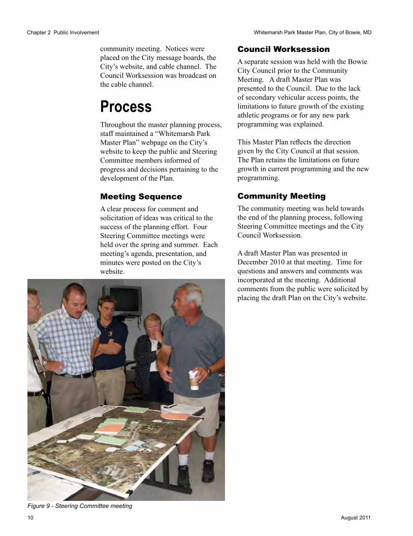
Figure 9 - Steering Committee meeting

11August 2011
Whitemarsh Park Master Plan, City of Bowie, MD
HistoryAccording to Prince George’s County deeds, patents, and tax assessments and as referenced in the National Register of Historic Places Inventory Nomination Form dated 1974, the site that now comprises Whitemarsh Park was once part of a much larger tract of land with an area of approximately 1,000 acres.
A smaller portion of this tract, approximately 300+ acres, was patented to Robert Wilson around 1671 and was called “The Plaine” or “The Plains”. The tract was owned by Mr. Wilson until 1694 when it was willed to Mareen Duvall. The Duvall family remained in ownership of “Wilsons Plain”/”Wilson’s Plain” until 1821 when the tract, now called “Williams Plains” and expanded to 364 1/2 acres was conveyed to John Johnson. (This was likely a late conveyance; tax assessments from 1812 onward were billed to Johnson.)
It is commonly believed that the Williams Plains house was constructed sometime between 1811 and 1813 for the Honorable John Johnson, a well known lawyer, judge, and Chancellor of the Maryland Court of Appeals, on the tract. Tax records from this period show a significant increase in property value, which leads one to believe that a home was constructed on the property at this time.
In 1829 a deed in trust was granted by Basil D. and Eliza Mullikin, for their residence, Williams Plains, and a 364 1/2 acre tract to William D. Bowie for Eliza Mullikin. An early map of the area, dated 1861, notes the name of the B.D. Mullikin. (See Figure 12.) The Mullikin name remained on deeds until 1869 when a deed was recorded for Theodore Simon et. al. for 298 acres. Some speculation is that the difference in the
CHAPTER 3
SITE INFOrMATION
Figure 11 - Williams Plains house - present day
Figure 10 - Williams Plains house -1980
acreage measurement can be attributed to better and more precise measuring tools. By 1948, a parcel known as Williams Plains remnant, at a size of 98 acres with structures, was transferred, followed by a second transfer in 1951 of 100 acres, noted as not lying with the house.
The 4.98 acre parcel, as known today, was separated in 1966 and sold as a separate property to a private owner. Around the same time, the City of Bowie acquired some 102 acres surrounding that parcel.
Chapter 3 Site Information

12 August 2011
Whitemarsh Park Master Plan, City of Bowie, MD
Figure 12 - 1861 Martenet map (red circle indicates best estimate based on PGAtlas and parcel maps for location of the Williams Plains house)
Chapter 3 Site Information
Figure 13 - 1938 Aerial photograph (red circle indicates location of the Williams Plains house)
Figure 14 - 1965 Aerial photograph (red circle indicates location of the Williams Plains house)
The Williams Plains property was officially placed on the National Register of Historic Places on November 28, 1980. The home, which had remained a private residence, was sold to Sport Fit Bowie in 2004. Sport Fit Bowie then conveyed the property to the City of Bowie. The home and grounds are currently being leased to Sport Fit Bowie, who is responsible for all maintenance and insurance for the property.
Any alterations to the Williams Plains property will require an Historic Area Work Permit. The 4.98-acre parcel is considered to be the environmental setting for the historic property and, as such, is regulated by Prince George’s County. The surrounding park parcel is not affected by the designation of the environmental setting.
According to the Environmental Impact Statement for Whitemarsh Park dated 1975, the southern 70 acres of the Park were cultivated for tobacco since colonial times and the land was, until 1967, a thriving tobacco farm. It was noted that grape cultivation also occurred on site.
However, given the history of the Williams Plains property and the adjacent farmlands, any alteration to the grounds may require an Archeological Survey to be completed for the entire Park boundary. (source: Cecelia Moore, M-NCPPC Historic Preservation Division) This may entail the development of a Phase I Cultural Resource investigation that may lead to a more complex Phase II exploration for historic and archeological resources.

13August 2011
Whitemarsh Park Master Plan, City of Bowie, MD
Site ConditionsPark LocationWhitemarsh Park is located on the easternmost portion of the City of Bowie. Surrounded on three sides by residential subdivisions, its eastern boundary is established by Crain Highway (MD Route 3), a divided four-lane highway with limited access points and median crossovers. The Sylvan Drive neighborhood is located to the Park’s northeastern boundary. The Park is bounded by land owned by the Corporation of Roman Catholic Clergymen of Maryland along its northern perimeter. Annapolis Road (MD Route 450) is on the northwestern corner of the Park. The Belair neighborhood flanks the western edge of the Park and the Forest Drive neighborhood is located to the Park’s south. An annexation agreement related to the Forest Drive neighborhood governs and limits public access to the Park from Forest Drive.
Topographic FeaturesThe Park is marked by two distinct topographic areas. The developed area of the Park, currently used for active recreation and the location of the Sport Fit Bowie facility, is located on relatively flat land. Slopes in this area are generally less than 5 percent.
To the north of the Sport Fit Bowie facility, and to the west of the Bowie Playhouse, the Park includes large areas of steep terrain bisected by a major stream valley and its tributaries. Many of the slopes in this area exceed 15 percent. The steep slopes that wrap the western and northern portions of the active area are undeveloped, bisected by pedestrian trails only. The extreme grade changes have prevented the development of any vehicular access points. Options to provide additional points of access were explored in
1975, 1977, 1979, and again as a part of this Master Planning process. The soils associated with these slopes are also classified as highly erodible, hindering potential development. According to the Whitemarsh Park Environmental Impact Study completed in 1975, the White Marsh Branch (also known as Marsh Branch) stream valley itself is divided into two parts: the floodplain, which at some locations is up to 400 feet wide, and a system of tributary valleys, that rise upwards of 70 feet above their respective valleys.
Chapter 3 Site Information
Figure 15 - Location of Whitemarsh Park
CR
AIN
HW
Y
FOREST DRIVE
WHITEMARSH PARK DRIVE
CROSSOVER
ANNAPOLIS ROAD
ANNAPOLIS ROAD
ANNAPOLIS ROAD
FOREST PLACE
BRUNSWICK LANE
SYLVAN DRIVE
SYLVAN DRIVE
SAFETY TU
RN
SCA
RLE
T OAK T
ERR
AC
E
STON
YBR
OO
K D
R
SUPE
RIO
R LA
NE
WE
UrdB
CnF
CnB
CnC
CnDCoB
CnD
CoD
CnE
CnE
CnB
CnC
CnECnD
CoD
CnF
CnCCoB
CoB
CnE
CoD
AdA
CoB
CnD
CnBCnB
CoD
CnE
CnE
CnD
CnE
CoD
CoB
Iu
CoD
CnC
CoD
CoD
CnB
UdaF
CoD
CnE
CnC
CnE
CnD
CnE
UrdB
CnD
CnC
CnE
CnD
CnD
CnE
CnD
CoD
CnF
CnB
CnD
CnC
CnF
CnF
CnE
CnBCnA
UduB
CnE
CoB
CoD
CnBDuD
UdgB
CnC
CoB
o0 150 300 450 60075Feet
WHITEMARSH PARKCITY OF BOWIE, MARYLAND
Lardner/Klein Landscape Architects, P.C.815 N. Royal St., Alexandria, VA 22314
In association with Burgess & Niple, Inc. DRAFTDRAFT
GIS Data Sources: Maryland-National Capital Park and Planning Commission and the City of Bowie, Maryland
LegendBallfield
soilmu_a_md033
slopetest3<VALUE>
0%-15%
15%-30%
Whitemarsh Park Boundary
Stream
Two Foot Contour
Building
Water Body
150'
156'120'
154'
164'
164'
134'
146'
Wooded Area
Wooded Area
Wooded Area
Wooded Area
Figure 16 - 15%-30% slopes (dark blue); buildings (brown); (red circle indicates location of the Williams Plains house)

14 August 2011
Whitemarsh Park Master Plan, City of Bowie, MDChapter 3 Site Information
Whitemarsh Park Acreage Acquisition History
1966 102acres-ParcelA PurchasedbytheCityofBowie;propertysurroundsWilliams
PlainsparcelandincludesdrivewaytoCrainHighway
1973 16.74acres-Parcel2 ParcellocatedjusteastofBowieForestSubdivision
1973 3.932acres-Parcel16 ParcellocatednorthofParcel2alongAnnapolisRoad
1973 0.518acres-Parcel27 ParcellocatednorthofParcel2alongAnnapolisRoad
1979 1.69acres-‘Jacob’sTriangle’ PurchasedbytheCityofBowie;‘Jacob’sTriangle’neartheold
tobaccobarn
DateUnknown 70.691acres-Parcel65 ParceltothewestsideofParkborderedbyM-NCPPCparcel,
ForestHillsandBelairneighborhoods
2005 4.98acres-Parcel50 WilliamsPlainsparcellocatedwithinthepark
= 200.551 acres (differsfromreportdated1975thatrefersto210acres
NOTINCLUDEDINPARKACREAGE:Parcel57(M-NCPPC)10.917acres
Information taken from Tax Records, PGAtlas, and City of Bowie
Surrounding Land UseThe Park is surrounded by a variety of residential neighborhoods. The majority are detached single-family homes, with the exception of the northwest corner of the Park, which abuts an area of townhomes (Bowie Forest).
The Park also adjoins a wooded and undeveloped parcel owned by the Maryland National Capital Park and Planning Commission (M-NCPPC) to the west which connects the Park with the adjacent Belair neighborhood at Spur Way.
Natural Resources and Environmental ConcernsSOILSThe vast majority of soils found at Whitemarsh Park are of the Collington-Wist series based on information provided by the NRCS Web Soil Survey database for Prince George’s County dated 12/16/2009. These soils are noted as being fine-loamy, very deep, well drained, with moderate to slow permeability. Historically, these soils have been used for farmland or pasture where slopes do not exceed 5 percent.
Where the ground is steeper, woodlands generally dominate. Woodland vegetation includes upland oaks, sweetgum, yellow poplar, hickory, American beech, red maple, sassafras, and dogwood. Where slopes allow, soils of this type also support urbanization and are noted as being able to support most types of development, including building foundations and roads. The White Marsh Branch stream valley, as it traverses the Park, contains Widewater and Issue soils which are known to be frequently flooded, poorly drained, and partially hydric. A tributary to White Marsh Branch that drains areas within the Bowie Forest and Belair neighborhoods as well as a small western portion of the Park. This drainage area contains Adelphia Holmdel Complex soils which are partially hydric, moderately well drained and seasonally wet.
STrEAMSThe White Marsh Branch (also known as Marsh Branch) traverses the Park from a southwesterly to northeasterly course for approximately 4,000 feet, with the main branch entering the Park from north of Brunswick Lane. A tributary enters the Park from the M-NCPPC parcel to the west. (See Figure 16.)
vEGETATIONWoodlands cover approximately 85 percent of the site based on County GIS data, dated 2005. The City of Bowie has established the goal of achieving 50 percent tree canopy

15August 2011
Whitemarsh Park Master Plan, City of Bowie, MD
coverage city-wide. Current coverage of the City is at 46 percent. The woods on the western side of the Park are the oldest stand of trees in the Park and consist of sugar maples, poplar, oak species, American beech, dogwood, and sweet gum.
The woods on the southern side of the Park are younger, having grown in on the lands farmed for tobacco as late as 1968. (See Figure 14.)
The wooded area traversed by the Tulip Loop Trail on the southwestern portion of the site consists almost exclusively of young tulip poplars.
GrEEN INFrASTruCTurEM-NCPPC in Prince George’s County created a county-wide Green Infrastructure Functional Master Plan in June 2005. It is the first comprehensive functional master plan ever developed for environmental ecosystems in Prince George’s County. Mapping was done from existing computer data. The County relies on Natural Resource Inventories (NRI), Forest Stand Delineations (FSD) or wetland studies prepared by a qualified professional before a development application can be submitted to update the plan. Once only applicable to subdivisions, the requirements have now been extended to include all development applications.
Whitemarsh Park is covered by the Green Infrastructure Plan. Much of the parkland is codified as an Evaluation Area. The computer-generated mapping by M-NCPPC consolidated the athletic fields with the adjacent woodlands. Any development proposed for this property, including the installation of synthetic turf, will require the completion of a Natural Resource Inventory (NRI) for the entire Park and a Tree Conservation Plan. The Evaluation Area may then be adjusted per the findings of the NRI. The Regulated Areas encompass White Marsh Branch and its tributaries and generally include 50-feet on either side of the waterway.
STOrMWATEr MANAGEMENTThere are currently two new sets of stormwater management regulations which will affect any future development at Whitemarsh Park. The first set of regulations are those at the state level. The Maryland State Legislature adopted the new Stormwater Management Act in April of 2007. The Act, which became effective in October of that year, required the use of Environmental Site Design (ESD). In May of 2009, the state revised its Stormwater Design Manual and supplemented it with a new Chapter 5 which provided design information for the required ESD. At the same time, the State revised the Code of Maryland Regulation (COMAR) requiring local jurisdictions to revise their ordinances to reflect the new requirements by May 4, 2010.
The second set of regulations includes the Code of the City of Bowie Chapter 21B - Stormwater Management Control, which was revised to reflect the new ESD requirements in May of 2010.
The new Environmental Site Design requirement mandates that any development within the Park must utilize non-structural stormwater treatment techniques (bioretention, wet swales, sheet flow, pervious pavements, and other ESDs) to the maximum extent possible. Every effort must be made to recreate the pre-development site hydrology. Stormwater will have to be treated on the surface without the use of underground storage tanks or ponds. Any proposed stormwater management Best Management Practices (BMPs) are to be located directly adjacent to the disturbed area. Cultural ResourcesThe Williams Plains house, on the 4.98 acre parcel, is listed on the National Register of Historic Places. The remaining acreage of Whitemarsh Park is not on the Register, but given its past association with the Williams Plains house
Chapter 3 Site Information

16 August 2011
Whitemarsh Park Master Plan, City of Bowie, MD
and known former outbuildings (tobacco barn and stripping shed)), further investigation may be required prior to construction.
The Williams Plains house and immediate parcel, as an identified historic property, are subject to Prince George’s County’s environmental setting requirements. These requirements may include screening parking areas from the historic property and encouraging additional landscape plantings in the parking areas and along the drive be planted in a manner sensitive to the historic character of the Williams Plains property. No encroachments may be made on the 4.98 acre parcel itself.
The Williams Plains house is leased to Sport Fit Bowie through 2035. The lease has two ten-year renewal options for extending the lease. If exercised, Sport Fit Bowie could remain as a tenant in the Williams Plains house through 2055.
Circulation and Site Access
PArK hOurSWhitemarsh Park is open during daylight hours. As noted by the City of Bowie Park Operations Division, and notifications on site, “City Parks close at sunset unless attending a scheduled City event. Only athletic field permit holders are permitted to remain in parks after sunset.”
Sport Fit Bowie controls its operating hours and is open at times when the Park is closed.
vEhICLESVehicular access to the site is limited to one entry, White Marsh Park Drive, located on the south-bound side of Crain Highway (MD Route 3), between Sylvan Drive to the north and Forest Drive to the south. Congestion at the entrance becomes an issue during peak use times when Playhouse productions, athletic practice for football, lacrosse and baseball, and Sport Fit Bowie activities overlap.
TrAILSThere are approximately 1.5 miles of improved (asphalt) trails in the Park, and additional mileage of unimproved trails. Four primitive hiking trails are located in the wooded section of the Park. The Discovery Nature Trail offers a self-guided nature walk, with its trailhead adjacent to Picnic Pavilion 2. The trails are used primarily by neighbors who walk, run, and exercise their dogs on the trail system. Bike route signs are located along White Marsh Park Drive and at the trail heads on Spur Way and Annapolis Road (MD Route 450). All the trails in Whitemarsh Park are identified on the City’s Trails Master Plan map and in the County GIS data set.
Two improved trails connect the Park with the surrounding neighborhoods to the west and north. From the west, a trail runs from Spur Way, through the M-NCPPC property,
Chapter 3 Site Information
Figure 17 - Sport Fit Bowie facility visitor count sample

17August 2011
Whitemarsh Park Master Plan, City of Bowie, MD
continues over White Marsh Branch, and terminates at the trailhead along White Marsh Park Drive. From the north, a second trail runs from Annapolis Road and connects with the other improved trail prior to crossing White Marsh Branch.
Trails are named Campfire Trail, Discovery Nature Trail, Lower Vistas Trail, Tulip Loop Trail, Vistas Trail, Whitemarsh Park Trail, and White Marsh Branch Overlook Trail. One geocaching site is located along the Tulip Loop Trail.
PArKINGWhitemarsh Park has a mix of paved and unpaved parking spaces, totaling 562, distributed throughout the developed portion of the Park. Marked or striped spaces equal 219, with an additional 259 spaces located on gravel or nonstriped pavement surfaces. The majority of the spaces are located along White Marsh Park Drive, adjacent to Sport Fit Bowie and the athletic fields. In addition, there are approximately 65 overflow spaces located on the grassed field within the Williams Plains property, approximately 15 unmarked gravel spaces near Pavilion 2, and four handicapped spaces near the Playhouse.
At certain times of the day and year, demand for parking exceeds the amount available, and in the locations currently provided. Particularly problematic is the August - September period, when the BBGC football league starts practice (all teams practice simultaneously), Sport Fit Bowie is serving the after school and work crowd, and the Bowie Playhouse is mounting a production that involves a large number of cast members and supporting staff as well as attendees.
Site UtilitiesPortable toilets are placed in several areas of the park, near the athletic fields and picnic pavilions. Permanent, year-round facilities are desired.
Public water is available and serves the site. The system has adequate expansion to serve new restrooms in the Park.
Public sewer is not available, and any installation of permanent restrooms will require the use of a septic system and drainfield.
An engineering study done in 2009 (Ben Dyer) evaluated potential sites for new permanent restrooms and associated locations for drainfields.
The football game field, baseball and multi-purpose field are irrigated with a system that is more than thirty years old. The lower practice field is not irrigated.
The Park has adequate electrical service; its athletic fields are lit for night use and the existing scoreboard adjacent to the football game field is electronically operated.
Built FacilitiesZONINGThe Park is surrounded on all sides by a variety of residential land uses and densities with the majority being single family homes zoned R-E (Residential-Estate) and R-A (Residential-Agriculture). Two parcels zoned R-T (Townhouse) and R-55 (Single Family Detached) border the site on the northwest. The Park also abuts a parcel owned by M-NCPPC to the west that is zoned O-S (Open Space) that connects the Park to the Belair neighborhood.
The Park itself is zoned R-O-S (Reserved Open Space) except for the five plus-acre parcel for the Williams Plains property that is zoned O-S for open space.
Individual Park buildings and built features are discussed in detail in Chapter 4.
Chapter 3 Site Information

18 August 2011
Whitemarsh Park Master Plan, City of Bowie, MD
Site Users Whitemarsh Park is used by active and passive recreation advocates. The extensive trail system is used by dog walkers, runners, bird watchers, bikers, and strollers. The developed portion of the Park is used by athletic organizations, playhouse patrons, picnickers, and members of Sport Fit Bowie.
As a part of the planning process, Steering Committee members were asked to supply data to complete a chart indicating their organization’s park use patterns and needs. A matrix summarizing this information is on pages 40 and 41 in Chapter 6. (See Figures 40a and 40b.)
BOWIE BOyS AND GIrLS CLuBBowie Boys and Girls CluB - BaseBall
Whitemarsh Park is currently used by the BBGC for one 14U team. Currently, the team has 13 players. The team uses the field for three organized games per week (Monday and Wednesday from 6:00 to 8:30 PM and on Saturday from 9:00 to 3:00 PM). The baseball field is used for practice on Monday, Wednesday and Saturday afternoons and evenings, and Sunday mornings. Permits to use the field are issued from May 1st to June 30th.
Bowie Boys and Girls CluB - FootBall
The BBGC football program is currently capped at 350 players. There are two age groups at every weight level, with the total number of teams at 15-16. By policy of the BBGC, all teams practice at the same time in the evening and all players must be accompanied by a parent or guardian.
BBGC football practices are held five nights a week in the late summer and fall season, starting at 6 PM. Although some practices are held on the game field, such activity is limited to younger age groups and to restricted areas of the field to protect the natural turf.
The current Commissioner for BBGC football staggered practice days for the teams during October, in an attempt to reduce peak traffic pressure. The second round of traffic counts, taken during that month, show a slight reduction in volume, but not a significant change.
Bowie Boys and Girls CluB - laCrosse
BBGC lacrosse currently has approximately 200 players, organized into 12 teams, each with 12-25 players per team. Players use the lower practice field and one multi-use field for spring practices. Practices are held four nights a week, Monday thru Thursday, for approximately 1.5 hours with three teams practicing simultaneously. Games are held on Saturdays and Sundays throughout the spring season.
KiCKBall leaGue oF Bowie
The Kickball League of Bowie uses the site on Thursday nights throughout the spring season. There are 36 teams currently in the league. Approximately 18 players are on each team. On any game night, there can be upwards of 200 people on the fields at a single time period. Each game is approximately 50 minutes long. On average, four games are played per night for a total of 16 games per week.
Although the World Adult Kickball Association (WAKA) recommends using a softball field for gamefields, the teams utilize the lower practice field, baseball outfield, and multi-use fields for kickball games. sport Fit Bowie
Sport Fit Bowie (also known as Bowie Racquet and Fitness Club) is a full service health club with approximately 11,000 members (at its peak). The facility is open from 6 AM to 11 PM Monday through Friday and from 8 AM to 9 PM Saturday and Sunday. The heaviest use periods for Sport Fit Bowie’s members are Monday and Wednesday evenings. During times of peak usage, a golf cart serving as a parking lot shuttle runs between the parking areas on the south side of White Marsh Park Drive.
Chapter 3 Site Information
19August 2011
Whitemarsh Park Master Plan, City of Bowie, MD
Sport Fit Bowie is currently leasing four tracts of land within the Park from the City. The lease, which was last modified January 24, 2005, shows that Tracts I-IV encompass approximately 11.13 acres and include the facility itself, the Williams Plains house and grounds, four surface parking lots located on the north side of White Marsh Park Drive, and a wooded area to the east of the facility that is being utilized as a sanitary drainage field.
Bowie playhouse
The Bowie Playhouse is located within the Park and is owned and operated by the City of Bowie. The Playhouse was opened in 1975. Renovations to the lobby were completed in 2008. Facilities include a lobby, box office, proscenium stage, and orchestra pit. The facility seats 150 people and shows frequently sell out. Only one production is run at a time. This use pattern allows for sets to be constructed and left in place for the performance’s entire run.
The Playhouse is home to three resident user groups: The Bowie Community Theatre; 2nd Star Productions; and, Prince George’s Little Theatre. Each group produces three to four shows a year. The productions are year-round and frequently overlap with other park activities. Only four parking spaces are immediately adjacent to the Playhouse and those are reserved for handicapped tagged users. All other attendees must park near the athletic fields and walk down a narrow lane to reach the facility. Spaces are reserved on performance days, but there is no formal monitoring program to ensure that Playhouse users actually are able to use the spaces.
Past Studies and Prior Master PlansNational Register of Historic Places Inventory - Nomination FormA nomination form was completed for the Williams Plains house in 1974. The house was listed on the National Register in 1980.
Prior Master PlansWhITEMArSh MASTEr PLAN (rEFErENCE ONLy) - PrEPArED By T.D. DONOvAN AND ASSOCIATES, 1969This Plan called for the development of a 12-acre lake created by damming White Marsh Branch. The Plan included a boathouse, active sports complex, par 3 golf course, equestrian trails, archery ranges, tennis courts, two pavilions, picnicking, foot trails, and three points of vehicular access to the Park.
From the 1969 Plan, the City approved three lighted athletic fields and disapproved the 12-acre lake. The remainder of the Plan was neither formally approved or disapproved. The private indoor-outdoor tennis facility was constructed in 1972. Its construction generated interest in the development of a mini-arts facility.
WhITEMArSh PArK MASTEr PLAN ENvIrONMENTAL IMPACT STATEMENT, MAy 1975Author unknown, City of BowieIn 1975, the Park encompassed approximately 210 acres. The Park was broken into two distinct areas: an active area directly east of an old tobacco road that connects the mini-arts facility and the old tobacco barn, and south of a treeline hugging the mini-arts facility, Williams Plains house and tennis facility; and, a natural (passive use area) that includes the entire wooded and non-wooded area north and west of the active area.
Chapter 3 Site Information

20 August 2011
Whitemarsh Park Master Plan, City of Bowie, MD
At the time of the report’s writing, the Park contained
• 1 lighted football field• 1 lighted softball field• 1 lighted combination field• Audubon Trail• 1 cultural arts facility (under
construction)• 1 small dwelling near tennis facility
- houses a Public Works employee; removal of structure planned in near future
• 1 old tobacco barn (not in use since 1967)
• 1 water fountain near softball field• 4 sani-cans• 2 picnic tables• 1 mini merry-go-round near water
fountain• 1 mini monkey bars near water
fountain
Privately held, within the Park, was• 1 health club• 6 indoor tennis courts• 4 outdoor tennis courts• 1 pro shop• 4 handball-raquetball courts• 1 formal 18th century country house
with garage
Proposed new elements included• Environmental Workshop to be
housed in existing tobacco barn, with a comfort station provided in the adjacent stripping shed
• Road extension to link active recreation area with Environmental Workshop area, using alignment of existing dirt road
• Parking area for 30 vehicles at the end of the access road to the Environmental Workshop
• Semi-programmed Combination Field located directly south of the existing football field for baseball/football/soccer
• Comfort/Storage Facility near existing parking area
• Basketball half-court near football field
Chapter 3 Site Information
Figure 18 - Original Plan for Whitemarsh Park by T.D. Donovan and Associates dated September 22, 1969
Figure 19 - 1979 Master Plan for Whitemarsh Park

21August 2011
Whitemarsh Park Master Plan, City of Bowie, MD
• Interpretive Trails in natural area: one trail to follow alignment of Audubon Trail and two smaller loop trails located within the parameters of the main interpretive trail
• Hiker-biker Trail - two-staged hiker biker trail system, with the first entering at Spur Way and a second connecting a trail from an entrance at MD Route 450 and Race Track Road
• William Plains Manor House [sic]- the Plan proposes that the City purchase the house and its surrounding five acres
• Improvements to the existing fire road
• Improvements to the existing parking areas
• Acquisition of a .69-acre triangular property to the west of the proposed Environmental Workshop site
Three actions were considered but not included
• Camping• Swimming Pool• Access Road from MD Route 450 to
Whitemarsh Park
Although a no-action path was considered, concerns were raised about a missed opportunity to address the continued erosion and deterioration of the White Marsh Branch. The 1975 Plan recommended improving and stabilizing the Branch with the use of the City Council’s Open Channel’s Task Force funding.
MEMOrANDuM TO ThE CITy OF BOWIE FrOM ThE BOWIE ADvISOry PLANNING BOArD, FEBruAry 15, 1979 rECOMMENDATION ON WhITEMArSh PArK MASTEr PLAN ACCESS rOADThe Bowie Advisory Board opposed any plan for the Park that included new or additional access roads until there was a demonstrated need. The Board recommended that southbound travelers on MD Route 3, from MD Route 450, be notified by luminated flashing warning signs at the Park entrance and that immediate discussions be held with
the state regarding extending both the acceleration and deceleration lanes at the Park.
This position was also supported by Glenn Garber, Director of Planning, in a memorandum dated February 1, 1979, and with a request from the Cultural and Recreation and Park Naturalist that the City Manager oppose additional park access roads.
A separate memorandum, dated April 22, 1977, and submitted by the Bowie Commission for Environmental Quality (CEQ), vehemently opposes any new automobile access to the Park. Three routes had been considered: one from Race Track Road at MD Route 450; one from Safety Turn; and one from Spur Way. All three were considered to have a significant negative impact on the natural area of the Park. If an alternative route was justified, the CEQ urged the City to consider access from Forest Drive, widening of the existing drive, or alternatives included in the plans for the expansion of Crain Highway (MD Route 3).
WhITEMArSh PArK rEvISED MASTEr PLAN, MArCh 1979, CAThy FOrMWALT, PArK NATurALIST, CITy OF BOWIEThe 1979 revised Whitemarsh Park Master Plan focused more on the organizational structure of the staffing model and on the misuse of the Park by visitors. A management plan, with an associated budget for improvements, was developed. The Plan includes a job description for the park naturalist, suggests recreational programming for the Park and is heavily focused on park security and park regulations. A strategy was developed with recommendations for the phased development of the recommendations included in the Master Plan modified in 1972 and 1975.
Chapter 3 Site Information
22 August 2011
Whitemarsh Park Master Plan, City of Bowie, MD
DEED FOr JACOBS TrIANGLE AT WhITEMArSh PArKThe 1.69-acre triangle parcel was sold to the City of Bowie on September 7, 1979.
ANNEXATION AGrEEMENT FOr FOrEST DrIvE AND FOrEST PLACE, CITy OF BOWIE rESOLuTION, MAy 18, 1990An Annexation Agreement prohibits extending public access to the Park from Forest Drive. Under the section: Obligations of the City [(7.) on page 14, item C], “Bowie agrees not to propose an extension of Forest Drive, Forest Place, nor any other street; Bowie will not permit any other street access to Forest Drive or Forest Place and will oppose any proposal to do so when it comes to Bowie’s attention.”
WOODLAND CONSErvATION PLAN WhITE MArSh PArK [SIC], CITy OF BOWIE, MD, PrEPArED By ThE CITy OF BOWIE, DEPArTMENT OF PuBLIC WOrKS, MArCh 1991The Woodland Conservation Plan proposes an off-set for the construction of a 20’ x 30’ storage building adjacent to the football game field. At time of the Plan’s development, the gross tract area in Parcel A was 188.9 acres. Removing the floodplain left a net tract area of 180.2 acres. Under O-S zoning, a woodland conservation area equaled 50 percent of the available acreage, which, at Whitemarsh came to 90.1 acres. The amount provided as a part of the plan was 61 percent or 109.6 acres.
SPOrT FIT BOWIE SITE GrADING & SEDIMENT CONTrOL PLAN FOr DrAINFIELD, NOvEMBEr 2000The site plan shows required buffers for a drainfield, but makes no mention of a Woodland Conservation Plan or any requirements related to such on sheets 1, 2, 3, or 4.
uPPEr PATuXENT IN PrINCE GEOrGE’S COuNTy STrEAM COrrIDOr ASSESSMENT SurvEy, PrODuCT OF ThE MAryLAND,
DEPArTMENT OF NATurAL rESOurCES, IN PArTNErShIP WITh PrINCE GEOrGE’S AND ANNE AruNDEL COuNTIES, uNDATEDDNR’s stream corridor assessment surveyfound fish migration barriers, erosion, and channel alteration within Whitemarsh Park. White Marsh Branch is also called Marsh Branch in the WRAS.
uPPEr PATuXENT rIvEr WATErShED rESTOrATION ACTION STrATEGy FOr ANNE AruNDEL AND PrINCE GEOrGE’S COuNTIES, MAryLAND, PrINCE GEOrGE’S COuNTy vOLuME, FINAL rEPOrT, JuLy 2003, PrINCE GEOrGE’S COuNTy, DEPArTMENT OF ENvIrONMENTAL rESOurCES, LArGO, MAryLANDThe report recommends addressing water quality and habitat problems identified in the White Marsh Branch Sub-watershed. This would entail controlling stormwater velocity, volume and water quality; removing fish migration barriers; and restoring channel geomorphology.
ENvIrONMENTAL INFrASTruCTurE, DEvELOPMENT rEvIEW GuIDELINES AND POLICIES, STANDArDS FOr CrEATING A quALITy LIvING ENvIrONMENT, DEPArTMENT OF PLANNING AND ECONOMIC DEvELOPMENT, CITy OF BOWIE, MD, JANuAry 18, 2005The environmental infrastructure section of the document recognizes the importance of preserving, protecting, and enhancing the environment within the City of Bowie.
Recognition of the importance of protecting and enhancing tributary streams within the Chesapeake Bay watershed and recognition of the importance of forested lands and wooded areas in the local environment are two components of the section. To recognize this importance, the City encourages education programs, use of native, non-invasive plant materials, and the incorporation of Green Building and Environmental Design standards in building design.
Chapter 3 Site Information

23August 2011
Whitemarsh Park Master Plan, City of Bowie, MD
Woodland conservation/tree preservation efforts and corresponding Tree Conservation Plans (TCPs) that exceed county and state thresholds are encouraged. The protection and preservation of open space to protect environmentally sensitive areas is also encouraged, as is the protection and preservation of stream valleys, tracts of land with pristine environmental characteristics and a system of interconnecting greenways. In addition, the Plan calls for wildlife habitat conservation consistent with the City’s Wildlife Habitat Management Guidelines adopted in January 2002. Finally, Low Impact Development (LID) should be incorporated into parking areas to reduce stormwater runoff and non-point pollution. Applicable LID techniques may include: porous pavement; bioretention islands; swales; weep walls; and, rain gardens. Plants used in bioretention cells, rain gardens and swales should be native and non-invasive.
WOODLAND CONSErvATION PLAN WhITE MArSh PArK, [SIC], CITy OF BOWIE, MD, FrEDErICK WArD ASSOCIATES, INC., APrIL 2006The Plan was amended for parking at Sport Fit Bowie (second submission). The gross tract was considered to be 177 acres. Of that, 147 acres (or 83 percent of the site) was woodland. Sport Fit Bowie cleared 0.25 acres of ground for parking and was required to replace what was cleared at a 1:1 replacement on-site. It is assumed that the area of mitigation was placed north of the Williams Plains house.
WOODLAND CONSErvATION PLAN WhITE MArSh PArK, [SIC], CITy OF BOWIE, MD, FrEDErICK WArD ASSOCIATES, INC., NOvEMBEr 2007The Plan was amended by Sport Fit Bowie (third submission) for the development of three outdoor tennis courts north of the Williams Plains house, on the 4.98 acre parcel. A permit for construction was issued, but expired before the courts were built. There is no need for a new Tree Conservation Plan unless the proposed
location of the woodland conservation action has changed.
WOODLAND CONSErvATION PLAN WhITE MArSh PArK, [SIC], CITy OF BOWIE, MD, FrEDErICK WArD ASSOCIATES, INC., FEBruAry 2008The Plan was amended (fourth submission) by the City of Bowie for Bowie Playhouse improvements. This Plan was noted as approved on 2/14/08 by KIF for the County. As a part of the approval of the Woodland Conservation Plan, the City was informed that no further submissions or amendments could be made to this plan set. A totally new plan must be developed per the current requirements for any future permit applications.
Chapter 3 Site Information
Excerpts from City of Bowie’s Environmental Infrastructure Action Strategy Plan
Bioretention areasLocateinparkinglotssuchasTheMarketPlaceandSomersetCondominiums
rain Gardens LocateatBowieHighSchoolAnnex
wras up405301InadequateBuffer-Afforest400feetontheleftbankand1700feetontherightbank
wras up407302Erosion-Correct500feetofdown-cuttingduetolandusechange
wras up404301PipeOutfall-Addrockbelowthe36”corrugatedmetalpipeattheheadofthestream.Identifysourceofcleardischarge
dpw 05-07 5UnusualCondition
wras up404308ChannelAlteration-Correct1100feetofearthchannel
wras up404303TrashDumping-Havevolunteersremove10truckloadsofyardwaste
wras up404305FishBarrier-Correct48”dam
turF reMoVal areasRemoveatCity-ownedsitessuchasFMSI#31ParcelCintheBowieForestneighborhood
BuFFer aFForestationPlantatCity-ownedsitessuchasFMSI#34ParcelC,Block33andParcelBintheBuckinghamneighborhood

24 August 2011
Whitemarsh Park Master Plan, City of Bowie, MDChapter 3 Site Information
WATEr AND SEWEr TO SErvE PrOPOSED rESTrOOM BuILDINGS AT ALLEN POND PArK, WhITE MArSh PArK AND ChurCh rOAD PArK FOr CITy OF BOWIE, BEN DyEr ASSOCIATES, INC., JAN. 2009This report examined the viability and costs associated with creating year-round permanent restrooms at Whitemarsh Park. Public sewer is not available, but public water is available. Waterlines on-site are adequately sized at 2 inches for restroom use. Installation of a septic system will be required, with the report recommending that it be located in the woods behind the ballparks.
CITy OF BOWIE ENvIrONMENTAL INFrASTruCTurE ACTION STrATEGy PLAN SEPTEMBEr 17, 2007, r-57-07 APPENDIX C, STAFF FINDINGS AND rECOMMENDATIONS By SuB-WATErShEDSubwatershed: White Marsh Branch receives a fair rating in the evaluation of the Upper Patuxent Watershed. The major finding for this subwatershed is that non-point sources may play a proportionately larger role in nutrient enrichment in this watershed. To address the pollution, the Plan recommends expanding vegetative buffers to mitigate the effects of non-point nutrient discharges.
ENvIrONMENTAL SETTINGS, ChAPTEr 6, PrELIMINAry hISTOrIC SITES AND DISTrICTS PLANS, 2009According to the Historic Sites and Districts Plans, the definition of an environmental setting is “The entire parcel of land, within those boundaries existing as of the date the historic resource is delineated on the master plan, or unless reduced by the Commission, and to which it relates physically and/or visually, as determined by the (Historic Preservation) Commission.” It adds, “Appurtenances and environmental settings shall include, but need not be limited to, walkways and driveways (whether paved or unpaved), vegetation (including trees, gardens, and lawns), rocks, pasture, cropland, and waterways.”
The Williams Plains house and surrounding 4.98-acre parcel in its entirety comprises the environmental setting and is subject to the Historic Area Work Permit.
GrEEN INFrASTruCTurE PLAN, PrINCE GEOrGE’S COuNTy, MD, uPDATING ThE OvErALL OrDINANCE CB-26-2010 (Dr-1) APPrOvED JuLy 13, 2010, WITh LISTENING SESSION ON DECEMBEr 1, 2010The Green Infrastructure Plan compiles and updates information related to the entire County and its environmental features. Excerpts from the Plan that relate to Whitemarsh Park include: “Sec. 24-132. Woodland and wildlife habitat conservation, tree preservation, clearing, and replacement.(a) Except for land located in the Chesapeake Bay Critical Area Overlay Zones, and development comprised of lands zoned Residential, R-M, and M-X-T, for which there is an approved single Conceptual Site Plan applicable to all of the properties, development shall comply with the provisions for woodland and wildlife habitat conservation and tree preservation established in Division 2 of Subtitle 25 and the tree canopy requirements of Division 3 of Subtitle 25 of the Prince George’s County Code.”
BOWIE STOrMWATEr MANAGEMENT rEvISION, CITy OF BOWIE MEMOrANDuM TO ThE CITy COuNCIL FrOM DAvID J. DEuTSCh, CITy MANAGEr, JuNE 16, 2010
Memorandum informing the City Council regarding the change in regulations related to stormwater management.
ENvIrONMENTAL TEChNICAL MANuAL, M-NCPPC AND PrINCE GEOrGE’S COuNTy PLANNING DEPArTMENT, APPrOvED JuLy 29, 2010 AND EDITED By PuBLICATIONS AS OF SEPTEMBEr 22, 2010The Manual defines how the Natural Resources Inventory (NRI) shall be prepared and includes checklists for Type 2 Tree Conservation Plan development (August 2010), NRI Checklist (August 2010), and Standard Symbols (August 2010).

25August 2011
Whitemarsh Park Master Plan, City of Bowie, MD
CHAPTER 4
ACTIvITIES AND FACILITIES EvALuATIONCondition of Existing FacilitiesBowie PlayhouseThe Bowie Playhouse began as the mini-art center in the Park. It is now home to three companies and sold-out productions.
Other than four handicapped spaces adjacent to the building, parking is distant from the theater and shared with other park activities near the athletic fields. Spaces are reserved on the day of events, but are sometimes used by others. Illegal parking also occurs along the narrow lane connecting the Playhouse with the large parking areas.
Sport Fit Bowie FacilityThe City of Bowie leases the facility and grounds (including the historic Williams Plains house) to Sport Fit Bowie, a private membership health and fitness club. The existing facility includes: one outdoor and two indoor swimming pools; six indoor and three outdoor tennis courts; an indoor basketball court; three racquetball courts; and, exercise programs for adults and children. There is a summer camp program for children that uses the Park as well as the Sport Fit Bowie facility.
Sport Fit Bowie’s use of the Williams Plains house is restricted to administration offices. An additional three outdoor tennis courts were permitted for construction within the parcel occupied by the historic residence by Prince George’s County, but the permit has expired, and the courts were never built.
The demand for parking peaks during after-work hours. Observations during
field work in early March made clear the demand for Sport Fit Bowie-related parking as no other uses were ongoing in the Park. On that particular visit, parking filled the lots adjacent to the baseball field and the Sport Fit Bowie building. Sport Fit Bowie provides shuttle service
Figure 20 - Bowie Playhouse
Figure 21 - Sport Fit Bowie facility

26 August 2011
Whitemarsh Park Master Plan, City of Bowie, MD
via a golf cart from more remote parking areas to the facility’s entrance. According to data provided by Sport Fit Bowie, Monday and Wednesday evenings are the heaviest use periods and when the demand for parking is greatest.
Athletic FieldsThe center of the Park itself is home to a complex of athletic fields, all of which are lighted and currently natural turf. On the eastern end of the Park, the rectangular field is used for three months during the fall season as a game field for football. A smaller, natural turf, practice field sits just to the south of the game field, approximately 12 feet lower in grade. West of the football field is a baseball field and a second practice area, which is used for multiple sports and was converted from a former softball field.
All of the fields at Whitemarsh, except the lower practice field, are irrigated.
The irrigation system is more than thirty years old. Bleachers are located at all fields with the exception of the lower practice field. FOOTBALL GAME FIELDWhitemarsh Park has housed the Bowie Boys and Girls Club’s football program for more than 25 years. Football is the primary organized athletic group user of the fields at the Park during late summer and the fall season. The program is supported by a natural turf game field. Games are rescheduled when field conditions do not support playing due to rain or snow, to avoid injuring the players and damaging the turf. The regulation-sized natural turf field is used for games and limited practices from August to November, and is closed the rest of the year for maintenance. Saturday game days may include up to nine games per day, beginning as early as 8 AM and running throughout the day in an hour and one-half increments. The game field is 160’ x 360’ with approximately 30’-40’ clear on all sides. Overall, the field is in good condition. Steps to the south of the storage facility as well as a handicapped ramp provide access to the field. The back side of the north end zone is marked by a steep slope leading up to White Marsh Park Drive and the Sport Fit Bowie facility. This slope is sometimes used for seating and game viewing by spectators and is one of the characteristics that makes the game field at Whitemarsh Park unique.
A scoreboard is located on the northeast corner of the field. Bleachers are located on the east and west sides of the field, approximately at the 50 yard line.
A large memorial stone marker is located in a small planting bed near the football field. Dedicated to Michael “Mickey” Dixon, the inscription on the stone reads: “Legendary Coach and Spirit of Bowie Football.”
A large drainage swale south of the existing football storage facility is lined with rip-rap. (See Figure 23.) It parallels the west side
Chapter 4 Activities and Facilities Assessment
Figure 22 - BBGC Football storage structure
Existing Field Dimensions
Football Game Field 160’ x 360’
Lower Practice Field 150’ x 200’
Baseball Field Baseline 90’ Left Field 318’ Center Field 368’ Right Field 316’
Multi-use Field Lined for Lacrosse 160’ x 270’

27August 2011
Whitemarsh Park Master Plan, City of Bowie, MD
of the game field from the storage structure down towards the lower practice field and into the woodlands. BBGC FOOTBALL STOrAGE BuILDINGThe storage structure is approximately 675 square feet (25’x 27’) and is located immediately west of the rectangular game field. The structure is used to store football equipment and is at capacity. Providing storage for any other sports or teams will require an expanded or larger new structure.
LOWEr PrACTICE FIELDThe lower practice field is located immediately to the south of the football game field and is approximately 12 feet below the football game field surface. The field is 150 feet x 200 feet and provides approximately 15 feet -25 feet clear space on all sides. BBGC uses the lower practice field for football practice for the younger age groups (6-8 years). During spring and early summer months, kickball and lacrosse use the field for practice and games.
The lower practice field was originally planned for use as tennis courts and a parking area. They were never constructed. Later plans called for the development of rectangular athletic fields at that site. Field lights and football goal posts were added, although the field is not sized for regulation play.
The area immediately west of the lower practice field was originally planned to be an asphalt parking lot, serving a proposed environmental center proposed to be located in the old tobacco barn. The environmental center never was built, the barn has disappeared and the site is currently used for non covered storage for football training equipment.
The lower practice field is accessed by wooden steps which descend from the existing parking area. The field can also be accessed by utilizing the handicapped ramp on the north end of the field near the rectangular game field.
BASEBALL FIELDThis field is one of the City’s only lit 90 foot diamonds with a skinned infield. Fence lines are 318 feet on the left field side and 316 feet on the right field side. Center field is 368 feet. The field is completely enclosed by a chain link fence. A small storage box is located behind the backstop, permanently anchored to the ground.
Formal use of the baseball field is limited to the spring season. Kickball and Sport Fit Bowie’s’s summer camp program occasionally use the field during baseball’s off-season. The field is in good physical condition.
BATTING CAGEA batting cage is located immediately adjacent to the baseball field.
Whitemarsh Combination Field
Thebaseballfieldwasonceadual-usefield,permittedforbothbaseballandsoftball.AsigndesignatingitastheWhitemarshCombinationFieldstandsnearthefield.Today,thefieldhasbeenmodifiedtobetterservebaseballandispermittedforbaseballandkickballactivities.ForpurposesoftheMasterPlan,itisreferredtoasthebaseballfield.
Chapter 4 Activities and Facilities Assessment
Figure 24 - Baseball field
Figure 23 - Drainage ditch near storage facility

28 August 2011
Whitemarsh Park Master Plan, City of Bowie, MD
rental StatisticsPermits Issued
2004 to 2009
Pavilion II2004 512005 522006 342007 392008 472009 44(approx. $7000 gross in 2009)
Fire Circle 2004 132005 112006 52007 42008 72009 7(approx. $195 gross in 2009)
Source: City of Bowie
MuLTI-uSE FIELDFormerly a softball field, the natural turf multi-use field is used for football practice in the fall, and lacrosse practice and kickball practice and games in the spring. A chain link fence (possibly a remnant from its former use as a softball field) separates the field from the parking area to the north and continues partially along the east side. A white split rail fence denotes the southern and western boundary of the field. The field was lined for non-regulation sized lacrosse games (approximately 160 feet x 270 feet) and supplied with goals for the spring season.
BASKETBALL GOALSA section of the parking lot between the baseball field and the football game field is used for half-court basketball. Four basketball hoops are located to the east of the baseball field and use the existing asphalt parking area for the court. The court is lined for parking spaces only, not for basketball. The hoops are used
occasionally during practices, but their use is limited when the parking area is occupied by cars.
RestroomsNo permanent year-round restroom facilities exist at Whitemarsh Park other than those associated with the Sport Fit Bowie facility, a member only operation. Portable toilets are located throughout the Park.
Permanent restroom facilities have been included in master planning efforts since the 1970s and are still much desired improvements. The Park is not served by public sewer and therefore all waste facilities are dependent upon septic capacity. Public water is available and the water lines were recently upgraded within the park.
Recreation AreaChILDrEN’S PLAy ArEATwo swing sets (one toddler-scaled and one standard), a climbing bar, a slide, and merry-go-round are all located near the picnic pavilion in the woods southwest of the athletic fields. The equipment is in good condition. The park operations staff thought the facilities were under-used, but children were using them during a site visit. Use is probably tied to siblings’ activities on the athletic fields, with the playground not serving as a destination itself. Two benches, a trash receptacle, and a bike rack are in good condition.
FIrE CIrCLEA campfire circle and fire pit are located to the northwest of the Bowie Playhouse. Although infrequently used due to location conflicts with the Playhouse, when used, it is by scout groups, athletic teams and organized groups from Bowie High School such as the soccer team. Activities are also programmed several times a year by the City’s Park Rangers.
PICNIC PAvILION 1Also commonly known as the “Family Pavilion”, Pavilion 1 is located in the center
Chapter 4 Activities and Facilities Assessment
Figure 25 - Children’s play area
Figure 26 - Fire Circle

29August 2011
Whitemarsh Park Master Plan, City of Bowie, MD
of the Park, just north of the baseball and multi-use fields. (See Figure 27.) Pavilion 1 is not currently rented-out, but could be per Chapter 17-2 of the City Code (Park Rules and Regulations). If it were to be rented-out, the issuance of a permit would be required. It is currently offered on a first-come, first-served basis. The shelter is approximately 26 feet in diameter. It seats approximately 24 people at two double-length picnic tables. No grilling facilities are provided. The pavilion is adjacent to a drinking fountain and a portable toilet.
PAvILION 2Also commonly known as “Whitemarsh Pavilion”, Pavilion 2 is the only picnic facility available for rental within the Park. (See Figure 28.) The shelter’s dimensions are 28 feet by 43 feet, and it seats approximately 96 people at eight double-length picnic tables. Three grills are provided and portable toilets are available near the multi-use field.
Revenues from all sources, commercial non-resident, commercial resident, non-resident and resident were $8,785 in 2004, $5,075 in 2006, and $6,865 in 2009.
INFOrMAL PICNIC ArEAThere is one informal picnic area located between the baseball and multi-use fields, underneath an existing grove of trees. (See Figure 29.) Natural Area of the ParkThe majority of the Park is a natural area, bisected only by pedestrian and bike trails. Steep topography, stream valleys and tributaries to the White Marsh Branch make further development difficult. As has been promulgated in past master planning efforts, the majority of the park land is to be left in its natural state, with remediation for streams and erosion very much needed.
STrEAM vALLEySWhite Marsh Branch (also known as Marsh Branch) is in fair condition due to sedimentation, erosion and pollution.
Chapter 4 Activities and Facilities Assessment
Major pollutants are fecal coliform, sediment and excess nutrients. The major source of pollution is non-point: erosion from construction; stormwater runoff carrying lawn chemicals; and, pet waste. (Environmental Infrastructure Action Strategy Plan for the City of Bowie, Appendix C: City of Bowie Environmental Infrastructure Action Strategy Plan Staff Findings and Recommendations by Sub-watershed, page 18.)
Figure 28 - Pavilion 2 (Whitemarsh Pavilion)
Figure 27 - Pavilion 1 (Family Pavilion)
Figure 29 - Informal picnic area

30 August 2011
Whitemarsh Park Master Plan, City of Bowie, MD
Circulation and ParkingvEhICuLAr CIrCuLATION The Park is currently accessed via one unsignalized entry from southbound Crain Highway (MD Route 3). Crain Highway is a divided highway, with a wide median and limited cross-overs. Park visitors from the south are forced to go past the Park, double back using the cross-over at Sylvan Drive, and enter the park from the southbound lanes. The single point of access creates a bottleneck when the Park is busy, and many users attempt to exit at the same time.
Crain hiGhway (Md route 3)Potential alternative points of access (prior to finding copies of earlier Master Plans, Environmental Assessments and the Annexation Agreement in 1990) were considered. That exploration led to a meeting with the State Highway Administration of Maryland (SHA) to discuss potential options at the current entry drive and its intersection with Crain
Highway, as well as options with Forest Drive to the south of the entry, which has a cross-over to the northbound lanes of MD Route 3. The MD Route 3 Corridor Study identifies a preferred alternative that does not provide a bridge or cross-over from Forest Drive. SHA’s study recommends that the current southbound lanes be converted to a service road, with access points near MD Route 450 and U.S. Route 50. SHA did not seem to think that a new traffic signal at the MD Route 3/Forest Drive intersection would be approved or meet the warrants, but did say that the City could seek permission to design and install a signal at its own expense. Given that this is a two-county project where the Prince George’s County segment is considered by the County to be a highway-scale segment and is a lower priority than the segment in Anne Arundel County (a boulevard segment), and that this part of the Prince George’s section is a low priority within the low priority segment, it didn’t seem realistic to pursue additional signalization at this point.
Chapter 4 Activities and Facilities Assessment
Figure 30 - Circulation analysis (circles indicate point of access: red is potential vehicular - later rejected for most - and yellow is potential or existing pedestrian access point)

31August 2011
Whitemarsh Park Master Plan, City of Bowie, MD
Forest driVe
Forest Drive is immediately south of the Park, with some park land fronting the road. It intersects Crain Highway and has a cross-over to the northbound lanes. Sight distances are limited due to the road’s vertical alignment and the speed of traffic, making it an unattractive option without signalization. Although the Concept Alternatives did explore options to use Forest Drive as a secondary access, the Annexation Agreement dated 1990, which prohibits any additional road connection with Forest Drive, eliminates that option.
spur way
Spur Way is located on the western side of the Park and serves as an entrance for the paved bicycle and pedestrian trail. The trail access is gated to prevent motorized vehicular use and night use. A potential secondary access was considered, using the general alignment of the paved trail. The development of such an alternative would require the participation of the M-NCPPC, since the parcel abutting Spur Way is owned by that agency. As past documents and discussions were uncovered, this option was abandoned due to the large environmental and economic costs.
Race Track Road and Annapolis Road (MD Route 450)A fourth potential point of access was investigated on the northwest side of the Park. It, too, was rejected due to the large environmental and economic costs required to traverse the natural area and steep topography.
TrAFFIC COuNTS FOr WhITE MArSh PArK DrIvEVolume counts were taken during two reporting periods, with a counter in place from 8/12/10 0 - 9/7/10 and again from 10/5/10 - 10/18/10. As expected, peak hours were weeknights, between 5PM and 8 PM. Weekday volumes entering the Park between 6 PM and 7 PM ranged from a low of 135 on 10/14 to a high of 351 vehicles on 8/16. The weekday average at 6 PM was approximately 200 vehicles. Exit
Chapter 4 Activities and Facilities Assessment
Figure 32 - Park access to the Park from Spur Way (west)
times were similar, although at the 8 PM hour. Weekend use peaked on Saturday mornings, but overall volume was much reduced compared to the 5 PM - 8 PM weekday volume.
In the October reporting period, athletic teams - primarily football - were practicing on staggered days, there were no days when all football teams practiced simultaneously. A copy of the full vehicular count within each reporting
Figure 31 - Park access from Crain Highway (MD Route 3)
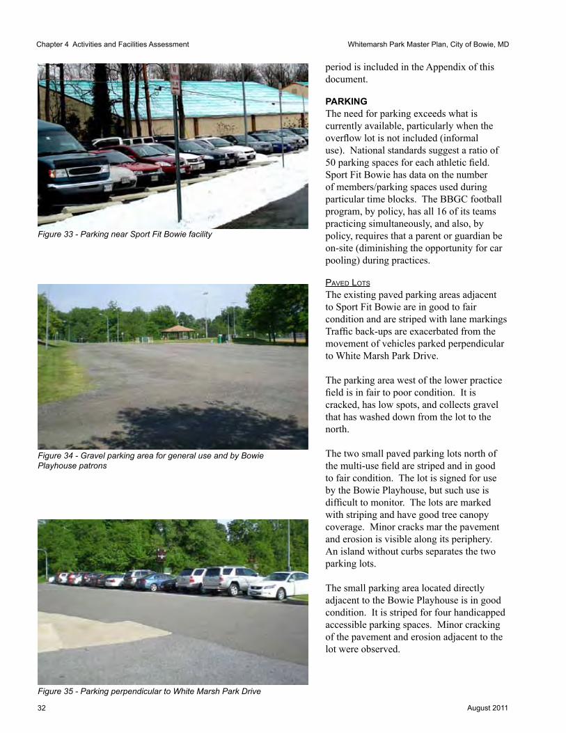
32 August 2011
Whitemarsh Park Master Plan, City of Bowie, MDChapter 4 Activities and Facilities Assessment
period is included in the Appendix of this document.
PArKINGThe need for parking exceeds what is currently available, particularly when the overflow lot is not included (informal use). National standards suggest a ratio of 50 parking spaces for each athletic field. Sport Fit Bowie has data on the number of members/parking spaces used during particular time blocks. The BBGC football program, by policy, has all 16 of its teams practicing simultaneously, and also, by policy, requires that a parent or guardian be on-site (diminishing the opportunity for car pooling) during practices.
paVed lots
The existing paved parking areas adjacent to Sport Fit Bowie are in good to fair condition and are striped with lane markings Traffic back-ups are exacerbated from the movement of vehicles parked perpendicular to White Marsh Park Drive.
The parking area west of the lower practice field is in fair to poor condition. It is cracked, has low spots, and collects gravel that has washed down from the lot to the north.
The two small paved parking lots north of the multi-use field are striped and in good to fair condition. The lot is signed for use by the Bowie Playhouse, but such use is difficult to monitor. The lots are marked with striping and have good tree canopy coverage. Minor cracks mar the pavement and erosion is visible along its periphery. An island without curbs separates the two parking lots.
The small parking area located directly adjacent to the Bowie Playhouse is in good condition. It is striped for four handicapped accessible parking spaces. Minor cracking of the pavement and erosion adjacent to the lot were observed.
Figure 35 - Parking perpendicular to White Marsh Park Drive
Figure 34 - Gravel parking area for general use and by Bowie Playhouse patrons
Figure 33 - Parking near Sport Fit Bowie facility

33August 2011
Whitemarsh Park Master Plan, City of Bowie, MD
GraVel lots
The two existing gravel lots are located west of the game field and north of the multi-use field. They are in fair condition. Large iron piping substitutes for curbing and is used to prevent gravel from being transported to adjacent grassy areas. Several trees are located in the lots. Cones and ropes organize the spaces.
oVerFlow lot
The existing overflow parking area is located on the 4.98-acre Williams Plains parcel.
TrAILSThe existing trail system provides access for both pedestrians and bicyclists. There are over 1.5 miles of improved (paved) and additional unimproved trails in the park.
The eight-foot wide improved trail is paved with asphalt and is in good condition. Erosion was noted on the trail edges and minor cracking of the pavement was observed. The pedestrian bridge appears to be in good condition, although a formal structural analysis was not done. There is stream undercutting at the bridge’s location.
The Discovery Nature trail is well mulched. Some of the signs are missing and should be replaced. All signs and graphics should be updated.
The unimproved trail conditions vary. Further evaluation of the existing unimproved trails may be necessary if major changes to the trail system are proposed in future planning efforts.
Figure 36 - Paved trail with bench, trash can, and sign marker
Parking Demand - Fall 5-8 PM weekday evening
Sport Fit Bowie Peak 249 (highest is 330 in Jan) Football 1503 fields @ 50 spaces/field Kickball 721 field (assume 4 teams at 18 each overlap)
Group and Family Picnicsand General users
Bowie Playhouse on Friday night 150
TOTAL SPACES NEEDED = 621
Figure 37 - Pedestrian trail bridge

34 August 2011
Whitemarsh Park Master Plan, City of Bowie, MD
This page left intentionally blank.

35August 2011
Whitemarsh Park Master Plan, City of Bowie, MD
CHAPTER 5
SITE SuMMAryIssues and OpportunitiesFollowing the analysis of the site conditions and site activities, a summary diagram was compiled. The diagram highlighted the areas the Master Plan should focus on, and identified important issues to address. Its compilation directed discussion on the future pattern of use for the site. Overall concerns include
• Limited access to Park from Crain Highway - difficult vehicular access with no intersection controls at the existing access road
• Shortage of parking - determination of appropriate ratio of parking to activities
• Degree of development appropriate for woodlands (if any) - an extensive wooded area covering a majority of the Park
• Field management - demand for athletic facilities exceeds field capacity and infrastructure
• Neighbors - although heavily wooded, site is surrounded by a variety of residential neighborhoods
• Williams Plains historic house and grounds (potential archeological survey for entire park boundary may be required as park outside of parcel once was connected to the property)
• Need to improve and expand infrastructure - parking, restrooms, field surfaces
Chapter 5 Site Summary
Figure 38 - Issues and Opportunities diagram

36 August 2011
Whitemarsh Park Master Plan, City of Bowie, MD
Opportunities include• Existing active uses are already
concentrated in a small area of the Park
• Extensive woodlands home to passive recreation uses
• Expansion of future revenue stream through additional pavilion rentals
• Removal of temporary toilets and construction of permanent year-round restroom
• Potential secondary vehicular access points
• Development of stormwater management options to reduce degradation of tributary streams on-site
Zones of UseExisting park activities currently split the Park into two zones. Active recreation uses are tightly compacted on the eastern edge of the Park. Passive recreation surrounds the active area, covering approximately 85 percent of the park land.
Chapter 5 Site Summary
Cra
in H
ighw
ay (M
D R
oute
3)
Whitemarsh Park
Figure 39- Zones of use within the Park

37August 2011
Whitemarsh Park Master Plan, City of Bowie, MD
CHAPTER 6
PrOGrAM NEEDS AND DESIGN CONSIDErATIONSProgram NeedsSince the Park was acquired by the City of Bowie, planning for Whitemarsh Park has struggled to find the balance between active and passive recreation uses. As master plans were created and revised, similar issues arose each time: limits generated by a single point of access; the challenge of and impact on the woodlands from any expansion of active recreation uses; peak parking demands and limitations; and wrestling with what was an appropriate level of human activity in the woodlands and programming for active recreation in the developed area of the Park.
Currently the Park is at capacity if a secondary access point is not developed and no further infrastructure improvements are made to expand parking and field capacity. However, this capacity limitation does not mean that all the programming needs for park users are adequately provided in the City. What it does mean is that these needs may not be economically or environmentally accommodated at Whitemarsh Park and another site within the City should be sought..
Design ConsiderationsPedestrian FocusPedestrians are the on-site park users. Whether a visitor arrives in a vehicle from Crain Highway, or walks or bikes in from adjacent neighborhoods, ultimately the Park is a pedestrian experience. Better separation of pedestrians and vehicles is needed, particularly between the athletic fields and the parking lots. Trails for pedestrian use, better connecting the parking areas with the Park, are recommended.
This Master Plan recommends that a linear parking lot, located between the game field and the baseball field, be replaced by a pedestrian area. Currently, movement between fields requires crossing a double-loaded parking lot. As the Park’s athletic fields are transformed and a practice session is run on multiple fields simultaneously, the removal of the existing vehicle/pedestrian conflict will become more important.
The proposed pedestrian area between fields is reinforced with pedestrian-oriented activities - the insertion of permanent restrooms, a concession stand, relocation of the picnic pavilion and informal picnic areas, and an additional playground. Whether the pedestrian area is paved or grassy or a combination of the two surfaces, trees should be planted within the area. New trees will provide shade and tree canopy additions and offset the loss of some of the trees removed for parking expansion.
Chapter 6 Program Needs and Design Considerations

38 August 2011
Whitemarsh Park Master Plan, City of Bowie, MD
Accessibility StandardsAll facilities must meet the federal standards for ADA accessibility. Requirements affect paths, parking areas, pavilions, playgrounds, sports seating areas, and game fields.
Circulation and ParkingVehicular traffic and circulation dominate the Park today. The recommended improvements must enhance the pedestrian experience - it is a park - and relegate the vehicle to secondary importance.
Total parking needs projected in the Master Plan are not substantially different than the amount of parking currently provided, when the grassy overflow parking lot’s capacity is included in the existing count. However, the grassy lot is used on an as-needed basis today and cannot serve as permanent parking in the future. Better organization of existing lots, and the relocation and expansion of several others will provide for parking to serve existing and projected Park activities.
The existing parking lot that bisects the athletic fields, located between the football and baseball fields, is recommended for removal in the Master Plan. Spaces provided there are to be reallocated north and west of the Bowie Playhouse, providing parking accessible to the theater. Additional parking is also provided near Pavilion 2 and the rearranged practice field. Should the need arise, additional parking (with proper design) may be added at the entrance drive and across from the Sport Fit Bowie facility.
No additional points of vehicular access were provided. This was not because such access was unwanted, but that it could not be provided in an environmentally and economically responsible manner. The City should
study further the benefits and challenges to adding acceleration and deceleration lanes to Crain Highway (MD Route 3) at the entrance to the Park.
Protection and Enhancement of Environmentally Sensitive AreasMost of the Park is wooded and undeveloped. No areas are known to require federal or state protections. New State, County, and City regulations require that a Natural Resource Inventory (NRI) be completed for the entire Park for any site improvements. In addition, an update to the previously approved Type 2 Tree Conservation Plan (TCP2) must be developed in conformance with current requirements.
Because the Park is subject to a TCP2 approved under government projects provision of the 1993 Woodland Conservation Ordinance, on-site tree removal must be replaced at a 1:1 basis, by afforestation, if proposed on-site. Any removal of woodlands will affect the woodland conservation requirement for the site, and trigger an on- or off-site replacement figure.
If a woodland conservation bank is used instead of afforestation on-site, an approved Natural Resource Inventory (NRI) and a form of Forest Stand Delineation (FSD), dependent upon the complexity of the project, and preparation of a TCP2 is required for the receiving site. Approval by Prince George’s County is also required. Off-site woodland conservation credits can be provided either by the preservation of existing trees or through the creation of new woodlands through afforestation. When provided by preservation, two acres of preserved woodlands are required for each acre of off-site woodland conservation credit required (2:1 basis). When it is provided by off-site afforestation, it is a one for one ratio (1:1 basis). If a Tree Conservation Plan is completed for the receiving site, say another
Chapter 6 Program Needs and Design Considerations

39August 2011
Whitemarsh Park Master Plan, City of Bowie, MD
City park, it is probable that the City of Bowie could use the afforestation effort for landscape plantings at that particular site. (Finch, 2011)
Under the 2010 WCO, the City has the option of retaining the 1:1 replacement requirement currently in place, or can choose the new option of preparing a TCP2 for the entire park property and applying a woodland conservation threshold based on the underlying zoning of the site instead of the existing woodland on the site, and subject to a reduced 0.25:1 replacement requirement for woodland removed above threshold. Under this approach, existing trees on-site or new afforestation can be used to fulfill the requirement on-site. (Finch, 2011)
The White Marsh Branch and its tributaries within the Park have continued to deteriorate as the area surrounding the Park has developed. Beyond the City of Bowie’s Environmental Infrastructure Action Strategy Plan Staff Findings and Recommendations for expansion of stream buffers, specific projects noted in the Strategy Plan should be implemented to improve the stream and its water quality. Examples of these specifics are included in the sidebar on page 23.
Non-native invasive vegetation is infesting the woodlands and requires a coordinated management and eradication plan. The Master Plan must address management needs such as the removal of invasive plant species, refurbishment of the understory, enhancement of the native species in the wooded areas, and restoration of stream tributaries.
Stormwater ManagementThe stream tributaries show evidence of degradation from increased run-off. Although the majority of the run-off is unlikely to be coming from within the Park, any opportunities to reduce run-off are important from an environmental as well as an educational standpoint.
Changes to the parking lots offer an opportunity to educate the public on ways to integrate Low Impact Development (LID) methods for capturing run-off within driveways and parking surfaces and to make use of pervious or semi-pervious paving material. Any improvements to the existing parking lots will require the incorporation of LID stormwater management strategies such as bioinfiltration swales, wet swales or permeable paving.
Current Park Management PracticesCurrent park management practices were reviewed and the recommended improvements in the Master Plan reflect those conversations.
Park operations requested a storage building for equipment, located on a site that is directly accessible by vehicles. No storage is currently available and all equipment must be brought to the site.
The existing irrigation system at the Park is over thirty years old and does not serve all athletic fields. It should be replaced.
The current football game field requires much effort from park staff to maintain the turf in playable condition. It is closed for much of the year, open only for three months in the fall for football season.
Park operations put up temporary flagging in the large parking areas in an attempt to protect parking spaces for Bowie Playhouse visitors.
Pervious Paving
Permeablepaving,aviablealternativemaybemorecostlytoinstallandrequiresignificantamountsofmaintenancesuchasvacuumingtokeepsiltbuild-upoutofporousconcreteorasphalt.Communitiesthathaveinstalledporouspavementhavediscoveredwithoutproactivevacuumingandcleaningtheporosityislostafterayearortwo.Gravelorpaversofferotheralternativeformsofpermeablepaving.Gravelisrelativelyinexpensive,butdifficulttomarkorstripeforparkingalignment.Somecommunitieshaveusedpaversinlieustripinglines,butthegravelwillhavetobeoccasionallysweptoffthepavers.Paversareavailablethatincorporateaholeorslottoallowpercolation.Paversaremoreexpensivetoinstallonapersquarefootbasis,butmaylastlongerthanotherpavingalternatives.
Chapter 6 Program Needs and Design Considerations

40 August 2011
Whitemarsh Park Master Plan, City of Bowie, MD
Whitemarsh Master Plan
DRAFT
5/21/2010
Number of
Teams
Number of
Players per
Team
Practice
Days
Practice
Length/Tim
e of Day
Number of
Teams
Simultan.
Practice
Number of
Teams
Simultan.Pl
ay
Length of
Game
Number of
Games per
Week
Game Time
Period
Parking
space needs
for practice
Parking
space needs
for games
2010
Program
2015
Program
2020
Program
Storage
Needs
Shared
Field/Field
preference
Season of
Play Other
Field Type
preference
or issues
Source of
Info
Kickball 36 18 aver. 4 50 min. 16
6:30 PM-
10:00 PM 400 48 50
contractor
box
Softball field
exact match;
can use
soccer; prefer
syn turf
Mark Villee,
Kickball
League of
Bowie, email
dated
5/18/10
Lacrosse 12
12-25/team;
total players
is about 200
each night -
four nights
per week:
assume
M,T,W,Th?
1.5 hour -
time slot? 3 15-25 30-45 300-400 400-500
No need if
shed on RT.
450 remains
Concession
facility;
Scoreboard;
Desire a 40'
cinderblock
wall 15' - 20'
high to be
used for wall-
bat training
like the one
at Cardinal
Field in
Crofton
Synthetic turf
which allow
shared
playing time
w/football
and year
round use;
Natural grass
fin is
available from
Feb through
June
Gary Hahn,
Bowie Boys
Lacrosse
Commissioner
, email dated
5/7/10
BBGC
Baseball;
Joe Bechtel
source
41: not clear
how many
are at
Whitemarsh
12 -16
average
average 2
hours w/ 1.5
hour for T-
ball
average 2
hours w/1.5
hour for T-
ball
10-13
timeframe?
20-28 -
timeframe? 513 650 750
7-8 teams
play year
round - at
WM?; Tryouts
in Feb
w/spring
season
ending early
July; fall
tryouts Aug,
play through
Oct
Field shortage
is 50' mound
and 70' base
fields w/250'
fenceline;
concession
stand for Sat
games would
be great;
First concern
is for 50'/70'
grass
bbfields,
additional
46'/60
skinned
infields
fix ext fields -
backstop,
load of dirt,
broken
benches and
groom
infields
Joe Bechtel;
BBGC-
Baseball
BBGC
Baseball;
Paul Meador
- numbers
for
WHITEMAR
SH current
use only
Limited
permit at
WM: 14U full
use; need
more field
time at WM;
1 team
currently
playing at WM
w/three
organized
events per
week
13 players
(deduced
from 14U
figure)
Monday,
Wednesday,
Saturday,
Sunday
morning
Monday and
Wednesday
6:00 pm -
8:30 PM;
Saturday 9AM-
3PM - DO
OTHER
GAMES GET
SCHEDULED?
; Sunday
morning - not
used
1 team w/1
field 1 unknown unknown unknown
13 members
on 14U team
demand will
increase for
70' and 90'
fields from
2012 onward
Permit for
WM runs from
May 1 - June
30
Paul Meador,
email dated
5/19/10
BBGC
Football 15 + 3 Flag 26
120 (time
period?) M-Th
200 (time
period) Sat. 375 425
1) Usable
field space (2
full game
fields); 2) reg
fields have
designated
spec stands
with
separation
apparatus; 3)
centralized
concession
and
bathroom; 4)
Press
box/scoreboa
rd w/storage
for field
items; 5)
designated
parking area
Synthetic on
game fields;
w/one natural
turf field
Jayson
Craddock,
BBGC
Football,
email dated
5/19/10
Chapter 6 Program Needs and Design Considerations
Figure 40a - User Matrix generated by Steering Committee members (left side)

41August 2011
Whitemarsh Park Master Plan, City of Bowie, MD
Whitemarsh Master Plan
DRAFT
5/21/2010
Number of
Teams
Number of
Players per
Team
Practice
Days
Practice
Length/Tim
e of Day
Number of
Teams
Simultan.
Practice
Number of
Teams
Simultan.Pl
ay
Length of
Game
Number of
Games per
Week
Game Time
Period
Parking
space needs
for practice
Parking
space needs
for games
2010
Program
2015
Program
2020
Program
Storage
Needs
Shared
Field/Field
preference
Season of
Play Other
Field Type
preference
or issues
Source of
Info
Kickball 36 18 aver. 4 50 min. 16
6:30 PM-
10:00 PM 400 48 50
contractor
box
Softball field
exact match;
can use
soccer; prefer
syn turf
Mark Villee,
Kickball
League of
Bowie, email
dated
5/18/10
Lacrosse 12
12-25/team;
total players
is about 200
each night -
four nights
per week:
assume
M,T,W,Th?
1.5 hour -
time slot? 3 15-25 30-45 300-400 400-500
No need if
shed on RT.
450 remains
Concession
facility;
Scoreboard;
Desire a 40'
cinderblock
wall 15' - 20'
high to be
used for wall-
bat training
like the one
at Cardinal
Field in
Crofton
Synthetic turf
which allow
shared
playing time
w/football
and year
round use;
Natural grass
fin is
available from
Feb through
June
Gary Hahn,
Bowie Boys
Lacrosse
Commissioner
, email dated
5/7/10
BBGC
Baseball;
Joe Bechtel
source
41: not clear
how many
are at
Whitemarsh
12 -16
average
average 2
hours w/ 1.5
hour for T-
ball
average 2
hours w/1.5
hour for T-
ball
10-13
timeframe?
20-28 -
timeframe? 513 650 750
7-8 teams
play year
round - at
WM?; Tryouts
in Feb
w/spring
season
ending early
July; fall
tryouts Aug,
play through
Oct
Field shortage
is 50' mound
and 70' base
fields w/250'
fenceline;
concession
stand for Sat
games would
be great;
First concern
is for 50'/70'
grass
bbfields,
additional
46'/60
skinned
infields
fix ext fields -
backstop,
load of dirt,
broken
benches and
groom
infields
Joe Bechtel;
BBGC-
Baseball
BBGC
Baseball;
Paul Meador
- numbers
for
WHITEMAR
SH current
use only
Limited
permit at
WM: 14U full
use; need
more field
time at WM;
1 team
currently
playing at WM
w/three
organized
events per
week
13 players
(deduced
from 14U
figure)
Monday,
Wednesday,
Saturday,
Sunday
morning
Monday and
Wednesday
6:00 pm -
8:30 PM;
Saturday 9AM-
3PM - DO
OTHER
GAMES GET
SCHEDULED?
; Sunday
morning - not
used
1 team w/1
field 1 unknown unknown unknown
13 members
on 14U team
demand will
increase for
70' and 90'
fields from
2012 onward
Permit for
WM runs from
May 1 - June
30
Paul Meador,
email dated
5/19/10
BBGC
Football 15 + 3 Flag 26
120 (time
period?) M-Th
200 (time
period) Sat. 375 425
1) Usable
field space (2
full game
fields); 2) reg
fields have
designated
spec stands
with
separation
apparatus; 3)
centralized
concession
and
bathroom; 4)
Press
box/scoreboa
rd w/storage
for field
items; 5)
designated
parking area
Synthetic on
game fields;
w/one natural
turf field
Jayson
Craddock,
BBGC
Football,
email dated
5/19/10
Chapter 6 Program Needs and Design Considerations
Figure 40b - User Matrix generated by Steering Committee members (right side)

42 August 2011
Whitemarsh Park Master Plan, City of Bowie, MD
Suggested Materials to Reduce Long-Term Maintenance CostsAny materials should be selected for their long term viability. Much interest was expressed in making use of permeable pavers. Careful analysis of the full-life cycle costs of any selected materials is important to fully understand the costs associated with the selection. The sidebar on this page presents some of the caution in the use of pervious pavement.
Green Design to Reduce CostsSite design recommendations should make use of native non-invasive plants and plants requiring minimal irrigation. Site furnishings should be made of renewable or recyclable materials with reduced or no petroleum by-products.
Site grading and drainage should make use of bioretention, infiltration, or other LID practices in accordance with the City of Bowie’s Development Policies.
Paving for parking and other hard surfaces should be pervious or semi-pervious or incorporate means of capturing rainwater run-off in infiltration trenches. Care should be given to ensure that the selected approach does not incur additional labor and maintenance, such as some porous pavements that require frequent vacuuming to remain porous. (See Sidebar, page 39.)
LEED certification or its comparable program should be achieved for any construction project.
Program InventoryEach of the members of the Steering Committee were asked to provide information on their group’s needs and activities. All of this information was organized into a large matrix, updated throughout the master planning process.
The matrix summarizes the current demands on the Park, and identifies preferences for future uses. (See Figures 40a and 40b.)
Chapter 6 Program Needs and Design Considerations

43August 2011
Whitemarsh Park Master Plan, City of Bowie, MD
Plan ElementsBowie PlayhouseBOWIE PLAyhOuSE - PrOGrAM NEEDSThe existing facility is adequate for the current productions. No change is proposed for the facility itself. However, the Playhouse is in need of parking located closer to the theater. At a minimum, 50 additional spaces located immediately adjacent to the Playhouse are desired. Currently, only four spaces are adjacent to the building and all other attendees must walk from remote parking lot, often after having to compete with other park users for the spots.
BOWIE PLAyhOuSE - DESIGN CONSIDErATIONSTwo locations for additional parking for 50 vehicles were considered in each of the Concept Alternatives. One location is northwest of the existing access drive, in a wooded, moderately sloped location near the existing Fire Circle. The second is directly south of the Playhouse and is relatively flat. Although both potential locations are covered with trees, many of the species are considered non-native invasive species.
Sport Fit BowieSPOrT FIT BOWIE - PrOGrAM NEEDSAlthough Sport Fit Bowie, as a lessee and membership organization, is operated independently of the City of Bowie and the Whitemarsh Park activities, its heavy use affects other users of the Park. As an organization with approximately 11,000 members at its peak, parking facilities and the single access road are affected by those users. Sport Fit Bowie has a current lease with the City that runs to 2035 and has two options to extend the lease for two ten-year periods, effectively extending the lease to 2055. Because of this, its use patterns must be factored into any programming needs for the Park itself. Much of the parking along White Marsh Park Drive and immediately north of the football game
field is predominately used by Sport Fit Bowie, as are the paved spaces located on the southeastern corner of the Williams Plains parcel.
The Steering Committee attempted to relocate the head-in parking that abuts the entry drive in the hope of reducing the ‘friction’ of cars entering and exiting the entry drive along that congested section of driveway but was unable to come to agreement on replacement spaces that were as close to the Sport Fit Bowie facility and could serve patrons that require spaces close to an entrance, such as those attending aqua therapy classes. (See Figure 35.) As is true with most users, the desire is for parking locations as close to the activity site as possible. Sport Fit Bowie operates a golf cart shuttle system to collect members who park in the more removed lots.
Sport Fit Bowie successfully applied for a permit to construct three tennis courts behind the Williams Plains house, although that permit has expired and no construction has commenced. This proposal is the only increase in Sport Fit Bowie programming that the Steering Committee was made aware of in the planning process.
SPOrT FIT BOWIE - DESIGN CONSIDErATIONSPotential additional parking, primarily serving Sport Fit Bowie, is proposed within the wooded area on the south side of White Marsh Park Drive. Although not immediately adjacent to the existing entrance, the configuration could provide as many as 77 spaces near the Sport Fit Bowie facility, freeing up parking spaces near the athletic fields for use by team members and spectators. Any parking development in this area is dependent upon providing appropriate buffers to adjacent property owners. Special attention shall be given to buffering Lot #1, located to the east of the synthetic turf field, where a unique equestrian facility of a sensitive nature is located.
Chapter 6 Program Needs and Design Considerations

44 August 2011
Whitemarsh Park Master Plan, City of Bowie, MD
Athletic Fields This update of the Master Plan for Whitemarsh Park was sparked by the heavy use and need for additional sports accommodation on the athletic fields at Whitemarsh Park. Currently, the fields serve the football program for the BBGC, provide a limited amount of playing area to the BBGC baseball league, the St. Pius X baseball team and the baseball program from Grace Christian School. The Park also provides practice areas for BBGC lacrosse, and game and practice fields for the Kickball League of Bowie. Each sport’s desired program expansion and needs is discussed by field association - Program Needs - and includes an analysis of the ability of that particular area to absorb any additional use or to be reprogrammed - Design Considerations.
The current configuration of athletic fields in the Park with one natural turf football game-sized rectangular field, two smaller grassed areas used for practices, and one game-sized baseball diamond, all lighted, limits the flexibility of field use and does not allow year-round access to the City’s infrastructure investment.
This Master Plan recognizes that the individual leagues mentioned in this discussion are not ‘owners’ of a particular field and are given access to the fields through a City-developed permit process. However, for purposes of the planning effort, the Steering Committee worked with athletic teams’ representatives who presented real needs and challenges in their use of Whitemarsh Park. The focus on specific athletic teams’ needs sharpened the Committee’s discussion. Costs for various improvements and their impact on existing park functions were explored. The impact of accommodating these needs is included in the Design Considerations discussion specific to each sport and field.
FOOTBALL GAME FIELD - PrOGrAM NEEDS The existing game field is currently used for football games and minimal practices from August to November. It is closed for maintenance the remainder of the year. The desire is to have a field that may be used during all weather conditions, year-round, for practices as well as games, and for multiple sports.
FOOTBALL GAME FIELD - DESIGN CONSIDErATIONS The existing natural turf game field, field light pole locations, and the lay of the land do not allow for the expansion of the existing field width to accommodate regulation soccer without significant grading, relocation of the existing storage facility and relocation of the handicapped access ramp and field lights.
Synthetic fields may be lined for up to three separate sports.
Installation of synthetic turf, lined for football, and men’s and women’s lacrosse, will best accommodate the needs of current users and match the physical restrictions (existing field lights and the restriction on the field width due to the site’s topography eliminate soccer as a regulation-sized field user) of the current field dimensions.
STOrAGE ArEA - PrOGrAM NEEDS Two athletic equipment storage sites are currently located at Whitemarsh Park. A small storage box permanently anchored near the baseball field holds baseball equipment seasonally. A small storage building, located adjacent to the football game field, is filled to capacity with football equipment. Additional on-site storage capacity has been requested by the BBGC program for football needs.
BBGC lacrosse indicated that it had adequate storage off-site and did not need storage facilities at Whitemarsh Park.
There is no overall park operations storage space available at the existing storage
Chapter 6 Program Needs and Design Considerations

45August 2011
Whitemarsh Park Master Plan, City of Bowie, MD
facility. Some provision for equipment and temporary use items would be of value. A Park operations storage facility should be directly accessible by park operation vehicles.
STOrAGE ArEA - DESIGN CONSIDErATIONSAny storage building expansion or construction should not dominate the site, and if possible, incorporate green building practices and LID site considerations. Any dual use that is possible should be explored, such as a combination of storage/press box configuration.A separate building, devoted to park operations needs, should be incorporated in the Park, adjacent to a parking lot or drive, for ease of access by park trucks and equipment.
LOWEr PrACTICE FIELD - PrOGrAM NEEDS There is a desire for a lacrosse practice rebounding wall at Whitemarsh Park and for expanding field space.
The lower practice field should be irrigated, it is not currently.
LOWEr PrACTICE FIELD - DESIGN CONSIDErATIONS The lower practice field has no room for realistic expansion to regulation-size field dimensions due to the steep slopes that surround it on three sides. Any expansion of the field would require significant grading and the disturbance of woodlands and streams. Originally planned to be a regulation-sized field or tennis courts in earlier master plans, the field instead has served as a practice field for football, lacrosse and kickball.
The installation of a lacrosse practice rebounding wall, approximately 40 feet long x 15 -20 feet high could be done working with the existing steep grades.
Irrigation of the field will extend the season for its use.
Chapter 6 Program Needs and Design Considerations
BASEBALL FIELD AND BATTING CAGE - PrOGrAM NEEDSOver the years, baseball and softball activities have been reduced at Whitemarsh Park as facilities have been expanded for their use in other parks in the City. The former softball field has been converted to a grassy practice area, leaving a single baseball diamond. The baseball field is signed as the Combination Field, although it is currently permitted for baseball only. Long-term, it is the City’s desire to move baseball to a baseball-oriented facility, and to convert the existing baseball field to a rectangular field for use by football and men’s and women’s lacrosse as well as the kickball program. However, until a suitable, lighted field site can be identified, baseball is to remain at Whitemarsh Park.
BASEBALL FIELD AND BATTING CAGE - DESIGN CONSIDErATIONS Ultimately, if and when a suitable alternative site for baseball is identified, the current field will be converted to an open, grassy practice field and free-play component of the Park.
MuLTI-uSE FIELD - PrOGrAM NEEDS Renovation and expansion of the field, reorienting it 90 degrees will yield a regulation-sized field for football and men’s and women’s lacrosse. This natural turf field will build-in flexibility and add value, allowing for year-round use by multiple sports.
Field lights along the southern side of the field will be required. Existing field lights are on the northern side and may remain in place.
The irrigation system should be replaced, as it is over thirty years old and field dimensions have changed.
Under drainage, placed under the entire field, will do much to increase the year-round usability of the natural turf field.

46 August 2011
Whitemarsh Park Master Plan, City of Bowie, MD
MuLTI-uSE FIELD - DESIGN CONSIDErATIONS Synthetic turf is not recommended as that would increase pressure to program the field for additional games and put more pressure on the capacity of the Park to accommodate additional users.
The existing irrigation system is recommended for replacement, due to its age (over thirty years) and the field reconfiguration. Lighting must be added to the southern side and under drainage incorporated under the field.
BASKETBALL hALF-COurT - PrOGrAM NEEDS Basketball is not an activity that receives much, if any, use at Whitemarsh Park. The current half-court configuration painted on the asphalt parking lot, and worn, is lightly used by park visitors.
BASKETBALL hALF-COurT - DESIGN CONSIDErATIONSProgramming for basketball will not be included in this Master Plan.
CONCESSION FACILITIES - PrOGrAM NEEDS Past Whitemarsh Park Master Plans have long called for concession facilities related to the athletic fields. Steering Committee members expressed interest in the development of a centralized facility near the practice and game fields.
Users of all ballfields desire a formal and equipped concession stand, both for convenience on game and practicedays, and for fundraising purposes.
CONCESSION FACILITIES - DESIGN CONSIDErATIONS The size, orientation, location, and amenities of such a facility may involve consultation with representatives of the user groups. Instead of multiple stands, the Plan recommends that one concession stand be shared by all sports and operated by all teams.
With the provision of permanent restrooms and a related extension of a water line, incorporation of a concession facility may be timely, housed in the same building as the new restrooms.
PrESS BOX - PrOGrAM NEEDSThe athletic teams using the football game field desire a larger press box. Currently there is a small press box at the Park.
PrESS BOX - DESIGN CONSIDErATIONS Consideration should be given to incorporating a new press box in the proposed storage structure, adjacent to the proposed synthetic turf field on the eastern side of the athletic area.
SCOrEBOArD - PrOGrAM NEEDSThe existing scoreboard is functional and needs no improvements. Its current location limits its use to the football game field (soon to be synthetic turf multi-sport game field).
SCOrEBOArD - DESIGN CONSIDErATIONSConsideration was given to locating a second scoreboard at the western field, but concerns regarding capacity of the Park and its infrastructure to support to ongoing games simultaneously led to its deletion from the Master Plan. The scoreboard may require modifications to incorporate the new use by men’s and women’s lacrosse programs.
RestroomsPermanent restrooms are a strongly desired addition to the Park. A 2010 study by Ben Dyer Associates explored several locations for septic-served facilities at Whitemarsh Park.
PrOGrAM NEEDSWhitemarsh Park currently does not have flush restroom facilities. At the time of this study, temporary toilets were placed in several locations throughout the Park. The installation of permanent flush restroom facilities on the site should be a priority and have been noted as such since the Revised Master Plan was developed in 1979.
Chapter 6 Program Needs and Design Considerations

47August 2011
Whitemarsh Park Master Plan, City of Bowie, MD
DESIGN CONSIDErATIONSProposed permanent restroom facility locations shown in the Ben Dyer report were based upon existing field configurations. Given the discussion and proposed athletic field reorganization, a different location for the restroom complex should be considered. A single facility, with six unisex/HC accessible units is proposed for location in the midst of the athletic fields, near or as a part of the concession stands.
Recreation AreaChILDrEN’S PLAyGrOuND - PrOGrAM NEEDSA playground is located near the western picnic pavilion, far from the active areas of the Park. Ranger observation is that few children use the facility, although on a game day, children were observed on the swings. It is likely that a playground will receive more use if it is located closer to the athletic fields, as siblings often are brought along to practices and games.
ChILDrEN’S PLAyGrOuND - DESIGN CONSIDErATIONSThe existing play area is not affected by any of the proposed changes and may remain as it is. The existing play area is nicely sited given the tree canopy and shade provided.
New playground equipment, aggregated into two areas by age of user, should be provided near the restroom/concession stand and athletic fields. Shade structures or non-invasive plantings should be incorporated in the development of the new playground. FIrE CIrCLE - PrOGrAM NEEDSThe existing Fire Circle is located in a remote, fairly unusable, portion of the Park due to its proximity to the Bowie Playhouse. A better location, adjacent to a picnic pavilion, is likely to increase its use.
FIrE CIrCLE - DESIGN CONSIDErATIONSIt is recommended that the Fire Circle
Chapter 6 Program Needs and Design Considerations
be relocated to an area near the western picnic facility. Still accessible to the natural woodland area, it will no longer compete with the evening use of the Playhouse and users can make use of the adjacent picnic facility as well.The new Fire Circle must have adequate separation from all pavilions, athletic fields and play areas for fire safety.
PICNIC PAvILION 1 - PrOGrAM NEEDSPicnic Pavilion 1 is currently located near the central parking lots, in the heart of the Park. Due to the recommended reconfiguration of the parking and athletic fields, this facility will need to be relocated. PICNIC PAvILION 1 - DESIGN CONSIDErATIONSPavilion 1 should be relocated to the area between the proposed synthetic turf field and the baseball field, an area that has been used for parking, but it is recommended as becoming solely pedestrian space. This location may also house new restrooms, a concession stand, and a new playground.
PAvILION 2 - PrOGrAM NEEDS Pavilion 2 is located to the west of the athletic fields.
PAvILION 2 - DESIGN CONSIDErATIONS No changes are recommended to Pavilion 2.
INFOrMAL PICNIC ArEA - PrOGrAM NEEDSThere is a collection of picnic tables under a canopy cover of deciduous trees north of the athletic fields. The area will be affected by the adjustments to the parking lots and athletic fields, resulting in the need to relocate this area.
DESIGN CONSIDErATIONS - INFOrMAL PICNIC ArEAThe picnic tables may be relocated to the pedestrian area between the proposed synthetic turf field and the baseball field.

48 August 2011
Whitemarsh Park Master Plan, City of Bowie, MDChapter 6 Program Needs and Design Considerations
Non-invasive tree species should be planted to provide shade for the picnic facilities.
Cultural ResourcesThe Williams Plains house and its 4.98-acre parcel is leased to Sport Fit Bowie. Given the lease runs to 2035, with two ten-year options for extension, the site is not included in this master planning effort.
However, given the historic use of the entire parcel, archeological investigation may be required by permitting entities, dependent upon the proposed activity, its location, and degree of proposed ground disturbance.
Natural Area of the ParkMuch of the Park is natural, wooded, and bisected by tributaries of the White Marsh Branch. There is significant erosion at the pedestrian bridge crossing, and significant erosion and down-cutting in most of the stream valleys.
Given that much of the increase in stormwater runoff is generated outside of the Park, a full watershed study of the entire White Marsh Branch is needed. Stormwater best management practices need to be emphasized upstream and within adjacent neighborhoods to improve the quality of White Marsh Branch. Once a watershed study is completed, a restoration plan for the White Marsh Branch and its watershed should be developed, and incorporate recommendations for White Marsh Branch within the Park.
Earlier studies have identified White Marsh Branch as one of the City’s subwatersheds that is in ‘Fair’ condition, compared to the rest, that are in ‘Poor’ condition. Recommendations for this subwatershed include expanding vegetative buffers to mitigate the effects of non-point source nutrient discharges and address water quality and habitat
problems identified in the White March Branch subwatershed.
While White Marsh Branch is not a priority subwatershed due to its ‘Fair’ condition, the City of Bowie’s Planning and Public Works Departments are beginning to re-examine sites that were initially assessed by MD DNR in 2003. This work has begun in the Middle Collington Branch and will proceed throughout the City’s watersheds over the coming years.
Tree clearing should be kept to a minimum, permitted for some additional parking, access roads and athletic fields, as discussed in this Master Plan on page 38. Non-native invasive vegetative species are a problem in portions of the Park’s natural areas. An invasive species management plan should be developed for the Park.
The City of Bowie currently has a tree canopy coverage of approximately 46 percent, as derived from high resolution aerial images in a 2009 study performed by Keith Pelletier and Jarlath O’Neil-Dunne at the University of Vermont and funded by Maryland Department of Natural Resources. City staff are currently considering a tree canopy coverage goal of 50 percent. Whitemarsh Park, due to its large natural area, has a tree canopy coverage of approximately 84 percent today. However, that coverage is not evenly distributed. Minimal tree coverage is found in the center of the Park, used for active recreation. Recommendations for field and parking realignment and expansion reduce the Park’s canopy coverage to approximately 82 percent, in excess of the 50 percent City goal.
Circulation and ParkingvEhICuLAr - PrOGrAM NEEDS The single point for vehicular circulation into and out of the Park is challenging during peak-use hours. Some football events have taken as long as thirty minutes of queuing to exit the Park. The access

49August 2011
Whitemarsh Park Master Plan, City of Bowie, MD
challenge is exacerbated since the only turn movement upon exiting is to the right, onto the southbound lanes of Crain Highway (MD Route 3). If the driver intends to go north, the vehicle must quickly cross two lanes of high-speed (50 mph) traffic to reach a cross-over in the median. Once across, the driver must merge with similarly fast northbound traffic.
vEhICuLAr - DESIGN CONSIDErATIONSFour potential vehicular access points were investigated by the Steering Committee during the master planning effort. All were rejected, due to environmental or economic concerns, discovery that the Annexation Agreement of the residential properties along Forest Drive precluded Park access from that neighborhood, or after conversations with the Maryland State Highway Administration regarding the preferred plan for Crain Highway (MD Route 3) corridor.
At the end of the Steering Committee’s discussion, further exploration of extending the acceleration and deceleration lanes along MD Route 3 at the Park’s entrance appeared to be the most viable solution for improving vehicular access to the Park. However, at the public meeting, residents of Forest Drive (South of the Park) raised concerns about the effect such an extension would have on the ‘gap’ that allows them to exit onto the southbound lanes of Crain Highway (MD Route 3).
PArKING - PrOGrAM NEEDSBetter design of the existing parking areas and the creation of additional parking spaces will better serve park users. New surfacing that allows for striping or some form of parking space identification will also increase the yield of the existing parking areas.
An informal overflow parking area, located on the Williams Plains house parcel will no longer be needed, better preserving the environmental setting of the historic house and property.
Vehicular Access Investigations
option 1 - white Marsh parK driVe (new Cross-oVer)RetainaccessforsouthboundtrafficonCrainHighway(MDRoute3)atcurrentlocation.Createmediancross-overforaccessfromnorthboundCrainHighway(MDRoute3).Thecross-overrequirespurchaseofapproximately2.9acresdirectlyacrossfromthePark.Thenewcross-overwouldnotremedythepotentiallydangeroussituationfromhighspeedsouthboundtraffic.NoadditionalentryorexitpointstotheParkwouldbeadded.
FutureSHAplansforthecorridordonotincludeanynewcross-oversatthislocation,orbetweenMDRoute450andU.S.Route50.Thesouthboundlanewillbecomeaservicedrive.
option 2 - Forest driVeProvidenewpointofaccesstoParkfromForestDrive.Exploredoingwarrantworktogainpermissiontoinstallfour-waysignalizedintersectionatForestDriveandCrainHighway;couldbeflashingyellowsignalatlowusetimes.SHAinformedCitythatallcostsforinvestigationandconstructionwouldneedtobebournebyCity.SightlinesareadverselyaffectedbyverticalalignmentofsouthboundlanesofCrainHighway.ThisoptionwillprovideaccessfromnorthandsouthboundCrainHighway.
FutureSHAplansforthecorridordonotincludeanynewcross-oversatthislocation(bridgeoriginallyshownin2004drawingsatForestDriveisnotincludedinthepreferredcorridorplan),orbetweenMDRoute450andU.S.Route50.TheAnnexationAgreementfortheForestDriveneighborhoodprohibitanyadditionalvehicularaccessfromForestDrivetoWhitemarshPark.
option 3 - spur wayVehicularaccessfromSpurWay,onthewesternedgeofthePark,couldparalleltheexistingeight-footwidepavedasphalttrailthatentersthepropertythroughaparcelownedbyM-NCPPC.M-NCPPCwouldconsidertheaccessiftherewerenoneighborhoodissuesresultingfromincreasedtrafficandiftheCityassumedmaintenanceresponsibilities.Theentrywouldcontinuetobegatedtocontrolaccessforuseduringpeaktimesandathleticgames.
Thisoptionwastoocostly,environmentallyandeconomically.
option 4 - annapolis road (Md route 450)VehicularaccessfromthenortheastcouldbeprovidedattheintersectionofRaceTrackRoadandAnnapolisRoad.
Thisoptionwastoocostly,environmentallyandeconomically,duetothelengthofthedrive,thesteepslopesassociatedwithWhitemarshBranchandsmallertributaries,streamcrossings,andtheimpacttoexistingwoodlands,whichwouldneedtobemitigated.Anaccessroadfromthenorthwouldalsobisectthenaturalarea.
Chapter 6 Program Needs and Design Considerations

50 August 2011
Whitemarsh Park Master Plan, City of Bowie, MD
PArKING - DESIGN CONSIDErATIONSAny improvements to existing parking areas, or the creation of new parking areas should consider the use of pervious or semi-pervious pavement or some form of bioinfiltration system to capture the stormwater runoff.
TrAILS - PrOGrAM NEEDSThe existing trail system is located in the western area of the Park. An inventory of the trail system, including recommendations for trail upgrades and replacement, should be done. The following items should be incorporated in that inventory and upgrade.
• Replace missing trail signs • Update existing trail signs with
new photographs• Remove dead trees adjacent to
trails for safety reasons• Add trail maps at main access
points and within the trail system
A new trail is needed to connect the athletic fields and Sport Fit Bowie facility with the trail system in the western end of the Park.
TrAILS - DESIGN CONSIDErATIONSAny improvements to trails should consider the use of pervious or semi-pervious pavement, while meeting ADA standards for accessibility.
Chapter 6 Program Needs and Design Considerations

51August 2011
Whitemarsh Park Master Plan, City of Bowie, MD
CHAPTER 7
MASTEr PLANVisionWhitemarsh Park is a valuable asset for the City of Bowie, City residents and all park users. Much of the park acreage is undeveloped and must remain so. A smaller, centrally located area is home to active recreation and organized athletic groups, picnic areas, the Bowie Playhouse and a private health and fitness club on land leased from the City.
After much discussion, the Steering Committee recommended to not expand programming at the Park and to not provide any additional vehicular access points to the Park. Internally, some improvements to the existing infrastructure are recommended, although minimal to no increase in overall capacity is advised. Some athletic fields are reoriented and resurfaced, parking is reconfigured, and if approved by SHA, the access drive intersection with MD Route 3 improved with acceleration and deceleration lanes.
Whitemarsh Park’s Master Plan recognizes the limitations of vehicular access to the Park and supporting infrastructure. Therefore, this Master Plan does NOT add any additional programming to the site. Rather, the Plan recommends future park improvements and facility upgrades. Even without new or expanded activities on-site, the Park is in need of renovation and proactive maintenance in both its active and natural areas.
The Master Plan for Whitemarsh Park delineates a vision for improvements and upgrades to the Park over the course of the next ten to fifteen years. It is a modest plan, focusing more on how best to stage upgrades of existing features and infrastructure, rather than adding new uses and programming to the site. For example, the overall parking count does not change significantly, but modifications to the location and design of the parking areas are recommended. Rather than a wholesale replacement and restart,
Chapter 7 Master Plan
Figure 41 - White Marsh Park Drive, single point of park entry

52 August 2011
Whitemarsh Park Master Plan, City of Bowie, MDChapter 7 Master Plan
the Master Plan directs renovations and improvements in a manner that is logical, practical, and environmentally responsible. Similarly, the athletic field area is recommended to be reorganized to make better use of the currently developed areas of the Park, while not incurring unnecessary infrastructure costs such as removal and replacement of field lights.
The master planning exercise reviewed existing space allocation, looked at the current uses and priorities for activities within the Park and explored the Park’s capacity to support any expansion of programming. After much discussion with the Steering Committee and review of two Concepts (A and B), this Master Plan recommends modifications to existing fields, rather than the expansion of athletic facilities within the Park.
Master Planning GoalsGoals, in direct response to the five questions posed for planning at Whitemarsh Park, (See sidebar.) were developed to guide the development of the Master Plan. They are listed below.
• Improve access to, and parking and infrastructure within the active section of the Park
• Reprogram the athletic field complex to house football, women’s and men’s lacrosse, and kickball, with baseball remaining as an interim use until a more appropriate off-site location is found
• Ensure programming is balanced with infrastructure capacity
Why Plan Whitemarsh Park
1.InadequateParkingandAccess
2.AthleticFieldNeeds
3.LackofInfrastructure
4.ExtensiveNaturalArea
5.DevelopmentofPhasedCapitalBudget
BOWIE PLAYHOUSE
RELOCATED FIRE CIRCLE
HISTORIC WILLIAMS PLAINS PROPERTY
PAVILION #2
SYNTHETIC TURF
(200’ X 415’)
SPORT FIT COMPLEX
GAME SEATING WITH RAISED PRESSBOX AND STORAGE BELOW
RESTROOMS & CONCESSIONS
NEW LOCATION FOR PAVILION #1
CHILDREN’S PLAY AREA (2 AGE GROUPS)
LACROSSE REBOUNDING WALL
A1 A2
B1
B2
D1F1
F2
F3
F4 F5 F6
F7
F8
FOREST DRIVE
CR
AIN
HW
Y
WHITE MARSH PARK DRIVE
TENNIS COURTS (2)
FUTURE BOWIE SPORT FIT EXPANSION
POOL
SY
LVAN
DR
IVE
E2
EXISTING PARK TRAIL (TYP)
POTENTIAL FUTURE PARKING
ADDITIONAL PARKING FOR BOWIE PLAYHOUSE
PAVED PEDESTRIAN CORRIDOR
SCOREBOARD TO REMAIN
WHITEMARSH PARK MASTER PLANFINAL CONCEPT
NATURAL TURF(220’ X 380’)
B3
B4
B5
PLAY AREA
ADDITIONAL PARKING FOR BOWIE PLAYHOUSE
LOT ID # SPACESA1 44A2 50B1 32B2 42B3 91B4 46B5 7C 77D1 4E1 17E2 33F1 54F2 7F3 24F4 42F5 19F6 17F7 2F8 14G1 32G2 16
TOTAL 670
PARKING SUMMARY FINAL CONCEPT
UNVERIFIED PROPERTY LINE
0 50 100 200
CR
AIN
HW
Y
CR
AIN
HW
Y
SPUR WAY
SAFETY TURN
WHITEMARSH PARK DR
FOREST DR
FOREST PLBRUNSWICK LN
STO
NE
YB
RO
OK
DR
.
ANNAPOLIS RD
RACE TRACK RD
NATURAL TURF (150’ X 200’)
WHITEMARSH PARK BOUNDARY (TYP)
LEGEND
EXISTING STRUCTURE
PROPOSED STRUCTURE
EXISTING ROADS/PARKING
PROPOSED ROADS/PARKING
EXISTING ATHLETIC FIELD
EXPANDED ATHLETIC FIELD
PROPOSED WALKS/PAVING
POTENTIAL TRAIL CONNECTION
EXISTING PARK TRAIL
GREEN INFRASTRUCTURE PLAN REGULATED AREA
E1
G1
G2
WHITEMARSH PARK MASTER PLAN
Lardner/Klein Landscape Architects, P.C.Planning • Urban Design • Landscape Architecture
CITY OF BOWIE, MARYLAND - MARCH 2011
SANITARY DRAIN FIELD
POTENTIAL EXTENDED ACCEL & DECEL LANES AT EXISTING ENTRANCEPOTENTIAL
CONNECTIONS TO EXISTING TRAILS AND
PAVILION (TYP)
PARK STORAGE AREA
C
OVERALL LOCATION MAP
WHITEMARSH PARK BOUNDARY (TYP)
PARK BOUNDARY
RO
UT
E 3
OLD TOBACCO BARN (APPROXIMATE LOCATION)
LOT ID # SPACESA1 44A2 50B1 32B2 42B3 91B4 46B5 7C 77D1 4E1 17E2 33F1 54F2 7F3 24F4 42F5 19F6 17F7 2F8 14G1 32G2 16
TOTAL 670
PARKING SUMMARY FINAL CONCEPT
Figure 42 - Whitemarsh Park Master Plan

53August 2011
Whitemarsh Park Master Plan, City of Bowie, MD
• Modernize the Park’s infrastructure in an environmentally and economically responsible manner
• Retain and enhance the natural area in the western section of the Park, while minimizing intrusion of active uses in the existing woodlands
Master Plan ElementsBowie PlayhouseThe only change recommended to the Bowie Playhouse complex is the addition of two parking areas, directly adjacent to the theater. New parking is recommended south of the Playhouse, on the western edge of the driveway (E1/E2) for approximately 50 spaces. A second parking lot, located to the northwest of the Playhouse, at the current site of the Fire Circle (G1/G2), would provide for approximately 48 spaces. The four existing handicapped spaces adjacent to the Playhouse building should (D1) remain. Additional accessible spaces should be incorporated into the new parking areas based upon code requirements and Playhouse needs.
Sport Fit BowieNo specific changes are included in the Master Plan for the Sport Fit Bowie facility, as it is an independent and private membership organization leasing the land from the City. The parking areas associated with Sport Fit Bowie (F1/F2/F3/F4/F5/F7/F8) have not been modified in the Master Plan. Discussions by the Steering Committee considered the removal of the perpendicular parking along White Marsh Park Drive (F5/F6). No alternative sites acceptable to Sport Fit Bowie were identified, so the perpendicular spaces remain in the Plan.
New parking could be installed to the southeast of the facility. This parking could be made available to Sport Fit Bowie
attendees as well as park users. Given its location, it is likely that the lot will be used by Sport Fit Bowie, and parking further to the southwest and closer to the athletic fields, currently used by Sport Fit Bowie members, will be freed up for park users. Shown as a diagram on the Master Plan, its final configuration and parking space yield will be determined during site plan development. Neighbors voiced concerns about the parking’s proximity to the property line and potential disturbance to the neighbor’s horses.
Athletic FieldsGAME FIELDThe natural turf football game field remains at its current location but is replaced by a synthetic turf field, sized and lined for regulation play by football and men’s and women’s lacrosse. A portion of the needed funding for the field conversion was included in the City’s Fiscal Year (FY) 2010 funding plan. The remaining funding is projected in FY 2012 and FY 2013. The new surface
Chapter 7 Master Plan
Proposed Field Dimensions
Synthetic Turf Field 200’ x 415’(will be lined for football, men’s and women’s lacrosse)
Natural Turf Lower Practice Field 150’ x 200’
Natural Turf Multi-use Field 220’ x 380’
Grass Play Area * 360’x 480’(with potential to be used as practice field)
*Retains baseball field until suitable off-site location is identified
Figure 43 - New parking near Bowie Playhouse
Bowie Playhouse

54 August 2011
Whitemarsh Park Master Plan, City of Bowie, MDChapter 7 Master Plan
configuration works with the existing field lights and current field grading.
GaMe seatinG
Bleachers provide seating, with home and away teams separated by a raised pressbox and expanded storage facility. Expansion beyond the current level of service is not anticipated. (200 seats on the home side and 140 seats on the away side) Space is available for the bleachers to be free-standing, or to be set into the hillside.
pressBox with storaGe FaCility
The BBGC football program requested additional storage on-site, as Whitemarsh is the home for their football program. BBGC lacrosse indicated that they had sufficient storage off-site. No other programs requested storage facilities.
Additional storage space for athletic teams, approximately 800 square feet in area, is recommended in combination with a new pressbox. The storage area should be accessible from the field level, with a press box located above it.
LOWEr FIELDThe lower practice field should remain in its current location and configuration. This field will continue to support practices for football, lacrosse and kickball, as well as kickball games. Access to the lower field from the pedestrian area should be provided by an accessible ramp. Field irrigation is incorporated in the recommendations.
A forty-foot long lacrosse rebounding wall is recommended for placement on the southwestern edge of the field.
BASEBALL FIELD AND BATTING CAGEinteriM use
The existing baseball field should remain as an interim use until appropriate, lighted, facilities are located elsewhere in the City.
Grassy play Field
Once relocated, the field will be converted to an open, grassed field, not lined for any specific sport, (See Figure 45.) but sufficient in size to host two full field practices for football or lacrosse.
potential expansion For two reCtanGular GaMe Fields
As shown on the Master Plan, the grassy area may be lined to accommodate two regulation-sized football or lacrosse game fields, with some expansion to the south, an action that will require some tree removal. (See Figures 46 and 47.) Once the fields
BOWIE PLAYHOUSE
RELOCATED FIRE CIRCLE
HISTORIC WILLIAMS PLAINS PROPERTY
PAVILION #2
SYNTHETIC TURF
(200’ X 415’)
SPORT FIT COMPLEX
GAME SEATING WITH RAISED PRESSBOX AND STORAGE BELOW
RESTROOMS & CONCESSIONS
NEW LOCATION FOR PAVILION #1
CHILDREN’S PLAY AREA (2 AGE GROUPS)
LACROSSE REBOUNDING WALL
A1 A2
B1
B2
D1F1
F2
F3
F4 F5 F6
F7
F8
FOREST DRIVE
CR
AIN
HW
Y
WHITE MARSH PARK DRIVE
TENNIS COURTS (2)
FUTURE BOWIE SPORT FIT EXPANSION
POOL
SY
LVAN
DR
IVE
E2
EXISTING PARK TRAIL (TYP)
POTENTIAL FUTURE PARKING
ADDITIONAL PARKING FOR BOWIE PLAYHOUSE
PAVED PEDESTRIAN CORRIDOR
SCOREBOARD TO REMAIN
WHITEMARSH PARK MASTER PLANFINAL CONCEPT
NATURAL TURF(220’ X 380’)
B3
B4
B5
PLAY AREA
ADDITIONAL PARKING FOR BOWIE PLAYHOUSE
UNVERIFIED PROPERTY LINE
0 50 100 200
NATURAL TURF (150’ X 200’)
WHITEMARSH PARK BOUNDARY (TYP)
LEGEND
EXISTING STRUCTURE
PROPOSED STRUCTURE
EXISTING ROADS/PARKING
PROPOSED ROADS/PARKING
EXISTING ATHLETIC FIELD
EXPANDED ATHLETIC FIELD
PROPOSED WALKS/PAVING
POTENTIAL TRAIL CONNECTION
EXISTING PARK TRAIL
GREEN INFRASTRUCTURE PLAN REGULATED AREA
E1
G1
G2
WHITEMARSH PARK MASTER PLAN
Lardner/Klein Landscape Architects, P.C.Planning • Urban Design • Landscape Architecture
CITY OF BOWIE, MARYLAND - MARCH 2011
SANITARY DRAIN FIELD
POTENTIAL EXTENDED ACCEL & DECEL LANES AT EXISTING ENTRANCEPOTENTIAL
CONNECTIONS TO EXISTING TRAILS AND
PAVILION (TYP)
PARK STORAGE AREA
C
PARK BOUNDARY
RO
UT
E 3
OLD TOBACCO BARN (APPROXIMATE LOCATION)
Figure 45 - Baseball field location, shown as grassy, unlined play area, with multi-use field sited to accommodate football and men’s and women’s lacrosse
Figure 46 - Potential to expand grassy area to accommodate football and men’s and women’s lacrosse practices shown in purple diagram
Figure 44 - New synthetic turf field and lower practice field
SYNTHETIC TURF
(200’ X 415’)
A1 A2
B1
B2
D1F1
F2
F3
F4 F5 F6
F7
F8
FOREST DRIVE
CR
AIN
HW
Y
WHITE MARSH PARK DRIVE
TENNIS COURTS (2)
FUTURE BOWIE SPORT FIT EXPANSION
POOL
SY
LVAN
DR
IVE
E2
WHITEMARSH PARK MASTER PLANFINAL CONCEPT
NATURAL TURF(220’ X 380’)
B3
B4
B5
0 50 100 200
NATURAL TURF (150’ X 200’)
E1
G1
G2
WHITEMARSH PARK MASTER PLAN
Lardner/Klein Landscape Architects, P.C.Planning • Urban Design • Landscape Architecture
CITY OF BOWIE, MARYLAND - MARCH 2011
C
RO
UT
E 3

55August 2011
Whitemarsh Park Master Plan, City of Bowie, MD
are expanded, it may prove difficult to limit their use to practices only. If the expanded two fields are programmed for game use, the increased visitor count will adversely affect the single point of access to Whitemarsh Park, a situation that is already problematic with the current level of park programming. No new lighting is proposed, but irrigation is incorporated into the recommendations.
MuLTI-uSE FIELDThe existing multi-use field west of the baseball field is to remain, but turned on a 90 degree angle and expanded to accommodate a natural turf field for football and men’s and women’s lacrosse practices and games.
New lighting is proposed for the south side of the multi-use field, along with the recommendation for new irrigation and an underfield drainage system.
Restrooms and ConcessionsYear-round restrooms and a concession stand are recommended to be housed in a single building, centrally located between the synthetic turf game field and the interim use baseball field, in the large pedestrian area. The restroom/concession complex may be modeled on the City’s Church Road facility, a combination of the two.
The drainfield is shown on the Master Plan on the southern edge of the baseball field. According to Prince George’s County Health Department, the drainfield can be placed under an athletic field, whether or not synthetic turf is in place.
Recreation AreaChILDrEN’S PLAy ArEASnew playGround
A new children’s playground is recommended as an addition to the pedestrian area between the proposed synthetic turf field and the baseball field. This location is more visible and
Figure 48 - New location of Fire Circle (light red, lower edge) near existing picnic pavilion and playground
Chapter 7 Master Plan
Fire Circle, new location
Picnic Pavilion
Playground
Figure 47 - Area of tree cover adversely affected by Master Plan proposals (in black); original tree cover in grey

56 August 2011
Whitemarsh Park Master Plan, City of Bowie, MD
accessible to the on-going organized athletic activities. The play equipment should be segregated by age group, while remaining adjacent to each other, the age groups separated by a low fence or seat wall. Age group clusters should include one area for ages 2 to 5 and a second for ages 6 to 12. Shade structures and trees should be incorporated in the design of the new playground.
existinG playGround
The existing children’s play area is to remain near Picnic Pavilion 2. (See Figure 48.) Any equipment replacement should reflect age group needs.
FIrE CIrCLEThe Fire Circle is proposed to be relocated to the wooded area just east of Pavilion 2. Trail access is provided for the new location. (See Figure 48.)
PICNIC FACILITIESpiCniC paVilion 1 (FaMily paVilion)Pavilion 1 is recommended to be relocated to the middle of the pedestrian corridor between, the proposed synthetic turf field and the baseball field. Currently, the family pavilion is available on a first-come, first-served basis, but could become a rental pavilion in its new location. Picnickers will have easy access to restrooms and the concession stand, the game field, the children’s play area, and parking.
piCniC paVilion 2 (whiteMarsh paVilion) Pavilion 2 should remain at its current location. No changes are proposed to the existing structure.
inForMal piCniC area
The informal collection of picnic tables near the large parking lots should be relocated to the pedestrian area between the proposed synthetic turf field and the baseball field. Trees or shade structures should be incorporated in the design of the new site.
Park StorageA small storage building for Bowie Park Operations staff to house needed equipment is recommended for placement adjacent to the parking area, as shown in Figure 50.
Natural Area of the ParkThe majority of the Park remains as woodland on the Master Plan. This designation is not a legal one, but does indicate the intent that future development in the Park not encroach on the woodlands.
Long-term, the woodlands portion of the Park need a plan for non-native invasives removal and management and a restoration plan White Marsh Branch and its tributaries..
Circulation and Parking IMPrOvED ACCESSNo viable alternative or addition to vehicular access was found during the planning process. Although four alternatives for vehicular access to the Park were explored, all were ultimately rejected. The only improvement to access shown on the Master Plan is the incorporation of acceleration and deceleration lanes on Crain Highway (MD Route 3) at the Park’s entrance. The design and review of modified acceleration/deceleration lanes are subject to approval of the State Highway Administration.
PArKING Parking is recommended to be expanded from 562 spaces (includes the overflow lot at the Williams Plains house) to approximately 670 spaces (excluding the overflow lot).
The Master Plan indicates the location for the parking areas within the Park, but does not provide specific materials for construction. The use of pervious or semi-pervious paving and innovative stormwater management practices is encouraged.
One parking area is recommended to be removed from the Plan. The area between
Figure 49 - Athletic team storage/pressbox/bleachers at game field; relocated picnic pavilion to the left in pedestrian area
Chapter 7 Master Plan
SYNTHETIC TURF
(200’ X 415’)
A1 A2
B1
B2
D1F1
F2
F3
F4 F5 F6
F7
F8
FOREST DRIVE
CR
AIN
HW
Y
WHITE MARSH PARK DRIVE
TENNIS COURTS (2)
FUTURE BOWIE SPORT FIT EXPANSION
POOL
SY
LVAN
DR
IVE
E2
WHITEMARSH PARK MASTER PLANFINAL CONCEPT
NATURAL TURF(220’ X 380’)
B3
B4
B5
0 50 100 200
NATURAL TURF (150’ X 200’)
E1
G1
G2
WHITEMARSH PARK MASTER PLAN
Lardner/Klein Landscape Architects, P.C.Planning • Urban Design • Landscape Architecture
CITY OF BOWIE, MARYLAND - MARCH 2011
C
RO
UT
E 3
Bleachers
Press Box/Storage below
BleachersPicnic Pavilion
Park Storage
Figure 50 - Location of park operations facility southwest of the multi-use field and adjacent to a parking area

57August 2011
Whitemarsh Park Master Plan, City of Bowie, MD
Figure 52 - Potential parking location at entry to Whitemarsh Park indicated by blue circle
Figure 51 - Potential acceleration and deceleration lanes on Crain Highway, indicated by tan shading
the proposed synthetic turf field and the baseball field should be converted to pedestrian only space. This space should include new restrooms, the playground, the relocated pavilion, and an informal picnic area. Instead of bisecting the athletic fields with vehicular traffic, the Master Plan recommends encircling the field area with vehicular parking and drives, leaving the core accessible only to pedestrians.
existinG GraVel parKinG lot
The existing gravel parking lots (B1/B2/B3/B4/B5) along White Marsh Park Drive have been reconfigured. Additional space is provided for interior infiltration trenches for stormwater runoff. Parking counts assume that whatever surfacing material is used, the lots will be striped to more efficiently make use of the space. The number of entrances into each parking area have been reduced to provide better traffic flow and at the same time provide additional spaces.
whiteMarsh driVe extension
White Marsh Park Drive is recommended to be extended to the west to provide access to a new parking area (A1/A2) and improved circulation to the B series parking area. The additional parking is available for athletic field users and users of Pavilion 2, the playground, and the Fire Circle.
additional landsCape requireMents For B and e parKinG areas
Additional landscape planting for the B series and the E series parking lots are recommended due to their proximity to the Williams Plains house, listed on the National Historic Register.
requireMents
All new parking areas must conform to Environmental Site Design (ESD) requirements by utilizing bioinfiltration, wet swales, sheet flow, as well as other techniques that capture and treat any runoff.
TrAILSA new trail connecting Sport Fit Bowie and the game field with the western end of the Park is recommended in the Master Plan. (See Figure 53.)
Figure 53 - Blue dashed line indicates new trail connection between Sport Fit Bowie and western end of Park
Chapter 7 Master Plan
SYNTHETIC TURF
(200’ X 415’)
A1 A2
B1
B2
D1F1
F2
F3
F4 F5 F6
F7
F8
FOREST DRIVE
CR
AIN
HW
Y
WHITE MARSH PARK DRIVE
TENNIS COURTS (2)
FUTURE BOWIE SPORT FIT EXPANSION
POOL
SY
LVAN
DR
IVE
E2
WHITEMARSH PARK MASTER PLANFINAL CONCEPT
NATURAL TURF(220’ X 380’)
B3
B4
B5
0 50 100 200
NATURAL TURF (150’ X 200’)
E1
G1
G2
WHITEMARSH PARK MASTER PLAN
Lardner/Klein Landscape Architects, P.C.Planning • Urban Design • Landscape Architecture
CITY OF BOWIE, MARYLAND - MARCH 2011
C
RO
UT
E 3
SYNTHETIC TURF
(200’ X 415’)
A1 A2
B1
B2
D1F1
F2
F3
F4 F5 F6
F7
F8
FOREST DRIVEC
RA
IN H
WY
WHITE MARSH PARK DRIVE
TENNIS COURTS (2)
FUTURE BOWIE SPORT FIT EXPANSION
POOL
SY
LVAN
DR
IVE
E2
WHITEMARSH PARK MASTER PLANFINAL CONCEPT
NATURAL TURF(220’ X 380’)
B3
B4
B5
0 50 100 200
NATURAL TURF (150’ X 200’)
E1
G1
G2
WHITEMARSH PARK MASTER PLAN
Lardner/Klein Landscape Architects, P.C.Planning • Urban Design • Landscape Architecture
CITY OF BOWIE, MARYLAND - MARCH 2011
C
RO
UT
E 3
SYNTHETIC TURF
(200’ X 415’)
A1 A2
B1
B2
D1F1
F2
F3
F4 F5 F6
F7
F8
FOREST DRIVE
CR
AIN
HW
Y
WHITE MARSH PARK DRIVE
TENNIS COURTS (2)
FUTURE BOWIE SPORT FIT EXPANSION
POOL
SY
LVAN
DR
IVE
E2
WHITEMARSH PARK MASTER PLANFINAL CONCEPT
NATURAL TURF(220’ X 380’)
B3
B4
B5
0 50 100 200
NATURAL TURF (150’ X 200’)
E1
G1
G2
WHITEMARSH PARK MASTER PLAN
Lardner/Klein Landscape Architects, P.C.Planning • Urban Design • Landscape Architecture
CITY OF BOWIE, MARYLAND - MARCH 2011
C
RO
UT
E 3

58 August 2011
Whitemarsh Park Master Plan, City of Bowie, MD
Partially Paved Pedestrian CorridorA new, partially paved pedestrian corridor, west of the proposed synthetic turf field, is recommended for the purpose of providing park users with a place to gather without fear of vehicle conflict. This corridor will link the parking areas to the fields, the new playground, the relocated Pavilion 1, and the combined concessions/restroom structure.
The character of the pedestrian corridor can take several forms. The diagram in the Master Plan does not mean to imply that hard surfaced paving (pervious or non) is required for the entire area. Grass and landscape plantings should be integrated amongst the paving, creating a truly pedestrian, people-scaled environment. Seating areas, bike parking, and picnic facilities should all be incorporated within the Pedestrian Corridor.
Phasing and Cost EstimatingFiscal Year (FY) ProjectionsPhases for recommended improvements have been articulated, with associated preliminary cost estimates provided to achieve each phase’s actions. The first four phases identify specific actions within each phase for implementation. Improvements not included in the first four phases are listed as ‘Phase 5 (Beyond FY 17)’. Each element listed in this phase is identified with an estimated cost for future incorporation in the City’s improvement planning. Specific budget years are not assigned to elements listed ‘Phase 5 (Beyond FY 17)’.
The phase and funding year listed in this document is a projection for planning purposes. It is subject to funding being available and City Council approval.
Chapter 7 Master Plan
Figure 54 - Pedestrian corridor, located between proposed synthetic turf field and baseball field; home to permanent restrooms, concession stand, new playground and relocated picnic pavilion
SYNTHETIC TURF
(200’ X 415’)
A1 A2
B1
B2
D1F1
F2
F3
F4 F5 F6
F7
F8
FOREST DRIVE
CR
AIN
HW
Y
WHITE MARSH PARK DRIVE
TENNIS COURTS (2)
FUTURE BOWIE SPORT FIT EXPANSION
POOL
SY
LVAN
DR
IVE
E2
WHITEMARSH PARK MASTER PLANFINAL CONCEPT
NATURAL TURF(220’ X 380’)
B3
B4
B5
0 50 100 200
NATURAL TURF (150’ X 200’)
E1
G1
G2
WHITEMARSH PARK MASTER PLAN
Lardner/Klein Landscape Architects, P.C.Planning • Urban Design • Landscape Architecture
CITY OF BOWIE, MARYLAND - MARCH 2011
C
RO
UT
E 3
Fy 2012Funding in this year includes one-quarter of the funds necessary for the synthetic turf installation for the football and men’s and women’s lacrosse field. Funding is also allocated for the development of a Natural Resource Inventory (NRI), a Tree Conservation Plan Type 2 (TCP2, Forest Stand Delineation (FSD), Cultural Resource Investigation and Watershed Study. The NRI and TCP2 are required before any construction permit will be issued by Prince George’s County.
PhASE 1 (Fy 13)Installation of the synthetic turf field.
PhASE 2 (Fy 15)Phase 2 funding is devoted to design fees for three areas: the permanent restroom; the natural turf field; and, for parking lots A, B, and E.
PhASE 3 (Fy 16)Construction of the permanent restroom, with the procurement of the associated permits required.
PhASE 4 (Fy 17)Construction of new parking areas E1 and E2 and design and construction of the lacrosse rebounding wall.
PhASE 5 (BEyOND Fy 17)This is place holder, with all remaining elements listed within this phase.
City-wide ElementsSeveral elements are not included in the estimates for Whitemarsh Park, but will benefit the Park if completed.
• Watershed study with actions for stream renovation. Anticipated cost - $65,000-$75,000
• Nature Center (originally called for at Whitemarsh in the tobacco barn), given the recommended restriction on adding new programming - consider housing a nature center at another City park or facility

59August 2011
Whitemarsh Park Master Plan, City of Bowie, MD
Preliminary Statement of Probable Costs
All numbers are in 2011 figures and were developed from large-scale Master Plans. No detailed engineering or architectural studies have been done to date.
Chapter 7 Master Plan
*** PRELIMINARY STATEMENT OF PROBABLE COSTS *******
March 1, 2011
Lardner/Klein Landscape Architects w/Burgess & NipleMASTER PLAN for Whitemarsh Park
Required for any Permitting for any work on site (Prince George's County)
ITEM QTY UNIT COST SUBTOTAL Fiscal Year
Implementation
Natural Resource Inventory / Forest Stand Delineation
1 LS $ 37,000 $ 37,000
Flood Plain Study (to be included in NRI) 1 LS $ 12,000 $ 12,000
Type 2 Tree Conservation Plan 1 LS $ 25,000 $ 25,000
SUBTOTAL FOR ITEM $ 74,000
CONTINGENCY AT 35% $ 25,900
TOTAL FOR ITEM $ 99,900 FY2012
Potentially Required for any Permitting for work on site (Prince George's County) and work dependentITEM QTY UNIT COST SUBTOTAL
Wetland Permits, if needed - permit process estimate 1 LS $ 15,000 $ 15,000
Phase I Cultural Resource Investigation 1 LS $35,000 $ 35,000
Meeting w/Prince George's County Historic Preservation - review of Environmental Setting (applicable to William Plains house parcel only; but may involve some judicious landscaping of adjacent parking and roadways)
1 LS $5,000 $ 5,000
SUBTOTAL FOR ITEM $ 55,000
CONTINGENCY AT 35% $ 19,250
GRAND TOTAL FOR ITEM $ 74,250 FY2012
WHITEMARSH PARK MASTER PLAN
WMCostPhasingbyFiscalYear031611.xls

60 August 2011
Whitemarsh Park Master Plan, City of Bowie, MDChapter 7 Master Plan
Preliminary Statement of Probable Costs
All numbers are in 2011 figures and were developed from large-scale Master Plans. No detailed engineering or architectural studies have been done to date.
*** PRELIMINARY STATEMENT OF PROBABLE COSTS *******
March 1, 2011
Lardner/Klein Landscape Architects w/Burgess & Niple
WHITEMARSH PARK MASTER PLAN
PARKING AREAS (BROKEN OUT AS INDIVIDUAL INSTALLATIONS)A1 - 44 SPACES - New Parking Area west of sportsfield; requires site clearing, forest mitigationITEM QTY UNIT COST SUBTOTAL Mobilization 1 LS 5,000$ 5,000$
Demo / relocate trailhead signage / gate 1 LS 500$ 500$
Clearing & Grubbing 0.36 Acre 20,250$ 7,290$
Tree Protection / E&S Control Fencing 552 LF 4$ 2,208$
Demo existing split rail fence @ multi use field 160 LF $ 2 $ 320
Demo existing asphalt drives 2843 SF 1$ 2,843$
Demo existing asphalt trail 1697 SF 1$ 1,697$
Disposal of Construction Debris 100 CY 5$ 500$
Disposal Organic Debris 1742 CY 5$ 8,710$
Site Grading 462 CY 15$ 6,930$
Assume trees can be replaced or mitigated on site; no cost
0.00
Parking lot bioretention area construction 140 LF $ 90 $ 12,600 Asphalt Pavement (drive to and lot itself) 24755 SF 4$ 92,831$
Assume NO curb and gutter - bioinfiltration
SUBTOTAL FOR ITEM $ 141,429 Phase 5 (Beyond FY 17)
A/E SERVICES @ 15% CONSTRUCTION $ 21,214 Phase 2 (FY 15)
CONTINGENCY AT 35% $ 49,500 Phase 5 (Beyond FY 17)
GRAND TOTAL FOR ITEM $ 212,144
A2 - 50 SPACES - New Parking Area west of sportsfield; requires site clearing, forest mitigationQTY UNIT COST SUBTOTAL
Mobilization 1 LS 5,000$ 5,000$
Demo / relocate trailhead signage / gate 1 LS 500$ 500$
Clearing & Grubbing 0.07 Acre 20,250$ 1,418$
Tree Protection / E&S Control Fencing 552 LF 4$ 2,208$
Demo existing split rail fence @ multi use field 160 LF $ 2 $ 320
Demo existing asphalt drives 730 SF 1$ 730$
Demo existing asphalt trail 1697 SF 1$ 1,697$
Disposal of Construction Debris 100 CY 5$ 500$
Disposal Organic Debris 338 CY 5$ 1,690$
Site Grading 519 CY 15$ 7,785$
Assume trees can be replaced or mitigated on site; no cost
0.00
Bioretention Swale 140 LF $ 90 $ 12,600 Asphalt pavement (drive and lot) 27394 SF 4$ 109,576$
Assume NO curb and gutter - bioinfiltration
SUBTOTAL FOR ITEM $ 144,024 Phase 5 (Beyond FY 17)
A/E SERVICES @ 15% CONSTRUCTION $ 21,604 Phase 2 (FY 15)
CONTINGENCY AT 35% $ 50,408 Phase 5 (Beyond FY 17)
GRAND TOTAL FOR ITEM $ 216,035
ITEM QTY UNIT COST SUBTOTAL Mobilization 1 LS 5,000$ 5,000$
Clearing & Grubbing 2913 SF 0.50$ 1,457$
Tree Protection E&S Control Fencing 350 LF 4$ 1,400$
Demo existing asphalt 4310 SF 1$ 4,310$
Disposal of Construction Debris 71 CY 5$ 355$
Site Grading 277 CY 15$ 4,155$
Assume trees can be replaced or mitigated on site; no cost
0.00
Biotention Swale 280 LF $ 90 $ 25,200 Asphalt pavement (drive and lot) 14284 SF 4$ 57,136$
Assume NO curb and gutter - bioinfiltration
SUBTOTAL FOR ITEM $ 99,013 Phase 5 (Beyond FY 17)
A/E SERVICES @ 15% CONSTRUCTION $ 14,852 Phase 2 (FY 15)
CONTINGENCY AT 35% $ 34,654 Phase 5 (Beyond FY 17)
GRAND TOTAL FOR ITEM $ 148,519
B1 - 32 SPACES - Partially new parking area, northwest of existing converted ballfield; requires some site clearing, partially built upon existing lot and pavement
WMCostPhasingbyFiscalYear031611.xls

61August 2011
Whitemarsh Park Master Plan, City of Bowie, MD Chapter 7 Master Plan
Preliminary Statement of Probable Costs
All numbers are in 2011 figures and were developed from large-scale Master Plans. No detailed engineering or architectural studies have been done to date.
*** PRELIMINARY STATEMENT OF PROBABLE COSTS *******
March 1, 2011
Lardner/Klein Landscape Architects w/Burgess & Niple
WHITEMARSH PARK MASTER PLAN
B2 - 42 SPACES - partially built upon existing lot and pavement; assume retention of existing portion of parking pavementITEM QTY UNIT COST SUBTOTAL Mobilization 1 LS 5,000$ 5,000$
Cleariing & Grubbing 0.45 Acre 20,250$ 9,113$
Tree Protection E&S Control Fencing 300 LF 4$ 1,200$
Demo existing asphalt 4268 SF 1$ 4,268$
Disposal of Construction Debris 50 CY 5$ 250$
Site Grading 111 CY 15$ 1,665$
Assume trees can be replaced or mitigated on site; no cost
0.00
Bioretention Swale (South of parking area) 280 LF $ 90 $ 25,200
Asphalt pavement 5617 SF 4$ 22,468$
SUBTOTAL FOR ITEM $ 69,164 Phase 5 (Beyond FY 17)
A/E SERVICES @ 15% CONSTRUCTION $ 10,375 Phase 2 (FY 15)
CONTINGENCY AT 35% $ 24,207 Phase 5 (Beyond FY 17)
GRAND TOTAL FOR ITEM $ 103,745
B3 - 91 SPACES - Build on existing site of parkingITEM QTY UNIT COST SUBTOTAL Mobilization 1 LS 7,500$ 7,500$
Clearing & Grading 1 LS 2,500$ 2,500$
Tree Protection E&S Control Fencing 518 LF 4$ 2,072$
Demo existing gravel? (Use as agg base?) 1075 SF 1$ 1,075$
Remove Existing Iron Pipes (used as curbs) 1 LS 500$ 500$
Disposal of Construction Debris 50 CY 5$ 250$
Site Grading 555 CY 15$ 8,325$
Assume trees can be replaced or mitigated on site; no cost
0.00
Bioretention Swale (South of parking area) 500 LF $ 90 $ 45,000
Asphalt pavement 29823 SF 4$ 119,292$
SUBTOTAL FOR ITEM $ 186,514 Phase 5 (Beyond FY 17)
A/E SERVICES @ 15% CONSTRUCTION (EXCLUDE DEMO) $ 27,977 Phase 2 (FY 15)
CONTINGENCY AT 35% $ 9,792 Phase 5 (Beyond FY 17)
GRAND TOTAL FOR ITEM $ 224,283
B4 - 46 SPACES - Build on existing site of parking; one-side parking onlyITEM QTY UNIT COST SUBTOTAL Mobilization 1 LS 5,000$ 5,000$
Clearing & Grading 1 LS 1,000$ 1,000$
Tree Protection E&S Control Fencing 518 LF 4$ 2,072$
Demo exitg gravel and area adjacent to ballfield 37180 SF 1$ 37,180$
Remove Existing Iron Pipes (used as curbs) 1 LS 500$ 500$
Disposal of Construction Debris 50 CY 5$ 250$
Site Grading 463 CY 15$ 6,945$
Assume trees can be replaced or mitigated on site; no cost
Bioretention Swale (South of parking area) 500 LF $ 90 $ 45,000
Asphalt pavement 22281 SF 4$ 89,124$
SUBTOTAL FOR ITEM $ 187,071 Phase 5 (Beyond FY 17)
A/E SERVICES @ 15% CONSTRUCTION $ 28,061 Phase 2 (FY 15)
CONTINGENCY AT 35% $ 65,475 Phase 5 (Beyond FY 17)
GRAND TOTAL FOR ITEM $ 280,607
Removal and relocation of the Existing Picnic Pavilion - MUST BE COORDINATED WITH DEVELOPMENT OF CENTER PAVING
ITEM QTY UNIT COST SUBTOTAL
Demo / Relocate existing pavilion #1 1 LS $ 25,000 $ 25,000
Concrete Paving (new foundation for pav #1) 33 CY $ 350 $ 11,550
Formwork (for new foundation for pav #1) 110 LF 5$ 550$
SUBTOTAL FOR ITEM $ 37,100
A/E SERVICES @ 15% CONSTRUCTION $ 5,565
CONTINGENCY AT 35% $ 1,948
GRAND TOTAL FOR ITEM $ 44,613 Phase 5 (Beyond FY 17)
WMCostPhasingbyFiscalYear031611.xls

62 August 2011
Whitemarsh Park Master Plan, City of Bowie, MDChapter 7 Master Plan
Preliminary Statement of Probable Costs
All numbers are in 2011 figures and were developed from large-scale Master Plans. No detailed engineering or architectural studies have been done to date.
*** PRELIMINARY STATEMENT OF PROBABLE COSTS *******
March 1, 2011
Lardner/Klein Landscape Architects w/Burgess & Niple
WHITEMARSH PARK MASTER PLAN
B5 - 7 SPACESITEM QTY UNIT COST SUBTOTAL Mobilization 1 LS 3,000$ 3,000$
Tree Protection E&S Control Fencing 50 LF 4$ 200$
Site Grading 50 CY 15$ 750$
Bioretention Swale (South of parking area) 50 LF $ 90 $ 4,500
Asphalt pavement 1458 SF 4$ 5,832$
SUBTOTAL FOR ITEM $ 14,282 Phase 5 (Beyond FY 17)
A/E SERVICES @ 15% CONSTRUCTION $ 2,142 Phase 2 (FY 15)
CONTINGENCY AT 35% $ 4,999 Phase 5 (Beyond FY 17)
GRAND TOTAL FOR ITEM $ 21,423
C1 - 52 SPACES - New spaces; site clearing; tree mitigationITEM QTY UNIT COST SUBTOTAL Mobilization 1 LS 7,500$ 7,500$
Clearing & Grubbing 0.76 Acre 20,250$ 15,390$
Tree Protection / E&S Control Fencing 384 LF 4$ 1,536$
Disposal Organic Debris 1839 CY 5$ 9,195$
Site Grading 435 CY 15$ 6,525$
Tree Mitigation per 9/10 Prince George's Standards; use 0.30/sf per county
66250 SF $ 0.30 $ 19,875
Bioretention Swale 350 LF $ 90 $ 31,500
Asphalt Pavement 19907 SF 4$ 79,628$
SUBTOTAL FOR ITEM $ 171,149
A/E SERVICES @ 15% CONSTRUCTION $ 25,672
CONTINGENCY AT 35% $ 59,902
GRAND TOTAL FOR ITEM $ 256,724 Phase 5 (Beyond FY 17)
C2 - 32 SPACES - New spaces; site clearing; tree mitigation; one sided parking onlyITEM QTY UNIT COST SUBTOTAL Mobilization 1 LS 5,000$ 5,000$
Clearing & Grubbing 0.54 Acre 20,250$ 10,935$
Tree Protection / E&S Control Fencing 384 LF 4$ 1,536$
Disposal Organic Debris 1306 CY 5$ 6,530$
Site Grading 400 CY 15$ 6,000$
Tree Mitigation per 9/10 Prince George's Standards; use 0.30/sf per county
47000 SF $ 0.30 $ 14,100
Bioretention Swale 350 LF $ 90 $ 31,500
Asphalt Pavement 15700 SF 4$ 62,800$
SUBTOTAL FOR ITEM 138,401$
A/E SERVICES @ 15% CONSTRUCTION 20,760$
CONTINGENCY AT 35% 48,440$
GRAND TOTAL FOR ITEM 207,602$ Phase 5 (Beyond FY 17)
E1 - 17 SPACES - New spaces; site clearing; tree mitigation; one-sided parking; severe gradingITEM QTY UNIT COST SUBTOTAL Mobilization 1 LS 5,000$ 5,000$
Clearing & Grubbing 0.45 Acre 20,250$ 9,113$
Tree Protection / E&S Control Fencing 454 LF 4$ 1,816$
Disposal Organic Debris 1089 CY 5$ 5,445$
Site Grading 1253 CY 15$ 18,795$
Tree Mitigation per 9/10 Prince George's Standards; use 0.30/sf per county
39250 SF $ 0.30 $ 11,775
Bioretention Swale 300 LF $ 90 $ 27,000
Asphalt Pavement 12468 SF 4$ 49,872$
SUBTOTAL FOR ITEM 128,816$ Phase 4 (FY 17)
A/E SERVICES @ 15% CONSTRUCTION 19,322$ Phase 2 (FY 15)
CONTINGENCY AT 35% 45,085$ Phase 4 (FY 17)
GRAND TOTAL FOR ITEM 193,223$
WMCostPhasingbyFiscalYear031611.xls

63August 2011
Whitemarsh Park Master Plan, City of Bowie, MD Chapter 7 Master Plan
Preliminary Statement of Probable Costs
All numbers are in 2011 figures and were developed from large-scale Master Plans. No detailed engineering or architectural studies have been done to date.
*** PRELIMINARY STATEMENT OF PROBABLE COSTS *******
March 1, 2011
Lardner/Klein Landscape Architects w/Burgess & Niple
WHITEMARSH PARK MASTER PLAN
E2 - 33 SPACES - New spaces; site clearing; tree mitigationITEM QTY UNIT COST SUBTOTAL Mobilization 1 LS 5,000$ 5,000$
Clearing & Grubbing 0.34 Acre 20,250$ 6,885$
Tree Protection / E&S Control Fencing 454 LF 4$ 1,816$
Disposal Organic Debris 822 CY 5$ 4,110$
Site Grading 300 CY 15$ 4,500$
Tree Mitigation per 9/10 Prince George's Standards; use 0.30/sf per county
30000 SF $ 0.30 $ 9,000
Bioretention Swale 300 LF $ 90 $ 27,000
Asphalt Pavement 12237 SF 4$ 48,948$
SUBTOTAL FOR ITEM 107,259$ Phase 4 (FY 17)
A/E SERVICES @ 15% CONSTRUCTION 16,089$ Phase 2 (FY 15)
CONTINGENCY AT 35% 37,541$ Phase 4 (FY 17)
GRAND TOTAL FOR ITEM 160,889$
G1 - 32 SPACES; severe grading; tree mitigationITEM QTY UNIT COST SUBTOTAL Mobilization 1 LS 5,000$ 5,000$
Clearing & Grubbing 0.45 Acre 20,250$ 9,113$
Tree Protection / E&S Control Fencing 600 LF 4$ 2,400$
Disposal Organic Debris 1089 CY 5$ 5,445$
Site Grading 805 CY 15$ 12,075$
Tree Mitigation per 9/10 Prince George's Standards; use 0.30/sf per county
31500 SF $ 0.30 $ 9,450
Bioretention Swale 300 LF $ 90 $ 27,000
Asphalt Pavement 14746 SF 4$ 58,984$
SUBTOTAL FOR ITEM 129,467$
A/E SERVICES @ 15% CONSTRUCTION (EXCLUDE DEMO) 19,420$
CONTINGENCY AT 35% 45,313$
GRAND TOTAL FOR ITEM 194,200$ Beyond
G2 - 16 SPACES; one-sided parking; tree mitigation; severe slopeITEM QTY UNIT COST SUBTOTAL Mobilization 1 LS 5,000$ 5,000$
Clearing & Grubbing 0.27 Acre 20,250$ 5,468$
Tree Protection / E&S Control Fencing 500 LF 4$ 2,000$
Disposal Organic Debris 653 CY 5$ 3,265$
Site Grading 500 CY 15$ 7,500$
Tree Mitigation per 9/10 Prince George's Standards; use 0.30/sf per county
23522 SF $ 0.30 $ 7,057
Bioretention Swale 300 LF $ 90 $ 27,000
Asphalt Pavement 10225 SF 4$ 40,900$
SUBTOTAL FOR ITEM 98,189$
A/E SERVICES @ 15% CONSTRUCTION 14,728$
CONTINGENCY AT 35% 34,366$
GRAND TOTAL FOR ITEM 147,284$ Phase 5 (Beyond FY 17)
FIELD CONSTRUCTION (BROKEN OUT AS INDIVIDUAL INSTALLATIONS)SYNTHETIC TURF FIELD ITEM QTY UNIT COST SUBTOTAL
Synthetic turf field at location of existing game field. Dimensions: 220' x 380' (DOES NOT INCLUDE DRAINAGE OR LIGHTING)
1 LS $ 550,000 $ 550,000
SUBTOTAL FOR ITEM
CONTINGENCY AT 35%
GRAND TOTAL FOR ITEM 550,000$ Phase 1 (FY 13)
WMCostPhasingbyFiscalYear031611.xls

64 August 2011
Whitemarsh Park Master Plan, City of Bowie, MDChapter 7 Master Plan
Preliminary Statement of Probable Costs
All numbers are in 2011 figures and were developed from large-scale Master Plans. No detailed engineering or architectural studies have been done to date.
*** PRELIMINARY STATEMENT OF PROBABLE COSTS *******
March 1, 2011
Lardner/Klein Landscape Architects w/Burgess & Niple
WHITEMARSH PARK MASTER PLAN
Press Box and Storage at SYNTHETIC TURF FIELD
ITEM QTY UNIT COST SUBTOTAL
Storage 720 SF $ 40 $ 28,800
Press box 300 SF $ 35 $ 10,500
Bioretention Swale LF $ 90 $ 34,200
SUBTOTAL FOR ITEM 73,500$
A/E SERVICES @ 15% CONSTRUCTION 11,025$
CONTINGENCY AT 35% 25,725$
GRAND TOTAL FOR ITEM 110,250$ Phase 5 (Beyond FY 17)
Bleachers at Synthetic Turf Field
ITEM QTY UNIT COST SUBTOTAL
Bleachers - Permanent 250 SEAT $ 182 $ 45,500
SUBTOTAL FOR ITEM 45,500$
A/E SERVICES @ 15% CONSTRUCTION 6,825$
CONTINGENCY AT 35% 15,925$
GRAND TOTAL FOR ITEM 68,250$ Phase 5 (Beyond FY 17)
EXPAND MULTI-USE FIELD (KEEP AS NATURAL TURF - EXPANDED TO 220'x380') ITEM QTY UNIT COST SUBTOTAL Seeding for renovated and expanded field 100000 SF $ 0 $ 15,000 Demo /Clearing and Grading 23000 SF $ 0.50 $ 11,500 Grading for expanded field 425 CY $ 15.00 $ 6,375 Irrigation for expanded field 85000 SF $ 0.85 $ 72,250 Field lighting for south side of field 1 LS $ 130,000 $ 130,000 Field underdrainage 1 LS $ 200,000.00 $ 200,000 Remove temporary restroom facilities 2 LS $ 200 $ 400 Tree Protection / E&S Control Fencing 350 LF 4$ 1,400$
Demo existing split rail fence @ multi use field 700 LF $ 2 $ 1,400
Demo existing asphalt 6414 SF 1$ 6,414$
Clearing & Grubbing 0.30 Acre 20,250$ 6,075$
Assume trees can be replaced or mitigated on site; no cost
0.00
Bioretention Swale 380 LF $ 90 $ 34,200
SUBTOTAL FOR ITEM 485,014$ Phase 5 (Beyond FY 17)
A/E SERVICES @ 15% CONSTRUCTION 72,752$ Phase 2 (FY 15)
CONTINGENCY AT 35% 25,463$ Phase 5 (Beyond FY 17)
GRAND TOTAL FOR ITEM 583,229$
LACROSSE REBOUNDING WALLITEM QTY UNIT COST SUBTOTAL Rebounding Wall 30 CY $ 500 $ 15,000
Strip Footing 7 CY $ 365 $ 2,555
SUBTOTAL FOR ITEM 17,555$
A/E SERVICES @ 15% CONSTRUCTION 2,633$ Phase 4 (FY 17)
CONTINGENCY AT 35% 6,144$
GRAND TOTAL FOR ITEM 26,333$ Phase 4 (FY 17)
ADA ACCESS and IRRIGATION for LOWER PRACTICE FIELDITEM QTY UNIT COST SUBTOTAL Irrigation for practice field 30000 SF $ 0.85 $ 25,500
Ramp access to lower practice field (concrete) 160 LF $580 $ 92,800
SUBTOTAL FOR ITEM 118,300$
A/E SERVICES @ 15% CONSTRUCTION 13,920$
CONTINGENCY AT 35% 46,277$
GRAND TOTAL FOR ITEM 178,497$ Phase 5 (Beyond FY 17)
WMCostPhasingbyFiscalYear031611.xls

65August 2011
Whitemarsh Park Master Plan, City of Bowie, MD Chapter 7 Master Plan
Preliminary Statement of Probable Costs
All numbers are in 2011 figures and were developed from large-scale Master Plans. No detailed engineering or architectural studies have been done to date.
*** PRELIMINARY STATEMENT OF PROBABLE COSTS *******
March 1, 2011
Lardner/Klein Landscape Architects w/Burgess & Niple
WHITEMARSH PARK MASTER PLAN
FIELD DEMOLITIONBASEBALL FIELD Demolition; return to seeded fieldITEM QTY UNIT COST SUBTOTAL DemoOutfield Fencing 1000 LF $ 5 $ 5,000 Backstop Fencing 150 LF $ 20 $ 3,000 Dugouts 2 LS $ 500 $ 1,000 Remove Bleachers 1 LS $ 1,000 $ 1,000 Irrigation for field area - grassy open space 170000 SF $ 0.85 $ 144,500.00 Remove Batting cage 1 LS $ 1,000 $ 1,000
Reseed turf area; includes ball field, former parking, extends to ped plaza
166000 SF $ 0.05 $ 8,300.00
SUBTOTAL FOR ITEM 163,800$
CONTINGENCY AT 35% 57,330$
GRAND TOTAL FOR ITEM 221,130$ Phase 5 (Beyond FY 17)
SITE AMENITIESPAVED PEDESTRIAN CORRIDORITEM QTY UNIT COST SUBTOTAL Demo Basketball Goals 4 EA $ 200 $ 800 Remove Bleachers 1 LS $ 1,000 $ 1,000 Remove Batting cage 1 LS $ 1,000 $ 1,000 Remove existing trash enclosure and bin 1 LS 500$ 500$
Demo existing asphalt parking and drives 30000 SF 1$ 30,000$
Site furniture for pedestrian corridor 1 LS 25,000$ 25,000$
Landscape allowance for tree and shrub planting within pedestrian corridor
1 LS 100,000$ 100,000$
Paved Pedestiran Walks 30000 SF $ 5 $ 150,000
SUBTOTAL FOR ITEM 308,300$
A/E SERVICES @ 15% CONSTRUCTION 46,245$
CONTINGENCY AT 35% 107,905$
GRAND TOTAL FOR ITEM 462,450$ Phase 5 (Beyond FY 17)
Play Area near Synthetic Turf Field
ITEM QTY UNIT COST SUBTOTAL
New Childs play area - dual ages 1 EA $ 208,300 $ 208,300
SUBTOTAL FOR ITEM 208,300$
A/E SERVICES @ 15% CONSTRUCTION (EXCLUDE DEMO) 31,245$
CONTINGENCY AT 35% 72,905$
GRAND TOTAL FOR ITEM 312,450$ Phase 5 (Beyond FY 17)
FIRE CIRCLEITEM QTY UNIT COST SUBTOTAL
Demo / relocate Fire Circle 1 LS 1,000$ 1,000$
SUBTOTAL FOR ITEM 1,000$
CONTINGENCY AT 35% 350$
GRAND TOTAL FOR ITEM 1,350$ Phase 5 (Beyond FY 17)
WMCostPhasingbyFiscalYear031611.xls

66 August 2011
Whitemarsh Park Master Plan, City of Bowie, MDChapter 7 Master Plan
Preliminary Statement of Probable Costs
All numbers are in 2011 figures and were developed from large-scale Master Plans. No detailed engineering or architectural studies have been done to date.
*** PRELIMINARY STATEMENT OF PROBABLE COSTS *******
March 1, 2011
Lardner/Klein Landscape Architects w/Burgess & Niple
WHITEMARSH PARK MASTER PLAN
RESTROOM / CONCESSIONS ITEM QTY UNIT COST SUBTOTAL DYER REPORT ESTIMATES
SEWER
4" Sewer 218 LF $ 34 $ 7,412
4" Perforated Sewer 150 LF $ 34 $ 5,100 2000 Gallon septic tank 1 LS $ 5,000 $ 5,000
Cleanouts 2 EA $ 250 $ 500
Site Prep, Clearing, Mobilization 1 LS $ 8,000 $ 8,000 Open Cut Trench Excavation 326 CY $ 15 $ 4,890
Backfill 218 CY $ 18 $ 3,924
Warning Tape 367 LF $ 3 $ 1,009 Erosion Control 1 LS $ 5,000 $ 5,000
WATER
2" Water 118 LF $ 46 $ 5,428
Site Prep, Clearing, Mobilization 1 LS $ 3,000 $ 3,000 Open Cut Trench Excavation 344 CY $ 15 $ 5,160
Backfill 230 CY $ 18 $ 4,140
Warning Tape 387 LF $ 3 $ 1,064 Erosion Control 1 LS $ 3,000 $ 3,000
INSPECTION AND TESTING 1 LS $ 10,000 $ 10,000
RESTROOM STRUCTURE 1 LS $ 140,000 $ 140,000
On site Materials, Roofing Footings 1 LS $ 5,000 $ 5,000 Installation Labor 1 EA $ 7,500 $ 7,500
Concessions Stand 250 SF $ 25 $ 6,250
SUBTOTAL FOR ITEM 231,378$ Phase 3 (FY 16)
A/E SERVICES @ 15% CONSTRUCTION 34,707$ Phase 2 (FY 15)
CONTINGENCY AT 35% 80,982$ Phase 3 (FY 16)
GRAND TOTAL FOR ITEM 347,066$
ACCEL/DECEL LANES ON RTE 3ITEM QTY UNIT COST SUBTOTAL Mobilization 1 LS 20,000$ 20,000$
Maintenance of Traffic 1 LS 45,000$ 45,000$
Tree Protection / E&S Control Fencing 450 LF 4$ 1,800$
Site Grading 500 CY 15$ 7,500$
Bioretention Swale 600 LF $ 90 $ 54,000 Asphalt Pavement 10600 SF 25$ 265,000$
Right of Way Permitting? 1 LS 30,000$ 30,000$
Traffic Studies 1 LS 15,000$ 15,000$
SUBTOTAL FOR ITEM $ 438,300
A/E SERVICES @ 15% CONSTRUCTION $ 65,745
CONTINGENCY AT 35% $ 153,405
GRAND TOTAL FOR ITEM $ 657,450 Phase 5 (Beyond FY 17)
$ 174,150
550,000$
$0.00
$ 269,094
$ 312,360
$ 345,033
4,453,257$ $ 6,103,894
Fiscal Year Expenditure Totals
FY 2012
Phase 4 (FY 17)
Phase 5 (Beyond FY 17)Grand Total (all figures are in 2011 dollars)
Phase 1 (FY 13)
(FY 14)
Phase 2 (FY 15)
Phase 3 (FY 16)
WMCostPhasingbyFiscalYear031611.xls

67August 2011
Whitemarsh Park Master Plan, City of Bowie, MD
APPENDIX
TABLE OF CONTENTSAPPENDIX
BIBLIOGRAPHY 68PLATES Figure 1 Traffic Volume 8/12/10 - 8/18/10 76Figure 2 Traffic Volume 8/19/10 - 8/25/10 77Figure 3 Traffic Volume 8/26/10 78Figure 4 Traffic Volume 8/26/10 - 9/1/10 79Figure 5 Traffic Volume 9/2/10 - 9/7/10 80Figure 6 Traffic Volume 10/4/10 - 10/11/10 81Figure 7 Traffic Volume 10/12/10 - 10/18/10 82Figure 8 Alternatives Elements 84Figure 9 Concept Alternative A 87Figure 10 Concept Alternative A diagram 87Figure 11 Concept Alternative B 88Figure 12 Concept Alternative B diagram 88 Plate 1 Existing Resources - Natural Resources 70Plate 2 Existing Resources - Cultural Resources 71Plate 3 Existing Resources - Circulation 72Plate 4 Existing Resources - Utilities 73Plate 5 Existing Resources - Built Facilities 74Plate 6 Soils 75Plate 7 Issues and Opportunities Diagram 76Plate 8 Concept A 89Plate 9 Concept B 90Plate 10 Concept A and B Sections 91Plate 11 Concept A1 Sections 92Plate 12 Concept A1 - close-up 93Plate 13 Concept A1 94Plate 14 Final Concept (on aerial of existing Park) 95Plate 15 Final Concept (w/potential field diagrams) 96Plate 16 Final Concept Master Plan 97

68 August 2011
Whitemarsh Park Master Plan, City of Bowie, MD
Ben Dyer Associates, Inc. Water and Sewer to Serve Proposed Restroom Buildings at Allen Pond Park, Whitemarsh Park, and Church Road Park for the City of Bowie, MD. Undated, drawings dated January 2009.
City of Bowie. Environmental Infrastructure Action Strategy Plan. Appendix C. Approved by Bowie City Council, September 17, 2007. R-57-07.
City of Bowie Department of Planning and Economic Development. Development Review Guidelines and Policies Standards for Creating a Quality Living Environment. Approved and Adopted by City Council R-2-05. January 18, 2005.
City of Bowie Department of Planning and Economic Development. State of the Environment Report for Fiscal Year 2010. October 2010.
City of Bowie. Whitemarsh Park Master Plan Environmental Impact Statement. May, 1975.
City of Bowie Lease Agreements• Lease Agreement and Concession between the City of Bowie and Bowie Racquet and Fitness Club, Inc. September 9, 1992.• Second Modification to Lease Agreement and Concession. January 24, 2005.
City of Bowie Resolution• Resolution of the Council of the City of Bowie, Maryland Enlarging the Corporate Boundaries of the City of Bowie by Annexing Land Contiguous and Adjoining the Existing Corporate Area (Forest Drive and Forest Place) R-68-87; pages 7697 278 - 7697 298. 5/18/90, 7/9/90.
City of Bowie Deed• Jacobs Triangle at Whitemarsh Park 1.69 Acre Triangle; pages 5155 650 - 5155 651; 0/13/79.
Finch, Kim. Environmental Planning Section, Countywide Planning Division, Prince George’s County Planning Department. M-NCPPC. Email correspondence regarding TCP2. March 16, 2011.
M-NCPPC and Prince George’s County Planning Department. Countywide Green Infrastructure Plan, Approved 6/14/05.
M-NCPPC and Prince George’s County Planning Department. Environmental Technical Manual. July 29, 2010. September 22, 2010.
National Register of Historic Places Inventory - Nomination Form, Williams Plains, 1970.
Pelletier, Keith and Jarlath O’Neil-Dunne. A Report on the City of Bowie’s Existing and Possible Urban Tree Canopy. University of Vermont. May 22, 2009.
APPENDIX
BIBLIOGrAPhy

69August 2011
Whitemarsh Park Master Plan, City of Bowie, MD
APPENDIX
PLATES

70 August 2011
Whitemarsh Park Master Plan, City of Bowie, MD
Pla
te 1

71August 2011
Whitemarsh Park Master Plan, City of Bowie, MD
Pla
te 2

72 August 2011
Whitemarsh Park Master Plan, City of Bowie, MD
Pla
te 3

73August 2011
Whitemarsh Park Master Plan, City of Bowie, MD
Pla
te 4

74 August 2011
Whitemarsh Park Master Plan, City of Bowie, MD
Pla
te 5

75August 2011
Whitemarsh Park Master Plan, City of Bowie, MD
Pla
te 6

76 August 2011
Whitemarsh Park Master Plan, City of Bowie, MDC
ITY
OF B
OW
IETR
AFFIC
AN
ALY
SIS
REP
OR
TSTREET
:W
HIT
EM
ARSH
DR.
Site:
WH
ITEM
ARSH
AD
DRESS
:EN
TRAN
CE
X S
TREET/
OTH
:Sev
en D
ay V
olu
me
Thu
Fri
Sat
Sun
Mon
Tue
Wed
Mon -
Fri
Wee
kIn
terv
al8/1
2/2
010
8/1
3/2
010
8/1
4/2
010
8/1
5/2
010
8/1
6/2
010
8/1
7/2
010
8/1
8/2
010
Ave
rage
Ave
rage
Beg
inEAST
WEST
EAST
WEST
EAST
WEST
EAST
WEST
EAST
WEST
EAST
WEST
EAST
WEST
EAST
WEST
EAST
WEST
12:0
0 A
M-
-0
11
210
00
10
00
00.0
0.5
1.8
0.7
1:0
0 A
M-
-1
00
00
00
00
00
00.3
0.0
0.2
0.0
2:0
0 A
M-
-0
00
01
10
00
00
00.0
0.0
0.2
0.2
3:0
0 A
M-
-0
30
10
01
21
20
20.5
2.3
0.3
1.7
4:0
0 A
M-
-1
62
10
00
70
80
90.3
7.5
0.5
5.2
5:0
0 A
M-
-5
36
01
00
328
143
531
3.5
34.5
2.3
23.2
6:0
0 A
M-
-20
54
16
15
19
53
33
47
22
60
23.5
53.5
16.0
37.5
7:0
0 A
M-
-45
64
658
125
41
73
42
52
49
71
44.3
65.0
30.7
57.2
8:0
0 A
M-
-53
102
28
117
18
60
64
121
64
102
52
68
58.3
98.3
46.5
95.0
9:0
0 A
M-
-100
135
85
141
41
75
111
115
83
97
93
113
96.8
115.0
85.5
112.7
10:0
0 A
M-
-98
69
82
79
61
62
93
89
70
96
60
85
80.3
84.8
77.3
80.0
11:0
0 A
M-
-90
57
140
88
63
31
94
76
93
56
88
63
91.3
63.0
94.7
61.8
12:0
0 P
M-
-85
50
107
59
69
54
96
53
81
57
89
53
87.8
53.3
87.8
54.3
1:0
0 P
M32
44
50
55
74
48
40
55
59
57
50
43
52
44
48.6
48.6
51.0
49.4
2:0
0 P
M39
49
49
52
43
46
35
38
50
62
39
50
45
47
44.4
52.0
42.9
49.1
3:0
0 P
M62
63
56
65
59
49
62
49
57
97
46
66
52
79
54.6
74.0
56.3
66.9
4:0
0 P
M65
101
86
70
48
64
34
42
105
131
85
129
102
113
88.6
108.8
75.0
92.9
5:0
0 P
M90
121
68
151
37
39
46
39
107
243
94
214
99
152
91.6
176.2
77.3
137.0
6:0
0 P
M152
137
97
255
47
43
34
28
178
351
175
320
137
146
147.8
241.8
117.1
182.9
7:0
0 P
M97
61
112
91
45
60
39
28
206
186
172
157
130
112
143.4
121.4
114.4
99.3
8:0
0 P
M86
37
248
31
51
19
37
9395
76
299
61
119
48
229.4
50.6
176.4
40.1
9:0
0 P
M49
21
49
20
14
424
6114
27
172
27
81
24
93.0
23.8
71.9
18.4
10:0
0 P
M37
754
443
52
043
12
51
544
10
45.8
7.6
39.1
6.1
11:0
0 P
M16
213
212
21
023
115
020
017.4
1.0
14.3
1.0
Tota
ls725
643
1380
1373
925
932
619
607
1859
1861
1666
1632
1339
1330
1491.1
1483.3
1279.5
1272.5
Com
bin
ed1368
2753
1857
1226
3720
3298
2669
2974.4
2552.0
Split
(%
)53.0
47.0
50.1
49.9
49.8
50.2
50.5
49.5
50.0
50.0
50.5
49.5
50.2
49.8
50.1
49.9
50.1
49.9
Peak
Hours
12:0
0 A
M -
--
10:3
0 A
M8:3
0 A
M10:4
5 A
M8:4
5 A
M9:3
0 A
M9:1
5 A
M9:3
0 A
M8:1
5 A
M11:0
0 A
M8:1
5 A
M9:0
0 A
M8:4
5 A
M9:0
0 A
M8:3
0 A
M11:0
0 A
M8:4
5 A
M12:0
0 P
MVolu
me
--
111
150
144
154
66
80
123
142
93
115
93
114
96.8
129.3
94.7
121.3
Fact
or
--
0.6
80.7
40.8
20.9
00.8
70.8
00.7
30.7
90.6
60.8
20.8
30.7
10.8
80.7
70.8
80.7
9
12:0
0 P
M -
5:4
5 P
M5:1
5 P
M7:4
5 P
M5:4
5 P
M12:0
0 P
M4:0
0 P
M12:0
0 P
M12:4
5 P
M8:0
0 P
M5:4
5 P
M8:1
5 P
M5:4
5 P
M5:4
5 P
M5:3
0 P
M8:0
0 P
M5:4
5 P
M8:0
0 P
M5:4
5 P
M12:0
0 A
MVolu
me
156
147
252
292
107
64
69
56
395
402
304
357
151
164
229.4
268.4
176.4
201.1
Fact
or
0.6
10.6
70.5
80.6
30.5
90.8
00.9
10.6
70.8
10.7
60.6
60.8
40.8
60.9
30.7
00.7
40.7
00.7
5
Page 1
Rep
ort
Dat
e: 9/2
7/2
010 11:1
8 A
MFi
le:
S:\
Tra
ffic
Dat
a\IM
AG
ES\B
ow
iedat
a\W
HIT
E M
ARSH
0810.r
df
Figu
re 1
- Tr
affic
Vol
ume
8/12
/10
- 8/1
8/10

77August 2011
Whitemarsh Park Master Plan, City of Bowie, MD
CIT
Y O
F B
OW
IETR
AFFIC
AN
ALY
SIS
REP
OR
TSTREET
:W
HIT
EM
ARSH
DR.
Site:
WH
ITEM
ARSH
AD
DRESS
:EN
TRAN
CE
X S
TREET/
OTH
:Sev
en D
ay V
olu
me
Thu
Fri
Sat
Sun
Mon
Tue
Wed
Mon -
Fri
Wee
kIn
terv
al8/1
9/2
010
8/2
0/2
010
8/2
1/2
010
8/2
2/2
010
8/2
3/2
010
8/2
4/2
010
8/2
5/2
010
Ave
rage
Ave
rage
Beg
inEAST
WEST
EAST
WEST
EAST
WEST
EAST
WEST
EAST
WEST
EAST
WEST
EAST
WEST
EAST
WEST
EAST
WEST
12:0
0 A
M0
00
05
11
21
02
01
00.8
0.0
1.4
0.4
1:0
0 A
M0
00
01
10
10
00
10
00.0
0.2
0.1
0.4
2:0
0 A
M0
00
00
00
10
00
00
00.0
0.0
0.0
0.1
3:0
0 A
M0
10
30
00
00
21
20
20.2
2.0
0.1
1.4
4:0
0 A
M0
70
60
01
00
70
50
30.0
5.6
0.1
4.0
5:0
0 A
M3
37
426
01
00
438
452
533
4.0
37.2
2.9
26.7
6:0
0 A
M20
54
21
57
17
28
26
51
31
52
17
63
23.0
55.4
16.9
41.7
7:0
0 A
M42
51
38
76
460
223
32
60
51
46
43
68
41.2
60.2
30.3
54.9
8:0
0 A
M69
98
66
98
23
120
14
80
42
80
42
76
47
86
53.2
87.6
43.3
91.1
9:0
0 A
M76
93
102
107
85
171
42
154
82
85
55
71
75
104
78.0
92.0
73.9
112.1
10:0
0 A
M76
95
84
83
106
72
61
167
89
72
67
79
97
70
82.6
79.8
82.9
91.1
11:0
0 A
M90
56
71
76
161
97
137
149
71
68
72
51
80
51
76.8
60.4
97.4
78.3
12:0
0 P
M70
58
95
83
76
53
147
131
68
58
78
55
78
51
77.8
61.0
87.4
69.9
1:0
0 P
M62
55
73
59
84
53
142
152
69
43
57
42
60
45
64.2
48.8
78.1
64.1
2:0
0 P
M52
41
72
56
52
41
128
117
43
49
49
51
39
48
51.0
49.0
62.1
57.6
3:0
0 P
M49
66
57
73
33
43
106
99
57
76
41
59
64
49
53.6
64.6
58.1
66.4
4:0
0 P
M87
97
104
83
48
45
121
58
66
99
39
93
48
73
68.8
89.0
73.3
78.3
5:0
0 P
M87
206
86
161
44
35
125
46
89
162
75
176
69
149
81.2
170.8
82.1
133.6
6:0
0 P
M143
333
102
270
49
28
73
41
121
232
171
298
110
224
129.4
271.4
109.9
203.7
7:0
0 P
M185
142
131
104
63
26
114
29
220
112
120
116
143
130
159.8
120.8
139.4
94.1
8:0
0 P
M315
65
265
66
24
733
11
149
66
299
71
208
72
247.2
68.0
184.7
51.1
9:0
0 P
M74
34
74
32
18
233
392
32
93
29
79
33
82.4
32.0
66.1
23.6
10:0
0 P
M46
752
20
10
11
65
564
14
82
12
61.8
11.6
44.4
8.4
11:0
0 P
M22
141
10
00
021
022
131
127.4
0.8
19.6
0.6
Tota
ls1568
1597
1538
1540
878
863
1283
1273
1407
1397
1433
1440
1376
1367
1464.4
1468.2
1354.7
1353.9
Com
bin
ed3165
3078
1741
2556
2804
2873
2743
2932.6
2708.6
Split
(%
)49.5
50.5
50.0
50.0
50.4
49.6
50.2
49.8
50.2
49.8
49.9
50.1
50.2
49.8
49.9
50.1
50.0
50.0
Peak
Hours
12:0
0 A
M -
8:3
0 A
M8:4
5 A
M9:0
0 A
M8:4
5 A
M11:0
0 A
M8:4
5 A
M11:0
0 A
M10:0
0 A
M9:4
5 A
M8:3
0 A
M10:3
0 A
M9:4
5 A
M10:3
0 A
M8:3
0 A
M10:3
0 A
M8:3
0 A
M11:0
0 A
M8:4
5 A
M12:0
0 P
MVolu
me
90
115
102
123
161
185
137
167
91
99
73
82
104
106
84.8
102.6
97.4
118.1
Fact
or
0.8
70.6
50.8
50.8
50.7
60.8
60.7
60.8
20.7
60.8
30.7
30.7
60.8
40.7
40.8
00.8
10.8
80.8
2
12:0
0 P
M -
8:0
0 P
M5:4
5 P
M8:0
0 P
M5:4
5 P
M12:3
0 P
M12:3
0 P
M1:1
5 P
M12:3
0 P
M7:1
5 P
M5:4
5 P
M8:0
0 P
M5:4
5 P
M7:4
5 P
M5:4
5 P
M8:0
0 P
M5:4
5 P
M8:0
0 P
M5:4
5 P
M12:0
0 A
MVolu
me
315
360
265
311
95
60
152
155
225
233
299
318
238
228
247.2
290.0
184.7
217.9
Fact
or
0.7
00.7
40.8
30.8
10.8
50.7
90.9
00.8
40.7
60.7
30.6
40.6
90.7
70.7
20.8
20.7
40.8
40.7
4
Page 2
Rep
ort
Dat
e: 9/2
7/2
010 11:1
8 A
MFi
le:
S:\
Tra
ffic
Dat
a\IM
AG
ES\B
ow
iedat
a\W
HIT
E M
ARSH
0810.r
df
Figu
re 2
- Tr
affic
Vol
ume
8/19
/10
- 8/2
5/10

78 August 2011
Whitemarsh Park Master Plan, City of Bowie, MDC
ITY
OF B
OW
IETR
AFFIC
AN
ALY
SIS
REP
OR
TSTREET
:W
HIT
EM
ARSH
DR.
Site:
WH
ITEM
ARSH
AD
DRESS
:EN
TRAN
CE
X S
TREET/
OTH
:Sev
en D
ay V
olu
me
Thu
Fri
Sat
Sun
Mon
Tue
Wed
Mon -
Fri
Wee
kIn
terv
al8/2
6/2
010
8/2
7/2
010
8/2
8/2
010
8/2
9/2
010
8/3
0/2
010
8/3
1/2
010
9/1
/2010
Ave
rage
Ave
rage
Beg
inEAST
WEST
EAST
WEST
EAST
WEST
EAST
WEST
EAST
WEST
EAST
WEST
EAST
WEST
EAST
WEST
EAST
WEST
12:0
0 A
M1
0-
--
--
--
--
--
-1.0
0.0
1.0
0.0
1:0
0 A
M0
0-
--
--
--
--
--
-0.0
0.0
0.0
0.0
2:0
0 A
M0
0-
--
--
--
--
--
-0.0
0.0
0.0
0.0
3:0
0 A
M0
2-
--
--
--
--
--
-0.0
2.0
0.0
2.0
4:0
0 A
M0
5-
--
--
--
--
--
-0.0
5.0
0.0
5.0
5:0
0 A
M3
36
--
--
--
--
--
--
3.0
36.0
3.0
36.0
6:0
0 A
M33
48
--
--
--
--
--
--
33.0
48.0
33.0
48.0
7:0
0 A
M28
40
--
--
--
--
--
--
28.0
40.0
28.0
40.0
8:0
0 A
M32
65
--
--
--
--
--
--
32.0
65.0
32.0
65.0
9:0
0 A
M44
90
--
--
--
--
--
--
44.0
90.0
44.0
90.0
10:0
0 A
M101
77
--
--
--
--
--
--
101.0
77.0
101.0
77.0
11:0
0 A
M62
46
--
--
--
--
--
--
62.0
46.0
62.0
46.0
12:0
0 P
M76
32
--
--
--
--
--
--
76.0
32.0
76.0
32.0
1:0
0 P
M1
0-
--
--
--
--
--
-4.0
0.0
4.0
0.0
2:0
0 P
M-
--
--
--
--
--
--
--
--
-3:0
0 P
M-
--
--
--
--
--
--
--
--
-4:0
0 P
M-
--
--
--
--
--
--
--
--
-5:0
0 P
M-
--
--
--
--
--
--
--
--
-6:0
0 P
M-
--
--
--
--
--
--
--
--
-7:0
0 P
M-
--
--
--
--
--
--
--
--
-8:0
0 P
M-
--
--
--
--
--
--
--
--
-9:0
0 P
M-
--
--
--
--
--
--
--
--
-10:0
0 P
M-
--
--
--
--
--
--
--
--
-11:0
0 P
M-
--
--
--
--
--
--
--
--
-
Tota
ls381
441
--
--
--
--
--
--
384.0
441.0
384.0
441.0
Com
bin
ed822
--
--
--
825.0
825.0
Split
(%
)46.4
53.6
--
--
--
--
--
--
46.5
53.5
46.5
53.5
Peak
Hours
12:0
0 A
M -
10:0
0 A
M8:3
0 A
M-
--
--
--
--
--
-10:0
0 A
M8:3
0 A
M10:0
0 A
M8:3
0 A
M12:0
0 P
MVolu
me
101
96
--
--
--
--
--
--
101.0
96.0
101.0
96.0
Fact
or
0.9
00.6
9-
--
--
--
--
--
-0.9
00.6
90.9
00.6
9
12:0
0 P
M -
12:0
0 P
M12:0
0 P
M-
--
--
--
--
--
-12:0
0 P
M12:0
0 P
M12:0
0 P
M12:0
0 P
M12:0
0 A
MVolu
me
76
32
--
--
--
--
--
--
76.0
32.0
76.0
32.0
Fact
or
0.8
60.8
0-
--
--
--
--
--
-0.8
60.8
00.8
60.8
0
Page 3
Rep
ort
Dat
e: 9/2
7/2
010 11:1
8 A
MFi
le:
S:\
Tra
ffic
Dat
a\IM
AG
ES\B
ow
iedat
a\W
HIT
E M
ARSH
0810.r
df
Figu
re 3
- Tr
affic
Vol
ume
8/26
/10

79August 2011
Whitemarsh Park Master Plan, City of Bowie, MDC
ITY
OF B
OW
IETR
AFFIC
AN
ALY
SIS
REP
OR
TSTREET
:W
HIT
EM
ARSH
DR.
Site:
WH
ITEM
ARSH
AD
DRESS
:EN
TRAN
CE
X S
TREET/
OTH
:Sev
en D
ay V
olu
me
Thu
Fri
Sat
Sun
Mon
Tue
Wed
Mon -
Fri
Inte
rval
8/2
6/2
010
8/2
7/2
010
8/2
8/2
010
8/2
9/2
010
8/3
0/2
010
8/3
1/2
010
9/1
/2010
Ave
rage
Beg
inW
EST
EAST
WEST
EAST
WEST
EAST
WEST
EAST
WEST
EAST
WEST
EAST
WEST
EAST
WEST
EAST
12:0
0 A
M-
-1
01
00
01
20
00
20.5
1.0
1:0
0 A
M-
-0
20
00
00
12
10
00.5
1.0
2:0
0 A
M-
-0
02
00
00
00
00
10.0
0.3
3:0
0 A
M-
-2
01
00
01
04
02
02.3
0.0
4:0
0 A
M-
-3
00
10
08
08
29
07.0
0.5
5:0
0 A
M-
-35
41
00
037
546
729
536.8
5.3
6:0
0 A
M-
-48
20
71
51
30
27
36
33
50
22
41.0
25.5
7:0
0 A
M-
-69
25
44
931
460
22
39
37
59
25
56.8
27.3
8:0
0 A
M-
-94
46
100
19
67
968
40
77
35
66
47
76.3
42.0
9:0
0 A
M-
-89
100
113
62
64
39
66
57
83
56
68
70
76.5
70.8
10:0
0 A
M-
-52
88
56
87
32
62
68
75
48
72
72
62
60.0
74.3
11:0
0 A
M-
-47
64
74
90
29
58
52
56
47
65
42
74
47.0
64.8
12:0
0 P
M-
-46
61
55
87
49
34
43
61
61
61
44
61
48.5
61.0
1:0
0 P
M40
40
45
45
60
58
83
43
39
45
36
55
38
44
39.6
45.8
2:0
0 P
M44
41
45
47
47
49
94
43
49
51
42
43
49
39
45.8
44.2
3:0
0 P
M53
49
51
45
54
40
64
51
64
39
57
39
65
47
58.0
43.8
4:0
0 P
M76
38
67
55
45
44
30
77
80
53
87
48
68
51
75.6
49.0
5:0
0 P
M132
80
149
63
38
56
39
97
136
94
149
72
142
84
141.6
78.6
6:0
0 P
M297
111
284
90
33
67
35
47
204
105
303
151
242
115
266.0
114.4
7:0
0 P
M104
110
107
134
39
55
22
29
100
172
136
116
111
134
111.6
133.2
8:0
0 P
M61
267
47
293
419
12
34
54
163
71
303
64
241
59.4
253.4
9:0
0 P
M27
56
19
57
513
521
32
63
23
123
32
74
26.6
74.6
10:0
0 P
M8
32
243
124
01
942
13
40
966
8.2
44.6
11:0
0 P
M2
36
028
05
01
130
217
09
1.0
24.0
Tota
ls844
860
1302
1310
780
786
661
651
1202
1203
1370
1376
1261
1273
1286.4
1279.1
Com
bin
ed1704
2612
1566
1312
2405
2746
2534
2565.5
Split
(%
)49.5
50.5
49.8
50.2
49.8
50.2
50.4
49.6
50.0
50.0
49.9
50.1
49.8
50.2
50.1
49.9
Peak
Hours
12:0
0 A
M -
--
7:4
5 A
M9:3
0 A
M8:4
5 A
M10:1
5 A
8:1
5 A
M10:3
0 A
7:4
5 A
M9:4
5 A
M8:3
0 A
M10:0
0 A
9:3
0 A
M9:1
5 A
M8:3
0 A
M9:4
5 A
M12:0
0 P
MVolu
me
--
105
106
119
91
72
67
76
79
93
72
82
75
85.8
80.5
Fact
or
--
0.8
20.8
50.9
30.9
10.7
50.7
30.7
90.7
90.8
30.6
90.6
80.8
90.8
60.8
7
12:0
0 P
M -
6:0
0 P
M8:0
0 P
M5:4
5 P
M8:0
0 P
M1:1
5 P
M12:0
0 P
1:4
5 P
M5:1
5 P
M6:0
0 P
M7:3
0 P
M5:4
5 P
M8:0
0 P
M6:0
0 P
M8:0
0 P
M5:4
5 P
M8:0
0 P
M12:0
0 A
MVolu
me
297
267
326
293
64
87
97
110
204
199
305
303
242
241
268.0
253.4
Fact
or
0.6
60.7
80.6
40.6
71.0
00.8
10.8
70.5
10.8
10.9
20.7
50.5
80.8
80.7
10.7
30.6
8
Page 1
Rep
ort
Dat
e:
3/1
4/2
011
6:5
0 A
MFi
le:
S:\
Tra
ffic
Dat
a\IM
AG
ES\B
ow
iedat
a\W
HIT
EM
ARSH
0910.r
df
CIT
Y O
F B
OW
IETR
AFFIC
AN
ALY
SIS
REP
OR
TSTREET
:W
HIT
EM
ARSH
DR.
Site:
WH
ITEM
ARSH
AD
DRESS
:EN
TRAN
CE
X S
TREET/
OTH
:Sev
en D
ay V
olu
me
Thu
Fri
Sat
Sun
Mon
Tue
Wed
Mon -
Fri
Inte
rval
8/2
6/2
010
8/2
7/2
010
8/2
8/2
010
8/2
9/2
010
8/3
0/2
010
8/3
1/2
010
9/1
/2010
Ave
rage
Beg
inW
EST
EAST
WEST
EAST
WEST
EAST
WEST
EAST
WEST
EAST
WEST
EAST
WEST
EAST
WEST
EAST
12:0
0 A
M-
-1
01
00
01
20
00
20.5
1.0
1:0
0 A
M-
-0
20
00
00
12
10
00.5
1.0
2:0
0 A
M-
-0
02
00
00
00
00
10.0
0.3
3:0
0 A
M-
-2
01
00
01
04
02
02.3
0.0
4:0
0 A
M-
-3
00
10
08
08
29
07.0
0.5
5:0
0 A
M-
-35
41
00
037
546
729
536.8
5.3
6:0
0 A
M-
-48
20
71
51
30
27
36
33
50
22
41.0
25.5
7:0
0 A
M-
-69
25
44
931
460
22
39
37
59
25
56.8
27.3
8:0
0 A
M-
-94
46
100
19
67
968
40
77
35
66
47
76.3
42.0
9:0
0 A
M-
-89
100
113
62
64
39
66
57
83
56
68
70
76.5
70.8
10:0
0 A
M-
-52
88
56
87
32
62
68
75
48
72
72
62
60.0
74.3
11:0
0 A
M-
-47
64
74
90
29
58
52
56
47
65
42
74
47.0
64.8
12:0
0 P
M-
-46
61
55
87
49
34
43
61
61
61
44
61
48.5
61.0
1:0
0 P
M40
40
45
45
60
58
83
43
39
45
36
55
38
44
39.6
45.8
2:0
0 P
M44
41
45
47
47
49
94
43
49
51
42
43
49
39
45.8
44.2
3:0
0 P
M53
49
51
45
54
40
64
51
64
39
57
39
65
47
58.0
43.8
4:0
0 P
M76
38
67
55
45
44
30
77
80
53
87
48
68
51
75.6
49.0
5:0
0 P
M132
80
149
63
38
56
39
97
136
94
149
72
142
84
141.6
78.6
6:0
0 P
M297
111
284
90
33
67
35
47
204
105
303
151
242
115
266.0
114.4
7:0
0 P
M104
110
107
134
39
55
22
29
100
172
136
116
111
134
111.6
133.2
8:0
0 P
M61
267
47
293
419
12
34
54
163
71
303
64
241
59.4
253.4
9:0
0 P
M27
56
19
57
513
521
32
63
23
123
32
74
26.6
74.6
10:0
0 P
M8
32
243
124
01
942
13
40
966
8.2
44.6
11:0
0 P
M2
36
028
05
01
130
217
09
1.0
24.0
Tota
ls844
860
1302
1310
780
786
661
651
1202
1203
1370
1376
1261
1273
1286.4
1279.1
Com
bin
ed1704
2612
1566
1312
2405
2746
2534
2565.5
Split
(%
)49.5
50.5
49.8
50.2
49.8
50.2
50.4
49.6
50.0
50.0
49.9
50.1
49.8
50.2
50.1
49.9
Peak
Hours
12:0
0 A
M -
--
7:4
5 A
M9:3
0 A
M8:4
5 A
M10:1
5 A
8:1
5 A
M10:3
0 A
7:4
5 A
M9:4
5 A
M8:3
0 A
M10:0
0 A
9:3
0 A
M9:1
5 A
M8:3
0 A
M9:4
5 A
M12:0
0 P
MVolu
me
--
105
106
119
91
72
67
76
79
93
72
82
75
85.8
80.5
Fact
or
--
0.8
20.8
50.9
30.9
10.7
50.7
30.7
90.7
90.8
30.6
90.6
80.8
90.8
60.8
7
12:0
0 P
M -
6:0
0 P
M8:0
0 P
M5:4
5 P
M8:0
0 P
M1:1
5 P
M12:0
0 P
1:4
5 P
M5:1
5 P
M6:0
0 P
M7:3
0 P
M5:4
5 P
M8:0
0 P
M6:0
0 P
M8:0
0 P
M5:4
5 P
M8:0
0 P
M12:0
0 A
MVolu
me
297
267
326
293
64
87
97
110
204
199
305
303
242
241
268.0
253.4
Fact
or
0.6
60.7
80.6
40.6
71.0
00.8
10.8
70.5
10.8
10.9
20.7
50.5
80.8
80.7
10.7
30.6
8
Page 1
Rep
ort
Dat
e:
3/1
4/2
011
6:5
0 A
MFi
le:
S:\
Tra
ffic
Dat
a\IM
AG
ES\B
ow
iedat
a\W
HIT
EM
ARSH
0910.r
df
Figu
re 4
- Tr
affic
Vol
ume
8/26
/10
- 9/1
/10

80 August 2011
Whitemarsh Park Master Plan, City of Bowie, MD
CIT
Y O
F B
OW
IETR
AFFIC
AN
ALY
SIS
REP
OR
TSTREET
:W
HIT
EM
ARSH
DR.
Site:
WH
ITEM
ARSH
AD
DRESS
:EN
TRAN
CE
X S
TREET/
OTH
:Sev
en D
ay V
olu
me
Thu
Fri
Sat
Sun
Mon
Tue
Wed
Mon -
Fri
Inte
rval
9/2
/2010
9/3
/2010
9/4
/2010
9/5
/2010
9/6
/2010
9/7
/2010
9/8
/2010
Ave
rage
Beg
inW
EST
EAST
WEST
EAST
WEST
EAST
WEST
EAST
WEST
EAST
WEST
EAST
WEST
EAST
WEST
EAST
12:0
0 A
M0
11
40
01
21
00
0-
-0.5
1.3
1:0
0 A
M1
00
01
00
00
10
0-
-0.3
0.3
2:0
0 A
M0
00
02
20
10
00
0-
-0.0
0.0
3:0
0 A
M2
02
10
00
00
00
0-
-1.0
0.3
4:0
0 A
M6
14
00
00
02
03
0-
-3.8
0.3
5:0
0 A
M33
424
50
00
05
042
2-
-26.0
2.8
6:0
0 A
M41
24
40
15
62
41
27
242
25
--
37.5
16.5
7:0
0 A
M38
24
65
25
70
221
249
14
49
32
--
50.3
23.8
8:0
0 A
M68
46
87
43
127
30
55
10
78
19
90
46
--
80.8
38.5
9:0
0 A
M90
52
84
77
143
78
44
21
75
60
95
74
--
86.0
65.8
10:0
0 A
M62
82
55
75
127
84
28
46
62
92
78
82
--
64.3
82.8
11:0
0 A
M61
52
33
81
122
122
30
50
69
71
19
38
--
45.5
60.5
12:0
0 P
M40
56
44
50
110
158
23
43
57
80
00
--
37.6
49.6
1:0
0 P
M35
72
28
29
101
104
39
24
36
75
--
--
33.0
58.7
2:0
0 P
M45
50
52
55
80
106
90
31
27
70
--
--
41.3
58.3
3:0
0 P
M39
32
56
48
59
68
48
32
15
16
--
--
36.7
32.0
4:0
0 P
M66
39
57
50
30
92
33
38
12
11
--
--
45.0
33.3
5:0
0 P
M131
74
154
67
43
116
27
71
14
18
--
--
99.7
53.0
6:0
0 P
M240
123
249
121
68
68
22
61
89
--
--
165.7
84.3
7:0
0 P
M104
111
133
118
43
33
16
29
77
--
--
81.3
78.7
8:0
0 P
M49
237
52
265
29
29
10
17
34
--
--
34.7
168.7
9:0
0 P
M25
41
15
35
13
48
114
10
--
--
13.7
25.3
10:0
0 P
M13
40
10
76
033
03
10
--
--
8.0
38.7
11:0
0 P
M1
20
122
25
00
00
--
--
0.7
14.0
Tota
ls1190
1181
1246
1262
1176
1180
492
496
549
549
418
299
--
993.0
987.1
Com
bin
ed2371
2508
2356
988
1098
717
-1980.1
Split
(%
)50.2
49.8
49.7
50.3
49.9
50.1
49.8
50.2
50.0
50.0
58.3
41.7
--
50.1
49.9
Peak
Hours
12:0
0 A
M -
8:4
5 A
M10:0
0 A
8:4
5 A
M9:3
0 A
M8:3
0 A
M10:4
5 A
8:1
5 A
M10:1
5 A
7:3
0 A
M9:4
5 A
M8:3
0 A
M10:1
5 A
--
8:3
0 A
M9:4
5 A
M12:0
0 P
MVolu
me
93
82
94
91
154
133
58
58
81
97
115
83
--
93.3
83.3
Fact
or
0.7
80.7
30.8
70.9
10.7
70.5
80.7
30.7
60.7
80.8
40.6
80.8
3-
-0.8
70.9
1
12:0
0 P
M -
5:4
5 P
M7:4
5 P
M5:3
0 P
M8:0
0 P
M12:0
0 P
12:3
0 P
2:0
0 P
M5:4
5 P
M12:0
0 P
1:1
5 P
M-
--
-5:4
5 P
M8:0
0 P
M12:0
0 A
MVolu
me
270
245
306
265
110
176
90
102
57
96
--
--
192.3
168.7
Fact
or
0.7
50.5
80.6
00.7
60.8
30.6
00.8
70.5
90.7
90.6
7-
--
-0.6
60.6
5
Page 2
Rep
ort
Dat
e:
3/1
4/2
011
6:5
0 A
MFi
le:
S:\
Tra
ffic
Dat
a\IM
AG
ES\B
ow
iedat
a\W
HIT
EM
ARSH
0910.r
df
Figu
re 5
- Tr
affic
Vol
ume
9/2/
10 -
9/7/
10

81August 2011
Whitemarsh Park Master Plan, City of Bowie, MD
CIT
Y O
F B
OW
IETR
AFFIC
AN
ALY
SIS
REP
OR
TSTREET
:EN
TRAN
CE R
OAD
Site:
WH
ITEM
ARSH
AD
DRESS
:X S
TREET/
OTH
:Sev
en D
ay V
olu
me
Tue
Wed
Thu
Fri
Sat
Sun
Mon
Mon -
Fri
Wee
kIn
terv
al10/5
/2010
10/6
/2010
10/7
/2010
10/8
/2010
10/9
/2010
10/1
0/2
010
10/1
1/2
010
Ave
rage
Ave
rage
Beg
inEAST
WEST
EAST
WEST
EAST
WEST
EAST
WEST
EAST
WEST
EAST
WEST
EAST
WEST
EAST
WEST
EAST
WEST
12:0
0 A
M0
00
10
12
11
00
02
10.8
0.8
0.7
0.6
1:0
0 A
M0
00
00
00
00
20
00
00.0
0.0
0.0
0.3
2:0
0 A
M1
00
00
00
00
00
10
00.2
0.0
0.1
0.1
3:0
0 A
M0
21
20
20
20
01
00
10.2
1.8
0.3
1.3
4:0
0 A
M0
60
41
51
51
00
00
40.4
4.8
0.4
3.4
5:0
0 A
M3
50
230
328
628
11
00
221
3.2
31.4
2.4
22.6
6:0
0 A
M35
59
18
47
18
60
18
41
210
29
13
40
20.4
49.4
15.1
38.0
7:0
0 A
M51
47
35
62
51
39
23
63
352
225
27
64
37.4
55.0
27.4
50.3
8:0
0 A
M45
87
40
98
43
61
43
111
23
144
12
49
38
93
41.8
90.0
34.9
91.9
9:0
0 A
M66
92
84
101
54
97
93
107
80
164
38
48
82
127
75.8
104.8
71.0
105.1
10:0
0 A
M71
77
87
79
75
84
93
69
105
142
54
51
103
81
85.8
78.0
84.0
83.3
11:0
0 A
M95
46
84
55
67
34
91
41
177
115
45
30
113
59
90.0
47.0
96.0
54.3
12:0
0 P
M68
48
77
64
83
47
60
39
171
119
48
44
71
49
71.8
49.4
82.6
58.6
1:0
0 P
M44
40
66
47
42
45
55
33
122
118
45
57
60
47
53.4
42.4
62.0
55.3
2:0
0 P
M54
55
44
45
40
45
35
53
74
124
32
23
47
71
44.0
53.8
46.6
59.4
3:0
0 P
M50
61
70
65
53
55
56
45
138
82
16
33
63
71
58.4
59.4
63.7
58.9
4:0
0 P
M45
96
42
68
52
83
53
81
94
89
63
21
59
85
50.2
82.6
58.3
74.7
5:0
0 P
M87
151
58
111
80
136
86
94
104
64
27
26
104
130
83.0
124.4
78.0
101.7
6:0
0 P
M154
285
104
245
139
332
100
307
81
49
25
69
101
158
119.6
265.4
100.6
206.4
7:0
0 P
M133
129
155
98
127
116
141
104
49
40
34
71
139
83
139.0
106.0
111.1
91.6
8:0
0 P
M268
63
183
73
275
52
242
41
85
12
92
30
137
46
221.0
55.0
183.1
45.3
9:0
0 P
M65
16
85
27
64
19
24
20
15
358
157
26
59.0
21.6
52.6
16.0
10:0
0 P
M46
10
64
336
341
628
21
137
244.8
4.8
36.1
3.9
11:0
0 P
M22
020
021
221
31
00
09
118.6
1.2
13.4
0.9
Tota
ls1403
1420
1319
1325
1324
1346
1284
1294
1355
1332
595
589
1264
1260
1318.8
1329.0
1220.6
1223.7
Com
bin
ed2823
2644
2670
2578
2687
1184
2524
2647.8
2444.3
Split
(%
)49.7
50.3
49.9
50.1
49.6
50.4
49.8
50.2
50.4
49.6
50.3
49.7
50.1
49.9
49.8
50.2
49.9
50.1
Peak
Hours
12:0
0 A
M -
11:0
0 A
M8:4
5 A
M9:4
5 A
M8:3
0 A
M10:0
0 A
M8:4
5 A
M9:3
0 A
M7:4
5 A
M11:0
0 A
M8:3
0 A
M10:1
5 A
M9:1
5 A
M10:3
0 A
M9:0
0 A
M9:4
5 A
M8:4
5 A
M11:0
0 A
M8:4
5 A
M12:0
0 P
MVolu
me
95
105
99
108
75
106
106
120
177
176
62
61
115
127
90.4
107.6
96.0
108.7
Fact
or
0.7
20.9
10.8
00.7
90.7
20.6
60.9
10.7
10.6
80.8
30.8
20.7
30.6
40.7
90.8
80.8
30.8
20.8
3
12:0
0 P
M -
7:4
5 P
M5:4
5 P
M7:3
0 P
M6:0
0 P
M7:4
5 P
M5:4
5 P
M8:0
0 P
M5:4
5 P
M12:1
5 P
M2:0
0 P
M8:1
5 P
M6:4
5 P
M7:3
0 P
M6:0
0 P
M7:4
5 P
M6:0
0 P
M7:4
5 P
M6:0
0 P
M12:0
0 A
MVolu
me
275
291
204
245
297
337
242
309
175
124
97
89
148
158
227.6
265.4
187.4
206.4
Fact
or
0.5
50.7
30.6
80.9
10.5
80.7
30.6
60.6
80.7
50.8
40.4
80.5
60.8
20.7
90.6
20.8
20.6
50.8
4
Page 1
Rep
ort
Dat
e: 10/1
9/2
010 12:2
8 P
MFi
le:
S:\
Tra
ffic
Dat
a\IM
AG
ES\B
ow
iedat
a\W
HIT
EM
ARSH
1010.r
df
Figu
re 6
- Tr
affic
Vol
ume
10/4
/10
- 10/
11/1
0

82 August 2011
Whitemarsh Park Master Plan, City of Bowie, MDC
ITY
OF B
OW
IETR
AFFIC
AN
ALY
SIS
REP
OR
TSTREET
:EN
TRAN
CE R
OAD
Site:
WH
ITEM
ARSH
AD
DRESS
:X S
TREET/
OTH
:Sev
en D
ay V
olu
me
Tue
Wed
Thu
Fri
Sat
Sun
Mon
Mon -
Fri
Wee
kIn
terv
al10/1
2/2
010
10/1
3/2
010
10/1
4/2
010
10/1
5/2
010
10/1
6/2
010
10/1
7/2
010
10/1
8/2
010
Ave
rage
Ave
rage
Beg
inEAST
WEST
EAST
WEST
EAST
WEST
EAST
WEST
EAST
WEST
EAST
WEST
EAST
WEST
EAST
WEST
EAST
WEST
12:0
0 A
M0
01
10
00
01
11
01
00.4
0.2
0.6
0.3
1:0
0 A
M4
10
00
00
00
00
00
00.8
0.2
0.6
0.1
2:0
0 A
M0
00
00
00
02
10
00
00.0
0.0
0.3
0.1
3:0
0 A
M0
10
20
10
10
00
00
10.0
1.2
0.0
0.9
4:0
0 A
M1
51
51
71
70
00
00
70.8
6.2
0.6
4.4
5:0
0 A
M4
46
437
340
431
21
00
229
3.4
36.6
2.7
26.3
6:0
0 A
M26
45
21
47
26
48
16
55
110
28
22
33
22.2
45.6
16.3
35.1
7:0
0 A
M41
37
34
70
41
40
34
68
975
732
29
56
35.8
54.2
27.9
54.0
8:0
0 A
M44
93
39
98
38
67
57
111
31
147
855
28
88
41.2
91.4
35.0
94.1
9:0
0 A
M69
107
97
83
61
102
101
117
97
185
35
58
76
104
80.8
102.6
76.6
108.0
10:0
0 A
M65
72
84
67
82
64
97
64
116
155
72
64
79
86
81.4
70.6
85.0
81.7
11:0
0 A
M106
53
82
51
62
44
102
55
157
107
62
45
105
48
91.4
50.2
96.6
57.6
12:0
0 P
M69
55
64
47
64
47
64
43
159
119
65
58
68
50
65.8
48.4
79.0
59.9
1:0
0 P
M57
46
50
40
41
37
52
31
110
109
51
86
64
54
52.8
41.6
60.7
57.6
2:0
0 P
M57
56
44
55
47
39
28
50
118
104
45
47
44
60
44.0
52.0
54.7
58.7
3:0
0 P
M61
68
51
61
40
53
47
61
121
144
47
36
67
80
53.2
64.6
62.0
71.9
4:0
0 P
M51
79
55
77
52
71
60
77
80
110
91
24
71
108
57.8
82.4
65.7
78.0
5:0
0 P
M79
137
55
134
56
95
92
124
139
74
31
36
86
141
73.6
126.2
76.9
105.9
6:0
0 P
M130
301
139
273
110
135
120
310
113
83
39
65
127
163
125.2
236.4
111.1
190.0
7:0
0 P
M141
98
183
111
99
108
140
105
60
81
32
74
154
105
143.4
105.4
115.6
97.4
8:0
0 P
M296
66
210
78
120
39
229
54
103
24
77
22
134
54
197.8
58.2
167.0
48.1
9:0
0 P
M48
24
81
22
90
38
40
12
85
763
381
31
68.0
25.4
69.7
19.6
10:0
0 P
M47
10
63
632
559
938
11
048
149.8
6.2
41.1
4.6
11:0
0 P
M16
115
120
28
02
10
120
015.8
0.8
11.6
0.9
Tota
ls1412
1401
1373
1366
1085
1082
1351
1385
1544
1539
729
714
1306
1299
1305.4
1306.6
1257.1
1255.1
Com
bin
ed2813
2739
2167
2736
3083
1443
2605
2612.0
2512.3
Split
(%
)50.2
49.8
50.1
49.9
50.1
49.9
49.4
50.6
50.1
49.9
50.5
49.5
50.1
49.9
50.0
50.0
50.0
50.0
Peak
Hours
12:0
0 A
M -
11:0
0 A
M8:4
5 A
M9:4
5 A
M7:4
5 A
M10:0
0 A
M8:3
0 A
M9:4
5 A
M8:4
5 A
M10:3
0 A
M8:3
0 A
M10:3
0 A
M10:1
5 A
M11:0
0 A
M8:3
0 A
M11:0
0 A
M8:3
0 A
M11:0
0 A
M8:3
0 A
M12:0
0 P
MVolu
me
106
109
99
105
82
105
116
123
181
199
83
69
105
110
91.4
107.6
96.6
113.3
Fact
or
0.6
50.7
40.8
80.8
00.8
20.5
60.6
70.8
80.6
90.8
60.7
20.7
80.7
50.9
20.8
90.7
50.9
50.8
1
12:0
0 P
M -
7:4
5 P
M6:0
0 P
M7:3
0 P
M6:0
0 P
M8:1
5 P
M6:4
5 P
M8:0
0 P
M6:0
0 P
M12:1
5 P
M2:4
5 P
M4:0
0 P
M1:0
0 P
M7:1
5 P
M6:1
5 P
M7:4
5 P
M6:0
0 P
M7:4
5 P
M6:0
0 P
M12:0
0 A
MVolu
me
316
301
245
273
122
136
229
310
174
149
91
86
165
169
211.8
236.4
175.1
190.0
Fact
or
0.5
00.7
70.7
00.7
90.9
20.7
90.6
10.7
30.8
10.7
90.7
10.9
00.7
60.9
00.6
70.8
30.6
90.8
4
Page 2
Rep
ort
Dat
e: 10/1
9/2
010 12:2
8 P
MFi
le:
S:\
Tra
ffic
Dat
a\IM
AG
ES\B
ow
iedat
a\W
HIT
EM
ARSH
1010.r
df
Figu
re 7
- Tr
affic
Vol
ume
10/1
2/10
- 10
/18/
10

83August 2011
Whitemarsh Park Master Plan, City of Bowie, MD
Pla
te 7
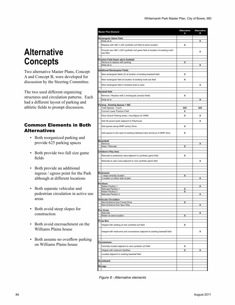
84 August 2011
Whitemarsh Park Master Plan, City of Bowie, MDWhiteMarsh Park Master PlanConcept Alternatives Matrix (DRAFT)
Master Plan Element AlternativeA
AlternativeB
Rectangular Game FieldKeep as is X
Replace with 380' x 220' synthetic turf field at same location X
Provide new 380' x 220' synthetic turf game field at location of existing multi-use field X
Practice Field (lower adj to football)Remove & replace with parking XKeep as is X
Additional Rectangular Fields
New rectangular fields (2) at location of existing baseball field X
New rectangular field at location of existing multi-use field X
New rectangular field in forested area to west X
Baseball field
Remove / Replace with 2 rectangular practice fields X
Keep as is X
Parking - Existing Spaces = 562Total Spaces - Count 625 625Convert Lower Practice Field X
Pave Gravel Parking areas / reconfigure for SWM X X
Add 48 paved spots adjacent to Playhouse X
Add spaces along WMP (entry) Drive X
Add spaces to the west of existing trailhead (near terminus of WMP drive X
BasketballRemove XKeep / Relocate X
Children's Play Area
Relocate to pedestrian area adjacent to synthetic game field X
Relocate to open area adjacent to new synthetic game field X
Restrooms1 large centrally located X2 smaller on either side of park X
PavilionsRetain Pavilion 1 XRelocate Pavilion 1 XRetain Pavilion 2 XRelocate Pavilion 2 X
Vehicular CirculationNew Entrance from Forest Drive XNew Entrance from Spur Way X
Fire CircleRelocate XRetain at same location X
Press Box
Integral with seating at new synthetic turf field X
Integral with restrooms and concessions adjacent to existing baseball field X
Concessions
Centrally located adjacent to new synthetic turf field X
Integral with restroom facilities X X
Located adjacent to existing baseball field
Scoreboard
Storage
Lardner/Klein Landscape Architects, P.C. June 14, 2010
Alternative ConceptsTwo alternative Master Plans, Concept A and Concept B, were developed for discussion by the Steering Committee.
The two used different organizing structures and circulation patterns. Each had a different layout of parking and athletic fields to prompt discussion.
Common Elements in Both Alternatives
• Both reorganized parking and provide 625 parking spaces
• Both provide two full size game fields
• Both provide an additional ingress / egress point for the Park although at different locations
• Both separate vehicular and pedestrian circulation in active use areas
• Both avoid steep slopes for construction
• Both avoid encroachment on the Williams Plains house
• Both assume no overflow parking on Williams Plains house
Figure 8 - Alternative elements

85August 2011
Whitemarsh Park Master Plan, City of Bowie, MD
Program Components for the Two Alternative Concepts (A and B)
NATurAL rESOurCES• Tree preservation for majority of site; replacement or mitigation for minimal tree removal is required• Approximately 4.3 acres affected for Concept A; approximately 9.7 acres affected for Concept B• Stream restoration (addressed as recommendation in Master Plan)• Avoidance of steep slopes for construction
STOrMWATEr MANAGEMENT• Stormwater surface treated with wet swales, sheet flow and bioretention within parking areas and adjacent to
athletic fields; (no underground tanks)• BMP’s located adjacent to disturbed area(s)
CuLTurAL rESOurCES• No encroachment on the Williams Plains house and 5+/- acre property• Archeological assessment likely required for any development on the Whitemarsh Park property in its
entirety, not just historic house parcel
CIrCuLATION AND PArKING• Additional vehicular access point – one Concept is from the south; one Concept is from the west• Paved parking in both Master Plan Concepts is 625 spaces• Pedestrian access points remain the same
rESTrOOMS• Alternatives both provide permanent restrooms on site – one a single, centrally located facility, and the other
two smaller separated facilities
FIELD LIGhTING• All fields shown as lighted fields
PICNIC PAvILIONS• Two picnic pavilions shown in both Concepts, one relocated in each Concept
BOWIE PLAyhOuSE• 50 additional parking spaces located in closer proximity to Playhouse in Concept A; 48 additional spaces
located in closer proximity in Concept B
SPOrT FIT BOWIE• Additional parking adjacent to the facility is provided along entry drive in Concept A• Sport Fit Bowie proposed tennis courts shown in each Concept Alternative
PLAyGrOuND• Playground relocated in each Concept: Concept A adjacent to current game football field; Concept B west of
new rectangular field and north of existing location• Playground separated into sub play areas, allowing age/equipment separation, while remaining adjacent to
each other
TrAILS• Existing trails to remain

86 August 2011
Whitemarsh Park Master Plan, City of Bowie, MD
CAMPFIrE CIrCLE• Concept A preserves location and use of Fire Circle• Concept B relocates location of Fire Circle near western pavilion
AThLETIC FIELDS• 2 full-sized rectangular fields – one synthetic, one natural turf sized to accommodate women’s lacrosse and
football in both Concepts A and B• ½ size practice field remains in Concept B• 1 additional full-sized rectangular field provided in Concept B• 1 triangle field shown in Concept B; the triangular field is replaced by two rectangular fields in Concept A;
either Concept alternative is spatially interchangeable with the other
CONCESSIONS• Centralized concessions; shown in different locations in Concept A vs. B
PrESSBOX• Located adjacent to centrally-located restroom in Concept B; under bleachers in Concept A
SCOrEBOArD• Concept A provides for two new scoreboards• Concept B provides for one new scoreboard and keeps the existing scoreboard as-is.
STOrAGE FACILITIES• Storage for field items tied to pressbox under bleachers in Concept A; expansion of existing storage location
in Concept B

87August 2011
Whitemarsh Park Master Plan, City of Bowie, MD
BOWIE PLAYHOUSE
FIRE CIRCLE
HISTORIC WILLIAMS PLAINS PROPERTY
RELOCATED TRAILHEAD
PAVILION #2
GAME FIELD GRASS
(180’ X 360’)
PRACTICE FIELDGRASS
(180’ X 360’)
GAME FIELD SYNTHETIC
TURF(220’ X 380’)
PRACTICE FIELDGRASS
(180’ X 360’)
BASKETBALL COURTS (2)
SPORT FIT COMPLEX
GAME SEATING WITH PRESSBOX AND STORAGE BELOW
CHILDREN’S PLAY AREA(2 AGE GROUPS)
NEW PAVILION #1
RESTROOM & CONCESSIONS
CONVERT EXISTING LOWER PRACTICE FIELD TO PARKING
SANITARY DRAIN FIELD 24,000 S.F.
A1A2
B1
B2
B3
B4
C1 C2 C3
D1F1
F2
F3
F4F5 F6
F7
F8
NEW ENTRY FROM FOREST DRIVE - SEE DIAGRAMFOREST DRIVE
CR
AIN
HW
Y
WHITE MARSH PARK DRIVE
TENNIS COURTS (2)
TENNIS COURTS (3)
POOL
SY
LVAN
DR
IVE
E1 E2
F9
F10ADDITIONAL PARKING ALONG WHITE MARSH PARK DRIVEADDITIONAL
PARKING FOR BOWIE PLAYHOUSE
GREEN INFRASTRUCTURE PLAN
- REGULATED AREA*NOTE: ENTIRE PARK
IS CONSIDERED EVALUATION AREA
B5
PAVED PEDESTRIAN CORRIDOR
NEW SCOREBOARD
NEW SCOREBOARD
WHITEMARSH PARK MASTER PLANCONCEPT A
WHITEMARSH PARK MASTER PLAN
Lardner/Klein Landscape Architects, P.C.Planning • Urban Design • Landscape Architecture
CITY OF BOWIE, MARYLAND - JUNE 30, 2010
EXISTING PARK TRAIL
UNVERIFIED PROPERTY LINE
OLD TOBACCO BARN (APPROXIMATE LOCATION)
0 50 100 200
A
A1
Figure 10 - Concept Alternative A
Concept AConcept A was structured to minimize the impacts to the existing woodland area while still allowing for expanded rectangular field usage and parking. An uninterrupted pedestrian core with additional vehicular access from the south was incorporated between the proposed synthetic field and the baseball field. Concept A presents a moderate increase in parking and increased rectangular field use without expanding too greatly into the existing woodland areas. Approximately 4.3 acres of wooded area are adversely affected.
Concept A also provides an additional entry point from the south, located off of Forest Drive, (this was prior to learning of the Annexation Agreement that prohibits such a connection) to create a perimeter access drive around the Park, separating all active uses from vehicular traffic flow and parking areas.
• Provides one centrally-located restroom facility
• Recommends additional parking adjacent to Sport Fit Bowie off of the existing entry drive
• Recommends 50 additional spaces at the Playhouse
• Relocates playground adjacent to current rectangular game field in pedestrian corridor relocated
• Retains existing trails • Retains Fire Circle in same location• Proposes two new scoreboards • Recommends storage facilities for
field items (under new pressbox / bleachers, adjacent to new synthetic game field)
Figure 9 - Concept Alternative A
LOT ID # SPACESA1 44A2 50B1 32B2 42B3 58B4 29 B5 7C1 33C2 32C3 31D1 4E1 17E2 33F1 54F2 7F3 24F4 42F5 19F6 17F7 2F8 14F9 13F10 21
TOTAL 625
PARKING SUMMARY CONCEPT A

88 August 2011
Whitemarsh Park Master Plan, City of Bowie, MD
Figure 12 - Concept B
Concept BConcept B was structured to incorporate a moderate increase in parking and an increase for rectangular field use, while still preserving the baseball field. Approximately 9.7 acres of wooded area will be adversely affected. Concept B also reviewed an additional entry point from the western side of the Park. Vehicular access was provided from Spur Way and created a linear access drive through the Park, separating all active uses from vehicular traffic flow.
• Proposes two full-size rectangular fields - one synthetic and one natural turf
• Proposes one additional full-sized rectangular field
• Recommends half-size rectangular field and baseball field remain
• Recommends two restroom facilities, on the east and one on the west portion of the Park
• Proposes no additional parking at Sport Fit Bowie
• Proposes 48 additional spaces provided at the Playhouse
• Recommends the relocation of the playground between two game fields on the western side of the active center relocated
• Recommends realignment of existing trails near athletic complex
• Proposes one new scoreboard • Proposes that the existing scoreboard
remain• Recommends the expansion of the
existing storage facility
BOWIE PLAYHOUSE
HISTORIC WILLIAMS PLAINS PROPERTY
TRAIL CONVERTED TO VEHICULAR
ACCESS FROM SPUR WAY
GAME FIELD GRASS
(160’ X 360’)
BASEBALL90’ DIAMOND
368’ CF FENCEGAME FIELD SYNTHETIC
TURF(220’ X 380’)
PRACTICE FIELDGRASS
(180’ X 360’)
SPORT FIT COMPLEX
EXPAND EXISTING STORAGE
RESTROOM & PRESS BOX
SANITARY DRAIN FIELD 12,000 S.F.
A1A2
B1
B2
B3
B4
D1
E1
F1F2
F3
F4F5 F6
F7
F8
FOREST DRIVE
WHITE MARSH PARK DRIVE
TENNIS COURTS (2)
TENNIS COURTS (3)
POOL
SY
LVAN
DR
IVE
A3
A4
C1
C2
C3 C4
PRACTICE FIELD
GRASS (150’ X 200’)
CHILDREN’S PLAY AREA (2 AGE GROUPS)
PAVILION #2
RESTROOMS & CONCESSIONS
PAVILION #1
E2ADDITIONAL BOWIE
PLAYHOUSE PARKING
EXISTING PARK TRAILS (TYP)
GREEN INFRASTRUCTURE
REGULATED AREA (TYP)*NOTE: ENTIRE PARK
IS CONSIDERED EVALUATION AREA
SEE ABOVE FOR REMAINING
LENGTH
EXISTING SCOREBOARD
CR
AIN
HW
Y
WHITEMARSH PARK MASTER PLANCONCEPT B
WHITEMARSH PARK MASTER PLAN
Lardner/Klein Landscape Architects, P.C.Planning • Urban Design • Landscape Architecture
CITY OF BOWIE, MARYLAND - JUNE 30, 2010
FIRE CIRCLE
SANITARY DRAIN FIELD 12,000 S.F.
NEW SCOREBOARD
UNVERIFIED PROPERTY LINE
OLD TOBACCO BARN (APPROXIMATE LOCATION)
0 50 100 200
A
A1
LOT ID # SPACESA1 16A2 8A3 21A4 28B1 12B2 6B3 60B4 62C1 30C2 30C3 53C4 68D1 4E1 16E2 32F1 54F2 7F3 24F4 42F5 19F6 17F7 2F8 14
TOTAL 625
PARKING SUMMARY CONCEPT B
Figure 11 - Concept Alternative B

89August 2011
Whitemarsh Park Master Plan, City of Bowie, MD
BO
WIE
PLA
YH
OU
SE
FIR
E C
IRC
LE
HIS
TO
RIC
WIL
LIA
MS
P
LAIN
S P
RO
PE
RT
Y
RE
LOC
AT
ED
T
RA
ILH
EA
D
PA
VIL
ION
#2
GA
ME
FIE
LD
GR
AS
S(1
80’ X
360
’)
PR
AC
TIC
E F
IELD
GR
AS
S (
180’
X 3
60’)
GA
ME
FIE
LD
SY
NT
HE
TIC
T
UR
F(2
20’ X
380
’)
PR
AC
TIC
E F
IELD
GR
AS
S (
180’
X 3
60’)
BA
SK
ET
BA
LL
CO
UR
TS
(2)
SP
OR
T F
IT
CO
MP
LEX
GA
ME
SE
AT
ING
WIT
H
PR
ES
SB
OX
AN
D
ST
OR
AG
E B
ELO
W
CH
ILD
RE
N’S
PLA
Y A
RE
A(2
AG
E G
RO
UP
S)
NE
W P
AV
ILIO
N #
1
RE
ST
RO
OM
&
CO
NC
ES
SIO
NS
CO
NV
ER
T E
XIS
TIN
G
LOW
ER
PR
AC
TIC
E
FIE
LD T
O P
AR
KIN
G
SA
NIT
AR
Y D
RA
IN
FIE
LD 2
4,00
0 S
.F.
A1
A2B
1
B2
B3
B4
C1
C2
C3
D1
F1
F2
F3
F4
F5
F6
F7
F8
NE
W E
NT
RY
FR
OM
F
OR
ES
T D
RIV
E -
SE
E
DIA
GR
AM
FO
RE
ST
DR
IVE
CRAIN HWY
WH
ITE
MA
RS
H P
AR
K D
RIV
E
TE
NN
IS
CO
UR
TS
(2)
TE
NN
IS
CO
UR
TS
(3)
PO
OL
SYLVAN DRIVE
E1
E2
F9
F10
AD
DIT
ION
AL
PA
RK
ING
A
LON
G W
HIT
E M
AR
SH
P
AR
K D
RIV
EA
DD
ITIO
NA
L P
AR
KIN
G F
OR
B
OW
IE P
LAY
HO
US
E
GR
EE
N
INF
RA
ST
RU
CT
UR
E P
LAN
-
RE
GU
LAT
ED
AR
EA
*NO
TE
: E
NT
IRE
PA
RK
IS
CO
NS
IDE
RE
D
EV
ALU
AT
ION
AR
EA
B5
PA
VE
D P
ED
ES
TR
IAN
C
OR
RID
OR
NE
W S
CO
RE
BO
AR
D
NE
W S
CO
RE
BO
AR
D
WH
ITE
MA
RS
H P
AR
K M
AS
TE
R P
LA
NC
ON
CE
PT
A
WH
ITE
MA
RS
H P
AR
K M
AS
TE
R P
LA
N
Lar
dn
er/K
lein
Lan
dsc
ape
Arc
hit
ects
, P.C
.P
lan
nin
g •
Urb
an D
esig
n •
Lan
dsc
ape
Arc
hit
ectu
re
CIT
Y O
F BO
WIE
, M
ARYLA
ND
- JU
NE
30, 2010
EX
IST
ING
PA
RK
T
RA
IL
UN
VE
RIF
IED
PR
OP
ER
TY
LI
NE
OLD
TO
BA
CC
O B
AR
N
(AP
PR
OX
IMA
TE
LO
CA
TIO
N)
050
100
200
A
A1
Pla
te 8
LOT
ID#
SPA
CES
A1
44A
250
B1
32B
242
B3
58B
429
B5
7C
133
C2
32C
331
D1
4E1
17E2
33F1
54F2
7F3
24F4
42F5
19F6
17F7
2F8
14F9
13F1
021
TOTA
L62
5
PAR
KIN
G S
UM
MA
RY
CO
NC
EPT
A
LEG
EN
D
EX
IST
ING
ST
RU
CT
UR
E
PR
OP
OS
ED
ST
RU
CT
UR
E
EX
IST
ING
RO
AD
S/P
AR
KIN
G
PR
OP
OS
ED
RO
AD
S/P
AR
KIN
G
EX
IST
ING
AT
HLE
TIC
FIE
LD
EX
PA
ND
ED
AT
HLE
TIC
FIE
LD
PR
OP
OS
ED
WA
LKS
/PA
VIN
G
EX
IST
ING
PA
RK
TR
AIL
GR
EE
N IN
FR
AS
TR
UC
TU
RE
P
LAN
RE
GU
LAT
ED
AR
EA
PA
RK
BO
UN
DA
RY
010
020
030
0S
PU
R W
AY
A
CC
ES
S
(PE
DE
ST
RIA
N
ON
LY)

90 August 2011
Whitemarsh Park Master Plan, City of Bowie, MD
Pla
te 9
BO
WIE
PLA
YH
OU
SE
HIS
TO
RIC
WIL
LIA
MS
P
LAIN
S P
RO
PE
RT
Y
TR
AIL
CO
NV
ER
TE
D
TO
VE
HIC
ULA
R
AC
CE
SS
FR
OM
SP
UR
W
AY
GA
ME
FIE
LD
GR
AS
S(1
60’ X
360
’)
BA
SE
BA
LL90
’ DIA
MO
ND
368’
CF
FE
NC
EG
AM
E F
IELD
S
YN
TH
ET
IC
TU
RF
(220
’ X 3
80’)
PR
AC
TIC
E F
IELD
GR
AS
S (
180’
X 3
60’)
SP
OR
T F
IT
CO
MP
LEX
EX
PA
ND
EX
IST
ING
S
TO
RA
GE
RE
ST
RO
OM
& P
RE
SS
B
OX
SA
NIT
AR
Y D
RA
IN
FIE
LD 1
2,00
0 S
.F.
A1
A2
B1 B
2
B3
B4
D1
E1
F1
F2
F3
F4
F5
F6
F7
F8
FO
RE
ST
DR
IVE
WH
ITE
MA
RS
H P
AR
K D
RIV
E
TE
NN
IS
CO
UR
TS
(2)
TE
NN
IS
CO
UR
TS
(3)
PO
OL
SYLVAN DRIVE
A3
A4
C1 C
2
C3
C4
PR
AC
TIC
E
FIE
LDG
RA
SS
(15
0’ X
200
’)C
HIL
DR
EN
’S P
LAY
AR
EA
(
2 A
GE
GR
OU
PS
)
PA
VIL
ION
#2
RE
ST
RO
OM
S &
C
ON
CE
SS
ION
S
PA
VIL
ION
#1
E2
AD
DIT
ION
AL
BO
WIE
P
LAY
HO
US
E
PA
RK
ING
EX
IST
ING
PA
RK
T
RA
ILS
(T
YP
)
GR
EE
N
INF
RA
ST
RU
CT
UR
E
RE
GU
LAT
ED
AR
EA
(T
YP
)*N
OT
E:
EN
TIR
E P
AR
K
IS C
ON
SID
ER
ED
E
VA
LUA
TIO
N A
RE
A
SE
E A
BO
VE
F
OR
RE
MA
ININ
G
LEN
GT
H
EX
IST
ING
SC
OR
EB
OA
RD
CRAIN HWY
WH
ITE
MA
RS
H P
AR
K M
AS
TE
R P
LA
NC
ON
CE
PT
B
WH
ITE
MA
RS
H P
AR
K M
AS
TE
R P
LA
N
Lar
dn
er/K
lein
Lan
dsc
ape
Arc
hit
ects
, P.C
.P
lan
nin
g •
Urb
an D
esig
n •
Lan
dsc
ape
Arc
hit
ectu
re
CIT
Y O
F BO
WIE
, M
ARYLA
ND
- JU
NE
30, 2010
FIR
E C
IRC
LE
SA
NIT
AR
Y D
RA
IN
FIE
LD 1
2,00
0 S
.F.
NE
W S
CO
RE
BO
AR
D
UN
VE
RIF
IED
PR
OP
ER
TY
LI
NE
OLD
TO
BA
CC
O B
AR
N
(AP
PR
OX
IMA
TE
LO
CA
TIO
N)
050
100
200
A
A1
LEG
EN
D
EX
IST
ING
ST
RU
CT
UR
E
PR
OP
OS
ED
ST
RU
CT
UR
E
EX
IST
ING
RO
AD
S/P
AR
KIN
G
PR
OP
OS
ED
RO
AD
S/P
AR
KIN
G
EX
IST
ING
AT
HLE
TIC
FIE
LD
EX
PA
ND
ED
AT
HLE
TIC
FIE
LD
PR
OP
OS
ED
WA
LKS
/PA
VIN
G
EX
IST
ING
PA
RK
TR
AIL
GR
EE
N IN
FR
AS
TR
UC
TU
RE
P
LAN
RE
GU
LAT
ED
AR
EA
PA
RK
BO
UN
DA
RY
LOT
ID#
SPA
CES
A1
16A
28
A3
21A
428
B1
12B
26
B3
60B
462
C1
30C
230
C3
53C
468
D1
4E1
16E2
32F1
54F2
7F3
24F4
42F5
19F6
17F7
2F8
14TO
TAL
625
PAR
KIN
G S
UM
MA
RY
CO
NC
EPT
B
010
020
030
0S
PU
R W
AY
V
EH
ICU
LAR
A
CC
ES
S

91August 2011
Whitemarsh Park Master Plan, City of Bowie, MD
Pla
te 1
0
WH
ITE
MA
RS
H P
AR
K M
AS
TE
R P
LA
NC
ON
CE
PT
A &
B S
EC
TIO
NS
WH
ITE
MA
RS
H P
AR
K M
AS
TE
R P
LA
N
Lar
dn
er/K
lein
Lan
dsc
ape
Arc
hit
ects
, P.C
.P
lan
nin
g •
Urb
an D
esig
n •
Lan
dsc
ape
Arc
hit
ectu
re
CIT
Y O
F BO
WIE
, M
ARYLA
ND
- JU
NE
30, 2010
CO
NC
EP
T A
SE
CT
ION
A -
A1
SC
AL
E:
1” =
20’
CO
NC
EP
T B
SE
CT
ION
A -
A1
SC
AL
E:
1” =
20’

92 August 2011
Whitemarsh Park Master Plan, City of Bowie, MD
Synth
etic
Turf
Fie
ldBle
acher
s /
Stora
ge
Park
ing
Dri
ve A
isle
Park
ing
Bio
fi
lter
Park
ing
Park
ing
Dri
ve A
isle
CO
NC
EP
T A
1S
EC
TIO
N A
- A
1S
CA
LE: 1
”=20
’
WH
ITE
MA
RS
H P
AR
K M
AS
TE
R P
LA
NC
ON
CE
PT
A1
SE
CT
ION
S
WH
ITE
MA
RS
H P
AR
K M
AS
TE
R P
LA
N
Lar
dn
er/K
lein
Lan
dsc
ape
Arc
hit
ects
, P.C
.P
lan
nin
g •
Urb
an D
esig
n •
Lan
dsc
ape
Arc
hit
ectu
re
CIT
Y O
F BO
WIE
, M
ARYLA
ND
- A
UG
UST
10, 2010
CO
NC
EP
T A
1S
EC
TIO
N B
- B
1S
CA
LE: 1
”=20
’
Res
troom
s an
d
Conce
ssio
ns
Pedes
tria
n P
laza
Spac
eW
alks
and A
cces
s to
Ble
acher
s an
d F
ield
Ble
acher
s /
Stora
ge
Synth
etic
Turf
Fie
ld
Pla
te 1
1

93August 2011
Whitemarsh Park Master Plan, City of Bowie, MD
BO
WIE
PLA
YH
OU
SE
RE
LOC
AT
ED
FIR
E C
IRC
LE
HIS
TO
RIC
WIL
LIA
MS
P
LAIN
S P
RO
PE
RT
Y
RE
LOC
AT
ED
P
AV
ILIO
N #
2
NA
TU
RA
L T
UR
F(1
80’ X
360
’)
SY
NT
HE
TIC
T
UR
F(2
20’ X
380
’)
NA
TU
RA
L T
UR
F (
180’
X 3
60’)
SP
OR
T F
IT
CO
MP
LEX
GA
ME
SE
AT
ING
WIT
H
RA
ISE
D P
RE
SS
BO
X A
ND
S
TO
RA
GE
BE
LOW
RE
ST
RO
OM
S &
C
ON
CE
SS
ION
S
NE
W L
OC
AT
ION
F
OR
PA
VIL
ION
#1
CH
ILD
RE
N’S
PLA
Y A
RE
A
(2 A
GE
GR
OU
PS
)
PO
SS
IBLE
SLE
DD
ING
H
ILL
/ NA
TU
RA
L P
LAY
A
RE
A
A1
A2B
1
B2
C1
C2
D1
F1
F2
F3
F4
F5
F6
F7
F8
FO
RE
ST
DR
IVE
CRAIN HWY
WH
ITE
MA
RS
H P
AR
K D
RIV
E
TE
NN
IS
CO
UR
TS
(2)
FU
TU
RE
BO
WIE
S
PO
RT
FIT
EX
PA
NS
ION
PO
OL
SYLVAN DRIVE
E2
EX
IST
ING
PA
RK
TR
AIL
(T
YP
)
AD
DIT
ION
AL
PA
RK
ING
A
LON
G W
HIT
E M
AR
SH
P
AR
K D
RIV
EP
AR
KIN
G F
OR
B
OW
IE P
LAY
HO
US
E
PA
VE
D P
ED
ES
TR
IAN
C
OR
RID
OR
/ B
AS
KE
TB
ALL
HA
LF
CO
UR
T
SC
OR
EB
OA
RD
TO
R
EM
AIN
SC
OR
EB
OA
RD
SY
NT
HE
TIC
T
UR
F(2
20’ X
380
’)
B3 B
4
B5
RE
SE
RV
E
PR
AC
TIC
E F
IELD
NA
TU
RA
L T
UR
F (
180’
X 3
60’)
NA
TU
RA
L P
LAY
AR
EA
RE
ST
RO
OM
S &
C
ON
CE
SS
ION
S
BLE
AC
HE
RS
PA
RK
ING
FO
R
BO
WIE
PLA
YH
OU
SE
LAC
RO
SS
E
RE
BO
UN
DIN
G W
ALL
LOT
ID#
SPA
CES
A1
44A
250
B1
32B
242
B3
91B
446
B5
7C
152
C2
25D
14
E117
E233
F154
F27
F324
F442
F519
F617
F72
F814
G1
32G
216
TOTA
L67
0
PAR
KIN
G S
UM
MA
RY
CO
NC
EPT
A1
UN
VE
RIF
IED
PR
OP
ER
TY
LI
NE
PR
ES
SB
OX
AN
D
ST
OR
AG
E
SA
NIT
AR
Y D
RA
IN
FIE
LD
1
2
3
050
100
200
4
CRAIN HWY
CRAIN HWY
SP
UR
W
AY
SA
FETY
TU
RN
WH
ITE
MA
RS
H P
AR
K D
R
FO
RE
ST
DR
FO
RE
ST
PL
BR
UN
SW
ICK
LN
STONEYBROOK DR.
ANN
APO
LIS
RD
RA
CE
TR
AC
K R
D
4
3
43
2
11
PO
TE
NT
IAL
IMP
RO
VE
D
AC
CE
SS
PO
INT
S
WH
ITE
MA
RS
H P
AR
K D
R(N
EW
CR
OS
SO
VE
R)
2F
OR
ES
T D
R
3S
PU
R W
AY
4A
NN
AP
OLI
S R
OA
D
4
NA
TU
RA
L T
UR
F (
150’
X 2
00’)
WH
ITE
MA
RS
H P
AR
K
BO
UN
DA
RY
(T
YP
)
/
SA
NIT
AR
Y D
RA
IN
FIE
LD
/
LEG
EN
D
EX
IST
ING
ST
RU
CT
UR
E
PR
OP
OS
ED
ST
RU
CT
UR
E
EX
IST
ING
RO
AD
S/P
AR
KIN
G
PR
OP
OS
ED
RO
AD
S/P
AR
KIN
G
EX
IST
ING
AT
HLE
TIC
FIE
LD
PR
OP
OS
ED
AT
HLE
TIC
FIE
LD
PR
OP
OS
ED
WA
LKS
/PA
VIN
G
PA
RK
BO
UN
DA
RY
EX
IST
ING
PA
RK
TR
AIL
RE
LOC
AT
ED
PA
RK
TR
AIL
GR
EE
N IN
FR
AS
TR
UC
TU
RE
P
LAN
RE
GU
LAT
ED
AR
EA
IMP
RO
VE
D A
CC
ES
S O
PT
ION
S
E1
G1G
2
WH
ITE
MA
RS
H P
AR
K M
AS
TE
R P
LA
NC
ON
CE
PT
A1
WH
ITE
MA
RS
H P
AR
K M
AS
TE
R P
LA
N
Lar
dn
er/K
lein
Lan
dsc
ape
Arc
hit
ects
, P.C
.P
lan
nin
g •
Urb
an D
esig
n •
Lan
dsc
ape
Arc
hit
ectu
re
CIT
Y O
F BO
WIE
, M
AR
YLA
ND
- A
UG
UST
10, 2010
OLD
TO
BA
CC
O B
AR
N
(AP
PR
OX
IMA
TE
LO
CA
TIO
N)
A
A1
B
B1
Pla
te 1
2

94 August 2011
Whitemarsh Park Master Plan, City of Bowie, MD
010
020
020
030
0
1
2
3
4
4
CRAIN HWY
CRAIN HWY
SP
UR
W
AY
SA
FETY
TU
RN
WH
ITE
MA
RS
H P
AR
K D
RIV
E
FO
RE
ST
DR
FO
RE
ST
PL
BR
UN
SW
ICK
LN
STONEYBROOK DR.
ANN
APO
LIS
RD
RA
CE
TR
AC
K R
OA
D
1
PO
TE
NT
IAL
IMP
RO
VE
D
AC
CE
SS
PO
INT
S
WH
ITE
MA
RS
H P
AR
K D
R
CR
EA
TE
NE
W C
RO
SS
OV
ER
A
T L
OC
AT
ION
OF
EX
IST
ING
E
NT
RA
NC
E
2F
OR
ES
T D
R
PO
TE
NT
IAL
AC
CE
SS
PO
INT
C
RE
AT
ING
LO
OP
RO
AD
AC
CE
SS
T
HR
OU
GH
PA
RK
3S
PU
R W
AY
P
OT
EN
TIA
L A
CC
ES
S P
OIN
T
FR
OM
SP
UR
WA
Y A
T L
OC
AT
ION
O
F E
XIS
TIN
G D
EA
D E
ND
RO
AD
P
RO
VID
ING
LIN
EA
R A
CC
ES
S
TH
RO
UG
H P
AR
K
4A
NN
AP
OLI
S R
OA
D
PO
TE
NT
IAL
AC
CE
SS
PO
INT
AT
IN
TE
RS
EC
TIO
N O
F R
AC
E T
RA
CK
R
OA
D
34 /
Sca
le: 1
” =
150
’
WH
ITE
MA
RS
H P
AR
K M
AS
TE
R P
LA
NC
ON
CE
PT
A1
WH
ITE
MA
RS
H P
AR
K M
AS
TE
R P
LA
N
Lar
dn
er/K
lein
Lan
dsc
ape
Arc
hit
ects
, P.C
.P
lan
nin
g •
Urb
an D
esig
n •
Lan
dsc
ape
Arc
hit
ectu
re
CIT
Y O
F BO
WIE
, M
ARYLA
ND
- A
UG
UST
10, 2010
Pla
te 1
3

95August 2011
Whitemarsh Park Master Plan, City of Bowie, MD
BO
WIE
PLA
YH
OU
SE
RE
LOC
AT
ED
FIR
E C
IRC
LE
HIS
TO
RIC
WIL
LIA
MS
P
LAIN
S P
RO
PE
RT
Y
PA
VIL
ION
#2
SY
NT
HE
TIC
T
UR
F(2
00’ X
415
’)
SP
OR
T F
IT
CO
MP
LEX
GA
ME
SE
AT
ING
WIT
H
RA
ISE
D P
RE
SS
BO
X A
ND
S
TO
RA
GE
BE
LOW
RE
ST
RO
OM
S &
C
ON
CE
SS
ION
S
NE
W L
OC
AT
ION
FO
R
PA
VIL
ION
#1
CH
ILD
RE
N’S
PLA
Y A
RE
A
(2 A
GE
GR
OU
PS
)
LAC
RO
SS
E
RE
BO
UN
DIN
G W
ALL
A1
A2B
1
B2
D1
F1
F2
F3
F4
F5
F6
F7
F8
FO
RE
ST
DR
IVE
CRAIN HWY
WH
ITE
MA
RS
H P
AR
K D
RIV
E
TE
NN
IS
CO
UR
TS
(2)
FU
TU
RE
BO
WIE
S
PO
RT
FIT
EX
PA
NS
ION
PO
OL
SYLVAN DRIVE
E2
EX
IST
ING
PA
RK
TR
AIL
(T
YP
)
PO
TE
NT
IAL
FU
TU
RE
P
AR
KIN
G
AD
DIT
ION
AL
PA
RK
ING
F
OR
BO
WIE
PLA
YH
OU
SE
PA
VE
D P
ED
ES
TR
IAN
C
OR
RID
OR
SC
OR
EB
OA
RD
TO
R
EM
AIN
WH
ITE
MA
RS
H P
AR
K M
AS
TE
R P
LA
NF
INA
L C
ON
CE
PT
NA
TU
RA
L T
UR
F(2
20’ X
380
’)
B3 B
4
B5
PLA
Y A
RE
A
AD
DIT
ION
AL
PA
RK
ING
F
OR
BO
WIE
PLA
YH
OU
SE
UN
VE
RIF
IED
PR
OP
ER
TY
LI
NE
050
100
200
WH
ITE
MA
RS
H P
AR
K D
R
NA
TU
RA
L T
UR
F (
150’
X 2
00’)
WH
ITE
MA
RS
H P
AR
K
BO
UN
DA
RY
(T
YP
)
LEG
EN
D
EX
IST
ING
ST
RU
CT
UR
E
PR
OP
OS
ED
ST
RU
CT
UR
E
EX
IST
ING
RO
AD
S/P
AR
KIN
G
PR
OP
OS
ED
RO
AD
S/P
AR
KIN
G
EX
IST
ING
AT
HLE
TIC
FIE
LD
EX
PA
ND
ED
AT
HLE
TIC
FIE
LD
PR
OP
OS
ED
WA
LKS
/PA
VIN
G
PO
TE
NT
IAL
TR
AIL
CO
NN
EC
TIO
N
EX
IST
ING
PA
RK
TR
AIL
GR
EE
N IN
FR
AS
TR
UC
TU
RE
P
LAN
RE
GU
LAT
ED
AR
EA
E1
G1G
2
WH
ITE
MA
RS
H P
AR
K M
AS
TE
R P
LA
NL
ard
ner
/Kle
in L
and
scap
e A
rch
itec
ts, P
.C.
Pla
nn
ing
• U
rban
Des
ign
• L
and
scap
e A
rch
itec
ture
CIT
Y O
F BO
WIE
, M
AR
YLA
ND
- M
AR
CH
20
11
SA
NIT
AR
Y D
RA
IN
FIE
LD
PO
TE
NT
IAL
EX
TE
ND
ED
A
CC
EL
& D
EC
EL
LAN
ES
A
T E
XIS
TIN
G E
NT
RA
NC
EP
OT
EN
TIA
L C
ON
NE
CT
ION
S T
O
EX
IST
ING
TR
AIL
S A
ND
P
AV
ILIO
N (
TY
P)
PA
RK
ST
OR
AG
E A
RE
A
C
PA
RK
BO
UN
DA
RY
ROUTE 3
OLD
TO
BA
CC
O B
AR
N
(AP
PR
OX
IMA
TE
LO
CA
TIO
N)
GIS
Dat
a S
ourc
es:
Mar
ylan
d-N
atio
nal C
apita
l Par
k an
d P
lann
ing
Com
mis
sion
and
the
City
of B
owie
, Mar
ylan
d
Pla
te 1
4
LOT
ID#
SPA
CES
A1
44A
250
B1
32B
242
B3
91B
446
B5
7C
77
D1
4E1
17E2
33F1
54F2
7F3
24F4
42F5
19F6
17F7
2F8
14G
132
G2
16TO
TAL
670
PAR
KIN
G S
UM
MA
RY
FIN
AL
CO
NC
EPT
CRAIN HWY
CRAIN HWY
SP
UR
W
AY
SA
FETY
TU
RN
WH
ITE
MA
RS
H P
AR
K D
R
FO
RE
ST
DR
FO
RE
ST
PL
BR
UN
SW
ICK
LN
STONEYBROOK DR.
ANN
APO
LIS
RD
RA
CE
TR
AC
K R
D
OV
ER
AL
L L
OC
AT
ION
MA
P
WH
ITE
MA
RS
H P
AR
K
BO
UN
DA
RY
(T
YP
)

96 August 2011
Whitemarsh Park Master Plan, City of Bowie, MD
BO
WIE
PLA
YH
OU
SE
RE
LOC
AT
ED
FIR
E C
IRC
LE
HIS
TO
RIC
WIL
LIA
MS
P
LAIN
S P
RO
PE
RT
Y
PA
VIL
ION
#2
SY
NT
HE
TIC
T
UR
F(2
00’ X
415
’)
SP
OR
T F
IT
CO
MP
LEX
GA
ME
SE
AT
ING
WIT
H
RA
ISE
D P
RE
SS
BO
X A
ND
S
TO
RA
GE
BE
LOW
RE
ST
RO
OM
S &
C
ON
CE
SS
ION
S
NE
W L
OC
AT
ION
FO
R
PA
VIL
ION
#1
CH
ILD
RE
N’S
PLA
Y A
RE
A
(2 A
GE
GR
OU
PS
)
LAC
RO
SS
E
RE
BO
UN
DIN
G W
ALL
A1
A2B
1
B2
D1
F1
F2
F3
F4
F5
F6
F7
F8
FO
RE
ST
DR
IVE
CRAIN HWY
WH
ITE
MA
RS
H P
AR
K D
RIV
E
TE
NN
IS
CO
UR
TS
(2)
FU
TU
RE
BO
WIE
S
PO
RT
FIT
EX
PA
NS
ION
PO
OL
SYLVAN DRIVE
E2
EX
IST
ING
PA
RK
TR
AIL
(T
YP
)
PO
TE
NT
IAL
FU
TU
RE
P
AR
KIN
G
AD
DIT
ION
AL
PA
RK
ING
F
OR
BO
WIE
PLA
YH
OU
SE
PA
VE
D P
ED
ES
TR
IAN
C
OR
RID
OR
SC
OR
EB
OA
RD
TO
R
EM
AIN
WH
ITE
MA
RS
H P
AR
K M
AS
TE
R P
LA
NF
INA
L C
ON
CE
PT
NA
TU
RA
L T
UR
F(2
20’ X
380
’)
B3 B
4
B5
PLA
Y A
RE
A
AD
DIT
ION
AL
PA
RK
ING
F
OR
BO
WIE
PLA
YH
OU
SE
UN
VE
RIF
IED
PR
OP
ER
TY
LI
NE
050
100
200
NA
TU
RA
L T
UR
F (
150’
X 2
00’)
WH
ITE
MA
RS
H P
AR
K
BO
UN
DA
RY
(T
YP
)
LEG
EN
D
EX
IST
ING
ST
RU
CT
UR
E
PR
OP
OS
ED
ST
RU
CT
UR
E
EX
IST
ING
RO
AD
S/P
AR
KIN
G
PR
OP
OS
ED
RO
AD
S/P
AR
KIN
G
EX
IST
ING
AT
HLE
TIC
FIE
LD
EX
PA
ND
ED
AT
HLE
TIC
FIE
LD
PR
OP
OS
ED
WA
LKS
/PA
VIN
G
PO
TE
NT
IAL
TR
AIL
CO
NN
EC
TIO
N
EX
IST
ING
PA
RK
TR
AIL
GR
EE
N IN
FR
AS
TR
UC
TU
RE
P
LAN
RE
GU
LAT
ED
AR
EA
E1
G1G
2
WH
ITE
MA
RS
H P
AR
K M
AS
TE
R P
LA
N
Lar
dn
er/K
lein
Lan
dsc
ape
Arc
hit
ects
, P.C
.P
lan
nin
g •
Urb
an D
esig
n •
Lan
dsc
ape
Arc
hit
ectu
re
CIT
Y O
F BO
WIE
, M
AR
YLA
ND
- M
ARC
H 2
011
SA
NIT
AR
Y D
RA
IN
FIE
LD
PO
TE
NT
IAL
EX
TE
ND
ED
A
CC
EL
& D
EC
EL
LAN
ES
A
T E
XIS
TIN
G E
NT
RA
NC
EP
OT
EN
TIA
L C
ON
NE
CT
ION
S T
O
EX
IST
ING
TR
AIL
S A
ND
P
AV
ILIO
N (
TY
P)
PA
RK
ST
OR
AG
E A
RE
A
C
PA
RK
BO
UN
DA
RY
ROUTE 3
OLD
TO
BA
CC
O B
AR
N
(AP
PR
OX
IMA
TE
LO
CA
TIO
N)
Pla
te 1
5
LOT
ID#
SPA
CES
A1
44A
250
B1
32B
242
B3
91B
446
B5
7C
77
D1
4E1
17E2
33F1
54F2
7F3
24F4
42F5
19F6
17F7
2F8
14G
132
G2
16TO
TAL
670
PAR
KIN
G S
UM
MA
RY
FIN
AL
CO
NC
EPT
CRAIN HWY
CRAIN HWY
SP
UR
W
AY
SA
FETY
TU
RN
WH
ITE
MA
RS
H P
AR
K D
R
FO
RE
ST
DR
FO
RE
ST
PL
BR
UN
SW
ICK
LN
STONEYBROOK DR.
ANN
APO
LIS
RD
RA
CE
TR
AC
K R
D
OV
ER
AL
L L
OC
AT
ION
MA
P
WH
ITE
MA
RS
H P
AR
K
BO
UN
DA
RY
(T
YP
)

97August 2011
Whitemarsh Park Master Plan, City of Bowie, MD
BO
WIE
PLA
YH
OU
SE
RE
LOC
AT
ED
FIR
E C
IRC
LE
HIS
TO
RIC
WIL
LIA
MS
P
LAIN
S P
RO
PE
RT
Y
PA
VIL
ION
#2
SY
NT
HE
TIC
T
UR
F(2
00’ X
415
’)
SP
OR
T F
IT
CO
MP
LEX
GA
ME
SE
AT
ING
WIT
H
RA
ISE
D P
RE
SS
BO
X A
ND
S
TO
RA
GE
BE
LOW
RE
ST
RO
OM
S &
C
ON
CE
SS
ION
S
NE
W L
OC
AT
ION
FO
R
PA
VIL
ION
#1
CH
ILD
RE
N’S
PLA
Y A
RE
A
(2 A
GE
GR
OU
PS
)
LAC
RO
SS
E
RE
BO
UN
DIN
G W
ALL
A1
A2B
1
B2
D1
F1
F2
F3
F4
F5
F6
F7
F8
FO
RE
ST
DR
IVE
CRAIN HWY
WH
ITE
MA
RS
H P
AR
K D
RIV
E
TE
NN
IS
CO
UR
TS
(2)
FU
TU
RE
BO
WIE
S
PO
RT
FIT
EX
PA
NS
ION
PO
OL
SYLVAN DRIVE
E2
EX
IST
ING
PA
RK
TR
AIL
(T
YP
)
PO
TE
NT
IAL
FU
TU
RE
P
AR
KIN
G
AD
DIT
ION
AL
PA
RK
ING
F
OR
BO
WIE
PLA
YH
OU
SE
PA
VE
D P
ED
ES
TR
IAN
C
OR
RID
OR
SC
OR
EB
OA
RD
TO
R
EM
AIN
WH
ITE
MA
RS
H P
AR
K M
AS
TE
R P
LA
NF
INA
L C
ON
CE
PT
NA
TU
RA
L T
UR
F(2
20’ X
380
’)
B3 B
4
B5
PLA
Y A
RE
A
AD
DIT
ION
AL
PA
RK
ING
F
OR
BO
WIE
PLA
YH
OU
SE
LOT
ID#
SPA
CES
A1
44A
250
B1
32B
242
B3
91B
446
B5
7C
77
D1
4E1
17E2
33F1
54F2
7F3
24F4
42F5
19F6
17F7
2F8
14G
132
G2
16TO
TAL
670
PAR
KIN
G S
UM
MA
RY
FIN
AL
CO
NC
EPT
UN
VE
RIF
IED
PR
OP
ER
TY
LI
NE
050
100
200
CRAIN HWY
CRAIN HWY
SP
UR
W
AY
SA
FETY
TU
RN
WH
ITE
MA
RS
H P
AR
K D
R
FO
RE
ST
DR
FO
RE
ST
PL
BR
UN
SW
ICK
LN
STONEYBROOK DR.
ANN
APO
LIS
RD
RA
CE
TR
AC
K R
D
NA
TU
RA
L T
UR
F (
150’
X 2
00’)
WH
ITE
MA
RS
H P
AR
K
BO
UN
DA
RY
(T
YP
)
LEG
EN
D
EX
IST
ING
ST
RU
CT
UR
E
PR
OP
OS
ED
ST
RU
CT
UR
E
EX
IST
ING
RO
AD
S/P
AR
KIN
G
PR
OP
OS
ED
RO
AD
S/P
AR
KIN
G
EX
IST
ING
AT
HLE
TIC
FIE
LD
EX
PA
ND
ED
AT
HLE
TIC
FIE
LD
PR
OP
OS
ED
WA
LKS
/PA
VIN
G
PO
TE
NT
IAL
TR
AIL
CO
NN
EC
TIO
N
EX
IST
ING
PA
RK
TR
AIL
GR
EE
N IN
FR
AS
TR
UC
TU
RE
P
LAN
RE
GU
LAT
ED
AR
EA
E1
G1G
2
WH
ITE
MA
RS
H P
AR
K M
AS
TE
R P
LA
N
Lar
dn
er/K
lein
Lan
dsc
ape
Arc
hit
ects
, P.C
.P
lan
nin
g •
Urb
an D
esig
n •
Lan
dsc
ape
Arc
hit
ectu
re
CIT
Y O
F BO
WIE
, M
AR
YLA
ND
- M
AR
CH
20
11
SA
NIT
AR
Y D
RA
IN
FIE
LD
PO
TE
NT
IAL
EX
TE
ND
ED
A
CC
EL
& D
EC
EL
LAN
ES
A
T E
XIS
TIN
G E
NT
RA
NC
EP
OT
EN
TIA
L C
ON
NE
CT
ION
S T
O
EX
IST
ING
TR
AIL
S A
ND
P
AV
ILIO
N (
TY
P)
PA
RK
ST
OR
AG
E A
RE
A
C
OV
ER
AL
L L
OC
AT
ION
MA
P
WH
ITE
MA
RS
H P
AR
K
BO
UN
DA
RY
(T
YP
)
PA
RK
BO
UN
DA
RY
ROUTE 3
OLD
TO
BA
CC
O B
AR
N
(AP
PR
OX
IMA
TE
LO
CA
TIO
N)
Pla
te 1
6
LOT
ID#
SPA
CES
A1
44A
250
B1
32B
242
B3
91B
446
B5
7C
77
D1
4E1
17E2
33F1
54F2
7F3
24F4
42F5
19F6
17F7
2F8
14G
132
G2
16TO
TAL
670
PAR
KIN
G S
UM
MA
RY
FIN
AL
CO
NC
EPT
CRAIN HWY
CRAIN HWY
SP
UR
W
AY
SA
FETY
TU
RN
WH
ITE
MA
RS
H P
AR
K D
R
FO
RE
ST
DR
FO
RE
ST
PL
BR
UN
SW
ICK
LN
STONEYBROOK DR.
ANN
APO
LIS
RD
RA
CE
TR
AC
K R
D
OV
ER
AL
L L
OC
AT
ION
MA
P
WH
ITE
MA
RS
H P
AR
K
BO
UN
DA
RY
(T
YP
)