where to go backpacking guide - wordpress.com · the wesertn los angeles county council high...
TRANSCRIPT
01-17-15
WHERE TO GO
BACKPACKING GUIDE
By: THE WESERTN LOS ANGELES
COUNTY COUNCILHIGH ADVENTURE TEAM
COMMITTEE1
01-17-15
This Where To Go Backpacking Guide includes overnight Backpack Trips in Joshua Tree,
Sequoia and Kings Canyon and Yosemite National Parks. The San Bernadino, San Gabriel,
Sierra Madre and Sierra Nevada Mountains.
There are Trips that cover from 2 Miles to 48 Miles, and from 2 Days to 9 Days in duration.
They go from Sea Level to 14,496 Feet above Sea Level.
We have done most of these hikes ourselves, some of them more than once.
The Finest Organization In This Country For Youth.
This Is Why Boys Join Boy Scouts
REMEMBER!! Keep The OUTing In SCOUTing!!
ENJOY!George Curtin, W.L.A.C.C. – H.A.T, Chairman
805/377/3320hatscouter.gmail.com
2
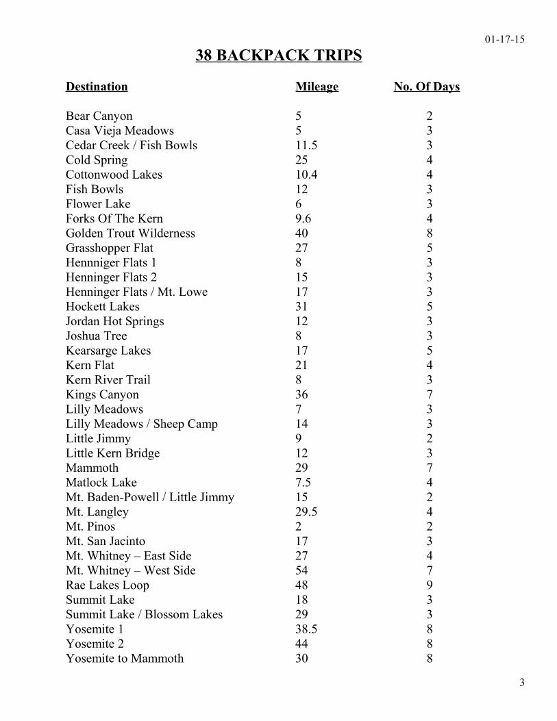
01-17-1538 BACKPACK TRIPS
Destination Mileage No. Of Days
Bear Canyon 5 2Casa Vieja Meadows 5 3Cedar Creek / Fish Bowls 11.5 3Cold Spring 25 4Cottonwood Lakes 10.4 4Fish Bowls 12 3Flower Lake 6 3Forks Of The Kern 9.6 4Golden Trout Wilderness 40 8Grasshopper Flat 27 5Hennniger Flats 1 8 3Henninger Flats 2 15 3Henninger Flats / Mt. Lowe 17 3Hockett Lakes 31 5Jordan Hot Springs 12 3Joshua Tree 8 3Kearsarge Lakes 17 5Kern Flat 21 4Kern River Trail 8 3Kings Canyon 36 7Lilly Meadows 7 3Lilly Meadows / Sheep Camp 14 3Little Jimmy 9 2Little Kern Bridge 12 3Mammoth 29 7Matlock Lake 7.5 4Mt. Baden-Powell / Little Jimmy 15 2Mt. Langley 29.5 4Mt. Pinos 2 2Mt. San Jacinto 17 3Mt. Whitney – East Side 27 4Mt. Whitney – West Side 54 7Rae Lakes Loop 48 9Summit Lake 18 3Summit Lake / Blossom Lakes 29 3Yosemite 1 38.5 8Yosemite 2 44 8Yosemite to Mammoth 30 8
3
01-17-15BEAR CANYON
Trip: From the Switzer Picnic Area to Bear Canyon
Length: 5 Miles Round Trip ( 4 Miles + 1400 ft. Elevation Gain )
Season: Fall
Topo Map: Tom Harrison Maps – Angeles Front Country Trail Map
Permits: California Campfire Permit Issued By The U.S.F.S.Adventure Passes are required to park vehicles at the Trailhead.
Trailhead: Take the ( 5 ) South to the ( 210 ) East to the ( 2 ) Angeles Crest Highway. From La 23 Miles Canada head up into the mountains 10.5 Miles to the Switzer Picnic Area. The parking
lot is on the right hand side of the highway. Take the driveway, on the right hand side of the parking lot, down to the lower parking lot. WARNING!! Do Not leave vehicles parked in lower parking lot, because of vandalism, bring them back up and park them in the upper parking lot on the highway.
Day 1 2 Miles
Drive to the Trailhead. From the Trailhead cross the bridge and follow the trail down canyon, past Commodore Switzer Trail Camp and down into the gorge of Arroyo Seco below Switzer Falls (fork to the left). Continue down the Arroyo Seco Gorge another 3/4 mile.
Day 2 2 Miles 1400 ft. Elevation Gain
Hike back out to the Trailhead and drive home.
4
01-17-15CASA VIEJA MEADOWS
Trip: From the Blackrock Trailhead to Casa Vieja Meadows
Length: 5 Miles Total ( 4 Miles + 650 ft. Elevation Gain )
Season: Summer
Topo Map: Tom Harrison Maps – Golden Trout Wilderness Trail Map
Wilderness Permit: 15 People MaximumStop at the Blackrock Ranger Station on your way to the Trailhead and fill out a Wilderness Permit and drop it in the Box. 760-365-9585California Campfire Permit Issued By The U.S.F.S.
Trailhead: Take the ( 14 ) North to the ( 395 ) toward Lone Pine. Turn Left at the Kennedy Meadows Turnoff, if you get to Little Lake you’ve gone too far. Take the Kennedy Meadows Turnoff up the mountain. There is a “Y” when you get to the Kennedy Meadows Campground, go Left as the sign indicates to Blackrock Ranger Station. Go up past the Kennedy Meadows Campground, the Fish Creek Campground and the Troy Meadow Campground. Keep going up and watch for signs to Blackrock Ranger Station. Stop at the Ranger Station and fill out a Wilderness Permit and drop it in the Box. Proceed to the end of the road to the Blackrock Trailhead.
Day 1
Drive to the Blackrock Trailhead at the end of the road and spend the night.
Day 2 2 Miles
Hike from the Blackrock Trailhead (8960 ft.) to Casa Vieja Meadows (8310 ft.)
Day 3 2 Miles 650 ft. Elevation Gin
Hike back out to the Blackrock Trailhead and drive home.
5
01-17-15CEDAR CREEK / FISH BOWLS
Trip: From the Cedar Creek Trailhead to Cedar Creek Campground and Fish Bowls Campground
Length: 11.5 Miles Total ( 10.5 Miles + 800 ft. Elevation Gain )
Season: Spring / Summer / Fall
Topo Map: U.S.G.S. Lockwood Valley & San Guillermo Mountain, CA
Permits: California Campfire Permit Issued By The U.S.F.S.Adventure Passes are required to park vehicles at the Trailhead.
Trailhead: Take the ( 5 ) North and Exit at Frazier Park Road. Take Frazier Park Road to Lockwood Valley Road and turn Left. Take Lockwood Valley Road to Mutau Flats Road and turn Left. Take the road down to the bottom of the canyon. Go past the corrals on your right to the Cedar Creek Trailhead on your right.
The Cedar Creek Trailhead sign NO longer exist, it was burned up in the 2007 fires.Look for the “7N03B” sign.
Day 1 2 Miles
Drive to the Cedar Creek Trailhead (4865 ft.) and hike into the Cedar Creek Campground ( 5090 ft.)
Day 2 2.5 Miles 800 ft. Elevation Gain
Hike from the Cedar Creek Campground (5090 ft.) to Fish Bowls Campground (5200 ft.)
Day 3 6 Miles
Hike from the Fish Bowls Campground (5200 ft.) to the Fish Bowls Trailhead (4835 ft.) and drive home.
6
01-17-15COLD SPRING
Trip: From the Jerkey Meadows Trailhead to Cold Spring
Length: 25 Miles Total ( 24 Miles + 970 ft. Elevation Gain )
Season: Summer
Topo Map: Tom Harrison Maps – Golden Trout Wilderness Trail Map
Wilderness Permit: 15 People Max. www.fs.fed.us/r5/sequoia/ (760-376-3781 Kernville Ranger Station)California Campfire Permit Issued By The U.S.F.S.
Trailhead: Stay on the road to Camp Whitsett and go 18 Miles past the entrance to Camp 203 Miles Whitsett to the road’s end to the Jerkey Meadows Trailhead.
Day 1
Drive to the Jerkey Meadows Trailhead and spend the night.
Day 2 5.9 Miles
Hike from the Jerkey Meadows Trailhead (5930 ft.) to the Little Kern Bridge (5760 ft.)
Day 3 6.7 Miles 800 ft. Elevation Gain
Hike from the Little Kern Bridge (5760 ft.) to Cold Spring (6560 ft.)
Day 4 11.7 Miles
Hike from Cold Spring (6560 ft.) to the Jerkey Meadows Trailhead (5930 ft.) and drive home.
7
01-17-15COTTONWOOD LAKES
Trip: From the Cottonwood Lakes Trailhead to Cottonwood Lakes
Length: 10.4 Miles Total ( 9.4 Miles + 1000 ft. Elevation Gain )
Season: Summer
Topo Map: Tom Harrison Maps – Golden Trout Wilderness Trail Map
Wilderness Permit: 15 People Maximum – www.recreation.gov - Inyo National ForestNO Ground Fires Allowed Above 10,000 ft.
Stop at the Eastern Sierra Inter Agency Visitor Center, South of Lone Pine, on the way to the Trailhead to pick up the Permit. 760-873-2483
Trailhead: Take the ( 14 ) North to the ( 395 ) to Lone Pine. In Lone Pine turn Left on Whitney 199 Miles Portal Road. Take Whitney Portal Road to Horseshoe Meadow Road, go Left and go
20.7 Miles to the Cottonwood Lakes Trailhead.
Day 1
Drive to the Cottonwood Lakes Trailhead and spend the night.
Day 2 4.7 Miles 1000 ft. Elevation Gain
Hike from the Cottonwood Lakes Trailhead (10,040 ft.) to Cottonwood Lakes (11,040 ft.)
Day 3
Layover at the Cottonwood Lakes.
Day 4 4.7 Miles
Hike back out to the Cottonwood Lakes Trailhead and drive home.
8
01-17-15FISH BOWLS
Trip: From the Fish Bowls Trailhead to Fish Bowls Campground
Length: 12 Miles Total
Season: Spring / Summer / Fall
Topo Map: U.S.G.S. Lockwood Valley & San Guillermo Mountain, CA
Permits: California Campfire Permit Issued By The U.S.F.S.Adventure Passes are required to park vehicles at the Trailhead.
Trailhead: Take the ( 5 ) North and Exit at Frazier Park Road. Take Frazier Park Road to Lockwood Valley Road and turn Left. Take Lockwood Valley Road to Mutau Flats Road and turn Left. Take the road down to the bottom of the canyon to the corrals on your right, look for yellow gate.
Day 1
Drive to the Fish Bowls Trailhead and spend the night.
Day 2 6 Miles
Hike from the Fish Bowls Trailhead (4835 ft.) to the Fish Bowls Campground (5200 ft.)
Day 3 6 Miles
Hike back out to the Fish Bowls Trailhead and drive home.
9
01-17-15FLOWER LAKE
Trip: From the Onion Valley Trailhead to Flower Lake
Length: 6 Miles Total ( 5 Miles + 951 ft. Elevation Gain )
Season: Summer
Topo Map: Tom Harrison Maps – Kearsarge Pass – Rae Lakes Loop Trail Map
Wilderness Permit: 15 People Maximum – www.recreation.gov - Inyo National ForestNO Ground Fires Allowed Above 10,000 ft. 760-873-2483
Stop at the Eastern Sierra Inter Agency Visitor Center, South of Lone Pine, on the way to the Trailhead to pick up the Permit.
Trailhead: Take the ( 14 ) North to the ( 395 ) North to Independence ( North of Lone Pine ) and 213 Miles turn left on Market Street. Take Market Street all the way up to the end to the Onion
Valley Trailhead.
Day 1
Drive to the Onion Valley Trailhead and spend the night. There are campsites on the West side of the parking lot.
Day 2 2.5 Miles 951 ft. Elevation Gain
Hike from the Onion Valley Trailhead (9185 ft.) to Flower Lake (10,136 ft.)
Day 3 2.5 Miles
Hike back out to the Onion Valley Trailhead and drive home.
10
01-17-15FORKS OF THE KERN
Trip: From the Lloyd Meadows Trailhead to the Forks Of The Kern and Boy Scout Camp
Length: 9.6 Miles ( 8.6 Miles + 840 ft. Elevation Gain )
Season: Summer
Topo Map: Tom Harrison Maps – Golden Trout Wilderness Trail Map
Wilderness Permit: 15 People Max. www.fs.fed.us/r5/sequoia/ (760-376-3781 Kernville Ranger Station)California Campfire Permit Issued By The U.S.F.S.
Trailhead: Stay on the road to Camp Whitsett and go 16 Miles past the entrance to Camp 210 Miles Whitsett, to the turnoff to the Forks Of The Kern Trailhead on the right side.
Turn right on the dirt road and go 2.5 Miles to the Forks Of The Kern Trailhead.
Day 1
Drive to the Lloyd Meadows Trailhead and spend the night.
Day 2 4.3 Miles
Hike from the Lloyd Meadows Trailhead (5550 ft.) 2.3 Miles down the canyon to the Forks Of The Kern (4710 ft.), ford Little Kern Creek and hike over to the Kern River. Hike 2 Miles up the Kern River to Boy Scout Camp (4790 ft.).
Day 3
Layover Day on the Kern River.
Day 4 4.3 Miles 840 ft. Elevation Gain
Hike back out to the Lloyd Meadows Trailhead and drive home.
11
01-17-15GOLDEN TROUT WILDERNESS
Trip: From the Horseshoe Meadow Trailhead to the Jerky Meadows Trailhead
Length: 40 Miles Total ( 37.5 Miles + 2950 ft. Elevation Gain )
Season: Summer
Topo Map: Tom Harrison Maps – Golden Trout Wilderness Trail Map
Wilderness Permit: 15 People Maximum – www.recreation.gov - Inyo National ForestCalifornia Campfire Permit Issued By The U.S.F.S.
Stop at the Eastern Sierra Inter Agency Visitor Center, South of Lone Pine, on the way to the Trailhead to pick up the Permit. 760-873-2483
Trailhead: Take the ( 14 ) North to the ( 395 ) to Lone Pine. In Lone Pine turn left on Whitney 199 Miles Portal Road. Take Whitney Portal Road to Horseshoe Meadow Road, go left and go
20.7 to the Horseshoe Meadow Trailhead.Day 1
Drive to the Horseshoe Meadow Trailhead and spend the night.
Day 2 4.3 Miles 680 ft. Elevation Gain
Hike from the Horseshoe Meadow Trailhead (9960 ft.) over Trail Pass (10,640 ft.) to the South Fork Kern River (9350 ft.)
Day 3 10.9 Miles 400 ft. Elevation Gain
Hike from the South Fork Kern River (9350 ft.) to Golden Trout Creek (8410 ft.)
Day 4 7.1 Miles 400 ft. Elevation Gain
Hike from Golden Trout Creek (8410 ft.) to Little Kern Lake (6400 ft.)
Day 5
Layover Day at Little Kern Lake.
Day 6 9.3 Miles 400 ft. + 900 ft. Elevation Gain
Hike from Little Kern Lake (6400 ft.) to Little Kern Bridge (5760 ft.)
Day 7
Layover Day at Little Kern Bridge.
Day 8 5.9 Miles 170 ft. Elevation GainHike from Little Kern Bridge (5760 ft.) to the Jerkey Meadow Trailhead (5930 ft.) and drive home.
12
01-17-15GRASSHOPPER FLAT
Trip: From the Jerkey Meadows Trailhead to Grasshopper Flat
Length: 27 Miles ( 27 Miles + 400 ft. Elevation Gain )
Season: Summer
Topo Map: Tom Harrison Maps – Golden Trout Wilderness Trail Map
Wilderness Permit: 15 People Max. www.fs.fed.us/r5/sequoia/ (760-376-3781 Kernville Ranger Station)California Campfire Permit Issued By The U.S.F.S.
Trailhead: Stay on the road to Camp Whitsett and go 18 Miles past the entrance to Camp 203 Miles Whitsett to the road’s end to the Jerkey Meadows Trailhead.
Day 1
Drive to the Jerkey Meadows Trailhead and spend the night.
Day 2 8.3 Miles 230 ft. Elevation Gain
Hike from the Jerkey Meadows Trailhead (5930 ft.) to the Trout Meadows Ranger Station (6160 ft.)
Day 3 5 Miles
Hike from the Trout Meadows Ranger Station (6160 ft.) to Grasshopper Flat (5850 ft.)
Day 4 7.5 Miles
Hike from Grasshopper Flat (5850 ft.) to Little Kern Bridge (5760 ft.)
Day 5 5.9 Miles 170 ft. Elevation Gain
Hike from Little Kern Bridge (5760 ft.) to the Jerkey Meadows Trailhead (5930 ft.) and drive home.
13
01-17-15HENNINGER FLATS 1
Trip: From the Eaton Canyon Park Trailhead to Henninger Flats
Length: 8 Miles Total ( 6 Miles + 1400 ft. Elevation Gain )
Season: Spring / Summer / Fall
Topo Map: Tom Harrison Maps – Angeles Front Country Trail Map
Permit: Henninger Flats Campground Reservations @ 626-794-0675California Campfire Permit Issued By The U.S.F.S.
Trailhead: Take the ( 5 ) South to the ( 210 ) East and Exit at Altadena Drive. Go North on Altadena Drive past the Eaton Canyon Natural Area to Crescent Drive, turn right to Pinecrest Drive and turn right to the beginning of the Old Mt. Wilson Toll Road. The Trailhead will be a small paved area on your right.
Day 1 3 Miles 1400 ft. Elevation Gain
Drive to the beginning of the Old Mt. Wilson Toll Road (960 ft.) at the East loop of Pinecrest Drive and hike up to Henninger Flats Campground (2360 ft.)
Day 2
Work on Merit Badges.
Option – Day Hike to Mt. Wilson (5710 ft.), 6.1 Miles one way and 3350 ft. elevation gain, for lunch.
Day 3 3 Miles
Hike back down the old Mt. Wilson Toll Road and drive home.
14
01-17-15HENNINGER FLATS 2
Trip: From Mt. Wilson to Henninger Flats
Length: 15 Miles Total ( 12 Miles + 3350 ft. Elevation Gain )
Season: Spring / Summer / Fall
Topo Map: Tom Harrison Maps – Angeles Front Country Trail Map
Permits: Henninger Flats Campground Reservations @ 626-794-0675Adventure Passes are required to park vehicles at TrailheadCalifornia Campfire Permit Issued By The U.S.F.S.
Trailhead: Take the ( 5 ) South to the ( 210 ) East to the ( 2 ) Angeles Crest Highway. Go North on the ( 2 ) Angeles Crest Highway to Red Box, 14 Miles from La Canada. Go Right on the Mt. Wilson Road to the parking area just outside the entrance to Skyline Park, 5 more miles. Immediately South of the parking area is the upper end of the old toll road, marked by a wooden sign.
Day1 6.1 Miles 3350 ft. Elevation Loss
Drive to the end of the old toll road up at Mt. Wilson (5710 ft.) and hike down to Henninger Flats Campground (2360 ft.)
Day 2
Layover Day at Henninger Flats Campground.
Day 3 6.1 Miles 3350 ft. Elevation Gain
Hike from Henninger Flats Campground (2360 ft.) back up to Mt. Wilson (5710 ft.) and drive home.
15
01-17-15HENNINGER FLATS / MT. LOWE
Trip: From the Eaton Canyon Park Trailhead to Henninger Flats and Mt. Lowe
Length: 17 Miles Total ( 13.6 Miles + 3520 ft. Elevation Gain )
Season: Spring / Summer / Fall
Topo Map: Tom Harrison Maps – Angeles Front Country Trail Map
Permit: Henninger Flats Campground Reservations @ 626-794-0675California Campfire Permit Issued By The U.S.F.S.
Trailhead: Take the ( 5 ) South to the ( 210 ) East and Exit at Altadena Drive. Go North on Altadena Drive past he Eaton Canyon Natural Area to Crescent Drive, turn right toPinecrest Drive and turn right to the beginning of the Old Mt. Wilson Toll Road.The Trailhead will be small paved area on the right.
Day 1 3 Miles 1400 ft. Elevation Gain
Drive to the beginning of the Old Mt. Wilson Toll Road (960 ft.) at the East loop of Pinecrest Drive and hike up to Henninger Flats Campground (2360 ft.)
Day 2 6 Miles 2120 ft. Elevation Gain
Hike from Henninger Flats Campground (2360 ft.) 2.0 Miles to Idlehour Trail Campand 4.1 Miles to the Mt. Lowe Tavern (4480 ft.)
Day 3 4.6 Miles
Day hike from the Mt. Lowe Tavern (4480 ft.) to Mt. Lowe Summit (5380 ft.).
Hike from the Mt. Lowe Tavern (4480 ft.) to the end of Lake Avenue (1400 ft.) and drive home.
16
01-17-15HOCKETT LAKES
Trip: From the Mountain Home State Forrest Trailhead to Summit Lake to Blossom Lakes and to Hockett Lakes
Length: 31 Miles Total ( 26.9 Miles + 3945 ft. Elevation Gain )
Season: Summer
Topo Maps: Tom Harrison Maps – Golden Trout Wilderness or Whitney High Country Trail Maps
Wilderness Permit: 15 People Max. www.fs.fed.us/r5/sequoia/ (559-784-1500 Porterville Ranger Station)California Campfire Permit Issued By The U.S.F.S.NO Ground Fires Allowed Above 10,000 ft.
Trailhead: Take the ( 5 ) North to the ( 99 ) North to Highway ( 65 ) to Porterville. Take Highway ( 65 ) for 45 Miles North to Highway ( 190 ) East to Springville. Go East on Highway ( 190 ) for about 20 Miles through the town of Springville. At the end of town go Left on Balch Park Road. Go for about 4 Miles on Balch Park Road to Bear Creek Road and go Right. Follow Bear Creek Road to the Mountain Home State Forrest Trailhead and Shake Camp.
Day 1
Drive to the Mountain Home State Forrest Trailhead and spend the night at Shake Camp.
Day 2 8.2 Miles 2975 ft. Elevation Gain
Hike from the Mountain Home State Forrest Trailhead (6455 ft.) to Summit Lake (9430 ft.)
Day 3 5.2 Miles 970 ft. Elevation Gain
Hike from Summit Lake (9430 ft.) to Blossom Lakes (10,400 ft.)
Day 4 4.8 Miles
Hike from Blossom Lakes (10,400 ft.) to Hockett Lakes (8610 ft.)
Day 5 8.7 Miles
Hike from Hockett Lakes (8610 ft.) back to the Mountain Home State Forrest Trailhead (6455 ft.) and drive home.
17
01-17-15JORDAN HOT SPRINGS
Trip: From the Blackrock Trailhead to Casa Vieja Meadows and Jordan Hot Springs
Length: 12 Miles Total ( 10 Miles + 2390 ft. Elevation Gain )
Season: Summer
Topo Map: Tom Harrison Maps – Golden Trout Wilderness Trail Map
Wilderness Permit: 15 People MaximumStop at the Blackrock Ranger Station on your way to the Trailhead and fill out a Wilderness Permit and drop it in the Box. 760-365-9585California Campfire Permit Issued By The U.S.F.S.
Trailhead: Take the ( 14 ) North to the ( 395 ) toward Lone Pine. Turn Left at the Kennedy Meadows Turnoff, if you get to Little Lake you’ve gone too far. Take the Kennedy Meadows Turnoff up the mountain. There is “Y” when you get to the Kennedy Meadows Campground, go Left as the sign indicates to Blackrock Ranger Station. Go up past the Kennedy Meadows Campground, the Fish Creek Campground and the Troy Meadow Campground. Keep going up and watch for signs to Blackrock Ranger Station. Stop at the Ranger Station and fill out your Wilderness Permit and drop it in the Box. Proceed to the end of the road to the Blackrock Trailhead.
Day 1
Drive to the Blackrock Trailhead at the end of the road and spend the night.
Day 2 5 Miles
Hike from the Blackrock Trailhead (8960 ft.) 2 Miles to Casa Vieja Meadows (8310 ft.).
At the West edge of the meadow will be a trail junction. Turn Left at this junction and hike 3 Miles down the canyon to Jordan Hot Springs (6570 ft.)
Day 3 5 Miles 1740 + 650 = 2390 ft. Elevation Gain
Hike back out to the Blackrock Trailhead and drive home.
18
01-17-15JOSHUA TREE
Trip: From the Boy Scout Trail Trailhead to the Indian Cove Trailhead
Length: 8 Miles Total
Season: Spring
Topo Map: Tom Harrison Maps – Joshua Tree National Park Trail Map
Permit: Fill Out Wilderness Permit At Trailhead & Drop In Box
Trailhead: Take the ( 14 ) North to the ( 138 ) Pearblossom Hwy. Take ( 138 ) East to the ( 18 ) 210 Miles to Victorville. Take the ( 18 ) to the ( 247 ) to Lucerne Valley. Take the ( 247 ) to the
( 62 ) and turn left – East. Take the ( 62 ) to the West Entrance Station to Joshua Tree National Park. Enter the Park at the West Entrance and take Park Blvd. to the Boy Scout Trail Trailhead.
Day 1
Drive to the Hidden Valley Campground, which is just past the Boy Scout Trail Trailhead and spend the night. Shuttle cars around to the Indian Cove Trailhead so that they are there when you come out on Sunday.
Day 2 6 Miles
Drive to the Boy Scout Trail Trailhead and hike for about 6 Miles, make camp at the bottom of the switchbacks.
Day 3 2 Miles
Hike from camp to the Indian Cove Trailhead and drive home.
19
01-17-15KEARSARGE LAKES
Trip: From the Onion Valley Trailhead over Kearsarge Pass to Kearsarge Lakes
Length: 17 Miles Total ( 13 Miles + 3609 ft. Elevation Gain )
Season: Summer
Topo Map: Tom Harrison Maps – Kearsarge Pass – Rae Lakes Loop Trail Map
Wilderness Permit: 15 People Maximum – www.recreation.gov - Inyo National ForestNO Ground Fires Allowed Above 10,000 ft.
Stop at the Eastern Sierra Inter Agency Visitor Center, South of Lone Pine, on the way to the Trailhead to pick up the Permit. 760-873-2483
Trailhead: Take the ( 14 ) North to the ( 395 ) to Independence ( North of Lone Pine ) and turn 213 Miles left on Market Street. Take Market Street all the way up to the end to the Onion
Valley Trailhead.
Day 1
Drive to the Onion Valley Trailhead and spend the night. There are campsites on the West side of the parking lot.
Day2 2.5 Miles 951 ft. Elevation Gain
Hike from the Onion Valley Trailhead (9185 ft.) to Flower Lake (10,136 ft.)
Day 3 4 Miles 1709 ft. Elevation Gain
Hike 2.8 Miles from Flower Lake (10,136 ft.) over Kearsarge Pass (11,845 ft.) and 1.2 Miles to Kearsarge Lakes (10,896 ft.)
Day 4
Layover day at Kearsarge Lakes
Optional – Day hike 1.5 Miles from Kearsarge Lakes (10,896 ft.) to Bullfrog Lake (10,800 ft.) and 2.5 Miles toCharlotte Lake (10,370 ft.) 8 Miles round trip.
Day 5 6.5 Miles 949 ft. Elevation Gain
Hike 1.2 Miles from Kearsarge Lakes (10,896 ft.) over Kearsarge Pass (11,845 ft.) and 5.3 Miles to the Onion Valley Trailhead (9185 ft.) and drive home.
20
01-17-15KERN FLAT
Trip: From the Lloyd Meadows Trailhead to Kern Flat
Length: 21 Miles ( 20 Miles + 1125 ft. Elevation Gain )
Season: Summer
Topo Map: Tom Harrison Maps – Golden Trout Wilderness Trail Map
Wilderness Permit: 15 People Max. www.fs.fed.us/r5/sequoia/ (760-376-3781 Kernville Ranger Station)California Campfire Permit Issued By The U.S.F.S.
Trailhead: Stay on the road to Camp Whitsett and go 16 Miles past the entrance to Camp201 Miles Whitsett, to the turnoff to the Lloyd Meadows Trailhead on the right side.
Turn right on the dirt road and go 2.5 Miles to the Lloyd Meadows Trailhead.
Day 1
Drive to the Lloyd Meadows Trailhead and spend the night.
Day 2 9.9 Miles
Hike from the Lloyd Meadows Trailhead (5550 ft.) 2.3 Miles down the canyon to the Forks Of The Kern(4710 ft.), ford Little Kern Creek and hike over to the Kern River.Hike up the Kern River 4 Miles to Kern Flat (4995 ft.)
Day 3
Layover Day at Kern Flat.
Day 4 9.9 Miles 285 + 840 = 1155 ft. Elevation Gain
Hike back out to the Lloyd Meadows Trailhead and drive home.
21
01-17-15KERN RIVER TRAIL
Trip: From the Kern River Trailhead up the Canyon following the Kern River.
Length: 8 Miles ( 410 ft. Elevation Gain )
Season: Spring / Summer
Topo Map: Tom Harrison Maps – South Sierra Wilderness Trail Map
Permit: California Campfire Permit Issued By The U.S.F.S.
Trailhead: There is NO place to camp overnight at the Trailhead, so take the road to Camp 185 Miles Whitsett and stay in one of the campsites either before or after the entrance to Camp
Whitsett and spend the night. Then come back down to the Trailhead the next morning which is at the bridge that crosses over the Kern River.
Day 1
Drive past the Trailhead up to one of the campsites either before or after the entrance to Camp Whitsett and spend the night.
Day 2 4 Miles
Come back down to the Trailhead (3835 ft.) which at the bridge that crosses over the River and hike up the canyon and make Camp (4245 ft.)
Day 3 4 Miles
Hike back out to the Trailhead and drive home.
22
01-17-15KINGS CANYON
Trip: From the Cedar Grove Roads End Trailhead to Woods Creek Crossing
Length: 36 Miles Total ( 28 Miles + 3135 ft. Elevation Gain )
Season: Summer
Topo Map: Tom Harrison Maps – Kearsarge Pass – Rae Lakes Loop Trail Map
Wilderness Permit: www.nps.gov/seki/planyourvisit/rae-lakes-loop.htm 559-565-3766California Campfire Permit Issued By The U.S.F.S.
Trailhead: Take the ( 5 ) North to the ( 99 ) North to the ( 198 ) to Visalia. Take the ( 198 ) East 242 Miles to the ( 63 ) North. Gas up in Orange Grove just off of the ( 63 ). Take the ( 63 )
North to the ( 180 ) to Kings Canyon.
Day 1
Drive to the Cedar Grove Roads End Trailhead and spend the night.
Day 2 6 Miles 1565 ft. Elevation Gain
Hike from the Cedar Grove Roads End Trailhead (5035 ft.) to Lower Paradise Valley (6600 ft.)
Day 3
Layover Day at Lower Paradise Valley.
Day 4 3 Miles 390 ft. Elevation Gain
Hike from Lower Paradise Valley (6600 ft.) to Upper Paradise Valley (6990 ft.)
Day 5 6.5 Miles 1180 Elevation Gain
Hike from Upper Paradise Valley (6990 ft.) to Woods Creek Crossing (8170 ft.)
Day 6 9.5 Miles
Hike from Woods Creek Crossing (8170 ft.) to Lower Paradise Valley (6600 ft.)
Day 7 3 Miles
Hike from Lower Paradise Valley (6600 ft.) to the Cedar Grove Roads End Trailhead (5035 ft.) and drive home.
23
01-17-15LILLY MEADOWS
Trip: From Camp Three Falls to Lilly Meadows
Length: 7 Miles ( 6 Miles + 1035 ft. Elevation Gain )
Season: Winter / Spring / Summer / Fall
Topo Map: U.S.G.S. Sawmill Mountain, CA
Permits: California Campfire Permit Issued By The U.S.F.S.Adventure Passes are required to park vehicles at the Trailhead.
Trailhead: Take the ( 5 ) North and Exit at Frazier Park Road. Take Frazier Park Road to 57 Miles Lockwood Valley Road. Take Lockwood Valley Road to Boy Scout Road and turn
Right. Park outside of the gate to Camp Three Falls.
Day 1 2 Miles
Hike from Camp Three Falls (5515 ft.) to the base of the first waterfall (6000 ft.)
Day 2 1 Mile 550 ft. Elevation Gain
Hike from the first waterfall (6000 ft.) up to Lilly Meadows (6550 ft.)
Day 3 3 Miles
Hike back out to Camp Three Falls and drive home.
24
01-17-15LILLY MEADOWS / SHEEP CAMP
Trip: From Camp Three Falls to Lilly Meadows and Sheep Camp
Length: 14 Miles Total ( 12 Miles + 2320 ft. Elevation Gain )
Season: Spring / Summer / Fall
Topo Map: U.S.G.S. Sawmill Mountain, CA
Permits: California Campfire Permit Issued By The U.S.F.S.Adventure Passes are required to park vehicles at the Trailhead.
Trailhead: Take the ( 5 ) North and Exit at Frazier Park Road. Take Frazier Park Road to 57 Miles Lockwood Valley Road. Take Lockwood Valley Road to Boy Scout Road and turn
Right. Park outside of the gate to Camp Three Falls.
Day 1 2 Miles
Hike from Camp Three Falls (5515 ft.) to the base of the first waterfall (6000 ft.)
Day 2 4 Miles 2320 ft. Elevation Gain
Hike from the first waterfall (6000 ft.) 1 Mile to Lilly Meadows (6550 ft.) and 3 Miles to Sheep Camp (8320 ft.)
Day 3 6 Miles
Hike from Sheep Camp (8320 ft.) to Camp Three Falls (5515 ft.) and drive home.
25
01-17-15LITTLE JIMMY
Trip: From the Islip Saddle Trailhead to Little Jimmy Campground
Length: 9 Miles Total ( 7 Miles + 1650 ft. Elevation Gain )
Season: Spring / Summer / Fall
Topo Map: Tom Harrison Maps – Angeles High Country Trail Map
Permits: California Campfire Permit Issued By The U.S.F.S.Adventure Passes are required to park vehicles at the Trailhead.
Trailhead: Take the ( 5 ) South to the ( 210 ) East to the ( 2 ) North. Take the ( 2 ) Angeles Crest 57 Miles Highway 41 Miles to the Islip Saddle Trailhead. Where the old Highway ( 39 ) used
to intersect Highway ( 2 ).
Day 1 4.5 Miles 900 ft. + 750 ft. = 1650 ft. Elevation Gain
Drive to the Islip Saddle Trailhead (6600 ft.) and hike to Little Jimmy Campground (7500 ft.) 2.5 Miles.
Day hike from Little Jimmy Campground (7500 ft.) to Mt. Islip (8250 ft.) 1 Mile and do map and compass work and back.
Day 2 2.5 Miles
Hike back out to the Islip Saddle Trailhead and drive home.
26
01-17-15LITTLE KERN BRIDGE
Trip: From the Jerkey Meadows Trailhead to the Little Kern Bridge
Length: 12 Miles ( 12 Miles + 170 ft. Elevation Gain )
Season: Summer
Topo Map: Tom Harrison Maps – Golden Trout Wilderness Trail Map
Wilderness Permit: 15 People Max. www.fs.fed.us/r5/sequoia/ (760-376-3781 Kernville Ranger Station)California Campfire Permit Issued By The U.S.F.S.
Trailhead: Stay on the road to Camp Whitsett and go 18 Miles past the entrance to Camp 203 Miles Whitsett to the road’s end to the Jerkey Meadows Trailhead.
Day 1
Drive to the Jerkey Meadows Trailhead and spend the night.
Day 2 5.9 Miles
Hike from the Jerkey Meadows Trailhead (5930 ft.) to the Little Kern Bridge (5760 ft.).
Day 3 5.9 Miles 170 ft. Elevation Gain
Hike back out to the Jerkey Meadows Trailhead and drive home.
27
01-17-15MAMMOTH
Trip: From the Agnew Meadows Trailhead to the Reds Meadow Trailhead
Length: 29 Miles Total ( 25.4 Miles + 3370 ft. Elevation Gain )
Season: Summer
Topo Map: Tom Harrison Maps – Mammoth High Country Trail Map
Wilderness Permit: Mammoth Lakes Visitor Center 760-924-5500 15 People MaximumCalifornia Campfire Permit Issued By The U.S.F.S.
Trailhead: Take the ( 14 ) North to the ( 395 ) to Mammoth.284 Miles
Day 1
Take the shuttle bus from the Mammoth Lodge to the Agnew Meadows Trailhead and Campground and spend the night.
Day 2 5.9 Miles 1550 ft. Elevation Gain
Hike from the Agnew Meadows Trailhead (8340 ft.) to Summit Lake (9890 ft.)
Day 3 5 Miles 600 ft. Elevation Gain
Hike from Summit Lake (9890 ft.) to Garnet Lake (9678 ft.)
Day 4 3.5 Miles 320 ft. Elevation Gain
Hike from Garnet Lake (9678 ft.) to Shadow Lake (8737 ft.)
Day 5 7.5 Miles 900 ft. Elevation Gain
Hike from Shadow Lake (8737 ft.) to Johnston Lake (8120 ft.)
Day 6 3.5 Miles 520 ft. Elevation Loss
Hike from Johnston Lake (8120 ft.) to Reds Meadow Trailhead (7600 ft.)
Day 7
Optional – Day hike 2 Miles from the Reds Meadow Trailhead to Rainbow Falls.
Take the shuttle bus back to the cars and drive home.
28
01-17-15MATLOCK LAKE
Trip: From the Onion Valley Trailhead to Matlock Lake
Length: 7.5 Miles Total ( 6 Miles + 1535 ft. Elevation Gain )
Season: Summer
Topo Map: Tom Harrison Maps – Kearsarge Pass – Rae Lakes Loop Trail Map
Wilderness Permit: 15 People Maximum – www.recreation.gov - Inyo National ForestNO Ground Fires Allowed Above 10,000 ft.
Stop at the Eastern Sierra Inter Agency Visitor Center, South of Lone Pine, on the way to the Trailhead to pick up the Permit. 760-873-2483
Trailhead: Take the ( 14 ) North to the ( 395 ) to Independence ( North of Lone Pine ) and turn 213 Miles left on Market Street. Take Market Street all the way up to the end to the Onion
Valley Trailhead.
Day 1
Drive to the Onion Valley Trailhead and spend then night.There are campsites on the West side of the parking lot.
Day 2 3 Miles 1535 ft. Elevation Gain
Hike from the Onion Valley Trailhead (9185 ft.) to Matlock Lake (10,720 ft.)
Day 3
Layover Day at Matlock Lake.
Day 4 3 Miles
Hike back out to the Onion Valley Trailhead and drive home.
29
01-17-15MT. BADEN-POWELL / LITTLE JIMMY
Trip: From the Vincent Gap Trailhead to Mt. Baden-Powell and Little Jimmy Campground
Length: 15 Miles Total ( 12.5 Miles + 2940 ft. Gain in Elevation )
Season: Spring / Summer / Fall
Topo Map: Tom Harrison Maps – Angeles High Country Trail Map
Permits: California Campfire Permit Issued By The U.S.F.S.Adventure Passes are required to park vehicles at the Trailhead.
Trailhead: Take the ( 5 ) South to the ( 210 ) East to the ( 2 ) North. Take the ( 2 ) Angeles Crest57 Miles Highway 53 Miles to the Vincent Gap Trailhead.
Day 1 10 Miles 2800 ft. + 140 ft. = 2940 ft. Elevation Gain
Drive to the Vincent Gap Trailhead (6600 ft.) and hike to Mt. Baden-Powell (9400 ft.) 4 Milesto Throop Peak (9140 ft.) to Mt. Hawkins (8850 ft.) and to Little Jimmy Campground (7500 ft.) 6 1/4 Miles
Day 2 2.5 Miles
Hike from Little Jimmy Campground (7500 ft.) to the Islip Saddle Trailhead (6600 ft.) and drive home.
30
01-17-15MT. LANGLEY
Trip: From the Cottonwood Lakes Trailhead to Mt. Langley
Length: 29.5 Miles Total ( 25.6 Miles + 4088 ft. Elevation Gain )
Season: Summer
Topo Map: Tom Harrison Maps – Mt. Whitney High Country Trail Map
Wilderness Permit: 15 People Maximum – www.recreation.gov - Inyo National ForestNO Ground Fires Allowed Above 10,000 ft.
Stop at the Eastern Sierra Inter Agency Visitor Center, South of Lone Pine, on the way to the Trailhead to pick up the Permit. 760-873-2483
Trailhead: Take the ( 14 ) North to the ( 395 ) to Lone Pine. In Lone Pine turn Left on Whitney 199 Miles Portal Road. Take Whitney Portal Road to Horseshoe Meadow Road, go Left and go
20.7 Miles to the Cottonwood Lakes Trailhead.
Day 1
Drive to the Cottonwood Lakes Trailhead and spend the night.
Day 2 7.8 Miles 1103 ft. Elevation Gain
Hike from the Cottonwood Lakes Trailhead (10,040 ft.) to Long Lake (11,143 ft.)
Day 3 10 Miles 2985 ft. Elevation Gain
Layover day at Long Lake.
Optional – Day hike 5 Miles from Long Lake (11,143 ft.) to Mt. Langley (14,025 ft.)
Day 4 7.8 Miles
Hike back out to the Cottonwood Lakes Trailhead and drive home.
31
01-17-15MT. PINOS
Trip: From the Parking Lot on the top of Mt. Pinos to the West Ridge of Mt. Pinos
Length: 2 Miles ( 295 ft. Elevation Gain )
Season: Winter
Topo Map: U.S.G.S. Sawmill Mountain, CA
Permits: California Campfire Permit Issued By The U.S.F.S.Adventure Passes are required to park vehicles at Trailhead.
Trailhead: Take the ( 5 ) North and Exit at Frazier Park Road. Take Frazier Park Road to Cuddy 61 Miles Valley Road. Take Cuddy Valley Road all the way to the top of Mt. Pinos.
Day 1 1 Mile 295 ft. Elevation Gain
Drive to the parking lot at the top of Mt. Pinos (8360 ft.) and follow the service road that goes up to the West Ridge of Mt. Pinos (8655 ft.)
Day 2 1 Mile
Hike back out to the parking lot and drive home.
32
01-17-15MT. SAN JACINTO
Trip: From the Seven Pines Trailhead to Little Round Valley and Mt. San Jacinto Peak
Length: 17 Miles Total ( 14 Miles + 3480 ft. Elevation Gain )
Season: Spring / Summer / Fall
Topo Map: Tom Harrison Maps – San Jacinto Wilderness Trail Map
Wilderness Permit: 15 People Maximum www.sanjac.statepark.org 951-659-2607Adventure Passes are required to park vehicles at the Trailhead.NO Fire Permit Required – There are NO fires permitted in the Wilderness Area.Backpacking Stoves are O.K.
Trailhead: Take the ( 5 ) South to the ( 210 ) East to the ( 10 ) East to Banning. In Banning Exit on Highway ( 243 ) South and ascend 19 winding Miles. Just about opposite the Alandale Forest Station, go Left on the road leading to Stone Creek Campground. After turning Left take the first fork to the Left (Not the Right fork to Stone Creek Campground). Take the next fork to the Left (Not the Right fork to Fern Basin and Marion Mountain Campgrounds). Continue on the paved road to the end to Dark Canyon Campground. In Dark Canyon Campground, as you start to follow the loop around to the left, watch for a sign that says Azalea Trails Camp / Seven Pines Trailhead. Turn Left at this sign on the dirt road and proceed 1.3 Miles to the Azalea Trails Camp. Just before the entrance to Azalea Trails Camp there will be a another dirt road to the Left. Take this road and proceed 0.3 Miles to the Seven Pines Trailhead, which will be the short fork to the Left.
Day 1
Drive to the Seven Pines Trailhead and spend the night.
Day 2 8.5 Miles 3480 ft. Elevation Gain
Hike from the Seven Pines Trailhead (6320 ft.) to Little Round Valley (9800 ft.) 5.3 Miles.
Optional – Day hike 1.6 Miles from Little Round Valley (9800 ft.) to Mt. San Jacinto Peak (10,800 ft.)
Day 3 5.3 Miles
Hike back out to the Seven Pines Trailhead and drive home.
33
01-17-15MT. WHITNEY – EAST SIDE
Trip: From the Whitney Portal Trailhead to Mt. Whitney Summit
Length: 27 Miles Total ( 21.4 Miles + 6136 ft. Elevation Gain)
Season: Summer / Fall
Topo Map: Tom Harrison Maps – Mt. Whitney High Country Trail Map
Wilderness Permit: 15 People Maximum – www.recreation.gov - Inyo National ForestNO Ground Fires Are Allowed Above 10,000 ft.
Stop at the Eastern Sierra Inter Agency Visitor Center, South of Lone Pine, on the way to the Trailhead to pick up the Permit. 760-873-2483
Trailhead: Take the ( 14 ) North to the ( 395 ) to Lone Pine. In Lone Pine turn left on Whitney 193 Miles Portal Road and take it to the end to the Trailhead.
Day 1
Drive to the Whitney Portal Trailhead and spend the night.
Day 2 3.5 Miles 1940 ft. Elevation Gain
Hike from the Whitney Portal Trailhead (8360 ft.) to Outpost Camp (10,300 ft.)
Day 3 14.4 Miles 4196 ft. Elevation Gain
Day hike from Outpost Camp (10,300 ft.) to Mt. Whitney Summit (14,496 ft.) and back.
Day 4 3.5 Miles
Hike back out to the Whitney Portal Trailhead and drive home.
34
01-17-15MT. WHITNEY – WEST SIDE
Trip: From the Cottonwood Lakes Trailhead to Mt. Whitney Summit andthe Whitney Portal Trailhead.
Length: 54 Miles Total ( 46.3 Miles + 7536 ft. Elevation Gain )
Season: Summer / Fall
Topo Map: Tom Harrison Maps – Mt. Whitney High Country Trail Map
Wilderness Permit: 15 People Maximum – www.recreation.gov - Inyo National ForestNO Ground Fires Allowed Above 10,000 ft.
Stop at the Eastern Sierra Inter Agency Visitor Center, South of Lone Pine, on the way to the Trailhead to pick up the Permit. 760-873-2483
Trailhead: Take the ( 14 ) North to the ( 395 ) to Lone Pine. In Lone Pine turn Left on Whitney 199 Miles Portal Road. Take Whitney Portal Road to Horseshoe Meadow Road, go Left and go
20.7 Miles to the Cottonwood Creek Trailhead.Day 1
Drive to the Cottonwood Lakes Trailhead and spend the night.
Day 2 4.8 Miles 1000 ft. Elevation Gain
Hike from the Cottonwood Lakes Trailhead (10,040 ft.) to Long Lake (11,040 ft.)
Day 3 10 Miles 1170 ft. Elevation Gain
Hike from Long Lake (11,040 ft.) over New Army Pass (12,310 ft.) 3 Miles to Rock Creek Crossing (9990 ft.) 7 Miles.
Day 4 7 Miles 340 ft. Elevation Gain
Hike from Rock Creek Crossing (9990 ft.) to Crabtree Meadow (10,330 ft.)
Day 5 3 Miles 1129 ft. Elevation Gain
Hike from Crabtree Meadow (10,330 ft.) to Guitar Lake (11,459 ft.)
Day 6 18 Miles 2021 ft. + 1016 ft. = 3037 ft. Elevation Gain
Hike from Guitar Lake (11,459 ft.) to Trail Crest Pass (13,480 ft.) 3 Miles, from Trail Crest Pass toMt. Whitney Summit (14,496 ft.) 2.5 Miles , from Trail Crest Pass to Outpost Camp (10,300 ft.) 5 Miles.
Day 7 3.5 MilesHike from Outpost Camp (10,300 ft.) to the Whitney Portal Trailhead (8360 ft.) and drive home.
35
01-17-15RAE LAKES LOOP
Trip: From the Cedar Grove Roads End Trailhead, Rae Lakes Loop and back to the Trailhead.
Length: 48 Miles Total ( 41 Miles + 6943 ft. Elevation Gain )
Season: Summer
Topo Map: Tom Harrison Maps – Kearsarge Pass – Rae Lakes Loop Trail Map
Wilderness Permit: www.nps.gov/seki/planyourvisit/rae-lakes-loop.htm 559-565-3766California Campfire Permit Issued By The U.S.F.S.NO Ground Fires Allowed Above 10,000 ft.
Trailhead: Take the ( 5 ) North to the ( 99 ) North to the ( 198 ) to Visalia. Take the ( 198 ) East to 242 Miles the ( 63 ) North. Gas up in Orange Grove just off of the ( 63 ). Take the ( 63 ) North to
the ( 180 ) to Kings Canyon.Day 1Drive to the Cedar Grove Roads End Trailhead and spend the night.
Day 2 6 Miles 1565 ft. Elevation GainHike from the Cedar Grove Roads End Trailhead (5035 ft. to Lower Paradise Valley (6600 ft.)
Day 3 9.4 Miles 1890 ft. Elevation GainHike from Lower Paradise Valley (6600 ft.) to Woods Creek Crossing (8490 ft.)
Day 4 7.1 Miles 2055 ft. Elevation GainHike from Woods Creek Crossing (8490 ft.) to Rae Lakes (10,545 ft.)
Day 5Layover Day at Rae LakesOptional – Day hike 5 Miles from Rae Lakes (10,545 ft.) to Charlotte Lake (10,370 ft.)
Day 6 6.4 Miles 1433 ft. Elevation GainHike from Rae Lakes (10,545 ft.) 2.5 Miles over Glen Pass (11,978) to Vidette Meadow (9515 ft.)
Day 7 5.5 Miles 1915 ft. Elevation LossHike from Vidette Meadow (9515 ft.) to Charlotte Creek (7600 ft.)
Day 8 7 Miles 2565 Elevation LossHike from Charlotte Creek (7600 ft.) to the Cedar Grove Roads End Trailhead (5035 ft.).
Drive from the Cedar Grove Roads End Trailhead to the showers at Cedar Grove, take showers and eat dinner.
Drive back to the Cedar Grove Roads End Trailhead, or one of the Campgrounds and spend the night.
Day 9Drive Home
36
01-17-15SUMMIT LAKE
Trip: From the Mountain Home State Forrest Trailhead to Summit Lake
Length: 18 Miles Total ( 15.2 Miles + 2640 ft. Elevation Gain )
Season: Summer
Topo Maps: Tom Harrison Maps – Golden Trout Wilderness or Whitney High Country Trail Maps
Wilderness Permit: 15 People Max. www.fs.fed.us/r5/sequoia/ (559-784-1500 Porterville Ranger Station)California Campfire Permit Issued By The U.S.F.S.
Trailhead: Take the ( 5 ) North to the ( 99 ) North to Highway ( 65 ) to Porterville. Take Highway ( 65 ) for 45 Miles North to Highway ( 190 ) East to Springville. Go East on Highway ( 190 ) for about 20 Miles through the town of Springville. At the end of town go Left on Balch Park Road. Go for about 4 Miles on Balch Park Road to Bear Creek Road and go Right. Follow Bear Creek Road to the Mountain Home State Forrest and Shake Camp.
Day 1
Drive to the Mountain Home State Forrest Trailhead and spend the night at Shake Camp.
Day 2 7.6 Miles 2640 ft. Elevation Gain
Hike from the Mountain Home State Forrest Trailhead (6800 ft.) to Summit Lake (9440 ft.)
Day 3 7.6 Miles
Hike back out to the Mountain Home State Forrest Trailhead and drive home.
37
01-17-15SUMMIT LAKE / BLOSSOM LAKES
Trip: From the Mountain Home State Forrest Trailhead to Summit Lake and Blossom Lakes
Length: 29 Miles Total ( 25.2 Miles + 3600 ft. Elevation Gain )
Season: Summer
Topo Maps: Tom Harrison Maps – Golden Trout Wilderness or Whitney High Country Trail Maps
Wilderness Permit: 15 People Max. www.fs.fed.us/r5/sequoia/ (559-784-1500 Porterville Ranger Station)California Campfire Permit Issued By The U.S.F.S.NO Ground Fires Allowed Above 10,000 ft.
Trailhead: Take the ( 5 ) North to the ( 99 ) North to Highway ( 65 ) to Porterville. Take Highway ( 65 ) for 45 Miles North to Highway ( 190 ) East to Springville. Go East on Highway ( 190 ) for about 20 Miles through the town of Springville. At the end of town go left on Balch Park Road. Go for about 4 Miles on Balch Park Road to Bear Creek Road and go Right. Follow Bear Creek Road to the Mountain Home State Forrest Trailhead and Shake Camp.
Day 1
Drive to the Mountain Homes State Forrest Trailhead and spend the night at Shake Camp.
Day 2 7.6 + 10 = 17.6 Miles 2640 + 960 = 3600 ft. Elevation Gain
Hike from the Mountain Home State Forrest Trailhead (6800 ft.) to Summit Lake (9440 ft.).
Day hike 5 Miles from Summit Lake (9440 ft.) to Blossom Lakes (10,400 ft.)
Day 3 7.6 Miles
Hike back out to the Mountain Home State Forrest Trailhead and drive home.
38
01-17-15YOSEMITE 1
Trip: From the Tuolumne Meadows Trailhead to Yosemite Valley
Length: 38.5 Miles Total ( 34.3 Miles + 4250 ft. Elevation Gain )
Season: Summer
Topo Map: Tom Harrison Maps – Yosemite High Country Trail Map
Wilderness Permit: Wilderness Office in Yosemite 209-372-0740Tuolumne Meadows Campground 209-372-0309California Campfire Permit Issued By The U.S.F.S.NO Ground Fires Above 10,000 ft.
Trailhead: The Tuolumne Meadows Trailhead in Yosemite.326 Miles
Day 1
Drive to the Tuolumne Meadows Campground and spend the night.
Day 2 6.7 Miles 1908 ft. Elevation Gain
Hike from the Tuolumne Meadows Trailhead (8620 ft.) over Tuolumne Pass (10,500 ft.) to Vogelsang (10,000 ft.)
Day 3 7.6 Miles
Hike from Vogelsang (10,000 ft.) to Merced Lake (7400 ft.)
Day 4 9 Miles
Hike from Merced Lake (7400 ft.) to Little Yosemite Valley (6500 ft.)
Day 5 7 Miles 2342 ft. Elevation Gain
Day hike from Little Yosemite Valley (6500 ft.) to Half Dome (8842 ft.) 3.5 Miles and back.
Day 6
Layover Day at Little Yosemite Valley
Day 7 4 MilesHike from Little Yosemite Valley (6500 ft.) to Yosemite Valley (4000 ft.)Spend the night in the walk in campground.
Day 8Drive home
39
01-17-15YOSEMITE 2
Trip: From the Tuolumne Meadows Trailhead to Yosemite Valley
Length: 44 Miles Total ( 41.4 Miles + 3120 ft. Elevation Gain )
Season: Summer
Topo Map: Tom Harrison Maps – Yosemite High Country Trail Map
Wilderness Permit: Wilderness Office in Yosemite 209-372-0740Tuolumne Meadows Campground 209-372-0309California Campfire Permit Issued By The U.S.F.S.
Trailhead: The Tuolumne Meadows Trailhead in Yosemite.326 Miles
Day 1
Drive to the Tuolumne Meadows Campground and spend the night.
Day 2 5.6 Miles 280 ft. Elevation Gain
Hike from the Tuolumne Meadows Trailhead (8620 ft.) up Lyell Canyon to the Vogelsang Junction (8900 ft.)
Day 3 8.9 Miles 498 ft. Elevation Gain
Hike from the Vogelsang Junction (8900 ft.) to Emeric Lake (9398 ft.)
Day 4 9.2 Miles
Hike from Emeric Lake (9398 ft.) to Echo Valley (7020 ft.)
Day 5 6.7 Mile
Hike from Echo Valley (7020 ft.) to Little Yosemite Valley (6500 ft.)
Day 6 7 Miles 2342 ft. Elevation Gain
Day Hike from Little Yosemite Valley (6500 ft.) to Half Dome (8842 ft.) 3.5 Miles and back.
Day 7 4 Miles
Hike from Little Yosemite Valley (6500 ft.) to Yosemite Valley (4000 ft.)Spend the night in the walk in campground.
Day 8
Drive home
40
01-17-15YOSEMITE TO MAMMOTH
Trip: From the Tuolumne Meadows Trailhead to the Agnew Meadows Trailhead
Length: 30 Miles Total ( 27.4 Miles + 2961 ft. Elevation Gain )
Season: Summer
Topo Maps: Tom Harrison Maps – Yosemite High Country Trail Map &Mammoth High Country Trail Map
Wilderness Permit: Wilderness Office in Yosemite 209-372-0740Tuolumne Meadows Campground 209-372-0309California Campfire Permit Issued By The U.S.F.S.NO Ground Fires Allowed Above 10,000 ft.
Trailhead: The Tuolumne Meadows Trailhead in Yosemite326 Miles
Day 1
Drive to the Tuolumne Meadows Campground and spend the night.
Day 2 5.6 Miles 280 ft. Elevation Gain
Hike from the Tuolumne Meadows Trailhead (8620 ft.) up Lyell Canyon to the Vogelsang Junction (8900 ft.)
Day 3 6.0 Miles 1100 Elevation Gain
Hike from the Vogelsang Junction (8900 ft.) up Lyell Canyon to Maclure Creek (10,000 ft.)
Day 4 5.6 Miles 1056 ft. Elevation Gain
Hike from Maclure Creek (10,000 ft.) over Donohue Pass (11,056 ft.) to Davis Lake Junction (9680 ft.)
Day 5 4.5 Miles 525 ft. Elevation Gain
Hike from Davis Lake Junction (9680 ft.) over Island Pass (10,205 ft.) to Badger Lakes (9590 ft.)
Day 6
Layover Day at Badger Lakes
Day 7 5.7 Miles 910 ft. Elevation Loss
Hike from Badger Lakes (9590 ft.) to the Agnew Meadows Trailhead (8340 ft.)Take the shuttle bus from the Agnew Meadows Trailhead to Reds Meadow and spend the night.
Day 8Take the shuttle bus back to the Mammoth Lodge and do car shuttle and drive home.
41