where did cornwallis's army invade north...
TRANSCRIPT
1
Where Did Cornwallis’s Army Invade North Carolina?
Also the Battle of Charlotte, 26 September 1780
Copyright © 2008–2009 by William Lee Anderson III. All rights reserved.
Where did Cornwallis’s Army invade North Carolina?
Short Answer One would expect that where Lieutenant General Charles Earl Cornwallis’s army first invaded
North Carolina to be a clear fact. Surprisingly, it is not so simple. In 1780, after British forces
captured South Carolina, the British Army under Cornwallis marched towards North Carolina
with the intention of overthrowing its independent government. For twelve days, Cornwallis’s
army camped at Waxhaw Creek along a road that was the North Carolina-South Carolina state
line. But at that location, Cornwallis indicated in his correspondence that he was in South
Carolina waiting for reinforcements and gathering loyalist militiamen. American officer Colonel
William R. Davie also indicated that Cornwallis had not yet entered North Carolina. So, from the
point of view of both Cornwallis and a principal American officer, the British Army while at
Waxhaw Creek remained in South Carolina. An invasion is an intentional political act conducted
by a large military unit. So arguably, the actual invasion into North Carolina began on the
afternoon of 25 September 1780 while the British Army marched towards Charlotte along Steele
Creek Road, and as it passed by Clems Branch campground and over the state line into
Mecklenburg County, North Carolina.

2
Lieutenant General Charles Earl Cornwallis
Painted by Thomas Gainsborough, 1783,
National Portrait Gallery, London.
Not So Short Answer What is the historical significance of Cornwallis’s army invading North Carolina? The American
Revolution started 5 years earlier. Since 1776, North Carolina had sent 1000s of its men to fight
within the Continental Army. Since 1776, its independent government had operated under a
written constitution. After Cornwallis defeated General Horatio Gates at Camden on 16 August
1780, an invasion of North Carolina was anticipated. Cornwallis’s army was large enough to
threaten the existence of North Carolina’s government. Fearing the consequences, the
government restructured itself for the emergency by creating a Board of War. At the same time,
Gates attempted to reorganize his army to block the British advance. Cornwallis knew an
invasion would induce military and political responses. Cornwallis intended to overpower
whatever resistance arose and reinstate a loyal North Carolina government. For that purpose,
former royal Governor Josiah Martin accompanied Cornwallis. So the significance of Cornwallis’s
invasion is that it was a mortal threat to North Carolina’s independent government.
On 12 September 1780, Cornwallis marched his army to Waxhaw Creek. There his troops
camped for almost two weeks. The camp was by the Salisbury Road that was the legal state line
between North Carolina and South Carolina. Although this camp was very close to North
Carolina, Cornwallis signed his correspondence as being in South Carolina (Cornwallis 1780 in
Tarleton 1787, 191). American officer Colonel William R. Davie did not consider Cornwallis’s
position as an invasion of North Carolina (Davie 1810 in Robinson 1976, 21). Beginning on the
evening of 24 September, Cornwallis marched his army along Steele Creek Road towards
Charlotte, North Carolina. During the afternoon of 25 September, it crossed the state line at
Clems Branch campground. Cornwallis appeared unstoppable. But within two weeks, he realized
that he had entered a “hornets’ nest of rebellion.” He had selected the worst possible place to

3
invade. So the precise invasion location is emblematic of the larger consequential events that
followed. It marked the beginning of the end of Cornwallis’s aspirations.
If where the North Carolina invasion began is noteworthy, then why is it not well documented?
The reasons are sketchy contemporaneous accounts, an oddly defined state line, two principal
roads connecting Waxhaw camp and Charlotte, an ambiguous road name, an ill-placed 1939
North Carolina historical marker, and contradictory assertions in modern histories. Clarifying
facts are:
• Before the Revolutionary War in 1772, a party of surveyors extended the state line
between North Carolina and South Carolina beginning from the previous survey
terminus point. That point on Salisbury Road is today known as Old North Corner. From
there the state line coincided with Salisbury Road to where it crossed Twelve Mile Creek
into the Catawba Nation. From there the state line followed the Catawba Nation
boundary established earlier in 1764. (Salley 1929) (Davis 1942) (Pettus and Bishop
1984, 39) (L. Pettus n.d.) (L. Pettus 1992)
• In 1780, there were two principal roads between Charlotte and Waxhaw Creek. One was
present-day Providence Road connected to Rehobeth Road that was entirely within
North Carolina. The other road was the wagon road that passed through the Catawba
Nation in South Carolina. It coincided with the older Indian trading path. Among settlers
it was known as Steele Creek Road. It crossed the state line at Clems Branch. That
stream provided water for livestock. Thus the location became a rest stop with a
campground of several acres. Local farmers supplied travelers with produce from
roadside markets and neighbors operated wagon repair shops. Because the
campground was on the state line, the location was a well-known gateway between the
two Carolinas.
• From 12 September 1780 until 24 September, Cornwallis’s army camped on Waxhaw
Creek. His headquarters was at Major Robert Crawford’s house. Although that location
was close to the road that defined the state line, Cornwallis indicated in his
correspondence that he was in South Carolina (Cornwallis 1780 in Tarleton 1787, 191).
Some North Carolina loyalist militiamen camped nearby at Wahab Plantation in North
Carolina.
• Beginning late evening 24 September, Cornwallis’s army marched north along Steele
Creek Road. Today, that road is approximately Old Church Road, Niven Road, highway
US521, across Twelve Mile Creek into the Catawba Nation, continuing to Harrisburg
Road, a bypassed segment from Clems Branch campground to Harrisons United
Methodist Church, Old US521, South Boulevard, Camden Road, and South Tryon Street.
• Cornwallis’s army entered Charlotte along South Tryon Street (Graham 1827 in W. A.
Graham 1904b, 251), not Providence Road and East Trade Street as asserted in some
histories.

4
• A 1939 North Carolina historical marker on highway NC200 claims to be the
approximate location where Cornwallis’s army invaded North Carolina. This marker was
erected by a staff committee without supporting evidence. It is misleading.
In 1780, Captain Joseph Graham was adjutant of the Mecklenburg militia, and led about
50 mounted militiamen. He witnessed both British and American troop movements. He was
severely wounded near Charlotte. In 1789, he drew a map that noted some of these events. In
1827, he recorded more.
Brigadier General Joseph Graham
Artist unknown, about 1805.
(W. A. Graham 1904b, frontispiece).
Timeline Format and Citations
This document follows a strict timeline. That format describes the circumstance when a leader
made an important decision or took decisive action. The reader can appreciate the drama of
unfolding events and a leader’s courage.
History is best appreciated when expressed by actual participants. This document frequently
quotes these participants. To assist further research, citations are embedded in the text and
appear in the form (author year written, series:volume:page) or some appropriate variation. For
example, a quote within a reference is cited as (person quoted year quoted in author
year published, series:volume:page). This technique helps evaluate authenticity and, with
careful text analysis, often uncovers precise time and place information. For these reasons, a
citation is more informative than an indirect footnote. Overall, embedded citations efficiently
guide the researcher to the best information available with a minimum of effort. A bibliography
of all sources, articles, and books appears at the end. Place names and an individual’s military
rank are specified contemporaneous with the event described. For example, Charlestown was
the contemporaneous name of present-day Charleston.

5
This timeline format with embedded citations creates a working document from which
conjectured scenarios can be tested and into which new evidence can be inserted.
Veteran Pension Applications
On 7 June 1832, United States Congress passed a law awarding pensions to all living
Revolutionary War veterans. Each applying veteran testified in court about his service, including
details about time, place, battles, officers, units, commissions, and discharges. Collaborating
witnesses testified. Excerpts from these applications appear throughout this document.
Long Answer Late August–Early September 1780, Mecklenburg County militia at McAlpine Creek
After Major General Horatio Gates’ defeat on 16 August 1780 and Colonel Thomas Sumter’s
defeat on 18 August at Fishing Creek, the British Army under Lieutenant General Charles
Earl Cornwallis occupied Georgia and South Carolina, and was posed to capture North Carolina.
Cornwallis was overconfident. Like many British officers, he was contemptuous of American
soldiers. He would have been wise to adopt conciliatory policies, including reinstating some
civilian government, that had a chance of winning American hearts and minds. Instead, he
encouraged his military subordinates to use extreme measures. In an August 1780 message to
Lieutenant Colonel John Cruger, commander of Ninety Six, Cornwallis wrote:
I have given orders, that all the inhabitants of this Province [South Carolina] who
had submitted, and who have taken part in its revolt, shall be punished with the
greatest rigour — that they should be imprisoned, and their whole property
taken from them or destroyed. I have ordered in the most positive manner, that
every militiaman, who had borne arms with us, and afterwards joined the
enemy, should be immediately hanged; and have now, Sir, only to desire, that
you will take the most vigorous measures to extinguish the rebellion, and that
you will obey, in the strictest manner, the directions given in this letter.
(Cornwallis 1780 in CP 1970, 80:27–28) (Cornwallis 1780 in Garden 1822, 35)
(Wickwire and Wickwire 1970, 179)
After Gates’ Defeat, on 16 August 1780, the American Army in the South was in utter disarray. It
tried to regroup at Hillsborough, North Carolina. During these panic circumstances, on
6 September 1780, the North Carolina legislature “established a Board of War for the more
effectually and expeditiously calling forth the powers and resources of the State against a
common enemy.” (W. A. Graham 1904b, 380). It was modeled on the Board of War established
by the Continental Congress. It usurped the executive authority of Governor Abner Nash who
complained (Rankin 1971, 246–247). This action contrasts with that of the South Carolina
legislature which the previous April granted its governor dictatorial powers (Borick 2003, 46).
Thomas Polk was appointed to the Board of War, but declined. Instead, Polk served as
Continental Army Commissary Officer.

6
On 20 August 1780, in Charlotte, during the commencement ceremony of Liberty Hall Academy,
President Reverend Alexander McWhorter, exhorted the older students to join the militia
(Preyer 1987, 153).
North Carolina Governor Abner Nash urged Mecklenburg County militia officers to meet in
Charlotte (Davidson 1951, 71). They directed Colonel Robert Irwin to assemble half the county
militia and camp to the south of Charlotte. They also directed Major William Richardson Davie to
patrol his cavalry in the country next to Camden. (Graham 1827 in W. A. Graham 1904b, 245–
246) (Robinson 1957, 65).
Colonel Irwin selected a position seven or eight miles southeast of Charlotte,
between the two roads that lead to Camden from that place, and encamped
behind McAlpin’s Creek. (Graham 1827 in W. A. Graham 1904b, 246).
These two roads were approximately present-day Providence Road and highway US521,
however with important deviations. Between Twelve Mile Creek and Waxhaw Creek, a
crossroad connected the two. It could have been present-day Rehobeth Road, a ridge road, and
vestige of the old colonial “Salisbury Road” (Plan of the Boundary Line Between the Provinces of
South and North Carolina 1772). Or it might have been the path of the present-day railroad
tracks that parallel highway NC75. Two old maps show these joining roads. Major Joseph
Graham, an active Revolutionary officer, prepared one of these maps in 1789. This map was
redrawn sometime in the early 1900s by the Charlotte engineering firm D. A. Tompkins
Company.

7
Caption reads: Original Map from which this was compiled bore this inscription:-
“A plan of Mecklenburg and portion of joining Counties is laid down by a scale of five miles to an
inch. January 16th 1789 By Maj Joseph Graham.” (J. Graham 1789)
(Graham 1789 in Tompkins in W. A. Graham 1904b, 188)
(Graham 1789 in Tompkins in Robinson 1976, 6)
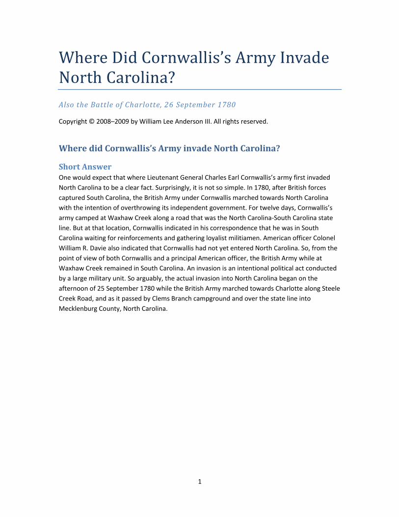
The second map is rough sketch of public roads drawn by Joshua Gordon, a resident of upper
Lancaster County, in 1810 (Gordon 1810 in SCDAH 2007, 176.1 0010 004 ND00 66714 00).
Historian Louise Pettus wrote:
Around 1810 Joshua Gordon petitioned the South Carolina legislature
“complaining of the improper conduct of the Board of Commissioners of Roads
of the district of Lancaster.” Gordon said there were already two public roads to
connect Charlotte and Lancaster Court House and that it was a hardship to add
another [those who lived on the road had to maintain it]. What is remarkable is
that Gordon included a hand-drawn road map showing the roads, creeks, some
households, the Six Mile and Providence Meeting House locations, etc. it is
probably the earliest road map of the area that is extant, preceding the Mills
Atlas map by around 15 years. (L. Pettus 1988).
8
Two roads between Charlotte and just below Twelve Mile Creek
Joshua Gordon, (Gordon 1810 in SCDAH 2007, 176.1 0010 004 ND00 66714 00).
One source suggests the two roads intersected four miles north of Waxhaw Creek (Sumner 1780
in NCSR 1895, XIV:775–776). That intersection was probably slightly west of where present-day
Old Church Road, SR378, forks into Niven Road in South Carolina and Rehobeth Road, SR1107, in
North Carolina (Salley 1929, map). Alternatively, it could have followed the present-day railroad
tracks that parallel highway NC75. At the time of the Revolution and well into the 1800s, the
western road was called Steele Creek Road. Along this road the distance between Waxhaw
Creek and Charlotte was 30 miles. Along Rehobeth Road and Providence Road the distance was
slightly longer, 33 miles. Between these two principal roads there were several crossroads that
were ridge roads. One notable crossroad ran along the ridgeline between the Sugar Creek and
Twelve Mile Creek watersheds. It was called Providence Road West. Today, it is the connected
segments of Ballantyne Commons Parkway, Elm Lane, Bryan Farms Road, Providence Road
West, and Barbersville Road.
Note: Steele Creek Road
At the time of the American Revolution, the main north-south wagon road was often referred to
as Steele Creek Road. This name appears in (Davie 1810 in Robinson 1976, 24), (Davidson 1780
in NCSR 1895, XIV:786) (Davidson 1780 in Davidson 1951, 89), (Graham 1827 in W. A. Graham
1904b, 249), (Bass 1961, 86), (Stinson 1871 in Draper 1873, VV:5:45), and (L. Pettus 1990b). This
name applied as far south as at least Twelve Mile Creek (D. L. Pettus 2008–2015).
9
Unfortunately, this obsolete name is ambiguous since Steele Creek flows into the opposite side
of Sugar Creek and two other roads in Mecklenburg County have the same name. This
ambiguous name confounded this author and at least one historian (Robinson 1957, 69). A
plausible explanation is that the name originated from an earlier time when the main Indian trail
may have paralleled the Catawba River by veering west, across Sugar Creek, and connecting to
the road that retains that name today. The name may predate 1763 before Charlotte had a
name and few roads led directly to it.
Although the name Steele Creek Road is problematic, it remains more distinguishable than the
alternatives: Camden Road, Charlotte Road, Great Road, wagon road, etc. Since it was in the
vernacular used by local residents during the American Revolution, it is also used in this
document.
8 September, Davidson commands Western District militia at McAlpine Creek
Colonel Robert Irwin’s camp was probably near present-day Old Providence Road bridge over
McAlpine Creek. In a few days, Colonel Francis Locke with the Rowan County militia joined. All
together, they constituted about 400 Salisbury District militiamen. However, who was
commander was unclear in the absence of Brigadier General Rutherford who had been captured
at Gates’ Defeat. In about a week, on 31 August, Governor Nash resolved this issue by
appointing William Davidson, an experienced Continental Army lieutenant colonel, who was
promoted on this occasion to militia brigadier general (Graham 1827 in W. A. Graham 1904b,
246). Davidson had just recovered from injuries received at Colson’s Ordinary on 21 July.
The spirited response of the Mecklenburg County and Rowan County militiamen encouraged
Governor Abner Nash to write Brigadier General Jethro Sumner at Ramsey’s Mill on Deep River
on 4 September:
The Western Counties are now high spirited, and things there wear a good
countenance; 500 Virginia regulars will be here [Hillsborough] in a day or two,
and nothing is wanting but the countenance of your brigade to give life and
spirit to our affairs; so let me beg of you, sir, to march on, surmounting and
despising all difficulties. Appoint a commissary yourself. (Nash 1780 in NCSR
1895, XIV:771)
At Ramsey’s Mill, surgeon Robert Williams joined Sumner.
We continued on until we joined the remains of the defeated army at Ramsey
Mills on Deep River in this State then under the command of General Jethro
Sumner who was a Brigadier in the Continental line. James Cole Montflorence
was his aid. He gave me an appointment of Surgeon General which I went and
returned because I was young and there was several surgeons on the
Continental establishment who had been several years in service. He then gave
me an appointment as surgeon to the army as he said the Doctors he believed

10
that were there were inattentive to their duty and some of them drank hard.
(Williams 1832 in Draper 1873, VV:10:192) (Williams, Robert, pension
application 1832)
Meanwhile, Cornwallis’s severe policy was implemented. In mid-September 1780, British Major
James Wemyss [pronounced Wē-mes] burned homes of noted Whigs along the Pee Dee River.
He burned Indiantown Presbyterian Church as a “sedition shop.” These vindictive policies drove
hundreds Whigs into Colonel Francis Marion’s camps.
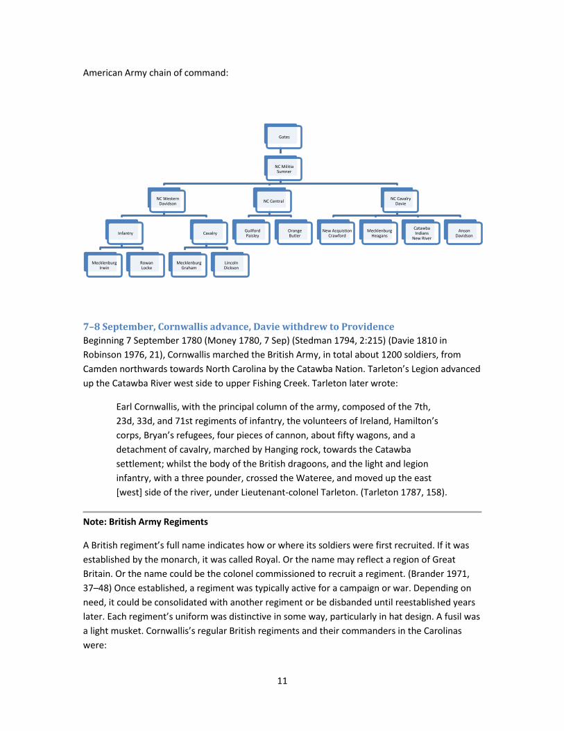
September 1780, British Army and American Army Chain of Commands
Only parts of both armies were operational in or near Charlotte, North Carolina, in September
1780. Of those that did participate, their chains of command appear below.
British Army chain of command:
Cornwallis
23rd
Webster33rd
Webster71st
MacArthurVol of Ireland
RawdonBritish Legion
Tarleton
11
American Army chain of command:
7–8 September, Cornwallis advance, Davie withdrew to Providence
Beginning 7 September 1780 (Money 1780, 7 Sep) (Stedman 1794, 2:215) (Davie 1810 in
Robinson 1976, 21), Cornwallis marched the British Army, in total about 1200 soldiers, from
Camden northwards towards North Carolina by the Catawba Nation. Tarleton’s Legion advanced
up the Catawba River west side to upper Fishing Creek. Tarleton later wrote:
Earl Cornwallis, with the principal column of the army, composed of the 7th,
23d, 33d, and 71st regiments of infantry, the volunteers of Ireland, Hamilton’s
corps, Bryan’s refugees, four pieces of cannon, about fifty wagons, and a
detachment of cavalry, marched by Hanging rock, towards the Catawba
settlement; whilst the body of the British dragoons, and the light and legion
infantry, with a three pounder, crossed the Wateree, and moved up the east
[west] side of the river, under Lieutenant-colonel Tarleton. (Tarleton 1787, 158).
Note: British Army Regiments
A British regiment’s full name indicates how or where its soldiers were first recruited. If it was
established by the monarch, it was called Royal. Or the name may reflect a region of Great
Britain. Or the name could be the colonel commissioned to recruit a regiment. (Brander 1971,
37–48) Once established, a regiment was typically active for a campaign or war. Depending on
need, it could be consolidated with another regiment or be disbanded until reestablished years
later. Each regiment’s uniform was distinctive in some way, particularly in hat design. A fusil was
a light musket. Cornwallis’s regular British regiments and their commanders in the Carolinas
were:
Gates
NC Militia Sumner
NC Western Davidson
Infantry
MecklenburgIrwin
RowanLocke
Cavalry
MecklenburgGraham
LincolnDickson
NC Central
GuilfordPaisley
OrangeButler
NC CavalryDavie
New AcquistionCrawford
MecklenburgHeagans
Catawba Indians
New River
AnsonDavidson

12
Regiment Name Commander
23rd Royal Welch Fusiliers Lieutenant Colonel James Webster
33rd West Riding Regiment Cornwallis (delegated to Webster)
63rd West Suffolk Regiment Major James Wemyss
71st Fraser’s Highlanders Major Archibald McArthur
7th Royal Fusiliers [garrison duty]
British Legion Lieutenant Colonel Banastre Tarleton
2nd American Volunteers of Ireland Lieutenant Colonel Francis Lord Rawdon
Volunteers of New York Lieutenant Colonel George Turnbull
militia Royal North Carolinians Lieutenant Colonel John Hamilton
militia Yadkin Valley loyalists Colonel Samuel Bryan
The 23rd and 33rd Regiments had distinguished records since the beginning of the war. The
23rd Regiment accompanied Brigadier General Hugh Percy’s rescue of British soldiers and
Marines who fought at Lexington and Concord, Massachusetts, on 19 April 1775 (Mackenzie
1930, 19–23). Both regiments participated in the flanking maneuver on Long Island, New York,
that won an important British victory on 27 August 1776. The British Legion and Volunteers of
Ireland were on the British establishment, but despite their name, most of their soldiers were
American loyalists.
In 1780, the 23rd Regiment was commanded by Lieutenant Colonel James Webster. He was also
delegated command of the 33rd Regiment by its titular colonel, Cornwallis.
On 7 September, Cornwallis’s army encamped at Rugeley’s Mill; on 8 September, at Hanging
Rock (Cornwallis 1780 in CP 1970, vol. 80); on 9 September, at Berkley’s on Camp Creek (Stinson
1874 in Draper 1873, VV:5:407–409), near present-day Shady Lane, Lancaster, South Carolina;
and on 10–11 September, at Forster’s or Foster’s (Cornwallis 1780 in CP 1970, vol. 80) near
present-day Foster’s Crossroads. (Allison 2009)
As Cornwallis advanced from Camden, Davie took up a new post at New Providence in front of
Davidson. At this time, Governor Nash promoted Major William Richardson Davie to colonel.
Colo Davie who was now appointed Colo Comt of all the Cavalry of No Carolina
with orders also to raise a regiment had there collected only about seventy men
however with these and two companies of riflemen commanded by Major Geo.
Davidson [of Anson County] he took post at Providence twenty five miles above
the British camp. (Davie 1810 in Robinson 1976, 21).
With this promotion, Davie no longer reported to the Mecklenburg County militia command, but
to Sumner. Major George Davidson was from Anson County and not related to William
Davidson. He contributed 80 mounted infantry, bringing Davie’s strength to 150 cavalrymen

13
(Davie 1810 in Robinson 1976, 21). Both William Davidson and Davie were subordinates to
Brigadier General Jethro Sumner, but operated independently. Davie’s cavalrymen continued to
patrol throughout the Waxhaw region.
The distances that Davie cites in his two quotes reveal an interesting insight. He wrote that the
British camp on Waxhaw Creek was 40 miles from Charlotte and his camp at Providence was
25 miles above the British camp (Davie 1810 in Robinson 1976, 21). So implicitly, Davie indicated
his camp was 15 miles from Charlotte. That is where Six Mile Creek crosses Providence Road.
How did he know the distance between the two camps was 25 miles? It is not likely that he
directly measured it. It is more likely that he computed it from known distances from Charlotte.
A milepost probably marked that location. Such mileposts were in existence in the early 1800s
(Rosser 1873 in Draper 1873, VV:13:6), and probably existed much earlier. So Davie almost
certainly used the well-known 15 miles to derive the 25-mile distance between the two camps.
This analysis is confused by Davie’s mistaken 40-mile distance from Charlotte to Waxhaw Creek
on the North Carolina line. The actual distance is 30 miles. This discrepancy is surprising since
Davie’s boyhood home was nearby. Perhaps Davie was referring to the long way, along
Providence Road and present-day Old Tirzah Church Road. Or perhaps his original manuscript
was misread. Whatever the reason, the invariant in Davie’s writing is that his camp was 15 miles
from Charlotte, and that is where Six Mile Creek crosses Providence Road.
Graham later wrote, “Davie retired before them [the British] until near General Davidson’s
quarters at McAlpin’s Creek.” (Graham 1827 in W. A. Graham 1904b, 249). The inference is that
Davie’s camp was distinct from Davidson’s camp and that Davie was closer to the enemy.
Graham, who was with the Mecklenburg County militia at McAlpine Creek, remembered the
camps relative positions. Because of his many horses, Davie was probably at either Four Mile
Creek or Six Mile Creek.
Four, Six, and Twelve Mile Creeks were probably named for the mileage from McAlpine Creek
along Providence Road.
12 September, Cornwallis at Waxhaw Creek
On 12 September, Cornwallis’s army marched past Old Waxhaw Presbyterian Church and
cemetery. It continued on to the North Corner of the South Carolina-North Carolina state line.
For an addition mile, it marched north along the road that defined the state line since 1772. It
encamped at Major Robert Crawford’s plantation on Waxhaw Creek. Cornwallis’s
correspondence of 12 September indicates his location was “Camp at Crawford’s, Waxhaw
Creek.” (Cornwallis 1780 in CP 1970, 80:17) Davie later wrote:
… Earle Cornwallis moved with the whole of the British Army from Camden to
the Waxhaws and took possession of the Camp occupied by Major Davie in the
months of June and July, forty [should be 30] miles below Charlotte and directly
on the No Cara line. (Davie 1810 in Robinson 1976, 21).

14
Davie described his previous camp as “on the North side of the Waxhaw creek” (Davie 1810 in
Robinson 1976, 8). Most of the British army camped north of Waxhaw Creek except for the
71st Highland Regiment that encamped in the rear, about half a mile south of the creek (Davie
1810 in Robinson 1976, 21). Cornwallis’s campsite was slightly north of the present-day highway
US521 bridge over Waxhaw Creek. At that time, Salisbury Road defined the state line. An 1813
map shows this road closely flanked by two small streams flowing into Waxhaw Creek (Salley
1929, map). Today, highway US521 has the same configuration. That puts the present-day
US521 bridge within 400 yards of where the Salisbury Road crossed Waxhaw Creek in 1780.
Major Robert Crawford’s house was Cornwallis’s headquarters. It was most probably on the
hilltop above the creek and west of the road (Allison 2009). This house site appeared later as
“J. Crawford’s” on an 1813 map (Salley 1929, map) and as “John Crawford’s” on the 1825 Mills
Atlas (Mills 1825). Since Robert Crawford died in 1801, these labels probably refer to his son
John. In fact, this was confirmed by General Andrew Jackson who after receiving a copy of the
Mills Atlas, replied on 8 July 1827:
The crossing of Waxhaw creek within one mile of which I was born, is still,
however, I see, possessed by Mr. John Crawford, son of the owner (Robert) who
lived there when I was growing up and at school … From the accuracy with
which this spot is marked on the map I conclude the whole [map] must be
correct. (Jackson 1827 in James 1938, 794)
Lieutenant John Money, Aide de Camp, recorded that British soldiers built huts (Money 1780, 12
Sep). Since Major Robert Crawford was a noted Patriot, Cornwallis probably confiscated
Crawford’s property.
He [Robert Crawford] served as a captain during 1776. He served under
Cols. Richard Richardson and Joseph Kershaw. He went to Charleston at the
time of Provost’s invasion [May 1779] and was in the battle at Stono’s Ferry. In
1780 he became a major and was taken prisoner in the fall of Charleston. After
being paroled, he joined Sumter and commanded a unit at the Battle of Hanging
Rock. In addition, he was at Sumter’s Defeat. He lost two horses in service.
(Moss 1983)

15
Probable British Army encampment site at Major Robert Crawford’s Plantation
Cornwallis’s pause at Waxhaw Creek was to await additional reinforcements and to consolidate
loyalist support before a new offensive (Graham 1827 in W. A. Graham 1904b, 248). Many
soldiers were sick, including Lieutenant Colonel Tarleton who was recuperating from serious
illness (Cornwallis 1780 in Tarleton 1787, 191). Tarleton was with the British Legion at White’s
Mill west of Catawba River on Taylor Creek off present-day Craig Road (Scoggins 2010–2017).
These two British positions controlled use of Land’s Ford.
No doubt, Cornwallis was sensitive about his entry into North Carolina since it had significant
political implications. It meant the expansion of the war into another political entity, threatening
the legitimacy of every North Carolina government agency, and forcing its officials to react.
Cornwallis considered his Waxhaw Creek camp within South Carolina. While there, Cornwallis
issued a Proclamation of Sequester against the property of certain notable South Carolina
rebels. The Proclamation explicitly states that it was signed in “the district of Wacsaw” in the
province of “South Carolina” (Cornwallis 1780 in Tarleton 1787, 191). Also, on 12 September, in
correspondence with Lieutenant Colonel Cruger, Cornwallis wrote explicitly that he was not yet
in North Carolina:
I have given the fullest Directions to Lt. Col. Balfour relative to the affairs of this
Province and he will have the Management of all the Posts when I move into
North Carolina. (Cornwallis 1780 in CP 1970, 80:11)
Also, Davie regarded Cornwallis’s location in South Carolina. In 1810, Davie wrote that
Cornwallis “moved with the whole of the British Army from Camden to the Waxhaws and took
possession of the Camp occupied by Major Davie in the months of June and July.” A few
sentences later, Davie wrote, “but his Lordship was not ready to enter North Carolina” (Davie
1810 in Robinson 1976, 21).

16
Some loyalists camped nearby in North Carolina, notably at Wahab’s Plantation (Davie 1810 in
Robinson 1976, 21–23).
On 12 September, Davidson wrote to Gates in Hillsborough requesting reinforcements to
counter Cornwallis’s army at Waxhaw Creek. Gates ordered Sumner, who was marching to
Salisbury, to support Davidson (Nelson 1976, 245). In a 14 September report to Gates, Davidson
indicated his location was on McAlpine Creek, 8 miles south of Charlotte.
Camp Maccappin’s Creek, Sept. 14, 1780
Sir:
I am now encamped 8 miles South of Charlotte, my number consisting of 400,
minute men from Rowan and Mecklenburg counties, none from the other
counties being yet arrived. The enemy are at Wax Haw creek, 20 miles distance.
Lords Cornwallace and Roddin [Rawdon] are both with them. Their number, by
the best intelligence, about 1,000. They are busied threshing and flouring
wheat, collecting cattle, sheep, butter, &c. I do not learn they have any artillery.
Col. Ferguson and his party, which by common report consists of 1,200, are
troublesom to the westward. I cannot find they have yet entered this State,
except some who have committed some depredations on the west end of
Rutherford county.
Lest they should advance I have sent Col. Lock to Rowan to embody the rest of
his regiment to join Col. Macdowell, who lies in Burke with about 400, by the
best accounts. Col. Paisley joins me to morrow with near 200. Gen. Sumner with
his brigade is expected to be at Salisbury this evening. Gen. Sumpter lies
13 miles to my right [probably at Bigger’s Ferry] with 200, his number daily
increasing. Our troops are in high spirits, and seem determined to stand out to
the last extremity rather than submit to the fate of So. Carolina.
Sir, I have the honour to be,
Your most obedt. Servt.,
Wm. Davidson.
(Davidson 1780 in NCSR 1895, XIV:615–616).
The closest straight-line distance that McAlpine Creek gets to downtown Charlotte is 7.3 miles
and that is between present-day Old Monroe Road and Providence Road. Because of mileposts,
Davidson knew the distance along Providence Road with precision. So, his 8 mile distance
locates the campsite near where present-day Old Providence Road crosses the creek. The camp
would have been on the high, dry ground on the Charlotte side of the creek (Graham 1827 in W.
A. Graham 1904b, 246). Because of the large number of horses, it probably extended a quarter
of a mile or more. Davidson’s indication that the British at Waxhaw Creek were 20 miles distant
is consistent with the total distance of 30 miles from Charlotte. Colonel Thomas Sumter was

17
located on the Catawba River east bank at Bigger’s Ferry (Hill 1815, 17) (Graham 1827 in W. A.
Graham 1904b, 249). That was actually 16 miles away. So, Davidson’s cited 13 miles was
probably an estimate he got from an express rider carrying a message from Sumter. In fact, in a
24 September report, Davidson revised this estimate to 15 miles (Davidson 1780 in NCSR 1895,
XIV:614–615). Graham’s later account was less specific, but consistent.
The foot, under Gen W. L. Davidson, encamped southeast of Charlotte, and the
horse, under Colonel Davie, were patrolling the country as far as Waxhaw, and
the adjoining counties in the west, which were disaffected. (Graham 1832 in W.
A. Graham 1904b, 48).
Probable American campground on McAlpine Creek, September 1780
On 14 September, Sumner arrived at Salisbury (Gates 1780 in NCSR 1895, XIV:773) (Sumner
1780 in NCSR 1895, XIV:785–786). Sometime before 18 September, Davidson wrote Sumner:
I am extremely glad to hear of your, being so near at hand. It raises the spirits of
the people here, who were greatly disgusted by the misfortune of Gen. Gates
and the near approach of the enemy. Lord Cornwallis commands, and
Lord Rawdon is there. Their force is perhaps almost 1,000, nearly all British.
They are thrashing and flowering wheat and driving in cattle, sheep, hogs, etc.
they have no artillery. Col. Brannon and his South Carolina refuges has routed a
party of tories in Rutherford County, killed and wounded 2 and taken 24. The
people here long for some support. (Davidson 1780 in NCSR 1895, XIV:772).
On hearing a rumor that Gates ordered Sumner to withdraw, Davidson wrote:
September 18, 1780
The news of your coming forward in such force gave a surprising spirit to the
people of this county, but a report has taken place that Gen. Gates has directed
you to retire over the Yadkin. Should that be the case, I dread the
consequences. I need not tell you the dreadful effects of Gen. Gates’s retreat to

18
Hillsborough. The effects of it are, in my opinion, worse than those of his defeat.
It has frightened the ignorant into despair, being left without cover or support
to defend themselves against the whole force of the enemy. No people have a
better claim to protection than the people of this county. They have fought
bravely and bled freely. I mention these things, as I have reason to fear that my
minute troops will disperse, should they not be treated agreeable to their
expectations. The enemy continue at Waxhaw Creek, and are almost 900, and
one third tories. The cavalry are inconsiderable. (Davidson 1780 in NCSR 1895,
XIV:773).
Actually, Gates ordered Sumner to Charlotte:
September 19th, 1780
This morning I received your letter of the 14th from Salisbury. I would have
wished to have been certain you were upon your march from thence, to succor
and sustain our friends in Charlotte, who seem to be threatened with an attack.
The instant the [Hillsborough] troops are in a proper condition to march be
assured they will be put in motion to join you. (Gates 1780 in NCSR 1895,
XIV:773).
20–21 September, Davie launches attack, Wahab Plantation
On 20 September, Davie’s 150 cavalrymen departed Six Mile Creek camp to attack loyalist
militiamen encamped on Cornwallis’s right flank. At dawn on 21 September, they attacked a
camp at Wahab Plantation, just west of present-day JAARS Institute. The attack was swift and
bloody. Davie later wrote, “the vicinity of British quarters, and the danger of pursuit
satisfactorily account for no prisoners being taken.” (Davie 1810 in Robinson 1976, 23). Davie’s
men captured 96 horses and returned to their Six Mile Creek camp that afternoon, “having
performed a march of sixty miles in less than twenty four Hours, notwithstanding the time
employed in seeking & beating the enemy.” (Davie 1810 in Robinson 1976, 23). Davie almost
certainly traveled Providence Road since 60 miles is more than his calculated, but mistaken, 50-
mile roundtrip distance to Waxhaw Creek by the most direct route. Later that day, Cornwallis
wrote:
Two or three Volunteer Companies of our Militia who had made some
successful Scouts, contrived this morning to be totally surprised and routed by a
Major Davy who is a celebrated partisan in the Waxhaws. (Cornwallis 1780 in CP
1970, 80:21)

19
Site of Wahab’s Plantation
20 September, Sumner arrives at McAlpine Creek
On the evening of 20 September, Sumner arrived at Davidson’s camp with about 400 militiamen
from Guilford, Granville, and Orange Counties (Sumner 1780 in NCSR 1895, XIV:775–776)
(Graham 1827 in W. A. Graham 1904b, 247) (Money 1780, 23 Sep). Among these men was
Lieutenant Richard Vernon (Vernon 1832 in Draper 1873, VV:10:169). Their total strength was
about 800 men. Davie later wrote:
Generals Sumner & Davidson had arrived that day [actually previous evening] at
his [Davie’s] camp with their brigades of militia both of which However did not
amount to one thousand men all on short enlistments, illy armed, and
diminishing every day. These with Davie’s corps were the whole assembled
force at that time opposed to the enemy. (Davie 1810 in Robinson 1976, 23).
When Davie wrote in 1810, he must have forgotten about other active militia units. Sumter with
400 men were encamped at Bigger’s Ferry on Catawba River (Hill 1815, 17) (Graham 1827 in W.
A. Graham 1904b, 249) and Colonel Charles McDowell and his men were at Quaker Meadows,
near present-day Morganton, NC (Draper 1881, 180).
Sumner described these events in a 12 October letter:
I arrived at Salisbury on the September 14th & joined Gen. Davidson on the 21st.
His Brigade was greatly reduced, not amounting to upwards of 20 [obvious
misprint, should read 200] privates fit for duty. (Sumner 1780 in NCSR 1895,
XIV:785–786).
22 September, Cornwallis prepares approach on Charlotte
At Waxhaw Creek, Cornwallis made his final plans to capture Charlotte. On 22 September, he
wrote his superior General Henry Clinton:
20
If nothing material happens to obstruct my plan of operations, I mean, as soon
as Lieutenant-colonel Tarleton can be removed, to proceed with the 23rd, 33rd,
volunteers of Ireland, and legion, to Charlotte town, and leave the 71st here
until the sick can be brought on to us. I then mean to make some redoubts, and
establish a fixed post at that place, and give the command of it to Major
Wemyss, whose regiment is so totally demolished by sickness, that it will not be
fit for actual service for some months. (Cornwallis 1780 in Tarleton 1787, 191).
That day, Cornwallis ordered the British Legion to cross Catawba River and join him at Waxhaw
Creek (Tarleton 1787, 158) (Stedman 1794, 2:216) (Graham 1827 in W. A. Graham 1904b, 249).
Tarleton, using the third person, later wrote:
On the 22d, Earl Cornwallis directed the British legion and light infantry to cross
the Catawba at Blair’s ford [Land’s Ford], in order to form the advance guard,
for the immediate possession of Charlotte town. The junction of the light troops
had been prevented for a few days, by a violent fever which had attacked
Lieutenant-colonel Tarleton, and which yet disabled him from holding his
situation when his regiment moved forwards. Several convalescent men of the
army having relapsed, the 71st [Regiment], under McArthur, was left near Blair’s
mill, to afford protection to the sick, to cover the mills in the neighbourhood,
and to hold communication with Camden, till the arrival of the additional
supplies. (Tarleton 1787, 158).
Blair’s Ford was named for Blair’s Mill, located about a half a mile above Land’s Ford (Draper
1873, VV:9:188) (Joy, Stine and Clauser 2000). On 23 September, Cornwallis wrote, “Tarleton is
better, and was moved to-day in a litter” (Cornwallis 1780 in Tarleton 1787, 192). So, Tarleton
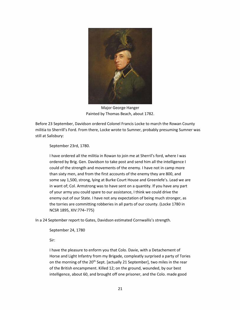
probably remained near Land’s Ford. In his absence, command of the British Legion fell to Major
George Hanger (Tarleton 1787, 159). Tarleton’s next known activity was on 10 October in
Charlotte (Tarleton 1787, 165).
21
Major George Hanger
Painted by Thomas Beach, about 1782.
Before 23 September, Davidson ordered Colonel Francis Locke to march the Rowan County
militia to Sherrill’s Ford. From there, Locke wrote to Sumner, probably presuming Sumner was
still at Salisbury:
September 23rd, 1780.
I have ordered all the militia in Rowan to join me at Sherril’s ford, where I was
ordered by Brig. Gen. Davidson to take post and send him all the intelligence I
could of the strength and movements of the enemy. I have not in camp more
than sixty men, and from the first accounts of the enemy they are 800, and
some say 1,500, strong, lying at Burke Court House and Greenlefe’s. Lead we are
in want of; Col. Armstrong was to have sent on a quantity. If you have any part
of your army you could spare to our assistance, I think we could drive the
enemy out of our State. I have not any expectation of being much stronger, as
the torries are committing robberies in all parts of our county. (Locke 1780 in
NCSR 1895, XIV:774–775)
In a 24 September report to Gates, Davidson estimated Cornwallis’s strength.
September 24, 1780
Sir:
I have the pleasure to enform you that Colo. Davie, with a Detachement of
Horse and Light Infantry from my Brigade, compleatly surprised a party of Tories
on the morning of the 20th Sept. [actually 21 September], two miles in the rear
of the British encampment. Killed 12; on the ground, wounded, by our best
intelligence, about 60, and brought off one prisoner, and the Colo. made good
22
his retreat with 50 Horses, as many saddles, 13 guns, &c. Lord Cornwallis
continues at the Waxsaw Creek, collection reinforcements from the Militia,
fattening his Horse, and Carrying off every article valuable to our Army. His
present strength is about 1,200, with one piece of Artillery — perhaps near one-
half of his number Tories. Colo. Trumbull, on the west of the River, has about
700, chiefly new recruits in uniform, and is now in fishing Creek Neighbourhood.
Colo. Ferguson, with about 800 Tories, has advanced to Gilberts Town, and a
Detachment from him has penetrated as far as Burk Court House, with which
Colo. Mc’dowul Skirmished with about two Hundred men, but gave ground and
retreated, I am enformed, over the Mountains. Genl. Sumner has joined me.
Genl. Sumpter has Collected about 400 of his Dispersed Troops, and lies
15 miles on our right on the Bank of the [Catawba] River. I have ordered
Collonels Amstrong, Cleveland and Lock to unite their forces against Furguson,
and if possible stop his progress. The establishment of a post at Maskes ferry
[on the Pee Dee River] appears well Calculated to make a Diverte and give relief
to the Western parts of the State. Inclosed you have a Coppy of a proclamation,
with Colo. Furguson has taken grate pains to Circulate.
I have the Honnour to be
Your most Obdt. & very Hbl. Serv’t,
Wm. Davidson
[incorrectly dated 14 September in (Davidson 1780 in NCSR 1895, XIV:614–
615)].
In a separate report to Gates, Sumner wrote:
The Cappings [McAlpine] Creek,
September 24th, 1780
I immediately marched from Salisbury, and arrived in this camp the 20th, in the
evening. Gen. Davidson informed me his minute men were upon leaving the
camp to go to Sherell’s Ford. Col. Armstrong has gone to join the forces
collecting to oppose Major Ferguson, who is in the neighborhood of Burke
County Court House, with a large number of the disaffected and some British.
The British force is near White’s Mill, and is commanded by Col. Turnbull, others
say by Lord Rodney [Rawdon]. Gen. Sumter judges he could drive them from
thence with as many more men as he has with him, which I have reason to
believe is almost 300. Lord Cornwallis is yet at the Waxhaw Creek with 600 or
700 British troops and 300 or 400 tories, mostly on horse, with 70 or
80 dragoons. They lie close and expect reinforcements. On the road westward,
almost 7 miles across, we have a party of horse; this road passes in four miles of
the British Camp, and passes through the Catawba nation to Charlotte. I judge
the enemy will make use of it should they move in force toward Charlotte.
23
Col. Davie, on returning from reconnoitering on the 22d [should be 21st], fell in
with a party of 130 tories, surprised them, killed 14 and took two prisoners. The
others dispersed with the greatest precipitation. Forty horses and saddles fell
into our hands. His party received no damage except in wounded. I am just
sending a party of 140 infantry and 20 horse under Col. Seawell as far as the
12 mile creek, to view the road which passes near that creek. (Sumner 1780 in
NCSR 1895, XIV:775–776).
Since Sumner lived in a different part of North Carolina, he did not know the local roads and
creeks. In this report, he clearly repeated his briefing by Davidson and Davie. With this
understanding of context, much information can be inferred from his choice of words. His
reference to the “road westward, almost 7 miles across” applies to Steele Creek Road. The party
of horse was probably that commanded by Graham since Davie implied he was not on Steele
Creek Road (Davie 1810 in Robinson 1976, 24). The expression “this road passes in four miles of
the British Camp,” likely refers to where the two roads from Charlotte joined. That intersection
was probably slightly west of where present-day Old Church Road, SR378, forks into Niven Road
in South Carolina and Rehobeth Road, SR1107, in North Carolina (Salley 1929, map). The latter is
a ridge road. Another possible ridge road traversed the path of the present-day railroad tracks
connecting to Providence Road at present-day Waxhaw, North Carolina (Graham 1789 in
Tompkins in W. A. Graham 1904b, 188).
Apparently, on the afternoon of 24 September, Davidson moved his remaining 200 militiamen
from Providence Road to Steele Creek Road, camping on the Charlotte side of McAlpine Creek,
but this time 12 miles from Charlotte, at the present-day highway Old-US521 bridge. That camp
location was drawn on a 1789 map by Major Joseph Graham (Graham 1789 in Tompkins in W. A.
Graham 1904b, 188) (Graham 1789 in Tompkins in Robinson 1976, 6). It was 3 miles north of
Clems Branch campground. These men likely traversed the ridge road that is the present-day
connected segments of Ballantyne Commons Parkway, Elm Lane, Bryant Farms Road,
Community House Road, and Providence Road West. Davidson probably intended to continue
north to Sherrill’s Ford to counter the threat posed by Major Patrick Ferguson’s army (Sumner
1780 in NCSR 1895, XIV:775–776). But Cornwallis’s approach forced Davidson to withdraw
towards Salisbury.
After ordering Colonel Benjamin Seawell out, Sumner received the following 23 September
message from Sumter:
My spies bring me accounts this morning that the enemy [British Legion] have
evacuated their camp at White’s Mill, and it is supposed they have crossed the
River at Landsford. They have a number of horse, but not one half of them
equipped as cavalry. Perhaps they mean to be troublesome to you. They have
been collecting guides for different purposes, and have offered twenty guineas
to any one who will conduct them privately to my camp. (Sumner 1780 in NCSR
1895, XIV:775).

24
Sumner quickly wrote to Seawell:
Evening. [24 September]
After your leaving the camp I have received a letter from Gen. Sumter. He says
the enemy have crossed the river at Landsford, and perhaps they may fall in
with you. I thought it necessary to send you this information. If you should fall in
with the [illegible] I doubt not but you’ll give a good account of them. (Sumner
1780 in NCSR 1895, XIV:776).
Meanwhile, from Waxhaw Creek, the British began their march. Lieutenant John Money
recorded:
The following Corps marched this afternoon at 4 pm towards Charlotte — 23rd,
33rd, Vol’n of Ireland and Legion with 2, 3 and 6-pounders. Halted at Twelve Mile
Creek till the moon rose and then proceeded toward Sugar Creek on the
Charlotte Road. (Money 1780, 24 Sep) (Allison 2009)
Apparently, Sumner did not realize that he put Seawell’s infantrymen at great risk. The next
morning, Seawell reported back to Sumner:
September 25th, 1780
We arrived at this place [probably Twelve Mile Creek] last evening and camped,
intending to start at moon-rise, but a very heavy rain coming on, I was obliged
to stay until the morning to examine the guns. I hear that Lord Cornwallis had a
reinforcement of a thousand British from Camden come in on Wednesday last,
as also a number of cannon. Col. Tarleton has joined him with 700 horse; also a
number of South Carolina militia has been sent to him, which makes them
number almost 5,000 [should be 2000] strong. I can’t tell how far I shall
proceed, as it depends on such intelligence as I shall hereafter get. If I had my
men mounted on horses I doubt not we should do something clever, but shall
do the best I can. (Seawell 1780 in NCSR 1895, XIV:776–777).
Interestingly, on 25 September 1780, the moon was four days past its last-quarter phase. Thus,
it rose about 4:00 a.m. (time and date.com 2009).
25 September, Cornwallis’s army crosses state line at Clems Branch
Late on 24 September, Cornwallis started to move his forces from Waxhaw Creek towards
Charlotte (Graham 1827 in W. A. Graham 1904b, 249). A 1787 British map shows the route, but
without great precision (Faden 1787). It is consistent with the route of present-day highway
US521. Although the British march formation was not recorded, it can be inferred from
historical information (Peterson 1968).
25
Note: British Army on the march
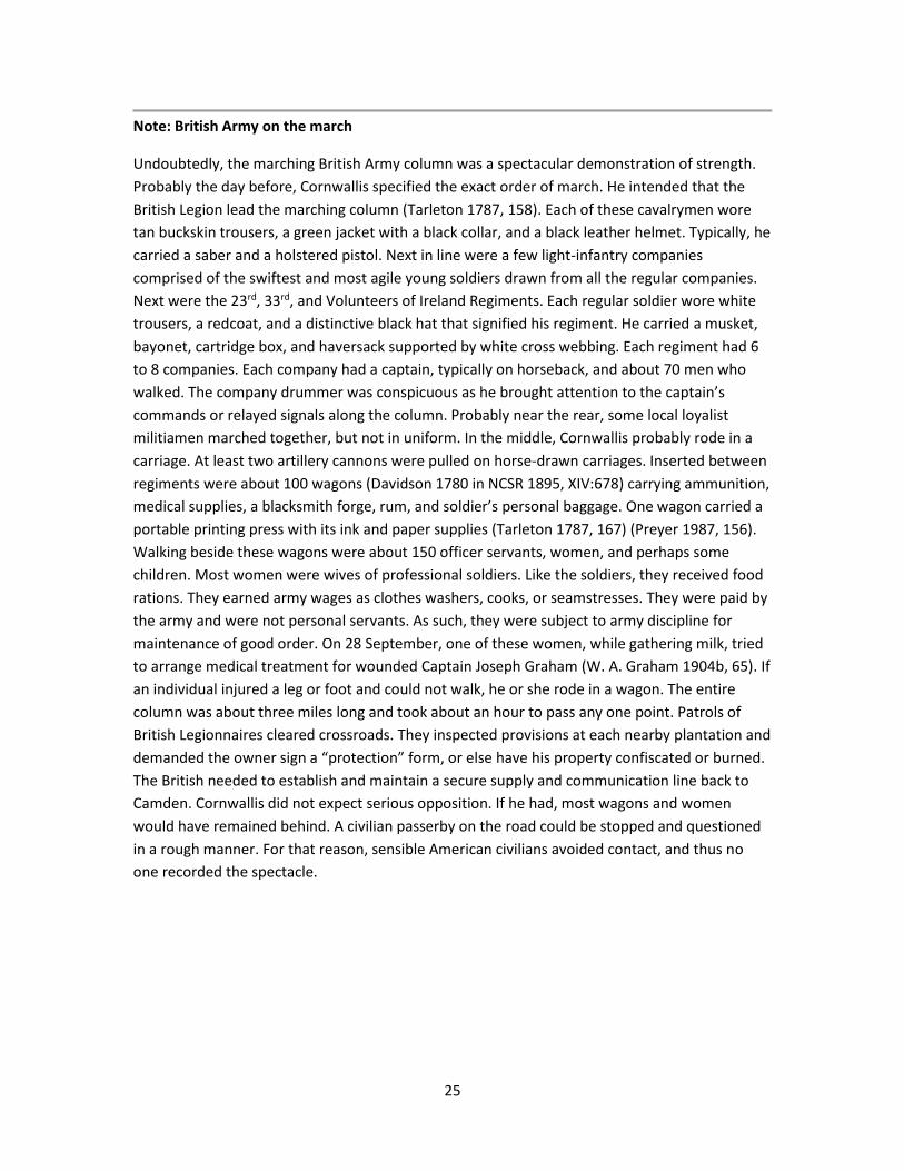
Undoubtedly, the marching British Army column was a spectacular demonstration of strength.
Probably the day before, Cornwallis specified the exact order of march. He intended that the
British Legion lead the marching column (Tarleton 1787, 158). Each of these cavalrymen wore
tan buckskin trousers, a green jacket with a black collar, and a black leather helmet. Typically, he
carried a saber and a holstered pistol. Next in line were a few light-infantry companies
comprised of the swiftest and most agile young soldiers drawn from all the regular companies.
Next were the 23rd, 33rd, and Volunteers of Ireland Regiments. Each regular soldier wore white
trousers, a redcoat, and a distinctive black hat that signified his regiment. He carried a musket,
bayonet, cartridge box, and haversack supported by white cross webbing. Each regiment had 6
to 8 companies. Each company had a captain, typically on horseback, and about 70 men who
walked. The company drummer was conspicuous as he brought attention to the captain’s
commands or relayed signals along the column. Probably near the rear, some local loyalist
militiamen marched together, but not in uniform. In the middle, Cornwallis probably rode in a
carriage. At least two artillery cannons were pulled on horse-drawn carriages. Inserted between
regiments were about 100 wagons (Davidson 1780 in NCSR 1895, XIV:678) carrying ammunition,
medical supplies, a blacksmith forge, rum, and soldier’s personal baggage. One wagon carried a
portable printing press with its ink and paper supplies (Tarleton 1787, 167) (Preyer 1987, 156).
Walking beside these wagons were about 150 officer servants, women, and perhaps some
children. Most women were wives of professional soldiers. Like the soldiers, they received food
rations. They earned army wages as clothes washers, cooks, or seamstresses. They were paid by
the army and were not personal servants. As such, they were subject to army discipline for
maintenance of good order. On 28 September, one of these women, while gathering milk, tried
to arrange medical treatment for wounded Captain Joseph Graham (W. A. Graham 1904b, 65). If
an individual injured a leg or foot and could not walk, he or she rode in a wagon. The entire
column was about three miles long and took about an hour to pass any one point. Patrols of
British Legionnaires cleared crossroads. They inspected provisions at each nearby plantation and
demanded the owner sign a “protection” form, or else have his property confiscated or burned.
The British needed to establish and maintain a secure supply and communication line back to
Camden. Cornwallis did not expect serious opposition. If he had, most wagons and women
would have remained behind. A civilian passerby on the road could be stopped and questioned
in a rough manner. For that reason, sensible American civilians avoided contact, and thus no
one recorded the spectacle.

26
British Army Marching Column
Davie later wrote, “on the 24th of september our patroles gave information, that the enemy
were in motion on the Steele-creek road leading to Charlotte.” (Davie 1810 in Robinson 1976,
24). Consequently, early in the morning on 25 September, Sumner and Davidson abandoned
their camp.
On the 25th of September, [we] heard that the whole British army were on the
march from Camden [Waxhaw Creek on Camden Road]. General Davidson
immediately decamped, marched towards Salisbury… (Graham 1832 in W. A.
Graham 1904b, 48–49).
Sumner marched from McAlpine Creek to Charlotte. From there after 6:00am, he wrote Gates:
I am to inform you about three Ock. this morn’g we received information of the
Enemys being on their march from the Waxhaws Creek, by the Steel Creek Road
in force. We immediately retreated thus far, judg’g it prudent, to prevent, if
possible, coming to a Genl. Action. (Sumner 1780 in NCSR 1895, XIV:651)
In Charlotte, Sumner loaded all public stores and marched towards Salisbury (Sumner 1780 in
NCSR 1895, XIV:778) (Graham 1827 in W. A. Graham 1904b, 69, 249). Sumner ordered Davie to
rear guard the slower foot soldiers. Sumner described these events in a 12 October letter:
On September 25th I was informed that the enemy had moved towards
Charlotte. We marched into Charlotte at 6 o’clock in the morning, and found the
main British army advancing and only 12 miles away. Having positive orders not
to risk a general engagement, & our force not being able to cope with the
enemy’s, I thought proper to order a retreat, having secured what provisions we
could and all the public stores, leaving Colo. Davie with his horse to cover our
retreat. (Sumner 1780 in NCSR 1895, XIV:785–786).
27
In 1832, Robert Williams, a surgeon in Sumner’s brigade, testified on his pension application:
We moved towards South Carolina and a few miles below Charlotte in
Mecklenburg County near the South Carolina line, a reconnoitering party of ours
took some British prisoners when we found we were near Cornwallis. We
retreated next day. (Williams 1832 in Draper 1873, VV:10:192) (Williams,
Robert, pension application 1832)
From Steele Creek Road, Davidson took the ridgeline road between Little Sugar Creek and
McMullen Creek, passing 4 miles east of Charlotte (Graham 1827 in W. A. Graham 1904b, 249).
Graham described that road:
Persons going from Waxhaw to Salisbury would not pass through Charlotte, but,
after passing Sugar [meant McApine] Creek, take a right-hand fork, and leaving
Charlotte four miles to the left, enter the Charlotte-Salisbury road at “Cross-
Roads” near the Alexander Residence. (W. A. Graham 1904b, 69).
Today, that route is the connected segments of highway Old-US521, Park Road, Sharon Road,
Sharon Amity Road, Pierson Drive, Kilborne Drive, Eastway Drive, and highway US29 (Barden
2010). At the “Cross Roads,” about a mile east of Sugar Creek Presbyterian Church, Davidson
ordered Graham “to Charlotte, to take command of the militia assembling there in consequence
of the alarm of the enemy advancing.” (Graham 1827 in W. A. Graham 1904b, 250). About
50 men collected (Graham 1832 in W. A. Graham 1904b, 49). Davidson continued on and halted
behind Mallard Creek. Sumner continued on towards Salisbury.
During the late afternoon of 25 September, Cornwallis’s army of about 2000 troops marched
(Davidson 1780 in NCSR 1895, XIV:678) (Sumner 1780 in NCSR 1895, XIV:778) past Clems Branch
campground as it entered North Carolina. In 1789, Major Joseph Graham drew a map that
marked Cornwallis’s route (Graham 1789 in Tompkins in W. A. Graham 1904b, 188) (Graham
1789 in Tompkins in Robinson 1976, 6). The British Army definitely entered North Carolina at
this location.
Cornwallis dispatched Rawdon’s Volunteers of Ireland regiment with part of the British Legion to
chase down Colonel Thomas Sumter and about 400 of his men who were encamped on the east
side of Bigger’s Ferry. Lieutenant John Money recorded:
No certain Intelligence being received of Sumpter’s having passed the Catawba
River, Lord Rawdon was detached with the Legion and Flank Companies of the
Vol’n of Ireland to attack him. I marched with his Lordship to Bigger’s Ferry
where we learned he had passed the evening before and that Sumner and
Davidson had retired from McAlpine’s Creek. (Money 1780, 24 Sep)
Rawdon’s march most likely traversed the route of present-day highway SC160, Zoar Road, and
Youngblood Road. Sumter and his men barely escaped by crossing at the ferry (Hill 1815, 17)

28
(Graham 1827 in W. A. Graham 1904b, 249) (Bass 1961, 87). Colonel William Hill was with
Sumter and later wrote:
Cornwallis detached Rawdon & Tarlton [actually British Legion without Tarleton]
with a number of horse & foot to five times the number that Genl –Sumter had
then in camp in order to surprise him but fortunately he got news of their
intentions & crossed the River to the west side at Bigers’ (now called Masons
ferry) & there encamped. Your author then as chairman of the Convention [of
the Whole] called it together in order to deliberate on some plan respecting
Genl-Sumter’s commission as it was protested by [Colonel James] Williams, but
before any progress was made in the business the firing commenced across the
River between our guard & Rawdon’s men this soon broke up the convention &
the army marched up the River & encamped that night in an uncommon thick
wood, where we supposed we were safe from the horse of the enemy. (Hill
1815, 17)
During the 1800’s, Bigger’s Ferry was renamed Mason’s Ferry. About 1904, that ferry location
was submerged under Lake Wylie. The western access is Mason’s Ferry Road off of South
Carolina road SR46-1099. The camp was in the fork of the Catawba River (Graham 1827 in W. A.
Graham 1904b, 249) but downstream of Tuckasegee Ford (Hill 1815, 18).
A tradition of Providence Presbyterian Church is that Cornwallis cut an oak sapling to use as a
walking stick. He inadvertently left it stuck in the ground. The following spring, it took root and
eventually grew very large. It became known as the “Cornwallis tree” until it burned much later.
(Matthews 1967, 71)
The British Army halted that afternoon one mile north of McAlpine Creek (Robinson 1957, 70).
That evening, “The [main] Army took Post at [Little] Sugar Creek.” (Money 1780, 25 Sep). That
location was “ten miles from Charlotte, between McAlpin and Sugar Creeks on the Camden
Road.” (Graham 1827 in W. A. Graham 1904b, 62, 249). That was near the present-day President
James K. Polk Birthplace State Historic Site (Hunter 1877, 84). A 1789 regional map marked this
as Cornwallis’s route (Graham 1789 in Tompkins in Robinson 1976, 6).
Fortunately for the American side, Sumter, Davidson, and Sumner evaded engagements with
Cornwallis’s superior army by mere hours.
In Charlotte, Davie ordered Graham:
to go down to the enemy’s lines and relieve a party who had been out two days.
He [Graham] relieved Colonel Davies’s party in the afternoon [25 September],
and in the evening took four men, stragglers, at a farm adjacent to the [British]
encampment, who had gone out in search of milk, and sent them on to Colonel
Davie. (Graham 1827 in W. A. Graham 1904b, 250).

29
Davie wrote Sumner that he would “keep parties down every Route and wait here [Charlotte]
for further orders.” (Davie 1780 in Robinson 1957, 70). Davie, “during the night and morning had
the hospital and military stores removed.” (Graham 1827 in W. A. Graham 1904b, 251). Doctor
James Rankin Alexander later testified:
At the time the enemy reached Charlotte, most of the invalids had sufficiently
recovered to go home and the hospital was broken up. (Alexander, James
Rankin, pension application 1833).
Likewise, Reverend Alexander McWhorter, with his family, escaped Charlotte (Marting 1948)
(Dussek 2011–2014). Before the British entered Charlotte, James Reed transported the
moveable property of Sugar Creek Presbyterian Church to McCorkle’s Meeting House (Allen,
James, 1781 in Mecklenburg County Estate Papers n.d.) (Boyer 2008–2017), probably Thyatira
Presbyterian Church where Reverend Samuel Eusebius McCorkle was minister.
To Waggonage of Sundry Goods from Sugar Creek to McCorkle’s Meeting House
when the British came to Charlotte – horses feeding &c. &c. bringing home &c.
&c. 1-0-0 (Allen, James, 1781 in Mecklenburg County Estate Papers n.d.) (Boyer
2008–2017)
On the morning of 26 September, events occurred quickly. Graham later wrote:
Before sunrise on the 26th, Graham’s party discovered the front of the enemy
advancing, and two of his men who had been sent down their left flank [maybe
Nations Ford Road], reported that the whole army was in motion — that they
had seen their artillery, baggage, etc., coming on. (Graham 1827 in W. A.
Graham 1904b, 250).
Receiving this report, Davie wrote to Sumner, “The Enemy were in motion at day break and if
they march on will reach this place by ten [o’clock].” (Davie 1780 in Robinson 1957, 70).
Two weeks later, on 8 October, Davidson reported to Sumner, “Golson Step, a Tory, on
examination gave the following particulars: That the Enemy brought to Charlotte 100 Waggons,
1,100 infantry in uniform, 550 Light Dragoons, 800 Militia & 2 field pieces” (Davidson 1780 in
NCSR 1895, XIV:678).
In 1812, Lieutenant Colonel Henry Lee published a history of the Revolution in the South. It
states:
Four days after the affair at Wahab’s, the British general put his army in motion,
taking the Steel creek road to Charlotte. This being announced to general
Sumner by his light parties, he decamped from Providence, and retired on the
nearest road to Salisbury; leaving colonel Davie with his corps, strengthened by
a few volunteers under major Graham, to observe the movements of the
enemy. (Lee 1812, I:201) (Lee 1869, 196).

30
Graham later wrote that Lee relied on Davie for this information (Graham 1827 in W. A. Graham
1904b, 249), since he did not join the Southern American Army until 11 January 1781. Lee’s
1812 publication was within the lifespan of many veterans, it was widely read and became a
standard reference. Many veterans commented on its factual details. Notably, neither Davie nor
Graham, both of whom followed the British advance, contradicted Lee’s explicit assertion that
Cornwallis’s army approached Charlotte along Steele Creek Road, in their subsequent
publications.
Some modern historians, in particular (Robinson 1957, 69), presume Davie made an error
because present-day Steele Creek Road passes to the west of Charlotte. Instead, they presume
the British Army traveled Providence Road and East Trade Street. That mistake is reinforced by
an ill-placed historical marker near where Providence Road extension crosses the South Carolina
boundary. But it was Davie’s mounted militiamen that tracked British movements on
25 September. Davie was near his boyhood home, and thus intimately familiar with all local
roads. For a person whose home was in the Waxhaws, such as Davie, that road was the road to
Steele Creek. A map of Clems Branch campground drawn in 1871 explicitly marks this road as
Steele Creek Road (Stinson 1871 in Draper 1873, VV:5:45). Name ambiguity arises from sources
that use Charlotte as the reference origin. From Charlotte, Steele Creek Road meant the road to
Steele Creek Presbyterian Church. Even today, a segment named Old Steele Creek Road
connects Wilkinson Boulevard and Tyvola Road. From Charlotte, the road Cornwallis used was
known as Camden Road. Today, its fork with South Tryon Street remains discernible.
North Carolina “Cornwallis” historical marker
In 1939, the North Carolina Office of Archives and History erected historical marker L16 on
highway NC200 in Union County. It asserts that Cornwallis’s army entered North Carolina
nearby.
North Carolina historical marker L16
Ill-placed on highway NC200 in 1939.
31
In April 2006, the North Carolina Office of Archives and History was asked what historical
sources supported this marker. Research historian Ansley Wegner found that the marker was
staff-proposed along with other markers indicating Cornwallis’s route through North Carolina. It
has no supporting documentation. The closest Cornwallis’s army got to that location was its
Waxhaw Creek encampment, 5 miles west near the present-day highway US521 bridge.
Apparently, in 1939, erecting roadside markers was a new public program that authorities
wanted to implement quickly.
26 September, Charlotte
Before sunrise on 26 September, Cornwallis’s army departed its Little Sugar Creek camp and
marched along present-day South Boulevard towards Charlotte. It passed by the plantation of
Ezekiel Polk near the present-day Lynx Light-Rail Train terminus. Polk signed a “protection” form
to avoid confiscation or destruction of his property. Although he was a Patriot leader, this act
tarnished his reputation. Even 64 years later, during the 1844 Presidential-election campaign,
political opponents of James K. Polk falsely asserted his grandfather was a Tory.
Captain Joseph Graham’s 50 mounted infantry (Graham 1832 in W. A. Graham 1904b, 49)
maintained contact with the British advance (Graham 1827 in W. A. Graham 1904b, 250).
At daybreak on 26 September, Lord Rawdon’s troops marched from Bigger’s Ferry to rejoin
Cornwallis. Lieutenant John Money wrote that juncture occurred at the “Cross Roads within four
miles of Charlottetown.” (Money 1780, 26 Sep) (Allison 2009). Graham, who was also an
eyewitness, located the juncture within 2 miles of Charlotte.
Within two miles of Charlotte, where the road from the ferry [Bigger’s Ferry]
comes in, Tarleton [actually Rawdon and Hanger] joined them [the main British
army]. In five minutes after he arrived, being indisposed by his night’s march,
Major Hanger took command of the cavalry, and, coming in front, compelled
Graham to keep a more respectful distance. He [Graham] was pursued by the
front troop in a brisk canter for a mile; after that they went at a common travel,
until they came in sight of the village, when they halted that the rear might
close up, and some of their officers endeavored to reconnoiter. (Graham 1827
in W. A. Graham 1904b, 250–251)
That location was probably where present-day Camden Road joins South Tryon Street.

32
Rawdon rejoined Cornwallis at Camden Road and Bigger’s Ferry Road
About noon on 26 September, Cornwallis’s army entered Charlotte (Graham 1827 in W. A.
Graham 1904b, 249). Graham later wrote, the British approached on South Tryon Street (W. A.
Graham 1904b, 62). He described the event:
His [Graham’s] orders were when the village was reached not to fire but to draw
the enemy up to the [American] infantry at the court-house. The commanding
officer of the British advance, Major Hanger, rode conspicuously at the head of
his troops. When Graham’s company arrived about where the railroad now
crosses South Tryon street [just south of present-day Stonewall Street (Kratt and
Boyer 2000, 8)], one of his men (his brother-in-law, Thomas Barnett) remarked
to a comrade, “I believe that is Cornwallis; I am going to get him.” He
dismounted and was aiming his rifle, when Captain Graham rode up and told
him he had given him orders not to fire, and if he did not remount his horse he
would cut him down in his tracks. Barnett obeyed the command. (W. A. Graham
1904b, 62)
Davie’s defense of Charlotte was later described by Graham:
The disposition of troops in the village for battle was about as follows: Major
Dickson’s command was placed behind the McCombs’ House, near where the
Buford Hotel now stands [northeast corner South Tryon and Fourth Streets
(Kratt and Boyer 2000, 73)]. The infantry was formed in three lines across North
Tryon street, the first line twenty steps from the court-house, the other lines
each fifty yards in rear, with orders to advance to the court-house, fire and
retire by flank. Eighty yards distance on East and West Trade streets were two
troops of cavalry, each concealed by a building. (W. A. Graham 1904b, 62–63)
Captain Joseph Graham and Captain John Brandon’s company from Rowan County, were placed
as reserve where Tryon Street Methodist Church stood in 1902 (W. A. Graham 1904b, 63). That
was the southwest corner of North Tryon and Sixth Streets (Kratt and Boyer 2000, 85). Tarleton

33
later wrote, “The conduct of the Americans created suspicion in the British: An ambuscade was
apprehended by the light troops, who moved forwards for some time with great
circumspection.” (Tarleton 1787, 159).
The Americans briefly defended Charlotte from the courthouse. They stopped three British
Legion cavalry charges and temporarily stopped the entire 2000-man British Army. British
commissary officer Charles Stedman later wrote:
In the centre of Charlotte, intersecting the two principal streets, stood a large
brick [pillared] building, the upper part being the court-house, and the under
part the market-house. Behind the shambles a few Americans on horseback had
placed themselves. The legion was ordered to drive them off; but upon
receiving a fire from behind the stalls, this corps fell back. Lord Cornwallis rode
up in person, and made use of these words: — “Legion, remember you have
everything to lose, but nothing to gain;” alluding, as was supposed, to the
former reputation of this corps. Webster’s brigade moved on and drove the
Americans from behind the court-house; the legion then pursued them; but the
whole of the British army was actually kept at bay, for some minutes, by a few
mounted Americans, not exceeding twenty in number. (Stedman 1794, 2:216).
Stedman must have been in the column rear and not seen the action. He thought at most
20 Americans participated. Actually, there were about 150 Americans (Davie 1810 in Robinson
1976, 24). It is not certain if Davie counted Graham’s and Dickson’s troops in this number. If not,
as many as 225 Americans participated.
Later, Davie wrote that Charlotte’s defense:
… furnishes a very striking instance of the bravery and importance of the
American Militia; few examples can be shewn of any troops who in one action
changed their position twice in good order although pressed by a much superior
body of Infantry and charged three times by thrice their number of Cavalry,
unsupported & in the presence of the enemy’s whole army and finally retreating
in good order. (Davie 1810 in Robinson 1976, 25).
On 15 August 1833, Captain Henry Connelly testified:
At the time of approach of Cornwallis to Charlotte, under Col Davie the troops
posted themselves to meet the enemy. On the enemy’s approach the
companies commanded by this applicant received the first onset from
Tarleton’s Cavalry, and the firing became general on the left wing. The troops
were commanded by Col Davie in person, and for three times we succeeded in
repulsing the enemy. At length we had to yield to superior numbers. In this
battle we had many men killed, several from under this applicant. (Connelly,
Henry, pension application 1833)
34
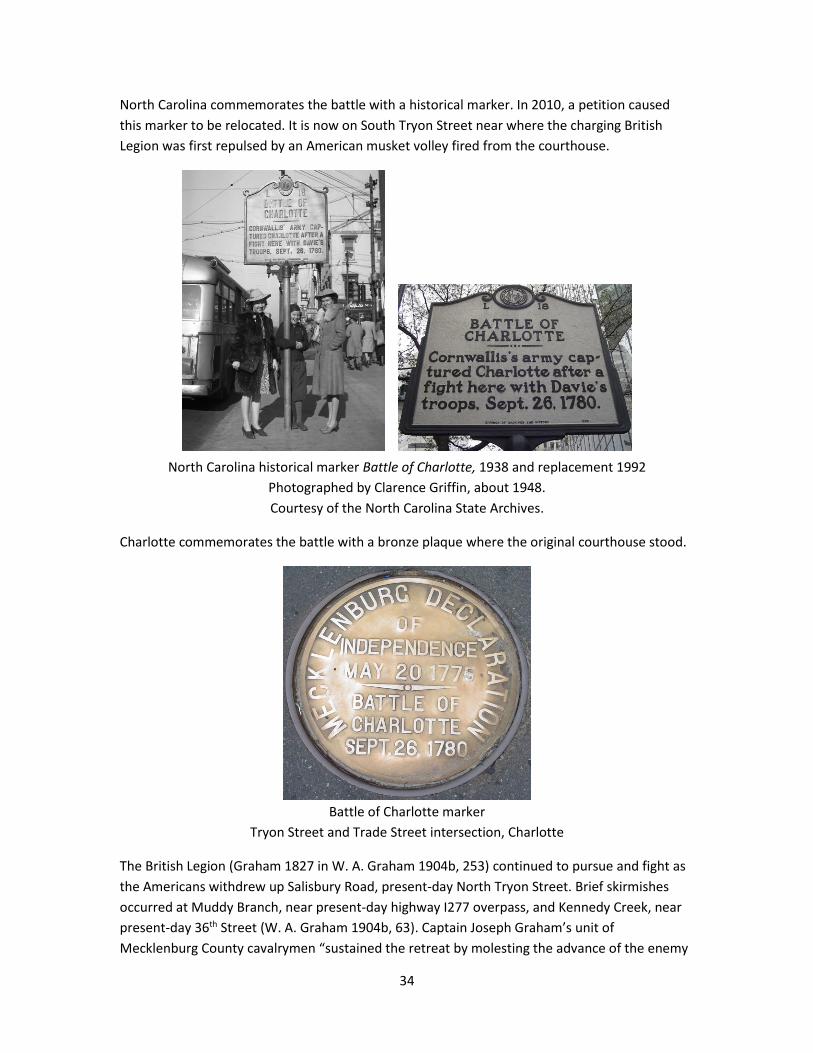
North Carolina commemorates the battle with a historical marker. In 2010, a petition caused
this marker to be relocated. It is now on South Tryon Street near where the charging British
Legion was first repulsed by an American musket volley fired from the courthouse.
North Carolina historical marker Battle of Charlotte, 1938 and replacement 1992
Photographed by Clarence Griffin, about 1948.
Courtesy of the North Carolina State Archives.
Charlotte commemorates the battle with a bronze plaque where the original courthouse stood.
Battle of Charlotte marker
Tryon Street and Trade Street intersection, Charlotte
The British Legion (Graham 1827 in W. A. Graham 1904b, 253) continued to pursue and fight as
the Americans withdrew up Salisbury Road, present-day North Tryon Street. Brief skirmishes
occurred at Muddy Branch, near present-day highway I277 overpass, and Kennedy Creek, near
present-day 36th Street (W. A. Graham 1904b, 63). Captain Joseph Graham’s unit of
Mecklenburg County cavalrymen “sustained the retreat by molesting the advance of the enemy

35
for four miles against their whole cavalry and a battalion of infantry which followed; at last they
charged, when Colonel Davie was not in supporting distance, and this deponent received nine
wounds” (Graham 1832 in W. A. Graham 1904b, 49).
As Captain [Joseph] Graham was engaged in a hand-to-hand fight, his horse
backed under a limb of a tree which knocked him off. He received three bullets
in the thigh, one saber thrust in the side, one cut on the back of the neck and
four upon the forehead. And from one of these some of his brains exuded. (W.
A. Graham 1904b, 64).
Some years afterwards an old lady acquaintance asked him if he thought he had
as much sense as before losing a portion of his brains. He replied that he had
not perceived any difference. (W. A. Graham 1904b, 64:footnote).
Graham’s papers and pension application indicate that this incident occurred at the “Cross
Roads” about 4.5 miles from Mallard Creek (Graham 1827 in W. A. Graham 1904b, 254) and
4 miles from Charlotte (Graham 1832 in W. A. Graham 1904b, 49). An independent source
indicates that the site known as the Cross Roads was where present-day Eastway Drive
intersects North Tryon Street (Barden 2010). Apparently, this location was later confused with
the intersection of Sugar Creek Road and North Tryon Street where a Graham monument was
erected in 1916. However, Graham made clear that Sugar Creek Presbyterian Church and the
Cross Roads were not the same place (Graham 1827 in W. A. Graham 1904b, 254). In 1904,
Graham’s grandson William Alexander Graham Jr. compiled his papers and published a book.
The grandson also understood that the incident occurred at the Cross Roads (W. A. Graham
1904b, 63). It is not known why the 1916 monument was placed at its present location since W.
A. Graham Jr., born 1839, died 1924, was living at that time.

36
Captain Joseph Graham monument marks where he was wounded.
Monument erroneously indicates his rank as major, his rank after September 1781.
Erected in 1916 across from Sugaw Creek Presbyterian Church, but the event occurred at Cross
Roads.
A few days later, wounded Graham was moved to a safe location in present-day Davie County
(W. A. Graham 1904b, 65) where he recuperated for two months (Graham 1832 in W. A.
Graham 1904b, 49). He was not active again until the following January (W. A. Graham 1904b,
66).
Sassafras Fields, about 3 miles from Cross Roads and 1.5 miles from Mallard Creek (Graham
1827 in W. A. Graham 1904b, 254) (Murphey 1830 in Hoyt 1914, II:243), or about 7 miles from
Charlotte, was the furthest extent of the British Legion advance (Graham 1827 in W. A. Graham
1904b, 255). This location was approximately at the present-day Lieutenant George Locke
monument. Although this marker conveniently marks Sassafras Fields, Locke’s was probably
killed near Cross Roads (Davie 1810 in Robinson 1976, 25) (Graham 1827 in W. A. Graham
1904b, 255–256) (W. A. Graham 1904b, 64). In 1832, Fowler Jones testified that, “Between
Salisbury and Charlotte I saw Young Locke who had been killed by the British. His brother was
carrying his dead body on a horse before him when we met & saw him.” (Jones, Fowler, pension
application 1832). George Locke was son of Brigadier General Matthew Locke (Graham 1827 in
W. A. Graham 1904b, 255) and nephew of Colonel Francis Locke of Rowan County. Before
sunset, the British pursuers disengaged and returned to Charlotte (W. A. Graham 1904b, 64).
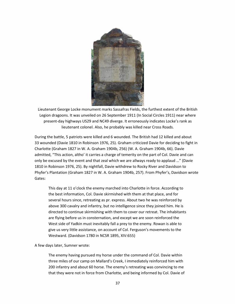
37
Lieutenant George Locke monument marks Sassafras Fields, the furthest extent of the British
Legion dragoons. It was unveiled on 26 September 1911 (In Social Circles 1911) near where
present-day highways US29 and NC49 diverge. It erroneously indicates Locke’s rank as
lieutenant colonel. Also, he probably was killed near Cross Roads.
During the battle, 5 patriots were killed and 6 wounded. The British had 12 killed and about
33 wounded (Davie 1810 in Robinson 1976, 25). Graham criticized Davie for deciding to fight in
Charlotte (Graham 1827 in W. A. Graham 1904b, 256) (W. A. Graham 1904b, 66). Davie
admitted, “This action, altho’ it carries a charge of temerity on the part of Col. Davie and can
only be excused by the event and that zeal which we are allways ready to applaud …” (Davie
1810 in Robinson 1976, 25). By nightfall, Davie withdrew to Rocky River and Davidson to
Phyfer’s Plantation (Graham 1827 in W. A. Graham 1904b, 257). From Phyfer’s, Davidson wrote
Gates:
This day at 11 o’clock the enemy marched into Charlotte in force. According to
the best information, Col. Davie skirmished with them at that place, and for
several hours since, retreating as pr. express. About two he was reinforced by
above 300 cavalry and infantry, but no intelligence since they joined him. He is
directed to continue skirmishing with them to cover our retreat. The inhabitants
are flying before us in consternation, and except we are soon reinforced the
West side of Yadkin must inevitably fall a prey to the enemy. Rowan is able to
give us very little assistance, on account of Col. Ferguson’s movements to the
Westward. (Davidson 1780 in NCSR 1895, XIV:655)
A few days later, Sumner wrote:
The enemy having pursued my horse under the command of Col. Davie within
three miles of our camp on Mallard’s Creek, I immediately reinforced him with
200 infantry and about 60 horse. The enemy’s retreating was convincing to me
that they were not in force from Charlotte, and being informed by Col. Davie of

38
their having 600 or 800 horse, we suppose that their intention was to take the
McKnitt’s road from Charlotte to Torrents’ road, & to cut off our retreat to
Salisbury. When we arrived at Salisbury, understanding the river was arising,
determined us to retire, and we have encamped within a mile of the Ford,
advantageously on the north side. The people of Mecklenburg County are very
spirited, and a majority will be in the field in a day or two. The enemy lay close
in their camp; they are not fond of fighting in small parties. The party under
Col. Davie repulsed the enemy’s advanced party of horse several times upon
their entering Charlotte, killed 22 of them and wounded a larger number. The
day following, the enemy engaged a small party of horse at the crossroads, four
miles from Charlotte, by surprise, and made prisoner of a son of Gen. Lock
[Francis Locke], whom they cut to pieces on the ground; one or two are yet
missing. (Sumner 1780 in NCSR 1895, XIV:777–778)
This reinforcement was described by Joseph McLane in his pension application:
that on their retreat from the aforesaid New Providence the [Davie’s] cavalry
staid behind and attacked the advanced guards not far from Charlotte—that as
soon as this was known Col. Paisley & Col. Armstrong volunteered and
requested others to join them and returned to assist the Cavalry there
engaged—that he [McLane] and others among whom was his neighbor Wm
Albright joined them but they met them [illegible word] on the retreat (McLane,
Joseph, pension application 1832).
Cornwallis’s headquarters in Charlotte was Colonel Thomas Polk’s white house on the northeast
corner of Independence Square (Foote 1846, 509).

39
Cornwallis’s Charlotte Headquarters Building on right
photographed by Rufus Morgan, 1873 (Kratt and Boyer 2000, 6).
Liberty Hall Academy continued to be used as a hospital. It was at the southeast corner of
present-day Second Street and South Tryon Street.
In Charlotte, the British encampment configuration is not known from original sources.
Nonetheless, before 1827, Joseph Graham learned that the British camp surrounded the
courthouse in an approximant square. Graham wrote that the 23rd and 33rd Regiments camped
220 yards east from and parallel to present-day Tryon Street. The Volunteers of Ireland
Regiment camped 165 yards north from and parallel to present-day Trade Street. O’Hara’s
regiment camped west, opposite the 23rd. The British Legion and Tories camped south, opposite
the Volunteers of Ireland. (Graham 1827 in W. A. Graham 1904b, 257). However, Joseph
Graham did not witness the British camp because he was recovering from serious wounds. Also,
neither Brigadier General Charles O’Hara nor his unit, the Brigade of Guards, was in Charlotte.
The British encampment enclosed the square that runs approximately along present-day College
Street, Fifth Street, Church Street, and Fourth Street. Later, on 8 October, the 71st Regiment
1st Battalion was ordered to march from Waxhaw Creek to Charlotte (Money 1780 in CPS 2010,
II:284). It could have camped along the western side.
On 27 September in Charlotte, Cornwallis, using a mobile printing press, issued a proclamation
that offered peace and protection to inhabitants (Preyer 1987, 157).

40
NORTH-CAROLINA
By the Right Honourable
CHARLES EARL CORNWALLIS
Lieutenant-General of His Majesty’s Forces
&c. &c. &c.
A PROCLAMATION.
Whereas the Enemies of His Majesty’s Government continuing to practise every
Artifice and Deceit to impose upon the Minds of the People, have, as
industriously as falsely, propagated a Belief among the People of this Country,
that the King’s Army indiscriminately makes War, and commits Ravages upon
the peaceable Inhabitants, and those who are in Arms and open Rebellion
against His Majesty’s Authority: I think it proper, in order to remove such false
and injurious Impressions, and to restore as much Peace and Quiet to the
Country as may be possible, during the Operations of War, hereby to assure the
People at large, that all those who come into the Posts of His Majesty’s Army
under my command, and faithfully deliver up their Arms, and give a Military
Parole to remain thenceforth peaceable at Home, doing no Offence against His
Majesty’s Government, will be protected in their Persons and Properties, and be
paid a just and fair Price in Gold or Silver, for whatever they may furnish for the
Use of the King’s Army; it being His Majesty’s most gracious Wish and Intention
rather to reclaim His deluded Subjects to a Sense of their Duty, and Obedience
to the Laws, by Justice and Mercy, than by the Force and Terror of His Arms.
GIVEN under my Hand and Seal at Headquarters in Charlotte-Town, this Twenty-
Seventh Day of September, One Thousand Seven Hundred and Eighty, and in the
Twentieth Year of His Majesty’s Reign.
CORNWALLIS.
By His Lordship’s Command,
J. Money, Aid-de-Camp.
GOD SAVE THE KING.
Cornwallis tried to encourage loyalist civilians, but had little success. Most Whig families
evacuated. Their men were already on active duty.
On 27 September, the Salisbury District militia under Brigadier General William Davidson was
posted near Phyfer’s plantation with about 600 militiamen with another 300 at their farm
(Davidson 1780 in NCSR 1895, XIV:677) s. On 27 September, Brigadier General Jethro Sumner
with about 800 Hillsborough District militiamen was in Salisbury. From these men, Colonel Philip
Taylor’s regiment from Granville County (Taylor, Philip, pension application 1837) (Taylor, John,

41
pension application 1832) was attached to Davie, raising his total strength to 300 cavalrymen
(Davie 1810 in Robinson 1976, 26). On 28 September, Sumner forded Yadkin River at Trading
Ford and encamped on the east side (Sumner 1780 in NCSR 1895, XIV:777) (Sumner 1780 in
NCSR 1895, XIV:786) (Graham 1827 in W. A. Graham 1904b, 249) (Vernon 1832 in Draper 1873,
VV:10:169). Today, Trading Ford can be seen while crossing present-day highway I85 bridge. The
ford traversed the large island about a half mile south. On 30 September, Major General Horatio
Gates in Hillsborough ordered Sumner to prevent a British advance beyond the Yadkin River.
If you should have been advised to cross the Yadkin, you must on no account
abandon the defense of that ford [Trading Ford], nor withdraw your guard from
the west side of that river until you are, by the near approach of a superior
number of the enemy, forced to do it. (Gates 1780 in NCSR 1895, XIV:778–779)
Soon afterwards, on 2 October, Gates ordered Major General William Smallwood to rush
reinforcements to Sumner at Trading Ford (Nelson 1976, 246). This objective was accomplished
on 13 October (Higginbotham 1961, 111).
On 1 October, at Phyfer’s Mill, Davie assessed the British deployment for Sumner:
Flying Camp Phyfer
Sunday, October 1st, 1780
Dear General [Sumner]:
Yesterday morning I detached Colo. Taylor with a party to reconnoitre the
Enemy; he returned late last night, informing me that a detachment of 800 of
the British marched that morning from Charlotte, partly foot, partly Horse, with
two pieces of Artillery, & that they took a rout between McKnits road & the
River. In consequence of this I sent a Captain’s command into that quarter, from
whence I have had my intelligence. The Enemy are cajoling & flattering the
People to take Paroles, & pursuing the same steps they did in South Carolina.
This with the Panic of the People, is an alarming circumstance. They forage
largely & carelessly below, & a few rifle light infantry companies might perhaps
be of singular service, if you think it requisite & safe. If you detach them, I will
endeavor to support them, the best of Guides may be had, & if the parties are
small, may lie secure among the thickets & Morasses, & annoy the Enemy very
considerably.
Their paroling the People, bringing large quantities of liquor with them &
provision, convinces me of their serious intentions to subjugate this State, but
their halting & marching so slowly is unaccountable, but of a piece with their
conduct in other places.

42
I am happy to hear Capt. Dickinson was so fortunate; enterprises of this kind
keep the Enemy in continual alarm.
I am &c. &c.
Wm. R. Davie (Davie 1780 in NCSR 1895, XIV:659–660)
Davie soon returned towards Charlotte to attack British foraging parties (Davie 1810 in Robinson
1976, 26). His patrols covered all roads to Charlotte.
Troop Deployment, Movement, and Strength Timeline
In piecing together the above scenario, a useful tool has been what crime-solving detectives
called a constraint timeline. It is effective when given lots of clues each containing partial
information. When these clues are forced into a timeline worksheet, many suspect scenarios
can be excluded as impossible. Even if the actual scenario is indeterminate, a detective can test
a plausible scenario against all clues. For this application, the analogous worksheet is a troop
deployment, movement, and strength timeline.
This timeline contains operational details: who was where and when with how many troops.
Commanders appear only when they operated independently or their presence was important.
Their abbreviations are:
Notation Commander Operational Command and Strength
I Col Robert Irwin Mecklenburg County militia, 200
L Col Francis Locke Rowan County militia, 200
r Col Armstrong Rowan County militia, 200
S MG Jethro Sumner NC Brigade, 400
D BG William Davidson Salisbury District NC militia, 400
d Col William R. Davie North Carolina militia cavalry, 300
g Capt Joseph Graham Mecklenburg County cavalry
u Col Thomas Sumter South Carolina state troops
P Col John Paisley Guilford County militia, 200
a Col Benjamin Seawell Franklin County, NC, militia
C LG Charles Earl Cornwallis 23rd, 33rd, 71st, 2000 + Rcy
T LCol Banastre Tarleton British Legion, 500
H Maj George Hanger British Legion, 500
R LCol Francis Lord Rawdon Volunteers of Ireland, 600
c Maj Archibald McArthur 71st, 1st Battalion, 250
y Maj James Wemyss 63rd

43
1 Sep 7 Sep 12
Sep
15
Sep
18
Sep
20
Sep
24
Sep
25
Sep
26
Sep
Ramsey’s Mill
Deep River
S400 S400 S400
Salisbury P200 S400
Phyfer’s Mill
Rocky River
P200 S400 S400
Mallard Creek SDP600 DP200
Sherrill’s Ford r200 r200 r200
Charlotte dg150 dg150
CH2000
McAlpine
Creek (8 miles)
I200 I200 IL400 DP600 DP600 DPS1000 DPS640
Providence d70 d150 d150 d150 d150
Bigger’s Ferry u200 u200 u400 u400 u400
R500
Little Sugar
Creek
(10 miles)
g50 CH2000
Twelve Mile
Creek
a160
Wahab
Plantation
d150
Waxhaw
Creek
d70 C1200 C1200 C1200 C1200 CH2000
Blair’s Mill cT250 cT250 cT250
White’s Mill T700 T700 T700 T700
Camden CT2000 CT2000
This timeline provides an overall perspective on how opposing American and British forces were
deployed. It is also a worksheet against which a newly conjectured scenario can be tested.
However, its troop strengths are approximate. Actual troop strength depended on sickness,
detachment duty, guard duty, etc. Some values are interpolated between known before and
after values. Nonetheless, the strengths appear to be at least as precise as known by the
commanders at that time. For that reason, commanders frequently ordered updated strength
returns from their subordinates.
Conclusions Beginning 7 September, Cornwallis’s army marched from Camden towards North Carolina.
Everyone understood that the large force of over 2000 professional soldiers would be used to
overthrow the independent North Carolina government. From 12–24 September 1780,

44
Cornwallis’s army camped at Crawford’s on Waxhaw Creek. Although the camp was near the
South Carolina and North Carolina state line, both Cornwallis and Americans considered this
camp within South Carolina.
• On 12 September, from Crawford’s on Waxhaw Creek, Cornwallis explicitly wrote to
Lieutenant Colonel Cruger that he had not entered North Carolina. (Cornwallis 1780 in
CP 1970, 80:11)
• While in the Waxhaws, he issued issued a Proclamation of Sequester against the
property of certain notable South Carolina rebels. The Proclamation explicitly states that
it was signed in “the district of Wacsaw” in the province of “South Carolina” (Cornwallis
1780 in Tarleton 1787, 191).
• Colonel William Richardson Davie explicitly wrote that while at Waxhaw Creek, “his
Lordship was not ready to enter North Carolina” (Davie 1810 in Robinson 1976, 21).
• Former royal North Carolina Governor Josiah Martin, who was with Cornwallis, must not
have regarded Waxhaw Creek camp as in North Carolina since he did not issue his
Proclamation to North Carolinians anytime during that 12-day camp. He waited until the
army was in Charlotte. (Martin 1780 in W. A. Graham 1904b, 263) (Preyer 1987, 157).
So, if contemporaneous sources indicate that Cornwallis’s army camp at Waxhaw Creek was in
South Carolina, then where did the army enter North Carolina? Or more precisely, what road
was used and where did it cross the state line? First, Cornwallis’s army used Steel Creek Road, as
evidenced by:
• Steele Creek Road, also known as Charlotte Road and Camden Road, was a principal
wagon road between Waxhaw Creek and Charlotte. It passed through the Catawba
Nation, which was entirely within South Carolina. Colonel Thomas Sumter used the
campground during late June and early July 1780 (Anderson 2006).
• British Lieutenant John Money stated the British Army “Halted at Twelve Mile Creek till
the moon rose and then proceeded toward Sugar Creek on the Charlotte Road.” (Money
1780, 24 Sep) (Allison 2009).
• Colonel William Richardson Davie wrote, “on the 24th of september our patroles gave
information, that the enemy were in motion on the Steele-creek road leading to
Charlotte.” (Davie 1810 in Robinson 1976, 24).
• In 1789, Major Joseph Graham drew a map showing Cornwallis’s route through the
Catawba Nation (Graham 1789 in Tompkins in W. A. Graham 1904b, 188) (Graham 1789
in Tompkins in Robinson 1976, 6). The route was west of Six Mile Creek, entirely within
South Carolina.
• In an 1812 published book, Lieutenant Colonel Henry Lee wrote that the British Army
used Steele Creek Road (Lee 1812, I:201). This assertion was not refuted by eyewitness
participants Davie or Graham (Graham 1827 in W. A. Graham 1904b, 249).

45
• In 1827, Joseph Graham wrote that the British camped “ten miles from Charlotte,
between McAlpin and Sugar Creeks on the Camden Road.” (Graham 1827 in W. A.
Graham 1904b, 62, 249). That distance was impossible along Providence Road.
• There is no known evidence that the British Army marched along Providence Road in
North Carolina. This inference appears only in secondary sources.
Secondly, Steel Creek Road crossed the state line at Clems Branch campground, as evidence by:
• Physical evidence of an old roadbed still exists, along which an old milestone that reads
“XV m to C” meaning 15 miles to Charlotte (Anderson 2006).
• A hand drawn 1871 map, based on veteran pension applications, marked the road past
Clems Branch campground as “Steele Cr. Road.” (Stinson 1871 in Draper 1873, VV:5:45).
• In 1873, John Rosser, who was born about 1810 and grew up within 2 miles from the
campground, wrote, “The line between the Carolinas crossed the Camden road at the
branch” (Rosser 1873 in Draper 1873, VV:13:4.2–4.3). He sketched a map of the
campground, old road, milestone, Clems Branch, and state line.
John Rosser sketch of Clems Branch campground (Rosser 1873 in Draper 1873, VV:13:6)
A milepost immediately south of the campground indicates 15 miles from Charlotte.
Finally, was it possible that Cornwallis’s army veered off Steele Creek Road and bypassed Clems
Branch campground? That was improbable because:
• There was no third alternative road:
o In 1789, Major Joseph Graham drew a map that showed only two principal
roads, Steele Creek Road and Providence Road (Graham 1789 in Tompkins in W.
A. Graham 1904b, 188) (Graham 1789 in Tompkins in Robinson 1976, 6).
o In 1827, Joseph Graham wrote that two roads connected Charlotte with
Camden in 1780 (Graham 1827 in W. A. Graham 1904b, 246).

46
o As late as 1810, Joshua Gordon indicated that two roads connected Charlotte
with Lancaster and so, maintaining a third road was unnecessary (Gordon 1810
in SCDAH 2007, 176.1 0010 004 ND00 66714 00).
o The earliest known evidence of an alternative road appeared 45 years later in
the 1825 Mills Atlas (Mills 1825).
• Major Jospeh Graham’s 1789 map showed Cornwallis’s route crossing McAlpine Creek
within North Carolina. That excludes present-day Harrisburg Road and Dorman Road
north of Clems Branch.
• Even if a short bypass road existed, Cornwallis’s 100-wagon convoy would have used the
best available road to avoid delay.
Thus, Cornwallis’s army almost certainly passed by Clems Branch campground on the already
established wagon-road, locally called Steele Creek Road. At this point, his army crossed the
state line, invading North Carolina.
Sources Alexander, James Rankin, pension application. 1833. National Archives and Records
Administration:W2901 (Allen County, KY, May 14).
Allison, John. 2009. correspondence
Anderson, William Lee. 2006. "Application for a South Carolina Historical Marker
Commemorating Colonel Thomas Sumter's Clems Branch Camp June–July 1780."
http://elehistory.com/amrev/SumtersClemsBranchCamp.pdf.
Barden, Larry. 2010. correspondence
Bass, Robert Duncan. 1961. Gamecock, The Life and Campaigns of General Thomas Sumter. Holt,
Rinehart and Winston.
Borick, Carl P. 2003. A Gallant Defense, The Siege of Charleston 1780. Columbia, SC: Universtiy of
South Carolina Press.
Boyer, Mary Manning. 2008–2017. correspondence
Brander, Michael. 1971. The Scottish Highlanders and Their Regiments. Reprited 1996, Barnes &
Noble Books.
Charlotte Observer. 1911. "In Social Circles." September 26.
Connelly, Henry, pension application. 1833. National Archives and Records
Administration:W8188 (Floyd County, KY, August 15).
CP. 1970. The Cornwallis Papers, Abstracts of Americana, PRO 30/11. George H. Reese, ed.,
University of Virginia.
47
CPS. 2010. The Cornwallis Papers. Uckfield, East Sussex, UK: Ian Saberton, ed., Naval & Military
Press Ltd.
Davidson, Chalmers Gaston. 1951. Piedmont Partisan, The Life and Times of Brigadier General
William Lee Davidson. Davidson, NC: Davidson College.
Davis, Charles S. 1942. "The Journal of William Moultrie While a Commissioner on the North and
South Carolina Boundary Survey, 1772." The Journal of Southern History, Vol. 8, No. 4,
November 549-555.
Draper, Lyman Copeland. 1873. "Draper Manuscripts." State Historical Society of Wisconsin.
—. 1881. King's Mountain and Its Heroes. Cincinnati, OH: Peter G. Thompson Publishing.
Dussek, Hugh. 2011–2014. correspondence
Faden, William. 1787. The Marches of Lord Cornwallis in the Southern Provinces now States of
North America. London, England.
Foote, William Henry. 1846. Sketches of North Carolina, Historical and Biographical. New York,
NY: Robert Carter Publisher.
Garden, Alexander. 1822. Anecdotes of the Revolutionary War in America, with Sketches of
Character of Persons most distinguished, in the Southern States, for Civil and Military
Service. Charleston, SC: A. E. Miller.
Graham, Joseph. 1789. "A plan of Mclenburg and portions of joining counties as laid down by a
scale of five miles to an inch." North Carolina Maps. January 16.
http://dc.lib.unc.edu/cdm/singleitem/collection/ncmaps/id/155/rec/23.
Graham, William Alexander. 1904b. General Joseph Graham and His Papers on North Carolina
Revolutionary History. Raleigh, NC: Edwards & Broughton.
Hill, William. 1815. "Col. William Hill's Memoirs of the Revolution." Columbia, SC: edited by A. S.
Salley, 1921, Historical Commission of South Carolina.
Hoyt, William Henry. 1914. The Papers of Archibald D. Murphey. Raleigh, NC: E. M. Uzzell & Co.
Hunter, Cyrus Lee. 1877. Sketches of Western North Carolina, Historical and Biographical.
Raleigh, NC: The Raleigh News Steam Job Print.
James, Marquis. 1938. The Life of Andrew Jackson. New York, NY: The Bobbs-Merill Company.
Jones, Fowler, pension application. 1832. National Archives and Records Administration:R5701
(Granville County, NC, August 10).

48
Joy, Deborah, Linda France Stine, and John W. Clauser. 2000. Catawba River Valley Grist Mill
Survey. Durham, NC: Legacy Research Associates, Inc.
Kratt, Mary, and Mary Manning Boyer. 2000. Remembering Charlotte. Chapel Hill, NC: University
of North Carolina Press.
Lee, Henry. 1869. Memoirs of the War in the Southern Department. New York, NY: revised by
Robert E. Lee, University Publishing Company.
—. 1812. Memoirs of the War in the Southern Department. Bradford and Inskeep.
Mackenzie, Frederick. 1930. Diary of Frederick Mackenzie, Giving a Daily Narrative of his Military
Service as an Officer of the Regiment of Royal Welch Fusiliers During the Years 1775–
1781 in Massachusetts, Rhode Island and New York. Cambridge, MA: Harvard University
Press.
Marting, Elizabeth. 1948. "MacWhorter's Southern Adversities." Journal of the Presbyterian
Historical Society, 26: 11–18.
Matthews, Louise Barber. 1967. A History of Providence Presbyterian Church. Charlotte, NC:
Jostens.
McLane, Joseph, pension application. 1832. National Archives and Records Administration:S8805
(Guilford County, NC, November 20).
Mecklenburg County Estate Papers. n.d.
Mills, Robert. 1825. Atlas of the State of South Carolina. Baltimore, MD: F. Lucas Jr.
Money, John. 1780. "Notebook." British Public Records Office.
Morrill, Dan L. 1993. Southern Campaigns of the American Revolution. Baltimore, MD: Nautical
& Aviation Publishing Company of America.
Moss, Bobby Gilmer. 1983. Roster of South Carolina Patriots in the American Revolution.
Baltimore, MD: Genealogical Publishing Co., Inc.
NARA. 1997. Revolutionary War Pension and Bounty Land Warrent Applicaton Files, 1800–1900,
Microfilm publication M804. Washington, DC: National Archives and Records
Administration, http://www.nara.gov/publications/microfilm/military/.
NCSR. 1895. State Records of North Carolina. Winston, NC: Walter Clark, ed., M. I. & J. C.
Stewart.
Nelson, Paul David. 1976. General Horatio Gates, A Biography. Baton Rouge, LA: Louisiana State
University Press.

49
Peterson, Harold Leslie. 1968. The Book of the Continental Soldier. Harrisburg, PA: Stackpole
Company.
Pettus, D. Lindsay. 2008–2015. correspondence
Pettus, Louise. n.d. "Surveying Practices in Early South Carolina." Backsights Magazine,
Surveyors Historical Society.
—. 1988. "Joshua Gordon." Charlotte Observer, September 4.
—. 1992. "North Carolina-South Carolina Boundary Line." Charlotte Observer, September 30.
—. 1990b. "Six Mile Creek Presbyterian Church." Charlotte Observer, November 18.
Pettus, Louise, and Martha Bishop. 1984. Lancaster County, A Picturial History. Norfork, VA:
Donning Company.
1772. "Plan of the Boundary Line Between the Provinces of South and North Carolina." John
McCrady Map Series, Series L10005, Reel 003, Plat 02120. Columbia: South Carolina
Department of Archives and History, June 4.
Preyer, Norris Watson. 1987. Hezekiah Alexander and the Revolution in the Backcountry.
Charlotte, NC: Heritage Printers, Inc.
Rankin, Hugh Franklin. 1971. The North Carolina Continentals. Chapel Hill, NC: University of
North Carolina Press.
Robinson, Blackwell Pierce. 1976. Revolutionary War Sketches of William R. Davie. Raleigh, NC:
North Carolina Department of Cultural Resources, Division of Archives and History.
—. 1957. William R. Davie. Chapel Hill, NC: University of North Carolina Press.
Ross, Charles. 1859. Correspondence of Charles First Marquis Cornwallis. London: John Murray.
Salley, Alexander Samuel. 1929. "The Boundary Line between North Carolina and South
Carolina." In Bulletin of the Historical Commission of South Carolina No.10. Columbia, SC:
The State Company.
SCDAH. 2007. South Carolina Department of Archives and History. Columbia, SC.
Scoggins, Michael Charles. 2010–2017. correspondence
Stedman, Charles. 1794. The History of the Origin, Progress, and Termination of the American
War. London: J. Murray.
Tarleton, Banastre. 1787. A History of the Campaigns of 1780–1781 in Southern Provinces of
North America. Reprint 1968, The New York Times & Arno Press, Inc.
50
Taylor, John, pension application. 1832. National Archives and Records Administration:S7684
(Granville County, NC, December 25).
Taylor, Philip, pension application. 1837. National Archives and Records Administration:W18100
(Chatham County, NC, February 15).
2009. time and date.com. Accessed February 25, 2009. http://www.timeanddate.com.
Wickwire, Franklin, and Mary Wickwire. 1970. Cornwallis The American Adventure. Houghton
Mifflin Co.
Williams, Robert, pension application. 1832. National Archives and Records
Administration:S7922 (Pitt County, NC, August 9).