when the sea flooded britain - society for interdisciplinary studies
TRANSCRIPT

Steve Mitchell
‘When the Sea Flooded Britain: A Catastrophic Late Holocene Isostatic Interlude along the Eastern
Seaboard of England and Scotland’
Article from Chronology & Catastrophism REVIEW 2005 (Production: Val Pearce)
© Society for Interdisciplinary Studies and author.
NOTES
Any errors found post-publication of the original article will have been noted in a subsequent issue of Chronology & Catastrophism REVIEW and as far as possible such errors (and any other errors found) will have been corrected in this PDF edition.
Original formatting style and layout has been retained.
Page numbers are those in the original article
VJP - 25.6.2012


When the Sea Flooded Britain: A Catastrophic Late Holocene Isostatic Interlude along the Eastern
Seaboard of England and Scotland
by Steve Mitchell
This article is a preliminary assessment of the nature and extent of the evidence for relative sea-level changes in the
period from around AD 400 until AD 1700. It will seek to show that much of the eastern and southern coast of Britain
was under the sea by up to 30 metres or more in the late Roman/early medieval period. This resulted in a landscape
that was dramatically different from that today, which has profound implications for our understanding of British
early medieval history [1].
Introduction
Some years ago I set out to explore the origins of Christian
architecture. This has taken me to the Near and Middle East,
most parts of central and southern Europe and the remoter
parts of Insular Britain. Whilst in the Shetland Isles and the
Outer Hebrides, I noticed a distinct type of site. Outwardly, it
appeared as an isolated cemetery bounded by a circular wall,
situated on a small headland close to a sheltered bay and
about 5 metres above the beach. On closer inspection there
were the remnants of a small single-cell church within the
boundary wall. Traditions have it that these were early
Christian sites of uncertain date, often associated with the
sea-borne ‘Irish’ missionary phase of conversion [2].
Although very little archaeological work has been done on
these sites, those excavations which have taken place do not
contradict this hypothesis [3].
I also found this type of site along the western seaboard of
mainland Scotland, although with less frequency. Again, on
the eastern seaboard, there were sites that generally matched
the diagnostic features of those in the west [4]. However, the
eastern sites differed in one vital respect. They were all at a
much higher altitude off the beach and some were at a
significant distance from the present coastline. It was hard to
avoid the conclusion that they had been stranded from their
original location by a fall in the sea-level (see Figs. 1a and
1b). This led me to investigate recent work by geographers,
which I tried to relate to the raised beaches observed along
the eastern coast of Scotland, in Caithness and Sutherland.
This remote cemetery on the east coast of Scotland might be one of the oldest Christian sites in
Britain. The medieval chapel in the middle of the walled enclosure was destroyed during clan
wars in the 17th
century. Its great antiquity, according to a leading expert, may be connected with
its unusual place-name – navi.
Figure 1a: A twenty metre drop of the land relative to the sea would turn this stranded church site into a low
promontory with water wrapping round the back to form a sheltered bay and perhaps even create a small boat-
shaped island. This would then be much more like the Shetland model sites. Can this provide the vital dating clue to
the raised beach as well as the archaeology?
Chronology & Catastrophism Review 2005 19
+20m
, Navidale, near Helmsdale, Sutherland

Figure 1b: The line indicates the maximum altitude of the sea at just above 30m OD. Because of
extensive moraines in the vicinity, the sea would form narrow channels or inlets between them, providing
an extremely sheltered anchorage. See Figure 5 for the sequence of flooding in the Clynekirkton channel.
Professor David Smith and his co-workers have published
the results of their environmental surveys in The Holocene
(see ‘Research by Smith et al’ on p. 22), tracing the
fluctuations of salt-water and fresh-water movements along
the Wick River valley of Caithness. Diatoms indigenous to
salt-water determine the inland extent of seaward regimes and,
by careful sampling and dating the layers of deposition, a
calibrated chronology was assembled. I reasoned that this
chronology could be used to date the stranding of the church
sites, thus giving me a ‘not earlier than’ or ‘not later than’ date
for their foundation.
Unfortunately there are not enough data from the period in
question to build more than a cursory model, but an analysis
of the actual landscape does admit some preliminary
conclusions. The sea had fallen relative to the land by some
30 metres sometime in the medieval period. However, it was
not the sea itself that had fallen – eustatic sea-levels have
changed little in the last 2,000 years [5]. It was the land that
had risen in what the geographers describe in their shorthand
as ‘bounce’, or post-glacial isostatic rebound or uplift. The
recovery was from compression due to the weight of ice
depressing the land below it. The mean level of northern
Scotland was 15m below present levels at the end of the last
Ice Age [6]. As with any ‘bounce’, the levels did not rise up
evenly over time. There were upward movements, countered
by smaller episodes of subsidence. This makes the chronology
much more complex but, at the same time, offers greater
20
potential dating accuracy. Once dates can be obtained from
secure strata for these turning points, then there is much more
scope to determine reasonably accurate upper and lower
boundary dates for the church-building activity.
The reason why the east coast of Scotland differs from the
west (including the Hebrides and Shetlands) is that the
geology to the east of the Moyne Thrust is less rigid. The
western half is composed of older and harder rocks of the
Torridon series whilst the eastern half is younger and ‘softer’
(Fig. 2). At this point it is perhaps worth recounting the
development of the Holocene coastal features.
The Holocene Coastline
The Holocene coastline of eastern Scotland is mainly
distinguished by a series of raised beaches (see Fig. 3a). The
highest and earliest dates from the earlier Holocene (between
7000 and 5000 BC) and is associated with the Mesolithic
(archaeological) or the Flandrian (geographical) period. This
phenomenon has long been familiar to geographers as the
‘100 foot’ beach; that is, the top of the original beach is
stranded at around 30m OD. Prior to this, the sea had risen
quite steeply following the glacial melt. The
Mesolithic/Flandrian divide is clearly characterised by a
marked change in climate, as well as the submersion of the
land-bridge between the British Isles and continental Europe.
The sequence starts at present sea-level, where there is
a modern beach and ‘clifflet’ about 3 to 5m OD that might
Chronology & Catastrophism Review 2005
church site could date back to C12 or even earlier.
Clynekirkton, near Brora, Sutherland
Clynekirkton church ruins looking south. The bell tower is late but the present
The site is stranded one mile from the sea-shore and at 40+m OD

Fig. 2: The effects and after-effects of glaciation in Scotland. The deposition of ice was thickest
in the Loch Rannoch area, leading to a compression of rocks of up to an average of 15m. The
development of the Holocene and the rapid retreat of the ice-sheet are easily traced in a
series of raised beaches. Only the highest of these beaches has been dated. The lowest beach
does not appear to have been colonised until at least the late medieval period and most of
the coastline communities were not founded until the early 19th
century. Towns such as Ullapool,
Wick, Thurso, Golspie, Brora and Helmsdale all started on top of Cliff 1 (see Figs. 3a and 3b)
and did not migrate below 10m OD until the late 19th
century.
Chronology & Catastrophism Review 2005 21
Wick River valley, Caithness
The Moyne Thrust Marks two distinct
geological time zones
– older and harder
rocks to the west and younger softer rocks to
the east.
Brora & Helmsdale Stranded church sites in this area
of Sutherland rest on top of the
oldest beach at between 25 to 30m
OD. For them to be near the sea the
land would have had to sink by the same amount.
Raised beaches on the western
mainland and the Inner & Outer
Hebrides are around 10m OD.
This is because the rocks are
much harder. Less squeeze =
less ‘bounce’
The ‘hundred foot’ raised beach is clearly
seen along the east coast of Scotland.
The two other raised beaches below it
are best seen in the most northerly parts.
The maximum compression of ice during
the last glaciation was centred around the
Loch Rannoch area of Scotland
Southern limits of ice cover
during the last glaciation.

only be a few hundred years old, at most, and is still growing.
Immediately above this is the youngest of the ancient ‘beach
and cliffs’ in the sequence. It looks very fresh, with little or
no surface erosion, evidenced by a ‘sharp’ profile and
virtually no slump at the base of the cliff (see Fig. 3b). The
top stands between 15m to 25m OD. There are some moraine
deposits at this level.
The next beach is much narrower and its cliff is much
shorter, perhaps no more than 10m high on average. On top
of this cliff is the 100 foot (30m OD) beach that rises gently
to meet the side of the mountains that formed the earliest of
the original cliffs. We can see that this is where the sea
stopped because the mountain streams fall steeply to meet the
ancient beach at this point.
The oldest and highest beach is lined with moraine
deposits that complicate the sequence and make the surface
landscape difficult to read. Their age is uncertain but cannot
be older than the formation of the ‘beach’ on which they sit
and might be the result of much later, i.e. post-
Mesolithic/Flandrian, ‘sea-push’ type deposition [7]. It is on
this level that the church sites occur. This could mean that the
churches were originally built on top of cliff number two and
that if we apply the general model for church foundations in
the highlands and islands, then the sea-level must have been
at least 25-30m OD higher than present. This would place
them somewhere in the early medieval period, but certainly
no earlier than AD 400, the threshold date of the first
Christian mission in Scotland [8].
This has interesting implications, if found to be true.
Firstly, the last and youngest two cliffs in the sequence
22
are much more recent than previously thought possible and,
secondly, the basic structure of the Clynekirkton site is older
than had been concluded from the available archaeological
evidence [9]. This was a tantalising prospect and I started to
wonder if there was any corroborating evidence from
elsewhere, for surely, I argued, this is not a totally isolated
incident.
Research by Smith et al
Professor D. E. Smith, Director of the Centre for
Quaternary Science at Coventry University (now at the
School of Geography and the Environment, Oxford
University) has conducted most of the post-glacial research
along the eastern coast of Scotland [10]. Along with Dr
S. Dawson, he has demonstrated the relative sea-level
changes in the lower Wick River valley, in which there was a
major flooding due to glacial melt, peaking at around 5500
BC. As the world’s ocean eustatic levels rose at this time,
any isostatic uplift accompanying the release of the weight of
the glacier over land would have been masked. This was
followed by a small but rapid retreat, bottoming out around
4000 BC and then followed by a much smaller and slower
rise in sea-level, culminating at around 1500 BC. It was
during this later phase that we have unambiguous isostatic
uplift because, although there were still eustatic changes
occurring, the ‘bounce’ was far greater in amplitude.
Following this, the sea-level retreat was more rapid, dropping
back to near its previous low level. This bottomed out at
around 100 BC. Sea-level then rose quite rapidly to AD 1000
and much less rapidly after that until by 1950 it was possibly
near its peak, which was marginally higher than the previous
one. From 100 BC the changes were almost entirely isostatic
Chronology & Catastrophism Review 2005
1
Fig. 3a: The raised beaches of Sutherland, Scotland, looking south along the coast to Brora. Key:‘A’ is
the present beach backed by a very young ‘clifflet’. ‘1’ is the ‘beach and cliff’ rising about 15m. ‘2’ is the
‘beach and cliff’ rising by about 10m. ‘3’ is the oldest ‘beach’ running inland for up to 1 kilometre to
meet the mountainside which was the original cliff. The stranded church site at Clynekirkton sits on this
‘beach’ about 2 kilometres further inland and 2 kilometres south on the right of the picture. The sea has
fallen more than 30m, so all that you can see was once under water at about 5000 BC. ‘Cliff 1’ could
have started to be formed about 800 years ago in a relatively rapid rise of the land. ‘Clifflet A’ might
have started in the last few hundred years, or even more recently.
A
2
3
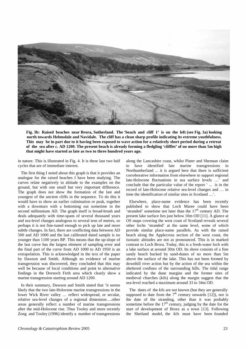
Fig. 3b: Raised beaches near Brora, Sutherland. The ‘beach and cliff 1’ is on the left (see Fig. 3a) looking
north towards Helmsdale and Navidale. The cliff has a clean sharp profile indicating its extreme youthfulness.
This may be in part due to it having been exposed to wave action for a relatively short period during a retreat
of the sea after c. AD 1200. The present beach is already forming a fledgling ‘clifflet’ of no more than 5m high
that might have started as late as two to three hundred years ago.
in nature. This is illustrated in Fig. 4. It is these last two half
cycles that are of immediate interest.
The first thing I noted about this graph is that it provides an
analogue for the raised beaches I have been studying. The
curves relate negatively in altitude to the examples on the
ground, but with one small but very important difference.
The graph does not show the formation of the last and
youngest of the ancient cliffs in the sequence. To do this it
would have to show an earlier culmination or peak, together
with a downturn with a bottoming out sometime in the
second millennium AD. The graph itself is broad-brush and
deals adequately with time-spans of several thousand years
and sea-level changes analogous to several tens of metres, so
perhaps it is not fine-tuned enough to pick up late and more
subtle changes. In fact, there are conflicting data between AD
500 and AD 1000 and the last calibrated dated sample is no
younger than 1100 years BP. This means that the up-slope of
the last curve has the largest element of sampling error and
the final part of the curve from AD 1000 to AD 1950 is an
extrapolation. This is acknowledged in the text of the paper
by Dawson and Smith. Although no evidence of marine
transgression was discovered, they concluded that this may
well be because of local conditions and point to alternative
findings in the Dornoch Firth area which clearly show a
marine transgression starting around AD 1200.
In their summary, Dawson and Smith stated that ‘it seems
likely that the two late-Holocene marine transgressions in the
lower Wick River valley … reflect widespread, or secular,
relative sea-level changes of a regional dimension….other
areas generally reflect a number of marine transgressions
after the mid-Holocene rise. Thus Tooley and more recently
Zong and Tooley (1996) identify a number of transgressions
Chronology & Catastrophism Review 2005
along the Lancashire coast, whilst Plater and Shennan claim
to have identified late marine transgressions in
Northumberland ... it is argued here that there is sufficient
corroborative information from elsewhere to support regional
late-Holocene fluctuations in sea surface levels …’ and
conclude that the particular value of the report ‘ ... is in the
record of late-Holocene relative sea-level changes and … in
time the identification of similar sites in Scotland …’.
Elsewhere, place-name evidence has been recently
published to show that Loch Maree could have been
‘stranded’ sometime not later than the 17th
century AD. The
present lake surface lies just below 10m OD [11]. A glance at
OS maps covering the west coast of Scotland reveals several
other lochs ‘stranded’ at the same level, some of which
provide similar place-name parallels. As with the raised
beach along the Applecross section of the west coast, the
isostatic altitudes are not as pronounced. This is in marked
contrast to Loch Brora. Today, this is a fresh-water loch with
a lake surface at around 30m OD. Its shore consists of a fine
sandy beach backed by sand-dunes of no more than 5m
above the surface of the lake. This has not been formed by
downhill river action but by the action of the sea within the
sheltered confines of the surrounding hills. The tidal range
indicated by the dune margins and the former sites of
medieval churches (kils) along the margin suggest that the
sea-level reached a maximum around 33 to 34m OD.
The dates of the kils are not known (but they are generally
supposed to date from the 7th
century onwards [12]), nor is
the date of the stranding, other than it was probably
sometime before the 17th
century, judging by the date for the
start of development of Brora as a town [13]. Following
the Shetland model, the kils must have been founded
23

Figure 4: Isostatic changes along the coast of Caithness & Sutherland
24 Chronology & Catastrophism Review 2005
Relative sea-level changes in
the Wick River Valley (from
Dawson and Smith)
This graph shows the rapid and huge
rise of pre-Flandrian sea-levels. The
post-Flandrian movements are
relatively modest. The right hand part
of the curve may have been over-
smoothed. The pecked lines (error
limits) shows that there could have
been a much steeper rise and fall from
AD 500 onwards.
Reproduced by kind permission of Dr S.
Dawson and Prof D. E. Smith.
Dawson and Smith’s model
inverted
The graph above has been de-
calibrated, inverted and re-orientated
to match that of the geomorphic
schema below. The arrows mark the
cyclical turning points of relative sea-
level. The pecked lines mimic the
profile of the actual raised beaches
shown in profile schematically below.
Raised beach geomorphic
schema to show sequence of
formation
The numbers relate to those in Figure
3a. The bold arrows relate to those in
the graph above. This graph is not
calibrated and only scaled vertically
(height in metres OD). As an analogue
of the Dawson and Smith model there
is good logical agreement, with the
last two arrows on the right reflecting
the difference – here the ‘bounce’ is at
the same date but more pronounced.
The final part of the present cycle is in
two phases with a pause or very slow
retreat starting around AD 1200.

from the sea. Each small kil could have served a broch or
cluster of brochs although it is by no means certain that they
were contemporaneous. Brochs, ubiquitous in most of the
Northern Highlands and the Islands, are thought to be round-
tower defensive dwellings dating from the Iron Age through
to the middle of the first millennium AD, and seemed to have
gone out of use by the time of the Viking invasion, although
most were built between 100 BC and AD 100 [14]. The
Fig. 5: A model for the sequence of raised beach formation at Brora, Sutherland, to explain the existence of
stranded man-made and natural features.
Chronology & Catastrophism Review 2005 25
Moraines stranded in this zone
Clynekirkton channel floods
Clynekirkton
church site stranded
Stranded moraines
Sea level c. 7,000 yrs BP
Following the pre-Flandrian flood the sea freezes
over pushing beach material on top of beach 3 to
form moraines. (The numbers in circles refers to the
‘beach and cliff’ sequence in Figure 3a)
Sea level c. 2,000 yrs BP
In the next 5,000 years the land rises and the sea
retreats close to present levels. The moraines are
stranded between 20+ and 30+m OD and cliff 2 is
formed.
Sea level c. 1,500 yrs BP
A sudden land subsidence in the late Roman/early
medieval period opens up the Clynekirkton channel
to navigation and re-floods Strath Brora. From
around AD 1000 the land starts to rise again and as
the sea retreats it forms ‘beach’ 2. After a pause
around AD 1200 the rise continues and ‘beach and
cliff’ 1 is formed.
Sea level today
What we see now. The stranded remains of the
church site at around 40m OD; fresh water Loch
Brora, a former sea loch stranded at 30m+ OD;
moraine material stranded on ‘beach’ 2. The
modern ‘clifflet’ represents a recent isostatic spurt.

best we can say is that Brora was a sea-loch from before the
7th
century and became stranded as a fresh-water loch
sometime before the 17th
century. This fits the general picture
suggested by the Loch Maree evidence and the English
evidence set out below. A reconstruction of the complete late
Holocene sequence at Clynekirkton, near Brora, Sutherland,
is illustrated in Fig. 5.
The Coastline in the Late Roman Period
The sea was slowly receding during the last millennium of
the prehistoric period and carried on receding until the end of
the Roman period in Britain [15]. If there was a marked
reversal of this trend then we should be able to detect both
aspects of this movement but this has proved very difficult to
spot on the ground. There could be several reasons for this.
Firstly, isostacy is a more difficult concept to visualise as it is
almost counter-intuitive: this means that it can be easily
overlooked unless you are prepared for it. Secondly, it could
be the result of local circumstances – some natural (erosion
and silting) and some man-made (damming and draining).
Thirdly, the sea-level is back close to the late Roman levels
which means that interpretation of any surviving site could
fool the investigator into thinking that nothing had happened
during the intervening period. Not all sites would have been
destroyed by wave action; indeed they may well have been
preserved by marine depositions of mud, sand and shingle.
The anaerobic environment of the wetlands in general is
conducive to the survival of organic remains. Some would be
exposed later and some would remain buried and this may
have happened more than once during the intervening period.
Archaeological evidence such as this would, therefore,
mostly lie south of the present Scottish border as the Roman
and Anglo-Saxon influence did not extend this far north [16].
I shall present examples, working from north to south round
the present coast of England, as far as Romney in Kent.
Some of the evidence is anecdotal but I have tried to rally as
much scientific corroboration as possible. However, this is
not an exhaustive study and is only intended as a snapshot,
showing the possibilities for further, more detailed, local
studies and the need for more synthesis to form a wider
picture. In this I have had to rely on Rackham’s History of
the Countryside [17] and Dark’s The Environment of Britain
in the First Millennium AD for an overview.
Rackham
Oliver Rackham’s work was published in 1986 and has not
yet been superseded. A more recent review of current
research is that by Petra Dark [18], which brings Rackham up
to date without challenging his general conclusions. She
clearly identifies the central problem that I am trying to
tackle. She concludes in her summary of sea-level and
coastline change:
‘It is likely that little of Britain’s existing coastline is
identical to that of any stage of the first millennium
AD, but identification of past coastlines is
problematic. The processes of uplift, erosion, silting
and reclamation have varied around the coast to such
an extent that no general reconstruction is possible.
Most research has concentrated on trends in
vertical sea level rather than on reconstructing
coastal topography, and detailed maps of former
coastlines are currently available only from the East
26
Anglian Fens. Despite the limitations of the existing
data, they at least alert us to the dynamic nature of the
coastal zone and urge caution in interpreting the
archaeological record of settlement in relation to
current topography’ [19]. (My emphasis).
Although Rackham covers Britain and Ireland, his main
evidence is drawn from woods and woodlands in an English
context, and that mainly from the Midlands. It has obvious
limitations as a result. His coverage of Scotland, Wales and
Ireland is brief.
Rackham’s method is to combine the written record with
scientific analysis of pollen deposits, archaeological
evidence, fauna and flora survivals and extinctions, aerial
photography, testimony and tradition. He analyses this
evidence within classifications such as: woodland; fields;
hedges; trees; highways; heathland; moorland; grassland;
ponds; marshes, fens, rivers and sea. The last section, on
wetlands, is pertinent. Dark uses the same general
methodology but with increased emphasis on environmental
science and archaeology.
We can start with some of Rackham’s definitions of
wetlands and these are the ones I shall use throughout. Salt
marsh is coastal wetland that is covered by the high tide.
High tides can also cause the fresh water of rivers to back up
and spill over, as happens in the Norfolk Broads. This
intermediate zone is dominated by brackish water and its
own distinct ecology [20] but is not distinguished in common
parlance or terminology, except for marsh indicating a
mixed regime [21]. It is in this intermediate zone that the
ancient salt industry is found. Further inland, as the fresh-
water starts to dominate, then this is where the neutral or
calcareous peaty area known as fen starts. The common term
bog is sometimes used technically to define areas where acid
peat is found. This does not apply to the flooded landscape
under examination and the term is avoided [22].
The Fens (as opposed to fen) is the name given to the
wetland area ranging from the lowlands of Lincolnshire in
the north to Cambridge in the south. It is not the only wetland
of a similar nature – there are the Yorkshire marshes, from
Hull and Doncaster to nearly as far north as Scarborough; the
Somerset Levels; the Norfolk Broads; Romney Marsh; the
Essex marshes; and so on in many smaller areas around the
coast [23] – and generally as delineated in Fig. 6 (see next
page).
The Fens have been successively drained in three main
phases [24]. The first was by the Romans, then by the Anglo-
Saxons and the medieval monks and the last and third phase
started by Vermuyden in the 17th
century. Each was a
different economic response to the changing environment.
The Romans found that the sea-level was falling and were
able to fully utilise their hydraulic skills in driving the sea
further back. In the late Roman period the sea started to rise
only to recede again in late Anglo-Saxon times so there was
an emphasis on defences and the exploitation of a fenland
economy [25]. From AD 1200 [26] (or AD 1250 [27]) the sea
began to rise again and that trend is continuing – the Thames
estuary is sinking at around 300 mm each century whilst
Scotland is gently rising. This at first sight seems
contradictory. It is not easy to see that the English coast is
sinking – after all the tidal head of the Thames has moved
Chronology & Catastrophism Review 2005

Fig. 6: England below 30m OD. This shows the present coastline and as it must have been during
the middle of the first millennium AD. Much of the Gyrwas and the Broads region is still below
sea-level. The approximate position of the Lincolnshire Carr Dyke is shown as the thick grey line.
Black arrow-heads refer to places mentioned in the text. From north to south: Trent Falls;
Scaftworth; Lincoln; Sleaford (Lincolnshire); Blakeney (Norfolk); Car Colston (Nottingham-
shire); Repton (Derbyshire); Hemmington (Leicestershire); Stamford (Lincolnshire); Peter-
borough; Oundle; Northampton; Cambridge; Sutton Hoo (Suffolk); Henley; Reading
(Berkshire); Dorney (Buckinghamshire); Port of London; Richborough and the Wantsum
Channel (Kent); Canterbury.
steadily down the valley until it is some 25m OD or more
below its medieval level (see The Thames Valley below) so
it would appear that the sea is receding rather than rising.
This is an entirely erroneous picture. It is the Thames Barrier
that tells the real story of relative sea-level – a mistake here
at a really high Spring tide and much of London will be
under several metres of sea. London has been on the brink of
crisis for much of the last century. Nevertheless, this level
seems to be still well below the levels in the 14th
century.
None of this is controversial. My findings differ only in
degree from the generally accepted picture. The paradigm is
one of relatively small and sluggish changes in the sea-levels
over the whole period in question, whereas I suggest that the
late Roman/early Anglo-Saxon marine transgression was
higher and quicker than previously thought and that, as a
consequence, it disrupted the whole fabric of society. The
Roman civil engineering effort that built Carr Dyke and
canalised the rivers flowing to the Wash disappeared under
an unstoppable flood of sea-water just at the point when the
Chronology & Catastrophism Review 2005
economic might of the Empire deserted Britannia for good. It
never recovered. However there were others who could and
did exploit this flood disaster. The ‘Irish’ Christian
missionaries were one such group [28] and, a little later, the
sea-borne immigrants from northern Europe were another
[29], as, later still, were the Viking raiders [30]. England no
longer had an infrastructure based on the Roman road but a
much more flexible one based on the small sea-going boat. It
is this thesis that I wish to explore more fully.
A Preliminary Model of Seawater Incursions
In order to test for evidence of flooding in the historic
period, I examined several coastal areas of England at
random and decided that, on the basis of the Scottish raised
beach altitudes, I should search within two distinct horizons –
below the 30m OD contour and the 15m OD contour. I would
not expect to find any evidence of sea incursion above 30m –
most of the middle/late Iron Age (I have ignored the early
Iron Age and previous periods for the sake of simplicity)
should lay below this height. There should be some evidence
27
The Carrs
The Broads
Romney
Marsh Pevensey
The Gyrwas?
River Trent
River Nene
Thanet
River Humber
Lincolnshire

of sea incursion below 30m especially along the major river
valleys; most late Roman settlements would be found there
as well as early settlements of the post-Roman period. Most
sea incursions would lie below 15m OD and would show up
as former or present fen and marsh areas and would be
marked by earlier Roman settlement as well as later medieval
activity and more recent maritime features. The areas
investigated are indicated in the section headings below and
in Fig. 6, [p. 27].
Yorkshire
The Vale of Pickering during the Iron Age may well have
been flooded inland as it lies below the 20m contour. There is
an interesting similarity with the Lincolnshire Carr Dyke (see
Lincolnshire below) in as much as the area of the estuary is
now known as The Carrs and is flanked by drainage channels
known to be of Roman origin [31]. These may have been a
method of flood control and land reclamation associated with
the fens in particular. The place name Car(r) is defined as
either a marsh or fen: wet boggy ground; meadowland
reclaimed from bog or marsh or a marshy copse,
especially of alders; boggy ground overgrown with shrubs [32]. In this context, we are most probably seeing land
reclaimed from marsh or fen. It might also be a borrowing
from the Scottish Lowland place-name, Carse, a derivation
of an Old Norse word for ‘low lying land by a river’ [33].
Virtually all of the early Anglo-Saxon church foundations
lie on the Yorkshire Wolds or Moors above the 15m contour,
as do early cemeteries. Most Domesday (AD 1086)
settlements also lie above the 15m contour. Virtually all of
the monastic sites are post-Conquest and lie below the 15m
contour (see Monasteries below). This same also holds true
for Northumbria, the ancient kingdom now identified as
modern Northumberland, Tyne and Wear and County
Durham.
The Humber Wetlands Project [34] initiated several
excavations of which two are of special interest, inasmuch
they demonstrate the extremes of Roman hydraulic work. An
extensive Roman settlement was discovered at Trent Falls,
the area where the Rivers Ouse, Trent and Don meet the
Humber. It is very low-lying although it occupies a slightly
raised island below 5m OD. This has yet to be dated but must
be the result of a general fall of sea-level as well as extensive
local drainage works. South of this is another Roman
engineering triumph. Scaftworth lies just below the 10m
contour on the South Yorkshire – Nottinghamshire border.
The Roman road consisted of a series of wooden rafts that
floated on the peat fen; again this has not been dated [35].
Lincolnshire
Attempts to identify the ancient coastline of Roman and
early medieval Lincolnshire have been made by Bennet and
others [36]. However, the situation is complicated by
extensive coastal defence work and fresh-water drainage
schemes along the fen edge in both Roman and medieval
times. As a consequence, it is not always clear where salt-
water ended and fresh-water began. For instance, peat deposit
analysis may not have been charted down to the oldest
regime of the sea’s inland incursions or may have decalcified
or have been stripped away. A much more telling diagnosis is
offered by the distribution of salterns, the Roman salt-pan
28
boilers, which lined the salt marshes at the point where they
were regularly scoured by fresh water. They show two
distinct scatters. The earliest is further inland from the later
scatter and marks two events – the gentle fall of the sea-level
mentioned above and the construction of an enormous
drainage channel on the fen edge known as Carr Dyke
(see Fig. 7a, p. 29). This has not been dated but probably
originated between the 2nd
and 4th
centuries. In the post-
Roman period the coastline appears to have moved eastwards
so that by the 13th
century it is close to the modern seaboard.
What is not particularly evident is whether there was a
sudden rise in sea-levels between these two dates. Today,
Carr Dyke is at about 3m above OD but its levee rises
another 1.5m. The channel is large enough to drain off
moderate flooding above this level.
If we look at the age of settlement patterns, then all of the
earliest villages (as defined by an entry in the Domesday
Book in AD 1086) occupy altitudes no lower than this,
although their location might be dictated by other criteria
such as spring lines rather than tidal surges. As we move
forward in time, the settlements that come after Domesday
occupy the areas that had once been fens or marshes [37].
This is also true of the large monastic houses, some repu-
tedly founded in the 7th
and 8th
centuries (see Monasteries
below). As with Yorkshire, all early church foundations lie
above the 15m contour, as do early cemeteries.
A more significant picture emerges when one examines the
strategic location of surviving Roman towns. They all occupy
positions between 15m and 20m OD [38], which would place
them at the navigable head of the tidal channel at the first
inland place of transhipment. This includes towns such as
Lincoln, Sleaford and Bourne; a little further south (but not
in Lincolnshire), Oundle and Stamford; and further south
still, Cambridge (see Gyrwas below). It is highly probable
that they were all sea-ports at some point (see The Nene
Valley, see p. 31). Stamford, for instance, was the source of
widely distributed eponymous glazed ceramic wares dated
from the 9th
to the 12th
centuries. This would make logistical
sense if the pottery were being shipped by boat along the
tidal rivers rather than overland.
The Trent Valley
The Trent is perhaps the most dynamic of all the English
river systems and consequently the most difficult to tame and
manage. Excavations at Hemmington, on the borders of
Leicestershire and Nottinghamshire, have shown that the
river was bridged at this point in medieval times but the river
was constantly changing its course, requiring much
rebuilding [39]. This was almost certainly not the first
crossing point and, because it was bridged then, we can infer
that the first fording point was much further inland.
Hemmington is about 25m OD. There is some archaeological
evidence to suggest that the tideway reached this far inland
[40]. Therefore, it is perhaps no coincidence that the raiding
army of the Vikings over-wintered at Repton in AD 873-4
[41]. The river at Repton stands at around 30m above OD, so
the Vikings might have taken advantage of higher winter
tides to have reached this far inland. Repton was also a base
for the Mercian kings from the 5th
century onwards and, if it
were the head of the Trent tideway, then this would have lent
it strategic importance. From here, the Mercian overlords
Chronology & Catastrophism Review 2005

Figure 7a: Carr Dyke, Lincolnshire
This massive double bank and ditch is over 30 metres from bank top to bank top and is more than 4.5 metres deep. It
ran for more than 90 km between Lincoln and Cambridge. Early theories that it was a contour canal are incorrect – it
is a fresh water drain running along the fen edge protecting the landward side from salt water incursions. This is one of
the very few surviving dry sections near Helpringham, Lincolnshire. The bottom of the ditch is just at or above modern
sea level. The channel is now dry because drainage has lowered the water table to more than the depth of the ditch.
Figure 7b: Carr Dyke, Nottinghamshire
Yet another Carr Dyke – this one is near Car Colston, Nottinghamshire. It is much smaller than its Lincolnshire cousin
and is the same size as the one in the Vale of Pickering, Yorkshire being a mere 11m across and 2m deep. This one is a
canalised stream – a tributary of the River Devon which in turn joins the Trent about 17 kilometres north of here. The
southern end of this channel is close to 30m OD and the northern end close to 20m OD.
could access most of their kingdom by boat quite rapidly, on
swift-running tides [42].
The exploitation of the Trent tideway at Repton as a
strategic site of the Mercian kings is clearly a possibility if
the sea-level rose by, say, 30m or more. This would give a
‘not earlier than’ date of AD 600 based on Mercian king-lists
but the conditions could already have been in existence
before this time [43]. In fact, the Mercian ascendancy may
have been largely due to the incursion of the tideway
Chronology & Catastrophism Review 2005
facilitating such rapid means of communication. The Mercian
kingdom reached its zenith in the 8th
century and then
withered under the Viking onslaught. It is interesting to note
that the superior Viking boat technology allowed them to
traffic further inland with specially-adapted craft [44]. If the
effects of a rapid sea incursion were starting to ameliorate by
the late 8th
century, then this could give them the window of
opportunity. They could reach those parts that the Mercians
could no longer reach.
29

In the valley of the Devon, a tributary of the Trent, there
is yet another Carr Dyke. It is similar in size and dimensions
to its cousin in the Carrs of Yorkshire and, like the giant Carr
Dyke of Lincolnshire, it also seems to serve the same
function, namely draining the edge of the valley. As the
southern end and highest point of the drainage channel (near
the eponymous village of Car Colston), it lies at around 30m,
OD so we must wonder if the valley it was draining could
have been brackish sometime in the Roman period (see Fig.
7b on previous page).
The Broads
Sometime during the medieval period, extensive peat
cutting was taking place in north Norfolk. The volumes were
enormous – 900 million cubic feet - and left several thousand
hectares of shallow depressions across the landscape.
Analysis of 2000 bore holes shows that this enormous
quantity of peat was mined in a three hundred year period
ending in December 1287. At this date, these declivities were
suddenly filled by a surge of seawater [45].
This is of peculiar interest because it has been shown that
the sea-level at this juncture was nearly 4m OD lower than at
present, possibly as a result of the land surface bowing
upward towards the middle of the north-south axis of East
Anglia [46]. Sometime after this, some of the salt-water lakes
became fresh-water lakes connected by rivers which are now
known as the Norfolk Broads. The process by which this
occurred is unclear. Today, the water surface of the Broads is
mostly just around OD, so that some of the Broads are
affected by high tides and are, as a consequence, brackish.
However, a tidal surge, possibly in excess of 6m deep,
appears to have swept inland in the year AD 1287. This depth
was probably greater than the 1953 surge and may have been
aggravated by, or caused by, fairly rapid isostatic subsidence
sometime after AD 1200, if we accept the Dornoch Firth
data, or slightly later if we accept the Thames River levels
data (see The Thames Valley below).
Monasteries – Islands in the Fens
Most of the medieval monasteries date from the 12th
century onwards, sponsored by the new Norman land-owning
aristocracy. They were able to exploit the fenlands in ways
beyond the scope of smaller local communities. Their
economic wealth derived from rent rolls of tenant farms on
land granted to them, as well as mineral rights and direct
patronage. This gave them critical mass to undertake
extensive civil engineering projects such as flood-control
schemes. New drainage channels were cut and existing
(mostly Roman) channels restored. We can see the remains
of flood-dykes commissioned by the monks in many parts of
the low-lying countryside. The value of the reclaimed land
rose considerably, leading to greater wealth.
We do know of instances where the flood-control failed,
drowning the hinterland. This indicates that the sea-level was
still within the tidal range that could reach a long way inland.
We also know that there was a successive breakdown of the
flood-controls, once the monasteries had been dissolved in
mid-16th
century. The Bedford Levels and fens of
Cambridgeshire and south Lincolnshire were not fully
reclaimed until the 17th
century by Vermuyden [47]. The
overall picture is one of a gradually retreating sea, right up to
30
the present day. Today the sea-dykes at Blakeney, in north
Norfolk, are about 6m high. However, they are still well
below the foot of the 14th
/15th
century dry docks at the foot of
the cliff at the adjacent Blakeney Priory and these are well
above the 1953 flood level – which points to the conclusion
that the sea-level in Norfolk must have fallen many metres
over the last five or six hundred years.
But what happened in the centuries before the Norman
Conquest? What evidence is there from the very early
monastic foundations that the sea-level was considerably
higher than in the 12th
century? Looking at the East Anglian
and Midland fens there are several documented monasteries
to consider. Working from north to south, these are:
Crowlands, Thorney, Peterborough, Ramsey and Ely [48].
All except Peterborough lie on islands in what was a fen.
Peterborough lies on a low promontory, as defined by the
15m contour, and an island as defined by the 20m contour.
Ramsey and Peterborough lie to the west of the Roman Carr
Dyke, Ramsey on a low island just 5m above OD and
Peterborough just above the 10m contour. The other three lie
to the east of Carr Dyke at similar altitudes on small islands
(the ey element means ‘island in the fen’), with the exception
of Ely (Eel-ey = ‘island of eels’), which lies above 25m. Of
all the foundations, this is possibly the earliest, having been
recorded by Bede as originating in AD 673 [49]. However,
there is no physical evidence other than the surviving fabric
of Ely Cathedral, which dates to no earlier than the late 11th
century [50]. Crowlands claims to have been founded in the
reign of King Aethelbald (reigned 716-57) of the Mercians,
but there is no archaeological evidence for this. We know
nothing even approaching certainty about it until well into
the 10th
century [51]. The same goes for Thorney and
Ramsey.
This leaves the problem of Peterborough. The present
Cathedral lies below the 15m contour but above the 10m one.
The archaeological evidence is unclear but an earlier
structure lies below the ground level of the present nave. It is
possibly 10th
century – a survival from the fire and rebuild of
AD 1116 [52]. Nothing of the monastic buildings remain,
having been sacked successively by the Danes in AD 870,
rebuilt in c.965 and then razed again by Hereward in 1070.
According to the popular ballads, Hereward conducted his
guerrilla campaign from the safety of the adjacent wetland
and maze of waterways [53]. The earliest sources tentatively
point to a 9th century foundation. But what of the very first
Benedictine monastery, supposedly founded around AD 656?
A charter names this as Medeshamstede (Medeshamstedi)
but, because the charter is corrupt [54], the story may have
been invented by the monks of Peterborough sometime in the
late 12th
century. They may well have based it on the brief
reference in Bede, which merely records that Sexwulf was
the first Abbot of Medeshamstede, in the country of the
Gyrwas (see Gyrwas below). There is no other known
connection between Medeshamstede and Peterborough (or
anywhere else) that can be considered reliable. Unfortunately
the early provenance for Thorney and Ramsey is also based
on this spurious charter.
Therefore the best estimate for all of these ‘early’
foundations, with the exception, perhaps, of Ely is the
late 9th or early 10th
century. If this is the case then, for one
Chronology & Catastrophism Review 2005

reason or another, the sea-level had moved below 5m OD by
this date, perhaps through reclamation.
The Gyrwas – a Seaside in the Heart of England?
Bede mentions the Gyrwas [55] but only that it was the
home of Medeshamstede, the ibly-mistaken forerunner
of Peterborough monastery and cathedral, and that he calls it
a province, divided between north and south and ruled by
princes [56]. The general location for this province or sub-
kingdom is thought to be south of the present Wash, in the
area drained by the Rivers Ouse, Nene and Welland.
Peterborough and March were probably near its southern
extreme and bounded by King’s Lynn and Spalding to the
north. It takes in most of the fens of East Anglia and perhaps
part of the Holland district of Lincolnshire but definitely
excludes Ely, which Bede informs us was under the control
of the East Angles. The present river system is of modern
origin. In the 5th
century, this whole area was criss-crossed by
Roman navigation and drainage channels of a wholly
different pattern, many of which survive and are in use today
[57].
No previous attempt has been made on the etymology but I
put forward the following suggestion based on the work of
Eilert Ekwall. The second element of the name is surely
diagnostic. It is the same as the modern Wash, from Old
English ‘(ge)waesc’, meaning wash, the washing of the
waves on the shore, surging movements of the sea or
other water. Connected to this is Old English ‘waesse’,
meaning wet, as in wet place, swamp. Ekwall goes on to
define the Wash or Washes as ‘fordable portions of the
estuary between Lincolnshire and Norfolk. It is used in the
sense of a sand-bank or tract of the land alternately covered
and exposed by the sea, or a portion of an estuary admitting
of being fordable or crossed on foot at low tide’ [58]. If this
interpretation is correct, then we can construe that the
Gyrwas was similar to the modern day Wash.
The Nene Valley
From the above, we know that part of the Nene valley was
probably in the mysterious ‘province’ of the Gyrwas and that
it could have been on the edge of an area of marshes and tidal
creeks. There must also have been some habitable land,
either on small gravel or sand islands, or on the upland
margin – the fen edge. Bede dates the Gyrwas to the 7th
century [59]. So what of the archaeological evidence to
support this?
The River Nene flows past the modern city of Peterborough
and it is along its banks that the remains of the Roman centre
of Durobrivae (in the Parish of Water Newton) is to be found.
Close by are a complex of Roman settlements in the adjacent
parishes of Castor and the Ortons. These seem to have been
replaced by settlements that spread inland westwards along
the Nene valley in late antiquity [60].
The pattern of settlements is dense and the excavations to
date are not easy to interpret. The earlier settlements all lie in
the lower part of the valley and do not seem to have survived
beyond the 5th
century. They are characterised by extensive
palaeo-Christian activity, with a possible hiatus in this
activity sometime after the 5th
century, when a baptismal site
near Rushden was abandoned for reasons that remain obscure
[61]. If this was because of flooding, then there may have
Chronology & Catastrophism Review 2005
been continuity further up the valley at sites such as
Irchester, which lies above 45m OD close to the Nene, about
8 km beyond the 30m contour. It is possible that this too was
tidal, for the river bottom is still below 30m OD at this point.
This tends to support the idea that the Roman settlements had
shifted upstream as the tidal head moved inland, sometime
after the 5th
century. Certainly, several feet of clay of
unknown date were deposited immediately on top of the 4th
century Roman period remains at Fengate. The excavator
interpreted this as widespread sea-flooding, following the
close of the Roman period [62]. Fengate lies less than a mile
east of Carr Dyke, near where the modern Nene enters
Peterborough. If this were tidal, then Northampton could
have been the head of the tide-way, in a manner similar to
Reading on the Thames (see The Thames Valley below) and
Repton on the Trent. As with Repton, this may have had a
bearing on Northampton’s rise to importance as a Royal
centre from the 8th
century onwards.
There is some evidence of Roman river-frontages
(wharfages) at Durobrivae and upstream from there, without
certainty as to whether they were riverine or estuarine [63].
However, they were most likely to have been for sea-going
trade, especially since we know that there was a tidal passage
from the Wash to Peterborough right up to modern times
[64].
Sutton Hoo
The early 7th
century boat-burials at Sutton Hoo are perhaps
the most famous discoveries of the early medieval period in
recent times. The site is thought to be the royal necropolis of
the Wulfingas, an East Anglian tribe related to the
Merovingians, judging by the style of the lavish grave-goods
of their boat-burials [65]. The Merovingians held sway in
what is now northern France and Belgium, which is only a
day’s sail away. Today the Hoo is some 17 kilometres inland
and lies above the 30m contour, nearly two kilometres from
the banks of the River Deben. If one traces the 25m contour
then it is easy to visualise the Hoo as the first promontory or
island on the north-shore, overlooking the ancient port of
Ipswich.
Ekwall gives the meaning of Hoo as a spur of land [66].
However, all of the place-name survivals listed by him
occupy coastal or former estuarial positions. It would appear,
therefore, that the descriptive term might apply specifically
to spurs of land by the sea.
The early date established for these boat-tumuli suggests
that any marine incursion was well advanced by the middle
of the first millennium AD [67].
The Thames Valley
In the 13th
/14th
century, bulk commodities bound for
Oxford came up the Thames as far as Henley by boat and
were then transhipped by road [68]. The boats arrived on the
flood-tide from London. Henley was then the nearest
transhipment point for Oxford. There is no reason to suppose
that the tideway stopped there. Today, the difference in
altitude between Henley and Teddington, the modern tidal
limit, is somewhere about 15m OD [69]. There is tentative
evidence that the tidal limit might have been as far inland as
Reading, which might have been the first fording point, as
31

opposed to a goods transhipment port. The river below
Caversham Lock, Reading, stands at the approximate altitude
of 30m OD. This would mean that the wide valley west of
London would have consisted of salt marshes criss-crossed
by tidal creeks - a far cry from the modern landscape.
The Roman town of Londinium was a busy port from the
1st century. Extensive excavation over recent years has
revealed the development of the river-frontage showing that
the river-level dropped continuously between the 1st and 4
th
centuries [70]. The wharfs can be seen successively moving
out and down from their original positions ‘in an ultimately
vain attempt to maintain sufficient depth of water for the
docking of cargo vessels’ [71]. These Roman wharfs at Swan
Lane, Seal House, New Fresh Wharf and Billingsgate Lorry
Park, on the north bank of the Thames between All Hallows
and Billingsgate Dock (from hereon collectively called the
‘Londinium’ wharfs – see Fig. 8, p. 34), fell out of use
sometime in the 4th
century. The youngest is several metres
below the oldest and 15 to 20m out into the channel.
Lying immediately over the ‘Londinium’ wharfs are a
series of medieval wharfs (from hereon collectively called
the ‘Swan Lane’ wharfs – see Fig. 8, [p. 34]. The first in the
sequence, dated to the early-mid 11th
century, starts on the
same level as the earliest of the ‘Londinium’ wharfs dated to
the 1st century. The next two in the sequence, although
almost exactly mirroring the ‘Londinium’ series, were built
further out into the channel and at a lower altitude. However,
the last of the ‘Swan Lane’ wharfs was built back up to the
level of the first, evidencing a sudden rise in sea-level of
several metres. The tidal amplitude is not thought to be the
cause of this change. It has been measured between the 11th
and 12th
centuries and found to give a range of 3.4m (+1.9m
OD to -1.5m OD). Similar studies were done for other
medieval river-front structures dating from the 12th
to 14th
centuries but, although they show that tides were slightly
higher (possibly the result of excessive silting of the
channel), the most significant feature was that the high-water
level was quite constant throughout this later period [72].
The reason for these various changes is not clear but is not
inconsistent with my interpretation that the sea-level had
risen sharply in the early medieval period and then fell back
to Roman levels at a later stage of the medieval period. A
point to note is that there is absolutely no evidence of
anything between the end of the functioning of the
‘Londinium’ wharfs and the start of the medieval ‘Swan
Lane’ series – a gap of over six hundred years. During that
in-between period, the earliest recorded settlements in the
vicinity of modern London are clearly Anglo-Saxon.
Lundenwic (the wic of Lunden) is further upstream from the
‘Londinium’ wharfs (nearer modern Westminster) and
further inland (at a higher altitude) [73]. As the sea-level fell,
the new Alfredian town of Lundenburg flourished in the
early 10th
century. The royal ‘port’ was founded and
settlement started amongst the Roman ruins that had, until
then, been submerged.
At some point in the Middle Ages, the port started to silt
up, probably as a result of fish weirs and milling activity
further upstream. Millers used temporary dams across the
river to equalise water-flow for their commercial purposes.
This had the effect of restricting fresh-water scouring of the
32
channel. In turn, the tidal head would have been pushed
downstream - at which point more mills would be
established, driving the headwaters further east. We have
some tentative evidence that the tidal head reached up as far
as Reading sometime before the 12th
century. However, with
the foundation of the large Abbey there in the mid 12th
century, and the consequent widespread exploitation of the
Thames and Kennet rivers, the process described above could
have had the consequence that, by the late 16th
and 17th
centuries, the river through London itself was so sluggish that
the smell was extremely unpleasant. By the time of the 19th
century Victorian expansion it was a serious health hazard.
The upper Thames was effectively controlled by the
millers, so it was not until the early 20th
century that proper
weirs and pound locks were constructed and navigation
started to regain its rightful place under the protection of a
Statutory Body [74]. However, although this process may
have hastened the downhill movement of the tidal head, it
could not have created the significant gradient between the
upper and lower parts of the river.
What happened in the period between AD 400 to AD
1000? Unfortunately there is very little archaeological
evidence to help us answer this question and what little there
is presents a truly conflicting picture. We know that the
Roman town of Londinium was abandoned and was not fully
reoccupied until the early 10th
century, with the establishment
of the Alfredian port at Queenshithe [75]. There was Anglo-
Saxon activity elsewhere in the vicinity from immediate post-
Roman times and, furthermore, the building of St Paul’s in
AD 609 acknowledged the significance of the old Roman
city in the mind of Pope Gregory, who tried to establish
London as his archdiocese for southern England [76].
However, the practical difficulties were such that Augustine
was forced to choose Canterbury instead. Offa struck trading
treaties with Charlemagne, based on access to the ‘port’ of
Lundenwic, as it was now known [77], although we do not
know exactly where this might have been, or even if it had a
discrete location [78].
The picture that is emerging is one of sea-borne trade,
conducted on the beaches along the numerous inlets and
estuaries. Care had to be taken to avoid the hard Roman
remains that would have posed an underwater hazard. The
centre of riparian activity shifted up and down the north
foreshore, probably as a result of Viking raids [79]. It was
not until the recapture of ‘London’ by Alfred in c.886 that the
first controlled port was established. This was at what later
became known as Queenshithe. There was no quayside, just a
hard ramp simulating a beach. Indeed ‘hithe’ simply means
‘landing place’- the term ‘wharf’ was not current until the
12th
/13th
centuries [80].
If one looks at this problem of lack of evidence afresh, then
one might expect some evidence to survive. A small boat
carrying goods arrives at a prearranged point on the tidal
surge. It stays to trade for as long as it takes for the tide to
turn, or until the next ebb tide, and then departs
leaving….nothing? Beach trading was the accepted means of
regional, national and international trade. Such sites are
known from the Viking period up and down the country,
usually in a coastal location buried under sand dunes,
high above the present tide line. The evidence is in the
Chronology & Catastrophism Review 2005

archaeological record [81]. But what about sites on the major
river estuaries – estuaries and valleys flooded by sinking of
the land surface?
Until recently, there was no evidence at all. Then a large
site at Lake End, Dorney, near Windsor, was excavated in
advance of the Maidenhead Flood Alleviation Scheme’. The
village of Dorney lies close to the northern edge of the
Thames Valley. The site had previously been excavated, as it
was known to be Roman, but further excavations in 1996
revealed a unique type of site dating from the 8th century.
‘One hundred and thirty large pits were spread over an area
of 500m by 200m, but there was no trace of any
contemporary building or ditch’. The report goes on to
describe an incredible range of broken goods, mostly of high
status, and food processing and debris. The authors are
careful not to draw any finite conclusion but a detailed
analysis of the pit contents and their locus suggests that the
‘dynamics of modern open-air gatherings of people seem to
offer the best scenario by which to explain this peculiar body
of evidence ... small parts of other “gathering” sites may have
already been revealed but not recognised as such. Only time
will tell whether Lake End is unique or whether we have the
first of a new type of Anglo-Saxon temporary occupation
site’ [82].
My hypothesis suggests that this is also a ‘beach market’ at
the tidal head of an inlet, about one tide’s sailing distance
from Lundenwic. If correct, then we should expect to find
more examples, both upstream and downstream from major
Dark Age entrepots such as Hamwic (Southampton), north-
wic (Norwich), Ipswich and the like. Indeed one could
profitably start by searching the south bank of the Thames,
opposite to the Lake End site.
The chronology, together with evidence of relative sea-
levels for the Thames Valley, as discussed above, is
modelled and shown graphically in Fig. 8.
Kent
When Augustine first landed in England in AD 597, he is
said to have landed at Ebbsfleet on the Isle of Thanet. The
island was separated from the mainland by a stretch of sea
and salt marsh, known as the Wantsum Channel. This has
since disappeared, leaving a surface which, on average, is
about 3m above OD.
Bede, writing in AD 731 but possibly quoting sources from
over a hundred years earlier, describes it thus:
‘To the east of Kent lies the large island of Thanet,
which by English reckoning is six hundred hides
[90,000 acres or 36,422 hectares] in extent; it is
separated from the mainland by a waterway about
three furlongs broad [1 furlong = 201 metres or 220
yards] called the Wantsum, which joins the sea at
either end and is fordable only in two places’ [83].
The Wantsum was a channel in Roman times, providing
access to Canterbury [84]. We know that the channel still
existed in the 6th
/7th
centuries, but was greatly reduced in
width and depth, and had probably become fresh-water fen
by the 12th
/13th
centuries, because we can still trace the
outline of monastic drains and banks that flank the modern
coastline. These drains cannot have been built earlier than the
Chronology & Catastrophism Review 2005
12th
century nor later than the 16th
century. Both ends of the
Wantsum channel were eventually blocked by a build-up of
sand and shingle. This process had started at the southern end
in Roman times, and was the first to close, but the northern
entrance remained open until the 19th
century [85].
This complex scenario is repeated at Richborough, a few
miles along the coast. Richborough was the ancient gateway
port founded by the Romans in the 3rd
century. It was an
island in the marshes, just off a low promontory, and was
connected by a raised causeway. The causeway, which was
built in the 3rd
century, was later covered by alluvial clay but
it is not known whether this was due to a marine
transgression [86]. Boats of people arrived by sea from the
continent at the quay just below the cliff, which was just less
than 20m above them [87]. Today, it is believed that the quay
would not lie more than about 5m above mean sea-level,
although it has not yet been found. Recent environmental test
bores by English Heritage have shown that the sea was still
level with the present base of the cliff (at around 3m OD) in
the 13th
century [88]. At about these levels, it was also
possible for William the Conqueror to make a beach landing
at the ruins of the former Roman shore-fort at Pevensey in
East Sussex. Recent estimates of sea-level in AD 1066, the
date of the Battle of Hastings, suggest that the sea stretched
well inland at around 5 to 10m OD at high-tide [89].
Romney Marsh
Cunliffe [90], and later Brooks [91], have
comprehensively analysed the historical origins and
development of Romney Marsh in Kent. Again, this is a
highly complex area but, in conclusion, Brooks states that
the:
‘…survey of the extant historical evidence for
Romney Marsh in the early Middle Ages must raise
as many questions about the current understanding of
the geomorphological development as it
answers…the calcareous marshland [salt marsh]
may have been inundated, at least at high tide, by
the late ninth century: it was not to be reclaimed
until the later Middle Ages, whilst the decalcified
[fen] area contained a tidal channel at least by the
eleventh century. We therefore need to question how
far the geological evidence can accommodate these
contrasts and apparent contradictions. For the future,
the need is clear. Historians, geologists and
archaeologists must work in collaboration if the
problems of the Marsh’s evolution are to be solved’
[92] (my parentheses and highlighting in bold).
Amen! I have tried to show that such anomalies have
occurred elsewhere, and provided a possible explanation, but
Brooks’ message is still timely and apposite.
Conclusions
There is ample evidence for changes of sea-levels.
However, determining their amplitude, and dating them, is
more problematic. Sometime after the end of the Roman
period, the fall in sea-level gradually stopped and reversed
into a relatively rapid rise of at least 15m and possibly as
much as 30m or more in some places. This was caused by a
fall in the level of the land rather than by a rise in the sea-
33

Fig. 8: A flood model of the
Thames Valley. A chronology
of maritime features unearthed
by archaeologists compared to
their altitude along the valley.
If it was not for the recent
discoveries of the early medi-
eval Queenshithe, and the even
more recent discovery of the
Anglo-Saxon rubbish pits at
Lake End, Dorney Wood, one
might be excused for thinking
that the tidal Thames in the
present Port of London
Authority district had stayed
at more or less the same level
since Roman times. Dorney
Wood has the archaeologists
puzzled because it defies
normal explanations. However,
it can easily be explained as a
beach-market served by the
ebb and flow of the tide.
Strategically it is located half-
way between Reading and
Queenshithe, or a single trip
on an alternate tide from each
of these places. The medieval
wharfs at Swan Lane lie over
their Roman counterparts,
which appears to corroborate
the evidence from elsewhere
of isostatic regression.
level. The timing of this isostatic subsidence is uncertain and
might be at slightly different times in different places. The
evidence tentatively points to it starting in the late
Roman/early medieval period, perhaps from the 5th
/6th
centuries onwards. The sea-level relative to the land does not
then appear to have receded to present levels until sometime
after the 14th
century and perhaps much later. We know that
there was a slight regression and further incursion in the 13th
century, but this has so far proved impossible to detect with
certainty, except in the case of the Broads, where it is
attributed purely to a freak tidal surge. The research work on
the Caithness river valleys offers us a tantalising model for
attempting a preliminary chronology but much more work is
needed before we can get a really good view of flooded
medieval Britain.
Clearly, if proved correct, then this has far-reaching
implications for our understanding of early history. To start
with, there would have been about a quarter less habitable
land surface than at present: coastal and continental trading
patterns could be interpreted differently: the wellsprings of
the local economy would be markedly more maritime in
character: the reasons for the strategic location of most of the
major towns would be dramatic – they were, quite simply,
sea-ports.
This article is not the first attempt to scratch the surface of
this problem but it is the first to attempt a wider, more
comprehensive, analysis using recent scientific data. To date
I know of no published attempt to correlate the piecemeal
research papers referred to here. The idea of a late isostatic
interlude of such magnitude was roundly dismissed as
‘highly-unlikely’ when I trailed it past the scientist who
wrote the Wick River report. Was he being fair? I certainly
do not think so.
34
Notes and references
(A bibliography is provided in the notes).
1. I use the shorthand term ‘sea-level’ to mean ‘sea-level
relative to land’. All land altitudes are measured by reference
to sea level so again when I use the term OD (Ordnance
Datum) I am again using the shorthand for ‘above Ordnance
Datum’ which is set from the steps in Newlyn harbour. When
dealing with history, both the sea-level (eustatic change) and
the land-level (isostatic change) move independently of each
other, sometimes going up and down together and sometimes
in opposite directions. The fact that land goes up (isostatic
uplift) and down (isostatic subsidence) can be confusing and
is often completely ignored by historians and archaeologists,
to their detriment.
2. A good introduction (unfortunately now out of print) to
the Christian conversion of Scotland is Charles Thomas,
Britain and Ireland in Early Christian Times, AD 400-800,
Thames and Hudson, 1971. A more recent work, Malcolm
Todd, Immigrants & Invaders: The Movement of Peoples in
the Ancient World, Tempus, 2001, is useful for understanding
all post-Roman transmigrations to and from Britain up to the
6th
century.
3. There is an excellent series of introductory books
published by Historic Scotland but they are all regionally-
based or topic-led, so do not give an overview. The most
useful and still the most authorative texts are Charles
Thomas’s The Early Christian Archaeology of Northern
Britain, Oxford University Press, 1971 and Christianity in
Roman Britain to AD 500, Batsford, 1981. Individual reports
are few, with Peter Hill, Whithorn & St Ninian: The
Excavation of a Monastic Town 1984-91, Sutton Publishing,
1997, leading the field.
4. Steve Mitchell, ‘The Stranded Kil Sites at Brora and
Chronology & Catastrophism Review 2005

Kildonnan, Sutherland: Evidence for an Isostatic Interlude’,
(in preparation). Over 20 diagnostic features have been
identified from preliminary site surveys and desk-top reviews
in Scotland (Highlands & Islands), the Shetland Isles and
Ireland by the author and also from the preliminary site
surveys of the Shetlands undertaken by GUARD (Glasgow
University Archaeological Research Department). Physical
features include a site next to a sheltered bay or natural
harbour, within 50m from the beach and no higher than 15m
above sea-level. Man-made features include the sites being a
day’s sail apart from each other, with each having an
enclosure wall and a one- or two-celled structure on an E-W
alignment within the enclosure. Other factors include oral
traditions, place-name survivals and being a spot where
Pictish artefacts are found.
5. On average, a range of about 2 metres. Source: British
Geological Survey (BGS).
6. K. Lambeck, ‘Glacial rebound and sea-level change in the
British Isles’, Terra Nova, 3, 1991, pp. 379-389.
7. No evidence is available for such a cold snap in this
geographical area, although very cold dry episodes have been
recorded elsewhere, but significant global temperature
reversals happened at the Bronze Age boundary at 4300
years BP – see Moe Mandelkehr in C&CR 1999:1. For a
description and classification of the Holocene chronozones,
see John Wymer, Mesolithic Britain, Shire Archaeology,
1991, pp 9ff. A recent analysis of the moraine deposits by the
present author reveals that the tallest and steepest part is
closest to the sea and consists of large smooth boulders.
Further inland, the boulders diminish in size to smooth
pebbles mixed with sand. Furthest inland, at the western end
of Loch Brora there is a fine sandy shore edged with
consolidated sand dunes. This strongly suggests that moraine
was formed by sea-ice of some sort and then sculpted by
wave action. The moraine seems to be localised to the area of
the Brora ‘estuary’. It has been identified as a moraine from
aerial photographs (personal communication from Steve
Pearson, BGS).
8. C. Thomas, Christianity in Roman Britain to AD 500, op.
cit.. He gives the date for the Ninian phase as no earlier than
the last quarter of the 4th
century.
9. The recent work at Clynekirton by members of the Clyne
Heritage Society have pushed the date of the church fabric
back, perhaps as early as the 14th
century (unpublished,
personal communication). A recent reading of Originales
Parochiales Scotiae has revealed the previously
unacknowledged fact that there was a parish church in Clyne
from, perhaps, as early as AD 1145.
10. The crucial publication is S. Dawson and D. E. Smith,
‘Holocene relative sea-level changes on the margin of a
glacio-isostatically uplifted area: an example from northern
Caithness Scotland’, The Holocene 7(1), 1997, pp. 59-77.
11. Chris Lowe, Torridon, the Nature of the Place, Lowe,
2000, p. 127. I am also indebted to this work for the general
introduction to the bedrock and surface geology, as well as
the geomorphology and ecology of the Highlands.
12. John Gifford, Buildings of Scotland: Highlands and
Islands, Penguin, 1992, p. 31.
Chronology & Catastrophism Review 2005
13. Ibid, p. 559.
14. Ibid, p. 28. Also S. Mitchell, op. cit. [4].
15. Oliver Rackham, History of the Countryside, Dent, 1986,
p. 376.
16. It is not that there is no evidence in Scotland but that it is
not so widely or deeply researched as elsewhere. In fact,
there is much more Roman activity in Scotland than
generally thought (see Lawrence Keppie, Scotland’s Roman
Remains, John Donald, 1998). If Anglo-Saxon evidence is
scarce, then Pictish artefacts are even scarcer, with only
place-names and Class I & II sculpted stones as safe
documentary sources. The archaeology of brochs, duns and
burnt mounds are not well-understood and there has been no
systematic attempt to investigate, analyse and classify early
Christian monuments – see note 3.
17. O. Rackham, op. cit.
18. Petra Dark, The Environment of Britain in the First
Millennium AD, Duckworth, 2000.
19. Ibid, p. 33.
20. A full explanation of brackish water formation and
ecology can be found in R. S. K. Barnes, The Brackish-water
Fauna of Northwestern Europe, Cambridge University Press,
1994.
21. The term ‘skirtland’ is used by Robert Evans in his
article, ‘The Early Courses of the River Nene’, Durobrivae,
Vol. 7, without making it clear what is meant by the term and
may refer to the limits of a former(?) brackish-water zone.
Interestingly, Evans cites evidence of 40 cm of marsh-clay
overlying a Roman saltern dated to AD 50-200. The saltern is
about 14 km due west of modern Peterborough.
22. O. Rackham, op. cit., pp. 375ff.
23. Ibid.
24. Ibid.
25. Ibid.
26. BGS (see note 5).
27. O. Rackham, op. cit. p. 376.
28. C. Thomas, op. cit. [2].
29. M. Todd, op. cit.
30. An excellent description of this period is found in
Michael Wood, In Search of the Dark Ages, Penguin, 1987.
We only really know of the Viking era through the entries in
the Anglo-Saxon Chronicle and very little from archaeology
– see also F. M. Stenton. 1943. Anglo-Saxon England,
Oxford University Press, 1943, pp. 679ff and C. J. Arnold,
An Archaeology of Early Anglo-Saxon Kingdoms, Routledge,
1997.
31. Source: article by Charles Clover in The Telegraph
newspaper, November 26, 2002, p. 10. An aerial photo
together with interpretative captions supplied by English
Heritage, is shown of part of the Vale of Pickering near
Malton. A double linear feature running along the southern
edge of the Tye River valley at between 20 to 30m OD is
35

described as a ‘Roman drain (flood defence from Fen to the
north)’. The scale shows it to be approximately the same
width as the smaller Carr Dyke in Lincolnshire. The place
name, if any, for this feature is not known.
32. Shorter Oxford English Dictionary, 1993 edition.
33. David Ross, Scottish Place-names, Birlinn, 2001, p. 46.
34. A review of all the Wetland Projects can be found in
Current Archaeology, 172, 2001 (www.archaeology.co.uk).
In this issue, there is also a useful review and bibliography of
current publications on this topic (John Coles, pp. 157ff).
35. Ibid, pp. 163ff.
36. Much interdisciplinary work has been done by local
geographers, archaeologists and historians in Lincolnshire.
An excellent round-up of the latest research is available in S.
and N. Bennett (ed.), An Historical Atlas of Lincolnshire,
Phillimore, 2001.
37. Kenneth Cameron, A Dictionary of Lincolnshire Place-
names, English Place-name Society, 1998.
38. A. E. Brown (ed.), Roman Small Towns in Eastern
England and Beyond, Oxbow Monograph 52, 1995. Despite
discussing all aspects of spatial distribution, there is no
mention of relative altitude or the possibility of sea-level
changes in their development.
39. See Current Archaeology 145, Nov. 1995 and
Transactions of the Leicestershire Archaeological and
Historical Society, 75, 2001, pp. 137ff.
40. Ibid. A considerable number of eel-trap wicker baskets
set in weirs have been recovered, but it is not known whether
they were for fresh or brackish water use. The earliest of
these dates from the 7th
century. The first bridge was not built
until AD 1096.
41. Michael Swanton (ed.), The Anglo-Saxon Chronicles,
Phoenix Press, 2000, Mss A & E, pp. 72-73.
42. A quick calculation suggests that you could sail
effortlessly between Repton and Lincoln in three full days.
The journey overland is about 85 km (50 miles) as the crow
flies across difficult river valleys. To cross at the nearest
fording points would require massive detours, possibly
doubling the distance.
43. M. Swanton, op. cit., pp. 24, 42, gives Pybba as founding
the dynasty prior to AD 632.
44. The superior Viking boat technology is illustrated in
John R. Hale, ‘The Viking Longships’, Scientific American,
Feb. 1998, pp. 46-53.
45. O. Rackham, op. cit. pp. 358ff.
46. Ibid.
47. The great inland lake of Whittlesea Mere did not totally
disappear until well into the 19th
century.
48. O. Rackham, op. cit., pp. 384ff.
49. Bede (ed. D. H. Farmer), The Ecclesiastical History of
the English People, Penguin, revised edn., 1990, IV 19, p.
236.
50. Nikolaus Pevsner and Priscilla Metcalf, The Cathedrals
36
of England: Midland, Eastern & Northern England, Penguin,
1985, pp. 103-130.
51. M. Lapidge et al, The Blackwell Encyclopaedia of Anglo-
Saxon England, 1999. Crowlands is unlikely to have been
founded before AD 971 (p. 222).
52. N. Pevsner & P. Metcalf, op. cit., pp. 271ff. Also H. M.
Taylor and J. Taylor, Anglo-Saxon Architecture, Cambridge
University Press, 1965, Vol II, pp. 491ff.
53. He razed the monastery but spared the church; this was
accidentally destroyed by fire in 1116 (F. M. Stenton, op. cit.,
p. 597). The earliest part of the present superstructure is late
12th
century (N. Pevsner & P. Metcalf, op. cit.).
54. M. Swanton, op. cit., pp. 30-31. The charter appearing in
E656 is dubbed spurious by Swanton.
55. Bede, op. cit., IV 6, p. 216.
56. Shown in Bede, op. cit., III 20, p. 176; IV 19, p. 236.
The Tribal Hidage written in the 10th
century assigns 600
hides (between 60 to 180 acres per hide) to each of the two
parts of the region, with each containing 600 households, so
it is not large. The source also mentions six other tribes,
probably to the immediate south, and some of the names are
thought to be associated with places in Huntingdonshire (F.
M. Stenton, op. cit., p. 292).
57. O. Rackham, op. cit., p. 385. See also R. Evans, op. cit.
58. Eilert Ekwall, The Concise Oxford Dictionary of English
Place-names, Oxford University Press, 4th
edn., 1960, p. 491.
59. Bede, op. cit., p. 216.
60. The complex history of this area of the lower Nene
valley is dealt with in Durobrivae: a Review of Nene Valley
Archaeology, which is published annually. Occasional
summaries also appear, such as D. F. Mackreth, ‘Durobrivae,
Chesterton, Cambridgeshire’, in A. E. Brown, op. cit.. Recent
general and specialist publications are listed in Current
Archaeology (see note 34).
61. James Looker, ‘Another early Christian tank/font from
Northamptonshire’, Northampton Archaeology, 28, 1998-9,
pp. 163ff and personal communication.
62. Francis Pryor, ‘(Excavations at) Fengate: 1971-4’,
Durobrivae, 5, 1975.
63. D. F. Mackreth, op. cit..
64. It is surprising just how far inland sea-borne trade could
reach – see aspects of this development, from the Romans
through to the arrival of the train, in Susan Oosthuizen’s
Cambridgeshire From the Air, Sutton Publishing, 1996.
65. Ten of the fifteen visible mounds have been investigated
but only Mound 1 has been fully excavated (and recently re-
excavated by Prof. Martin Carver). There are many
publications about the site (including Carver’s Sutton Hoo:
Burial Ground of Kings?, British Museum Press, 1998) and
its finds have been lavishly and widely illustrated.
66. E. Ekwall, op. cit., p. 248.
67. Some of the mounds (see note 65) could be earlier than
Mound 1 and in any case the burials (if that is what they are)
would stretch back over time, perhaps into the 6th
century.
Chronology & Catastrophism Review 2005

68. Source: Lecture given by Robert Peberdy on ‘The
Disappearance of Navigation from the Thames below
Oxford: a Mystery of the Late Middle Ages’, to the
Leicestershire Archaeological and Historical Society,
February 1999.
69. Source: Environment Agency, Thames Conservancy
Division.
70. Ken Steedman, Tony Dyson and John Scholfield, Aspects
of Saxo-Norman London: III. The Bridgehead and
Billingsgate to 1200, Lamas, 1992, pp. 119ff.
71. Ibid.
72. Ibid.
73. Source: Museum of London permanent exhibition; also
John Clark, Saxon and Norman London, Museum of London,
1989. An interesting reconstruction of the landscape of
Thorney Island is offered in Current Archaeology 162, pp.
218ff. This shows the present site of Westminster Cathedral
and the Houses of Parliament as they were at the foundation
date of the cathedral in c. AD 959. Evidence suggests that
this was indeed an island that was bridged in the late Saxon
period. Adjacent hithes were created on the mainland side
which flooded by a metre or more at high-tide, allowing for
the beaching and unloading between tides. There then
followed ‘a period of crisis…when river levels rose sharply
and new quays had to be built…tree-ring dated to 1179-
80…’.
74. The Thames Conservancy, now a division of the
Environment Agency. Also, whilst pointing to extreme
paucity of (and conflicting) data, The Holocene Evolution of
the London Thames, MoLAS Monograph 5, 2000,
summarises thus: ‘ ...that there was a significant downstream
migration of the tidal head in the Roman period (AD 43-410,
or 1907-1540 cal BP) … This appears to have reversed in the
later Roman/Early Saxon period (1650-1300 cal BP) … By
the C14 … the tidal influence was much stronger than it had
been throughout the historic period and this trend has
continued with river levels rising to the present day’ (p. 110).
75. K. Steedman, T. Dyson and J. Scholfield, op. cit., pp.
14ff.
76. Ibid.
77. Ibid.
78. Current Archaeology 124, May 1991, pp. 170ff (see note
34).
79. Ibid. Also, for an overview see George Lambrick, ‘The
Development of Late Prehistoric and Roman Farming on the
Thames Gravels’, in M. Fulford and E. Nichols (eds.),
Developing Landscapes of Lowland Britain: Archaeology of
the British Gravels: a Review, Society of Antiquaries,
London, 1992, pp. 78 ff. The review only takes in the upper
Thames valley but notes that at Farmoor, near Oxford, a
Middle Iron Age (350-50 BC) site in the flood plain is buried
below a metre of alluvium towards the end of the period.
This strongly suggests that the river had backed up for a
substantial period sometime after this date. Farmoor is above
50m OD.
80. K. Steedman, T. Dyson and J. Scholfield, op. cit.
81. Martin Carver, Bulletins of the Tarbat Discovery
Programme, Tarbat Peninsular and Tarbat Church,
Portmahomack. (www.york.ac.uk/depts/arch/sites/tarbat)
82. Current Archaeology, 178, March 2002, pp. 427ff (see
note 34). Helena Hamerow’s attempted overview,
‘Settlement on the Gravels in the Anglo-Saxon Period, in M.
Fulford and E. Nichols, op. cit. [79] is inconclusive and was
written before the Dorney excavation. Anglo-Saxon
‘gathering sites’ is now the hot topic amongst Anglo-
Saxonists.
83. Bede, op. cit., I 25, p. 75.
84. Andrew Pearson, The Roman Shore Forts: Coastal
Defences of Southern Britain, Tempus, 2002, pp. 111ff. The
ships docked at Fordwich, about 5 km downstream from the
town itself.
85. Ibid. Note that Bede, op. cit., p. 75, describes a channel of
just over half a kilometre wide, whereas the narrowest point
of the Roman channel is estimated to be around 2 km.
86. Ibid. Note, however, that the situation here is very similar
to the Fenland examples cited above, which are interpreted as
sea inundation.
87. This is the current model of Roman Richborough
promoted by English Heritage.
88. Channel Four (2003) programme on Richborough,
featuring the investigative work of English Heritage.
89. Edwin Tetlow, The Enigma of Hastings, Owen, 1974,
pp. 134ff.
90. A. Pearson, op. cit., pp. 115ff, citing Barry Cunliffe.
91. N. Barnes, Anglo-Saxon Myths: State and Church 400-
1066, Hambledon Press, 2000. See Chapter 12, ‘Romney
Marsh in the Middle Ages’, pp. 275ff.
92. Ibid.
All photographs and diagrams by the author unless
otherwise stated
_________________________
Chronology & Catastrophism Review 2005 37