what’s happening today? · october 2016 t:13-1401commer113-com14-cons1phase11eng-tp1eng - tpl -...
TRANSCRIPT

For more information, visit vancouver.ca/commercial-complete-streetOctober 2016
At Home
We are here to discuss the Commercial Drive Complete Street Project. There are many ways to provide feedback:
• Discuss ideas, opportunities, and needs with neighbours and City staff
• Share ideas through interactive displays and activities
• Provide written feedback
In Person
• Join a 30-minute walking tour led by City staff
• Learn more about opportunities and constraints
• Tours depart on Thursday, October 20 at 5:30 PM and Saturday, October 22 at 12PM and 2PM. Additional tours will be added if necessary.
• All the information shown today is available online at vancouver.ca/commercial-complete-street
• Sign up for the project email list to be notified of future updates and events
• Share your thoughts on the online feedback form
T:\13-140~1\COMMER~1\13-COM~1\4-CONS~1\PHASE1~1\ENG-TP~1\ENG - TPL - Commercial Drive - Phase 1 - Presentation Boards_ Oct 18 update #7.indd
Join a Walking Tour
What’s Happening Today?Commercial DR

For more information, visit vancouver.ca/commercial-complete-streetOctober 2016
Please take a few moments to review the information presented here and give us your feedback.
All of the information shown today is also available online at vancouver.ca/commercial-complete-street
We want to hear from you!
Consultation process:
The Grandview-Woodland Community Plan highlights the importance of Commercial Drive as the heart and soul of the neighbourhood.
This project aims to make Commercial Drive a more Complete Street. We want your help!
» Learn more about the project
» Confirm design principles
» Share your ideas and concerns
Your input will be combined with technical analysis and cost considerations to develop preliminary design options.
Phase 1: Listen & Learn
Fall 2016
We are here
Phase 2: Design Options
Winter/Spring 2017
Phase 3: Recommendation
Spring/Summer 2017
T:\13-140~1\COMMER~1\13-COM~1\4-CONS~1\PHASE1~1\ENG-TP~1\ENG - TPL - Commercial Drive - Phase 1 - Presentation Boards_ Oct 18 update #7.indd
Commercial Drive near Grandview Park (photo: by Tim Welbourn)
Welcome!1Commercial DR

For more information, visit vancouver.ca/commercial-complete-streetOctober 2016
What is “All Ages and Abilities”?
1. Provide direct and convenient access to shops and services for people of all ages and abilities (AAA) using all modes of transportation
2. Improve safety and comfort for people travelling by all modes of transportation, with a focus on walking, cycling, and transit
3. Ensure loading, delivery, and access works well for local businesses
4. Consider impacts to transit, traffic flow, nearby streets, and parking
5. Consider flexible design approaches that facilitate special events
6. Explore opportunities to integrate sustainable rainwater management
“All Ages and Abilities” (AAA) describes walking and cycling facilities that are attractive, comfortable, and low-stress for all users, including children, seniors, and people new to active transportation.
For most people to feel safe and comfortable on busy streets when walking or cycling, they prefer their own space, physically separated from motor vehicles.
On Commercial Drive:
• Increase safety and comfort for people of all ages and abilities using all types of transportation
• Allow people convenient access to shops and services
• Maintain and enhance the vitality of the street
• Ensure local businesses continue to thrive
This project covers the corridor of Commercial Drive between Hastings Street and East 14th Avenue, which is separated into two distinct sections.
T:\13-140~1\COMMER~1\13-COM~1\4-CONS~1\PHASE1~1\ENG-TP~1\ENG - TPL - Commercial Drive - Phase 1 - Presentation Boards_ Oct 18 update #7.indd
Project Goal
Proposed Design Principles:
Project Goals
Outdoor seating at a cafe on Commercial Drive adds vibrancy and life to the street.
AAA bicycle facility along Union Street.
2Commercial DR
For more information, visit vancouver.ca/commercial-complete-streetOctober 2016
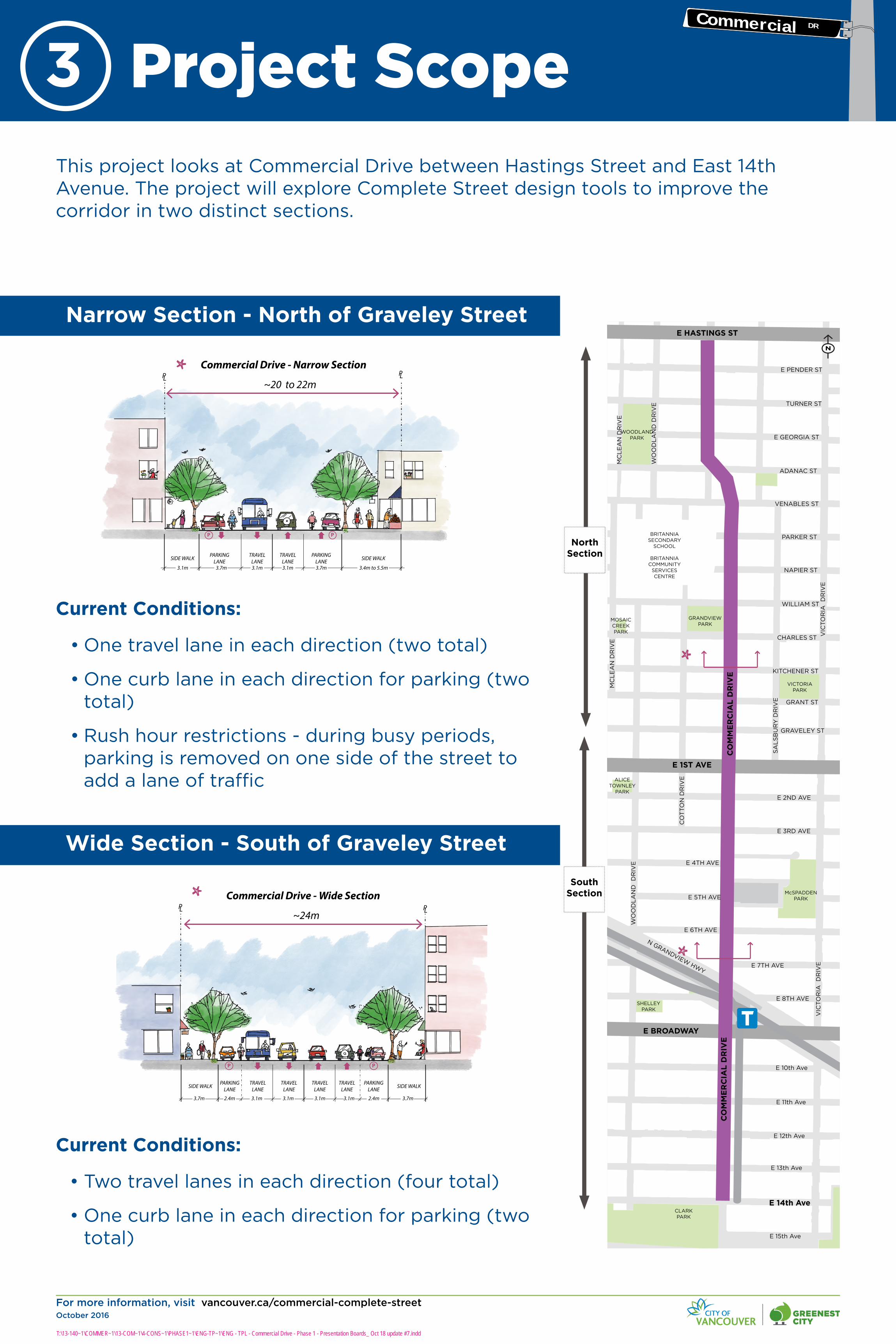
This project looks at Commercial Drive between Hastings Street and East 14th Avenue. The project will explore Complete Street design tools to improve the corridor in two distinct sections.
Narrow Section - North of Graveley Street
Current Conditions:
• One travel lane in each direction (two total)
• One curb lane in each direction for parking (two total)
• Rush hour restrictions - during busy periods, parking is removed on one side of the street to add a lane of traffic
Wide Section - South of Graveley Street
Current Conditions:
• Two travel lanes in each direction (four total)
• One curb lane in each direction for parking (two total)
E 13th Ave
N
TRINITY ST
MCGILL ST
ETON ST
CAMBRIDGE ST
OXFORD ST
DUNDAS ST
TRIUMPH ST
PANDORA ST
FRANKLIN ST
E HASTINGS ST
E PENDER ST
TURNER ST
E GEORGIA ST
ADANAC ST
VENABLES ST
PARKER ST
NAPIER ST
WILLIAM ST
CHARLES ST
KITCHENER ST
GRANT ST
GRAVELEY ST
E 1ST AVE
E 2ND AVE
E 3RD AVE
E 4TH AVE
E 5TH AVE
E 6TH AVE
E 7TH AVE
E 8TH AVE
E BROADWAY
E 10th Ave
E 11th Ave
E 12th Ave
KA
MLO
OP
S S
T
CL
AR
K D
RIV
E
WO
OD
LA
ND
D
RIV
E
CO
MM
ER
CIA
L D
RIV
E
GA
RD
EN
D
RIV
E
NA
NA
IMO
ST
SE
ML
IN D
RIV
E
LA
KE
WO
OD
D
RIV
E
VIC
TO
RIA
D
RIV
E
TE
MP
LE
TO
N D
RIV
E
SA
LS
BU
RY
DR
IVE
CO
TTO
N D
RIV
E
MC
LE
AN
DR
IVE
OD
LU
M D
RIV
E
MC
LE
AN
DR
IVE
WO
OD
LA
ND
DR
IVE
POWELL ST
SE
ML
IN D
RIV
E
RO
SE
ST
MC
LE
AN
DR
IVE
N GRANDVIEW HWY
E 13th Ave
LIL
LY S
T
CO
MM
ER
CIA
L D
RIV
E
E GEORGIA ST
E 15th Ave
VIC
TO
RIA
D
RIV
E
E HASTINGS ST
PANDORAPARK
McGILLPARK
WOODLAND PARK
GRANDVIEW PARK
MOSAIC CREEK PARK
ALICE TOWNLEY
PARK
VICTORIA PARK
McSPADDEN PARK
SHELLEYPARK
GARDENPARK
TEMPLETON PARK
OXFORDPARK
JOHN HENDRY
PARKCLARKPARK
BRITANNIA SECONDARY
SCHOOL
BRITANNIA COMMUNITY
SERVICESCENTRE
ADANAC ST
VENABLES ST
PARKER ST
NAPIER ST
WILLIAM ST
CHARLES ST
KITCHENER ST
GRANT ST
GRAVELEY ST
E 1ST AVE
E 2ND AVE
E 3RD AVE
E 4TH AVE
E 5TH AVE
E 6TH AVE
E 7TH AVE
E 8TH AVE
E BROADWAY
E 10th Ave
E 11th Ave
E 12th Ave
E 14th Ave
TURNER ST
E PENDER ST
SIDE WALK
3.1m
PARKINGLANE
3.7m
TRAVELLANE3.1m 3.1m
TRAVELLANE SIDE WALK
3.7m 3.4m to 5.5m
Commercial Drive - Narrow SectionPLPL
~20 to 22m
PP
PARKINGLANE
SIDE WALK
3.7m
PARKINGLANE
TRAVELLANE
3.1m 3.1m
TRAVELLANE SIDE WALK
Commercial Drive - Wide SectionPLPL
~24m
3.7m3.1m
P P
TRAVELLANE
2.4m
PARKINGLANE
TRAVELLANE
2.4m3.1m
T:\13-140~1\COMMER~1\13-COM~1\4-CONS~1\PHASE1~1\ENG-TP~1\ENG - TPL - Commercial Drive - Phase 1 - Presentation Boards_ Oct 18 update #7.indd
Project Scope3
N
NorthSection
SouthSection
Commercial DR

For more information, visit vancouver.ca/commercial-complete-streetOctober 2016
Transportation 2040 is a long-term strategic vision for the City that helps guide transportation and land use decisions and public investments. The plan sets long-term targets and includes policies and actions to help us reach them.
• Target: Make two-thirds of trips on foot, bike, and transit by 2040
• Target: Achieve zero traffic-related fatalities
Key Transportation 2040 Directions:
• W 1.2: Make streets safer for walking
• C 1.1: Build cycling routes that feel comfortable for people of all ages and abilities
• C 1.2: Expand the cycling network to efficiently connect people to destinations
• T 1.3: Improve transit reliability and speed using transit priority measures
• M 1.2: Consider impacts to transit, commercial vehicles, and general traffic flow prior to reallocating road space
• M 1.3: Manage traffic and improve safety and neighbourhood livability
• G 2.2: Provide for efficient loading and unloading
Other Policies Supported:
• Greenest City 2020 Action Plan: Green Transportation
• Healthy City Strategy: Active Living and Getting Outside, Getting Around
• Renewable City Strategy: Complete Streets
• Economic Action Strategy: Support for Local Business
T:\13-140~1\COMMER~1\13-COM~1\4-CONS~1\PHASE1~1\ENG-TP~1\ENG - TPL - Commercial Drive - Phase 1 - Presentation Boards_ Oct 18 update #7.indd
Transportation 2040
Transportation 2040 Policies
Background
Wide sidewalks in this area of Commercial Drive accomodate people strolling and shopping, street trees, business signs, and bicycle racks.
Commercial-Broadway Station is a busy area with people walking and taking transit, and often sidewalk vending.
4Commercial DR
For more information, visit vancouver.ca/commercial-complete-streetOctober 2016
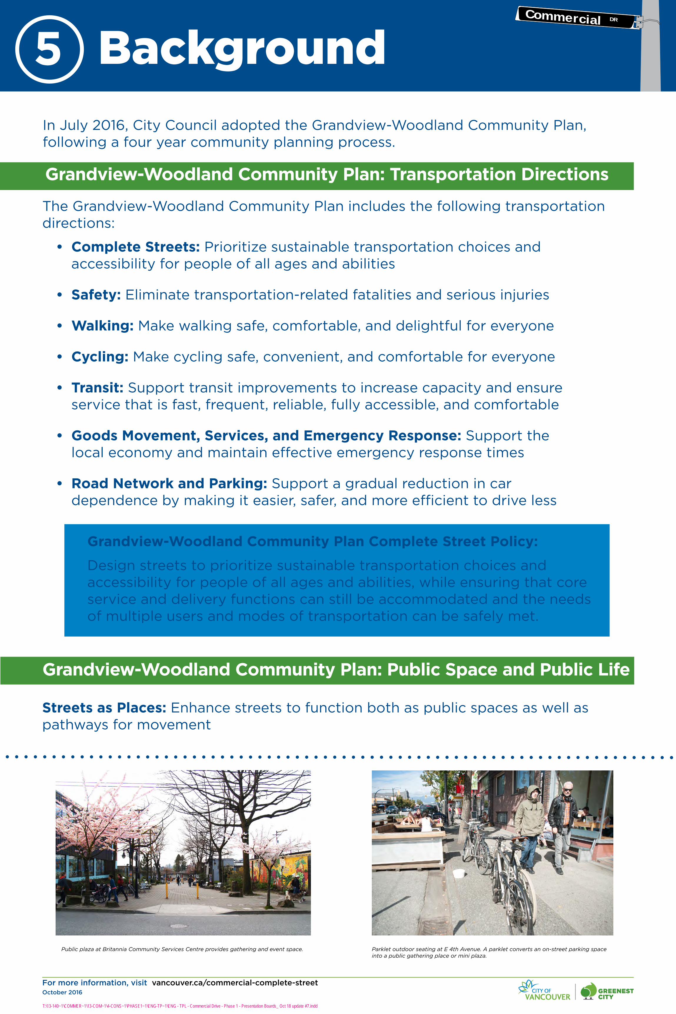
Grandview-Woodland Community Plan: Transportation Directions
The Grandview-Woodland Community Plan includes the following transportation directions:
• Complete Streets: Prioritize sustainable transportation choices and accessibility for people of all ages and abilities
• Safety: Eliminate transportation-related fatalities and serious injuries
• Walking: Make walking safe, comfortable, and delightful for everyone
• Cycling: Make cycling safe, convenient, and comfortable for everyone
• Transit: Support transit improvements to increase capacity and ensure service that is fast, frequent, reliable, fully accessible, and comfortable
• Goods Movement, Services, and Emergency Response: Support the local economy and maintain effective emergency response times
• Road Network and Parking: Support a gradual reduction in car dependence by making it easier, safer, and more efficient to drive less
In July 2016, City Council adopted the Grandview-Woodland Community Plan, following a four year community planning process.
Streets as Places: Enhance streets to function both as public spaces as well as pathways for movement
Public plaza at Britannia Community Services Centre provides gathering and event space.
Grandview-Woodland Community Plan: Public Space and Public Life
Grandview-Woodland Community Plan Complete Street Policy:
Design streets to prioritize sustainable transportation choices and accessibility for people of all ages and abilities, while ensuring that core service and delivery functions can still be accommodated and the needs of multiple users and modes of transportation can be safely met.
T:\13-140~1\COMMER~1\13-COM~1\4-CONS~1\PHASE1~1\ENG-TP~1\ENG - TPL - Commercial Drive - Phase 1 - Presentation Boards_ Oct 18 update #7.indd
Background
Parklet outdoor seating at E 4th Avenue. A parklet converts an on-street parking space into a public gathering place or mini plaza.
5Commercial DR
For more information, visit vancouver.ca/commercial-complete-streetOctober 2016
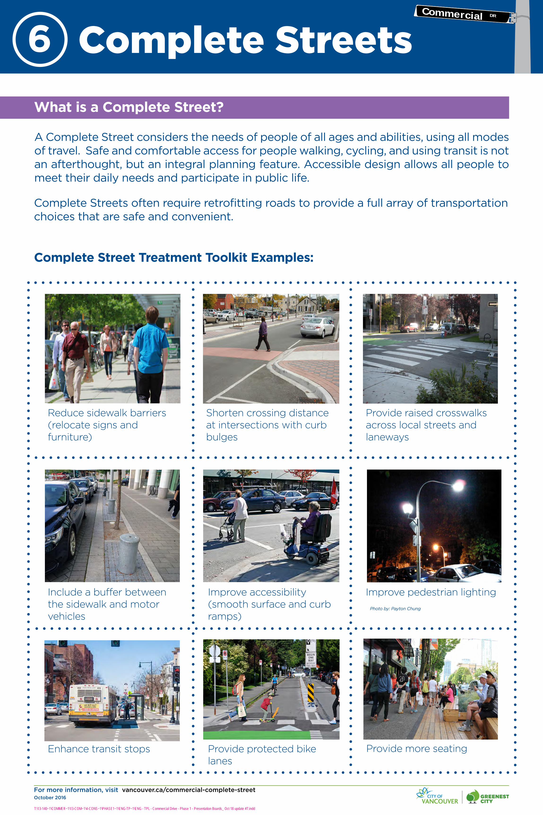
What is a Complete Street?
A Complete Street considers the needs of people of all ages and abilities, using all modes of travel. Safe and comfortable access for people walking, cycling, and using transit is not an afterthought, but an integral planning feature. Accessible design allows all people to meet their daily needs and participate in public life.
Complete Street Treatment Toolkit Examples:
Shorten crossing distance at intersections with curb bulges
Provide raised crosswalks across local streets and laneways
Include a buffer between the sidewalk and motor vehicles
Complete Streets often require retrofitting roads to provide a full array of transportation choices that are safe and convenient.
Improve accessibility (smooth surface and curb ramps)
Improve pedestrian lighting
Provide more seating Provide protected bike lanes
Enhance transit stops
Reduce sidewalk barriers (relocate signs and furniture)
T:\13-140~1\COMMER~1\13-COM~1\4-CONS~1\PHASE1~1\ENG-TP~1\ENG - TPL - Commercial Drive - Phase 1 - Presentation Boards_ Oct 18 update #7.indd
Complete Streets
Photo by: Payton Chung
6Commercial DR

For more information, visit vancouver.ca/commercial-complete-streetOctober 2016
T:\13-140~1\COMMER~1\13-COM~1\4-CONS~1\PHASE1~1\ENG-TP~1\ENG - TPL - Commercial Drive - Phase 1 - Presentation Boards_ Oct 18 update #7.indd
Proposed Design Principles Potential Design Elements
Help us confirm the Complete Street design principles for Commercial Drive. Tell us what is important to you.
1. Provide direct and convenient access to shops and services for people of all ages and abilities (AAA) using all types of transportation
2. Improve safety and comfort for people travelling by all types of transportation, with a focus on walking, cycling, and transit
3. Ensure loading, delivery, and access works well for local businesses
4. Consider impacts to transit, traffic flow, nearby streets, and parking
5. Consider flexible design approaches that facilitate special events
6. Explore opportunities to integrate sustainable rainwater management
» Provide more seating and gathering spaces (i.e. parklets, plazas)
» Provide more public art
» Provide clearer sidewalk paths by reducing clutter (i.e. locked bicycles, free-standing signs, newspaper boxes)
» Shorten intersection crossings (i.e. reduce crossing distance with sidewalk extensions or curb bulges)
» Provide raised crosswalks (i.e. elevate crosswalks to sidewalk level at local streets and laneways)
» Provide more street trees and landscaping
» Improve accessibility features (i.e. smooth surfaces, curb ramps, audible signals)
» Improve pedestrian lighting
» Provide more weather protection
» Provide protected bike lanes
» Improve transit stops (i.e. shelters, more space for people to wait)
» Maintain on-street parking
What’s missing...?
Select Top 5 Design Elements
Select Top 3 Design Principles
Complete Street Design Principles7Commercial DR

For more information, visit vancouver.ca/commercial-complete-streetOctober 2016
Most of Commerical Drive is a thriving commercial high street, but there are ongoing problems with collisions between motor vehicles and other road users, especially people walking and cycling.
• Almost 90% feel comfortable walking with a young child today
• However, only 14% feel comfortable cycling with a young child today
• The highest collision locations are at Hastings Street, Venables Street, East 1st Avenue, and East Broadway
• Right turn or ‘right hook’ collisions for people walking and cycling
• Midblock collisions, often with people jaywalking
• ‘Dooring’ is a hazard, as people cycling are often squeezed between moving and parked cars
4%
15%
60%
80%
10%
22%
27%
15%
How comfortable do/would you feelcycling along Commercial Drive with a
young child?
How comfortable do/would you feelcycling along Commercial Drive
How comfortable would you feelwalking along Commercial Drive with ayoung child or elderly person who may
need assistance?
How comfortable do you feel walkingalong Commercial Drive?
Completely Comfortable Somewhat Comfortable
How comfortable .....?
• Two-thirds of people surveyed have never cycled on Commercial Drive, but only 16% say it’s because they are not interested
• Over 50% are interested but identified the following barriers:
» Feel unsafe/uncomfortable (41%)
» Don’t own a bike (37%)
41%37%
16%
8%12%
50%
21%24%
12% 11%
Don't feelsafe
Don't havebike
Notinterested
Too Far Other
Reasons people don’t cycle on Commercial Drive
All respondents
People travelling by car
Why don’t you cycle on Commercial Drive?
Source: 2016, Intercept Survey
Source: 2016, Intercept Survey
T:\13-140~1\COMMER~1\13-COM~1\4-CONS~1\PHASE1~1\ENG-TP~1\ENG - TPL - Commercial Drive - Phase 1 - Presentation Boards_ Oct 18 update #7.indd
Safety Hotspots
Perception of Comfort
Safety is a major barrier
Safety and Comfort8
Collision Hotspots Walking & Cycling
T
Potential bike routes and greenways
Existing bike routes and greenways
TRINITY ST
MCGILL ST
ETON ST
CAMBRIDGE ST
OXFORD ST
DUNDAS ST
TRIUMPH ST
PANDORA ST
FRANKLIN ST
E HASTINGS ST
E PENDER ST
TURNER ST
E GEORGIA ST
ADANAC ST
VENABLES ST
PARKER ST
NAPIER ST
WILLIAM ST
CHARLES ST
KITCHENER ST
GRANT ST
GRAVELEY ST
E 1ST AVE
E 2ND AVE
E 3RD AVE
E 4TH AVE
E 5TH AVE
E 6TH AVE
E 7TH AVE
E 8TH AVE
E BROADWAY
CLARK DRIV
E
WO
ODLAND D
RIVE
COM
MERCIA
L DRIV
E
NANAIMO
ST
VICTO
RIA D
RIVE
E 10TH AVE
E 11TH AVE
E 12TH AVE
PANDORAPARK
McGILLPARK
WOODLAND PARK
GRANDVIEW-PARKMOSAIC
CREEK PARK
ALICE TOWNLEY
PARK
VICTORIA PARK
McSPADDEN PARK
SHELLEYPARK
GARDENPARK
TEMPLETON PARK
OXFORDPARK
BRITANNIA SECONDARY
SCHOOL
BRITANNIA COMMUNITY
SERVICESCENTRE
10 + crashes involving Pedestrians & Cyclists
1 to 3 crashes involving Pedestrians & Cyclists
4 to 9 crashes involving Pedestrians & Cyclists
LEGEND
Source: ICBC, Quick Statistics 2016 (2009-2013 collision data); Pedestrian Safety Study, 2012; Cycling
Safety Study, 2015.
N
Commercial DR

For more information, visit vancouver.ca/commercial-complete-streetOctober 2016
Overview
• Thousands of people walk along Commercial Drive every day
• About 70% are visiting shops or services
• About 90% feel comfortable walking with a small child or elderly person who needs assistance
Challenges
• Competing sidewalk uses, including people strolling, outdoor seating, locked bicycles, and free-standing signs
• Sidewalk congestion, especially at busy bus stops
Opportunities
• Create a better pedestrian environment and public realm
• Improve comfort by providing raised crosswalks across local streets and lanes
• Improve pedestrian lighting
• Expand sidewalk space at bus stops
• Optimize street furniture locations and reduce sidewalk clutter
• Create more public plazas and parklets on adjacent local streets
Walking and Public Space
Are we missing any challenges or opportunities?
T:\13-140~1\COMMER~1\13-COM~1\4-CONS~1\PHASE1~1\ENG-TP~1\ENG - TPL - Commercial Drive - Phase 1 - Presentation Boards_ Oct 18 update #7.indd
Walking and Public Space9
Sidewalks on Commercial Drive are generally very busy. Relocating bike parking, smooth surfaces, and improved crossings may help improve accessibility and comfort.
Commercial Drive at Broadway is a gateway to the Grandview-Woodland neighbourhood and a frequent collision location.
Commercial DR

For more information, visit vancouver.ca/commercial-complete-streetOctober 2016
Overview
• A bike-friendly community: half of all people in the area cycle regularly in good or fair weather, and 60% would like to cycle more often
• About two-thirds of people visiting have never cycled on Commercial Drive, with safety concerns and not having a bike being the largest barriers cited
• Only 14% of people would feel comfortable cycling with a small child today
Challenges
• Shared roadways feel unsafe and uncomfortable for people cycling
• Lack of cycling facilities means people cycle on the sidewalks and in the ‘door zone’ between moving and parked cars
20% 50%
28%
14%
20%
36% 34%
24%
27%
Source: 2015, Transportation Panel Survey
People who cycle regularly ingood/fair weather
Cycling on The Drive
Opportunities
• Explore reallocating a travel lane south of Graveley Street to create a protected bike lane
• Explore improved intersection designs to reduce conflicts between road users
• Expand Mobi bike share
• Relocate bike racks from the sidewalk by adding bike corrals (using on-street parking spaces)
• Improve connections and wayfinding to existing bike routes
T:\13-140~1\COMMER~1\13-COM~1\4-CONS~1\PHASE1~1\ENG-TP~1\ENG - TPL - Commercial Drive - Phase 1 - Presentation Boards_ Oct 18 update #7.indd
Cycling10
People are more likely to bike on the sidewalk if riding on the street does not feel safe. AAA facilities will help reduce sidewalk riding by providing a safe option.
Without cycling facilities, people are forced to ride in the ‘door zone’ between parked cars and moving traffic. Some people avoid riding altogether because it does not feel safe.
People cycling or skateboarding ride in the ‘door zone’ between parked cars and moving traffic.
Commercial DR
For more information, visit vancouver.ca/commercial-complete-streetOctober 2016
Overview
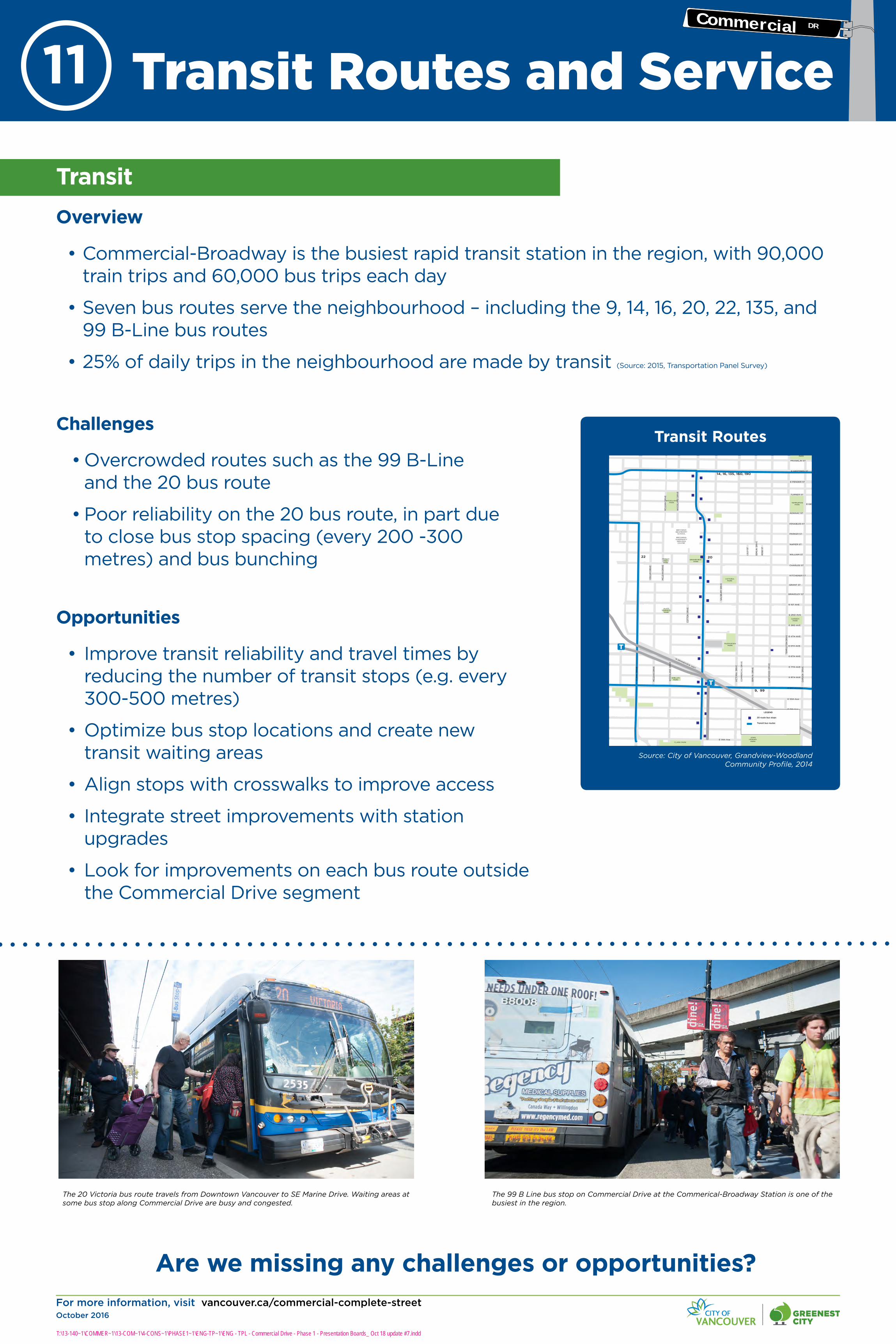
• Commercial-Broadway is the busiest rapid transit station in the region, with 90,000 train trips and 60,000 bus trips each day
• Seven bus routes serve the neighbourhood – including the 9, 14, 16, 20, 22, 135, and 99 B-Line bus routes
• 25% of daily trips in the neighbourhood are made by transit (Source: 2015, Transportation Panel Survey)
Challenges
• Overcrowded routes such as the 99 B-Line and the 20 bus route
• Poor reliability on the 20 bus route, in part due to close bus stop spacing (every 200 -300 metres) and bus bunching
Opportunities
• Improve transit reliability and travel times by reducing the number of transit stops (e.g. every 300-500 metres)
• Optimize bus stop locations and create new transit waiting areas
• Align stops with crosswalks to improve access
• Integrate street improvements with station upgrades
• Look for improvements on each bus route outside the Commercial Drive segment
Are we missing any challenges or opportunities?
The 20 Victoria bus route travels from Downtown Vancouver to SE Marine Drive. Waiting areas at some bus stop along Commercial Drive are busy and congested.
The 99 B Line bus stop on Commercial Drive at the Commerical-Broadway Station is one of the busiest in the region.
T:\13-140~1\COMMER~1\13-COM~1\4-CONS~1\PHASE1~1\ENG-TP~1\ENG - TPL - Commercial Drive - Phase 1 - Presentation Boards_ Oct 18 update #7.indd
Transit
Transit Routes and Service11
N
14, 16, 135, 160, 190
20
9, 99
22 7
4, 7, 209, 210, 211
N
TRINITY ST
MCGILL ST
ETON ST
CAMBRIDGE ST
OXFORD ST
DUNDAS ST
TRIUMPH ST
PANDORA ST
FRANKLIN ST
E HASTINGS ST
E PENDER ST
TURNER ST
E GEORGIA ST
ADANAC ST
VENABLES ST
PARKER ST
NAPIER ST
WILLIAM ST
CHARLES ST
KITCHENER ST
GRANT ST
GRAVELEY ST
E 1ST AVE
E 2ND AVE
E 3RD AVE
E 4TH AVE
E 5TH AVE
E 6TH AVE
E 7TH AVE
E 8TH AVE
E BROADWAY
E 10th Ave
E 11th Ave
E 12th Ave
KA
MLO
OP
S S
T
CL
AR
K D
RIV
E
WO
OD
LA
ND
DR
IVE
GA
RD
EN
DR
IVE
NA
NA
IMO
ST
SE
ML
IN D
RIV
E
LA
KE
WO
OD
DR
IVE
VIC
TOR
IA D
RIV
E
TE
MP
LE
TON
DR
IVE
SA
LS
BU
RY
DR
IVE
CO
TTO
N D
RIV
E
MC
LE
AN
DR
IVE
OD
LUM
DR
IVE
MC
LE
AN
DR
IVE
WO
OD
LA
ND
DR
IVE
POWELL ST
SE
ML
IN D
RIV
E
RO
SE
ST
MC
LE
AN
DR
IVE
N GRANDVIEW HWY
E 14th Ave
E 15th Ave
E 13th Ave
LIL
LY S
T
CO
MM
ER
CIA
L D
RIV
E
PANDORAPARK
McGILLPARK
WOODLAND PARK
GRANDVIEW-PARK
MOSAIC CREEK PARK
ALICE TOWNLEY
PARK
VICTORIA PARK
SHELLEYPARK
GARDENPARK
TEMPLETON PARK
OXFORDPARK
JOHN HENDRY
PARK CLARK PARK
McSPADDEN PARK
20 route bus stops
Transit bus routes
LEGEND
BRITANNIA SECONDARY
SCHOOL
BRITANNIA COMMUNITY
SERVICESCENTRE
Transit Routes
Source: City of Vancouver, Grandview-Woodland Community Profile, 2014
Commercial DR
For more information, visit vancouver.ca/commercial-complete-streetOctober 2016
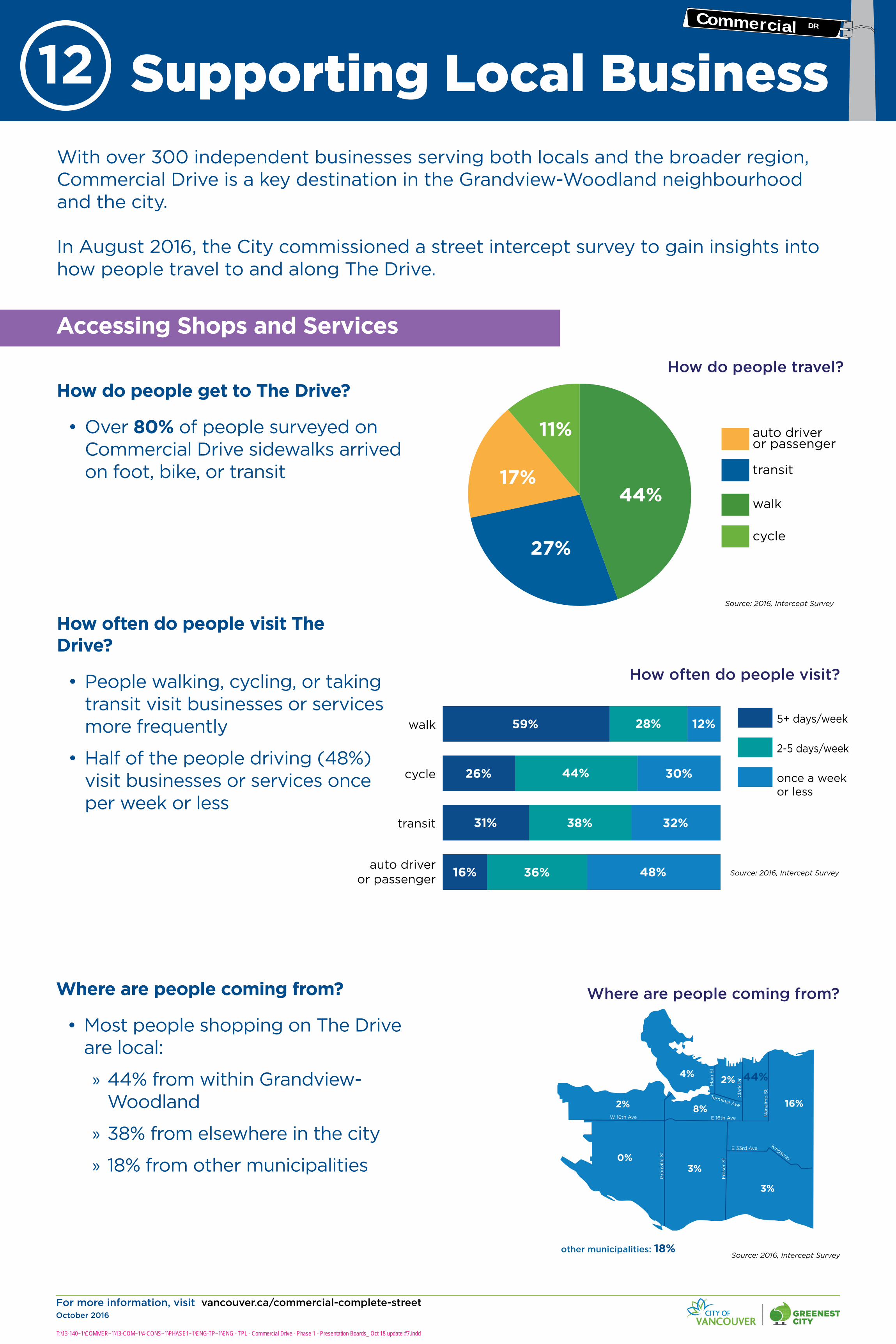
With over 300 independent businesses serving both locals and the broader region, Commercial Drive is a key destination in the Grandview-Woodland neighbourhood and the city.
In August 2016, the City commissioned a street intercept survey to gain insights into how people travel to and along The Drive.
How do people get to The Drive?
• Over 80% of people surveyed on Commercial Drive sidewalks arrived on foot, bike, or transit
walk
transit
auto driver or passenger
cycle
44%
27%
17%
11%
How do people travel?
Source: 2016, Intercept Survey
How often do people visit The Drive?
• People walking, cycling, or taking transit visit businesses or services more frequently
• Half of the people driving (48%) visit businesses or services once per week or less
5+ days/week
2-5 days/week
once a weekor less
auto driveror passenger
transit
cycle
walk 59% 28% 12%
26% 44% 30%
31% 38% 32%
48%36%16%
How often do people visit?
Source: 2016, Intercept Survey
Where are people coming from?
• Most people shopping on The Drive are local:
» 44% from within Grandview-Woodland
» 38% from elsewhere in the city
» 18% from other municipalities
W 16th Ave
Fra
ser
St
Main
St
Cla
rk D
r
Nan
aim
o S
t
E 16th Ave
E 33rd Ave
Gra
nvill
e S
t
Kingsway
Terminal Ave
44%
8%
3%
2%
0%
other municipalities: 18%
16%
3%
2%
4%
Where are people coming from?
Source: 2016, Intercept Survey
T:\13-140~1\COMMER~1\13-COM~1\4-CONS~1\PHASE1~1\ENG-TP~1\ENG - TPL - Commercial Drive - Phase 1 - Presentation Boards_ Oct 18 update #7.indd
Accessing Shops and Services
Supporting Local Business 12Commercial DR

For more information, visit vancouver.ca/commercial-complete-streetOctober 2016
Where do people park to get to The Drive?
• 42% use metered parking either on The Drive (33%) or nearby (9%)
• 32% use free (unmetered) parking on neighbourhood side streets
• Less than 7% use off-street parkades/lots
• 272 on-street parking spaces between Venables St and Grandview Hwy N
• Estimated 800* off-street parking spaces between Venables St and Grandview Hwy N
• Neighbourhood streets have prioritized on-street permit parking for residents
How easy was it to park when coming to The Drive?
• 86% said it was very easy (53%) or somewhat easy (33%) to find parking
• 11% found it somewhat difficult or very difficult (4%) to find parking
off-street parkade
free parking nearby
metered on The Drive
nearby metered parking
42%
32%
9%
7%
Where do people park?
A popular shopping destination for locals who can walk to Commercial Drive, or regional visitors who may drive or take transit.
With limited laneway access on some blocks, delivery vehicles may park on side streets.
ADANAC ST
VENABLES ST
PARKER ST
NAPIER ST
WILLIAM ST
CHARLES ST
KITCHENER ST
GRANT ST
GRAVELEY ST
E 1ST AVE
E 2ND AVE
E 3RD AVE
E 4TH AVE
E 5TH AVE
E 6TH AVE
E 7TH AVE
E 8TH AVE
E BROADWAY
CLAR
K D
RIVE
WOO
DLAN
D D
RIVE
GARD
EN D
RIVE
NANA
IMO
ST
VICT
ORIA
DRI
VE
TEM
PLET
ON D
RIVE
LAKE
WOO
D DR
IVE
E 10TH AVE
E 11TH AVE
E 12TH AVE
E 13TH AVE
E 14TH AVE
COM
MER
CIAL
DRI
VE
E 15TH AVE
COTT
ON D
RIVE
MCL
EAN
DRI
VE
SALS
BURY
DRI
VE
N GRANDVIEW HWY
WOODLAND PARK
GRANDVIEW PARKMOSAIC
CREEK PARK
ALICE TOWNLEY
PARK
VICTORIA PARK
McSPADDEN PARK
SHELLEYPARK
GARDENPARK
TEMPLETON PARK
Commercial Dr and Venables St (Easy Park surface lot)
Commercial Dr and E 1st Ave(WestPark parade at Il Mercato)
Commercial Dr and lane south of E 8th Ave(Impark parkade at Grandview Woodland Health Centre)
Commercial Dr and E 10th Ave(Impark parkade)
Commercial Dr and E 11th Ave(Impark surface lot & parkade)
Commercial Dr and E 11th Ave(Diamond Parking surface lot)
Commercial Dr and E 11th Ave(Metro Parking surface lot)
F
DE
C
B
A
G
BRITANNIA COMMUNITY
SERVICESCENTRE
Off-Street Parking Locations
Source: City of Vancouver and Parkopedia
17% of people arrive by vehicle, and there is on-street and off-street parking available in the area for visitors.
*Areas behind businesses were often not demarcated into individual spaces, requiring the number of available parking spaces to be estimated (as opposed to counted). Source: 2014, City of Vancouver
Source: 2016, Intercept Survey
T:\13-140~1\COMMER~1\13-COM~1\4-CONS~1\PHASE1~1\ENG-TP~1\ENG - TPL - Commercial Drive - Phase 1 - Presentation Boards_ Oct 18 update #7.indd
Parking
Supporting Local Business 13Commercial DR

For more information, visit vancouver.ca/commercial-complete-streetOctober 2016
Daily traffic
• Commercial Drive carries 13,000 to 22,000 vehicles per day, with heavier volumes south of East 1st Avenue
Hourly traffic
• 700-800 vehicles per hour, in each direction in busiest sections during peak times
• Similar volumes to Victoria Drive
• By comparison, Clark Drive, Hastings Street, Broadway, and East 1st Avenue carry in excess of 1,200 vehicles per hour
Are we missing any challenges or opportunities?
A Goods Movement and Business Survey is underway to better understand the loading, delivery, and access needs of individual businesses on The Drive. If you represent a local business and have not completed a survey, please talk to us!
Commercial Drive is a street that primarily serves local destinations. Parallel streets like Clark Drive or Nanaimo Street carry most of the regional traffic through the neighbourhood.
Challenges
• Design must continue to accomodate loading and delivery needs
• Interventions may reduce available on-street parking
T
Potential bike routes and greenways
Existing bike routes and greenways
NA
NA
IMO
ST
VIC
TO
RIA
D
RIV
E
CO
MM
ER
CIA
L D
RIV
E
CL
AR
K D
RIV
E
8200
4000
019
000
1700
022
000
1800
0
49000 46000
2200
0
35000
59000
6200
1700
013
000
1400
036
000
2500
230
26000
40000
4300
0
1300
0
3900
0
1800
0
2400
0
34000
1300
0
1200
0
48000
16000
44000 47000
LEGEND
Secondary Arterial Streets
Neighbourhood Collector Streets
Arterial Streets
TRINITY ST
MCGILL ST
ETON ST
CAMBRIDGE ST
OXFORD ST
DUNDAS ST
TRIUMPH ST
PANDORA ST
FRANKLIN ST
E HASTINGS ST
E PENDER ST
TURNER ST
E GEORGIA ST
ADANAC ST
VENABLES ST
PARKER ST
NAPIER ST
WILLIAM ST
CHARLES ST
KITCHENER ST
GRANT ST
GRAVELEY ST
E 1ST AVE
E 2ND AVE
E 3RD AVE
E 4TH AVE
E 5TH AVE
E 6TH AVE
E 7TH AVE
E 8TH AVE
E BROADWAY
CLARK D
RIVE
COM
MERCIA
L DRIV
E
NANAIM
O S
TVICTO
RIA D
RIVE
Traffic Counts and Road Designation
Source: City of Vancouver, Grandview-Woodland Community Profile, 2014
N
E HASTINGS ST
VENABLES ST
E 1ST AVE
E BROADWAY
E 12TH AVE
COM
MER
CIA
L D
RIVE
N
AMPM
Number of Motor Vehicles Travelling During the Weekday Peak Hour (rounded to nearest hundred)
LEGEND
Direction of Motor Vehicle Travel
Data from 2016
500400
400700
400800
600500
700500
300800
300300
300400
Hourly Peak Volumes
Source: City of Vancouver, 2016
Opportunities
• Improve wayfinding and signage to existing off-street parking
• Increase customer access to local shops and services
• Consider relocation of special zones (e.g. commercial loading, passenger loading, taxi, etc.)
T:\13-140~1\COMMER~1\13-COM~1\4-CONS~1\PHASE1~1\ENG-TP~1\ENG - TPL - Commercial Drive - Phase 1 - Presentation Boards_ Oct 18 update #7.indd
Goods Movement and Road Network
Supporting Local Business 14Commercial DR

For more information, visit vancouver.ca/commercial-complete-streetOctober 2016
E 13th Ave
N
TRINITY ST
MCGILL ST
ETON ST
CAMBRIDGE ST
OXFORD ST
DUNDAS ST
TRIUMPH ST
PANDORA ST
FRANKLIN ST
E HASTINGS ST
E PENDER ST
TURNER ST
E GEORGIA ST
ADANAC ST
VENABLES ST
PARKER ST
NAPIER ST
WILLIAM ST
CHARLES ST
KITCHENER ST
GRANT ST
GRAVELEY ST
E 1ST AVE
E 2ND AVE
E 3RD AVE
E 4TH AVE
E 5TH AVE
E 6TH AVE
E 7TH AVE
E 8TH AVE
E BROADWAY
E 10th Ave
E 11th Ave
E 12th Ave
KA
MLO
OP
S S
T
CL
AR
K D
RIV
E
WO
OD
LA
ND
D
RIV
E
CO
MM
ER
CIA
L D
RIV
E
GA
RD
EN
D
RIV
E
NA
NA
IMO
ST
SE
ML
IN D
RIV
E
LA
KE
WO
OD
D
RIV
E
VIC
TO
RIA
D
RIV
E
TE
MP
LE
TO
N D
RIV
E
SA
LS
BU
RY
DR
IVE
CO
TTO
N D
RIV
E
MC
LE
AN
DR
IVE
OD
LU
M D
RIV
E
MC
LE
AN
DR
IVE
WO
OD
LA
ND
DR
IVE
POWELL ST
SE
ML
IN D
RIV
E
RO
SE
ST
MC
LE
AN
DR
IVE
N GRANDVIEW HWY
E 13th Ave
LIL
LY S
T
CO
MM
ER
CIA
L D
RIV
E
E GEORGIA ST
E 15th Ave
VIC
TO
RIA
D
RIV
E
E HASTINGS ST
PANDORAPARK
McGILLPARK
WOODLAND PARK
GRANDVIEW PARK
MOSAIC CREEK PARK
ALICE TOWNLEY
PARK
VICTORIA PARK
McSPADDEN PARK
SHELLEYPARK
GARDENPARK
TEMPLETON PARK
OXFORDPARK
JOHN HENDRY
PARKCLARKPARK
BRITANNIA SECONDARY
SCHOOL
BRITANNIA COMMUNITY
SERVICESCENTRE
ADANAC ST
VENABLES ST
PARKER ST
NAPIER ST
WILLIAM ST
CHARLES ST
KITCHENER ST
GRANT ST
GRAVELEY ST
E 1ST AVE
E 2ND AVE
E 3RD AVE
E 4TH AVE
E 5TH AVE
E 6TH AVE
E 7TH AVE
E 8TH AVE
E BROADWAY
E 10th Ave
E 11th Ave
E 12th Ave
E 14th Ave
TURNER ST
E PENDER ST
Narrow Section - North of Graveley Street
Wide Section - South of Graveley Street
Opportunity - Spot Improvements and Minor Changes:
• Sidewalk and public realm enhancements
• Potential Mobi bike share expansion
• Bus stop changes
• Review parking restrictions
Opportunity - Significant Improvements:
• Sidewalk and public realm enhancements
• Protected bike lane
• Potential Mobi bike share expansion
• Bus stop changes and expanded waiting areas
This project covers Commercial Drive between Hastings Street and East 14th Avenue.
While the project will explore walking, cycling, transit, and public space improvements through the corridor, the south section is wider and there may be potential to reallocate a travel lane in each direction.
SIDE WALK
3.1m
PARKINGLANE
3.7m
TRAVELLANE3.1m 3.1m
TRAVELLANE SIDE WALK
3.7m 3.4m to 5.5m
Commercial Drive - Narrow SectionPLPL
~20 to 22m
PP
PARKINGLANE
SIDE WALK
3.7m
PARKINGLANE
TRAVELLANE
3.1m 3.1m
TRAVELLANE SIDE WALK
Commercial Drive - Wide SectionPLPL
~24m
3.7m3.1m
P P
TRAVELLANE
2.4m
PARKINGLANE
TRAVELLANE
2.4m3.1m
T:\13-140~1\COMMER~1\13-COM~1\4-CONS~1\PHASE1~1\ENG-TP~1\ENG - TPL - Commercial Drive - Phase 1 - Presentation Boards_ Oct 18 update #7.indd
Project Opportunities15
N
NorthSection
SouthSection
Commercial DR
For more information, visit vancouver.ca/commercial-complete-streetOctober 2016
2)
3)
6)
5)
4)
7)
10)
9)
8)
11)
14)
13)
12)
15)
1)
17)
18)
21)
20)
19)
22)
25)
24)
23)
26)
29)
28)
27)
30)
16)
E 13th Ave
BRITANNIA SECONDARY
SCHOOL
BRITANNIA COMMUNITY
SERVICESCENTRE
N
TRINITY ST
MCGILL ST
ETON ST
CAMBRIDGE ST
OXFORD ST
DUNDAS ST
TRIUMPH ST
PANDORA ST
FRANKLIN ST
E HASTINGS ST
E PENDER ST
TURNER ST
E GEORGIA ST
ADANAC ST
VENABLES ST
PARKER ST
NAPIER ST
WILLIAM ST
CHARLES ST
KITCHENER ST
GRANT ST
GRAVELEY ST
E 1ST AVE
E 2ND AVE
E 3RD AVE
E 4TH AVE
E 5TH AVE
E 6TH AVE
E 7TH AVE
E 8TH AVE
E BROADWAY
E 10th Ave
E 11th Ave
E 12th Ave
KA
MLO
OP
S ST
CLA
RK
DR
IVE
WO
OD
LAN
D D
RIV
E
CO
MM
ERC
IAL
DR
IVE
GA
RD
EN
DR
IVE
NA
NA
IMO
ST
SEM
LIN
DR
IVE
LAK
EW
OO
D D
RIV
E
VIC
TOR
IA D
RIV
E
TEM
PLE
TON
DR
IVE
SALS
BU
RY
DR
IVE
CO
TTO
N D
RIV
E
MC
LEA
N D
RIV
E
OD
LUM
DR
IVE
MC
LEA
N D
RIV
E
WO
OD
LAN
D D
RIV
E
POWELL ST
SEM
LIN
DR
IVE
RO
SE S
T
MC
LEA
N D
RIV
E
N GRANDVIEW HWY
E 13th Ave
LILL
Y S
T
CO
MM
ERC
IAL
DR
IVE
E GEORGIA ST
E HASTINGS ST
PANDORAPARK
McGILLPARK
WOODLAND PARK
GRANDVIEW PARK
MOSAIC CREEK PARK
ALICE TOWNLEY
PARK
VICTORIA PARK
McSPADDEN PARK
SHELLEYPARK
GARDENPARK
TEMPLETON PARK
OXFORDPARK
JOHN HENDRY
PARKCLARKPARK
ADANAC ST
VENABLES ST
PARKER ST
NAPIER ST
WILLIAM ST
CHARLES ST
KITCHENER ST
GRANT ST
GRAVELEY ST
E 1ST AVE
E 2ND AVE
E 3RD AVE
E 4TH AVE
E 5TH AVE
E 6TH AVE
E 7TH AVE
E 8TH AVE
E BROADWAY
E 10th Ave
E 11th Ave
E 12th Ave
E 14th Ave
TURNER ST
E PENDER ST
N
What transportation improvements would you make along Commercial Drive?
Please number your dot, place it onto the map, and tell us what it is!
Commercial DR
Opportunities16

For more information, visit vancouver.ca/commercial-complete-streetOctober 2016
17)
18)
21)
20)
19)
22)
25)
24)
23)
26)
29)
28)
27)
30)
16)
2)
3)
6)
5)
4)
7)
10)
9)
8)
11)
14)
13)
12)
15)
1)
E 13th Ave
BRITANNIA SECONDARY
SCHOOL
BRITANNIA COMMUNITY
SERVICESCENTRE
N
TRINITY ST
MCGILL ST
ETON ST
CAMBRIDGE ST
OXFORD ST
DUNDAS ST
TRIUMPH ST
PANDORA ST
FRANKLIN ST
E HASTINGS ST
E PENDER ST
TURNER ST
E GEORGIA ST
ADANAC ST
VENABLES ST
PARKER ST
NAPIER ST
WILLIAM ST
CHARLES ST
KITCHENER ST
GRANT ST
GRAVELEY ST
E 1ST AVE
E 2ND AVE
E 3RD AVE
E 4TH AVE
E 5TH AVE
E 6TH AVE
E 7TH AVE
E 8TH AVE
E BROADWAY
E 10th Ave
E 11th Ave
E 12th Ave
KA
MLO
OP
S ST
CLA
RK
DR
IVE
WO
OD
LAN
D D
RIV
E
CO
MM
ER
CIA
L D
RIV
E
GA
RD
EN
DR
IVE
NA
NA
IMO
ST
SEM
LIN
DR
IVE
LAK
EW
OO
D D
RIV
E
VIC
TOR
IA D
RIV
E
TE
MP
LETO
N D
RIV
E
SALS
BU
RY
DR
IVE
CO
TTO
N D
RIV
E
MC
LEA
N D
RIV
E
OD
LUM
DR
IVE
MC
LEA
N D
RIV
E
WO
OD
LAN
D D
RIV
E
POWELL ST
SEM
LIN
DR
IVE
RO
SE S
T
MC
LEA
N D
RIV
E
N GRANDVIEW HWY
E 13th Ave
LILL
Y S
T
CO
MM
ER
CIA
L D
RIV
E
E GEORGIA ST
E HASTINGS ST
PANDORAPARK
McGILLPARK
WOODLAND PARK
GRANDVIEW PARK
MOSAIC CREEK PARK
ALICE TOWNLEY
PARK
VICTORIA PARK
McSPADDEN PARK
SHELLEYPARK
GARDENPARK
TEMPLETON PARK
OXFORDPARK
JOHN HENDRY
PARKCLARKPARK
ADANAC ST
VENABLES ST
PARKER ST
NAPIER ST
WILLIAM ST
CHARLES ST
KITCHENER ST
GRANT ST
GRAVELEY ST
E 1ST AVE
E 2ND AVE
E 3RD AVE
E 4TH AVE
E 5TH AVE
E 6TH AVE
E 7TH AVE
E 8TH AVE
E BROADWAY
E 10th Ave
E 11th Ave
E 12th Ave
E 14th Ave
TURNER ST
E PENDER ST
N
What aspects of transportation do you love along Commercial Drive?
Please number your dot, place it onto the map, and tell us what it is!
OpportunitiesCommercial DR
17
For more information, visit vancouver.ca/commercial-complete-streetOctober 2016
T:\13-140~1\COMMER~1\13-COM~1\4-CONS~1\PHASE1~1\ENG-TP~1\ENG - TPL - Commercial Drive - Phase 1 - Presentation Boards_ Oct 18 update #7.indd
Tell us what is important to consider as we improve the street for all users. Share your hopes and concerns for Complete Street transportation improvements along Commercial Drive.
What are your hopes? ... concerns? 18Commercial DR

For more information, visit vancouver.ca/commercial-complete-streetOctober 2016
Summer 2016
Phase 1: Listen and Learn
What we’ll do: Launch public consultation process, identify
transportation improvements, and present Complete Street
design principles.
Who we’ll consult with: Residents, local businesses, Grandview-
Woodland Transportation and Neighbourhood Parking
Stakeholder Advisory Group (Grandview-Woodland SAG), and
civic advisory committees.
What we’ll create based on feedback: Confirm Complete Street
principles and draft design concepts informed by community
input, stakeholder input, technical analysis, and City policy
priorities.
Grandview-Woodland Community Plan adopted by City Council
Winter 2016 and Spring 2017
Spring and Summer 2017
We Are Here Fall 2016
Phase 2: Design Options
What we’ll do: Public consultation on design options.
Who we’ll consult with: Residents, local businesses, civic
advisory committees, and the Grandview-Woodland SAG.
What we’ll create based on feedback: Evaluate design options
and recommend a preferred design.
Phase 3: Recommendation
What we’ll do: Finalize the design recommendations for a
Commercial Drive Complete Street.
Who we’ll consult with: The public, local businesses, civic
advisory committees, and the Grandview-Woodland SAG.
What we’ll create: Final design recommendation for a
Complete Street on Commercial Drive with refinements to go to
Council.
Ways to share your feedback:
• Review the information on these boards and complete a comment sheet in person at an open house or online at vancouver.ca/commercial-complete-street
• Email: [email protected]
• Phone: 3-1-1
Your input will help finalize the design principles and contribute to design options for creating a more Complete Street along Commercial Drive.
Our process and anticipated milestones:
T:\13-140~1\COMMER~1\13-COM~1\4-CONS~1\PHASE1~1\ENG-TP~1\ENG - TPL - Commercial Drive - Phase 1 - Presentation Boards_ Oct 18 update #7.indd
TimelineE Project Timeline19Commercial DR
We want to hear from you!