what is a hill? an analysis of the meanings of generic
TRANSCRIPT

ETL-0576
AD-A231 413 ZDPY
What is a Hill?An Analysis of theMeanings of GenericTopographic Terms
Robert R. Hoffman
DTIC9 ELECT; A
August 1985 FEBO 11991B
Approved for public release; distrihuticn is unlimited.
91 1 31 01U.S. Army Corps of EngineersEngineer Topographic LaboratoriesFort Belvoir, Virginia 22060-5546

I
Destroy this report when no longer needed.Do not return it to the originator.
The findings in this report are not to be construed as an officialDepartment of the Army position unless so designated by otherauthorized documents.
The citation in this report of trade names of commercially availableproducts does not constitute official endorsement or approval of theune of such products.

Form Approv.ed
REPORT DOCUMENTATION PAGE FM o o041e
1. AGENCY USE ONLY (Leave blank) 2. REPORT DATE 3. REPORT TYPE ANO DATES COVERED
1August 1985 I Research I Jue-15gust1J ,4. TITLE AND SUBTITLE 5. FUNDING NUMBERSWhat is a Hill? An Analysis of the Meaningsof Generic Topographic Terms DAAG29-8 1 -D-0100
6. AUTHOR(S) Delivery Order No. 1380
Robert R. Hoffman, Ph.D.
7. PERFORMING ORGANIZATION NAME(S) AND ADORESS(ES) B. PERFORMING ORGANIZATION
U.S. Army Engineer Topographic Laboratories REPORT NUMBER
Fort Belvoir, Virginia 22060-5546 ETL-0576
9. SPONSORING/MONITORING AGENCY NAME(S) AND ADDRESS(ES) 10. SPONSORING/ MONITORINGAGENCY REPORT NUMBER
Battelle InstituteResearch Triangle Park, NC 27709
11. SUPPLEMENTARY NOTES
1I. DISTRIBUTION / AVAILABILITY STATEMENT 12b. DISTRIBUTION CODE
Approved for public release; distribution is unlimited.
13. ABSTRACT (Maximum 200 words)This report is part of the effort to generate artificial intelligence systems for aerial photo interpretation.
Such a system requires symbolic definitions of generic topographic terms, especially if the system is to interactwith a human operator. The author analyzes the meanings of terms such as "hill," "plain," and "terrace," andidjectival descriptors such as "blocky," "rugged," and "large." A review of literature on topography,geomorphology, and terrain analysis reveals that generic topographic terms occur frequently in descriptions of:errain, especially those intended to communicate the perceptual form of terrain. Yet such concepts--rooted inerception, judgment, and experience--are rarely defined.
A terrain analysis data base of over 1 ,000 propositions about the knowledge of expert aerial photonterpreters was analyzed to extract and categorize approximately 100 generic terms and 250 generic descriptors.lhe author's approach to defining these terms is based on concepts from ecological optics and the psychology of'erception. The definitions themselves are built on concepts from the literature of terrain analysis andopography. This study has implications for practicing terrain analysts and aerial photo interpreters, as well asor the field of artificial intelligenc. It suggests some new methods for describing terrain and somelarifications of traditional terminology.
14. SUBJECT TERMS IS. NUMBER OF PAGES
Aerial photo interpretation Artificial intelligence 16. PRICE CODEPsychology of perception Terrain description
17. SECURITY CLASSIFICATION 18. SECURITY CLASSIFICATION 19. SECURITY CLASSIFICATION 20. LIMITATION OF ABSTRACT
OF REPORT OF THIS PAGE OF ABSTRACTJNCLASSIFIED UNCLASSIFIED UNCLASSIFIED UL
NSN 7540-01-280-5500 Standard Form 298 (Rev 1-89)P,eV,,d by ANSISid 139.ig296-02

Aug 19 14:16 1985 finalreport Page 1
What is a Hill?
An Analysis of the Meanings of Generic Topographic Terms
A Final Report
Scientific Services Program
U.S. Army Research Office
August, 1985
Delivery Crder Number 1380
Contract CAAG29-81-D-0100
The viems* opinions and/or findings contained in this report are those of the
author and should not be construed as an official Department of the Army
positiont policy, or decision, unless so designated 'y other documntation.
Accession For
NT1S PA&IIDTI' ,-I,
l~l~v "*'1J l " " iY I t ionUI t:.ilc( E
I _1:;tIibut.ion
Availatility Codes
Avail and/orDist Special

Aug 19 14:16 1935 finalreport Page 2
PREFACE
This repoCt fas prepared for the U.S. Aruy Engineer T opographic
Laboratories ElL), Fort Belvoirt Virginia 22060, through the Battelle
Institute, Research Triangle Parke North Carolina 12297, under the U.S.
Army Research Office's Scientific Services Program.
The work was ;erformed at the Engineer Topographic Laboratories by
Or. Robert R. Hoffman of the Departmtent of Psychology of Adelphi University,
Garden City, NY 11530, under the technical supervision of Mr. Olin W.
Mintzer, ETL, who was also the Contracting Cfficer's Representative.
-4-
Aug 19 14:1b 1905 firn.lreport Page 3
ACKNOWiLEDGMENT
The Authoi mould like to thank Professor Olin We D'intzer for his
guidance and technical sugervision. Thanks are also, due to John Benton
and Lauretta Williams for their help in showing me the use of the computer
systems, and to Dan Edwards* Greg Desmond, and Mike Schoppman for per-
mitting an analysis of the KES programs which they dovelored.

Aug 19 14:16 1985 finalreport Page 4
TABLE OF CONTENTS
Report Documentation Page . . . . . o . .... . .... o ....... i
Cover Page •.••••••••••.••••o••.o•.••.•.••.
Preface . . . • . . . . . * * o * o o . . * o * • * o . o * o * * . * . 2
AcknowledS.-ent .3 . * .3
Table of Contents .. . . . . . . . . . . . ... 4
Summary f Cott . o . . . . . . . .* . . . . . . . .* . . o . . . . 4
Introduction to The Problem .. . . . . . .. .. ............ 6
Method of Analysis of Generic Topographic Ter.ms . . a ... 0..... *.14
Materials *.*. .*******..****** * . * .14
Method . . . ............ ... . 15
Results of The Analysis ...... . * * ... .. ..... . 19
Discussion of the Results * .... .. . .. ... .... 23
Generic Topographic Terms and Their Meanings . . .. .... .... 28
Further Work to Se o . . . . .D.o.. ...... ... ... 57
References e. . * . . * - . . . * * • • .* . . . . . .e w e . 61
%ppendix I - A listing of generic topographic descriptors.
Appendix 2 - A listing of generic topographic terms.

Aug 19 14:16 1985 firalreport Page 5
SU MMAR T
Ttis Report Ls one *piece of the puzzlea of how to generate arti-
ficial intelligence systems for aerial photo interpretation. Here I present
an analysis of the meanings of generic topographic concepts---terms such as
"hillps "plaint" and "terraces" and adjectival descriptors such as Oblockym
"ruggeds and "large." A review of some of the literature on topography,
geomorphology, and terrain analysis reveals that such terms are relied upon
heavily In descriptions of terrains especially those that are intended to
communicate the perceptual form of terrain. Yet rarely, if evert is an
attempt made to define such concepts. They are rooted in perceptions
Judgment, and experience. Any artificial intelligence or expert system for
dealing with topographlcal information or-aerial photo interpretation should
be able tc "understand' such terms, especially if it is to interact with a
huuan operator. Hence, it sill be necessary to have symbolic definitions of
such terms.
First, the terrain analysis data base (Hoffman, 1984) of over 19000
oropositions about the knowledge of expert &erial ohoto interpreters sas
analyzed to extract and categorize the generic terms (about 100 of them) and
the generic descriptors (about 250 of them). The listings and categorizations
were used as the starting point for an attempt to provide some of them sith
definitions. My approach to the definition problem relies on concepts 1rom
ecological optics and the psychology of perception. The definitions them-
selves rely on concepts from topography. This Report has implications that
should be of interest to pr2cticing terrain analysis and aerial photo inter-
preterst as well as implications for artificial intelligence. 7he definitions
suggest some new methods for describing terrain and some clarifications of
traditional terminology.

Aug 19 14:16 1985 finalreport Page 6
INTRODUCTION TO THE PROBLfM
Tte basic problem or startin; point of the present work was aptly
described in a recent paper on photointerpretation by Hall and Benz (1985):
"How can me increase the throughput of the
rprocess of exploiting remote sensing imagery) and* at
the same time, improve or at least maintain the current
quality of the output products? On approach is to train
and equip enough rhotointerpreters to exploit all the
imagery..data. Unfortunately, the current training
facilities could not produce the required number of
photointerpreters even if enough qualified people were
available fo- the training. In addition, a substantial
amount of practical experience is required to achieve
competence as a photointerpreter. This approach, then,
delivers too little too late. An alternative solution is
to develop automated systems which will reduce the number
of required photointerpreterso . * Hosever, the promise of
a fully-automated photointerpretation system, or even
portions of one, still remains elusive. . . thare is a
place for a man in the loop, now and for some years to
come. An important part of Cthe concept of coupled men-
mechine interfaces3 is to complement the computing and
data-handling powers of the machine with the inferencing
and reasoning abilities of the human eperator' (Pp. 54-55).
In order to develop such a man-machine complements specification

Aug 19 14:16 1985 finalreport Page 7
of the knowledge and reasoning skills of expert photointerpreters is
necessary. In a previous report (Hoffman* 19e4) I described sore methods
that can be used to extract the knowledge and reasoning processes of the
exerts. Thor i methods yielded a corpus of information about photo inter-
pretation called a Oterrain analysis data base." The more than 1,000
propositions in that data base consisted of descriptions of various land-
forms and terrain featuras. Example exerpts from that data base are in-
cluded here as Table 1.
insert Table 1 about here

Aug 14 09:07 19S tablel Page 1
TABLE 1
Extracts from Hoffman's (1983) terrain analysis data base. Includedhere is one an example of each of the major %ectiors of the data base.
Context 03 - TROPICAL CLIVATEvery rugged topographylush vegetation growthhighly eroded in eaforested areaslittle agriculture in areas of low population densitydeep soils except on slopes
Rock Form 33 - DOMESraised rock defined by closed topographycan be smallcan be circulart lineartor ellipsoid in shapecan be compoundcan be clusteredstructural disturbances et the flxncs imply. tilted hads, faultec
beds, hogback ridgesp rugged mountainscan have raciating fracturesradial drainaget annular at bps*undiss~cted implies it is youn,can be composed of salty Sypsumt intrusive bedrock
Rock Type 41 - FLAT SHALEgently rolling, irregular plainrounded contourssymmetrical finger ridgesbranching rorded hills with saddla ridgesusually lowlandsuniform gradients imply homogeneous rockuniform gradients imply uniform erosiontcnal banos imply beddingcompound slope gradi~nt implies thick beddingflared at base implies thick beddingscalloped hill basesV- ane U-shzped gullyslandslidesescarpmentst very sh3ro rldcas steeop pinnacles, steep slopes,
V-sthaped gullysq and a meocium to fine drainage netimply sancy soils
hu-nid climrateimolies vall.ys, rounded hillsimmlies dendr'tic drainageimplies fine drainage nett ponds, meanders, especially
if beddedAmlies forested, dense on hill slopesimplies tonal bands
(taole• continues)
i 4

Aug 14 09:07 1965 tablel Page 2
uplins row crops in roctzngular arr3ys, -plies intense agriculture
arid climateimplies steepe roundid hills and ridgesimplies intrfittent drainageimplies asynv'etrical slopesimplies steep gullysimplies shrub lend, brren landimplies light or mottlad tones
Soil Type 62 - SILllight tonessilky texturehigh sater-holdin; capacityU-shaped gullyshighly erodableless permeable than sandwater cruses instability
Fluvial Landforms '17 - PLAYASdooye los relief lakebeds in-arid regions"very flat surface in the region ef a val? yscrabbled surface implies alkaline dapositscan include bech ridgesfew drainage featuresno vegetation, unless scattered scrubirrigation and intense cultivationrectangular field gridincludes salt flats
Drainage Patterns 45 - THERMOK4RST
go' ys form polygons and hexagonspolygons linked by meandering streamsstreams link small dapressions like "beads on a stringmiwplies permafrost
Gully Shapes 92 Il-SHAPED GULLSmcderately steep side slopec~rved channel bottomImplies loess soil
Agriculture Type g4 - ORCHARDS1l ttic patternrepeated uniform rowsPorous, well-crzined soilslevel terrain rlus treas arranged in a rectangular pattern isplias
nutst citrusrolling, uneveti terrsin plus trees arranged ir a contour pattern
irplies fruits, peachest apples

Aug 19 14:16 1985 firalreport Page 8
The present Report takes this analysis one step further by
examining the meanings of the various terms that appear in the data base.
There, and throughout the literature on terrain analysis and photo inter-
pretationt a host of relativistic generic terms and concepts appears. Such
terms are generic in that they apply to many different situations. For
examples a plain can take on many different forms and have many different
features. It might be smooth and rolling, or it might even be rugged in
situations where it is elevated and highly dissected by erosion. One would
ordinarily not think of a plain as the kind of thing that can be rugged, but
since the concept of a plain is a generic one, it can take on many different
forms and appearances. On the other hand, an outwash plain is a specific
type of plain and has only certain specific features. Generic topographic
concepts are not limited to noun-termst but also appear as adjectives or
descriptors that are used to modify or qualify the meanings of the nouns.
For examplep hills can be described as 'blocky8 or as "rugged.0
While they are certainly descriptive# such generic terms are
relative to the perceptions, Judgments, and experience of the photo inter-
preter. Such terms will have to be defined as explicitly as possible if
they are to be incorporated in any "expert system" for computer-assisted
photo interpretation.
Suppose me have the following situation. A non-expert is inter-
orating an sarial photo stereopair sith the assistance of a computer
expert system. Also available to the interpreter is a topographical map
uhich covers the area of the photos. Tha computer system would ask the
interpreter a series of questions about the covera2e end the mag infor-
mation. As a result of the analysis, the computer system might inform
the interpreter that the coverage consists of "gently rolling hills and

Aug 19 14:16 198S finalroport Page 9
plains#" or some such description. But how does either the comuter or
the interpreter know &hat a "rolling" hill Is$ or by implication, what
a non-rolling hill is? How does the computer or the Interpriter know
what the difference between a hill and a plain is? As should be obvious
from this example, the computer system will have to be able to Perform
operations that allow it to apply generic terms Chill, plain) and descriptors
(gentlet rolling). Furthermore# the interperter will have to be informed
of the meanings of these termst so s/he will know what to look for when
going from the topographic maps to the aerial photos. Both the interpreter
and the computer will have to be able to translate from topographic
information about relief and slopes to perceptually relevant information,
information about the. appe.arance o-f terrain forts.
To help achieve this ends the present Report describes a method
for defining the meanings of the relativistic, judgmental, perceptual
terms that are used in terrain analysis and photoinlerpretation. It
also includes a preliminary attempt at defining many of the terms. In
sum, the main goal of this Report is to mike some inroads into this
problem of perceptual relativlties--to find some links between such
relativities and symbolic descriptions.
First I must show in this Introduction that terms like "rugged,"
"blockyt" etc. are heavily relied upon in the literature on terrain analysis
and photo interpretation, and that rarely, if evar, is an attempt mpdo to
define the termst since t1e terms are subjective and their meanings are hard
to capture in words. Xndeed, in some cases, relativistic descriptors are
defined using other relativistic descriptors!
RELATIVISTIC CESCRIPTORS IN REFERENCE WORKS ON TERRAIk ANALYSIS
All the available major reference works on terrain analysis,
geomorphology, and photo interpretation rely on generic topographic terms

Aug 19 14:16 1985 finalreport Page 10
and descriptors. While some generic terms@ such as Ohills" "plaint and
umountainO are sometimes defined in terms of topography, they are usually
not defined. Furthereoret generic topographic descrigtors such as Oblocky,"
"ruggedu and the like are relied on and yet are very rarely defined. For
instances Lobeck's classic work on geomorphology (1939) includes an oc-
casional definition far some generic terms (e.g., hills are elevations
with relief less than 300 meters), but it does not include definitions of
the relativistic descriptors that are used to describe the terms (e.g.,
'ribbed" topography, Ocanoe-shaped* mountains). Generic descriptors
do not even appear as entries in its index.
Reference works. do tend to offer dafinitions of topographic and
terrain termso but only for specific types 4i.e., for landforms)t not for
generic concepts. For example, Ways (1978) standard reference work on
terrain analysis, like Lobeckg offers definitions for such specific forms as
dune types, delta types, gully types, glacial forms* and the like. It too
relies heavily on generic terms and descriptors, and like Lobeckq offers only
the occasional definition for such terms (eog., a butte is an Isolated hill
or mountain with relatively steep side slopes and a flat or rounded top).
Also like Lobeck, Way offers no definitions for generic descriptors. Generic
descriptors do not appear as entries in his index or in his glossary. The
Reader is left to rely on his own perceptions to understand the meanings of
such terms as "blocky' and "pitted.' In those rare instances w1are a generic
descriptor is definedt the definition is in terms of geodynamic formation
processes rather than in terms of perceptual appearance. For example, an
"exfoliated" form is defined as one for which there has been "the bretking or
spalling off of thin concentric shells, scales or lamellae from rock surfaces"
(p.384). But how does this look in an aerial photo? What is 'thin?'.
The texts by Lobeck and by Way are by no mans isolated examples.

Aug 19 14:16 1985 finalreport Page 11
Mintzer and Messmore's (1984) terain analysis guide relies heavily on generic
terms and descriptors, and yet offers definitions only for specific topo-
graphic types (e.g., glacial forms, fluvial forms) and for a fee generic
types (e.Q., the relief ranges for hills and Rountains)o The Reader is
left to his own devices to determine the meaning and perceptual significance
of such things as "bench-like elevations", "long, narrow, snake-like ridgesm,
"parallel, terraced rldges", and Oirregular, star-shaped hills". Similar
statements can be made about about Frost et al.'s (1953) photo interpretation
guide. Its glossary offers some definitions for specific topographic types
(e.g., a kame Is a "short, irregular ridge, hill or hillock of stratified
glacial drift," an esker is an "elongated, serpentine ridge," sandstone can
give rise to "broad, V-shcpedg sherply-crested ridges," a plateau composed
of a certain type of rock can involve a *flat-topped plain with shelves or
benches as galls"). Note, hosevert that such definitions themselves rely on
generic descriptors and terms which go largely undefined.
Even if one were to consult Parker's (1984) dictionary of earth
sciences, Gary et al.*s glossary of geology (1972) and Fairbridge's (1968)
encyclopedia of earth sciences, one would be hard-pressed to come away with
a significant understanding of the meanings of such terms as "jagged,"
"blocky," "sawtooth," and the like. One certainly would find no indication
of the perceptual referents and importance of such terms.
One exception to this state of affairs is the photo interpretation
manual by Rinker and Corl (1984). Of course, they too rely heavily on
generic terms and descriptors (eo.g. 0closely spaced hills," "pockmarked
plain," "teardrop-shaped hills," "sharlpy rounded crests"). They also
provide an occasional definition for a generic term. For examples "basins
and valleys are depressions that are sufficiently large to provide a sig-
nificant separation between the adjecent higher elevations" (p. 1T).

Aug 19 14:16 1985 firalreport Page 12
Faults are defined as a Operceptible displacement betteen the sides of a
fracture along the fracture plant* ranging from small cracks to trans-
continental lineationsO (p. 33). Plains are defined as 'any relatively
flat surface of sufficient extent to be a mappable unito (p. 63). An
escarpment is defined as "a significant and obvious boundary that separates
landform unitsO (p.64). They even offer an occasional definition for a
generic descriptor (e.g.9 lumpiness Is *small-scal* roundness" or a "blocky
and choppy profile"). K4otevers these definitions themselves rely on other
generic terms and descriptors (as can be seen in the above examples).
The distinguishing feature of the Rinker and Cori manual Is its awareness
of the fact that there Is indeed a problem of deiniftion here. In their
extensive cataloging of landforsi features they mention that the definitions
are relative to the perceptions and experience of the Interpreter. To ii-
lustrate their point about perception, they offer a number of profile
diagrams, some of which are reproduced here in Figure 1. Each profile
relates to a different descriptor or set of descriptors. In every case,
they mention that the description is based on the visual Impression of the
landforms (Pp. 266-Z81) and they define the descriptors ostensively, that
is, by pointing to an illustration of the visual appearance of the form
profile.
insert Figure 1 about here

FIGURE 1
Examples from Rinker and Corl's (1984) photo interpretation "logic sheets"
which involve ostensive definitions of some generic topographic terms (re-
produced with peazission)'.
GENERIC DESCRIPTORS PROFILE ILLUSTRATION
(1) Sharply angular, jagged,irregular, inconsistent,asymmetric
(2) Smooth slopes, uniformgradient
(3) Stepped, sloping faces,interrupted slopes
(4) Blocky, fin-like projectionsand pinnacles, box-likevalleys
(5) Gentle slopes, deep pits,vertical walls, roundedcontours JV"IA ,
(6) Rounded angularity, lumpysurfaces
(7) Smooth slopes, very
gently rounded profiles

Aug 19 14:16 1985 finalreport Page 13
A ridge can be long, but so can a stream gully. So can a canyon.
Ho is *long" for a canyon different from Olongs for a stream? Can one
definition of Olovg" work for both cases? A mountain range tan be rugged,
but so can a plain. Can *plain" be defined in such a way that the word
*ruggedw &ill apply to it without negating its meaning as something that
is flat? A small mountaint in a cluster of larger mountains can appear to
be a hill. Ohat's a hill?
The stage has been set for an attempt to fill in what appears
to be a major gap in the literature on photo Interpretation and terrain
analysis. The literature abounds sith generic terms such as plains hills
ridges knob, mound, and the like. It abounds with gonoric descriptors such
as. roughs blockyg rolling,. scillopedt and the like. SuCh. generic terms and
descriptors appear to be absolutely'necessary in the description of landforms
and terrain. Yet, little or no concentrated effort has been applied to
defining these terms.
I believe that it is possible to generate definitions of generic terms
and descriptors, definitions that do not eleminate the relativities, but that
anchor the relativities in measurable and perceptually informative topograph-
ic features of terrain. The fact that relativistic descriptors are relied on
heavily in terrain analysis, combined with the fact that they seem to be used
in a consistent way by various expert photointerpreters, implies that there
is sufficient information available in photos and topographic maps to allom
for precise definitions of the generic terms. Countless hours of debate have
been spent by expert photointerpreters on such questions as, OWhat do te mean
when we say that a hill is blocky?" The usual answer is to throe up one's
hands and say "It's blocky because it looks blockyl Indeed, it does look
blocky, and my claim is that the reason that people can agree that it looks
blocky is because there actually Is sufficient information available in the

Aug 19 14:16 1985 finalreport Page 14
optic array to specify such perceptual judgments. Furthermore, if the infor-
mation is avalable in the optic array, then it can be specified in tope-
grapghic terms. - 4
In the next secticn I will describe the method I used to catalog and
analyze thi meanings cf generic topographic terms and descriptors. Following
that sill be an analysis and discussion of the results, which will lead in
turn to my attempt at defining some of the generic terms.
PETHOO
MATERIALS
The meterials which were analyzed mere Hoffman's (1984) terrain
analysis data base and eight specific terrain analysis programs developed
at the Center for Physical Sciences of the Engineer Topographic Laboratories
using the KES expert-systems development package.
The terrain analysis data base consists of 2,233 propositions
about landforps. It was derived from standard reference works on terrain
analysis end hotointer;pretation (Frost, et al., 1953; Lobeck, 1939;
Mintzer and Messmore, 1984; Rinker and Corl, 1984; Way, 1978) and from a
structured interview of an expert photointerpreter. The deta base has a
number of categories, including cliwate context, rock forws, rock types,
soil types, fluvial lanoforms, drainage patterns, jully shapes, agriculture,
and cultural forms. Example exerpts from each category were ;resented above
in Table I (with the exception of cultural forms, which fall outside of
the focus of the present anrlysis).
The KES programs are small routines for assisting photointerpret.rs
in the analysis of specific forms, such as motamorphic rocks, glacial forms,
Aug 19 14:16 1985 finalreport Page 15
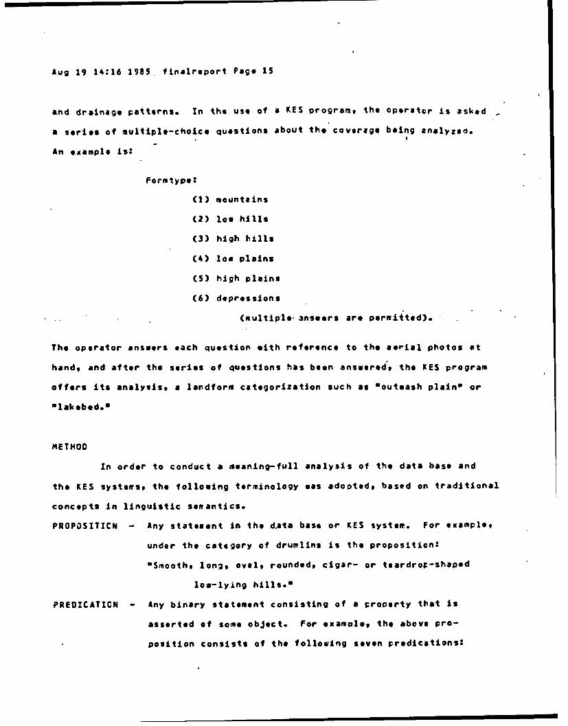
and drainage patterns. In the use of a KES program, the operator is asked -
a series of multiple-choice questions about the coverage being analyzed.
An example is:
Formtype:
(1) mountains
(2) low hills
(3) high hills
(4) low plains
(5) high plains
(6) depressions
(multiple, anseers are permitted),
The operator answers each question with reference to the aerial photos at
hand, and after the series of questions has been answered's the KES program
offers its analysis, a landform categorization such as "outeash plain' or
ulakebed.0
METHOD
In order to conduct a meaning-full analysis of the data base and
the KES systems, the following terminology was adopted, based on traditional
concepts In linguistic semantics.
PROPOSITICN - Any statenent in the d.ata base or KES system. For example,
under the category of drumlins is the proposition:
"Smooth, lon2 oval, rounded, cigar- or teardrop-shaped
low-lying hills."
PREDZCATICN - Any binary statement consisting of a property that is
asserted of some object. For examole, the above pro-
position consists of the following seven predications:

Aug 19 14:16 1985 finalreport Page 16
"The hills are smooths" "The hills are long," "The hills
are oval," "The hills are rounded," "The hills are cigar-
shaped," "The hills are teardrop-shaped." "The hills are
low-lyin;."
Since all of the predications that occur in the date base and the KES
programs take the form of adjectives, the term Oadjectivesm is used to
refer to the descriptors that are used to identify the properties in the
predications. Counting of adjectives is not equivalent to the counting of
predications, however, since one adjective can serve In more than one
predication. For example, under the category of basalt forms it is
asserted that there are "terraced hill slopes, canyon walls, and gorges.0
In this proposition, the si'ngle adjective "terraced" occurs'in three
predications, one about hill slopes, one about canyon walls, and one about
gorges. Thus, the number of predications in the data base should be greater
than the total number of propositions. Any one proposition can contain more
than one "chunk" or predication.
Note that not all propositions need to contain predications. For
example, under the category of glaciers, one proposition asserts that
"moraines are at the glacier edge." In this proposition, the presence
of a form is asserted and nothing is predicated of the form except for
its presence. Thus, not all of the propositions in the datm base contain
adjectives.
Armed with this terminology, one can perform a metning-full analysis
of a set of linguistic propositions such as those that occur In the terrain
analysis oata base or the KES programs. One can ask, How many predications
occur in the propositions?---in other words, how "dense" pre the propositions?
One can ask, How many adjectives are used in the propositions?---in other
aords, hot much relience is there on relativistic perceptual judgments, in

Aug 19 14:16 1985 finalreport Page 17
contrast with simple assertions about the presence or absence of features?
The terrain analysis data base and the KES systems mere analyzed
in terms of their number of propositions and predications. Freouency counts
were made of the occurrence of particular adjectives and particular generic
terms. Tie analysis was straight-formardt even though over a thousand
propositions and hundreds of generic terms and descrirtors sere involved.
For the next step in the analysis, the propositions and predications
were classified. The categorization which I relied on bears some resemblance
to the traditional classification of "pattern elements" used in terrain
analysis, however, my classification differs from it In some says since my
purpose was to develop a meaning-full categorization rather than to engage
in the kinds of. activities that terrain anaiysts engage in. In the tradi-
tional classifications features are classified into seven groups: tones
vegetation, drainage patterns, gully shapes, form or relief, land use, and
special features. The present analysis departed from this traditional
classification in some respects. First, the vegetation and land use
categories were ccmbined since propositions of the two types two usually
referred to vegetation or agriculture. Second, drainage patterns and gully
shapes were combined into one category since both refer to drainage.
Second, a category of soils was included since many of the propositions in
the data base referred specifically to soils. Third, a category called
"formation processes" was added since many of the procositions in the data
base referred to geological dynamics. For example, a proposition under the
heading of arid climate was "evaporation causes surficial mineral deposits,"
which refers to the processes which cause a form or feature. Fourth, the
traditional category of "special features" was re-named "associated impli-
cations." Examples of such entries in the database are: "arid climate
implies blocky hills and ridges" and "playas can include beach ridges." An

Aug 19 14:16 1985 finalreport Pago 18
implication can be a reference to any of the other types of feature (soils,
reliof tones, etc.). Since my purpose here sas to analyze the propositions
for their meaning content, an associatod implication In the data base was
counted as such* howoverp it was also counted as an instance of other cate-
gories depending on its content. For this reason, my category of associated
implications differs from the traditional cztegory of "special features.0
For example, the proposition warid climate implies blocky hills and ridges"
was counted as an associated implication and was also counted as a reference
to relief. Fifth and finally, a category called Olocation" was included
since a number of the propositions referred to the locations of various form-.
For example, an entry under the heading of outwash plains asserted that they
Roccur at the borders of gLacial forms.,
An example *xerpt from the data base mith indications of how its pro-
positions were scored is included in Table Z.
insert Table Z about here

Aug 14 09:00 1985 table2 Page I
7APLE 2
An example exerpt from the data base and an illustration of hcuthe propositions in it mere scored. The cate;ory of this entry gas*Terminal moraine.* Technically, the prorisition in lint 4 has no predi-
cations since it contains ko adjectives. Nevertheless, since all propo-sitions were scored for their content, the proposition in line 4 is cate-gorized under the predications column.
NUMBER OF NUMER OF NLMPER OF PREDICATIONOATA BASE ENTRY PROPOSIT13NS AIJECTIVES PREDICATIONS CArEGCY
---------------------------- ------------ -----------
Usually within a rolling 1 1 1 LRprarie.
UndulatinG, linear bands 1 2 2 Rof hills.
Small, concentric knobs, 1 2 Rridges, and deoressions.
Resulting from material 1 0 0 Fpushed ahead of glacieor.
Many pondst swamos, and 1 1 3 DIVhedgeross.
Oeranged drainage. 1 1
Narrow, deep V-gullys. 1 2 2 0
Rounded, steep ridges, 1 5 5 AvR9TvDvVSlight tones, saucergullys, forests implycoarse soils.
R= relief 7=tones LalocationOx dreinaga V-vegatation Fzformation processesAz associated implication S=soils
Aug 19 14:16 1985 firalreport Pase 19
RESULTS
TERRAIN ANALYSIS CATA BASE
The frequency counts for the terrain analysis data base are pro-
sented in Appendix 1 and Appendix 2. Appendix 1 shows the frequency of use
of each of 249 generic descriptors (adjectives) and Appendix 2 shows the
frequency of use of 99 generic teres.
The number of different adjectives used was 249, however this is
not the same as the total number of adjectives. That is, the number of
different adjectives used does not reflect the total number of predications
in which the adjectives appe.ared. The total number of adjectives is given
by the sum of the frequencies that appear in column in Appendix 1---1,695.
Since the total number of propositions in the data base was 19233i this
means t,,at there were about 1.37 adjectives per proposition. In other words,
each proposition tended to include more than one adjective. Some propositions
included no adjectives and some included as many as seven. An example of a
proposition with a relatively large number of adjectives is an entry under
the category of the schist rock type: "Long, deeo, parallel U- or V-shaped
gullys with light, banded tones.3 On the average, 2.51 different descriptor
adjectives were applied to each topic (249/99) and each topic was described
using an average total of 17.12 adjectives (1E95/99). In other words, each
generic adjective is typically used to describe more than one topic, and each
topic is typically described with a large number of adjectives.
Table 3 presents a breakdown of the predicaticns in terms of the
categorization. The total number of predications (1,525) is greater than
the total number of propositions (1,233) since a proposition could include
more than one predication, as explained above, and since predications in
the Oassociated implicationsO category were often counted in other categories

Aug 19 14:16 1985 finaireport Page 20
&S inch, depending upon their referentse
insert Table 3 about here

Aug 14 09:00 1985 tibl*3 Page I
TASLE 3
A categorization of the predications in 4otfsangs (1983) terrainanalysis aata base. The table seq8rete, orocositions which Includedadjective descriptors from those which did not (I.e., predications thatsimply assert the presence or absence of a form or feature). Entriesconsist of the nuiber and percentage of predications of each type.Since each proposition could contain more than one predication, thetotal number of predications given her* (the sum of the two totals columnsbelow, or 1,525) is greater than the total nunber of propositions (1,233).Furthermore, predicLti3ns in the "associated implicetionsO category werealso counted in other categories, denending on the nature of what wasimplicated (e..., an implication &,out soils, tones, etc.).
PREDICATIONS FROM PRECICATICNS FROMPRCPOSITIONS PROPOSITIONS
WITH AOJECTIVES WITHOUT A0JECTIVES
CATEGORY
(1) DRAIAGE 292 = 22.2Z 39 * 18.311
(2) TONES 136 10.371 2 a 0.94%
(3) VEETATION/ 181 13.793 17 a 7.982LANO USE
(4) RELIEF 401 * 30.569 59 a 27.69X
(5) SOILS 136 a 10.371 8 " 3.762
(6) FORMATION I a 0.53% 14 a 6.571PROCESSES
(7) ASSCCIATED 309 x 23.551 58 a 27.23%IPPLICATIGNS
(8) LOCATIONS 32 a 2.361 1 a 7.52
TOTAL 1312 213

Aug 19 14:16 1985 finalreport Page 21
Since there were 1,525 predicationst the average rumber of predica-
tions per proposition was 1.24 (l5Z5/1233)o Of the 1,233 Fropositions, 77
or 6.2Z contained no adjectives at all and 1156 or 93.76% contained at least
one adjective. it we compare the total number of adjectives to ths total
number of propositions which contained adjectives, we find that each predi-
cation-containing proposition had an average of 1.46 adjectives.
A final aspect of the results of the analysis of the data base
is the finding that a number of the generic terms and descriptors are
used In both adjectival and noun form. A listing of all those terms
which also occur in adjectival form is included here in Table 4.
insert Table 4 about here
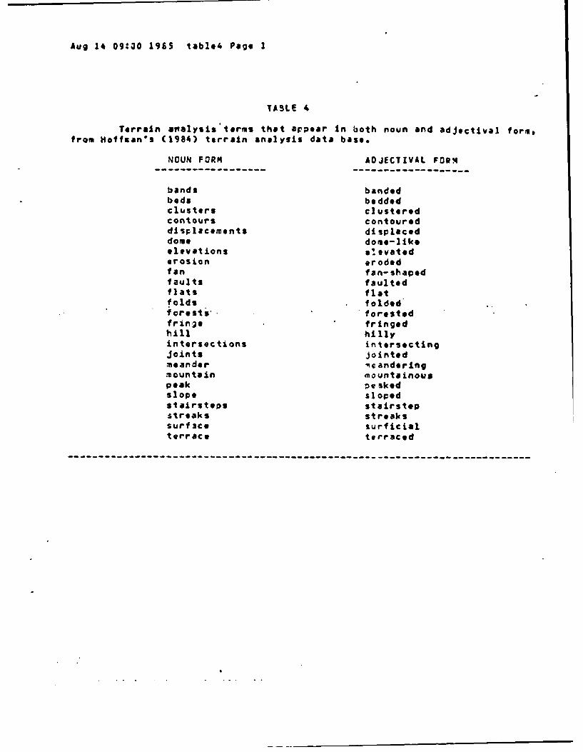
Aug 14 09:00 1965 tabl*4 Page I
TABLE 4
Terrain ainalysis'lors that appear In both noun and adjectival form,from Hoffman's (1984) terrain analysis data base.
NOUN FORM ADJECTIVAL FORM----------------------------- -------------------
bands bandedbeds beddedclusters clusteredcontours contoureddisplacements displaceddome dome-like,elevat ions e'. vatederosion erodedfan fan-shapedfaults faultedflats flatf olds folded'forests- forestedfringe fringedhill hillyintersections intersectingjoints jointedmeander me anderingmountain mountainouspeak peaekedslope sloapedstairsteps stairstepstreaks streakssurf~ct surficialterrace terraced

Aug 19 14:16 1985 finaireport Page 22
KES PROGRAMS
The UES programs sere analyzed In a fashion similar to that used
for the data bass, i.e., adjectives and their frequencies were counted #nd
categorized.
Table 5 presents the results of the frouencr analysis for the KES
programs end Table 6 presents a categorization of the predications. Unlike
the data baseo for the KES programs the total number of propositions IS equal
to the total number of predications, since the propositions in the UES pro-
grams were expressed as simple predications in the questions which the KES
programs presented to the user. Hence, the total* row in Table 6 has the
same entries as the column in Table 5 labeled "total number of tradicatpr.ft
Only a fet propositionis in the U.S programs contained no adjectives.
insert Tables 5 and 6 about hero

Aug 14 09:01 1965 tables Page 1
TABLE 5
Analysis of the freouency of predicates (adjectives) In KES terrainanalysis files. Each KES'file, when executed, asks the user a series ofbetween seven and nine qjestxons and from the answers determines the typeof landform tiat is being analyzed. Thus, tthe number of categories in aKES file equalS one (landform tyoe) plus the number of questions.
RANGE OF AVERAGE NUMBER
NUV*ER OF TOTAL NU'FR PREDICATES OF PREDICATESCATEGORIES OF PREDICATES PER CATEGORY PER CATEGORY
--------------------- --------------- --------------- ---------------SOURCE FILE
(1) GLACIAL 8 29 0 - 8 3.63
FORMS
(2) DUNES 7 26 2 - 9 3.71
(3) GULLYS 8 26 2 - s 3.25
(4) ORAINAGE 7 39 3 - 8 5.57PATTERNS
(5) METAMCRPHIC 10 49 0 - 9 4.90RCCK
(6) SEOIEN1ARY 10 56 2 - 10 5.60ROCK
(7) IGNEOUS 10 74 1 - 18 7.40ROCK
(8) FLUVIAL 10 67 3 - 13 6.70FORMS
OVEPALL AVERAGES 9.75 45.75 1.6 - 10 5.09

Aug 14 09:01 1985 table6 Page 1
TG.LE 6
Analysis of the frequency of predications (adjectives) in KES terrafnanalysis files as a function of the category of the predications. Entriesconsist of the frequency.and percentage of predications of each of eightcategories. Empty-cells are those with a frequency Of zero. The total fre-
quencies at the bott3m of th* toble correspond with t e efntries in thesecond column of Table S.
CAT SOURCE KES FILEEG GLAC. CAXN. META* SEC. IGN. FLUVIAL0 FORMS OUNES GULLYS PATT. ROCK ROCK ROCK FORMSRY
ORAIN. 6 23 14 21 2Z20.7% 46.9t 25% 31.1t 32.8%
TO4eS 9 8 1 93'0 3.32 16.3 1Z.5 12.1% 11.9%
VEGET. 9 5 4 3 1030t 10.2% 7.12 4.12 14.9:
RELIEF 5 25 20 39 13 29 33 2117.2: 96.12 76.9: loot 26.51 51.8% 45.6t 31.32
SOrLS 3 111.52 1.49%
FCRM. IPROC. 3.92
ASSOC. 2 6 SIMPLI. 3.62 8.1Z T.S
LOCA. 1 1
3.9% 3.9%
TOTALS 29 26 26 39 49 56 74 67
-- - -- - - -- - - -- - - -- |-- - - -- -|-- - - -- - -- - - -- - - -- - -

Aug 19 14:16 1985 finalreport Page 23
One slight departure had to be made from the method of analysis
used for the data base. A number of the KES programs included cuestions
about "special featuresq! and a number of them did not. Some but not all
of them had propositions of the type I refer to as "associated implications.a
In order to allow comparison of tie KES programs and lh. data base in terms
of their reliance on associated itMpliC3tionsq propositions that the KES
author(s) included as 'special features" sere counted here as references
to reliefs tones, or ehatever, deFending on their referents (e.g., listing
*round hills" as a special feature of sedimentary rocks was counted here as
a reference to relief). Only propositions that referred to c1imatological
variations or to the simple presence or absence of associated forms were
included tere in the category.of *associated implications.' For example,
the statement that Obuffalo walloss' occur in fluvial forms-and the statement
that various fluvial forms occur in a humid climate mere counted here as
associated implications.
DISCUSSION OF THE RESULTS
TERRAIN AKALYSIS DATA BASE
Aralysis of the data base yielded a large corpus of generic terms
and descriptors, including a listing of which descriptors get arplied to
which terws, and how often. The listings presented in Appendix I and
Appendix 2 are more than just representative of the literature on terrain
analysis and ;hotointerpretation .a. they are no doubt close to an exhaus-
tive listing of the generic terms and descriptors. Thus, the Appendixes
provide a good starting point for any attempt to defire the generic terms and
descriptors (as I shall do In a later section of this report).

Aug 19 14:16 1985 finalreport Page 24
By far, most of the propositions and predications in the data base
rely on adjectival descriptors, thus verifying the hypothesis that generic
desciptors are relied on heavily in terrain analysis. Of the 1,525 predi-
cationst 1,312 relied on adjectives. Of the 19233 prepositions, only
6.2 percent included no adjectives at all. These adjective-free propositions
tended to be references to relief (e.g., hills have relief less than 300
meters; an outwash plain can be a terrace), to drainage (e.g., in a till
plain, drainage patterns are controlled by the underlying rock), and to
associated implications that simply assert the presence of a form or feature
(e.g., ponds are present in outwash plains).
Comparing the percentages of predications of each type across the
propositions that contained adjectives and those that did not, one can see
some overall agreement. Since it is hard to refar to tones without using
adjectives, the number of adjective-free predications that refer to tones
is very small. Conversely, it is easy to refer to formation processes
without using adjectives, so the percenlage of predications in this
category is greater for the adjective-free predications. With regard
to the other six categories of predications, there appears to be some overall
concordance in the percentage of predications of each type across the two
types of propositions, as inspection of Table 3 reveals (for example, 302
of the relief-related predications with adjectives and abeut 28? of the relief
related predications sithout adjectives).
Tto propositions in the data base range from being very dense
(i.e., containing a number of preications and adjectives) to being very
simple (i.e., simply asserting the presence of a form). On the average,
each proposition contains 1 to 2 predications and I to 2 adjectives.
Each different adjective can be applied to many different terms
and each term can get predicated by many different adjectives. For example,

Aug 19 14:16 1985 finalreport Page ZS
the adjective Oflat" gets applied to 12 different forms (deltas, plains,
ridges, etc.) in Appendix 1. The term Ohilla gets described by 37 different
adjectives (conical, long, rugged, etc.) In Arpendix 2. On the average,
each different adjective is applied to 17 terms and each term is described
using 2.5 different adjectives. Any proposed definition for a term must
work when the term is modified by each of the applicable descriptors. Con-
verselyt any proposed definition for a descriptor must work when applied to
any applicable term. Thus, the definition for "hill* must work even when
the hills in question are blocky, bold, jointed, knobby, etc. The definition
of 0"flatO must work when it is applied to ridges, plainso etc. Coming up with
definitions that satisfy these mutual constraints will no doubt be difficult.
The effort can be lessined so'mewhat (but not mukh) by avoiding the use of
words that appear as both adjectives (descriptors) and terms (nouns) (I.e.#
the terms shon in Table 4).
Axbiguity arises not only when a term appears both In adjectival and
noun form, but also when a term is used with wore than one meaning. The
best example of this is the uses in the data base (and in terrain analysis in
general) of the term Orelief.g It is used to refer to a general description
of a region (as in the phrases "gentle relief8), that is, it is used
interchangably with the terms "land," "topograpl'y9" and Oterrain." The
other meaning of relief is a specific reference to the relief metrice that
is, the difference in elevation between the loaest and highest points of a
terrain form. Certainly any attempt to systewatically define and use generic
topographic terms and descriptors will have to avoid such ambiguities by using
various terms in a consistent fashion.
The categorization of the predications in the data base reveals
somethin; interesting about the traditional pattern element called "srecial
features.* In the present analysiss propositions that are ordinarily

Aug 19 14:16 1985 finalreport Page 26
referred to as special features gore counted as associated Implications and
were also counted in the other categoriest deponding on the nature of their
referents. The fact that the percentage of such propositions (309 or 231)
was higher than any other category except for relief indicates that the
*catch-allO category of special features as traditionally may not afford
much power in discriminating aspects of terrain. Rathert it is the specific
mwaning content of various "special features" that is what is ieportant.
Certainly* each landform or terrain type will have certain "special" features
associated with it. However, these special features are special not just
because they are associated with certain forms, but because they refer to
such things as relief, tones, otc., and thereby refer to perceptible qualities.
The one category of predications that was relatively low in fre-
quency was the category of Oformation processes." This is to be expected
since it cas not the purpose of the data base to explain the formation of
landforms. This task is part of the *explanation" cowponent of an expert
system rather than its data base. Clearly, a great deal of information
will have to be included in the explanation component of an aerial photo
interpretation expert system end the information about formation processes
that is included in the data base only scratches the surface.
THE KES PROGRAMS
The analysis of the KES programs also reveals something interesting
a the traditional categories of "pattern elements." A nuwber ol the
cells in Table 5 are blank# indicating that none of the propositions in a
given KES program fell into those categories. This is interesting because
Way (1978)9 the source for the information used to build the prcgramst places
great emphasis on analysis of each pattern element for every landform.

Aug 19 14:16 1985 finalreport Page 27
Ind~oe the present results suggest that different pattern elements are Sort
Or less iwrportant In th. analysis of a Given type of landform and they shOul'd
not be givien equal weight, as Is traditionally 'the caSe Perhaps more
analyses like the present one, could be used to derive and assign such weights
* for various landforms and terrain types. Such weights would assert that for a
given landform or terrain types one or another pattern element should be given
more or loss weight than other elements.
The eight KES programs nere, developed by different researchers, and
yet each programmer found It necessary to ask the user 7 or 8 questions in
order to determine the classification of the forms being analyzed. Even
though my attempts to use the KIS programs with various aerial photos en-
countered problems when the features in the ph~otos did not precisely watch'the
features listed in the KES-provided questions, this common reliance on only
seven or eight questions suggests that this nu.mber of questions is sufficient
for classification purposes. Here, th~e results of the present analysis fit
with the traditional practices of terrain analysis, that Is* the use of the
seven "pattern elements." Although for any given KES program tht questions
do not necessarily refer to exactly the seven traditicnal pattern elements,
the KES programs to tend to ask seven or so questions. This suggests that
seven may be a lower limit on the number of questions needed to categorize
landforms.
COMiPARISON OF THE DATA BASE ANO TH4E KES PROGRAM4S
The KES, programs involved a total of 119 different adjectives.
of these, 103 appeared in the data base. Thus, the KES programs included
16 adjectives that ere not included In the data base. In most cases,
equivalent terms could be found, however, For example, the KES toe
"black tones" corresponded sith tie, data base term, adark tones." The

Aug 19 14:16 1985 finalreport Page 28
KES term, "soft hillsO corresponded with the data base cescriptor, agentle
relief." Of the 366 adjective4 in te KES programst only a handful had abso-
lutely no correspondirg adjective in the data base (i.e., "mixed tones,"
"abandoned gullys," "coalescing fans" and "complex shapes*). One can Safely
conclude that the two fferent sources, the data base and the KES files,
relied on essentially the same set of generic terms and descriptors. This
is to be expected since they came from the same sources. Development of the
KES programs relied almost exclusively on the text by Way (1978) which was
also a major source of information for the data base.
GENERIC TOPOGRAPHIC TERMS AND THEIR MEANINGS
Tie discussion up to this p~int has set the stage for an attempt
to specify some of the meanings of generic terms and descriptors. I began
aith the lypothesis that generic terminology %as relied upon heavily In the
literature on terrain analysis, and this hypothesis was bcrne out hy the
analysis of the data base and the KES programs. That analysis yielded a
cataloging of various generic terms and descriptorst a cataloging that
can be the starting point for an attempt to defir,. the terms.
The method I used for analyzing the data base and the KES programs
can work as a general metiod for deriving definitions of generic topographic
terms and descriptors. In order to derive a definition for a given descriptor
(adjective) or a given topic (term), one needs to pair each adjective with
-.ach of its topics (in Appendix 1) to see if the candidate definition works
across topics. Alsot one needs to pair each term with all of the adjectives
that are applied to it (in Appendix 2) to see if the candidate definition fcr

Aug 19 14:16 1985 finalreport PaGe 29
the term ,orks across adjectives.
This &as the approach I took. What follows is a set of definitions
and some commTentary on them. I begin at the most general lovel, with terms
and metrics that describe relief. These basic concepts are then used in the
definitions of generic terms and descriptors that appear in Appendix I and
Appendix 2. Each definition relies on definitions that came before.
SOME ASSUVPTICNS ABOUT PERCEPTION
It is assumed in the following discussion, as it is in the
literature on terrain analysis and geomorphology, that only a few 'slices"
of a terrain foim are Svffic'jent to capture the important features of the
form. This assumption may or may not be an obvious one. Nonetheless,
some justification for it should be sought. Ctherwiset we might proceed
to define generic topographic terns using such diagrams as those shown in
Figure 1, when such 'slices' way not be sufficient.
A justification for this assumption can be found in an analysis of
pereption. In the Introduction I made the claim that definitions of generic
terms and descriptors can be derived si-ice generic terminology is used con-
sistently by various terrain analysts. Their perceptions must be similar, and
hence, there must be sufficient information in the opti- array (and therefore
in stereo aerial photos as well) to specify those perceptions.
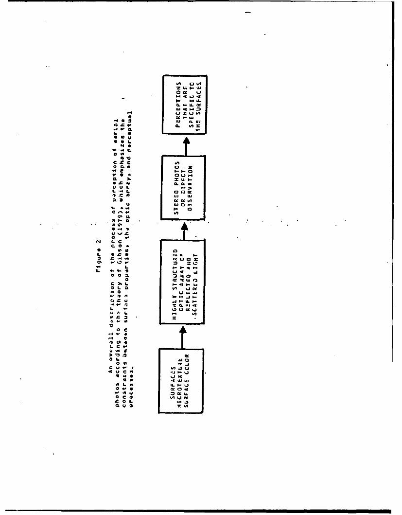
Surfaces, their orientations, their ficrotexturel and their surface
colors all ado structure to the ambient light (Gibson, 1979). The light thus
contains information that is specific to the terrain. The information tnat
is available in the optic array that allows for the perception of such aspects
as "blockinoss" and 'plateauness' pervades the landforms. The information
that is available is specific to surfaces, not to individual points or 'rays"
of light. Perception is of surface properties, occluding edges, and varia-

Aug 19 14:16 1385 finaireport Pal. 30
tions in surface properties. The dependencies as I have outlined them are
illustrated in Figure 2.
Insert Figure 2 about here
b,4 ox1
0- iua w " =0,.1-u.
u . tj ,)
4 C.. 02 tu o- Ui
0 #A
I a[
* Wg
S4a
cc ti 44,Q. -0. l
O U . b.t
r. 4uJ WJ
J UJOm
9 . *."4 L 1
;:~ ~ ~~l 0ks ,- )-'L
ofq. F u-
0' UAA
.V 0 _L 6-
u I p- IL p-I
U es
inoa
* c
L 0
Oa
fI UC
+0 0 fWh
A9 M 09 .I. a &
L CL %
Aug 19 14:16 1985 finalreport Page 31
Cne implication of this reasoning about 6ecological optics" by
psychologist James Gibson Is that tho perception of such aspects as Nblocki-
ness* is not layers of inference deep in the cognitive process. Indeed* by
this l1no of raa:=ringq perception is direct and requires no levels of
inference or computation. The labeling process of saying that a terrain
form looks blocky requires matching or the recognition of concepts. H~omver,
the perceptual act itself of seeing the terrain Is direct in that the infor-
mation available in the optic array directly specifies the terrain.
It is easy to perceive blockiness or ruggedness. So too, it is
easy for terrain analysts to consistently decide when descriptors such as
Oblocky" or "rugged" apply. Therefore, it might not be as difficult as
one might suppose to come up with descriptions of surfaces in sufficient
detail to give a topographic specification of the meanings of generic
descriptors.
In contrast with this line of reasoning, one might begin with the
fact that hills and other terrain forms are very complex three-dimensional
things. Shouldn't it be necessary to use highly complex topological equa-
tionst or even fractalst so that so can build a complete model of terrain and
thereby define such features as blockiness? There are two sides to this
question. One is, Is a partial description of terrain forms sufficient?
The other is, Sufficient for &hat purposes?
Certainly terrain forms can range fro the geometrically simple
(eg., a drumlin as a truncated inclined cylinder) to the georetrically
complex (e.g., a highly dissected mountain range where one mountaines
slopes blend imperceptibly into the next wountaines slopes). However,
6ibson's theory of perception suggests that it is not necessary to generate
a Complete topological description of terrain forms in order to define
generic descriptors. The information that is available in the optic array

Aug I 14:16 1985 finalreport Page 32
*pervadesO the landforms. Only a fle 8slices" of a terrain form are needed
to describe the surfaces of a terrain form In sufficient detail to determine
whether such concepts as hills, plateaus, blocky, or rugged apply. Since
the surfaces In the terrain serve to structure the ambient optic arraV, the
surface information ttat allots for perception of such properties as blocki-
ness Is the same Information that allows topographers to describe terrain
sufficiently in terms of a few •slicas" of the surfaces. To determine that a
hill is rugged and highly dissected, one need not compute the total three-
dimensional shape.
I am now in a position to begin a presentation of some definiti$ons
of generic topographic terms and descriptors, and start off at the most
general levol, that of relief. As the presentation proceeds, 46 Reacer will
see that later definitions rely on the earlier ones. The Reader will also see
that some of the definitions presented her* are Ostandardm in the literature
on terrain analysis and tcpography (e.g. the definition of degrees of slope).
In all cases, the definitions were derived by first seeing whether definitions
were offered in reference works on terrain analysis (i.e.* those cited in
the IntroCuction to this Report). In some cases, the literature afforded
partial dafinitions, and these were refined and expanded upon here.
BASIC RELIEF TERMINOLCGY
The first terms to define are those that fall at the Rost basic level
of doscriction:
SURFACE: The planar interface of the terrain and the air. The surface can be
divided into surfaces.
COVERAGE: The set of all surfaces represented in a particulor map or photo.
AREA: Any subset of adjacent surfaces In a coverage.

Aug 19 14:16 1985 finalreport Page 33
ELEVATION: The height of a pcint on a surface relative to the lowest point
on the surface, or In the coverage or in an area.
RELIEF: Relative elevation* or the difference between the highest and lanest
points on a surface, or in the coverage or in the area.
SLOPE: Tie angle of a surface relative to the horizontal plane, or the
change in extent between two points on the surface divided by the
change in elevation across the two same points.
The next set of terms to define are those that deal with the observeres
perspective on the surfaces:
ANGLE OF REGARD: The perspective from which a surface is viewed.
AERIAL ANGLE OF REGARD:' Viewing a surface from the aerial persrective, that
is, gaze direction is downward In the vertical
plane.
TERRESTRIAL ANGLE OF REG&RO: Viesing a surface from the ;erspective of some-
one who is on the surface and directing their
gaze horizontally.
Having defined these vost basic terms, I can now define the "slices* that
will be used to describe terrain surfaces:
CONTOUR: The outline formed by the intersection of a horizontal plane and
the areal surface, where the plane is perpendicular to an
aerial angle of regard and parallel to a terrestrial angle
of regard.
CROSS-SECTION: The outline formed by the intersection of a vertical plane
and the areal surface, where the plane is parallel to a
terrestrial angle of regard.
PROFILE: The outline formed by the intersection of a vertical plane of
and the areal surface, here the plane is perpendicular to
a terrestrial an~le of regard.
Aug 19 14:16 1985 finalreport Page 34
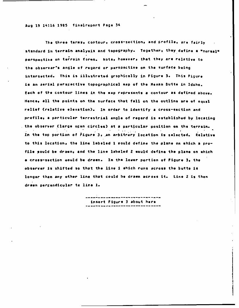
The three terms, contour, cross-sectiont and profile, are fairly
standard In terrain analysis and topography. Together, they define a "normal*
perspective on torrain forms. Note, however, that they are relative to
the observer's angle of regard or perspective on the surface being
intersected. This is illustrated gr3phically in Figure 3. This Figure
is an aerial perspective topographical map of the Menan Butte in Idaho.
Each of tie contour lines in the map represents a contour as defined above.
Hence, all the points on the surface that fall on the outline are of equal
relief (relative elevation). In order to identify a cross-section and
proftle, a particular terrestrial angle of regard is established by locating
the observer (large open circles) at a particular position on the terrain.
In the top portion of tigure 3, an arbitrary location Is selected. Relative
to this location, the line labeled 1 would define the plane on which a pro-
file mould be drawn, and the line labeled Z would define the plane on which
a cross-section would be drawn. In the lower portion of Figure 3, the
observer Is shifted so that the line I which runs across the butte is
longer than any other line that could be drawn across It. Line Z is then
drawn perpendicular to line 1.
insert Figure 3 about here

FIGURE 3
An 11justr-4tiof of 1936 the Positioning Of the Planes for Cross-
itctiofls end crofile5 is reittive to the pngle of rt~frd tahem by the
observer. These eaerpts Iroms a tOPO~t)FtIcal Int shoe a butte, an twie.uIle
of a for-% whove boundiries zro f3irly distinct. In tUe toP Portion, an
arbitrary positionl for the oasorvt'- is seiectei. In the loirr portion, thl
location of the observer is S1tilted Such that the profile Plate (defined by
line 1) is maximized in length. The cross:-Section ClineO is defined lay line, 2
and is perpendicular to line I.
01 0

Aug 19 14:16 1985 finalreport Page 35
Positioning the observar and the lines of intersection such that the
plane of the profile is maximized in length represents the Onorwal m perspec-
tive. Establishing this perspective requires that the boundaries between
forms are definable, and this sometimes is a difficult prerequisite to meet.
Zn practices this may not matter such since, as indicated above, just about
any handfull of slices should be sufficient to allow a description of a given
form. Indeedt the more complex the form, and the less discernabl, its
boundaries, the less it should matter how the observer Is oriented. This is
illustrated in Figure 49 shich is of a contour map of highly dissected
plateaus in Arizona. The forms In this region blend almost imperceptibly
into one another. Even sot it seems to be possible to-orient the observer
in such a way as to establish a "normal* persectivefor profiles and cross-
sections.
insert Figure 4 about here
- ---- - - - --- - - - - - - - - - - - -- - - -mm

FISURE 4
&n illus tral icn of the "norrial "pe rspective f or a f orm a hoseboundaries are indistinct. This *xerpt is from a topcgrachic map shoeinghighly dissected p-lateaus. tiote that the norrmal persrective for the twoplateaus reQuires a different location for the observer, since the majoraxes of tie two plateaus.are In different orientations.

Aug 19 14:16 1985 finalreport Page 36
Having defined these three Oslices 0 can not defIne other concepts
that are used to describe terrain surfaces.
CONVEX: A sloped surface for which a profile or cross-section contains an
increase of relief toward the center of the plane of intersection
and a decrease of relief tosard at least one of the the margins
of the plane of intersectiont when the plane is centered on the
elevation maximum.
CONCAVE: A sloped surface for which a profile or cross-section contains a
decrease of relief toward the center of the plane of intersection
and an increase of relief toward at least one of the the margins
of th !q plane of intersection, when the plake Is centered on the
elevation minimum.
Having defined these basic terms to be used in describing terrain
surfaces, I can now move on to defining terms and concepts tha* involve the
uscalingu of differences In surfaces.
RELIEF SCALAR
GENTLE RELIEF: Difference of between zero and 100 meters in the
relief of points within an area.
MEDERATE RELIEF: Cifference of between 100 and 300 meters in the
relief of points within an area.
STRONG RELIEF: Difference of greater than 30C meters in the relief
of points within an area.
SLOPE SCALAR
HCRIZC4TAL SLCPE: Slope of approximately zero percent.
VERY GENTLE SLOPE: Slope of between zero and five percent.
GENTLE SLOPE: Slope of between 5 and 15 percent.
MCDERATE SLOPE: Slope of between 15 and 40 percent.

Aug 19 14:16 1985 finalreport Page 37
STEEP SLOPE: Slope of betseen 40 and 60 percent.
VERY STEEP SLCPE: Slope of between 60 percent up to vertical.
The above tao scalars are a traditional part of terrain analysis and topo-
graphy. Powevert they appear to be insufficient for providing a full
picture of the appearence of terrain, and hence insufficient for the
definition of generic topographic terms. For this reasonp I found it
necessary to look beyond these available scalars.
Wat is needad is a means for describing the variability of slopes
both within a particular form and across various forms within an area. I
could find in the literature only one such scalar, which goes by various
names and which I refer to as the Slope Change Index, or SC!. To determin-
the SC! one counts the* number of slopes with a positive sign (i.e., the
slopes are going up as one moves across the terrain) and the number of slopes
with a neGative sign (i.e., the slopes are going down as one moves across
the terrain). The sum of these two 3ives the SCI, and is an index of the
number of deflections in slope as one moves across forms. This is illustrated
in Figure 5.
---- nsert--igure-5-a-out-insert figure 5 about here

FIGURE
IILustration of th,, Slope Change Index, 2r the number of times tneslope changes sign fro. pcsitive to ne ativG. Capital N represents thecounting function. Tho diagrem could be a cro'ss-section or a profile.
GOING UP
1 _____GOING OWN
xI x2 x3 x4
II I40I I I

Aug 19 14:16 1985 finaireport Page 38
The major problem with this scalar is that it yields a Value c7 :Zero
for slopes that vary and-yot that have no deflection Faints*' Thus, a mountain
with very steep slopes and a 1till with smooth slopes aould have the same SCI
vn though the slopes on the hill tight be more variable (.g., a steep crest
region, a less steep side, and a flarsd base). This Is illustrated in Figure
6. The SCI is able to discriminate between the two "tough casoSO but is unabe
to discriminate between the clear cases and their corres.ponling tough cases.
insert Figure 6 about nere

FIGLRE
An illustration of the Slooce ChrmSe Ir'e of slope variability.Note that the SCI can discri.ainate hetisen the too Oteugh casestw but cennotdiscriainate each toughcase from its corres.,cnditng clear case.
(1) CLEAR CASE OF A SINGLE FORMI
ALL SLOPES NEGATIVE
SCI - 0
(2) "TOUGH CASE" OF A SINGLE FORM
ALL SLOPES NEGATIVE
SCI - 0
(3) "TOUGH CASE" OF TWO FORMS
ONE POSITIVE SLOPE
SCI - 1
(4) CLEAR CASE OF TWO FORMS
ONE POSITIVE SLOPE
SCI - 1

Lug i9 14:16 1985 /inalrecort Page 39
Since the SCI is unable to discriminate between the clear cases and
their corresponding tough cases, I sont in search of additional scalars
that might be of use in describing the variability of relief'in such a way
as to make further discriminations. The metric called relief involves col-
paring surfaces only in terms of the elevations of two pointst the highest
and the lcwest. What if new metrics are defined which involve more fine-
grained analysis and which involve various transformations of the raw
elevations other than a single difference?
One possibility that comes to mind immediately Is the concept of
a slopes the angle of a surfaca. This angle is computed as the ratio of
the differences in values on the two coordinates of a slice (cross-section
or profile). Whiat if the slojes Iat'various points arong a surface were
calculated and these values compared? For most formst they would differ.
For many areast the values would differ across forms. Can some metric be
devised to capture this variability?
That very sord, variability, is the key. The statistical concept
of the "variances is a very useful tool in descriptive and inferential
statistics. The variance is a measure of the degree to which a set of numbers
deviates from its own average value. First one computes the average. Then
each of the numbers in tne sat is subtracted from the average and the resultin;
value is squared (the arithmatic-al mean is like a "balance point" and if one
does not square the differences, they would sum to zero, for any set of
numbers). The squared values are next summed and the result is divided by the
number of numbers involved. The result, the variance, is a kind of aver3ge,
the average degree to which a set of numbers 0scatter° or differ from their
own average. Calculation and use of the variance is a basic part of statistics
and is illustrated in all statistics texts (e.g., Mood, et al., 1974).
One could compute the variance of the slopes, that is, the average

Aug 19 14:16 1905 finalreport Page 40
of the squares of the deviations of the slopes about their mean slop@.
This Is illustrated in Figure 7. The Slope Variance could take on any pos-
itive value from zero (for a flat plane) onward, expressinlg the degree of
variability of the slopes.
insert Figure 7 about here

F GUPE7
:lJustrotion of It- co'irJtatiOn of the Slope Varience. The diatram
represents a cross-sectiOn. Sloces Jould soe cmiuted for the right and left
6alvas of the cross-section, similar to the formulas shown here for the ri2ht
hnaf. Six slopes mould also be computed for .a profile. Tto letter € stends
for components (right and left halves, crests side ano base). S-sub y
reoresents a s5pe an 'the y-axis (uidth or cross-section) and S-iLu) i rep-
represents a slope on the x-axis (length or orofile). The mean slop, for 2
form would be the sus of all 12 comonant slopes divided by 12. The Slope
Variance is the average of the scuares of the deviations of each of the 1Z
slopes from their mean.
% =3__CEST3
z2
0 0
MSIDE
~BASE
7Y Y2 73 Y 4
WIDTH (y-axls)
CROSS-SECTION RIGHT CREST SLOPE --
CROSS-SECTION RIGHT SIDE SLOPE -b %-%
CROSS-SECTION RIGHT BASE SLOPE 4 : s
MEAN SLOPE 7j (s $)
SLOPE VARIANCE Y
T~¢at
V2.

Aug 19 14:16 1985 finalreport Page 41
Togother, the Slope Variance and the SC! augment our ability to
describe terrain surfaces since they make up for each other'S deficiencies.
8oth the SC! and the Slope Variance would yield a value of zero when a
single, urvarying surface is described. For such surfacest the concepts of
surface and slope would be sufficient for descriptive purposes. The Slope
Variance has an advantage over the SCI in that the Slope Variance will
discriminate cases that the SC! will not. The SC! gives a value of zero
for any slope that varies without changing sign. For such slopest the
Slope Variance would yield numbers whose magnitude is in proportion to the
degree of variability. Referring back to Figure 69 the Slope Variance
would discriminat* each. tough case from:its Corresponding clear case. For
case (1) the Slope Variance would be less than for case (2)9 for case (3)
tho Slope Variance would be less than for case (4). The Slope Variance is
sensitive to the magnitude of change across three negative slopest or across
one positive and two negative slopes.
In contrast, the SC! has an advantage over the Slope Variance. Con-
sider a "sautoothr form in which there are rereating crests with equal slopes
between tiem. As the number of such crests being counted increasest the SC!
would keep on increasing. Hosevar, since the alternating ascending and de-
scending slopes are all eaual, the Slope Variance would remain constant.
The SC! does not apply to individual forms that have no slope changes, such as
a urollingm plain. Unlike the Slope Change Index, the Slope variance would
apply to all individual forms as well as to areas. 7hus, the SCI and Slope
Variance augment each other's descriptive powers.
Ttis line of reasoning about the utility of variability metrics can
be taken yet another step further. The res elevation data can also be entered
into a calculation of the skew and kurtosis of a profile or cross-section.
Aug 19 14:16 1985 finalreport Page 42
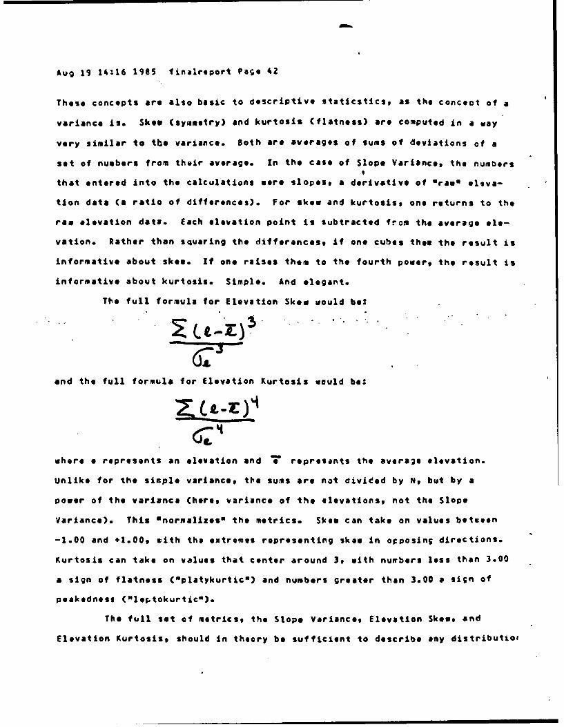
These concepts are also basic to descriptive staticstics, as the concoct of a
variance is. Skew (symmetry) and kurtosis (flatness) are computed in a way
very similar to the variance. Both are averages of sums of deviations of a
set of numbers from their average. In the case of Slope Variance, the numbers9
that entered into the calculations mere slopes, a derivative of wraam eleva-
tion data (a ratio of differences). For skew and kurtosisp one returns to the
raw elevation data. Each elevation point is subtracted from the average ele-
vation. Rather than squaring the differancest If one cubes then the result is
informative about skee. If on* raises them to the fourth powers the result is
informative about kurtosis. Simple. And elegant.
The full formula for Elevation Skew would be:
and the full formula for Elevation Kurtosis would be:
where o represents an elevation and 7 represents the average elevation.
Unlike for the sixple variance, the sums are not divided by N, but by a
power of the variance (here, variance of the elevationst not the Slope
variance). This Onormalizes" the metrics. Skew can take on values between
-1.00 and +l.009 mith the extremes representing skew in orposing directions.
Kurtosis can take on values that center around 3, with numbers less than 3.00
a sign of flatness (Cplatykurticm) and numbers greater than 3.00 a si;n of
peakedness ("1e5tokurtic").
The full set of metrics, the Slope Variances Elevation Skew, and
Elevation Kurtosis, should In theory be sufficient to describe any distributiol

Aug 19 14:16 1985 finalreport Pa; 43
of elevations exactly (since the three basic Omorentsg or deviations about
the average are sufficient to describe any distribution of numbers CMood,
et al., 19743). They are illustrated in Figure 8,
----------- ----------------------insert Figure I about here
-----------------------------

c I PUR~ E
*n illustration of Slop# varianca, kurtogss and skew.
StWo! vARiAIc!
smoothn 3.00e
lowosi vallues.0
urtois value eethan 3.00
Pinnvauclloe o er
hill. kurool valun3.0
ngatisvle lhosaes

Aug 19 14:16 1985 flinalreport Page 44
(I should point out parenthetically that the traditional distinction
between a hill and a mountain as a difference In relief confounds increasing
relief with increasing volume Cmass~o Hills are of laer elevation, but one
can Increase elevation mithout getting a mountain: If the volume is constant
one would got a pinnacle.)
Just and the SCI and the Slope Variance complement each othor, so too
do the Slope Variance* Elevation Skew and Elevation Kurtosts metrics complemen'
each other. Various combinations of levels of each of these three metrics
are illustrated In Figure 9.
insert Figure 9 about here

T%.o v&rious CCmtbnaiicnS of levels of slopa variance, skes, ardkurtosis. For the matrix comparing slop* variance and skew, kurtosis
as set at #t a non-kurtotic values wlking the forms hills rather than
oinnacles or founds. FOr th.e zatrlx cow-erinq skes and kurtosis, slop,variance &as set £t a jo level, making all the form$ smooth. For t e
matrix comparing slope vari&nca and kurtosist skw was set at Zero, moking
all tha fcrms syinatrical. The fourth w.trix illustrates forms that
fall at the extremes of sloue variance, skew ano kurtosts.
MUMOISHIMS SKIV Lw
tuggsd. sym metical Suxqed4. Symetcal Smooth, asymmttical Smooth, asy)mmtticalhill hill pinnacl
e sound
io NICE
gooothi asymmetrical Smooth. uSymmerical smooth, Symecrical Smooth, symatrcalhill hill pinnacle sound
L.|
KU1TOSTS
Symetrical, rugged Symetrical, rgUedpinnacle sound
Rica SMRica G StOWlE VAIIA14CI
DIGE llIca KITOSIS
Asymetrical, ru pedpinnacle
SLOPIVAR.AMA3 Symetrical. smooth Symmtric*l. smooth
pinnacle ound
WU SKEWLOV SL0S VARIA14CE
LOW LOW KUITOSISLWl
ISystrical, smooth
0 ,s IIIou n d

Aug 19 14:16 1985 firalreport Pace 45
Note that for all of the forms illustrated in Figure 8 and all
those Illustrated In Figure 9, the SCI would yield the same value (l..,
1). This is not to say that the three variability aetrics replace the
SCI. The Elevation Skew and Kurtosis metrics apply to individual for*$
and the SCI and Slope Variance apply to regions as 6011 as to individual
forms. Each of the metricst the SC?, the Slope Variance, Elevation Skew, and
elevation Kurtosise discriminates some aspect of the variability of relief.
Together* they offer a powerful set of tools since-each one makes up for one
or another daficiency in the others. This Is Illustrated In Table 7.
insert Table 7 about here• . "T." "---eeeeeeeeeeeeeeeeee-- ---.-."-".-"
TA8LE 7
A comparison of t1. slope change 21.04x, slope variances kurtosist
and skew aatrics.
cXALE cCRPS EXAPPLE FORPS '
P-A.4ONG IT CISTINGUISHFS DOES NOT OISTIN;LISH------------------------------------------------------
"IETRIC
SLOPE Airount of change AA
CriANGE in the signs of
INDEX the slopes# thwther vs$or not they frekurtqtic or skewed.,ssunes non-zeroslope variance.
SLOPE
VARIANCE V3rLrbility of
the slorsqs w i'theror not they ?rekurtotic cr skdsed. '15"
KURTOSIS Flatness of the \
slooesg wnethar ornot they re, skewed. YS. V6.Assu no hO-z ar
SlO0. varinco..
SKEiP Asynuatry of thtslopesy *haihtr or V onot thvy zre kurtotic.
As~sum1es non-zora sioce 0\
variance.

Aug 19 14:16 1985 finalreport Page 46
It should be pointed out that these relief metrics apply to in-
verted forms, such as canyons or sullyst as Well as to elevated forms
like hills and plateaus. For examplet hanging valleys are skewed in that one
slope rises into mountains and another slope declines into a larger valley
below. cx-shaped gullys would be defined metrically in the same way as
plateaus: The base of the gully is flat and the crest of the plateau is
flat. Both have steep sloges an both are leptokurtic with lo Slope Variance.
So far in the presentation, I have introduced and defined basic
concepts about surfaces (slope, orientation, elevation) and about surface
variations (relief scalar, slope scalar, and variability metrics). my
study of the use of generic descriptors in the terrain, analysis data
base showed that 'e need metrics of surfaces" that will enable us to define
such thints as roughness and knobiness. In Figures 8 and 9 1 could hint
at this by labeling forms as smooth, rugged, and asymmetrical. Having so
far defined basic relief terminology and matrics, I am now ready to get back
to task and will use the basic terminology to define generic torographical-
concepts, with each step closing the gap between topography and perception.
I can now-define an important generic concept, "formqu much more
precisely than by saying that a form is "any perceptually discriminable areaO
or "any area of homogeneous relief":
FORM: Any subset of surfaces (any area) described in terms of its relief*
slopes, Slope Change ndext Slope Variance, Elevation Skeet and
Elevation Kurtosis.
What one rerceiver sees as a separate "form" may not be what another perceiver
sees, nor need it correspond to what terrain analysts call slandftrms.o The
definitions to be provided in the remainder of this Oicsussion mill provide
further constraints on what a *form" is.
ELEVATED FORM: A form which has non-zero relief and that has elevations that
•MMMM

Aug 19 14:16 1985 firalreport Page 47
lit above a horizofltaa plant that is tangential to the
lowesi elevation In the coverage.
INVERTED FORM: A form shich has floflz~to relief and has Its highest point
at an elevation that Is coincident with the lowest
elevation of the adjacent areas.
In Figure 7 1 Illustrated the Slope Variance bhy by showing the 9lope at the
crest, side and base of an elevated form. eefore going fu-ther I need to
define these three terms more explicitly.
CREST (apex): The upper cuartilo of the relief of an elevated form.
SIDE: The middle two quartiles of the relief of an elevated form.
BASE: The lover ouartile of the relief of-an elevated form.
These three terms will be vary useful i~i a what follows. They apply to both
elevated and inverted forms. T he term OsidoO was chosen over the commson
tarm Oslopom so as to avoid ambiguity (see Table 4). Here, uslopoO refers
only to the angle of a surface.
With the introduction ,f the concept of a form and its two basic.-
types and three basic cousponents, I can now commience a rather long list of
of definitions of generic descriptors, definitions that rely on the termiin-
ology of relief to describe the di,.ferent characters of forms.
FLAT: An area or surface with gantle, non-varying slope, that is highly
platykurtic but not necessarily horizortal.
SMOOTH: A surface or area with no slpoe variance.
LEVEL& A surface or Preathat is flat or flat and horizontal.
4RADUAL (slope): A surface or area with gentle slope and low Slope, Variance.
SUBDUED: A surface with horizontal or very gentle slope, gentle relief,
low Slope Variance, and a Slo;e Change Index value of zero.
ROLLING: A surface without elevated or Inverted forms, with platykurtic slo
a Slope Ctange Index value of zero and los Slope Variance.

Aug 19 14:16 1985 finalreport Page 48
SYMMETRICAL: When the fores within an area have similir Slope Varianceb -
and Elevation Skees and Kurtosqs in their profiles or
cross-sections as the plane of intersection is rotated
about a vertical axis or translated from one form to another.
HOM GENEOLS RELIEF: Uhen suosets of adjacent surfaces (areas) have profiles
and cross-sqctions with similar relief, SCIs, Slope
Variance, and Elevation Skews and Kurtoses. There
ari no elevated or inverted forms that fall out-
side the ranges of relief, SCs:, Slope Variance, and
Elevation Skews and Kurtoses of a majority of the
forms In the coverage.
The concepts of non-symmetricility and non-homogeneity would be defined as
the complements of the &.eve definitions.
PR.DOMIhAkT: A form that is th, vost freauently occurring form within an
an area or coverage.
PROMINENT: A form that falls outside the range of relief or slope changL or
Slope Variance or Elevation Skew or Elevation Kurtosis of the
form that is predominant.
LARGE: When the profile. contourp or cross-section of a form is greater than
the range of same for a majority of forms of the same char-
actereithin the area or coverage.
SMALL: Wten the profile, contour, or.cross-section of a form is less than
the range of same for a majority of forms of the same characte
within the area or coveraGe.
oROA (wide): When the cross-ssction of a form is larg..r than the range of
cross-sections for a majority of the forms of the same type within
the area or coverage. If all the forms of that type are of homo-

Aug 19 14:16 1965 finalreport Page 49
geneous cross-section, broad is when the largest cross-soction of
the form Is wider than its relief is high. Ths distance from the
profile plane to the largest contour on both sides of tie profile
plane will be greater than the range of same for forms of the sae
type within the area or coverage. If all the fores in the area
are homogeneous in this regard, broad will be when the greatest
distance between its profile plane and the largest contour is greater
than the formes relief.
dARROW (thin): When the cross-section of a form is less than the ranse of
cross-sections for a majority of the forms of the same type within
that area or coverage. If all the forms of that type are of homo-
.geneoous cross-sectionp narrow -is when; the. largest cross-section of
the form is less wide that its relief is high. The distance from
the profile plane to the largest contour on both sides of the
profile plane will be less than the range of saws for a majority
of the forms of the same type in the coverage. If all the for-s
are homogensous in this regard, narrow Is when the greatest
distance between the profile plane and the largest contour is less
the form's relief.
LONG: When the profile of a form is greater than the renge of profiles for
a majority of the forms of the same tyce within the area or coverage.
If all the forms of that type are of homogeneous profile, long is
when the largest profile of the form is greater than its relief is
high.
SHORT: When the profile of a forr Is smaller than the range of profiles for
a majority of the forn of the same type within the area or coverage.
If all the forms of that type are of homogeneous grofilat short is
when the largest profile of the form is less than its rclief Is high.

Aug 19 14:16 1985 finalreport Page 50
DEEP: When the relief of an inverted form is greater than the range of relief
in the adjacent areas.
SHALLOW: When th; relief of an inverted form is less the the range of
relief of the adjacent areas.
EXTENSIVE: A large, broad, or side fore. Its largest profile plane will
have an area that is larger than that of a majority of the
forms of the same type within the area or coverage.
coverage.
MASSIVE: An extensive form with moderate to strong relief.
SPACED (spacing): The horizontal separation between forms in an area or
coverage.
ISOLATED: A form th'at is the only form of Its character within an area or
coverage, or a form that Is spaced from other forms of the
same character within the same area or coverage by a distance
that Is equal to or greater than the largest axis in the
contour plans of the fore that is predominant.
DISTINCT: A form that Is isolated or prominent, or which has an SCIal or
high Slope Variance between it and the adjacent surfaces or
formst or which has a flat base or an inverted form between
it and the adjacent surfaces or forms.
CONTINUOUS (interconnected)S When the forms within an area are not spaced
and each form shares part of its side, crest
or base with an adjacent form.
3ISCONTINLOUS: When the for'ss within an area are spaced and the area has
slope changes in profile or cross-section.
REPEATEC: When there is ffore than one form of the sawve character in an
area or coverage.
LINEAR: Repeated forms that have profiles or cross-sections that are

Aug 19 14:16 1985 finalreport Pa;. 51
parallel end colinear as the axis plane is transleted
from form to fori.
PARALLEL: Repeated forms that have profiles or cross-sections that are
parallel as the axis plane is translated from form t* form.
CLUSTERED: When a form is repeated within an area with little spacing
between the forms and when the area is isolated relative to
the adjacent areas.
WINCING (curvilinear): WIen a form or a linear cluster of forms has
curvature along its profile plane.
SCATTERED: Repeated isolated forms within a coverage.
COMPOUND: When repeated forms are continuous.
BRANCHING:. When-a for. furchtes into, two or more. forms along. its ptofile, r
when a set of continuous repeated linear forms furcates into
too or more sets of continuous forms sith parallel profiles.
DISSECTED= A forw with inverted forms within it.
FLARED: A bass with a cross-sqction or profile which Is of moderate to very
steep slope and moderate to low Slope Variance at its higher ele-
vationst and which Is concave or convex at its base.
CIRCULAR: A form with round contours.
ELLIPTICAL: A form with elliptical contours.
FAN-SHAPEC: A form with convex contours*
DISH-SHAPED: An Inverted form with concave sides and base.
OVAL: A form with elliptical contours.
CIGAR-SHAPED: A long oval form.
CCNICAL: A circular elevated form eith very steep to moderately steep sloped
convex sidest low to moderate Slope Variance, leptokurtic,
and non-skewed.
ANSULAR: Repeated ascending and descending sides that are flat or of

Aug 19 14:16 1985 f inaireport Pago 52
moderate to very steep slopes moderate to strong reliefs
and low Slop* Variance.
RUGGEC (rough): An elevated or inverted form or repeated fotris with moderate
to strong relief, steep to very steep sloped sides, and
moderate to high Slope Variance*
COLUMNAR: Elevated forms with very steep slopie sides, smalls and flat or
slightly convex crests, and bases that are narrow.
At this points I need te define a "ridge*m In order to define the
descriptors that apply to ridges.
RIDGE: A crest that Is long and narrow.
JAGGED; A crest..or ridge that Is. jrugged or' angular.
SCALLCPEO: A ridge or base e1t0 repeated concave sides sith parallel cross-
sections or profiles that maximize the concavity of each
side.
SAWTOOTHEC: An angular ridge of compound repeated crests of equal spacing
and hemogeneous relief.
SADDLED: A ridge that is convex in profile ard concave in cross-section.
FINGER: A long, elevated form with a ridge.
SHARP: A crest or ridge aith steep or very steep sloped sides.
HOGBACKED: A jagged ridge vith repeated ascending and deicending sides
with equal spacing and homogeneous relief and orientrtion.
KNIFE-EDGED Cpeaked): A crest or ridge with steem to very stoop slopre and
low Slope Variance
KNOBBY: When a form or cluster of forms has a narrow, convex crest, and
convex profiles and contours ibith moderate to steep ;.1aod
sides with moderate to low Slcp* Variance.
3LOCKY: A non-skewed leptokurtic elevated form or cluster of continuous

Aug 19 14:16 1985 finalreport Page 53
elevated forms with low Slope Variance, steep or very steeply
sloped sides, and a flat sloped crest.
LOBATE: Compound.el*vated forms with high Slope Variance and high Slope Change
Index values. The component forms are continuous, highly
skewed, moderately kurtotic, and have convex crests.
LUMPY: Compound elevated forms with high Slope Variance and high Slope
Change Index values. The component fcrms are continuous,
moderately kurtotic, with have convex crests and profile
and contour planes of similar extent.
POCKMARKEC (pitted): A surface that has within its contour repeated, small,
circular or elliptical platykurtic convex inverted
forms. with- varying reliqf, gentle to-moderate
slope sides, and a flat or convexs base.
STAIRSTEPPED: Crestst sides or bases whose contours or cross-sections have
surfaces that alternate between low relief with very gentle
to horizontal slope, and moderate to very strong relief sith
moderate to very steep slope.
V-SHAPED: An inverted form with steep to very steep sides with low Slope
Variance, and a narrow base.
U-SHAPED: An inverted form with steep concave sides and a concave base.
BOX-SHAPEC: A non-skewed leptokurtic elevated form with a flat crest and
very steep slope sides with le Slope Variance, or a lepto-
kurtic inverted form with a flat base and very steep sloo
sides with low Slope Variance.
TRAPEZ3XO-SHAPED: A leptokurtic inverted form with a flat base and steep
to moderately steep slope sides with low Slope
Variance.
So far, I have focused on generic dscriotors, although along the way
Aug 19 14:16 1985 finalreport Page 54
I have had to define a fee generic terms (such as wridges). With the def- -
initions of the descriptors in hands I can no@n proceed to define some generic
terms. My discussion of generic descriptors was step-wise in that later
definitions relied heavily on earlier ones. For generic terms, I can go
thzough them and their definitions in alphabetical order (even though there
are a few sequential dependencLes, e.g., a horn is a type of mountain crest).
I begin with elevated forest followed by inverted forms.
ELEVATED FORMS
ARCH: The crest of an elevated form.
BLUFF: A steep, high, broad slope valley side.
BUTTE: Saall, isolated hill' with steep slope sides and a flat or horizontal
crest.
CLIFF: Vertical or overhanging side of moderate to strong relief, with slopes
greater than 50 degrees to to 90 degrees, and beyond 90 degrees
for overhanging cliffs.
DOME: A hill or mountain with concave cross-sections and profiles and ellip-
tical or oval contours. Can be small or large ana broad.
ESCARPMENT: Steep or very steep sloped side of a ridge that separates two
gently sloped or flat areas.
HILL: Elevated form with relief less than 700 meters.
LCW HILLS Hills with moderate to steep sloped sides, relief between
160 and 3Z0 meters and slopes between 30 and 40
degrees.
HIGH HILL: Hills eith steep slopes, gentle reliefs and convex crests.
Relief of between 320 and 6C0 meters and slopes
3enerally greater than 40 degrees. Spaced by steep
sloped valleys with narrow floors.

Aug 19 14:16 1985 finalreporl Page 55
HORN: Mountain crest with four distinct, very steep sloped sides.
LOWLAND: An extensivet broadp or large area of homogeneous relief that is at
lower relative elevation than adjacent areas In the coverage.
MESA: Broad, isolated mountain or hill with a horizontal or flat crest.
Extends from an escarpment or cliff on at least one side and is of
greater relief than the adjacent forms or surfaces on all sides.
MOUND: An elevated #orm of lou Slope Variance and less than 100 meters in
relief.
MOUNTAIN: Elevated form with moderate to very steep slope sides, and rising
to a peak or a ridge with small area In contour. More than
.. 700 meters in relief.
MOUNTAIN BELT: A cluster of closely spaced or continuous mountains that Is
compounded of more than one parallel or linear cluster of
mountains.
MOUNTAIN RANGE: A linear cluster or cluster of paralle, closely spaced or
continuous mountains
NEEDLE: A small pinnacle that is adjacent to or continuous with the basa of
an elevated form of greater relief.
PEAK: A countain crest with small area in contour, moderate to very steep
sloped sides, and low Slope Variance.
PINNACLE: Narrow, isolated, laptokurtic form with very steep to vertical
slope sides, a base that is flared, and a peak or flat crest.
PLAIN: A broad, continuous surface of gentle relief, horizontal, flat or
gentle slope, and having only small, isolated variations in
relief. There are no prominent elavated or inverted forms
within its contour.
LGW PLAIlJS: Plains with gentle relief of between 20 and 60 meters,
slope commonly less than 3 degrees.

Aug l 14:16 1985 firalreport Pate 56
HIGH PLAINS: Plains sith gentle to moderate relief of between 60 to
160 meters. with Slope ranging from horizontal to
15 degrees.
PLATEAU: High# broad plain with horizontal or flat slope and with an
escarpment or cliff on at least one side. Uusully of more
than 150 to 300 meters relief.
TERRACE: A long, flat, narrow, horizontal or gently sloped surface lying
along the contour of a valley side or other inverted form,
and thus lying between a floor or plain and an uqland or
steeper ascending side.
UPLAND: An extensivet broad, or large area of homogeneous relief that is
-at higher elevation than adjacent areas in the coverage.
INVER.TED FORMS
aASIN: An isolated depression enclosed by uplands. Can range from small
valleys to large, mountain-rimmed depressions.
CANYON: A deep, narrow, longs very steep sloped passage between elevated
forms or cut into an inverted form. Usually the floor is
occupied by a river or stream.
CRATER: A depression that is circular in contour and has a knife-edged
ridge, a concave crest, and broad, concave, conical outer
sides.
OEPRESSION: An inverted form with a concave profile and cross-section.
GORGE: A deep, very step slooed, very narrow passage between closely spaced
elevated forms or cut into an inverted form. Usually the floor
is occupied by a river or stream.
VALLEY: A broad depression or lowland with horizontal to gentle sloe mith

Aug 19 14:16 1985 finalreport Page 57
gentle to moderate relief and los Slope Variance, and that
is bordered on at least two sides by uplandso Usually the
floor is-occupied by a river.
This concludes my presentation of definitions. With all these
definitions behind us, it may not be clear hoe the later enes rely on the
earlier ones. An example might proove instructive. A horn is defined as
a kind of mountain peaks a peak Is a kind of crest# a crest is a kind of
elevated forms an elevated form is a kind of slooed surface. My point here
is that all the various descriptors and terms should be consistent and
coherent sith one another. For instance, a rugged plain mould be defined as:
A'broad-continuous and possibly flat siarface o gentle relief,
horizontal to gentle slope, with small isolated variations in
elevation (the splain" part) and that has within its contours
repeated inverted forms with moderate to strong relieft steep to
very steep sloped sides, and moderate to high Slope Variance
(the Orugged" part).
ks another oxample, a knobby ridge would be defined as:
A crest that Is long and narrow (the "ridge" part) and is com-
pcunded of forms with narrow, convex crests with moderate to step
slope sides with woderate to low Slope Variance (the *knobby" pert).
The above list of descriptorst terms, and their definitions allow for mony
combinations and permuictionst all of which should be consistent and co-
herent.
FURTHER WCRK TO 8E D3KE
There are, no doubt, a number of 0 glitchess in the definitions
that have been offered heret both in terms of the individual definitions

Aug 19 14:16 1985 finalreport Page 58
and in terms of their combinations. Thise will have to be identified and
correc ted.
A number of relief-related descriptors appear in Appendix 1 and
have not been defined here, lime did not perwit me to define them, Yet I
believe, tl-at definitions can be derived. Some terms In need of definition
are: bay, desert, dune, and prarie. Descriptors In need cf definition
are: beaded, blended, bold, closed. concentric, crescent-shaPed (dunes),
hook-shaped, hummocky, intersectingt scrabbled, snake-likes star-shaped
(dunes), and save-shaped.
In this discussion I have focused on generic tprms and descriptors
that refer to relief* Further work will be needed to define those Oenerics
:that refer to tones C(eig., fringed'# dark, banded~t soils (eo'g., soil'.creep),
drainage patterns (eg., arcuate), vegetation (e.g., forested), and rock
types (e.g., stratified, bedded, faults CfaultedJ, folds Cfoldedj, fissures,
joints Cjcinted2, lineaanentst troughs, displaced, exfoliatoe tilted,
uplifted). Here too, Appendix 1 and Appendix 2 would be the startin; point.
Ttroughout this discussion I have been describing terrain and
terrain fcrms without reference to formation process or geological dynamics.
In other sords, I have been describing forms, not landforfrs. The definitions
offered here should be sufficient to describe landforns in such a way as to
allow for precise description of their features. For exaffple, hare are a
few candieate definitions for some landforms:
CINOS5R MOE: A conical elevated form with concave sides and either a concave
crest or a creter.
CIRQUJE: Snal,$ steep slope basin which is circular in contour and concavt in
profile and cross-section and exists as an inverted form~ in
a mountatin side, usually at the end of a valley, Usually less
than 30C meters in contour diameter. The side that is

Aug 19 14:16 1985 finalreport Page 59
adjacent to or continuous with the upland has very steep
slope down to a slope change at the base. The base gradually
fglls into the looland or vallay base.
COASTAL PLAIN:. Broad plain of gentle relief bordering the sea an one side
upland on the other. Rises with gentle slope from the
sea, often in a series of terraces of gentle to
moderate relief, and leads up to tills of 100 to
300 meters relief. Usually contains at least one
major stream.
ORUMLIN: A long elevated form with a skewed profile, elliptical contours,
moderately steep slope sides, and a convex crest. Usually
less. than 1.& kiulometers long -and 'usually ocated within a
rolling plain. Usually clustered, sometimes compound.
SINKHOLE: A cicrular or elliptical, leptokurtic, convex inverted form with
steep to very steep slope sides with low Slope Variance,
and a flat or convex base. Usually located within a plain
or subdued or rolling plain.
Further work sill be needed to generate definitions for other landforms.
Time did not permit me to apply the concepts of Slope Vriance,
Elevation Ske, and Elevation Kurtosis to actual elevation data to compare
values for actual forms and regions. However, the use of the variance
and its derivatives is a straight-forward process. Elevation Skew and
Kurtosis are directly computahle from elevation data and the Slope
Variance is a simple oerivative of the elevation data (i.e., a ratio of
differences). It has not escaped my attention that these concepts imply an
entire program of basic topographical research, perhaps involving both field
measurements as well as theoretical calculations.
It has also not esacaped try attention that the definitions offered

Aug 19 14:16 19BS finalreport Page 60
here can te used in terrain descriptions for fflitary purposes. For example,
the concept of a *back slope" could be defined as: "An ascending slope behind
the Observer as te Observer descends along a profile or contour toeard or
beyond a change in the slope.0 Further work @III oe needed to apply the
above definitions of descriptors and terms to other concerts that are used
by the military in their dascriptions of terrain.
The nex big Oviece of the puzzle" of how to generate artific3l intel-
ligence systess for aerial photo Interpretation is the auestion of hoa to use
these definitions of reneric descriptors and terms in symbolic communications
with the Iuman operator of the expert system.

Aug 19 14:16 1985 finalreport Page 61
REFERENCES
Fairbridge, R.W. (Ed.) ($968) The encyclopedia of geovorphology. Stroudsburg,
PA: Conden, Hutchinson and Rosso Inc.
Frost, R.E. (et al.)(1953) A manual on the airphoto interpretation of soils
and rocks for engineering purposes. West Lafayette, IN: Purdue
University.
Gibson, J.J. (1979) Th. ecological approach to visual perception. Beoston,
MA: Houghton-Mifflin.
Hal, C.F. and Benz# S.L. (1985) A knowledge-based photointerpretation
systeM. National Defenses Vol.69, 54-62.
4offman, R.R. (1984) Methodological or9jiminaries to the oevelopment of.
an expert system for aerial photo interpretation. Report Number
ETL-0342. Fort Belvoir, VA: U.S. Army Corps of Engineers
Lobeck, A.K. (1939) Geomorpholog,'. ew York, NY: McGraw-"ill took Company.
Mood, A.M.* Graybill, F.A. and Boes, D.C. (1974) Introduction to the theory
of stutistics. Ne York, NY: McGraw-Hill Book Company.
Mintzer, 0. and Messmore, JoA. (1984) Terrain analysis procedureal guide
for surface configuration. Report ETL-0352. Fort Selvoir, VA:
U.S. Army Corps of Engineers.
Parker, S.P. (Ed.) (1984) The Ioctrau-Mill dictionary of earth sciences.
Ne York, NY: McGraw-Hill Eook Co.pany.
Rinker# J.N. and Corl, P.A. Air photo analysis and feature extraction.
Fort Balvoir, VA: U.S. Army Corps of Enjineers.
day, C.S. (1978) Terrain analysis. Stroudsburg, PA: Dowden, Hutchinson
ard Ross.

Aug 19 14:24 1985 apponJXl~ Page 1
APFENDIX 1
An alphabetical listene, of the adjectives used in Hoffman's (1984)
terrain analysis data base. Frequency data refer to hoe often a descriptor
, as ajgplied to a given topic. The terms in parentheses folloeing sote* of
the descriptors apoeared In the eata base as modifiers or variants of the
descriptors or topics.
PkDICATE OR TOPIC TO WHICH THE FRcCUENCyOESCRIPTOR FREDZCATE IS APPLIED CF USE
------------------------------------------------
(1) abundant soil (sand) 1
(2) active dunes 6
(3) aeolian deposizs 2
(4) anastamotic drainage pattern 2
(5) alluvial deposits I'deserts 1fans 6landforms I
olains 2
soils 2
(6) angular (acute, drainage pattern 4
angled, right- field patterns 1
angled, sharp) gullys (streams, tributaries,intersections) 16
ridges 1
(7) annular (ring) drainage patterns 4
(8) apex fan 1hcrn 1
(9) arcuate d-ltas Istreaks I
(10) artificial drainage patterns 3
(11) banded hills Itones 15vegetation I
(1M) barbed drainage pattern 1
(13) barchan dunes 1

Aug 19 14:24 1985 appendixl Page 2
(14) bare reck 2scils 2
(15) barren dunes 7land 12
(16) beach dunes 1ridges 3
(17) beaded eskers Iponds 1
(18) beds (bedded) rock 4
(19) birdsfoot deltas
(20) blended relief 1
(21) blocked drainage pattern 3
(22) blocky hills 5profile 1ridges 1
(23) bold doies 1hills 1
(24) boulder deposits 3
(25) box-shaped gullys 6
(26) braided drainage patterns Tgullys (streams) 1scars 1
(27) branchins hills 1ridges 2
(28) broad base zdome 1gullys (meanders) 2horns Imeanders Iplains 7ridges Islope 2valeys 1
(29) centrifugal drainage pattern
(3C) centripetal drainage pattern
(31) channel (stream, sc-r- (streaks) 4sind)
(32) cigar-shaped hills 1
Aug 19 14:24 1985 apoendixl Page 3
(33) circular depressions Ido oes 1drainage patterns 1
hills Isinkholes 2
(34) cirqLe valleys 1
(35) close gullys I
(36) closed topography 1
(37) clustered craters (cinder cones) Idome 1drumlins Idunes 1gullys 1lineaments 1mounds 1sinkholes 1
(38) coarse drainage pattern Ssoils Itexture 3
(39) coastal plains 3
(40) cohesive soils 3
(41) colunnar escarpments 1joints 1
(42) compound domes Islopes 2
(43) concave hills 1
slopes 1
(44) concentric depressions 1drainage pattern Iknobs 1ridges 1
(45) conical hills 3-mounds 1
(46) continental olains 2(alluvium)
(47) continuous drainage pattern I(disccntinuous) eskers 1
gullys (streams) 3
(48) contoured Plosing Itone pattern 1

Aug 19 14:24 1985 appendlxl Page 4
tree pattern (orchards)(49) convex delta (edge) 1
slopes I
(50) creep rock
(51) crescent-shaped dunes
(52) cultivated hills 2land $plains 4slopes 3uplands 3valleys 4
(53) curvilinear (curved) beds (sheets, rock beds) 3field patterns 3gullys 4joints 1ridges 4slopes 1tone streaks 4valleys 1
(54) dark (very) tones (tone streaks) 23
(55) deep gorges 1gullys zsinkholes 1soils 4
(56) dendritic (tree-like) drainag, pattern 34
(57) dense forest 3vegetation 4
(58) deranged drainage pattern 4
(59) desert varnish tone 2
(60) dichctooic drainage pattern 3
(61) dish-shaped (profile) crater 1
(62) displaced rock 1
(63) dissected (highly, dome undissected) land 1
mountains Iplains 5plateau 1ridges 2topography 3
(64) distinct (indistinct, drainage pattern
Aug 19 14:24 1985 apPendixl Page 5
abrupt, sharp, dunesnot sharp, even, edges (to sinkholes) Iperfect) field patterns 3Igullys
landform boundarytones 2soil moisture
1(65) dome-like elevations I
hills z(66) drained (sell, soils z
poorly)
(67) dry lzkebd Isoils
2(68) dull tones Z
(69) durable rock
(70) elastic soils z
(71) elevated plain
(72) elliptical (ellipsoid) bays 1depressions Idome Isinkholes 1
(73) equal (unequal, drainage Idiffering, varying) elevations 12shapes 2sizes (depression, ponds) 2slopes 2tones 3topography 1
(74) eroded (erodablet land 2highly) soils 4
(75) even (uneven) terrain 1topography 1
(76) estuarine delta. 1
(77) exfoliated dome 1
(78) expanding (expandable) soils 1
(79) extensive floodplains 1plains I
(80) fan-shaped deposija Idrainage pattern Iolain I

Aug 19 14:24 1965 aprendixl Page 6
(81) faulted (disrupted) beds Irock 2
(82) few (occasional, beds znc) fans I
gullys (meanders) 24orchards 1ridges 1rock outcropPings 1
(83) field tile drainage pattern 5
(84) fine drainage density 13soils 7texture 1
(85) finger lakes 1ridges 2
(86) flared bose 4ridges 2
(87) flat (very) beds 1deltas 2denression bottoms Idrumlins 1gully bottoms 3hills (tops) 2land 3plain 8ridge 1rock 9topography 11valleys 3
(88) flood plains 7
(89) fluvial fans Ilandforms 1
(90) folded rock 2
(91) forested (deforestede hills 5heavily) land 7
lowlands Iplain Iridges zslopes 5v-lleys 1
(92) frin~ed tones 2
(93) gentle relief Isl opas 6topography 1

Aug 19 14:24 1985 appendixl Page 7
(94) glacial (glaciated) features (forms) 1lakebed 3terrain I
- till (soil) z
(95) gradual slope S
(96) granular soils 2
(97) grass land 27
(98) grey tones 1
(99) hair-like drainage channels I
(100) hanging valleys 1
(101) heavy forestation Iscrub Ivegetation I
(102) hexagonal' drainage patt'rn 1
(103) high (higher) arch (to a slope) Ielevations Iplain Iwater holding capacity 1water table 2
(104) hilly terrain I
(105) hogback ridges 2
(106) homogeneous rock Isoil 1
(107) hook-shaped mounds 1
(108) horizontal plain I
(109) humffocky dunes 1
(110) inactive gullys (streams) I
(111) increasing slop* 1
(112) infiltration basins 3
(113) inland oonds 1ridges 1
(114) integrated (well) drainage pattern 1
(115) intense (Intensive) agriculture 3cultivation 4

Aug 19 14:24 1985 appendixl Page 8
(116) interbedded rock 12
(117) Interconnected oskers 1
(118) intermittent drainage Pattern 1
(119) internal drainage pattern 15
(120) intersecting fractures 1gullys 2lineaments 1
(121) intrusive rock 4
(122) irrigation drainage pattern (ditches) 5
(123) isolated hills 1moundstrees 1
(124) Jagged needles 1pinnacles 1.profile 1.ridges 2
(125) jointed hills 1
(126) knife-edged crater 1(knife-sharp) ridges I
(127) knobby hills 5mounds 1ridges ztexture 1
(128) lake beds 3
(129) large (major) depression 2gullys (streaw channels) 5plain 4
sinkholes 2
(130) lattice field Pattern (orchards) I
(131) level plains 1terrain 1
(132) light (lighter) tones 61
(133) linear beach ridges Idome 1faults 1folds Ihi lls 2relief 1

Aug 19 14:24 1385 aendixl Page 9
tone streakstroughs
Ivalleys Ivegetation pattern 22
(134) little (slight, no arricultur aoccasional, some) cultivation z
drainage pattern 6forestation
1hills
1peandering (streams) Imoisture (soil) Isoil
1vegetatIon 4
(135) loaded (heavily) ;ullys (streams)
(136) lobate lava flos 2(137) loess plains z
soils 4
(138) lon .(elongated, bayvery) depressions 1
escarpments Ifaults 1fissures Igullys
2hills zmounds
Iridges
asinkholes slopes (gr3dients) Ivalleys 3
(139) longitudinal dunes 1
(140) low (los-lying) hills 2
prarle I
profile 2
relief I
ridges I
wter holding capacity I( 1 41), lumy hills'
I(142) lush vegetation
2(143) many ;ullys (strearrs) 7
hills 1
inlets 1islands 1
ponds IridSes IsanDs 1

Aujg 19 14:24 1985 ap~ondixl Page 10
terraces IValleysI
(144) massivie beds 3dome$ zhills 2ridges I
(145) matuire cropsIstreams (drainage pattern) I
(146) meandering eskers 1(significant) gullys (streams@ channels) 5(147) medium drainage density 2
tones5 24(148) mineral deposits 3(149) minor terraces 2(150) mixed soils .1
(151) moderate Slop* 1
(152) moist Coet) base Iland 2soils 6
(153) mottled (slightly, tones 14occasional, sharp)
(154) mountainous topography Iuplands I
(155) mud deposits Iflats 1
(156) narrow boys Ibeds Icrests Ideltas Ifloodplain s Igully$ 2horns. Ijc ints Iridges 6slopes Ivalleys Z
(157) offset beds 1gullys (streaffs) 2
(158) old drainage pattern Iplains 7

Aug 19 14:Z4 1985 apgendixl Page 11
(159) outwash plains 4
(160) oval hills 1
(161) oxbow lakes
(162) parallel axis (dunes) 2bays 1depressions 1drainage pattern 6drumlins 2dunes 19ullys (streams) Thi lls 1joints 2lakes 1lineaments Iridges 15uplands 1valleys 4
(163) peaked crests. I
ridges I
(164) perfect outline (lake) 1
(165) permeable (impermeable, rock (bedrock) zlow permeability, soils 4less, imprevious)
(166) perpendicular vegetation pattern (by gullys) 1
(167) Pinnate (feather-like) drainage pattern 4
(168) pitted plain Itexture 1
(169) plastic soils 3
(170) pockmarked dunes 1plains 1
(171) polygonal drainage pattern 1ponds (frost wed;es) 1
(172) pjrous (highly) rock Isoils 3
(173) radial (radiating) drainage pattern 8fractures Igullys (streams) 3
(174) random drainage pattern 1
(175) range land I

Aug 19 14:Z4 1985 apgendIxI Page 12
(176) raised dome Irock I
(177) rapid e erosion I
(178) rectangular drainage pattern 9(nonrectangular) field pattern 12tree array (orchards) I
(179) regular (irregular) drainage pattern 1field pattern 4gullys Ihills 3plains 1topography 2
(180) repeated hills 1
(181) resistant (mores less) rock 3
(182) rolling (gently) plains 7prrie .5relief 1slopes (gradients)surfaces 1terrain 1topography 6uplands 1
(183) ropey lava flows 1profile 1
(184) rose-shaped rock (granite) I
(185) rouGh slopes 1texture 1
(186) rourd (rounded) contours Icrests (tops) 4depressions Idrumlins 1hill (tops) 14mounds 1profile Zridges 7sinkholes Islopes 1terraces 1topography 4valloys I
(187) row crops 2
(188) rugged (very) hlls 1mountains 3

Aug 19 14:24 1985 apPendixl Page 13
plains 1topography 8
(189) saddle rIdges 2
(190) salt flats 1
(191) saucer gullys 11
(192) sawtooth ridges 5
(193) scalloped bases Idunes Ihills 4rocks 1slopes 3
(194) scattered buttes Iforests 4e sas 1
orchards 1plateaus 1
(195) scrabbled surface 1
(196) scrub land 4
(197) shallow depressions 1gullys (channels) 1
(198) sharp crests 2hill 1peak 1ridges 7
(199) short (shorter) fans Igullys 7Joints Iridges 2slope 2
(200) shrub land 10
(201) silky texture I
(202) silty soil 7
(203) sluip soil I
(204) small (very, depressions 3minor) do mes 1
QuIlys 3hills Iislands Iknobs Iplains 1

Aug 19 14:24 1985 appendixl Page 14
ponds Iridges 3valleys 2
(205) smooth - hills 3ridges 2slopes 6terraces Itexture 4topography I
(206) snak6-like ridges 1
(207) soil dcposits 4
(Z08) spaced (widely, gullys 2closely, evenly) jcints 1ridges 1
(209) sparse vegetation 2
(210) spurred drainage pattern 1
(211) stable (stabilized) dunes 4gullys (stream channels) Islope 2
(212) stairstep slopes 2
(213) star-sheped (many- dunes 2pcinted)
(214) steep (steeper, bluffs 1moderate# very) cliffs Idrumlins 1escarpments 13ullys 6hills 4mounds Ipinnacles 1ridges 5slopes (gradients, sides) 30valleys 1
(215) straight gullys' (tributaries, streams) 2ridges 1Sl opes 1
(216) stretified (layered, rock 3unstratifled) soils 5
(217) streaked plain Isand 3tones 4
(218) striped tonev 2
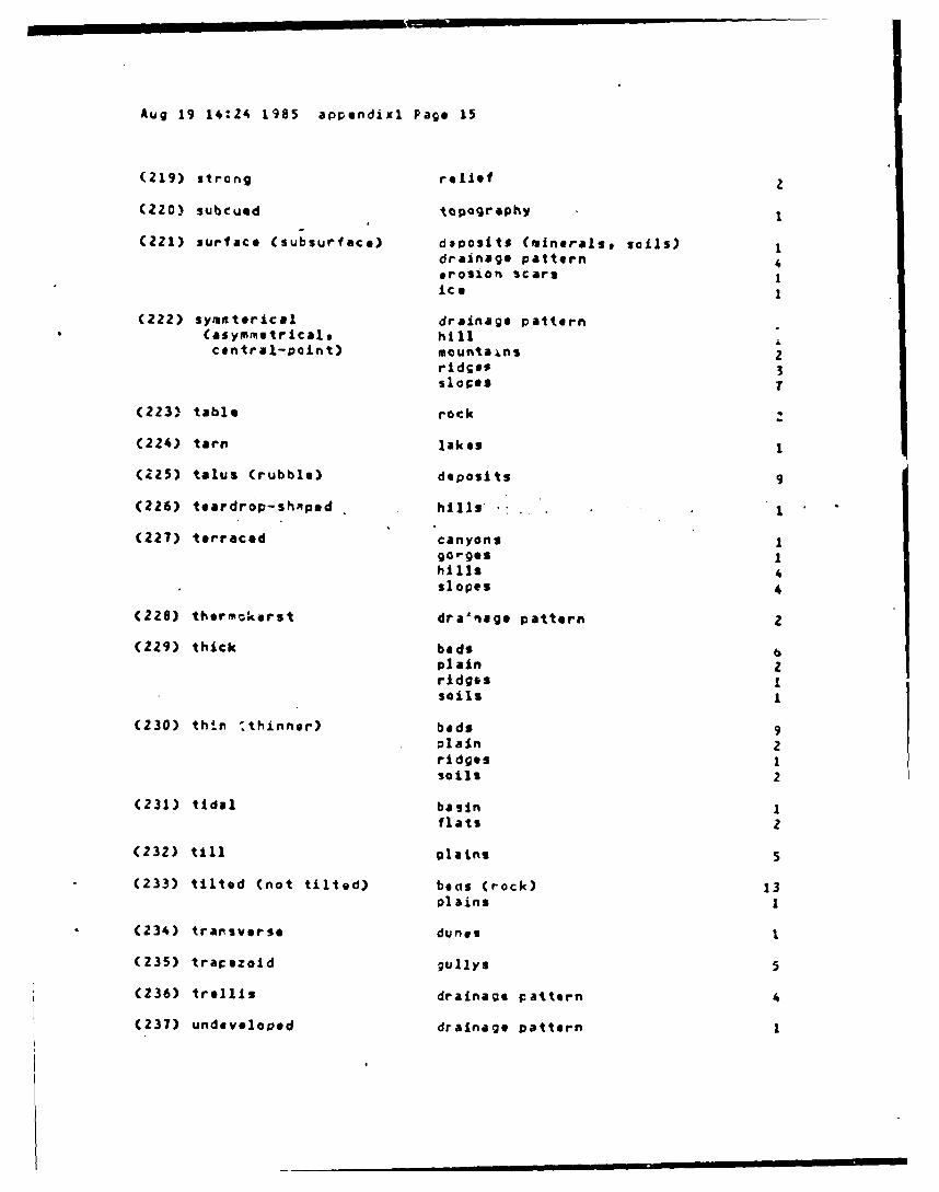
Aug 19 14:24 1985 appendixi Page 15
(219) strong relief 2
(220) subCued topography
(221) surface (subsurface) deposits (minerals, soils) Idrainage pattern 4erosion scars 1ice 1
(222) symaterical drainage pattern(asymmtrical, hillcentral-point) mountalns 2
ridse, 3slopos
(223) table rock
(224) tarn lakes
(225) talus (rubble) deposits 9
(226) teardrop-shRped hills 1
(227) terraced canyons 1gorges 1hills 4slopes 4
(228) thermokorst dra'nage pattern 2
(229) thick bed$ 6plain zridges Isoils 1
(230) thin 'thinner) beds 9plain 2ridges 1soils 2
(231) tidal basin I
flats 2
(232) till plains s
(233) tilted (not tilted) becis (rock) 13plains I
(234) transverse dunes 1
(235) trapezoid gullys 5
(236) trellis drainage pattern 4
(237) undeveloped drainage pattern 1

Aug 19 14:24 1985 appendix1 Page 16
(238) undulating (slightly) hills 2lculands Iplains ztopography 5
(239) uniform (non- angle (gullys) 1uniform) depressions 1
erosion 1rows (crops) 1slopes (gradients) 10soils 1tones 2topography 2
(240) uplifted beds (rock) 1
(241) U-shaped dunes (Cind-drift) 2gullys (profiles) 15valleys 1
(242) varying (sizes) craters (cinder cones) 1
(2"43) vertical beds (rock) 1bluffs 1cliffs 2escarpments 2fractures Islopes I
(244) V-shaped dunes 1gullys (profiles) 34valleys (profiles) 1
(245) wave-shaped dunes I
(246) wide faults 1
gully (bottoms) 4
(247) wincing ridges 1
(248) yazoo drainage pattern 1
(249) young domes Idrainage pattern 1
plain 6
-------------------------------------------------------------------

Aug 19 14:36 1985 aprendix2 Page 1
APPENOIX 2
A listing-of the'adjectives used in terrain aralysis, alphabeticallyentered according to the topic to which the adjectives are aPPlied. As forTable 1, the source is Hoffman's (1984) terrain analysis data base. Fre-quency data refer to how often each topic was described with a particularadjective. Terms in parentheses appeared as Nodifiers or variants of thedescriptors or topics.
PREDICATE OR DESCRIPTOR FREQUENCYTOPIC WHICH IS OPPLIED TO IT OF USE
(1) agriculture intense 3
little (sparse) 3
(2) axis (of dunes) parallel 2
(3) angle (of gully uniformintersections)•
(4) arch (to a slope) high
(5) base broad 2flared 4moist 1scalloped 1
(6) basins infiltration 3tidal 1
(T) bays elliptical 1long 1narrow 1parallel 1
(8) beach ridges linear 1
(9) beds Crock sheeots) curvilinear (curved) 3faulted 1few (none) 2flat 1lake 3-Vessive 3narrow 1offset 1thick 6thin 9tilted 13
uglifted 1vertical 1
(10) bluffs steep I

Aug 19 14:36 1985 appendix? Page, 2
vertical 1
(11) buttes scattered I
(12) canyons terraced1
(13) cliffs steep I
vertical
(14) contours rounded 1
(15) crater (cinder cones) clustered 1dish-shaped (profile) 1knife-edged Ivarying sizes 1
(16) crests narrow Ipe aked 1rounded 4s~arp 2
(17) crops matureraw 1
(15) cultivaition intensive 4little 2
(19) deltas arcuate Ibirdsfoot Iconvex (delta edge) Ies tuarine Iflat 2narrov 1
(20) deposits adolian 2alluvial Iboulder 3fon-shaped Imineral 3mud Isoil 4surface, Italus 9
(21) depressions cicrular Iconcentric Ielliptical Iflat (bottoms) Il.-rg* 2long1nonuniformParallel1roundst'allossmall 3various sizes I

Aug 19 14:36 1985 appendix2 Page 3
(22) deserts alluvial
(23) domes bold 1broad 1circular 1clustered Icampound 1dissected Ielliptical Iexfoliated Ilinear 1m assiVe 2raised Ismall 1young 1
(24) drainage pattern anastamotic 2angular 4annular 4artificial 3barbed 1blocked 3braided 7centrifugal 1centripetal 1circular 1coarso (density) 8concentric 1dendritic (tres-like) 34deranged 4dichotomic 3discontinuous 7distinct 2fan-shaped 1field tile Sfine (density) 13hair-like (channels) 1hexagonal 1integrated 1intermittent Iinternal 15irregular 1irrigation 5little (slight) 6mature 1medium (density) 2old Iparallel 6pinnate 4polygonal Iradial arectangular 9spurred 1surface (subsurface) 4symoetrical 1

Aug 19 14:36 1985 aprendix2 Page 4
thermokarst 2
trelliS 4undeveloped Ivarying Iyazoo Iyoung I
(25) drualins clustered 1flat (tops) 1parallel 2round 1stoop 1
(26) dunes active 6
barchan 1.
barren 7beach Iclustered I
distinct Icrescent-shaped
hummocky 1longitudinal I
parallel 1-pockmarked I
scallopedstabilized 4
star-shaped 2transverse 1U-shaped (wind-drift) 2V-shaped Iwave-shaped 1
(27) edges (to sinkholes) abrupt (distinct) 1
(28) elevations equal (unequall differing) 12dome-like 1high 1
(29) erosion rapid Iscars Iuniform 1surface 1
(30) escarpments cclumnar Ilong 1steep Ivertical 2
(31) eskers beaded 1discontinuous Iinterconnected 1meandering 1
(32) fans apex 1alluvial 6few 1
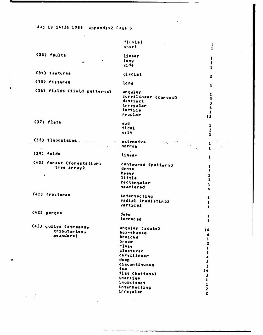
Aug 19 14:36 1985 aplendxx2 Page 5
fluvial Ishort I
(33) faults linear I_long I
wid 1
(34) features glacial z(35) fissures long I
(36) fields (field patterns) angular Icurvilinear (curved) 3distinct 3irregular 4lattice 1regular 12
(37) flats mud 1tidal 2salt I
(38) floodplains, etensive. 1
narrou 1(39) folds linear 1
(40) forest (forestation, contoured (pattern) 1tree array) dense 3heavy 1little 1rectangular Iscattered 4
(41) fractures intersecting Iradial (radiatin;) Ivertical 1
(42) gorges deep 1terraced 1
(43) gullys (streams, angular (acute) 16tributarles, box-shaped 6meanders) braided 1broad 2close 1clustered 1curvilinear 4deep 2discontinuous 3few 24flat (bottoms) 3inactive Iindistinct 1intersecting 2irregular 2

Aug 19 14:36 1985 appendaxx Page 6
large (channels)5loaded (heavily) Ilong 2manymeanderingna rroe 2of fset zparallel 7radial (radiating) 3sa ucer 11sI~allow Ishort 7small3spaced zstable Istoop 6straight 2trapezoid 5U- shaped 15V-shaped 34wide (bottoms) 4
(..44) hills baitdodIblocky 5bold 1branching 1ciger-shaped 1circular 1concave 1ccnical 3cultivated 2dome-like 2flat (tops) 2forested 5Irregular 3isolated 1Jointed 1knobby 5linear 2little 1long 2low-lying 2lumpy 1many 1ma ssive 2oval 1pa rallel 1repeatead Iround 14rugged 1scalloped 4sh-arp Ismall Ismiooth 3steop 4symmetrical I

Aug 19 14:36 1985 appendix2 Page 7
teardrop-shaped 1terraced 4undulating
2
(45) horns acex Ibroad Ina rrow 1
(46) ice surface
(47) inlets a ny I(48) islands many 1
small 1
(4) joints columnar Icurvilinear 1narrow 1Parallel 2short Ispaced 1.
(50) knobs concentric ,scall 1
(51) lakes finger 1oxbow 1parallel 1Perfect (outline) 1tarn I
(52) lakebed dry 1glacial 3
(53) land barren 12cultivated 5di ssec te d Ieroded (highly) 2flat 3forested 7grass 27moist 2range Iscrub 4shrub 10
(54) landforms abrupt (distinct) boundary 8allivial 1fluvial 1indistinct boundary i
(55) lava lobate (flows) 2ropey I
(56) lineaments clustered 1Lntersecting £

Aug 19 14:36 1985 apcendix2 Page 8
oaral 1.1
(57) loslands forestedundulating
(58) meanders troadIlittle (meandering) 1
(59) mesas scattered 1(60) moisture (soil) distinct I
little 1
(61) mounds clusteredIconical Ihook-shapod 1Isolated 1knobby Ilong 1round 1$leep I
(62) mounta ins asYnumetrical 2dissected 1rugged 3
(63) needles jegged 1
(64) orchards occasional 1scattered 1
(65) outline (lake) perfect 1(66) peak sharp I(67) pinnacles jagged I
stoep I(6a) plains alluvial 2
broad 7coastal 3continental 2cultivated 4dissected 5elevated 1ex tens ive 1fan-shaped Iflat 8flood 7fcrested 1hig~h 1horizontal 1irregular 1large 4level, Ile es$ 2

Aug 19 14:36 1985 aDrendix2 Page 9
old 7outuash 4pitted 1pockoarked 1rolling 7rugged 1smallIstreaked 1thick zthin 2till 5tilted 1undulating 3young 4
(69) plateau dissected 1
scattered 1
(70) ploing contour ?
(71) ponds be aded 1inland 1many 1polygonal (frost wedges) 1small 1various sizes 1
(12) prarie lou-lying 1rolling S
(73) profile blocky 1Jigced 1lou 2repay 1round 2
(74; relief blended 1gentle 1linear 1lou 1rolling Istrong 2
(75) ridges angular 1beach 3blocky Ibranching 2broad 1concentric 1curvilinear 4dissected 2finger 2few 1flared 2flat Iforested 2

Aug 19 14:36 1985 aprendix2 Page 10
hogback 2inland
IJagged
2knife-edged Iknobby 2linear (beach) 1long 8low 1many 1massive 1narrow 6parallel 15peaked 1round 7saddle 2sawtooth 5sharp 7short 2small 3smooth 2snake-like 1spaced Isteep 5straight Isymm trical 3thick 1thin Iwinding ]
(76) rock bare 2bedded 4displaced 1durable 1faulted 2few (outcroppings) 1flat 9folded 2homogeneous 1interbedded 22intrusive 4permeable (imperveable) zporous 1raised 1resistant 3rose-shaped (granite) 1scalloped 1stratified 3table 1
(77) rows (crops) uniform 1
(78) sand streaked 3
(79) scars (streaks) arcuate 1braided 1clannel (stream) 4

Aug 19 14:36 1985 eprofndlx2 Page 11
(80) scrub heavily (vegetagd) I(81) shapes various
(82) sinkholes circular 2
ci usterod 1deep 1elliptical Ilarge
2long 2round
1(83) slopes (gradients) asymmetrical
5broad
2compound
2ccncave
1convex Icurvilinear
1cultivated
3equal (differing) 2forested
5"gentle 8
gradual 5
increasing I
long I
,moderate Inarrowrolling 8rough
1round 1
scalloped 3short Z
smooth 6stable 2
stsirsteoa zsteep
30straight
1symmetrical
2terraced 4uniform (nonuniform) 10vertical
1(84) soils abundant
1bare
2coarse
acohesive
3creep
Ide ep
4drained (eell) Zdry
2elastic 2
eroded Cerodable) 4expandable 1
fine 7granular
2

Aug 19 14:36 1985 aorpendlx2 Page 12
homogeneous 1little 1mixed 1moist 6permeable 4plasticporous (highly)
3
silty 73
slump 7
stratified I
thick 1
thin I
uniform 1
(85) surfaces rolling 1scrabbled 1
(86) swamps many
(87) terraces -sny 1minor 2round 1sQooth K
(88) terrain glacial 1hilly 1level 1rolling 1uneven 1
(89) texture coarse 3fine 1knobby Ipitted 1rough 1silky 1swooth 4
(90) till glacial 2old 1plains S
(91) tones bended 15Contoured 1curvilinear (streaks) 4dark (very) 23desert varnish 2distinct 2dull 2equal (varying) 3fringed 2grey 1light 81linear (streaks) 2medium 24mottled 14

Aug 19 14:36 1985 aprendixZ Pag 13
streaked 4striped 2uniform (nonuniform) 2
(92) topography - closed 1dissected 3flat 11gentle 1irregular 2mountainous Irolling ?rcund 4rugged 8smooth 1subdued 1uneven 1undulating 5uniform 1varying 1
(93) trees isolated
(94) troughs linear .
(9S) uplands cultivated 3mountainous 1ptrallel Irolling 1
(96) valleys broad 1cirous 1cultivated 4curvilinear 3flat 3hanging 1long 3linear 1many Inarrow 2parellel 4round 1small 1sleop 1U-shaped 1V-shaped I
(97) vegetation bwndsd 1dense 4heavy 1linear (pattern) 2little 4lush 2perrendicular (to gullys) 1srars. 2
(92) eater-holding caacity high I

Aug 19 14:36 1985. appendix2 Page 14
low
(99) water table hl gh