what does it take to flood the pampas?: lessons from a decade of
TRANSCRIPT

Seediscussionsstatsandauthorprofilesforthispublicationathttpwwwresearchgatenetpublication274731861
WhatdoesittaketofloodthePampasLessonsfromadecadeofstronghydrologicalfluctuationsFloodsandthewatercycleinthePampas
ARTICLEmiddotAPRIL2015
DOI1010022015WR016966
DOWNLOADS
81
VIEWS
146
4AUTHORS
SylvainKuppel
NationalScientificandTechnicalResearchCohellip
20PUBLICATIONS43CITATIONS
SEEPROFILE
JavierHouspanossian
UniversidadNacionaldeSanLuis
6PUBLICATIONS12CITATIONS
SEEPROFILE
MarceloDNosetto
NationalScientificandTechnicalResearchCohellip
42PUBLICATIONS631CITATIONS
SEEPROFILE
EstebanJobbaacutegy
NationalScientificandTechnicalResearchCohellip
162PUBLICATIONS6367CITATIONS
SEEPROFILE
AvailablefromSylvainKuppel
Retrievedon09September2015
RESEARCH ARTICLE1010022015WR016966
What does it take to flood the Pampas Lessons from a decadeof strong hydrological fluctuationsS Kuppel1 J Houspanossian1 M D Nosetto1 and E G Jobbagy1
1Grupo de Estudios Ambientales IMASL-CONICETUniversidad Nacional de San Luis San Luis Argentina
Abstract While most landscapes respond to extreme rainfalls with increased surface water outflowsvery flat and poorly drained ones have little capacity to do this and their most common responses include(i) increased water storage leading to rising water tables and floods (ii) increased evaporative water lossesand after reaching high levels of storage (iii) increased liquid water outflows The relative importance ofthese pathways was explored in the extensive plains of the Argentine Pampas where two significant floodepisodes (denoted FE1 and FE2) occurred in 2000ndash2003 and 2012ndash2013 In two of the most flood-proneareas (Western and Lower Pampa 60000 km2 each) surface water cover reached 31 and 19 during FE1 ineach subregion while FE2 covered up to 22 and 10 respectively From the spatiotemporal heterogeneityof the flood events we distinguished slow floods lasting several years when the water table is brought tothe surface following sustained precipitation excesses in groundwater-connected systems (Western Pampa)and lsquolsquofastrsquorsquo floods triggered by surface water accumulation over the course of weeks to months typical ofpoor surface-groundwater connectivity (Lower Pampa) or when exceptionally strong rainfalls overwhelminfiltration capacity Because of these different hydrological responses precipitation and evapotranspirationwere strongly linked in the Lower Pampa only while the connection between water fluxes and storage waslimited to the Western Pampa In both regions evapotranspirative losses were strongly linked to floodedconditions as a regulatory feedback while liquid water outflows remained negligible
1 Introduction
Flooding is a natural process in flat continental and coastal landscapes and a key component of the hydro-logical connectivity ensuring the water-mediated transport of energy matter and living organisms andecological processes and features [Heiler et al 1995 Pringle 2001] Yet because they also affect infrastruc-ture and agricultural production ecosystems (eg crops and pastures) flood events are commonly seen as ahazard potentially jeopardizing local economies transportation networks and human life [de Loe 2000 Vig-lizzo and Frank 2006]
Very flat sedimentary regions with low topographic gradients and poorly developed drainage networks pre-clude the surface drainage of excess water (ie precipitation inputs exceeding evapotranspiration) oftenhave relatively stagnant hydrological systems that lead to shallow water tables and long-lasting floods [Fanet al 2013] While in well-drained and sloped landscapes enhanced liquid water outflow is the most imme-diate response to rainfall excesses stagnant systems are more likely to respond with (i) increased water stor-age leading to rising water tables and floods (ii) higher evapotranspirative water losses favored by higherwater storage and availability and at very high levels of water storage (iii) enhanced liquid water outflowsfavored by the surface water connectivity [Aragon et al 2010] The relative importance of these three hydro-logical pathways significantly determines the timing duration and extent of flood episodes with strongramifications on ecosystem functioning (eg evapotranspiration is linked to primary production) biogeo-chemical balances (eg liquid outflows are associated with nutrient and salt exports) and atmospheric feed-backs (eg flooded area affects surface energy exchange processes)
Extended flat landscapes show low horizontal water transport as a result of low surface runoff and slowgroundwater fluxes that become dominated by local-to-intermediate-scale flow paths [Toth 1963] Hencethe water balance of these systems is primarily driven by precipitation and evapotranspiration while thefluxes of groundwater (GW) and its connection with surface water (SW) are highly dependent on thehydraulic conductivity and textureporosity of soils [Brunke and Gonser 1997 Ferone and Devito 2004 Kollet
Key Points Floods in the subhumid Pampas are
sporadic but can last several years Connectivity between surface and
belowground water shapes flooddynamics Plant transpiration from nonflooded
areas could significantly regulatefloods
Supporting Information Supporting Information S1
Correspondence toS Kuppelskuppel1gmailcom
CitationKuppel S J HouspanossianM D Nosetto and E G Jobbagy(2015) What does it take to flood thePampas Lessons from a decade ofstrong hydrological fluctuations WaterResour Res 51 2937ndash2950doi1010022015WR016966
Received 22 JAN 2015
Accepted 2 APR 2015
Accepted article online 6 APR 2015
Published online 26 APR 2015
VC 2015 American Geophysical Union
All Rights Reserved
KUPPEL ET AL FLOODS AND THE WATER CYCLE IN THE PAMPAS 2937
Water Resources Research
PUBLICATIONS
2009] In landscapes with shallow groundwater the degree of GW-SW coupling affects in turn the genera-tion of flood events and the behavior of regional water storage (response (i) above) High GW-SW couplingwill first result in GW recharge until water tables get close enough to the surface to emerge and increasethe area of surface water bodies while low GW-SW coupling will result in a more rapid flooding before infil-tration and GW recharge take place These two idealized extreme responses can be seen as triggering inthe first case slow flood episodes lagging behind strong rainfall periods while the second case would causefaster flood appearance and retraction with a notable hysteresis between GW and SW dynamics
In landscapes that are usually nonflooded precipitation inputs directly control soil moisture and evapo-transpiration through both bare soil evaporation [Chen and Hu 2004] and plant transpiration [Baldocchi andXu 2007 Chen et al 2008] Yet where water tables are shallow soil moisture is also influenced by ground-water dynamics [Kollet 2009 Soylu et al 2011] and this can have positive or negative effects on evapo-transpiration rates Obvious enhancing effects are related to the increased water availability for both directsoil evaporation and plant transpiration However inhibiting effects can arise as well if water excesseshinder plant transpiration through waterlogging and root anoxia [Beltr~ao et al 1996 Rathore et al 1998Nosetto et al 2009] increased soil salinity [Nosetto et al 2013] and die-off or lack of successful establish-ment of cultivated vegetation [Viglizzo et al 2009] The net effect on evapotranspiration will thus dependon vegetation tolerance to salinity and waterlogging and on the extent to which direct evaporation frommoist or waterlogged soils can compensate for reduced transpiration [Moffett et al 2010] Although weexpect that increased evaporative losses will occur in surface water-covered areas the surrounding flood-free landscapes of the plains in which water tables are closer to the surface may result in either negative orpositive net changes in their evapotranspirative losses Finally extreme flooding can favor the coalescenceof surface water bodies triggering long-distance runoff and surface water drainage out of the floodedregion (response (iii) above) as more commonly seen in humid sedimentary plains like the Amazon basin[Richey et al 1989]
The Argentine Pampas are subhumid eolian plains that experience large episodic flood events covering asignificant fraction of the landscape for months or even years [Moncaut 2001 Aragon et al 2010] Severalregions around the world share this particular topographicclimatic setting including the Pantanal (Brazil)[Hamilton 2002] the Orinoco Llanos (Colombia and Venezuela) [Hamilton et al 2004] the plains of Mani-toba and Saskatchewan (Canada) [Jobbagy et al 2008] the Great Plains of Hungary [Jobbagy et al 2008]and Western Siberia [Biancamaria et al 2009] Extending over more than 600000 km2 the Pampas aremostly covered by annual crops that have displaced cultivated pastures and native grasslands [Hall et al1992 Viglizzo and Frank 2006 Baldi and Paruelo 2008] However the reciprocal influences of land use andenvironmental hazards such as floods have hindered a harmonious combination between ecosystem con-servation human well-being and efficient farming in this highly productive region [Viglizzo et al 2009Nosetto et al 2009 2012] As the agricultural use of these arable lands is expected to further intensify inresponse to increasing global food demand and trade [Paruelo et al 2005] careful land management strat-egies must consider the peculiar hydrological behavior of very flat regions
The understanding of flood dynamics at large spatial and temporal scales in extremely flat sedimentaryregions like the Pampas is still in its early stages [Viglizzo et al 2009 Aragon et al 2010] The continuousemergence and improvement of remote-sensing tools has allowed a more systematic detection of floodsand surface waters dynamics [Brakenridge 2014] In a portion of the Western Pampa a first attempt thatcombined surface water area level and stock estimates together with precipitation data provided the firstquantitative characterization of a single flood cycle (1996ndash2005) and its associated water balance shifts [Ara-gon et al 2010] Yet the yearly resolution and limited temporal and spatial extent of this study did not per-mit evaluation of the timing of floods in response to extreme rainfall episodes to compare differentsubregions of the Pampas or distinct flooding cycles or to ultimately assess the relative importance of thethree hydrological responses (i ii and iii) In this study we characterize the dynamics of floods throughoutthe entire Pampas region of Argentina for a period of nearly 14 years that encompassed at least two majorflooding cycles Based on multiple remote sensing tools we link these floods to water inputs (precipitation)outputs (evapotranspiration) and storage (total water mass and groundwater levels) to evaluate to whatextent slow groundwater-driven floods or fast surface water-driven floods prevail We also explore the rela-tive importance of landscape water storage (i) evapotranspiration (ii) and surface drainage (iii) in balancingwater excesses in the region
Water Resources Research 1010022015WR016966
KUPPEL ET AL FLOODS AND THE WATER CYCLE IN THE PAMPAS 2938
2 Material and Methods
21 Study RegionThe study region encompasses most of the Argentine Pampas (Figure 1) a large plain covering approxi-mately 600000 km2 with low elevation (lt200 m) and regional topographic gradients (typically less than a01 slope) [Kruse and Zimmermann 2002 Viglizzo et al 2009] Rainfall in the region decreases from NE toSW gradually shifting from a relatively even distribution throughout the year to spring-summer-concentrated rain events [Magliano et al 2014] Several subregions can be identified in the Pampas withthe most relevant ones in terms of extension and flooding incidence being the Western Pampa and theLower Pampa (the latter term being preferred to Flooding Pampamdashalso found in the literaturemdashto avoidconfusion) While both regions share a common eolian sedimentary origin [Zarate 2003] the WesternPampa displays a stronger imprint of wind a deposition on its soils and landforms with widespread dunelandscapes sandy to sandy loam materials and high density of water bodies in the lower portions of thelandscape [Iriondo 1990 Imbellone and Gimenez 1998] The Lower Pampa has experienced a strong influ-ence of fluvial forces that reshaped many of the original eolian landforms [Tricart 1973] Being further awayfrom the Andean dust sources than the Western Pampa the Lower Pampa received slightly finer sedimentswith a higher proportion of silt [Zarate 2003] In both regions subsurface soil horizons with finer textureand secondary calcite formation are common particularly in lowlands resulting from illuviation of currentand past soil formation cycles and the spatial extension thickness and impermeability of these soil horizonsis higher in the predominant natric soils of the Lower Pampa [Kreuroohling 1999] The stream and river networkin both regions is very poorly developed [Drago and Iriondo 2004] yet the Lower Pampa shows more per-manent water courses particularly the lower leg of the Salado River that flows into the Atlantic Ocean Dueto a higher proportion of waterlogged and salt-affected soils [Lavado and Taboada 1988] the Lower Pampahas a lower fraction of its territory devoted to annual crop cultivation than does the Western Pampa [Baldiand Paruelo 2008]
22 Remote Sensing of Surface Water CoverThe surface water coverage data were estimated at 500 3 500 m2 resolution with a temporal resolution of8 days from 6 March 2000 to 27 December 2013 using the scenes h13v12 and h12v12 of the standardblack-sky shortwave albedo product from the MODIS BRDFalbedo product (MCD43A) [Lucht et al 2000Schaaf et al 2002] Based on a reference water albedo value of 006 for solar elevation angles greater than30 [Gao et al 2006] which is much lower than the albedo of the typical land cover in the landscape
Figure 1 (a) Recurrence of surface water cover in the Argentine Pampas at 500 3 500 m2 resolution expressed as the relative time spanunder flooded conditions throughout the period from March 2000 to December 2013 The lowest class corresponds to a permanentabsence of flooding as detected by MODIS The next highest class includes any pixel covered by water at least in one MODIS period (8days) and up to 5 of the time (254 days) (b) Maximum surface water cover (SWC) at GRACE resolution (1 3 1) during the same timeperiod The focus regions are delimited by the dashed red (Western Pampa) and blue (Lower Pampa) lines
Water Resources Research 1010022015WR016966
KUPPEL ET AL FLOODS AND THE WATER CYCLE IN THE PAMPAS 2939
(grasslands crops and fallow lands) [Loarie et al 2011 Gao 2005] we applied a simple observationalthreshold criterion fixed to 009 below which each pixel is considered as covered by water The MODIS-derived estimate of water-covered pixels was also spatially aggregated to provide the surface water cover(SWC) expressed in percentage of the corresponding area To improve the accuracy of our SWC estimatewe calibrated our estimates performed in the two focus regions using LANDSAT data with higher resolutionin the same fashion as Aragon et al [2010] from 2000 to 2011 (see supporting information Text S1)
23 Other Data Sources and AnalysisThe terrestrial water storage (TWS) which is the total vertically integrated water stored above and belowthe Earthrsquos surface is provided by the Gravity Recovery And Climate Experiment (GRACE) land data [Swen-son and Wahr 2006 Landerer and Swenson 2012] We used the three RL05 solutions releases of the 1 3 1
near-monthly products from April 2002 to December 2013 provided by the Center for Space Research atthe University of Texas at Austin (CSR) the Jet Propulsion Laboratory (JPL) and the German Research Centrefor Geosciences (GFZ) to which were applied the scaling factors (provided along with the data sets) com-pensating for signal modification from sampling and post processing of the original data [Landerer andSwenson 2012] Finally we averaged the three data sources to derive a mean TWS recordmdashthen spatiallyaggregated over both focus regions as this approach allows reducing the noise within the available gravityfield solutions [Sakumura et al 2014] Note that the two 60500 km2 wide focus regions (see section 31) aresmaller than the characteristic GRACE footprint (200000 km2) [Longuevergne et al 2010] calling for a cau-tious somewhat qualitative interpretation of the TWS variation and its relation with the other componentsof the water cycle
The Tropical Rainfall Measuring Mission (TRMM) provides estimates of precipitation based on remote-sensing observations covering a global belt (180Wndash180E) between latitudes 50S and 50N [Kummerowet al 1998] We used the TRMM Multisatellite Precipitation Analysis (TMPA) product generated with version7 of the 3B42 algorithm which incorporates a post real-time calibration and merging with monthly raingauge data [Huffman et al 2007 2010] The 3B42V7 precipitation estimates originally with 3 h and 025 3
025 resolution were aggregated to daily data for the period covering 1 March 2000 to 31 December 2013We evaluated the accuracy of these estimates finding good agreement with in situ precipitation measure-ments (see supporting information Figure S2) Evapotranspiration (ET) was estimated from an empirical for-mula derived from the methodology of Di Bella et al [2000] calibrated for the Pampas
ET528834391177636 002 Ts2273eth THORN1286406 NDVI
30 (1)
expressed in millimeters per day with resolutions of 8 days and 1 3 1 km2 Ts is the level-3 MODIS daytimeland surface temperature in Kelvin (MOD11A2 product) and NDVI is the Normalized Difference VegetationIndex derived from the surface reflectance bands of the MOD09Q1 product This ET estimate was preferredto the MODIS evapotranspiration product (MOD16A2) [Mu et al 2011] because the former compared muchbetter to ET values brought by other independent studies [eg Nosetto et al 2015] than the MODIS-basedET did as it significantly underestimates evapotranspiration in the Pampas region Importantly it should bekept in mind that the ET estimate used in this study was only applied in nonflooded areas with water-covered pixels being excluded from regional averaging
Lastly an estimate of monthly groundwater depth (GWD) covering the 2000ndash2013 time period was recon-structed at the regional scale based on the long-term records available at six sites (Table 1) Because of thelocation of the monitoring wells the regional GWD estimate is only considered representative of the West-ern Pampa and therefore used for the analysis of this subregion alone To this end we used as primaryinformation the GWD monthly variation given that all sites did not share the same measurement periodsand dates and that the absolute levels of GWD are strongly dependent on the elevation and location ofeach well in the local landscape (valley hilltop etc) but their temporal level shifts are not and display simi-lar patterns across sites At each site GWD variation rates from one record date to the subsequent one werecalculated and converted to monthly rates excluding any intervals longer than 2 months For each monthof the calendar from March 2000 to December 2013 GWD variation rates were averaged across sites to gen-erate a unique time series Finally the regional absolute GWD time series was obtained by propagating theregionally averaged GWD variation rate from April 2000 backward (to March 2000) and forward (untilDecember 2013) taking the cross-site-averaged monthly GWD at this date as a reference since all sites have
Water Resources Research 1010022015WR016966
KUPPEL ET AL FLOODS AND THE WATER CYCLE IN THE PAMPAS 2940
a recorded GWD value then Note that a similar procedure had been applied beforehand across the mea-surement wells of each sitemdashexcept for La Paz site where there was only one well so as to avoid giving toomuch weight to sites having a large number of wells (Table 1)
3 Results
31 Spatial DistributionWhile permanent water bodies were very scarce in the Pampas intermittent ones (ie flooded areas) werewidespread and most abundant in the center-north part of the Western Pampa and in the Salado Riverbasin in the Lower Pampa (Figure 1a) A few large areas with near-permanent water coverage were identi-fied including the Guaminı lagoons i (370S 625W) Hinojo lagoon (360S 625W) Picasa lagoon (343S623W) and Melincue lagoon (337S 615W) (Figure 1a) A clear WNW-ESE corridor of approximately700 km from the western edge of the region to the Atlantic Ocean encompasses 49800 km2 of territorythat became flooded at least once (Figure 1a) We focused the rest of the study on two rectangular subre-gions covering about 60500 km2 each and matching GRACE data cells (Figure 1b) In the first one (red
Table 1 Study Sites Used for Long-Term Groundwater Level Measurement (2000ndash2013)a
Site Longitude () Latitude () Elevation (m) Wells
Catrillo 26345 23640 131 3General Pico (Linea 1) 26373 23568 134 7Intendente Alvear 26370 23531 131 16La Paz 26186 23650 117 1Quemu Quemu 26358 23605 121 3Speluzzi 26380 23548 147 7
aFor each site the name geographic coordinates (decimal degrees) elevation (masl) and number of monitoring wells are indicated
Figure 2 Region-averaged (a) surface water cover from 6 March 2000 to 27 December 2013 (b) terrestrial water storage from April 2002to December 2013 and (c) 6 month-accumulated precipitation (PPT) anomaly (current month and the five preceding ones using March2000 to February 2014 as the reference period)
Water Resources Research 1010022015WR016966
KUPPEL ET AL FLOODS AND THE WATER CYCLE IN THE PAMPAS 2941
dashed line in Figure 1 34Sndash36S 61Wndash63W hereafter referred to as Western Pampa) 21 of the terri-tory was flooded at least once and up to 5 of the time In the second focus region (blue dashed line in Fig-ure 1 35Sndash37S 58Wndash61W hereafter referred to as Lower Pampa) 25 of the territory was included inthat flooding frequency class Areas intermittently covered by water more than 5 of the time were muchless common representing only 75 and 47 of the Western and Lower Pampa respectively Note that thelower Parana River Delta region although displaying some of the most significant water body occurrenceand maximum surface water coverage in the study frame was excluded from our analysis since it is hydro-logically and geologically disconnected from the Pampas and responds to the Parana River water level fluc-tuations [see eg Zoffoli et al 2008]
32 Temporal DistributionIn the two focus regions two major flood events could be identified since the beginning of the 2000s (Fig-ure 2a) The first event (hereafter FE1) started before 6 March 2000 when MODIS data began to be availablepeaking in 2001ndash2002 and lasting until late 2003 The second event (hereafter FE2) took place over thecourse of the year 2012 and the first half of 2013 Flood episodes of lesser importance also occurred in 2007and during the austral summer of 2009ndash2010 more markedly in the Western Pampa (Figure 2a)
In addition to its duration FE1 was the most extensive flood episode with water covering up to 306 and185 of the Western Pampa and Lower Pampa areas respectively (Figure 2a) In the Western Pampa thesurface water cover remained above 10 for three and a half years (May 2000 to October 2003) with shortdrier periods in July 2000 and early 2001 Surface water cover fluctuated around a basal valuemdashby analogywith the stream base flow definition of Arnold and Allen [1999]mdashof 14ndash15 from mid-2000 to mid-2003with a 2 month long peak in late 2001 when the maximum was reached and later decreased throughoutthe second half of 2003 The temporal dynamics of FE1 were somewhat different in the Lower Pampa asthere were at least five distinct peaks of surface water coverage above 13 between August 2000 andNovember 2002 lasting only a few weeks while basal flood coverage remained around 3 during most ofthat flooding cycle
Compared to FE1 FE2 was briefer and less extensive A first stage could be seen in the Western Pampa witha moderate cover peak in March 2012 (11) while the maximum flood extent occurred in late October2012 (22) before retracting almost completely by the austral winter of 2013 This flooding cycle was evenmore succinct in the Lower Pampa starting during the austral fall of 2012 reaching its water cover peak inearly September 2012 (10) and receding by the end of the austral summer in early 2013
In addition a significant long-term reduction of the terrestrial water storage was observed following FE1 inthe Western and Lower Pampa (Figure 2b) with a respective decline of 162 and 143 mm from maximumannual average values (JulyndashJune) in 2002ndash2003 to minimum values in 2012ndash2013 in coherence with thelarger-scale water depletion reported across the La Plata basin [Chen et al 2010] Four stages in the overallwater storage trend could be distinguished (1) a steep decrease at the end and during the aftermath ofFE1 by 168 mm (Western Pampa) and 146 mm (Lower Pampa) from April 2002 to April 2004 (2) a some-what stable trend from 2004 to 2007 (3) a decreasing storage from 2008 to 2011 and finally (4) an increas-ing trend by 73 mm (Western Pampa) and 76 mm (Lower Pampa) between December 2011 and December2013 Also terrestrial water storage displays a marked and relatively regular seasonal cycle in both regionswith a slightly larger mean amplitude in the Western Pampa (107 mm) than in the Lower Pampa (90 mm)
The time span of both main flood episodes (FE1 and FE2) corresponded to sustained positive precipitationanomalies in both focus regions (Figure 2c) In the Western Pampa from the beginning of MODIS record tothe peak of FE1 the monthly rainfall anomalies summed 453 mm over 20 months while the 9 month longascending phase of FE2 corresponded to an accumulated anomaly of 420 mm In the Lower Pampa therecorded ascending phase of FE1 until the first large peak took 19 months and coincided with by a summedrainfall anomaly of 548 mm versus 253 mm within the 7 months of the FE2 buildup Precipitation excessesof similar magnitude but with shorter duration were visible in the Western Pampa in 2007 and early 2010when minor flood episodes occurred there In addition marked variations of water storage appeared to bea signature of precipitation anomalies (Figures 2b and 2c) In particular the deep storage valley in 2009 issynchronous with a strong negative accumulated anomaly reaching 305 and 375 mm (ie 51 and 63 mmmonth on average) in the Western and Lower Pampa respectively while a decrease in surface water coveris also noticeable for the Western Pampa (Figure 2a)
Water Resources Research 1010022015WR016966
KUPPEL ET AL FLOODS AND THE WATER CYCLE IN THE PAMPAS 2942
33 Water Storage and FloodsThe relation between the monthlyaveraged water-covered area and thetotal terrestrial water content showedsignificant differences between subre-gions and flooding cycles (Figure 3) Inthe Western Pampa during both theretraction of FE1 and the full cycle ofFE2 it appears that SWC changedsomewhat linearly with TWS (Figure3a) with respective Pearsonrsquos R2 equalto 082 and 079 (plt 0001 notshown) In the Lower Pampa thepoorer linear fit of the TWS-SWC rela-tionship during FE1 and FE2 (R2 5 068and R2 5 041 respectively plt 005not shown) is significantly improvedusing an exponential regression(R2 5 083 and R2 5 066 respectivelyplt 0005 not shown) suggesting amore time-segmented behavior withpossible threshold-driven waterdynamics (Figure 3b) Indeed a two-step succession could be noticed inthe latter subregion during FE1 (1) nosignificant change of TWS over thecourse of 2002 when SWC wasdecreasing threefold (from 113 to39) (2) TWS started to decreasenotably from January 2003 while SWCshrank from 26 to 09 its value as ofMarch 2004 Also four steps can beidentified during the full FE2 cycle inthe Lower Pampa (1) July to August2012 sharp increase of SWC from 1to almost 7 paralleled by a 40 mmincrease of TWS (2) August to Septem-
ber 2012 similar increase of TWS (40 mm) with a small increase of SWC (3) September to November 2012 (noTWS record available in October 2012) sharp decrease of SWC down to 3 with a slight increase of TWS (4)November 2012 to February 2013 progressive decrease of TWS by nearly 70 mm while SWC went back to itslsquolsquopre-FE2rsquorsquo value
The two regions thus differ in the much more hysteretic profile of the SWC-TWS relationship in the Lower Pampawhere the flooding extent associated to a given water storage was significantly different between the water-gaining phase and the water-losing phase For example in the latter subregion the water storage was roughly thesame in August 2012 and in February 2013 (TWSlt 15 mm) but in the first case it corresponded to flooded condi-tions (SWC 5 68) that had almost disappeared in the second case (SWC 5 13) (Figure 3b) Note that in mostcases the visible hysteresis loops are clockwise meaning that the changes in water storage lag behind those ofsurface water cover Finally in both regions there is a horizontal displacement of the TWS-SWC relationshipbetween the cloud of points corresponding to FE1 and that encompassing FE2 (Figure 3) This TWS offset of nearly100 mm confirms that less water storage was necessary to cause FE2 than FE1 as could be inferred from Figure 2
34 Regional Water CyclesThe correlation analysis between the different components of the water cycle provides insights about themechanisms triggering flooding in both regions (Table 2 and Figure 4) In the Western Pampa there was a
Figure 3 Relation between the monthly averaged surface water cover and terrestrialwater storage in (a) the Western Pampa and (b) Lower Pampa During both floodevents FE1 and FE2 the additional dashed lines show the chronological sequence
Water Resources Research 1010022015WR016966
KUPPEL ET AL FLOODS AND THE WATER CYCLE IN THE PAMPAS 2943
positive but weak association of precipi-tation to changes in total water storagea mild coupling between surface andtotal water stocks and a strong associa-tion of evapotranspiration to waterstocks but none to precipitation (Table 2and Figure 4) This suggests that thishydrological system has a relativelyweak perhaps lagged or cumulativeresponse to rainfall while evapotranspi-ration depends much more on soil waterstorage than rainfall Water balance reg-ulation there most likely follows a pathinvolving water accumulationdepletion(response pathway (i) see section (1)and with a certain lag increased
decreased evapotranspirative losses (pathway (ii)) respectively Moreover the robust coupling between totalwater storage and the groundwater level in the Western Pampa (Figure 5a) would suggest that belowgroundcompartments were the main drivers of the TWS dynamics at least outside of flood events and that surfacedynamics were linked to those of groundwater This hypothesis is supported by the fact that the evolution ofthe surface water bodies in the Western Pampa was strongly linked to groundwater depth during the wholestudy period although the relationship substantially changed after 2011 (Figure 5b) Indeed surface watercover showed a steeper response to phreatic rise and fall (ie with negative and positive changes of ground-water depth respectively) in 2012ndash2013 than it did over the 11 previous years
In the Lower Pampa a faster response of evapotranspiration to precipitation excess seemed to take placeBy comparison to the Western Pampa the precipitation was mildly related to surface water cover (insteadof total water storage) and strongly to evapotranspiration the correlation between SWC and TWS wasslightly tighter and total water storage had nil effect on evapotranspiration while surface water coverstrongly did (Table 2 and Figure 4) In this case the response pathway (i) to water excesses would be limitedto water accumulation in the shallowest soil layers and at the surface this storage being itself restricted byrapid evapotranspirative losses to the atmosphere (pathway (ii)) These mechanisms may reflect that themore shallow water table levels of the Lower Pampa are always offering water to plants and hence no par-ticular stimulation of evapotranspiration is seen by increasing water table levels just the effect of rain Alter-natively more salty soils and groundwater may prevent water table contribution in the Lower Pampamaking evapotranspiration more responsive to rainfall than to that salty water pool Moreover the largercorrelation between surface water cover and total water stock in this subregion (Table 2) would not indicatelarger water transfer between aboveground and belowground compartments but rather that occasionalsurface water bodies play a central role in the water cycle of the Lower Pampa being the most dynamic
Table 2 Spearmanrsquos Rank Correlation Factor Between Annual Quantities(JulyndashJune) From 2000ndash2001 to 2012ndash2013a
Pair of Variables Western Pampa Lower Pampa
SWCTWS 0645 0755SWCDTWS 0164 20073SWCPPT 0423 0599SWCET 0890 0852SWCPPT-ET 0028 0401TWSPPT 20136 0136TWSET 0745 0518TWSPPT-ET 20427 20218DTWSPPT 0582 0309DTWSET 0091 0200DTWSPPT-ET 0509 0345PPTET 0401 0797
aSignificance against the null hypothesis is indicated at plt 01 (italic) andplt 001 (bold)
Figure 4 Statistically significant connections between the components of the yearly water cycle (left) in the Western Pampa (right) and inthe Lower Pampa precipitation (blue) evapotranspiration (red) surface water cover (green) and terrestrial water storage (gold) The sizeof the black arrows is proportional to the associated Spearmanrsquos rank correlation factor (see Table 2)
Water Resources Research 1010022015WR016966
KUPPEL ET AL FLOODS AND THE WATER CYCLE IN THE PAMPAS 2944
component of the terrestrial waterreservoir This hydrological pictureis coherent with the relativedecoupling between SWC andTWS at shorter time scales duringboth flood events in this region(Figure 3b) and the pulse-like pro-file of surface water as comparedto that of the Western Pampa alarger number of peaks and alower basal value of SWC (Figure2a)
The third potential pathway as aresponse to rainfall excesses sur-face water outflows is difficult toquantify The definition of theexact limits of the river watershedduring flooded periods is veryuncertain due to the coalescenceof water bodies and small water-sheds that would otherwisebehave as closed basins yet a con-servative estimate of the basinareas (which yields an exagger-ated figure of surface water out-flow) can take the rectangularareas used in our study (Figure 1a)the latter being located for theirmost part in the 150000 km2 widewatershed of the Salado river
[Gabellone et al 2005] Combining flow rate records from stations Junınmdashwhere the Salado River exits theWestern Pampamdashand Guerreromdashwhere in the Salado River exits the Lower Pampamdash(P Garcia personalcommunication 2014) gave a maximum drainage of nearly 15 mmmo from the Western Pampa and40 mmmo from the Lower Pampa in November 2001mdashthe highest recorded values in the available 2000ndash2004 period and roughly corresponding to the peak of FE1 in the Western Pampa Outside these anoma-lous peaks the river flow fluctuated around basal flow values corresponding to 3ndash6 mmmo We can thusdeduce that liquid water losses in pathway (iii) remain of secondary importance in the water budget of theArgentine Pampas although they can be dramatically increased at the peak of large flood events
4 Discussion
Unlike humid sedimentary plains such as the Amazon or the Fly River basins where repeated seasonal waterexcesses (ie precipitation larger than potential evapotranspiration) lead to seasonal flooding cycles everyyear [Martinez and Letoan 2007 Swales et al 1999] the subhumid plains of the Pampas displayed sporadicpulses of floods that lasted several months or even years followed by several years without flooding condi-tions There the subhumid climatic setting makes water input and output somewhat balanced on a yearlybasis Significant water excesses are relatively unusual yet they can trigger intense long-lasting flood epi-sodes as opposed to the more periodical and predictable water balance of the aforementioned humidregions For this reason the onset of floods in the Pampas and other flat subhumid regions may representone of the most serious disturbances of both natural and human systems whose adaptation and adjustmentis hampered by the lack of periodicity and hence predictability [Turner et al 1989]
Two kinds of flood dynamics can be distinguished in the Pampas slow flood episodes characterized by amoderate surface water cover lasting several years (eg most of FE1 in the Western Pampa) and faster
Figure 5 Depth to groundwater in the Western Pampa compared with (a) terrestrialwater storage and (b) monthly averaged surface water cover
Water Resources Research 1010022015WR016966
KUPPEL ET AL FLOODS AND THE WATER CYCLE IN THE PAMPAS 2945
flood events showing moderate-to-high water cover for weeks to months (eg FE1 and FE2 in the LowerPampa) It is important to highlight that even the faster floods described here are much slower than the typ-ical flashier flood events of just a few days observed in the more sloped territories that cover the majority ofthe continental surface The two flood types that we described for the Pampas may occur in combinationas was likely the case during the peak of FE1 in the Western part of the plain in October 2001 (Figure 2a)
The fact that floods showed slower dynamics in the Western Pampa is most likely related to the higherbelowground groundwater connectivity favored by deep sandy sediments and the lower surface waterconnectivity caused by the blockage of surface flow by the wind-shaped relief of this part of the region(Figures 3a and 5) [Viglizzo et al 2009] By contrast the sediments of the Lower Pampa are finer and imper-meable layers are more widespread lowering belowground connectivity In addition Taboada et al [2001]showed that the natric soils of the Lower Pampa are subject to swelling-shrinking cycles resulting from airentrapment and pressure buildup from above (ponding) and below (groundwater head) When connectionwith the atmospheric pressure is reestablished following the evaporation of ponds (usually in Australsummer) desiccation cracks facilitate groundwater recharge This particular mechanism may furtherenhance the vertical decoupling during flood episodes while also accelerating flood retraction As initiallyhypothesized this low coupling between the aboveground and belowground water compartments notonly affected the timing of floods but resulted in hysteretic dynamics in which surface water accumulationpreceded groundwater recharge and the latter could still take place when surface water cover plateaued oreven dropped provided that there were sufficient rainfall inputs (Figure 3b) Note that this sequence ofevents seems to have even occurred to a lesser extent in the Western Pampa during FE2 (Figure 5b) prob-ably because the precipitation anomaly then was twice that of FE1 (Figure 2c) Lastly note that the surfaceconnectivity in the Lower Pampa is higher due to scarcer local topographic barriers for water flow yieldingan easier coalescence of water bodies during floods (Figure 1a) [Lavado and Taboada 1988 Chaneton andLavado 1996]
Another consequence of this regional difference in flood dynamics is the quality of flooding water In theWestern Pampa the groundwater-driven floods are likely to bring water with high salt content causing top-soil salinization after their recession [Taboada et al 2009] By contrast the floods in the Lower Pampa aresomewhat similar to a temporary water table above an impervious natric horizon so that the rain-fed flood-ing water does not result in topsoil salinization The latter when it occurs originates from the appearanceof bare ground surfaces after overgrazing andor land use changes From this perspective floods cannot beconsidered a disturbance in this region as they contribute to recover the quality of soils and grasslands[Taboada et al 1999 Chaneton and Lavado 1996]
The duration and the possibility to predict floods in the Pampas depend on the dominant response path-way of the hydrologic system and the rate at which large precipitation excesses build up Whetherincreased water storage occurs predominantly above (expansion of surface water bodies) or belowground(water table rise and soil moisture increase) dictates how these two compartments interact and to whatextent slow or fast flooding patterns prevail In the Western Pampa a storage anomaly of 100 mm over thearbitrary zeroing of the GRACE records seemed to correspond with sustained flooding (Figure 2b) so thatwhenever the region approaches this storage the long-lasting and more devastating slow floods should beexpected following additional water excess even if the latter occurs at a slow rate Below such regionalwater storages faster floods can be expected only if additional water excess rapidly builds up ie short andintense positive precipitation anomalies are required As new flooding episodes unfold and GRACE dataavailability and processing quality improve early warning of floods in the Pampas will be not only possiblebut highly desirable A more quantitative understanding of storage thresholds and precipitation excessmagnitude and buildup rates is still needed to achieve this goal
From a historical perspective both FE1 and FE2 corresponded to largely unusual precipitation excesses inboth regions over the last century (1911ndash2013) 2001 and 2002 were among the five wettest years onrecord with 200ndash400 mm above the long-term reference while the rainfall amount of 2012 was unprece-dented (430ndash580 mm of anomaly) (supporting information Figure S3) Also in the Western Pampa the 3year accumulated rainfall anomaly reached 917 mm for the 2000ndash2002 period ie nearly the average yearlyprecipitation of the region (not shown) Keeping in mind the limits of this in situ-based analysis (see sup-porting information section 3) these results seem nonetheless to point to the exceptionality of the rainfallconditions that coincided with FE1 and FE2 and to the fact that precipitations excesses above 200 mmyr
Water Resources Research 1010022015WR016966
KUPPEL ET AL FLOODS AND THE WATER CYCLE IN THE PAMPAS 2946
are likely to result in flooding the Pampas As mentioned in the previous paragraphs the magnitude of theflood will notably depend on the pathway taken by the water input itself influenced by the antecedentwater storage in the region and the intensity of the rainfall events
The most important water output in the Pampas evapotranspiration (ET) had a more immediate responsein the Lower Pampa than in the Western Pampa as suggested by its much higher correlation with precipita-tion In contrast in the Western Pampa the effect of evapotranspiration seems to be mediated by waterstorage ie precipitation excess leads to increased storage and this causes higher evapotranspirationThese differences between subregions may stem from the larger storage capacity of the Western Pampa ascompared to the Lower Pampa given its higher soil porosity and depth and large water table fluctuations[Aragon et al 2010] Further the evapotranspiration data used were limited to nonflooded areas whichdespite the large flood events represent by far the largest portion of the studied regions Therefore theremarkable correlation between annual mean surface water cover and annual evapotranspiration both inthe Western and Lower Pampa (Table 2) shows that increased regional evaporative losses (pathway (ii)) areassociated with flood events This negative net feedbackmdashin the sense that it tends to self-regulate waterexcessmdashis mostly the result of enhanced plant transpiration to which the ET estimation method that weused is most sensitive as confirmed by the similar positive correlation between surface water cover andNDVI (not shown) However this method provides less information about direct soil evaporation In spite ofbeing a secondary component of ET direct evaporation could push the negative feedback even more sincewetter soils and increased capillary movements of groundwater towards the surface could greatly enhancethis flux [Moffett et al 2010 Shokri and Salvucci 2011] Also our analysis suggests that when the wholeregion is integrated the possible positive feedback of waterlogging restricting transpiration in lower land-scape positions as shown by Nosetto et al [2009] is likely overwhelmed by the negative feedback ofenhanced water supply to plant transpiration mentioned above A modeling approach could help quantifythe relative importance of these ET components in flooded and nonflooded conditions and compare themwith the potentially important contribution of evaporation from ephemeral wetlands [Drexler et al 2004Mohamed et al 2012]
Finally of the three basic hydrological responses to high precipitation anomaliesmdashwhich include (i) waterstorage (ii) evapotranspiration and (iii) surface water outflowmdashonly the first two were significant in thePampas Surface water outflow is surprisingly small in the region as suggested by available flow data for theSalado River (see section 34) although lateral surface water movement at local scale can be an importantdriver of water body coalescence [Aragon et al 2010] While this could open avenues for an efficient drain-age network reducing the negative impact of flood episodes on human infrastructures while also benefit-tingmdashdirectly and indirectlymdashagricultural systems it should be kept in mind as mentioned in theintroduction that floods are a key driver of the ecological balance of riparian and wetland ecosystems
5 Conclusions
Investigating the flood dynamics in the extensive plains of the Argentine Pampas during the 2000ndash2013period we highlighted two major flood events in 2000ndash2003 and 2012ndash2013 covering up to a quarter ofthe 120000 km2 wide focus area These floods were subsequent to unusually intense precipitation excessesand resulted in significantly increased evapotranspirative losses This feedback might explain the relativelymild change of total water storage during flood events given that there were negligible horizontal waterfluxes Two types of floods dynamics were identified and there are not mutually exclusive Slow floodswere primarily driven by large groundwater recharge bringing the water table near to or at the surfaceleading to moderate water cover for several years Faster floods were triggered by surface water accumula-tion and could produce an extensively flooded landscape for weeks to months We also found that waterdynamics substantially differed between the two halves of the study region (Western Pampa and LowerPampa) owing to a weak connectivity between aboveground and belowground water compartments inthe Lower Pampa as compared to the sandier soils of the Western Pampa As a result slow groundwater-driven floods occurred only in the latter region mostly during the 2000ndash2003 period Faster surface-drivenfloods were by contrast dominant in the Lower Pampa but were also found in the Western Pampa whenthe exceptional rainfall rates overwhelmed the infiltration capacity In addition despite the similarities withother large floodplains mentioned in the introduction the Pampas are distinctively characterized by the
Water Resources Research 1010022015WR016966
KUPPEL ET AL FLOODS AND THE WATER CYCLE IN THE PAMPAS 2947
absence of a significant river system which associated to extremely low slopes makes vertical waterexchanges the dominant components of the regional water cycle As a likely consequence this subhumidregion shows a strong sensitivity of floods to positive rainfall anomalies over the course of weeks to a fewmonths in the Lower Pampa and at monthly-to-multiannual time scales in the Western Pampa Finally thetwo distinctive hydrological behaviors identified in the Pampas bear consequences for designing efficientflood risk anticipation systems in addition to near-real-time rainfall and surface water monitoring in theentire region a more extensive network of phreatic sensors could be of significant added value to warn ofthe buildup of stored water in the groundwater-connected landscapes such as the highly cultivated West-ern Pampa
ReferencesAragon R E G Jobbagy and E F Viglizzo (2010) Surface and groundwater dynamics in the sedimentary plains of the Western Pampas
(Argentina) Ecohydrology 4(3) 433ndash447 doi101002eco149Arnold J G and P M Allen (1999) Automated methods for estimating baseflow and ground water recharge from streamflow records
J Am Water Resour Assoc 35(2) 411ndash424Baldi G and J M Paruelo (2008) Land-use and land cover dynamics in South American temperate grasslands Ecol Soc 13(2) 6Baldocchi D D and L Xu (2007) What limits evaporation from Mediterranean oak woodlands The supply of moisture in the soil physio-
logical control by plants or the demand by the atmosphere Adv Water Resour 30(10) 2113ndash2122 doi101016jadvwatres200606013
Beltr~ao J A A Da Silva and J B Asher (1996) Modeling the effect of capillary water rise in corn yield in Portugal Irrig Drain Syst 10(2)179ndash189 doi101007bf01103700
Biancamaria S P D Bates A Boone and N M Mognard (2009) Large-scale coupled hydrologic and hydraulic modelling of the Ob riverin Siberia J Hydrol 379(1ndash2) 136ndash150 doi101016jjhydrol200909054
Brakenridge G R (2014) Global active archive of large flood events Dartmouth Flood Obs Univ of Colo [Available at httpfloodobserva-torycoloradoeduArchivesindexhtml]
Brunke M and T O M Gonser (1997) The ecological significance of exchange processes between rivers and groundwater FreshwaterBiol 37(1) 1ndash33 doi101046j1365ndash2427199700143x
Chaneton E J and R S Lavado (1996) Soil nutrients and salinity after long-term grazing exclusion in a Flooding Pampa grasslandJ Range Manage Arch 49 182ndash187 doi1023074002692
Chen J C Wilson B Tapley L Longuevergne Z Yang and B Scanlon (2010) Recent La Plata basin drought conditions observed by satel-lite gravimetry J Geophys Res 115 D22108 doi1010292010JD014689
Chen X and Q Hu (2004) Groundwater influences on soil moisture and surface evaporation J Hydrol 297(1) 285ndash300 doi101016jjhydrol200404019
Chen X Y Rubin S Ma and D Baldocchi (2008) Observations and stochastic modeling of soil moisture control on evapotranspiration ina Californian oak savanna Water Resour Res 44 W08409 doi1010292007WR006646
de Loe R (2000) Floodplain management in Canada Overview and prospects Can Geogr 44(4) 355ndash368 doi101111j1541-00642000tb00718x
Di Bella C M C M Rebella and J M Paruelo (2000) Evapotranspiration estimates using NOAA AVHRR imagery in the Pampa region ofArgentina Int J Remote Sens 21(4) 791ndash797 doi101080014311600210579
Drago E C and M H Iriondo (2004) The headwater hydrographic characteristics of large plains The Pampa case Ecohydrol Hydrobiol4(1) 7ndash16
Drexler J Z R L Snyder D Spano U Paw and K Tha (2004) A review of models and micrometeorological methods used to estimate wet-land evapotranspiration Hydrol Proc 18(11) 2071ndash2101 doi101002hyp1462
Fan Y H Li and G Miguez-Macho (2013) Global patterns of groundwater table depth Science 339(6122) 940ndash943 doi101126science1229881
Ferone J M and K J Devito (2004) Shallow groundwaterndashsurface water interactions in pondndashpeatland complexes along a Boreal Plainstopographic gradient J Hydrol 292(1) 75ndash95 doi101016jjhydrol200312032
Gabellone N A M C Claps L C Solari and N C Neschuk (2005) Nutrients conductivity and plankton in a landscape approach to a Pam-pean saline lowland river (Salado River Argentina) Biogeochemistry 75(3) 455ndash477
Gao F (2005) MODIS bidirectional reflectance distribution function and albedo climate modeling grid products and the variability ofalbedo for major global vegetation types J Geophys Res 110 D01104 doi1010292004JD005190
Gao W Q Lu Z Gao W Wu B Du and J Slusser (2006) Analysis of temporal variations of surface albedo from MODIS in Remote Sensingand Modeling of Ecosystems for Sustainability III edited by W Gao and S L Ustin SPIE Optics1 Photonics (pp 62981Gndash62981G) Inter-national Society for Optics and Photonics
Hall A J C M Rebella C M Ghersa and J P Culot (1992) Field-crop systems of the Pampas in Ecosystems of the World (Netherlands)Elsevier Netherlands
Hamilton S (2002) Comparison of inundation patterns among major South American floodplains J Geophys Res 107(D20) 8308LBA 5ndash1ndashLBA 5ndash14 doi1010292000JD000306
Hamilton S S Sippel and J Melack (2004) Seasonal inundation patterns in two large savanna floodplains of South America The Llanosde Moxos (Bolivia) and the Llanos del Orinoco (Venezuela and Colombia) Hydrol Proc 18(11) 2103ndash2116 doi101002hyp5559
Heiler G T Hein F Schiemer and G Bornette (1995) Hydrological connectivity and flood pulses as the central aspects for the integrity ofa river-floodplain system Reg Rivers Res Manage 11(3ndash4) 351ndash361
Huffman G D Bolvin E Nelkin D Wolff R Adler G Gu Y Hong K Bowman and E F Stocker (2007) The TRMM multisatellite precipita-tion analysis (TMPA) Quasi-global multiyear combined-sensor precipitation estimates at fine scales J Hydrometeorol 8(1) 38ndash55 doi101175jhm5601
Huffman G J R F Adler D T Bolvin and E J Nelkin (2010) The TRMM multi-satellite precipitation analysis (TMPA) in Satellite RainfallApplications for Surface Hydrology pp 3ndash22 Springer Netherlands doi101007978-90-481ndash2915-7
AcknowledgmentsThis work has been supported by theInternational Development ResearchCenter (project F3) the AgenciaNacional de Promocion Cientıfica yTecnologica (PRH 27 PICT2008-00187)and the Consejo Nacional deInvestigaciones Cientıficas The authorswould like to thank S HamiltonM Taboada an anonymous reviewerand the Associate Editor for theirvaluable comments and suggestionson earlier versions of the manuscriptS Ballesteros for her help with creatingthe surface water cover record and theregional water depth times series(both data sets being available uponrequest to the authors) andE F Schibber and C M Di Bella forproviding the evapotranspiration dataset (available upon request)Processing algorithms for GRACE landdata (available from httpgracejplnasagovdatagracemonthlymassgridsland) wereprovided by Sean Swenson andsupported by the NASA MEaSUREsProgram Finally the TRMM 3B42V7precipitation data set can be retrievedfrom the Mirador Earth Science DataSearch Tool website (httpmiradorgsfcnasagov)
Water Resources Research 1010022015WR016966
KUPPEL ET AL FLOODS AND THE WATER CYCLE IN THE PAMPAS 2948
Imbellone P and J Gimenez (1998) Parent materials buried soils and fragipans in northwestern Buenos Aires province Argentina QuatInt 51ndash52 115ndash126 doi101016s1040ndash6182(97)00038-4
Iriondo M (1990) Map of the South American plains Its present state Quat South Am Antarct Peninsula 6 297ndash308Jobbagy E M Nosetto C Santoni and G Baldi (2008) El desafıo ecohidrologico de las transiciones entre sistemas le~nosos y herbaceos en
la llanura Chaco-Pampeana Ecol Austral 18(3) 305ndash322Kollet S (2009) Influence of soil heterogeneity on evapotranspiration under shallow water table conditions Transient stochastic simula-
tions Environ Res Lett 4(3) 035007 doi1010881748ndash932643035007Kreuroohling D (1999) Sedimentological maps of the typical loessic units in North Pampa Argentina Quat Int 62(1) 49ndash55 doi101016
s1040ndash6182(99)00022-1Kruse E and E Zimmermann (2002) Hidrogeologıa de grandes llanuras Particularidades en la llanura pampeana (Argentina) in Workshop
Publication on Groundwater and Human Development pp 2025ndash2038 La Plata ArgentinaKummerow C W Barnes T Kozu J Shiue and J Simpson (1998) The tropical rainfall measuring mission (TRMM) sensor package J Atmos
Oceanic Technol 15(3) 809ndash817 doi1011751520-0426(1998)015lt0809TTRMMTgt20CO2Landerer F W and S C Swenson (2012) Accuracy of scaled GRACE terrestrial water storage estimates Water Resour Res 48 W04531
doi1010292011WR011453Lavado R and M Taboada (1988) Water salt and sodium dynamics in a Natraquoll in Argentina Catena 15(6) 577ndash594 doi101016
0341ndash8162(88)90008-2Loarie S R D B Lobell G P Asner and C B Field (2011) Land-cover and surface water change drive large albedo increases in South
America Earth Interact 15 1ndash16 doi1011752010ei3421Longuevergne L B R Scanlon and C R Wilson (2010) GRACE hydrological estimates for small basins Evaluating processing approaches
on the High Plains Aquifer USA Water Resour Res 46 W11517 doi1010292009WR008564Lucht W C Schaaf and A Strahler (2000) An algorithm for the retrieval of albedo from space using semiempirical BRDF models IEEE
Trans Geosci Remote Sens 38(2) 977ndash998 doi10110936841980Magliano P R Fernandez J Mercau and E Jobbagy (2014) Precipitation event distribution in Central Argentina Spatial and temporal
patterns Ecohydrology 8 94ndash104 doi101002eco1491Martinez J and T Letoan (2007) Mapping of flood dynamics and spatial distribution of vegetation in the Amazon floodplain using multi-
temporal SAR data Remote Sens Environ 108(3) 209ndash223 doi101016jrse200611012Moffett K A Wolf J Berry and S Gorelick (2010) Salt marsh-atmosphere exchange of energy water vapor and carbon dioxide Effects of
tidal flooding and biophysical controls Water Resour Res 46 W10525 doi1010292009WR009041Mohamed Y W Bastiaanssen H Savenije B van den Hurk and C Finlayson (2012) Wetland versus open water evaporation An analysis
and literature review Phys Chem Earth 47ndash48 114ndash121 doi101016jpce201108005Moncaut C (2001) Inundaciones y Sequıas en la Pampa Bonaerense 1576ndash2001 102 pp Editorial El Aljibe City Bell ArgentinaMu Q M Zhao and S W Running (2011) Improvements to a MODIS global terrestrial evapotranspiration algorithm Remote Sens Environ
115(8) 1781ndash1800Nosetto M D E G Jobbagy R B Jackson and G A Sznaider (2009) Reciprocal influence of crops and shallow ground water in sandy
landscapes of the Inland Pampas Field Crops Res 113(2) 138ndash148 doi101016jfcr200904016Nosetto M D E G Jobbagy A B Brizuela and R B Jackson (2012) The hydrologic consequences of land cover change in central Argen-
tina Agric Ecosyst Environ 154 2ndash11 doi101016jagee201101008Nosetto M D A M Acosta D H Jayawickreme S I Ballesteros R B Jackson and E G Jobbagy (2013) Land-use and topog-
raphy shape soil and groundwater salinity in central Argentina Agric Water Manage 129 120ndash129 doi101016jagwat201307017
Nosetto M D R A Paez S I Ballesteros and E G Jobbagy (2015) Higher water-table levels and flooding risk under grain vs livestock pro-duction systems in the subhumid plains of the Pampas Agric Ecosyst Environ 206 60ndash70 doi101016jagee201503009
Paruelo J M J P Guerschman and S R Veron (2005) Expansion agrıcola y cambios en el uso del suelo Cienc Hoy 15(87) 14ndash23Pringle C M (2001) Hydrologic connectivity and the management of biological reserves A global perspective Ecol Appl 11(4) 981ndash998
doi1018901051-0761(2001)011[0981HCATMO]20CO2Rathore T R M Z K Warsi N N Singh and S K Vasal (1998) Production of maize under excess soil moisture (waterlogging) conditions
in Proceedings of the 2nd Asian Regional Maize Workshop PACARD pp 23ndash27 Los Banos PhilippinesRichey J E L A Mertes T Dunne R L Victoria B R Forsberg A C Tancredi and E Oliveira (1989) Sources and routing of the Amazon
River flood wave Global Biogeochem Cycles 3(3) 191ndash204 doi101029gb003i003p00191Sakumura C S Bettadpur and S Bruinsma (2014) Ensemble prediction and intercomparison analysis of GRACE time-variable gravity field
models Geophys Res Lett 41 1389ndash1397 doi1010022013GL058632Schaaf C et al (2002) First operational BRDF albedo nadir reflectance products from MODIS Remote Sens Environ 83(1ndash2) 135ndash148 doi
101016s0034ndash4257(02)00091-3Shokri N and G Salvucci (2011) Evaporation from porous media in the presence of a water table Vadose Zone J 10(4) 1039ndash1318 doi
102136vzj20110027Soylu M E E Istanbulluoglu J D Lenters and T Wang (2011) Quantifying the impact of groundwater depth on evapotranspiration in a
semi-arid grassland region Hydrol Earth Syst Sci 15(3) 787ndash806 doi105194hessd-7ndash6887-2010Swales S A Storey I Roderick and B Figa (1999) Fishes of floodplain habitats of the Fly River system Papua New Guinea and changes
associated with El Ni~no droughts and algal blooms Environ Biol Fishes 54(4) 389ndash404 doi101023a1007474501507Swenson S and J Wahr (2006) Post-processing removal of correlated errors in GRACE data Geophys Res Lett 33 L08402 doi101029
2005GL025285Taboada M A R S Lavado H Svartz and A M L Segat (1999) Structural stability changes in a grazed grassland Natraquoll of the Flood-
ing Pampa of Argentina Wetlands 19(1) 50ndash55Taboada M A R S Lavado G Rubio and D J Cosentino (2001) Soil volumetric changes in natric soils caused by air entrapment following
seasonal ponding and water table Geoderma 101(3) 49ndash64Taboada M A F Damiano and R S Lavado (2009) Inundaciones en la Region Pampeana Consecuencias sobre los suelos in Alteraciones
de la fertilidad de los suelos el halomorfismo la acidez el hidromorfismo y las inundaciones edited by M A Taboada and R S Lavado pp103ndash127 Univ de Buenos Aires Buenos Aires Argentina
Toth J (1963) A theoretical analysis of groundwater flow in small drainage basins J Geophys Res 68(16) 4795ndash4812 doi101029jz068i016p04795
Water Resources Research 1010022015WR016966
KUPPEL ET AL FLOODS AND THE WATER CYCLE IN THE PAMPAS 2949
Tricart J (1973) Geomorfologia de la Pampa Deprimida Base para los estudios edafologicos y agronomicos vol xi 202 pp Secr de Estadode Agric y Ganaderia de la Nac Inst Nacl de Tecnol Agropecuaria Buenos Aires Argentina
Turner M R Gardner V Dale and R OrsquoNeill (1989) Predicting the spread of disturbance across heterogeneous landscapes Oikos 55(1)121 doi1023073565881
Viglizzo E F and F C Frank (2006) Ecological interactions feedbacks thresholds and collapses in the Argentine Pampas in response toclimate and farming during the last century Quat Int 158(1) 122ndash126 doi101016jquaint200605022
Viglizzo E F E G Jobbagy L Carre~no F C Frank R Aragon L De Oro and V Salvador (2009) The dynamics of cultivation and floods inarable lands of Central Argentina Hydrol Earth Syst Sci 13(4) 491ndash502 doi105194hess-13ndash491-2009
Zarate M A (2003) Loess of southern South America Quat Sci Rev 22(18) 1987ndash2006 doi101016s0277ndash3791(03)00165-3Zoffoli M L P Kandus N Madanes and D H Calvo (2008) Seasonal and interannual analysis of wetlands in South America using NOAA-
AVHRR NDVI time series The case of the Parana Delta Region Landscape Ecol 23(7) 833ndash848 doi101007s10980-008-9240-9
Water Resources Research 1010022015WR016966
KUPPEL ET AL FLOODS AND THE WATER CYCLE IN THE PAMPAS 2950
- l
-
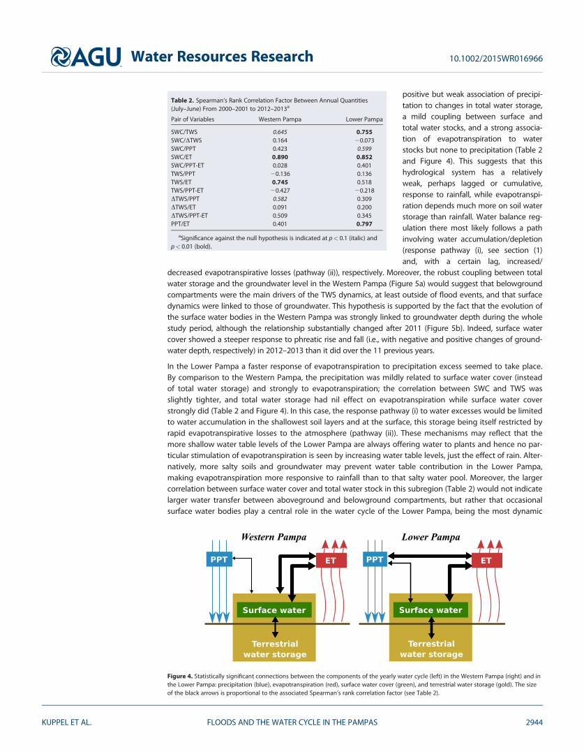