wgs 84 geoid - geonet names serverwgs 84 geoid 6.1 general ... as the vertical datum ... contoured...
TRANSCRIPT
6 . WGS 84 G E O I D
6.1 General
I n geodet i c a p p l i c a t i o n s , t h r e e d i f f e r e n t su r faces o r e a r t h
f i g u r e s a r e norma l l y invo lved . I n a d d i t i o n t o t h e e a r t h ' s n a t u r a l o r
p h y s i c a l sur face, these i n c l u d e a geometr ic o r mathematical f i g u r e o f t h e
e a r t h taken t o be an e q u i p o t e n t i a l e l l i p s o i d o f r e v o l u t i o n (Chapter 3 ) ,
and a second e q u i p o t e n t i a l su r f ace o r f i g u r e o f t h e ear th , t h e geoid. The
geo id i s de f i ned as t h a t p a r t i c u l a r e q u i p o t e n t i a l su r face o f t h e e a r t h
t h a t co inc ides w i t h mean sea l e v e l over t h e oceans and extends
h y p o t h e t i c a l l y beneath a l l land sur faces. I n a mathematical sense, t h e
geo id i s a l s o d e f i n e d as so many meters above ( + N ) o r below ( - N ) t h e
e l l i p s o i d (F igu re 6.1). I n F i g u r e 6.1 and i n subsequent f i g u r e s and
equat ions, t h e d i f f e r e n c e
v e r t i c a l i s ignored due t o
The f i r s t d e f i n i t
n d i r e c t i o n between t h e geodet i c normal and t h e
i t s i n s i g n i f i c a n c e t o t h e t o p i c d iscussed here.
on o f t h e geo id has g r e a t p r a c t i c a l importance
s i nce it r e f e r s t o t h e h y p o t h e t i c a l ex tens ion o f mean sea l e v e l ( t h e
geo id ) beneath land surfaces. I n t h i s capac i ty , t h e geo id serves no t o n l y
as t h e v e r t i c a l datum ( re fe rence su r f ace ) f o r height-above-mean sea l e v e l
( h ) va lues i n areas where e l e v a t i o n da ta i s n o t a v a i l a b l e f rom
convent iona l l e v e l i n g , b u t i s fundamental t o t h e de te rm ina t i on o f t he
h-values themselves. Th is i s apparent from t h e Equat ions

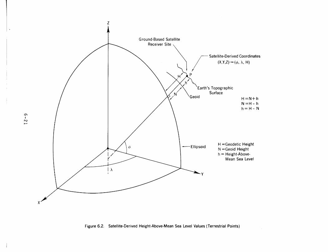
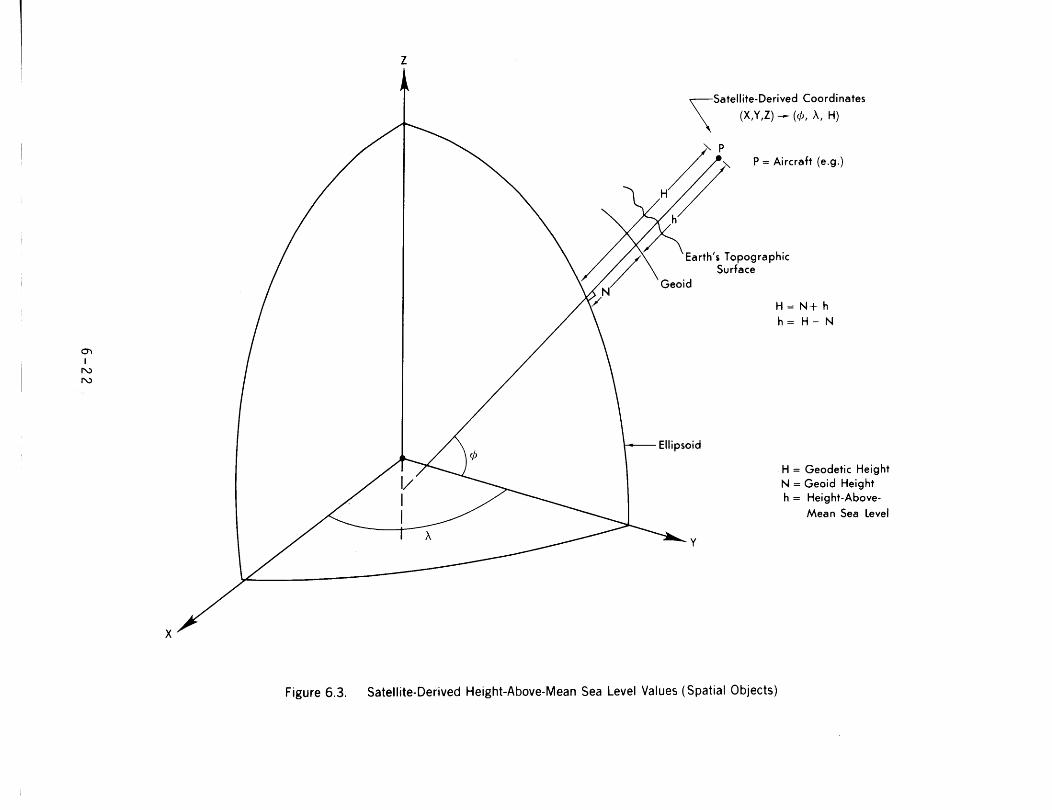
and F igu res 6.2 and 6.3, where:
H = geodet i c h e i g h t = h e i g h t above t h e e l l i p s o i d *
N = geo id h e i g h t
h = height-above-mean sea l eve l ,
F i gu res 6.2 and 6.3 i l l u s t r a t e t h e use o f geo id he igh t s i n t h e
de te rm ina t i on o f h-va lues from geodet i c he igh t s de r i ved us ing s a t e l l i t e
r e c e i v e r s (e.g., NAVSTAR GPS r e c e i v e r s ) l oca ted on t h e e a r t h ' s p h y s i c a l
su r f ace and aboard a v e h i c l e ope ra t i ng near t h e e a r t h ( o r i n space),
r e s p e c t i v e l y .
I n p a r t i c u l a r , it i s easy t o see from F igu re 6.2 how geo id
he igh t s ( N ) p o s i t i o n t h e geoid w i t h respec t t o t h e e l l i p s o i d where t he
former can then serve as t h e v e r t i c a l datum f o r t h e height-above-mean sea
l e v e l va lues which t h e N-values a l s o he lped determine. It i s hard t o
over -es t imate t h e importance o f t h e geo id i n t h i s dua l r o l e . I n some
p a r t s o f t h e world, t h e e l e v a t i o n da ta appearing on maps and c h a r t s was
ob ta ined v i a t h i s geo id - re l a ted approach.
I n land areas where heights-above-mean sea l e v e l a r e a v a i l a b l e
f rom convent iona l l e v e l i n g , t h e geoid, as determined here in , i s n o t needed
as t h e v e r t i c a l datum ( re fe rence su r f ace ) f o r these h-values. Instead,
height-above-mean sea l e v e l values a r e determined by convent iona l l e v e l i n g
f rom t h e r e l a t i o n s h i p L6.11:
% When N i s nega t i ve and t h e va lue of h i s p o s i t i v e , b u t sma l l e r than t h e magnitude o f N, t h e geodet i c ( e l l i p s o i d a l ) h e i g h t o f a p o i n t i s nega- t i v e . I n F l o r i d a , f o r example, t h e WGS 84 E l l i p s o i d , i f t r ans lucen t , would be v i s i b l e above a p o i n t (an observer) on t h e e a r t h ' s p h y s i c a l su r face . (See F i g u r e 6.4.)
where
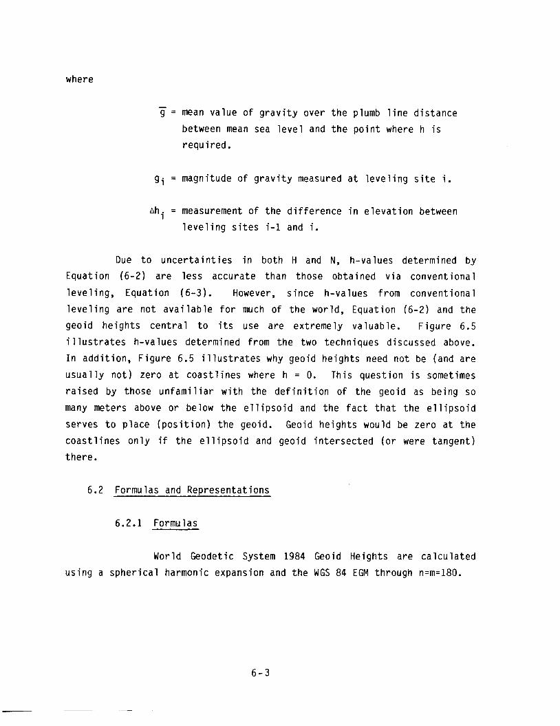
- g = mean va lue o f g r a v i t y over t h e plumb l i n e d i s tance
between mean sea l e v e l and t h e p o i n t where h i s
r equ i red .
gi = magnitude o f g r a v i t y measured a t l e v e l i n g s i t e i.
ahi = measurement o f t he d i f f e r e n c e i n e l e v a t i o n between
l e v e l i n g s i t e s i-1 and i.
Due t o u n c e r t a i n t i e s i n bo th H and N, h-values determined by
Equat ion (6-2) a re l e s s accura te than those ob ta ined v i a conven t iona l
l e v e l i n g , Equat ion (6-3) . However, s i nce h-values from convent iona 1
l e v e l i n g a r e n o t a v a i l a b l e f o r much o f t h e world, Equat ion (6-2) and t h e
geo id he igh t s c e n t r a l t o i t s use a re ext remely va luable. F i gu re 6.5
i l l u s t r a t e s h-values determined from t h e two techniques discussed above.
I n add i t i on , F i g u r e 6.5 i l l u s t r a t e s why geoid he igh t s need n o t be (and a re
u s u a l l y n o t ) zero a t c o a s t l i n e s where h = 0. Th is ques t ion i s sometimes
r a i s e d by those u n f a m i l i a r w i t h t h e d e f i n i t i o n o f t he geoid as be ing so
many meters above o r below t h e e l l i p s o i d and t h e f a c t t h a t t h e e l l i p s o i d
serves t o p l ace ( p o s i t i o n ) t h e geoid. Geoid he igh t s would be zero a t t h e
coas t1 i nes o n l y i f t h e e l 1 i p s o i d and geo id i n t e r s e c t e d ( o r were tangent )
there .
6.2 Formulas and Representat ions
6.2.1 Formulas
World Geodetic System 1984 Geoid Heights a re c a l c u l a t e d
us ing a s p h e r i c a l harmonic expansion and t h e WGS 84 EGM through n=m=180.
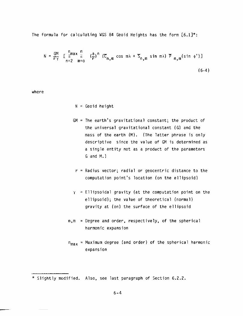
The formula for calculating WGS 84 Geoid Heights has the form [6.1]*:
where
N = Geoid height
GM = The earth's gravitational constant; the product of
the uni versa1 gravitational constant (G) and the
mass of the earth (M). (The latter phrase is only
descriptive since the value of GM is determined as
a single entity not as a product of the parameters
G and M.)
r = Radius vector; radial or geocentric distance to the
computation point's location (on the el 1 ipsoid)
y = Ellipsoidal gravity (at the computation point on the
el 1 ipsoid) ; the value of theoretica 1 (normal )
gravity at (on) the surface of the ellipsoid
n,m = Degree and order, respectively, of the spherical
harmonic expansion
%ax = Maximum degree (and order) of the spherical harmonic expansion
* Slightly modified. Also, see last paragraph of Section 6.2.2.
6 - 4
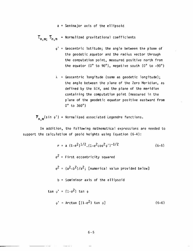
a = Semimajor a x i s o f t h e e l l i p s o i d
-€ S n,m; n,m = Normal ized g r a v i t a t i o n a l c o e f f i c i e n t s
4 ' = Geocentr ic l a t i t u d e ; t h e angle between t h e p lane o f
t h e geode t i c -equa to r and t h e r a d i u s vec to r through
t h e computat ion p o i n t , measured p o s i t i v e n o r t h f rom
t h e equator (0" t o 90'1, nega t i ve south (0' t o -90")
A = Geocentr ic l ong i t ude (same as geodet i c l ong i t ude ) ;
t h e angle between t h e p lane o f t h e Zero Mer id ian, as
de f i ned by t h e B I H , and t h e p lane o f t he mer i d i an
c o n t a i n i n g t h e computat ion p o i n t (measured i n t h e
p lane o f t h e geodet i c equator p o s i t i v e eastward f rom
0" t o 360')
P ( s i n 4 ' ) = Normal ized assoc ia ted Legendre f unc t i ons . n,m
I n add i t i on , t h e f o l l o w i n g mathematical express ions a re needed t o
suppor t t h e c a l c u l a t i o n o f geo id he igh t s us ing Equat ion (6-4) :
e' = F i r s t e c c e n t r i c i t y squared
2 2 e2 = (a -b ) /a2; [numer ica l va lue p rov ided below]
b = Semiminor a x i s o f t h e e l l i p s o i d
t a n Q' = (1-e2) t a n +
+ ' = Arctan [ ( l - e 2 ) t a n $1
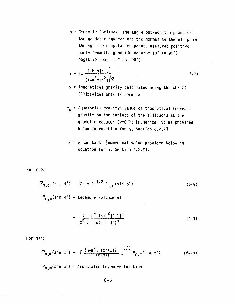
4 = Geodetic l a t i t u d e ; t h e angle between t h e p lane o f
t h e geodet i c equator and t h e normal t o t h e e l l i p s o i d
through t h e computat ion p o i n t , measured p o s i t i v e
n o r t h from t h e geodet i c equator (0° t o 90°),
nega t i ve south (0 " t o -90').
l + k s i n 4 2 Y = Ye (6-7)
2 2 (1-e s i n +)
y = T h e o r e t i c a l g r a v i t y c a l c u l a t e d us ing t h e WGS 84
E l l i p s o i d a l G r a v i t y Formula
'e = E q u a t o r i a l g r a v i t y ; va lue o f t h e o r e t i c a l (normal )
g r a v i t y on t h e su r f ace o f t h e e l l i p s o i d a t t h e
geodet i c equator ( +OO); [numer ica l va lue p rov ided
below i n equa t ion f o r y, Sec t ion 6.2.21
k = A constant ; [numer ica l va lue p rov ided below i n
equa t ion f o r Y, Sec t ion 6.2.23.
For m=o :
PnSo ( s i n 4 ' ) = (2n + 1)li2 Pn,o(sin 4 ' )
Pn,,(sin 4 ' ) = Legendre Polynomial
- 2 1 dn ( s i n 4 ' - l ) n - -
znn! d ( s i n + ' ) n
For mfo :
P,,,(sin 4 ' ) = Assoc ia ted Legendre f u n c t i o n
6 - 6

dmpn(s in 4 ' ) = (COS
d ( s i n
6.2.2 I n p u t Data
The f o l l o w i n g WGS 84 numer ica l da ta i s needed t o proceed
w i t h t h e c a l c u l a t i o n o f WGS 84 Geoid Heights u t i l i z i n g t h e above formulas:
8 3 GM = 3986005 x 10 m s" ( i n c l u d e s t h e mass o f t h e
e a r t h ' s atmosphere)
m = meters
s = seconds
7: S n,m ' n,m = A t o t a l o f 32755 g r a v i t a t i o n a l c o e f f i c i e n t s . These
c o e f f i c i e n t s , when supplemented w i t h GM, comprise
t h e WGS 84 Ea r th G r a v i t a t i o n a l Model (EGM). The
WGS 84 EGM i s c l ' a s s i f i e d CONFIDENTIAL w i t h t h e
excep t ion o f t h e c o e f f i c i e n t s through n=m=18 which
a r e UNCLASSIFIED. NOTE: For c a l c u l a t i n g WGS 84
Geoid Heights, t h e 5 Z,O, T 4,0, 7: 6,0, 7: 8,0, and
'c 10,o c o e f f i c i e n t s must be rep laced by t h e
q u a n t i t i e s :

The five preceding coefficient differences were formed
using the relationship
%n , 0 - - %n,0 (Dynamic) - rZny0 ("Geometric")
where
'2, ,O (Dynamic) = WGS 84 EGM coefficients
'2n, o ("Geometric" ) = Computed using in Equation (3-62) the defining
parameter 7: and e2 of the WGS 84 Ellipsoid. 290
(These "geometr ica 1 ly-determi ned" even degree
zonal gravitational coefficients are insignifi-
cantly small for other than the five coefficients
computed. )
6.2.3 Representations
The geoid is usually depicted as a contour chart which
shows the deviations of the geoid from the ellipsoid selected as the
mathematical figure of the earth. A worldwide WGS 84 Geoid Height Contour
Chart was developed using in Equations (6-4) to (6-11) the above WGS 84
numerical data and the WGS 84 EGM coefficients through n=m=180. A
worldwide 1°x10 grid of WGS 84 Geoid Heights was calculated and then
contoured using a five meter contour interval to form the chart. This
contour chart and other WGS 84-related geoid height graphics are contained
in 16.21. A 10°xlOO grid of WGS 84 Geoid Heights (n=m=180) is provided in
C6.31 [6.4] along with a contour chart developed by contouring at a five
meter contour interval a worldwide 1°x10 grid of WGS 84 Geoid Heights
truncated at (n=m=18).
WGS 84 Geoid Heights are available to DoD requesters in
representations other than contour charts of various contour intervals and
scales. WGS 84 Geoid Heights can be provided on magnetic tape for a
specified grid interval or for sites of interest. A Geoid Height Computer
Program (n=m=180) capable of calculating both gridded and random point
geoid heights can also be made available (along with appropriate
documentation and test cases). (See Section 6.5. )
6.3 Geoid Height Interpolation Method
A basic objective with respect to WGS 84 Geoid Heights is that
they be based on a utilization of the complete n=m=180 WGS 84 EGM.
Adherence to this objective is necessary to ensure that WGS 84 Geoid
Heights calculated by different organizations for the same locations are
in agreement. For some situations or applications, should it be
impractical from either a computer storage or computer time standpoint to
calculate geoid heights using the n=m=180 expansion, adherence to the
desired expansion can be maintained by interpolating from a pre-computed
grid of geoid heights calculated using the n=m=180 WGS 84 EGM. Such an
interpolation can be conducted with minimal (and acceptable) accuracy
degradation by choosing a small enough grid interval. Use of a 30'x301
grid of geoid heights will provide interpolated values of sufficient
accuracy for most applications.
A brief investigation of various grid sizes and geoid height
interpolation methods was conducted before coming to the above
conclusion. The criteria for selecting a geoid height interpolation
method are that it be economical to use, easy to implement, provide good
accuracy, and produce consistent values along the grid boundaries. The
investigation of interpolation techniques involved two methods, a
Weighting Function Method [6.5] and a Bi-Linear Interpolation Method
[6.6]. Since the Bi-Linear Interpolation Method provided interpolated
values that were more accurate than those obtained using the Weighting
Function Method, and adequately met all the criteria for selecting an
interpolation method, the Bi-Linear Interpolation Method was selected as
t h e geo id h e i g h t i n t e r p o l a t i o n scheme t o use w i t h a g r i dded s e t o f WGS 84
Geoid Heights .
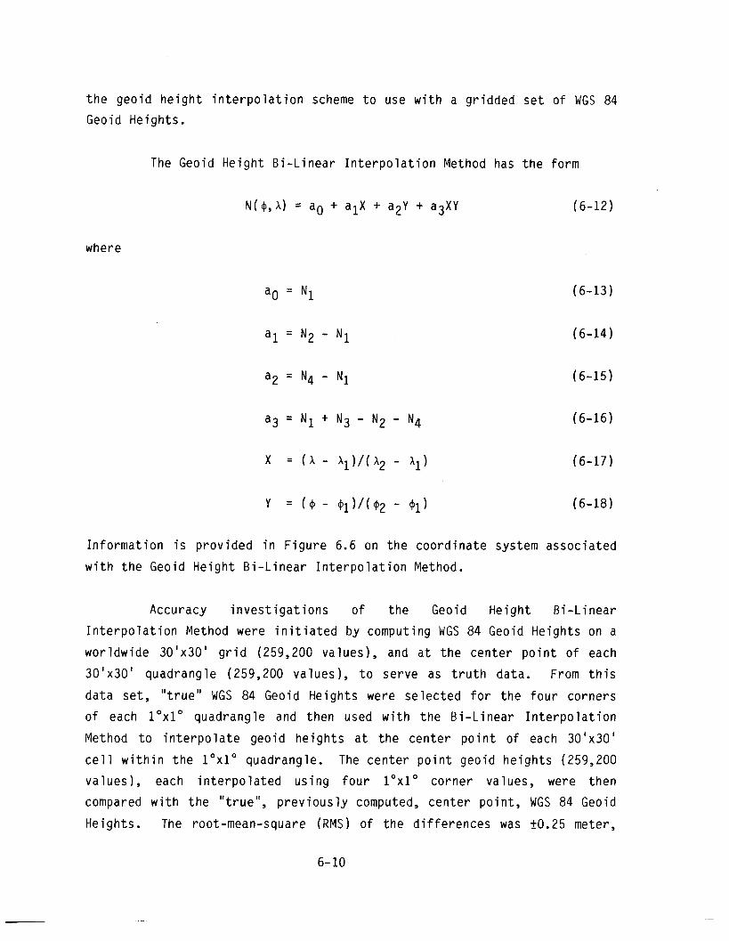
The Geoid He igh t B i - L i nea r I n t e r p o l a t i o n Method has t h e fo rm
N(9, A) = a. + alX + a2Y + a3XY (6-12)
where
I n f o r m a t i o n i s p rov i ded i n F i g u r e 6.6 on t h e coo rd i na te system assoc ia ted
w i t h t h e Geoid He igh t B i - L i nea r I n t e r p o l a t i o n Method.
Accuracy i n v e s t i g a t i o n s o f t h e Geoid He igh t B i - L i nea r
I n t e r p o l a t i o n Method were i n i t i a t e d by computing WGS 84 Geoid He igh ts on a
wor ldwide 30 'x301 g r i d (259,200 va lues) , and a t t h e cen te r p o i n t o f each
301x30 ' quadrangle (259,200 va lues) , t o se rve as t r u t h data. From t h i s
da ta se t , " t r u e " WGS 84 Geoid He igh ts were se lec ted f o r t h e f o u r co rners
o f each 1°x10 quadrangle and then used w i t h t h e B i - L i nea r I n t e r p o l a t i o n
Method t o i n t e r p o l a t e geo id h e i g h t s a t t h e cen te r p o i n t o f each 30 'x301
c e l l w i t h i n t h e 1°x10 quadrangle. The cen te r p o i n t geo id h e i g h t s (259,200
va lues) , each i n t e r p o l a t e d us i ng f o u r 1°x10 corner values, were then
compared w i t h t h e " t r ue " , p r e v i o u s l y computed, cen te r p o i n t , WGS 84 Geoid
Heights . The root-mean-square (RMS) of t h e d i f f e r e n c e s was f0.25 meter,
w i t h t h e l a r g e s t p o s i t i v e and nega t i ve d i f f e r e n c e s be ing 4.16 and -3.53
meters, r e s p e c t i v e l y (Tab le 6.1). Next, t h e f o u r " t r u e " WGS 84 Geoid
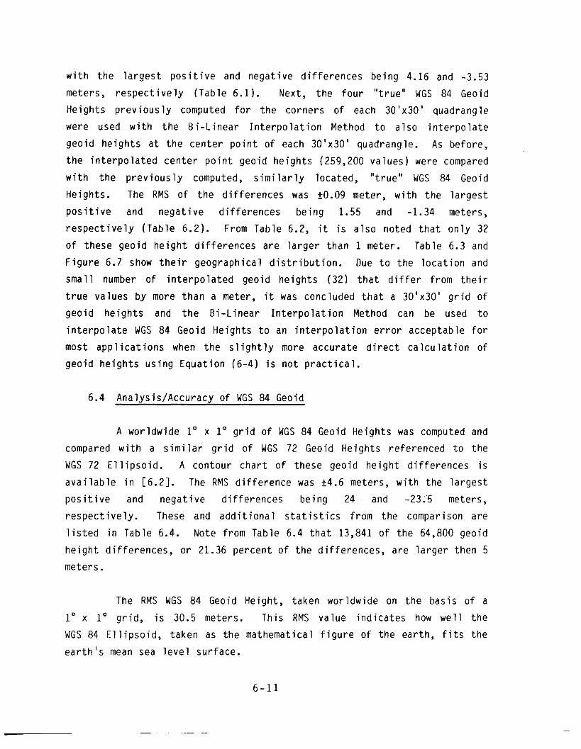
He igh ts p r e v i o u s l y computed f o r t h e co rners o f each 308x30 ' quadrangle
were used w i t h t h e B i - L i nea r I n t e r p o l a t i o n Method t o a l s o i n t e r p o l a t e
geo id h e i g h t s a t t h e cen te r p o i n t of each 301x30 ' quadrangle. As before,
t h e i n t e r p o l a t e d cen te r p o i n t geo id he igh t s (259,200 va lues) were compared
w i t h t h e p r e v i o u s l y computed, s i m i l a r l y located, " t r u e " WGS 84 Geoid
Heights . The RMS of t h e d i f f e rences was t0.09 meter, w i t h t h e l a r g e s t
p o s i t i v e and nega t i ve d i f f e r e n c e s be ing 1.55 and -1.34 meters,
r e s p e c t i v e l y (Tab le 6.2). From Table 6.2, i t i s a l s o noted t h a t o n l y 32
o f these geo id h e i g h t d i f fe rences a re l a r g e r than 1 meter. Table 6.3 and
F i g u r e 6.7 show t h e i r geograph ica l d i s t r i b u t i o n . Due t o t h e l o c a t i o n and
sma l l number o f i n t e r p o l a t e d geo id h e i g h t s (32) t h a t d i f f e r f rom t h e i r
t r u e va lues by more t h a n a meter, it was concluded t h a t a 30 'x301 g r i d of
geo id h e i g h t s and t h e B i - L i nea r I n t e r p o l a t i o n Method can be used t o
i n t e r p o l a t e WGS 84 Geoid Heights t o an i n t e r p o l a t i o n e r r o r acceptab le f o r
most a p p l i c a t i o n s when t h e s l i g h t l y more accura te d i r e c t c a l c u l a t i o n o f
geo id h e i g h t s u s i n g Equat ion (6-4) i s n o t p r a c t i c a l .
6.4 Analvs is /Accuracv o f WGS 84 Geoid
A wor ldwide lo x lo g r i d o f WGS 84 Geoid Heights was computed and
compared w i t h a s i m i l a r g r i d o f WGS 72 Geoid He igh ts re fe renced t o t h e
WGS 72 E l l i p s o i d . A con tour c h a r t o f these geo id h e i g h t d i f f e r e n c e s i s
a v a i l a b l e i n 16.21. The RMS d i f f e r e n c e was f4.6 meters, w i t h t h e l a r g e s t
p o s i t i v e and nega t i ve d i f f e r e n c e s be ing 24 and -23.5 meters,
r e s p e c t i v e l y . These and a d d i t i o n a l s t a t i s t i c s f rom t h e comparison a re
l i s t e d i n Table 6.4. Note f rom Table 6.4 t h a t 13,841 o f t h e 64,800 geoid
h e i g h t d i f f e r e n c e s , o r 21.36 percen t o f t h e d i f f e r e n c e s , a re l a r g e r then 5
meters.
The RMS WGS 84 Geoid Height , taken wor ldwide on t h e bas i s o f a
lo x lo g r i d , i s 30.5 meters. Th is RMS va lue i n d i c a t e s how w e l l t h e
WGS 84 E l l i p s o i d , taken as t h e mathematical f i g u r e o f t h e ear th , f i t s t h e
e a r t h ' s mean sea l e v e l su r face .
It is generally acknowledged that the most accurate geoid heights
available today from an absolute accuracy standpoint are satellite-derived
geometric geoid heights. These geoid heights are obtained by expressing
Equation (6-1) in the form
In the context of this discussion:
N = satellite-derived geometric geoid height
H = satellite-derived geodetic height
h = height-above-mean sea level value obtained via
conventional leveling.
From the error relationship
and the lack of correlation between the errors ( E ) in H and h, assumed
random:
If H is laser derived, aH is approximately fl meter. For
Doppler-derived WGS 84 H-values, determined via satellite point posi-
tioning, "H ranges from fl to f4 meters. See Equations (9-2), (9-4), and
(9-6). The absolute error in h (ah) at well-surveyed satellite tracking
sites is on the order of fl to f2 meters. Using these values for OH and
in Equation (6-211, and rounding to the nearest meter:
oN = +1 to f4 meters. (6-22)
Therefore, Equation (6-22) establishes fl meter (one sigma) as the current
absolute accuracy threshold, at well-surveyed tracking stations, for
satellite-derived geometric geoid heights (relative to the WGS 84
El 1 ipsoid).
The preceding accuracy information was utilized through
geoid height comparisons, Doppler-derived and laser-derived WGS 84 geome-
tric geoid heights versus WGS 84 (n=m=180) Geoid Heights, to establish the
accuracy threshold for WGS 84 Geoid Heights E6.21. The WGS 84 Geoid
Heights have an error range of f2 to a6 meters (one sigma), and are known
to accuracies of f2 to f3 meters over approximately 55 percent of the
earth. Approximately 93 percent of the earth has WGS 84 Geoid Heights of
accuracy better than f4 meters. A worldwide WGS 84 Geoid Height Accuracy
Graphic and error analysis particulars are available in [6.2].
6.5 Availability of WGS 84 Geoid Height Data
WGS 84 Geoid Height data and products that can be provided to
requesters include:
- A worldwide WGS 84 Geoid Height Contour Chart (developed by
contouring a 1°x10 grid of values), contour interval = 5 meters. If
needed, contour charts of various physical size can be provided based on
other contour intervals and scales, and for specific geographic areas.
- A magnetic tape containing the worldwide 1°x10 grid of WGS 84 Geoid Heights used in developing the worldwide WGS 84 Geoid Height Contour
Chart.
- A magnetic tape containing a worldwide 3O1x30' grid of WGS 84 Geoid Heights, plus a Bi-Linear Interpolation Method for interpolating
WGS 84 Geoid Heights at random points. As stated previously, this
interpolation scheme has an interpolation error (RMS difference) of f 0.09
meter based on a comparison between 259,200 true and interpolated WGS 84
Geoid Heights . Only 32 geo id h e i g h t d i f f e r e n c e s exceeded 1 meter, t h e
l a r g e s t d i f f e r e n c e be ing 1.55 meters.
- A Computer Program f o r c a l c u l a t i n g WGS 84 Geoid Heights a t a
s p e c i f i e d g r i d i n t e r v a l o r a t random p o i n t s . Assoc ia ted documentat ion and
a p p r o p r i a t e t e s t cases a re inc luded.
Requests f o r WGS 84 Geoid He igh t da ta and p roduc ts should be
forwarded t o t h e address p rov i ded i n t h e PREFACE.
6.6 Comments
Due t o t h e absence o f t i d e gauges and o t h e r r e l a t e d problems,
much of t h e w o r l d today does no t have an accura te v e r t i c a l datum
( r e f e r e n c e ) f o r e l e v a t i o n data. Also, those v e r t i c a l datums t h a t do e x i s t
a re n o t c o n s i s t e n t w i t h one another. Much has been w r i t t e n i n t h e l a s t
few years about t h e need f o r a new accura te wor ldwide v e r t i c a l datum.
Such a datum can e a s i l y be e s t a b l i s h e d by u s i n g t h e WGS 84 Geoid t o
p r o v i d e c o a s t l i n e va lues (geo id h e i g h t s ) a t s i t e s (h=O) f rom which
conven t i ona l l e v e l i n g can proceed and, where such l e v e l i n g i s absent,
e l e v a t i o n da ta can be e s t a b l i s h e d f rom Equat ion (6 -2 ) where such h-values
a re a u t o m a t i c a l l y r e l a t e d t o t h e WGS 84 Geoid and t h e WGS 84 E l l i p s o i d .
Wi th t h i s approach, t h e WGS 84 E l l i p s o i d can serve as t h e re fe rence f o r
e l e v a t i o n da ta (as i t now serves as t h e re fe rence f o r h o r i z o n t a l
p o s i t i o n s ) , w h i l e a t t h e same t ime t h e concept o f heights-above-mean sea
l e v e l i s r e ta i ned . Al though i n t h e l i t e r a t u r e some researchers propose
abandoning use o f t h e geoid, it i s impor tan t f o r some v e r t i c a l p o s i t i o n i n g
a p p l i c a t i o n s t h a t mean sea l e v e l be r e t a i n e d a t t h i s t ime. For example,
a i r c r a f t equipped w i t h baromet r i c a l t i m e t e r s measure t h e i r h e i g h t above
mean sea l e v e l .
REFERENCES
6.1 Heiskanen, W.A. and H. M o r i t z ; P h y s i c a l Geodesy; W.H. Freeman and
Company; San F r a n c i s c o , C a l i f o r n i a ; 1967.
6.2 Supplement t o Department o f Defense World Geodet ic System 1984
T e c h n i c a l R e ~ o r t : P a r t 111 - Non-Releasable WGS 84 Geoid. E a r t h - - - - - -- - - - - - - - - - - - - - - -
G r a v i t a t i o n a l Model, and Datum S h i f t I n f o r m a t i o n and/or Graph ics
(U) ; DMA TR 8350.2-C; Headquar ters , Defense Mapping Agency; - Washington, DC; 1 December 1987; c l a s s i f i e d CONFIDENTIAL.
6.3 Sumlemen t t o D e ~ a r t m e n t o f Defense World Geodet ic Svstem 1984
T e c h n i c a l Repor t : P a r t I 1 - Parameters, Formulas, and Graph ics f o r
t h e P r a c t i c a l A p p l i c a t i o n o f WGS 84; DMA TR 8350.2-8; Headquar ters ,
Defense Mapping Agency; Washington, DC; 1 December 1987.
6.4 D e ~ a r t m e n t o f Defense World Geodet ic Svstem 1984 - I t s D e f i n i t i o n
and R e l a t i o n s h i p s Wi th Loca l Geodet ic Systems; DMA TR 8350.2;
Headquar ters , Defense Mapping Agency; Washington, DC;
30 September 1987.
6.5 Junk ins , J.L.; M i l l e r , G.W.; and J. R. J a n c a i t i s ; "A We igh t ing
F u n c t i o n Approach t o Mode l i ng o f I r r e g u l a r S u r f a c e s " ; J o u r n a l o f
Geophys ica l Research; Vol . 78, No. 11; 10 A p r i l 1973.
6.6 M o r i t z , H. ; " I n t r o d u c t i o n t o I n t e r p o l a t i o n and Approx ima t ion " ;
A D D r ~ ~ i m a t i ~ n Methods i n Geodesv: H. M o r i t z and H. Sunkel
( E d i t o r s ) : H e r b e r t Wichmann ( P u b l i s h e r ) ; K a r l s r u h e , F e d e r a l
R e p u b l i c o f Germany; 1978.
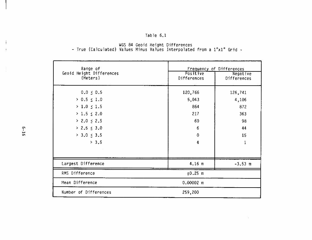
Table 6.1
WGS 84 Geoid He igh t D i f f e rences - True (Ca l cu la ted ) Values Minus Values I n t e r p o l a t e d f rom a 1°x10 G r i d -
Range o f Geoid He igh t D i f f e rences
(Meters )
La rges t D i f f e r e n c e
RMS D i f f e r e n c e
Frequency P o s i t i v e
D i f f e rences D i f f e r e n c e s
I Mean D i f f e r e n c e 0.00002 rn I I Number o f D i f f e r e n c e s 259,200 I
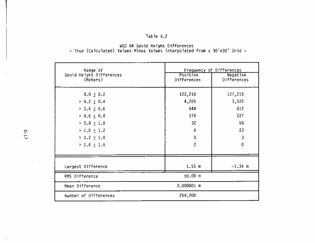
Table 6.2
WGS 84 Geoid H e i g h t D i f f e r e n c e s - True ( C a l c u l a t e d ) Values Minus Values I n t e r p o l a t e d f rom a 3O1x30' G r i d -
Range o f Geoid H e i g h t D i f f e r e n c e s
(Mete rs )
L a r g e s t D i f f e r e n c e
Frequency o P o s i t i v e
D i f f e r e n c e s
RMS D i f f e r e n c e
D i f f e r e n c e s Nega t i ve
if fe rences
Mean D i f f e r e n c e 0.000001 m
Number o f D i f f e r e n c e s

Table 6.3
Distribution of Geoid Height Differences Greater Than One Meter - True (Calculated) Values Minus Values Interpolated from a 30' x 30' Grid* -
2 Points > I 1.0 I [-I .04 -1 .OOI
25 Points > 1 1.0 I [-I .23 1 .55I
5 Points > I 1.0 I 1-1.34 -1 .OOI
Geodetic Longitude 360"
*259,2OO Va 1 ues Compared.
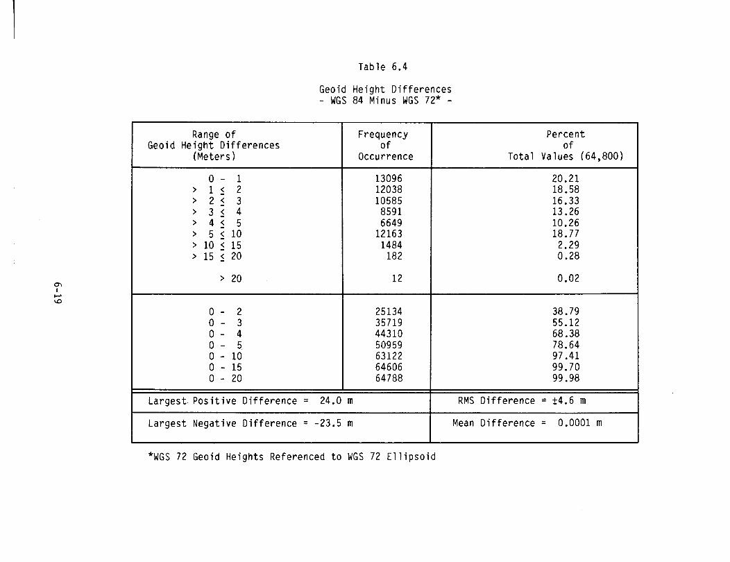
Table 6.4
Geoid He igh t D i f f e r e n c e s - WGS 84 Minus WGS 72* -
Range o f Geoid He igh t D i f f e r e n c e s
(Meters)
Frequency 0 f
Occurrence
Percen t o f
T o t a l Values (64,800)
I
L a r g e s t P o s i t i v e D i f f e r e n c e = 24.0 m I RMS D i f f e r e n c e = f4 .6 m
L a r g e s t Negat ive D i f f e r e n c e = -23.5 m I Mean D i f f e r e n c e ; 0.0001m
*wGS 72 Geoid He igh ts Referenced t o WGS 72 E l l i p s o i d
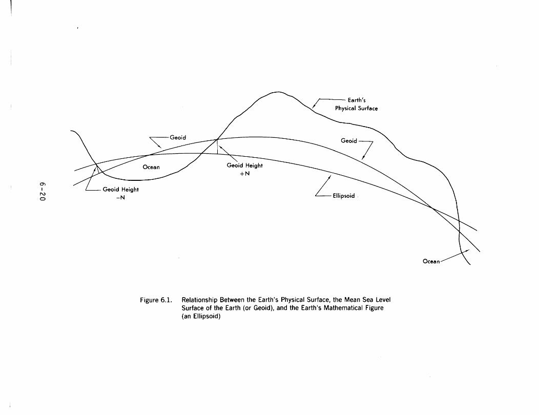
Figure 6.1. Relationship Between the Earth's Physical Surface, the Mean Sea Level Surface of the Earth (or Geoid), and the Earth's Mathematical Figure (an Ellipsoid)
G round-Based Satellite
H =Geodetic Height N =Geoid Height h = Height-Above-
Mean Sea Level
Figure 6.2. Satellite-Derived Height-Above-Mean Sea Level Values (Terrestrial Points)
Satellite-Derived Coordinates
T o(lY1Z) - (rn, H,
P = Aircraft (e.g.)
'~arth'r Topographic Surface
H = Geodetic Height N = Geoid Height h = Height-Above-
Mean Sea Level
Figure 6.3. Satellite-Derived Height-Above-Mean Sea Level Values (Spatial Objects)

Point P
(i, = 29" N, X = 278"E (82"W) (Marion County, Florida)
Figure 6.4. Illustration of a Negative WGS 8 4 Geodetic He~ght (H)

Topographic Surface
hl(P) f h*(P)
Oh1 (P) <Oh2h2(V
'Th rrh = Errors in hl, h2 at P 1' 2
Figure 6.5. TwoTechniques for Obtaining Height Above Mean Sea Level Values

N~(@~,X,,) = Geoid Height to be Interpolated at Point P
N 21N31N4 = Available Grid Point Geoid Heights
X,Y = Non-Dimensional Coordinates of Point P
[Equations (6.17), (6.18)]
Figure 6.6. Coordinate System Associated With Geoid Height Bi-Linear Interpolation Scheme
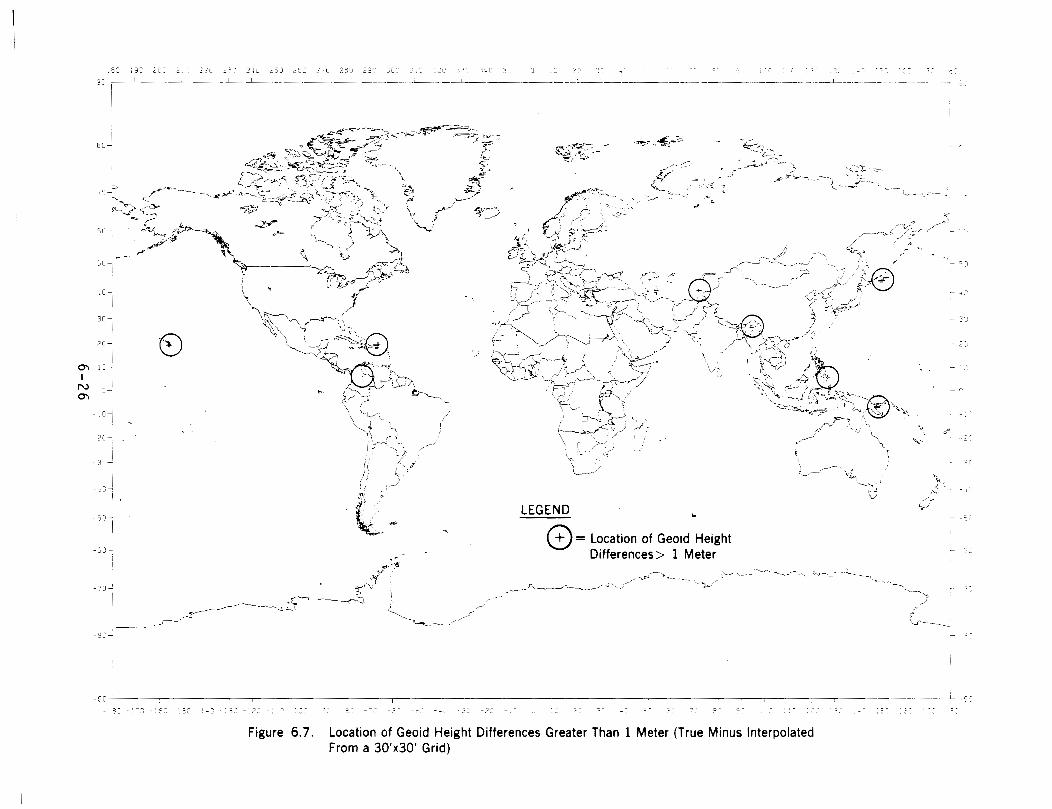
Figure 6.7. Location of Geoid Height Differences Greater Than 1 Meter (True Minus Interpolated From a 30fx30' Grid)