westside subway extension - findings regarding
TRANSCRIPT

Westside Subway ExtensionFindings Regarding Constellation Station
and Tunnel Alignment
Metro Board of Directors
May 24th 2012

Century City Alignment and Station Location
•7

Active Faults are Present
Beverly Hills consultantsgenerated additional datathat allowed Metro to refineits understanding of the NIFZand SMZ
Metro takes strong issue withtheir basic conclusions
Santa Monica Fault is Active
Northern Newport InglewoodFault Zone extends intoCC/BH along the WBHL
Both of these fault zones areshown as active on statemaps

Map of Continuous Santa Monica FaultZone Scarp
Dolan et al., 2000

Active Santa Monica Fault Evidence
Trench at VA Hospital SiteScarp at Mormon Temple

Summary of Trench and High Resolution SeismicReflection Data from VA Hospital Study Site

Profile along Avenue of the Stars

Map of Continuous Santa Monica FaultZone Scarp
Dolan et al., 2000

Elevation Contours on top of San Pedro FormationShow 300+ ft Strike-Slip Offset

San Pedro Contours – Pre Faulting (330+ feet ofright-lateral strike-slip restored)
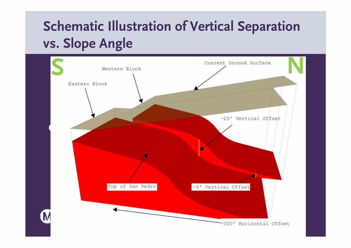
Schematic Illustration of Vertical Separationvs. Slope Angle
•S
NS

Schematic Illustration of VerticalSeparation vs. Slope Angle

Schematic Illustration of VerticalSeparation vs. Slope Angle

Schematic Illustration of Vertical Separationvs. Slope Angle
•S
NS

Geomorphic Evidencefor N NW-TrendingStrike-Slip Faults of theNNI Fault Zone
1920’s USGS Topo Map

Geomorphic Evidencefor N NW-TrendingStrike-Slip Faults of theNNI Fault Zone
1920’s USGS Topo Map

Compilation of BH + Metro CPT and Borehole DataShows Vertical Steps Indicative of NIFZ Faulting
NESW
ExamplealongDurantAvenue

Trench 3 North Wall from Leighton ReportShows Evidence of Faulting
FAULT FAULT

Fault Investigation Summary
Major strand of NewportInglewood Fault Zone
• Clearly shown by bothanalysis of topographyand offset of the top-SanPedro paleosurface
• Extends through thestation location on SMB
Santa Monica Fault is Active
• Wide zone of faulting

Active Faults are Present
Multiple complementarylines of evidence(topography, boreholes,CPTS, geophysical data,regional fault interactions,and trenches)demonstrate:– Santa Monica Fault is Active
– Northern NewportInglewood Fault Zoneextends into CenturyCity/Beverly Hills along theWBHL
– Both of these fault zones areshown as active on statemaps

Sufficiency of Investigation at Constellation
No evidence of faulting– From geomorphology,
excavations for existingbuildings, borehole data

Sufficiency of Investigation at Constellation
No evidence of faulting– From geomorphology,
excavations for existingbuildings, borehole data
Gassy ground conditionshave been and will bemitigated– Metro design
– Existing buildings with deepparking garages operatingsafely

Alignment Selection Century City
Santa Monica Boulevard: The risks associatedwith the construction of the station within anactive fault rupture zone are unacceptable
Constellation Boulevard: The risks associatedwith construction of the station are known,acceptable, and can be managed
– Proven in the City of Los Angeles and Century City area
– Beverly Hills Consultants agree that, given propercontrols, tunneling is safe

Metro Actively Manages Risk
Metro conducts qualitative and quantitative risk assessment inaccordance with FTA and ITA Guidelines
Metro maintains a detailed Risk Register to track risks and to controland monitor assigned mitigation
Metro’s Century City studies were focused not on estimating theprobability of an event but rather on providing solutions to mitigatethe risk of an event occurring and then to establish controls to confirmthat the risk has been mitigated
Tunneling Safety and Fault Investigation Reports– Identify and describe hazards and qualitatively evaluate risks
– Provide engineering solutions to mitigate risks to acceptable levels

Metro’s Management of Risk at Century City
Detailed engineering and geologic studies
– Build on successful design
– State of the art studies and innovative designs
Workshops and team reviews with internationally recognized experts
Review by Metro Tunnel Advisory Panel
Review by Independent Review Panel (IRP)
The IRP has confirmed that Metro’s approach to risk management iscorrect and that a probability based risk analysis approach is not requiredfor alignment selection

Building Construction Over Tunnels
Wide bridge-like foundations not required
Foundations and multi-level basementscan be constructed above the tunnels.
Basements reduce the load on underlyingstructures
Deep foundations, such as drilled piers,can be placed adjacent to, and between,the tunnels
Metro has successfully worked withproperly owners to develop over itstunnels

Building Construction Over Subway Easements
MTA’s easement deed includes the right “to review plans and specifications for excavation orsubsurface construction above or adjacent to the easement area.”
MTA’s policy is always to seek to negotiate the property rights that are required. If negotiationscannot be successfully completed, the Board is requested to consider adoption of a Resolution ofNecessity to condemn and to acquire through an Eminent Domain action.
If a property is taken by Eminent Domain, MTA retains the right to review and approve what isbuilt over the tunnels for the purpose of protecting the tunnels and for safety considerationsduring construction of the building improvements over the tunnels.
MTA has worked with property owners to approve building construction over subway easements.Examples include residential and mixed-use projects at Union Station (Alameda/Cesar Chavez),Wilshire/Vermont Station and the Westlake MacArthur Park Station (between Wilshire and 7th).
Union Station

Building Construction Over Subway Easements
•Wilshire/Vermont •Westlake/MacArthur Park

BHHS Proposed Option 1

•NOTE: CENTURY CITYCONSTELLATION STATIONMOVES 917 FEET WESTCOMPARING TO FEIS/EIR
BHHS Proposed Option 1 Issues

BHHS Proposed Option 2

10000SANTAMONICASITE
•NOTE: CENTURY CITYCONSTELLATION STATIONMOVES 1338 FEET WESTCOMPARING TO FEIS/EIR
BHHS Proposed Option 2 Issues

BHHS Proposed Option 3

•NOTE: CENTURY CITYCONSTELLATION STATIONMOVES 389 FEET WESTCOMPARING TO FEIS/EIR
BHHS Proposed Option 3 Issues

*Metrorail curve radii criteria is 1000’ Deviation from Criteria to minimize impact toBHHS
Alternate MinSpeed(mph)
Depthcompared to
EIS route(deeper)
MinimumTrack & Tunnel
Radii (ft)
MetroEIR/EIS
(Red)
45 NA 961’*
BH 1(Purple)
25 6-20 ft 800
BH 2(Yellow)
25 18 ft 800
BH 3(Blue)
25 15 ft 800
Proposed BH Century City Alignments