western south of market neighborhood transportation … san francisco...neighborhood transportation...
TRANSCRIPT

Western South of Market Neighborhood Transportation Plan
ADOPTED BY THE AUTHORITY BOARD IN MARCH 2012
S A N F R A N C I S C O C O U N T Y T R A N S P O R T A T I O N A U T H O R I T Y
FINAL REPORT

ACKNOWLEDGEMENTSThe study has been a collaborative effort, with contributions from many individuals. The Authority wishes to thank:
San Francisco County Transportation Authority
Tilly Chang, Deputy Director for PlanningChester Fung, Project ManagerLiz Brisson, Transportation PlannerBen Stupka, Senior Transportation PlannerKarla Kingsley, Kim Lucas, Stephen Newhouse, Taylor Reiss, Lucas Woodward
Consultant Team
Michael Eiseman, Paul Supawanich – Nelson\Nygaard Consulting AssociatesThomas Kronemeyer, Greg Pasquali, Jessica Look – Community Design + ArchitectureMeghan Mitman, Todd Henry – Fehr & PeersFernando Martí, Max Kwok, Claudia Sun – Asian Neighborhood Design
Technical Working Group
San Francisco Department of Public Health – Megan WierSan Francisco Department of Public Works – Jasmine Kaw, Charles YuSan Francisco Municipal Transportation Agency – Manito Velasco, Tom Folks, Mike Sallaberry, Ellen Robinson,
Jerry RobbinsSan Francisco Planning Department – Paul Lord, Andrea Contreras, Andres Power, Viktoriya WiseSan Francisco Redevelopment Agency – Mike Grisso
Community Partner
Western SoMa Citizens Planning Task Force
This project was funded by a Community-Based Transportation Planning grant from the Metropolitan Transportation Commission and Prop K sales tax from the San Francisco County Transportation Authority.

Contents Executive Summary 5
1. Introduction 9
2. Existing and Future Conditions 11Land Use Context 11Transportation Context 11
3. Public and Stakeholder Involvement 17Outreach Methods 17Key Feedback Messages and Study Response 18
4. Proposed Improvements 21Project Screening and Prioritization Process 21Key Features of the Alley Improvement Concepts 22Minna, Natoma, and Ringold Conceptual Designs 26
5. Implementation 29Project Development Path 29Outstanding Coordination and Implementation Issues 30Cost Estimates and Funding Strategy 35
Appendices A. Cost Estimate Detail 38B. Minna/Natoma Mid-Block Crossing Evaluation (available upon request)C. Project Screening Analysis (available upon request)
FINAL REPORT • WESTERN SOUTH OF MARKET NEIGHBORHOOD TRANSPORTATION PLAN
SAN FRANCISCO COUNTY TRANSPORTATION AUTHORITY • MARCH 2012
100 Van Ness Avenue, 26th Floor, San Francisco, CA 94102tel 415.522.4800 fax 415.522.4829
email [email protected] web www.sfcta.org
S A N F R A N C I S C O C O U N T Y T R A N S P O R TAT I O N A U T H O R I T Y

This page left intentionally blank

THE WESTERN SOUTH OF MARKET Neighborhood Transportation Plan (NTP) addresses existing needs and supports the implementation of the land use changes envisioned in the recent Western SoMa Community Plan by advancing high-priority transportation improvements that can be implemented in the short term. The recommended improvements, which have been developed to conceptual design, include traffic calming and pedestrian improvements to the alleys of Minna, Natoma, and Rin-gold Streets and signalized mid-block crossings of 7th and 8th Streets. This report presents the findings and recommendations of the NTP, providing documentation of existing conditions in the Western SoMa neighborhood, summarizing public and stakeholder input, presenting the conceptual project designs and describing an implementation strat-egy. This NTP represents the necessary first step toward implementation that will assist city agencies and the community in pursuing funding and advancing project development.
E.1 ContextWestern South of Market (Western SoMa), defined roughly as the area between 4th and 12th Streets and Howard and Townsend Streets, is an historically industrial neighborhood, home to a moderate-density mix of land uses, businesses, small-scale retail, restaurants, and nightlife, as well as single- and multi-family housing. The neighborhood is desig-nated as a Community of Concern by the Metropolitan Transportation Commission (MTC), making it eligible for regional funds devoted to improving mobility and access in low-income areas. With adoption of a recent land use effort for the area, the Western SoMa Community Plan, the population could increase the neighborhood’s housing from 3,000 to 6,000 units by 2030. The study area is located within San Francisco’s Eastern Neighborhoods Priority Development Area.
E.2 Study ProcessTo define the recommended improvements, the NTP conducted a plan-ning process that combined technical analysis, community input, and inter-agency coordination. The process included developing an evalua-tion framework and screening a list of previously proposed and newly identified potential projects to arrive at a shortlist of high-priority projects. The NTP then created conceptual designs and an implementa-tion strategy for the improvements. Each step in this process was guided
ExecutiveSummary
FINAL REPORT • WESTERN SOUTH OF MARKET NEIGHBORHOOD TRANSPORTATION PLAN
SAN FRANCISCO COUNTY TRANSPORTATION AUTHORITY • MARCH 201
PAGE 5
EXECUTIVE SUMMARY

FINAL REPORT • WESTERN SOUTH OF MARKET NEIGHBORHOOD TRANSPORTATION PLAN
SAN FRANCISCO COUNTY TRANSPORTATION AUTHORITY • MARCH 2012
PAGE 6
EXECUTIVE SUMMARY
by engagement with the community and the Western SoMa Citizen Planning Task Force, a citizen-led body appointed by the Board of Supervisors to oversee the Community Plan.
E.3 Existing and Future Conditions The study team considered existing and expected future conditions in Western SoMa to inform development and selection of candidate projects. The analysis revealed the follow-ing key issues and opportunities:
• High pedestrian volumes on the alleys, indicating an opportunity to benefit a signifi-cant number of corridor travelers through pedestrian improvements;
• Pedestrian connectivity challenges, indicating a need for mid-block crossings to facili-tate safer and more direct access through the alleys;
• High traffic speeds and collision risks, indicating a need for traffic calming treatments to reduce vehicle speeds;
• Personal security concerns, indicating a need to carefully design public realm improve-ments to avoid susceptibility to vandalism and loitering;
• Limited and spartan public space, indicating an opportunity for the alleys to serve as additional public spaces; and
• Need for parking and loading use on the alleys, indicating a need to mostly maintain these types of uses.
E.4 Public and Stakeholder InputThe study team sought public input throughout the Study, in particular to seek input on the selection of preferred transportation projects, and in refining conceptual designs for the preferred transportation projects. Public involvement activities included regular con-
The Western South of Market Neighborhood Transportation Plan addresses existing needs and supports the implementation of the land use changes envisioned in the Western SoMa Community Plan by advancing high-priority transportation improvements that can be implemented in the short term.
Figure ES-1. Western SoMa Neighborhood Transportation Plan Study Area.

FINAL REPORT • WESTERN SOUTH OF MARKET NEIGHBORHOOD TRANSPORTATION PLAN
SAN FRANCISCO COUNTY TRANSPORTATION AUTHORITY • MARCH 2012
PAGE 7
CHAPTER ONE
PAGE 7
EXECUTIVE SUMMARY
sultation with the Western SoMa Community Plan Task Force, an appointed body that has also guided the development of the Community Plan. In addition, activities such as public meetings, online surveys, storefront charrettes, and door-to-door outreach were utilized to solicit input. From these activities, the team heard the following key messages, which have been incorporated into the Study recommendations:
• Strong support for improvements in the area, in particular pedestrian-scale lighting and mid-block crossings;
• Desire to balance pedestrian improvements with the need to maintain parking;
• Concern about vandalism and personal security; and
• Need to maintain loading space;
E.5 Proposed ImprovementsThe NTP recommends pedestrian improvements including traffic calm-ing, landscaping, and signalized mid-block crossings for Minna and Natoma Streets between 7th and 9th Street, as well as a “shared street” treatment for Ringold Street between 8th and 9th Street. Public and stakeholder outreach indicated strong support for these improvement concepts.
MINNA AND NATOMA STREETS
Proposed improvements include bulb-outs, landscaping elements, and enhanced entry and exit features. They also include chicanes—hori-zontal jogs in the travelway that reduce traffic speeds by design—cre-ated by alternating the side of the street on which parking is provided. Alley entries and exits would be enhanced with raised crosswalks and bulb-outs, designed to reduce vehicle speeds and enhance pedestrian visibility. New street trees and landscaping would be included at strate-gic locations, made possible by the space created by converting mod-est amounts of on-street parking to pedestrian space. In the proposed design, most of the existing 97 curb parking spaces are retained; 18 are repurposed as additional pedestrian space. All active curbside freight loading spaces would be retained. The recommendations also include public art recognizing the cultural and historical significance of Western SoMa to the Filipino community.
The NTP calls for new signalized midblock crossings at 7th and Minna Streets and 8th and Natoma Streets, locations already frequently used as crossings. Signals would be pedestrian-actuated, and pedestrian crossing distances would be reduced with bulb-outs that extend into the parking lane. Analysis indicates the ability to implement at these loca-tions with negligible traffic impacts.
RINGOLD STREET
On Ringold Street, the NTP recommends implementation of a “shared street” design, which transforms the entire street into pedestrian space. Consistent with the city’s Better Streets Plan guidelines for Shared Pub-lic Ways, the treatment would include a demarcated “pedestrian only” zone and a “shared” zone. Shared streets, an example from Amsterdam of which is provided in Figure ES-3 (right), can create a sense of aware-ness from the mixing of modes, and can calm traffic while increasing
Before
After
Figure ES-2. Minna/Natoma before and after improvement (representative block).
Figure ES-3. Example of a shared street in Amsterdam, the Netherlands.Source: Jeff Loux, http://ucdesustainability.blogspot.com/ 2011/07/wonderful-world-of-woonerfs.html

FINAL REPORT • WESTERN SOUTH OF MARKET NEIGHBORHOOD TRANSPORTATION PLAN
SAN FRANCISCO COUNTY TRANSPORTATION AUTHORITY • MARCH 2012
PAGE 8
EXECUTIVE SUMMARY
the amount of usable pedestrian space. The design would include: detectable warnings (such as truncated domes) at the entrances and exits of the alley, treatments such as color or texture to demarcate the pedestrian-only versus shared space within the alley, a me-andering shared way to reduce traffic speeds, and landscaping. The improvements would require conversion of approximately 5 of the 12 on-street parking spaces to create oppor-tunities for seating or bicycle parking. This improvement could complement a proposed residential project at 350 8th Street, which would include more than 400 units of housing, new retail space, and a small new park at 8th and Ringold. The project design also includes public art recognizing the historical and cultural significance of the alley to the Lesbian, Gay, Bisexual, and Transgender community in Western SoMa.
E.6 Implementation After adoption of this Plan, the proposed improvements will undergo a typical project development process, including environmental review, detailed design and engineering, competition for funding, and construction. Clearance under the California Environmental Quality Act (CEQA) is already underway as a part of the Community Plan and is expected to be complete in 2012.
During the detailed design and engineering phase, several coordination needs must be ad-dressed, including:
• Legislating changes in curb space uses, after confirming locations where parking, likely inactive loading zones, and curb cuts will be modified;
• Addressing universal access needs by conducting outreach with the disabled commu-nity to review and comment on refined designs;
• Sharing refined designs with the Fire Department, to ensure emergency access design standards such as those related to turning radii are addressed;
• Developing a plan to fund the on-going maintenance of the improvements, including the proposed pedestrian-scale lighting; and
• Coordinating with the San Francisco Arts Commission to commission and select art treatments.
The NTP developed conceptual project cost estimates for the improvements, as shown in Table ES-1 (below), totaling between $2.4 and $4.7 million. Pre-implementation costs to complete final design are expected to be approximately 15% of total costs, or $360,000-$700,000.
The projects are expected to be competitive for many different fund sources, including the One Bay Area Block Grant, Safe Routes to Transit, the Proposition K Sales Tax, the Federal Transportation Enhancements program, the Transportation Fund for Clean Air and San Francisco Proposition AA. There is also the possibility of private contributions from area developers and residents. Depending on funding availability, the improvements could be implemented as soon as 2014.
Table ES-1. Conceptual Cost Estimates
IMPROVEMENTS COST ESTIMATE RANGE
Minna and Natoma alley improvements (7th to 9th Street) $0.7–1.9M
Signalized mid-block crossings $0.5–0.9M
Ringold alley improvements (8th to 9th Street) $1.2–1.9M
TOTAL $2.4–4.7M

FINAL REPORT • WESTERN SOUTH OF MARKET NEIGHBORHOOD TRANSPORTATION PLAN
SAN FRANCISCO COUNTY TRANSPORTATION AUTHORITY • MARCH 2012
PAGE 9
CHAPTER ONE
THE WESTERN SOUTH OF MARKET (Western SoMa) neighborhood, defined as the area between 4th and 12th Streets and Howard and Townsend Streets, has been the focus of a community planning process that envisions land use and transportation changes to improve livability in the neighborhood while preserving its historical character. Created through a multi-year process led by the Western SoMa Citizens Planning Task Force (Task Force), the Western SoMa Community Plan (Commu-nity Plan) includes policy recommendations and concepts for improving pedestrian, bicycle, and transit conditions to support residential growth in the neighborhood.
The Neighborhood Transportation Plan (NTP) for Western SoMa, led by the San Francisco County Transportation Authority (Authority), sup-ports the Community Plan by further identifying and refining specific transportation projects for implementation. Using community and stakeholder input as well as technical analysis, the NTP recommends specific near-term improvements to the alleys of Minna and Natoma between 7th and 9th Streets and to Ringold Street between 8th and 9th Street. These projects will improve pedestrian safety and enhance public space on the alleys through implementation of new signalized mid-block crossings, traffic calming features, and new pedestrian amenities includ-ing landscaping and pedestrian-scale lighting. As with the Community Plan, this work was guided by the Task Force.
This report lays the conceptual planning groundwork for the alley im-provements. The report will be used to seek grant funding for detailed engineering designs and construction. To develop the recommendations in this plan, the study team carried out the following steps, documented in the remaining chapters of the report:
1. ASSESS EXISTING AND FUTURE CONDITIONS
The study team identified existing and forecast transportation and land use conditions in the study area, key findings of which are presented in Chapter 2.
2. SEEK INPUT FROM STAKEHOLDERS
Throughout the entire Study, the team sought input from members
1Introduction

FINAL REPORT • WESTERN SOUTH OF MARKET NEIGHBORHOOD TRANSPORTATION PLAN
SAN FRANCISCO COUNTY TRANSPORTATION AUTHORITY • MARCH 2012
PAGE 10
CHAPTER ONE
of the public and relevant city agencies. Activities included hosting two rounds of public involvement, regular meetings of a technical advisory committee (TAC), as well as regular presentations to the Task Force. Chapter 3 describes public and stakeholder involvement activities and how feedback was incorporated into the NTP’s recommendations.
3. IDENTIFY, SCREEN, AND SELECT TRANSPORTATION IMPROVEMENT PROJECTS
The team compiled a list of potential transportation projects and applied an evaluation process to assess each one, weighing community priority, technical merit, implementation feasibility, and environmental impact implications. Based on the findings of the proj-ect screening, the study team selected three priority projects and developed conceptual designs for them: alley upgrades for Minna and Natoma streets, including associated mid-block crossings; and alley upgrades for Ringold Street. The process and conceptual designs are described in Chapter 4.
4. DEVELOP AN IMPLEMENTATION PLAN
Finally, the team crafted an implementation strategy that identifies the outstanding coor-dination needed during subsequent phases of the project, as well as conceptual project cost estimates and a funding strategy (described in Chapter 5).
Western SoMa Community PlanThe Community Plan is a framework for land use, transportation, and the public realm in the neighborhood. Under new zoning controls introduced through the Community Plan, residential density in the area is expected to increase in strategic locations while maintaining the light-industrial use and feel of the neighborhood. With respect to transportation, the Community Plan recommends more than 100 policies that emphasize:
• Improvement of pedestrian and bicycle facilities to promote safety, connectivity and quality of life
• Calming traffic and reducing vehicle speeds, particularly near freeway ramps and on the alleys
• Retaining on-street parking while managing parking demand more effectively
• Reducing the impact of freight vehicles on neighborhood-serving streets
• Improving transit speed and reliability.
As a whole, these transportation policies aim to re-balance the priorities in Western SoMa, placing less emphasis on the role of SoMa’s streets in moving regional vehicle traffic and greater priority on livability and other modes of transportation.
With respect to land use, the Community Plan aims to maintain the character of existing development, maintaining housing resources and the mixed-use nature of the neighborhood. The Community Plan also calls for policies to support an emerging neighborhood commercial corridor on Folsom Street. It emphasizes the need to maintain and enhance the residential districts and to accommodate the light-industrial uses that exist in the neighborhood’s alleys.
Using community and stakeholder input as well as technical analysis, the NTP recommends specific near-term improvements to the alleys of Minna and Natoma between 7th and 9th Streets and to Ringold Street between 8th and 9th Street.
FINAL REPORT • WESTERN SOUTH OF MARKET NEIGHBORHOOD TRANSPORTATION PLAN
SAN FRANCISCO COUNTY TRANSPORTATION AUTHORITY • MARCH 2012
PAGE 11
CHAPTER TWO
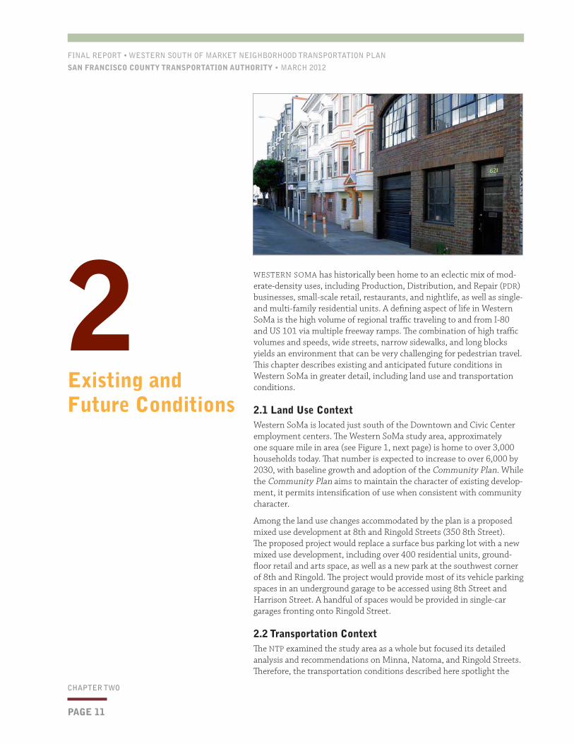
WESTERN SOMA has historically been home to an eclectic mix of mod-erate-density uses, including Production, Distribution, and Repair (PDR) businesses, small-scale retail, restaurants, and nightlife, as well as single- and multi-family residential units. A defining aspect of life in Western SoMa is the high volume of regional traffic traveling to and from I-80 and US 101 via multiple freeway ramps. The combination of high traffic volumes and speeds, wide streets, narrow sidewalks, and long blocks yields an environment that can be very challenging for pedestrian travel. This chapter describes existing and anticipated future conditions in Western SoMa in greater detail, including land use and transportation conditions.
2.1 Land Use ContextWestern SoMa is located just south of the Downtown and Civic Center employment centers. The Western SoMa study area, approximately one square mile in area (see Figure 1, next page) is home to over 3,000 households today. That number is expected to increase to over 6,000 by 2030, with baseline growth and adoption of the Community Plan. While the Community Plan aims to maintain the character of existing develop-ment, it permits intensification of use when consistent with community character.
Among the land use changes accommodated by the plan is a proposed mixed use development at 8th and Ringold Streets (350 8th Street). The proposed project would replace a surface bus parking lot with a new mixed use development, including over 400 residential units, ground-floor retail and arts space, as well as a new park at the southwest corner of 8th and Ringold. The project would provide most of its vehicle parking spaces in an underground garage to be accessed using 8th Street and Harrison Street. A handful of spaces would be provided in single-car garages fronting onto Ringold Street.
2.2 Transportation ContextThe NTP examined the study area as a whole but focused its detailed analysis and recommendations on Minna, Natoma, and Ringold Streets. Therefore, the transportation conditions described here spotlight the
2 Existing and Future Conditions

FINAL REPORT • WESTERN SOUTH OF MARKET NEIGHBORHOOD TRANSPORTATION PLAN
SAN FRANCISCO COUNTY TRANSPORTATION AUTHORITY • MARCH 2012
PAGE 12
CHAPTER TWO
existing conditions, issues and opportunities on those alleys. More information on how the Study selected these locations is presented below and in Section 5.1.
All three of the alleys are narrow east-west, one-way streets. As the two longest continuous alleys in SoMa, Minna and Natoma are often used by pedestrians as travel corridors, of-fering an alternative from the high-volume, high-speed traffic of the major arterial streets. Yet, pedestrians who use these alleys as connecting streets today also confront less-than-friendly conditions, including narrow sidewalks, speeding vehicles, a spartan streetscape, and low levels of perceived personal security. Additionally, they are forced to cross the major streets at uncontrolled locations, without aid from crosswalks or traffic signals. Table 1 and Figure 2 (below) present additional information on the alley characteristics.
The combination of high traffic volumes and speeds, wide streets, narrow sidewalks, and long blocks yields an environment that can be very challenging for pedestrian travel.
Figure 1. Western SoMa Neighborhood Transportation Plan Study Area.
Table 1: Characteristics of Selected Alleys
STREET CONTIGUOUS BLOCKS DIRECTION
Minna 4th–9th Street Westbound
Natoma 5th–9th Street Eastbound
Ringold 8th–9th Street Westbound
Figure 2. Typical Alley Cross-Section.Note: This cross-section does not apply to Minna St. between 8th and Julia St.. That section is wider, at 21 feet. Source: Community Design + Architecture.

FINAL REPORT • WESTERN SOUTH OF MARKET NEIGHBORHOOD TRANSPORTATION PLAN
SAN FRANCISCO COUNTY TRANSPORTATION AUTHORITY • MARCH 2012
PAGE 13
CHAPTER TWO
HIGH PEDESTRIAN VOLUMES
The alleys see relatively low vehicle volumes—less than 100 vehicles per hour dur-ing peak hours, or about one-fifth of the pedestrian travel that occurs during the same period (see Figure 3, right). Volumes on the major streets are much higher—for example, 9th Street experiences over 45,000 vehicles daily, whereas Minna Street between 7th and 8th experiences only about 1,200.
PEDESTRIAN CONNECTIVITY CHALLENGES
Even where alleys continue across multiple blocks, pedestrian through-travel is restricted by the lack of signalized crossings of major arterials. At intersections with arterials, pedestrians traveling on Minna and Natoma Streets must either: wait for a break in traffic to cross without a signal or divert roughly 250 feet out-of-direction to the nearest signalized crossing (this practice is much less common). Despite these challenges, large numbers of pedestrians continue to use Minna and Natoma Streets as through routes. For example, a field survey indicated nearly 100 pedes-trians crossing at either Minna Street or Natoma Street and 8th Street during the peak hour. Based on collision data, the most common cause of vehicle-pedestrian collisions is pedestrian right-of-way violation, reflecting the relative scarcity of safe pedestrian crossings. (Source: SFMTA, May 2009.)
HIGH TRAFFIC SPEEDS AND COLLISION RISKS
Throughout Western SoMa, high vehicle speeds present a challenge to pedestrian safety and comfort. During off-peak periods, vehicles unconstrained by congestion travel at high rates of speed on SoMa’s wide arterials. In both peak and off-peak periods, vehicles often use alleys as cut through routes, frequently exceeding the speed limit. High vehicle speeds on the alleys, where the speed limit is 15 miles per hour, increase collision risk and dimin-ish comfort for residents, pedestrians, and cyclists. As shown in Figure 4, (below) a major-ity of vehicles observed during a speed survey conducted on Minna and Natoma Streets in July 2009 were found to be speeding, with a significant number of vehicles traveling over 10 mph above the speed limit.
While Ringold Street is not a through-route, it is sometimes used by drivers making a U-turn from southbound on 8th Street to northbound on 9th Street. When taken at high
600
500
400
300
200
100
0
NU
MB
ER
OF
VE
HIC
LE
S O
R P
ER
SO
NS
(4
–5 P
M W
eekd
ay P
eak)
Figure 3. Pedestrian and Vehicle Volumes During Weekday Peak Hours
Source: SFCTA, 2009
MINNAbetw. 7th/8th
NATOMAbetw. 7th/8th
900
800
700
600
500
400
300
200
100
0
DA
ILY
VE
HIC
LE
S (
JULY
200
9)
Figure 4. Vehicle Speeds on Minna and Natoma, 7th-9th Streets
Source: SFCTA, 2009 SPEED (MPH)
1–3 4–6 7–9 10–12 13–15 16–18 19–21 22–24 25–27 28–30 31–33 34–36 37–39
Speeding
PedestriansVehicles

FINAL REPORT • WESTERN SOUTH OF MARKET NEIGHBORHOOD TRANSPORTATION PLAN
SAN FRANCISCO COUNTY TRANSPORTATION AUTHORITY • MARCH 2012
PAGE 14
CHAPTER TWO
speed, this maneuver increases collision risk and diminishes comfort for residents, pedes-trians, and cyclists. Traffic associated with the Enterprise rental car company on Ringold Street is also known to travel at unsafe speeds in the alley.
Simply the perception of an unsafe pedestrian environment is an important consideration, but the location and cause of pedestrian-vehicle collisions are also important. There have been numerous collisions between vehicles and pedestrians, both at major intersections, and where the alleys intersect the major streets in Western SoMa. Between 2003 and 2007, by far the most frequent factor for vehicle-vehicle collisions in this area was unsafe speeds. Speeding accounted for over 25% of all accidents, which was twice as frequent as the next largest collision factor. (Source: SFMTA, May 2009).
PERSONAL SECURITY CONCERNS
Concerns about personal security are widespread in Western SoMa, particularly in the alleys and after dark. These concerns, which were raised repeatedly by those who partici-pated in public outreach for this NTP, stem from a perception of high criminal and vandal-ism activity. The concentration of social services providers in the area contributes to this perception. Current design aspects, such as lighting that illuminates only the street, often leaving the sidewalk dark, also play a role in reducing the sense of security.
On Ringold Street, a proposed new apartment complex at 350 8th Street is expected to help improve personal security by vastly increasing the number of people who use the street on a daily basis, both from new residents of the building as well as visitors drawn to a new café and public park included within the development.
LIMITED AND SPARTAN PUBLIC SPACE
Western SoMa has almost no dedicated public open space. The only nearby park is just outside the boundary of the study area: Victoria Manalo Draves Park, located off of Harrison Street between 6th and 7th Streets. The proposed 350 8th Street development would add a small new public park at 8th and Ringold. Given this fact, the alleys in Western SoMa amount to one of its largest sources of public space removed from the heavily trafficked arterials. As such, they represent an important opportunity for providing much-needed community-oriented public space. Currently, as shown in Fig-ure 5 (left), the alleys’ features do not contribute to livability; they include a paucity of landscaping and other pedestrian amenities, narrow sidewalks, and tall, unadorned streetlight fixtures that cast light mainly on the street itself rather than on the sidewalk. A thoughtful re-design could help the alleys fulfill their potential as community-oriented spaces.
PARKING AND LOADING NEEDS
All three alleys are used today for parking and loading. On-street parking is available on one side of the street, and is limited to one hour, except for holders of Residential Parking Permits. Many Western SoMa homes do not have dedicated off-street parking, and many residents who own cars rely on on-street parking for vehicle storage, as shown in Figure 6 (left).
Parking counts conducted for this plan found curbside parking fully occupied on Minna, Natoma, and Ringold Streets during evening hours. The project team observed that many residents who have garages and driveways utilize the space in front of their garage as parking (a legal practice). Businesses also rely on curbside loading and unloading in the alleys. Figure 7 (following page) indicates existing parking and curb space regulations on the alleys.
Figure 5. Minna Street under current conditions, with narrow sidewalks and few amenities.
Figure 6. On-street parking is used by many residents for vehicle storage.

FINAL REPORT • WESTERN SOUTH OF MARKET NEIGHBORHOOD TRANSPORTATION PLAN
SAN FRANCISCO COUNTY TRANSPORTATION AUTHORITY • MARCH 2012
PAGE 15
CHAPTER TWO
ISSUES AND OPPORTUNITIES
To summarize, the existing and future conditions analysis reveals the following findings and resultant issues and opportunities:
• High pedestrian volumes on the alleys, indicating an opportunity to benefit a signifi-cant number of corridor travelers through pedestrian improvements;
• Pedestrian connectivity challenges, indicating a need for mid-block crossings to facili-tate safer and more direct access through the alleys;
• High traffic speeds and collision risks, indicating a need for traffic calming treatments to reduce vehicle speeds;
• Personal security concerns, indicating a need to limit public realm improvements to prevent vandalism and loitering;
• Limited public space, indicating an opportunity for changes to the alleys enabling them serve as much-needed additional community-oriented public space; and
• Need for parking and loading use on the alleys, indicating a need to mostly maintain these types of uses in improvement concepts.
8th Street
7th Street
Minna St.
Natoma St.Natoma St.
8th Street
7th Street
Minna St.
Natoma St.Natoma St.Natoma St.
Loading ZoneAccessible ZoneRed ZoneHydrantOn-Street Parking: 1-Hr Limit except for Residential Parking Permit Holders
ttt
Figure 7
Minna St.
Natoma St.
8th Street
9th Street
Minna St.
Natoma St.
8th Street
9th Street
Note 1: All shown parking spaces will be considered Residential Parking Permit (RPP) areas
Loading ZoneAccessible ZoneRed ZoneHydrantInactive Curb CutOn-Street Parking, 1-Hr Limit except for Residential Parking Permit Holders
MINNA & NATOMA STREETS (BETWEEN 8TH & 9TH)EXISTING PARKING AND LOADING CONDITIONS
tt
t
8th Street
7th Street
Minna St.
Natoma St.Natoma St.
8th Street
7th Street
Minna St.
Natoma St.Natoma St.Natoma St.
Loading ZoneAccessible ZoneRed ZoneHydrantOn-Street Parking: 1-Hr Limit except for Residential Parking Permit Holders
West SoMa Neighborhood Transportation Plan
N
FEBRUARY 8 2012MINNA & NATOMA STREETS (BETWEEN 7TH & 8TH)
EXISTING PARKING AND LOADING CONDITIONS
8th Street
7th Street
Minna St.
Natoma St.Natoma St.
8th Street
7th Street
Minna St.
Natoma St.Natoma St.Natoma St.
Loading ZoneAccessible ZoneRed ZoneHydrantOn-Street Parking: 1-Hr Limit except for Residential Parking Permit Holders
West SoMa Neighborhood Transportation Plan
N
FEBRUARY 8 2012
MINNA & NATOMA STREETS (BETWEEN 7TH & 8TH)EXISTING PARKING AND LOADING CONDITIONS
KEYLoading ZoneAccessible ZoneRed ZoneHydrantOn-street Parking (1hr. limit, except Residential Parking Permit holders
Figure 7. Parking and loading zone regulations on Minna, Natoma, and Ringold streetsNote: Not to scale. Parking spaces indicate curb space dedicated to parking spaces, not actual number of available spaces.
t
9th Street
8th Street
Ringold St.Ringold St.

This page left intentionally blank
PAGE 16
CHAPTER TWO

FINAL REPORT • WESTERN SOUTH OF MARKET NEIGHBORHOOD TRANSPORTATION PLAN
SAN FRANCISCO COUNTY TRANSPORTATION AUTHORITY • MARCH 2012
PAGE 17
CHAPTER THREE
COMMUNITY AND STAKEHOLDER INPUT was critical to developing the improvements recommended in this NTP. The study team sought input through a variety of mechanisms and heard several key messages that were incorporated into the project conceptual designs presented in Chapter 4. This chapter describes outreach activities and key messages heard in greater detail.
3.1 Outreach MethodsThe Study team sought input in three ways: coordination with the West-ern SoMa Citizen Planning Task Force; hosting of public workshops and other outreach activities; and outreach to other city agencies.
Citizen Planning Task Force. As the Authority’s community partner for the Study, the Task Force provided guiding input over the entire course of the study. The Task Force provided early input on Study products before major public milestones.
Public workshops and other activities. The Authority hosted activities to solicit public input at key phases during the Study, as shown in Table 2:
3 Public and Stakeholder Involvement
Table 2: Summary of Public Involvement Events and Feedback Sought
OUTREACH PHASEPURPOSE AND FEEDBACK SOUGHT OUTREACH FORMAT
Round 1
Fall 2009; approximately 25 participants
Narrowing the potential topics/locations of focus:
• Which areas?
• What types of im-provements?
Public workshop including open house, presentation, and break-out discussions
Round 2
Fall 2010 and Summer 2011; approximately 160 participants
Refine alternative improvement options toward one recommended option:
How much alley space should be dedicated to pedestrian space versus maintained as parking space?
• What locations should we prioritize for mid-block crossings?
• What amenities are most desired (bulb-outs, chicanes, seating, landscaping, lighting)?
Public workshop presentation, group discussion
“Sidewalk charettes” outside Harvest Urban Market at 8th and Natoma
Presentation to residents of the Cannon Kip Senior Center
Door-to-door survey on Ringold Street
Windshield flyer notice on cars parked on the alleys, with opportunity to provide feedback via an online survey

FINAL REPORT • WESTERN SOUTH OF MARKET NEIGHBORHOOD TRANSPORTATION PLAN
SAN FRANCISCO COUNTY TRANSPORTATION AUTHORITY • MARCH 2012
PAGE 18
CHAPTER THREE
The NTP’s notification efforts included:
• Email blast to 200 individuals, businesses, and neighborhood organizations in the study area;
• Direct mail to over 1,400 individuals in the area; and
• Publicizing the event at neighborhood organization regular meetings, includ-ing at: SoMa Leadership Council Meeting, SoMa Business Association (SOMBA) Board Meeting, SoMa Project Area Committee (SOMPAC) General Meeting, Western SoMa Citizens Planning Task Force Meeting, and the SoMa Commu-nity Action Network (SOMCAN) General Meeting.
INTER-AGENCY COORDINATION
To obtain input from city agencies to help shape the study proposals, the Study convened an inter-agency Technical Advisory Committee which met regularly over the course of the Study. Participating agencies are shown in Table 3 (left).
The Study also coordinated with other city agencies to review the proposals and obtain feedback, including the Mayor’s Office on Disability, the Department of Public Works Accessibility Coordinator, the Fire Department, and the San Francisco Public Utilities Commission.
3.2 Key Feedback Messages and Study ResponseThe following key messages were revealed during public outreach activities and were incor-porated into the Study recommendations.
STRONG SUPPORT FOR IMPROVEMENTS IN THE AREA, ESPECIALLY FOR PEDESTRIAN-SCALE LIGHTING AND MID-BLOCK CROSSINGS
Community Message: There is overwhelming support among area residents, business own-ers and employees, and visitors to make alley improvements. Of the suite of improvements proposed, community support was most emphatic for mid-block crossings along Minna and Natoma, as well as pedestrian-scale lighting throughout Western SoMa (see Figure 9, next page). For example, residents of the Canon Kip Senior Center, located at 8th and Natoma, expressed strong support for the mid-block crossing at this location, which would enable them to cross 8th Street at the alley, instead of traveling to Mission Street, a par-ticular challenge for this population with mobility challenges. Similarly, the management of the Harvest Urban Market, at 8th and Natoma, has observed customers frequently crossing mid-block and expressed concern about the safety hazard posed by such crossings.
Study Response: The project improvement conceptual designs presented in Chapter 5 incorporate this feedback, including two recommended locations for mid-block crossings, at 8th and Natoma, and 7th and Minna. The improvement conceptual designs also include pedestrian-scale lighting along the entire length of the proposed improvement areas.
DESIRE TO BALANCE PEDESTRIAN IMPROVEMENTS WITH THE NEED TO MAINTAIN PARKING
Community Message: Although there is a desire to improve the alleys, there is also a desire to maintain the majority of parking along the alleys (see Figure 10, next page). Residents of the alleys who park their cars on-street note high demand and limited availability, and they express concern that removal of numerous spaces will exacerbate that shortage. This concern is both a matter of convenience and security, as some residents feel unsafe parking on arterials and walking to the alleys at night. However, most residents expressed a willing-ness to trade some parking spaces for increased pedestrian space and amenities. Moreover,
Figure 8. “Dot Voting” exercise conducted as part of community outreach.
Table 3. Technical Advisory Committee
Planning Department
Department of Public Works
Redevelopment Agency
Department of Public Health
Municipal Transportation Agency

FINAL REPORT • WESTERN SOUTH OF MARKET NEIGHBORHOOD TRANSPORTATION PLAN
SAN FRANCISCO COUNTY TRANSPORTATION AUTHORITY • MARCH 2012
PAGE 19
CHAPTER THREE
the study team also heard from many residents of the corridor who do not own cars and desire use and access to curb space as public space.
Study Response: In order to balance these two competing desires, the study team devel-oped conceptual designs that limit removal of on-street parking, while also allowing for enough improvement to the pedestrian realm to justify the resources that would be nec-essary to implement the project. While initial conceptual alternatives considered a range of parking reduction options between 21 and 46 spaces on Minna and Natoma Streets and up to 5 spaces on Ringold Street, the final conceptual designs presented in Chapter 6 would result in only 18 fewer spaces on Minna and Natoma Streets and up to 5 spaces on Ringold. These numbers represent a conservative, high-end, estimate of parking loss, as they assume a 20-foot parking space template per car. The Western SoMa alleys are un-striped today and would remain un-striped after improvement, so parking capacity would likely be higher than those estimates suggest.
CONCERN ABOUT VANDALISM, PERSONAL SECURITY
Community Message: The Western SoMa area is home to a high concentration of men-tal health and social services, in particular along Minna and Natoma, which results in a high presence of transient populations who make use of the alleys. Some alley residents expressed concern that improvements would be vulnerable to vandalism, noting such vandalism has occurred to recent landscaping improvements on Minna and Natoma be-tween 5th and 6th Streets. Others noted a preference against installing benches as they may attract long-term use by transient persons.
Study Response: The study team incorporated this feedback into the final conceptual designs for the alleys. In particular, for Minna and Natoma, the conceptual design recom-mends installation of landscaping elements that could begin as temporary installations in planter boxes, to test out their vulnerability to vandalism. In addition, the proposed designs do not call for benches on Minna and Natoma, although they could be installed at a later date.
NEED TO MAINTAIN LOADING SPACE
Community Message: Those who own businesses along the alleys use curb space currently designated as loading zones, and there is a desire to continue to use these spaces.
Study Response: The proposed improvements maintain all active loading spaces. One loading space, on 8th Street and Natoma at the Harvest Market, would be shortened to allow for a corner bulb-out, a change that is acceptable to the store management that requires the loading zone.
100
90
80
70
60
50
40
30
20
10
0
Figure 9. Community feedback with respect to design element priorities, Phase 2 outreach.
“Which three design elements would you like to prioritize?”
EVERYONE RESIDENTSONLY
HERITAGE
LIGHTING
ENHANCED ENTRIES
PAVING TREATMENTS
BULBOUTS
CHICANES
t
t
t
t
t
t
100
90
80
70
60
50
40
30
20
10
0
Figure 10. Community feedback with respect to pedestrian vs. parking space balance, Phase 2 outreach
“How much of the street face would you like to see dedicated to pedestrian space?”
EVERYONE RESIDENTSONLY
HIGH
MEDIUM
LOW
NONE
t
t
t
t

PAGE 20
CHAPTER THREE
This page left intentionally blank

FINAL REPORT • WESTERN SOUTH OF MARKET NEIGHBORHOOD TRANSPORTATION PLAN
SAN FRANCISCO COUNTY TRANSPORTATION AUTHORITY • MARCH 2012
PAGE 21
CHAPTER FOUR
THIS CHAPTER presents the design concepts for the recommended im-provements to Minna and Natoma Streets between 7th and 9th Street and Ringold Street between 8th and 9th Street. The chapter begins with a brief description of the project screening and prioritization process that was used to identify and select improvement concepts. It then describes each of the key features incorporated into the conceptual de-signs, and finally presents the conceptual designs, including plan-views and cross-sections.
4.1 Project Screening and Prioritization ProcessThe study team considered dozens of potential project ideas to address the key issues and opportunities revealed during the existing and future conditions analysis, including ones generated by the Community Plan and by the study team and stakeholders. The team applied an evaluation framework to narrow the list, considering candidate project benefits and impacts to each mode (pedestrian, bicycle, transit, vehicle), coordination with land use, and implementation feasibility. For more detail on this process, see Appendix C.
Several reasons led the study team to select the alley concepts for further development:
• The alleys present an opportunity to provide an east-west pedestrian circulation route with advantages over the arterial streets. Removed from high-speed, high-noise traffic, the alleys could provide a more attractive and safe walking environment.
• With additional investments in amenities such as landscaping and seating, the alleys could help to fill part of the need for public space revealed during the existing and future conditions analysis. While they do not replace public parks, well-designed alleys can provide at-tractive places to rest and gather, and they can provide much-needed greenery in a neighborhood that has little.
• Improvements to alleys can be implemented in the short-term. Alley improvements would not have the same larger-scale circulation im-pacts that modifications to arterial streets would have, which require more significant environmental review, project design and engineer-ing time, and funding (these types of longer-term improvements are being considered as a part of other studies).
After the alley improvement concept was selected, the team selected three locations for treatments, along Minna, Natoma, and Ringold,
Proposed Improvements
4

FINAL REPORT • WESTERN SOUTH OF MARKET NEIGHBORHOOD TRANSPORTATION PLAN
SAN FRANCISCO COUNTY TRANSPORTATION AUTHORITY • MARCH 2012
PAGE 22
CHAPTER FOUR
shown in Figure 11 (left). Of the neighborhood’s extensive alley network, Minna and Natoma have the potential to offer the lon-gest continuous path of pedestrian travel, with Natoma stretching without interruption from 5th Street to 9th Street, and Minna continuing to 10th Street. In 2010, the San Francisco Redevelop-ment Agency (SFRA) installed traffic calming and landscape treat-ments on the blocks of Minna and Natoma between 5th and 7th Streets. Thus, improvements on Minna and Natoma between 7th and 9th Streets would complement and extend the SFRA improve-ments. The Ringold Street alley focus aims to capitalize on and complement the proposed 350 8th Street development project. With the addition of new housing in this area already proposed, the Ringold concept presents an opportunity to leverage private sector investment and timing to transform the block.
4.2 Key Features of the Alley Improvement ConceptsThis section describes the key features of the recommended improvements to Minna, Natoma, and Ringold Streets. As shown in Table 4 (below), many of the same features are recommended for all three alleys, including traffic calming, landscaping, and pedestrian-scale lighting. The main differences are that the mid-block crossings are only recommended along Minna and Natoma Streets because they span multiple blocks, and a shared street treatment is only recommended on Ringold Street because of the opportunity created by the 8th Street development (described further in this section).
SIGNALIZED MID-BLOCK CROSSINGS
Signalized mid-block crossings would enable safe crossings where the alleys cross the major numbered streets in Western SoMa. The study team considered three potential locations for mid-block crossings as shown in Figure 12 (next page).
Table 4. Key proposed features for Minna, Natoma, and Ringold streets
FEATUREMINNA
betw. 7th/9thNATOMA
betw. 7th/9thRINGOLD
betw. 8th/9th
Signalized mid-block crossings 4
At 7th St.
4
At 8th St.
Traffic calming
Chicanes 4 4 4
Bulb-outs 4 4
Enhanced Entry/Exit 4 4 4
Public realm/streetscape
Landscaping 4 4 4
Pedestrian-scale Lighting
4 4 4
Seating 4
Public art 4
Highlighting Filipino heritage/
history
4
Highlighting Filipino heritage/
history
4
Highlighting LGBT heritage/
history
Modest reductions in parking 4 4 4
Shared street treatment 4
Improvements to alleys can be implemented in the short-term. They would not have the same larger-scale circulation impacts that modifications to arterial streets would have.
Figure 11. Western SoMa alleys of focus.

FINAL REPORT • WESTERN SOUTH OF MARKET NEIGHBORHOOD TRANSPORTATION PLAN
SAN FRANCISCO COUNTY TRANSPORTATION AUTHORITY • MARCH 2012
PAGE 23
CHAPTER FOUR
Among these three locations, two locations—at 8th and Natoma, and at 7th and Minna—were selected to be included in the recommended improvements. As shown in Figure 13 (below), these locations provide the greatest opportunity for benefit, while avoiding potential impacts to traffic operations. The team, through discussions with SFMTA, has developed a conceptual traffic operation plan for the new pedestrian signals in which the signals would be pedestrian-actuated but also coordinated with adjacent signals to avoid excessive queuing. The team conducted preliminary traffic analysis to confirm that the queuing would be acceptable.
The treatments would include installation of a new traffic signal, pedestrian activation buttons, bulb-outs into the parking lane to reduce crossing distance, and crosswalk and vehicle stop-bar striping. The crossings would be designed to resemble a full intersection for familiarity to drivers, but with a few exceptions. Figure 14 (right) provides an example design for 7th Street/Minna Street. First, vehicle traffic approaching 7th Street on Minna Street would be forced to turn right onto 7th; through movements across 7th would not be allowed. This prohibition supports the policy of encouraging vehicles to use the major streets for through travel instead of the alleys. Second, the design features a striped crosswalk across 7th only on the south side of Minna. If pedestrians were to be allowed to cross on the north side, there may be conflicts with right-turning drivers from Minna to 7th, who may focused on finding a gap in approach traf-fic from the south and not looking for pedestrians on the north side.
In the final engineering phase, the mid-block crossings are expected to be designed to meet all SFMTA guidelines related to pedestrian safety, including ensuring that any street trees are pruned for a 14-foot minimum height of low-est branch and that the bulb-out extends the width of on-street parking with a one-foot buffer.
TRAFFIC CALMING
The main design treatment to calm traffic and reduce vehicle speeds recom-
Figure 12. Candidate mid-block crossing locations.1: location evaluated but not recommended due to lower benefits, higher impacts
2, 3: locations recommended for mid-block crossings.
Figure 14. Conceptual diagram of proposed mid-block crossing, 7th and Minna streets.
Figure 13. Mid-Block Crossing Evaluation Results
BENEFITS IMPACTS
LOCATION PEDESTRIAN VOLUME COLLISION HISTORY TRAFFIC OPERATIONS
8th and Natoma Highest volume crossing
One reported collision involving a pedestrian resulting in a fatality
Second smallest impacts to traffic
7th and Minna No reported collisions
Smallest impacts to traffic
9th between Minna and Natoma
Two reported collisions with pedestrians, resulting in injuries
Queue at 9th and Mission streets presently extends to Howard St.; new signal would cause queue to extend beyond Howard.
pp q
p
p
p
p q
q
BENEFIT
p p
MORE LESS
IMPACT
LESS MORE
q q

FINAL REPORT • WESTERN SOUTH OF MARKET NEIGHBORHOOD TRANSPORTATION PLAN
SAN FRANCISCO COUNTY TRANSPORTATION AUTHORITY • MARCH 2012
mended on the alleys are chicanes, which are created by altering the side of the street that is dedicated to on-street parking. This alternation introduces curves and jogs in the travel lane that naturally cause drivers to slow down (see Figure 15, left). The recommended improvements include seven chicanes on Minna and Natoma, and three on Ringold. Alternating the parking can result in parking reductions or increases, depending on whether the side of the street to which parking is moved contains more or less driveways than the other side. Subsequent sec-tions contain more information on parking supply changes.
In addition, entries and exits on all three alleys would be enhanced with raised crosswalks and bulb-outs, designed to reduce vehicle speeds, signal to drivers the special nature of the alleys and enhance pedestrian visibility (see Figure 16, left). Figure 17 (below) shows an example diagram of the recommended types of improvements.
PUBLIC REALM IMPROVEMENTS
The conceptual designs indicate new locations for streetscape ele-ments that provide pedestrian amenities. These new locations are made possible as a result of the spaces created by bulb-outs—side-walk extensions into the parking lane (see Figure 18, next page). Ex-isting travel lane and sidewalk widths would remain, except sidewalk widths would increase by seven feet at locations where bulb-outs are proposed. The bulb-outs would extend most of the width of the park-ing lane but include a one-foot buffer. To create the bulb-outs, parking would need to be removed; see below for more information on park-ing reductions. In the new pedestrian space created, new landscaping,
trees, or other amenities could be provided, to be determined during the final design phase of the project. New seating is recommended on Ringold Street, but not on Minna and Natoma Streets in the short-term, to address community concerns raised about personal security in those areas.
The proposed designs also call for augmenting or replacing the existing street lighting with pedestrian-scale lighting to improve personal security and enhance the public realm. The conceptual designs indicate lights spaced closer than currently, at approximately 70 feet. The Lumec Optima LED light, which has been used for other pedestrian lighting instal-lations in the city, such as those along the 3rd Street corridor and for the Leland Avenue streetscaping project (shown in Figure 19, next page), is one fixture that could be used on Ringold, Minna and Natoma.
PAGE 24
CHAPTER FOUR
Figure 16. Raised crosswalk implemented at Minna and 7th streets is similar to the treatments recommended here.
Figure 15. Chicane created by alternating on-street parking.
Figure 17. Minna/Natoma before (left) and after (right) improvement (representative block).

FINAL REPORT • WESTERN SOUTH OF MARKET NEIGHBORHOOD TRANSPORTATION PLAN
SAN FRANCISCO COUNTY TRANSPORTATION AUTHORITY • MARCH 2012
PAGE 25
MODEST REDUCTIONS IN PARKING
The recommended improvements result in a reduction in on-street parking, but the improvements have been designed to minimize that reduction. Because park-ing is not striped in these alleys, the number of cars fitting within them can vary. This plan estimates the existing and proposed parking supply (see Figure 20, below) conservatively, assuming a 20-foot parking space that is likely longer than the average car will occupy. Given that conservative assumption, on Minna and Natoma, most of the existing 97 curb parking spaces would be retained. Eigh-teen would be repurposed to provide additional pedestrian space. On Ringold, approximately six of 11 spaces would be retained. Total future parking capacity would likely be higher than these numbers indicate. All active curbside freight loading spaces would be retained in the designs for Minna, Natoma, and Ringold.
HIGHLIGHTING CULTURAL HERITAGE THROUGH PUBLIC ART
Historically, Ringold Street played a prominent role in the Lesbian Gay Bisexual Transgender (LGBT) community, and Minna and Natoma Streets are of historical significance to the Filipino community. Highlighting these heritage elements is important to the Western SoMa community and a key component of the Com-munity Plan. The Study recommends highlighting these areas of cultural signifi-cance by incorporating custom elements into new infrastructure improvements or through public art installations in the alleys.
“SHARED STREET” CONCEPT
The Study recommends a shared street treatment for Ringold. The function of a shared street generally is to enable pedestrians to use the full building-to-building right-of-way instead of confining them to each side of the vehicle travel way. The street and sidewalk are aligned on the same horizontal plane, and the street does not have curbs (see Figure 21, next page). In shared streets, vehicles are still allowed but must yield to pedestrians and bicyclists. Shared streets can calm vehicle traffic, which naturally slows in such environments, while increasing the amount of usable pedestrian space. While not uncommon in European cities, only a few officially designed shared streets currently exist in San Francisco, including Lin-den Street in Hayes Valley. Shared streets must be carefully designed to ensure that they do not negatively affect universal access, particularly for people with limited vision.
Ringold Street has a number of qualities that make it a good candidate for a shared street, including its short length, low traffic volume, proximity to numerous residential entrances (providing pedestrian activity), and potential adjacency to a new “pocket park” at the southwestern corner of 8th and Ringold; the shared street concept would help to extend the park into the alley itself.
CHAPTER FOUR
Figure 18. An example of bulb-out transforming parking space into pedestrian space.
Figure 19. Pedestrian-scale lighting on Leland Ave. uses the Lumec Optima LED fixture, a potential fixture for lighting on Minna, Natoma, and Ringold streets.
Figure 20. Changes to parking and pedestrian space for Minna, Natoma, and Ringold streets
MINNA/NATOMA
0% 20% 40% 60% 80% 100% 0% 20% 40% 60% 80% 100%
RINGOLD
97 11
79 6
6Parking spacesNUMBER OF SPACES
Parking converted to pedestrian space

FINAL REPORT • WESTERN SOUTH OF MARKET NEIGHBORHOOD TRANSPORTATION PLAN
SAN FRANCISCO COUNTY TRANSPORTATION AUTHORITY • MARCH 2012
PAGE 26
CHAPTER FOUR
The street would be designed with exclusive pedestrian-only space on either side of the shared space, complying with the Americans with Disabilities Act requirements for univer-sal access and the city’s Better Streets Plan guidelines for shared public ways. This configu-ration offers the advantages of a shared street while ensuring universal access. The design would include detectable warnings (such as truncated domes) at entrances and exits of the alley, as well as treatments such as color or texture to demarcate the pedestrian-only versus shared space within the alley.
Additional pedestrian space is created by treating the entire right-of-way as part of the pedestrian realm, with design signals such as special paving materials, landscape and hardscape elements, and a meandering shared way that encourages low traffic speeds and enhances the sense of pedestrian priority. The shared travel-way width would remain the same as the travel lane is today, at 14 feet.
4.3 Minna, Natoma, and Ringold Conceptual DesignsThis section (Figures 22–24) provides cross-section and plan view diagrams of the pro-posed improvement concepts.
Figure 21. Shared streets. Examples in Amsterdam, Netherlands (left), Linden Street, San Francisco (right).
Figure 22. Proposed Cross-Sections for Minna and Natoma streetsNote: For existing conditions, see Figure 2, page 12. Source: Community Design + Architecture. 2011.
Minna and Natoma streets, proposed(Typical at curb extension)
Minna between 8th and Julia Street, proposed
Additional pedestrian space is created by treating the entire right-of-way as part of the pedestrian realm.

FINAL REPORT • WESTERN SOUTH OF MARKET NEIGHBORHOOD TRANSPORTATION PLAN
SAN FRANCISCO COUNTY TRANSPORTATION AUTHORITY • MARCH 2012
PAGE 27
CHAPTER FOUR
8th Street
7th Street
Min
na S
t.
Nat
oma
St.
Nat
oma
St.
8th Street
7th Street
Min
na S
t.
Nat
oma
St.
Nat
oma
St.
Nat
oma
St.
Load
ing
Zone
Acc
essi
ble
Zone
Red
Zone
Hyd
rant
On-
Stre
et P
arki
ng: 1
-Hr L
imit
exce
pt fo
r Res
iden
tial P
arki
ng P
erm
it H
olde
rs
Wes
t SoM
a N
eigh
borh
ood
Tran
spor
tatio
n Pl
an
N
FEB
RUA
RY 8
201
2
MIN
NA
& N
ATO
MA
STR
EETS
(BET
WEE
N 7
TH &
8TH
)EX
ISTI
NG
PA
RKIN
G A
ND
LO
AD
ING
CO
ND
ITIO
NS
KE
YL
oadi
ng Z
one
Acc
essi
ble
Zon
eR
ed Z
one
Hyd
rant
Inac
tive
Cur
b C
ut
Not
e 1:
See
“Coo
rdin
atio
n w
ith
near
by
proj
ects
,” p.
33.
Not
e 2:
Add
itio
nal p
lant
ing
of n
arro
w-
crow
ned
tree
s w
ithi
n th
e si
dew
alk
is
enco
urag
ed w
here
this
is re
ques
ted
by
adja
cent
resi
dent
s/pr
oper
ty o
wne
rs.
Figu
re 2
3. P
ropo
sed
Pla
n V
iew
con
cept
s fo
r M
inna
and
Nat
oma
stre
ets
Not
e: F
or e
xist
ing
cond
itio
ns, s
ee F
igur
e 7,
pag
e 15
. Sou
rce:
Com
mun
ity
Des
ign
+ A
rchi
tect
ure.
201
1.

PAGE 28
CHAPTER ONE
CHAPTER ONE
FINAL REPORT • WESTERN SOUTH OF MARKET NEIGHBORHOOD TRANSPORTATION PLAN
SAN FRANCISCO COUNTY TRANSPORTATION AUTHORITY • MARCH 2012
Not
e 1:
See
“Coo
rdin
atio
n w
ith
near
by p
roje
cts,”
p.3
3.Fi
gure
24.
Pro
pose
d P
lan
Vie
w c
once
pts
for
Rin
gold
Str
eet
Not
e: F
or e
xist
ing
cond
itio
ns, s
ee F
igur
e 7,
pag
e 15
. Sou
rce:
Com
mun
ity
Des
ign
+ A
rchi
tect
ure.
201
1.
PAGE 28
CHAPTER FOUR

FINAL REPORT • WESTERN SOUTH OF MARKET NEIGHBORHOOD TRANSPORTATION PLAN
SAN FRANCISCO COUNTY TRANSPORTATION AUTHORITY • MARCH 2012
PAGE 29
CHAPTER ONE
Implementation
CHAPTER FIVE
THIS PLAN provides an agreed-upon vision for short-term improve-ments in Western SoMa, but several steps must occur after adoption of the Plan to bring the improvements to fruition. This chapter outlines those subsequent steps, including the coordination and remaining issues to be addressed. It also presents cost estimates and concludes with a discussion of potential funding sources.
5.1 Project Development PathAfter completion of the Plan, the proposed improvements would go through the typical project development steps, as follows. A potential schedule for these steps is presented in Table 5 (next page).
1. Funding. The proposed improvements are not yet funded beyond conceptual design; however, the plan anticipates that the improvements will be competitive for multiple grant sources. The Authority would lead the city’s efforts to obtain implementation funding, with assistance from SFMTA and SFDPW. See Section 5.3 for more information on costs and funding.
2. Environmental Review. The Western SoMa improvements require environmental analysis under the California Environmental Quality Act (CEQA) prior to their construction to identify any significant environ-mental impacts as a result of implementation. CEQA clearance is already underway and near completion as a part of the Western SoMa Commu-nity Plan under development by the Planning Department. A Trans-portation Impact Study is in progress and will likely find no significant impacts due to implementation of the project. A Final Environmental Impact Report confirming this finding is expected to be certified in 2012. The proposed improvements will also need to undergo environ-mental analysis under the federal National Environmental Policy Act (NEPA) to be eligible for federal sources of funding. If the final funding strategy does call for federal funding, then a NEPA-compliant Environ-mental Impact Study will be completed during the design phase of the project.
3. Design Engineering, Review. After completion of the Plan, the Author-ity and partner agencies will monitor funding opportunities and seek funding for design engineering work for the project. When the project enters detailed design, project development work is expected to be led by the Department of Public Works (DPW), with the major design tasks
5

FINAL REPORT • WESTERN SOUTH OF MARKET NEIGHBORHOOD TRANSPORTATION PLAN
SAN FRANCISCO COUNTY TRANSPORTATION AUTHORITY • MARCH 2012
PAGE 30
CHAPTER FIVE
including street, streetscape, and landscape design. The SFMTA would lead some steps in the process, such as developing geometric and striping designs for the streets. Final design would include review by the SFMTA’s Transportation Advisory Staff Committee, which includes participation from several city departments. In this phase of the project, many considerations will need to be addressed as described further in this chapter.
4. Legislation, Construction. After design is finalized, the project would require legislation by the SFMTA Board to codify the changes in use of curb space. Construction would com-mence when funding is secured and could last three to six months.
5.2 Outstanding Coordination and Implementation IssuesThis section describes implementation issues that will require future coordination among city agencies to resolve, in order to advance the proposed improvements to construction.
MAINTENANCE FINANCIAL RESPONSIBILITY AND MECHANISMS
San Francisco does not have a clear policy with respect to providing maintenance of streetscape improvements that increase the City’s baseline cost. While examples exist where the City has assumed responsibility—such as improvements implemented under the Great Streets Program—the City has also indicated in other cases that the increment must be absorbed by the street’s adjoining property owners. This issue requires resolution, especially in light of the recently completed Better Streets Plan that sets a higher standard for streetscape improvements as policy.
A rough order-of-magnitude estimate for annual maintenance of the improvements pro-posed here is $5,000 per block. During outreach for this Plan, surveyed residents expressed willingness to contribute, either financially on that order of magnitude, or via in-kind volunteer activities. But a mechanism for collecting and administering contributions would be needed, such as a community facilities district.
An opportunity may exist to support ongoing maintenance with funds from the develop-ment impact fees associated with approved area plans. In this case, the Eastern Neighbor-hoods Citizens Advisory Committee oversees the allocation of the impact fee assessed on developments in this area and would need to be engaged for such a discussion. The fee administration must also adhere to specified rules regarding the use of funds; the agencies will need to establish the eligibility of maintenance for the use of fee revenues.
During the design phase, the Team should review any developments in City policy related to maintenance before commencing coordination and discussion of potential fund sources and mechanisms.
Table 5. Potential Implementation Schedule
2012 2013 2014
Q2 Q3 Q4 Q1 Q2 Q3 Q4 Q1 Q2
Environmental Clearance
Secure Fudning
Engineering/Design
Design Review
Final Design
Legislation
Construction
During outreach for this Plan, surveyed residents expressed willingness to contribute to annual maintenance of the improvements, either financially or via in-kind volunteer activities.

FINAL REPORT • WESTERN SOUTH OF MARKET NEIGHBORHOOD TRANSPORTATION PLAN
SAN FRANCISCO COUNTY TRANSPORTATION AUTHORITY • MARCH 2012
PAGE 31
CHAPTER FIVE
LIGHTING MAINTENANCE AND DESIGN ISSUES
Lighting is one specific aspect of the proposal requiring further coordination. Currently, the alleys are lighted only by fixtures aimed on the street itself. The proposed improve-ments call for adding pedestrian-scale lighting in the alleys—indeed, this is one of the strongest community desires revealed during outreach. However, inter-agency coordina-tion has uncovered a gray area with respect to the responsibility to maintain pedestrian-scale fixtures. The Public Utilities Commission (PUC) typically maintains lighting that illuminates the roadway, and the City Charter currently delineates that the PUC’s responsi-bility is for roadway lighting but not pedestrian lighting.
Pedestrian lighting brings the maintenance question into sharp relief. Such lighting has previously been installed at some locations around the city, but the responsibilities for construction and maintenance among have not been assumed in a consistent manner. Maintenance of existing pedestrian lighting in the city has been shared variously between private property owners, PUC, DPW, SFMTA, Recreation and Parks, and the Redevelopment Agency1, yet no formal policy exists with respect to how to identify the responsible agency.
In addition to resolving which agency would be responsible, additional lighting analysis will need to be conducted during the detailed design phase. This analysis is necessary to ensure the spacing and pattern of lights results in an even distribution of light to citywide standards. This analysis is typically done by a lighting engineer at DPW. While this Plan’s cost estimates assumes the Lumec Optima fixture that has been used in other pedestrian scale lighting projects in the city, the Team may consider other fixtures, or even custom fixtures that complement public art installations (see more on public art below).
CURB SPACE RE-DESIGNATION PROCESS
This Plan has surveyed existing curb space uses in the alleys, including locations of curb cuts, spaces signed for residential parking, and spaces signed for loading. The proposed designs respect all curb cuts, although the team’s field survey of the area revealed three locations along Minna and Natoma where curb cuts appear inactive (see Figure 26, next page). During the detailed design phase of the project, the Team should confirm whether these cuts need to be retained through coordination with the Planning Department or the Department of Building Inspections, who can review the authorization granted for on-site parking at those locations. Should there no longer be a need to maintain these curb cuts, the design can consider using the spaces for additional parking or pedestrian space.
With respect to loading spaces, the field survey indicated four locations on Minna and Nato-ma that appear to be inactive, as shown in Figure 26. While the proposed designs assume these spaces would be converted, one would require additional confirmation during the design phase. In addition, the existing loading zone on the southeast corner of 8th Street and Natoma, adjacent to the Harvest Urban Market would need to be shortened to accom-modate the bulb-out proposed there, a change that is agreeable to the store management.
Finally, as noted in Chapter 4, the estimate of on-street parking reductions is approximate-ly 18 on Minna and Natoma, and five on Ringold, using a conservative 20-feet-per-vehicle assumption.
These loading and parking changes, once confirmed, would need to be legislated by the SFMTA Board. This process typically includes public notice to affected residents and busi-nesses, a public hearing at the SFMTA Engineering Committee, and approval by the SFMTA Board. SFMTA staff have indicated their willingness to conduct this process at the appropri-ate time.
1 Bay Area Economics. Streetscape Elements Life Cycle Cost Analysis. September 2010. Report Commissioned by the San Francisco Controller’s Office.
The proposed improvements call for adding pedestrian-scale lighting in the alleys—indeed, this is one of the strongest community desires revealed during outreach.

FINAL REPORT • WESTERN SOUTH OF MARKET NEIGHBORHOOD TRANSPORTATION PLAN
SAN FRANCISCO COUNTY TRANSPORTATION AUTHORITY • MARCH 2012
PAGE 32
CHAPTER FIVE
UNIVERSAL ACCESS DESIGN ISSUES
Universal access, particularly for people with limited vision, will require special attention during the detailed design phase for the Ringold improvements, given its proposed novel treatment as a shared street. The shared street concept for Ringold has been vetted at a conceptual level with the Mayor’s Office on Disability (MOD) and the DPW Accessibil-ity Coordinator. The Ringold design adheres to the city’s Better Streets Plan policy with respect to shared public rights-of-way, including provision of an exclusive pedestrian space on either side of the shared space. During the detailed design phase, additional review by MOD and DPW will be necessary. Design considerations particularly important for univer-sal access include:
• Accommodate five feet of walkway in the exclusive pedestrian spaces (48 inches is required under the Americans with Disabilities Act).
• Use permeable pavers on road, but not sidewalks; at some locations along the road, non-permeable paving should be used to provide crossing points from the pedestrian-only space.
• Demarcate exclusive pedestrian space with detectable warnings (such as truncated domes) and a gateway treatment at entrances and exits of the alley and with a treat-ment such as color or texture throughout the alley.
• Design for truck movements and turns that minimize potential blind spots.
• Design for appropriate access for disabled passengers entering and exiting vans with wheelchair ramps.
Figure 26. Potential curb designation changes for follow-up: Minna and Natoma between 7th and 8th streets (above) and between 8th and 9th streets (right).
KEY
Likely inactive loading zonesActive loading zone to be shortenedPortion of zone that would be removedLikely inactive curb cuts

FINAL REPORT • WESTERN SOUTH OF MARKET NEIGHBORHOOD TRANSPORTATION PLAN
SAN FRANCISCO COUNTY TRANSPORTATION AUTHORITY • MARCH 2012
PAGE 33
CHAPTER FIVE
• Uses appropriate edges to mark spaces.
• Consider ways to minimize commercial traffic on the street. During the design phase, the implementing agencies should reach out to businesses to see if existing loading activities could occur on other adjacent streets. The implementing agencies should also reach out to the Enterprise car rental company located at the corner of Ringold and 8th Street to ascertain whether Enterprise is willing to shift the circulation pattern such that the entrance is on Ringold and the exit is on 8th Street, so that traffic would only have to access a very short segment of the alley.
In addition, universal access design review should include vetting from stakeholders with disabilities. During the design phase, the implementing agencies should solicit review of the project through the Mayor’s Disability Council-Physical Access Committee. The imple-menting agencies should also consider constructing a three-dimensional or tactile model, so stakeholders with vision impairment can understand the proposed design elements. This review could also include additional direct outreach such as to the Lighthouse for the Blind and Visually Impaired or other interested stakeholder groups.
EMERGENCY ACCESS DESIGN ISSUES
The design of the proposed improvements should also accommodate the city’s emergency access standards. During the design phase, a turning analysis should be completed to meet the Fire Department’s needs for truck access. The implementing agencies should also provide the Fire Department an opportunity to review the detailed design to comment on other relevant items such as the proximity of parking spaces near chicane bulb-outs to ensure emergency vehicles have enough space to clear bulbs before encountering a parked car.
COORDINATION WITH NEARBY PROJECTS
As described in Chapter 5, the Western SoMa improvements include bulb-outs into the 8th Street parking lane. In addition, two other projects are planned on 8th Street:
• 8th Street Re-Paving: the SFMTA plans to re-pave and re-stripe 8th Street in 2012. This project could include a road diet (reducing 8th Street from four vehicle lanes to three) and a bicycle lane located between the parking and driving lane, with a painted buffer.
• Eastern Neighborhoods Transportation Implementation Planning Study (EN TRIPS): this study proposes to change the configuration of 7th and 8th Streets, including a full cycletrack on the west side of 8th Street (which would be created in between the side-walk and parking lane) and a widened sidewalk on the east side. A similar treatment is proposed on 7th Street, except the full cycletrack is on the east side of the street and the widened sidewalk on the west side. ENTRIPS is not expected to be implemented for years, as the proposed requirements will require environmental analysis under CEQA and significant funding.
Implementation of the Western SoMa improvements is expected to occur after the re-paving but before ENTRIPS. As shown in Figure 28 (p. 35), these projects could be imple-mented sequentially on 8th Street as follows.
1. Re-paving of 8th Street. This project does not change the overall street width, nor its configuration. The parking lane remains adjacent to the curb and the bike lane adjacent to the parking lane on the west side of the street.
2. Western SoMa improvements. The Western SoMa improvements include bulb-outs on each corner of 8th Street at Minna and Natoma, enabled by the removal of the on-street parking spaces at those locations. The bulb-outs on the northern corners of Natoma and 8th Street support a shortened crossing distance at the mid-block cross-
Universal access design review should include vetting from stakeholders with disabilities.
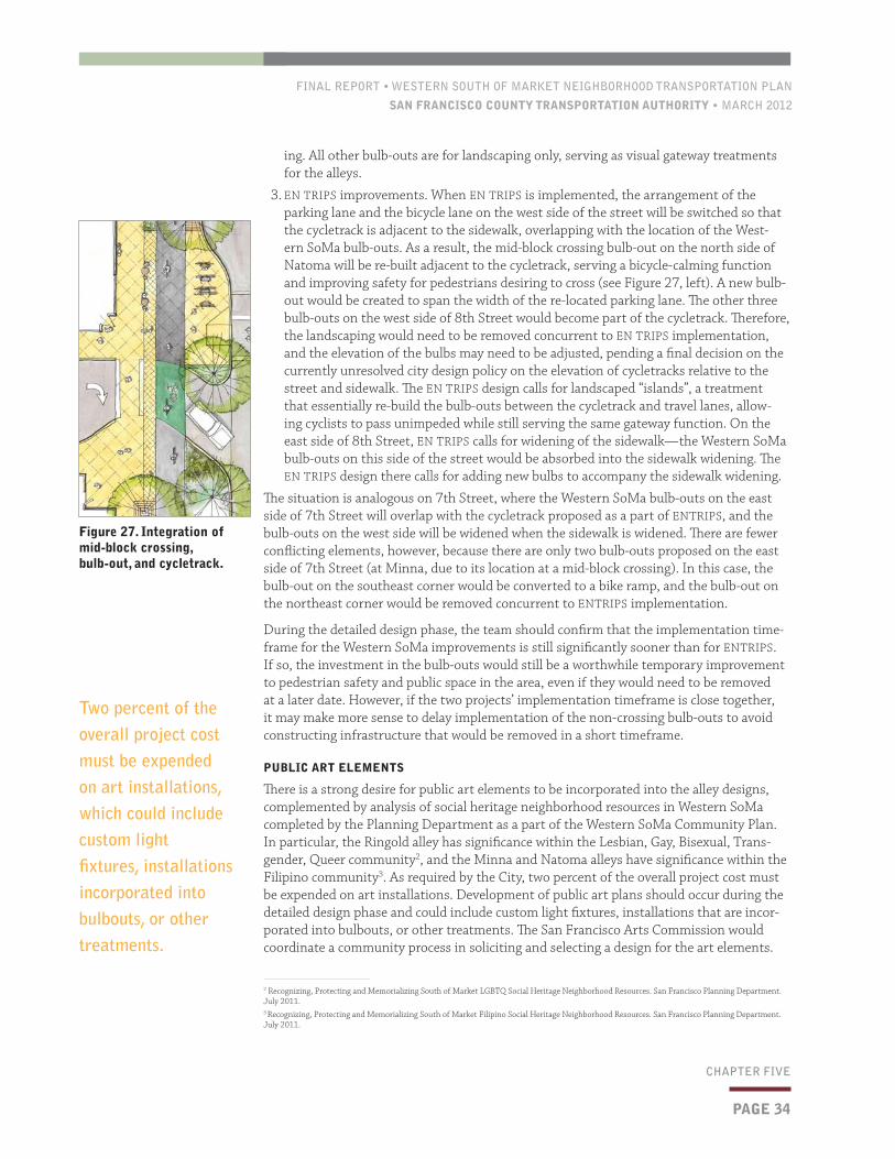
FINAL REPORT • WESTERN SOUTH OF MARKET NEIGHBORHOOD TRANSPORTATION PLAN
SAN FRANCISCO COUNTY TRANSPORTATION AUTHORITY • MARCH 2012
PAGE 34
CHAPTER FIVE
ing. All other bulb-outs are for landscaping only, serving as visual gateway treatments for the alleys.
3. EN TRIPS improvements. When EN TRIPS is implemented, the arrangement of the parking lane and the bicycle lane on the west side of the street will be switched so that the cycletrack is adjacent to the sidewalk, overlapping with the location of the West-ern SoMa bulb-outs. As a result, the mid-block crossing bulb-out on the north side of Natoma will be re-built adjacent to the cycletrack, serving a bicycle-calming function and improving safety for pedestrians desiring to cross (see Figure 27, left). A new bulb-out would be created to span the width of the re-located parking lane. The other three bulb-outs on the west side of 8th Street would become part of the cycletrack. Therefore, the landscaping would need to be removed concurrent to EN TRIPS implementation, and the elevation of the bulbs may need to be adjusted, pending a final decision on the currently unresolved city design policy on the elevation of cycletracks relative to the street and sidewalk. The EN TRIPS design calls for landscaped “islands”, a treatment that essentially re-build the bulb-outs between the cycletrack and travel lanes, allow-ing cyclists to pass unimpeded while still serving the same gateway function. On the east side of 8th Street, EN TRIPS calls for widening of the sidewalk—the Western SoMa bulb-outs on this side of the street would be absorbed into the sidewalk widening. The EN TRIPS design there calls for adding new bulbs to accompany the sidewalk widening.
The situation is analogous on 7th Street, where the Western SoMa bulb-outs on the east side of 7th Street will overlap with the cycletrack proposed as a part of ENTRIPS, and the bulb-outs on the west side will be widened when the sidewalk is widened. There are fewer conflicting elements, however, because there are only two bulb-outs proposed on the east side of 7th Street (at Minna, due to its location at a mid-block crossing). In this case, the bulb-out on the southeast corner would be converted to a bike ramp, and the bulb-out on the northeast corner would be removed concurrent to ENTRIPS implementation.
During the detailed design phase, the team should confirm that the implementation time-frame for the Western SoMa improvements is still significantly sooner than for ENTRIPS. If so, the investment in the bulb-outs would still be a worthwhile temporary improvement to pedestrian safety and public space in the area, even if they would need to be removed at a later date. However, if the two projects’ implementation timeframe is close together, it may make more sense to delay implementation of the non-crossing bulb-outs to avoid constructing infrastructure that would be removed in a short timeframe.
PUBLIC ART ELEMENTS
There is a strong desire for public art elements to be incorporated into the alley designs, complemented by analysis of social heritage neighborhood resources in Western SoMa completed by the Planning Department as a part of the Western SoMa Community Plan. In particular, the Ringold alley has significance within the Lesbian, Gay, Bisexual, Trans-gender, Queer community2, and the Minna and Natoma alleys have significance within the Filipino community3. As required by the City, two percent of the overall project cost must be expended on art installations. Development of public art plans should occur during the detailed design phase and could include custom light fixtures, installations that are incor-porated into bulbouts, or other treatments. The San Francisco Arts Commission would coordinate a community process in soliciting and selecting a design for the art elements.
2 Recognizing, Protecting and Memorializing South of Market LGBTQ Social Heritage Neighborhood Resources. San Francisco Planning Department. July 2011.3 Recognizing, Protecting and Memorializing South of Market Filipino Social Heritage Neighborhood Resources. San Francisco Planning Department. July 2011.
Figure 27. Integration of mid-block crossing, bulb-out, and cycletrack.
Two percent of the overall project cost must be expended on art installations, which could include custom light fixtures, installations incorporated into bulbouts, or other treatments.

FINAL REPORT • WESTERN SOUTH OF MARKET NEIGHBORHOOD TRANSPORTATION PLAN
SAN FRANCISCO COUNTY TRANSPORTATION AUTHORITY • MARCH 2012
PAGE 35
CHAPTER FIVE
5.3 Cost Estimates and Funding StrategyConceptual construction costs have been developed for the major components of the im-provements as shown in Table 5 (p. 37), totaling between $2.4 and $4.7 million. Pre-im-plementation costs to complete final design are expected to be approximately 15% of total costs, or an additional $360,000–$700,000. For cost estimate details, see Appendix A. The Ringold improvements are notably more expensive than Minna and Natoma because of the level of investment required for the shared-street concept. Ringold is an ideal location for this higher investment treatment given the opportunity presented for coordination with the 8th Street development project adjacent to the alley. As noted in Section 5.2, there would also be an increase in ongoing maintenance costs associated with the proposed streetscape improvements, estimated at about $5,000 per block or about $25,000 annually in total for the five blocks.
The project is expected to be competitive for many different fund sources as shown in Table 6 (p. 37). Each of these funding sources is described briefly in this section.
The One Bay Area Block Grant (OBAG) is a proposal from the Metropolitan Transportation Commission (MTC) that would guide the regional policy for distribution of the Bay Area’s share of federal Surface Transportation Program and Congestion Mitigation and Air Qual-ity (STP/CMAQ) funds available in Fiscal Years 2013–2015. The MTC is expected to approve the framework for the block grant program and associated policies for distribution of the funds in May 2012. The draft framework requires that the selected projects be an eligible pedestrian or bicycle facility project or eligible for funding from one of the following MTC programs: Transportation for Livable Communities, Regional Bicycle Program, Local Street & Roads (e.g. street resurfacing), or Safe Routes to School. As currently proposed, the Authority would distribute approximately $30 million to San Francisco projects and would be required to direct 70% of those funds to projects that support the City’s growth areas,
Figure 28. Western SoMa implementation sequencing
EXISTING CONDITIONSWESTERN SOMA NTP
PROPOSAL EN TRIPS PROPOSAL
KEYBike lane/CycletrackParkingMid-block crossing bulb turns into “speed table” with ENTRIPSLandscape only bulb-outs (removed with ENTRIPS)New ENTRIPS bulb-outs and curb on west sideEast side bulb-outs (widened with ENTRIPS)

FINAL REPORT • WESTERN SOUTH OF MARKET NEIGHBORHOOD TRANSPORTATION PLAN
SAN FRANCISCO COUNTY TRANSPORTATION AUTHORITY • MARCH 2012
identified as Priority Development Areas (PDAs). The improvements proposed in this Plan are all within a PDA and so would be eligible for this fund source.
Prop AA was approved by San Francisco voters in November 2010, putting into place a new $10 vehicle registration fee on motor vehicles registered in San Francisco and adopting a 30-year Expenditure Plan for the use of the revenues. Prop AA, which is administered by the Authority, is expected to raise approximately $5 million per year for transportation improvements in three Expenditure Plan categories. Of relevance to this Plan, the Expen-diture Plan calls for 25% of the funds be dedicated to projects that increase the safety and usability of streets for pedestrians.
Regional Safe Routes to Transit is a program funded by the Regional Measure 2 bridge toll that funds non-motorized improvements that improve access to regional transit hubs. The last cycle of funds for this program will distribute $4 million in Fiscal Year 2013/14 to proj-ects within the nine-county Bay Area. Given its proximity to the regional transit hubs on the Mission and Market Street transit corridors, Minna and Natoma improvements would be eligible for this funding source.
Prop K is the City’s 1/2-cent transportation sales tax. The funds are administered by the Authority, dedicated to transportation improvements identified in the 30-year Expendi-ture Plan. The improvements recommended in this Plan, would be eligible for funding from multiple Expenditure Plan categories, including Pedestrian Safety and Circulation, Traffic Calming, Bicycle Safety and Circulation and Transportation and Land Use Coordination. The latter is generally used as the local match for other state and federal funding programs such as OBAG mentioned above.
Transportation Enhancements is a federal funding source that can be used for transportation investments that, among other requirements, enhance communities and access. The type of streetscape and non-motorized improvements recommended in this Plan are eligible for en-hancements funds. The Authority established San Francisco project priorities for these funds, which are programmed biennially through the State Transportation Improvement Program.
Transportation Fund for Clean Air funds come from a $4 per vehicle surcharge collected by the Department of Motor Vehicles on motor vehicle registrations in the nine-county Bay Area region, and are distributed by the Bay Area Air Quality Management District (Air Dis-trict). A portion of these funds (40%) are returned to each of the counties These funds are used to implement strategies to improve air quality by reducing motor vehicle emissions. Eligible projects that correspond with Plan recommendations include traffic calming and bicycle improvements.
The Lifeline Transportation Program is a MTC program intended to fund improvements that address gaps and/or barriers the low-income residents face in accessing to job and job-related activities, as identified in Community-Based Transportation Plans or other substantive local planning efforts involving focused outreach to low-income populations. The Authority is the administrator of a portion of these funds for San Francisco, while the SFMTA prioritizes programming for the Prop 1B funds that are restricted to funding transit capital improvements.
Private Contributions may be another source of funding for the project. In particular, the developer of the 350 8th Street project may be able to contribute funds or in-kind support for the Ringold improvements. The Eastern Neighborhoods development impact fee rules will need to be clarified. In lieu of paying the fee, development projects may be allowed to take credit for on-site improvements such as the Ringold improvements identified here. The Planning Department is expected to clarify these rules before final approvals are given.
PAGE 36
CHAPTER FIVE
The Ringold improvements are notably more expensive than Minna and Natoma because of the level of investment required for the shared-street concept. Ringold is an ideal location for this higher investment treatment given the opportunity presented for coordination with the 8th Street development project adjacent to the alley.

FINAL REPORT • WESTERN SOUTH OF MARKET NEIGHBORHOOD TRANSPORTATION PLAN
SAN FRANCISCO COUNTY TRANSPORTATION AUTHORITY • MARCH 2012
PAGE 37
CHAPTER FIVE
Table 6. Potential Funding Sources
SOURCE NEXT CYCLE MAXIMUM AWARDEXPECTED AMOUNT AVAILABLE IN UPCOMING CYCLE
One Bay Area block grant: comprised primarily of federal Surface Transportation Program/Congestion Mitigation and Air Quality Improvement Program (STP/CMAQ) funds.
FY 2014–2015 N/A Approximately $30 million for San Francisco projects.
Regional Safe Routes to Transit: comprised of Regional Measure 2 bridge toll funds.
FY 2014 $500,000 for capital, $750,000 for multi-jurisdictional/agency capital projects.
$4 million within the nine-county Bay Area region; FY 2014 will be the last funding cycle for this source.
Prop K: San Francisco ½-cent transportation sales tax.
Continuous N/A Variable; project is likely eligible for several Prop K categories, see text for details.
Transportation Enhancements: Comprised of Federal Transportation Enhancement funds matched with State Highway Account funds.
FY 2015-2019 N/A Variable; In the last two cycles San Francisco has programmed an average of $2 million per cycle.
Prop AA: San Francisco’s $10 vehicle registration fee for transportation improvements.
FY 2013 N/A Approximately $5 million projected to be available on an annual basis for the entire Prop AA program; no maximum annual limit per Expenditure Plan category.
Transportation Fund for Clean Air: San Francisco’s share of a $4 per vehicle surcharge collected by the Department of Motor Vehicles in the Bay Area region and administered by the Bay Area Air Quality Management District
FY 2012 N/A Variable; San Francisco generally receives approximately $700,000 per cycle
Lifeline Transportation Program: Comprised of Federal Job Access and Reverse Commute, STP, State Transit Assistance and state Prop 1B funds.
FY 2013–2014 N/A $5.3M for San Francisco projects excluding Prop 1B transit funds for which Western SoMa projects would not be eligible.
Private contributions: The City may seek private contributions as appropriate, such as for Ringold improvements from the 350 8th Street project.
N/A N/A Unknown
Table 5. Summary of construction cost estimates*
IMPROVEMENTS COST ESTIMATE RANGE
Minna and Natoma streets, 7th to 9th streets
Alley improvements $0.7–1.9M
Signalized mid-block crossings $0.5–0.9M
Ringold Street, 8th to 9th streets
Shared-street treatment $1.2–1.9M
TOTAL $2.4–4.7M
* Pre-implementation costs to complete final design are estimated at $360,000–$700,000

CHAPTER ONE
FINAL REPORT • WESTERN SOUTH OF MARKET NEIGHBORHOOD TRANSPORTATION PLAN
SAN FRANCISCO COUNTY TRANSPORTATION AUTHORITY • MARCH 2012
PAGE 38
APPENDIX A1
Alleyway Improvements: Minna and Natoma, between 7th and 9th streets
ITEM QUANTITY UNIT* UNIT COST (LOW)
UNIT COST (HIGH)
ESTIMATE TOTAL (LOW)
ESTIMATE TOTAL (HIGH)
Demolition/Relocation1. Sawcut existing pavement 350 SF $4.5 $5 $1,575 $1,750
2. Remove existing curb and gutter1 190 SF $4 $6 $760 $1,140
3. Remove existing AC paving 58,700 SF $1 $3 $58,700 $176,100
4. Remove existing concrete sidewalk 1,200 SF $1.5 $4 $1,800 $4,800
5. Remove existing lights 28 SF $750 $1,000 $21,000 $28,000
6. Remove trees 4 SF $500 $600 $2,000 $2,400
TOTAL COST OF DEMOLITION/RELOCATION $86,730 $214,190
Paving and Drainage7. New curb and gutter 690 SF $30 $55 $20,700 $37,950
8. New concrete sidewalk 860 SF $8 $10 $6,880 $8,600
9. New AC paving 55,900 SF $9 $11 $503,100 $614,900
10. Raised crosswalk with asphalt aprons 6 LS $5,000 $6,000 $30,000 $36,000
11. Curb ramp 4 SF $2,600 $3,000 $10,400 $12,000
12. Corner curb extension 6 LS $15,000 $25,000 $90,000 $150,000
13. Chicane with permeable paving (includes curb) 2,800 SF $20 $25 $56,000 $70,000
TOTAL COST OF PAVING AND DRAINAGE $354,750 $929,450
Landscaping14. New tree with root guard (24" box) 35 EA $900 $1,300 $31,500 $45,500
15. Landscaping, soil improvement in curb extensions (on 7th and 8th)2
1,025 SF $12 $15 $12,300 $15,375
TOTAL COST OF LANDSCAPING $47,500 $60,875
Lighting16. Decorative pedestrian-scale light fixture 46 EA $4,500 $5,500 $207,000 $253,000
17. New connections to existing conduits 1 ALLOW $46,000 $69,000 $46,000 $69,000
TOTAL COST OF LIGHTING $67,200 $322,000
Striping, Signage, and Pavement Markings18. 12" stop lines 200 LF $3 $6 $600 $1,200
19. Pavement legends 1 LS $500 $1,000 $500 $1,000
20. Traffic signs 4 EA $300 $750 $1,200 $3,000
TOTAL COST OF STRIPING, SIGNAGE, AND PAVEMENT MARKINGS $2,300 $5,200
Subtotal $558,480 $1,531,715
20% Contingency $111,696 $306,343
2% for the Arts $11,170 $30,634
TOTAL ESTIMATE OF PROBABLE COST $670,176 $1,838,058
1 Along curb extensions on 7th and 8th2 No irrigation
* UNITS KEY:
SF: square feet
LF: linear feet
EA: each
LS: lump sum
ALLOW: allowance
Appendix A1 Conceptual Cost Estimate Detail
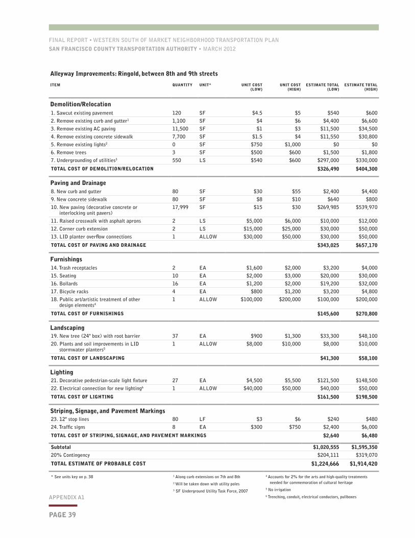
FINAL REPORT • WESTERN SOUTH OF MARKET NEIGHBORHOOD TRANSPORTATION PLAN
SAN FRANCISCO COUNTY TRANSPORTATION AUTHORITY • MARCH 2012
PAGE 39
APPENDIX A1
Alleyway Improvements: Ringold, between 8th and 9th streets
ITEM QUANTITY UNIT* UNIT COST (LOW)
UNIT COST (HIGH)
ESTIMATE TOTAL (LOW)
ESTIMATE TOTAL (HIGH)
Demolition/Relocation1. Sawcut existing pavement 120 SF $4.5 $5 $540 $600
2. Remove existing curb and gutter1 1,100 SF $4 $6 $4,400 $6,600
3. Remove existing AC paving 11,500 SF $1 $3 $11,500 $34,500
4. Remove existing concrete sidewalk 7,700 SF $1.5 $4 $11,550 $30,800
5. Remove existing lights2 0 SF $750 $1,000 $0 $0
6. Remove trees 3 SF $500 $600 $1,500 $1,800
7. Undergrounding of utilities3 550 LS $540 $600 $297,000 $330,000
TOTAL COST OF DEMOLITION/RELOCATION $326,490 $404,300
Paving and Drainage8. New curb and gutter 80 SF $30 $55 $2,400 $4,400
9. New concrete sidewalk 80 SF $8 $10 $640 $800
10. New paving (decorative concrete or interlocking unit pavers)
17,999 SF $15 $30 $269,985 $539,970
11. Raised crosswalk with asphalt aprons 2 LS $5,000 $6,000 $10,000 $12,000
12. Corner curb extension 2 LS $15,000 $25,000 $30,000 $50,000
13. LID planter overflow connections 1 ALLOW $30,000 $50,000 $30,000 $50,000
TOTAL COST OF PAVING AND DRAINAGE $343,025 $657,170
Furnishings14. Trash receptacles 2 EA $1,600 $2,000 $3,200 $4,000
15. Seating 10 EA $2,000 $3,000 $20,000 $30,000
16. Bollards 16 EA $1,200 $2,000 $19,200 $32,000
17. Bicycle racks 4 EA $800 $1,200 $3,200 $4,800
18. Public art/artistic treatment of other design elements4
1 ALLOW $100,000 $200,000 $100,000 $200,000
TOTAL COST OF FURNISHINGS $145,600 $270,800
Landscaping19. New tree (24" box) with root barrier 37 EA $900 $1,300 $33,300 $48,100
20. Plants and soil improvements in LID stormwater planters5
1 ALLOW $8,000 $10,000 $8,000 $10,000
TOTAL COST OF LANDSCAPING $41,300 $58,100
Lighting21. Decorative pedestrian-scale light fixture 27 EA $4,500 $5,500 $121,500 $148,500
22. Electrical connection for new lighting6 1 ALLOW $40,000 $50,000 $40,000 $50,000
TOTAL COST OF LIGHTING $161,500 $198,500
Striping, Signage, and Pavement Markings23. 12" stop lines 80 LF $3 $6 $240 $480
24. Traffic signs 8 EA $300 $750 $2,400 $6,000
TOTAL COST OF STRIPING, SIGNAGE, AND PAVEMENT MARKINGS $2,640 $6,480
Subtotal $1,020,555 $1,595,350
20% Contingency $204,111 $319,070
TOTAL ESTIMATE OF PROBABLE COST $1,224,666 $1,914,420
* See units key on p. 38 1 Along curb extensions on 7th and 8th2 Will be taken down with utility poles3 SF Underground Utility Task Force, 2007
4 Accounts for 2% for the arts and high-quality treatments needed for commemoration of cultural heritage
5 No irrigation6 Trenching, conduit, electrical conductors, pullboxes

CHAPTER ONE
FINAL REPORT • WESTERN SOUTH OF MARKET NEIGHBORHOOD TRANSPORTATION PLAN
SAN FRANCISCO COUNTY TRANSPORTATION AUTHORITY • MARCH 2012
PAGE 40
APPENDIX A1
Signalized mid-block crossings, 7th and Minna, 8th and Natoma
ITEM QUANTITY UNIT* UNIT COST (LOW)
UNIT COST (HIGH)
ESTIMATE TOTAL (LOW)
ESTIMATE TOTAL (HIGH)
Demolition/Relocation1. Sawcut existing pavement1 165 LF $4.5 $5 $743 $825
2. Remove existing curb w/ 2' concrete gutter1 165 LF $4 $6 $660 $990
3. Remove existing AC pavement1 750 SF $1 $3 $750 $2,250
4. Remove existing concrete1 1,100 SF $1.5 $4 $1,650 $4,400
5. Grind existing AC pavement1 750 SF $2 $3 $1,500 $2,250
6. Remove storm drain structure 3 SF $750 $1,500 $2,250 $4,500
TOTAL COST OF DEMOLITION/RELOCATION $7,553 $15,215
Layout and Improvements7. New extension (LF curb, SF concrete, demo)2 3 EA $15,000 $25,000 $45,000 $75,000
8. Forced turn curb extension (LF curb, SF concrete, demo)2
2 EA $15,000 $25,000 $30,000 $50,000
9. Planting at curb extension3 720 SF $9 $9 $6,480 $6,480
10. Concrete curb and gutter at planters4 165 LF $30 $55 $4,950 $9,075
11. Concrete sidewalk adjacent to planters5 1,200 SF $8 $10 $9,600 $12,000
12. Raised crosswalk6 3 EA $5,000 $5,000 $15,000 $15,000
13. Curb ramp finishing/scoring/half domes7 3 EA $2,600 $3,000 $7,800 $9,000
14. Signage8 4 EA $300 $750 $1,200 $3,000
15. Pedestrian level street lights9 6 EA $3,000 $5,000 $18,000 $30,000
16. Signals 2 EA $125,000 $250,000 $250,000 $500,000
17. Install curb inlet and reconnect existing storm drain pipes
3 EA $5,000 $7,500 $15,000 $22,500
18. Utility adjustments10 2 LS $3,000 $5,000 $6,000 $10,000
19. Asphalt concrete pavement 750 SF $9 $11 $6,750 $8,250
TOTAL COST OF LAYOUT AND IMPROVEMENTS $415,780 $750,305
Pavement Striping and Markers20. 12" limit line11 80 LF $7 $9 $560 $720
21. Crosswalk (thermoplastic)11 80 LF $3 $6 $240 $480
22. Pavement legends SF $8.5 $10 — —
TOTAL COST OF PAVEMENT STRIPING AND MARKERS $800 $1,200
Subtotal $424,133 $766,720
20% Contingency $84,827 $153,344
TOTAL ESTIMATE OF PROBABLE COST $508,960 $920,064
* See units key on p. 38 1 For planters (demo for curb extensions incl. below)
2 Assumes 6’x20’ extension3 Assumes 6’x20’ planter at each extension4 For planters5 SF cost of interior sidewalk at planters only
6 At signals only. No change on east side of 7th St. 7 Curb ramps at opposite side of curb extension8 Assumes new post in sidewalk and installation9 One at each corner10 Assumes each crosswalk is done separately11 40’ each across 8th and 7th sts.