westchester county a guide to aquatic buffers · westchester county a guide to aquatic buffers....
TRANSCRIPT
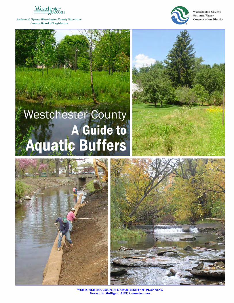
Westchester CountySoil and WaterConservation District
WESTCHESTER COUNTY DEPARTMENT OF PLANNINGGerard E. Mulligan, AICP, Commissioner
Westchester CountyA Guide to
Aquatic Buffers

Types of Aquatic Buffers
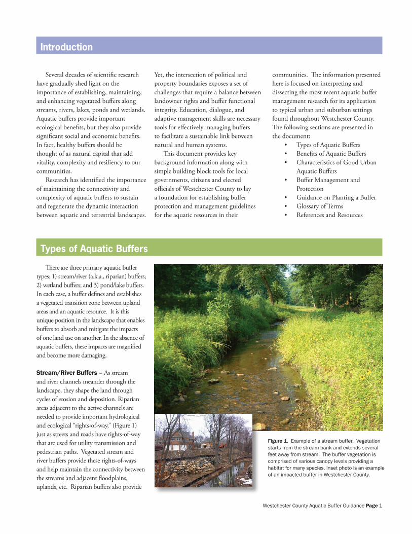
Figure 1. Example of a stream buffer. Vegetation starts from the stream bank and extends several feet away from stream. The buffer vegetation is comprised of various canopy levels providing a habitat for many species. Inset photo is an example of an impacted buffer in Westchester County.
Introduction
Several decades of scientific research have gradually shed light on the importance of establishing, maintaining, and enhancing vegetated buffers along streams, rivers, lakes, ponds and wetlands. Aquatic buffers provide important ecological benefits, but they also provide significant social and economic benefits. In fact, healthy buffers should be thought of as natural capital that add vitality, complexity and resiliency to our communities.
Research has identified the importance of maintaining the connectivity and complexity of aquatic buffers to sustain and regenerate the dynamic interaction between aquatic and terrestrial landscapes.
Yet, the intersection of political and property boundaries exposes a set of challenges that require a balance between landowner rights and buffer functional integrity. Education, dialogue, and adaptive management skills are necessary tools for effectively managing buffers to facilitate a sustainable link between natural and human systems.
This document provides key background information along with simple building block tools for local governments, citizens and elected officials of Westchester County to lay a foundation for establishing buffer protection and management guidelines for the aquatic resources in their
communities. The information presented here is focused on interpreting and dissecting the most recent aquatic buffer management research for its application to typical urban and suburban settings found throughout Westchester County. The following sections are presented in the document:
• Types of Aquatic Buffers• Benefits of Aquatic Buffers• Characteristics of Good Urban
Aquatic Buffers• Buffer Management and
Protection• Guidance on Planting a Buffer• Glossary of Terms• References and Resources
There are three primary aquatic buffer types: 1) stream/river (a.k.a., riparian) buffers; 2) wetland buffers; and 3) pond/lake buffers. In each case, a buffer defines and establishes a vegetated transition zone between upland areas and an aquatic resource. It is this unique position in the landscape that enables buffers to absorb and mitigate the impacts of one land use on another. In the absence of aquatic buffers, these impacts are magnified and become more damaging.
Stream/River Buffers – As stream and river channels meander through the landscape, they shape the land through cycles of erosion and deposition. Riparian areas adjacent to the active channels are needed to provide important hydrological and ecological “rights-of-way,” (Figure 1) just as streets and roads have rights-of-way that are used for utility transmission and pedestrian paths. Vegetated stream and river buffers provide these rights-of-ways and help maintain the connectivity between the streams and adjacent floodplains, uplands, etc. Riparian buffers also provide
Westchester County Aquatic Buffer Guidance Page 1
longitudinal connectivity and habitat corridors, which provide important linkages between critical habitats such as forest patches (Figure 2). Riparian buffer widths can vary depending on factors such as the size and slope of the stream/river and the quality of the stream. Forested riparian buffers are typically preferred over grassed buffers because they provide a broader range of benefits.
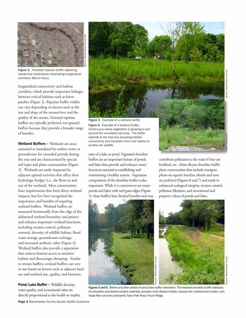
Wetland Buffers – Wetlands are areas saturated or inundated by surface water or groundwater for extended periods during the year and are characterized by special soil types and plant communities (Figure 3). Wetlands are easily impacted by adjacent upland activities that affect their hydrologic budget (i.e., the flows in and out of the wetland). Most communities have requirements that limit direct wetland impacts, but few have recognized the importance and benefits of requiring wetland buffers. Wetland buffers are measured horizontally from the edge of the delineated wetland boundary and protect and enhance important wetland functions, including erosion control, pollutant removal, diversity of wildlife habitat, flood water storage, groundwater recharge, and increased aesthetic value (Figure 4). Wetland buffers also provide a separation that reduces human access to sensitive habitat and discourages dumping. Similar to stream buffers, wetland buffers can vary in size based on factors such as adjacent land use and wetland size, quality, and function.
Pond/Lake Buffer – Wildlife diversity, water quality, and recreational value are directly proportional to the health or trophic
state of a lake or pond. Vegetated shoreline buffers are an important feature of ponds and lakes that provide and enhance many functions essential to establishing and maintaining a healthy system. Vegetation composition of the shoreline buffer is also important. While it is common to see many ponds and lakes with turf grass edges (Figure 5), these buffers have limited benefits and may
contribute pollutants to the water if they are fertilized, etc. More diverse shoreline buffer plant communities that include emergent plants on aquatic benches, shrubs and trees are preferred (Figures 6 and 7) and result in enhanced ecological integrity, erosion control, pollution filtration, and recreational and property values of ponds and lakes.
Figure 4. Example of a wetland buffer. Continuous native vegetation is growing in and around the inundated wet area. The buffer extends to the tree line providing habitat connectivity and transition from one habitat to another for wildlife.
Figures 5 and 6. Before and after photos of pond/lake buffer restoration. The restored shoreline buffer stabilizes the shoreline and lessens erosion potential, provides more diverse habitat, reduces the maintenance burden, and helps filter out some pollutants; Town Park Pond, Pound Ridge.
Figure 3. Example of a wetland buffer.
Sour
ce: W
estc
hest
er C
ount
y G
IS
Figure 2. Forested riparian buffer adjoining residential subdivistion illustrating longitudinal corridors; Mount Kisco.
Sour
ce: W
estc
hest
er C
ount
ySo
urce
: Wes
tche
ster
Cou
nty
Sour
ce: W
estc
hest
er C
ount
y
Keith
Und
erw
ood
Page � Westchester County Aquatic Buffer Guidance
Vegetated aquatic buffers offer a large array of ecological, sociological, and economic benefits to communities. In urban and suburban settings, it can be challenging to balance these benefits with the need for public living spaces and services. Often, engineered solutions are pursued that allow for increased development intensity and density adjacent to aquatic resources. Unfortunately, these expensive structural solutions can have limited effectiveness, can exacerbate undesirable conditions, and may simply transfer a problem to another location. In the end, the most ecological, sociological, and economical approach is to set aside an appropriately sized vegetated buffer around aquatic resources. It is helpful to consider the following benefits of aquatic buffers:
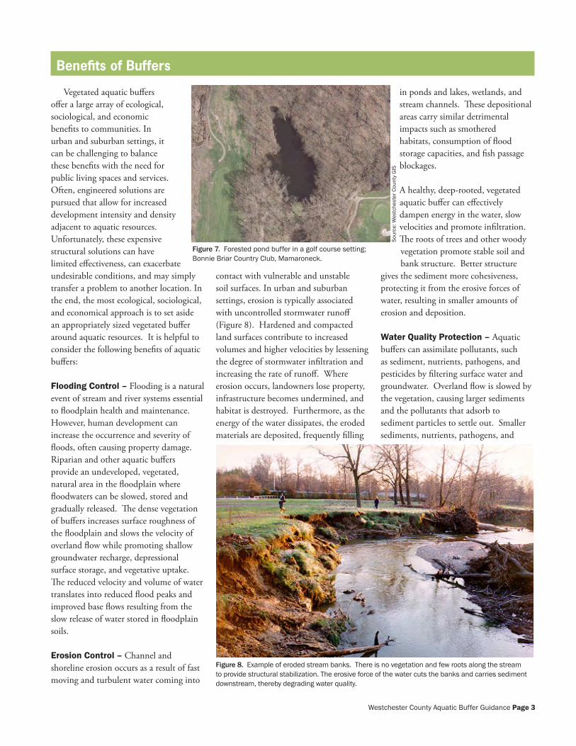
Flooding Control – Flooding is a natural event of stream and river systems essential to floodplain health and maintenance. However, human development can increase the occurrence and severity of floods, often causing property damage. Riparian and other aquatic buffers provide an undeveloped, vegetated, natural area in the floodplain where floodwaters can be slowed, stored and gradually released. The dense vegetation of buffers increases surface roughness of the floodplain and slows the velocity of overland flow while promoting shallow groundwater recharge, depressional surface storage, and vegetative uptake. The reduced velocity and volume of water translates into reduced flood peaks and improved base flows resulting from the slow release of water stored in floodplain soils.
Erosion Control – Channel and shoreline erosion occurs as a result of fast moving and turbulent water coming into
contact with vulnerable and unstable soil surfaces. In urban and suburban settings, erosion is typically associated with uncontrolled stormwater runoff (Figure 8). Hardened and compacted land surfaces contribute to increased volumes and higher velocities by lessening the degree of stormwater infiltration and increasing the rate of runoff. Where erosion occurs, landowners lose property, infrastructure becomes undermined, and habitat is destroyed. Furthermore, as the energy of the water dissipates, the eroded materials are deposited, frequently filling
in ponds and lakes, wetlands, and stream channels. These depositional areas carry similar detrimental impacts such as smothered habitats, consumption of flood storage capacities, and fish passage blockages.
A healthy, deep-rooted, vegetated aquatic buffer can effectively dampen energy in the water, slow velocities and promote infiltration. The roots of trees and other woody vegetation promote stable soil and bank structure. Better structure
gives the sediment more cohesiveness, protecting it from the erosive forces of water, resulting in smaller amounts of erosion and deposition.
Water Quality Protection – Aquatic buffers can assimilate pollutants, such as sediment, nutrients, pathogens, and pesticides by filtering surface water and groundwater. Overland flow is slowed by the vegetation, causing larger sediments and the pollutants that adsorb to sediment particles to settle out. Smaller sediments, nutrients, pathogens, and
Figure 8. Example of eroded stream banks. There is no vegetation and few roots along the stream to provide structural stabilization. The erosive force of the water cuts the banks and carries sediment downstream, thereby degrading water quality.
Benefits of Buffers
Sour
ce: W
estc
hest
er C
ount
y G
IS
Figure 7. Forested pond buffer in a golf course setting; Bonnie Briar Country Club, Mamaroneck.
Westchester County Aquatic Buffer Guidance Page �
pesticides not removed from surface water will be further removed through groundwater filtration, uptake by vegetation, biogeochemical processes, and microbial processes in the shallow soil profile. Without dense naturally vegetated buffers, common urban runoff pollutants such as pesticides and fertilizers easily find their way into receiving waters and contribute to their impairment. Naturally vegetated pond and lake shoreline buffers also provide effective barriers to resident waterfowl populations, which can contribute significant nutrient and pathogen loads.
Groundwater Recharge and Protection – Groundwater recharge and filtration is another benefit of aquatic buffers ultimately contributing to improved water quality. Vegetated aquatic buffers slow surface flows, which promotes infiltration and vegetative uptake. Pollutants such as nutrients and heavy metals can be reduced or completely removed if groundwater is in contact with roots of vegetation and denitrifying microbes in the soil column. Purification of alluvial groundwater is particularly enhanced when stream beds and banks act as a natural filtration system that reduces pollutant loads of waters that have been slowed and absorbed into adjacent floodplains and floodplain buffers.
Ecosystem Protection – Healthy, diverse aquatic buffers directly provide or help support critical habitat (e.g., areas that support rare, threatened or endangered species) to a variety of
aquatic and terrestrial species. Species diversity and abundance translates into more resilient and stable natural systems that are able to adapt to natural and human-induced disruptions. Stable natural systems in turn provide reliable and consistent benefits to human systems.
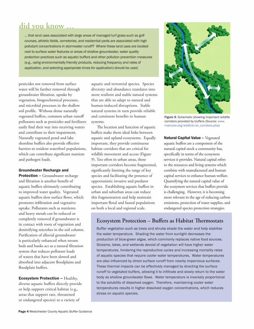
The location and function of aquatic buffers make them ideal links between aquatic and upland ecosystems. Equally important, they provide continuous habitat corridors that are critical for wildlife movement and access (Figure 9). Too often in urban areas, these important corridors become fragmented, significantly limiting the range of key species and facilitating the presence of opportunistic invasive and predator species. Establishing aquatic buffers in urban and suburban areas can reduce this fragmentation and help maintain important floral and faunal populations on both a local and regional scale.
Natural Capital Value – Vegetated aquatic buffers are a component of the natural capital stock a community has, specifically in terms of the ecosystem services it provides. Natural capital refers to the resources and living systems which combine with manufactured and human capital services to enhance human welfare. Quantifying the natural capital value of the ecosystem services that buffers provide is challenging. However, it is becoming more relevant in the age of reducing carbon emissions, protection of water supplies, and endangered species protection strategies.
… that land uses associated with large areas of managed turf grass such as golf courses, athletic fields, cemeteries, and residential yards are associated with high pollutant concentrations in stormwater runoff? Where these land uses are located next to surface water features or areas of shallow groundwater, water quality protection practices such as aquatic buffers and other pollution prevention measures (e.g., using environmentally friendly products, reducing frequency and rates of application, and selecting appropriate times for application) should be used.
did you know …
Figure 9. Schematic showing important wildlife corridors provided by buffers (Source: www.rivercare.org/wildlink/wl_corridors.php)
Ecosystem Protection – Buffers as Habitat ThermostatsBuffer vegetation such as trees and shrubs shade the water and help stabilize the water temperature. Shading the water from sunlight decreases the production of blue-green algae, which commonly replaces native food sources. Streams, lakes, and wetlands devoid of vegetation will have higher water temperatures, hindering the reproductive cycles and increasing mortality rates of aquatic species that require cooler water temperatures. Water temperatures are also influenced by direct surface runoff from nearby impervious surfaces. These thermal impacts can be effectively managed by directing the surface runoff to vegetated buffers, allowing it to infiltrate and slowly return to the water body as shallow groundwater flows. Water temperature is inversely proportional to the solubility of dissolved oxygen. Therefore, maintaining cooler water temperatures results in higher dissolved oxygen concentrations, which reduces stress on aquatic species.
Page � Westchester County Aquatic Buffer Guidance
At a minimum, communities need to realize the presence of natural capital and establish inventories of natural capital stock. For example, aquatic buffers provide aesthetic value to communities because of the natural habitat comprised of diverse flora and fauna. Aquatic buffers offer recreational and educational opportunities for neighborhoods and schools, promoting healthy lifestyles and enhanced community stewardship and camaraderie. Finally, aquatic buffers
provide cost-effective and reliable human health and safety services such as flood control, erosion control, water quality protection and enhancement, and recreational opportunities that would otherwise cost communities significant amounts of money through engineered structures and systems.
Economic Value – In addition to the natural capital value described above, communities and property owners that
establish and implement aquatic buffers typically benefit from increased property values due to the aesthetic appeal of open space. Development next to streams, lakes, or wetlands is often able to draw premium sales prices. Where buffers are absent from aquatic resources, communities and property owners may be faced with mitigation and repair costs to protect infrastructure and property being impacted by erosion, sediment deposition and floods.
Characteristics of Good Urban Aquatic Buffers
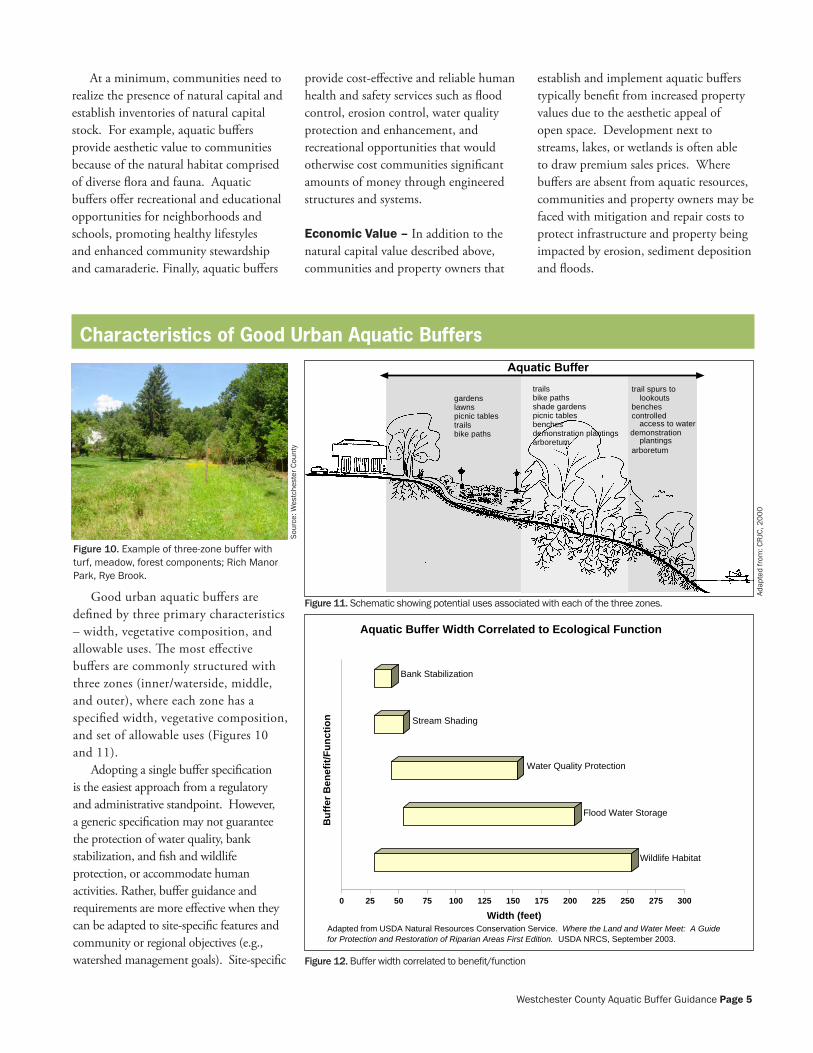
Good urban aquatic buffers are defined by three primary characteristics – width, vegetative composition, and allowable uses. The most effective buffers are commonly structured with three zones (inner/waterside, middle, and outer), where each zone has a specified width, vegetative composition, and set of allowable uses (Figures 10 and 11).
Adopting a single buffer specification is the easiest approach from a regulatory and administrative standpoint. However, a generic specification may not guarantee the protection of water quality, bank stabilization, and fish and wildlife protection, or accommodate human activities. Rather, buffer guidance and requirements are more effective when they can be adapted to site-specific features and community or regional objectives (e.g., watershed management goals). Site-specific
Aquatic Buffer
gardenslawnspicnic tablestrailsbike paths
trailsbike pathsshade gardenspicnic tablesbenchesdemonstration plantings demonstration
plantingsarboretum
trail spurs tolookouts
benchescontrolled
access to water
arboretum
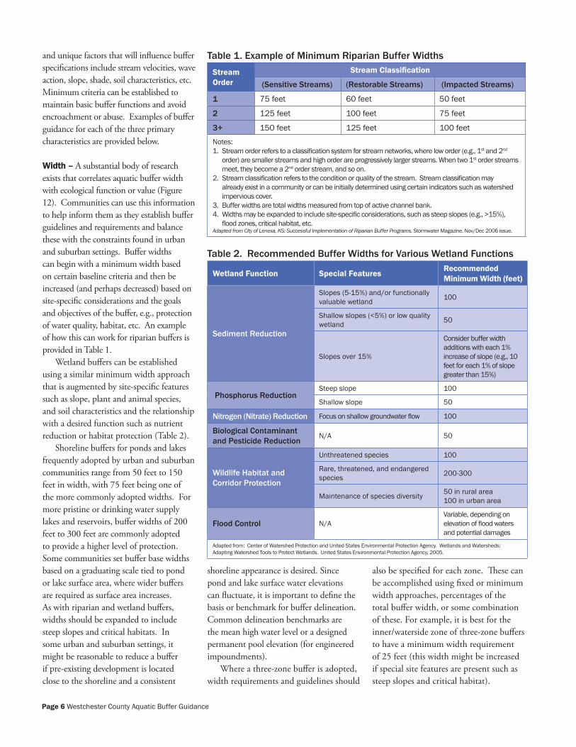
Wildlife Habitat
Flood Water Storage
Water Quality Protection
Stream Shading
Bank Stabilization
0 25 50 75 100 125 150 175 200 225 250 275 300
Width (feet)
Wildlife Habitat
Flood Water Storage
Water Quality Protection
Stream Shading
Bank Stabilization
Buf
fer B
enef
it/Fu
nctio
n
Aquatic Buffer Width Correlated to Ecological Function
Adapted from USDA Natural Resources Conservation Service. Where the Land and Water Meet: A Guide for Protection and Restoration of Riparian Areas First Edition. USDA NRCS, September 2003.
Figure 10. Example of three-zone buffer with turf, meadow, forest components; Rich Manor Park, Rye Brook.
Adap
ted
from
: CRJ
C, 2
000
Figure 11. Schematic showing potential uses associated with each of the three zones.
Figure 12. Buffer width correlated to benefit/function
Sour
ce: W
estc
hest
er C
ount
y
Westchester County Aquatic Buffer Guidance Page �
and unique factors that will influence buffer specifications include stream velocities, wave action, slope, shade, soil characteristics, etc. Minimum criteria can be established to maintain basic buffer functions and avoid encroachment or abuse. Examples of buffer guidance for each of the three primary characteristics are provided below.
Width – A substantial body of research exists that correlates aquatic buffer width with ecological function or value (Figure 12). Communities can use this information to help inform them as they establish buffer guidelines and requirements and balance these with the constraints found in urban and suburban settings. Buffer widths can begin with a minimum width based on certain baseline criteria and then be increased (and perhaps decreased) based on site-specific considerations and the goals and objectives of the buffer, e.g., protection of water quality, habitat, etc. An example of how this can work for riparian buffers is provided in Table 1.
Wetland buffers can be established using a similar minimum width approach that is augmented by site-specific features such as slope, plant and animal species, and soil characteristics and the relationship with a desired function such as nutrient reduction or habitat protection (Table 2).
Shoreline buffers for ponds and lakes frequently adopted by urban and suburban communities range from 50 feet to 150 feet in width, with 75 feet being one of the more commonly adopted widths. For more pristine or drinking water supply lakes and reservoirs, buffer widths of 200 feet to 300 feet are commonly adopted to provide a higher level of protection. Some communities set buffer base widths based on a graduating scale tied to pond or lake surface area, where wider buffers are required as surface area increases. As with riparian and wetland buffers, widths should be expanded to include steep slopes and critical habitats. In some urban and suburban settings, it might be reasonable to reduce a buffer if pre-existing development is located close to the shoreline and a consistent
shoreline appearance is desired. Since pond and lake surface water elevations can fluctuate, it is important to define the basis or benchmark for buffer delineation. Common delineation benchmarks are the mean high water level or a designed permanent pool elevation (for engineered impoundments).
Where a three-zone buffer is adopted, width requirements and guidelines should
also be specified for each zone. These can be accomplished using fixed or minimum width approaches, percentages of the total buffer width, or some combination of these. For example, it is best for the inner/waterside zone of three-zone buffers to have a minimum width requirement of 25 feet (this width might be increased if special site features are present such as steep slopes and critical habitat).
Table 1. Example of Minimum Riparian Buffer WidthsStream Order
Stream Classification
(Sensitive Streams) (Restorable Streams) (Impacted Streams)
1 75 feet 60 feet 50 feet
2 125 feet 100 feet 75 feet
3+ 150 feet 125 feet 100 feet
Notes:1. Stream order refers to a classification system for stream networks, where low order (e.g., 1st and 2nd
order) are smaller streams and high order are progressively larger streams. When two 1st order streams meet, they become a 2nd order stream, and so on.
2. Stream classification refers to the condition or quality of the stream. Stream classification may already exist in a community or can be initially determined using certain indicators such as watershed impervious cover.
3. Buffer widths are total widths measured from top of active channel bank.4. Widths may be expanded to include site-specific considerations, such as steep slopes (e.g., >15%),
flood zones, critical habitat, etc.Adapted from City of Lenexa, KS: Successful Implementation of Riparian Buffer Programs. Stormwater Magazine. Nov/Dec 2006 issue.
Table 2. Recommended Buffer Widths for Various Wetland Functions
Wetland Function Special Features Recommended Minimum Width (feet)
Sediment Reduction
Slopes (5-15%) and/or functionally valuable wetland 100
Shallow slopes (<5%) or low quality wetland 50
Slopes over 15%
Consider buffer width additions with each 1% increase of slope (e.g., 10 feet for each 1% of slope greater than 15%)
Phosphorus ReductionSteep slope 100
Shallow slope 50
Nitrogen (Nitrate) Reduction Focus on shallow groundwater flow 100
Biological Contaminant and Pesticide Reduction
N/A 50
Wildlife Habitat and Corridor Protection
Unthreatened species 100
Rare, threatened, and endangered species 200-300
Maintenance of species diversity 50 in rural area 100 in urban area
Flood Control N/AVariable, depending on elevation of flood waters and potential damages
Adapted from: Center of Watershed Protection and United States Environmental Protection Agency. Wetlands and Watersheds: Adapting Watershed Tools to Protect Wetlands. United States Environmental Protection Agency, 2005.
Page � Westchester County Aquatic Buffer Guidance
Vegetation Composition – Vegetation composition can have a significant effect on the health, function, maintenance and effectiveness of a buffer. Specifying vegetation for buffers is an important consideration, and it can be influenced by factors such as existing conditions, desired and allowable land use, and aesthetics. As a guiding principle, however, native plants (grasses, shrubs, and trees) should be used to the greatest extent possible. Native plants are the best choice because they are adapted to the climate and relatively resistant to most diseases and insects in the area, leading to a greater likelihood of creating a regenerative (i.e., self-sustaining) ecosystem. Utilizing native plants also provides specific and unique habitat and food sources that are preferred by native wildlife, which in turn contributes to a more robust and resilient ecosystem in challenging urban and suburban settings.
Vegetation composition can vary based on identifying different planting zones within a buffer in conjunction with the three-zone designation illustrated in Figure 11. For example, it is common to see buffers where outer zones (i.e., the buffer zone furthest away from the aquatic resource) are more highly managed and maintained and often are comprised of meadow grasses, herbaceous plants or even turf grass.
Middle zones are commonly comprised of managed areas of shrubs and trees, and inner zones are dominated by shrubs and trees subject to limited management.
There are different approaches available for buffer establishment, typically dictated by the existing buffer condition. The best and most cost-effective situation is where a naturally vegetated buffer already exists to some extent and the focus is on allowing a natural regeneration of the buffer to occur through succession of native plants, and animal, wind, and insect dispersal. Early successional species will stabilize the riparian zone and eventually be replaced by longer-term species. This natural regenerative process can also be enhanced through beneficial management that includes selective thinning, invasive species management, supplementary native plantings, or reduced mowing practices.
A second approach to buffer establishment is active revegetation, which allows for faster results in areas that have little or no beneficial vegetation. In these situations, a more
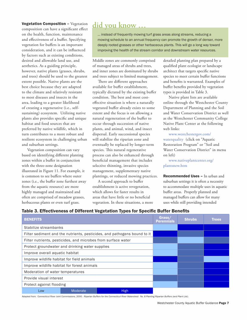
detailed planting plan prepared by a qualified plant ecologist or landscape architect that targets specific native species to meet certain buffer functions and benefits is warranted. Examples of buffer benefits provided by vegetation types is provided in Table 3.
Native plant lists are available online through the Westchester County Department of Planning and the Soil and Water Conservation District as well as the Westchester Community College Native Plant Center at the following web links:
www.westchestergov.com/waterquality (click on “Aquatic Restoration Program” or “Soil and Water Conservation District” in menu on left)
www.nativeplantcenter.org/plantsnew.htm
Recommended Uses – In urban and suburban settings it is often a necessity to accommodate multiple uses in aquatic buffer areas. Properly planned and managed buffers can allow for many uses while still providing intended
… instead of frequently mowing turf grass areas along streams, reducing a mowing schedule to an annual frequency can promote the growth of denser, more deeply rooted grasses or other herbaceous plants. This will go a long way toward improving the health of the stream corridor and downstream water resources.
did you know …
Table 3. Effectiveness of Different Vegetation Types for Specific Buffer Benefits
BENEFITS Grass/Perennials Shrubs Trees
Stabilize streambanks
Filter sediment and the nutrients, pesticides, and pathogens bound to it
Filter nutrients, pesticides, and microbes from surface water
Protect groundwater and drinking water supplies
Improve overall aquatic habitat
Improve wildlife habitat for field animals
Improve wildlife habitat for forest animals
Moderation of water temperatures
Provide visual interest
Protect against flooding
Low Moderate HighAdapted from: Connecticut River Joint Commissions, 2000. Riparian Buffers for the Connecticut River Watershed: No. 8 Planting Riparian Buffers (and Plant List).
Westchester County Aquatic Buffer Guidance Page �
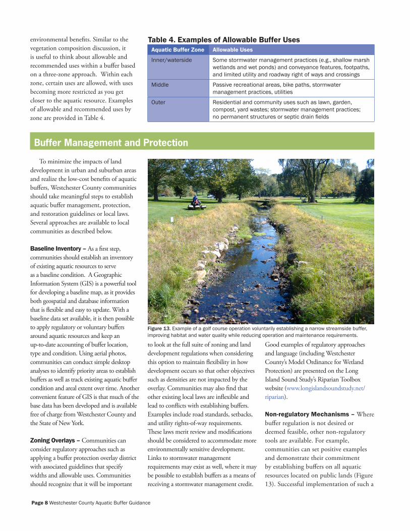
environmental benefits. Similar to the vegetation composition discussion, it is useful to think about allowable and recommended uses within a buffer based on a three-zone approach. Within each zone, certain uses are allowed, with uses becoming more restricted as you get closer to the aquatic resource. Examples of allowable and recommended uses by zone are provided in Table 4.
Aquatic Buffer Zone Allowable Uses
Inner/waterside Some stormwater management practices (e.g., shallow marsh wetlands and wet ponds) and conveyance features, footpaths, and limited utility and roadway right of ways and crossings
Middle Passive recreational areas, bike paths, stormwater management practices, utilities
Outer Residential and community uses such as lawn, garden, compost, yard wastes; stormwater management practices; no permanent structures or septic drain fields
Buffer Management and Protection
To minimize the impacts of land development in urban and suburban areas and realize the low-cost benefits of aquatic buffers, Westchester County communities should take meaningful steps to establish aquatic buffer management, protection, and restoration guidelines or local laws. Several approaches are available to local communities as described below.
Baseline Inventory – As a first step, communities should establish an inventory of existing aquatic resources to serve as a baseline condition. A Geographic Information System (GIS) is a powerful tool for developing a baseline map, as it provides both geospatial and database information that is flexible and easy to update. With a baseline data set available, it is then possible to apply regulatory or voluntary buffers around aquatic resources and keep an up-to-date accounting of buffer location, type and condition. Using aerial photos, communities can conduct simple desktop analyses to identify priority areas to establish buffers as well as track existing aquatic buffer condition and areal extent over time. Another convenient feature of GIS is that much of the base data has been developed and is available free of charge from Westchester County and the State of New York.
Zoning Overlays – Communities can consider regulatory approaches such as applying a buffer protection overlay district with associated guidelines that specify widths and allowable uses. Communities should recognize that it will be important
to look at the full suite of zoning and land development regulations when considering this option to maintain flexibility in how development occurs so that other objectives such as densities are not impacted by the overlay. Communities may also find that other existing local laws are inflexible and lead to conflicts with establishing buffers. Examples include road standards, setbacks, and utility rights-of-way requirements. These laws merit review and modifications should be considered to accommodate more environmentally sensitive development. Links to stormwater management requirements may exist as well, where it may be possible to establish buffers as a means of receiving a stormwater management credit.
Good examples of regulatory approaches and language (including Westchester County’s Model Ordinance for Wetland Protection) are presented on the Long Island Sound Study’s Riparian Toolbox website (www.longislandsoundstudy.net/riparian).
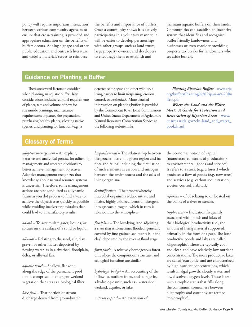
Non-regulatory Mechanisms – Where buffer regulation is not desired or deemed feasible, other non-regulatory tools are available. For example, communities can set positive examples and demonstrate their commitment by establishing buffers on all aquatic resources located on public lands (Figure 13). Successful implementation of such a
Figure 13. Example of a golf course operation voluntarily establishing a narrow streamside buffer, improving habitat and water quality while reducing operation and maintenance requirements.
Table �. Examples of Allowable Buffer Uses
Page � Westchester County Aquatic Buffer Guidance
policy will require important interaction between various community agencies to ensure that cross-training is provided and appropriate education on the benefits of buffers occurs. Adding signage and other public education and outreach literature and website materials serves to reinforce
the benefits and importance of buffers. Once a community shows it is actively participating in a voluntary manner, it will be easier to develop partnerships with other groups such as land trusts, large property owners, and developers to encourage them to establish and
maintain aquatic buffers on their lands. Communities can establish an incentive system that identifies and recognizes buffer friendly landowners and businesses or even consider providing property tax breaks for landowners who set aside buffers.
Guidance on Planting a Buffer
There are several factors to consider when planting an aquatic buffer. Key considerations include: cultural requirements of plants, rate and volume of flow for streamside plantings, maintenance requirements of plants, site preparation, purchasing healthy plants, selecting native species, and planting for function (e.g., a
deterrence for geese and other wildlife, a living barrier to limit trespassing, erosion control, or aesthetics). More detailed information on planting buffers is provided by the Connecticut River Joint Commissions and United States Department of Agriculture Natural Resources Conservation Service at the following website links:
Planting Riparian Buffers - www.crjc.org/buffers/Planting%20Riparian%20Buffers.pdf
Where the Land and the Water Meet: A Guide for Protection and Restoration of Riparian Areas - www.ct.nrcs.usda.gov/eln-land_and_water_book.html
Glossary of Terms
adaptive management – An explicit, iterative and analytical process for adjusting management and research decisions to better achieve management objectives. Adaptive management recognizes that knowledge about natural resource systems is uncertain. Therefore, some management actions are best conducted as a dynamic (learn as you do) process to find a way to achieve the objectives as quickly as possible while avoiding inadvertent mistakes that could lead to unsatisfactory results.
adsorb – To accumulate gases, liquids, or solutes on the surface of a solid or liquid.
alluvial – Relating to the sand, silt, clay, gravel, or other matter deposited by flowing water, as in a riverbed, floodplain, delta, or alluvial fan.
aquatic bench – Shallow, flat zone along the edge of the permanent pool that is comprised of emergent wetland vegetation that acts as a biological filter.
base flow – That portion of stream discharge derived from groundwater.
biogeochemical – The relationship between the geochemistry of a given region and its flora and fauna, including the circulation of such elements as carbon and nitrogen between the environment and the cells of living organisms.
denitrification – The process whereby microbial organisms reduce nitrate and nitrite, highly oxidized forms of nitrogen, into gaseous nitrogen, which in turn is released into the atmosphere.
floodplain – The low-lying land adjoining a river that is sometimes flooded; generally covered by fine-grained sediments (silt and clay) deposited by the river at flood stage.
forest patch - A relatively homogenous forest unit where the composition, structure, and ecological functions are similar.
hydrologic budget – An accounting of the inflow to, outflow from, and storage in, a hydrologic unit, such as a watershed, wetland, aquifer, or lake.
natural capital – An extension of
the economic notion of capital (manufactured means of production) to environmental ‘goods and services’. It refers to a stock (e.g. a forest) which produces a flow of goods (e.g. new trees) and services (e.g. carbon sequestration, erosion control, habitat).
riparian – of or relating to or located on the banks of a river or stream.
trophic state – Indication frequently associated with ponds and lakes of their biological productivity (i.e., the amount of living material supported, primarily in the form of algae). The least productive ponds and lakes are called ‘oligotrophic’. These are typically cool and clear, and have relatively low nutrient concentrations. The most productive lakes are called ‘eutrophic’ and are characterized by high nutrient concentrations, which result in algal growth, cloudy water, and low dissolved oxygen levels. Those lakes with a trophic status that falls along the continuum somewhere between oligotrophy and eutrophy are termed ‘mesotrophic’.
Westchester County Aquatic Buffer Guidance Page �
References and Resources
1. Boyd, L. Wetland Buffer Zones and Beyond: Wildlife Use of Wetland Buffer Zones and Their Protection under the Massachusetts Wetland Protection Act. WCPP, DNRC, and Univ. of Massachusetts, 2001.
2. Center for Watershed Protection. Watershed Protection Techniques: Urban Lake Management. Center for Watershed Protection, 2001.
3. Center for Watershed Protection and United States Environmental Protection Agency. Wetlands and Watersheds: Adapting Watershed Tools to Protect Wetlands. United States Environmental Protection Agency, 2005.
4. Chagrin River Watershed Partners, Inc., et al., 2006. Riparian Setbacks Technical Information for Decision Makers.
5. Connecticut River Joint Commissions, 2000. Riparian Buffers for the Connecticut River Watershed: No. 1 Introduction to Riparian Buffers.
6. Connecticut River Joint Commissions, 2000. Riparian Buffers for the Connecticut River Watershed: No. 2 Backyard Buffers.
7. Connecticut River Joint Commissions, 2000. Riparian Buffers for the Connecticut River Watershed: No. 3 Forestland Buffers.
8. Connecticut River Joint Commissions, 2000. Riparian Buffers for the Connecticut River Watershed: No. 4 Buffers for Habitat.
9. Connecticut River Joint Commissions, 2000. Riparian Buffers for the Connecticut River Watershed: No. 5 Buffers for Agricultural Land.
10. Connecticut River Joint Commissions, 2000. Riparian Buffers for the Connecticut River Watershed: No. 6 Urban Buffers.
11. Connecticut River Joint Commissions, 2000. Riparian Buffers for the Connecticut River Watershed: No. 7 Guidance for Communities.
12. Connecticut River Joint Commissions, 2000. Riparian Buffers for the Connecticut River Watershed: No. 8 Planting Riparian Buffers (and Plant List).
13. Connecticut River Joint Commissions, 2000. Riparian Buffers for the Connecticut River Watershed: No. 9 Field Assessment.
14. Connecticut River Joint Commissions, 2000. Riparian Buffers for the Connecticut River Watershed: No. 10 Sources of Assistance.
15. Presler, H.H. Successful implementation of Riparian Buffer Programs. The Journal of Surface Water Quality Professionals Stormwater. November/December 2006.
16. Thomas, J. Riparian Conservation in California Wine County: A Comparison of the County Planning Approach. Masters Thesis. University of California, Berkley, 2004.
17. USDA Natural Resources Conservation Service. Where the Land and Water Meet: A Guide for Protection and Restoration of Riparian Areas First Edition. USDA NRCS, September 2003.
18. Wenger, S. A Review of the Scientific Literature on Riparian Buffer Width, Extent and Vegetation. Office of Public Service and Outreach at the Institute of Ecology, University of Georgia, 1999.
19. Westchester County Department of Planning and Soil and Water Conservation District webpages at www.westchestergov.com/waterquality, then click on Aquatic Restoration Program and/or Soil and Water Conservation Distric in left menu.
20. Long Island Sound Study website at www.longislandsoundstudy.net/riparian.
Page 10 Westchester County Aquatic Buffer Guidance

Developed on behalf of the Westchester County Department of Planning and Soil and Water
Conservation District by:
This guide has been partially funded through a grant from the Hudson River Estuary Program to the Lower Hudson Coalition of Conservation Districts.
Restore the Earth & Inspire Ecological Stewardship
B i o h a b i t a t s I n c . • 2 0 8 1 C l i p p e r P a r k R o a d • B a l t i m o r e , M a r y l a n d • w w w . b i o h a b i t a t s . c o m • F e b r u a r y 2 0 0 7