west virginia statewide addressingdhsem.wv.gov/operations/documents/data specification guide...
TRANSCRIPT


West Virginia Statewide Addressing
and Mapping System
Data Specification
September 2008
This report was prepared by Michael Baker Jr., Inc. for
The West Virginia Statewide Addressing and Mapping Board.
Please forward any comments, recommendations, concerns or requests for an
updated version of this document to:
West Virginia Statewide Addressing and Mapping Board The Greenbrooke Building
1124 Smith Street, Room LM-10 Charleston, WV 25301
West Virginia Statewide Addressing and Mapping Board
Making the Safety of West Virginians Our #1 Priority – One Address at a Time.
© Copyright 2008
West Virginia Statewide Addressing and Mapping Board, All Rights Reserved

TABLE OF CONTENTS
1.0 INTRODUCTION................................................................................... 1
2.0 GENERAL REQURIEMENTS ................................................................. 3 2.1 DATA LAYERS AND TABLES.......................................................................3
2.2 DATA FORMATS.........................................................................................4
2.3 COORDINATE SYSTEM AND PROJECTION.................................................5
2.4 METADATA.................................................................................................5
2.5 ADDRESSING STANDARDS........................................................................6
2.6 COUNTY ID ................................................................................................6
2.7 DATA MANAGEMENT NOTES .....................................................................6
3.0 ELECTRONIC DATA DELIVERABLE SPECIFICATION ............................ 7 3.1 STREET......................................................................................................7
3.1.1 DEFINITION....................................................................................7 3.1.2 DATASET NAME .............................................................................7 3.1.3 ATTRIBUTE DEFINITION ................................................................7 3.1.4 SPECIFIC REQUIREMENTS ............................................................8
3.2 STREET_NAME.........................................................................................10
3.2.1 DEFINITION..................................................................................10 3.2.2 DATASET NAME ...........................................................................10 3.2.3 ATTRIBUTE DEFINITION ..............................................................10 3.2.4 SPECIFIC REQUIREMENTS ..........................................................11
3.3 STREET_NAME_JOIN ...............................................................................11
3.3.1 DEFINITION..................................................................................11 3.3.2 DATASET NAME ...........................................................................11 3.3.3 ATTRIBUTE DEFINITION ..............................................................11 3.3.4 SPECIFIC REQUIREMENTS ..........................................................12
3.4 SITES .......................................................................................................12
3.4.1 DEFINITION..................................................................................12 3.4.2 DATASET NAME ...........................................................................12 3.4.3 ATTRIBUTE DEFINITION ..............................................................12 3.4.4 SPECIFIC REQUIREMENTS ..........................................................13

DATA SPECIFICATION WEST VIRGINIA STATEWIDE ADDRESSING AND MAPPING SYSTEM
ii SEPTEMBER 2008
3.5 UNIT ........................................................................................................ 14
3.5.1 DEFINITION ................................................................................. 14 3.5.2 DATASET NAME........................................................................... 14 3.5.3 ATTRIBUTE DEFINITION .............................................................. 14 3.5.4 SPECIFIC REQUIREMENTS.......................................................... 14
3.6 OLD_ADDRESS........................................................................................ 14
3.6.1 DEFINITION ................................................................................. 14 3.6.2 DATASET NAME........................................................................... 15 3.6.3 ATTRIBUTE DEFINITION .............................................................. 15 3.6.4 SPECIFIC REQUIREMENTS.......................................................... 15
3.7 SITE PICTURE.......................................................................................... 16
3.7.1 DEFINITION ................................................................................. 16 3.7.2 DATASET NAME........................................................................... 16 3.7.3 ATTRIBUTE DEFINITION .............................................................. 16 3.7.4 SPECIFIC REQUIREMENTS.......................................................... 16
3.8 EMERGENCY ZONE ................................................................................. 17
3.8.1 DEFINITION ................................................................................. 17 3.8.2 DATASET NAME........................................................................... 17 3.8.3 ATTRIBUTE DEFINITION .............................................................. 17 3.8.4 SPECIFIC REQUIREMENTS.......................................................... 17
3.9 AGENCY................................................................................................... 18
3.9.1 DEFINITION ................................................................................. 18 3.9.2 DATASET NAME........................................................................... 18 3.9.3 ATTRIBUTE DEFINITION .............................................................. 18 3.9.4 SPECIFIC REQUIREMENTS.......................................................... 18
3.10 UNNAMED_ROAD................................................................................ 18
3.10.1 DEFINITION ................................................................................. 18 3.10.2 DATASET NAME........................................................................... 19 3.10.3 ATTRIBUTE DEFINITION .............................................................. 19 3.10.4 SPECIFIC REQUIREMENTS.......................................................... 19
7.0 APPENDICES APPENDIX A DOMAIN LISTS............................................................. 21 APPENDIX B WEST VIRGINIA 9-1-1 ADDRESSING STANDARDS ...... 25

1.0 INTRODUCTION The State Legislature created the West Virginia Statewide Addressing and
Mapping Board (WVSAMB) in 2001 to enable city-type addressing in rural areas of
the state for 9-1-1 service. A city-type address, such as 250 Mountain Road,
clearly identifies where a telephone is physically located when dialing 9-1-1.
Current rural postal addresses are not sufficient to provide this location based
information. The WVSAMB is providing long-needed assistance to counties, and
where necessary, to municipalities, for the creation of city-type addresses where
none currently exist.
The WVSAMB has implemented a statewide E9-1-1 addressing and mapping
system (WVSAMS). County 9-1-1 Addressing Coordinators, 9-1-1 Directors and
their staff that agree to continue participating in the WVSAMB project will have
access to this system at http://www.wvsams.com/wvsams. WVSAMB grant
monies and GPS equipment will be available to those counties who begin using
WVSAMS to GPS collect roads and sites in the field using WVSAMS. WVSAMS will
contain all of the data management tools necessary to develop a county’s E9-1-1
mapping and addressing database. Because data are entered directly into a State-
operated system, counties will benefit from the value-added data validation,
reporting, printing, and support services
WVSAMS will be operated and maintained by The West Virginia Department
of Military Affairs and Public Safety (WVDMAPS) Division of Homeland Security
and Emergency Management (WVDHSEM). An Addressing Coordination Office
(ACO) is being established within WVDHSEM. The ACO will maintain the system
and provide technical support to the counties using WVSAMS. WVSAMS was
designed for county E9-1-1 organizations that need to perform mapping and
addressing but can not afford to purchase their own desktop mapping equipment,
software, training, and related costs.
However, some counties may already have GIS assets in place, and will want
to use them for the completion of the addressing project. Other counties may
DATA SPECIFICATION WEST VIRGINIA STATEWIDE ADDRESSING AND MAPPING SYSTEM
2 SEPTEMBER 2008
want to invest in GIS, CAD or related products and training in order to complete
the addressing project. And still others may wish to hire a contractor to complete
their county’s portion of the overall statewide addressing project. This
specification was designed to offer West Virginia Counties more flexibility in
performing E9-1-1 addressing and related postal and telephone company
conversion activities.
This document provides technical data specification for the collection and
compilation of street centerline and address information for submittal to the
WVSAMB Website. This specification is intended to serve as a minimum set of
data requirements and standards for each of the data layers captured, developed,
or maintained to create the Centerline and site-specific address layers. These
requirements will enable the data to be collected using existing systems.
Participating counties wanting to use their own systems or contractors will
have to comply with this specification. Proposals must be submitted in writing to
the WVSAMB for approval, and must contain a detailed scope of work and
methodology section. Counties that use their own systems or contractors will
receive WVSAMB grant moneys upon delivery of data to the WVSAMB in the
format specified in this document. The WVSAMB will ensure that final
deliverables meet these minimum specifications. All data will be loaded into the
WVSAMS database.

WEST VIRGINIA STATEWIDE ADDRESSING AND MAPPING SYSTEM DATA SPECIFICATION
SEPTEMBER 2008 3
2.0 GENERAL REQURIEMENTS 2.1 DATA LAYERS AND TABLES
The following data layers and tables will be compiled to meet the minimum
addressing requirement. The Data Element presents the name of the
Feature/Table. Type defines the feature type or if it is a nonspatial table.
Description provides a general description of the table. Detailed descriptions and
details are presented below.
Data Element Type Description
Street Line Layer This layer contains street centerline
segments.
Street_Name Table This table contains the street name(s).
Street_Name_Join Table This table joins the Street_Name and
Street tables.
Street_Type Table Domain Table for the STREET_TYP field
in the Street table
Surface_Type Table Domain Table for the SURFACE_TY field
in the Street table
MSAG_LLC Table Domain Table for the Last Line MSAG
Community field in the Street/Site tables
Site Point
Layer
Contains unique point locations for
addressable and non-addressable
structures.
Unit Table This table captures sub-address
information for multiple addresses within
a single Site.
Old_Address Table This table captures the old or historic address. It is linked to both the Site table as well as the Unit Table

DATA SPECIFICATION WEST VIRGINIA STATEWIDE ADDRESSING AND MAPPING SYSTEM
4 SEPTEMBER 2008
Data Element Type Description
Site_Picture Table Table provides link to associated photos of a Site
Site_Type Table Domain Table for the SITE_TYPE field in the Site table
Emergency_Zone Polygon Layer
This table contains the Emergency Zone Information.
Agency Table Listing of Fire, Law Enforcement, EMS and PSAPs
Unnamed_Road Line Layer Catch all feature for trails, driveways, unidentified roads, etc.
Postal_LLC Table Domain Table listing unique Last Line Community Names by County
County Table Domain Table listing of Counties Drop_Line Polyline
Layer Drop Line is a WVSAMB Generated feature included in the download for informational purpose. It is not necessary for upload.
Job Table Drop Line is a WVSAMB Generated Table included in the download for informational purpose. It is not necessary for upload.
2.2 DATA FORMATS All GIS Data layers must be delivered as ESRI shapefiles according to the
database design in this specification. Database tables must be delivered in a
standard database format such as Microsoft Access, DBF files, Oracle, or
Microsoft SQL/Server. Database field names must be capitalized and consist of no
more than 10 characters to be shapefile compatible.
While this specification allows for the delivery of “Flat” GIS data layers and
associated tables, there are however relationships inherent in this design. The
domain tables listed above are provided in Appendix A and contain the universe of
acceptable values for certain columns in the tables described in Section 3. With
the exception of POSTAL_LLC, these values must be used. No other values are
WEST VIRGINIA STATEWIDE ADDRESSING AND MAPPING SYSTEM DATA SPECIFICATION
SEPTEMBER 2008 5
acceptable unless approved in writing by the WVSAMB. POSTAL_LLC domain is
an exception as the core dataset has not been completed. Once completed, the
same rule will apply.
MSAG_LLC is not provided below but can be requested as a download from
WVSAMB. It contains > 4000 records and is too large to list in Appendix A. The
Postal_LLC is also not included as it has > 1100 records. It can be requested as a
download from WVSAMB as well.
2.3 COORDINATE SYSTEM AND PROJECTION The GIS data layers must conform to the following coordinate system:
• Universal Transverse Mercator Zone 17 (UTM 17)
The coordinate system used will be referenced to North American Datum
1983 (NAD 1983) and North American Vertical Datum 1988 (NAVD 1988).
Metadata describing the project used and the projection files must be included
with the delivery.
Discussion concerning this Coordinate Systems, datum and their
requirement is recorded on the West Virginia GIS Steering Committee Website at
http://wvgis.wvu.edu/otherdocs/standardsandpubs/
wv_coordinate_systems_aug02.html (Standardization of Coordinate Systems and
Datums for Data Exchange by West Virginia State and Local Government
Agencies).
2.4 METADATA Metadata must be maintained for all datasets following the Federal
Geographic Data Committee (FGDC) Content Standards for Digital Geospatial
Metadata. The metadata must be provided in XML format and accompany all data
deliveries. The metadata XML file should follow the same naming convention as
the GIS data set. For example the metadata file for a street shape file (street.shp)
would be named street.xml. Reference to the FGDC metadata standards can be
found at http://www.fgdc.gov/metadata/meta_stand.html.

DATA SPECIFICATION WEST VIRGINIA STATEWIDE ADDRESSING AND MAPPING SYSTEM
6 SEPTEMBER 2008
If the county data has been extracted from the WVSAMB, an additional
table, JOB, has been included with the set. This table provides metadata
concerning the extracted data and is not necessary for uploaded.
2.5 ADDRESSING STANDARDS This specification as a standalone document is not intended to be an
“Addressing Standard.” It is meant to be used in conjunction with other
specifications prepared by the WVSAMB. Addressing resources, including the
WVSAMB 9-1-1 Addressing Handbooks (Version I – starting on Page 18) and the West
Virginia 9-1-1 Addressing Standards (Appendix C of the Handbook) beginning on page
59, can be found at http://www.addressingwv.org/resources.htm. (Please Note –
Version 2 of the Handbook is specific to the selected addressing vendor and is
therefore not recommended as a resource for these purposes.)
West Virginia 9-1-1 Addressing Standards have also been included as
Appendix B of this document.
2.6 COUNTY ID The County ID appears in many of the tables within this specification. The
County ID is used by the WVSAMS system for User and Administrative Rights. It
should therefore be a required field and populated for all records.
2.7 DATA MANAGEMENT NOTES Attribute fields to indicate if a record should be deleted (DELREC) has been
added for all tables that may have additions/deletions. Please use this field
appropriate to indicate data that is to be deleted. The STREET table also has field
for flipping the Geometry and splitting a street segment. Use of these fields is
encouraged as well to ensure the proper capture of information back into
WVSAMS.

WEST VIRGINIA STATEWIDE ADDRESSING AND MAPPING SYSTEM DATA SPECIFICATION
SEPTEMBER 2008 7
3.0 ELECTRONIC DATA DELIVERABLE SPECIFICATION 3.1 STREET 3.1.1 Definition
The Street line layer contains line segments representing street centerlines.
The layer contains the attributes necessary to support geocoding and E9-1-1
dispatch functions.
3.1.2 Dataset Name
Data Element Table Type Description
Street STREET Line Layer
This layer contains street centerline segments.
3.1.3 Attribute Definition
Attribute Datatype Null Definition STREET_ID Numeric (10, 0) N Unique Record Number – Primary Key STREET_TYP Numeric (2, 0) Y The STREET_TYP domain table can be
found in Appendix A. Use the Code field. LABEL Character (100) Y The default street name label LABEL_ID Numeric (10, 0) N Link to Street_Name Table (Name_ID) ROUTE_NUMB Character (8) Y If type is route, this is the Route number ROUTE_SUBN Character (2) Y Route Sub-Number SURFACE_TY Numeric (2, 0) Y The SURFACE_TYPE domain table can be
found in Appendix A. Use the ID field. L_FROM_ADD Numeric (10, 0) Y Lowest addressable value for the left
hand side of the street L_TO_ADD Numeric (10, 0) Y Highest addressable value for the left
hand side of the street L_POST_ID Numeric (10, 0) Y Post_ID for the left hand side of the street L_CNTY_ID Numeric (10, 0) Y County ID for the left hand side of the
street – The COUNTY domain table can be found in Appendix A. Use the ID field
L_ZIP Character (5) Y 5 digit ZIP for the left hand side of the street
L_STATE Character (2) Y State Abbreviation for the left hand side of the street
L_ESN Numeric (10, 0) Y ESN for the left hand side of the street - ESN Field from the Emergency Zone Table
DATA SPECIFICATION WEST VIRGINIA STATEWIDE ADDRESSING AND MAPPING SYSTEM
8 SEPTEMBER 2008
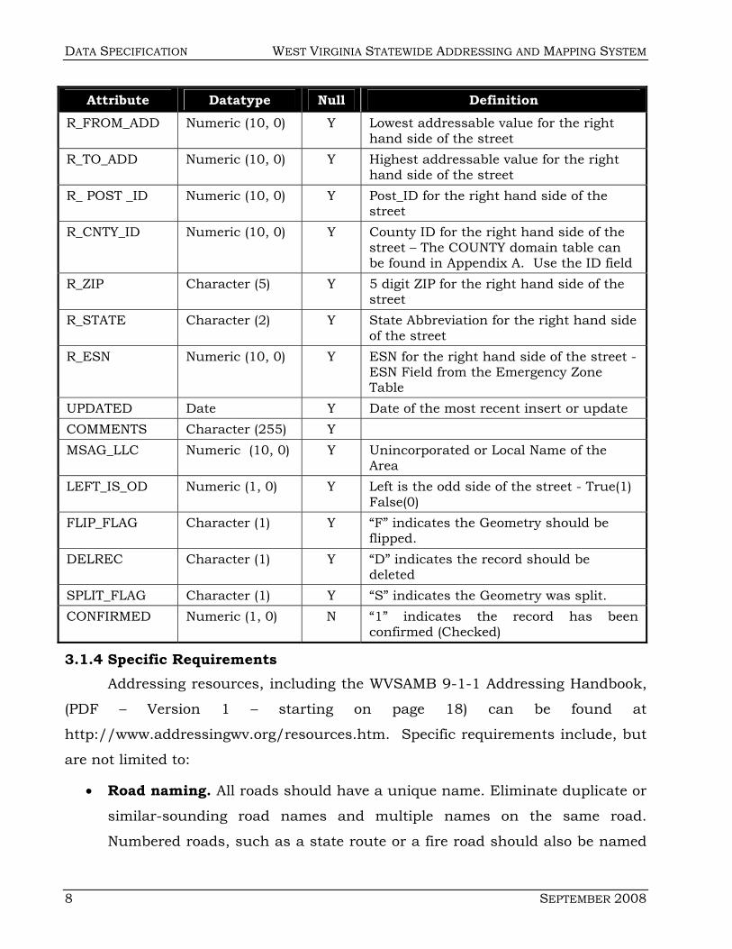
Attribute Datatype Null Definition R_FROM_ADD Numeric (10, 0) Y Lowest addressable value for the right
hand side of the street R_TO_ADD Numeric (10, 0) Y Highest addressable value for the right
hand side of the street R_ POST _ID Numeric (10, 0) Y Post_ID for the right hand side of the
street R_CNTY_ID Numeric (10, 0) Y County ID for the right hand side of the
street – The COUNTY domain table can be found in Appendix A. Use the ID field
R_ZIP Character (5) Y 5 digit ZIP for the right hand side of the street
R_STATE Character (2) Y State Abbreviation for the right hand side of the street
R_ESN Numeric (10, 0) Y ESN for the right hand side of the street - ESN Field from the Emergency Zone Table
UPDATED Date Y Date of the most recent insert or update COMMENTS Character (255) Y MSAG_LLC Numeric (10, 0) Y Unincorporated or Local Name of the
Area LEFT_IS_OD Numeric (1, 0) Y Left is the odd side of the street - True(1)
False(0) FLIP_FLAG Character (1) Y “F” indicates the Geometry should be
flipped. DELREC Character (1) Y “D” indicates the record should be
deleted SPLIT_FLAG Character (1) Y “S” indicates the Geometry was split. CONFIRMED Numeric (1, 0) N “1” indicates the record has been
confirmed (Checked)
3.1.4 Specific Requirements Addressing resources, including the WVSAMB 9-1-1 Addressing Handbook,
(PDF – Version 1 – starting on page 18) can be found at
http://www.addressingwv.org/resources.htm. Specific requirements include, but
are not limited to:
• Road naming. All roads should have a unique name. Eliminate duplicate or
similar-sounding road names and multiple names on the same road.
Numbered roads, such as a state route or a fire road should also be named
WEST VIRGINIA STATEWIDE ADDRESSING AND MAPPING SYSTEM DATA SPECIFICATION
SEPTEMBER 2008 9
to avoid using numbers in both the property address and the road name.
Please see the full list of road naming standards in Appendix C1 beginning
on page 60. For standard road name suffixes, please see Appendix C4 of the
Addressing Handbook (Version 1- pages 69 and 70).
• Beginning point. This designates the point, location, or direction from
which numbers begin to ascend on a road. Please see the options for
choosing a beginning point on Appendix C4 of the Addressing Handbook
(Version 1 - page 63). Whichever option is chosen should be consistently
applied throughout the county or community. Consider such factors as
existing numbering directions (if any), the numbering pattern on roads
shared with neighboring communities or counties, and the direction from
which emergency services respond.
• Odd and even sides. This determines which side of the road will be
assigned odd numbers and which will be assigned even numbers, as
numbers ascend from the beginning point. The 9-1-1 Addressing Standards
require that odd numbers should be assigned to structures on the left side
of the road and even numbers to those on the right, ascending from the
beginning point. If part of a county or community has been previously
numbered in the opposite fashion, however, then consider maintaining that
standard for consistency.
• Numbering interval. This is the standard interval in feet used to assign
consecutive property numbers along a road, regardless of whether or not a
structure is at every interval. The standard numbering interval in the 9-1-1
Addressing Standards is 10.56 feet, which provides 1000 numbers per mile
(500 odd numbers and 500 even numbers). For example, the address 2346
Oakwood Road is approximately 2.3 miles down the road on the right.
• Property numbering. These standards establish how numbers are assigned
for houses, apartments, businesses, circular streets, condominiums, cul-de-
sacs, corner lots, duplexes, mobile home parks, shopping malls, and other
special situations. Please see Appendix C4 of the Addressing Handbook
DATA SPECIFICATION WEST VIRGINIA STATEWIDE ADDRESSING AND MAPPING SYSTEM
10 SEPTEMBER 2008
(Version 1- page 63) for a comprehensive list of property numbering
standards and recommendations.
• Road signage. If a county chooses to erect its own road signs, it should, at a
minimum, follow existing standards set by the WV Division of Highways. Their
standards are incorporated into the West Virginia 9-1-1 Addressing Standards
found in Appendix C4 of the Addressing Handbook (Version 1- page 71).
• Please use a negative number as the STREET_ID as this will allow you to
have a unique Primary Key for new records and the loading program will
recognize the entry as an addition.
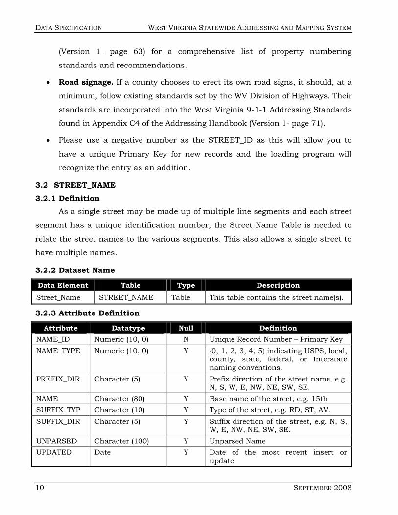
3.2 STREET_NAME 3.2.1 Definition
As a single street may be made up of multiple line segments and each street
segment has a unique identification number, the Street Name Table is needed to
relate the street names to the various segments. This also allows a single street to
have multiple names.
3.2.2 Dataset Name
Data Element Table Type Description Street_Name STREET_NAME Table This table contains the street name(s).
3.2.3 Attribute Definition
Attribute Datatype Null Definition NAME_ID Numeric (10, 0) N Unique Record Number – Primary Key NAME_TYPE Numeric (10, 0) Y {0, 1, 2, 3, 4, 5} indicating USPS, local,
county, state, federal, or Interstate naming conventions.
PREFIX_DIR Character (5) Y Prefix direction of the street name, e.g. N, S, W, E, NW, NE, SW, SE.
NAME Character (80) Y Base name of the street, e.g. 15th SUFFIX_TYP Character (10) Y Type of the street, e.g. RD, ST, AV. SUFFIX_DIR Character (5) Y Suffix direction of the street, e.g. N, S,
W, E, NW, NE, SW, SE. UNPARSED Character (100) Y Unparsed Name UPDATED Date Y Date of the most recent insert or
update

WEST VIRGINIA STATEWIDE ADDRESSING AND MAPPING SYSTEM DATA SPECIFICATION
SEPTEMBER 2008 11
3.2.4 Specific Requirements • Street_Names is a Domain Table for the Entire State. As such, the
names that are currently in the table cannot be changed. However,
new names can be added. Please use a negative number as the
NAME_ID as this will allow you to have a unique Primary Key for new
records and the loading program will recognize the entry as an
addition for the master list.
• When the dataset is uploaded, a validation will be run on the
STREET_NAME table. If a name is determined to be changed, the set
will be rejected and the submitter will be asked to correct the error.
3.3 STREET_NAME_JOIN 3.3.1 Definition
The Street Name and the Street Tables are joined via a Join table called
Street_Name_Join.
3.3.2 Dataset Name Data Element Table Type Description
Street_Name_Join STREET_NAME_JOIN Table This table joins the Street_Name and Street tables.
3.3.3 Attribute Definition
Attribute Datatype Null Definition NAME_ID Numeric (10, 0) N NAME_ID from the STREET_NAME table.
STREET_ID Numeric (10, 0) N STREET_ID from the STREET table.
HISTORIC Numeric (1, 0) Y Boolean value, if non-zero then the name
may be used for finding the street but
never labeling it.
SIDE Character (1) Y Side of the street the NAME_ID applies.
Example: L, R
NAME_ORDER Character (1) N {P, S} domain values which stand for
Primary and Secondary.
UPDATED Date Y Date of the most recent insert or update
DATA SPECIFICATION WEST VIRGINIA STATEWIDE ADDRESSING AND MAPPING SYSTEM
12 SEPTEMBER 2008
3.3.4 Specific Requirements None
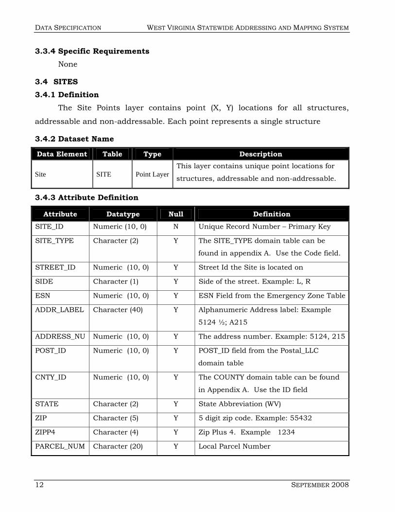
3.4 SITES 3.4.1 Definition
The Site Points layer contains point (X, Y) locations for all structures,
addressable and non-addressable. Each point represents a single structure
3.4.2 Dataset Name
Data Element Table Type Description
Site SITE Point Layer This layer contains unique point locations for
structures, addressable and non-addressable.
3.4.3 Attribute Definition
Attribute Datatype Null Definition SITE_ID Numeric (10, 0) N Unique Record Number – Primary Key
SITE_TYPE Character (2) Y The SITE_TYPE domain table can be
found in appendix A. Use the Code field.
STREET_ID Numeric (10, 0) Y Street Id the Site is located on
SIDE Character (1) Y Side of the street. Example: L, R
ESN Numeric (10, 0) Y ESN Field from the Emergency Zone Table
ADDR_LABEL Character (40) Y Alphanumeric Address label: Example
5124 ½; A215
ADDRESS_NU Numeric (10, 0) Y The address number. Example: 5124, 215
POST_ID Numeric (10, 0) Y POST_ID field from the Postal_LLC
domain table
CNTY_ID Numeric (10, 0) Y The COUNTY domain table can be found
in Appendix A. Use the ID field
STATE Character (2) Y State Abbreviation (WV)
ZIP Character (5) Y 5 digit zip code. Example: 55432
ZIPP4 Character (4) Y Zip Plus 4. Example 1234
PARCEL_NUM Character (20) Y Local Parcel Number
WEST VIRGINIA STATEWIDE ADDRESSING AND MAPPING SYSTEM DATA SPECIFICATION
SEPTEMBER 2008 13
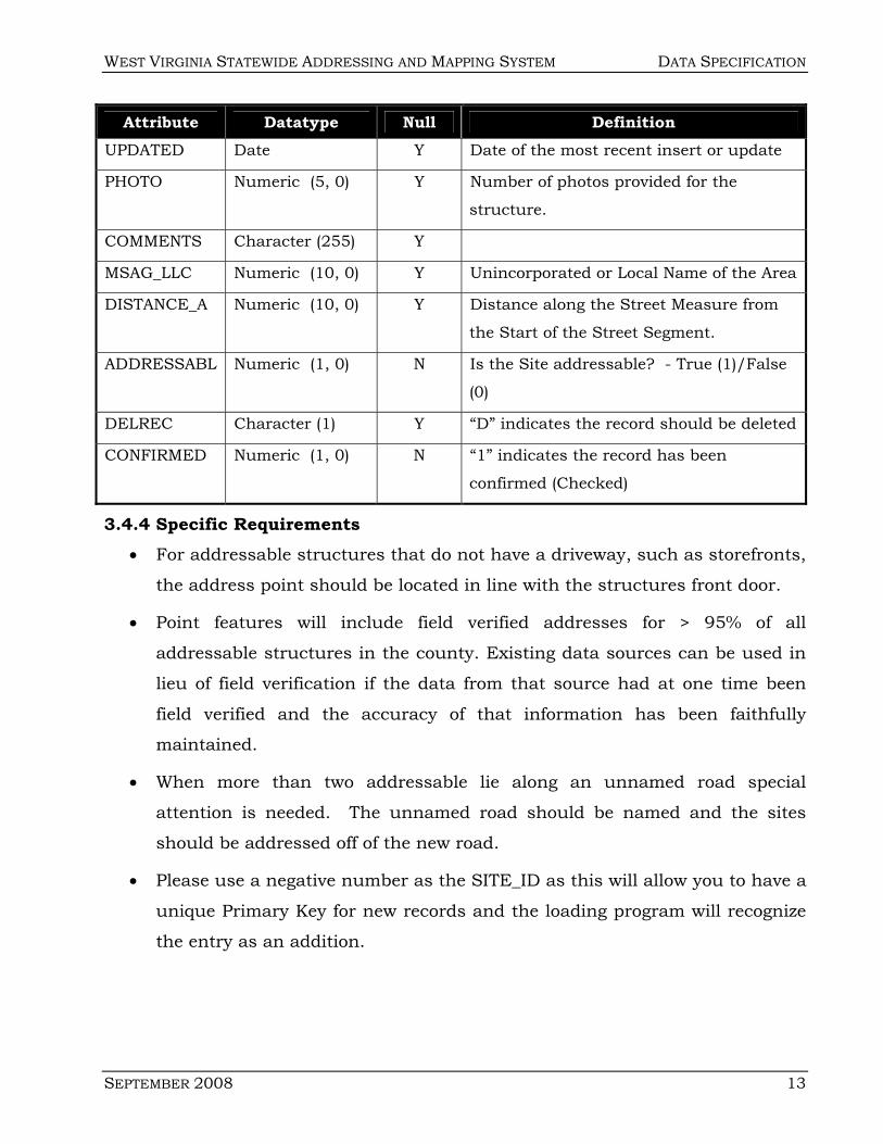
Attribute Datatype Null Definition UPDATED Date Y Date of the most recent insert or update
PHOTO Numeric (5, 0) Y Number of photos provided for the
structure.
COMMENTS Character (255) Y
MSAG_LLC Numeric (10, 0) Y Unincorporated or Local Name of the Area
DISTANCE_A Numeric (10, 0) Y Distance along the Street Measure from
the Start of the Street Segment.
ADDRESSABL Numeric (1, 0) N Is the Site addressable? - True (1)/False
(0)
DELREC Character (1) Y “D” indicates the record should be deleted
CONFIRMED Numeric (1, 0) N “1” indicates the record has been
confirmed (Checked)
3.4.4 Specific Requirements • For addressable structures that do not have a driveway, such as storefronts,
the address point should be located in line with the structures front door.
• Point features will include field verified addresses for > 95% of all
addressable structures in the county. Existing data sources can be used in
lieu of field verification if the data from that source had at one time been
field verified and the accuracy of that information has been faithfully
maintained.
• When more than two addressable lie along an unnamed road special
attention is needed. The unnamed road should be named and the sites
should be addressed off of the new road.
• Please use a negative number as the SITE_ID as this will allow you to have a
unique Primary Key for new records and the loading program will recognize
the entry as an addition.

DATA SPECIFICATION WEST VIRGINIA STATEWIDE ADDRESSING AND MAPPING SYSTEM
14 SEPTEMBER 2008
3.5 UNIT 3.5.1 Definition
The Units Table contains additional information about a structure. For a
single family home, this information is likely the same and will require a single
record. For Apartment buildings or leased space, there may be multiple records.
3.5.2 Dataset Name
Data Element Table Type Description Unit UNIT Table This table details a Site.
3.5.3 Attribute Definition
Attribute Datatype Null Definition UNIT_ID Numeric (10, 0) N Unique Record Number – Primary Key
SITE_ID Numeric (10, 0) Y Site the Unit is located at. The
SITE_ID is from the SITE Table.
UNIT_NUM Character (40) Y Unit number or name
COMMENTS Character (255) Y
LOC_INFO Character (255) Y Information to assist in locating the
unit
UPDATED Date Y Date of the most recent insert or
update
DELREC Character (1) Y “D” indicates the record should be
deleted
3.5.4 Specific Requirements • Please use a negative number as the UNIT_ID as this will allow you to
have a unique Primary Key for new records and the loading program
will recognize the entry as an addition None
3.6 OLD_ADDRESS 3.6.1 Definition
The OLD_ADDRESS table captures the previous or historic address for a
SITE and/or UNIT. This table is primarily used for readdressing purpose.

WEST VIRGINIA STATEWIDE ADDRESSING AND MAPPING SYSTEM DATA SPECIFICATION
SEPTEMBER 2008 15
3.6.2 Dataset Name
Data Element Table Type Description OLD_ADDRESS OLD_ADDRESS Table This table captures the old or historic
address. It is linked to both the Site table as well as the Unit Table
3.6.3 Attribute Definition
Attribute Datatype Null Definition OLDADD_ID Numeric (10, 0) N Unique Record Number – Primary
Key SITE_ID Numeric (10, 0) N Site the old address is associated.
The SITE_ID is from the SITE Table.
UNIT_ID Numeric (10, 0) Y Unit the old address may be associated. The UNIT_ID is from the UNIT Table.
RES_NAME Character (100) Y Resident of the Site at the time the old address was collected
BOX Character (20) Y The BOX number if used. Example: 5124, A215
PO_BOX Character (20) Y The PO BOX number if used. Example: 5124
NUM Character (20) Y The address number if any. Example: 105
STREET Character (50) Y Street or Route Information UNPARSEDAD Character (50) Y Unparsed old address – as
gathered from data source. CITY Character (25) Y City portion of the old address STATE Character (2) Y State Abbreviation (WV) ZIP Character (5) Y 5 digit zip code. Example: 55432 ZIPP4 Character (4) Y Zip Plus 4. Example 1234 SOURCE Character (1) Y The SOURCE domain table can
be found in Appendix A. Use the ID field
PHONE_NUM Numeric (10, 0) N 10-digit Phone Number
COMMENTS Character (255) Y UPDATED Date Y Date of the most recent insert or
update DELREC Character (1) Y “D” indicates the record should
be deleted
3.6.4 Specific Requirements • Please use a negative number as the OLDADD_ID as this will allow
you to have a unique Primary Key for new records and the loading
program will recognize the entry as an addition.
DATA SPECIFICATION WEST VIRGINIA STATEWIDE ADDRESSING AND MAPPING SYSTEM
16 SEPTEMBER 2008
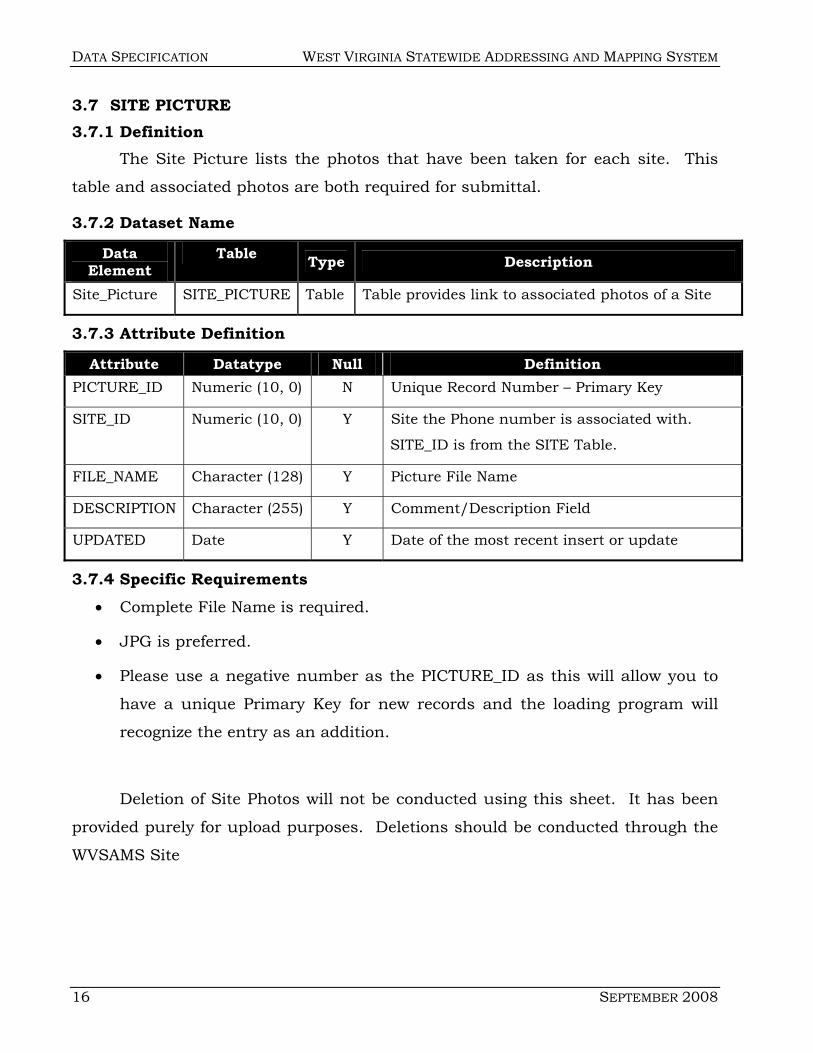
3.7 SITE PICTURE 3.7.1 Definition
The Site Picture lists the photos that have been taken for each site. This
table and associated photos are both required for submittal.
3.7.2 Dataset Name
Data Element
Table Type Description
Site_Picture SITE_PICTURE Table Table provides link to associated photos of a Site
3.7.3 Attribute Definition
Attribute Datatype Null Definition PICTURE_ID Numeric (10, 0) N Unique Record Number – Primary Key
SITE_ID Numeric (10, 0) Y Site the Phone number is associated with.
SITE_ID is from the SITE Table.
FILE_NAME Character (128) Y Picture File Name
DESCRIPTION Character (255) Y Comment/Description Field
UPDATED Date Y Date of the most recent insert or update
3.7.4 Specific Requirements • Complete File Name is required.
• JPG is preferred.
• Please use a negative number as the PICTURE_ID as this will allow you to
have a unique Primary Key for new records and the loading program will
recognize the entry as an addition.
Deletion of Site Photos will not be conducted using this sheet. It has been
provided purely for upload purposes. Deletions should be conducted through the
WVSAMS Site

WEST VIRGINIA STATEWIDE ADDRESSING AND MAPPING SYSTEM DATA SPECIFICATION
SEPTEMBER 2008 17
3.8 EMERGENCY ZONE 3.8.1 Definition
As the primary purpose of the readdressing is to support 9-1-1 operations,
Emergency Zone information has been incorporate into the model as a key
attribute. This information includes the appropriate contact information for the
relevant emergency responders.
3.8.2 Dataset Name
Data Element Table Type Description Emergency
Zone EMERGENCY_ZONE
Polygon
Layer
This table contains the Emergency
Zone Information.
3.8.3 Attribute Definition
Attribute Datatype Null Definition ESN Numeric (5, 0) Y Unique Record Number – Primary Key.
ESA_FIRE Numeric (10, 0) Y AGENCY_ID for Fire Dept Contact
ESA_LAW Numeric (10, 0) Y AGENCY_ID for Law Enforcement
ESA_EMS Numeric (10, 0) Y AGENCY_ID for EMS
ESA_PSAP Numeric (10, 0) Y AGENCY_ID for PSAP
UPDATED Date Y Date of the most recent insert or update
CNTY_ID Numeric (10, 0) Y The COUNTY domain table can be found
in Appendix A. Use the ID field
COMMENTS Character (255) Y
3.8.4 Specific Requirements • Due to the nature of the Emergency Zones, the Emergency Zone
shapefile will be imported in slightly different manner then the rest of
the shapefiles. If you wish to upload Emergency Zones, please notify
the current administrator of WVSAMS and indicate your request.
They will instruct you in what is necessary.

DATA SPECIFICATION WEST VIRGINIA STATEWIDE ADDRESSING AND MAPPING SYSTEM
18 SEPTEMBER 2008
3.9 AGENCY 3.9.1 Definition
Agency provides the list of Fire, Law Enforcement and Emergency
Responders for the state. This list is used in conjunction with the Emergency
Zones to define areas of coverage for call routing at the PSAP level.
3.9.2 Dataset Name
Data Element
Table Type Description
Agency AGENCY Table Listing of Fire, Law Enforcement, EMS and PSAPs
3.9.3 Attribute Definition
Attribute Datatype Null Definition AGENCY_ID Numeric (10, 0) N Unique Record Number – Primary Key.
AGENCY_NAM Character (100) Y Official Name for the Agency
AGENCY_TYP Numeric (1, 0) Y Type of Organization 1- Police; 2-Fire;
3-EMS
UPDATED Date Y Date of the most recent insert or
update
DELREC Character (1) Y “D” indicates the record should be
deleted
3.9.4 Specific Requirements • Please use a negative number as the AGENCY_ID as this will allow
you to have a unique Primary Key for new records and the loading
program will recognize the entry as an addition.
3.10 UNNAMED_ROAD 3.10.1 Definition
The Unnamed_Road Feature Class was created to accommodate the
miscellaneous trails, driveways, unnamed roads, paths, and other linear features
that may or may not be legitimate Streets. It is included for two purposes. First –
for completeness in case an unnamed road has been mislabeled or can be
identified as a legitimate street; Second – for navigational considerations.
WEST VIRGINIA STATEWIDE ADDRESSING AND MAPPING SYSTEM DATA SPECIFICATION
SEPTEMBER 2008 19
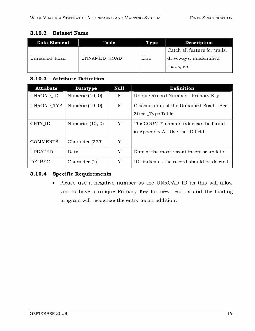
3.10.2 Dataset Name
Data Element Table Type Description
Unnamed_Road UNNAMED_ROAD Line
Catch all feature for trails,
driveways, unidentified
roads, etc.
3.10.3 Attribute Definition
Attribute Datatype Null Definition UNROAD_ID Numeric (10, 0) N Unique Record Number – Primary Key.
UNROAD_TYP Numeric (10, 0) N Classification of the Unnamed Road – See
Street_Type Table
CNTY_ID Numeric (10, 0) Y The COUNTY domain table can be found
in Appendix A. Use the ID field
COMMENTS Character (255) Y
UPDATED Date Y Date of the most recent insert or update
DELREC Character (1) Y “D” indicates the record should be deleted
3.10.4 Specific Requirements • Please use a negative number as the UNROAD_ID as this will allow
you to have a unique Primary Key for new records and the loading
program will recognize the entry as an addition.

DATA SPECIFICATION WEST VIRGINIA STATEWIDE ADDRESSING AND MAPPING SYSTEM
20 SEPTEMBER 2008
THIS PAGE INTENTIONALLY LEFT BLANK.
WEST VIRGINIA STATEWIDE ADDRESSING AND MAPPING SYSTEM DATA SPECIFICATION
SEPTEMBER 2008 21
APPENDIX A DOMAIN LISTS
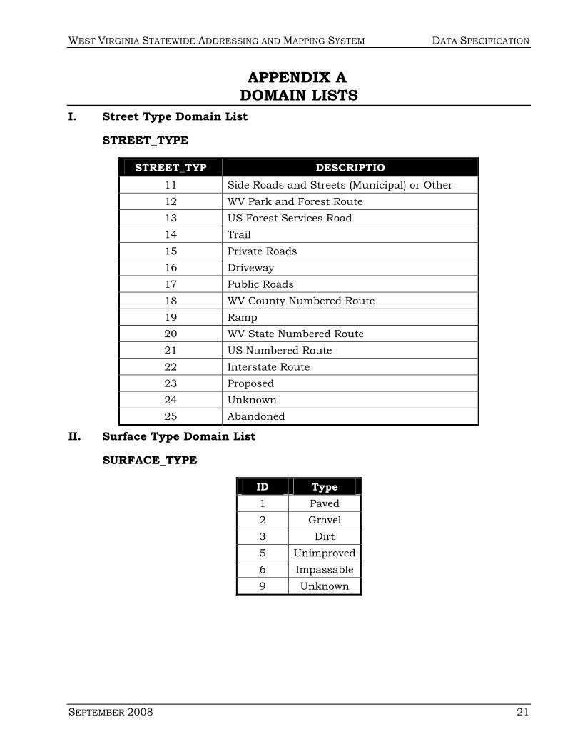
I. Street Type Domain List
STREET_TYPE
STREET_TYP DESCRIPTIO 11 Side Roads and Streets (Municipal) or Other 12 WV Park and Forest Route 13 US Forest Services Road 14 Trail 15 Private Roads 16 Driveway 17 Public Roads 18 WV County Numbered Route 19 Ramp 20 WV State Numbered Route 21 US Numbered Route 22 Interstate Route 23 Proposed 24 Unknown 25 Abandoned
II. Surface Type Domain List
SURFACE_TYPE
ID Type 1 Paved 2 Gravel 3 Dirt 5 Unimproved 6 Impassable 9 Unknown
DATA SPECIFICATION WEST VIRGINIA STATEWIDE ADDRESSING AND MAPPING SYSTEM
22 SEPTEMBER 2008
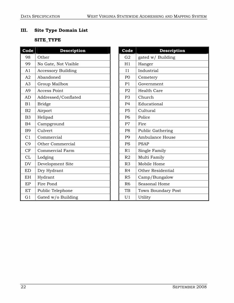
III. Site Type Domain List
SITE_TYPE
Code Description Code Description 98 Other G2 gated w/ Building 99 No Gate, Not Visible H1 Hanger A1 Accessory Building I1 Industrial A2 Abandoned P0 Cemetery A3 Group Mailbox P1 Government A9 Access Point P2 Health Care AD Addressed/Conflated P3 Church B1 Bridge P4 Educational B2 Airport P5 Cultural B3 Helipad P6 Police B4 Campground P7 Fire B9 Culvert P8 Public Gathering C1 Commercial P9 Ambulance House C9 Other Commercial PS PSAP CF Commercial Farm R1 Single Family CL Lodging R2 Multi Family DV Development Site R3 Mobile Home ED Dry Hydrant R4 Other Residential EH Hydrant R5 Camp/Bungalow EP Fire Pond R6 Seasonal Home ET Public Telephone TB Town Boundary Post G1 Gated w/o Building U1 Utility
WEST VIRGINIA STATEWIDE ADDRESSING AND MAPPING SYSTEM DATA SPECIFICATION
SEPTEMBER 2008 23
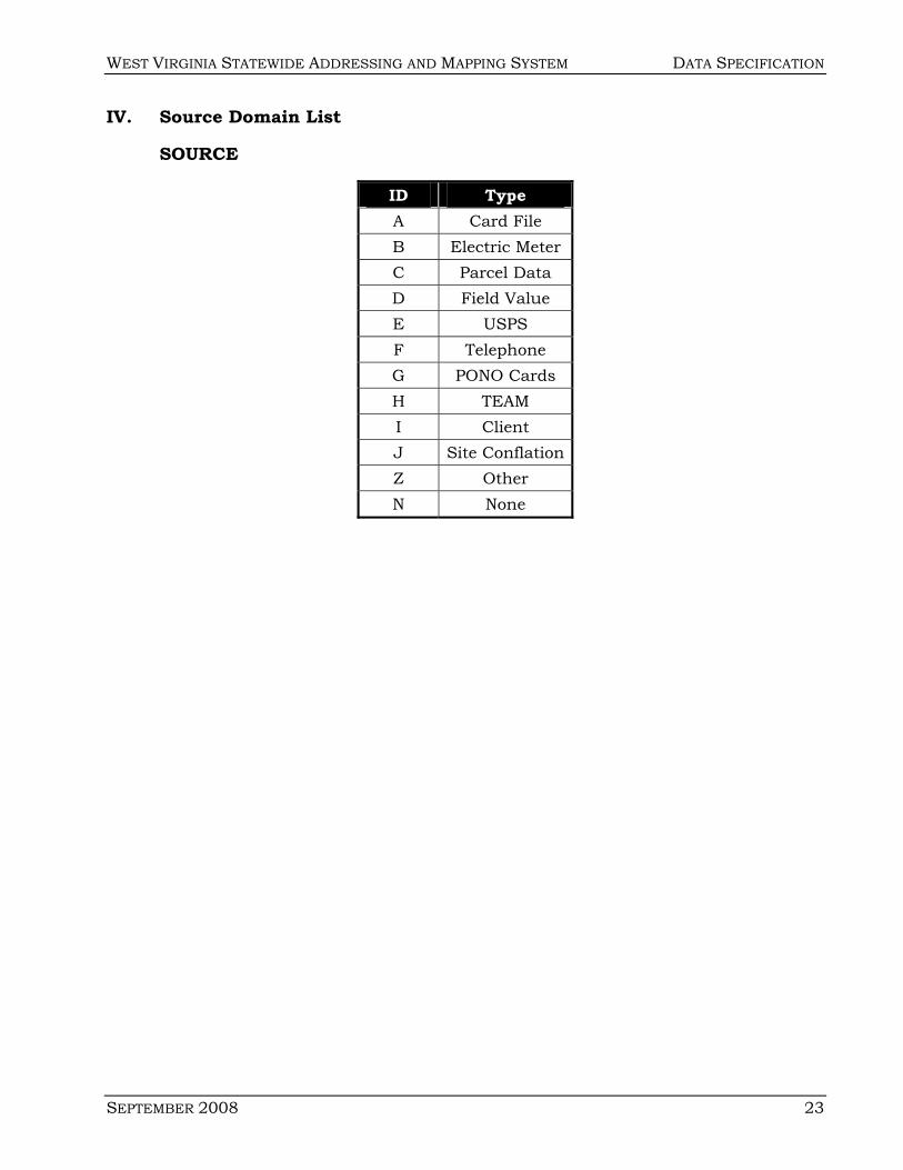
IV. Source Domain List
SOURCE
ID Type A Card File B Electric Meter C Parcel Data D Field Value E USPS F Telephone G PONO Cards H TEAM I Client J Site Conflation Z Other N None

DATA SPECIFICATION WEST VIRGINIA STATEWIDE ADDRESSING AND MAPPING SYSTEM
24 SEPTEMBER 2008
V. County Domain List
COUNTY
ID County Name ID County Name 54001 Barbour 54057 Mineral 54003 Berkeley 54059 Mingo 54005 Boone 54061 Monongalia 54007 Braxton 54063 Monroe 54009 Brooke 54065 Morgan 54011 Cabell 54067 Nicholas 54013 Calhoun 54069 Ohio 54015 Clay 54071 Pendleton 54017 Doddridge 54073 Pleasants 54019 Fayette 54075 Pocahontas 54021 Gilmer 54077 Preston 54023 Grant 54079 Putnam 54025 Greenbrier 54081 Raleigh 54027 Hampshire 54083 Randolph 54029 Hancock 54085 Ritchie 54031 Hardy 54087 Roane 54033 Harrison 54089 Summers 54035 Jackson 54091 Taylor 54037 Jefferson 54093 Tucker 54039 Kanawha 54095 Tyler 54041 Lewis 54097 Upshur 54043 Lincoln 54099 Wayne 54045 Logan 54101 Webster 54047 McDowell 54103 Wetzel 54049 Marion 54105 Wirt 54051 Marshall 54107 Wood 54053 Mason 54109 Wyoming 54055 Mercer 54999 Statewide
WEST VIRGINIA STATEWIDE ADDRESSING AND MAPPING SYSTEM DATA SPECIFICATION
SEPTEMBER 2008 25
APPENDIX B WEST VIRGINIA 9-1-1 ADDRESSING STANDARDS The West Virginia Statewide Addressing and Mapping Board was created by
the West Virginia Legislature in 2001 (Senate Bill 460, codified as W. Va. Code 24E-1-1 et seq.) to advance the infrastructure of West Virginia by overseeing two major tasks:
1) Providing new high quality digital mapping of the entire state;
2) Assigning a standard city-type address to every identifiable structure in the state.
To fulfill its mission, the West Virginia Statewide Addressing and Mapping Board has adopted the West Virginia 9-1-1 Addressing Standards to provide standards for counties and municipalities to use in establishing city-type addresses within their jurisdictions where no such addresses exist. In areas where city-type addresses do exist, these standards can be used to evaluate the quality and consistency of addresses and provide a basis for needed change. The standards cover the following issues:
• Road naming • Property numbering • Number posting • Road name suffixes • Road signage
The West Virginia 9-1-1 Addressing Standards are based on the following standards:
• Addressing Guidelines for The State of West Virginia (Adopted by the West Virginia Enhanced 9-1-1 Council and the US Postal Service District Office, Charleston, WV, July 1999.)
• National Emergency Number Association Addressing Systems (1995) • US Postal Service Postal Addressing Standards (Pub 28, November 2000) • US Postal Service Address Conventions (Filing Number DM-940-89-03,
July 1989) • West Virginia Division of Highways standards for road signing

DATA SPECIFICATION WEST VIRGINIA STATEWIDE ADDRESSING AND MAPPING SYSTEM
26 SEPTEMBER 2008
Questions regarding these standards can be directed to the West Virginia Statewide Addressing and Mapping Board at 304-558-4218.
Road Naming Standards
The following standards should be adhered to when naming or renaming
roads:
1. Each road should have one correct name for emergency services purposes
and postal delivery purposes.
2. Never assume a road does not have a name. Research should be conducted
to find whether a road has a name or not.
3. Any road with two or more residences should be named. Additionally, any
road or trail without structures that might need to be accessed by emergency
responders should be considered for naming to better locate it in an
emergency.
4. Avoid duplicate road names at a minimum in the same ZIP code, and
emergency service zone wherever practical. Optimally, avoid duplications in
the entire county.
5. Avoid duplicate road names with different suffixes, such as PINE RD and
PINE LN, especially when naming new roads or existing roads without names,
or renaming existing ones.
6. Avoid sound-alike names. For example: BEECH and BEACH, MAINE and
MAIN, GREY AND GRAY.
7. Avoid family names or individual’s names, especially living persons or
politicians.
8. Rename a road when one current name sounds too much like another road
name or if the road name is a duplicate. Once two or more roads have been
identified with similar sounding or duplicating names, rename the road or
roads that will impact the least number of residents and businesses.

WEST VIRGINIA STATEWIDE ADDRESSING AND MAPPING SYSTEM DATA SPECIFICATION
SEPTEMBER 2008 27
9. When renaming roads, involve the property and business owners affected.
Providing a choice of three to five options will usually eliminate most
controversy. In developing names, use historical considerations.
10. Never rename a road unless absolutely necessary.
11. If a road is continuous, try not to change the road name. If the name must
change, then do so at an intersection or prominent landmark, rather than at
a curve or some other arbitrary point.
12. Avoid road names longer than 22 characters (excluding pre- and post-
directional and suffix). Abbreviations of such names may produce
inadvertent duplicates.
13. Avoid special characters in street names. For example: hyphens,
apostrophes, periods, and ampersands (&).
14. Avoid assignment of a primary street name that is also used as a standard
suffix or directional. For example: NORTH AVE, COURT ST, SOUTHEAST
BLVD.
15. Avoid using numbers or numbered streets. For example: US HIGHWAY 290,
1ST ST, THIRD AVE.
16. All roads names should use a suffix. For a complete list of approved suffixes,
see the enclosed standards for new and existing road names.
17. If a directional (pre or post) is used in a road name, it should be abbreviated
to avoid potential confusion with the road name. Approved directional
abbreviations are: N, S, E, W, NE, NW, SE, and SW.
18. Avoid the use of pre- or post-directionals or suffixes to distinguish separate
non-continuous or continuous streets. For example: PALM CT, N PALM CT,
PALM ST, PALM AVE.
19. Avoid the use of non-standard street name suffixes in residential areas that
may be confused with commercial developments. For example: STONEWALL
PLZ, SMITH CTR.
DATA SPECIFICATION WEST VIRGINIA STATEWIDE ADDRESSING AND MAPPING SYSTEM
28 SEPTEMBER 2008
20. Avoid using double suffixes in new street names. For example: TWIN
BRANCH LN, CARVER RUN RD.
21. When naming new roads, consider using a consistent suffix for the type of
road, such as those suggested below:
Avenue = A thoroughfare running principally in a north-south direction (or
could be east-west depending on how “street” is defined).
Circle = Short road that returns to itself; circular or semi-circular roads.
Lane = Fire road or private road.
Loop = Short drive that begins and ends on the same road.
Road = Most common designation for a secondary thoroughfare; generally
indicates a heavily traveled route.
Street = Usually found in downtown or more congested areas; run principally
in an east-west direction (or could be north-south depending on how “avenue”
is defined).
22. Use the following format for road or street names: Pre-Directional – 2
characters (max.), Road Name – 22 characters (max.), Road Suffix – 4
characters (max.), and Post-Directional – 2 characters (max.).
Note: Instances may arise that do not conform to the guidelines set forth in this
document. When such situations occur, the county’s 9-1-1 center, the US Postal
Service District Address Management Systems Office, and the West Virginia
Division of Highways should be consulted to reach a joint decision.
Property Numbering Standards
The following standards should be adhered to when assigning property numbers:
1. Frontage interval. Numbers should be assigned every 10.56 feet or each
1/500 mile on each side of a road. This will yield 1000 numbers per mile,
500 odd on one side and 500 even on the other. The interval chosen gives
meaning to an address. For example, 3746 Mountain Road is located
approximately 3.7 miles from the beginning of Mountain Road.
WEST VIRGINIA STATEWIDE ADDRESSING AND MAPPING SYSTEM DATA SPECIFICATION
SEPTEMBER 2008 29
2. Odd/Even number location. Even numbers should be assigned the right
side of a road, from the point of its beginning. Assign odd numbers on the
left side of a road, from the point of its beginning.
3. Beginning point. Numbering should begin in a consistent manner on each
road throughout a county or municipality. Use one of the following options
for establishing the beginning point for numbering roads.
Option One: Numbers should ascend as emergency responders enter a
majority of roads. For example, if emergency responders were based at the
center of the county, then this would establish the beginning point for road
numbering. All roads whose ends are closest to this origination point would
have their numbers begin from that end.
Option Two: Numbers should normally begin when a road proceeds away
from the road that is deemed of higher importance. The defined road
hierarchy for the determination of road directions will be arterial, collector,
local, unpaved, seasonal and non-essential. In the event that the roads are at
the same hierarchy and importance level, road direction should be based on
Option One above.
Option Three: Consider a numbering origin at a West beginning point and
proceed eastward, or begin at a South beginning point and proceed
northward.
Regardless of the option chosen, the following considerations should apply.
1) If numbers ascend on a road that cross jurisdictional boundaries, care
should be taken to insure that the numbers at the border are not in close
proximity to those numbers near the border in the adjacent jurisdiction. If
so, then discussions with that jurisdiction should insure that numbering
continues in one direction or another. 2) The beginning point for all dead-end
roads should be at the place of departure from the main road. 3) The above
guidelines will apply unless continuing a city numbering scheme, as in
leaving a city where other numbers are being used. The system in place will
then dictate the beginning number.
DATA SPECIFICATION WEST VIRGINIA STATEWIDE ADDRESSING AND MAPPING SYSTEM
30 SEPTEMBER 2008
4. Intersections. Both 4-way and “T” type intersections should be numbered,
just as houses. These addresses will be useful as references.
5. Bridges. Bridges longer than 50 (fifty) feet should be numbered just as
houses. In most cases measure the middle of the bridge and post the
numbers at the ends of the bridge in both directions. You may prefer to use
an odd and even number to post the bridge address, odd on the odd
numbered side facing traffic and even on the even numbered side facing
traffic. On bridges longer than ½ mile, number the ends of the bridge and
post accordingly.
6. Circular streets. Circular streets and roads begin where they meet the
lowest numbered intersecting road. The outside of the circle is numbered
first according to the frontage interval. The inside is then numbered to match
and mix with the outside. This will result, in some cases, with fewer numbers
on the inside of the circle, a smaller frontage interval, and spaces between
numbers.
7. Cul-de-sacs. Cul-de-sacs often require applying the rules for both dead-end
and circular streets. The numbering begins from the intersection toward the
cul-de-sac. Once in the cul-de-sac, the numbers proceed following the
odd/even rules to the center point of the cul-de-sac (i.e. odd numbers proceed
around one side of the circle and even around the other side). On rare
occasions there may be structures inside the cul-de-sac. When this occurs,
name the circular section of the cul-de-sac a separate road name from the
access road. Number this street counter-clockwise according to the circular
street numbering rule.
8. “T” roads. Roads with no outlet at both ends and that are intersected by an
entering road should be named and numbered as a separate road or roads. If
using the same name, then numbering should begin at the left end of the
road and run the length of the road, unless that end may be extended in the
foreseeable future. If two names are used, then numbering should begin for
each road where it leaves the intersecting road. In the case where the
WEST VIRGINIA STATEWIDE ADDRESSING AND MAPPING SYSTEM DATA SPECIFICATION
SEPTEMBER 2008 31
intersecting road logically continues to the end of one of the road segments,
then continue the name and numbering of the intersecting road to that end
and separately name and number the spur road from where it departs the
intersecting road.
9. Crossing county lines. When crossing county lines, consideration should be
given to an existing numbering system in that county. If no system exists, the
numbering should stop at the county line. If a system does exist in that county,
those numbers may continue, following the standards for distance and
direction. Since many emergency-response zones cross county lines, try not to
rename roads at the county line, unless there is a permanent landmark such as
a river, in order to avoid confusion to responders. Instead, bring the road to a
logical point, such as an intersection, before changing the road name.
10. Stacked addresses. Houses or trailers behind other trailers facing the road
sharing a common driveway should be numbered with consecutive odd or even
numbers. If more than two structures share a driveway, consider naming the
driveway as a separate road and number the structures accordingly.
11. Apartment and duplexes. Apartments with individual outside entrances
(such as duplexes or townhouses) should be assigned separate street
addresses. Apartments and multi-tenant structures with one main entrance
should be assigned one primary number with a secondary address as the
assigned apartment number (ex. 123 MAIN ST APT 101). Apartment numbers
should only be numeric. Do not use 0 for an apartment number.
Apartments should be numbered consecutively with odd apartment numbers
on the left and even on the right (from the point of access).
In multi-level apartment houses or complexes, if more than four apartments
are on a floor, a three-digit apartment number should be used. The first digit
of the apartment number represents the floor number. For example,
apartment 304 represents the second apartment on the right on the third floor.
If there are more than nine floors, the apartment numbers should follow the
same rules, but for floors 10 and higher the apartment number will be four

DATA SPECIFICATION WEST VIRGINIA STATEWIDE ADDRESSING AND MAPPING SYSTEM
32 SEPTEMBER 2008
digits. For example, apartment 1216 would be located on the 12th floor.
Basement apartments should be numbered beginning with the number 1.
Offices in multi-unit buildings should be assigned a number following the
same guidelines, but will be referred to as a suite (STE) instead of an
apartment (APT). In a multiple building apartment complex, each building
should be assigned its own street address and follow consistent apartment
numbering from building to building.
12. Businesses. Office buildings and business districts should be numbered
following the apartment numbering rules. The secondary address will be
referred to as suites instead of apartments. Strip malls and office parks,
where each business has its own entrance, should be assigned separate
street addresses for each business.
13. Trailer parks. If possible, name roads accessing trailer parks and number pads
or lots using the frontage system. An alternative is to number the trailers just
like apartments. Assign one primary address to the park and then assign
secondary addresses to the trailers using Lot # instead of Apt #. If it is not
conducive to address in either manner, a joint decision on numbering should be
made between the county’s 9-1-1 center, the US Postal Service District Address
Management Systems Office, and the West Virginia Division of Highways.
14. Highways. Highways with no city numbering systems in place or where the
city system is to be changed should be numbered from county line to county
line following the number origination guidelines set by the county.
15. Number assignment location for structures. When assigning numbers, the
middle of a structure should determine the number. Structures should
always be numbered according to the road they face, not where the driveway
enters the road or where the mailbox is. An exception to this is when the
house can be seen but not approached directly from the road. In this case,
the driveway should be numbered on the road from which it departs.
WEST VIRGINIA STATEWIDE ADDRESSING AND MAPPING SYSTEM DATA SPECIFICATION
SEPTEMBER 2008 33
16. Preplanning subdivisions. Use maps provided by the developer to assign
numbering to new subdivisions. Ensure either footage is marked on the
maps or the map is drawn using an engineering scale. In addition, corner
lots should be numbered in both directions so as to accommodate a house
built facing either street.
17. Interfacing with existing systems. When interfacing with an existing
numbering system, care should be taken in locating the last assigned number
of the existing system. All possible sources should be checked to determine
the last number. Once the last number is determined, start the new
numbering from the next available hundred block. For example, if the last
number is 3846, begin numbering from 3900. Some roads leaving a city limit
may not have any numbers within the city. These may be numbered from the
in-city beginning point.
18. General numbering guidelines. Primary numbers assigned to structures
should be whole numbers. Use of the following types of numbers is not
acceptable:
• Alphanumeric numbers, ex. 235A.
• Numbers with hyphens or special characters, ex. 45-46 or 78/1.
• Numbers with fractions, ex. 28 ½.
• Numbers with more than six digits.
Number Posting Standards
To insure that numbers will be visible, they should be posted as follows:
1. Number on the Structure. Where the structure is within 50 (fifty) feet of the
edge of the road right-of-way and can be clearly seen from the road, the
assigned number should be displayed on the front of the structure in the
vicinity of the front door or entry.
2. Number at the Road Line. Where the structure is over 50 (fifty) feet from the
edge of the road right-of-way, the assigned number should be displayed on

DATA SPECIFICATION WEST VIRGINIA STATEWIDE ADDRESSING AND MAPPING SYSTEM
34 SEPTEMBER 2008
the structure as above and be displayed on a post, fence, wall, mailbox, or on
some structure at the property line adjacent to the walk or access drive to the
numbered structure. Any posted number at the road should be placed high
enough to not be obscured by snow during an average winter.
3. Size and Color of Number. Numbers should be a minimum of four (4)
inches high and be of a contrasting color to their background. Numbers
made from block letters and reflective materials are recommended.
4. Property owner responsibility. Every person whose duty is to display the
assigned number should remove any different number that might be
mistaken for, or confused with, the number assigned to the property.
5. Interior location. All residents and other occupants should post their
assigned number and road name adjacent to their telephone for emergency
reference.
Road Name Suffixes for New Roads
ALLEY ALY AVENUE AVE BOULEVARD BLVD BYPASS BYP CIRCLE CIR DRIVE DR EXPRESSWAY EXPY EXTENSION EXT FREEWAY FWY HIGHWAY HWY LANE LN LOOP LOOP PARKWAY PKWY ROAD RD SPUR SPUR STREET ST TERRACE TER TURNPIKE TPKE WAY WAY
WEST VIRGINIA STATEWIDE ADDRESSING AND MAPPING SYSTEM DATA SPECIFICATION
SEPTEMBER 2008 35
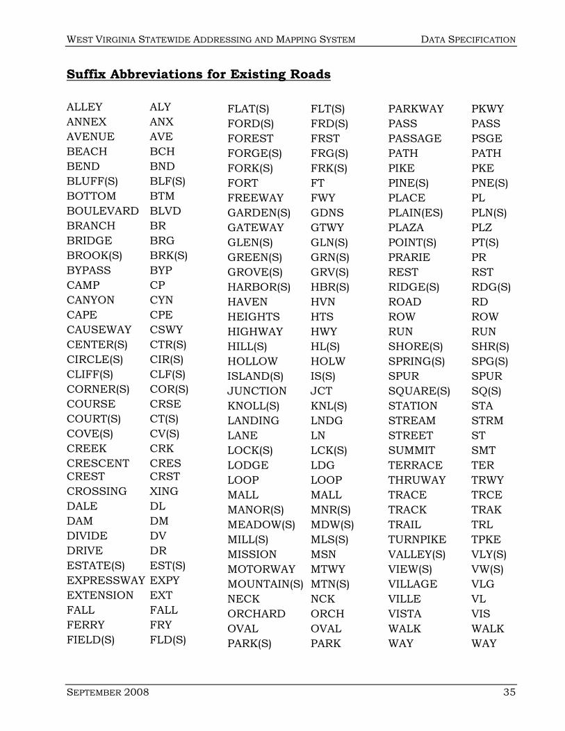
Suffix Abbreviations for Existing Roads
ALLEY ALY ANNEX ANX AVENUE AVE BEACH BCH BEND BND BLUFF(S) BLF(S) BOTTOM BTM BOULEVARD BLVD BRANCH BR BRIDGE BRG BROOK(S) BRK(S) BYPASS BYP CAMP CP CANYON CYN CAPE CPE CAUSEWAY CSWY CENTER(S) CTR(S) CIRCLE(S) CIR(S) CLIFF(S) CLF(S) CORNER(S) COR(S) COURSE CRSE COURT(S) CT(S) COVE(S) CV(S) CREEK CRK CRESCENT CRES CREST CRST CROSSING XING DALE DL DAM DM DIVIDE DV DRIVE DR ESTATE(S) EST(S) EXPRESSWAY EXPY EXTENSION EXT FALL FALL FERRY FRY FIELD(S) FLD(S)
FLAT(S) FLT(S) FORD(S) FRD(S) FOREST FRST FORGE(S) FRG(S) FORK(S) FRK(S) FORT FT FREEWAY FWY GARDEN(S) GDNS GATEWAY GTWY GLEN(S) GLN(S) GREEN(S) GRN(S) GROVE(S) GRV(S) HARBOR(S) HBR(S) HAVEN HVN HEIGHTS HTS HIGHWAY HWY HILL(S) HL(S) HOLLOW HOLW ISLAND(S) IS(S) JUNCTION JCT KNOLL(S) KNL(S) LANDING LNDG LANE LN LOCK(S) LCK(S) LODGE LDG LOOP LOOP MALL MALL MANOR(S) MNR(S) MEADOW(S) MDW(S) MILL(S) MLS(S) MISSION MSN MOTORWAY MTWY MOUNTAIN(S) MTN(S) NECK NCK ORCHARD ORCH OVAL OVAL PARK(S) PARK
PARKWAY PKWY PASS PASS PASSAGE PSGE PATH PATH PIKE PKE PINE(S) PNE(S) PLACE PL PLAIN(ES) PLN(S) PLAZA PLZ POINT(S) PT(S) PRARIE PR REST RST RIDGE(S) RDG(S) ROAD RD ROW ROW RUN RUN SHORE(S) SHR(S) SPRING(S) SPG(S) SPUR SPUR SQUARE(S) SQ(S) STATION STA STREAM STRM STREET ST SUMMIT SMT TERRACE TER THRUWAY TRWY TRACE TRCE TRACK TRAK TRAIL TRL TURNPIKE TPKE VALLEY(S) VLY(S) VIEW(S) VW(S) VILLAGE VLG VILLE VL VISTA VIS WALK WALK WAY WAY
DATA SPECIFICATION WEST VIRGINIA STATEWIDE ADDRESSING AND MAPPING SYSTEM
36 SEPTEMBER 2008
Road Signage
Installing road signs is one of the final, and more important tasks in
addressing. To assist both emergency service personnel and the general public,
signs must be visible and maintained. A frequent complaint about road signs is
that snow banks or vegetation often hide them. Annual trimming or minor
maintenance can eliminate this problem.
1. Color. Signs should be reflectorized. The letters and background should be of
contrasting colors and should have white letters and border on a green
background. Letters should be at least 3” upper case. It is important to
insure that letters are tall enough and thick enough to be easily seen day or night.
2. Grade. High Intensity Reflective Sheeting (250 candle power silver high
intensity) is recommended when nighttime high visibility is necessary from
long distances or at high accident intersections where quick identification of
markings is important. High intensity sheeting is available in packaged
letters or can be cut on a machine as with the engineer grade sheeting. High
intensity sheeting meets the Federal Manual of Uniform Traffic Control
Devices (MUTCD) specifications and carries a ten-year warranty.
3. Lettering. Letters should conform to the standard alphabets for highway
signs printed by the Federal Highway Administration. Suffix abbreviation
should follow those listed in these standards, such as ALY, RD, LN, CIR, AVE,
etc. Road names should not be abbreviated.
4. Materials. The most commonly used material for blades is either extruded
aluminum with a 0.25" inch flange thickness and a 0.090" inch web (min.) or
flat sheet aluminum with a minimum thickness of 0.08 inches. 6061T6
aluminum alloy is a hard, strong alloy manufactured from flat sheet. This has
been replaced, to some extent, by 5052H38 series alloy, which is softer and
comes in a roll. 5052H38 is flattened on a press, but retains a memory and may
warp slightly over time. Both alloys must be alodined or anodined or the
sheeting may delaminate to the surface of the blank over a period of time.
Thickness can range from .080" to 0.125", but 0.080" are recommended.

WEST VIRGINIA STATEWIDE ADDRESSING AND MAPPING SYSTEM DATA SPECIFICATION
SEPTEMBER 2008 37
5. Posts. Posts for elevated signs vary from round to "U" channel. Both types of
post are made of aluminum or galvanized steel. The type of post chosen may
depend on the environment, soil type, cost, or preference of the installing and
maintaining agency. Sign mounting hardware is available for both types of
post. When installing posts, it is recommended to install anchor posts, such
as "Lok-Set" post anchors. These anchors will help keep the sign from
leaning and will also keep vandals from twisting the sign around, a very
popular pastime among juveniles. Any new obstacles have to be a break
away device approved by the Federal Highway Administration.
6. Heights. The height of the sign is very important. Posts come in lengths of 8
feet to 14 feet. In most cases, the taller the better. As a general rule, signs
should be 7 feet or more off the ground when mounted on the post. This
keeps the signs visible and can reduce some types of vandalism.
7. Placement. Sign placement is generally prescribed by state and federal
rules. As a general guide, signs are placed on two sides of each four-way
intersection and on the right hand side of a "T" intersection. It is generally
recommended that a four-way sign be used, one that displays the name of
both roads using a sign-to-sign bracket. If not economically possible to place
the four-way sign at every intersection, an attempt should be made to place
one at every other intersection.
8. Installation. Before installing any road signs, a municipality or county must
call Miss Utility of West Virginia, Inc. at least 48 hours before digging. Miss
Utility can be contacted 24 hours a day, seven days a week by calling toll-free
1-800-245-4848. Routine 48-hour notifications can be made via fax or e-
mail. Notification must not be made more than 10 business working days in
advance of the beginning of any such work due to the possible deterioration
of the locate markings. The time requirements are exclusive of Saturdays,
Sundays, and legal holidays.
For additional information on the design and installation of road name signing, please refer to the following standards of the West Virginia Division of Highways.

Standards for the Design and Installation of Road Name Signing
Proposed Location of Sign at Jct. Of: And:
Posted Speed
Letter Height Border Arrow County
Route No. Bkgd. Color
LegendColor
US or WV Rte. Local Serv. Rte. All 3" Yes Yes Yes Green White
US or WV Rte. Private Drive All 3" Yes Yes No Green White
Local Serv. Rte. Local Serv. Rte.
35 and Above 3" Yes Yes Yes Green White
Local Serv. Rte. Local Serv. Rte.
Less than 35 2" or 3" Yes Yes 2" No -
3" Yes Green White
Local Serv. Rte. Private Drive 35 and Above 3" Yes Yes No Green White
Local Serv. Rte. Private Drive Less Than 35 2" Yes No No Green White
In addition to the above noted design criteria, the following installation procedures should also be followed:
1) WV DOH approved supports to be used.
2) Supports to be standard depth in ground (normally 3').
3) Lateral clearance of 6' - 12' from edge of pavement should be strived for.
4) Vertical clearance of 7' from edge of pavement to bottom of sign should be maintained.
5) Existing supports for existing signs should not be used to mount road name signing except on stop and yield
signs, with the positioning of these signs not affecting the purpose of the signs.
DA
TA S
PEC
IFICA
TION
W
ES
T VIR
GIN
IA S
TATE
WID
E A
DD
RE
SS
ING
AN
D M
APPIN
G S
YSTE
M
38 F
EB
RU
AR
Y 2007
