west virginia flood hazard determination tool update · west virginia flood hazard determination...
TRANSCRIPT

West Virginia Flood Hazard Determination Tool Update
Tucker Clevenger, PE, CFM AMEC Environment and Infrastructure
Eric Hopkins West Virginia University
June 4, 2012

AFH Overview
WV AFH Partnership AMEC – Floodplain Modeling and Data Development WVGISTC – Tool Development and Data Hosting WVDHSEM – Overall vision, outreach, and prioritization FEMA Region III – funding and FEMA program support

AFH Overview
WV AFH Partnership AMEC – Floodplain Modeling and Data Development WVGISTC – Tool Development and Data Hosting WVDHSEM – Overall vision, outreach, and prioritization FEMA Region III – funding and FEMA program support
Alignment with FEMA Risk MAP Program West Virginia executing Risk MAP Program ahead of FEMA rollout Better Communicate Flood Risk Promote sound Floodplain Management All Approximate Floodplains now model backed
Now accepted by FEMA for LOMA Determinations/Elevation Certificates

AFH Overview
WV AFH Partnership AMEC – Floodplain Modeling and Data Development WVGISTC – Tool Development and Data Hosting WVDHSEM – Overall vision, outreach, and prioritization FEMA Region III – funding and FEMA program support
Alignment with FEMA Risk MAP Program West Virginia executing Risk MAP Program ahead of FEMA rollout Better Communicate Flood Risk Promote sound Floodplain Management All Approximate Floodplains now model backed
Now accepted by FEMA for LOMA Determinations/Elevation Certificates Growing importance with changing regulations/Biggert-Waters

WV Flood Hazard Development Goals
► Improve upon effective approximate floodplains § Provide more accurate approximate floodplain boundaries § Resolve legacy “DFIRM Conversion” issues

WSEL=1170ft WSEL=1145ft WSEL=1170ft WSEL=1145ft
AFH=1143ft

WV Flood Hazard Development Goals
► Improve upon effective approximate floodplains § Provide more accurate approximate floodplain boundaries § Resolve legacy “DFIRM Conversion” issues
► Expand coverage of approximate floodplain boundaries § All streams down to 2 Square Miles § 4600 miles of approximate floodplains

WV Flood Hazard Development Goals

WV Flood Hazard Development Goals
► Improve upon effective approximate floodplains § Provide more accurate approximate floodplain boundaries § Resolve legacy “DFIRM Conversion” issues
► Expand coverage of approximate floodplain boundaries § All streams down to 2 Square Miles § 4600 miles of approximate floodplains
► Provide enhanced data utility -> leverage technology § Model backed floodplains with AFH elevations § Accessible via the WV Flood Determination Tool Website § Improve floodplain management and permitting decisions § Support LOMA determinations

WV Flood Hazard Refinement Goals

Statewide Status Update

AFH Floodplain Modeling
► 2003 WV SAMB 3M DEM topographic data
► USGS Regression Equation Hydrology
► HEC-RAS Hydraulic Modeling ► No hydraulic structures
included ► No channel survey ► Depth and water-surface
elevation grids developed ► No BFEs on the FIRM

Limitations of Enhanced Approximate Studies
► Not accurate immediately upstream of hydraulic structures (bridges/culverts)
► No channel survey data included in HEC-RAS models ► Cannot support BFE inclusion on FIRMs ► Terrain Data § Predominantly based on SAMB 3M DEMs § LiDAR/Aerial topo only selectively available
► Field survey data is always paramount
Value of Enhanced Approximate Studies
► Replace outdated effective Zone A boundaries

Value of Enhanced Approximate Studies
► Replace outdated effective Zone A boundaries ► Used as best available data for floodplain management and
permitting

Value of Enhanced Approximate Studies
► Replace outdated effective Zone A boundaries ► Used as best available data for floodplain management and
permitting ► AFHs can support LOMA determinations § BFEs are higher level of quality than FEMA LOMA WSEL
determination approaches

Value of Enhanced Approximate Studies
► Replace outdated effective Zone A boundaries ► Used as best available data for floodplain management and
permitting ► AFHs can support LOMA determinations § BFEs are higher level of quality than FEMA LOMA WSEL
determination approaches ► Cost effective technology to develop high volume of
improved floodplains

Value of Enhanced Approximate Studies
► Replace outdated effective Zone A boundaries ► Used as best available data for floodplain management and
permitting ► AFHs can support LOMA determinations § BFEs are higher level of quality than FEMA LOMA WSEL
determination approaches ► Cost effective technology to develop high volume of
improved floodplains ► Can be updated/enhanced to limited detailed or detailed
studies

Value of Enhanced Approximate Studies
► Replace outdated effective Zone A boundaries ► Used as best available data for floodplain management and
permitting ► AFHs can support LOMA determinations § BFEs are higher level of quality than FEMA LOMA WSEL
determination approaches ► Cost effective technology to develop high volume of
improved floodplains ► Can be updated/enhanced to limited detailed or detailed
studies ► Accessible via the WV Flood Determination Tool – unique
to West Virginia
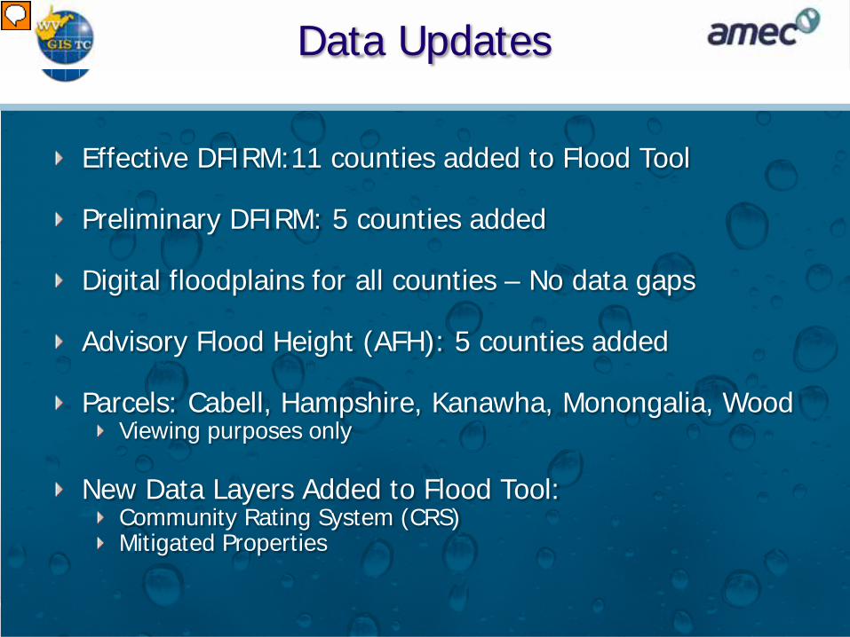
Data Updates
Effective DFIRM:11 counties added to Flood Tool Preliminary DFIRM: 5 counties added Digital floodplains for all counties – No data gaps Advisory Flood Height (AFH): 5 counties added Parcels: Cabell, Hampshire, Kanawha, Monongalia, Wood
Viewing purposes only New Data Layers Added to Flood Tool:
Community Rating System (CRS) Mitigated Properties


Future Development
Mobile App: Proof Of Concept Spring 2013 Agreement pending
Migration to Javascript from Flex API Mitigated Property / Parcel Correlation

Data Sharing Request
High Resolution Orthoimagery Elevation:
Lidar 2-foot contours
Digital Parcels

GIS Training
► Scheduled Training Courses (WVGISTC) § Foundational Training
► ArcGIS I & II (June 10-14)
§ Specialized Training ► ArcGIS Advanced Editing (June 19) ► ArcGIS Python (July 16-18)
► Training Resources § WV Association of Geospatial Professionals (www.wvagp.org)
► Mapper ListServe - [email protected]
§ WV Property Tax Division § WV Office of GIS Coordination § Academic & Research Institutions § Software companies § Other assessor offices
