west of devers upgrade project environmental impact … court, trails/open space within 1/4 mile of...
TRANSCRIPT

SCE West of Devers Upgrade Project D.15 RECREATION
December 2015 D.15-1 Final EIR
D.15 Recreation This section describes the affected environment for Recreation in Section D.15.1 and presents the rele-vant regulations and standards in Section D.15.2. Sections D.15.3 through D.15.5 describe the impacts of the Proposed Project and the alternatives. Section D.15.6 presents the mitigation measures and mitiga-tion monitoring requirements, and Section D.15.7 lists references cited.
A recreation area is any site or facility that is used by the public for recreational activities. Recreation areas may include: national, State, county, or city parks; refuges or preserves; open space; cultural centers or museums; campgrounds; significant ecological areas; special recreation management areas, areas of critical environmental concern (ACEC);1 or private recreational sites such as golf courses.
D.15.1 Environmental Setting / Affected Environment
D.15.1.1 Regional Setting and Approach to Data Collection
The Proposed Project and alternatives are located within or pass adjacent to recreation areas under the jurisdiction of the Bureau of Land Management (BLM), USDA Forest Service (USFS), California Department of Parks and Recreation, Caltrans, San Bernardino and Riverside Counties, and several cities. Field data were collected to identify recreation along the Proposed Project and alternatives. The locations of these recreation areas are shown in Figures D.15-1a through D.15-1k. These provide the locations of rec-reation by Segment on a larger scale. The following discussion describes the identified recreation facili-ties within 0.25 miles of the Proposed Project route. Recreation areas located outside of this 0.5 miles wide corridor are identified for orientation purposes in the environmental setting sections, but are not considered in the impact assessment.
D.15.1.2 Environmental Setting by Segment
The project study area includes the cities of Banning, Beaumont, Calimesa, Colton, Grand Terrace, Loma Linda, Palm Springs, Rancho Cucamonga, Redlands, San Bernardino, and Yucaipa, and unincorporated areas of Riverside and San Bernardino Counties. The Proposed Project component in the City of Rancho Cucamonga is limited to improvements within the Mechanical Electrical Equipment Room (MEER) at Eti-wanda Substation. The extent of this work within an existing facility would not have the potential to affect recreational resources in the City of Rancho Cucamonga; therefore, recreation areas within the City of Rancho Cucamonga are not discussed.
Figures D.15-1a through D.15-1k show the locations of existing park and recreation areas. Table D.15-1 provides details for each recreation resource, including the type of resource, amenities, and location rel-ative to the Proposed Project. Some of these resources are described further in Sections D.15.1.2.1 through D.15.1.2.6.
1 ACEC or “Areas of Critical Environmental Concern” are areas within the public lands where special management
attention is required (when such areas are developed or used or where no development is required) to protect and prevent irreparable damage to historic, cultural, or scenic values, fish and wildlife resources or other natural systems or processes, or to protect life and safety from natural hazards (FLPMA Section 103 (a), 1976).
SCE West of Devers Upgrade Project D.15 RECREATION
Final EIR D.15-2 December 2015
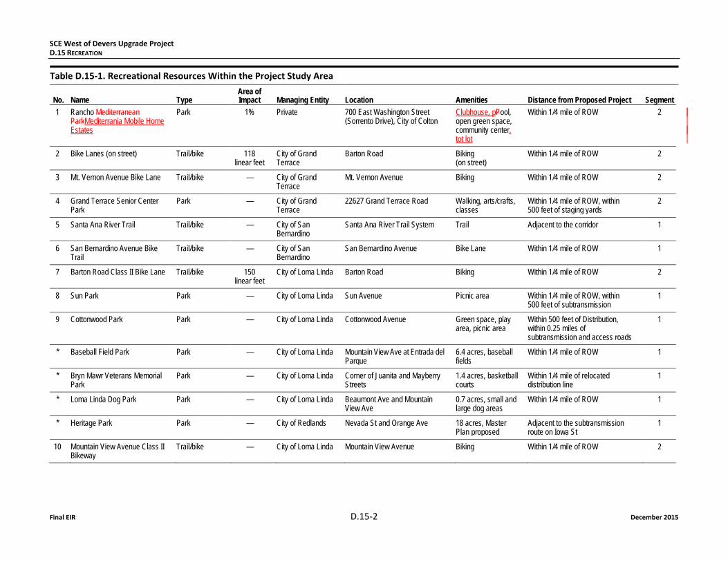
Table D.15-1. Recreational Resources Within the Project Study Area
No. Name Type Area of Impact Managing Entity Location Amenities Distance from Proposed Project Segment
1 Rancho Mediterranean ParkMediterrania Mobile Home Estates
Park 1% Private 700 East Washington Street (Sorrento Drive), City of Colton
Clubhouse, pPool, open green space, community center, tot lot
Within 1/4 mile of ROW 2
2 Bike Lanes (on street) Trail/bike 118 linear feet
City of Grand Terrace
Barton Road Biking (on street)
Within 1/4 mile of ROW 2
3 Mt. Vernon Avenue Bike Lane Trail/bike — City of Grand Terrace
Mt. Vernon Avenue
Biking Within 1/4 mile of ROW 2
4 Grand Terrace Senior Center Park
Park — City of Grand Terrace
22627 Grand Terrace Road
Walking, arts/crafts, classes
Within 1/4 mile of ROW, within 500 feet of staging yards
2
5 Santa Ana River Trail Trail/bike — City of San Bernardino
Santa Ana River Trail System
Trail Adjacent to the corridor 1
6 San Bernardino Avenue Bike Trail
Trail/bike — City of San Bernardino
San Bernardino Avenue
Bike Lane Within 1/4 mile of ROW 1
7 Barton Road Class II Bike Lane Trail/bike 150 linear feet
City of Loma Linda Barton Road
Biking Within 1/4 mile of ROW 2
8 Sun Park Park — City of Loma Linda Sun Avenue Picnic area Within 1/4 mile of ROW, within 500 feet of subtransmission
1
9 Cottonwood Park Park — City of Loma Linda Cottonwood Avenue Green space, play area, picnic area
Within 500 feet of Distribution, within 0.25 miles of subtransmission and access roads
1
* Baseball Field Park Park — City of Loma Linda Mountain View Ave at Entrada del Parque
6.4 acres, baseball fields
Within 1/4 mile of ROW 1
* Bryn Mawr Veterans Memorial Park
Park — City of Loma Linda Corner of Juanita and Mayberry Streets
1.4 acres, basketball courts
Within 1/4 mile of relocated distribution line
1
* Loma Linda Dog Park Park — City of Loma Linda Beaumont Ave and Mountain View Ave
0.7 acres, small and large dog areas
Within 1/4 mile of ROW 1
* Heritage Park Park — City of Redlands Nevada St and Orange Ave 18 acres, Master Plan proposed
Adjacent to the subtransmission route on Iowa St
1
10 Mountain View Avenue Class II Bikeway
Trail/bike — City of Loma Linda Mountain View Avenue
Biking Within 1/4 mile of ROW 2

SCE West of Devers Upgrade Project D.15 RECREATION
December 2015 D.15-3 Final EIR
Table D.15-1. Recreational Resources Within the Project Study Area
No. Name Type Area of Impact Managing Entity Location Amenities Distance from Proposed Project Segment
11 Hulda Crooks Park Park — City Loma Linda Corner of Beaumont Avenue and Mountain View Avenue
50 acres; barbecue, picnic tables, volleyball/sports court, trails/open space
Within 1/4 mile of ROW 2
12 South Hills Preserve Trails/open space 6% City of Loma Linda City of Loma Linda and City of Loma Linda Sphere of Influence (unincorporated San Bernardino and Riverside Counties)
Trails/open space Within 1/4 mile of ROW 2,3
13 Lillian V. Miller Memorial Trail (also referred to as the Edison Easement Trail)
Trail/bike 6,307 linear feet
City Loma Linda Between Beaumont Avenue and Mission Road
Paved and earthen trails, benches, drinking fountains
Within 1/4 mile of ROW 1
14 Leonard Bailey Park Park — City of Loma Linda Lawton Avenue and Whittier Avenue
10 acres; barbeque pits, tennis courts, turf/landscaping; proposed soccer field
Within 1/4 mile of distribution 1
15 San Bernardino County Museum Museum — County of San Bernardino
2024 Orange Tree Lane
Regional museum with exhibits and collections in cultural and natural history
Within 0.25 miles of subtransmission
1
16 Brookside Park Park — Private Brookside Avenue, City of Redlands
Green space, picnic areas, play area
Within 1/4 mile of subtransmission 1
17** Moonlight Farms Horse Exercise Track
No longer in operation
18 San Timoteo Canyon State Park Park 5% California Dept of Parks and Recreation
Unincorporated Riverside County Open space, not yet open to public, expected to provide hiking, horse trails, and camping
Within 1/4 mile of ROW, crossed by ROW
3
19 El Casco Lake Other — Private San Timoteo Canyon Road and Lakeshore Drive, Unincorporated Riverside County
Fishing Within 1/4 mile of ROW 3
20 Halo Resorts Other — Private San Timoteo Canyon Road and Entranz Boulevard, City of Redlands
Camping, fishing Within 1/4 mile of ROW r 3
SCE West of Devers Upgrade Project D.15 RECREATION
Final EIR D.15-4 December 2015
Table D.15-1. Recreational Resources Within the Project Study Area
No. Name Type Area of Impact Managing Entity Location Amenities Distance from Proposed Project Segment
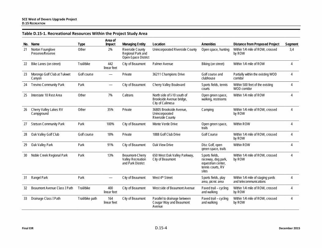
21 Norton Younglove Preserve/Reserve
Other 2% Riverside County Regional Park and Open-Space District
Unincorporated Riverside County Open space, hunting Within 1/4 mile of ROW, crossed by ROW
3,4
22 Bike Lanes (on street) Trail/bike 442 linear feet
City of Beaumont Palmer Avenue
Biking (on street) Within 1/4 mile of ROW 4
23 Morongo Golf Club at Tukwet Canyon
Golf course — Private 36211 Champions Drive Golf course and clubhouse
Partially within the existing WOD corridor
4
24 Trevino Community Park Park — City of Beaumont Cherry Valley Boulevard Sports fields, tennis courts
Within 500 feet of the existing WOD corridor
4
25 Interstate 10 Rest Area Other 7% Caltrans North side of I-10 south of Brookside Avenue bridge, City of Calimesa
Open green space, walking, restrooms
Within 1/4 mile of ROW 4
26 Cherry Valley Lakes RV Campground
Other 35% Private 36805 Brookside Avenue, Unincorporated Riverside County
Camping Within 1/4 mile of ROW, crossed by ROW
4
27 Stetson Community Park Park 100% City of Beaumont Monte Verde Drive
Open green space, trails
Within ROW 4
28 Oak Valley Golf Club Golf course 18% Private 1888 Golf Club Drive Golf Course Within 1/4 mile of ROW, crossed by ROW
4
29 Oak Valley Park Park 91% City of Beaumont Oak View Drive
Disc Golf, open green space, trails
Within ROW 4
30 Noble Creek Regional Park Park 13% Beaumont-Cherry Valley Recreation and Park District
650 West Oak Valley Parkway, City of Beaumont
Sports fields, raceway, dog park, equestrian center, tennis courts, RV sites
Within 1/4 mile of ROW, crossed by ROW
4
31 Rangel Park Park — City of Beaumont West 4th Street
Sports fields, play area, picnic area
Within 1/4 mile of staging yards and telecommunications
4
32 Beaumont Avenue Class I Path Trail/bike 400 linear feet
City of Beaumont West side of Beaumont Avenue Paved trail – cycling and walking
Within 1/4 mile of ROW, crossed by ROW
4
33 Drainage Class I Path Trail/bike path 164 linear feet
City of Beaumont Parallel to drainage between Cougar Way and Beaumont Avenue
Paved trail – cycling and walking
Within 1/4 mile of ROW, crossed by ROW
4

SCE West of Devers Upgrade Project D.15 RECREATION
December 2015 D.15-5 Final EIR
Table D.15-1. Recreational Resources Within the Project Study Area
No. Name Type Area of Impact Managing Entity Location Amenities Distance from Proposed Project Segment
34 SCE Corridor Class I Path Trail/bike 3,973 linear feet
City of Beaumont SCE Corridor between Cherry Ave and Beaumont Avenue
Paved Trail – cycling and walking
In ROW 4
35 Albert A. Chatigny Sr. Community Center
Community center
— City of Beaumont 1310 Oak Valley Parkway
Basketball court, playground, gym
Within 1/4 mile of ROW 4
36 Cherry Avenue Class I Path Trail/bike 3,170 linear feet
City of Beaumont Between Cherry Avenue and Starlight Avenue
Paved Trail – cycling and walking
In ROW 4
37 Stewart Park Park — City of Beaumont Located at the intersection of 8th & 11th and Orange & Maple Avenues
Play area, open space
Within 1/4 mile of telecom line
38 Sun Lakes Country Club Golf Course
Golf course — Private 850 S. Country Club Drive, City of Banning
Golf Course Within 1/4 mile of telecommunications
4
39 Gilman Historic Ranch Other — Riverside County Regional Park and Open-Space District
1901 West Wilson Street, City of Banning
Historic tours, picnic tables, barbeques, and museum
Partially within the existing WOD corridor
4
40 Lions Park Park — City of Banning S. Hargrave Street,
Sports fields, play area
Within 1/4 mile of telecommunications
5
41 Roosevelt Williams Park Park — City of Banning Located at the corner of Wilson and Blanchard Streets
Play area, basketball courts, picnic area, boys & girls club
Within 1/4 mile of telecommunications and Matich Yard
5
42 BLM Land Other 15% Bureau of Land Management
Various parcels within, north and south of PS, between SR-62 and Rushmore Avenue
Open Space Within 1/4 mile of ROW, crossed by ROW
6
43 Pacific Crest National Trail Trail 607 linear feet
USFS Unincorporated Riverside County National Scenic Trail; 2,650 miles through California, Oregon, and Washington
Within 1/4 mile of ROW, crossed by ROW
6
44 Rest Area Other — Caltrans I-10 W/E, Exit 113 Bathrooms, picnic tables, phones
Within 1/4 mile of access roads 6
* Not shown on Figures D.15-1a through D.15-1k. ** The recreational facility identified as 17 in the PEA (Moonlight Farms Horse Exercise Track) is no longer in operation. Source: SCE, 2013; Loma Linda, no date; Redlands, 2012.

SCE West of Devers Upgrade Project D.15 RECREATION
Final EIR D.15-6 December 2015
Federal, state, local and private parks and recreational areas, including open space and trails, are found across the project study area. Substantial portions of land within both counties in the project study area are public land, including federal land administered by the BLM or the USFS, state parks, county parks and open spaces, and municipal parks and facilities. Private recreational facilities within or near the project study area include open spaces, equestrian facilities, trails, golf courses, and campgrounds.
D.15.1.2.1 Segment 1: San Bernardino
The San Bernardino Substation to San Bernardino Junction segment would traverse approximately 0.4 miles of open space in the City of Loma Linda, passing through residential and industrial development as well as agricultural areas. The line would be within 0.25 miles of Cottonwood Park, Baseball Field Park, Loma Linda Dog Park (within ROW), Leonard Bailey Park, Brookside Park, and Heritage Park. These parks are described in Table D.15-1 and shown on Figures D.15-1a and D.15-1b.
The line would be rebuilt approximately 0.1 miles east of the 19.6-acre Hulda Crooks Park. Hulda Crooks Park, operated by the City of Loma Linda, would be located in both Segment 1 and 2. Hulda Crooks Park features playground equipment, barbecue pits, basketball, volleyball, and lighted tennis courts, and an open area for field sports. Approximately 12 acres of the park are located within the project study area.
The San Bernardino County Museum is located in the City of Redlands within 0.25 miles of the 66 kV subtransmission lines in Segment 1. The museum is a regional museum with exhibits and collections in cultural and natural history.
Also located within the project study area in Segments 1 and 2 are on-street bike lanes on Barton Road and Mountain View Avenue. These bike lanes/routes are maintained by the City of Loma Linda. An esti-mated 1.25 miles of the Lillian V. Miller Memorial Trail (also known as the Edison Easement Trail) is located within the existing WOD corridor in Segment 1. This Class I (off-road) trail consists of paved and earthen surface trails, benches, and drinking fountains.
Segment 1 includes on-street bike lanes within the existing WOD corridor on San Bernardino Avenue in the City of San Bernardino. A portion of the Santa Ana River Trail is located within the project study area. The Santa Ana River Trail and Parkway is overseen by a Policy Advisory Group of elected officials and representatives of nonprofit organizations. Currently, the Policy Advisory Group includes the mayors of the cities of Anaheim, Corona, Redlands, Riverside, and San Bernardino; supervisors from the counties of Orange, Riverside, and San Bernardino; a commissioner from the Santa Ana Watershed Project Authority; and a member of The Wildlands Conservancy. Operations and maintenance of the Santa Ana River Trail is undertaken by a combination of city and county park departments, including the Riverside County Regional Parks and Open Space District, the San Bernardino County Regional Parks Division, and the parks departments of the cities of Redlands and San Bernardino (SCE, 2014).
Additional recreation areas located further from the Proposed Project include the Santa Ana River Wash ACEC, located approximately 2.9 miles northeast of San Bernardino Substation. The ACEC encompasses 750 acres of BLM land north of Redlands.
D.15.1.2.2 Segment 2: Colton and Loma Linda
The Colton to Loma Linda segment would traverse approximately 2.7 miles of open space in the City of Loma Linda and approximately 0.6 miles of open space in the City of Colton, both used for recreation. A number of riding and hiking trails are located within this open space. On-street bike lanes on Barton Road and the Mt. Vernon Bike Lane (Mt. Vernon Avenue) are located within the Proposed Project boundaries in the City of Grand Terrace. These bike lanes/trails are maintained by the City of Grand Terrace.

SCE West of Devers Upgrade Project D.15 RECREATION
December 2015 D.15-7 Final EIR
The City of Loma Linda adopted a riding and hiking trail plan in 1973, which includes the SCE easement and provides access to the trail system in the Badlands area (Loma Linda, 2009). The riding and hiking trail sys-tem is accessed via Mountain View Avenue, Richardson Street, and Oakwood Drive in the City of Loma Linda.
The Rancho Mediterraniaean and Grand Terrace Senior Center Parks are located within Segment 2. The Rancho Mediterraniaean Park is an approximately 4-acre privately maintained park in the City of Colton consisting of a clubhouse, pool, and tot lot for the mobile home park. Approximately 0.04 acres of the park is located within the existing WOD corridor in Segment 2, and approximately 2.82 acres of the park are located within 500 feet of the Proposed Project boundaries in Segment 2 (SCE, 2014). These parks are described in Table D.15-1 and shown on Figure D.15-1b.
The City of Grand Terrace operates the Grand Terrace Senior Center and Park. The Grand Terrace Senior Center provides a full spectrum of services and activities for seniors. The park offers seating areas, walking paths, monuments, gardens, and direct access into the senior center. The Senior Center and Park are located within 500 feet of the Proposed Project boundaries (SCE, 2014).
The South Hills Preserve is located in Segments 2 and 3 and would be crossed by the Proposed Project. The South Hills Preserve is almost 2,000 acres of protected open space. Conservation of the hillside and maximizing the preservation of natural open space are part of Loma Linda’s long-range plan for the South Hills area (Loma Linda, 2009). South Hills is open to pedestrians, bicycles, and horses.
D.15.1.2.3 Segment 3: San Timoteo Canyon
Segment 3 would cross three large recreation areas and one smaller private recreation facility. These are described in Table D.15-1 and shown on Figures D.15-1c and D.15-1d. The California State Park, San Timoteo Canyon, is an ancient river valley that runs from south of the City of Banning in Riverside County to a point just south of the City of San Bernardino in San Bernardino County. In 2001, a portion of the canyon came under management of the California State Parks with the intent to provide hiking trails, horse riding trails, camping, and historic sites. Due to budget constraints, California State Parks has not prepared a Management Plan for San Timoteo Canyon State Park, and no opening date has been set. Approximately 37.5 acres of San Timoteo Canyon State Park are within the existing WOD corridor in Segment 3, 102 acres are within 500 feet of the boundaries of the Proposed Project in Segment 3, and 294 acres are within 0.25 miles of the existing WOD corridor in Segment 3 (SCE, 2013).
The El Casco Lake is a reservoir located 3.2 miles from Calimesa in Riverside County. The 15-acre lake, owned by the Riverside Land Conservancy, is among approximately 8,000 acres of publicly owned land in San Timoteo Canyon. El Casco Lake offers fishing activities but is not currently open to the public. In January 2013, the Riverside County Regional Park and Open-Space District Advisory Commission approved a memorandum of understanding between the Park District and the Riverside Land Con-servancy “to work cooperatively to develop and further the concept and ideas for El Casco Regional Park.” Approximately 1.63 acres of the lake are located within 500 feet of the existing WOD corridor in Seg-ment 3, and approximately 19 acres are located within the project study area in Segment 3 (SCE, 2013).
The Norton Younglove Preserve/reserve, located west of the City of Beaumont in Riverside County, con-sists of an extensive pattern of dramatic and rugged mountainous terrain. The Preserve/reserve includes grasslands, riparian, and woodland habitat areas and serves as a wildlife corridor. The Riverside County Regional Park and Open-Space District presently manages the Preserve/reserve. There are ongoing dis-cussions between the County of Riverside and the State of California Department of Parks and Recrea-tion regarding the possible transfer of the property into the San Timoteo Canyon State Park. Approxi-mately 66 acres of the Preserve/reserve are located within the existing WOD corridor in Segments 3
SCE West of Devers Upgrade Project D.15 RECREATION
Final EIR D.15-8 December 2015
and 4, approximately 295 acres of the Preserve/reserve are located within 500 feet of the Proposed Project boundaries in Segments 3 and 4, and approximately 588 acres are located within 0.25 miles of the Proposed Project boundaries in Segments 3 and 4 (SCE, 2013).
One privately owned recreational facility is located within 0.25 miles of the ROW in of Segment 3. Halo Resorts owns and maintains campgrounds that offer recreational vehicle (RV) sites with full hook-ups, dedicated tent sites, cabin rentals, and scheduled activities (e.g., fishing).
D.15.1.2.4 Segment 4: Beaumont and Banning
Segment 4 recreation facilities are described in Table D.15-1 and shown on Figures D.15-1d through D.15-1f. Within the Beaumont and Banning segment, the City of Beaumont operates the Trevino Com-munity Park, Albert A. Chatigny Senior Center, Oak Valley Park, Stewart Park, and Stetson Community Park. A portion of some of the parks is located within the Proposed Project ROW:
Stetson Community Park is approximately 9 acres and offers open space and trails. The entire park is located within the Proposed Project ROW boundaries.
Noble Creek Regional Park is located in the City of Beaumont, but it is operated by the Beaumont-Cherry Valley Recreation and Park District. Approximately 7 acres of Noble Creek Regional Park are located within the existing WOD corridor in Segment 4, 24.6 acres are within 500 feet of the Proposed Project boundaries, and 53.2 acres are within 0.25 miles of the Proposed Project boundaries (SCE, 2013).
Cherry Valley Lakes RV Campground is a privately owned and maintained campground within unincor-porated Riverside County. A portion of the campground is located within the existing WOD corridor in Segment 4.
Oak Valley Park is approximately 13 acres and offers open space, trails, and disc golf facilities. Most of Oak Valley Park (11.62 acres) is located within the Proposed Project Corridor and the entire park is located within 500 feet of the Proposed Project boundaries.
The City of Beaumont maintains an on-street bike route on Palmer Avenue, which is located within the Proposed Project boundaries in Segment 4. In addition, off-street (Class I) bikeways and trails are main-tained by the City of Beaumont on the west side of Beaumont Avenue, parallel to a drainage ditch between Cougar Way and Beaumont Avenue, between Cherry Avenue and Starlight Avenue, and within the Southern California Edison (SCE) corridor between Cherry Avenue and Beaumont Avenue.
Additionally, two golf courses are partially located within the corridor. The Oak Valley Golf Club is a pri-vate 18-hole golf course and the Morongo Golf Club at Tukwet Canyon is a private golf course offering 36 holes; portions of both clubs are within the 0.5-mile wide study corridor, and the ROW passes through the Oak Valley Golf Club. Caltrans maintains a rest area along Interstate 10 (I-10) within the Segment 4 project study area. The rest area (referred to as Wildwood rest area) located on the north side of I-10 south of the Brookside Avenue bridge (in the City of Calimesa) features open green space and restrooms.
In addition to the local and regional parks within 0.25 miles of the ROW, the route would travel south of the San Bernardino National Forest and north of Gilman Historic Ranch. The Potrero ACEC would be located further south of the Proposed Project.
San Bernardino National Forest (SBNF). The SBNF was established in 1907 and is managed by the USFS. The SBNF is located both north and south of I-10, and the Banning and Beaumont segment would travel within 1 mile of the northern portion of the SBNF. Recreational activities at the SBNF include hiking, camping, OHV use, skiing, fishing, and horseback riding (USDA Forest Service, no date).

SCE West of Devers Upgrade Project D.15 RECREATION
December 2015 D.15-9 Final EIR
Gilman Historic Ranch and Wagon Museum. The Gilman Historic Ranch and Wagon Museum pro-vides visitors with an interpretation of the history of California from the Cahuilla Indians to the explora-tion and settlement of southern California. Recreational facilities include the Gilman homestead ranch in addition to historical and educational programs that attract visitors (Riverside County Parks, 2014).
The other recreational area that is located in the vicinity of the Banning and Beaumont segment, but is further than 1 mile away, is the Potrero ACEC (located 3 miles south of the Proposed Project and accessed from Highland Springs Ave.). The Potrero ACEC is located within the Western Riverside County Multiple Species Habitat Conservation Plan and is managed by the BLM.
D.15.1.2.5 Segment 5: Morongo Tribal Lands and Surrounding Areas
The only designated recreation facilities within Segment 5 is the Roosevelt Williams Park (formerly called Pass Valley Park). This park is located on approximately 6.3 acres within the City of Banning and is shown on Figure D.15-1g.
D.15.1.2.6 Segment 6: Whitewater and Devers
Recreation opportunities in the Whitewater and Devers segment are listed in Table D.15-1 and shown on Figure D.15-1j. Most of the recreation opportunities in Segment 6 are located on BLM managed land. The BLM manages 15.2 million acres of public lands in California, nearly 15 percent of the State’s land area. Approximately 381 acres of BLM land are located within 0.25 miles of the existing WOD corridor in Segment 6. Approximately 283 acres are within 500 feet of the project study area and approximately 53 acres are within the boundaries of the Proposed Project. The Proposed Project does not cross special recreation management areas or Areas of Critical Environmental Concern.
A portion of the Pacific Crest National Scenic Trail (PCT) is partially located on BLM land and crosses the existing WOD corridor in Segment 6 west of the City of Palm Springs. The PCT is a long-distance moun-tain hiking and equestrian trail closely aligned with the highest portions of the Sierra Nevada and Cascade Mountain Ranges. The trail’s southern terminus is on the United States border with Mexico and its northern terminus is in British Columbia, Canada. Its corridor through the United States is in the states of California, Oregon, and Washington. The BLM manages 180 miles of the Pacific Crest National Trail, primarily in the southern half of California.
The Caltrans rest area located near Exit 113 (referred to as Whitewater rest area) features restrooms, picnic areas, and phones, and is located within 0.25 miles of the access roads in Segment 6. This rest area is partially in the City of Palm Springs and partially in the County of Riverside.
Additional recreation areas located further from the Proposed Project include the Whitewater Canyon Area of Critical Environmental Concern, the San Gorgonio wilderness area to the north, the Santa Rosa and San Jacinto Mountains National Monument and the San Jacinto wilderness area to the south and the SBNF to the north and south. Some additional information is provided below.
Whitewater Canyon Area of Critical Environmental Concern. The 16,381-acre Whitewater Canyon ACEC is located less than 0.5 miles north of the Proposed Project. This resource area is managed by the BLM, California Desert District and is designated for its wildlife habitat and Native American values (BLM, 1999).
Santa Rosa and San Jacinto Mountains National Monument. The monument is located 0.6 miles south of the ROW and is accessed from Highway 111 or Highway 243.
SCE West of Devers Upgrade Project D.15 RECREATION
Final EIR D.15-10 December 2015
D.15.1.3 Environmental Setting for Connected Actions
The connected actions identified in Table B-22 (see Section B.7.1) would require a total of approximately 10,560 acres for solar generation development in the Desert Center and the Blythe areas.
Desert Center Area. Connected action projects in the Desert Center area include the proposed Palen Solar Power Project and the proposed Desert Harvest Project, both of which would be on BLM-administered land, as well as approximately 2,400 acres of other solar PV development in the area. This region of the Colorado Desert is located within the relatively flat Chuckwalla Valley. The area is generally undeveloped with the exception of a recently completed solar project and high-voltage transmission lines that cross the area.
The majority of the area’s developed recreation sites are managed by BLM and the National Park Ser-vice. The Desert Center area does not include any state, regional, or community parks. Recreational use of BLM lands in the Desert Center area is limited primarily to cooler months (i.e., September through May), and the number of visitors is estimated to be approximately 2,000 to 3,000 per year (BLM, 2013). Dispersed recreation on BLM-administered lands includes camping, hiking, hunting, and OHV use on designated routes (BLM, 2012). Recreational resources in the Desert Center area include the following:
ACECs: Chuckwalla Desert Wildlife Management Area, Palen Dry Lakes, Corn Springs, Alligator Rock, Desert Lily Preserve, and Chuckwalla Valley Dune Thicket;
Wilderness areas: Palen-McCoy, Chuckwalla Mountains, Little Chuckwalla Mountains, Orocopia Mountains, Sheephole Valley, and Joshua Tree;
Joshua Tree National Park;
Bradshaw Trail National Back Country Byway;
Edmund C. Jaeger Nature Sanctuary;
General Patton Museum at Chiriaco Summit;
Corn Springs Campground (BLM-managed);
Lake Tamarisk Desert Resort (member-owned community for seniors) (BLM, 2013); and
Former Desert Center Airport (members-only automotive racetrack) (BLM, 2012).
Blythe Area. The connected projects in the Blythe area would involve approximately 4,200 acres for solar PV developments. Recreation areas in this area include BLM-managed resources, recreation facilities operated by the Riverside County Regional Park and Open-Space District, City of Blythe parks and recre-ation areas, and privately owned motor vehicle parks and campgrounds. Dispersed recreation on BLM-administered lands is limited to cooler months (i.e., September through May) and includes backpacking, camping, hiking, horseback riding, rockhounding, photography and painting, rock climbing, spelunking, hunting (e.g., dove, quail, deer), landsailing on dry lakes, mountain and trail biking, observing cultural resources, and OHV use on designated routes (POWER Engineers, 2014).
Specific recreational resources in the Blythe Area include the following:
ACECs: Mule Mountains and Big Marias (number of annual visitors to these ACECs is estimated to be approximately 100);
Wilderness areas: Palo Verde Mountains, Rice Valley, Big Maria Mountains, and Riverside Mountains (the number of annual visitors to these wilderness areas is estimated to be approximately 100 to 200 hikers, while motor vehicle camping near the wilderness areas accounts for up to 2,000 annual visitors);

SCE West of Devers Upgrade Project D.15 RECREATION
December 2015 D.15-11 Final EIR
BLM-managed camping facilities: Mule Mountain Long Term Visitor Area (LTVA), Midland LTVA, Wiley’s Well Campground, and Coon Hollow Campground;
Bradshaw Trail National Back Country Byway (65-mile route that begins 35 miles southeast of Indio and ends 15 miles southwest of Blythe; and
Cibola National Wildlife Refuge (managed by U.S. Fish and Wildlife Service).
D.15.2 Applicable Regulations, Plans, and Standards The Proposed Project would traverse federal, state, and local jurisdictions that have implemented man-agement plans for recreational resources. To determine the Proposed Project’s consistency with these government plans and policies, a thorough review of applicable policies was conducted.
D.15.2.1 Federal
Federal Land Policy and Management Act
Congress established the Federal Land Policy and Management Act (FLPMA) in 1976 to provide for the management, protection, development, and enhancement of public lands. FLPMA requires public lands be provided for multiple objectives including to provide for outdoor recreation and human use. Sections 201 and 202 of this act established BLM land use planning requirements. Land use plans and planning decisions are the basis for every on-the-ground action the BLM undertakes.
The BLM has exclusive jurisdiction of ROWs on BLM public lands in the Proposed Project area. Public lands have inherent recreational value and offer varying opportunities for recreational activities. The Proposed Project corridor is located within the Palm Springs–South Coast Resource Management Plan area (1994). This plan is in the process of being updated. The BLM published a Draft South Coast Resource Management Plan and Environmental Impact Statement in 2011. The Final EIS is scheduled to be released later in 2015. It has not yet been adopted.
In addition, the Proposed Project would be located within the California Desert Conservation Area Plan of 1980, as amended. The purpose of the CDCA designation is “to provide for the immediate and future protection and administration of the public lands in the California desert within the framework of a pro-gram of multiple use and sustained yield, and the maintenance of environmental quality” (43 U.S.C. 1781[b]).
There are no BLM-designated or proposed special recreation management areas or extensive recreation management areas within the Proposed Project limits.
Recreation and Public Purposes Act
The Recreation and Public Purposes Act is administered by the BLM. The act authorizes the sale or lease of public lands for recreational or public purposes to state and local governments and to qualified nonprofit organizations. Examples of typical uses on lands subject to the Act are historic monument sites, campgrounds, schools, fire houses, law enforcement facilities, municipal facilities, landfills, hospitals, parks, and fairgrounds.
Comprehensive Management Plan for the Pacific Crest National Scenic Trail
The PCT is one of the original National Scenic Trails established by Congress in 1968. It is administered by the USFS in partnership with the BLM, National Park Service, California State Parks, and the Pacific

SCE West of Devers Upgrade Project D.15 RECREATION
Final EIR D.15-12 December 2015
Crest Trail Association. The Comprehensive Management Plan for the Pacific Crest National Scenic Trail (1982) provides overall guidance for the development, management and use of the trail. The Proposed Project would cross the PCT in Segment 6, west of Whitewater Canyon.
D.15.2.2 State
The Proposed Project crosses the San Timoteo Canyon State Park. As noted above, due to budget con-straints, California State Parks has not prepared a Management Plan for the park so there are no applic-able plans or standards at this time.
D.15.2.3 Local
The CPUC has jurisdiction over the siting and design of the Proposed Project because it authorizes the construction of investor-owned public utility (IOU) facilities. General Order (GO) No. 131-D Section III.C requires “the utility to communicate with, and obtain the input of, local authorities regarding land-use matters and obtain any nondiscretionary local permits.” Appendix 9 (Policy Screening Report) identifies county and city plans and policies regarding recreation and other resources of concern to planners. The Appendix indicates policies that are potentially applicable to the Proposed Project and whether the project would be consistent with the plan or policy. These policies are numerous and are not repeated here.
D.15.3 Environmental Impacts of the Proposed Project
D.15.3.1 Approach to Impact Assessment
This section considers the potential impact to and disruption of recreational resources from imple-menting the Proposed Project. Loss of recreational resources is anticipated to be minor as the project is located primarily in an already existing corridor and the line would replace existing structures. However, as portions of the corridor are currently used for recreation, temporary impacts to recreation are likely to occur during construction when the recreation areas would be temporarily unavailable to the nearby users or when a nearby recreation area would be affected by indirect impacts. The metrics used to com-pare alternatives would be the number of recreational resources directly and indirectly impacted by the alternative and the length of time of the direct and indirect impact, in particular, the length of closure time during construction of the project for each recreational resource, if necessary.
D.15.3.1.1 Applicant Proposed Measures
Table D.15-2 presents the Applicant Proposed Measures that SCE has committed to implementing dur-ing construction and operation of the Proposed Project. If revision or expansion of any APM is found to be required based on the analysis in this EIR, those changes are explained in Section D.15.3.3 (Impact Analysis).
Table D.15-2. Applicant Proposed Measures for Recreation
APM Description APM REC-1 SCE would coordinate temporary closures with recreational facility managers and would post a public
notice at recreation facilities indicating that the facilities would be closed or have limited use during construction.
APM REC-2 SCE would prepare a construction notification plan identifying procedures for notifying the public of the location and duration of construction.

SCE West of Devers Upgrade Project D.15 RECREATION
December 2015 D.15-13 Final EIR
D.15.3.2 CEQA Significance Criteria
According to the CEQA Environmental Checklist for assessing the impacts to recreation, a project causes a potentially significant impact if it would:
Increase the use of existing neighborhood and regional parks or other recreational facilities such that substantial physical deterioration of the facility would occur or be accelerated.
Include recreational facilities or require the construction or expansion of recreational facilities which might have an adverse physical effect on the environment.
Neither of these is applicable. The Proposed Project is a transmission project with a set construction period and a small operations workforce. It does not include an increase in population that would sub-stantially increase the use of existing neighborhood and regional parks such that a substantial physical deterioration would occur; therefore, the first CEQA Environmental Checklist significance criterion is not applicable. The Proposed Project would not require construction of recreational facilities or require the expansion of recreational facilities; therefore the second criterion is not applicable to this project and is not addressed.
Although not identified in the CEQA checklist, from previous transmission projects it is known that the Proposed Project could result in impacts to recreation that:
Would directly or indirectly disrupt activities in established recreation areas and reduce access or visitation.
Would substantially reduce the scenic, biological, cultural, geologic, or other important factors that contribute to the value of recreational facilities or areas.
These are addressed below.
D.15.3.3 Impacts and Mitigation Measures
Impact R-1: Construction activities would temporarily reduce access and visitation to recreation areas.
Construction activities for the Proposed Project are anticipated to occur between May 2016 and May 2020. This would require establishing temporary staging yards used as reporting locations for workers, vehicle and equipment parking, and material storage, modification of existing substations, rehabilitation and construction of new access and spur roads, preparation of laydown/work areas for the new struc-ture pad locations, grading and clearing of vegetation for each structure pad location, foundation instal-lation for each pole, and installation of the new structures.
Construction of the Proposed Project would require the use of temporary shoo-fly facilities. A shoo-fly is a temporary electrical line on temporary poles that is used during construction to maintain electrical service to the area while allowing portions of a permanent line to be taken out of service temporarily. The shoo-fly facilities would be removed after work on the permanent line is completed.
The Proposed Project would also require permanent relocation of portions of existing 66 kV and 12 kV lines and upgrades to existing telecommunications. Some of the relocation of the 12 kV circuits and tele-communication facilities would include underground systems.
Project construction activities create a number of temporary disturbances that would diminish the value of affected areas, such as bike lanes, parks, golf clubs, and open space/preserves. The noise, dust, and

SCE West of Devers Upgrade Project D.15 RECREATION
Final EIR D.15-14 December 2015
traffic generated during construction would negatively affect a visitor’s enjoyment of these recreation areas so recreationists may be less likely to visit these resources during project construction.
In certain instances, for reasons of safety, access to some areas or facilities might be temporarily pro-hibited. Some specific recreation locations would experience direct impacts and closures during con-struction. These include those listed below (also see the full list of recreation areas within the ROW in Section D.15.1.2 and Table D.15-1):
Rancho Mediterraniaean Park (parking lot) South Hills Preserve (open space) Lillian V. Miller Memorial Trail (trail within ROW) Rest areas (restroom and parking) Stetson Community Park (Grass areas and paved pathways) Noble Creek Regional Park (dirt and paved parking, baseball field and spectator seating) Trevino Community Park (paved walkway) Bike lane on Barton Road, Beaumont Avenue, Drainage and SCE Corridor Class I path, Cherry Avenue Norton Younglove Preserve (open space and trails) San Timoteo Canyon State Park (open space and trails) Cherry Valley Lakes RV Campground (10 RV sites and much of RV parking and storage area) Oak Valley Golf Club and Park (grass areas outside fairways and dirt pathways) Pacific Crest Trail (trail)
These trails, parks, and bike lanes are directly within the ROW. The facilities would be off limits to the pub-lic during active construction at transmission structure sites, which could last up to eight weeks. In addi-tion, the entire ROW corridor would be temporarily closed during conductor stringing activities, which would be intermittent, with the total cumulative closure duration no more than two weeks (SCE, 2014; Data Response REC-3). For the bike lane closure along Palmer Avenue, SCE has stated that the closure would be no more than 72 hours (SCE, 2014; Data Response REC-3).
Through implementation of APM REC-1 and REC-2, SCE has committed to coordinating closures with rec-reational facility managers and posting information about the closures but has not provided any additional information regarding the timing of such coordination or provided any notification regarding alternative recreational facilities available during construction. Without appropriate schedule information and alterna-tive recreation options, direct and indirect effects to recreational users and loss of recreational facilities would result in a substantial impact. Mitigation Measures R-1a (Coordinate construction schedule and activities with the authorized officera representative for the recreation area) and R-1b (Coordinate with local agencies to identify alternative recreation areas) would be required to reduce these impacts, and would ensure that recreational users are informed of scheduled construction activities and informed of alternative areas for use. These mitigations measures supersede APMs REC-1 and REC-2.
The Proposed Project would cross the PCT as the trail traverses unincorporated Riverside County land north of the Santa Rosa and San Jacinto Mountains National Monument. As described in Section D.15.3.1, the PCT was designated as one of the first scenic trails in the National Trails System, and is limited to non-mechanized means of travel. For the PCT closure, SCE has stated that the closure would be no more than 72 hours (SCE, 2014; Data Response REC-3). The presence of construction equipment and antici-pated construction work would negatively affect users of the trail and construction would require tem-porary closure of the trail. In order to allow for continued use of the trail, Mitigation Measure R-1c (Pro-vide a temporary detour for Pacific Crest National Scenic Trail users) is recommended. Implementation of this mitigation measure would allow recreationists to use the trail during construction, and would inform visitors of scheduled construction activities and would reduce impacts to PCT users to the extent feasible.

SCE West of Devers Upgrade Project D.15 RECREATION
December 2015 D.15-15 Final EIR
The Proposed Project would be constructed across approximately 66 acres of the Norton Younglove reserve within the Calimesa and San Timoteo Canyon segment. Project construction activities would create a number of temporary conditions that would diminish the value of the visitor experience at the Norton Younglove reserve. For example, the noise, dust, and construction traffic generated during construction activities could negatively affect a visitor’s enjoyment of this recreation area. Recreationists may be less likely to visit this resource during project construction. The location of construction equipment may also temporarily preclude access to some areas. Such a disturbance to recreational activities or a reduction in the visitation to the reserve due to construction activities would result in a substantial effect. Construction-related impacts to the Norton Younglove reserve would be mitigated through implementation of Mitigation Measure R-1a (Coordinate construction schedule and activities with the authorized officera representative for the recreation area). Implementation of this mitigation measure would minimize impacts to recreationists at the Norton Younglove reserve, and would ensure that recreational users are informed of scheduled construction activities.
Mitigation Measures for Impact R-1: Construction activities would temporarily reduce access and visitation to recreation areas
R-1a Coordinate construction schedule and activities with the authorized officer a representative for the recreation area. No less than 30 days prior to construction that would affect recreation areas, SCE shall coordinate construction activities and the project construction schedule with the authorized officer a representative of the recreation areas listed below. SCE shall use best efforts to schedule construction activities to avoid heavy rec-reational use periods, including major holidays, in coordination with, and at the discretion of the authorized officerrepresentative. If SCE is unable to accommodate this avoidance, it will notify the CPUC and BLM as to the dates and reasons they are not able to comply. SCE shall locate construction equipment to avoid temporary preclusion of recreation area use whenever feasible per the recommendations of the authorized officerrepresentative. SCE shall also prepare a public notice of construction activities consistent with Mitigation Mea-sure LU-1a (Prepare Construction Notification Plan). SCE shall document its coordination efforts with the authorized officerrepresentative, and provide this documentation to the CPUC and the BLM 30 days prior to construction.
Rancho Mediterraniaean Park South Hills Preserve Lillian V. Miller Memorial Trail Rest areas Stetson Community Park Noble Creek Regional Park Trevino Community Park
Bike lane on Barton Road, Beaumont Avenue, Drainage and SCE Corridor Class I path, Cherry Avenue
Norton Younglove Preserve San Timoteo Canyon State Park Cherry Valley Lakes RV Campground Oak Valley Golf Club and Park Pacific Crest Trail
R-1b Coordinate with local agencies to identify alternative recreation areas. SCE shall coordi-nate with the local parks and recreation departments regarding construction activities at the park and recreation facilities listed in R-1a, in order to identify alternative recreation sites that may be used by the public. SCE shall post a public notice at recreation facilities to be closed or have limited access during construction consistent with Mitigation Measure LU-1a (Prepare Construction Notification Plan) as allowed by the facility representative and iden-tify any alternative recreation sites. SCE shall document its coordination with the parks and recreation departments and shall submit this documentation to the CPUC and the BLM 30 days prior to initiating project construction.

SCE West of Devers Upgrade Project D.15 RECREATION
Final EIR D.15-16 December 2015
R-1c Provide a temporary detour for Pacific Crest National Scenic Trail users. No less than 60 days prior to construction affecting the PCT, SCE shall coordinate with the USFS to establish a temporary detour of the trail during trail closure to avoid hazardous construction areas. SCE shall prepare a public notice of the temporary trail closure and information on the trail detour consistent with Mitigation Measure L-1a (Prepare Construction Notification Plan). SCE shall document its coordination efforts with the USFS and submit this documentation to the CPUC and the BLM 30 days prior to construction.
Impact R-2: Presence of a transmission line or substation would change the character of a recreation area, diminishing its recreational value
The Proposed Project would replace two existing single-circuit transmission lines and one existing double-circuit transmission line with two double-circuit transmission lines. Project activities would occur within an existing ROW. The proposed double-circuit structures would be greater in height than the single-circuit structures, and as such the Proposed Project would alter the viewshed along the ROW (see Section D.18.3, Visual Resources). However, the number of transmission lines that would traverse the recreational areas would decrease, allowing additional space for recreation.
At its crossing of the PCT, the Proposed Project would remove two existing single-circuit 220 kV structures and one existing double-circuit 220 kV structure and construct new double-circuit 220 kV structures. The nearest proposed transmission structure would include one double-circuit structure an estimated 190 feet east of the trail. The nearest existing structure to the PCT is an estimated 280 feet west of the line. All other structures would be over 350 feet from the trail. The Proposed Project would therefore place one structure almost 100 feet closer to the PCT than previously sited. In addition, the PCT is located within a proposed stringing site, would be an estimated 180 feet from a shoofly work area, and would be less than 50 feet from a temporary disturbance area. While this structure would be slightly more noticeable, overall, there would be no increase in the total amount of industrial development across the recreational areas as a result of project activities. Consequently, development and operation of the Proposed Project would not significantly change the character of the recreation area. No mitigation is required.
Impact R-3: Presence of a transmission line would permanently preclude recreational activities
Recreational resources that are located in the vicinity of the ROW would potentially be affected by the removal of three existing transmission lines and siting of a two new transmission lines. For example, the construction of proposed transmission structures would place a structure closer to the Pacific Crest Trail than currently located. However, this would not preclude or prevent use of the recreational uses. The siting of new structures adjacent to existing structures would avoid the creation of new barriers to recrea-tional uses and would reduce barriers to recreational activities in the long term by reducing the number of transmission structures overall. As such, the Proposed Project would not permanently preclude recrea-tional activities and no mitigation is required.
D.15.3.4 Impacts of Connected Actions
Impact R-1: Construction activities would temporarily reduce access and visitation to recreation areas
Desert Center Area. This area is characterized by dispersed recreational opportunities on BLM-administered land. Construction of the connected actions (i.e., Palen Solar Power Project; Desert Harvest Project; and 2,400 acres of other solar PV development) across BLM-managed areas would require the agency’s review and approval, and direct conflicts with temporary access to recreational resources could only occur at the discretion of the BLM. To ensure that recreation impacts are minimized to the extent fea-
SCE West of Devers Upgrade Project D.15 RECREATION
December 2015 D.15-17 Final EIR
sible, measures similar to Mitigation Measure R-1b (Coordinate with local agencies to identify alterna-tive recreation areas) would need to be implemented in the event that construction activities require a temporary preclusion of a recreational resource or facility.
While the location of construction activities may not interfere with public access to recreation areas, construction would create indirect impacts from noise, fugitive dust, vehicle movement, and nighttime lighting. These nuisance impacts may affect visitation at the many ACECs, wilderness areas, and other recreational resources in the region. Construction-related impacts would be mitigated through imple-mentation of measures similar to Mitigation Measure R-1a (Coordinate construction schedule and activ-ities with the authorized officera representative for the recreation area), which would ensure that recre-ational users are informed of scheduled construction activities.
Blythe Area. This area includes many regional, city, and private recreational facilities, as well as resources that are managed by the BLM and the U.S. Fish and Wildlife Service. Recreation areas that are privately owned or managed by local jurisdictions are located near residential areas or along the Colo-rado River. As the connected actions (i.e., 4,200 acres of solar PV development) would interconnect with the Colorado River Substation, the construction of these actions is not expected to preclude the use of these regional, city, or private recreational facilities. In contrast, BLM-managed recreation areas include developed facilities (e.g., campgrounds) and protected areas (e.g., ACECs and wilderness areas) that are dispersed throughout the Blythe area. Any construction of solar generation on or across BLM-managed areas would require the agency’s review and approval, and direct conflicts with temporary access to rec-reational resources could only occur at the discretion of the BLM. To ensure that recreation impacts are minimized to the extent feasible, measures such as Mitigation Measure R-1b (Coordinate with local agencies to identify alternative recreation areas) would need to be implemented in the event that con-struction activities require a temporary preclusion of the use of a recreational resource or facility.
While the location of construction activities may not interfere with public access to recreation areas, construction would create indirect impacts from noise, fugitive dust, vehicle movement, and nighttime lighting that may affect visitation at the recreational resources in the region. Construction-related impacts would be mitigated through implementation of measures such as Mitigation Measure R-1a (Coordinate construction schedule and activities with the authorized officera representative for the rec-reation area), which would ensure that recreational users are informed of scheduled construction activities.
Construction workers may use both the Mule Mountain LTVA and the Midland LTVA as a source of tem-porary housing. Depending on the number of construction workers seeking housing, use of these LTVAs during construction of solar generation projects would limit the public’s access to long-term camping facilities. Given that each LTVA can accommodate several hundred camping vehicles, it is unlikely that recreational use of the LTVA would be restricted. Additionally, LTVAs provide a limited opportunity for employee housing as they require the use of self-contained camping vehicles, and are closed from April 16 to September 14 (POWER Engineers, 2014). Seasonal or vacation home rentals would serve as an alternative to temporary, affordable housing in the Blythe Area (POWER Engineers, 2014).
Impact R-2: Presence of project facilities would change the character of a recreation area, diminishing its recreational value
Desert Center Area. This region includes many recreation areas (e.g., ACECs, wilderness areas, and Joshua Tree National Park) that attract visitors for their scenic resources and undeveloped landscapes. Develop-ment of the connected actions would be visible from numerous recreational resources, which would alter the recreational experience by introducing energy-related facilities and infrastructure into the area.

SCE West of Devers Upgrade Project D.15 RECREATION
Final EIR D.15-18 December 2015
In order to minimize impacts to the recreational value of these resources to the extent feasible, mitiga-tion measures such as those required for visual resources would need to be implemented.
Blythe Area. Similar to Desert Center, the Blythe area includes many recreation areas (e.g., ACECs and wilderness areas) that attract visitors for their scenic resources and undeveloped landscapes. It also includes the Colorado River. The connected solar projects could be visible from numerous recreational resources, which would alter the recreational experience by introducing energy infrastructure into these areas. In order to minimize impacts to the recreational value of these resources to the extent feasible, mitigation measures such as those required for visual resources would need to be implemented.
Impact R-3: Presence of project facilities would permanently preclude recreational activities
None of the connected actions are expected to limit or preclude access to regional, city, and private rec-reational facilities within the Desert Center or the Blythe areas. BLM-managed recreational opportu-nities are dispersed across these areas. Any construction of solar generation on BLM lands would require the agency’s review and approval, and direct conflicts with access to recreational resources could be limited by requirements imposed by BLM.
D.15.3.5 CEQA Significance Determination for Proposed Project and Connected Actions
Impact R-1: Construction activities would temporarily reduce access and visitation to recreation areas (Class II)
Construction of the Proposed Project would result in temporary disturbances from noise, dust, and traffic that would diminish the value of nearby recreational facilities. The Proposed Project would require some recreation areas to be closed temporarily from 72 hours to up to 10 weeks during construction, a potentially significant impact. Mitigation Measures R-1a (Coordinate construction schedule and activities with the authorized officera representative for the recreation area), R-1b (Coordinate with local agencies to identify alternative recreation areas), and R-1c (Provide a temporary detour for Pacific Crest National Scenic Trail users) include coordinating construction schedule with the authorized officers of the recrea-tion areas and identifying alternative recreation areas. These measures would reduce the impact to a less than significant level by ensuring that the construction time frame avoids the heavy recreational use periods and by identifying alternative areas for recreation to provide the users recreational options throughout the entire construction period (Class II).
For the connected actions, temporary conflicts regarding access to recreation areas during construction of the solar projects would depend on the final location of these projects relative to recreation areas. A short-term interference with visitation to a recreation site would create a potentially significant impact. Indirect impacts to recreation areas would also occur from construction-related noise, dust, and traffic that would diminish the value of nearby recreational facilities and would contribute to a decline in visita-tion. Imposing measures similar to Mitigation Measures R-1a and R-1b would reduce the impact to a less than significant level by ensuring that the construction time frame avoids the heavy recreational use periods and by identifying alternative areas for recreation to provide the users recreational options throughout the entire construction period (Class II).

SCE West of Devers Upgrade Project D.15 RECREATION
December 2015 D.15-19 Final EIR
Impact R-2: Presence of a transmission line or substation would change the character of a recreation area, diminishing its recreational value (Class III for Proposed Project)
The Proposed Project would replace three existing transmission lines with two double-circuit transmis-sion lines. It would occur within an existing ROW. While the Proposed Project would change the location of some of the structures within existing recreation areas, it would not substantially change the charac-ter of the recreation area as they are already crossed by existing lines. This impact would be less than significant (Class III).
Impact R-2: Presence of project facilities would change the character of a recreation area, diminishing its recreational value (Class I for Connected Actions)
Connected Actions. The solar generation projects that are connected to the WOD Project would intro-duce energy infrastructure into a natural and undeveloped landscape that is characterized by its scenic resources. These projects would be visible from many recreation areas, especially in the Desert Center Area and the Blythe Area where many ACECs and wilderness areas are located. In particular, the CEC concluded that the impacts on local residents, the Desert Center Airport, and recreational visitors to the Chuckwalla Valley Raceway from the effects of glint and glare would be significant. The environmental review of the Solar Harvest project concluded that construction of the project would alter the existing character of the area and may affect surrounding recreational uses as a result of the altered viewshed, including a substantial adverse effect on the wilderness experience of dispersed and occasional visitors to the Joshua Tree Wilderness Area. It is likely that glint and glare for other solar PV projects would also be significant. Implementing mitigation measures similar to those imposed on the Proposed Project for visual resources would reduce impacts to the recreational experience of these resources to the extent feasible. However, the long-term impacts to the recreational value of these resources would remain sig-nificant and unavoidable (Class I).
Impact R-3: Presence of a transmission line would permanently preclude recreational activities (Class III for Proposed Project)
The Proposed Project would replace three existing transmission lines with two double-circuit transmis-sion lines. It would occur within an existing ROW. While the Proposed Project would change the location of some of the structures within existing recreation areas, it would not preclude recreational activities that were previously permitted within the easement. This impact would be less than significant (Class III).
Impact R-3: Presence of project facilities would permanently preclude recreational activities (Class II for Connected Actions)
Connected Actions. The connected projects are not anticipated to limit or preclude access to regional, city, or private recreation areas. Unlike these recreation opportunities, most BLM-managed recreational opportunities are dispersed across the desert areas. Construction of solar generation projects on BLM lands would eliminate access to these affected lands for the life of the project and could alter access to other areas. Mitigation measures would be needed to require alternate access to areas made inaccessible; such measures would make the impact less than significant (Class II).
D.15.4 Environmental Impacts of Project Alternatives Three alternatives are considered in this section; all of these alternatives would be located within the existing WOD ROW. The No Project Alternative is evaluated in Section D.15.5. Alternatives are described in detail in Appendix 5 (Alternatives Screening Report) and are summarized in Section C.

SCE West of Devers Upgrade Project D.15 RECREATION
Final EIR D.15-20 December 2015
Recreational resources within the ROW are described by segment in Section D.15.1.2 above; the descrip-tion of the environmental setting would apply equally to the alternatives.
D.15.4.1 Tower Relocation Alternative
The Tower Relocation Alternative would locate certain transmission structures in Segments 4, 5, and 6 farther from existing homes than would be the case under the Proposed Project.
Three impacts related to recreation were identified for the Proposed Project. These impacts also would apply to the Tower Relocation Alternative, which overall would be the same as the Proposed Project, with the exception of the relocated transmission towers that are described above and in Appendix 5. The full text of all mitigation measures referenced in this section is presented in Section D.15.3.3.
Impact R-1: Construction activities would temporarily reduce access and visitation to recreation areas
Like the Proposed Project structures, several of the relocated towers would be located near or on recre-ational facilities. Construction of this alternative would result in temporary disturbances from noise, dust, and traffic that would diminish the value of nearby recreational facilities. In addition, five facilities would be directly affected by construction of the relocated towers, including: Stetson Community Park, Oak Valley Golf Course, Oak Valley Park, SCE Corridor Class I Path, and Cherry Avenue Class I Path. Direct impacts to these five facilities would include closure of the facilities, which would be off limits to the public during active construction at transmission structure sites. Although these same five facilities would be directly affected by construction of the Proposed Project, the direct adverse effects under this alternative would be greater due to the extended construction timeframe for this alternative, which would be up to one year longer than the Proposed Project. Also, indirect adverse effects to nearby recreational facilities would be similarly greater due to the extended construction timeframe.
The severity of this adverse effect would be reduced through implementation of Mitigation Measures R-1a (Coordinate construction schedule and activities with the authorized officera representative for the recreation area) and R-1b (Coordinate with local agencies to identify alternative recreation areas). Imple-mentation of these mitigation measures would ensure that the potential adverse effects related to dis-ruption of recreational access or visitation under this alternative would be minor.
Impact R-2: Presence of a transmission line or substation would change the character of a recreation area, diminishing its recreational value
Several of the relocated towers would be near to or on recreational facilities, as described above under Impact R-1. The change in the aesthetic quality and landscape character for nearby recreational facilities would be the same in this alternative as in the Proposed Project. Development and operation of this alternative would not substantially change the character of any nearby recreation area. No mitigation is required.
Impact R-3: Presence of a transmission line would permanently preclude recreational activities
The construction of these towers would temporarily disrupt access and visitation to recreation facilities along the ROW. However, the operational presence of these towers would not preclude recreational activities in a manner substantially different than baseline conditions, nor would the relocated towers preclude recreational activities in a more substantial manner than would the Proposed Project. No miti-gation is required.
CEQA Significance Determination for Tower Relocation Alternative
The CEQA significance determination for each recreation impact in this alternative is presented below.
SCE West of Devers Upgrade Project D.15 RECREATION
December 2015 D.15-21 Final EIR
Impact R-1: Construction activities would temporarily reduce access and visitation to recreation areas (Class II)
Construction of this alternative would result in temporary disturbances due to noise, dust, and traffic that would diminish the value of nearby recreational facilities. Like the Proposed Project, this alternative would require some recreation areas to be closed temporarily during construction, which would result in a potentially significant impact. This impact would be slightly more severe compared to the Proposed Project due to the extended construction schedule. Implementation of Mitigation Measures R-1a (Coor-dinate construction schedule and activities with the authorized officera representative for the recreation area) and R-1b (Coordinate construction schedule and activities with the authorized officer for the recre-ation area) would reduce this impact to a less than significant level by ensuring that the construction time frame avoids the heavy recreational use periods and by identifying alternative areas for recreation to provide users with recreational options throughout the entire construction period (Class II).
Impact R-2: Presence of a transmission line or substation would change the character of a recreation area, diminishing its recreational value (Class III)
As for the Proposed Project, this alternative would replace three existing transmission lines with two double-circuit transmission lines within an existing ROW. While this alternative would change the loca-tion of some of the structures within existing recreation areas, it would not substantially change the character of the recreation area as they are already crossed by existing lines. This impact would be less than significant (Class III).
Impact R-3: Presence of a transmission line would permanently preclude recreational activities (Class III)
The same as for the Proposed Project, this alternative would replace three existing transmission lines with two double-circuit transmission lines within an existing ROW. While this alternative would change the location of some of the structures within existing recreation areas, it would not preclude recreational activities that were previously permitted within the easement. This impact would be less than significant (Class III).
D.15.4.2 Iowa Street 66 kV Underground Alternative
The Iowa Street 66 kV Underground Alternative would place a 1,600-foot segment of subtransmission line underground, rather than overhead.
Three impacts were identified under the Proposed Project for recreation. These impacts also would apply to the Iowa Street 66 kV Underground Alternative, which overall would be the same as the Pro-posed Project, with the exception of the underground portion of the subtransmission line that is described above and in Appendix 5. The full text of all mitigation measures referenced in this section is presented in Section D.15.3.3.
Impact R-1: Construction activities would temporarily reduce access and visitation to recreation areas
The underground subtransmission line portion of this alternative is not located on or within any recrea-tional facilities. The nearest recreational facility, Brookside Park, is located approximately 0.25 miles to the southeast, too far away to have direct impacts.

SCE West of Devers Upgrade Project D.15 RECREATION
Final EIR D.15-22 December 2015
Impact R-2: Presence of a transmission line or substation would change the character of a recreation area, diminishing its recreational value
The presence of the underground subtransmission line would not change the character of a recreation area or diminish the recreational value of any facility. The location of the underground line would not be visible from any recreational facility, and after construction the line would be located underground and would be invisible.
Impact R-3: Presence of a transmission line would permanently preclude recreational activities
The presence of the underground subtransmission line would not permanently preclude recreational activities.
CEQA Significance Determination for Iowa Street 66 kV Underground Alternative
The CEQA significance determination for each recreation impact in this alternative is presented below.
Impact R-1: Construction activities would temporarily reduce access and visitation to recreation areas (No Impact)
Construction of this alternative would not affect access or use of any recreation area.
Impact R-2: Presence of a transmission line or substation would change the character of a recreation area, diminishing its recreational value (No Impact)
The presence of this alternative would not affect the character of any recreation area.
Impact R-3: Presence of a transmission line would permanently preclude recreational activities (No Impact)
The presence of this alternative would not preclude any recreation activities.
D.15.4.3 Phased Build Alternative
The Phased Build Alternative would retain existing double-circuit 220 kV transmission structures to the extent feasible, remove single-circuit structures, add new double-circuit 220 kV structures, and string all structures with higher-capacity conductors.
Three impacts related to recreation were identified for the Proposed Project. These impacts also would apply to the Phased Build Alternative, which would be located in the same corridor as the Proposed Project and would involve similar although less intense construction activities. The full text of all mitiga-tion measures referenced in this section is presented in Section D.15.3.3.
Impact R-1: Construction activities would temporarily reduce access and visitation to recreation areas
Like the Proposed Project structures, several of the new and existing reconductored structures would be located near or on recreational facilities. Due to the reduction in construction activities occurring for this alternative, the severity of these disturbances would be reduced compared to the Proposed Project. Rec-reational facilities that would experience direct impacts are the same as in the Proposed Project, as described in Section D.15.3.3. Direct impacts to these facilities would include closure of the facilities, which would be off limits to the public during active construction at new structure sites and reconductoring at existing structure sites. Direct adverse effects to recreational facilities would be reduced in this alternative compared to the Proposed Project due to the reduction in construction activity.

SCE West of Devers Upgrade Project D.15 RECREATION
December 2015 D.15-23 Final EIR
The severity of this adverse effect would be reduced through implementation of Mitigation Measures R-1a (Coordinate construction schedule and activities with the authorized officera representative for the recreation area), R-1b (Coordinate with local agencies to identify alternative recreation areas), and R-1c (Provide a temporary detour for Pacific Crest National Scenic Trail users). Implementation of these miti-gation measures would ensure that the potential adverse effects related to disruption of recreational access or visitation under this alternative would be minor.
Impact R-2: Presence of a transmission line or substation would change the character of a recreation area, diminishing its recreational value
Several of the new and existing structures in this alternative would be near to or on recreational facili-ties, as described above under Impact R-1. Similar to the Proposed Project, construction and operation of this alternative would result in two double-circuit 220 kV transmission lines in the West of Devers cor-ridor, which represents a reduction in the number of transmission lines in the corridor compared to baseline conditions. Therefore, changes to the landscape character of nearby recreational facilities (including the Pacific Crest Trail) would be the same in this alternative as in the Proposed Project. Devel-opment and operation of this alternative would not substantially change the character of any nearby recreation area. No mitigation is required.
Impact R-3: Presence of a transmission line would permanently preclude recreational activities
Several of the new and existing structures in this alternative would be near to or on recreational facili-ties, as described above. The construction and reconductoring of these new and existing structures would temporarily disrupt access and visitation to these facilities. However, the operational presence of these towers would not preclude recreational activities in a manner substantially different than baseline conditions, nor would the reconductored towers preclude recreational activities in a more substantial manner than would the Proposed Project. The new and existing reconductored structures would be sited in an existing ROW and neither this alternative nor the Proposed Project would permanently preclude recreational activities. No mitigation is required.
CEQA Significance Determination for Phased Build Alternative
The CEQA significance determination for each recreation impact in this alternative is presented below.
Impact R-1: Construction activities would temporarily reduce access and visitation to recreation areas (Class II)
Construction of this alternative would result in temporary disturbances due to noise, dust, and traffic that would diminish the value of nearby recreational facilities. This alternative would require some recrea-tion areas to be closed temporarily during construction, which would result in a potentially significant impact. This impact would be less severe compared to the Proposed Project due to the reduced con-struction activities. Implementation of Mitigation Measures R-1a (Coordinate construction schedule and activities with the authorized officera representative for the recreation area), R-1b (Coordinate construc-tion schedule and activities with the authorized officer for the recreation area), and R-1c (Provide a tem-porary detour for Pacific Crest National Scenic Trail users) would reduce this impact to a less than signifi-cant level by ensuring that the construction time frame avoids the heavy recreational use periods and by identifying alternative areas for recreation to provide users with recreational options throughout the entire construction period (Class II).
SCE West of Devers Upgrade Project D.15 RECREATION
Final EIR D.15-24 December 2015
Impact R-2: Presence of a transmission line or substation would change the character of a recreation area, diminishing its recreational value (Class III)
The same as for the Proposed Project, this alternative would result in two double-circuit transmission lines within an existing ROW. While this alternative would change the location of some of the structures within existing recreation areas, it would not substantially change the character of the recreation area as they are already crossed by existing lines. This impact would be less than significant (Class III).
Impact R-3: Presence of a transmission line would permanently preclude recreational activities (Class III)
The same as for the Proposed Project, this alternative would result in two double-circuit transmission lines within an existing ROW. While this alternative would change the location of some of the structures within existing recreation areas, it would not preclude recreational activities that were previously per-mitted within the easement. This impact would be less than significant (Class III).
D.15.5 Environmental Impacts of No Project Alternative
D.15.5.1 No Project Alternative Option 1
The No Project Alternative Option 1 is described in Section C.6.3.1. It would consist of a new 500 kV circuit, primarily following the Devers-Valley transmission corridor and extending 26 miles between Devers Substation. It would also require a new 40-acre substation south of Beaumont, and 4 new 220 kV circuits extending 7 miles from the new Beaumont Substation to El Casco Substation, primarily following the existing El Casco 115 kV ROW. The remainder of the No Project Alternative, from El Casco Substation to the San Bernardino and Vista Substations, would be identical to the Proposed Project. Information on environmental resources and project impacts is derived from the Devers–Palo Verde 500 kV No. 2 Project EIR/EIS (CPUC and BLM, 2006) and the El Casco System Project Draft EIR (CPUC, 2007); which include nearly all of the No Project alignment.
Devers to Beaumont Substation. The 500 kV line between Devers Substation and Beaumont would cross the Pacific Crest National Scenic Trail (PCT) and would pass through the Santa Rosa and San Jacinto Mountains National Monument, the San Bernardino National Forest, and the San Jacinto Wilderness Area. Near the Beaumont Substation the line would traverse by the Potrero ACEC, a designated wildlife habitat managed by the BLM. Users of the public lands through which the corridor passes could be tem-porarily affected during construction. For example, temporary detours may be required where the line would cross the PCT. Because of the steep terrain through which the transmission ROW passes on fede-ral lands, other direct impacts are not anticipated to occur. Coordinating construction scheduling with public and community facilities would address this impact. In the Devers to Valley segment of DPV2, the EIR/EIS identified that operation of the transmission line would change the character of the recreation and wilderness areas through which it passed, and this was a significant and unavoidable impact.
Beaumont Substation. The substation site is in open grassland and is north of but not adjacent to the Potrero ACEC. It is not expected to affect any recreation resources.
Beaumont to El Casco Substation. Recreational use of open space and conservation habitat in the Norton Younglove Preserve occurs for about 2 miles of the 220 kV corridor, between Highway 60 and El Casco Substation. As with recreational uses elsewhere, there may be temporary restrictions on access during construction. Coordinating construction scheduling with public and community facilities would address this impact.

SCE West of Devers Upgrade Project D.15 RECREATION
December 2015 D.15-25 Final EIR
D.15.5.2 No Project Alternative Option 2
No Project Alternative Option 2 would require the construction of over 40 miles of new 500 kV transmis-sion line, following the existing Valley-Serrano 500 kV line. The alternative is described in Section C.6.3.2, and illustrated on Figure C-6b. Construction activities for the No Project Alternative Option 2 would create a number of temporary disturbances that would diminish the value of affected areas, including parks, open space/preserves, and backcountry within the Cleveland National Forest (CNF). The noise, dust, and traffic generated during construction would negatively affect a visitor’s enjoyment of these recreation areas such that the public may be less likely to visit these resources during project con-struction. In certain instances, for reasons of safety, access to some areas or facilities might be temporarily prohibited.
Construction and operation of this alternative would change the character of the recreational areas sur-rounding the corridor by introducing new transmission structures and conductors. However, the new 500 kV circuit would be built mostly adjacent to an existing circuit and therefore would not substantially alter the character of the recreational areas through which it passes. Recreational resources that are located in the vicinity of the ROW would potentially be affected by the siting of a new transmission line. For exam-ple, the construction of proposed transmission structures would place new structures within the Lake Mathews–Estelle Mountain reserve, the Coldwater and Ladd Inventoried Roadless Areas in the CNF, and Weir Canyon Regional Park. However, this would not preclude or prevent use of these recreational areas, except in the immediate areas surrounding construction. The siting of new structures adjacent to existing structures would avoid the creation of new barriers to recreational uses. Coordinating construc-tion scheduling with public and community facilities would reduce the severity of these impacts.

SCE West of Devers Upgrade Project D.15 RECREATION
Final EIR D.15-26 December 2015
D.15.6 Mitigation Monitoring, Compliance, and Reporting Table D.15-3 presents the mitigation monitoring program for recreation.
Table D.15-3. Mitigation Monitoring Program – Recreation
MITIGATION MEASURE R-1a: Coordinate construction schedule and activities with the authorized officer a rep-resentative for the recreation area. No less than 30 days prior to construction that would affect recreation areas, SCE shall coordinate construction activities and the project construction schedule with the authorized officer a representative of the recreation areas listed below. SCE shall use best efforts to schedule construction activities to avoid heavy recreational use periods, including major holidays, in coordination with, and at the discretion of the representative authorized officer. If SCE is unable to accommodate this avoidance, it will notify the CPUC and BLM as to the dates and reasons they are not able to comply. SCE shall schedule construction activities to avoid conflicting with the entirety of a heavy use season, in coordination with the representative. SCE shall locate construction equipment to avoid temporary preclusion of recreation area use whenever feasible per the recommendations of the authorized officerrepresentative. SCE shall also prepare a public notice of construction activities consistent with Mitigation Measure LU-1a (Prepare Construction Notification Plan). SCE shall document its coordination efforts with the authorized officerrepresentative, and provide this documentation to the CPUC and the BLM 30 days prior to construction. Rancho Mediterraniaean Park South Hills Preserve Lillian V. Miller Memorial Trail Rest areas Stetson Community Park Noble Creek Regional Park Trevino Community Park Bike lane on Barton Road, Beaumont Avenue, Drainage and SCE Corridor Class I path,
Cherry Avenue Norton Younglove Preserve San Timoteo Canyon State Park Cherry Valley Lakes RV Campground Oak Valley Golf Club and Park Pacific Crest Trail
Location In all segments having construction affecting recreation facilities. Monitoring / Reporting Action CPUC/BLM monitor verifies that SCE has documented the required coordination. Effectiveness Criteria Recreational facility users potentially impacted are informed of construction activities affecting
recreational resources. Responsible Agency CPUC; BLM Palm Springs–South Coast Field Office, authorized officers of recreation areas. Timing 30 days prior to construction.
MITIGATION MEASURE R-1b: Coordinate with local agencies to identify alternative recreation areas. SCE shall coordinate with the local parks and recreation departments regarding construction activities at the park and recreation facilities listed in R-1a, in order to identify alternative recreation sites that may be used by the public. SCE shall post a public notice at recreation facilities to be closed or have limited access during construction consistent with Mitigation Measure LU-1a (Prepare Construction Notification Plan) as allowed by the facility representative and identify any alternative recreation sites. SCE shall document its coordination with the parks and recreation departments and shall submit this documentation to the CPUC and the BLM 30 days prior to initiating project construction.
Location In all segments having construction affecting recreation facilities. Monitoring / Reporting Action CPUC/BLM monitor verifies that SCE has documented the required coordination. Effectiveness Criteria Recreational facility users potentially impacted are notified of closures and alternative
recreation areas.

SCE West of Devers Upgrade Project D.15 RECREATION
December 2015 D.15-27 Final EIR
Table D.15-3. Mitigation Monitoring Program – Recreation Responsible Agency CPUC; BLM Palm Springs–South Coast Field Office, local recreational agencies. Timing 30 days prior to construction.
MITIGATION MEASURE R-1c: Provide a temporary detour for Pacific Crest National Scenic Trail users. No less than 60 days prior to construction affecting the PCT, SCE shall coordinate with the USFS to establish a temporary detour of the trail during trail closure to avoid hazardous construction areas. SCE shall prepare a public notice of the temporary trail closure and information on the trail detour consistent with Mitigation Measure L-1a (Prepare Construction Notification Plan). SCE shall document its coordination efforts with the USFS and submit this documentation to the CPUC and the BLM 30 days prior to construction.
Location Pacific Crest National Scenic Trail Monitoring / Reporting Action CPUC/BLM monitor verifies that SCE has documented the required coordination. Effectiveness Criteria Detour is provided and marked. Responsible Agency CPUC; BLM Palm Springs–South Coast Field Office, USFS. Timing 60 days prior to construction affecting PCT.
D.15.7 References BLM (Bureau of Land Management). 2013. Palen Solar Electric Generating System Draft Supplemental
Environmental Impact Statement. CACA #048810. July.
_____. 2012. Desert Harvest Solar Project Final Environmental Impact Statement and Proposed California Desert Conservation Area Plan Amendment. CACA #49491. November.
_____. 1999. The California Desert Conservation Area Plan 1980 as amended. http://www.blm.gov/style/medialib//blm/ca/pdf/pdfs/cdd_pdfs.Par.aa6ec747.File.pdf/ca_desert_.pdf. Accessed November, 2014.
CEC (California Energy Commission). 2013. Final Staff Assessment for the Palen Solar Electric Generating System, Part A: Amendment to the Palen Solar Power Project. Docket Number 09-AFC-07C. September.
_____. 2008. Final Staff Assessment for the CPV Sentinel Energy Project. Docket Number 07-AFC-3. October.
CPUC (California Public Utilities Commission). 2007. SCE El Casco System Project Draft EIR, individual resource Sections. http://www.cpuc.ca.gov/environment/info/aspen/elcasco/toc-deir.htm. Accessed April 15, 2015.
CPUC and BLM. 2006. SCE Devers–Palo Verde 500 kV No. 2 Project EIR/EIS, Sections on West of Devers Alternative. http://www.cpuc.ca.gov/environment/info/aspen/dpv2/toc-deir.htm. Accessed April 15, 2015
CPUC and USDA (United States Department of Agriculture) Forest Service. 1984. Devers-Valley 500 kV, Serrano-Valley 500 kV and Serrano–Villa Park 220 kV Transmission Line Project Final EIS/EIR. August.
Loma Linda. No date. All City Parks. http://www.lomalinda-ca.gov/asp/Site/Departments/PublicWorks/Parks/index.asp. Accessed September 2014.

SCE West of Devers Upgrade Project D.15 RECREATION
Final EIR D.15-28 December 2015
_____. 2009. Loma Linda General Plan: Conservation and Open Space Element. http://www.lomalinda-ca.gov/PDFs/General%20Plan/May%2009/Chapter%209%20-%20Conservation%20&%20Open%20Space%20Element.pdf. Accessed September 2014.
POWER Engineers, Inc. 2014. Blythe Mesa Solar Project Draft Environmental Impact Report/Environmental Assessment. SCH #2011111056. June.
Redlands. 2012. Redlands Heritage Park: Master Improvement Plan. http://www.cityofredlands.org/sites/default/files/qol/Heratige%20Park/HERITAGE%20PARK%20COLORED%20MASTER%20PLAN.pdf. Accessed September 2014.
Riverside County Parks. 2014. Gilman Historic Ranch and Wagon Museum. http://www.rivcoparks.org/historic-sites/gilman/gilman-historic-ranch-and-wagon-museum-main-page/. Accessed November 2014.
USDA (United States Department of Agriculture) Forest Service. No date. Website: About the Forest and Recreation. http://www.fs.usda.gov/main/sbnf/about-forest. Accessed November 2014.

SCE WEST OF DEVERS UPGRADE PROJECT D.15 Recreation
Figure D.15-1a
Recreational Resources, Segment 1
West of Devers Upgrade ProjectSource: SCE, 2013.
December 2015

SCE West of Devers Upgrade Project D.15 RECREATION
Final EIR D.15-30 December 2015
This page intentionally blank.

SCE WEST OF DEVERS UPGRADE PROJECT D.15 Recreation
Figure D.15-1b
Recreational Resources, Segment 2
West of Devers Upgrade ProjectSource: SCE, 2013.
December 2015

SCE West of Devers Upgrade Project D.15 RECREATION
Final EIR D.15-32 December 2015
This page intentionally blank.

SCE WEST OF DEVERS UPGRADE PROJECT D.15 Recreation
Figure D.15-1c
Recreational Resources, Segment 3
West of Devers Upgrade ProjectSource: SCE, 2013.
December 2015

SCE West of Devers Upgrade Project D.15 RECREATION
Final EIR D.15-34 December 2015
This page intentionally blank.

SCE WEST OF DEVERS UPGRADE PROJECT D.15 Recreation
Figure D.15-1d
Recreational Resources, Segment 3 & 4
West of Devers Upgrade ProjectSource: SCE, 2013.
December 2015

SCE West of Devers Upgrade Project D.15 RECREATION
Final EIR D.15-36 December 2015
This page intentionally blank.
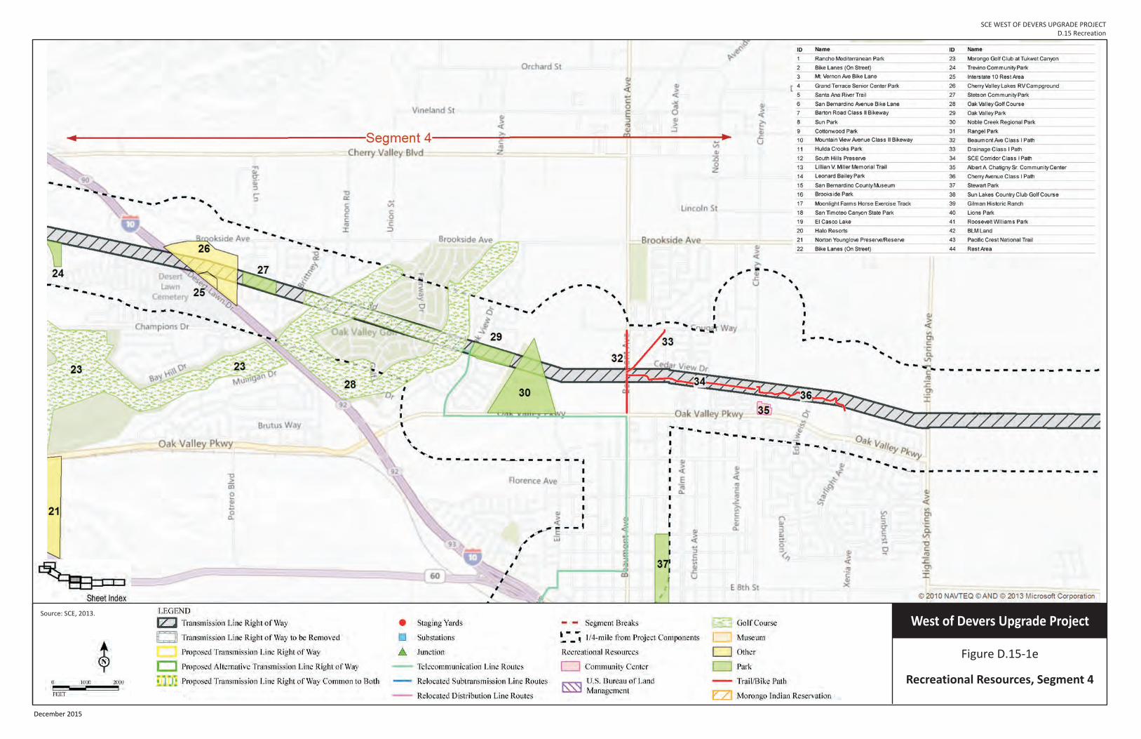
SCE WEST OF DEVERS UPGRADE PROJECT D.15 Recreation
Figure D.15-1e
Recreational Resources, Segment 4
West of Devers Upgrade ProjectSource: SCE, 2013.
December 2015

SCE West of Devers Upgrade Project D.15 RECREATION
Final EIR D.15-38 December 2015
This page intentionally blank.

SCE WEST OF DEVERS UPGRADE PROJECT D.15 Recreation
Figure D.15-1f
Recreational Resources, Segment 4
West of Devers Upgrade ProjectSource: SCE, 2013.
December 2015

SCE West of Devers Upgrade Project D.15 RECREATION
Final EIR D.15-40 December 2015
This page intentionally blank.

SCE WEST OF DEVERS UPGRADE PROJECT D.15: Recreation
Figure D.15-1g
Recreational Resources, Segment 4 & 5
West of Devers Upgrade ProjectSource: SCE, 2013.
December 2015

SCE West of Devers Upgrade Project D.15 RECREATION
Final EIR D.15-42 December 2015
This page intentionally blank.

SCE WEST OF DEVERS UPGRADE PROJECT D.15 Recreation
Figure D.15-1h
Recreational Resources, Segment 4 & 5
West of Devers Upgrade ProjectSource: SCE, 2013.
December 2015

SCE West of Devers Upgrade Project D.15 RECREATION
Final EIR D.15-44 December 2015
This page intentionally blank.
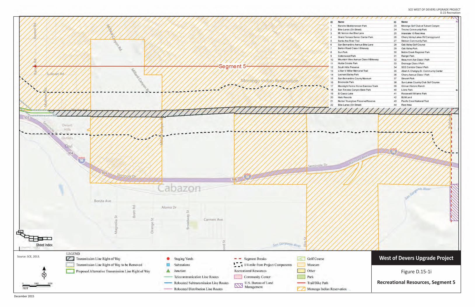
SCE WEST OF DEVERS UPGRADE PROJECT D.15 Recreation
Figure D.15-1i
Recreational Resources, Segment 5
West of Devers Upgrade ProjectSource: SCE, 2013.
December 2015

SCE West of Devers Upgrade Project D.15 RECREATION
Final EIR D.15-46 December 2015
This page intentionally blank.
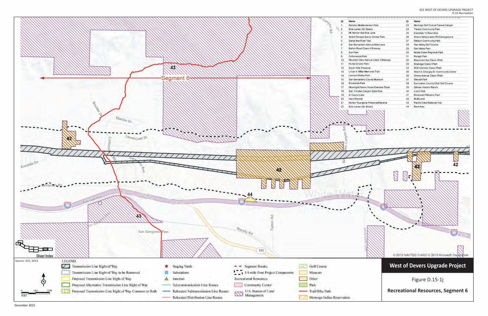
SCE WEST OF DEVERS UPGRADE PROJECT D.15 Recreation
Figure D.15-1j
Recreational Resources, Segment 6
West of Devers Upgrade ProjectSource: SCE, 2013.
4242
4242
December 2015

SCE West of Devers Upgrade Project D.15 RECREATION
Final EIR D.15-48 December 2015
This page intentionally blank.

SCE WEST OF DEVERS UPGRADE PROJECT D.15 Recreation
Figure D.15-1k
Recreational Resources, Segment 6
West of Devers Upgrade ProjectSource: SCE, 2013.
December 2015

SCE West of Devers Upgrade Project D.15 RECREATION
Final EIR D.15-50 December 2015
This page intentionally blank.