weather. the atmosphere thin layer of gas that clings to earth’s surface ( as thick as the skin...
Post on 18-Dec-2015
216 views
TRANSCRIPT
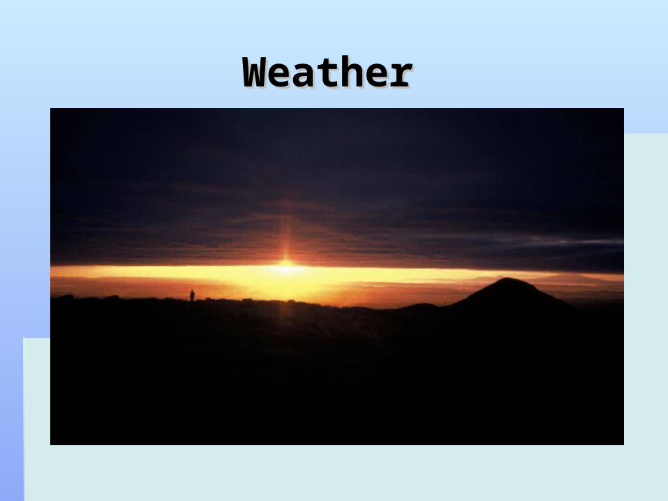
Weather Weather

The AtmosphereThe Atmosphere
Thin layer of gas that Thin layer of gas that clings to earth’s surfaceclings to earth’s surface
( as thick as the skin on ( as thick as the skin on an apple )an apple )
Water vapour varies Water vapour varies from less than 1% to 4% from less than 1% to 4% of atmosphere. This is of atmosphere. This is because of the water because of the water cycle – evaporation and cycle – evaporation and condensation.condensation.
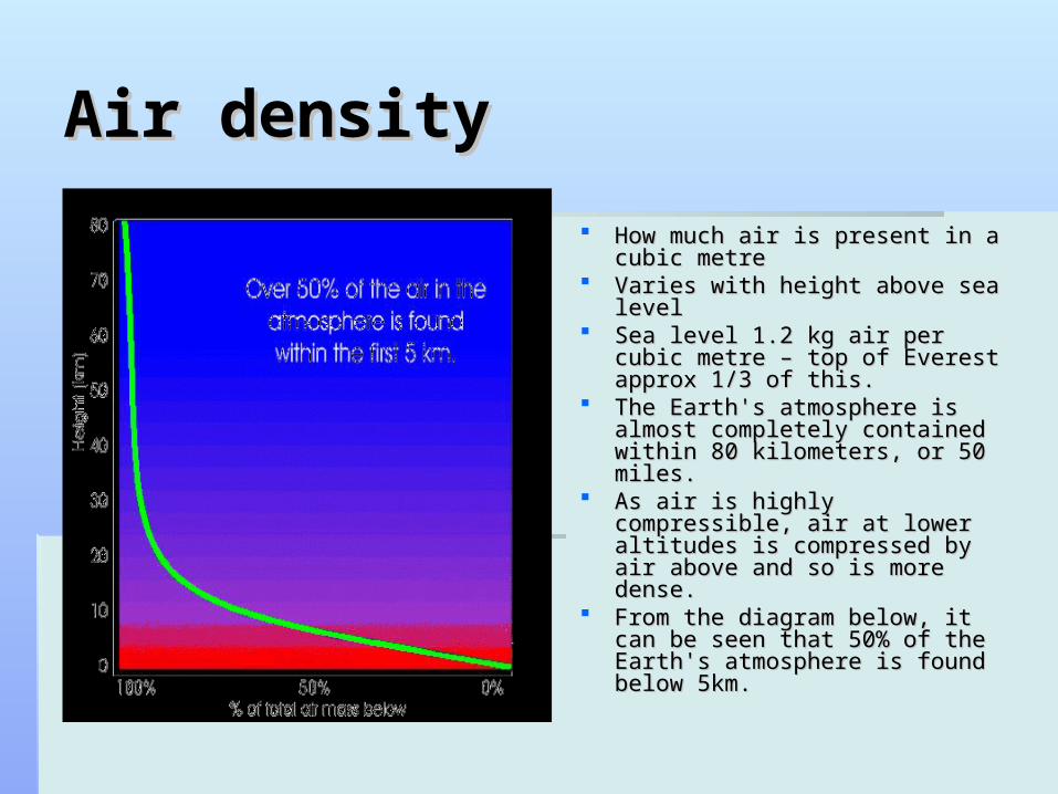
Air densityAir density
How much air is present in a How much air is present in a cubic metrecubic metre
Varies with height above sea Varies with height above sea levellevel
Sea level 1.2 kg air per cubic Sea level 1.2 kg air per cubic metre – top of Everest approx 1/3 metre – top of Everest approx 1/3 of this.of this.
The Earth's atmosphere is almost The Earth's atmosphere is almost completely contained within 80 completely contained within 80 kilometers, or 50 miles. kilometers, or 50 miles.
As air is highly compressible, air As air is highly compressible, air at lower altitudes is compressed at lower altitudes is compressed by air above and so is more by air above and so is more dense. dense.
From the diagram below, it can From the diagram below, it can be seen that 50% of the Earth's be seen that 50% of the Earth's atmosphere is found below 5km. atmosphere is found below 5km.

Air pressureAir pressure
Weight of the air vertically above an areaWeight of the air vertically above an area At mean sea level the air pressure At mean sea level the air pressure
averages just over 1000 hectopascals averages just over 1000 hectopascals ( hPa) whilst at the top of Everest ( hPa) whilst at the top of Everest ( nearer 300hPa( nearer 300hPa
The decreasing pressure with increase in The decreasing pressure with increase in height has key influence on Weather.height has key influence on Weather.

Expanding airExpanding air
As air rises from the surface it As air rises from the surface it experiences lower experiences lower surrounding pressure.surrounding pressure.
This allows the rising air to This allows the rising air to expand which in turn causes expand which in turn causes the air to cool at a rate approx the air to cool at a rate approx 1 C per 100m1 C per 100m
When air is compressed it When air is compressed it tends to heat up ( bike pump)tends to heat up ( bike pump)
When air descends it When air descends it experiences increased experiences increased pressure and so is pressure and so is compressed and heats up.compressed and heats up.

The Suns RaysThe Suns Rays
The amount of The amount of sunlight hitting the sunlight hitting the earth has an effect earth has an effect on weather.on weather.
The more sunlight The more sunlight the greater the the greater the heating that occursheating that occurs
Equator most heat, Equator most heat, poles least heatpoles least heat

How clouds are formed.How clouds are formed.
When rising air rises and cools enough it will reach saturation point.When rising air rises and cools enough it will reach saturation point. This is when water vapour will condense around a tiny dust speck and form a This is when water vapour will condense around a tiny dust speck and form a
droplet.droplet. These will stay up in the air as the are incredibly small ( 200 per millimetre )These will stay up in the air as the are incredibly small ( 200 per millimetre ) They fall slower than the surrounding air is rising and so stay airbourne. They fall slower than the surrounding air is rising and so stay airbourne. As the droplets collide or increase in size they will eventually become too large to As the droplets collide or increase in size they will eventually become too large to
stay airbourne and fall as rain.stay airbourne and fall as rain. This is one way rain forms and is known as warm rain.This is one way rain forms and is known as warm rain.
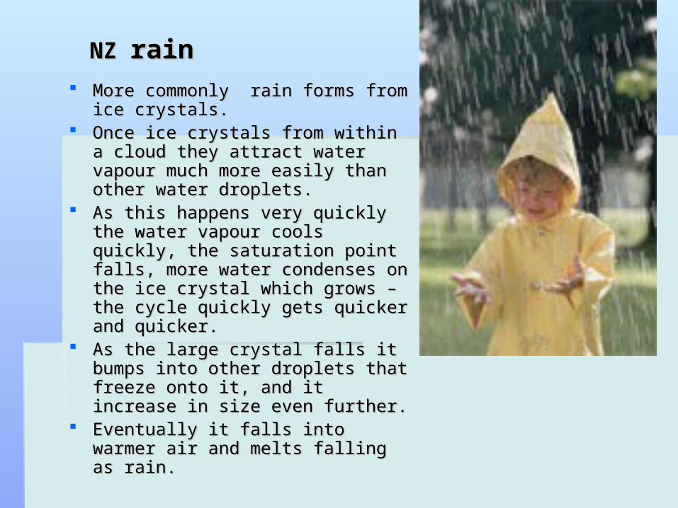
NZ NZ rainrain More commonly rain forms from ice More commonly rain forms from ice
crystals.crystals. Once ice crystals from within a cloud Once ice crystals from within a cloud
they attract water vapour much more they attract water vapour much more easily than other water droplets.easily than other water droplets.
As this happens very quickly the As this happens very quickly the water vapour cools quickly, the water vapour cools quickly, the saturation point falls, more water saturation point falls, more water condenses on the ice crystal which condenses on the ice crystal which grows – the cycle quickly gets quicker grows – the cycle quickly gets quicker and quicker.and quicker.
As the large crystal falls it bumps into As the large crystal falls it bumps into other droplets that freeze onto it, and other droplets that freeze onto it, and it increase in size even further.it increase in size even further.
Eventually it falls into warmer air and Eventually it falls into warmer air and melts falling as rain.melts falling as rain.

Rain and the Weather Rain and the Weather mapmap
To find where rain is to fall search the To find where rain is to fall search the weather map for areas where air is rising weather map for areas where air is rising or going to rise in the atmosphereor going to rise in the atmosphere

What is a weather mapWhat is a weather map
An analysis map is a An analysis map is a map that shows the map that shows the CURRENT situation CURRENT situation at the specified timeat the specified time
A prognosis map is a A prognosis map is a prediction of the prediction of the future – a forecastfuture – a forecast
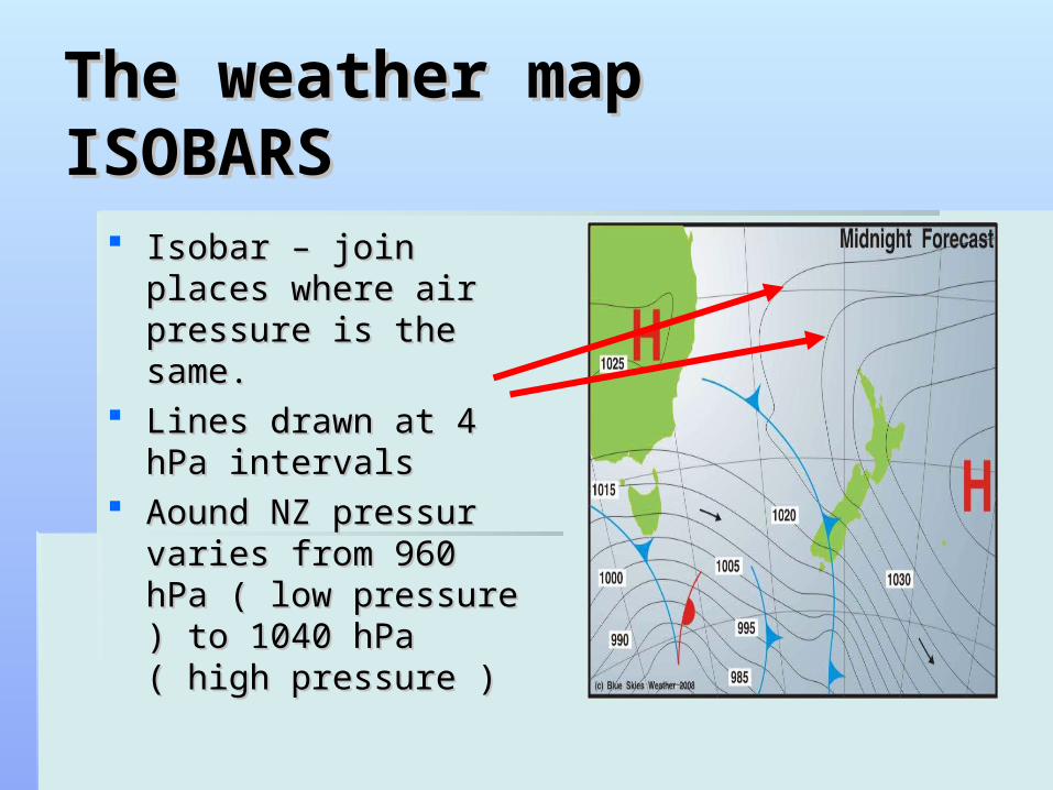
The weather mapThe weather mapISOBARSISOBARS
Isobar – join places Isobar – join places where air pressure is the where air pressure is the same.same.
Lines drawn at 4 hPa Lines drawn at 4 hPa intervals intervals
Aound NZ pressur varies Aound NZ pressur varies from 960 hPa ( low from 960 hPa ( low pressure ) to 1040 hPa pressure ) to 1040 hPa ( high pressure )( high pressure )

WindWind Is caused by the movement of air from high to low Is caused by the movement of air from high to low
pressure.pressure. From the pattern of the isobars should be able to work From the pattern of the isobars should be able to work
out what the wind is doing at different places. out what the wind is doing at different places. Air moves from high to low pressureAir moves from high to low pressure Sometimes air is deflected by obstacles in its way.Sometimes air is deflected by obstacles in its way.
WindWind
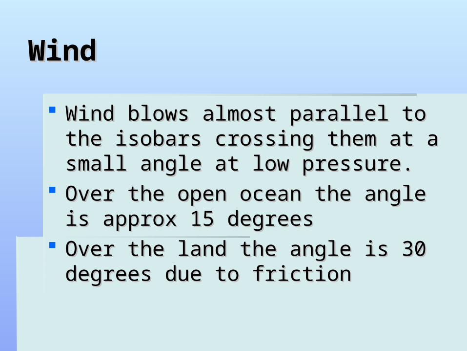
Wind blows almost parallel to the isobars Wind blows almost parallel to the isobars crossing them at a small angle at low crossing them at a small angle at low pressure.pressure.
Over the open ocean the angle is approx Over the open ocean the angle is approx 15 degrees15 degrees
Over the land the angle is 30 degrees Over the land the angle is 30 degrees due to frictiondue to friction

Coriolis effectCoriolis effect
Lower pressure at Lower pressure at tropics as heat rises, tropics as heat rises, lower pressure at poles lower pressure at poles as cold air sinks. This as cold air sinks. This continually happens.continually happens.
As this happens the As this happens the movement is deflected movement is deflected westerly by the earths westerly by the earths rotation – this is called rotation – this is called the coriolis effectthe coriolis effect
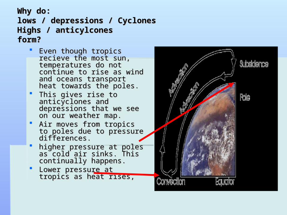
Why do:Why do:lows / depressions / Cyclones lows / depressions / Cyclones Highs / anticylcones Highs / anticylcones form?form?
Even though tropics recieve Even though tropics recieve the most sun, temperatures the most sun, temperatures do not continue to rise as do not continue to rise as wind and oceans transport wind and oceans transport heat towards the poles.heat towards the poles.
This gives rise to anticyclones This gives rise to anticyclones and depressions that we see and depressions that we see on our weather map.on our weather map.
Air moves from tropics to Air moves from tropics to poles due to pressure poles due to pressure differences.differences.
higher pressure at poles as higher pressure at poles as cold air sinks. This continually cold air sinks. This continually happens.happens.
Lower pressure at tropics as Lower pressure at tropics as heat rises,heat rises,

Covection – Tricellular Covection – Tricellular modelmodel
The tricellular model found by Ferrel is still the best model we have. The tricellular model found by Ferrel is still the best model we have. In this model the air, after crossing the warm oceans in the trade In this model the air, after crossing the warm oceans in the trade winds and becoming warm and moist, arrives at the Equator (at the winds and becoming warm and moist, arrives at the Equator (at the ITCZ, inter-tropical convergence zone) and is heated, causing it to ITCZ, inter-tropical convergence zone) and is heated, causing it to rise. rise.
The unstable air rises to form very high cumulo-nimbus clouds and The unstable air rises to form very high cumulo-nimbus clouds and afternoon thunderstorms and low-pressures are found. afternoon thunderstorms and low-pressures are found.
The equator is an area with very gentle winds called the The equator is an area with very gentle winds called the doldrumsdoldrums.. Polar Front Jet Stream (PFJS):Sub Tropical Jet Stream (STJS):Polar Front Jet Stream (PFJS):Sub Tropical Jet Stream (STJS):

Wind Patterns around the world – Wind Patterns around the world – seasonal changes will have some seasonal changes will have some
effecteffect

Pessure gradient – wind Pessure gradient – wind speed.speed.
In basic terms the In basic terms the bigger the difference bigger the difference in pressure between in pressure between the High and the Low the High and the Low the stronger the the stronger the winds will be.winds will be.
The smaller the The smaller the difference the lighter difference the lighter the winds.the winds.

Winds are named according Winds are named according to the compass direction of to the compass direction of their source. Thus, a wind their source. Thus, a wind from the north blowing toward from the north blowing toward the south is called a northerly the south is called a northerly wind. wind.
The diagram describes the The diagram describes the sixteen principal bearings of sixteen principal bearings of wind direction. Most wind direction. Most meterological observations meterological observations report wind direction using report wind direction using one of these sixteen bearings. one of these sixteen bearings.
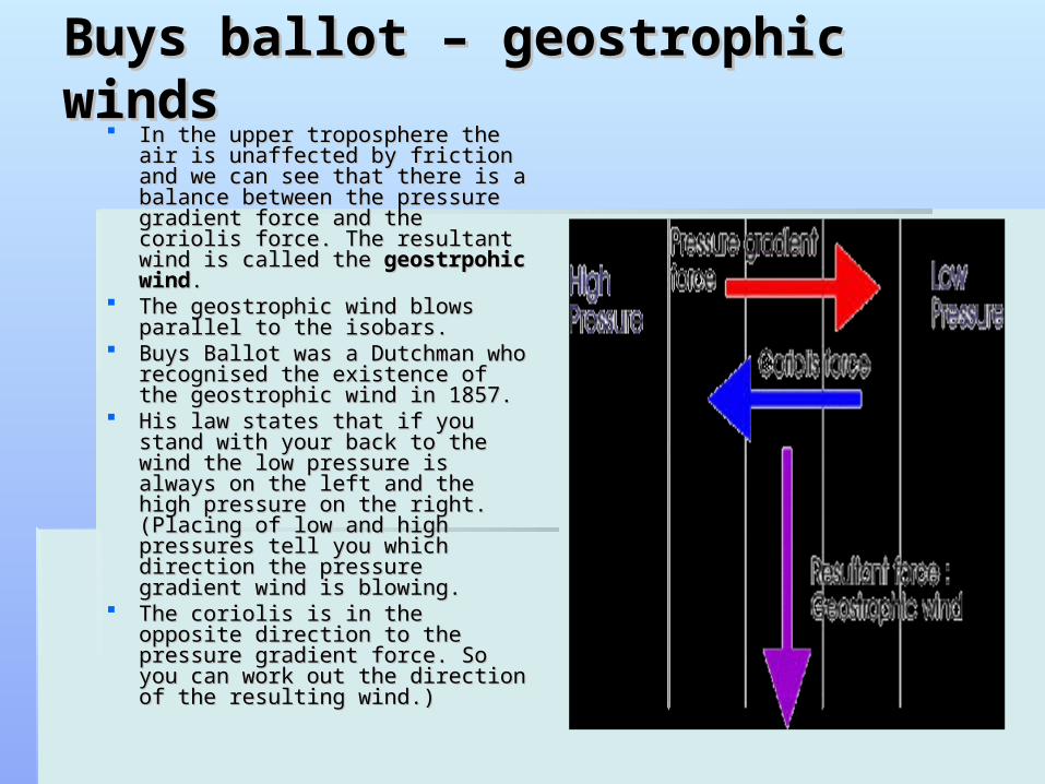
Buys ballot – geostrophic windsBuys ballot – geostrophic winds In the upper troposphere the air In the upper troposphere the air
is unaffected by friction and we is unaffected by friction and we can see that there is a balance can see that there is a balance between the pressure gradient between the pressure gradient force and the coriolis force. The force and the coriolis force. The resultant wind is called the resultant wind is called the geostrpohic windgeostrpohic wind. .
The geostrophic wind blows The geostrophic wind blows parallel to the isobars. parallel to the isobars.
Buys Ballot was a Dutchman who Buys Ballot was a Dutchman who recognised the existence of the recognised the existence of the geostrophic wind in 1857. geostrophic wind in 1857.
His law states that if you stand His law states that if you stand with your back to the wind the with your back to the wind the low pressure is always on the left low pressure is always on the left and the high pressure on the and the high pressure on the right. (Placing of low and high right. (Placing of low and high pressures tell you which direction pressures tell you which direction the pressure gradient wind is the pressure gradient wind is blowing. blowing.
The coriolis is in the opposite The coriolis is in the opposite direction to the pressure gradient direction to the pressure gradient force. So you can work out the force. So you can work out the direction of the resulting wind.) direction of the resulting wind.)

Wind directionWind direction
In southern In southern hemisphere the wind hemisphere the wind travel clockwise in a travel clockwise in a low and anti low and anti clockwise in a highclockwise in a high
In northern In northern hemisphere the flow hemisphere the flow is reversed.is reversed.

Wind strengthWind strength
In general the closer the isobars the stronger In general the closer the isobars the stronger the wind.the wind.
Does depend on lattitude. Straight isobars at Does depend on lattitude. Straight isobars at 30 degrees south would cause twice as much 30 degrees south would cause twice as much wind as at 50 degrees south .wind as at 50 degrees south .
Where winds curve tightly around a low the Where winds curve tightly around a low the wind speed may be much less than the isobars wind speed may be much less than the isobars suggest.suggest.

Low pressureLow pressure
Areas of low Areas of low pressure are marked pressure are marked with an Lwith an L
Associated with Associated with rising airrising air
As air rises it rapidly As air rises it rapidly expands and cools expands and cools thereby causing thereby causing clouds and usually clouds and usually rain.rain.

Coriolis and the Coriolis and the roundaboutroundabout The coriolis force can be The coriolis force can be
explained by using an explained by using an example of a roundabout. example of a roundabout.
If we consider person a If we consider person a standing in the middle of the standing in the middle of the roundabout and trying to roundabout and trying to throw a ball to person B throw a ball to person B standing at the edge of the standing at the edge of the roundabout. roundabout.
If A throws the ball straight at If A throws the ball straight at B then by the time the ball B then by the time the ball has reached the edge of the has reached the edge of the roundabout B has further roundabout B has further round.round.
To the people on the To the people on the roundabout it looks like the roundabout it looks like the ball has curved round to the ball has curved round to the right. right.

High PressureHigh Pressure Associated with high pressure Associated with high pressure
and sinking air. and sinking air. Marked with a HMarked with a H AnticycloneAnticyclone Air sunks compressing and Air sunks compressing and
warming – clouds evaporatewarming – clouds evaporate Produces fine settled weather Produces fine settled weather
– summer– summer In winter low cloud and drizzleIn winter low cloud and drizzle Thunderstorms common in Thunderstorms common in
summersummer Air diverges at high altitude, Air diverges at high altitude,
converges low altitude.converges low altitude.
Highs / Anti cycloneHighs / Anti cyclone Formed when air converges aloft.Formed when air converges aloft. The air descends, compresses and heats – pressure The air descends, compresses and heats – pressure
increases.increases. Water vapour remains the same, but this air becomes Water vapour remains the same, but this air becomes
relatively dry as warm air can hold more vapour.relatively dry as warm air can hold more vapour. Any cloud rapidly evaporates.Any cloud rapidly evaporates. Normally air does not reach the surface but spreads out at Normally air does not reach the surface but spreads out at
around 1500m leaving a layer of colder, denser air around 1500m leaving a layer of colder, denser air between it and the surfacebetween it and the surface
Water vapour at the edge of the cold air often form cloud.Water vapour at the edge of the cold air often form cloud. In summer this cloud burns off over the land during the dayIn summer this cloud burns off over the land during the day In winter this cloud may stay all day as the sun is not In winter this cloud may stay all day as the sun is not
strong enough to heat the air to burn it off.strong enough to heat the air to burn it off. This is common in Coastal areas.This is common in Coastal areas.
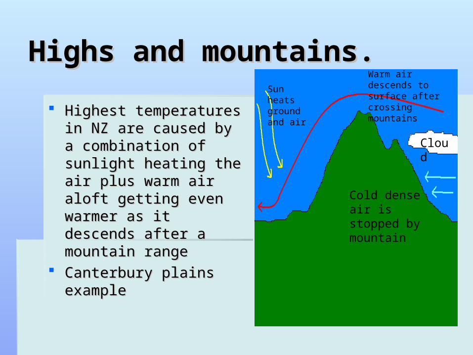
Highs and mountains.Highs and mountains.
Highest temperatures in Highest temperatures in NZ are caused by a NZ are caused by a combination of sunlight combination of sunlight heating the air plus heating the air plus warm air aloft getting warm air aloft getting even warmer as it even warmer as it descends after a descends after a mountain rangemountain range
Canterbury plains Canterbury plains exampleexample
Sun heats ground and air
Warm air descends to surface after crossing mountains
Cold dense air is stopped by mountain
Cloud
Blocking highBlocking high Important characteristics of highs or anticyclones is the Important characteristics of highs or anticyclones is the
way they sometimes become stationary or slow moving way they sometimes become stationary or slow moving for a week or more.for a week or more.
This is called BLOCKINGThis is called BLOCKING In NZ this can have an effect on the weather depending In NZ this can have an effect on the weather depending
on where the blocking high is situated.on where the blocking high is situated. If the high is centred to the west it will mean prolonged If the high is centred to the west it will mean prolonged
south / southwest winds bringing cold air up from the south / southwest winds bringing cold air up from the Antartic. ShowersAntartic. Showers
If the high is east then warm North or Northwestly winds If the high is east then warm North or Northwestly winds will be experienced. Heavy rainwill be experienced. Heavy rain
If the high is centre over the islands then weather will be If the high is centre over the islands then weather will be mainly dry apart from coastal drizzle in winter.mainly dry apart from coastal drizzle in winter.
Prolonged blocking highs in summer can lead to drought.Prolonged blocking highs in summer can lead to drought.
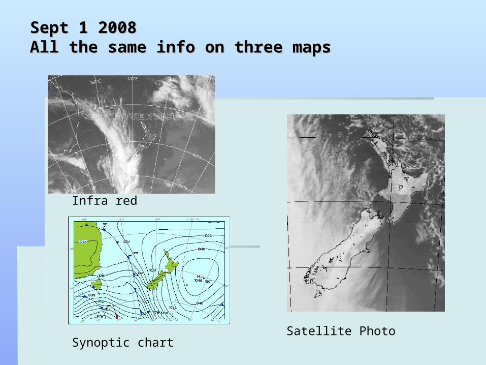
Sept 1 2008Sept 1 2008All the same info on three mapsAll the same info on three maps
Synoptic chart
Infra red
Satellite Photo
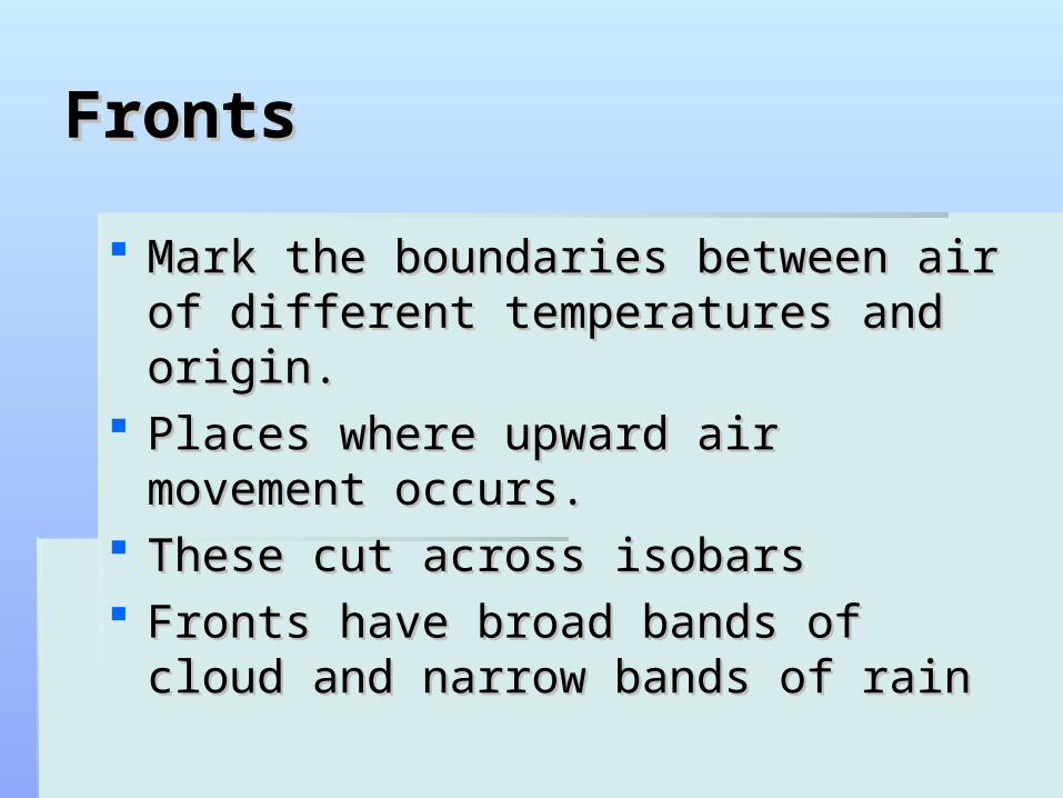
FrontsFronts
Mark the boundaries between air of Mark the boundaries between air of different temperatures and origin.different temperatures and origin.
Places where upward air movement Places where upward air movement occurs.occurs.
These cut across isobarsThese cut across isobars Fronts have broad bands of cloud and Fronts have broad bands of cloud and
narrow bands of rainnarrow bands of rain

Frontal symbolsFrontal symbols
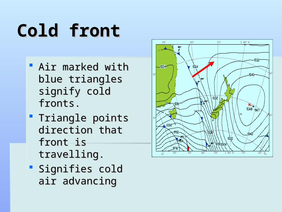
Cold frontCold front
Air marked with blue Air marked with blue triangles signify cold triangles signify cold fronts.fronts.
Triangle points Triangle points direction that front is direction that front is travelling.travelling.
Signifies cold air Signifies cold air advancingadvancing
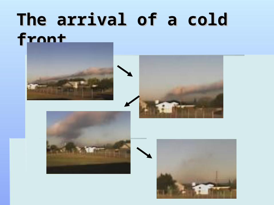
The arrival of a cold frontThe arrival of a cold front
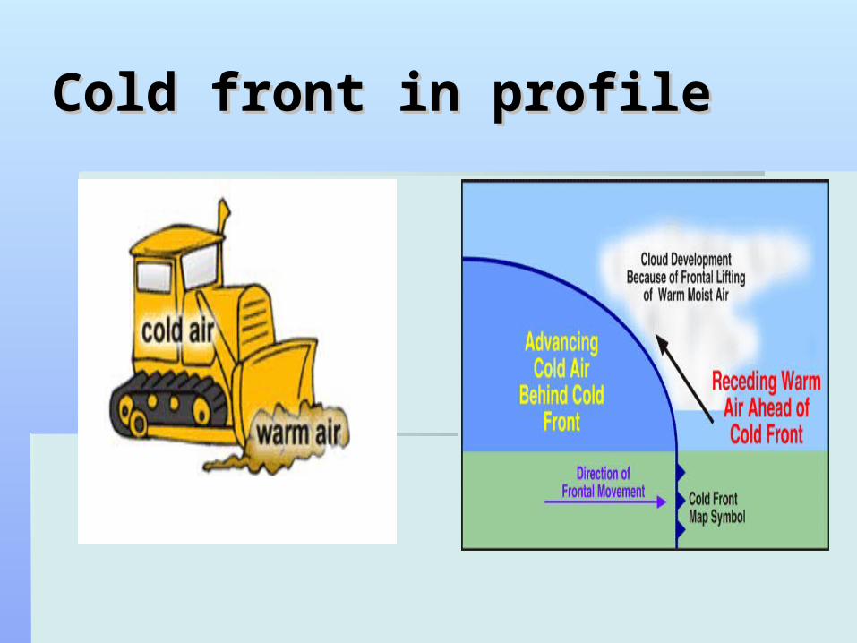
Cold front in profileCold front in profile

Warm FrontWarm Front
Shown by red half Shown by red half moons side by side moons side by side and facing the same and facing the same way.way.

Warm front in profileWarm front in profile

Occluded frontOccluded front
Where traiangle and Where traiangle and half moon shapes half moon shapes are side by side and are side by side and facing the same wayfacing the same way
No marked No marked difference between difference between temperature on temperature on either side at sea either side at sea levellevel
Stationary frontStationary front
Symbols are placed on either side of the Symbols are placed on either side of the frontfront
Shows that the front has slowed as is not Shows that the front has slowed as is not moving.moving.
If the line at the front is dashed it means If the line at the front is dashed it means it is weak.it is weak.

Troughs and ridgesTroughs and ridges
Trough - Dashed line Trough - Dashed line without triangles signifies without triangles signifies a trough ( associated a trough ( associated with lows ) frequently with lows ) frequently contains showers or contains showers or thunderstormsthunderstorms
Ridge - Area of high Ridge - Area of high pressure extending away pressure extending away from a high. Not usually from a high. Not usually marked on a map. marked on a map. Weather similar to that of Weather similar to that of a high.a high.

Who gets the rain?Who gets the rain?
If there is a front near by or strong winds If there is a front near by or strong winds blowing from seas to land likely to be rain.blowing from seas to land likely to be rain.
This is because all have or cause rising air that This is because all have or cause rising air that cools, condenses to produce rain.cools, condenses to produce rain.
In NZ our mountains have a lot to do with the In NZ our mountains have a lot to do with the rainfallrainfall
Depending on what side of the ranges you live Depending on what side of the ranges you live will determine weather you receive the rain.will determine weather you receive the rain.

Prevailing WesterliesPrevailing Westerlies
Prevailing – where it Prevailing – where it comes from most comes from most oftenoften
One of the most One of the most common weather common weather events is a cold front events is a cold front moving over NZ from moving over NZ from the tasman sea with the tasman sea with NW winds ahead NW winds ahead and SW winds and SW winds behindbehind
hokitikaChristchurch
Southern Alps

What the Map showsWhat the Map shows
Strong winds in Strong winds in Canterbury– isobars Canterbury– isobars close together ahead close together ahead of the frontof the front
Cold front pushing Cold front pushing warm air up, also warm air up, also over the Alps will over the Alps will cause heavy rain on cause heavy rain on west coast.west coast.
Deflection due to southern alps
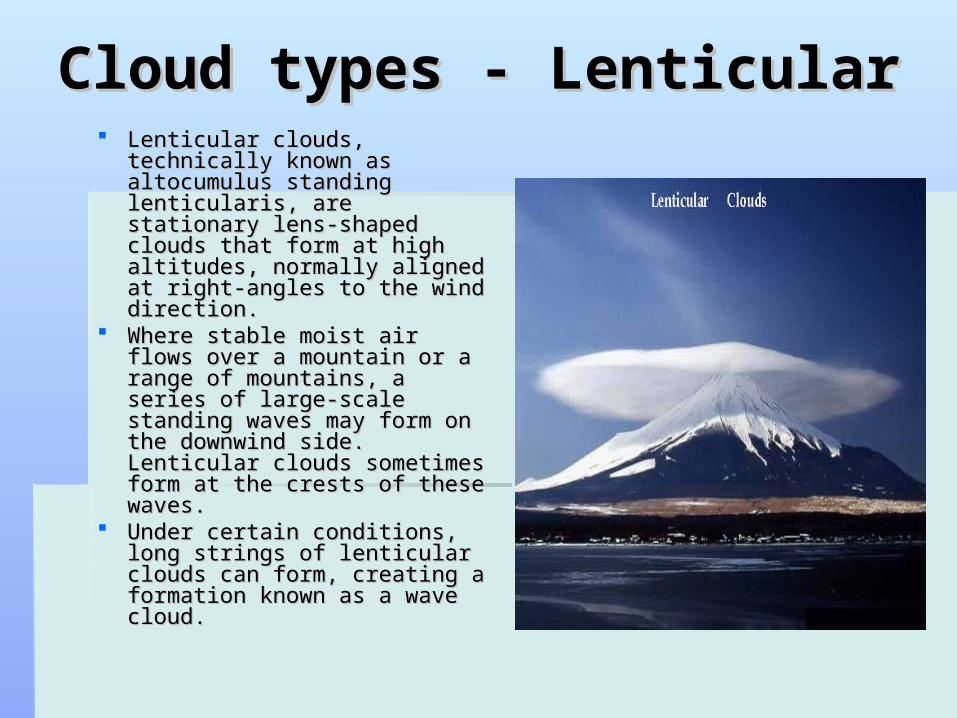
Cloud types - LenticularCloud types - Lenticular Lenticular clouds, technically Lenticular clouds, technically
known as altocumulus known as altocumulus standing lenticularis, are standing lenticularis, are stationary lens-shaped clouds stationary lens-shaped clouds that form at high altitudes, that form at high altitudes, normally aligned at right-normally aligned at right-angles to the wind direction. angles to the wind direction.
Where stable moist air flows Where stable moist air flows over a mountain or a range of over a mountain or a range of mountains, a series of large-mountains, a series of large-scale standing waves may scale standing waves may form on the downwind side. form on the downwind side. Lenticular clouds sometimes Lenticular clouds sometimes form at the crests of these form at the crests of these waves. waves.
Under certain conditions, long Under certain conditions, long strings of lenticular clouds strings of lenticular clouds can form, creating a formation can form, creating a formation known as a wave cloud. known as a wave cloud.

High cloudHigh cloud
Cirrus
Cirrostratus”halo cloud”
Cirrocumulus Clouds

Mid Layer CloudMid Layer Cloud
Altocumulus Clouds
Cumulonibus (Mamma) Clouds Alto stratus – grey sheet
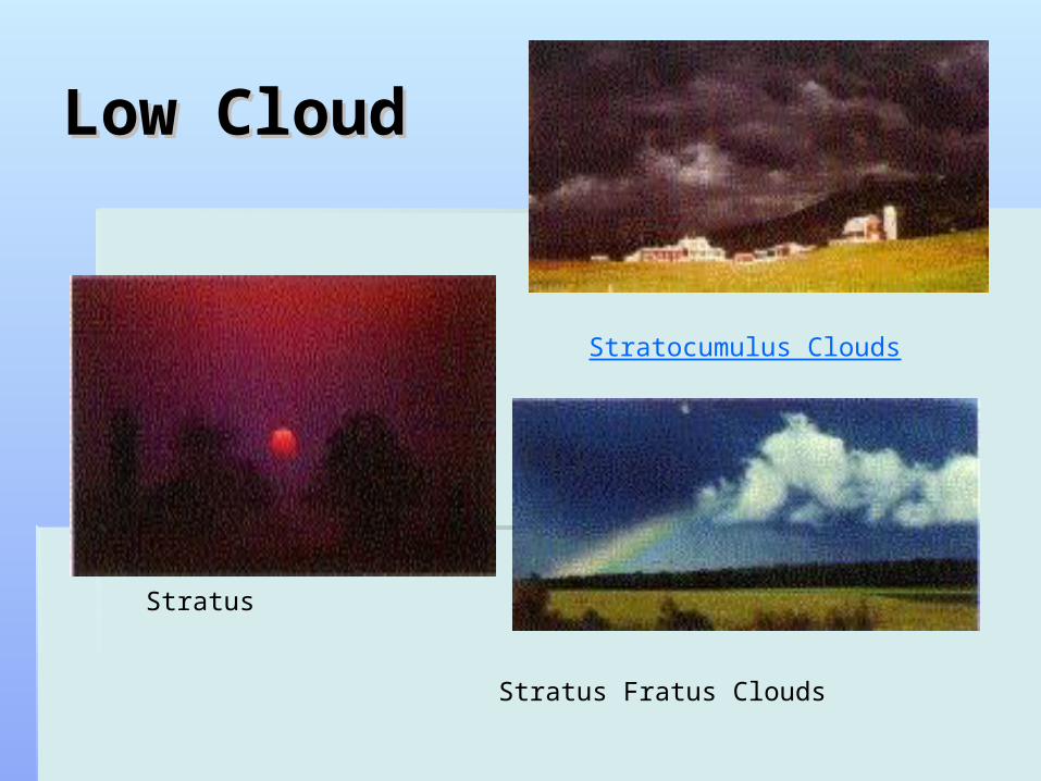
Low CloudLow Cloud
Stratus
Stratocumulus Clouds
Stratus Fratus Clouds

Vertical development Vertical development Clouds ( any height )Clouds ( any height )
Cumulonimbus – usually anvil shaped
cumulus
Growing Congest Cumulus Clouds
Cumulonimbus

CumulusCumulus
Shower cloudShower cloud Look fluffyLook fluffy Can contain heavy Can contain heavy
rainrain Last for maybe an Last for maybe an
hour or morehour or more Created by strong Created by strong
upward air motionupward air motion


Warming by the seaWarming by the sea
Most commonly in Most commonly in NZ when a cold air NZ when a cold air front from the south front from the south moves north usually moves north usually behind a cold front.behind a cold front.

Warming by the LandWarming by the Land
Happens most in the Happens most in the summersummer
Showers can be Showers can be producedproduced
Favoured are places Favoured are places where land can heat up where land can heat up quickly – ploughed fields, quickly – ploughed fields, rocky surface, citiesrocky surface, cities
Can develop into Can develop into thunderstormsthunderstorms
Sometimes firesSometimes fires

Cooling AloftCooling Aloft
Sometimes caused by divergence Sometimes caused by divergence common in NZcommon in NZ
Winds up high often stronger than down Winds up high often stronger than down below.below.

FOGFOG Simply cloud resting on earth’s surfaceSimply cloud resting on earth’s surface Humid air next to ground is cooled enough to reach saturation Humid air next to ground is cooled enough to reach saturation
point so water vapour starts to ocndensepoint so water vapour starts to ocndense Most common on clear nights with light or no wind.Most common on clear nights with light or no wind. Heat radiates into space from the land cooling the air from Heat radiates into space from the land cooling the air from
below.below. If the ground temperature is below freezing before the vapour If the ground temperature is below freezing before the vapour
starts to condense a frost will form.starts to condense a frost will form. Can also form when humid air is blown over a cold surface – Can also form when humid air is blown over a cold surface –
sometimes on the coast with on shore winds, or at seas with sometimes on the coast with on shore winds, or at seas with different temperatures in currents.different temperatures in currents.
This sometimes happens in Wellington with the cooler Cook This sometimes happens in Wellington with the cooler Cook strait.strait.
Fog can clear by evaporation, droplets falling to ground without Fog can clear by evaporation, droplets falling to ground without new vapour condensing to replace, wind changenew vapour condensing to replace, wind change
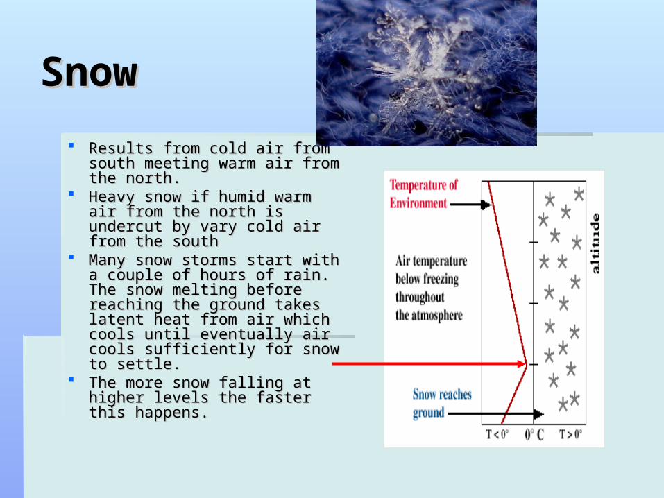
SnowSnow
Results from cold air from Results from cold air from south meeting warm air from south meeting warm air from the north.the north.
Heavy snow if humid warm air Heavy snow if humid warm air from the north is undercut by from the north is undercut by vary cold air from the southvary cold air from the south
Many snow storms start with Many snow storms start with a couple of hours of rain. The a couple of hours of rain. The snow melting before reaching snow melting before reaching the ground takes latent heat the ground takes latent heat from air which cools until from air which cools until eventually air cools eventually air cools sufficiently for snow to settle.sufficiently for snow to settle.
The more snow falling at The more snow falling at higher levels the faster this higher levels the faster this happens.happens.

HailHail Hail is a large frozen Hail is a large frozen
raindrop produced by raindrop produced by intense thunderstorms, intense thunderstorms, where snow and rain can where snow and rain can coexist in the central coexist in the central updraft. updraft.
As the snowflakes fall, As the snowflakes fall, liquid water freezes onto liquid water freezes onto them forming ice pellets them forming ice pellets that will continue to grow that will continue to grow as more and more droplets as more and more droplets are accumulated. are accumulated.
Upon reaching the bottom Upon reaching the bottom of the cloud, some of the of the cloud, some of the ice pellets are carried by ice pellets are carried by the updraft back up to the the updraft back up to the top of the storm. top of the storm.
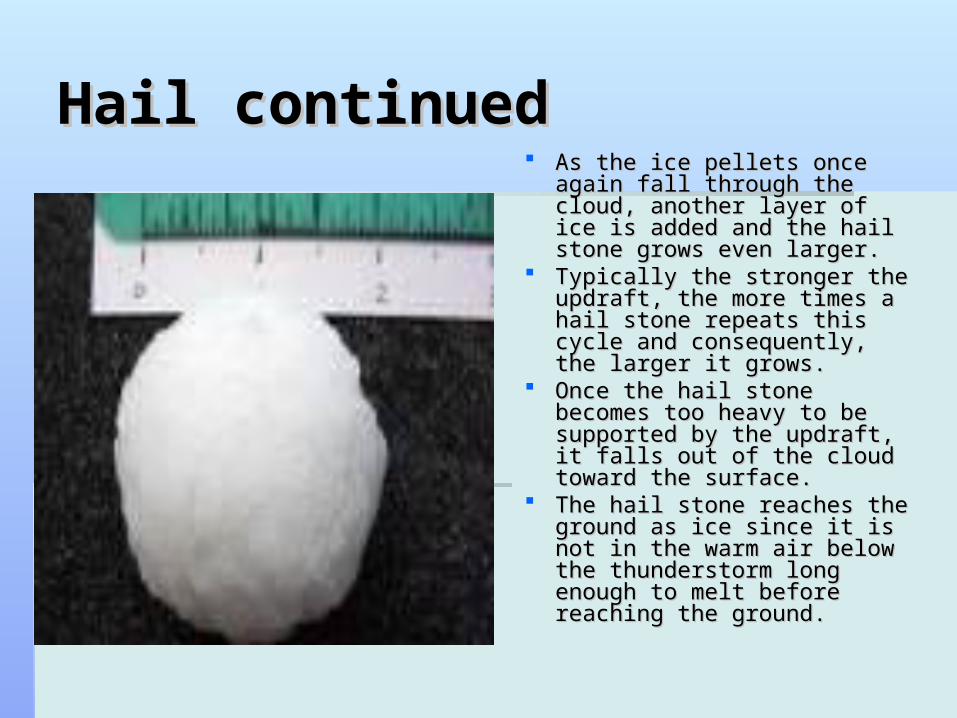
Hail continuedHail continued As the ice pellets once again As the ice pellets once again
fall through the cloud, another fall through the cloud, another layer of ice is added and the layer of ice is added and the hail stone grows even larger. hail stone grows even larger.
Typically the stronger the Typically the stronger the updraft, the more times a hail updraft, the more times a hail stone repeats this cycle and stone repeats this cycle and consequently, the larger it consequently, the larger it grows.grows.
Once the hail stone becomes Once the hail stone becomes too heavy to be supported by too heavy to be supported by the updraft, it falls out of the the updraft, it falls out of the cloud toward the surface. cloud toward the surface.
The hail stone reaches the The hail stone reaches the ground as ice since it is not in ground as ice since it is not in the warm air below the the warm air below the thunderstorm long enough to thunderstorm long enough to melt before reaching the melt before reaching the ground. ground.
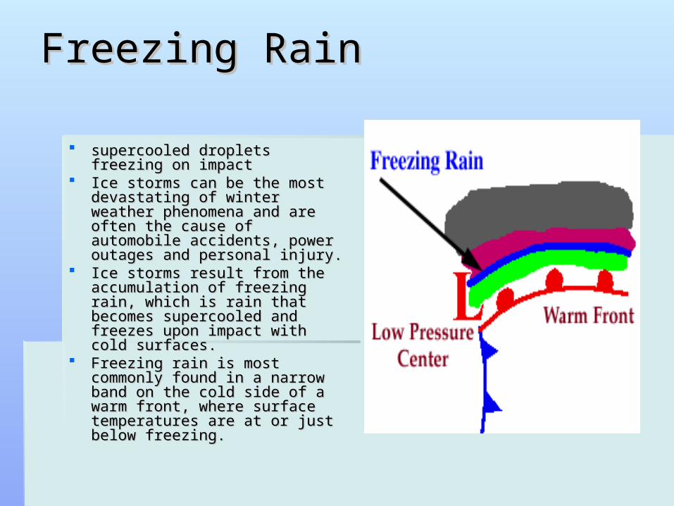
Freezing RainFreezing Rain
supercooled droplets freezing on supercooled droplets freezing on impact impact
Ice storms can be the most Ice storms can be the most devastating of winter weather devastating of winter weather phenomena and are often the phenomena and are often the cause of automobile accidents, cause of automobile accidents, power outages and personal power outages and personal injury. injury.
Ice storms result from the Ice storms result from the accumulation of freezing rain, accumulation of freezing rain, which is rain that becomes which is rain that becomes supercooled and freezes upon supercooled and freezes upon impact with cold surfaces.impact with cold surfaces.
Freezing rain is most commonly Freezing rain is most commonly found in a narrow band on the found in a narrow band on the cold side of a warm front, where cold side of a warm front, where surface temperatures are at or surface temperatures are at or just below freezing. just below freezing.

Freezing rain continuedFreezing rain continued Freezing rain develops as Freezing rain develops as
falling snow encounters a layer falling snow encounters a layer of warm air deep enough for the of warm air deep enough for the snow to completely melt and snow to completely melt and become rain. become rain.
As the rain continues to fall, it As the rain continues to fall, it passes through a thin layer of passes through a thin layer of cold air just above the surface cold air just above the surface and cools to a temperature and cools to a temperature below freezing. below freezing.
However, the drops themselves However, the drops themselves do not freeze, a phenomena do not freeze, a phenomena called supercooling (or forming called supercooling (or forming "supercooled drops"). "supercooled drops").
When the supercooled drops When the supercooled drops strike the frozen ground (power strike the frozen ground (power lines, or tree branches), they lines, or tree branches), they instantly freeze, forming a thin instantly freeze, forming a thin film of ice, hence freezing rain. film of ice, hence freezing rain.
SleetSleet
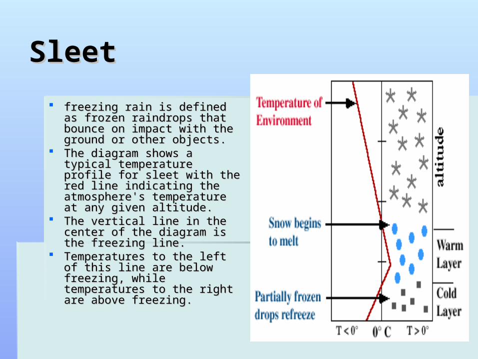
freezing rain is defined as freezing rain is defined as frozen raindrops that bounce frozen raindrops that bounce on impact with the ground or on impact with the ground or other objects. other objects.
The diagram shows a typical The diagram shows a typical temperature profile for sleet temperature profile for sleet with the red line indicating the with the red line indicating the atmosphere's temperature at atmosphere's temperature at any given altitude. any given altitude.
The vertical line in the center The vertical line in the center of the diagram is the freezing of the diagram is the freezing line. line.
Temperatures to the left of Temperatures to the left of this line are below freezing, this line are below freezing, while temperatures to the while temperatures to the right are above freezing. right are above freezing.

Sleet continuedSleet continued
Sleet is more difficult to Sleet is more difficult to forecast than freezing forecast than freezing rain because it develops rain because it develops under more specialized under more specialized atmospheric conditions. atmospheric conditions. It is very similar to It is very similar to freezing rain in that it freezing rain in that it causes surfaces to causes surfaces to become very slick, but is become very slick, but is different because its different because its easily visible. easily visible.

La Nina / El NinoLa Nina / El Nino
La Nina – NW winds. Wet weather to La Nina – NW winds. Wet weather to eastern areas, Bay of plenty, East capeeastern areas, Bay of plenty, East cape
El Nino – W winds. Wet weather west El Nino – W winds. Wet weather west coast, dry east coast - canterburycoast, dry east coast - canterbury

Katabatic / adiabatic Katabatic / adiabatic
Katabatic where air cooled at the top of Katabatic where air cooled at the top of mountains and descendsmountains and descends
Adiabatic where air warms at bottom of Adiabatic where air warms at bottom of mounatins and rises.mounatins and rises.
Lapse rates is the term given as to the Lapse rates is the term given as to the temperature at given points of altitude.temperature at given points of altitude.

KatabaticKatabatic
Most katabatic winds (except the Foehn) are Most katabatic winds (except the Foehn) are more or less the result of air in contact with more or less the result of air in contact with upper level ground is cooled by radiation, upper level ground is cooled by radiation, increases in density, and flows downhill and increases in density, and flows downhill and along the valley bottom. For example radiation along the valley bottom. For example radiation cooling during nighttime can cause a katabatic cooling during nighttime can cause a katabatic flow in the early morning when a pool of cold, flow in the early morning when a pool of cold, high elevation air begins to descend beneath high elevation air begins to descend beneath warmer, less dense air. warmer, less dense air.

Adiabatic lapse rateAdiabatic lapse rate
The temperature of the The temperature of the air at sea level on the air at sea level on the west side of the west side of the mountain begins at 30 mountain begins at 30 degrees celsius. The air degrees celsius. The air begins to rise over the begins to rise over the mountain cooling at the mountain cooling at the dry adiabatic rate of -10 dry adiabatic rate of -10 degrees/1000 meters. degrees/1000 meters.
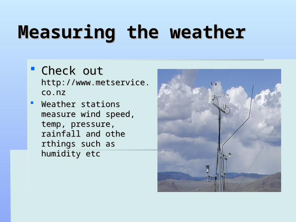
Measuring the weatherMeasuring the weather
Check out Check out http://www.metservice.co.nzhttp://www.metservice.co.nz
Weather stations measure Weather stations measure wind speed, temp, pressure, wind speed, temp, pressure, rainfall and othe rthings such rainfall and othe rthings such as humidity etcas humidity etc