weather considerations for uas integration · weather considerations for uas integration sponsor:...
TRANSCRIPT

Scot Campbell
8 December 2016
Weather Considerations for UAS Integration
Sponsor: Steve Abelman, ANG-C6
DISTRIBUTION STATEMENT A. Approved for public release: distribution unlimited.
Lincoln Laboratory Air Traffic Control Workshop 2016 - 2SC 8 December 2016
Legal Notices
This material is based upon work supported by the Federal Aviation Administration under Air Force Contract No. FA8721-05-C-0002 and/or FA8702-15-D-0001. Any opinions, findings, conclusions or recommendations expressed in this material are those of the author(s) and do not necessarily reflect the views of the Federal Aviation Administration.
© 2016 Massachusetts Institute of Technology.
Delivered to the U.S. Government with Unlimited Rights, as defined in DFARS Part 252.227-7013 or 7014 (Feb 2014). Notwithstanding any copyright notice, U.S. Government rights in this work are defined by DFARS 252.227-7013 or DFARS 252.227-7014 as detailed above. Use of this work other than as specifically authorized by the U.S. Government may violate any copyrights that exist in this work.

Lincoln Laboratory Air Traffic Control Workshop 2016 - 3SC 8 December 2016
Example Weather Impacts on UAS
“When the aircraft flew into cloud cover, it simultaneously lost satellite link. Shortly thereafter, the crew spotted ice buildup using the onboard camera. Before they could recover the aircraft from cloud cover, ice buildup and lost link made the controls erratic, causing the aircraft to stall.”
“… he had been trying to take pictures of the monument and that the wind blew the drone across a street that divides the White House from the grounds of the Washington Monument.”
Small UAS Large UAS
October 5, 2015
September 24, 2015

Lincoln Laboratory Air Traffic Control Workshop 2016 - 4SC 8 December 2016
Current Weather Sources
Aviation weather products have evolved over time for conventional aircraft.Needs specific to UAS operations have not been defined
Aviation-Specific WeatherConsumer Weather
Point-Based Weather Forecasts
Simple Drone Weather Apps
Lincoln Laboratory Air Traffic Control Workshop 2016 - 5SC 8 December 2016
• Background
• UAS Weather Needs Study
• Weather Considerations for Visual Line Of Sight (VLOS)
• Weather Considerations for Beyond VLOS (BVLOS)
• Summary
Overview

Lincoln Laboratory Air Traffic Control Workshop 2016 - 6SC 8 December 2016
FAA / LincolnUAS Weather Study Objectives
Investigate weather information requirements for UAS operations
Consider a wide range of UAS missions and weather conditions
Identify weather information gaps
Provide preliminary UAS weather research
roadmap to FAA

Lincoln Laboratory Air Traffic Control Workshop 2016 - 7SC 8 December 2016
Weather Information Gap IdentificationProcess
• Dependent on mission class
• Safety
• Airspace management
• Mission efficiency
• Mission urgency
Mission Classification
Operator Surveys and Interviews
ConOps and Vision for Integration
Mission ClassClass Code
Use Case
Bridge and Structure InspectionAccident Scene InvestigationAerial Photography / ImagingAgriculture (Crop Monitoring/ Management)Media / CinematographySurveying and MappingResearch and DevelopmentSearch and RescueSnowpack MonitoringPower Production InspectionAgriculture (Crop Monitoring/ Management)Agriculture (Aerial Application)Search and RescueTraffic MonitoringSurveillance / Reconnaissance SensingPackage DeliverySurveying and MappingSnowpack Monitoring
0‐500 ft / 0‐1 hr / 0‐3 mi
0‐500 ft / 0‐1 hr / 3‐25 mi
L1
L2
Current Weather Products
UAS Weather Needs
Similar Missions
Strategies for Airspace Management
UAS Weather Gaps
List of Wx Products Ability to meet need
Recommendations for deeper
quantitative analysis and development

Lincoln Laboratory Air Traffic Control Workshop 2016 - 8SC 8 December 2016
Stakeholder Outreach
• Stakeholder surveys: Identify mission operational characteristics, weather impact, weather resources, and potential weather information gaps
• Surveyed population:
4000+ Surveys Disseminated – Received 102 Responses or Interviews to date

Lincoln Laboratory Air Traffic Control Workshop 2016 - 9SC 8 December 2016
• UAS operation characteristics• Weather considerations and significance to mission• Currently-available weather information sources & utility• Additional weather information needs
Survey Content

Lincoln Laboratory Air Traffic Control Workshop 2016 - 10SC 8 December 2016
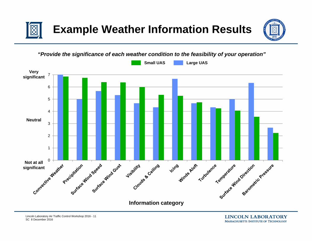
Example Weather Information Results
Information category
Not at allsignificant
Verysignificant
Neutral
“Provide the significance of each weather condition to the feasibility of your operation”Small UAS
0
1
2
3
4
5
6
7
Lincoln Laboratory Air Traffic Control Workshop 2016 - 11SC 8 December 2016
Example Weather Information Results
Information category
Not at allsignificant
Verysignificant
Neutral
“Provide the significance of each weather condition to the feasibility of your operation”Small UAS Large UAS
0
1
2
3
4
5
6
7
Lincoln Laboratory Air Traffic Control Workshop 2016 - 12SC 8 December 2016
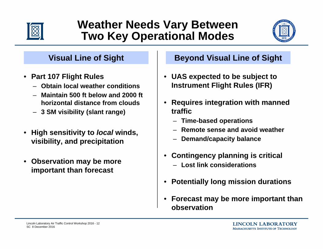
• Part 107 Flight Rules– Obtain local weather conditions– Maintain 500 ft below and 2000 ft
horizontal distance from clouds– 3 SM visibility (slant range)
• High sensitivity to local winds, visibility, and precipitation
• Observation may be more important than forecast
Weather Needs Vary BetweenTwo Key Operational Modes
• UAS expected to be subject to Instrument Flight Rules (IFR)
• Requires integration with manned traffic– Time-based operations– Remote sense and avoid weather– Demand/capacity balance
• Contingency planning is critical– Lost link considerations
• Potentially long mission durations
• Forecast may be more important than observation
Visual Line of Sight Beyond Visual Line of Sight

Lincoln Laboratory Air Traffic Control Workshop 2016 - 13SC 8 December 2016
• Background
• UAS Weather Needs Study
• Weather Considerations for Visual Line Of Sight (VLOS)
• Weather Considerations for Beyond VLOS (BVLOS)
• Summary
Overview

Lincoln Laboratory Air Traffic Control Workshop 2016 - 14SC 8 December 2016
1. Precipitation / Thunderstorms
– UAS not waterproof
2. Surface Wind– Controllability– Ability to stay within
geofence boundaries
3. Clouds and Visibility– Part 107 weather
minimums to separate from IFR traffic
– Maintain visual contact with UAS
Significant Weather for VLOS
Local Conditions are Critical
…

Lincoln Laboratory Air Traffic Control Workshop 2016 - 15SC 8 December 2016
Local Variability in C&V
• Geographic location– Terrain effects– Atmospheric effects
• Time– Weather is dynamic

Lincoln Laboratory Air Traffic Control Workshop 2016 - 16SC 8 December 2016
Ceiling & Visibility (C&V) Gap Analysis:Qualitative Evaluation
Weather Product Rated Ability to Meet Weather NeedMETAR/ASOS Direct measurement, but often not co-located with launch site. MOS/LAMP Demonstrated skill, with some diminishment after 24 hours. Terminal Aerodrome Forecast (TAF)
Less precision than MOS/LAMP, but human value-added for aviation weather thresholds. Limited to airports.
Direct Observation Provides direct observation at launch location, but usually restricted to visual estimate rather than measurement.
Satellite Imagery Good for areal coverage, but lacking in height.Area Forecast Broad area forecast of C&V.Prog Charts Broad forecast of C&V.
NWP Models High resolution area coverage. Practical application shows up in statistical products (MOS/LAMP).
NEXRAD Provides precipitation but not explicit C&V.TDWR Provides precipitation but not explicit C&V.PIREP Few low altitude observations away from airportAIRMET Broad forecast of C&V.ITWS Provides precipitation but not explicit C&V.CIWS Provides precipitation but not explicit C&V.CoSPA Provides precipitation but not explicit C&V.NWS Point Forecasts High resolution area coverage. Height information typically not included.
Mostly meets weather need Partially meets weather need Does not meet weather need

Lincoln Laboratory Air Traffic Control Workshop 2016 - 17SC 8 December 2016
• Potential TAF constraints– Updates only scheduled
every 6 hours: may not capture dynamic changes
– Forecast can lag/lead observation: may miss timing of events
– Only valid in the vicinity of an airport: may not be valid at remote location
Ceiling & Visibility (C&V) Gap Analysis:Example Quantitative Evaluation
Terminal Aerodrome Forecast (TAF)
Less precision than MOS/LAMP, but human value-added for aviation weather thresholds. Limited to airports.
Impact of potential limitations (gaps) can be quantified through statistical analysis

Lincoln Laboratory Air Traffic Control Workshop 2016 - 18SC 8 December 2016
• Background
• UAS Weather Needs Study
• Weather Considerations for Visual Line Of Sight (VLOS)
• Weather Considerations for Beyond VLOS (BVLOS)
• Summary
Overview

Lincoln Laboratory Air Traffic Control Workshop 2016 - 19SC 8 December 2016
1. Thunderstorms– Unable to ‘see and avoid’
2. Winds Aloft– Critical for time-based ops
3. Icing– Lack of ice protection
4. Urban/Terrain Wind Effects
Significant Weather for BVLOS
Uncertainty degrades efficiency due to strict contingency planning
…

Lincoln Laboratory Air Traffic Control Workshop 2016 - 20SC 8 December 2016
Effect of Wind onPredicted Flight Time
0
10
20
30
40
50
60
70
0 50 100 150 200 250 300 350 400
Flig
ht T
ime
Erro
r (%
)
Assumptions• Planned flight is direct route between
origin and destination• Flight time = Distance / Ground Speed• Ground Speed = Cruise Speed – Wind Error• Constant wind error
DJI Phantom
Scan Eagle
ReaperGlobal Hawk
10 knot wind error
5 knot wind error
Cruise Speed (knots)

Lincoln Laboratory Air Traffic Control Workshop 2016 - 21SC 8 December 2016
Winds Aloft Gap Analysis:Qualitative Evaluation
Weather Product Ability to Meet Weather NeedNumerical Weather Prediction Models
High resolution area coverage. Practical application in statistical products (MOS/LAMP).
Wind/Temp Aloft Tables Does not provide low level winds information. Direct Observation This would provide wind aloft at launch location. However, not typically available.
METAR/ASOS Primary value is some correlation between surface and aloft wind. Often not co-located with launch site.
Terminal Aerodrome Forecast (TAF)
Less precision than MOS/LAMP, but human value-added for aviation weather thresholds.
MOS/LAMP Primary value is some correlation between surface and aloft wind.Area Forecast Broad area forecast of significant winds. Aloft not typically represented.NWS Point Forecasts Winds aloft not typically addressed. Primary value is correlation with surface winds.Rawinsonde Soundings Sparse observationTDWR Gust front product. Sparse.ITWS Terminal winds product. Limited availability.
NEXRAD Unexploited Doppler information.
AIRMET Provides high threshold wind warning. Not typically aloft.
Mostly meets weather need Partially meets weather need Does not meet weather need
Lincoln Laboratory Air Traffic Control Workshop 2016 - 22SC 8 December 2016
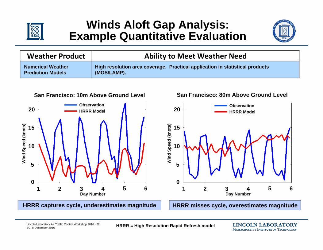
Winds Aloft Gap Analysis:Example Quantitative Evaluation
San Francisco: 10m Above Ground Level San Francisco: 80m Above Ground Level
HRRR captures cycle, underestimates magnitude HRRR misses cycle, overestimates magnitude
HRRR = High Resolution Rapid Refresh model
ObservationHRRR Model
ObservationHRRR Model
0
5
10
15
20
1 2 3 4 5 6
Win
d Sp
eed
(kno
ts)
Day Number
0
5
10
15
20
1 2 3 4 5 6
Win
d Sp
eed
(kno
ts)
Day Number
Weather Product Ability to Meet Weather NeedNumerical Weather Prediction Models
High resolution area coverage. Practical application in statistical products(MOS/LAMP).

Lincoln Laboratory Air Traffic Control Workshop 2016 - 23SC 8 December 2016
• Background
• UAS Weather Needs Study
• Weather Considerations for Visual Line Of Sight (VLOS)
• Weather Considerations for Beyond VLOS (BVLOS)
• Summary
Overview

Lincoln Laboratory Air Traffic Control Workshop 2016 - 24SC 8 December 2016
• Off-airport weather conditions– Off-airport winds, including urban and
terrain effects– Ceiling & visibility for Part 107 operations
• Low-level winds aloft– To enable time-based integration
• Weather-impacted capacity prediction for sUAS– Weather avoidance models for sUAS of
different capability levels
• Tactical weather avoidance for BVLOS
Summary of Key UAS Weather Gaps
• Long-range weather forecasts for missions up to 30 hours– Convective weather (including cloud
tops)– Stratospheric turbulence– Icing layers
• Characterization of weather forecast uncertainty for contingency planning
• High-level winds aloft– Forecasted winds up to FL600 to enable
time-based integration
• Tactical weather avoidance for BVLOS
Gaps being translated into research roadmap based on magnitude and importance
‘Small’ UAS ‘Large’ UAS
Focus on weather that impacts UAS operations

Lincoln Laboratory Air Traffic Control Workshop 2016 - 25SC 8 December 2016
1. Evaluate Numerical Weather Model performancea) Determine 80m and 10m HRRR forecast performance over a variety of geographic areasb) Determine accuracy of 80m and 10m HRRR analysis field over a variety of geographic areas
2. Quantify the sensitivity of time-based operation performance to wind model accuracya) Consider wide range of UAS platformsb) Model and simulate UAS operations in historical wind conditionsc) Establish recommendations for wind model accuracy to support sUAS time-based operations
Preliminary Roadmap
Example: Winds aloft below 500 feet to support time-based operations
• Research roadmap connects UAS weather gaps to R&D activities
• Roadmap topics include:– Evaluation of weather observation, model, and forecast performance (spatial and temporal)– Determination of weather requirements to support UAS operations– Dissemination of restricted or unobservable weather data to the UAS operator– Development of advanced weather technology to address UAS weather gaps

Lincoln Laboratory Air Traffic Control Workshop 2016 - 26SC 8 December 2016
• Current weather information may not meet needs of UAS operations
• FAA / Lincoln study is developing preliminary UAS weather research roadmap– Covering broad spectrum of UAS classes and mission types– Surveying stakeholders: vehicle- and mission-specific requirements– Correlating against current weather information sources to identify gaps
• Potential opportunity for new weather-based decision support tools to provide safety and operational benefits– Current weather products and tools may be tailored for specific ops– Wholly new data sources and products may be required
Summary
Lincoln Laboratory Air Traffic Control Workshop 2016 - 27SC 8 December 2016
Questions?