ways of seeing environmental change: participatory...
TRANSCRIPT

Ways of seeing environmental change: Participatoryresearch engagement in Yunnan, China, with ethnic
minority Hani participantsapv_1422 164..178
John McKinnonVictoria University of Wellington, New Zealand.
Email: [email protected]
Abstract: In this article, I reflect on a participatory learning and action (PLA) and participatorygeographic information system (PGIS) project undertaken in two adjacent Hani villages in southernYunnan, China. After a lengthy process to gain research authorisations, Hani villagers worked witha group of visiting researchers (Hani, Han Chinese and New Zealanders) to articulate local visionsof land-use change and environmental challenges. PLA exercises produced a diverse range ofhand-made and PGIS products over a 10-week period. As villagers became more accustomed tothe ‘outsider team’, methods – both designed and spontaneous – diversified. Afterwards, based onthe results and acting on their own initiative, local leaders backed by popular support moved quicklyto reassert traditional and ritually prescribed Hani conservation measures. Nevertheless, theseendogenously driven solutions were not necessarily universally beneficial. In describing the com-plexities encountered in implementing a participatory framework and the ambiguities of the out-comes engendered, I argue that privileging local coherence and celebrating such participatoryapproaches should not be done at the expense of ignoring the intricacies of on-going contradictorybehaviours in a rapidly changing arena. Yet, in China, where authorities often remain suspiciousof those seeking to undertake long-term fieldwork, especially among ethnic minorities, PLA offers apotential route forward.
Keywords: China, fieldwork, Hani, participatory geographic information systems (PGIS), partici-patory learning and action (PLA), Yunnan
Introduction: A project in search of a partner
Until the 1990s, the state, the Party,1 interna-tional development agencies, overseas academ-ics and so forth, set their own agendas thatimpinged on ethnic minorities’ lives in China inways that were quickly normalised. Interventionwas (and often continues to be) asserted withina modernisation framework that prioritisedeither what was ‘best’ for the greatest numberor, more likely, what national power elites sawas being in the best interests of the state. Undersocialist agendas, although ethnic minoritieswere given the full legal rights of citizens, theywere still likely to find themselves categorisedas outsiders, either as a political and environ-mental threat to the nation, or treated like pri-mitive, exotic objects whose principal talent
was to entertain by dancing in circles holdinghands, and whose destiny was to be patronised(Harrell, 2001).
During the 1990s, with the help of inter-national support, ethnic minorities in Chinafound it easier to claim a place on the inter-national stage. Through a rise in the number oflobby groups, conferences, documents such asthe Declaration on the Rights of IndigenousPeoples (2007), UN agencies (InternationalLabour Organization) and development bankssuch as the Asian Development Bank, the rights,positions and prospects of indigenous peoplesreceived increased attention and legitimacy.This access was accompanied by the grow-ing use of participatory research techniquesdesigned to engage local people in develop-ment planning. These approaches emerged as a
Asia Pacific Viewpoint, Vol. 51, No. 2, August 2010ISSN 1360-7456, pp164–178
© 2010 The AuthorJournal compilation © 2010 Victoria University of Wellington
doi: 10.1111/j.1467-8373.2010.01422.x

strategy to navigate old bipolar arrangementsin ways that might enable ethnic minority andindigenous communities to exercise some influ-ence over the outcomes of ‘development’ andover their own identities. With the help of theFord Foundation, agencies such as the YunnanInstitute of Geography were able to experimentwith Participatory Rural Appraisal (PRA); in thiscase, establishing a specialised Rural Develop-ment Research Center. In turn, this centre pro-vided PRA training for government and NGOsorganisations, mentored their progress and setup a PRA network to exchange information andshare experiences.
In the early 1990s, in consultation withGraeme Aggett, a geographic information spe-cialist (GIS), I developed an integrated approachto participatory learning and action (PLA) whichwe called mobile interactive GIS (MIGIS) in afield which is now better known as participatoryGIS (PGIS). We took MIGIS toThailand where weworked with the Highland Inter Mountain Peo-ple’s Education and Culture inThailand Associa-tion (IMPECT) to research the interactions ofmembers of an ethnic minority group, the Karen,with their local environment and to what degreethey were engaged in the broader political andcultural life of the region. Through participatorytechniques of engagement, supplemented by theuse of maps and digital photographs (McKinnon,2003: 64–84; McKinnon, 2005: 217–232), itbecame clear that communities were aware ofthe challenges of coping with intrusive forces inthe dominant societies around them – such asurbanisation, and the increasing sophisticationand seductive power of markets and globalisa-tion. Moreover, communities were keen to adoptsome new forms through which to express theiridentities and concerns (see Williams, 1975;Bourdieu, 1977; Li, 1996; Ganjanapan, 2000).The positive response of the Karen to this parti-cipatory research opportunity gave me the con-fidence to propose a similar undertaking in arelatively isolated highland community in thePeople’s Republic of China.
It was in pursuit of an upland, ethnic minorityfield site, in which to extend exploration ofthe usefulness of the PLA and PGIS tools usedduring the Karen project, that in May 1996 Ipresented a paper subtitled ‘A Project in Searchof a Partner’ to the Second International Hani/Akha Conference, held in Chiang Mai and
Chiang Rai. At that meeting, I met two peoplewho would play a critical role in establishing aChina project: Ms Cai Kui from the Rural Devel-opment Research Center (RDRC) based in theYunnan Institute of Geography, who attendedthe conference as a translator; and Mr Li Qibo,the Hani director of the Hani-Lisu HongheInstitute for Minority Studies, who offered tohost a joint field exercise. His conference paper,which offered a critique of how traditional Hanirice production patterns had been replacedby other forms in China, echoed aspects of theKaren experience in Thailand (Li, 1996).
Li Qibo contended that contemporaryresource management ignored old practices andhe was displeased by what he saw occurringin Hani villages. He reported ‘big changes’including rapid increases in population, fellingof forest, increased erosion and increasing watershortages. Although Hani consciously protectedthe ‘sacred forest’ in which trees would neverbe deliberately harmed, these special grovesrepresented only a remnant of the protectiveup-slope forest; thus, Hani cultural beliefsystems no longer played a significant role inoverall natural resource management. To LiQibo, these changes indicated the detrimentalextent to which past conservation and tenurearrangements had been undermined.
I was sceptical. The judgement appearedto come too easily. The work that I had carriedout over seven years in north Thailand between1975 and 1990 had taught me that on scientificgrounds (Lee, 1980; Cassells et al., 1987) thecharge of misuse of land was frequently mislead-ing and based on misinformation recycled againand again by the Thai establishment as part of adeeply ingrained habit to diminish the credibi-lity of highlanders (McKinnon, 1977, 1989). Assuch, Li Qibo and I set out on a participatoryproject to explore local experiences of thechanging environment in southern Yunnan; notto specifically explore Li Qibo’s hypothesis, butto see what emerged from an open agenda.
I next briefly explore and critique PLAmethods before outlining PGIS, which at thetime of our project, we called MIGIS. I thendetail the two Hani village field sites where ourPLA/PGIS research was undertaken. I introducethe research teams involved and the methods –both planned and those that evolved sponta-neously – used in our PLA/PGIS exercise that
Ways of seeing environmental change
© 2010 The AuthorJournal compilation © 2010 Victoria University of Wellington
165

aimed to better understand local perspectivesregarding land use, environmental challengesand water management in light of recent marketopportunities such as lemongrass cultivation. Iconclude by critiquing the PLA process, as wellas the endogenously driven solutions that aroseas a consequence of the project.
PLA
The overarching approach used for this projectis known in development practice as PLA.Although contemporary scholarship has beencritical of participation as more rhetoric thansubstance (Cook and Kothari, 2001), a widerange of exercises in Cambodia, India and theSouth Pacific illustrate that there cause to beoptimistic about such approaches (Hickey andMohan, 2004).
The emergence of participatory methods forrural development research was inspired bythe shortcomings of Rapid Rural Appraisal(RRA) approaches, which outside experts usedto assess the primarily socio-economic deve-lopment needs of impoverished communi-ties (Chambers, 2007a). Participatory RuralAppraisal (PRA) emerged as a counterpoint,emphasising the value of local knowledge andthe need to empower local beneficiaries ofresearch and development (Robinson, 2002).This change of approach entailed an epistemo-logical shift, which realised the potential forparticipants to create the knowledge needed(Campbell, 2001). This constituted a reversalof power dynamics, with PRA researchers func-tioning as facilitators (Chambers, 2007a) or‘change agents’ (Wetmore and Theron, 1998;Chambers, 2007b). These agents had to developa professional level of humility and respect(Terry and Khatri, 2009), as well as ‘self-criticalepistemological awareness’ in order to criticallyanalyse PRA data (Chambers, 1997: 32).
Throughout the 1980s, the benefits of partici-pation were advocated for all fields of socialscience research, and PLA was coined as anoverarching, trans-disciplinary category (Cham-bers, 2007a). Within agricultural research, PLAmethodologies have been applied to researchon soil fertility (Defoer, 2002; Nederlof andConstant, 2007), integrated pest management(Bentley, 2009) and land management (Arévaloand Ljung, 2006). Importantly, PLA research
design allows for evaluation and adaptationduring the research process (Wetmore andTheron, 1998; Defoer, 2002). The techniquesrecommended for PLA research are visual, tan-gible and group-based, often involving partici-patory mapping, ranking exercises, interviewsand focus groups (Kumar, 2002; Mukherjee,2002; Terry and Khatri, 2009).
Critics have noted that PLA researchers haveoften failed to focus on the significance of sam-pling and selection processes, as well as theimpact of the researcher, given the skills neededto either contribute or facilitate participatorymethods (Campbell, 2001). Furthermore, par-ticipation may be limited by cultural, genderand power dynamics, leading to biased data(Chambers, 2007a). Such critiques suggest thatethnographic analysis and interaction withresearch participants allow researchers to betterunderstand the importance of local participa-tion and employ stratified sampling techniques(Campbell, 2001; Ruggeri Laderchi, 2001). Thiscorresponds with calls for PLA research designto incorporate elements of repetition andallow for triangulation with insights from par-ticipant observation. Furthermore, in repre-senting research results, the process must bedocumented for transparency and criticallyconsidered during analysis to enhance rigour(Campbell, 2001).
Participatory GIS
As I had learnt over a decade of research withethnic minorities in northern Thailand and withthe example of the way Karen had respondedto the augmentation of their knowledge withdigital technology, I argued that if the value ofindigenous knowledge was to be properlyappreciated, it would gain a great deal frombeing more closely linked to advanced technol-ogy. I wanted to experiment with using PGIS orMIGIS. I aimed to take the results from PLA toolsand enhance them with the use of digitisedmaps and graphics to provide feedback to thecommunity and to provide results in a mannerthat enabled officials to better focus on contentrather than images produced by inexperiencedhands (see Bocco and Toledo, 1997; McKinnonand Aggett, 1998). Although early on the useof GIS was subject to sceptical comment(Abbot et al., 1998), such an approach has since
J. McKinnon
© 2010 The AuthorJournal compilation © 2010 Victoria University of Wellington
166
become increasingly acceptable and addsconsiderably to the credibility of, and confi-dence in results.2 For example, using sparsebaseline maps showing streams and ridges toscale would make it possible to calculate landuse changes from information provided by Hanivillagers. Results could be processed quickly,incorporated into computer-formatted graphics,projected by a digital projector onto a screenfor comment, and some of it (such as trendlines, Venn diagrams) altered live in front of thepeople to whom the information belonged. Thiswould add to the interactive nature of theresearch and improve transparency. By record-ing, digitising and processing information on acomputer, results could be triangulated, infor-mation from sketch maps adjusted to matchinformation included on published maps, theactual size of holdings calculated and futuretrends projected.
The most serious criticism of the MIGIS orPGIS extension of PLA is that it imposes adegree of separation between indigenously gen-erated results and outsider computer-generated
representations, leading to a form of expro-priation. In our study, we proposed to avoid thisfundamental error by sharing results as theycame in from day to day, consulting fully withvillagers to check the results of Hani researchteams (explained below), and respondingimmediately to queries as they arose. Further-more, we showed all the images at open meet-ings with the community and incorporatedcriticism and altered results as more preciseinformation became available. The PGIScomputer-driven graphic capability was to betreated as a vehicle for hire, a ‘taxi’ that wouldbe driven to destinations designated by the pas-sengers not the driver. We intended to presentinformation in graphic form, in projected digitalphotos, scanned images and eventually bringresults together in PowerPoint presentations, anexample of which appears in Figure 1.
Field sites
Located in southern Yunnan, near the borderwith northwest Vietnam, the two study villages
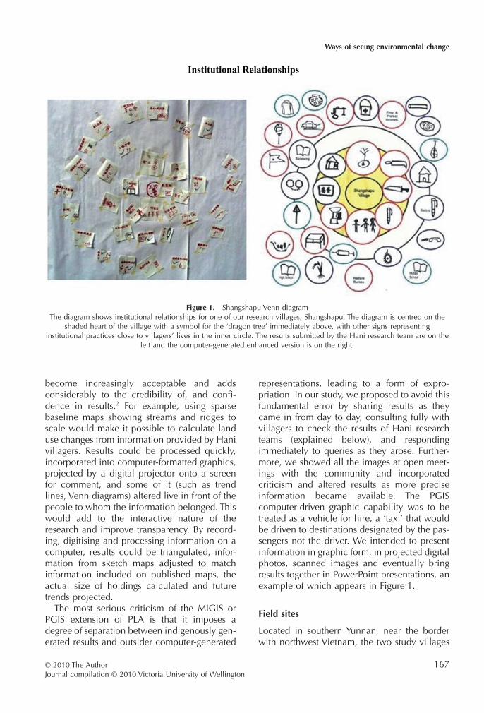
Figure 1. Shangshapu Venn diagramThe diagram shows institutional relationships for one of our research villages, Shangshapu. The diagram is centred on the
shaded heart of the village with a symbol for the ‘dragon tree’ immediately above, with other signs representinginstitutional practices close to villagers’ lives in the inner circle. The results submitted by the Hani research team are on the
left and the computer-generated enhanced version is on the right.
Ways of seeing environmental change
© 2010 The AuthorJournal compilation © 2010 Victoria University of Wellington
167
for our PLA/MIGIS research were Xiashapu andShangshapu (see Fig. 1, number 3, in Turner’sintroduction to this special issue). These villagesare located in the Badong catchment, at theheadwaters of the Amo Jiang River, which, inVietnam, becomes the Song Da (Black River)and eventually joins the Song Hong (Hongheor Red River). Today, the two villages arecircumscribed within Sanmeng Township,approximately 18 kilometres from Daxing,the administrative centre of Luchun County,Honghe Prefecture. The two study villages sitbelow a ridge that runs along a northeast–southwest diagonal. At the time of our initialresearch in 1999, the upper village, Shang-shapu, had a population of 178 people dividedbetween 79 households. The lower village,Xiashapu, was slightly smaller with a popula-tion of 140 living in 70 households.
Over centuries, the local landscape has beentransformed from steep forested slopes to a clas-sical Hani landscape of irrigated rice terraces,although corn remains the main upland foodcrop. In a bad year, a summer drought of four tofive months followed by a poor rainy seasonmay place all rain-fed upland crops at risk.Starting in late April or May, and even afterthe start of the monsoon, heavy hail can alsodamage crops. This environmental variabilityposes serious challenges for local livelihoodsand well-being (Bouchery, 1996).
In the complex ethno-linguistic mosaic ofChina, the Hani belong to the Tibeto-Burmanlanguage group and are closely related to theAkha in Sipsongpanna, northern Thailandand Burma. In 2000, they numbered 1 439 673people, largely concentrated in the HongheHani-Yi Autonomous Prefecture of southeastYunnan (Michaud, 2006: 100). Like many otherHani communities in Luchun County, thepeople of Xiashapu and Shangshapu are rela-tively poor. According to official Luchun CountyStatistics in 1998, the average annual per capitanet income was 388 RMB (US$44) for Shang-shapu and 422 RMB (US$48) for Xiashapu,below the county-wide average of 434 RMB.The county itself was ranked one of the 50poorest in China.
Kinship is important to the Hani, and theycontribute to extended family welfare whilemaking the most of their limited resources. Onecould argue that they remain resilient, prag-
matic and optimistic when faced with numer-ous obstacles to improving their livelihoods. Yetresilience alone does not guarantee a securefuture. There are single-parent households thatfind it difficult to make ends meet and a fewhouses are in danger of collapse. Mice and ratseat grain reserves, making food insecurity aconstant threat. Property is not entirely secureand, although residents had no complaintsabout antisocial behaviour in their own village,they did not necessarily trust the honesty ofall residents in neighbouring communities.Livestock occasionally go missing; neighbourspoach eels from flooded paddy fields and fishfrom ponds. Furthermore, it is difficult for youngpeople who do not speak standard Chineseto gain decent employment in nearby towns.Indeed, employment through state agenciesfavour Han over ethnic minority people.
Fieldwork: Getting approval to undertake PLA
After having met Li Qibo, the Hani Director ofthe Hani-Lisu Honghe Institute for MinorityStudies in Thailand in 1996, it took a furtherthree years to get approval to undertake field-work in Yunnan. Although Li Qibo was instru-mental in securing local support and interestfrom Hani, he did not have the administrative orpolitical leverage to get us permission to carryout fieldwork. Instead, over this three-yearperiod, other personal contacts played a majorpart in negotiations (c.f. Cornet; Gros; Michaud,this issue). A sense of trust developed overseveral visits, establishing and conveying aseriousness of purpose and genuine interest,and building a guanxi relationship of mutualrespect. This set a firm foundation on which toconstruct a project. Mr Yin Yonglin, whom I hadbriefly taught at the Mekong Institute at KhonKaen University, Thailand (June–July 1997), wasa Programme Officer in the Foreign Technical-Economic Cooperation Division of what wasthen the Provincial Bureau of Foreign Trade andEconomic Cooperation, (BOFTEC). He helpedsteer the project through the provincial bureau-cracy. Dr Hermann J. Tillmann, an EU advisor tothe EU-Yunnan-Honghe Environmental Protec-tion and Poverty Alleviation Project based inKunming, also helped by linking our proposedresearch to his Chinese counterpart agencythe Environmental Protection Bureau and
J. McKinnon
© 2010 The AuthorJournal compilation © 2010 Victoria University of Wellington
168

recommending the names of specific indivi-duals whom he considered to be particularlycapable and committed to their jobs. Mr LuXing the experienced team leader of the RDRCwas extremely welcoming and accompaniedme on my first visit to BOFTEC. His colleagueMs Cai Kui then made several journeys to Jian-shui to talk with Li Qibo and negotiate access toa suitable Hani field site.
The Hani-Lisu Honghe Institute of MinorityStudies provided a research assistant who couldspeak Hani, Chinese and some English; whilethe Environmental Protection Bureau providedtwo Hani-Chinese speakers to live with us in thevillages. Although Li Qibo then played a majorpart in selecting and negotiating entry to studyvillages, the results emerged from observationsvolunteered by Hani farmers and were notframed ahead of time by Li Qibo’s opinions.Finally, through all these contacts outlinedabove, at the end of 1998, the project was givenapproval. It was proposed that the work wouldculminate in a series of action plans that wouldbe followed up by our counterpart agency, theEnvironmental Protection Bureau.
Fieldwork: Setting up the PLA
The team was committed to a very demandingschedule as the research agreement permittedonly two months research in Yunnan. Nearlyhalf of this was to be spent in preparation, vis-iting the agencies that had given us support,reporting to them before we left the country,and wrapping up the whole exercise with finalreports in English, Chinese and Hani. Althoughit may not be considered part of the methodol-ogy, meeting demands on our time was part ofour obligation and necessary to maintaining agood relationship with our hosts.
Initially, eight days were spent in Kunmingpreparing fieldwork with Cai Kui and Dr Ma atthe RDRC, and making presentations on whatwe intended to do to people at BOFTEC, theYunnan Institute of Geography and the NGOCenter for Biodiversity and Indigenous Knowl-edge. On the road, we made similar presen-tations to the Hani-Lisu Honghe Institute ofMinority Studies and the staff of the HongheHani-Yi Autonomous Prefecture administration.At that stage, much of what we did had to bemade up as we went along.
PLA ‘outsider team’
When we arrived at the field villages, the visit-ing or ‘outsider’ PLA team consisted of eightresearchers: three New Zealanders, two HanChinese, and three Hani.3 Our team includedtwo GIS and computer graphic specialists withparticipatory research experience: Dr Ma, a40-year-old male, Han Chinese academic soilscientist and forester from the SouthwestCollege of Forestry; and Jack McConchie, a40-year-old geo-hydrologist from VictoriaUniversity of Wellington, New Zealand.4 MsCai Kui, a 30-year-old Han researcher with amasters in Agricultural Systems from ChiangMai University was the principal PLA specialist.Jean McKinnon, a 57-year-old gender andgraphics specialist had the role of finding andfostering the participation of village artists (oneof whom is shown in Fig. 2). She also assembledthe Hani visual glossary used to replace writtenlanguage in graphic representations of plants,animals, artefacts and infrastructure as much aspossible. She also managed financial matters,
Figure 2. Hani village artistA ‘vocabulary’ of some 80 images was prepared, scanned
and incorporated into computer versions of diagramsprepared by the Hani village research teams.
Ways of seeing environmental change
© 2010 The AuthorJournal compilation © 2010 Victoria University of Wellington
169

monitored interactions for gender, age andstatus bias, watched how various stakeholderswere treated, and drew the attention of ‘offend-ing’ team members to less than satisfactory atti-tudes and behaviour. I, as the near 60-year-oldteam leader, geographer and developmentstudies specialist with training experience inPLA took overall responsibility for runningthings. I worked at developing and maintaininggood relationships within the facilitating ‘out-sider’ PLA team, and between our team and thetwo Hani village teams (described below) andthe community. I ran feedback exercises heldeach morning; and made sure the briefings forthe evening exercises were clear and precise. Iwas also responsible for writing the field reportsand taking a lead role in the presentation ofresults.
The three Hani team members of our ‘out-sider team’ acted principally as facilitators andtranslators. Each spoke a different Hani dialectand their fluency in Hani was in reverse pro-portion to their formal educational qualifica-tions. Miqli, the only one to hold a bachelor’sdegree, was less confident in Hani but spokea reasonable level of English, while Mr Baiclaimed 60% fluency in Hani, and Mr Heng80%. In the village, conversations and discus-sions with elders could be conducted in stan-dard Mandarin Chinese (putonghua) whichsupported a ‘natural’ bias that privilegedhigh-status older men. To counteract this, aconscious effort was made to create opportu-nities in which women and younger peoplecould comfortably have their say in Hani. Con-versations and briefings within the team alsopresented a challenge and when the wholeteam was assembled everything was translatedfrom Chinese into English and vice versa.Within the village, three-way translationswere sometimes required and communicationthrough sign language, graphic images andmaps required constant checking and a goodsense of humour.
To a large degree, the success (or failure) ofthe team in this venture was shaped by ourpositionalities, including who we were as indi-viduals, our gender, training, and role in theteam. I think it is fair to say that the ‘outsiderteam’ strived to conduct our work openly andtransparently. Though it sounds naïve, we sin-cerely attempted to establish a symmetrical
relationship. This, we hoped, would enable usto go beyond profiling indigenous knowledgeand community tradition to truly grasping localpoints of view. Whether we ever understoodlocal perspectives completely can only becritically reflected upon in subjective terms.
Although members of the ‘outsider team’emphasised that we were not directly affiliatedwith a project that could guarantee materialassistance, we could see that villagers found itdifficult to separate us from the EnvironmentalProtection Bureau, particularly as two Hanimembers on our team were part of that organi-sation. Just by their presence visiting officialssuch as the director of the Luchun Environ-mental Protection Bureau and his colleaguesseemed to confirm this assumption. Despite ourprotestations and although we were not subjectto restraints on how we conducted research,villagers knew we could not be there withoutgovernment support and we could not avoid butbe treated as an extension of government. Thisconnection must have introduced a bias intoour dealings and influenced what we were told,yet it did not appear to significantly or adverselyaffect our results. When they did visit, bureauofficials appeared to be more interested indrinking our hosts’ whiskey and eating theirfood than in our research results. There must,however, have been tensions that we remainedunaware of.
PLA village teams
Two village teams undertook the PLA exercises(explained below), one from each village. Toensure representation across each settlement,the ‘outsider team’ established participation cri-teria relating to family, age and gender. Weasked elders who took responsibility for choos-ing the teams not to appoint more than twomembers from the same extended family. Threeage groups were identified so that youngpeople, active farmers in their prime andparents, and elders, would have a direct voice.Overall, we aimed for equal gender representa-tion. Although we asked the elders in eachvillage to choose just six members, some teammembers felt more comfortable having friendsaccompany them. The ‘outsider team’ acceptedthis without question and, initially, there wereas many as 20 people gathered, making it rather
J. McKinnon
© 2010 The AuthorJournal compilation © 2010 Victoria University of Wellington
170
impossible to distinguish between participants,observers and ‘hangers-on’.
Although these criteria cut across customarylines of separation (by which the voices ofyounger people and females are muted in favourof older male voices), participants did not com-plain (to us). However, groups still tended todivide along customary lines such that womenwould cluster together and ‘do their own thing’.The discussions over differences in perspectivewere often more revealing than a single finishedproduct, and a multiplicity of results was wel-comed. Differing returns were used to spawnfurther discussion at open forums.
PLA exercises
To meet the aim of our project to uncoverand document environmental challenges andchanges in the communities, the ‘outsider team’researchers facilitated standard PLA exercisesover a 40-day period, in which the two Hanivillage teams completed tasks such as creating:• social maps5 of their village. These were ini-
tially constructed on the ground with a stick
and various features of interest shown withmaterials at hand such as stones, fruit, seed,and vegetation. This was then recorded onpaper by members of the Hani teams, digi-tally photographed and transferred to thecomputer;
• chronological time lines recording importanthistorical events and historical transectsreaching as far back as the memory of elderspermitted (Fig. 3);
• a detailed land use map, one for each village,on a base map drawn to scale;
• seasonal calendars, one for each village thatsummarised the annual round of agricultural,ritual, and social activities including periodsof food shortage, poor health and so forth;
• gender and age breakdowns of time allo-cation over a typical 24-h period over theperiod of our visit, the season immediatelybefore the rains came, when farmers werepreparing their land for planting;
• Venn diagrams constructed to configureinstitutional village relationships in whichparticipants placed family, the headman andthe religious leader (see Fig. 1);
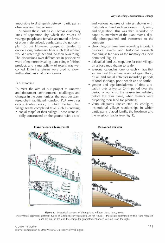
Figure 3. Historical transect of Shangshapu village 1950, 1980, 1999The symbols represent different types of landforms or vegetation. As for Figure 1, the results submitted by the Hani research
team are on the left and the computer generated enhanced version is on the right.
Ways of seeing environmental change
© 2010 The AuthorJournal compilation © 2010 Victoria University of Wellington
171

• graphs illustrating trends of different phe-nomena over the past two or three decades,identified by the participants themselves,such as frequency of religious ceremonies,veterinary services, fertiliser supply, forestedarea, incidence of disease, supply of teach-ers, and different sources of income;
• list and rank problems/challenges facing thecommunity in order of importance;
• use-diagrams and problem trees to analyseprincipal issues identified by the communitythat impact negatively on the sustainability oftheir livelihoods and increase their vulner-ability (i.e. basic needs such as water, shelter,food, health, etc.);
• and, lastly, a series of action plans to addressthe issues identified in earlier steps in thesequence of PLA exercises detailing whowill do what and when, and what inputs arerequired.
Meetings were scheduled in the evenings andconducted in Hani either at the local school orin village homes. In addition, an open ‘office’,a lean-to resting against the main school build-ing, was constantly staffed by team memberswho recorded and processed information as itarrived from dawn to dusk. Villagers who hadqueries could visit at any time and be sure offinding somebody there who understood theirlanguage. Every morning, the ‘outsider team’would meet at the ‘office’ and compare notesmade during the village teams’ efforts theday before, review what had been said andrecorded, and follow up on issues arising outof participant observation. We were oftenjoined by locals curious to know what we weredoing. When relevant, graphic representa-tions and GIS versions of information were pre-pared as soon as possible and shown to eachvillage for comment and criticism before beingaccepted as finished. Verification typicallyinvolved, for example, trying to locate a streamshown on official maps that villagers stated didnot exist, a count of eels in a flooded paddyfield that seemed to be exaggerated and soforth. As fieldwork proceeded and as villagers –not necessarily those on their village researchteam – became increasingly aware of emerg-ing issues, they would come by the work‘office’ to volunteer information and take us tosee things of interest to them that we may haveoverlooked.
Following a form of snowball sampling, alarge number of places of significance wereexplored, ranging from ceremonial sites, areasof cultural interest, to water sources. Villageestate boundaries were traversed and character-istics marked on land use maps. The ‘outsiderteam’ visited fish ponds, talked to their owners,listened to accounts of accidents, visited housesin various states of repair, and took photographsof every family in each village. These photo-graphs allowed us to first, give something backto the villagers and second, make a visualrecord of the number of people in a household,the state of their dwelling and condition oftheir clothes. Film and digital images were sentinto Daxing for developing and printing so thatphotographs could be returned to householdsbefore we left.
Exercise results were digitally photographedand transcribed from hand-drawn and hand-written accounts to computer, and feedbacksessions prioritised maps and graphics. All vil-lagers were invited to these open forums thatwere held frequently, with results explainedby Hani speakers (as shown in Fig. 4). So asto verify translation, digital photographs oforiginals were shown alongside graphi-cally enhanced, computer-generated images(Figs 1,3). The forums were well-attended andgenerated interest, noise and excitement. Theyshowed what both field teams were doing andopened the work to questions, furthering theopen participation made available to villagersthrough the field ‘office’.
Participatory fieldwork: Adaptation,negotiation, understanding
The interpretations of members from the ‘out-sider team’ of environmental challenges andchanges in the communities gradually emergedfrom the information that Hani villagers volun-teered in the course of PLA exercises, snowballinterviews and casual conversations. Althoughwe had set out to work with Hani ‘villageteams’, our sources of information becamebroader. In the course of taking family photo-graphs, members of the ‘outside team’ wouldsometimes interview householders, especially ifthe family concerned did not have somebodyon a village team, did not attend open forummeetings and were known, often because of
J. McKinnon
© 2010 The AuthorJournal compilation © 2010 Victoria University of Wellington
172

poverty and low status, to be shy. No question-naires were used, but in the first week or sochecklists were kept at hand.6
Members of the ‘outsider team’ were oftenspontaneously taken into peoples’ confidence.Most of the time, these occasions were taken asan opportunity to tell one of us about problemsfaced by the household or the village. Forexample, the Xiashapu ritual head (milguq ormilguq guqma), who ran the tubhe Spirit Stoneceremony and looked after the sacred grove andits centre piece, the ‘dragon tree’, lived nextdoor to the household where I was staying andin close proximity to the ‘office’. He frequentlysat smoking, watching and, from time to time,commenting on what we were doing, raisingconcerns about teacher absences, the lack of agood water supply, and what life was going tobe like for his children. An older farmer, whowas distilling lemongrass oil when we first methim and whose terraces close to the river hadbeen covered by the rising level of shingle andboulders caused by deforestation upstream, hadplenty to say about his perceived injustices, butonly in private. Moreover, there was the eldestson of a large household who, with his brothers,had dug a fishpond, but with fish being stolenfaster than he could harvest them he despair-ingly accepted that he would never make aprofit from the venture. A young man who hadleft the village in search of paid employment
and found work on a construction site hadlaboured on the promise of payment at theend of a contract period, but was never paid.Returning home with nothing, he bemoanedhis bad fortune. The moqpil or beima (spiritpractitioner/priest), whom I met on severaloccasions, told me how, over the socialistperiod, spirit practitioner skills had been lost.He was trying to reintroduce these, buying ritualtexts from aYi ethnic minority healer in a nearbytown. These ongoing and accidental privateand sometimes surprisingly intimate encountersprovided poignant examples of shared andindividual lived experiences.
As villagers became accustomed to our pres-ence, they also became more confident andcomfortable speaking to us as individuals, evento those of us whom were known to speakonly English. Once a conversation was initiated,anybody within reach who spoke either Hani orstandard Chinese would join in. There was a lotof banter, joking and touching, but nothing tooclose: the rules of cross-gender communica-tion and restraint remained in place. Thesewere relaxed circumstances and, over time, webecame able to ask informed questions whichalso tended to enhance our credibility. Aspeople began to understand what we foundinteresting, they responded by telling us more.
One day, the old headman of Shangshapuasked me to visit him. I visited with Miqli as
Figure 4. Open forumOpen forums were held at night using a digital projector. At first, they were difficult to run in an orderly interactive manner
because they generated too much excitement. As the novelty wore off, two-way communication became easier.
Ways of seeing environmental change
© 2010 The AuthorJournal compilation © 2010 Victoria University of Wellington
173
translator. Despite the language difficulties, hewas able to share his thoughts on what had orhad not worked in efforts to earn money tocompensate for village shortfalls, the impact thishad on the environment, and how the villagecommittee was reluctant to intervene. Giventhe ‘inherently hierarchical’ (English, 1994: 86)nature of our relationship, I, as the ‘outside’team leader and a man of a certain age, wasexpected to know more about the world andwhat might provide a path to prosperity. GivenI am not an agriculturalist, in this case, as inmany others, the flattering nature of this expec-tation had to be disappointed. Again, I had toexplain that I was here as a student, not a pro-fessor. The visit became a three-way explorationof land, water and crop management to whicheach of us contributed in our own way. I was notan agricultural expert, and as an urban resident,Miqli was learning about matters that wereentirely new to her, while the headman spokefreely about how land use practices in the olddays were no longer followed.
Near the end of the PLA work, a special openforum meeting was called to bring all thepeople in both villages together and presentthe joint research results of the village teamsand ‘outsider team’. The collection of maps anddigital images redrawn from the images pro-vided by the Hani village teams using PLA toolswas reviewed and a selection assembled ina PowerPoint presentation. The presentationincluded digital photos of the landscape andland use, mostly taken by the ‘outside team’in consultation with the village teams. Theseshowed the dynamic processes at work; ‘threedimensional’ images of the landscape wereconstructed from a contour map; and 1990 and1999 land use maps were placed side by side.The latter was created as part of a PLA exerciseand showed the marked decrease in the amountof forested land from 58% of the combinedvillage areas in 1990 to 22% in 1999.
The digital photographs and graphics eliciteda continual stream of sighs and audible remarks.Although invited to do so, nobody challengedthe representations of either current land use orthe graphic portrayal of the expected shortfall infood production for the three different socio-economic groups within the village. It was clearthat there was a strong underlying sense ofagreement. A diagram showing the allocation
of time by age and gender drew laughter, aspeople realised how much longer the workingday was for women; this was not a matter thatwould change in the near future. The sound ofconversation rose as people began to realise thescale of changes in the landscape, particularlywhen a number of remnant terraces close to theaggraded Badong river were pointed out. Aburied streambed immediately below a smallsub-catchment cleared and planted in lemon-grass encouraged an elder to remind everybodythat he remembered when it flowed on thesurface. It was the economic opportunity toearn ‘good money’ from selling lemongrass oilthat had largely created the transformationwhen forest was first cleared to plant the grassand then again to provide fuel to distil the oil.7
The meeting was particularly lively and, as itended, those who had tried to point out whatwas happening to the land around them andthe consequences of turning a blind eye tothe transformations appeared relieved that at lasttheir story had been told. The old headmanof Shangshapu was positively joyful, raised hishands above his head and, with a broad smile,exclaimed what could be translated as ‘yes, yes,yes!’ over and over again. ‘Now they must see!’When Li Qibo, who had joined the researchteam for the last few days realised that his ownresearch had been triangulated in a positiveway he was also pleased. In unexpected ways,the interpretations and discussions appearedto strengthen people’s sense of community andtheir identity as Hani by reminding them of whatthey already knew, but what they had beenreluctant to acknowledge collectively in public.
True reform, however, requires more than arush of blood to the head. Nine action plans8 hadbeen drawn up by the village teams as part of thelast exercise on the list, facilitated by the visiting‘outsider team’, and completed before the finalpresentation was made but only one addressedthe issue of unwise land use. It was a first step andalthough the Environmental Protection Bureaupromised to provide follow up assistance withinfrastructure such as upgrading the water supplyor installing latrines, the more substantial issue ofdeforestation was left in the hands of the villageleaders of Xiashapu and Shangshapu.
The journey from Xiashapu and Shangshapuback to Kunming was busier than the journey in.Within 12 days of leaving the villages, the team
J. McKinnon
© 2010 The AuthorJournal compilation © 2010 Victoria University of Wellington
174

made seven presentations of findings, the finalreport was written in English, translated intoMandarin and Hani, printed and at least onecopy either given or sent to each of the principalpartners.
Participatory knowledge . . . to action?
Six months later, I returned to see what hadhappened, but could not complete the journeyto the villages. Heavy late rain had causedwhole mountainsides of Hani irrigated terracesto collapse and block the only road access. Itwas not until June 2000 that I was able to returnand find out what had happened in Xiashapuand Shangshapu. What I saw was initiallyreassuring. The Environmental ProtectionBureau had come to help with villager-initiatedprojects. What was even more gratifying wasthat further action plans had been organised bylocals. The headman of Shangshapu village,along with 14 other elders, had formed a water-shed protection committee. Seemingly empow-ered by what they had been able to articulateduring the shared PLA project, they hadreclaimed unstable collective land consideredtoo steep for cultivation and placed it underprotection. All remaining forest, regardless ofwho had been issued with rights of usufruct,had been declared part of a village reserve. Aforest reserve agreement had also been negoti-ated, and each household tasked with makingsure everybody understood what was involved.This agreement superseded the rights of indi-vidual tenure granted under the 1984–1985land reform exercise. Household heads hadconfirmed their commitment to abide by theagreement by signing with a fingerprint.
The small amount of land claimed back,10 mu (1.65 acres or .66 ha.), was plantedwith Chinese fir seedlings (Cunninghamia lan-ceolata) in conservation clusters on steep ripar-ian land.9 Hani leaders told me that it was ‘thefirst act, for this generation and the next’, fol-lowing a half-year ceremony which included anoffering to the Mountain Spirit and called backthe spirits of the forest and the land. Four dayslater, this was followed by a symbolic affirma-tion from each household in which a chickenwas sacrificed to ensure good fortune. Environ-mental action was once again linked to reli-gious practice and Hani ways.
As opposed to local development actions,state-sponsored options appeared to be seen inless of a positive light. Hence, projects that wereaccepted or opposed by the villagers werenow rooted in locally grounded, ethnicallyinformed processes, thereby mobilising localHani agency. The presence of our research teamand the participatory research exercise hadseemingly contributed to setting up a seriesof interactions between villagers and localofficials; some involved cooperation, otherstriggered dissent.
We were hopeful that, through this project,the links between indigenous knowledge andenvironmental awareness would be streng-thened or, at least, that these links would bebrought to the forefront of Hani consciousness.An entirely independent evaluation of theproject carried out in 2003 confirms that in thisaspect, the engagement was successful. Oversuccessive drastic changes of state regimes theregion had known, the customary connectionsbetween indigenous knowledge and environ-mental management in the villages had beenseverely challenged, but not lost. The symbolsof ritual were muted by several decades of con-cealment, but oral histories of land manage-ment resurfaced when people felt they couldonce again be asserted. These discussions werecrowded with spiritual references to the envi-ronment, reminding people of what it meantto be Hani. As people saw an opportunity tobecome actively involved in the decision-making processes concerning what was hap-pening around them, they were also remindedthat their survival in both a physical and spiri-tual domain – their culture – meant that theymust activate their own agency and exercisetheir collective will, rather than wait and seewhat happened.
It appeared, therefore, that the PLA workenabled people to acknowledge and carefullyconsider the consequences of what was hap-pening around them. Acting on their owninitiative, although not immune to outside influ-ences from local elites, state representatives,and powerful neighbours, elders with popularsupport in both communities moved to intro-duce conservation measures in a uniquely Haniway. The whole community-driven exerciseappeared to help people cultivate the confi-dence to assert their identity and determine
Ways of seeing environmental change
© 2010 The AuthorJournal compilation © 2010 Victoria University of Wellington
175

their own future in the ‘politics of alternativedevelopment’ (Friedman, 1992).
Concluding thoughts: Reconcilingparticipatory objectives and outcomes
What ‘developers’ consider best may not bewhat local people for whom the assistance isintended really want (Li, 2007). Participatorygrassroots approaches such as PLA are designedto address this concern, but they are frequentlycompromised. Outside agencies seldom fundparticipatory exercises that allow villagers toplan their own future. Sometimes, the objec-tives of participatory exercises have beenorganised in advance. Oftentimes, villagers suc-cessfully uncover what the development agencyhas in mind, and, to ensure they become ben-eficiaries, massage results to fit the expectation(see Sahlins, 1999).
The specific participatory action researchreported on here was kept as open as possible inaims and direction. The ‘outsider’ research teamwas not looking for an opportunity to tell Hanivillagers about the precarious status of theirenvironment; the insiders, the Hani villagers,did not particularly want to see, let alone articu-late what was happening. For the latter, it waseasier to leave it all in the ‘too-hard basket’. Yetas work progressed, everybody – the outsiderresearch team and local Hani villagers alike –became acutely aware of the unfolding poten-tial for disaster.
Still, there is no fairy tale ending. While thisparticular participatory research exercise raisedpeoples’ consciousness and stimulated an inde-pendent community decision to take actionrelating to land use, how long this culturalrenaissance lasted or how far it extended intodaily life was not established. By 2003, growingsocio-economic differentiation between house-holds was beginning to replicate the inequali-ties of old. Individual households continuedtheir efforts to enhance their livelihoods, andwell-off families were clearly better poised totake advantage of improved links between townand country. For example, on the back of rela-tionships set up during the research exercise,better-off leaders in Xiashapu brokered a dealwith staff from the Environmental ProtectionBureau to set up an industrial-sized piggery thatboth increased demand on the local water
supply and discharged high rates of faecalcoliform waste into the Badong river. Moreover,the leaders of Shangshapu and Xiashapu mayhave led the fight for reforestation, but theyignored the environmental risk of getting theEnvironmental Bureau to bulldoze vehicularaccess down a steep shingle slope. The zigzagtrack was washed out within six months.
In sum, the participatory research providedimportant insights but had only just begun toreveal the complexity of the underlying socialand economic processes at work. Vestedinterests, economic gain, individual actions,asymmetrical relationships and interactions,macropolicy and so on, constantly (re)makereality. Participatory methodologies are a socialmapping system that help researchers navigatediverse contexts and reach minority communi-ties, and provide at least a relatively positivemanner in which to engage with people andhelp participants learn about each other. Yetwhen working with ethnic minority groups,I would argue, as have critiques of PLA ingeneral, this approach is still a fragile, short-term substitute for long periods in the field,repeated visits, and learning the language(s).Pursuing complex research questions in a sus-tained manner is the only way to keep on learn-ing; there is no completely adequate short cut.Nevertheless, despite the drawbacks, in acontext such as the People’s Republic of China,where authorities are often still suspicious ofthose who wish to undertake long-term field-work, especially among ethnic minorities, PLAdoes offer a potential way forward.
Acknowledgements
The author wishes to acknowledge the NewZealand Asia Development Assistance Facility,Ministry of Foreign Affairs for their financialsupport to conduct the fieldwork on which thisarticle is based. I also wish to acknowledge thecontributions made by all of the Hani, Han andNew Zealand research team members. Withoutthe input of the anonymous reviewers, as wellas research assistants Stephanie Coen, BernardHuber, Lindsay Long, and issue editor SarahTurner who helped draft, comment on, andredraft this paper to fit the requirements of thetheme, this text would not have made it tothe publishers.
J. McKinnon
© 2010 The AuthorJournal compilation © 2010 Victoria University of Wellington
176

Notes
1 Throughout this article, ‘Party’ refers to the CommunistParty of China (CPC).
2 See the online: Open Forum on Participatory Geo-graphic Information Systems and Technologies at http://www.ppgis.net/
3 Li Qibo was not available for the whole period andjoined the team in the last week of fieldwork.
4 While both had experience with participatory research,I would argue that they tended to privilege their ownacademic perspectives. The Hani role is subordinated tothe hydrologist’s concern in the McConchie authoredpapers that emerged from this project. See McConchieand McKinnon (2002); McConchie and McKinnon(2004); and McConchie and Ma (2003).
5 A social map provides people with the opportunityto show the following: important physical and socialfeatures of their community; location, wealth and othercharacteristics of households; and, may also includeother features such as roads, streams, wells, publicbuildings and so on. The tool enables people to showtheir own surrounding as they see it and is rarely if everdrawn to scale.
6 The social map provided a ranked socio-economic posi-tion for each household in the village. This was checkedin the course of the visit using criteria built up by theHani research teams after households were subjectivelyranked into three groups. The criteria itself was triangu-lated and the position assigned intuitively to the house-hold checked.
7 This issue is discussed in detail elsewhere. See McCon-chie and McKinnon (2004).
8 Altogether nine action plans were drawn up but onlyone targeted a restricted area for reforestation in thevicinity of Xiashapu. Shangshapu developed its ownforestry initiative in the following months completely ontheir own. Among the first action plans drawn up werethe following: for Xiahapu, an upgrade of the irrigationsystem, construction of a tractor road, toilets and watersupply; for Shangshapu, the upgrade of the irrigationsystem, paving the principal path through the village,constructing toilets, improving water supply, and acquir-ing higher yielding varieties of rice.
9 It should be noted that this is a very small scale initiative.To talk in more general terms, many academics andcritical observers quite properly harbour strong reserva-tions about monoculture plantation forestry for in-creasing water demand, diminishing biodiversity, andreducing agricultural land (Walker, 2003). For thesereasons, the ‘Go West’ programme in Yunnan, whichparticularly uses the strategy of coniferous monoculturereplanting, has deservedly been criticised.
References
Abbot, J., R. Chambers, C. Dunn et al. (1998) Participa-tory GIS: Opportunity or oxymoron? PLA Notes 33:27–34.
Arévalo, K.M. and M. Ljung (2006) Action research on landmanagement in the Western Amazon, Peru – A research
process, its outcomes and the researcher’s role,Systemic Practice and Action Research 19(4): 309.
Bentley, J. (2009) Commentary: The right message andmethod, International Journal of Agricultural Sustain-ability 7(2): 79.
Bocco, G. and V.M. Toledo (1997) Integrating peasantknowledge and geographical information systems: Aspatial approach to sustainable agriculture, IndigenousKnowledge and Development Monitor 5(2): 10–12.
Bouchery, P. (1996) The relationship between society andnature among the Hani People of China, Diogenes44(174): 99–116.
Bourdieu, P. (1977) Outline of a theory of practice.Cambridge: Cambridge University Press.
Campbell, J.R. (2001) Participatory rural appraisal as quali-tative research: Distinguishing methodological issuesfrom participatory claims, Human Organization 60(4):380.
Cassells, D.S., M. Bonell, L.S. Hamilton and D.A. Gilmour(1987) Protective role of tropical forests: A state ofknowledge review, in N.T. Vegara and N.D. Briones(eds), Agroforestry in the humid tropics: Its protectiveand ameliorative roles to enhance productivity andsustainability, pp. 31–58. Honolulu: East-West Center.
Chambers, R. (1997) Whose reality counts? Putting the firstlast. London: Intermediate Technology Publications.
Chambers, R. (2007a) From PRA to PLA and pluralism:Practice and theory, IDS Working Paper 286. Sussex:Institute of Development Studies.
Chambers, R. (2007b) Participation and poverty, Develop-ment 50(2): 20.
Cook, B. and U. Kothari (2001) Participation – The newtyranny? London: Zed Books.
Defoer, T. (2002) Learning about methodology developmentfor integrated soil fertility management, AgriculturalSystems 73(1): 57–81.
English, K. (1994) Getting personal – Reflexivity, position-ality, and feminist research, Professional Geographer46(1): 80–89.
Friedman, J. (1992) Empowerment: The politics of alter-native development. Cambridge, Massachusetts:Blackwell.
Ganjanapan, A. (2000) Local control of land and forest:Cultural dimensions of research management in North-ern Thailand. Regional Center for Social Science andSustainable Development Faculty of Social Sciences,RCSD Monograph Series No. 1, Chiang Mai: ChiangMai University.
Harrell, Stevan (ed.) (2001) Perspectives on the Yi ofSouthwest China. Berkeley: University of CaliforniaPress.
Hickey, S. and G. Mohan (eds) (2004) Participation: Fromtyranny to transformation. London: Zed Books.
Kumar, S. (2002) Methods for community participation –A complete guide for practitioners. London: ITDGPublishing.
Lee, R. (1980) Forest hydrology. New York: ColumbiaUniversity Press.
Li, Q. (1996) Hani terraced fields and the ecological envi-ronment, Paper presented to the Second InternationalConference on Hani-Akha Culture, Chiang Mai andChiang Rai, Thailand, 12–18 May, 1996.
Ways of seeing environmental change
© 2010 The AuthorJournal compilation © 2010 Victoria University of Wellington
177
Li, T.M. (2007) The will to improve: Governmentality, devel-opment, and the practice of politics. Durham: DukeUniversity Press.
McConchie, J.A. and H.C. Ma (2003) MIGIS – An effectivetool to negotiate development interventions relating toforestry, Journal of Forestry Research 14(1): 9–18.
McConchie, J.A. and J.M. McKinnon (2002) Using GISto produce community-based maps to promotecollaborative natural resource management, ASEANBiodiversity 2(1): 27–34.
McConchie, J.A. and J.M. McKinnon (2004) Empower-ing indigenous peoples and promoting collaborativenatural resource management through Mobile Inter-active GIS (MIGIS), in D.G. Janelle, B. Warf, and K.Hansen (eds), WorldMinds: Geographical perspectiveson 100 problems. Commemorating the 100th Anni-versary of the Association of American Geographers1904–2004, pp. 541–546. London: Kluwer AcademicPublishers.
McKinnon, J.M. (1977) Shifting cultivation: Who’s afraid ofthe big bad wolf? Paper presented to the 77th Seminaron Agriculture in Northern Thailand, Northern Agricul-tural Development Center and the Faculty of Agricul-ture, Chiang Mai University 8 April.
McKinnon, J.M. (1989) Structural assimilation and theconsensus: Clearing grounds on which to rearrangeour thoughts, in J.M. McKinnon and B. Vienne (eds),Hill tribes today: Problems in change, pp. 303–359.Bangkok: White Lotus-Orstom.
McKinnon, J.M. (2003) Community culture: Strengtheningpersistence to empower resistance, in C.O. Delang(ed.), Living at the edge of Thai Society: The Karen inthe highlands of northern Thailand, pp. 64–84.London: RoutledgeCurzon.
McKinnon, J.M. (2005) Mobile Interactive GIS (MIGIS):Bringing indigenous knowledge and scientific infor-mation together: a narrative account, in A. Neef (ed.),Participatory approaches for sustainable land use inSoutheast Asia, pp. 217–232. Bangkok: White LotusPress.
McKinnon, J.M. and G. Aggett (1998) Partici-patory Rural Appraisal (PRA) and applied anth-ropology in Southwest China, Anthropology andthe peoples of Southwest China, Kunming: YunnanUniversity.
Michaud, J. (2006) Historical dictionary of the peoples of theSoutheast Asian massif. Oxford: The Scarecrow Press.
Mukherjee, N. (2002) Participatory learning and action:With 100 field methods. New Delhi: Concept Publish-ing Company.
Nederlof, E.S. and D. Constant (2007) Lessons for farmer-oriented research: Experiences from a West African soilfertility management project, Agriculture and HumanValues 24(3): 369.
Robinson, L. (2002) Participatory rural appraisal: A briefintroduction, Group Facilitation (4): 29A.
Ruggeri Laderchi, C. (2001) Participatory methods in theanalysis of poverty: A critical review, QEH (QueenElizabeth House, University of Oxford) Working Paper,62.
Sahlins, M. (1999) What is anthropological enlightenment?Some lessons of the 20th century, Annual Review ofAnthropology 28: i–xxiii.
Terry, J.P. and K. Khatri (2009) People, pigs and pollution –Experiences with applying participatory learning andaction (PLA) methodology to identify problems of pig-waste management at the village level in Fiji, Journalof Cleaner Production 17(16): 1393–1400.
United Nations (2007) United Nations Declaration onthe Rights of Indigenous Peoples. New York: UnitedNations Publications.
Walker, A.R. (2003) Merit and the millennium: Routine andcrisis in the ritual lives of the Lahu people. New Delhi:Hindustan Publishing Corporation.
Wetmore, S.B. and F. Theron (1998) Community develop-ment and research: Participatory learning and action –A development strategy in itself, Development South-ern Africa 15(1): 29–54.
Williams, R. (1975) The country and the city. St Albans:Paladin.
J. McKinnon
© 2010 The AuthorJournal compilation © 2010 Victoria University of Wellington
178