waterway strategy productive plains summary - …€¦ · waterways goulburn river, ... • provide...
TRANSCRIPT

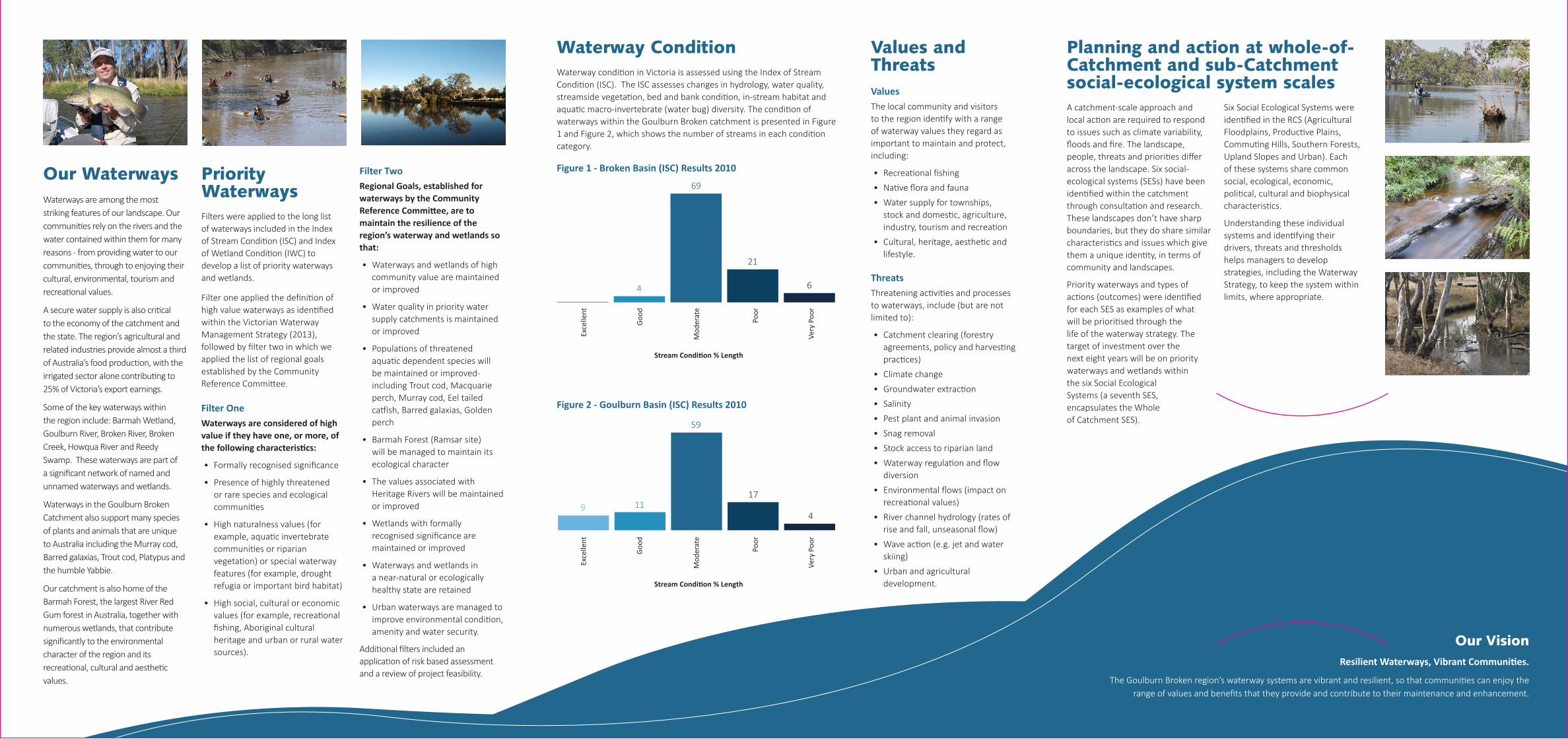
Agricultural Floodplains
Priority Waterways
Goulburn River, Broken Creek, Barmah Wetland, Reedy Swamp, Kinnairds Wetland, Kanyapella Basin
Values Native fish, riparian vegetation condition, significant amphibians, significant birds (waterway) , significant Ecological Vegetation Classes (EVCs), recreational fishing , important bird habitats
Threats Bank instability, change in monthly streamflow variability, increase in low flow magnitude, increase in probability of zero flow, invasive terrestrial fauna, loss of instream habitat (large wood), reduction in high flow magnitude
Resource Condition Targets
- Stream hydrology will be improved by 2017 - Riparian vegetation condition is maintained or
improved by 2020. - Populations of native fish are maintained or
improved by 2025 - Instream habitat is maintained or improved by 2030.
Upland Slopes
Priority Waterways
Upper Hollands Creek, Acheron River, Broken River, Goulburn River, Ryans Creek
Values Aquatic invertebrate community condition, riparian vegetation condition, urban or rural township water sources, water storages, significant migratory fish, recreational fishing
Threats Livestock access, loss of instream habitat (large wood), reduced riparian connectivity, reduced riparian vegetation width
Resource Condition Targets
- The population of Macquarie perch is secure and continues to produce young
- The riparian vegetation condition is maintained or improved by 2030
- Barriers to the movement of migratory species are removed/remodeled by 2021
- Maintain “Ecological Healthy Status” of key waterways and wetlands.
Productive Plains
Priority Waterways
Hollands Creek, Goulburn River, Seven Creeks, Dowdle Swamp, Winton Wetland
Values Significant migratory fish, significant EVCs, significant non-migratory fish, camping, game hunting, motor boating
Threats Bank instability, barriers to fish migration, degraded riparian vegetation (decline in large trees), degraded water quality, livestock access, reduced vegetation width
Resource Condition Targets
- Riparian/floodplain vegetation condition is maintained or improved by 2021.
- Instream diversity is maintained or improved by 2030
- Hydrology within the Goulburn River is improved, to sustain current values, by 2021
- Wetland conditions are maintained or improved by 2025
- Habitat for aquatic birds will be maintained or improved by 2015.
Southern Forests
Priority Waterways
Rubicon River, Big River, Howqua River, Goulburn River, Central Highland Peatlands, Alpine Bogs
Values Aquatic invertebrate community condition, riparian vegetation condition, significant non-migratory fish, significant amphibians, non-motor boating, recreational fishing, sightseeing
Threats Livestock access, loss of instream habitat (large wood), reduced riparian vegetation width
Resource Condition Targets
- Riparian vegetation condition is maintained or improved by 2021
- Instream habitat is maintained or improved by 2030 - Maintain the ecologically healthy status - The condition of the Central Highland Peatlands /
Alpine Bogs are maintained or improved - Water Quality in maintained or improved by 2030.
Commuting Hills
Priority Waterways
Hughes Creek, Sunday Creek, Mollison Creek, King Parrot Creek, Yea River, Goulburn River
Values Urban or rural township water sources, water storages, significant migratory fish, native fish, significant birds (riparian), significant birds (waterway), significant EVCs, non-motor boating, landscape
Threats Degraded water quality, reduced riparian vegetation width, livestock access, loss of instream habitat (large wood), loss of instream habitat (through sedimentation)
Resource Condition Targets
- Enhance riparian vegetation width by 2050 - Reduce the impact of stock by 2030 - Maintain or enhance water quality by 2050 - The population of Macquarie perch is secure,
increases or remains stable in numbers and/or distribution, and continues to produce young
- In stream diversity is maintained or improved by 2030.
The Goulburn Broken Waterway Strategy (GB WS) reflects the vast amount of work the community has achieved in waterway health over many years. It incorporates recent environmental and policy drivers and knowledge gained through research and monitoring. The GB WS identifies key threats to community values and provides recommendations to influence the future management of waterways in the catchment.
The intent of the 2014 GB WS is to:
• Identify priority waterways and wetlands based on their environmental, social, cultural and economic values, and set objectives for their management.
• Develop a program of works to achieve these objectives, and targets against which to measure progress.
• Provide a consistent process for identifying priorities for government investment in waterways and wetlands.
• Engage key stakeholders and the community in the process of developing the Waterway Strategy to ensure priority assets reflect areas of high community value.
The GB WS has been structured and compiled with input from our community and our many partners. It is a living document that will be regularly reviewed and updated over its life (2014-22). Continuous engagement with the community and partner agencies will ensure an adaptive management approach is used to enhance the resilience of our waterways and catchment as we face the challenges of the future together.
GB WS is one of several sub-strategies supporting the Regional Catchment Strategy (RCS). The RCS presents a vision for integrated catchment management in the region. It identifies land, water and biodiversity assets, sets 20-year condition objectives for those assets and outlines regional priorities and management measures to achieve the objectives.
Waterway Strategy Summary
Further information
Goulburn Broken Catchment Management Authority
PO Box 1752, Shepparton VIC 3632
Tel. (03) 5822 7700 Fax. (03) 5831 6254Email. [email protected]
www.gbcma.vic.gov.au
Social Ecological Systems and Priority Waterways in the Goulburn Broken Catchment
Our WaterwaysWaterways are among the most striking features of our landscape. Our communities rely on the rivers and the water contained within them for many reasons - from providing water to our communities, through to enjoying their cultural, environmental, tourism and recreational values.
A secure water supply is also critical to the economy of the catchment and the state. The region’s agricultural and related industries provide almost a third of Australia’s food production, with the irrigated sector alone contributing to 25% of Victoria’s export earnings.
Some of the key waterways within the region include: Barmah Wetland, Goulburn River, Broken River, Broken Creek, Howqua River and Reedy Swamp. These waterways are part of a significant network of named and unnamed waterways and wetlands.
Waterways in the Goulburn Broken Catchment also support many species of plants and animals that are unique to Australia including the Murray cod, Barred galaxias, Trout cod, Platypus and the humble Yabbie.
Our catchment is also home of the Barmah Forest, the largest River Red Gum forest in Australia, together with numerous wetlands, that contribute significantly to the environmental character of the region and its recreational, cultural and aesthetic values.
Priority Waterways Filters were applied to the long list of waterways included in the Index of Stream Condition (ISC) and Index of Wetland Condition (IWC) to develop a list of priority waterways and wetlands.
Filter one applied the definition of high value waterways as identified within the Victorian Waterway Management Strategy (2013), followed by filter two in which we applied the list of regional goals established by the Community Reference Committee.
Filter OneWaterways are considered of high value if they have one, or more, of the following characteristics:
• Formally recognised significance
• Presence of highly threatened or rare species and ecological communities
• High naturalness values (for example, aquatic invertebrate communities or riparian vegetation) or special waterway features (for example, drought refugia or important bird habitat)
• High social, cultural or economic values (for example, recreational fishing, Aboriginal cultural heritage and urban or rural water sources).
Filter TwoRegional Goals, established for waterways by the Community Reference Committee, are to maintain the resilience of the region’s waterway and wetlands so that:
• Waterways and wetlands of high community value are maintained or improved
• Water quality in priority water supply catchments is maintained or improved
• Populations of threatened aquatic dependent species will be maintained or improved- including Trout cod, Macquarie perch, Murray cod, Eel tailed catfish, Barred galaxias, Golden perch
• Barmah Forest (Ramsar site) will be managed to maintain its ecological character
• The values associated with Heritage Rivers will be maintained or improved
• Wetlands with formally recognised significance are maintained or improved
• Waterways and wetlands in a near-natural or ecologically healthy state are retained
• Urban waterways are managed to improve environmental condition, amenity and water security.
Additional filters included an application of risk based assessment and a review of project feasibility.
Planning and action at whole-of-Catchment and sub-Catchment social-ecological system scalesA catchment-scale approach and local action are required to respond to issues such as climate variability, floods and fire. The landscape, people, threats and priorities differ across the landscape. Six social-ecological systems (SESs) have been identified within the catchment through consultation and research. These landscapes don’t have sharp boundaries, but they do share similar characteristics and issues which give them a unique identity, in terms of community and landscapes.
Priority waterways and types of actions (outcomes) were identified for each SES as examples of what will be prioritised through the life of the waterway strategy. The target of investment over the next eight years will be on priority waterways and wetlands within the six Social Ecological Systems (a seventh SES, encapsulates the Whole of Catchment SES).
Six Social Ecological Systems were identified in the RCS (Agricultural Floodplains, Productive Plains, Commuting Hills, Southern Forests, Upland Slopes and Urban). Each of these systems share common social, ecological, economic, political, cultural and biophysical characteristics.
Understanding these individual systems and identifying their drivers, threats and thresholds helps managers to develop strategies, including the Waterway Strategy, to keep the system within limits, where appropriate.
Waterway ConditionWaterway condition in Victoria is assessed using the Index of Stream Condition (ISC). The ISC assesses changes in hydrology, water quality, streamside vegetation, bed and bank condition, in-stream habitat and aquatic macro-invertebrate (water bug) diversity. The condition of waterways within the Goulburn Broken catchment is presented in Figure 1 and Figure 2, which shows the number of streams in each condition category.
Figure 1 - Broken Basin (ISC) Results 2010
Figure 2 - Goulburn Basin (ISC) Results 2010
Values and ThreatsValuesThe local community and visitors to the region identify with a range of waterway values they regard as important to maintain and protect, including:
• Recreational fishing
• Native flora and fauna
• Water supply for townships, stock and domestic, agriculture, industry, tourism and recreation
• Cultural, heritage, aesthetic and lifestyle.
ThreatsThreatening activities and processes to waterways, include (but are not limited to):
• Catchment clearing (forestry agreements, policy and harvesting practices)
• Climate change
• Groundwater extraction
• Salinity
• Pest plant and animal invasion
• Snag removal
• Stock access to riparian land
• Waterway regulation and flow diversion
• Environmental flows (impact on recreational values)
• River channel hydrology (rates of rise and fall, unseasonal flow)
• Wave action (e.g. jet and water skiing)
• Urban and agricultural development.
Exce
llent
Good
Mod
erat
e
Poor
Very
Poo
r
69
21
64
Stream Condition % Length
Exce
llent
Good
Mod
erat
e
Poor
Very
Poo
r
59
17
4119
Stream Condition % Length
Our VisionResilient Waterways, Vibrant Communities.
The Goulburn Broken region’s waterway systems are vibrant and resilient, so that communities can enjoy the range of values and benefits that they provide and contribute to their maintenance and enhancement.