watershed achievements report · with the lake shaokatan project began when he was ... turf and...
TRANSCRIPT
Watershed Achievements Report2015 Annual Report to the U.S. Environmental Protection Agency
Clean Water Act Section 319; Clean Water Fund; and Clean Water Partnership Projects in Minnesota

Minnesota Pollution Control Agency www.pca.state.mn.us 2
This page left blank intentionally.

Minnesota Pollution Control Agency www.pca.state.mn.us 3
0
50
100
150
200
250
300
350
400
450
TP
pp
b
Section 319 and Clean Water Partnership grants along with Clean Water Legacy funds were used to help improve water quality in Lake Shaokatan in southwestern Minnesota by addressing feedlot runoff, farming and urban sources of pollutants, and failing septic systems.
Plagued by toxic blue-green algal blooms for several years, the lake is now recording all-time lows of phosphorus (P), the nutrient that causes algae, and showing other signs of improvement.
Typical of many shallow lakes in agricultural watersheds, Lake Shaokatan’s condition shows that long-term efforts can make a difference. This 995-acre lake near the town of Ivanhoe in Lincoln County has a maximum depth of ten feet. Excessive nutrient runoff from neighboring farm fields and developed shorelines likely led to extensive algae blooms in the lake. The lake has a history of water quality problems including severe nuisance blue-green blooms, low oxygen levels in summer and winter, and periodic fish kills.
Lake Shaokatan was part of a Clean Water Partnership effort, sponsored by the Yellow Medicine Watershed District, involving the MPCA, state and federal agencies, local groups, and local units of government. A detailed diagnostic study started in 1991 and restoration efforts were underway by 1993.
These efforts included rehabilitation of three animal feedlots, four wetland areas, and shoreline septic systems. The result was a 58% reduction in P loading into the lake. By 1994, P levels in the lake had dropped significantly. This decrease resulted in reductions in the frequency and severity of nuisance algal blooms. In addition, water clarity increased and residents reported that rooted plants – instead of algal plants – were increasing.
The MPCA officially listed the lake as impaired in 2002, requiring a Total Maximum Daily Load (TMDL) study to determine the maximum amount of nutrients the lake can accept and still meet standards. That study led to further restoration efforts that are now paying off.
The level of P in Lake Shaokatan has dropped significantly in recent years, with the blue lines indicating the summer means and the red line showing the water quality standard of 90 parts per billion (ppb) maximum. Additional sampling in future years will show if Lake Shaokatan can be delisted as an impaired water.
Making a difference: Local watershed partnersFrom an article in the online journal Water Laws
Terry Renken served on the Board of Managers of the Yellow Medicine River Watershed District. His involvement with the Lake Shaokatan project began when he was designated by the Yellow Medicine River Watershed District as the watershed district’s project representative.
Terry’s ultimate satisfaction with the completion of the project has been in watching the public’s excitement about Lake Shaokatan’s improvements.
“Lake lots are now developing at a rapid pace. Economic values have increased, as well as the lake’s increased recreational value. The Picnic Point County Park rests along the south shore, offering campsites, a new playground, and a newly created beach. A supper club has reopened on the north shore.”
According to Terry, “through the Lake Shaokatan Project, new knowledge was gained. As a result, the Yellow Medicine River Watershed District has grown, redeveloping and extending its interests, broadening our horizons.”
a Success Story . . .
Lake Shaokatan: A prairie lake with improving water qualityAnnual Total Phosphorus in Lake Shaokatan
1989 – 2014
Minnesota Pollution Control Agency www.pca.state.mn.us 4
Contentsa Success Story . . . Lake Shaokatan: A prairie lake with improving water quality .........................................................................................3List of acronyms .....................................................................................................................................................................................................................6Introduction ............................................................................................................................................................................................................................8Maps
Statewide intensive watershed monitoring schedule and progress ....................................................................................................... 10Watershed Restoration and Protection Strategies (WRAPS) progress ................................................................................................... 11Impaired waters in Minnesota ............................................................................................................................................................................... 12Approved TMDLs in Minnesota ............................................................................................................................................................................. 13Tracking progress ....................................................................................................................................................................................................... 14Previous Impairments Now Meeting Water Quality Standards Due to Corrective Actions............................................................. 16
LARS and eLINK results from Section 319 and CWP projects 1997–July 2015 ........................................................................................ 17All projects awarded through 2015 ........................................................................................................................................................................... 21Summary of statewide watershed project activity Projects completed, currently active and awarded .................................... 26Statewide .............................................................................................................................................................................................................................. 27
Clean Water Performance Report – Social Measures Monitoring System (MPCA) .................................................................................... 28eLINK Database Support – FFY 2013 ......................................................................................................................................................................... 29Enhanced filter media for removal of dissolved heavy metals and phosphorus from stormwater runoff ...................................... 30Initiate Implementation of Minnesota’s Nutrient Reduction Strategy .......................................................................................................... 31Minnesota Pollution Reduction and Economics Test with Nutrient Tracking Tool .................................................................................. 32Phosphorus and Water Balance Tools for TMDL Plans ......................................................................................................................................... 34Planning Tool for Watershed Scale Surface Water Nutrient Reduction ........................................................................................................ 35Side Inlets to Improve Water Quality ......................................................................................................................................................................... 36Social Indicators for Nonpoint Source Pollution in Minnesota ........................................................................................................................ 38Strategy to Increase Vegetative Cover on Agricultural Landscapes ............................................................................................................... 40Turf and Winter Maintenance Training – FFY 2010 Amendment .................................................................................................................... 41
Statewide Active projects ............................................................................................................................................................................................... 43Cedar River Basin .............................................................................................................................................................................................................. 46
Watershed Achievements Report 2015 Annual Report to the U.S. Environmental Protection Agency Clean Water Act Section 319, Clean Water Partnership, and Clean Water Fund Projects in Minnesota
A portion of the Clean Water Partnership
Grant funds that are passed through to local
units of government for nonpoint source
implementation projects listed in this report
are appropriated from the Clean Water, Land,
and Legacy Amendment.
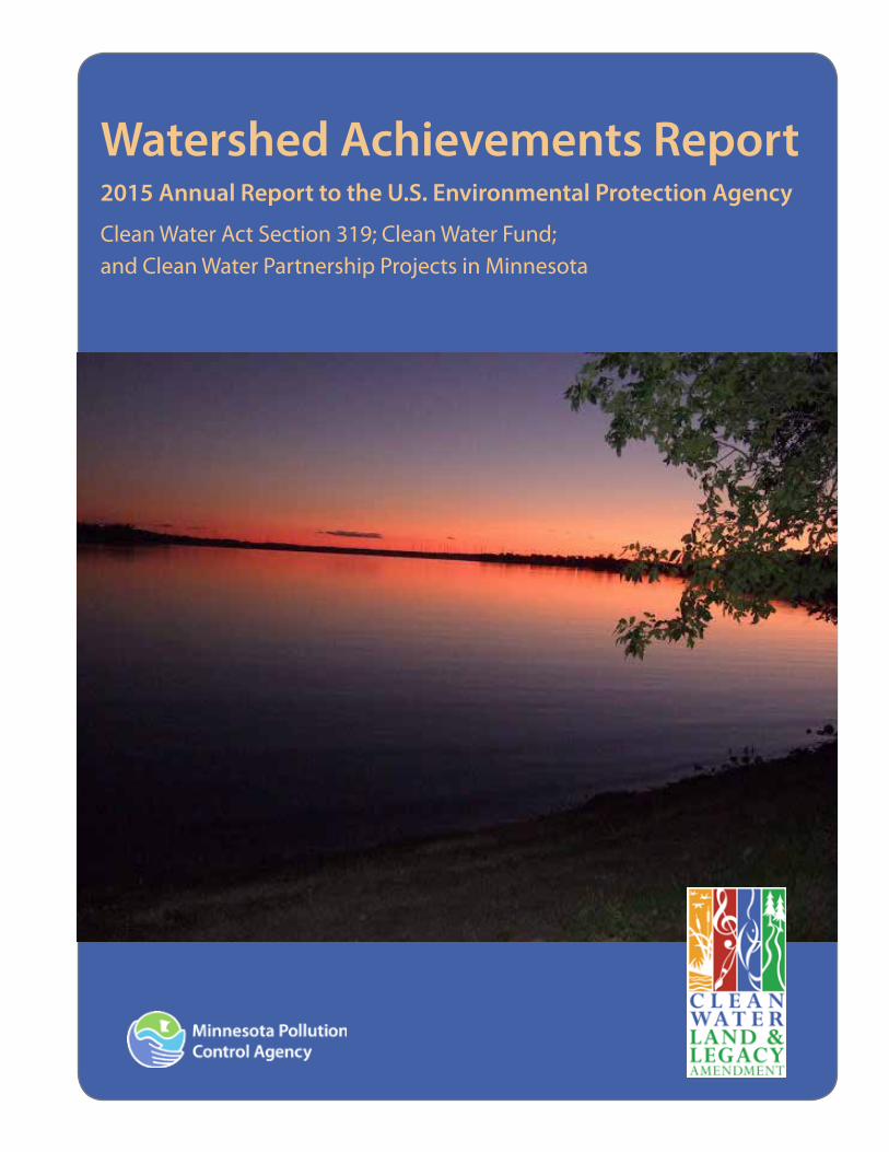
Cover photo: Lake Shaokatan, Lincoln Countywq-cwp8-18

Minnesota Pollution Control Agency www.pca.state.mn.us 5
Cedar River Watershed and Shell Rock River Watershed HSPF Modeling ................................................................................................... 47Cedar River Alternative Ditch Designs ..................................................................................................................................................................... 48
Cedar River Basin Active projects ............................................................................................................................................................................... 49Des Moines and Missouri River Basins ..................................................................................................................................................................... 50
Heron Lake Sediment Reduction Demonstration Project ................................................................................................................................ 51Des Moines and Missouri River Basins Active projects ...................................................................................................................................... 52Lake Superior Basin ........................................................................................................................................................................................................... 54
HSPF Active Groundwater Refinement .................................................................................................................................................................. 55Lake Superior River Basin ............................................................................................................................................................................................... 56Lower Mississippi River Basin ....................................................................................................................................................................................... 57
Southeast Regional Grant for Water Quality .......................................................................................................................................................... 58Lower Mississippi Basin Active Projects ................................................................................................................................................................... 60Minnesota River Basin ..................................................................................................................................................................................................... 62
A decision support tool to restore impaired waters .......................................................................................................................................... 63Minnesota River BMPs to Reduce Phosphorus ..................................................................................................................................................... 64Cottonwood River Native Vegetation Water Quality .......................................................................................................................................... 65Strengthening Watershed Work Group Formation ............................................................................................................................................. 67Burandt Lake Excess Nutrient Implementation Plan .......................................................................................................................................... 69Minnesota River Tributary Phosphorus and Flow BMPs .................................................................................................................................... 71Quantifying Nutrient Removal by Street Sweeping ........................................................................................................................................... 73Rush River Watershed TMDL Implementation Project for Fecal Coliform ................................................................................................... 75Middle Minnesota Phosphorus Load Reduction ................................................................................................................................................. 77Greater Blue Earth and Des Moines River SSTS loans ......................................................................................................................................... 79HSPF Minnesota River basin resegmentation 2010-2012................................................................................................................................. 80HSPF Upper Minnesota and Lac qui Parle Rivers Watershed Phase 1 .......................................................................................................... 81Redwood River Watershed Nonpoint Pollution Reduction Project ............................................................................................................... 82Lower Minnesota River Dissolved Oxygen Elevation Project .......................................................................................................................... 83HSPF Scenario Application Manager Development ........................................................................................................................................... 85
Minnesota River Basin Active Projects ...................................................................................................................................................................... 86Red River Basin .................................................................................................................................................................................................................... 94
Bois de Sioux Watershed Nutrient Load Assessment ......................................................................................................................................... 95Grand Marais and Snake River Watersheds HSPF Modeling – July 2014 ..................................................................................................... 97
Red River Basin .................................................................................................................................................................................................................... 98St. Croix River Basin .......................................................................................................................................................................................................... 99
Groundhouse Fecal Coliform and Biota Implementation Project ...............................................................................................................100North Branch Sunrise River Fecal Coliform Reduction Project .................................................................................................................101St. Croix Basin Civic Governance Training and Civic Policy Pilot ..................................................................................................................103
St. Croix River Basin Active projects .......................................................................................................................................................................105Upper Mississippi River Basin .....................................................................................................................................................................................107
North Cannon River Bacteria Reduction Project ................................................................................................................................................108Hardwood Creek TMDL Implementation Project ...............................................................................................................................................109Permeable Reactive Barrier for Phosphorus Removal ......................................................................................................................................110Twin Lake Wetland 639W Nutrient Export Reduction ......................................................................................................................................111Villa Park Wetland Enhanced TP Removal Project..............................................................................................................................................112
Upper Mississippi River Basin Active projects .....................................................................................................................................................113
Minnesota Pollution Control Agency www.pca.state.mn.us 6
List of acronymsARS Agricultural Research Services
BASIN Basin Analysis of Sediment-laden InflowBEC Blue Earth County
BMP best management practice
BOD biochemical oxygen demand
BWSR Minnesota Board of Water and Soil Resources
CCWMO Carver County Water Management Organization
CFU colony forming unit
CLFLWD Comfort Lake – Forest Lake Watershed District
CRP Conservation Reserve ProgramCRWD Capitol Region Watershed DistrictCWF Clean Water Fund
CWP Clean Water Partnership
DEM Digital Elevation ModelDMRP Dissolved molybdate reactive phosphorusDNR Minnesota Department of Natural Resources
DO dissolved oxygen
EPA Environmental Protection Agency
EQuIS Environmental Quality Information System
FC Fecal Coliform FCI Fortin Consulting Inc.FTE full time equivalentFWMC Flow weighted mean concentrationGBERBA Greater Blue Earth River Basin Alliance
GFLOW Groundwater Flow
GIS geological information systems
GPS global positioning system
HEI Houston Engineering, Inc. HCWP Hawk Creek Watershed ProjectHLWD Heron Lake Watershed District
HSPF Hydrologic Simulation Program FORTRAN
HUC hydrologic unit code
IBI index of biological integrity
ICT Interagency Coordination Team
IHT Imminent Health Threat
IPM integrated pest managementIWAV Impaired water viewer
IWI International Water Institute
IWM Intensive Watershed Monitoring
JPB Joint Powers BoardJD2 Judicial Ditch 2KAP Knowledge, attitudes and practices studykg kilograms
LARS Local Annual Reporting System
lbs pounds
lbs/yr pounds per year
LGU Local Government Unit
LiDAR Light Detection and Ranging
MAWD Minnesota Association of Watershed DistrictsMCES Metropolitan Council Environmental Services
MDA Minnesota Department of Agriculture
mg/L milligrams/liter
MMW Middle Minnesota Watershed
MNDOT Minnesota Department of Transportation
MPCA Minnesota Pollution Control Agency
MPN most probable number
MS4 Municipal Separate Storm Sewer System
N nitrogen
NBMP.xlsm Watershed Nitrogen Reduction Planning Tool
NBSR North Branch Sunrise River
NCHF North Central Hardwood Forest ecoregionNCRWMO North Cannon River Watershed Management Organization
NO3-N Nitrite, Nitrate
NPS nonpoint source
NRCS Natural Resource Conservation Service
NTT Nutrient Tracking ToolP Phosphorus
PAH polycyclic aromatic hydrocarbons PBMP.xlsm Watershed Phosphorus Reduction Planning toolPI Principal investigatorPPDP Participatory Program Development Projects
PPB parts per billion
RCRCA Redwood-Cottonwood Rivers Control Area
RRBC Red River Basin Commission RRW Rush River Watershed SCWMC Shingle Creek Watershed Management Commission SAC State Advisory Committee SAM Scenario Application Manager
SE SWCD JPB SE SWCD Technical Support Joint Power Board
Minnesota Pollution Control Agency www.pca.state.mn.us 7
Section 319 Section 319 Grant program
SEMWRB Southeast Minnesota Water Resources Board
SIDMA Social indicators data management and analysis (software)SIPES Social indicators planning and evaluation systemSMMS Social Measures Monitoring System
SOD sediment oxygen demand
SRF state revolving fund
SRWD Sauk River Watershed District
SRWMB Snake River Watershed Management Board
SSTS Subsurface Sewage Treatment System
Strategy Minnesota Nutrient Reduction Strategy
SWCD soil and water conservation district
SWPTSA 5 Southwest Prairie Technical Service Area 5
SWROC Southwest Research and Outreach Center
TACS Technical Assistance and Cost ShareTCMA Twin Cities Metropolitan AreaTMDL total maximum daily load
TN Total nitrogen
TP total phosphorus
TSS total suspended solids
TSVS total suspended volatile solids
U of M University of Minnesota
ug/L micrograms per liter
USDA United States Department of Agriculture
WASCOBS Water and Sediment Control Basin
WD watershed district
WFDMR West Fork Des Moines River
WMA Winter Maintenance Assessment
WMC Watershed Management Commission
WMO Watershed Management Organization
WRAPS Watershed Restoration and Protection Strategies
WRC Water Resources Center, University of Minnesota

Minnesota Pollution Control Agency www.pca.state.mn.us 8
IntroductionMinnesota’s water resources are treasured by its citizens for the beneficial uses they provide, including recreation, drinking water, aquatic life, industrial and agricultural uses. With more than 10,000 lakes, 100,000 river and stream miles, and extensive groundwater systems, water is a major part of Minnesota’s culture, economy, and natural ecosystems.
Three programs provide local governments with resources to restore and protect surface water, with a special focus on nonpoint pollution sources (NPS). The Minnesota Pollution Control Agency (MPCA) relies on the Federal Section 319 Grant program (Section 319) to provide funding for efforts to reduce NPS pollution. The second source, the Clean Water Partnership (CWP) grant program was recently defunded by the state legislature. However, previous grants are underway and will be for the next three years. Finally, the CWP loan program provides low interest loans to local units of government for best management practices (BMPs) which reduce NPS water pollution in local areas. The Watershed Achievements Report is an annual report on the efforts supported by these three funding resources and the state’s progress for reducing NPS pollution. This report describes the newly awarded, active and final NPS projects for statewide and watershed-based projects.
Minnesota’s clean water roadmapMinnesota state agencies with responsibilities for water resources worked together to develop the Clean Water Roadmap – a set of goals for protecting and restoring Minnesota’s water resources during the 25-year life of the Clean Water, Land, and Legacy Amendment. Clean Water Roadmap goals are based on currently available data and are intended to be ambitious, yet achievable. Progress in meeting these goals will require significant investment from the Clean Water Fund (CWF) established by the Amendment, combined with historical water resource funding from other sources.
This first edition of the Clean Water Roadmap lays out goals for four high-level indicators that describe surface water quality, groundwater quality, and groundwater quantity. These concrete measures mirror Minnesotans’ desire for healthy lakes, rivers, streams, drinking water, and groundwater.
Watershed program accomplishments – 2015 Minnesota’s statewide buffer initiativeMinnesota passed legislation in 2015 for a statewide buffer initiative. Buffers along lakes and rivers will now be mandated in several areas. The compromise plan requires most farmers to install 50-foot buffers along public lakes and rivers, with smaller strips along ditches. Plan highlights are:
• Improving Water Quality – The Buffer Initiative will protect Minnesota’s water resources from erosion and runoff pollution by establishing 110,000 acres of perennial vegetative cover adjacent to Minnesota’s waters.
• Cooperation and Compromise – This proposal was crafted with input from agriculture groups, environmental groups, local government groups, legislators from both parties, and landowners.
• A Multi-Agency Effort – The four lead state agencies are: Minnesota Department of Agriculture (MDA), Minnesota Board of Water and Soil Resources (BWSR), DNR, and the Minnesota Pollution Control Agency.
Swimmable, Fishable, Fixable?A new report by the MPCA provides additional evidence that agricultural and urban runoff is contributing significantly to the impairment of Minnesota’s lakes, rivers and streams. Swimmable, Fishable, Fixable? is a new study which takes an in-depth look at the lakes and streams in the state’s major drainage areas.
What we’ve learned so far about Minnesota waters
The MPCA has reached the midpoint of its first comprehensive look at water quality – and what is needed to protect and restore it – throughout the state. The agency and its partners have systematically monitored and assessed a large number of the streams, rivers, and lakes in half of Minnesota’s major watersheds. According to the data, it is unlikely that current or new clean water funding can significantly improve the deteriorating conditions of many of the state’s waters, unless the state employs new strategies to prevent the pollution from happening in the first place.
Introduction Watershed Achievements Report 2015

Minnesota Pollution Control Agency www.pca.state.mn.us 9
The data shows that phosphorus and nitrogen, high bacteria levels and mercury contamination continue to be problems in many of Minnesota’s lakes, rivers and streams. These pollutants, which are typically the product of urban and agricultural land runoff, have left many bodies of water inadequate for human consumption and aquatic life. Key findings from the report include:
Swimmable?
In watersheds dominated by urban and agricultural land, half or fewer of the lakes fully support the standard for swimming because of phosphorus and resulting algae blooms. Bacteria, nitrogen and suspended solids are also major causes for these impairments. The general pattern is that water quality is exceptionally good in the northeast part of the state and declines moving toward the southwest.
Fishable?
A healthy water system will sustain a variety of life. By looking at fish and macroinvertebrate (bug) communities, we can detect problems that other monitoring may miss or underestimate. Identifying stream stressors (factors that harm fish and other stream life) is a key step in identifying the cause of impairments and to finding solutions. Stressors found to be affecting fish and aquatic life in one third of Minnesota’s watersheds include; low dissolved oxygen (DO), excess nutrients, excess sediment, altered hydrology, lack of habitat, lack of connectivity.
Water quality is a reflection of how people use the land draining to a lake or river. Pollutants flow with water through drainage tiles and ditches, stormwater and wastewater pipes, and run off from developed and agricultural areas. Techniques, such as buffers along streams, controlled drainage, and rain gardens can reduce the flow of pollutants to streams and lakes.
Different stressors are more prevalent in various regions of the state. Many of these differences can be attributed to the dominant land use practices and disturbances in the respective regions.
Fixable?
While each watershed is different, some general themes related to conservation practice strategies have emerged for the watersheds that have completed this step:
1. In watersheds where agriculture dominates the landscape, prominent strategies include stream buffers, nutrient and manure management, wetland restorations and other forms of water storage, and stream channel stabilization.
2. For more urbanized areas, strategies focus on stormwater runoff controls ranging from site planning and rain gardens, to the construction of stormwater ponds and wetlands.
3. Not all strategies relate to traditional water pollutants. Throughout Minnesota, common strategies include improving habitat and reducing barriers (connectivity) for fish and other aquatic life.
4. Some strategies call for stronger and more targeted application of state and local laws on feedlots, shoreland, and septic systems.
“We are in this for the long haul – and we are talking 20 or more years,” said Commissioner John Linc Stine. “We need continued vigilance to protect our healthy waters and take targeted action to restore those that are impaired. It took decades for our lakes and streams to become polluted, and it will take many more years to restore them.”
Introduction Watershed Achievements Report 2015

Minnesota Pollution Control Agency www.pca.state.mn.us 10
Maps Watershed Achievements Report 2015
Statewide intensive watershed monitoring schedule and progressMinnesota’s watershed approach starts with Intensive Watershed Monitoring (IWM) around the state. Because of MPCA’s monitoring efforts, combined with other local monitoring efforts, Minnesota is well on its way to a comprehensive assessment of the waters of the state on a 10-year cycle, wrapping up in 2018. The MPCA has now initiated or completed IWM in 69 of the state’s major watersheds – that is approximately 85% of the state’s watersheds. The level of effort of this monitoring and the amount and types of data being collected in this Watershed Approach is well beyond that of past monitoring efforts.
Lk Superior (N)
Lk Sup
erior
(S)St. Louis R
Cloquet R
Nemadji R
Mississippi R(Headwaters)
Leech Lk R
Mississippi R(GrandRapids)
Mississippi R(Brainerd)
Pine R
CrowWingRiver
RedeyeRiver
Long Prairie R
Mississ
ippi R
(Sartell)
Sauk R
Mississippi R(St. Cloud)
N Fk Crow R
S Fk Crow R
Mississippi R(Twin Cities)
Rum R
Minnesota R(Headwaters)
Pommede
Terre R
Lac QuiParle R
Minnesota R(Yellow Medicine R)
Chippewa R
Redwood R
MN R(Mankato)
Cottonwood R
Blue Earth R
Watonwan R Le Sueur R
LowerMinnesota R
Upper St.Croix R
Kettle R
Snake R
LowerSt.
Croix R
Mississippi R(Lk Pepin)
Cannon R
Mississippi R(Winona)Zumbro R
Mississippi R(La Crescent)
Root RMississippi R
(Reno)
Upper Iowa R
Cedar R
ShellRock R
WinnebagoRiver
Des Moines R
LowerDes Moines
River
E Fk DesMoines R
Bois DeSioux R
Mustinka R
Otter Tail R
UpperRed R
Buffalo R
Marsh R
Wild Rice R
Sandhill R
Red LkRedLake R
Thief R
Clearwater R
GrandMarais Cr
Snake R
TamaracR
TwoRivers
Roseau R
Rainy Headwaters
Vermilion R
Rainy LakeLower Rainy
LittleFork R
Big Fork R
Rapid R
Lake ofthe Woods
Upper BigSioux R
Lower BigSioux R
Rock R
LittleSioux R
Upper Wapsipinicon R
14
0915
10
09
10
10
14
13
16
08
14
16
08
14
13
13
11
12
14
13
12
12
16
12
1417
12
09
11
09
08
13 15
16
08
15
16
10
11
11
11
17
09
08
13
10
17
15
15
12
13
15
09
16
11
11
07/17
10
08
12
11
16
08
16
06/1707/17
11
11
0914 15
10
14
15
15
14 15
11
1515
Intensive Watershed Monitoring
0 10050 Miles
´Major WatershedsStart Year
200620072008200920102011201220132014201520162017Basin
May 2014

Minnesota Pollution Control Agency www.pca.state.mn.us 11
Maps Watershed Achievements Report 2015
Watershed Restoration and Protection Strategies (WRAPS) progress WRAPS reports for the major watersheds in Minnesota are completed or underway for all except one watershed. There are six completed WRAPS studies and work in the other watersheds is underway with monitoring, watershed modeling, biological stressor work and/or a WRAPS project in progress.

Minnesota Pollution Control Agency www.pca.state.mn.us 12
Maps Watershed Achievements Report 2015
Impaired waters in MinnesotaImpaired waters in Minnesota can be viewed using the MPCA web-based mapping application impaired waters viewer (IWAV). The graphic below is a screen shot of the application that is available at this internet address: http://www.pca.state.mn.us/index.php?option=com_k2&view=item&id=871
Minnesota Pollution Control Agency www.pca.state.mn.us 13
Maps Watershed Achievements Report 2015
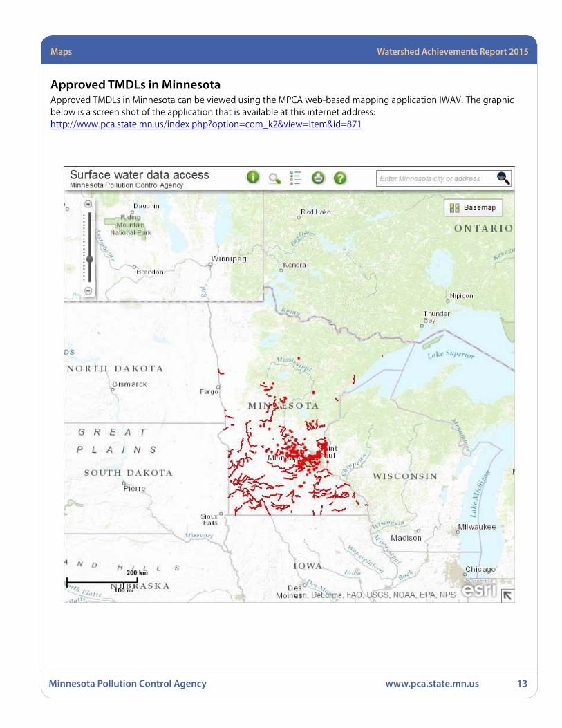
Approved TMDLs in MinnesotaApproved TMDLs in Minnesota can be viewed using the MPCA web-based mapping application IWAV. The graphic below is a screen shot of the application that is available at this internet address: http://www.pca.state.mn.us/index.php?option=com_k2&view=item&id=871
Minnesota Pollution Control Agency www.pca.state.mn.us 14
Maps Watershed Achievements Report 2015
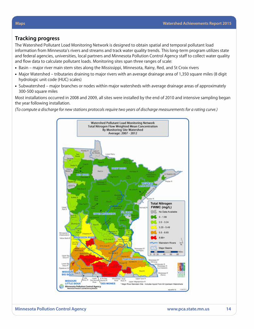
Tracking progressThe Watershed Pollutant Load Monitoring Network is designed to obtain spatial and temporal pollutant load information from Minnesota’s rivers and streams and track water quality trends. This long-term program utilizes state and federal agencies, universities, local partners and Minnesota Pollution Control Agency staff to collect water quality and flow data to calculate pollutant loads. Monitoring sites span three ranges of scale:
• Basin – major river main stem sites along the Mississippi, Minnesota, Rainy, Red, and St Croix rivers
• Major Watershed – tributaries draining to major rivers with an average drainage area of 1,350 square miles (8 digit hydrologic unit code (HUC) scales)
• Subwatershed – major branches or nodes within major watersheds with average drainage areas of approximately 300-500 square miles
Most installations occurred in 2008 and 2009, all sites were installed by the end of 2010 and intensive sampling began the year following installation.
(To compute a discharge for new stations protocols require two years of discharge measurements for a rating curve.)

Minnesota Pollution Control Agency www.pca.state.mn.us 15
Maps Watershed Achievements Report 2015
Tracking progress continued

Minnesota Pollution Control Agency www.pca.state.mn.us 16
Maps Watershed Achievements Report 2015
!
!!!!!!
!!
!
!
!!!!
Chippewa R.Ammonia (2006)
Swan R.Fecal Coliform (2006)
Redwood R.Ammonia (2008)
Dissolved Oxygen (2002)
Cedar Cr.Ammonia (2006)
Tanners Lake, Nutrients (2004)
Red R.Ammonia (2008)Fecal Coliform (2014*)
Pomme de Terre R.Dissolved Oxygen (2006)
Clearwater R.Fecal Coliform (2006)
Powderhorn Lake, Nutrients (2012)
Clearwater R.Fecal Coliform (2010)
Lost R.Fecal Coliform
(2010)
Credit R.Turbidity (2012)
Jewitts Cr.Ammonia (2012)
McKusick Lake, Nutrients (2012)
Schmidt Lake, Nutrients (2014*)Kroon Lake, Nutrients (2014*)
Fish Lake, Nutrients (2014*)
Wirth Lake, Nutrients (2014*)Lower Twin Lake, Nutrients (2014*)
Ryan Lake, Nutrients (2014*)
Keller Lake (Main Bay), Nutrients (2014*)Beaver Lake, Nutrients (2014*)
Battle Creek Lake, Nutrients (2014*)Carver Lake, Nutrients (2014*)
Red R.Fecal Coliform (2014*)
Snake R.Fecal Coliform (2014*)
Little Beauford DitchAcetochlor (2014*)
Le Sueur R.Acetochlor (2014*)
Mississippi R. (3 sections)PFOS in Fish Tissue (2014*)
Lee Lake, Nutrients (2014*)
Howard Lake, Nutrients (2014*)
Previous Impairments now MeetingWater Quality Standards due to Corrective Actions
0 10050 Miles
´
May 2014
35 Impairments
* To be proposed by MPCA for delisting in the next listing cycle.Delisting proposals are subject to public comment and EPA approval.
Legend! Lake
River
Major Watershed
Basin
County
Previous Impairments Now MeetingWater Quality Standards Due to Corrective Actions
May 2014
35 Impairments
* To be proposed by MPCA for delisting in the next listing cycle. Delisting proposals are subject to public comment and EPA approval.

eLINK Watershed Achievements Report 2015
Minnesota Pollution Control Agency www.pca.state.mn.us 17
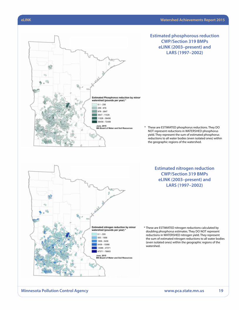
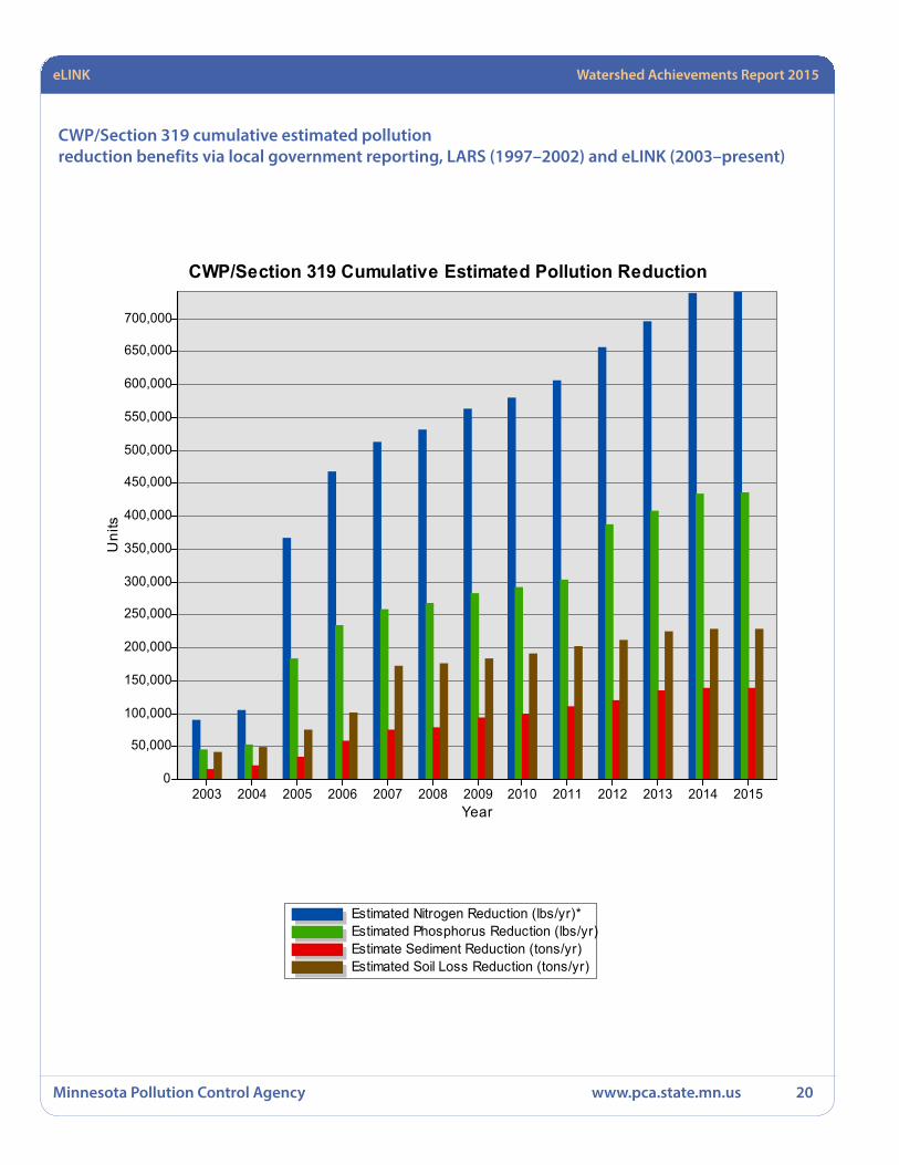
LARS and eLINK results from Section 319 and CWP projects 1997–July 2015The following table shows progress through July 2015 based on previous Local Annual Reporting System (LARS) reporting (1997–2002) and reporting data from eLINK (2003–July 2015). Based on LARS/eLINK reporting by Clean Water Partnership (CWP) and Section 319 project partners, these projects have reduced soil loss from 1998 through July 2015 by more than 228,972 tons/year. During the same period, sedimentation was reduced by more than 138,712 tons/year. Phosphorus loading was reduced by more than 435,378 pounds/year. Nitrogen reduction was reduced by more than 740,587 pounds/year.
CWP/Section 319 BMPs eLINK (2003–present) and
LARS (1997–2002)

eLINK Watershed Achievements Report 2015
Minnesota Pollution Control Agency www.pca.state.mn.us 18
Estimated sediment reduction by minorwatershed (tons per year) *
0.1 - 88
88 - 265
265 - 543
543 - 1066
1066 - 3073
3073 - 12066
June, 2015MN Board of Water and Soil Resources
CWP/319 BMPseLINK (2003-present) & LARS (1997-2002)
* These are ESTIMATED sedimentreductions. They DO NOT representreductions in WATERSHED sedimentyield. They represent the sum ofestimated sediment reductions toall water bodies (even isolated ones)within the geographic regions of thewatershed.
* These are ESTIMATED soil loss reductions. They DO NOT represent reductions in WATERSHED soil loss yield. They represent the sum of estimated soil loss reductions to all water bodies (even isolated ones) within the geographic regions of the watershed.
Estimated soil loss reductionCWP/319 BMPs
e LINK (2003 - present) and LARS (1997–2002)
Estimated sediment reductionCWP/319 BMPs
eLINK (2003 - present) and LARS (1997 - 2002)
* These are ESTIMATED sediment reductions. They DO NOT represent reductions in WATERSHED sediment yield. They represent the sum of estimated sediment reductions to all water bodies (even isolated ones) within the geographic regions of the watershed.
eLINK Watershed Achievements Report 2015
Minnesota Pollution Control Agency www.pca.state.mn.us 19
Estimated nitrogen reductionCWP/Section 319 BMPs
eLINK (2003–present) and LARS (1997–2002)
* These are ESTIMATED nitrogen reductions calculated by doubling phosphorus estimates. They DO NOT represent reductions in WATERSHED nitrogen yield. They represent the sum of estimated nitrogen reductions to all water bodies (even isolated ones) within the geographic regions of the watershed.
* These are ESTIMATED phosphorus reductions. They DO NOT represent reductions in WATERSHED phosphorus yield. They represent the sum of estimated phosphorus reductions to all water bodies (even isolated ones) within the geographic regions of the watershed.
Estimated phosphorous reductionCWP/Section 319 BMPs
eLINK (2003–present) andLARS (1997–2002)
eLINK Watershed Achievements Report 2015
Minnesota Pollution Control Agency www.pca.state.mn.us 20
CWP/Section 319 cumulative estimated pollution reduction benefits via local government reporting, LARS (1997–2002) and eLINK (2003–present)
Estimated Nitrogen Reduction (lbs/yr)*Estimated Phosphorus Reduction (lbs/yr)Estimate Sediment Reduction (tons/yr)Estimated Soil Loss Reduction (tons/yr)
CWP/Section 319 Cumulative Estimated Pollution Reduction
Year2003 2004 2005 2006 2007 2008 2009 2010 2011 2012 2013 2014 2015
Uni
ts
700,000
650,000
600,000
550,000
500,000
450,000
400,000
350,000
300,000
250,000
200,000
150,000
100,000
50,000
0

Watershed Achievements Report 2015
Minnesota Pollution Control Agency www.pca.state.mn.us 21
All projects awarded through 2015No Federal Section 319 awards were given during state fiscal year 2015 (July 1, 2014 – June 30, 2015) because of administrative delays in opening the annual funding round. The funding round opened in late spring 2015, and award recommendation was not made until after August 1, 2015.
Watershed Achievements Report 2015
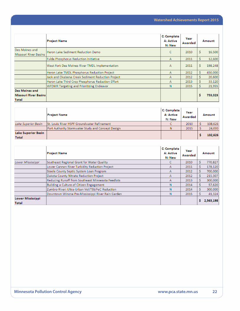
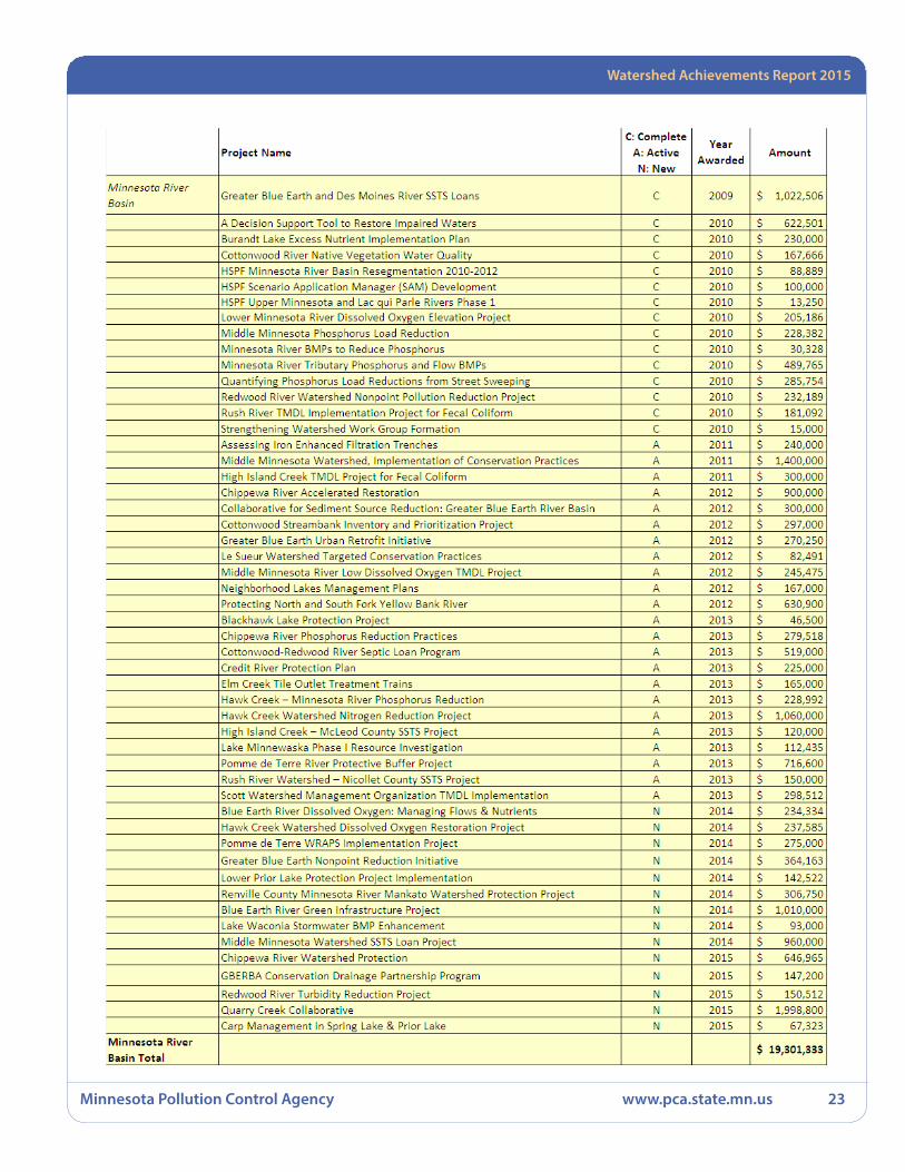
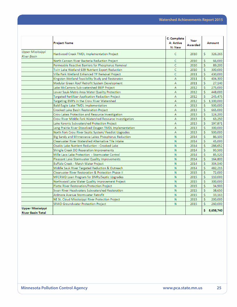
Minnesota Pollution Control Agency www.pca.state.mn.us 22
Watershed Achievements Report 2015
Minnesota Pollution Control Agency www.pca.state.mn.us 23

Watershed Achievements Report 2015
Minnesota Pollution Control Agency www.pca.state.mn.us 24
Watershed Achievements Report 2015
Minnesota Pollution Control Agency www.pca.state.mn.us 25
Statewide Watershed Achievements Report 2015
Minnesota Pollution Control Agency www.pca.state.mn.us 26
!
!!
!
!
!!
!
!
!
!
!
!
!
!
!
!!
! !
!
!!
!!
!
!
!
!!
!
!
!
!
!!
!
!!
!!!
!
!
!
!
!
!
!!
! !
!
!
!
!
!
!!
!
!
!
!
!
!
!
!
!!! !
!
!!
!
!!
!
!
!
!
!
!!
!!!
!!!!
!!
!!!!
!
!!!!
!
!!
!
!!
!
!
!!
!
!! !
!
!
!! !!!
!
!
!
!!
!
!
!
!
!
!
!
!
!
!
!
!!
!!!
!
!!
!
!
!
!
!
!!
!
!
!! !!
!
!
!
! !
!
!
!
!! !
!
!
!!!
!
!!
!
!
!
!
!
!
!
!
!!!
!!!
!
!
!
!
!
!
!
!
!
!
!
!
! !
!
!
!
!
!
!
!
!
!
Lk Superior (N)
Lk Sup
erior
(S)St. Louis R
Cloquet R
Nemadji R
Mississippi R(Headwaters)
Leech Lk R
Mississippi R(GrandRapids)
Mississippi R(Brainerd)
Pine R
CrowWingRiver
RedeyeRiver
Long Prairie R
Mississ
ippi R
(Sartell)
Sauk R
Mississippi R(St. Cloud)
N Fk Crow R
S Fk Crow R
Mississippi R(Twin Cities)
Rum R
Minnesota R(Headwaters)
Pommede
Terre R
Lac QuiParle R
Minnesota R(Yellow Medicine R)
Chippewa R
Redwood R
MN R(Mankato)
Cottonwood R
Blue Earth R
Watonwan R Le Sueur R
LowerMinnesota R
Upper St.Croix R
Kettle R
Snake R
LowerSt.
Croix R
Mississippi R(Lk Pepin)
Cannon R
Mississippi R(Winona)Zumbro R
Mississippi R(La Crescent)
Root RMississippi R
(Reno)
Upper Iowa R
Cedar R
ShellRock R
WinnebagoRiver
Des Moines R
LowerDes Moines
River
E Fk DesMoines R
Bois DeSioux R
Mustinka R
Otter Tail R
UpperRed R
Buffalo R
Marsh R
Wild Rice R
Sandhill R
Red LkRedLake R
Thief R
Clearwater R
GrandMarais Cr
Snake R
TamaracR
TwoRivers
Roseau R
Rainy Headwaters
Vermilion R
Rainy LakeLower Rainy
LittleFork R
Big Fork R
Rapid R
Lake ofthe Woods
Upper BigSioux R
Lower BigSioux R
Rock R
LittleSioux R
Upper Wapsipinicon R
M i n n e s o t a
´
0 5025 Miles
Legend! Approved Lake TMDL
Approved Stream TMDLMajor WatershedBasin Boundary
Watershed ProjectsNewNew and ActiveActiveCompleted
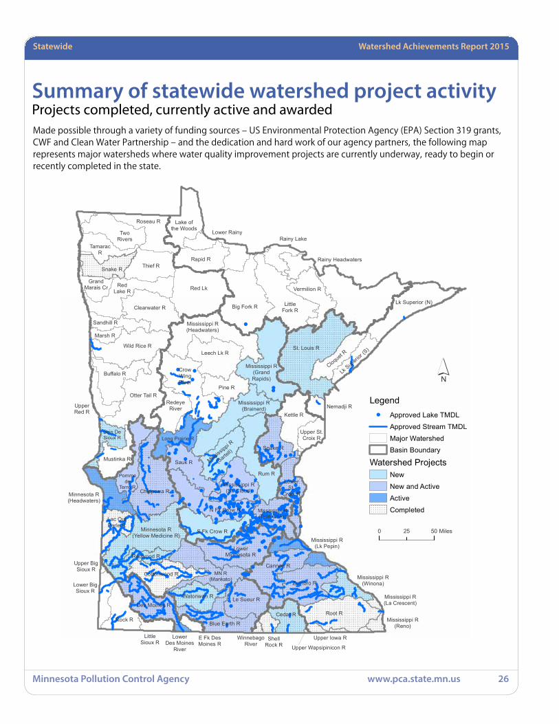
Summary of statewide watershed project activity Projects completed, currently active and awarded Made possible through a variety of funding sources – US Environmental Protection Agency (EPA) Section 319 grants, CWF and Clean Water Partnership – and the dedication and hard work of our agency partners, the following map represents major watersheds where water quality improvement projects are currently underway, ready to begin or recently completed in the state.

Statewide Watershed Achievements Report 2015
Minnesota Pollution Control Agency www.pca.state.mn.us 27
Statewide Projects completedClean Water Performance Report – Social Measures Monitoring System (MPCA)
eLINK Database Support – FFY 2013
Enhanced filter media for removal of dissolved heavy metals and phosphorus from stormwater runoff
Initiate Implementation of Minnesota’s Nutrient Reduction Strategy
Minnesota pollution reduction and economics test with Nutirent Tracking Tool
Phosphorus and Water Balance Tools for TMDL Plans
Planning Tool for Watershed Scale Surface Water Nutrient Reduction
Side Inlets to Improve Water Quality
Social Indicators for Nonpoint Source Pollution in Minnesota
Strategy to Increase Vegetative Cover on Agriculutural Landscapes
Winter and Turf Maintenance Training – FFY 2010 Amendment
Statewide Watershed Achievements Report 2015
Minnesota Pollution Control Agency www.pca.state.mn.us 28
Clean Water Performance Report – Social Measures Monitoring System (MPCA)From July to September 2014, researchers from the Department of Forest Resources, University of Minnesota (U of M), and MPCA staff advanced efforts to integrate the Social Measures Monitoring System (SMMS, Davenport, 2013) and the MPCA Participatory Program Development Project (PPDP) project and program management resources.
This integration requires an application of social science assessment principles and methodologies drawn from current bodies of knowledge and standards of practice in both the basic (e.g. psychology and sociology) and applied (e.g., human dimensions of natural resources) social sciences. The PPDP Project Management Worksheet guides project teams in planning public participation implementation using an array of social science-based activities including critical thinking exercises, worksheets and sample measures menus.
The SMMS consists of an overview document, five metadata sheets corresponding to five high-level social measures and a menu of project-specific sample measures that can be used to monitor progress towards these high-level measures. The SMMS is a systematic and science-based framework that provides concepts and principles to consider when planning, managing, tracking and reporting the human and social dimensions of watershed projects. The SMMS and PPDP both use the Multilevel Community Capacity Model (Davenport, 2013) to help ensure program consistency, project flexibility, and technique replicability and scalability.
The specific objectives of this 2.5 month project were to (1) understand the SMMS in light of current MPCA program needs; (2) develop and deliver the first of five workshops on the Project Management Worksheet and (3) gather feedback to improve the workshop and worksheet. This is the initial phase of a multi-year effort to consolidate resources in development since 2009 through the PPDP, pilot the SMMS within program-specific procedures and to generate content for the 2016 Clean Water Fund Report to be compiled by the Interagency Social Measures Subteam. Project results justify continued project funding.
Goals• Continue to integrate and test social science concepts
and principles in MPCA PPDP project and program
management resources; integrate SMMS and gather content for the 2016 Clean Water Fund (CWF) Report.
• Develop workshop prototype to help orient project teams to Program Management Worksheet and social science concepts and principles.
• Gather user-testing feedback to inform iterative development of PPDP project and program management systems and resources.
Results that count• Watershed professionals have better understanding
of community capacity assessment principles and techniques and their connection to MPCA Watershed Program public participation and engagement practice and principles.
• Watershed professionals have increased ability to design watershed projects for community capacity outcomes.
• Program has increased ability to track human dimension of selected watershed project for 2016 Interagency Clean Water Fund Report.
Financial informationFunding type: Section 319Grant amount: $33,179 Final in Kind: $1,447
Contact informationDr. Mae A. Davenport, Associate ProfessorUniversity of Minnesota, Department of Forest Resources1530 Cleveland Avenue N, Room 301FSt. Paul, MN 55108 612-624-2721, [email protected] MPCA Project Manager: Cindy Hilmoe
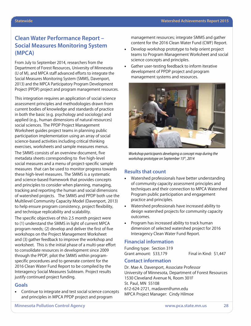
Workshop participants developing a concept map during the workshop prototype on September 15th, 2014

Statewide Watershed Achievements Report 2015
Minnesota Pollution Control Agency www.pca.state.mn.us 29
eLINK Database Support – FFY 2013This project provides financial support to the I.T. and grant program staff that support the eLINK reporting system and eLINK users. eLINK, the electronic link between state and local governments, is a web based reporting system that is maintained and supported by the Board of Water and Soil Resources (BWSR). eLINK is used by BWSR to track expenditures and accomplishments by local governments with state grant funds. In Minnesota, the same local governments who receive state grant funds from BWSR also receive federal 319 water quality grants via the MPCA. BWSR and MPCA have long had a coordinating relationship regarding the collection of expenditure and accomplishment reporting data from local governments. To the extent that state water quality agencies can coordinate their administrative requirements, we are all better off.
Specifically, this project provides financial support for BWSR staff to maintain and support the eLINK system. This includes a variety of tasks, such as server administration, database administration, GIS administration, eLINK configuration, eLINK system reports management, eLINK account administration, eLINK user support, and eLINK user training. These support tasks are ongoing throughout the year.
BWSR staff provided system support and developed guidance materials for MPCA during the contract. Conor Donnelly provided system technical support, and Gwen Steel provided user interface support. During this reporting period, BWSR finalized migration of remaining 319 grants from the old eLINK system. Additionally, BWSR staff set up new grants in the system, created user accounts for relevant MPCA staff, and developed 319 and CWP-specific training materials for distribution to MPCA grant recipients and project managers. BWSR will continue to work with MPCA as we maintain and improve the system.
Goals• Provide access and support to local government 319
grant recipients so they can report expenditures and accomplishments back to the state via the eLINK reporting system.
• Provide training to MPCA staff to participate in the “set up” of 319 grant information.
• Provide data and maps from eLINK to MPCA upon request.
Results that count• Local government staff have been submitting
information about their BMP installations and associated pollution reductions via eLINK since 2004. There are more than 4000 landowner BMP 319 implementations recorded in eLINK going back to 2004.
New organizational and user accounts were created for new grantees, and user accounts were created and team membership assigned to MPCA project managers.
• In the old eLINK system, MPCA was responsible for setting up new grant information. With the implementation of new eLINK, BWSR staff has been setting up 319 information for local stakeholders and adding the appropriate MPCA project managers to the “team membership” of 319 grants to allow MPCA to monitor what has been entered.
BWSR, in collaboration with MPCA, has developed a guidance document for 319 and CWP grantees and project managers. A training video has also been recorded for MPCA project managers to instruct them in how to pull reports and find grant data in eLINK.
• MPCA receives data and maps out of the eLINK database annually upon request for inclusion in the annual Watershed Achievements Report submitted to EPA.
In February and August of 2014, eLINK staff provided the reported pollution reduction estimates of Section 319 funding projects for download to the Federal GRTS reporting system.
Financial informationFunding type: Section 319Grant amount: $59,966
Contact informationDave Weirens,Acting Assistant Director for Programs & Policy MN Board of Water & Soil Resources520 Lafayette Road NorthSt. Paul, MN 55155 [email protected] MPCA Project Manager: Doug Wetzstein

Statewide Watershed Achievements Report 2015
Minnesota Pollution Control Agency www.pca.state.mn.us 30
Enhanced filter media for removal of dissolved heavy metals and phosphorus from stormwater runoffThe purpose of this project was to research materials that could be used in new or renovated sand filters, infiltration systems, rain gardens, and buffer strips to capture significant amounts of dissolved heavy metals, phosphorus, and nitrogen that are typically found in urban and agricultural runoff. Literature was thoroughly reviewed to document performance by existing stormwater treatment practices and investigate potential enhancements for water quantity reduction and capture of dissolved heavy metals, phosphorus, and nitrogen. Batch studies found that several enhancing agents such as commercial products and organic materials captured a substantial amount of dissolved metals; iron-based products captured a significant fraction of dissolved phosphorus; and two activated carbons were found to remove a significant fraction of nitrate from synthetic stormwater.
Column studies confirmed that activated carbons removed dissolved nitrate in an upflow system with 15 minutes of contact time, but nitrate ions competed for sorption sites with other ions (e.g., carbonate). Field verification experiments were designed to determine how the treatment technology could be expected to perform in field applications. The activated carbons performed better under simulated field conditions than laboratory conditions, despite significantly shorter contact time. In addition, nitrate competition with other ions was not observed in the field verification experiments. The Thomas model can be used to estimate and represent removal of nitrate from stormwater by activated carbon.
A filter containing an activated carbon from this study that is 5% of the contributing watershed area will have an estimated lifespan of between 40 and 100 storm events (rainfall depth of 5 cm (2 inch), nitrate concentration of 0.6 mg NO3-N/L). Additional research is needed to determine if this is cost-effective, or if captured nitrate can be denitrified between storm events to increase capacity and extend the lifespan of activated carbon filters for nitrate removal.
Goals• Determine performance capabilities of existing
stormwater treatment practices
• Identify and evaluate potential enhancements to existing stormwater treatment practices that remove dissolved metals, phosphorus, and nitrogen
• Establish design criteria for enhanced media filters
Results that count• The Literature Review provides details on
performance of existing practices.
• The experiments identified and evaluated various enhancements for removing dissolved metals, phosphorus and nitrogen.
• The recommendations provide design criteria necessary for sizing and estimating the performance of an enhanced media filter.
Financial informationFunding type: Section 319Grant amount: $404,000Final in-kind: $330,546
Contact informationKevin McKoskeyUniversity of Minnesota450 McNamara Alumni Center, 200 Oak StreetMinneapolis, MN 55455612-624-5066MPCA Project Manager: Greg Johnson
The picture above shows the column experiment system used in the study to examine the performance of the treatment technology using real stormwater. This picture was taken at the St. Anthony Falls Laboratory at the University of Minnesota.

Statewide Watershed Achievements Report 2015
Minnesota Pollution Control Agency www.pca.state.mn.us 31
Initiate Implementation of Minnesota’s Nutrient Reduction StrategyThis third phase of the Minnesota Nutrient Reduction Strategy (strategy) focused on revising the strategy to address comments and requests from the Interagency Coordination Team (ICT). The final strategy is the product of several years of work and resulted in a state-level nutrient reduction strategy to achieve and track meaningful and achievable progress for reducing point and nonpoint nutrient losses to waters. The questions addressed in the strategy include:
1. Goals – What are the needed levels of reductions?
2. Sources – Which nitrogen and phosphorus sources should be priorities?
3. Priority areas – What parts of the state are most critical for reductions?
4. BMPs – What level of BMP adoption is needed to achieve goals?
5. Stepping up – How can we increase BMP adoption?
6. Research – What new/improved BMPs are needed to ensure long term goals are achieved?
7. Accountability – How can we track progress in BMP adoption and water quality improvement?
This project resulted in a strategy to achieve nitrogen and phosphorus decreases within Minnesota water bodies and also provide incremental benefits for the Gulf of Mexico hypoxia problem and other waters downstream of Minnesota, as well as enhance the health of aquatic life in Minnesota water bodies, and increase the recreational potential of Minnesota’s numerous lakes. Initial steps were anticipated to begin implementation of the strategy as part of this project.
Goals• Support the ICT work on the Minnesota Nutrient
Reduction Strategy.
• Initiate Strategy implementation.
Results that count• The final Nutrient Reduction Strategy was completed
September 2014.
• Meetings were held with the ICT to obtain input and direction on strategy implementation
Financial informationFunding type: Section 319
Grant amount: $37,007
Contact informationJennifer OlsonTetra TechP.O. Box 61Stillwater, MN [email protected] Project Manager: David Wall
Cover of the 2015 Minnesota Nutrient Reduction Strategy report
wq-s1-80

Statewide Watershed Achievements Report 2015
Minnesota Pollution Control Agency www.pca.state.mn.us 32
Minnesota Pollution Reduction and Economics Test with Nutrient Tracking Tool This project will professionally validate and demonstrate the Nutrient Tracking Tool (NTT) to evaluate land management scenarios and provide measureable outcomes for conservation practices designed to reduce non-point source pollution. The NTT, being developed by the United States Department of Agriculture (USDA) and Texas Institute for Applied Environment Research, compares agricultural management scenarios to calculate a change in nitrogen, phosphorous, sediment loss potential and crop yield. A farm economic component will be incorporated to understand the economic bottom line related to productive land management. The NTT can be used for farm management planning; market based programs, as well as calculating measurable outcomes for conservation practices. In addition, the NTT estimates nitrogen delivered in the shallow aquifer at field edge.
Project partners (Minnesota River Board, American Farmland Trust, Kieser & Associates, Rural Advantage, South Central College and Stearns County Soil and Water Conservation District [SWCD]) view the NTT as a valuable tool to evaluate and compare agricultural management systems and justify conservation implementation from both an economic and environmental standpoint. The project will test and demonstrate the NTT for future use in conservation practice decision making and implementation. Natural resource professionals will be trained to use the NTT. Priority BMP sites will be selected to evaluate performance of the NTT and costs / benefits of management scenarios. After validating and developing the NTT curriculum, the project team will engage in outreach events and train natural resource managers.
Goals• One of our primary goals for this project focused on
the successful and well-timed identification of priority BMP’s practices and on-the-ground functioning sites. The priority BMP’s, perennial establishments, buffers, nutrient management, conservation tillage, and cover crops, will be the focus of landowner interviews and a comprehensive assessment of the crop rotation surrounding the BMP. An economic analysis of these BMP’s are part of this goal.
• The second goal of this project was the professional validation of the NTT by peer review, utilizing technical committees and a State Advisory Committee (SAC) comprised of state level conservation professionals. Through this peer review and validation of the tool, the team will have a goal of running a final evaluation of the NTT and determine applicability of this tool for future use in ecosystem management.
• The third goal of this project is to build a network of individuals trained and tested to use the NTT. The team hopes to create heightened awareness of the NTT and its use for farm planning, water quality conservation and ecosystem services. The team hopes to see the use of NTT by natural resources professionals in Minnesota. This will all be supported by the completion of core curriculum development of NTT, explaining its use and how to use it.
Results that count• The goal of identifying well timed BMP’s was achieved
due to many reasons. The BMP’s the team chose are practices that are currently being utilized on the landscape and are practices that our partners have strong connections with. The Stearns County SWCD has a strong history of working with producers in terms of nutrient management and Rural Advantage has a strong history of working with producers in the area of cover crops. Conservation tillage, buffers and perennial establishments are all practices that are currently on the landscape and that producers are supporting. Integrated with this information that is gathered from the producers is the economic information concerning each of these practices. The inputs that are required for each of these scenarios are recorded and will be inputted into the NTT tool.
• The second goal of this project has been hampered by the NTT not being calibrated for Minnesota. It has also been hampered by the Tool itself, at times, giving different outputs based on the same initial inputs on repeated runs. Professional validation by the SAC was initiated and is mostly in the beginning phases of validation by the SAC. The applicability of the tool to Minnesota and its relation to our latitude and growing seasons was discussed and shared with the developers. The team believes in the applicability of the tool for future use in ecosystem management but the tool needs to be calibrated for Minnesota so that the natural resource professionals who would use it, are confident in the outputs the tool is producing.
Statewide Watershed Achievements Report 2015
Minnesota Pollution Control Agency www.pca.state.mn.us 33
• The third goal of this project of building a network of individuals trained in the use of NTT is in process. The NTT tool has been shared with many natural resource professionals and has been received very well by those professionals for its functionality. The ease of use of the tool is being addressed in the core curriculum and training and is not completed at this time. However, the outputs of the program have been shared with these professionals and the ability of the tool to show the decreases or increases in nitrogen, phosphorus, and sediment has been well received. The team has created a heightened awareness of the NTT tool and this is reflected in the Natural Resource Conservation Service (NRCS) wanting to work with Minnesota in getting the tool calibrated. The team can see its use in farm planning, water quality conservation, and ecosystem services occurring.
Lessons learnedA valuable lesson learned in this project was to have a tool that was calibrated and ready for use within the project. This project objective experienced substantial delays and challenges surrounding NTT development complications occurring at the national level. Even though the model was originally promised to be calibrated and in service over a year ago, the NRCS and its contractors have run into budget delays that resulted in this complicating issues. One example causing NTT
work delays has been the national level management and decision making process regarding the targeted audience and release of a full working version of the tool. Recently NRCS has concluded it will work only with the USDA Agricultural Research Services (ARS) and take back full control of NTT setup, calibration and documentation. The team is very excited that the tool will soon become calibrated in Minnesota but will await the day that will happen. We find value in this tool and really want to see this tool come to fruition. We would like to continue this project once there is a calibrated version.
Financial informationFunding type: Section 319Grant amount: $62,496Final in-kind: $98,417
Contact informationShannon Fisher, Executive DirectorMinnesota River Board135 Trafton Science Center SouthMinnesota State UniversityMankato, MN [email protected] Project Manager: Nick Gervino
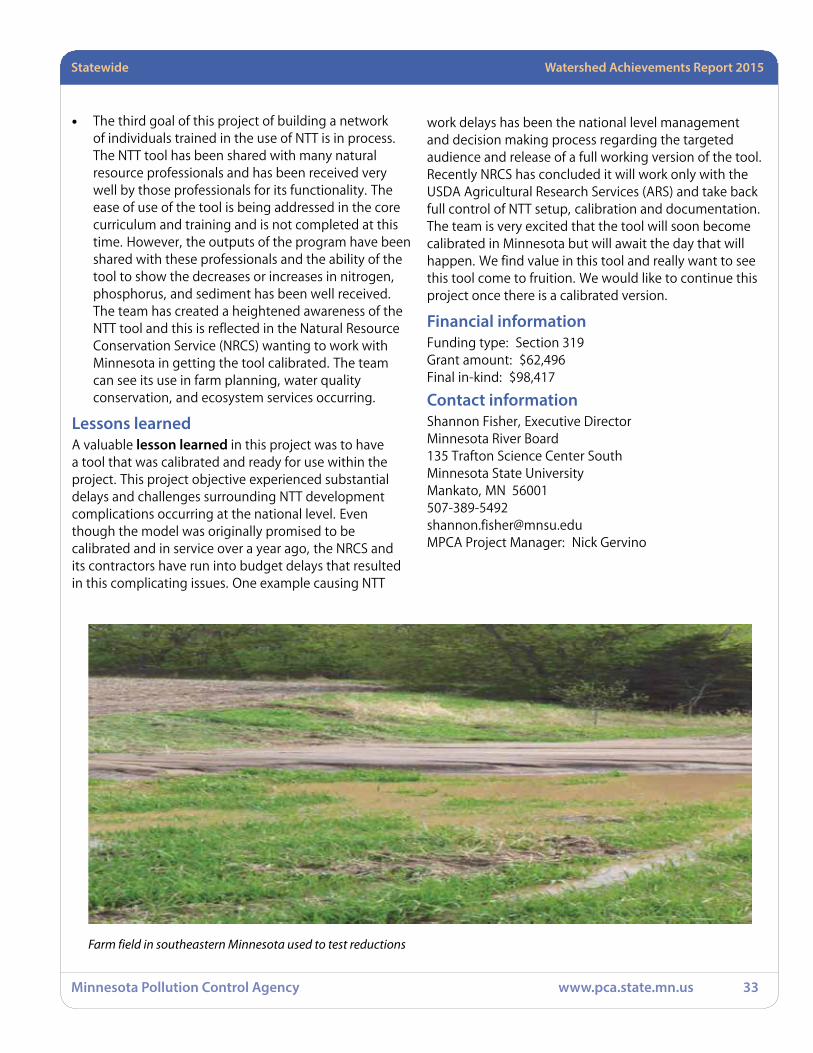
Farm field in southeastern Minnesota used to test reductions

Statewide Watershed Achievements Report 2015
Minnesota Pollution Control Agency www.pca.state.mn.us 34
Phosphorus and Water Balance Tools for TMDL PlansMost efforts to reduce nonpoint source (NPS) phosphorus (P) inputs to water are based on the idea of trapping particles in structural BMPs. This has not been effective at reducing P loads in the Mississippi River basin, so new approaches are needed. In this study, we developed a P balance calculator tool that will allow watershed managers to think in terms of P balances, seeking to reduce inputs (fertilizer, feed, human food, etc.) or increase deliberate outputs (crops, animal products, biosolids) to reduce accumulation in the watershed. For our case study agricultural watershed in the Albert Lea, Minnesota region, the P balance revealed a negative balance – more P was brought into the watershed that was deliberately exported, a condition that would reduce P accumulation and eventually reduce stream P. Our urban P balance revealed that the largest flux of P was in animal bones – an outcome associated with having a large meat-packing plant in the watershed.
We also developed “biogeochemical diagnostic” tools that can help watershed managers tailor BMPs to be most effective across hydrologic settings varying from mostly groundwater inputs to mostly overland runoff. In our agricultural study site we learned that P loads were dominated by soluble P, which came from both groundwater and overland flow.
To translate research into practice, we developed Urban and Agricultural P Balance Calculators, both simple-to-use, open-source, Excel spreadsheets that embeds extensive knowledge acquired in this project. We also developed a complete P balance for the Albert Lea region – the city and its industries, along with upstream agricultural watersheds, to enable local governments to envision new directions in P management that utilize “P balance thinking.”
Goals• Develop detailed P balances for the agricultural
watershed and the City of Albert Lea, Minnesota.
• Develop hydrologic tool to improve selection of BMPs.
• Develop a guidance manual that embeds knowledge from the above goals.
Results that count• We developed detailed P balances for the agricultural
watershed and the City of Albert Lea.
• We developed a “biogeochemical diagnostics” toolkit to guide BMP selection.
• We developed a User’s Manual and associated spreadsheet P balance calculator tools.
Financial informationFunding type: Section 319Grant amount: $294,868Matching funds: $73,215Final in-kind: $170,851
Contact informationKevin McKoskeyUniversity of Minnesota450 McNamara Alumni Center, 200 Oak StreetMinneapolis, MN 55455612-624-5066MPCA Project Manager: Greg Johnson
Agricultural drainage ditch in the Albert Lea Lake watershed,
Minnesota

Statewide Watershed Achievements Report 2015
Minnesota Pollution Control Agency www.pca.state.mn.us 35
Planning Tool for Watershed Scale Surface Water Nutrient Reduction The University of Minnesota previously developed a spreadsheet tool for estimating watershed nitrogen reductions to surface waters when combinations of BMPs are adopted, referred to as the “Watershed Nitrogen Reduction Planning Tool” or NBMP.xlsm. This project developed a similar spreadsheet tool for estimating watershed phosphorus reductions to surface waters when one or more BMPs are adopted, along with making improvements in the previously-developed nitrogen tool. The new tool is referred to as the “Watershed Phosphorus Reduction Planning Tool” or PBMP.xlsm. The BMPs incorporated into PBMP.xlsm include: 1) reducing P fertilizer rates on six major crops to target rates; 2) applying P fertilizer as close to planting as possible; 3) using reduced tillage; 4) installing riparian buffers near streams; 5) planting cover crops; 6) adopting controlled drainage and alternatives to open tile inlets; and 6) injecting or immediately incorporating manure. Geological information System (GIS) analysis was used to determine suitable acreage for each BMP. The reduction in P load and costs to adopt each of the BMPs are calculated in the spreadsheet based on user-defined adoption rates and various research-based assumptions and parameters.
Goals
• Add a phosphorus reduction BMP spreadsheet component to the NBMP tool.
• Improve the nitrogen load reduction estimates in the current NBMP tool.
Results that count• A draft version of the PBMP.xlsm spreadsheet has
been developed and is undergoing review and refinement.
• Added N inhibitor and saturated buffers as BMPs. Added more detail on the overlap between suitable acres of riparian buffers, wetlands, and perennial crops. Made many other small changes. Revised the documentation. Refined the estimates of corn yield reductions under current and BMP N rates and different rainfall scenarios. Fixed a bug in the manure crediting calculations that affects the individual watershed loading calculations. Also changed
(increased) the estimate of manure in the current sheet to be more consistent with other estimates. Revised the riparian buffer suitable acres data with new data that accounts for land currently in buffers. Also, changed the default assumption for land shifted from fall N application to spring or sidedressed, to assume that that acreage also has the rate reduced, even if the rate reduction adoption is less than the acreage shift adoption rates. Fixed a bug in the perennial crop value calculations.
Financial informationFunding type: Section 319Grant amount: $67,002Final in-kind: $22,501
Contact informationJudy KrzyzekUniversity of Minnesota450 McNamara Alumni Center, 200 Oak StreetMinneapolis, MN 55455612 624 [email protected] Project Manager: Dave Wall

Statewide Watershed Achievements Report 2015
Minnesota Pollution Control Agency www.pca.state.mn.us 36
Side Inlets to Improve Water QualityThe primary focus of this study is the effectiveness of alternative side inlet designs in reducing the sediment contributions of croplands and decreasing downstream peak flow rates.
The key objectives were to: 1) conduct an inventory of side inlet locations in several selected watersheds to help develop siting method(s), 2) perform hydrologic modeling on large and small scales to evaluate the potential for side inlets and water quality benefits, 3) conduct side inlet control experiments at U of M, Southwest Research and Outreach Center (SWROC) to evaluate several alternative side inlet designs, 4) develop design guidance, and 5) to demonstrate the use of alternative side inlets in field conditions, with associated outreach. The types of side inlets considered in this study were the existing straight sloped pipe and alternative designs consisting of a drop inlet with flush pipe, Hickenbottom™ perforated riser on a drop inlet, rock inlet, perforated tile coil inlet, and rock weir.
Three GIS-based methods were developed and evaluated for identifying the location of side inlets. Overall, the best method predicted locations of side inlets, or potential need for a side inlet, with a fair level of accuracy.
Field experiments were conducted at the U of M SWROC in Lamberton, Minnesota to experimentally assess five alternative side inlets to obtain hydraulic and sedimentation parameters that are needed to model them and to define field scale pros and cons of these inlets. The data indicated that side inlets with a longer detention time have greater sediment removal and that the perforated tile coil did not function well.
Modeling results support the use of alternative types of side inlets along with potential earth reshaping to establish short-term detention. When performance, cost, maintenance, life expectancy and modeling results for individual sites were all considered, the Hickenbottom™ riser (or similar product) on a drop inlet was indicated as the best alternative side inlet choice. A drop inlet type of side inlet has a number of advantages over designs like straight sloping pipes, rock weirs and rock trenches, including:
a. Typically can be constructed closer to a berm along the top of the ditch or streambank compared to
a straight sloping pipe, reducing the distance the side inlet extends into the field and improving the potential for location of the inlet in a perennial buffer.
b. Typically reduces the flow velocity at the outlet of the structure, reducing associated outlet erosion potential, by dissipating more energy in the drop pipe and reducing the slope of the horizontal pipe.
c. Provides for optional types of intakes on top of the drop pipe that can be tailored to the residue accumulation conditions at the intake, including easy replacement, to ensure adequate flow capacity, as well as adequate detention time for sediment trapping. A wide variety of intake styles and capacities for drop inlets are available from various manufacturers.
Watershed level modeling indicated trapping efficiencies, reduction efficiencies, watershed reduction efficiencies and net reduction efficiencies were generally dependent on the magnitude of the runoff event and the influent size distribution, as well as on-field detention time.
Four local partners demonstrated alternative side inlets. The events led by local, state agency and university partners engendered positive responses to alternative side inlet designs, as well as some producer investigation of the practice for their property.
Goals• Develop a GIS methodology for identifying side inlet
from Light Detection and Ranging (LiDAR) data.
• Develop design guidance material based on results of experimental work at SWROC and modeling done using Basin Analysis of Sediment-laden Inflow (BASIN).
• Demonstrate side inlets for water quality in four partner local governmental unit (LGU)s.
Results that count• GIS methodology was found that has a fair degree
of accuracy in locating and prioritizing sites for side inlet control structures. However, more research and development will be required to make the methodology available to and usable by LGU staff.
• Supplemental design guidance was developed clearly defining the potential of side inlets to increase

Statewide Watershed Achievements Report 2015
Minnesota Pollution Control Agency www.pca.state.mn.us 37
water quality by the use of various types of intakes with associated temporary water detention. The design guidance can be used to promote the use of drop inlets with options for inlet type correlated to drainage area, detention design and residue accumulation conditions, and to start conversations with the NRCS to modify their present side inlet design standard to emphasize temporary water detention for improved water quality performance.
• Four demonstration field days were held demonstrating multiple side inlet alternatives on 20 separate sites. Evaluations indicate that the demonstrations were opportunities for innovation in the minds of many producers, drainage inspectors and others involved with field runoff to drainage ditches. The potential for adoption of side inlets for improved water quality was measurably increased.
Lessons learned The scope and complexity of the project involving numerous players, and associated timeframe, made it challenging to have consistent University graduate student staffing, as well as staffing at the Minnesota Board of Water and Soil Resources (BWSR), and LGU partners, as it turned out. However, the project scope enabled a quite thorough investigation of the side inlets practice from siting through design and demonstration to improve water quality.
Financial informationFunding type: Section 319Grant amount: $341,605Matching funds: $130,000Final in-kind: $172,525
Contact informationTim Gillette, Conservation Drainage EngineerMinnesota Board of Water and Soil Resources520 Lafayette Road NorthSt. Paul, MN [email protected] MPCA Project Manager: Nick Gervino
Side Inlet Demonstration Day, Summer 2014

Statewide Watershed Achievements Report 2015
Minnesota Pollution Control Agency www.pca.state.mn.us 38
Social Indicators for Nonpoint Source Pollution in MinnesotaThe EPA Region 5 funded a multi-state effort to create a social evaluation framework, called the Social Indicators Planning and Evaluation System (SIPES). Minnesota joined this effort in 2006, testing the SIPES framework with four urban and rural NPS projects. The results of the testing phase of the SIPES framework was that this evaluation tool did not meet local needs. Some partners declined to use SIPES again for post-project summative evaluation.
Our research found that Minnesota’s NPS projects vary considerably by type, scale, and capacity to evaluate outcomes. About half of Minnesota’s projects have audiences too small for random probability sampling as required by SIPES. Local partners reported that SIPES was too complicated and costly for them to use. Minnesota’s NPS audiences are also more diverse than other states, which is not captured by the SIPES framework.
Therefore, we adapted and tested an alternative method called the knowledge, attitudes and practices (KAP) study as part of our approved work plan. The KAP method worked well in instances where audiences are too small for SIPES, or where standardized SIPES questionnaires are not a good fit with the characteristics of the local audience. By April 2013 twenty-five KAP studies were completed or in process, mostly commissioned by local watershed agencies. The KAP method is useful for formative and summative evaluation, and is helpful in organizing civic engagement and education strategies. We have completed a training package for local partners on social research and evaluation methods, including a protocol for the KAP study method.
In summary, the social indicators project was completed on time and within budget, and yielded useful findings and practical tools for watershed projects. Demand for KAP studies has grown in Minnesota. SIPES continues to be used by other Region 5 states.
Goals• The overarching goal of this project was to create
practical evaluation methods and tools for the staff of 319-funded NPS projects that can measure changes in human behaviors, knowledge and
capacities, as measured through pre (formative) and post (summative) project evaluation methods.Develop design guidance material based on results of experimental work at SWROC and modeling done using BASIN.
• Provide 319-funded NPS projects with the SIPES/social indicators data management and analysis (SIDMA) framework, and train project staff in its use and applications. This indicator-based evaluation framework is intended for 319-funded projects with larger target audiences, and enables evaluation data to be compared across states and within EPA Region 5. The SIPES and SIDMA tools may eventually be required by EPA for use in all 319-funded projects.
• Provide smaller-scale NPS projects in Minnesota with practical “supplemental” evaluation tools and methods to determine project impacts and outcomes. Supplemental tools are intended for situations where random sampling and standardized questionnaires are not appropriate.
Results that countThe social indicators framework (SIPES and SIDMA) was tested in four diverse cases in Minnesota (a mid-size urban stormwater project in Duluth; a municipal winter maintenance training program to reduce chloride application by snowplow drivers; a small rural agricultural project in southwestern Minnesota; and a large-scale random probability survey of producers in four counties in the Buffalo-Red watershed). In other Region 5 states, members of the regional social indicators team generally conducted the surveys for the local partner. In Minnesota, we asked the local partner to actually conduct and implement the SIPES surveys, since they were the intended end-users. The testing process found that the framework was too burdensome for local partners (generally municipalities, counties, and SWCDs).
In response to their feedback, we adapted and tested the KAP study method for use in NPS projects at different scales. In all cases the KAP method has worked very well, yielding information that has contributed to engagement/outreach strategies and educational content, as well as the original intent (formative and summative evaluation). The KAP method has proven to yield valuable information for project staff that has enabled them to fine-tune their outreach efforts and to customize educational messages. With such direct and immediate information about pre/post project

Statewide Watershed Achievements Report 2015
Minnesota Pollution Control Agency www.pca.state.mn.us 39
social outcomes becoming available, an indicator-based (proxy) system is not necessary for project staff to determine baseline conditions and post-project results. As noted, indicator frameworks are often most useful at a macro agency and inter-agency level to observe broad programmatic and policy outcomes. Eventually, as KAP experience in NPS evaluation continues to build, it may become possible at some point to build a reference database of standards and outcomes that could be used for macro-level project comparison and meta-analysis of multiple projects. In any case, as a result of this project, there is now a cost-effective, reliable method available for evaluating the social outcomes and impacts of NPS projects on local audiences.
Lessons learned Training in practical social research and evaluation/impact assessment would be very beneficial for NPS and other environmental projects.
Financial informationFunding type: Section 319Grant amount: $200,000Matching funds: $122,595
Contact informationKarlyn Eckman, Senior Research AssociateUniversity of Minnesota Water Resources Center (WRC)173 McNeal Hall, 1985 Buford AvenueSt. Paul, MN 55108612 [email protected] Project Manager: Lynne Kolze

Statewide Watershed Achievements Report 2015
Minnesota Pollution Control Agency www.pca.state.mn.us 40
Strategy to Increase Vegetative Cover on Agricultural LandscapesMinnesota is working to develop a multi-organizational plan to move the state from its current level of vegetative cover into a long term plan of increased vegetative cover that will enable water quality goals to be met. Vast acreages of cover crops and vegetative cover increases are needed to meet the State’s nutrient and sediment reduction goals.
This project identified short- and long-term strategies that can be used to increase vegetative cover on agricultural lands in Minnesota, in order to address water quality and other environmental and agricultural concerns. It was developed based on interviews and conversations with thirty experts and leaders in the agricultural community over a four-month period. These experts included University of Minnesota researchers and administrators, and personnel from state and federal agencies, state commodity groups, farm organizations, agricultural industry, and non-profit organizations.
The interviews started with a look at the “big picture” opportunities and challenges in agriculture today, and gradually focused on ways to increase vegetative cover on the landscape along with the associated barriers, gaps/needs, and resources to making this increase happen. It also included discussion of what activities are happening already related to vegetative cover.
Additionally, a literature review was conducted to further identify technical gaps and needs associated with advancing vegetative cover adoption in Minnesota.
The information was then compiled, and a set of nine strategies were identified. The successful advancement of vegetative cover BMPs on agricultural lands hinges on a common vision and approach that is understood and supported among all key agencies, academia and private industry.
Goals• Develop a multi-faceted strategy to substantially
increase vegetative cover on Minnesota agricultural landscapes
Results that count• Opinions were obtained from 30 experts and leaders
• Nine strategies were identified, along with associated gaps, opportunities, and partners
• A literature review further identified options for cover crops and technical challenges which we will need to overcome
Financial informationFunding type: Section 319Grant amount: $49,687Final in-kind: $27,035
Contact informationDonald Wyse, Professor, Dept. of Agronomy & Plant GenUniversity of Minnesota411 Borlaug Hall1991 Buford CircleSt. Paul, State: MN [email protected] Project Manager: David Wall
A cover crop sample plot in southwest Minnesota supervised by U of M researchers
Statewide Watershed Achievements Report 2015
Minnesota Pollution Control Agency www.pca.state.mn.us 41
Turf and Winter Maintenance Training – FFY 2010 AmendmentNutrients and chloride are immediate issues of concern for Minnesota and many other states due to their negative impacts on the environment, including impaired waters. Currently 329 Minnesota streams and lakes are on the 2008 TMDL list for nutrient/eutrophication. Thirty percent of sampled groundwater wells in the Twin Cities Metropolitan Area (TCMA) exceed the federal drinking water standard for chloride, and Minnesota has seven streams already on the impaired list for chlorides.
Goals
This amendment and funding were added to expand the number of trainings. As with Fortin Consulting Inc. (FCI)’s other 319 work, the emphasis is on teaching BMP’s of winter snow and ice control with rock salt, and with chemicals such as phosphorus and nitrogen used in turfgrass maintenance.
Results that count
This grant funded training of an extra 415 maintenance professionals, public and private, who engage in winter and summer activities which lead to the introduction of nutrients/phosphorus and chloride into the environment. We also offered an MPCA-approved test for voluntary certification.
Sixteen workshops and two short presentations were held under this grant, with a total of 215 participants. A sampling shows a minimum reduction of 20% in chlorides and 35% reduction of phosphorus sent through stormwater runoff due to this educational outreach and the subsequent changed practices. The training material was also refined and improved throughout the course of the grant funding.
With a portion of this funding, FCI also evaluated the interest for having a field demonstration as part of the turfgrass class. The demonstration consisted of seven stations. Participants rotated through the stations at half hour increments. We had a strong turnout with 81 participants. One hundred percent of the respondents rated the Field Demo good or excellent. Ninety six percent would recommend it to a colleague. Participants found the event valuable and felt the field demo should be held every year (52%) or every two years (30%).
Lessons learnedTraining for governmental and private maintenance must include information addressing potential cost concerns. We were fortunate in that we were able to provide information that showed that adoption of the BMPs could also save money. As we continued to gain actual results from those using the practices, we added these actual numbers to our training.
The thing we struggled most with is getting the attendance of the private contractors. They are not paid to attend training, and are not earning money while attending, so it is difficult to get them to come to workshops, even with the training being free or low cost. Some ideas were discussed which we believe would help, but none were tried by the local partners. FCI recommends that counties and cities be supported in requiring certification of maintenance staff doing work within their borders.
Liability is a big barrier for many of the contractors and government staff. Many were concerned that if they reduced the amount of deicers used they would open themselves up for future legal problems. The training promotes reduction of material while maintaining safety. However, we believe liability will continue to be a barrier to chloride reduction unless there is an effort through legal means to give individuals more responsibility for their driving and walking under winter conditions.
From the start we planned on including two types of instructors, one knowledgeable in water resources and training, and another that has the experience and knowledge in conducting winter and turfgrass maintenance. We found that this worked very well and helped give the training credibility with the winter maintenance professionals. We were able to provide environmental information, technical information on the products, equipment and methods, and practical information on using the practices. We recommend this model for similar training.
One thing we recommend for this priority area is a media campaign for the general public. Plow drivers continue to frequently comment that they are using a lot of salt or lawn chemicals because of public demand and that the public must reduce its demands for perfectly clear roads and perfect turfgrass. A public media campaign could be used to help the public understand that there are environmental ramifications to using salt and sand on our roads and excess chemicals on turfgrass.

Statewide Watershed Achievements Report 2015
Minnesota Pollution Control Agency www.pca.state.mn.us 42
Financial informationFunding type: Section 319Grant amount: $39,997Final in-kind: $69,082
Contact informationConnie Fortin, PresidentFortin Consulting Inc.215 Hamel RoadHamel, MN [email protected] Project Manager: Brooke Asleson
Winter Road Maintenance Training in Scott County, 2014

Statewide Watershed Achievements Report 2015
Minnesota Pollution Control Agency www.pca.state.mn.us 43
StatewideActive projectsSection 319 projects awarded in 2014None awarded in 2015Assessing Enhanced Swales for Pollution Prevention – 2011Sponsor: U of M
Funding: Section 319 (Grant) $400,000
Purpose: This research will demonstrate the effectiveness of a new stormwater treatment system developed specifically for capturing dissolved phosphorus and heavy metals from roadway runoff. This new technology is relatively inexpensive to install compared to standard stormwater treatment practices and will fit within the limited roadway right-of-way, making it applicable to public and private roadways throughout the State of Minnesota and beyond. With approximately 290,954 lane-miles of public roadways in Minnesota and an approximate annual phosphorus load of 1.87 pounds per lane-mile, the potential reduction in phosphorus load to receiving water bodies is (at a 90% capture rate) approximately 488,800 pounds per year. The result would be a substantial improvement in water quality wherever this novel technology is installed.
Stormwater professionals will be informed of these results through workshops, a technical advisory panel, and UPDATES (a stormwater research newsletter with distribution to more than 2,000 interested parties). We will also seek inclusion in the on-line document, “Minnesota Stormwater Manual,” http://www.pca.state.mn.us/index.php/view-document.html?gid=8937.
Chloride Reduction Outreach Program – 2012Sponsor: Freshwater Society
Funding: Section 319 (Grant) $97,286
Purpose: This project will engage public officials, businesses and citizens in a facilitated planning process that will increase their understanding of chloride pollution, ways to reduce it at organizational and personal levels, create and implement a collaborative Chloride Reduction Outreach Strategy and Implementation Plan for Rochester, Mankato and
St. Cloud that will be distributed to citizens, businesses and public officials for future action.
eLINK Database Support FY15 – 2014Sponsor: Minnesota Board of Water and Soil Resources
Funding: Section 319 (Grant) $60,000
Purpose: Provide eLINK database support to MPCA staff, local units of government and grant sponsors; record soil and water conservation project BMPs, geographic project locations and load reductions in eLINK; and provide a section for the annual Watershed Achievements Report showing estimated load reductions.
HSPF Scenario Application Manager (SAM) User Group Workgroup – 2015Sponsor: RESPEC
Funding: Section 319 (Grant) $170,282
Purpose: Develop SAM interface enhancements, BMP database improvements and development of a pre-processing tool to automate the processing of HSPF model applications. The contractor will also develop documentation for the software and perform QA/QC and testing for functionality created for the previous work order and the phase in this work order.
HSPF Scenario Application Manager User Group Workshop – 2015Sponsor: RESPEC
Funding: Section 319 (Grant) $10,060
Purpose: Provide funding for a Scenario Application Manager (SAM) User Group workshop to assess the needs of likely users for a watershed-scale, decision-support tool to facilitate prioritization and placement of BMPs to achieve the needed pollution reductions identified by the WRAPS/TMDL reports.
Internal Phosphorus Load Reduction with Iron Filings – 2013Sponsor: U of M
Funding: Section 319 (Grant) $299,047
Purpose: Determine the effectiveness of iron filings under different conditions at reducing internal phosphorus loading, determine the conditions required for iron filings to be effective at reducing internal phosphorus loading, and determine the quantity of iron filings that must be

Statewide Watershed Achievements Report 2015
Minnesota Pollution Control Agency www.pca.state.mn.us 44
placed in the sediments for a successful reduction of internal phosphorus loading.
Level 2 Winter Maintenance Training – 2014Sponsor: Fortin Consulting, Inc.
Funding: Section 319 (Grant) $129,176
Purpose: Create a Level 2 winter maintenance training curriculum, conduct up to 24 Level 2 MPCA certification training courses and/or presentations; train up to 400 senior maintenance professionals and certify the majority; produce specific and substantial organizational changes in maintenance practices as a result of training; and produce and distribute the use of education. We will evaluate success by the number of classes conducted, number of short presentations given in support of the long-term viability of the program, number of individuals trained, number of organizations trained, educational materials produced and distributed, number of individuals certified, estimated pollutant reductions, Winter Maintenance Assessment (WMA) reports/refinement and course evaluations.
Linking Water Storage BMPs to Watershed Goals – 2012Sponsor: Minnesota River Board
Funding: Section 319 (Grant) $292,140
Purpose: This project will develop, adjust, verify and test a water storage calculator that links new and existing individual projects to large-scale watershed goals, measuring the results in “cubic feet stored” or “volume and rate of storage” for structural and vegetative BMPs; establish and facilitate a Water Storage Learning Group; select and implement 5-10 water storage practices/projects; and reach out to technical service providers, certified crop advisors, SWCDs, and NRCS so this technology and thinking can be applied in everyday work.
Performance of an Agricultural Drainage Tile Filter – 2013Sponsor: U of M
Funding: Section 319 (Grant) $256,465
Purpose: This project will measure and evaluate the performance of an engineered enhancement to agricultural drainage tiles that will significantly decrease the release of phosphates to surface waters from agricultural runoff. The innovative filter design would be based on previously developed technology that enables increased phosphate removal by adsorption using iron, in the form of iron filings.
Reducing Phosphorus Runoff From Livestock Farms – 2012Sponsor: U of M
Funding: Section 319 (Grant) $296,318
Purpose: This project will determine phosphorus balances on farms in two regions of high dairy and beef density near nutrient impaired waters; select management strategies for bringing representative farms with a phosphorus surplus into balance or below; develop selected farm analyses into teaching case studies; and use case studies from the farm phosphorus balance analyses to assist livestock producers and their agricultural professionals in evaluating their operations and select strategies to prevent excessive build-up in soil test phosphorus and transport of phosphorus to waters, while maintaining or improving profitability.
Turf and Winter Maintenance Training – 2013Sponsor: Fortin Consulting, Inc.
Funding: Section 319 (Grant) $110,000
Purpose: Three different voluntary certifications courses will be taught: Winter Maintenance of Roads, Winter Maintenance of Parking Lots/Sidewalks and Turfgrass Maintenance with Reduced Environmental Impacts. We anticipate a fourth course, MPCA Level II Winter Maintenance, will exist so we can offer it. We will conduct 30-40 classes or shorter presentations at conferences or group meetings across the state. We will teach about 2,000 people and will reach many more through our training manuals and information on the MPCA website. This project is unique in that the audience is maintenance workers and it is a certification course. It will help organizations meet salt reduction goals expected to be established with the metro chloride plan. Based on results from previous classes, we expect changes in practices and substantial reductions in salt, sand, nutrients pesticide and water use from this project,
Statewide Watershed Achievements Report 2015
Minnesota Pollution Control Agency www.pca.state.mn.us 45
which will translate into pollutant loading reductions to Minnesota waters.
Watershed Specialist Training, Phase II – 2011Sponsor: U of M, Water Resources Center (WRC)
Funding: Section 319 (Grant) $193,029
Purpose: The U of M, through its WRC, proposes to develop Minnesota’s Watershed Specialist Training Program. The program is in partnership with other training providers and watershed organizations including the MPCA, academic departments, and other state and local governmental and non-governmental conservation organizations. This training program will ensure that those leading and involved in watershed planning and implementation involving impaired waters understand the legal framework, the programmatic requirements, and the resources and tools needed to complete TMDLs, develop watershed plans, and lead implementation efforts. The goal is to help managers go beyond their specialized skills to be able to integrate a broad set of natural and social science skills.
We will develop and implement an online training program for watershed professionals that will improve their management skills and their ability to effectively and holistically address water quality issues.

Minnesota Pollution Control Agency www.pca.state.mn.us 46
Cedar River Basin Watershed Achievements Report 2015
Cedar River Basin Projects completed
Project involving multiple watershedsCedar River Watershed and Shell Rock River Watershed HSPF Modeling
Cedar River WatershedCedar River Alternative Ditch Designs
!
!! !! !
Shell RockRiver
WinnebagoRiver
C e d a r R i v e rB a s i n
Upper WapsipiniconRiver
CedarRiver
Cedar River Basin
´0 2010 Miles
Minnesota
Legend! Approved Lake TMDL
Approved Stream TMDL
County Boundary
Major Watershed
Basin Boundary
Watershed ProjectsNew
New and Active
Active
Completed

Cedar River Basin Watershed Achievements Report 2015
Minnesota Pollution Control Agency www.pca.state.mn.us 47
Project involving multiple watershed
Cedar River Watershed and Shell Rock River Watershed HSPF ModelingThis project resulted in the construction, calibration, and validation of watershed models using Hydrologic Simulation Program Fortran (HSPF). The contractor produced HSPF models that can readily be used to provide information to support conventional parameter TMDLs. The contractor has demonstrated that this model generates predicted output timeseries for hydrology, sediment, nutrients, and DO which are consistent with available sets of observed data. The contractor provided all modeling files, several memorandums, and a final report documenting model calibration, validation and supporting statistics.
Goals • The construction of HSPF models for the Cedar River
and the Shell Rock-Winnebago River watersheds.
• The calibration and validation of these two models for hydrology, sediment, nutrients and DO.
• The generation of model output to support permitting efforts in the Shell Rock River.
Results that count• The Cedar River (07080201) and Shell Rock River
(07080202) watershed models are fully functioning.
• These models have been successfully calibrated and validated.
• Sources and sinks of DO have been examined for both point and NPS in the Shell Rock River watershed.
Financial informationFunding type: Section 319
Grant amount: $25,000
Matching funds: 40,000
Contact information RESPEC/Jason Love, Vice President: Water & Natural Resources13824 Jet DriveRapid City, SD [email protected] Project Manager: Charles Regan
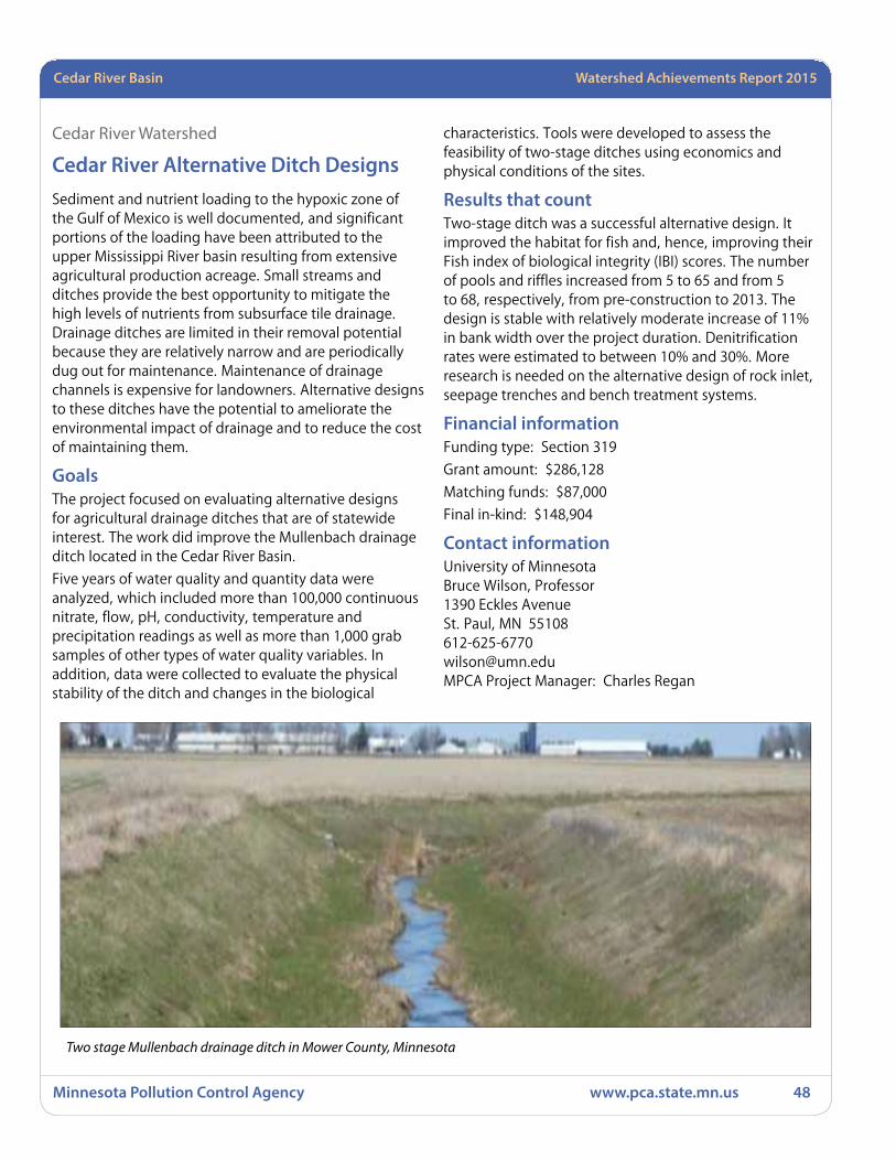
Minnesota Pollution Control Agency www.pca.state.mn.us 48
Cedar River Basin Watershed Achievements Report 2015
Cedar River Watershed
Cedar River Alternative Ditch DesignsSediment and nutrient loading to the hypoxic zone of the Gulf of Mexico is well documented, and significant portions of the loading have been attributed to the upper Mississippi River basin resulting from extensive agricultural production acreage. Small streams and ditches provide the best opportunity to mitigate the high levels of nutrients from subsurface tile drainage. Drainage ditches are limited in their removal potential because they are relatively narrow and are periodically dug out for maintenance. Maintenance of drainage channels is expensive for landowners. Alternative designs to these ditches have the potential to ameliorate the environmental impact of drainage and to reduce the cost of maintaining them.
GoalsThe project focused on evaluating alternative designs for agricultural drainage ditches that are of statewide interest. The work did improve the Mullenbach drainage ditch located in the Cedar River Basin.
Five years of water quality and quantity data were analyzed, which included more than 100,000 continuous nitrate, flow, pH, conductivity, temperature and precipitation readings as well as more than 1,000 grab samples of other types of water quality variables. In addition, data were collected to evaluate the physical stability of the ditch and changes in the biological
characteristics. Tools were developed to assess the feasibility of two-stage ditches using economics and physical conditions of the sites.
Results that countTwo-stage ditch was a successful alternative design. It improved the habitat for fish and, hence, improving their Fish index of biological integrity (IBI) scores. The number of pools and riffles increased from 5 to 65 and from 5 to 68, respectively, from pre-construction to 2013. The design is stable with relatively moderate increase of 11% in bank width over the project duration. Denitrification rates were estimated to between 10% and 30%. More research is needed on the alternative design of rock inlet, seepage trenches and bench treatment systems.
Financial informationFunding type: Section 319
Grant amount: $286,128
Matching funds: $87,000
Final in-kind: $148,904
Contact information University of MinnesotaBruce Wilson, Professor1390 Eckles AvenueSt. Paul, MN [email protected] Project Manager: Charles Regan
Two stage Mullenbach drainage ditch in Mower County, Minnesota
Cedar River Basin Watershed Achievements Report 2015
Minnesota Pollution Control Agency www.pca.state.mn.us 49
Cedar River BasinActive projectsSection 319 projects awarded in 2014
Effectiveness of Targeted Dobbins Creek BMPs – 2014Sponsor: Cedar River Watershed District
Funding: Section 319 (Grant) $300,000
Purpose: Demonstrate the ability of new GIS and LiDAR technology to facilitate water quality and aquatic habitat improvements in waterways receiving agricultural drainage using a suite of targeted conservation practices. The primary focus will be to assess and document targeted BMP performance in reducing sediment, nutrient, and fecal coliform loads, improving IBI scores, and to analyze these changes from financial and watershed perspectives. This project will demonstrate the impact of prioritized, targeted, and tailored BMPs in the Dobbins Creek watershed with respect to hydrologic pathways and processes. This method could serve as a model for future watershed comprehensive BMP implantation projects.

Des Moines and Missouri River Basins Watershed Achievements Report 2015
Minnesota Pollution Control Agency www.pca.state.mn.us 50
Des Moines and Missouri River Basins Projects completed
Des Moines River – HeadwatersHeron Lake Sediment Reduction Demonstration Project
!
!
!
LowerBig Sioux R
Upper Big Sioux R
Rock River
Little Sioux R
Des Moines R
Lower Des Moines R
E Fk Des Moines R
M i s s o u r i R i v e rB a s i n
D e s M o i n e sR i v e r B a s i n
Des Moines and Missouri River Basins
´0 2010 Miles
Legend! Approved Lake TMDL
Approved Stream TMDL
County Boundary
Major Watershed
Basin Boundary
Watershed ProjectsNew
New and Active
Active
Completed Minnesota
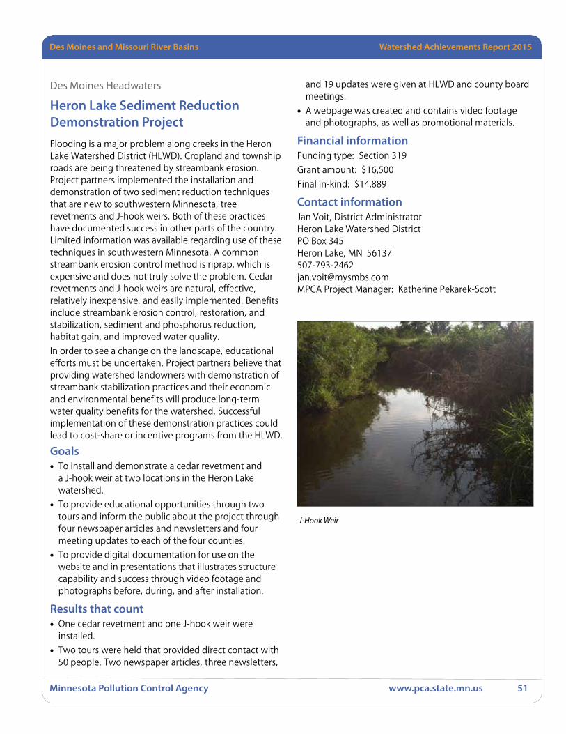
Watershed Achievements Report 2008 StatewideDes Moines and Missouri River Basins Watershed Achievements Report 2015
Minnesota Pollution Control Agency www.pca.state.mn.us 51
Des Moines Headwaters
Heron Lake Sediment Reduction Demonstration ProjectFlooding is a major problem along creeks in the Heron Lake Watershed District (HLWD). Cropland and township roads are being threatened by streambank erosion. Project partners implemented the installation and demonstration of two sediment reduction techniques that are new to southwestern Minnesota, tree revetments and J-hook weirs. Both of these practices have documented success in other parts of the country. Limited information was available regarding use of these techniques in southwestern Minnesota. A common streambank erosion control method is riprap, which is expensive and does not truly solve the problem. Cedar revetments and J-hook weirs are natural, effective, relatively inexpensive, and easily implemented. Benefits include streambank erosion control, restoration, and stabilization, sediment and phosphorus reduction, habitat gain, and improved water quality.
In order to see a change on the landscape, educational efforts must be undertaken. Project partners believe that providing watershed landowners with demonstration of streambank stabilization practices and their economic and environmental benefits will produce long-term water quality benefits for the watershed. Successful implementation of these demonstration practices could lead to cost-share or incentive programs from the HLWD.
Goals• To install and demonstrate a cedar revetment and
a J-hook weir at two locations in the Heron Lake watershed.
• To provide educational opportunities through two tours and inform the public about the project through four newspaper articles and newsletters and four meeting updates to each of the four counties.
• To provide digital documentation for use on the website and in presentations that illustrates structure capability and success through video footage and photographs before, during, and after installation.
Results that count• One cedar revetment and one J-hook weir were
installed.
• Two tours were held that provided direct contact with 50 people. Two newspaper articles, three newsletters,
and 19 updates were given at HLWD and county board meetings.
• A webpage was created and contains video footage and photographs, as well as promotional materials.
Financial informationFunding type: Section 319
Grant amount: $16,500
Final in-kind: $14,889
Contact informationJan Voit, District AdministratorHeron Lake Watershed DistrictPO Box 345Heron Lake, MN [email protected] Project Manager: Katherine Pekarek-Scott
J-Hook Weir

Des Moines and Missouri River Basins Watershed Achievements Report 2015
Minnesota Pollution Control Agency www.pca.state.mn.us 52
Active projectsSection 319 projects awarded in 2014
Des Moines River Basin
Des Moines River – Headwaters Fulda Phosphorus Reduction Initiative – 2011Sponsor: Heron Lake Watershed District
Funding: Section 319 (Grant) $12,600
Purpose: Through this effort, project sponsors will conduct a rain garden demonstration project to work with the community to address pollution concerns. This will be done by providing educational opportunities for students and the community to learn about native vegetation, water quality improvement, pollution reduction, and environmentally-friendly landscaping. This project will provide opportunities for students to learn about the importance of water quality improvement and how they can play a part in pollution reduction efforts.
The community is concerned about their lake system and has requested assistance from the HLWD. The majority of landowners and operators in this sub-watershed are concerned about soil health and water quality. These residents have been involved in a redetermination of benefits of filter strip installation, and other conservation efforts. Landowners are receptive to conservation practices along the ditch system. This effort will provide landowners with funding for conservation tillage incentives and shoreline restoration demonstration projects.
Fulda Lakes 1 and 2 were placed on the impaired list in 2008 for nutrient and eutrophication biological indicators. Stormwater runoff contributes to these impairments.
The City of Fulda residents were invited to participate in a Social Indicators Pilot Project in 2009 by completing a survey. This was an effort to gauge public opinion regarding water quality efforts conducted in the Fulda Lakes’ project area.
Des Moines and Missouri River BasinsHeron Lake TMDL Phosphorus Reduction Project – 2012Sponsor: Heron Lake Watershed District
Funding: CWP (Loan) $450,000
Purpose: This project will promote and install 45 Subsurface Septic Treatment Systems (SSTS) and other agricultural BMPs in the Heron Lake watershed.
Heron Lake Third Crop Phosphorus Reduction Effort – 2013Sponsor: Heron Lake Watershed District
Funding: Section 319 (Grant) $33,120
Purpose: Provide incentives to establish 200 acres of cover crops on an annual basis during the three-year grant period. This will be done by aerially seeding a third crop, or cover crop, of cereal rye, purple top turnip, and tillage radish. Cover crops reduce erosion, decrease soil compaction, increase water infiltration to prevent runoff, bring leached nitrogen back to the root zone for the following year’s crop, increase organic matter, and provide habitat cover. The HLWD also proposes to conduct civic engagement through the development of a steering committee. Processes taught at the Southwest Civic Engagement Cohort will be employed with the committee to brainstorm about the needs, wants, and perceptions of watershed landowners as they relate to water quality improvement, focusing on cover crops. They will also be asked to assist in identifying barriers to making changes and develop strategies for behavior change.
Jack and Okabena Creek Sediment Reduction Project – 2012Sponsor: Heron Lake Watershed District
Funding: Section 319 (Grant) $20,600
Purpose: This project will install 2 J-hook weirs on Jack and Okabena Creeks; monitor sites and collect documentation; publicize project through Heron Lake Watershed district website, newsletters, local newspapers and landowner mailings; and complete all project reporting requirements.
Watershed Achievements Report 2008 StatewideDes Moines and Missouri River Basins Watershed Achievements Report 2015
Minnesota Pollution Control Agency www.pca.state.mn.us 53
West Fork Des Moines River TMDL Implementation Project – 2011Sponsor: Heron Lake Watershed District
Funding: Section 319 (Grant) $198,248
Purpose: In December 2008, the USEPA approved a TMDL study encompassing 32 impairments in the West Fork Des Moines River watershed. This project is unique in that it addressed several impairments on a basin-wide scale, worked with local partners, and developed an advisory stakeholder committee early in the process. The local stakeholder advisory committee that provided input and received project updates during the development of the TMDL Report provided a foundation for developing an implementation plan. A cooperative effort of local, state, and federal representatives from conservation agencies and the advisory committee led to the development of the WFDMR and Heron Lake TMDL Implementation Plan, approved by the MPCA on September 22, 2009.
WFDMR Targeting and Prioritizing Endeavor – 2015
West Fork Des Moines RiverSponsor: Heron Lake Watershed District
Funding: Clean Water Partnership (Grant) $21,955
Purpose: Heron Lake Watershed District proposes to build upon the terrain analysis products developed by Southwest Prairie Technical Service Area 5 (SWPTSA 5) and extend the data products to include BMP suitability, BMP effectiveness, and BMP value datasets. The extended data products are derived by using advanced GIS and engineering methods, developed by Houston Engineering, Inc. (HEI) and applied to the hydrologically corrected Digital Elevation Model (DEM). The outcome of this project will be GIS datasets, summary maps, and a technical memorandum describing the suitability for BMP placement, effect of implementation on priority resources, and the measurable cost-effectiveness of pursuing opportunities to implement BMPs. All of these methods are complimentary to implementation, restoration, and protection strategies identified within the WRAPS process and will aid local civic engagement efforts.
Missouri BasinNo projects active in Missouri Basin
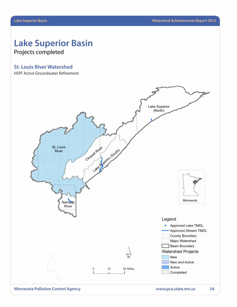
Minnesota Pollution Control Agency www.pca.state.mn.us 54
Lake Superior Basin Watershed Achievements Report 2015
Lake Superior BasinProjects completed
St. Louis River WatershedHSPF Active Groundwater Refinement
!!
!
!
!
!
!!
!
!!
!
!!
!
!
!
!!
!
!
!
St. LouisRiver
Lake Superior(North)
Cloquet Rive
r
Lake Superio
r (South)
NemadjiRiver
Lake Superior Basin
´0 3015 Miles
Legend! Approved Lake TMDL
Approved Stream TMDLCounty BoundaryMajor WatershedBasin Boundary
Watershed ProjectsNewNew and ActiveActiveCompleted
Minnesota

Lake Superior Basin Watershed Achievements Report 2015
Minnesota Pollution Control Agency www.pca.state.mn.us 55
St. Louis River Watershed
HSPF Active Groundwater Refinement The goal of the St. Louis Watershed was to develop a more detailed understanding of the impacts of mining and mine processing operations on the surface water hydrology of streams in the St. Louis River portion of the Minnesota Iron Range. This required a better understanding of the details of the water balance and water management at Iron Range taconite mining and processing operations, including the interactions of surface and ground water. This work effort increased our understanding of these interactions in concert with the development of watershed and surface water models of hydrology and water quality in the St. Louis watershed and resulted in the development and calibration of a steady state groundwater flow model for a portion of the Mesabi Iron Range.
Goals• The contractor will compile available existing data on
mining practices in part of the Iron Range
• The contractor will construct a steady state groundwater flow model to be used to constrain the watershed model
• The contractor will summarize and communicate the results
Results that count• The contractor submitted a database of compiled and
evaluated mining related data
• The contractor submitted a calibrated groundwater flow (GFLOW) model for the Iron Range portion of interest
• The contractors submitted reports and a presentation and communicated results at a stakeholders meeting
Financial informationFunding type: Section 319
Grant amount: $108,626
Contact informationJennifer Olson, Project ManagerMPCA Tetra TechP.O. Box 61Stillwater, MN 55082651-342-2245,[email protected] Project Manager: Chuck Regan
Open pit iron mine in the St. Louis watershed of northeastern Minnesota
Minnesota Pollution Control Agency www.pca.state.mn.us 56
Lake Superior Basin Watershed Achievements Report 2015
Lake Superior River BasinProjects awarded
St. Louis River River WatershedPort Authority Stormwater Study and Concept Design – 2015Sponsor: Duluth Seaway Port Authority (Port Authority)
Funding: Clean Water Partnership (Grant) $24,000
Purpose: This project will evaluate the sources of detected metals and other stormwater constituents, as well as identify and conceptually design effective green infrastructure BMPsto address these concentrations of metals and other constituents in stormwater at the Port Authority’s Clure Terminal. The project’s first phase includes development and implementation of a sampling plan to investigate stormwater quality within impervious areas for the previously described stormwater constituents; soil borings to determine the soil type; a topographical survey to determine drainage patterns and infrastructure locations; and data gathering of existing infrastructure and the extent of leased areas. A season-long stormwater quality monitoring program will monitor stormwater within the drainage areas that flow directly to the storm sewer, including monitoring of roof runoff and overland flow to determine potential pollutant sources and thus mitigation options. The project’s second phase will propose options for effective BMPs within the investigated impervious areas. Another component of this phase will be implementing practices that protect stormwater through education and outreach to the Port Authority’s tenants, which represent a variety of commercial and industrial activities.
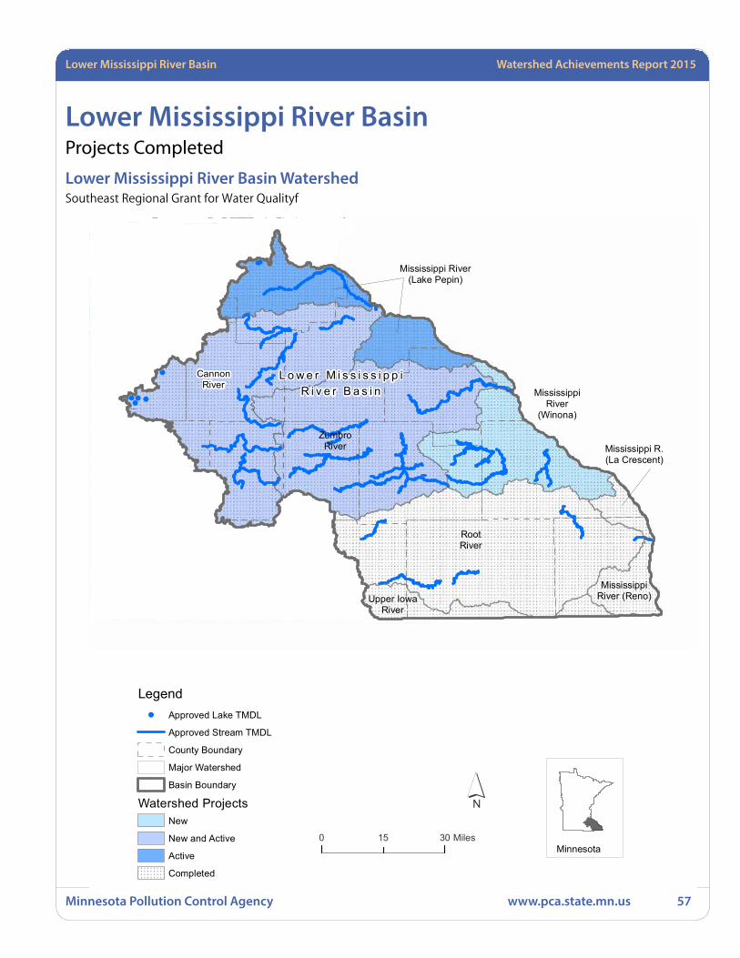
Lower Mississippi River Basin Watershed Achievements Report 2015
Minnesota Pollution Control Agency www.pca.state.mn.us 57
Lower Mississippi River BasinProjects Completed
Lower Mississippi River Basin WatershedSoutheast Regional Grant for Water Qualityf
!
!!
!! !
!
!
!
!
!
!
!
!
!
!
!
!
!
!
!
!
!!
!
!!
!
!
!
!
!
!
!
!
!!!
!
!
!
!
!!
!
!
!
!
!
!
!
!!
!
!
!
!
!
!!
!!
!
!!
!!
!
!
!
!!
!
!
!! !!!
!
!
!
!
!
!
!
!
!
! !
!!
!!
!
!!
!
!
!
!
!
!
!
!
!! !
!
!
!
!
!
!
!
! !
!
! !
!
!
!
!
!
!
!
!
!! !
!!
!
!
!
!
! !
!
!
!
!
!
!
!
L o w e r M i s s i s s i p p iR i v e r B a s i n
Upper IowaRiver
MississippiRiver (Reno)
RootRiver
Mississippi R.(La Crescent)
ZumbroRiver
MississippiRiver
(Winona)
CannonRiver
Mississippi River(Lake Pepin)
Lower Mississippi River Basin
´0 3015 Miles
Minnesota
Legend! Approved Lake TMDL
Approved Stream TMDL
County Boundary
Major Watershed
Basin Boundary
Watershed ProjectsNew
New and Active
Active
Completed

Minnesota Pollution Control Agency www.pca.state.mn.us 58
Lower Mississippi River Basin Watershed Achievements Report 2015
Project involving multiple watershed
Southeast Regional Grant for Water Quality“Southeast Regional Grant for Water Quality” was part of a basin-wide response to the findings of the Regional TMDL study that identified the streams of the Lower Mississippi River Basin in Minnesota (the Basin) as posing a risk of human illness from excessive levels of fecal coliform bacteria. The TMDL study found that runoff from feedlots or manure stockpiles without runoff controls comprises an estimated loading of fecal coliform bacteria to streams of 17% during a wet spring and 37% during a wet summer. To reach water quality standards, the Regional TMDL Implementation Plan calls for reducing bacteria impairments from all major sources by an average of 65%. One of several strategies for reaching this goal includes providing assistance for accelerated compliance with the state feedlot rules.
A successful strategy used in the Basin to reach runoff reduction goals has been to build local capacity for accelerating producer compliance with state feedlot rules. Employing this strategy in four previous regional feedlot projects, 2295 producers in the region signed up for the Open Lot Agreement, runoff reduction designs for over 1,500 feedlots have been completed, and 434 fixes were completed through the first four feedlot grants with very low 50% cost-share funding of $1,000 – $15,000, plus technical assistance.
Goals• Reduce fecal coliform bacteria runoff from 75 feedlots
under 300 animal units through financial, technical and engineering assistance.
Results that count• One hundred fourteen (114) feedlots under 300
animal units had their runoff reduced to negligible levels through technical, financial and engineering assistance.
• Fecal Coliform runoff was reduced by over 1.217 colony forming units (CFU)s per year.
• Phosphorus runoff was reduced by 2,750 pounds per year and Nitrogen runoff was reduced by over 7,460 pounds per year.
Components and Evaluation• Technical Assistance; Southeast Minnesota Water
Resources Board (SEMWRB), partnering with the SE SWCD Technical Support Joint Power Boards (SE SWCD JPB), Counties and SWCD’s will provide 75 livestock producers with technical assistance to design and implement low-cost fixes to control polluted runoff.
• Cost-Share; SEMWRB will manage cost share funding in coordination with Counties and SWCD’s. This partnership is set up and ready to go, and through this project will provide 50% cost share, up to $15,000 per fix, for small livestock producers (under 300 animal units) to implement feedlot runoff treatment.
• Engineering Technical Assistance; SE SWCD JPB has 14 years of experience coordinating regional grants for feedlot engineering assistance in Southeast Minnesota. These engineers provide needed support to local feedlot staff in the design of small feedlot fixes. SEMWRB will partner with SE SWCD JPB to retain one primary engineer and two additional regional engineering technical staff to provide enhanced engineering assistance for feedlot design.
• Evaluation; The average before and after percent drop in the amount (mass) of fecal coliform in MinnFARM examples from four feedlots in Winona County was calculated at approximately 98%. The following are reductions expected through this project, based on the average reductions from four feedlots in Winona County: COD, 177,375 lbs/year/75 sites fixed; P, 3,175 lbs/year/75 sites fixed; N, 9,731 lbs/year/75 sites fixed; BOD, 39,450 lbs/year/75 sites fixed.
County/SWCD staff and regional engineers worked with livestock producers of under 300 animal units, providing technical assistance to design, plan and implement feedlot runoff controls. SE SWCD JPB had three engineering staff working primarily on Feedlot Runoff Control Projects in coordination with the this grant throughout the 10 Counties covered by this grant and providing assistance to local feedlot staff for design and construction of larger fixes. Weather delayed construction on many sites in the spring and summer of 2013 and again during the first half of 2014. When construction was able to convene in fall 2013 and again mid-2014 it was limited by contractor availability due to the backlog of projects once conditions dried out.

Lower Mississippi River Basin Watershed Achievements Report 2015
Minnesota Pollution Control Agency www.pca.state.mn.us 59
A total of 114 low-cost feedlot runoff fixes were completed with project cost share and/or with technical and engineering assistance made available from this 319 grant (see table below).
# Designs – Goal 120
# Designs – Completed 193
# Fixes – Goal 75
# Fixes – 114
Financial informationFunding type: Section 319
Grant amount: $770,827
In-kind: $104,660
Matching funds: $1,324,208
Contact informationLinda Dahl, DirectorSEMWRB
972 Summerfield DriveNorthfield, MN [email protected] Project Manager: Shaina Keseley
Irrigation riser and example of established irrigation area with sprinklers running
Wabasha County clean water diversion, fencing, filter strip and seeding
Before
Outlet before

Minnesota Pollution Control Agency www.pca.state.mn.us 60
Lower Mississippi River Basin Watershed Achievements Report 2015
Active ProjectsProjects awarded in 2014 - 2015
Projects involving multiple watersheds
Reducing Runoff from Southeast Minnesota Feedlots – 2013Sponsor: SEMWRB
Funding: Section 319 (Grant) $300,000
Purpose: A larger regional effort to comprehensively address sources of fecal coliform bacteria tied to the Regional TMDL Implementation Plan. Local feedlot staff in the ten counties of SE Minnesota will provide technical and engineering assistance to design and implement feedlot runoff control activities to treat polluted runoff. Farms will be prioritized based on criteria developed by each county and SWCD. The MinnFARM model will be run by feedlot technicians for each completed fix to determine reductions in polluted runoff from projects implemented. Reduction amounts will be reported using the Feedlot Unified Reporting Form developed for this project.
Cannon River WatershedBuilding a Culture of Citizen Engagement – 2014Sponsor: Cannon River Watershed Partnership
Funding: Section 319 (Grant) $57,620
Purpose: Develop and pilot a process for building local community capacity for engaging in the watershed management process that can be sustained long-term with continuity. Using two subwatersheds currently engaged by CRWP, the process will cross-fertilize and organize diverse perspectives and segments of watershed residents and stakeholders to get watershed management work done in a way that is in tune with community needs, identities and aspirations. The project will explore new approaches to strategic collaborations and coalitions with local, regional and state programs and organizations.
Lower Cannon River Turbidity Reduction Project – 2011Sponsor: Cannon River Watershed Partnership
Funding: Section 319 (Grant) $178,120
Purpose: The Lower Cannon River Turbidity TMDL study, completed in July 2007, sets significant load reductions for sediment in the Lower Cannon River watershed. The water quality goal is a total suspended solids (TSS) value of 44 mg/L or less. At high flows, a reduction in TSS values ranging from 49% to 82% is needed in the Cannon River system depending on the reach. The implementation plan, completed in October 2009, established a short term goal of achieving a 30% reduction in sediment sources by 2020.
Project Goals:
• Identify the major sources of sediment to the Little Cannon River and Belle Creek that are contributing to the pollution of these streams and the Cannon River.
• Implement BMPs to reduce sediment delivery to the streams with the support of local landowners.
The water body is considered of high public value, having been designated a Wild and Scenic River in order to afford it additional protection from potential degradation. It is located less than an hour’s drive from the TCMA, along a popular bicycle path which brings thousands of Minnesotans close to the water.
Steele County Septic System Loan Program – 2012Sponsor: Steele County
Funding: CWP (Loan) $700,000
Purpose: This project will promote and install 70 SSTSs in Steele County.
Mississippi River – Twin CitiesDakota County Nitrate Reduction Project – 2012Sponsor: Dakota County
Funding: Section 319 (Grant) $215,307
Purpose: This project will create and implement agricultural projects to validate, demonstrate, and refine BMPs for nitrogen fertilizer for corn production that will lower nitrate levels in Dakota County’s groundwater and surface water; promote Private Pesticide Applicator Training, Crops Days, “Focus on Ag” Newsletter and innovative demonstration projects to area farmers to improve quality of Dakota County’s water resources; monitor nitrate levels in private drinking water wells and
Lower Mississippi Basin

Lower Mississippi River Basin Watershed Achievements Report 2015
Minnesota Pollution Control Agency www.pca.state.mn.us 61
in the Vermillion River and its tributaries; track project grant, matching funds and expenditures; and complete required reporting.
Mississippi River – WinonaDowntown Winona Pre-Mississippi River Rain Garden – 2015Sponsor: Port Authority of Winona
Funding: Clean Water Partnership (Grant) $41,324
Purpose: This project will protect the Mississippi River at Winona, MN by the installation of a downtown Winona parking lot rain garden. This project will improve the Mississippi River water quality by removing an incorrectly sloped, 100% impervious parking lot surface then regrading and resurfacing the parking lot to direct runoff into a central rain garden planted with deep-rooted native vegetation that will filter pollutants such as oil, grease, dirt, debris, broken glass, road salt, sand and unseen nutrients before any runoff reaches Winona’s stormwater system and the Mississippi River. The rain garden will also serve to slow the velocity of runoff and reduce the likelihood of flooding which is a regular concern in Winona.
Zumbro River Zumbro River Ultra-Urban Vol-TSS-FeC Reduction – 2014Sponsor: City of Rochester
Funding: Section 319 (Grant) $300,000
Purpose: Reduce turbidity and fecal coliform bacteria loading in the receiving waters for downtown Rochester by identifying feasible volume control locations in the project area and demonstrating green infrastructure designs, benefits, and maintenance practices before redevelopment opportunities arise. In addition to delineating these areas, volume control practices need to be demonstrated to help “sell” their effectiveness and attractiveness and to clarify their maintenance needs.
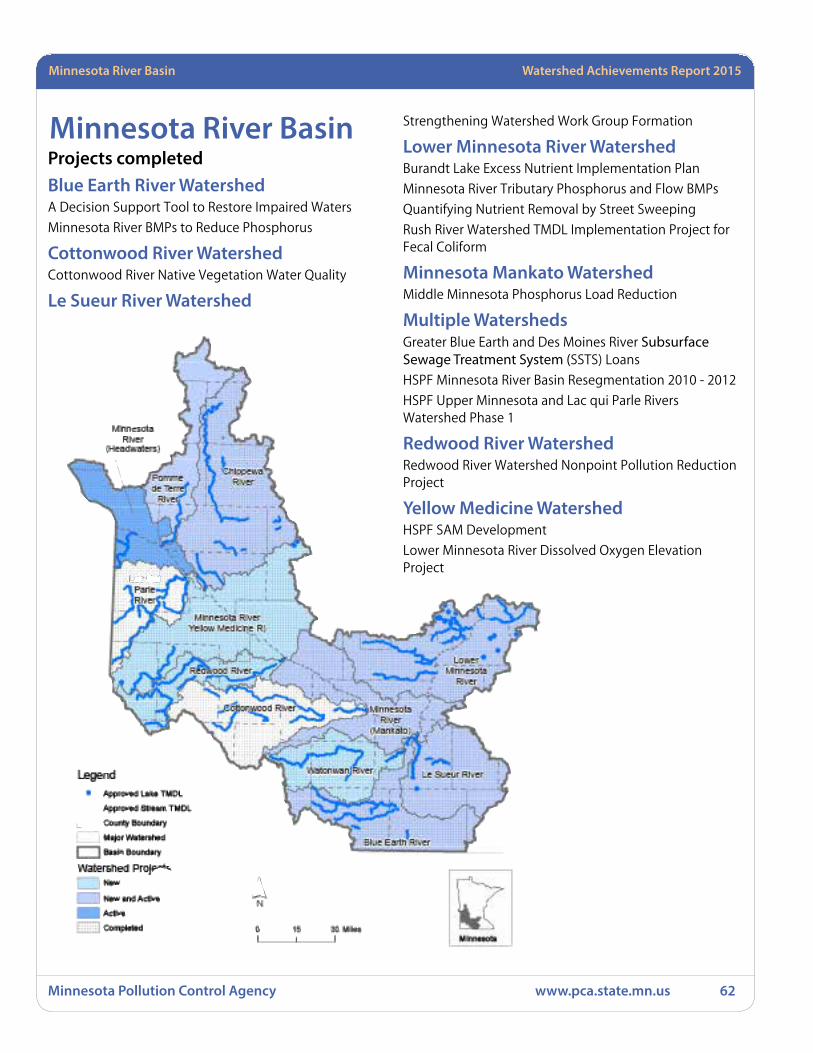
Minnesota Pollution Control Agency www.pca.state.mn.us 62
Minnesota River Basin Watershed Achievements Report 2015
Minnesota River BasinProjects completedBlue Earth River WatershedA Decision Support Tool to Restore Impaired Waters
Minnesota River BMPs to Reduce Phosphorus
Cottonwood River WatershedCottonwood River Native Vegetation Water Quality
Le Sueur River Watershed
Strengthening Watershed Work Group Formation
Lower Minnesota River WatershedBurandt Lake Excess Nutrient Implementation Plan
Minnesota River Tributary Phosphorus and Flow BMPs
Quantifying Nutrient Removal by Street Sweeping
Rush River Watershed TMDL Implementation Project for Fecal Coliform
Minnesota Mankato WatershedMiddle Minnesota Phosphorus Load Reduction
Multiple WatershedsGreater Blue Earth and Des Moines River Subsurface Sewage Treatment System (SSTS) Loans
HSPF Minnesota River Basin Resegmentation 2010 - 2012
HSPF Upper Minnesota and Lac qui Parle Rivers Watershed Phase 1
Redwood River WatershedRedwood River Watershed Nonpoint Pollution Reduction Project
Yellow Medicine WatershedHSPF SAM Development
Lower Minnesota River Dissolved Oxygen Elevation Project
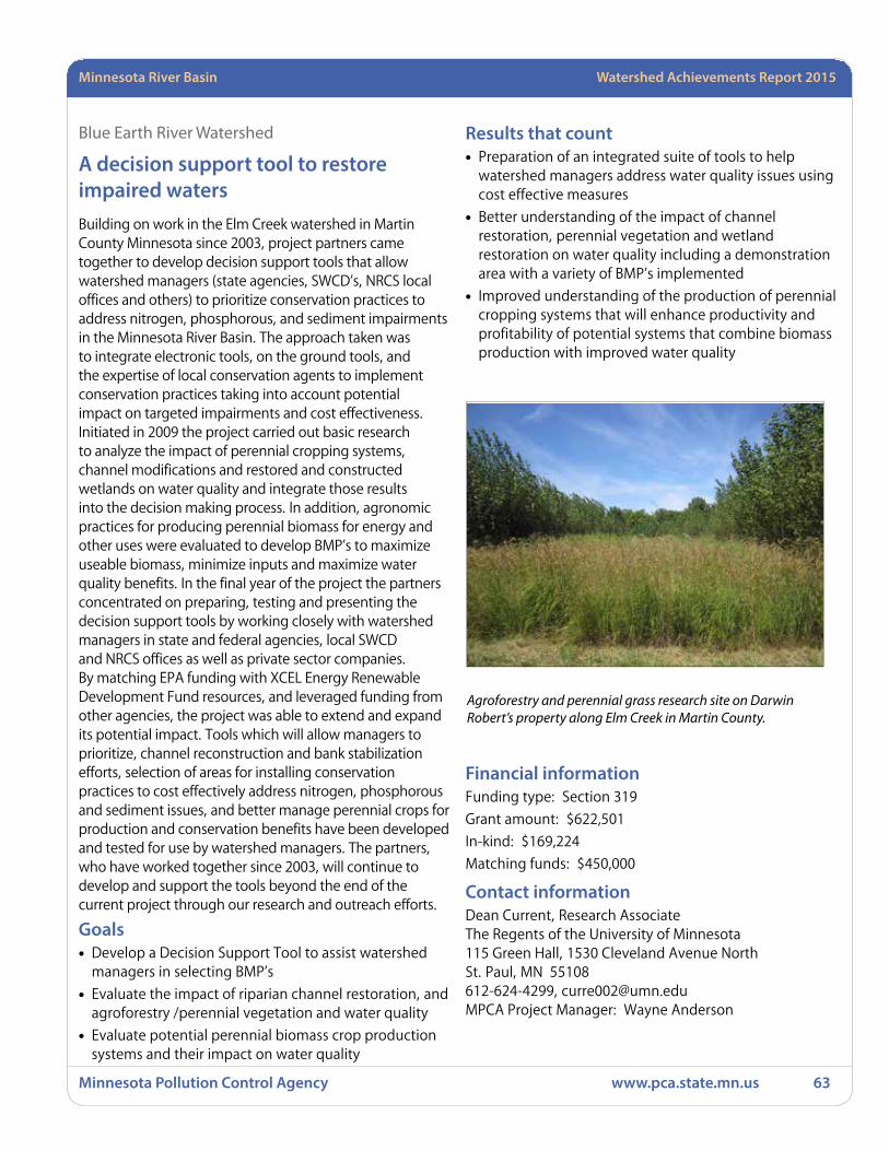
Watershed Achievements Report 2008 StatewideMinnesota River Basin Watershed Achievements Report 2015
Minnesota Pollution Control Agency www.pca.state.mn.us 63
Blue Earth River Watershed
A decision support tool to restore impaired waters Building on work in the Elm Creek watershed in Martin County Minnesota since 2003, project partners came together to develop decision support tools that allow watershed managers (state agencies, SWCD’s, NRCS local offices and others) to prioritize conservation practices to address nitrogen, phosphorous, and sediment impairments in the Minnesota River Basin. The approach taken was to integrate electronic tools, on the ground tools, and the expertise of local conservation agents to implement conservation practices taking into account potential impact on targeted impairments and cost effectiveness. Initiated in 2009 the project carried out basic research to analyze the impact of perennial cropping systems, channel modifications and restored and constructed wetlands on water quality and integrate those results into the decision making process. In addition, agronomic practices for producing perennial biomass for energy and other uses were evaluated to develop BMP’s to maximize useable biomass, minimize inputs and maximize water quality benefits. In the final year of the project the partners concentrated on preparing, testing and presenting the decision support tools by working closely with watershed managers in state and federal agencies, local SWCD and NRCS offices as well as private sector companies. By matching EPA funding with XCEL Energy Renewable Development Fund resources, and leveraged funding from other agencies, the project was able to extend and expand its potential impact. Tools which will allow managers to prioritize, channel reconstruction and bank stabilization efforts, selection of areas for installing conservation practices to cost effectively address nitrogen, phosphorous and sediment issues, and better manage perennial crops for production and conservation benefits have been developed and tested for use by watershed managers. The partners, who have worked together since 2003, will continue to develop and support the tools beyond the end of the current project through our research and outreach efforts.
Goals• Develop a Decision Support Tool to assist watershed
managers in selecting BMP’s
• Evaluate the impact of riparian channel restoration, and agroforestry /perennial vegetation and water quality
• Evaluate potential perennial biomass crop production systems and their impact on water quality
Results that count • Preparation of an integrated suite of tools to help
watershed managers address water quality issues using cost effective measures
• Better understanding of the impact of channel restoration, perennial vegetation and wetland restoration on water quality including a demonstration area with a variety of BMP’s implemented
• Improved understanding of the production of perennial cropping systems that will enhance productivity and profitability of potential systems that combine biomass production with improved water quality
Financial informationFunding type: Section 319
Grant amount: $622,501
In-kind: $169,224
Matching funds: $450,000
Contact information Dean Current, Research AssociateThe Regents of the University of Minnesota115 Green Hall, 1530 Cleveland Avenue NorthSt. Paul, MN 55108612-624-4299, [email protected] Project Manager: Wayne Anderson
Agroforestry and perennial grass research site on Darwin Robert’s property along Elm Creek in Martin County.

Minnesota Pollution Control Agency www.pca.state.mn.us 64
Minnesota River Basin Watershed Achievements Report 2015
This outlet grade stabilization structure project was located in NW ¼ of Section 32 of South Bend Township in Blue Earth County, Minnesota
Blue Earth Watershed
Minnesota River BMPs to Reduce PhosphorusThis project involved planning, targeted education and implementation that led to improved water quality with construction of BMPs in riparian and other near shore, critical areas that reduced bacteria, sediment, P and other pollutants. The project’s planning and education efforts were important steps in achieving long-term water management goals. Direct education of landowners and local government officials will improve adaptive management skills in critical areas beyond the project period. Project goals were consistent with TMDL implementation plans and TMDL studies that are underway. The project work plan complements other efforts to address these and related concerns in BEC.
This project ran concurrently with two State FY 2011 Clean Water Fund projects until December 31, 2012. Consistent with the 319 RFP at the time of application, a portion of State grants and loans were used to match the 319 grant. This project also complemented a Hazard Mitigation Plan update project.
Goals• Install BMPs in the riparian areas to reduce erosion
and run-off containing livestock manure, phosphorus, bacteria and sediment
• Eliminate direct sewage discharges to reduce phosphorus and bacteria reaching surface waters
• Identify and prioritize major sources and sites of ravine, stream bank and bluff erosion in BEC
Results that count• One hundred and ninety landowners installed
vegetated buffers on 6,605 acres. One landowner installed a grade stabilization structure. It is estimated that the following pollution reductions were achieved per year for the grade stabilization structure: 194.77 tons of soil saved, 207.19 tons of sediment reduced, and 227.94 lbs of phosphorus reduced.
• Fifty-nine SSTS upgrades were completed. Using BWSR Calculators it is estimated that the following pollution reductions were achieved per year: 13,970 lbs of TSS, 626 lbs of phosphorus, 1,925 lbs of nitrogen, 25,290 lbs of biochemical oxygen demand (BOD), and 3.658 E+15 Bacteria most probable number (MPN).
• Over 800 actively eroding ravine, stream bank and bluff erosion sites were identified. Twenty-two locations were followed up with landowner/field visits. Eight of those locations are working with future grant funds to be fixed.
Financial informationFunding type: Section 319
Grant amount: $30,328
In-kind: $705,371
Matching funds: $7,836
Contact information Jerad Bach, District ManagerBEC SWCD1160 South Victory Drive Suite #3Mankato, MN [email protected] Project Manager: Scott MacLean/Bryan Spindler
Watershed Achievements Report 2008 StatewideMinnesota River Basin Watershed Achievements Report 2015
Minnesota Pollution Control Agency www.pca.state.mn.us 65
Cottonwood River Watershed
Cottonwood River Native Vegetation Water QualityThis study quantified the surface water quantity and quality and soil hydrologic characteristics of perennial vegetation on undisturbed soils in southwest Minnesota, and measured the changes that occurred following the conversion of a portion of the perennial vegetation to cropland utilizing a paired watershed design. Two small watersheds were instrumented with H-flumes and monitored year-round for four years. The perennial vegetation did not produce run-off during non-frozen soil conditions; however, it did have run-off associated with snowmelt over frozen soils. The water quality of the snowmelt run-off did have elevated levels of total phosphorus (TP), primarily in the dissolved molybdate reactive phosphorus (DMRP) form, and contained various forms of nitrogen, along with low sediment levels. The water leaving the perennial vegetation did carry nitrogen, phosphorus, and sediment although the run-off volumes were very low resulting in minimal pollutant exports.
One of the watersheds was converted from perennial vegetation to cropland in May 2013. Four run-off events from the cropland were observed in June of 2013. These were the only run-off events on non-frozen soils over the duration of the project. The conversion to cropland did result in additional total nitrogen (1.8 lb./acre), total phosphorus (0.24 lb/acre), and sediment (953 lb/acre) being exported from the watershed compared to the control in June 2013. These increased losses are more reflective of a shift in hydrology rather than a shift in pollutant concentrations, due to the lack of run-off observed from the perennial vegetation during non-frozen soil conditions.
An above and below design was also used to monitor non-point source agriculture run-off as it entered and exited the perennial vegetation. The vegetation effectively captured pollutants and run-off with high infiltration rates on a transition zone between a highly productive agriculture zone and the river valley floodplain.
Goals • Water quality and quantity characterization of
perennial vegetation (including Conservation Reserve Program [CRP]) system.
• Quantification of natural background contributions from soil and perennial vegetation to current water quality impairments related to turbidity, excess nutrients, and bacteria.
• Comparison of water quality characteristics among differing land management practices including: perennial vegetation and conventional row crop agriculture.
Results that count• Three factors were determined to be important
in affecting watershed hydrology, surface runoff, erosion and nutrient loss during the experiment: 1) precipitation (timing, intensity, frequency and duration); 2) frozen versus non-frozen soil conditions, and 3) land management (cultivated versus perennial vegetation).
No run-off occurred from perennial vegetation during periods with non-frozen soils; therefore no export of sediment or nutrients were measured from the perennial vegetation during non-frozen periods. Lack of run-off on non-frozen soil was attributed to the high infiltration capacity of the perennial vegetation. Sediment yields and flow-weighted mean concentrations (FWMC) were low for all events that occurred on frozen soils. Nitrogen losses were small in surface run-off, as anticipated, since most nitrogen losses occur through leaching. Total phosphorus (TP) FWMC ranged from 0.68 to 7.73 mg/L from perennial vegetation, however, export loads were low when combined with run-off volumes. The dominant form of phosphorus was in the dissolved form (range of 16 to 80%, averaged 52%). E. coli bacteria counts in run-off from watersheds with perennial vegetation over frozen soils ranged from <1 to 1046 MPN/100mL, and averaged 375.2 MPN/100mL.
• No run-off occurred from perennial vegetation during periods with non-frozen soils; four run-off events occurred in June of 2013 following conversion to cropland. When comparing the water quality of perennial vegetation to the recently converted cropland, the recently converted cropland had higher surface losses (yields) and FWMC for nitrogen, phosphorus, and sediment, along with much higher E. coli bacteria counts. A change in hydrology (run-off volumes) was the primary difference. Perennial vegetation provided better soil cover in May and June when the largest precipitation events occurred.
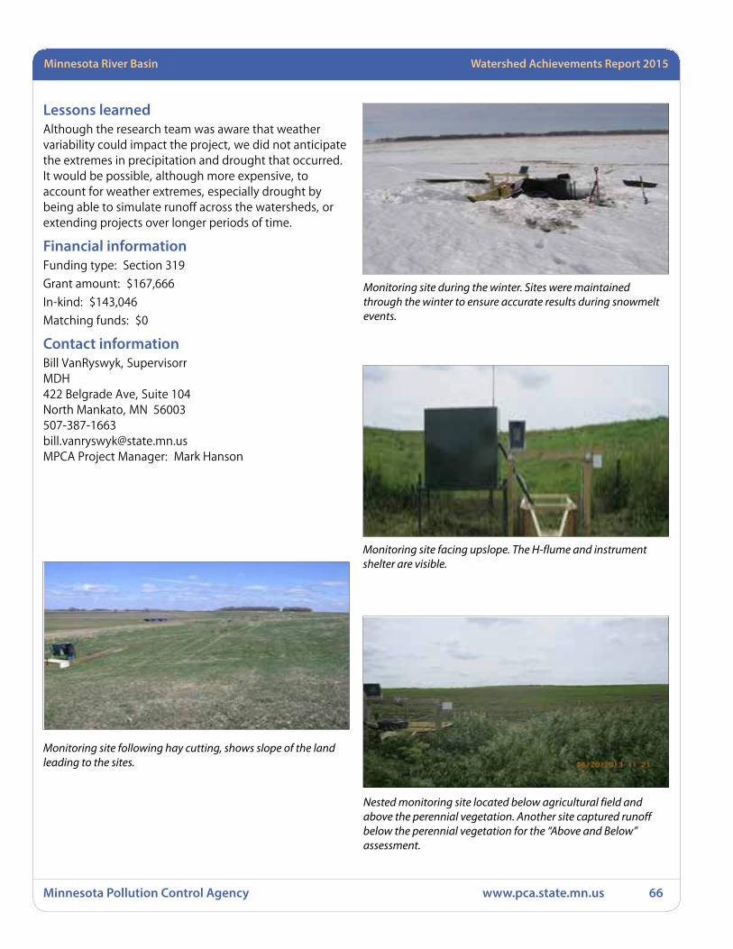
Minnesota Pollution Control Agency www.pca.state.mn.us 66
Minnesota River Basin Watershed Achievements Report 2015
Lessons learnedAlthough the research team was aware that weather variability could impact the project, we did not anticipate the extremes in precipitation and drought that occurred. It would be possible, although more expensive, to account for weather extremes, especially drought by being able to simulate runoff across the watersheds, or extending projects over longer periods of time.
Financial informationFunding type: Section 319
Grant amount: $167,666
In-kind: $143,046
Matching funds: $0
Contact information Bill VanRyswyk, SupervisorrMDH422 Belgrade Ave, Suite 104North Mankato, MN [email protected] Project Manager: Mark Hanson
Monitoring site during the winter. Sites were maintained through the winter to ensure accurate results during snowmelt events.
Monitoring site facing upslope. The H-flume and instrument shelter are visible.
Nested monitoring site located below agricultural field and above the perennial vegetation. Another site captured runoff below the perennial vegetation for the “Above and Below” assessment.
Monitoring site following hay cutting, shows slope of the land leading to the sites.
Watershed Achievements Report 2008 StatewideMinnesota River Basin Watershed Achievements Report 2015
Minnesota Pollution Control Agency www.pca.state.mn.us 67
Le Sueur River Watershed
Strengthening Watershed Work Group FormationThe goal of this project is to infuse civic governance principles into citizen engagement efforts in the Le Sueur River Watershed. Civic Governance training expanded the interest among local government and work group members and citizens to integrate more civic governance as a framework. Coaching helped the group to develop a mission statement rooted in empowering citizens. This project helped to strengthen the mission and future vision of this emerging watershed group.
Goals • This project supports efforts to build local civic capacity
for engaging communities in watershed management through developing local leaders and the watershed work group in using civic governance principles and practices.
Results that count• Local government personnel and work group members
are becoming knowledgeable in and familiar with the application of civic organizing and governance principles, policy, standards and disciplines.
• Increased interest among local government personnel and work group members in expanding their understanding and application of civic organizing and governance principles, policy, standards and disciplines, potentially through training programs.
• Work group vision, mission and governing structure are informed by civic organizing and governance principles and standards.
Lessons learnedIn watershed work, there is a pervasive challenge to develop processes that foster communication with diverse perspectives and interests. Videos are a powerful vehicle for multi-perspective storytelling.
Civic governance training is valuable to foster citizen leadership and is a promising route to sustaining citizen initiative and action over time.
The Network needs to build citizen leaders and civic governance capacity if it is going to succeed independently in the long term. It is currently reliant on project staff for its sustainability.
We are learning the importance of one-on-one networking and training for both staff and citizens. We are learning that this is a key component for civic engagement.
As we move forward, we plan to focus on the civic standard or clarifying how each member can contribute resources and helping us all understand where we can help implement policies where we have the authority to act.
The process of creating video and documenting stories builds important relationships and that has added significant value to our network building. The process of creating a video also allows the group to reflect on the past achievements and reaffirm the group’s mission and purpose.
Feedback / Suggestions Civic Engagement Cohorts across the state have been very helpful in providing training to local staff engaged in citizen engagement. We used some of the tools and techniques learned in the cohorts and integrated that with our civic governance training. These types of training and coaching are valuable for citizen engagement work.
There is a larger structural challenge of keeping these emerging watershed groups funded during their development process. The group started with MPCA funds and are now looking to foundations to continue the work.
There is a need to instill a philosophy and framework that promotes citizen action and fosters diverse stakeholders working together. Using techniques that foster the broader framework of citizenship, open and transparent processes and trust building is a promising route to engage both staff and citizens.
If a voluntary approach remains the primary route to realizing water quality improvements, the real task ahead is to engage and inspire citizens to take action and collaborate. This requires a sustained investment in civic infrastructure.
Financial informationFunding type: Section 319
Grant amount: $15,000
In-kind: $19,561
Matching funds: $0

Minnesota Pollution Control Agency www.pca.state.mn.us 68
Minnesota River Basin Watershed Achievements Report 2015
Contact information Kimberly Musser, Assistant DirectorWater Resources Center, Minnesota State University, Mankato135 Trafton Science Center SouthMankato, MN [email protected] Project Manager: Cynthia Hilmoe
Duncanson Farm
June 26, 2014 – Le Sueur River Watershed Network Community Potluck and Meeting at Duncanson Farm, Mapleton, MN – 32 people attended
Group is learning from MPCA staff Paul Davis about river and lake monitoring at St. Olaf Lake Park.
Le Sueur River Watershed Network Steering Committee Member Gene Scheffert explains the group’s mission statement at St. Olaf Lake Park.
Steering Team Members (courtesy of New Richland Star Eagle)

Watershed Achievements Report 2008 StatewideMinnesota River Basin Watershed Achievements Report 2015
Minnesota Pollution Control Agency www.pca.state.mn.us 69
Lower Minnesota River Watershed
Burandt Lake Excess Nutrient Implementation PlanBurandt Lake (10-0084) is a deep, 92-acre lake located 0.5 miles west of Waconia in Carver County, Minnesota (about 25 miles southwest of Minneapolis) in the North Central Hardwood Forest ecoregion (NCHF). The lake has a 7,823-acre (excluding Burandt Lake) watershed that can be divided into three sub watersheds. First, the area of land draining directly to Burandt Lake consists of 246 acres (excluding Burandt Lake) that are primarily developed into residential and commercial areas. Next, flowing in from the northeast is the largest sub watershed, the Lake Waconia (3,080 acres) sub watershed, which is 7,147 acres (including Lake Waconia) of agricultural and residential land. Finally, the Scheuble Lake (16 acres) sub watershed flowing in from the west is 430 acres (including Scheuble Lake) of primarily agricultural lands. Portions of the City of Waconia are within the watershed.
Water quality data collected from 1999-2005 revealed that Burandt Lake has average total phosphorus concentrations ranging from 56 to 98 micrograms per liter (ug/L). The phosphorus standard for the NCHF ecoregion is 40ug/L, summer average (June through September). The lake was listed for excess nutrients in 2004 and has the following sources of phosphorous:
External: Stormwater runoff from developed and agricultural areas, failing or direct-discharge septic systems, degraded wetlands.
Internal: Anoxic sediments, seasonal turnover, mixing by wind and boat propellers, aquatic plant senescence.
The phosphorus load to Burandt Lake over the 2005 season (42.18 inches of precipitation) was determined to be 687 kilograms per year (kg/yr), The Burandt Lake loading capacity was 1.19kg/day (2005 study). Of this total, external sources have been determined to contribute approximately 457 kg annually, which includes runoff from precipitation and precipitation itself. The remaining 230 kg of phosphorus is from nutrient recycling within the lake.
A key factor in this TMDL is that prior to 1970, a sewage treatment plant discharged directly to Burandt Lake. During the course of the TMDL study staff were unable to recover information about the treatment plant, although during discharge there are accounts of severe algal
blooms and depletion of oxygen resulting in winterkills. Since the elimination of the discharge, winterkills have been less frequent and water quality has improved. Staff feels that if we are able to curb the internal phosphorous cycle coupled with the efforts of the City’s Municipal Separate Storm Sewer System (MS4) program and other non-point work (rain gardens) already underway in the watershed that we could see marked changes in water quality in Burandt Lake quite rapidly.
The county and its stakeholders are also currently working on the Carver and Bevens Fecal Coliform Implementation Plan which encompasses the area around Burandt Lake and its sub watersheds. This area has already been targeted for SSTS and agricultural BMP funds with success. The county has upgraded direct discharging SSTS (4), installed buffers and will restore a 60 acre wetland in the watershed. Also, the county has partnered with the City of Waconia to install four rain gardens and one lakeshore restoration project to date with others awaiting funds. Also, the County has recently submitted the Carver Creek Turbidity TMDL and many of the practices mentioned above will also help us to work toward the goals of that TMDL.
Goals• Increase the awareness and participation of Burandt
Lakeshed residents who implement urban BMP’s (i.e raingardens and lakescapes).
• Reach the interim mean lake water quality goal of 60 ug/L of total phosphorus (the long term goal is 40 ug/L) and increase water clarity (secchi depth) to a mean of greater than five feet in Burandt Lake.
• Monitor water quality conditions in Burandt Lake and its tributaries so that we can make effective adaptive management decisions to improve the water quality of the lake and remove it from the impaired waters list.
Results that count • A total of eleven raingarden practices were installed in
the Burandt lakeshed targeting previously un-treated stormwater. Vegetation has established at these locations very well.
• Alum treatment in June of 2011 is proving to have a positive result in keeping total phosphorus levels below the interim water quality goal of 60 ug/L, and even below the long term goal of 40 ug/L (averaging 35 ug/L over 2011 and 2012). Further, from 2011-2013, average secchi depth was 6.1 feet.
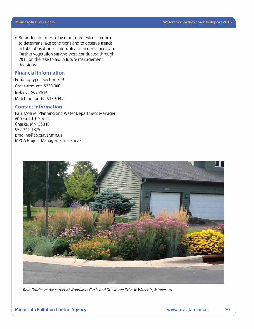
Minnesota Pollution Control Agency www.pca.state.mn.us 70
Minnesota River Basin Watershed Achievements Report 2015
• Burandt continues to be monitored twice a month to determine lake conditions and to observe trends in total phosphorus, chlorophyll a, and secchi depth. Further vegetation surveys were conducted through 2013 on the lake to aid in future management decisions.
Financial informationFunding type: Section 319
Grant amount: $230,000
In-kind: $62,7614
Matching funds: $189,049
Contact information Paul Moline, Planning and Water Department Manager600 East 4th StreetChaska, MN [email protected] Project Manager: Chris Zadak
Rain Garden at the corner of Woodlawn Circle and Dunsmore Drive in Waconia, Minnesota
Watershed Achievements Report 2008 StatewideMinnesota River Basin Watershed Achievements Report 2015
Minnesota Pollution Control Agency www.pca.state.mn.us 71
Lower Minnesota River Watershed
Minnesota River Tributary Phosphorus and Flow BMPsThis project was initially a partnership between Scott County, the Scott Watershed Management Organization (WMO), the Scott SWCD, BWSR and the NRCS. Project boundaries were subsequently amended to include the headwaters of Sand Creek in Rice and Le Sueur Counties and the respective SWCDs as partners.
The project area consisted of the Sand Creek and Roberts Creek watersheds, and bluff areas directly tributary to the Minnesota River in southwest Scott County. The Minnesota River, Sand Creek and many of the lakes located in the Sand Creek watershed are considered water quality impaired. Impairments include aquatic life due to excessive turbidity, and recreation due to excessive nutrients. A number of studies had been completed to diagnose problems and identify pollutant sources. This project focused on using the information generated from these studies (including the Lower Minnesota River DO TMDL study and implementing identified BMPs.
Agriculture is the primary land use in the project area and BMPs promoted included water and sediment basins (WASCOBs), grade control, terraces, grassed and lined waterways, nutrient management, alternative (rock) tile inlets, wetland restoration and filter strips. Over the project duration 84 applications were certified complete resulting in159 BMPs. The estimated receiving water pollutant reduction from the BMPs totals 2,115 tons/year of sediment and 2,470 lbs/year of total phosphorus. In June of 2014 the area was hit by two large storms totaling about 14 inches of precipitation. The result was a Presidential Disaster Declaration. Inspections of the installed practices has been started but not completed. Of the 21 inspections complete 15 found damage.
Goals • Accelerate the implementation of BMPs, specifically
targeting 150 acres of filter strip, 25 to 30 acres of wetland restoration, 3 to 5 grade/water control structures, 5 to 10 tile intake controls, and an unspecified number of nutrient management plans.
• Monitor water quality improvements and evaluate and document pollutant load reductions created by the project.
• Effectively administer the project.
Results that count• The filter strip and wetland restoration goals were
not met with 80 acres, and 17 acres completed respectively. However, the grade/water control structures and alternative tile intake goals were greatly exceeded at 60 structures and 79 intakes, respectively. In addition, eight nutrient management plans were written. Estimated pollution reductions are 2115 tons/year of sediment and 2470 pounds/year of phosphorus.
• This goal was met with monitoring completed in 2013 at 5 sites plus the Metropolitan Council’s site on Sand Creek in Jordan. Metropolitan Council also completed pollutant load calculations using the monitoring data. Unfortunately variability in the data was high due to an eight inch precipitation event that fell on a portion of the watershed and the coefficients of variation for the TSS calculations were high meaning that the resulting areal loads for TSS should be used with caution. Pollutant reduction estimates were also completed for all of the BMPs.
• The project was effectively administered as evidenced by the installation and certification of 159 BMPs, and BMP implementation cost finishing within 2% of the amount budgeted for BMPs.
Lessons learned/RecommendationsA number of lessons have been learned over the last few years. Most of these were not unique to the grant, and were learned from a combination of activities. They include:
1. To build on success.
2. Momentum is important and builds further momentum.
3. Momentum is as important as targeting.
4. Since momentum leads to further momentum it can also pull efforts away from targeting, and targeting requires on-going discipline from staff.
5. More implementation is needed. The project enabled the installation 159 BMPs. This is only about one BMP for every two square miles of the project area.
6. If you provide good service people come back with additional applications (note that many of the applications approved came from repeat land owners).
7. Relationship building and trust is key.
8. Annually revising the docket based on the past years’ experience is important for adapting.

Minnesota Pollution Control Agency www.pca.state.mn.us 72
Minnesota River Basin Watershed Achievements Report 2015
9. Permanent easements are a difficult sell.
10. Interest in filter strips dropped off as commodity prices increased.
11. Requiring escrows from the land owners helped make sure they followed through on applications and that the SWCDs did not spend a lot of time designing only to have the application canceled. We only had three cancellations over the course of the project.
12. Staff time providing technical assistance was critical and was an additional project cost of about 35% to 50% (as a percentage of the BMPs).
13. Encumber the dollars early so that the last year of the project is spent finishing projects.
14. Over-encumber some of the dollars in anticipation that some of the applicants will not get their practices completed. The Scott WMO could do this since the grant was not the only source of funding for the Technical Assistance and Cost Share (TACS) program and therefore could still fund all the projects even if they all finished on time – otherwise there is a risk.
The partners are appreciative of the support provided by the USEPA and MPCA through the grant. The only suggestions we have for improving the program are:
1. To review the grant contract language from the perspective of the receiving local unit of government. The language is a little one sided toward the agencies when the grant recipient is providing 45% to 50% of the project cost. Should reflect more of a partnership.
2. Keep the same reporting form every year. Having to use a new form every year requires unproductive time to populate repeat information.
Financial informationFunding type: Section 319
Grant amount: $489,765
In-kind: $30,971
Matching funds: $424,143
Contact information Paul Nelson, Environmental Services Program ManagerScott County200 Fourth Avenue WestShakopee, MN [email protected] Project Manager: Chris Zadak
Before
After
Maynard Schmidt, 27740 Keystone Lane, Belle Plaine, Minnesota – Grade Stabilization This project addressed a head cut of a large ravine in the Blakeley bluff area that was eroding due to runoff and groundwater seeps, and a cattle access lane. Multiple conservation practices including a water and sediment control basin, check dams, critical area shaping, subsurface drainage, livestock exclusion and water bars were installed to stabilize this site
Watershed Achievements Report 2008 StatewideMinnesota River Basin Watershed Achievements Report 2015
Minnesota Pollution Control Agency www.pca.state.mn.us 73
Lower Minnesota River Watershed
Quantifying Nutrient Removal by Street SweepingStreet sweeping has traditionally been regarding as a “housekeeping” task in stormwater management, with early studies indicating that sweeping had little impact on reducing stormwater nutrients. This study revisited the issue, and was unique in several aspects: (1) we included streets with tree canopy covers (over the streets) ranging from 0 to 20%; (2) measured nutrients in the sweepings removed, including nutrients in coarse organics (leaves, etc.), as well as fines; (3) swept through the entire snow-free season, including autumn leaf fall. Results show that the coarse organic fraction of sweepings included 42% of the P and 75% of the N in the sweepings. Nutrient removal increased with increasing canopy percentages, and with increasing sweeping frequency. During the spring and fall, the cost per pound of P removed dropped below $100/lb, an order of magnitude lower than for stormwater ponds. We developed a spreadsheet planning calculator designed to help public works and streets departments decide whether enhanced sweeping would work for their cities, supported by a User Support Manual, and convened two translational workshops, training ~ 80 professionals representing many of the municipalities in the Twin Cities region.
Goals • Plan and conduct the Prior Lake Street Sweeping
Experiment
• Analyze results and develop a street sweeping planning tool for cities
• Conduct translational workshops, disseminate findings in multiple venues
Results that count• The project showed that enhanced street sweeping can
remove substantial amounts of nutrients, especially in the form of coarse organics, and that the removal of nutrients for a given route can be modeled from tree canopy cover over streets and sweeping frequency within each month of the year.
• We embedded the modeling approach into a street sweeping planning calculator that enables public works
and streets departments to estimate removal of solids, N, and P for each sweeping route, the cost, and the cost/lb of pollutant removed. The Excel-based planning calculator and User Support Manual are posted on a website.
• Translation of research results to practice occurred through several mechanisms: translational workshops, publication of key findings in Stormwater Magazine and a Stormwater Updates newsletter; and presentation in numerous forums, including a Low Impact Development Conference and a state-wide water resources conference, at several public works departments, watershed management districts, guest lectures, and others.
Lessons learnedAs to “lessons learned”, this has been one of the most rapidly translated projects that either the Principal Investigator (PI) or co-PI has worked on, and an experience that we hope to repeat. This occurred for two reasons: (1) our research filled a void in knowledge that, once filled, had enormous practical application; and (2) we developed an accessible modeling tool that is simple enough to use that it is leading to rapid adoption by cities.
With regard to MPCA, we greatly appreciated Greg Johnson’s (our project manager) effort to enable us to present our findings of two 319 projects to MPCA offices statewide, and have suggested that MPCA might in the future hold “319 workshops” for projects to share findings.
Financial informationFunding type: Section 319
Grant amount: $285,754
In-kind: $150,045
Matching funds: $96,622
Contact information Kevin McKoskeyUniversity of Minnesota450 McNamara Alumni Center200 Oak StreetMinneapolis, MN 55455612-624-5066MPCA Project Manager: Greg Johnson
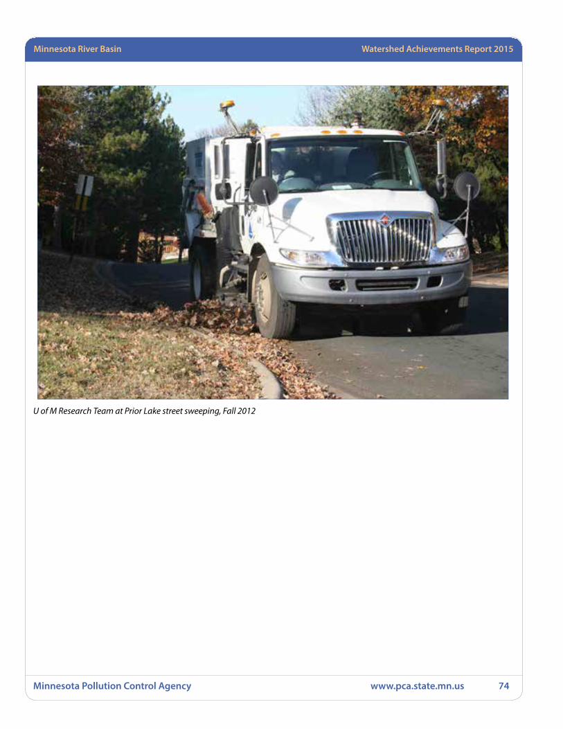
Minnesota Pollution Control Agency www.pca.state.mn.us 74
Minnesota River Basin Watershed Achievements Report 2015
U of M Research Team at Prior Lake street sweeping, Fall 2012

Watershed Achievements Report 2008 StatewideMinnesota River Basin Watershed Achievements Report 2015
Minnesota Pollution Control Agency www.pca.state.mn.us 75
Lower Minnesota River Watershed
Rush River Watershed TMDL Implementation Project for Fecal Coliform
The Rush River Watershed TMDL Project for Fecal Coliform was not a complete success. During the course of the project there were four different coordinators and the project technician serving as interim coordinator during coordinator vacancies. This led to a lot of time being spent getting each new coordinator updated and other project concerns not getting looked at or finished.
Two of the biggest problems facing the project concerning BMPs were the downturn of small and medium animal producers staying in animal agriculture and the tight parameters of the best management practices that were offered in the project plan. Larger animal producers were already following BMPs that were offered so they could retain their feedlot permits. Smaller and older producers were getting out of animal agriculture instead of upgrading. The Rush River Watershed TMDL Project for Fecal Coliform restricted most of the BMPs that were close and around feedlots and facilities. When the program was amended to include manure management in fields additional interest was shown in the practices. But with our cold, wet spring in 2013 and 2014, not many practices were installed.
Upgrading septic systems was the most successful BMP offered. Fifty MDA BMP loans were approved while the project was ongoing. Alternative tile intakes were
another BMP that saw success. Thirty-one rock inlets were installed and five tile intakes were removed.
The Rush River Watershed TMDL Project for Fecal Coliform sent $105,700.00 back to Minnesota Pollution Control Agency early, as it was evident that all the funds would not be spent. Because of the lack of BMPs put on the ground, $95,700.00 from Objective 1 was returned. Having four different coordinators during the project, Objective 5 would have unused funds from the grant so $10,000.00 was returned.
Rush River watershed The Rush River Watershed (RRW) is a rural watershed that drains 257,770 acres (403 square miles) in Sibley, Nicollet and McLeod counties. The RRW comprises 22% of the total land area of the Lower Minnesota Watershed, a major watershed of the Minnesota River Basin. There are three branches to the Rush River: the north, middle and south branches. All three of these branches drain into the main stem of the river south of Henderson, Minnesota. The watershed contains a population of just over 9,000 people (47% rural) and has four towns including Gaylord, Gibbon, Lafayette and Winthrop. The Rush River Watershed’s primary land use is agriculture, with 90% of the watershed acreage utilized for producing crops such as corn, soybeans, small grain and forage.
The 2004 Rush River Assessment Project determined the water quality concerns of the Rush River Watershed to be fecal coliform (FC) bacteria, TSS, TP and NO2+NO3-N. The study also listed excessive stream flows and flooding as further water quality concerns for the watershed. Concurrently with this implementation project, a FC TMDL study was completed in partnership with the Water Resources Center at Minnesota State University, Mankato. The elevated levels of FC bacteria have resulted in the main stem and south branch of the Rush River being listed on the 303(d) Impaired Waters list.
Goals• Make significant progress on achieving the Rush River
TMDL for fecal coliform bacteria with a 30% reduction in the monthly fecal coliform geometric means from the FC TMDL Assessment Study.
• Increase the adoption of BMPs that reduce FC bacteria levels in the Rush River.
• Continue to foster watershed stewardship and community pride in clean water that achieves a legacy beyond this implementation grant.

Minnesota Pollution Control Agency www.pca.state.mn.us 76
Minnesota River Basin Watershed Achievements Report 2015
Results that count• A total of 94 BMPs were installed
• Pollution reductions for fecal coliform have been hard to quantify for this report. Taking an average of the reductions that I was able to do for upgrades to septic system the reduction in E. coli was 5.17E13 CFUs per system. Resulting in a total reduction of 258.5E13 CFUs for all septic systems installed during the grant. The other BMPs that were installed were practices that would prevent measures that would keep E. coli from reaching waterways. Additional pollution reductions as a side benefit of this project included a phosphorus reduction of 245.24 lbs, nitrogen reduction of 478 lbs. and sediment reductions of 77.83 tons a calculated by e LINK estimators based on the number and type of BMPs installed.
• Water quality monitoring occurred for this project during monitoring years 2010-2012 to determine if improvements in water quality are occurring.
• Education and Outreach Results:
• Eleven River Watcher Newsletters were distributed to around 1,250 residents in the RRW on a quarterly basis. These newsletters contained a variety of articles educating residents on BMPs.
• A Manure and Nutrient Management Field Day was held on July 23, 2014 with 80 attendees. 700 brochures were printed and mailed for the day. The field day had displays, speakers on nutrient management, calibration of spreaders and discussion of spill protocol.
• 500 project brochures were printed and distributed.
• Yearly Sibley and Nicollet County Fair informational booth displays.
• Watershed photo contests were held 2011, 2012 and 2013. With the photo contest winners a watershed calendar was produced in 2012, 2013 and 2014. Calendars included facts and tidbits about watershed related items including BMPs.
• Ten JPB Meetings
• Five Technical Committee Meetings
Lessons Learned• The parameters of the project only focused on
problems around feedlots. Fecal coliform sticks to sediment and then moves with sediment. The project could have done a lot more to solve fecal coliform problems if more BMPs would have been available for land owners.
Financial informationFunding type: Section 319
Grant amount: $181,092
In-kind: $365,976
Matching funds: $58,034
Contact information Ronald Otto, Watershed CoordinatorSibley County111 6th Street, P.O. Box 161Gaylord, MN [email protected] Project Manager: Bryan Spindler
Rock tile inlet installtion
Watershed Achievements Report 2008 StatewideMinnesota River Basin Watershed Achievements Report 2015
Minnesota Pollution Control Agency www.pca.state.mn.us 77
Minnesota River Mankato Watershed
Middle Minnesota Phosphorus Load ReductionThe Middle Minnesota Watershed (MMW) is a major watershed of the Minnesota River Basin. It covers approximately 862,000 acres across parts of eight counties in south-central Minnesota. Nicollet County is part of the MMW. Agriculture is the dominant land use covering 78% of all land in Nicollet County. Increased farming pressure on the land has caused extensive damage to ravine areas throughout the MMW. In Nicollet County, almost 70% of the soil being deposited in our streams and rivers is coming from ravines and other near stream features such as stream banks and bluffs. The remaining soils are carried from crop production lands into the drainage ditches, and into streams/rivers. Though 70% of soil loss is coming from near stream features, the main source of phosphorous pollution in our Watershed comes from the 30% of soil lost on our crop production land.
The project prioritized implementation activities to areas of the Seven Mile Creek Watershed, an area of southeast Nicollet County with a rich legacy of watershed-scale efforts to improve water quality. Nicollet SWCD was able to re-instate a Watershed Coordinator for Seven Mile Creek in partnership with Great River Greening, re-imagine and re-energize a dormant watershed program, and received a $170,000 grant from a private foundation to continue collaborative watershed-scale work in this area. In addition, implementation activities included 22 structural practices to reduce sediment and phosphate loading and seven acres of vegetative buffers along the cropland-ravine interface resulting in the prevention of more than 1,200 tons of sediment and 1,400 pounds of phosphorus from reaching Seven Mile Creek and the Minnesota River.
Goals • Install 20 erosion control structures, 20 side inlet
control structures on ditches.
• Establish vegetative buffers where feasible.
• Continue to foster watershed stewardship and community pride in clean water that achieves a legacy beyond this implementation grant.
Results that count• Twenty-two structural practices (including WASCOBs,
grade stabilizations, and side inlet controls on drainage ditches and at the cropland-ravine interface).
• Seven acres of vegetative buffer at the cropland-ravine interface.
• Secured an additional grant to continue promoting BMPs and fostering a culture of conservation in the Seven Mile Creek watershed.
Lessons learned/Recommendations• Skills required to be successful in creating a watershed
partnership that can really generate results are far different from those skills that we typically seek in our technical service providers. It’s the soft skills – relationship-building, diplomacy, creative problem-solving, long-term visioning, strategic planning, among many others – that are truly critical when considering this approach to watershed work.
• Even landowners who are not typical clients of SWCDs are eager to do conservation work when it doesn’t interfere with their business.
• Landowners have plenty of good, common sense ideas about how to address many of our surface water concerns, but they are almost never consulted or involved in conservation projects in a collaborative way.
• Neighbors will be a more effective at outreach to each other than a technical service provider every time – it ought to be the goal of watershed programs to harness this potential within our communities in order to reach more people and to make our own work more efficient.
• Outreach is most effective when well-targeted, much like conservation activities. Mass mailings of generic information are not worth the time it creates to send them. Generating specific, compelling content, and personalizing outreach materials is worth the extra time and effort required.
RecommendationsProvide more flexibility to grantees to account for uncontrollable factors like staff turnover and weather.
Financial informationFunding type: Section 319
Grant amount: $228,382
In-kind: $64,501
Matching funds: $141,117
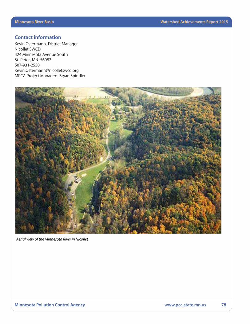
Minnesota Pollution Control Agency www.pca.state.mn.us 78
Minnesota River Basin Watershed Achievements Report 2015
Contact information Kevin Ostermann, District ManagerNicollet SWCD424 Minnesota Avenue SouthSt. Peter, MN [email protected] Project Manager: Bryan Spindler
Aerial view of the Minnesota River in Nicollet
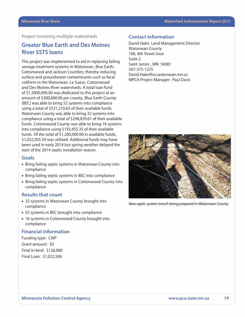
Watershed Achievements Report 2008 StatewideMinnesota River Basin Watershed Achievements Report 2015
Minnesota Pollution Control Agency www.pca.state.mn.us 79
Project involving multiple watersheds
Greater Blue Earth and Des Moines River SSTS loansThis project was implemented to aid in replacing failing sewage treatment systems in Watonwan, Blue Earth, Cottonwood and Jackson Counties; thereby reducing surface and groundwater contaminants such as fecal coliform in the Watonwan, Le Sueur, Cottonwood and Des Moines River watersheds. A total loan fund of $1,2000,000.00 was dedicated to this project at an amount of $300,000.00 per county. Blue Earth County (BEC) was able to bring 52 systems into compliance using a total of $531,210.63 of their available funds. Watonwan County was able to bring 32 systems into compliance using a total of $298,839.61 of their available funds. Cottonwood County was able to bring 16 systems into compliance using $192,455.35 of their available funds. Of the total of $1,200,000.00 in available funds, $1,022,505.59 was utilized. Additional funds may have been used in early 2014 but spring weather delayed the start of the 2014 septic installation season.
Goals • Bring failing septic systems in Watonwan County into
compliance
• Bring failing septic systems in BEC into compliance
• Bring failing septic systems in Cottonwood County into compliance
Results that count• 32 systems in Watonwan County brought into
compliance
• 52 systems in BEC brought into compliance
• 16 systems in Cottonwood County brought into compliance
Financial informationFunding type: CWP
Grant amount: $0
Final in-kind: $126,080
Final Loan: $1,022,506
Contact information David Haler, Land Management Director Watonwan County 108, 8th Street SoutSuite 2Saint James , MN [email protected] Project Manager: Paul Davis
New septic system trench being prepared in Watonwan County
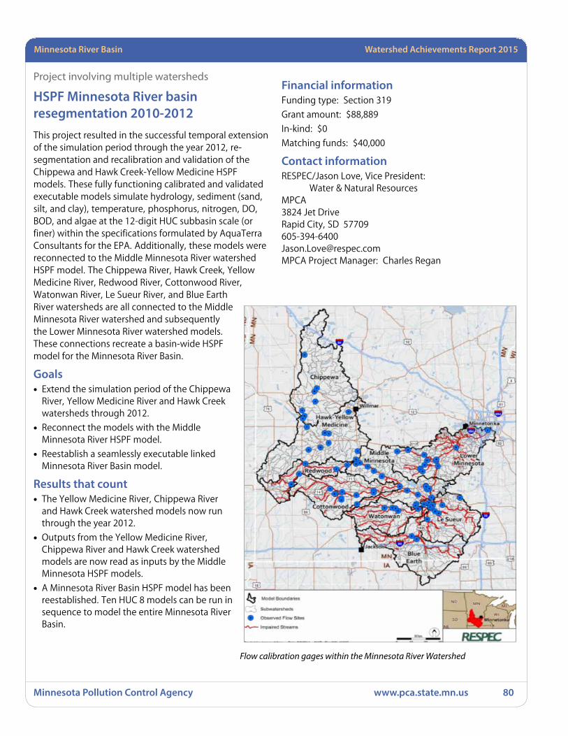
Minnesota Pollution Control Agency www.pca.state.mn.us 80
Minnesota River Basin Watershed Achievements Report 2015
Project involving multiple watersheds
HSPF Minnesota River basin resegmentation 2010-2012This project resulted in the successful temporal extension of the simulation period through the year 2012, re-segmentation and recalibration and validation of the Chippewa and Hawk Creek-Yellow Medicine HSPF models. These fully functioning calibrated and validated executable models simulate hydrology, sediment (sand, silt, and clay), temperature, phosphorus, nitrogen, DO, BOD, and algae at the 12-digit HUC subbasin scale (or finer) within the specifications formulated by AquaTerra Consultants for the EPA. Additionally, these models were reconnected to the Middle Minnesota River watershed HSPF model. The Chippewa River, Hawk Creek, Yellow Medicine River, Redwood River, Cottonwood River, Watonwan River, Le Sueur River, and Blue Earth River watersheds are all connected to the Middle Minnesota River watershed and subsequently the Lower Minnesota River watershed models. These connections recreate a basin-wide HSPF model for the Minnesota River Basin.
Goals • Extend the simulation period of the Chippewa
River, Yellow Medicine River and Hawk Creek watersheds through 2012.
• Reconnect the models with the Middle Minnesota River HSPF model.
• Reestablish a seamlessly executable linked Minnesota River Basin model.
Results that count• The Yellow Medicine River, Chippewa River
and Hawk Creek watershed models now run through the year 2012.
• Outputs from the Yellow Medicine River, Chippewa River and Hawk Creek watershed models are now read as inputs by the Middle Minnesota HSPF models.
• A Minnesota River Basin HSPF model has been reestablished. Ten HUC 8 models can be run in sequence to model the entire Minnesota River Basin.
Financial informationFunding type: Section 319
Grant amount: $88,889
In-kind: $0
Matching funds: $40,000
Contact information RESPEC/Jason Love, Vice President: Water & Natural ResourcesMPCA3824 Jet DriveRapid City, SD [email protected] Project Manager: Charles Regan
Flow calibration gages within the Minnesota River Watershed
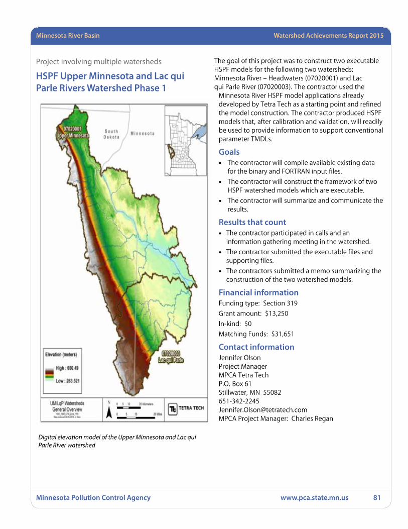
Watershed Achievements Report 2008 StatewideMinnesota River Basin Watershed Achievements Report 2015
Minnesota Pollution Control Agency www.pca.state.mn.us 81
Project involving multiple watersheds
HSPF Upper Minnesota and Lac qui Parle Rivers Watershed Phase 1
The goal of this project was to construct two executable HSPF models for the following two watersheds: Minnesota River – Headwaters (07020001) and Lac qui Parle River (07020003). The contractor used the
Minnesota River HSPF model applications already developed by Tetra Tech as a starting point and refined the model construction. The contractor produced HSPF models that, after calibration and validation, will readily be used to provide information to support conventional parameter TMDLs.
Goals• The contractor will compile available existing data
for the binary and FORTRAN input files.
• The contractor will construct the framework of two HSPF watershed models which are executable.
• The contractor will summarize and communicate the results.
Results that count• The contractor participated in calls and an
information gathering meeting in the watershed.
• The contractor submitted the executable files and supporting files.
• The contractors submitted a memo summarizing the construction of the two watershed models.
Financial informationFunding type: Section 319
Grant amount: $13,250
In-kind: $0
Matching Funds: $31,651
Contact information Jennifer OlsonProject ManagerMPCA Tetra TechP.O. Box 61Stillwater, MN [email protected] Project Manager: Charles Regan
Digital elevation model of the Upper Minnesota and Lac qui Parle River watershed
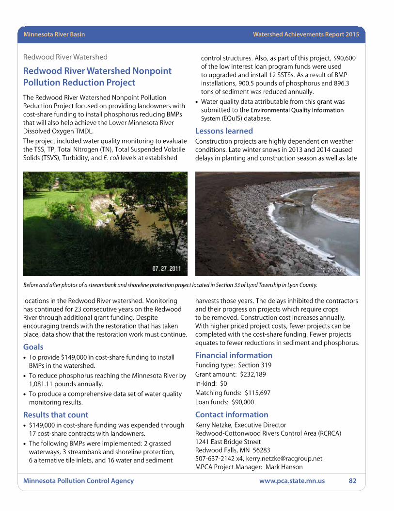
Minnesota Pollution Control Agency www.pca.state.mn.us 82
Minnesota River Basin Watershed Achievements Report 2015
Redwood River Watershed
Redwood River Watershed Nonpoint Pollution Reduction ProjectThe Redwood River Watershed Nonpoint Pollution Reduction Project focused on providing landowners with cost-share funding to install phosphorus reducing BMPs that will also help achieve the Lower Minnesota River Dissolved Oxygen TMDL.
The project included water quality monitoring to evaluate the TSS, TP, Total Nitrogen (TN), Total Suspended Volatile Solids (TSVS), Turbidity, and E. coli levels at established
locations in the Redwood River watershed. Monitoring has continued for 23 consecutive years on the Redwood River through additional grant funding. Despite encouraging trends with the restoration that has taken place, data show that the restoration work must continue.
Goals • To provide $149,000 in cost-share funding to install
BMPs in the watershed.
• To reduce phosphorus reaching the Minnesota River by 1,081.11 pounds annually.
• To produce a comprehensive data set of water quality monitoring results.
Results that count• $149,000 in cost-share funding was expended through
17 cost-share contracts with landowners.
• The following BMPs were implemented: 2 grassed waterways, 3 streambank and shoreline protection, 6 alternative tile inlets, and 16 water and sediment
control structures. Also, as part of this project, $90,600 of the low interest loan program funds were used to upgraded and install 12 SSTSs. As a result of BMP installations, 900.5 pounds of phosphorus and 896.3 tons of sediment was reduced annually.
• Water quality data attributable from this grant was submitted to the Environmental Quality Information System (EQuIS) database.
Lessons learnedConstruction projects are highly dependent on weather conditions. Late winter snows in 2013 and 2014 caused delays in planting and construction season as well as late
harvests those years. The delays inhibited the contractors and their progress on projects which require crops to be removed. Construction cost increases annually. With higher priced project costs, fewer projects can be completed with the cost-share funding. Fewer projects equates to fewer reductions in sediment and phosphorus.
Financial informationFunding type: Section 319Grant amount: $232,189In-kind: $0Matching funds: $115,697Loan funds: $90,000
Contact information Kerry Netzke, Executive DirectorRedwood-Cottonwood Rivers Control Area (RCRCA)1241 East Bridge StreetRedwood Falls, MN 56283507-637-2142 x4, [email protected] Project Manager: Mark Hanson
Before and after photos of a streambank and shoreline protection project located in Section 33 of Lynd Township in Lyon County.

Watershed Achievements Report 2008 StatewideMinnesota River Basin Watershed Achievements Report 2015
Minnesota Pollution Control Agency www.pca.state.mn.us 83
Yellow Medicine Watershed
Lower Minnesota River Dissolved Oxygen Elevation ProjectPrompted by water quality issues in the Hawk Creek watershed, a group of concerned citizens and local, state, and federal representatives from the three counties in the watershed began meeting in 1997 to work together to address these water quality issues. Known as the Hawk Creek Watershed Committee, the group determined their long-term goal to be “improving the water quality/quantity issues in the watershed, while also promoting a healthy agricultural, industrial, and recreational based economy for the region.”
The Hawk Creek Watershed drains 623,105 acres of land. It is comprised of a main tributary (Hawk Creek) and several other streams that flow directly into the Minnesota River. Hawk Creek originates in the lakes region of Kandiyohi County and flows approximately 65 miles to its mouth in the Minnesota River, located eight miles southeast of Granite Falls. Agriculture occupies approximately 88% of the land in the watershed.
The primary goal of this project was to implement BMPs that decrease phosphorus runoff and increase water infiltration in agricultural and urban areas in an effort to achieve the water quality conditions outlined in the Lower Minnesota River Dissolved Oxygen TMDL.
Throughout the duration of this grant, a total of 44 BMP projects were implemented with a reduction of an estimated 23,653.43 pounds of phosphorus per year and 4,529.27 tons of sediment per year and saving an estimated 947.50 tons of soil per year. Water quality monitoring has shown BMP implementation is working with the reduction in phosphorus and sediment, but they are still not to ecoregion standards. Hawk Creek Watershed Project (HCWP) will continue the goals of water quality improvement and increased watershed citizen involvement.
Goals • This project aimed to implement the following BMPs:
7 alternative intakes, 5 side inlets, 1 feedlot waste reduction project, 1 rain garden, 1 bank stabilization, and 1 grade stabilization. In total, a phosphorus reduction of 485 pounds per year was anticipated.
• This project anticipated the enrollment of 100 acres of buffer strips, which will reduce phosphorus loading by 849 pounds per year.
• This project aimed to restore 165 acres of wetlands, with a phosphorus reduction of 3,929 pounds per year.
Results that count• BMPs installed during this grant period include 1
alternative intake, 11 side inlets, 1 bio-engineered streambank stabilization, 1 agriculture waste project, 1 rain garden, and 1 water and sediment control basin for a total of 441.58 total treated acres, a phosphorus reduction of 18,547.12 pounds per year, a sediment reduction of 289.53 tons per year, and soil saved 289.53 tons per year. We exceeded our goal of the anticipated phosphorus reduction by 18,062.12 pounds per year.
• 144.80 acres were enrolled in a buffer program, resulting in a phosphorus reduction of 1,176.83 pounds per year, a sediment reduction of 935.82 tons per year, and 488.99 tons per year. We exceeded our goal of the anticipated phosphorus reduction by 327.83 pounds per year.
• 138.40 acres of wetlands were restored, resulting in a phosphorus reduction of 3,929.48 pounds per year, a sediment reduction of 3,303.92 tons per year, and soil saved 168.98 tons per year. We exceeded our goal of the anticipated phosphorus reduction by 0.48 pound per year.
Lessons learned/RecommendationsBuilding cooperative working relationships with communities and property owners is of the utmost importance in maintaining a successful program. Without interest and active participation of landowners, implementation would be impossible. The reputation of HCWP as a trusted partner in the arena of soil and water conservation is at the core of our ability to secure and implement pollutant reducing BMPs.
It is also important to recognize that individual farming operations and communities have a wide range of needs. To continue to be successful, a program must remain as flexible as possible to serve the unique needs of each individual producer. Project guidelines and goals must be established without inhibiting the ability to diversify our practices to meet the needs of the people we serve.
Feedback/SuggestionsGrant funds need to be inclusive enough to include unforeseen expenses that are necessary to administer the grant and fulfill grant objectives. Grant funds should allow for expenditures that are necessary and required in order to continue to operate and fulfill grant obligations.

Minnesota Pollution Control Agency www.pca.state.mn.us 84
Minnesota River Basin Watershed Achievements Report 2015
A grant program that offers some flexibility in grant fund expenditures is essential to meeting the changing needs and circumstances of HCWP and its watershed citizens.
Financial informationFunding type: Section 319
Grant amount: $205,186
In-kind: $1,260,377
Matching funds: $121,582
Contact information Heidi Rauenhorst, Project CoordinatorRenville County – Hawk Creek Watershed Project500 East DePue AvenueOlivia, MN [email protected] Project Manager: Mike Weckwerth
Before
After
Project: Agricultural Waste This project enlarged a manure holding pit to eliminate the need to do winter spreading. By eliminating winter spreading, phosphorus and nitrogen pollutants, mostly through spring runoff/rain events, are reduced.

Watershed Achievements Report 2008 StatewideMinnesota River Basin Watershed Achievements Report 2015
Minnesota Pollution Control Agency www.pca.state.mn.us 85
Yellow Medicine Watershed
HSPF Scenario Application Manager DevelopmentThis project led to the further development of a watershed-scale, decision-support tool to facilitate prioritization and placement of management practices to achieve the needed reductions identified by various watershed management programs in Minnesota. The decision-support tool, SAM, now consists of a GIS system for site selection, HSPF model application to simulate the transport and fate of pollutants, and development of a set of management practices and HSPF Parameters associated to those practices. This decision support tool provides decision makers with a user friendly, comprehensive approach to achieve the water quality improvement goals set by the TMDL assessments, protection strategies, and watershed restoration programs. The decision-support tool assists in identifying priority areas and BMPs that will provide the greatest water-quality benefits for dollar invested.
The value of the tool is in its simplification of complex hydrologic and water quality models into a transparent estimation of the significant pollutant sources in watershed. Local watershed entities can then apply their knowledge and expertise of BMP implementation using the tools interpretation of model results.
Goals • The review and selection of an existing HSPF model to
serve at the SAM pilot. (Yellow Medicine River).
• Develop a list of management practices appropriate to the Yellow Medicine River watershed.
• Construct the SAM interface.
Results that count• The Yellow Medicine River watershed was selected to
serve as the SAM pilot watershed.
• With input from local partners, a list of relevant BMPs were chosen for inclusion in the SAM tool.
• The SAM interface was constructed using the existing Yellow Medicine HSPF model as a foundation.
• Intensive monitoring revealed extensive influence from Upper Prior Lake on the southernmost bay, and influence from the watershed on the rest of the lake. Further communication will build on this understanding of what influence BMPs will have on different parts of the lake.
Financial informationFunding type: Section 319
Grant amount: $100,000
In-kind: $0
Matching funds: $99,970
Contact information RESPEC/Jason Love, Vice President: Water & Natural Resources13824 Jet DriveRapid City, SD [email protected] Project Manager: Charles Regan
Minnesota Pollution Control Agency www.pca.state.mn.us 86
Minnesota River Basin Watershed Achievements Report 2015
Minnesota River BasinActive ProjectsProjects awarded
Multiple watersheds in the basin Cottonwood-Redwood River Septic Loan Program – 2013Sponsor: RCRCA
Funding: $ 9,000 CWF, $510,000 Clean Water Partnership (loan)
Purpose: This project will continue offering low-interest loans to citizens, some of whom may not be able to acquire funding otherwise, for upgrading 50 septic systems to ensure compliance with state rules. Grant funds will be used to administer the low-interest loan program.
GBERBA Conservation Drainage Partnership Program – 2015Sponsor: Greater Blue Earth River Basin Alliance
Funding: Clean Water Partnership (Grant) $147,200
Purpose: Alternative side-inlets (categorized as grade stabilization structures) are an effective alternative to the classical side-inlet pipe. Instead of a horizontal pipe through the spoil bank, alternative side-inlets may utilize a drop structure with a water quality inlet on the surface. The water quality inlet allows water to temporarily pond, decreasing the stormwater’s sediment carrying capacity by as much as 95%. Twenty-seven shovel-ready projects will reduce peak downstream flows and annually prevent 23.5 tons of soil and sediment and 23.5 lbs of phosphorus from entering ditches. The trash guard of the water quality inlet also prevents field residue from leaving the field. Additional water treatment (nitrogen) is likely with the setting of the water quality inlet in the grassed buffer of the drainage ditch.
Greater Blue Earth Nonpoint Reduction Initiative – 2014Sponsor: Faribault SWCD
Funding: Clean Water Partnership (Grant) $364,163
Purpose: Provide education, outreach and civic engagement necessary for the development of structural and non-structural BMPs needed to improve water quality within the Greater Blue Earth River Basin. General education will have a regional focus to landowners. Outreach efforts will be focused on regional officials,
staff and landowners. Civic engagement efforts will have a smaller watershed scale focus with efforts resulting in structural BMPs being placed on the land and non-structural BMPs being adopted. Provide cost-share assistance to landowners within the Greater Blue Earth River Basin to implement NPS reduction BMPs. Provide technical assistance to landowners and administration for this grant. Develop and deliver education, outreach and civic engagement efforts.
Blue Earth River Blue Earth River Dissolved Oxygen: Managing Flows & Nutrients – 2014Sponsor: Faribault County SWCD
Funding: Section 319 (Grant) $234,334.00
Purpose: Design a drainage watershed water quality treatment system through a mix of management and implementation practices to strike a balance between improved drainage need and local water quality benefit, while serving as an example site across the Greater Blue Earth River Basin. Install targeted BMP’s to reduce the amount of phosphorus, nitrogen, and sediment reaching the Blue Earth River, including 2 woodchip bioreactors, 1 sediment basin, 5 water control structures, 6 alternative surface intake, and 1 saturated buffer. Establish up to 75 acres of cover crop demonstration plots. Host a minimum of one workshop/field day on BMP installation and/or cover crops/soil health. Create short videos so landowners, elected officials and LGU’s can see the installation process and how the practice works beneath the surface. Design and install signage at cover crop plots and BMP installation sites. Create and distribute promotional materials and advertisements as necessary.
Blue Earth River Green Infrastructure Project – 2014Sponsor: City of Winnebago
Funding: Clean Water Partnership (Grant) $10,000 and Clean Water Partnership (Loan) $1,000,000
Purpose: Design and implement a region bioretention basin within the 25 block reconstruction project area, promote and implement green infrastructure activities throughout the City of Winnebago to reduce stormwater volume entering critical infrastructure, implement voluntary landowner BMPs found in the MN Stormwater Manual, prepare an in project area video and disconnect inflow and infiltration issues between the structures and main connection and develop SWCD grant program

Watershed Achievements Report 2008 StatewideMinnesota River Basin Watershed Achievements Report 2015
Minnesota Pollution Control Agency www.pca.state.mn.us 87
education and civic engagement within the City of Winnebago and project area.
Collaborative for Sediment Source Reduction: Greater Blue Earth River Basin – 2012Sponsor: U of M, Jeff Marr
Funding: Section 319 (Grant) $300,000
Purpose: This project will develop a sediment budget for the Greater Blue Earth River watershed; establish efficiency and cost of sediment reduction strategies (type, setting, and location); develop a sediment simulation model; build a decision analysis system; develop management strategy; provide seven workshops to develop and test the simulation model and decision tools; and complete all fiscal management and planning.
Elm Creek Tile Outlet Treatment Trains – 2013Sponsor: Rural Advantage
Funding: Section 319 (Grant) $165,000
Purpose: Demonstrate innovative redesign of tile outlets using an innovative treatment train approach that addresses water traveling through drainage systems, focused toward linking upland practices with farm tile outlets to increase practice adoption, deliver environmental soundness and transfer knowledge on effective techniques resulting in improved nutrient management, post field treatment, reduced in-stream nutrient loads, and enhance wildlife and other ecosystem services while maintaining agricultural productivity.
Greater Blue Earth Urban Retrofit Initiative – 2012Sponsor: Faribault County SWCD
Funding: Section 319 (Grant) $270,250
Purpose: This project will use various electronic and printed media, as well as meetings, to promote environmentally-friendly stormwater management practices; design and implement stormwater retrofit and new stormwater practices; provide technical assistance for stormwater implementation; track grant project and matching fund expenditures; and complete required reporting.
Chippewa RiverChippewa River Accelerated Restoration – 2012Sponsor: Chippewa County
Funding: CWP (Loan) $900,000
Purpose: This project will promote and install 90 SSTS, rural and agricultural BMPs in the Chippewa River watershed.
Chippewa River Phosphorus Reduction Practices – 2013Sponsor: Chippewa River Watershed Project
Funding: Section 319 (Grant) $279,518
Purpose: Address phosphorus loading sources within the watershed and effectively reduce the amount of pollutant load entering the local priority waters within the watershed and lower the Chippewa River Watershed’s contribution to the Minnesota River. The utilization of alternative surface tile intakes, drop side inlets, cover crops, livestock exclusion (fencing), pasture management/planned grazing, and water and sediment control basins will provide the best options for landowners to make site and management specific choices for reducing phosphorus.
Chippewa River Watershed Protection – 2015Sponsor: Chippewa River Watershed Project
Funding: Clean Water Partnership (Grant) $296,965 and Clean Water Partnership (Loan) $350,000
Purpose: Stabilize 235 feet of streambank with bio-engineering techniques, install 10 shoreline restorations, install approximately 3/4 mile of livestock exclusion fencing, enroll 30 acres of buffer strips, upgrade septic systems, and other recognized BMP’s for reducing pollutant loading that may be brought forth by landowners that would have a direct impact on protecting water quality. Program evaluation tools will be developed to evaluate other key activities within program elements such as bus tours, field days, and public meetings. Levels of nutrients and sediments will be monitored on an ongoing basis to compare with the 15 years of historic data available and point to any increasing or decreasing trends in water quality. Using BWSR’s calculation tools it is estimated that 235 ft of streambank stabilization will reduce phosphorus by 68 lbs/yr and delivery of sediment by 59 tons/yr. Shoreline restorations reduce phosphorus by 35.05 lbs/yr and sediment by 41.25 tons/yr, buffer strips reduce phosphorus by 3,416 lb/yr and sediment by 2,867 tons/yr, sediment basins reduce sediment by 75 tons/yr and reduce phosphorus by 90 lbs/yr, livestock exclusion fencing saves three tons of soil

Minnesota Pollution Control Agency www.pca.state.mn.us 88
Minnesota River Basin Watershed Achievements Report 2015
per year and reduces phosphorus by three lbs/yr, and cover crops reduce 620 lbs/yr of phosphorus and reduce sediment by 414 tons/yr.
Lake Minnewaska Phase I Resource Investigation – 2013Sponsor: Pope Soil & Water Conservation District
Funding: CWP (Grant) $112,435
Purpose: This project will hire a half time employee for three years responsible for meeting the requirements outlined in the preparation of a diagnostic study and implementation plan guidance document. The requirements are as follows but not limited to: monitoring water quality, compiling data, gathering public comments, identifying priority areas, providing timelines and cost estimates for BMPs and writing a detailed report The resource investigation report will explore land use in the watershed, point and nonpoint pollution sources, agricultural practices being used, lakeshore development, septic system compliance, and water quality trends.
Cottonwood Streambank Inventory and Prioritization Project – 2012Sponsor: Redwood-Cottonwood Rivers Control Area (RCRCA)
Funding: Section 319 (Grant) $297,000
Purpose: This RCRCA project will promote agricultural BMPs projects, identify sensitive areas for projects, inventory and prioritize project need, provide cost-share funding for BMP implementation, particularly the remediation of stream bank failures through direct streambank restoration and practices that slow hydrologic processes; identify high erosion streambanks and near-channel grade stabilization/ravine problems along the Cottonwood River corridor and create a method to prioritize the sites; and provide necessary project administration, meeting all grant requirements.
Le Sueur RiverLe Sueur Watershed Targeted Conservation Practices – 2012Sponsor: Minnesota State University – Mankato – Water Resources Center
Funding: Section 319 (Grant) $82,491
Purpose: The Water Resources Center at Mankato will form a steering committee to serve an advisory role for the project; collect and organize data on existing BMP implementation, targeting and modeling research and other data for the map production; complete tillage
transect survey/WinTransect; determine what existing laws or regulations, location and type of BMPs to target; complete “Flow Calculation Modeling”; actively seek out willing stakeholders through the “Le Sueur Civic Engagement Project”; provide project information to local government units meetings; provide a project survey, and data usage analysis; and manage and coordinate project administration.
Lower Minnesota RiverAssessing Iron Enhanced Filtration Trenches – 2011Sponsor: City of Prior Lake
Funding: Section 319 (Grant) $240,000
Purpose: The purpose of this project is to quantify the performance of full-scale, field-installed, iron-enhanced filtration trenches which will provide critical design, construction, and performance information for a practice that could be used to significantly reduce the dissolved phosphorus load entering wetlands, rivers, and lakes in Minnesota.
This project will investigate the design of a new treatment system that utilizes a sand filter enhanced with iron shavings or steel wool around the perimeter and near the outlet of a wet detention basin. When stormwater enters the basin, the water level will increase and stormwater will begin flowing into the filtration trenches. Significant particulate removal occurs through settling within the wet detention basin and additional particle and dissolved pollutant capture occurs by filtration and adsorption within the enhanced media trench. The technology was tested during the summer of 2010 through funding provided by the City of Prior Lake, the Prior Lake Spring Lake Watershed District, and the Scott County Watershed Management Organization.
Blackhawk Lake Protection Project – 2013Sponsor: City of Eagan
Funding: CWP (Grant) $46,500
Purpose: The City of Eagan will collaboratively develop educational programs and materials for the Black Hawk Middle School and Deerwood Elementary School community and will determine the most appropriate opportunities for community education and involvement in site analyses and selection, design, installation, operation, and maintenance of selected BMPs.

Watershed Achievements Report 2008 StatewideMinnesota River Basin Watershed Achievements Report 2015
Minnesota Pollution Control Agency www.pca.state.mn.us 89
Carp Management in Spring Lake & Prior Lake – 2015Sponsor: Prior Lake - Spring Lake Watershed District
Funding: Clean Water Partnership (Grant) $67,323
Purpose: Capture and surgically implant 30 adult carp throughout three lakes with high frequency radio transmitters. In addition to radio tagging, all remaining carp will be marked with a fin clip and returned to the lake to allow us to complete a mark/recapture population estimate. Radio tagged carp will be tracked to determine if migration routes exist, and if so, where barriers may be sited to restrict carp from potential nursery sites and spawning habitat, as well as to identify potential aggregation areas. Once a significant aggregation of carp has been located, a removal will be completed. During the removal, a count of the recaptured carp will be completed to generate a population estimate, combining the information with a weight and length subsample to obtain a biomass estimate. This value can then be used to gauge if additional removals are warranted on the lakes. By quantifying the amount of carp that are present post-removal, a total phosphorus load reduction can be estimated and compared to the amount specified in the 2012 TMDL for Spring and Upper Prior Lakes. Spring/Summer spawning tracking data will inform decisions on where we may be able to site carp barriers as part of our integrated pest management (IPM) strategy to inhibit carp recruitment. Barriers will be placed in identified locations after sufficient spawning period data has been collected. Carp will be tracked post barrier installation in 2017 to determine the effectiveness of the barriers and allow us to determine if any modifications may be necessary.
Credit River Protection Plan – 2013Sponsor: Scott Watershed Management Organization
Funding: CWP (Grant) $225, 000
Purpose: This project will promote land and water treatment practices, including wetland restoration, riparian vegetation management, geomorphic (stream stabilization and grade control), livestock exclusion, native grasses, and rain gardens. Also included are three specific geomorphic (stream/grade) stabilization projects in the Hidden Hills Park area of Savage, a wetland restoration in Savage, and finishing the Ponds Park Storm Water Reuse Project. The project includes a 0.25 full time equivalent (FTE) to provide the technical assistance necessary to implement the practices. Metrics or targets for this objective include: installation of 30 rain gardens, 70 acres of natural practices (i.e., wetland restoration,
native grass or riparian vegetation management), the completion of 3-4 geomorphic practices (stream stabilization or grade control), and 1 storm water reuse project. The bulk of the education/outreach effort, will develop and implement a program targeting small hobby farm and other large-lot residential land owners, to include both broad-based and individual (e.g. door-to-door) marketing and outreach components. A 0.25 FTE position is included in the budget for this effort.
High Island Creek – McLeod County SSTS Project – 2013Sponsor: McLeod County
Funding: CWP (Loan) $120,000
Purpose: This project will work to address non-compliant SST systems in McLeod County’s portion of the High Island Creek Watershed through the allocation of loan funds to rural homeowners. Overall, this specific project strives to implement 3 SSTS upgrades per year for the next 3 years.
High Island Creek TMDL Project for Fecal Coliform – 2011Sponsor: Sibley County
Funding: Section 319 (Grant) $300,000
Purpose: Results from the Agricultural Drainage and Pesticide Transport model by the University of Minnesota (Dr. David Mulla), shows that the Lower Minnesota River watershed contributes a large percentage of the sediment and nutrients that enter into the Mississippi River.
The desired environmental outcome for this project is to make significant progress on or achieve the TMDL for fecal coliform bacteria. Project activities will be focused to on-the-ground implementation practices that reduce fecal coliform bacteria levels and educational activities. By applying significant implementation practices, this project will also increase wildlife habitat and improve aquatic habitat. The project will continue to strive to create a sense of watershed stewardship and community pride in clean water, a social goal from previous grants.
Lake Waconia Stormwater BMP Enhancement – 2014Sponsor: Carver County Water Management Organization (CCWMO)
Funding: Clean Water Partnership (Grant) $93,000
Purpose: Mitigate phosphorus and TSS loading to Lake Waconia by enhancing urban stormwater treatment with the installation and Inspection (to follow guidelines of the Minnesota Stormwater Manual) of up to 5 bioretention areas, a sand iron filtration bench, and approximately 90
Minnesota Pollution Control Agency www.pca.state.mn.us 90
Minnesota River Basin Watershed Achievements Report 2015
feet of installed permeable pavers. Monitor practice outlet prior to BMP installation to assess total phosphorus and TSS event-based loading. Install flow meter to gather in-pipe, event based, and storm hydrographs. Collect event samples for processing. Compile and analyze data to determine event based total phosphorus and TSS loading.
Lower Prior Lake Protection Project Implementation – 2014Sponsor: Prior Lake-Spring Lake Watershed District
Funding: Clean Water Partnership (Grant) $142,522
Purpose: A reduction in watershed phosphorus loading to Lower Prior Lake by 33 lb/yr, or 10% of the total drainage area phosphorus load of 326 lb/year, to maintain or improve water quality conditions (as monitored in the central basin) by up to 10% within 10 years of initiation of implementation activities, which include Infiltration areas, water control structure, rain gardens, shoreline restorations and filter benches. Through community outreach activities, watershed residents will understand that immediate phosphorus reduction actions result in future benefits to water quality; in other words, that tangible benefits of watershed BMPs implemented now may only appear in long-term, future trends, and not until full BMP establishment (in particular, vegetation).
Neighborhood Lakes Management Plans – 2012Sponsor: City of Eagan
Funding: CWP (Grant) $167,000
Purpose: The City of Eagan will prepare state-of-the-art water quality management plans for twelve neighborhood lakes. The plans will include the following specific sections: 1) Introduction of purpose, problem, etc.; 2) Summary of watershed and lake, including history, soils and geology, climate, watershed characteristics, lake morphometry and hydrology, historical water quality, fisheries status, aquatic vegetation, and water level; 3) Discussion of water quality standards (as above) and numeric targets; 4) Assessment and analysis of TP sources and contributions from urban stormwater, internal release, atmospheric deposition, and others; 5) Modeling water quality to source loads; 6) Development of a TMDL for impaired lakes and a virtual TMDL for unimpaired lakes, including waste load allocations, load allocations, and margin of safety, and discussion of future growth and anti degradation; 7) Public input and involvement in development of plan; and 8) Implementation
strategy, including reasonable assurance and follow-up monitoring.
Quarry Creek Collaborative – 2015Sponsor: Scott County/Scott Watershed Management Organization
Funding: Clean Water Partnership (Loan) $1,998,800
Purpose: This project will reduce sediment to the Minnesota River, control erosion and reduce sedimentation in Quarry Creek as well as protect private land and public infrastructure. Stabilization techniques proposed are designed to significantly reduce flow rates and velocities, channel incision, the migration of knick points and head cuts; such that sediment erosion will be reduced by at least 75% to 80% within the stabilized areas. The project activities include stabilizing 2 nick points, thousands of feet of channel armoring and turf reinforced mat, a couple dozen grade control/rock weir structures, and 1 large detention basin. Landowners are contemplating a native prairie planting, grassed waterways, and several Water and Sediment Control Basins in the areas tributary to the ravines. With the heavy rains of mid-June 2014 there is significant damage to ravines and creeks like Quarry Creek throughout the area and the project will serve as an example.
Rush River Watershed – Nicollet County SSTS Project – 2013Sponsor: Nicollet County
Funding: CWP (Loan) $150,000
Purpose: This project will work to address non-compliant SSTS systems in Nicollet County’s portion of the Rush River Watershed through the allocation of loan funds to rural homeowners. Overall, this specific project strives to implement 5 SSTS upgrades per year for the next 3 years.
Scott Watershed Management Organization TMDL Implementation – 2013Sponsor: Scott Watershed Management Organization
Funding: Section 319 (Grant) $298,512
Purpose: Implement BMPs that are part of, and citizen engagement efforts that support; Implementation Plans for Cedar and McMahon Lakes Excessive Nutrients and the Lower Minnesota River Dissolved Oxygen TMDLs. BMPs to be promoted include: harvestable filter strips, alternative tile intakes, water and sediment basins, grassed waterways, grade control, wet detention ponds, native vegetation plantings, wetland restoration, riparian

Watershed Achievements Report 2008 StatewideMinnesota River Basin Watershed Achievements Report 2015
Minnesota Pollution Control Agency www.pca.state.mn.us 91
vegetation improvements, and shoreline restoration and stabilization. Much of the funding is for staffing to provide the technical assistance necessary to promote and implement the BMPs. One specific project included on public land converts roughly 19 acres of cropland near Cedar Lake to native vegetation. A citizen engagement event using volunteers to complete the seeding and planting will be coordinated with this effort. A second citizen engage/community capacity building effort that will be completed is a customer service survey with landowners who participated in the cost share/incentive program.
Minnesota River – HeadwatersProtecting North and South Fork Yellow Bank River – 2012Sponsor: Lac qui Parle-Yellow Bank Watershed District
Funding: CWF (Grant) $260,900, CWP (Loan) $370,000
Purpose: This project will offer incentives to protect 80 acres of land in filter strips and highly erodible lands adjacent to the rivers; construct 9 sediment and water control basins or terraces; replace 35 open tile intakes and advocate wetland restorations and grassland easement programs; organize a Friendship Tour to bring together Minnesota and South Dakota farmers, county commissioners, farm organizations, local, state and federal agency personnel to experience the watershed, farming practices, discuss future project ideas and strengthen relationships; and upgrade 37 SSTS by offering landowners low interest loans for their share of construction.
Minnesota River – Mankato Middle Minnesota River Low Dissolved Oxygen TMDL Project – 2012Sponsor: Renville County
Funding: Section 319 (Grant) $245,475
Purpose: This Renville County project will offer one-time and annual financial incentives to landowners for BMP efforts that will be focused on activities that reduce phosphorus loss, prevent soil erosion, and increase groundwater recharge. The anticipated activities include 50 side inlets, 150 acres of buffers, two feedlot upgrades/livestock exclusions and other special projects to be determined.
Middle Minnesota Watershed, Implementation of Conservation Practices – 2011 Sponsor: Cottonwood County
Funding: CWP (Loan) $1,400,000
Purpose: Coordinate the CWP loan program in southern Minnesota counties to demonstrate the influence low interest SSTS loans has on the rate of SSTS compliance. It is anticipated that 120-160 new systems will be installed. Each of these systems will be financed through low interest loans which will be administered by individual counties: Blue Earth, Brown, Cottonwood, Nicollet, Redwood, Renville and Sibley.
Middle Minnesota Watershed SSTS Loan Project – 2014Sponsor: Renville County
Funding: Clean Water Partnership (Grant) $10,000 and Clean Water Partnership (Loan) $950,000
Purpose: The project will utilize low interest loan funds to provide second-tier loans to landowners for the replacement or upgrade of 65-85 noncompliant septic systems located in the MMW. This project will serve as a means to financially assist landowners in Renville, Cottonwood, Redwood, Nicollet, and Le Sueur counties to continue eliminating noncompliant septic systems and improving water quality.
Renville Co MN River Mankato Watershed Protection – 2014Sponsor: Hawk Creek Watershed Project
Funding: Clean Water Partnership (Grant) $306,750
Purpose: To address nutrients in surface waters coming from the most common origins of upland sources (eroding soils and runoff from fields, animal feedlots, and urban areas) and near-channel sources (ravines, gullies, bluffs, and streambanks), multi-beneficial, targeted BMPs, such as buffer strips, grassed waterways, grade/gully stabilizations, streambank and shoreline stabilizations, tile intake protection practices, controlled drainage, wetland restorations/protection, and feedlot runoff reduction practices, will be a priority in order to prevent impairments and degradation. Based on past project pollutant reductions, the estimated pollutant reductions through this grant are 680 pounds of phosphorus per year and 255 tons of sediment per year.
Minnesota Pollution Control Agency www.pca.state.mn.us 92
Minnesota River Basin Watershed Achievements Report 2015
Minnesota River – Yellow Medicine RiverHawk Creek – Minnesota River Phosphorus Reduction – 2013Sponsor: Hawk Creek Watershed Project
Funding: Section 319 (Grant) $228,992
Purpose: Cost-share assistance will be available for BMPs that focus on and are proven to be effective in reducing phosphorus, such as, but not limited to: side inlets, alternative tile intakes, conservation drainage systems, water and sediment control basins, grade stabilizations, streambank stabilizations, feedlot waste reduction projects, rain gardens, and lakeshore buffers. Another goal is to build on established relationships through increased authentic civic engagement activities to increase conversations and collaboration with a more diverse community.
Hawk Creek Watershed D.O. Restoration Project – 2014Sponsor: Hawk Creek Watershed Project
Funding: Section 319 (Grant) $237,585
Purpose: The goal of this project is to reduce phosphorus levels, increase base flows, and reduce sediment volume entering the Minnesota River via the Hawk Creek Watershed through restorative BMP implementation with 10 local landowners in strategic targeted locations as identified in the Lower Minnesota River Dissolved Oxygen TMDL Implementation Plan. BMPs with multiple benefits, such as improving water quality, habitat, and hydrology, will be a priority. Based on past project pollutant reductions, the estimated pollutant reductions through this grant are 680 pounds of phosphorus per year and 255 tons of sediment per year. A Volunteer Citizen Monitoring Network of approximately 25 volunteers will be maintained and water quality and precipitation data will be collected and analyzed. The data collected will be added to long-term data to help identify water quality trends. Interactions with volunteers will strengthen citizen involvement in watershed issues and solutions. This project will utilize outreach and education to target BMP implementation and the decision making process of watershed issues.
Hawk Creek Watershed Nitrogen Reduction Project – 2013Sponsor: Hawk Creek Watershed Project
Funding: CWF (Grant) $10,000, CWP (Loan) $1,050,000
Purpose: This project will upgrade an estimated 75 SSTS for the three counties of Chippewa, Kandiyohi, and Renville within the watershed. The grant funds will be used to administer the loan program for the three counties.
Pomme de Terre RiverPomme de Terre River Protective Buffer Project – 2013Sponsor: Pomme de Terre River Association
Funding: CWF (Grant) $216,600, CWP (Loan) $500,000
Purpose: This project will offer incentives to protect 200 acres of riparian buffer in the headwaters of the watershed, accounting for 1,860 tons of sediment prevented from reaching surface waters each year the practices remain in place. This project will allow for outreach programs, such as tours, to engage more interested citizens. The desired outcome would include 30 or more participants in the program, and to develop a more extensive volunteer base.
Pomme de Terre WRAPS Implementation Project – 2014Sponsor: Pomme de Terre River Association
Funding: Section 319 (Grant) $275,000
Purpose: This project will continue the BMP implementation process for the Pomme de Terre Watershed. Opportunities to reach landowners and citizens of the watershed will be leveraged through this project and will include an outreach program to inform citizens, city officials, and other individuals about water quality issues and solutions. The outcome will be a reduction of 1,220 lbs/yr of phosphorous and 1,100 tons/yr of sediment. The BMPs installed will provide 10 years of protection from agricultural and urban non-point source pollution. By addressing phosphorus and sediment concerns, this project will have a positive impact on aquatic life for both macroinvertebres and fishes by reducing turbidity within the river. In addition, project coordination with partnering LGUs will be strengthened with continued cooperation.

Watershed Achievements Report 2008 StatewideMinnesota River Basin Watershed Achievements Report 2015
Minnesota Pollution Control Agency www.pca.state.mn.us 93
Redwood RiverRedwood River Turbidity Reduction Project – 2015Sponsor: RCRCA
Funding: Clean Water Partnership (Grant) $150,512
Purpose: Assist at least 12 cooperators to achieve total reductions of 715 tons/year of sediment and 715 lbs/year of phosphorus. This project will take further steps to provide funding, up to 70% cost-share, to cooperators to restore high priority erosion areas and to retain water in upland areas which retards flow into the system. Proposed conservation practices of water and sediment control basins, grassed waterways, grade stabilizations and streambank stabilizations are in direct agreement with the planned activities by the partnering water management plans. In order to help determine which BMPs are most effective, which BMPs are needed, and which BMPs cooperators are most willing to implement, two civic engagement meetings will be hosted by this project. Dialogue will be facilitated by a past cooperator who can attest to the benefits provided by his personal BMP installations. The perceptions of past and future cooperators will be sought as to how they see the watershed restoration progressing, and to recommend methods to continue restoration efforts with greater public involvement. The results of these meetings with help identify the public concerns and will tailor future conservation approaches.

Minnesota Pollution Control Agency www.pca.state.mn.us 94
Minnesota River Basin Watershed Achievements Report 2015Red River Basin Watershed Achievements Report 2015
Red River BasinProjects completed
Bois de Sioux WatershedBois de Sioux Watershed Nutrient Load Assessment
Snake River WatershedGrand Marais and Snake River Watesheds HSPF Modeling – July 2014
!!
!
!
!
!
!
!
!
!
!
!
!
!
!
!
!!
!
!
!
!
!
!
!
!
!
!
!
!
!
!
!
!!
Roseau River
Two Rivers
Tamarac River
Snake River
Grand MaraisCreek
Clearwater River
ThiefRiver
Red LakeRiver Upper and Lower
Red Lake
Sandhill River
Wild Rice River
Marsh River
Buffalo River
Otter Tail River
Mustinka River
Bois DeSioux R.
Red River Basin
´0 3015 Miles
Minnesota
Legend! Approved Lake TMDL
Approved Stream TMDL
County Boundary
Major Watershed
Basin Boundary
Watershed ProjectsNew
New and Active
Active
Completed

Watershed Achievements Report 2008 StatewideMinnesota River Basin Watershed Achievements Report 2015
Minnesota Pollution Control Agency www.pca.state.mn.us 95
Watershed Achievements Report 2008 StatewideRed River Basin Watershed Achievements Report 2015
Bois de Sioux Watershed
Bois de Sioux Watershed Nutrient Load Assessment
The main purpose of this project is to monitor phosphorous nutrient loading at the North Ottawa Impoundment site in the Bois de Sioux Watershed and to assess the potential for the capture, removal and reuse of phosphorus from the watershed through aquatic plant management (primarily cattails) growing within Pool C of the impoundment. MPCA completed a pollutant load monitoring process between 2007 and 2009 to look at Minnesota watersheds and their contributions of TP and TSS. The Bois de Sioux Watershed is listed among the moderately high watersheds in the state with P yields ranging between .153- .377 lbs. /ac TP yield and 51-100 lbs. /ac TSS yield.
Historically, the International Water Institute (IWI) has been monitoring at sites upstream and downstream of the North Ottawa site to measure any positive effects that this site has on water quality. This project reviewed historical monitoring results as a reference to support loading and removal potential. The project timeline, May-September 2014, allowed for summer sampling at targeted sites including the inlet, outlets and within the main retention pool (Pool C) in an attempt to gather baseline information as a reference for longer
term monitoring. The project also included soil sampling and analysis work to collect baseline nutrient analysis within the three pools (A, B, C). Pools B and C within the impoundment are farmed unless there is a need to hold water beyond the capacity of Pool C.
There is a need to understand watershed nutrient pathways and processes to help define a statistical range of input/output P and N for off channel flood storage sites. This information will lead and support best practices for managing existing sites and for planning and design across the watershed and where future impoundments will be constructed.
Goals • Gather and review existing water quality data for
project site.
• Targeted monitoring of North Ottawa impoundment to measure nutrient loading.
• Establish potential nutrient (phosphorus) removal potential through vegetation harvesting and removal.
Results that count • Targeted monitoring at inlet and outlet of the
impoundment from this project have yielded significantly different results when compared to historical data collected to measure water quality conditions and North Ottawa impoundment effects on water quality improvement.
• Targeted monitoring of impoundment at inlet and outlets reflects the following reductions after treatment through the impoundment: P 38%, N 70%, TSS 84%.
Bois de Sioux Watershed with North Ottawa Drainage Basin
Pool C of the North Ottawa impoundment for the Bois de Sioux Watershed

Minnesota Pollution Control Agency www.pca.state.mn.us 96
Minnesota River Basin Watershed Achievements Report 2015Red River Basin Watershed Achievements Report 2015
• Sample analysis of cattails indicates a potential to remove 17-18 pounds elemental P per acre of harvested cattail with a projected yield of 7tons/acre plant matter.
Financial informationFunding type: Section 319
Grant amount: $12,317
In-kind: $12,726
Contact information Red River Basin Commission (RRBC)Joe Courneya, Project Development Specialist1120 28th Avenue N. Suite CFargo, ND 58102701 356 [email protected] Project Manager: Tara Mercil
Summer 2014 high water impact on cattail growth

Watershed Achievements Report 2008 StatewideMinnesota River Basin Watershed Achievements Report 2015
Minnesota Pollution Control Agency www.pca.state.mn.us 97
Watershed Achievements Report 2008 StatewideRed River Basin Watershed Achievements Report 2015
Snake River Watershed
Grand Marais and Snake River Watersheds HSPF Modeling – July 2014In an effort to expedite the completion of TMDL projects, the MPCA has decided to construct watershed models. These models have the potential to support the simultaneous development of TMDL studies for multiple listings within a cataloging unit or 8-digit HUC watershed. In most cases, the MPCA will develop HSPF models.
Goals The goal of this project is to continue and finalize watershed models using HSPF for the Grand Marais Creek and Snake River Watersheds and complete the calibration/validation process. The contractor is verified and updated the representation of point source discharges in the models. Where needed, the contractor will compile flow and water quality data for the purposes of calibration and validation. The contractor will produce HSPF watershed models that can readily be used to provide information to support conventional parameter TMDLs. The contractor will clearly demonstrate that the models generate predicted output time series for hydrology, sediment, nutrients, and DO that are consistent with available sets of observed data. The contractor will deliver all modeling files and a final report documenting model development, calibration and validation, and supporting statistics.
Results that count • The contractor provided the hydrologic model
with simulated flow results and a discussion on the hydrologic calibration approach. The contractor submitted for approval a preliminary section of the final report explaining the hydrology calibration, validation, and water balance, including organized calibration statistics and a narrative discussion.
• The contractor provided a description of watershed sediment sources and processes, and associated model representation, which will be included in the final report.
Financial informationFunding type: Section 319
Grant amount: $55,000
Matching funds: $100,000
Contact information Mike Vavricka, Hydrologist 2MPCA Detroit Lakes Regional Office714 Lake Avenue Detroit Lakes, MN [email protected] Project Manager: Mike Vavricka

Minnesota Pollution Control Agency www.pca.state.mn.us 98
Minnesota River Basin Watershed Achievements Report 2015Red River Basin Watershed Achievements Report 2015
Red River BasinProjects awarded in 2015Bois de Sioux River WatershedRed River Basin Reservoir Nutrient Load Reduction – 2014Sponsor: RRBC
Funding: Section 319 (Grant) $289,998
Purpose: Determine if vegetated flood storage reservoirs (current and future) can provide a 50 percent reduction in nutrient loading to selected tributaries that feed the Red River. This project will explore the use of flood-water impoundment structure for nutrient reduction by redesigning the cell management to reroute the stream flow through vegetated treatment cells. It is expected that the treatment cells will capture and hold nutrients both in sediment and in the vegetation (i.e., cattails); however, the nature of nutrient movement and storage is dynamic. This project will attempt to clearly define nutrient flux in the contributing watershed and both inside and outside of the Impoundment’s cells. This project will serve as a test pilot to aid with future nutrient control BMP design.

Watershed Achievements Report 2008 StatewideMinnesota River Basin Watershed Achievements Report 2015
Minnesota Pollution Control Agency www.pca.state.mn.us 99
Watershed Achievements Report 2008 StatewideRed River Basin Watershed Achievements Report 2015 St. Croix River Basin
St. Croix River BasinProjects completed
Lower St. Croix WatershedGroundhouse Fecal Coliform and Biota Implementation Project
North Branch Sunrise River Fecal Coliform Reduction Project
St. Croix Basin Civic Governance Training and Civic Policy Pilot
!
!
!
!
!
!!
!
!
!
!
!
!
!
!
!
!
!
!
!
!
!
!
!
!
!!
!
!
!
!
!
!
!!
!
!
!
!
!
!
!
!
!
!
!
!
!
!
!
!!
!
!
!
!
!
!!
!
!
!
!
!
!
!
!
!!
!
!
!
!
!
!
!!
!!
!
!!
!!
!
!
!
!!
!!
!
! !
!
!
!! !!!
!
!
!
!
!
!
!
!
!
!
!
! !
!!
!!
!
!
!
!
!
!
!
!
!
!
!
!! !
!
!
!
! !
!
!
!
!
!!
!
!
! !
!
!
!
!
!
!
!
!
!
!! !
!
!!
!
!
!
!
!
!
!
!!
!
!
!
!
!
!
!
!
!
St. CroixRiver
(Stillwater)
SnakeRiver
KettleRiver
St. CroixRiver
(Upper)
St. Croix River Basin
´
0 2010 MilesMinnesota
Legend! Approved Lake TMDL
Approved Stream TMDL
County Boundary
Major Watershed
Basin Boundary
Watershed ProjectsNew
New and Active
Active
Completed
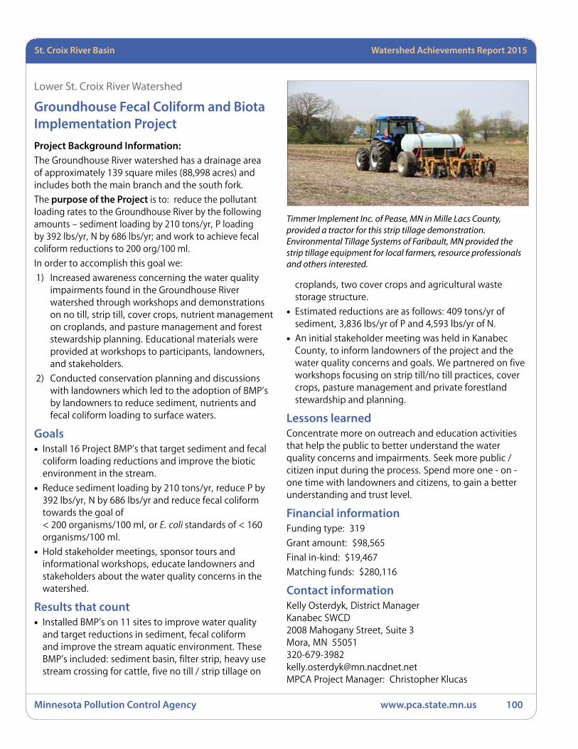
Minnesota Pollution Control Agency www.pca.state.mn.us 100
Minnesota River Basin Watershed Achievements Report 2008St. Croix River Basin Watershed Achievements Report 2015
Lower St. Croix River Watershed
Groundhouse Fecal Coliform and Biota Implementation ProjectProject Background Information: The Groundhouse River watershed has a drainage area of approximately 139 square miles (88,998 acres) and includes both the main branch and the south fork.
The purpose of the Project is to: reduce the pollutant loading rates to the Groundhouse River by the following amounts – sediment loading by 210 tons/yr, P loading by 392 lbs/yr, N by 686 lbs/yr; and work to achieve fecal coliform reductions to 200 org/100 ml.
In order to accomplish this goal we:
1) Increased awareness concerning the water quality impairments found in the Groundhouse River watershed through workshops and demonstrations on no till, strip till, cover crops, nutrient management on croplands, and pasture management and forest stewardship planning. Educational materials were provided at workshops to participants, landowners, and stakeholders.
2) Conducted conservation planning and discussions with landowners which led to the adoption of BMP’s by landowners to reduce sediment, nutrients and fecal coliform loading to surface waters.
Goals• Install 16 Project BMP’s that target sediment and fecal
coliform loading reductions and improve the biotic environment in the stream.
• Reduce sediment loading by 210 tons/yr, reduce P by 392 lbs/yr, N by 686 lbs/yr and reduce fecal coliform towards the goal of < 200 organisms/100 ml, or E. coli standards of < 160 organisms/100 ml.
• Hold stakeholder meetings, sponsor tours and informational workshops, educate landowners and stakeholders about the water quality concerns in the watershed.
Results that count• Installed BMP’s on 11 sites to improve water quality
and target reductions in sediment, fecal coliform and improve the stream aquatic environment. These BMP’s included: sediment basin, filter strip, heavy use stream crossing for cattle, five no till / strip tillage on
croplands, two cover crops and agricultural waste storage structure.
• Estimated reductions are as follows: 409 tons/yr of sediment, 3,836 lbs/yr of P and 4,593 lbs/yr of N.
• An initial stakeholder meeting was held in Kanabec County, to inform landowners of the project and the water quality concerns and goals. We partnered on five workshops focusing on strip till/no till practices, cover crops, pasture management and private forestland stewardship and planning.
Lessons learnedConcentrate more on outreach and education activities that help the public to better understand the water quality concerns and impairments. Seek more public / citizen input during the process. Spend more one - on - one time with landowners and citizens, to gain a better understanding and trust level.
Financial informationFunding type: 319
Grant amount: $98,565
Final in-kind: $19,467
Matching funds: $280,116
Contact informationKelly Osterdyk, District ManagerKanabec SWCD2008 Mahogany Street, Suite 3Mora, MN [email protected] Project Manager: Christopher Klucas
Timmer Implement Inc. of Pease, MN in Mille Lacs County, provided a tractor for this strip tillage demonstration. Environmental Tillage Systems of Faribault, MN provided the strip tillage equipment for local farmers, resource professionals and others interested.
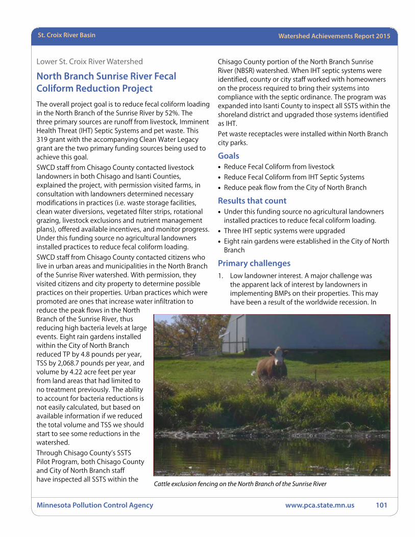
Watershed Achievements Report 2008 StatewideMinnesota River Basin Watershed Achievements Report 2015
Minnesota Pollution Control Agency www.pca.state.mn.us 101
Watershed Achievements Report 2008 StatewideRed River Basin Watershed Achievements Report 2015 St. Croix River Basin
Lower St. Croix River Watershed
North Branch Sunrise River Fecal Coliform Reduction ProjectThe overall project goal is to reduce fecal coliform loading in the North Branch of the Sunrise River by 52%. The three primary sources are runoff from livestock, Imminent Health Threat (IHT) Septic Systems and pet waste. This 319 grant with the accompanying Clean Water Legacy grant are the two primary funding sources being used to achieve this goal.
SWCD staff from Chisago County contacted livestock landowners in both Chisago and Isanti Counties, explained the project, with permission visited farms, in consultation with landowners determined necessary modifications in practices (i.e. waste storage facilities, clean water diversions, vegetated filter strips, rotational grazing, livestock exclusions and nutrient management plans), offered available incentives, and monitor progress. Under this funding source no agricultural landowners installed practices to reduce fecal coliform loading.
SWCD staff from Chisago County contacted citizens who live in urban areas and municipalities in the North Branch of the Sunrise River watershed. With permission, they visited citizens and city property to determine possible practices on their properties. Urban practices which were promoted are ones that increase water infiltration to reduce the peak flows in the North Branch of the Sunrise River, thus reducing high bacteria levels at large events. Eight rain gardens installed within the City of North Branch reduced TP by 4.8 pounds per year, TSS by 2,068.7 pounds per year, and volume by 4.22 acre feet per year from land areas that had limited to no treatment previously. The ability to account for bacteria reductions is not easily calculated, but based on available information if we reduced the total volume and TSS we should start to see some reductions in the watershed.
Through Chisago County’s SSTS Pilot Program, both Chisago County and City of North Branch staff have inspected all SSTS within the
Chisago County portion of the North Branch Sunrise River (NBSR) watershed. When IHT septic systems were identified, county or city staff worked with homeowners on the process required to bring their systems into compliance with the septic ordinance. The program was expanded into Isanti County to inspect all SSTS within the shoreland district and upgraded those systems identified as IHT.
Pet waste receptacles were installed within North Branch city parks.
Goals• Reduce Fecal Coliform from livestock
• Reduce Fecal Coliform from IHT Septic Systems
• Reduce peak flow from the City of North Branch
Results that count• Under this funding source no agricultural landowners
installed practices to reduce fecal coliform loading.
• Three IHT septic systems were upgraded
• Eight rain gardens were established in the City of North Branch
Primary challenges1. Low landowner interest. A major challenge was
the apparent lack of interest by landowners in implementing BMPs on their properties. This may have been a result of the worldwide recession. In
Cattle exclusion fencing on the North Branch of the Sunrise River
Minnesota Pollution Control Agency www.pca.state.mn.us 102
Minnesota River Basin Watershed Achievements Report 2008St. Croix River Basin Watershed Achievements Report 2015
2008, an inventory was completed of all landowners within the watershed having livestock. Direct mailings to landowners included a pamphlet titled “North Branch of the Sunrise River Fecal Coliform Reduction Plan”, and a brochure containing information on reducing bacterial levels. Staff attempted to meet with all livestock landowners within the watershed. Few landowners expressed interest in the project. In August, 2009, BWSR hosted a workshop to discuss what is working and what is not working with respective TMDL projects so that groups could learn from each other.
2. No agricultural projects were installed. This was primarily due to the inability to provide 100% cost share for projects. The project could only offer 75% of the total costs. During the recession, landowners were not willing/able to provide the 25% match funds to complete projects. In addition, the increased price of corn was a bigger draw than what incentive programs could offer. In this situation, offering 100% cost share may not have gotten many projects.
In general, landowners were not motivated by the TMDL and Fecal Coliform issues. Fecal Coliform is hard to deal with, and efforts to target other issues like phosphorus and sediment in the future could likely address the upland Fecal Coliform issues.
Ideally, for overall success in reducing pollutant loading, landowners need to have buy-in on the issue and solutions.
3. Grant funding was limited to projects that would reduce fecal coliform loading into the NBSR. Other projects which controlled nutrient and sediment loading, but not Fecal Coliform, could not be funded under the grant.
4. Colonies of Fecal Coliform bacteria remain active and alive in sediment along shorelines and river bottoms for many years (possibly decades) after deposition. Even when new loading of bacteria into the river is reduced, the total amount in the river may remain unchanged.
5. Grant funding was available to complete inspections in the shoreland zone within Isanti County but were not expanded to the entire watershed area. Funding assistance was unavailable for landowner cost share
to restore or replace IHTseptic systems in Isanti County. The program was voluntary. Local support and landowner interest was minimal. As a result, the program was discontinued in Isanti County.
Within the last year grant funding was expanded to include urban and rural BMP installation. As a result, six rain gardens were installed during the final months of the project.
Feedback/Suggestions1. The NBSR was one of the first TMDLs completed
in Minnesota, focusing on a single tributary and a single pollutant. The state has adopted a watershed approach for TMDLs which expand the focus to a larger watershed area along with multiple pollutants affecting the water body. This is a much more efficient use of funding and labor which will likely result in more projects and ultimately cleaner water bodies.
2. Clarification is needed on how long colonies of bacteria remain viable in soils and river sediment. It is unclear whether or not the bacteria in the NBSR were established decades ago or continues to receive significant inputs from the watershed.
3. Landowners need to be involved very early in the process and need to help with the decision making process to gain a sense of ownership of the project.
4. Continue active and helpful support of state agency staff.
Financial informationFunding type: Section 319
Grant amount: $46,529
Final in-kind: $18,919
Matching funds: $19,151
Contact informationJerry Spetzman, Water Resource ManagerChisago County313 North Main StreetCenter City, MN 55012651-213-8383, [email protected] Project Manager: Chris Klucas
Watershed Achievements Report 2008 StatewideMinnesota River Basin Watershed Achievements Report 2015
Minnesota Pollution Control Agency www.pca.state.mn.us 103
Watershed Achievements Report 2008 StatewideRed River Basin Watershed Achievements Report 2015 St. Croix River Basin
Snake River Watershed
St. Croix Basin Civic Governance Training and Civic Policy PilotProject need: There is a significant amount of institutional infrastructure in our current water management system, but there is a lack of success in engaging the broad base of stakeholders needed to achieve water quality goals (households, farmsteads, businesses, congregations, non-profits, and government) It has become clear we need a new approach to water governance and policymaking that can be integrated into existing systems to increase the capacity to organize this broad base of necessary stakeholders in the interest of the common good. The role of “citizenship” is the common role we all share that obligates us to govern for the common good. Yet current management systems do not focus on developing this civic capacity and infrastructure. Instead the existing infrastructure has inadvertently caused fragmentation, inadequate coordination across sectors and organizations, competition for resources, resulting in increased cynicism. From the analysis of the need for a new approach to governance, questions were raised: What are the barriers within existing approaches to water quality planning, implementation and governance to achieving broad based ownership in addressing water quality? Can individuals within government address those barriers and institute approaches grounded in civic principles and standards for governance that would increase civic capacity and the civic infrastructure needed to impact the scale of the problem?
Proposed Solution Strategy: Launched a Civic Governance pilot to test a civic organizing approach both inside (and between) several federal, state, and county government agencies that each play a watershed management role in the Snake River and Rum River watersheds. Pilot leaders were Kelly Osterdyk (Kanabec SWCD), Susan Shaw (Mille Lacs SWCD), and Shannon Carpenter (NRCS) supported by Lynne Kolze (MPCA) and Peg Michels (Civic Organizing Inc. and the Minnesota Active Citizenship Initiative).
GoalsThe project focused on implementation issues, including:
• Test capacity to organize a Civic Governance organizing agency (1-2) in the St. Croix Basin linked to existing civic organizing initiatives.
• Produce a training model that would ensure investment in educational strategies supporting the capacity to organize and sustain the base of key stakeholders needed to address water quality.
• Produce a Civic Governance Policy Agenda based upon outcomes from practice.
Results that count• Achieved and exceeded work plan goals and
objectives.
• A core base of leaders (14) implementing water quality and environmental protection projects integrated civic organizing disciplines into their existing projects, have evidence that the approach shows promise for maximizing the resources already dedicated and expended in water quality implementation. This core base formed three civic organizing agencies (a permanent structure for civic leadership development) and worked together to learn from practice and advance findings across watersheds.
• Developed a model for civic leadership development and a regional Civic Leadership Institute that includes a four hour Civic Governance Policy Workshop and provides the opportunity for leaders to take a six session Introduction to Civic Governance. The outcome from this training track provides the opportunity for leaders interested to develop and sustain a permanent regional civic organizing agency. At all points of this integrated educational track, individuals can chose to contribute to advancing Civic Governance in whatever way works for them. Members of the civic organizing agency take the lead on keeping the larger network in the loop on findings; sustain the integrated educational track; produce and track evidence based upon criteria for civic organizing; convene members across regions to expand impact; and govern the initiative. The key to achieving this outcome is the use of a common approach to organizing within each region.
• A Civic Governance Case Study co-authored by the base of leaders that is based upon their practice. Case study is a work in progress and a method for organizing a broad base of feedback and ownership of results from practice.
• A Civic Governance Policy Agenda developed through the process of civic organizing that produced specific policy recommendations through workshops, trainings, and practice by members of each regional civic organizing agency. Policy recommendations are

Minnesota Pollution Control Agency www.pca.state.mn.us 104
Minnesota River Basin Watershed Achievements Report 2008St. Croix River Basin Watershed Achievements Report 2015
being advanced by each civic organizing agency, the Citizens League and the Minnesota Active Citizenship Initiative. This is the beginning stage of organizing a civic infrastructure that is advancing a new approach to policy-making grounded in the obligation we each have as citizens
• Development of a final report that describes the application of civic organizing practices.
• Completed and submitted quarterly reports and a final report as required and in a timely manner to track progress made in completing this project.
Financial informationFunding type: Section 319
Grant amount: $31,976
Final in-kind: $7,262
Matching funds: $31.398
Contact informationKelly Osterdyk, District ManagerKanabec County SWCD2008 Mahogany Street Suite 3Mora, MN [email protected] Project Manager: Chris Klucas / Lynne Kolze

Watershed Achievements Report 2008 StatewideMinnesota River Basin Watershed Achievements Report 2015
Minnesota Pollution Control Agency www.pca.state.mn.us 105
Watershed Achievements Report 2008 StatewideRed River Basin Watershed Achievements Report 2015 St. Croix River Basin
St. Croix River BasinActive projects Projects awarded in 2015
Lower St. Croix River WatershedForest Lake Diagnostic Study – 2015Sponsor: Comfort Lake - Forest Lake Watershed District (CLFLWD)
Funding: Clean Water Partnership (Grant) $52,500
Purpose: The primary outcome from this project is a comprehensive list of targeted implementation activities throughout the watershed, ranked by phosphorus reduction cost-benefit. This quantitative data will allow the CLFLWD and partnering organizations to implement activities that will maximize water quality protection/restoration. This project will also help achieve the actions identified for Forest Lake in the 2014 Sunrise River Watershed Restoration and Protection Strategies report. The administrative outcomes for the project include a comprehensive work plan, timely invoicing, and meeting reporting and other grant requirements. The social outcomes for this project include educating lakeshore owners and City of Forest Lake residents on the connection between stormwater runoff and lake water quality. Additional elements of this project include a field inventory of stormwater outfall locations and conditions around the perimeter of Forest Lake, targeted monitoring of major stormwater outfalls and stream tributaries to refine watershed pollutant loading estimates that were modeled in the previously completed stormwater retrofit analysis, and collection of lake sediment samples in each of the three bays of Forest Lake to determine if internal loading is likely to be a problem in the future.
Forest Lake North Shore Subwatershed Assessment – 2013Sponsor: CLFLWD
Funding: CWP (Grant) $12,000
Purpose: This project will identify, prioritize, and prepare 10 to 15 feasible concept designs for specific water quality improvements capable of capturing and treating 1 inch of runoff from the direct contributing watershed of North Shore Trail.
Forest Lake Stormwater Filtration Retrofit – 2013Sponsor: CLFLWD
Funding: CWP (Grant) $143,025
Purpose: This project will implement a stormwater retrofit of an existing stormwater pond and shoreline stabilization project in the Hilo Lane development, circa 1970s, located on the south shore of Forest Lake. Stormwater treatment for this 14 acre tributary drainage area comprised of residential land uses will include bio-filtration, iron enhanced sand filtration, channel stabilization and shoreline stabilization. The estimated nutrient reduction from the project is almost 12 pounds per year of total phosphorous.
Sand and Long Lakes Protection Project – 2013Sponsor: CLFLWD
Funding: CWF (Grant) $132,000
Purpose: Implementation activities proposed as a part of this project include water quality monitoring, biotic surveys, sediment core sampling, mechanical treatment of curly-leaf pondweed (in accordance with regulations and permitting), an iron-enhanced sand filter, with a high capacity multi-stage outlet weir and 40,000 pounds of iron filings and stakeholder involvement in the design process and educational presentations.
Snake River WatershedKanabec Water Resources Protection Project Phase 2 – 2015Sponsor: Kanabec SWCD
Funding: Clean Water Partnership (Grant) $196,200
Purpose: This project includes surface water monitoring of six rivers/tributaries and three lakes in the watershed that are currently un-assessed. The outcomes expected through this monitoring will provide a baseline of data to help prioritize and focus on future project areas for protection. This project will also include the implementation of sixteen approved BMP’s in protection areas which include feedlot runoff treatment and control, manure storage pit closures, livestock fence exclusion from streams, heavy use protection areas for cattle crossings, roadside runoff/erosion control, critical area seeding, sediment basin, gully erosion control, wetland restoration, reduced tillage methods, cover crops, nutrient management, well abandonment and closures, streambank and shoreline protection, riparian vegetative buffer enhancements, and other approved BMP’s that

Minnesota Pollution Control Agency www.pca.state.mn.us 106
Minnesota River Basin Watershed Achievements Report 2008St. Croix River Basin Watershed Achievements Report 2015
protect water quality. The measureable outcomes and non-point source pollutant reduction goals expected from these BMP’s are: 76 tons/yr of TSS (sediment), 76 tons/yr of soil loss savings, 14,000 lbs./yr of P reductions and 18,000 lbs./yr of N reductions. This project also includes outreach, education, civic engagement, and civic organizing, to include key stakeholders, citizens and landowners in the process. Additional activities include the development of ten forest stewardship plans for landowners in areas that need protection to provide an inventory, assessment and mapping of the various forest cover types, and include management recommendations for reforestation practices, harvesting, wildlife habitat improvement, and overall protection of the forest resources. Finally, the agricultural BMP loan program will be used to assist landowners with BMP’s that protect and improve water quality.
Kanabec Water Resources Protection Project – 2012Sponsor: Kanabec SWCD
Funding: CWF (Grant) $201,892
Purpose: This project will provide baseline data through water monitoring, recording and analyzing the results of six unassessed rivers/tributaries, three unassessed lakes and five storm water outlets in the city of Mora which drain to the Snake River; promote and implement approved BMPs, including feedlot runoff treatment and control, livestock fence exclusion from streams, heavy use protection areas for cattle, roadside runoff/erosion control, critical area seeding, sediment basin and wetland restoration; sponsor an outdoor water quality learning event in 2012 for 90 Girls Scouts and their families, as a national event for the Girl Scouts of America; provide technical assistance for the development of eight nutrient management plans for landowners; develop eight forest stewardship plans for landowners; promote and implement the Agriculture BMP Loan Program to assist landowners with BMPs that protect and improve water quality.
Snake River Watershed Resource Protection Project – 2012Sponsor: Snake River Watershed Management Board (SRWMB )
Funding: CWP (Loan) $400,000
Purpose: This project will promote and install 40 SSTSs and other rural BMPs in the Snake River watershed.
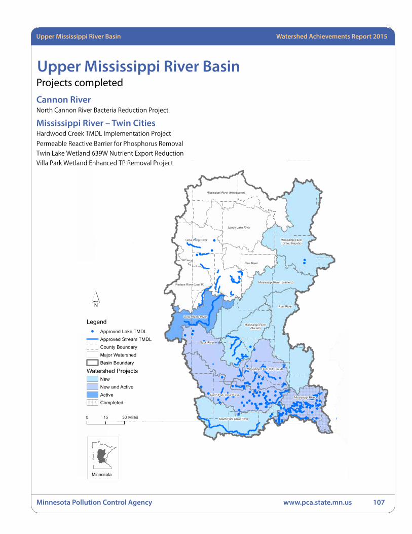
Watershed Achievements Report 2008 StatewideMinnesota River Basin Watershed Achievements Report 2015
Minnesota Pollution Control Agency www.pca.state.mn.us 107
Watershed Achievements Report 2008 StatewideRed River Basin Watershed Achievements Report 2015 St. Croix River BasinUpper Mississippi River Basin Watershed Achievements Report 2015
Upper Mississippi River Basin
!
!
!
!
!
!
!
!
!
!
!
!
!
!
!
!
!!
! !
!
!
!
!!
!
!
!
!
!
!
!
!
!
!
!
!
!!
!
!!
!
!
!
!
!
!
!!
! !
!
!
!
!
!
!!
!
!
!
!
!
!
!
!
!
!!!
!
!!
!
!!
!
!
!
!
!
!!
!!!
!
!!
!
!
!
!!
!!
!
!!!!
!
!
!
!
!!
!
!
!!
!
!! !
!
!
!! !!!
!
!
!
!
!
!
!
!
!
!
!
!
! !
!!
!!
!
!
!!
!
!
!
!
!
!
!
!
!
!! !
!
!
!
!
! !
!
!
!
!
! !
!
!
!
! !
!
!!
!
!
!
!
!
!
!
!
!!!
!
!!
!
!
!
!
!
!
!
!
!
!
!
! !
!
!
!
!
!
!
!
!
!
Mississippi River (Brainerd)
Pine River
Crow Wing River
Redeye River (Leaf R)
Long Prairie River
Mississippi River(Sartell)
Sauk River
Mississippi River (St. Cloud)
North Fork Crow River
South Fork Crow River
Mississippi River
Rum River
Mississippi River (Headwaters)
Leech Lake River
Mississippi River(Grand Rapids)
Upper Mississippi River Basin
´
0 3015 Miles
Minnesota
Legend! Approved Lake TMDL
Approved Stream TMDLCounty BoundaryMajor Watershed Basin Boundary
Watershed ProjectsNewNew and ActiveActiveCompleted
Projects completed
Cannon RiverNorth Cannon River Bacteria Reduction Project
Mississippi River – Twin CitiesHardwood Creek TMDL Implementation Project
Permeable Reactive Barrier for Phosphorus Removal
Twin Lake Wetland 639W Nutrient Export Reduction
Villa Park Wetland Enhanced TP Removal Project

Minnesota Pollution Control Agency www.pca.state.mn.us 108
Minnesota River Basin Watershed Achievements Report 2008Upper Mississippi River Basin Watershed Achievements Report 2015
Cannon River Watershed
North Cannon River Bacteria Reduction ProjectThe North Cannon River Bacteria Reduction Project began in 2009 by using GIS to identify specific parcels of land in southern Dakota County (within the North Cannon River Watershed Management Organization [NCRWMO]) in need of filter strips (or buffer strips) along streams, waterways and ditches. Landowners were then identified and contacted by the SWCD with information about the benefits of filter strips and programs offering cost share options and funding to install filter strips or other BMPs.
Through this project 40.9 acres of filter strips were installed along streams, rivers and ditches to slow runoff and improve water quality. Additionally, a large-scale feedlot improvement project was installed along with two water and sediment control basins. These projects will result in annual estimated pollutant reductions of 2,050 lbs of phosphorus and 1,360 tons of sediment. Bacteria loads to water bodies will also be reduced through these practices.
Less tangible but equally important are results of the landowner outreach and education that was conducted through this project. Although it’s difficult to quantify, discussions about the benefits of buffers with individual landowners raise awareness about the issue, the current rules requiring buffers along Minnesota Department of Natural Resources (DNR)-protected waters, and the various programs facilitating buffer installations. Although the option of installing harvestable filter strips for biomass production was not utilized as anticipated, conversations were generated and the concept was advanced in this area.
Goals• Significantly increase the acreage of filter strips in the
North Cannon River Watershed.
• Contact and inform landowners about the benefits of filter strips and programs available to install them.
• Minimize contamination runoff from entering waterbodies.
Results that count• 40.9 acres of filter strips were installed in addition
to one feedlot project and two water and sediment control basins.
• Approximately 130 landowners were contacted by mail and another 40 were contacted in person regarding filter strips and funding opportunities.
• Trends in water quality improvements are difficult to track and are dependent on multiple conditions during a given monitoring season. Bacteria remains high during runoff events in Chub Creek.
Financial informationFunding type: Section 319 Grant amount: $66,000In-kind: $18,510Matching funds: $36,500
Contact informationBrian Watson, District ManagerDakota County SWCD4100 220th Street West, Suite 102Farmington, MN [email protected] Project Manager: Justin Watkins
Filter Strip at the Fred Volkert farm near Waterford Township along the North Cannon River
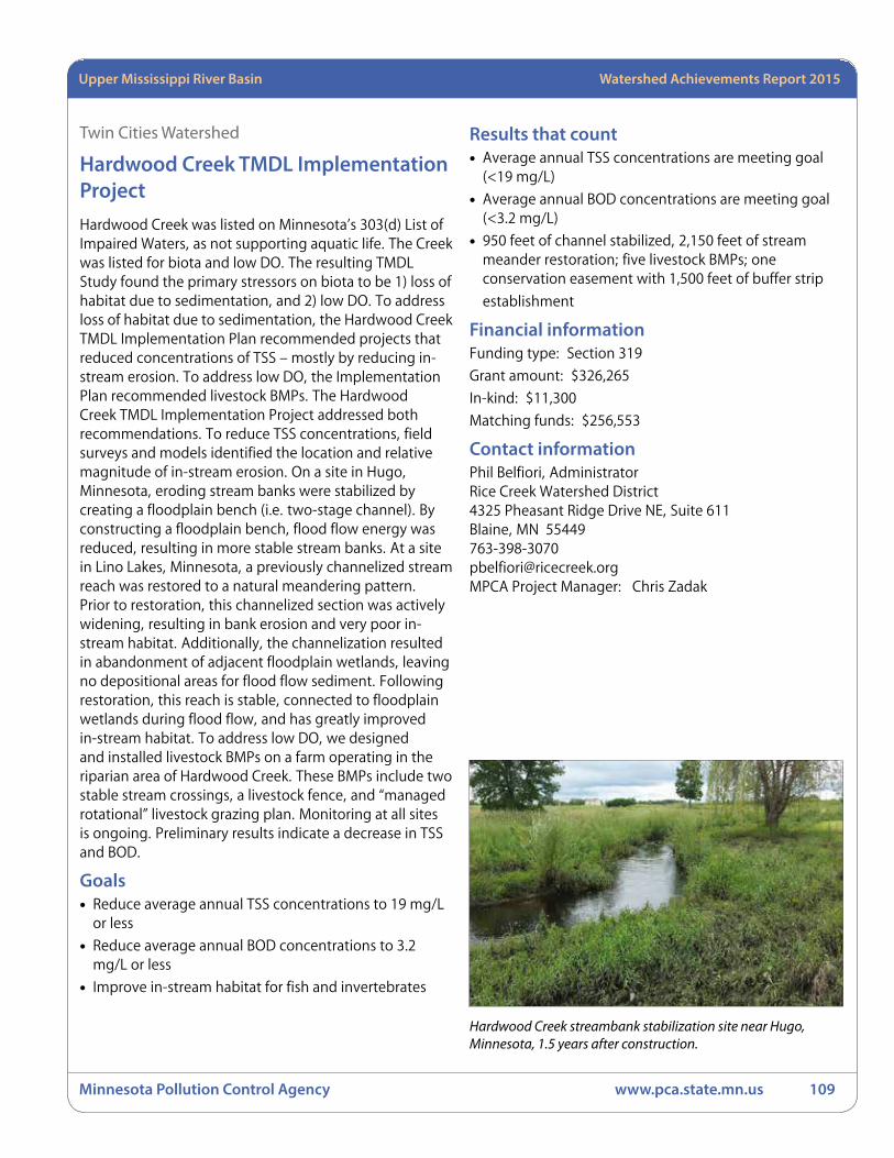
Watershed Achievements Report 2008 StatewideMinnesota River Basin Watershed Achievements Report 2015
Minnesota Pollution Control Agency www.pca.state.mn.us 109
Watershed Achievements Report 2008 StatewideRed River Basin Watershed Achievements Report 2015 St. Croix River BasinUpper Mississippi River Basin Watershed Achievements Report 2015
Twin Cities Watershed
Hardwood Creek TMDL Implementation ProjectHardwood Creek was listed on Minnesota’s 303(d) List of Impaired Waters, as not supporting aquatic life. The Creek was listed for biota and low DO. The resulting TMDL Study found the primary stressors on biota to be 1) loss of habitat due to sedimentation, and 2) low DO. To address loss of habitat due to sedimentation, the Hardwood Creek TMDL Implementation Plan recommended projects that reduced concentrations of TSS – mostly by reducing in-stream erosion. To address low DO, the Implementation Plan recommended livestock BMPs. The Hardwood Creek TMDL Implementation Project addressed both recommendations. To reduce TSS concentrations, field surveys and models identified the location and relative magnitude of in-stream erosion. On a site in Hugo, Minnesota, eroding stream banks were stabilized by creating a floodplain bench (i.e. two-stage channel). By constructing a floodplain bench, flood flow energy was reduced, resulting in more stable stream banks. At a site in Lino Lakes, Minnesota, a previously channelized stream reach was restored to a natural meandering pattern. Prior to restoration, this channelized section was actively widening, resulting in bank erosion and very poor in-stream habitat. Additionally, the channelization resulted in abandonment of adjacent floodplain wetlands, leaving no depositional areas for flood flow sediment. Following restoration, this reach is stable, connected to floodplain wetlands during flood flow, and has greatly improved in-stream habitat. To address low DO, we designed and installed livestock BMPs on a farm operating in the riparian area of Hardwood Creek. These BMPs include two stable stream crossings, a livestock fence, and “managed rotational” livestock grazing plan. Monitoring at all sites is ongoing. Preliminary results indicate a decrease in TSS and BOD.
Goals• Reduce average annual TSS concentrations to 19 mg/L
or less
• Reduce average annual BOD concentrations to 3.2 mg/L or less
• Improve in-stream habitat for fish and invertebrates
Results that count• Average annual TSS concentrations are meeting goal
(<19 mg/L)
• Average annual BOD concentrations are meeting goal (<3.2 mg/L)
• 950 feet of channel stabilized, 2,150 feet of stream meander restoration; five livestock BMPs; one conservation easement with 1,500 feet of buffer strip
establishment
Financial informationFunding type: Section 319
Grant amount: $326,265
In-kind: $11,300
Matching funds: $256,553
Contact informationPhil Belfiori, AdministratorRice Creek Watershed District4325 Pheasant Ridge Drive NE, Suite 611Blaine, MN [email protected] Project Manager: Chris Zadak
Hardwood Creek streambank stabilization site near Hugo, Minnesota, 1.5 years after construction.

Minnesota Pollution Control Agency www.pca.state.mn.us 110
Minnesota River Basin Watershed Achievements Report 2008Upper Mississippi River Basin Watershed Achievements Report 2015
• 30 to 70% P removal improvement.
• Determine if this practice is warranted for a full scale installation for stormwater treatment.
Results that count• Monitoring was effectively completed to allow for an
accurate analysis of the treatment results and cost effectiveness of the BMP.
• The demonstration treatment cell removed an average of 63.6% total phosphorus and 63.9% of total dissolved phosphorus.
• Our analysis and testing has confirmed that this is a practical and cost effective BMP for the reduction of total and dissolved phosphorus in urban settings.
Financial informationFunding type: Section 319
Grant amount: $89,200
In-kind: $0
Matching funds: $82,222.51
Contact informationCliff Aichinger, AdministratorRamsey-Washington Metro Watershed District2665 Noel DriveLittle Canada, MN [email protected] Project Manager: Brooke Asleson
Twin Cities Watershed
Permeable Reactive Barrier for Phosphorus RemovalThe goal of this project was to determine the effectiveness of using “spent lime”, created by local water utilities during drinking water clarification, to reduce phosphorus in storm water flow. Spent lime contains calcium, iron, and/or aluminum, all three of which bind P. Because of the potential for high phosphorus binding capacity, we hypothesize that spent lime could be used in a reactive barrier system to remove phosphorus from storm water runoff in a cost effective manner. Laboratory experiments were conducted to determine the optimum conditions needed for effective phosphorus removal and in what type of storm water a spent lime barrier would be most effective. The results of these experiments were the basis for the pilot study to determine the P removal effectiveness under field conditions.
To effectively and permanently remove phosphorus, phosphate must be incorporated into recalcitrant organic material or be bound to cations such as calcium, magnesium, or unreducible trace metals such as aluminum. Spent lime is an abundant waste byproduct of drinking water treatment and the primary component of spent lime is calcium carbonate. Fortunately, calcium chemically prefers to be bound to phosphate over carbonate, and phosphate is readily converted into calcium phosphate in the presence of high concentrations of calcium carbonate (Stumm and Morgan, 1996). Spent lime has an advantage over limestone in that it consists of recently precipitated and hence more available calcium carbonate. The use of spent lime for stormwater treatment is a new concept. A treatment cell with spent lime is not precipitating or flocculating phosphate (e.g., like alum), and it is not necessarily intended to filter as do sand filters. Rather, it is a chemical “substitution” reaction whereby the newly formed calcium phosphate simply resides in the cell where the calcium carbonate once resided.
Goals• Quantify the percentage improvement in phosphorus
removal that can be achieved with the addition of spent lime to storm water compared to storm water treated by traditional sedimentation practices.
Installation of the spent lime test cell on the NW corner of Larpenteur Avenue and Prosperity Road in Maplewood, Minnesota.

Watershed Achievements Report 2008 StatewideMinnesota River Basin Watershed Achievements Report 2015
Minnesota Pollution Control Agency www.pca.state.mn.us 111
Watershed Achievements Report 2008 StatewideRed River Basin Watershed Achievements Report 2015 St. Croix River BasinUpper Mississippi River Basin Watershed Achievements Report 2015
Twin Cities Watershed
Twin Lake Wetland 639W Nutrient Export ReductionThis project’s purpose is to reduce phosphorus export from Wetland (27-639W), which is a major external phosphorus source to impaired water, Upper Twin Lake (AUID 27-0042-01), which is severely impaired by excess nutrients. North Twin Lake is the first in a chain of connected lakes, and the nutrient-rich outflow from Upper Twin Lake is the single largest source of phosphorus to the downstream lakes, which are also impaired. A Feasibility Study concluded that the export is primarily caused by drawdown and drying in the wetland through growing season evapotranspiration by the dense cattail vegetation in the central wetland. This drying speeds the conversion of peat to mineral soil. Large precipitation events then sheet flow through the wetland, and the iron-bound phosphorus in the mineralized soil is released and transported through the outlet channel into North Twin Lake. The project constructed a controlled outlet for the wetland, reducing flow-through and increasing storage in the wetland. This keeps the wetland wetter, slowing soil mineralization and reducing the release of phosphorus. A new overflow outlet and channel were constructed on the upstream, west side of the wetland to convey overflow and large events. Followup monitoring was conducted for two seasons following construction, confirming an estimated reduction in total phosphorus export of 250-300 pounds annually.
Goals• Reduce phosphorus export from Wetland 27-0639W by
an average of 300 pounds per year.
Results that count• Post construction monitoring suggests a reduction of
250-300 pounds phosphorus per year.
Financial informationFunding type: Section 319
Grant amount: $300,000
In-kind: $0
Matching funds: $264,461
New outlet weir
New overflow weir
Contact informationTina Carstens, ChairShingle Creek Watershed Management Commission (SCWMC)3235 Fernbrook LanePlymouth, MN [email protected] Project Manager: Rachel Olmanson
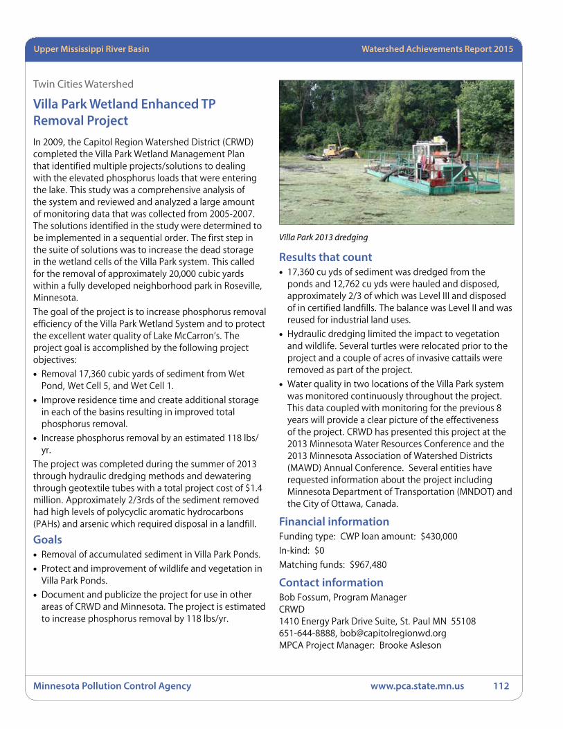
Minnesota Pollution Control Agency www.pca.state.mn.us 112
Minnesota River Basin Watershed Achievements Report 2008Upper Mississippi River Basin Watershed Achievements Report 2015
Twin Cities Watershed
Villa Park Wetland Enhanced TP Removal ProjectIn 2009, the Capitol Region Watershed District (CRWD) completed the Villa Park Wetland Management Plan that identified multiple projects/solutions to dealing with the elevated phosphorus loads that were entering the lake. This study was a comprehensive analysis of the system and reviewed and analyzed a large amount of monitoring data that was collected from 2005-2007. The solutions identified in the study were determined to be implemented in a sequential order. The first step in the suite of solutions was to increase the dead storage in the wetland cells of the Villa Park system. This called for the removal of approximately 20,000 cubic yards within a fully developed neighborhood park in Roseville, Minnesota.
The goal of the project is to increase phosphorus removal efficiency of the Villa Park Wetland System and to protect the excellent water quality of Lake McCarron’s. The project goal is accomplished by the following project objectives:
• Removal 17,360 cubic yards of sediment from Wet Pond, Wet Cell 5, and Wet Cell 1.
• Improve residence time and create additional storage in each of the basins resulting in improved total phosphorus removal.
• Increase phosphorus removal by an estimated 118 lbs/yr.
The project was completed during the summer of 2013 through hydraulic dredging methods and dewatering through geotextile tubes with a total project cost of $1.4 million. Approximately 2/3rds of the sediment removed had high levels of polycyclic aromatic hydrocarbons (PAHs) and arsenic which required disposal in a landfill.
Goals• Removal of accumulated sediment in Villa Park Ponds.
• Protect and improvement of wildlife and vegetation in Villa Park Ponds.
• Document and publicize the project for use in other areas of CRWD and Minnesota. The project is estimated to increase phosphorus removal by 118 lbs/yr.
Results that count• 17,360 cu yds of sediment was dredged from the
ponds and 12,762 cu yds were hauled and disposed, approximately 2/3 of which was Level III and disposed of in certified landfills. The balance was Level II and was reused for industrial land uses.
• Hydraulic dredging limited the impact to vegetation and wildlife. Several turtles were relocated prior to the project and a couple of acres of invasive cattails were removed as part of the project.
• Water quality in two locations of the Villa Park system was monitored continuously throughout the project. This data coupled with monitoring for the previous 8 years will provide a clear picture of the effectiveness of the project. CRWD has presented this project at the 2013 Minnesota Water Resources Conference and the 2013 Minnesota Association of Watershed Districts (MAWD) Annual Conference. Several entities have requested information about the project including Minnesota Department of Transportation (MNDOT) and the City of Ottawa, Canada.
Financial informationFunding type: CWP loan amount: $430,000
In-kind: $0
Matching funds: $967,480
Contact informationBob Fossum, Program ManagerCRWD1410 Energy Park Drive Suite, St. Paul MN 55108651-644-8888, [email protected] Project Manager: Brooke Asleson
Villa Park 2013 dredging

Watershed Achievements Report 2008 StatewideMinnesota River Basin Watershed Achievements Report 2015
Minnesota Pollution Control Agency www.pca.state.mn.us 113
Watershed Achievements Report 2008 StatewideRed River Basin Watershed Achievements Report 2015 St. Croix River BasinUpper Mississippi River Basin Watershed Achievements Report 2015
Active projectsNewly awarded in 2014 and 2015
Clearwater River WatershedClearwater River Watershed Alternative Tile Intakes Project – 2014Sponsor: Clearwater River Watershed District
Funding: Section 319 (Grant) $45,000.00
Purpose: This project will install up to 120 open tile intakes that filter out nutrients and sediments, providing 700 pounds per year of total phosphorus load reduction from priority crop land. It will also document reduction in farmer and tile contractor resistance to the use of alternative tile intakes. Educational materials will be produced, demonstrating the benefits, effectiveness and utility of alternative tile intakes from environmental and economic standpoints, as well as applicability throughout the state.
Long Prairie RiverLong Prairie River Dissolved Oxygen TMDL Implementation – 2013Sponsor: Todd SWCD
Funding: Section 319 (Grant) $300,000
Purpose: Implement 25-30 BMP’s in the Long Prairie Watershed and increase DO levels such that they are consistently above 5 mg/l. This would delist the Long Prairie as an impaired water body. Morrison, Douglas, and Todd SWCDs will be the primary partners on the project since they are the primary counties with land in the watershed. It is anticipated that projects implemented will annually reduce 1,409 pounds of phosphorus, 716 tons of sediment and 6,771 pounds of nitrogen from reaching the Long Prairie River system. These reductions will decrease algae growth and result in higher DO readings.
Mississippi River – BrainerdPlatte River Restoration/Protection Project – 2015Sponsor: Morrison SWCD
Funding: Clean Water Partnership (Grant) $34,900
Purpose: Through a combination of rock, streambarbs and bio-engineering, the stream channel will be slightly
modified to deflect the river’s energy away from the bridge abutments and the eroded banks. Through this combination of practices erosion will be reduced and long term stabilization can be achieved. The bio-engineered components and riparian buffer will also add aquatic and pollinator habitat with water quality benefits. The water quality improvements predicted are decreased water turbidity, decreased sediment load of the river by 39.6 tons/yr., and stabilization of the north bank of the river.
Swan River Headwaters Subwatershed Restoration – 2015Sponsor: Todd SWCD
Funding: Clean Water Partnership (Grant) $38,650
Purpose: Grant dollars would be used to install riparian buffers and restore a series of sediment ponds to keep nutrient rich runoff from flowing into several local lakes and the Swan River. Riparian landowners in this area, both agricultural producers and shoreland residents, have agreed that work is needed and are willing to implement these strategies to restore water quality in this area. These projects would improve conditions for fish and invertebrate communities. The efforts outlined in these projects would increase cooperation between the shoreland and agricultural communities and encourage a conservation ethic throughout this area.
Mississippi River – Grand RapidsBig Sandy and Minnewawa Lakes Phosphorus Reduction – 2014Sponsor: Aitkin County SWCD
Funding: Section 319 (Grant) $86,100
Purpose: This project will implement phosphorus reduction strategies for the Big Sandy Lake Watershed, as outlined in the Big Sandy Lake and Lake Minnewawa TMDL Implementation Plan. BMP demonstration projects will be installed, including 2 rain gardens and 5 shoreline stabilization projects. We estimate a reduction in phosphorus pollution of 9,145 lbs/yr, and a reduction in sedimentation of 5,165 tons/yr. One hundred rain barrels will be distributed at a reduced cost to critical landowners. Septic system inventories
Upper Mississippi River Basin

Minnesota Pollution Control Agency www.pca.state.mn.us 114
Minnesota River Basin Watershed Achievements Report 2008Upper Mississippi River Basin Watershed Achievements Report 2015
will provide county staff, as well as lake residents, with critical information needed to further address the issues related to improper septic system maintenance. Education activities will increase awareness of and concern about consequences of landuse practices that have environmental impacts. Water quality data will be collected on nine lake sites within the Big Sandy Watershed.
Mississippi River – St. CloudClearwater River Restoration & Protection Phase II – 2015Sponsor: Clearwater River Watershed District
Funding: Clean Water Partnership (Grant) $72,000
Purpose: District staff will update an existing bacteria and TSS source inventory through a desktop survey and field reconnaissance to identify and prioritize project locations to reduce sediment and bacteria loading to the River. Projects will be prioritized for preliminary design based on their potential for load reduction to the Clearwater River. The district will finalize design and permitting for projects with signed agreements and high cost benefit in terms of bacteria and TSS load reductions. Construction will be complete by spring of 2018. The District will use the projects as demonstrations to promote participation in agricultural programs and projects
Kingston Wetland Feasibility Study and Restoration – 2011Sponsor: Clearwater River Watershed District
Funding: Section 319 (Grant) $404,300
Purpose: The Kingston Wetland Complex is a riparian wetland of the Clearwater River Chain of Lakes. The MPCA found that the Clearwater River between Clear Lake and Lake Betsy is impaired and does not meet Minnesota water quality standards for DO. This reach was placed on the 303(d) list in 2004 because monitoring data have revealed that DO concentrations sometimes fall below the state standard of 5 milligrams per liter, which can impair aquatic habitat. The TMDL study completed for this reach (January 2009) showed that the sediment oxygen demand (SOD) and altered wetland hydrology in the Kingston Wetland were contributing to the DO impairment. The study further showed that a reduction in the Kingston Wetland SOD, and possibly a change in hydrology would be necessary to meet the state standard.
The project will be considered successful if the following specific targeted outcomes are achieved:
• Sixty percent reduction in wetland SOD.
• Annual nutrient loads to the lakes downstream are reduced by 20%. Wetland and riverine habitat is restored to support a wider range of wildlife.
• Recreational opportunities in the Clearwater River are enhanced by the restoration, providing a corridor to connect the upper agricultural watershed with the lower recreational lakes watershed. Kiosks are installed to mark the project and educate users about the impacts of ditching on water quality and habitat, and specifically the evolution of the Kingston Wetland through the various stages and its role in protecting downstream water quality.
Local partners are engaged to cooperate in the project, measured by attendance at project meetings and educational curriculum developed in coordination with local school district for use at local schools.
NE St. Cloud Mississippi River Protection Project – 2015Sponsor: City of St. Cloud
Funding: Clean Water Partnership (Grant) $200,000
Purpose: The proposed project will increase pervious surfaces, create disconnection of impervious areas prior to entering the storm sewer system (i.e. Mississippi); implement alternative “green” landscaping, and bioretention facilities. Alternative landscaping techniques/BMPs will be implemented throughout the drainage area where site characteristics make sense. This may include, but is not limited to; incorporating trees into landscaped areas, tree boxes, pervious pavement, grass swales, vegetated filter strips, etc. Targeted areas include: areas where the City plans to re-stabilize pervious surfaces; areas where the City plans to install bioretention or other volume reduction BMPs; areas adjacent to reconstructed catch basins and/or retrofit sump catch basins (tree boxes); areas where the City plans to landscape existing paved and/or gravel areas. The education of property owners and citizens will also be an important aspect of the project to ensure long term function of the BMPs and future participation by other property owners. Projects implemented as part of this grant will be promoted and highlighted to educate and encourage participation in future projects for this area. Furthermore, the projects will improve the aesthetics of the old rundown industrial/commercial area bringing additional attention and educational efforts.
Watershed Achievements Report 2008 StatewideMinnesota River Basin Watershed Achievements Report 2015
Minnesota Pollution Control Agency www.pca.state.mn.us 115
Watershed Achievements Report 2008 StatewideRed River Basin Watershed Achievements Report 2015 St. Croix River BasinUpper Mississippi River Basin Watershed Achievements Report 2015
The City plans to submit follow-up presentations on the implemented BMPs and the impacts to the Mississippi River to area stakeholder and citizen groups.
Pleasant Lake Stormwater Quality Improvements – 2014Sponsor: City of Annandale
Funding: Clean Water Partnership (Grant) $164,800
Purpose: The City of Annandale intends to plan and implement stormwater infiltration systems, including trenches, sump manholes and perforated pipes, to settle out solids, to increase water detention times, to reduce stormwater discharge volumes and to prevent the discharge of nutrients and sediment from urban runoff into local water bodies. Water quality results will help determine effectiveness of BMP’s.
Targeted Fertilizer Application Reduction Project – 2012Sponsor: Clearwater River Watershed District
Funding: Section 319 (Grant) $245,475
Purpose: Clearwater River Watershed District will identify and recruit fertilizer application participants; prepare, distribute and present materials for education and outreach; collect soil samples from participants’ fields on a 2.2 acre grid across up to 16,000 acres of critical crop land to determine the fertilizer needs for each field; use global positioning system (GPS) - aided fertilizer application technology to apply fertilizer at variable rates consistent with field needs, avoiding tile intakes and providing a 50 lineal foot buffer where no fertilizer is applied; conduct water quality monitoring at drain tile outlets from selected fields, including both farms that are and are not participating in the program; annually report the extent of program application and reductions in fertilizer application over standard practice, but also corresponding water quality results; provide recommendations to optimize the program implementation and achieve the maximum load reduction possible; and track, manage, and report on project results and finances as necessary and required.
Mississippi River – Twin CitiesBald Eagle Lake TMDL Implementation – 2013Sponsor: Rice Creek Watershed District
Funding: CWP (Loan) $500,000
Purpose: This project proposes to use aluminum sulfate (“alum”) to control internal phosphorus loading to Bald Eagle Lake. Over the lifespan of the alum treatment,
expected to be 15-20 years, 1,195 pounds of phosphorus will be removed from the budget each year.
Lake McCarrons Sub-watershed BMP Project – 2012Sponsor: Capitol Region Watershed District
Funding: CWF (Grant) $275,000
Purpose: Capitol Region Watershed District will compile and review previously conducted studies and will prioritize BMPs based on a cost-benefit analysis of their pollutant load reductions and life cycle costs; will conduct a sub-watershed analysis to determine optimal BMP locations and types to maximize volume and pollutant removal; solicit and consider stakeholder input in prioritizing BMPs; will design and construct BMPs, such as rain gardens and infiltration practices, within the Villa Park sub-watershed of the Lake McCarrons watershed to meet phosphorus load reduction goals to the Villa Park Wetland System and ultimately maintain the long term water quality of Lake McCarrons.
Modular Green Roof Retrofit System Development – 2011Sponsor: SCWMC
Funding: Section 319 (Grant) $27,140
Purpose: Shingle Creek, which drains the watershed, is impaired by excess chloride, low DO, and has an impaired biotic community as well. Thirteen of the sixteen lakes in the watershed are impaired due to excess nutrients. This project is based on the hypothesis that development of a light-weight, easily installed extensive green roof system suitable for installation on existing flat or gently sloping roofs can substantially reduce runoff volume from highly developed urban and suburban areas that represent some of the greatest challenges in urban stormwater management.
Northwood Lake Water Quality Improvement Project – 2015Sponsor: Bassett Creek Watershed Management Commission
Funding: Clean Water Partnership (Grant) $300,000
Purpose: This project will treat storm water runoff from over 110 acres of currently untreated urban land. At the east end of the lake project components include a structural treatment device for pre-treatment of runoff, underground storm water re-use chamber (160,000 gallons capacity), pump house, distribution system to irrigate 6.4 acres of adjacent ball fields, and finally a system overflow directed into a series of linear rain
Minnesota Pollution Control Agency www.pca.state.mn.us 116
Minnesota River Basin Watershed Achievements Report 2008Upper Mississippi River Basin Watershed Achievements Report 2015
gardens prior to discharging into Northwood Lake. At the west end of Northwood Lake, a wet ponding basin will be constructed in a green space area between Trunk Highway 169 and Jordan Avenue. Storm water runoff from rear yard areas and Jordan Avenue draining from the south will be directed into the pond for treatment before discharging into an existing storm sewer pipe tributary to Northwood Lake. This project is expected to remove 22 pounds of phosphorus per year in addition to other pollutants associated with storm water runoff and snowmelt. Additional benefits of the project include water conservation through the storage and use of storm water as irrigation water for adjacent ballfields. It’s estimated that up to 3.8 million gallons of drinking water may be conserved annually due to irrigation using storm water captured through this project.
Shingle Creek DO Reaeration Improvements – 2014Sponsor: SCWMC
Funding: Section 319 (Grant) $93,500
Purpose: Design and construct reaeration structures and stream improvements and conduct preconstruction and post construction water quality and biological monitoring to document improved water quality and biotic integrity of the stream. The desired outcome would be a stream that meets the state DO standard downstream of each project area. This will be analyzed by completing pre- and post-construction longitudinal DO and continuous DO surveys. Documenting a post-construction macroinvertebrate community composition that includes more sensitive taxa would be an indication of the desired response to improved DO conditions. The education and outreach component will be measured based on hits to the project’s website and social media accounts.
North Fork Crow RiverCrow Lakes Protection and Resource Investigation – 2013Sponsor: Crow River Organization of Water
Funding: CWP (Grant) $124,200
Purpose: The Project’s “virtual TMDL” studies will evaluate lake water quality relative to MPCA eutrophication standards, assess external and internal TP loads, quantify maximum TP allocations, and identify TP reduction (or stabilization) plans or strategies for source areas. The Project will focus on ten lakes: Minnie Belle, Manuella, Stella, Lake Washington, Francis, West Sylvia, East Sylvia, John, Charlotte, and Martha. These lakes are located throughout Meeker and Wright County, are
highly used recreational lakes with adjacent park land, and are significant contributors to the North Fork Crow River. These key lakes are parts of lake chains in which the whole chain is not impaired, and the protection strategies developed through this project will complement the TMDL implementation efforts to focus on comprehensively managing the chain as a system.
Crow River Middle Fork Watershed Resource Investigation – 2013Sponsor: Middle Fork Crow River Watershed District
Funding: CWP (Grant) $63,250
Purpose: This project will continue a monitoring program for the purpose of tracking the long term changes in the 8 lakes of the watershed, assist the District Board and staff in identifying key areas for BMP implementation, offer two water quality education workshops per year to area residents providing information of our investigation and many ways to protect these resources, visit area schools nine times per year to implement water quality classes into school curricula, provide one volunteer training workshop per year, informing 10-12 citizens of the fine points of stream and lake data collection to supplement our resource investigation, continue to submit regular columns and news releases for existing local newsletters and newspapers and continue the promotion of BMP and educational programs through the District website, which will also contain monitoring information on local lakes and streams.
Lake Koronis Subwatershed Protection Project – 2013Sponsor: Stearns County SWCD
Funding: CWF (Grant) $197,871
Purpose: This project will evaluate and prioritize approximately 13,000 lineal feet of Lake Koronis shoreline for shoreline erosion and vegetative buffer condition. Those property owners with the most erosion, stormwater and vegetative buffer issues will be targeted to stabilize, infiltrate and buffer their shoreline. This project will also evaluate an additional 300 properties in the subcatchment area and target those properties that are best able to capture and treat stormwater from impervious surfaces. Education/Outreach efforts will include a field day demonstrating the installation of typical BMPs which will be installed in the project area as well as on-site tours of practices after installation.

Watershed Achievements Report 2008 StatewideMinnesota River Basin Watershed Achievements Report 2015
Minnesota Pollution Control Agency www.pca.state.mn.us 117
Watershed Achievements Report 2008 StatewideRed River Basin Watershed Achievements Report 2015 St. Croix River BasinUpper Mississippi River Basin Watershed Achievements Report 2015
MFCRWD Loan Program for BMPs/Septic Upgrades – 2015Sponsor: Middle Fork Crow River Watershed District
Funding: Clean Water Partnership (Grant) $10,000 and Clean Water Partnership (Loan) $100,000
Purpose: This project’s goal is to reduce the impacts of stormwater runoff and sediment and nutrient loading into the Middle Fork Crow River by implementing a variety of Best Management Practices including stormwater retrofits, streambank restorations, conservation agricultural projects, and septic system upgrades. This will be done by evaluating current water quality impacts, implementing best management practices already in the planning stages, and promoting BMP’s to landowners with the support of a low interest loan program.
North Fork Crow River Septic System/Feedlot Upgrades – 2012Sponsor: North Fork Crow River Watershed District
Funding: CWP (Loan) $500,000
Purpose: The CWP State Revolving Fund (SRF) will finance ongoing efforts to upgrade 45-50 noncompliant septic systems in the watershed area of Rice and Koronis Lakes and undertake two to three cooperative feedlot manure management projects such as manure pit upgrades, installing storage ponds, pumps, liners, and clean water diversions.
Targeting BMPs in the Crow River Watershed – 2012Sponsor: Crow River Organization of Water
Funding: CWP (Loan) $1,100,000
Purpose: This project will promote and install 110 SSTSs, agricultural and rural BMPs in the Crow River watershed.
Rum RiverMille Lacs Lake Protection – Stormwater Control – 2014Sponsor: Aitkin County SWCD
Funding: Clean Water Partnership (Grant) $85,520
Purpose: This project will implement five stormwater control demonstration BMPs and educate watershed landowners regarding stormwater control. These projects will serve to change behavior and perceptions of how stormwater may be managed, and demonstrate how easy changes may have a positive impact on land stewardship and water quality protection. One hundred rain barrels will be distributed at a reduced cost to critical
landowners. These will serve as examples to numerous area residents, resulting in benefits that include control of stormwater runoff and increased awareness of the water quality impacts of untreated stormwater runoff. Education activities will increase awareness of and concern about consequences of improper stormwater management practices and their environmental impacts. Participants will become knowledgeable regarding stormwater and water quality best management practices developing a new understanding of their environment. All efforts combined will engage the local citizens and further the project goal of protecting the water quality of the Mille Lacs Lake Watershed. Involvement of citizen volunteers will increase their confidence and ability to address stormwater management and water quality concerns. Support of their efforts will lead to long term involvement of the citizens and foster their continued leadership in the local community.
Sauk River Crooked Lake Basin Restoration Project – 2013Sponsor: Sauk River Watershed District (SRWD)
Funding: CWP (Loan) $665,000
Purpose: This project will use CWP loan funds to purchase 1,280 acres from 12 landowners in order to install a ditch weir which will hold back water to re-establish the lake basin. Under management, a restored Crooked Lake will provide 2,200 acres of submerged and emergent plants that will filter and take up nutrients and stabilize sediments from Judicial Ditch 2 (JD2).
Lower Sauk-Metro Area Water Quality Protection — 2012Sponsor: SRWD
Funding: CWP (Grant) $233,000 CWP (Loan) $150,000 CWF $65,000 (Grant)
Purpose: The SRWD will conduct the Whitney Park river clean-up, adopt a river program and other community events as part of their healthy living programs; will collaborate with the city of St. Cloud to install a rain garden demonstration site at Whitney Park; use local radio and public television stations to promote the District’s “neighborhood rain garden initiative” and other incentive programs; interact with residents during the annual events of the Master Gardener’s organization, the local Farmer’s Markets, Friends of the Sauk River organization and other groups; host its first video contest for local high school students on water quality issues; conduct three adult education workshops on

Minnesota Pollution Control Agency www.pca.state.mn.us 118
Minnesota River Basin Watershed Achievements Report 2008Upper Mississippi River Basin Watershed Achievements Report 2015
designing and installing rain gardens; conduct three youth outdoor events focusing on water quality; host two radio segments to inform residents of the available funding and upcoming events; conduct three additional adult education workshops focusing on water quality protection, human impacts and BMP project maintenance; install conservation BMPs within the Sauk River watershed of St. Cloud, Waite Park and St. Joseph, including 35 rain gardens and an effective erosion control BMP to address the river bank sloughing in Whitney Park; design and install five stormwater BMPs in the three municipalities; conduct water quality monitoring on the Sauk River and two stormwater outfalls for selected sub-watersheds undergoing a neighborhood rain garden initiative; and be responsible for all reporting, tracking and overall management of this project.
Middle Sauk River Targeted Reduction and Outreach – 2014Sponsor: SRWD
Funding: Clean Water Partnership (Grant) $332,214.50 and Clean Water Partnership (Loan) $150,000
Purpose: A Farmer-led Council will be developed and meetings will be held up to four times to guide the SRWD in the development of the Hayed Buffer Program and participate in public outreach efforts to promote the program. The project will install 40-50 acres of vegetative buffers under the established Hayed Buffer program, reducing an estimated 126.6 tons of sediment per year. Landowners participating in the Hayed Buffer program will supply feedback on the program by completing the Hayed Buffer Survey developed by the Farmer-led Council. The project will implement 2 streambank restorations and four erosion control practices to target an estimated sediment reduction of 3.3 to 6.6 tons per year. Stream samples will be collected and compared to archived data. Stream modeling will be completed to determine load reduction and the success of the CWP project.
Osakis Lake Nutrient Reduction – Crooked Lake – 2014Sponsor: SRWD
Funding: Section 319 (Grant) $286,652
Purpose: Entice landowners, using additional incentives, to secure their enrollment into the RIM program, or other similar programs to restore the Crooked Lake basin. Approximately 1,200 acres would be restored to a standing water basin. Under management, a restored Crooked Lake would provide 3,291 acre-foot of storage,
resulting in increased storage, decreased nutrient transport, flood mitigation and increase wildlife habitat. The restored basin would enhance the quality of water flowing through JD2, which directly outlets to Osakis Lake. A fully restored shallow lake would have a potential load reduction of 2,135 lbs/yr of TP and 562,575 lbs/yr of TSS. 72 lakes samples and 30 stream samples will be collected and compared to archived data. Data from the JD2 sites and lakes sites will be compiled and submitted to MPCA for EQuIS and posted on SRWD’s website for public review. Stream modeling will be completed to determine load reduction and the success of the restoration project.
SRWD Groundwater Protection Project – 2015Sponsor: SRWD
Funding: Clean Water Partnership (Grant) $10,000.50 and Clean Water Partnership (Loan) $250,000
Purpose: Educate the local residents of the importance of groundwater protection and provide financial assistance to those who need to properly abandon their unused well or to upgrade their nonconforming septic system to prevent nutrients and other contaminants from impacting groundwater and surface water through groundwater permeation. Agencies within each of the five counties will take the lead on conducting the septic inspections throughout the Sauk River watershed. Incentive dollars (grant funds) will be offered to watershed residents that have an unused well, cistern or underground reservoir to properly abandon the system. The SRWD will work with the local county agencies to provide public outreach to watershed residents informing them of the impact that unused wells and substandard septic systems have on drinking water and surface water.
South Fork Crow RiverArdmore Avenue Stormwater Retrofit – 2015Sponsor: City of Medina
Funding: Clean Water Partnership (Grant) $33,162.50
Purpose: The installation of a filtration basin to treat stormwater prior to entering Lake Ardmore and Lake Independence, will result in a reduction of the TP and TSS load contributed to these waterbodies from a portion of the neighboring developed area. Lower TP and TSS loads also reduces chlorophyll-a concentrations in-lake; an indirect measure of the amount of algae within these lakes. Lower phosphorous and chlorophyll-a concentrations improve water clarity (Secchi depth) as

Watershed Achievements Report 2008 StatewideMinnesota River Basin Watershed Achievements Report 2015
Minnesota Pollution Control Agency www.pca.state.mn.us 119
Watershed Achievements Report 2008 StatewideRed River Basin Watershed Achievements Report 2015 St. Croix River BasinUpper Mississippi River Basin Watershed Achievements Report 2015
well and allow the lakes to support the designated uses assigned to them. This project will serve as a city-led example of a stormwater retrofit for a 6.8 acre tributary area that can be replicated on a smaller scale by private property owners. Native plantings installed with the proposed BMP will facilitate bioretention and plant uptake. The filtration basin includes a drain-tile due to poorly draining soils. However, the proposed engineered mix of sand and compost within the basin will provide water quality treatment of the lawn and impervious runoff.
Buffalo Creek – Marsh Water Project – 2014Sponsor: Buffalo Creek Watershed District
Funding: Clean Water Partnership (Grant) $10,000 and Clean Water Partnership (Loan) $294,540
Purpose: The Marsh Water Project includes the construction of a stormwater wetland BMP, placed in-line with the existing ditch, to treat stormwater from agricultural, industrial, and residential land uses. Since few (if any) vegetative buffers, ponds, or other BMPs exist along the drainage system, nutrient concentrations are relatively high at the proposed BMP site, enabling substantial reductions as a result of the BMP through both particle settlement and absorption from the wetland plantings. Total anticipated yearly pollutant removals for the stormwater wetland BMP is 23 tons of TSS and 67 pounds of TP.
Regional Offices
MPCA Brainerd Office
7678 College Road
Suite 105
Baxter, MN 56425
218-828-2492 or
toll-free 800-657-3864
MPCA Detroit Lakes Office
714 Lake Avenue
Suite 220
Detroit Lakes, MN 56501
218-847-1519 or
toll-free 800-657-3864
MPCA Duluth Office
525 Lake Avenue South
Suite 400
Duluth, MN 55802
218-723-4660 or
toll-free 800-657-3864
MPCA Mankato Office
12 Civic Center Plaza
Suite 2165
Mankato, MN 56001
507-389-5977 or
toll-free 800-657-3864
520 Lafayette Road NorthSt. Paul, MN 55155651-296-6300 or toll-free 800-657-3864www.pca.state.mn.us
MPCA Rochester Office
18 Wood Lake Drive SE
Rochester, MN 55904
507-285-7343 or
toll-free 800-657-3864
MPCA Marshall Office
504 Fairgrounds Road
Suite 200
Marshall, MN 56258
507-537-3001 or
toll-free 800-657-3864
MPCA Willmar Office
1601 East Highway 12 East
Suite 1
Willmar, MN 56201
320-441-6965 or
toll-free 800-657-3864
