waterfront activation network plan for the charlestown ... · (team leader, background planning,...
TRANSCRIPT

Waterfront Activation
Network Plan for the
Charlestown Navy Yard
City of Boston
Mayor Thomas M. Menino
Boston
Redevelopment
Authority
Paul L. McCann, Acting Director
2007

Charlestown Navy Yard Waterfront Activation Network Plan

Community Partners Consultants, Inc.
City of Boston
Mayor Thomas M. Menino
Boston Redevelopment Authority
Paul L. McCann, Acting Director
Project Team:
Boston Redevelopment AuthorityRichard McGuinness, Deputy Director of Waterfront PlanningCarlos Montanez, Senior Planner
Community Partners Consultants, Inc.(team leader, background planning, urban design and story loop concept)
John Roll & Associates, Inc.(signage and wayfinding concepts)
Ross Miller Studio(public art)
Waterfront Activation Network Plan for the
Charlestown Navy Yard

Charlestown Navy Yard Waterfront Activation Plan
AcknowledgmentsMany people who have contributed their ideas, perspectives, and commitment to soundwaterfront planning for the Charlestown Navy Yard in Boston. We would particularly like toacknowledge the following individuals and organizations who took time to participate in ournumerous meetings, discussions, and inquiries on behalf of this project:
Boston Redevelopment Authority (BRA)
Richard McGuinness, Deputy Director for
Waterfront Planning
Carlos Montanez, Senior Planner
James Alberque, GIS Specialist
Community Partners Consultants, Inc.(team leader, background planning, urban designand story loop concept)
Adele Fleet Bacow, Principal-in-Charge
Susan Crowl Silberberg, Project Director
Shilpa Mehta, Project Planner
Annis Whitlow, Project Planner
Alice Martin, Project Planner
Kath Phelan, Project Planner
John Roll & Associates, Inc.(signage and wayfinding concepts)
John Roll, Principal-in-Charge
Ross Miller Studio(public art)
Ross Miller, Artist
OrganizationsLandmarks CommissionBunker Hill Community CollegeCharlestown Neighborhood CouncilCourageous SailingFort Point Associates, Inc.Freedom Trail FoundationFriends of the Charlestown Navy YardInstitute for Contemporary ArtMassportNational Park ServiceSave the Harbor/Save the BayThe Boston Habor AssociationUrban ArtsWalkBostonCharlestown Waterfront Coalition
IndividualsTom CuhnaMichael ParkerIvey St. JohnPeter BorreVivien LiTerry SavageRuth RaphaelEllen LipseyEllen BerklandWendy LandmanJill MedvedowCarole Ann MeehanLou CabralAndrew HargensRicardo BarretaMary Yntema
Community Partners Consultants, Inc.
Table of Contents
Table of Contents
Chapter One: Introduction and Overview 3
Chapter Two: Context 12
Chapter Three: Case Studies and Lessons Learned 30
Chapter Four: Waterfront Activation Plan 38
Chapter Five: Making it Happen - Implementation 83
Appendices (in separate document):Procedure for Approval of an AmendmentConsistency with the City of Boston Harborwalk PlanConsistency with Coastal Zone Management Policies and PrinciplesKey Historical FactsCase Study MatrixList of IntervieweesPublic Meeting Summary Notes and InformationReferences and Resources

Charlestown Navy Yard Waterfront Activation Network Plan
Chapter 1: Introduction and Overview
2
3Community Partners Consultants, Inc.
Chapter 1: Introduction and Overview
This Waterfront Activation Network Plan for the
Charlestown Navy Yard lays out a conceptual plan for
public access and enjoyment of the Harborwalk and wa-
terfront areas of the Navy Yard. General goals and
objectives of the plan are outlined and an analysis of exist-
ing conditions supports the plan. Identification of public
destinations and amenities as well as suggestions for loca-
tions and uses of Facilities of Public Accommodation
(FPAs) and Special Public Destination Facilities (SPDFs)
are illustrated. An implementation framework for realiz-
ing the plan is proposed, and an extensive appendix is
provided with historical, case study, and Municipal Har-
bor Plan Amendment information.
The Charlestown Navy Yard and Massachusetts General Law Chapter 91
The Charlestown Navy Yard is an important piece of the 47 miles of Boston shoreline; this Amend-
ment to the Municipal Harbor Plan provides a conceptual framework for public destinations and water-
front activation from Tudor Wharf to Building 114 in the Navy Yard. The Navy Yard is representative
of the changes that have occurred along most of the Boston waterfront; there has been a steady transi-
tion from industrial to private uses along the waterfront. During the industrial era, public access to the
waterfront took the form of commercial and industrial activity. As industrial activities left the water-
front, demand for other uses such as residential and recreational has increased. This new demand pre-
cipitated a revision of guidelines to protect the public’s rights to tidelands in the 1980s. The Common-
wealth of Massachusetts’ Executive Office of Environmental Affairs (EOEA) instituted licensing re-
quirements under the statewide waterway regulations of the Massachusetts General Laws. The original
goal of these regulations, primarily Chapter 91, was to protect public navigation rights, largely focusing
on maritime uses.
The latest versions of the waterway regulations (ca. 1989) indicate that filled tidelands are included in the
regulatory jurisdiction. These waterway regulations introduced a requirement that waterfront property
owners construct a Harborwalk, preserve and create usable open space, and reserve all ground floor
space over flow tidelands for public use. Other basic regulations defined height limits at the water and
set-back requirements. A 100-foot set-back or water-dependent use zone (WDUZ) was established.
Since each community is distinct, its build-out is unique. The harbor-planning process allows each com-
munity to tailor the regulations to its unique needs while preserving public access.
Facilities of Public Accommodation
“Facilities of Public Accommodation” or “FPAs” is a term taken directly from the language of state-
wide waterway regulations adopted by the Department of Environmental Protection (DEP) under the
authority of the Commonwealth of Massachusetts stating that between 40% and 75% of ground floor
square footage within Chapter 91 jurisdiction be dedicated to public use as a Facility of Public Accom-
modation and that a public pedestrian walkway be constructed at the water’s edge around any new
development (known as the Harborwalk). That jurisdiction is bounded along the first public way or
within 250 ft of the high water mark (source: http://www.mass.gov/dep/brp/waterway/faqs.htm).
Facilities of Public Accommodation (FPAs) have been defined in the waterfront regulations as “Facilities
at which goods or services are made available directly to the public on a regular basis, or at which the
Chapter 1: Introduction and Overview
Charlestown Navy Yard Waterfront Activation Network Plan
Chapter 1: Introduction and Overview
4
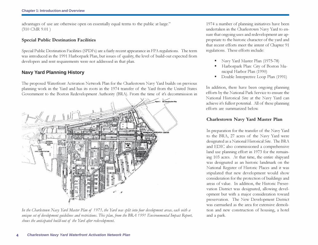
Navy Yard Planning History
The proposed Waterfront Activation Network Plan for the Charlestown Navy Yard builds on previous
planning work in the Yard and has its roots in the 1974 transfer of the Yard from the United States
Government to the Boston Redevelopment Authority (BRA). From the time of it’s decommission in
Charlestown Navy Yard Master Plan
In preparation for the transfer of the Navy Yard
to the BRA, 27 acres of the Navy Yard were
designated as a National Historical Site. The BRA
and EDIC also commissioned a comprehensive
land use planning effort in 1973 for the remain-
ing 103 acres. At that time, the entire shipyard
was designated as an historic landmark on the
National Register of Historic Places and it was
stipulated that new development would show
consideration for the protection of buildings and
areas of value. In addition, the Historic Preser-
vation District was designated, allowing devel-
opment but with a major consideration toward
preservation. The New Development District
was earmarked as the area for extensive demoli-
tion and new construction of housing, a hotel
and a park.
1974 a number of planning initiatives have been
undertaken in the Charlestown Navy Yard to en-
sure that ongoing uses and redevelopment are ap-
propriate to the historic character of the yard and
that recent efforts meet the intent of Chapter 91
regulations. These efforts include:
� Navy Yard Master Plan (1975-78)
� Harborpark Plan: City of Boston Mu-
nicipal Harbor Plan (1990)
� Double Interpretive Loop Plan (1991)
In addition, there have been ongoing planning
efforts by the National Park Service to ensure the
National Historical Site at the Navy Yard can
achieve it’s fullest potential. All of these planning
efforts are summarized below.
In the Charlestown Navy Yard Master Plan of 1973, the Yard was split into four development areas, each with a
unique set of development guidelines and restrictions. This plan, from the BRA 1991 Environmental Impact Report,
shows the anticipated build-out of the Yard after redevelopment.
advantages of use are otherwise open on essentially equal terms to the public at large.”
(310 CMR 9.01 )
Special Public Destination Facilities
Special Public Destination Facilities (SPDFs) are a fairly recent appearance in FPA regulations. The term
was introduced in the 1991 Harborpark Plan, but issues of quality, the level of build-out expected from
developers and rent requirements were not addressed in that plan.
5Community Partners Consultants, Inc.
Chapter 1: Introduction and Overview
The plan was created to guide completion of
the Navy Yard redevelopment. The planning
principles outlined in the plan evolved over the
course of nearly 125 meetings with
Charlestown residents, local merchants, harbor
advocacy groups, historic preservation officials,
organized labor, and other interested parties.
General recommendations for the Boston
waterfront include preservation of 1/3 of the
waterfront for open space and recreation as
well as the creation of new waterfront housing
units. Private investment was encouraged to
provide a mix of uses, new jobs and housing..
Specific recommendations for the Navy Yard
included:
� Maximize public access to and activity along
the waterfront while preserving the Yard’s
original form and character
Harborpark Plan: City of Boston Munici-
pal Harbor Plan
In 1984, the City established the Harborpark plan-
ning program for the entire Boston waterfront
including the Charlestown Navy Yard. In Octo-
ber 1990, the City of Boston and the Boston
Redevelopment Authority completed the
Harborpark Municipal Harbor Plan. The
Harborpark Plan was approved by the Massa-
chusetts Secretary of Environmental Affairs in
May 1991. The four primary goals of the
Harborpark Plan include:
� Provide public access to the waterfront though
the City’s Harborwalk program;
� Revitalize Boston’s underutilized and dilapi-
dated shoreline through private investment that
brings public benefits and amenities that are shared
by all of Boston residents;
� Activate the waterfront zone through appro-
priate urban design, active public and cultural uses
and water-dependent uses;
� Protect and enhance the waterfront’s mari-
time-industries.
The Harborpark Plan sets minimum standards
for public access and open space in the varied
waterfront subdistricts along Boston Harbor. The
Harborpark Plan recommended devoting
facilities of public accommodation (“FPAs”) with
special consideration to facilities that enhance the
destination value of the waterfront including
cultural uses at the ground level of buildings
containing residential uses or alternative locations
that more effectively promote public use and
enjoyment of the waterfront. The Harborpark
Plan suggests that areas with more intensive
development such as the Downtown Waterfront
could support at least 25% of the first floor area.
The plan codified land use controls to ensure con-
tinuous visual and physical public access along the
entire water’s edge of the Boston Inner Harbor.
Prior to this, projects would routinely be designed
with private yards, terraces, and balconies along
the water. This development pattern enhanced pri-
vate value and marketability at the expense of the
public. Harborpark regulations ensured that the
primacy of access to the water’s edge is preserved
for the public and also makes provisions for the
Harborwalk. The regulations also seek to protect
and enhance maritime industries.
The completed Harborpark Plan of 1990 was
informed by an extensive BRA community
planning process in 1987 in the Charlestown
Navy Yard.
� Improve and expand open space and create
an open space network
� Connect the Navy Yard to surrounding
communities (between Charlestown Gateway/
Tudor Wharf and CNY, improve City Square)
The Secretary’s approval of the Harborpark Plan
supports the City’s objectives to develop a network
of special public destination facilities (“SPDFs”)
within the waterfront subdistricts. The Secretary
specifically pointed to the proposed “Double
Interpretive Loop Plan” for the Charlestown
Navy Yard that suggests SPDFs that help link the
collection of historic piers, drydocks and backland
buildings.
Special Requirement 8 of the Harborpark
Decision provides additional guidance for SPDF
The earlier 1978 plans envisioned a significant
component of light industrial space, in part to
ameliorate the elimination of jobs resulting
from the Navy Yard’s closure. By 1990, regional
economic forces had severely affected the
viability of these uses in urban core locations
such as the Navy Yard. However, biomedical
research emerged as a new growth economy,
providing a broad range of employment
opportunities.
The City’s efforts to establish this new growth
economy were successful in 1987 with the
conversion of Building #149 into the
Massachusetts General Hospital Biomedical
Research Center. Other biomedical research
uses have since been attracted to the Yard in
order to benefit from proximity to this
Research Center.

Charlestown Navy Yard Waterfront Activation Network Plan
Chapter 1: Introduction and Overview
6
The Double Interpretive Loop Concept Plan
from 1991 put forth a conceptual framework
for public experience of the Navy Yard.
� How will we give special consideration to
public and non-profit organizations that otherwise
would be unable to afford market rates for
waterfront space?
� How does the plan appropriately distribute
SPDFs among the respective subdistricts
particularly on pile supported structures with new
residential uses or elsewhere in the surrounding
area where opportunities exist to offset
privatization particularly at the immediate
waterfront and at other sites that have traditionally
played a significant role in maritime culture of
the subdistrict?
� How are the SPDFs recommended by this
plan of a condition, size and type which is
appropriate to meet needs identified in the Navy
Yard and are consistent with the guidelines for
Harborwalk, the proposed double interpretive
loop plan and other networks for pedestrian
circulation?
� How does the plan address/further define
the requirement of SPDFs to be concurrent with
the development of the residential uses over
flowed tidelands?
� How does the plan incorporate other terms
and conditions in a manner analogous to the
specification of public benefit criteria in other City
zoning articles such as the Midtown Cultural
District?
The Secretary also concurred with the City’s analysis
that waterfront sub-districts that do not have the
intensive development of the Downtown
Waterfront may not support SPDFs equal or
greater than 25% of the ground floor area. To
address this matter, the Secretary approved a
substitution requiring at least 50% of ground floor
space on piers with residential uses to be occupied
by FPA’s including SPDFs.
Double Interpretive Loop Plan
An approach to achieving the goals of the
Harborpark Plan was the 1991 Double Interpretive
Loop Plan. In 1988, the New England Aquarium
unveiled plans to relocate to the Charlestown Navy
Yard. The aquarium proposed to build the world’s
largest, most technologically advanced facility
which included a whale tank within Drydock #5
as its centerpiece. The aquarium was seen as an
ideal magnet to activate the Yard’s waterfront and
to establish a dynamic relationship with the U.S.S.
Constitution at the other end of the Yard. It was
envisioned that visitors would circulate between
these two “magnets,” thus making the entire
Charlestown Navy Yard more familiar, accessible,
and significant as a public resource.
network plans including the amount of space and
how to distribute the SPDFs among the
waterfront subdistricts. This requirement indicates
that plans shall be developed in accordance with
the following provisions:
� How does the network plan enhance the
destination value of the Navy Yard by serving
significant community needs, attracting a broad
range of people or providing innovative amenities
for public use?
� How does the plan encourage diversity in the
pattern of uses and population of users at the
waterfront?
� How will we solicit creative use concepts
from the planning and advocacy community at
large in the choice of facility operators?
7Community Partners Consultants, Inc.
Chapter 1: Introduction and Overview
As part of this relationship between these two major destinations, the Plan proposed the creation of a
“double interpretive loop” that tied the two major attractions into an overall system which would have
enhanced people’s appreciation of the entire Yard as an historic resource. When the New England
Aquarium withdrew it’s plans to relocate to Yard’s End in the Navy Yard, the Double Interpretive Loop
Plan was not put forward as a proposed amendment to the City’s Municipal Harbor Plan and no other
action was taken at that time.
North End Historic Piers Network Plan
In January 1999 the City completed a SPDF network plan for the North End to accommodate the
development of residential uses on Battery Wharf. The Commonwealth of Massachusetts approved
this plan in March 1999. The Secretary’s approval supports the distribution of SPDFs at key anchor
sites along the waterfront and modifies Requirement 8c substituting qualitative standards for the 4:1
quantitative standard. This decision was based upon the combination of diverse attractions and the
nature of special programming proposed in the North End Historic Piers Network Plan.
Study of Cultural, Civic, and Non-Profit Facilities of Public Accommodation in Boston
Harbor
The Boston Redevelopment Authority completed a Study of Cultural, Civic and Non-profit Facilities of
Public Accommodation in Boston Harbor in 2005. Beginning in 2003 the BRA began an assessment of
waterfront development in light of MGL Chapter 91 requirements for Facilities of Public
Accommodation (FPAs). The Study was based on input received during numerous meetings, informal
discussions and numerous stakeholder interviews with the intent to creatively tackle the challenges to
successful waterfront redevelopment and the improving public use and enjoyment of Boston Harbor.
The analysis of FPAs includes investigation of space availability and demand for such space for cultural,
non-profit, and other uses.
The report presented the overall perspective of FPA space on the Boston waterfront, illustrating what
properties are subject to Chapter 91 regulations, overall land use and water transportation, and existing
and future FPA spaces across the entire waterfront. Two case studies, Clippership Wharf and Russia
Wharf, illustrated characteristics of successful projects to inform future development strategies. An in-
depth analysis of FPAs identified challenges and opportunities for each waterfront neighborhood.
With the assistance of the BRA’s Economic Development and Research Departments, demographic
data and physical characteristics of each waterfront neighborhood were summarized within the context
of the development parcels and FPA spaces. Based on that information and analysis, a set of
recommendations was offered for future cultural, educational and civic development on the waterfront.
The recommendations to address these challenges were presented in three parts:
� Waterfront neighborhood themes and
suggested uses
� City-wide waterfront themes and issues
� Implementation strategies
The City-wide waterfront themes and issues
addressed in the Study included:
� Identification of suitable non-profit,
cultural, civic and educational uses
� Greater efforts toward Harborwalk
planning and coordination
� Programming and coordination
� Ensuring affordability and suitability of
FPAs for non-profit use
Some of the suggested uses for the Navy Yard
included an Interactive Maritime Park, smaller
SPDFs along the waterfront that provide
interpretive interactive exhibits on martime history,
and year-round educational uses including
Courageous Sailing. The study also suggests
providing space that is rent free and built-out with
funding for programming and staffing as ways
to support non-profit, cultural, civic and
educational uses.
Facilities of Public Accommodation:
Commercial, Retail, and Restaurant Mar-
ket Demand and Supply Analyses,
Water’s Edge Districts, Boston, MA
The study of supply and demand for commercial,
retail and restaurant uses within the Water’s Edge
Districts (WED) of Boston provides an estimate
of the supportable commercial FPA development
envelope (over the next 25 years) for each District

Charlestown Navy Yard Waterfront Activation Network Plan
Chapter 1: Introduction and Overview
8
and also suggests a series of development
principles that can be useful in guiding the
development of successful commercial FPA’s in
the future.
� The CNY has FPA totals that had not
been finalized at the time of the report
in 2006, including Yard’s End, Parcel 5
and Pier 5. Any increase in new
commercial FPA’s will further exacerbate
the potential oversupply condition.
� In the CNY, the isolated nature of the
Navy Yard from a retail market capture
point of view, the abundance of better,
more competitive commercial
opportunities for consumers in these
markets and the un-evolved nature of
the physical environments are likely to
impact negatively on the ability of these
WED’s to successfully absorb new
commercial space during the planning
time horizon.
Guiding principles for commercial waterfront
development include:
� Location – the relative isolation of locations
like the Charlestown Navy Yard will
continue to prove challenging for retail
developments in the future.
� Access and visibility – retail spaces do
best when they can be seen directly from
the street and feel easily accessible on foot.
� Critical Mass/Scale - Retail spaces do
best when they are part of a larger retail
environment. Single spaces rarely do well
unless they are occupied by destination
users (restaurants and some specialty
stores).
� Environmental Quality - Great retail needs
great streets. The quality of the pedestrian
environment is critically important to the
success of urban retail.
� Design - Projects that open their ground
floor commercial areas to the street and
invite traffic in from the outside rather
than insulating and isolating it for the
benefit of onsite users alone, will enjoy
broader exposure to potential consumers
and greater potential for long term retail
success.
� Development Density and Land Use -
Projects that can only effectively reach
their onsite consumers, or that are located
in areas where only one demand source
dominates will have severely constrained
retail potentials.
� Development Timing - Retail follows
other development, it does not lead. This
has been a significant factor for
commercial endeavors in the
Charlestown Navy Yard.
Current plans for the Charlestown Navy Yard
call for the development of nearly 93,000 SF of
new commercial FPA space between now and
2030. Assuming that the existing commercial FPA’s
are in equilibrium with existing demand sources
and that added sales will not be absorbed by
existing establishments, market forecasts suggest
that only 35,300 SF of new retail and restaurant
space can be supported in the Charlestown WED
during this time frame, an excess supply of over
57,000 SF. In short, there is currently more
commercial FPA space planned for the
Charlestown District than the market can
reasonably be expected to absorb.
Chart from the Facilities of
Public Accommodation
Commercial, Retail, and
Restaurant Market De-
mand and Supply Analy-
ses Study showing that the
current and future build-out
of FPA space will create a
significant over supply of space
than can be filled by commer-
cial, retail, and restaurant
uses.

9Community Partners Consultants, Inc.
Chapter 1: Introduction and Overview
preserve historic finishes, an upgrae of the elec-
trical system to meet current code, an upgrade of
the fire alarm system and accessibility improve-
ments.
� The rehabilitation of Building 125 (Fiscal Year
2005) includes selected rehaiblitaiton for enhanced
building use, accessibility improvements, structural
stabilization, window repairs and an upgrade of
mechanical and electrical systems to meet current
code.
� Other NPS Projects projected for the future
include the rehabilitation of Dry Dock 1, replacement
of the barge with an accessible ferry landing, and the dry
docking and rehabilitation of the USS Cassin Young.
These projects are intended to provide enhanced
visitor services and a more centrally located visi-
tor entrance for the NHS and the Navy Yard as
well as upgrade other facilities for increased use
for public events and possible leasing.
Building 125 is the former site of an exhibit on the his-
tory of the Navy Yard. The building’s lack of visibility
made it difficult to attract visitors and a new visitor center
in Building 5 should greatly enhance the visitor experience.
It is hoped that future uses for this building support the
NHS and the Navy Yard as a public destination with
an active waterfront. Source: National Park Service
A new visitor center in Building 5 will help centralize
visitor services for the National Historical Site and the
entire Navy Yard. Enhanced exhibits can orient the visi-
tor to destinations and amenities throughout the Yard.
This illustration shows the proposed National His-
torical Site rehabilitation projects. Source: National
Park Service
National Park Service Planning
The National Park Service has a number of plan-
ning projects underway. The events of 9/11 made
security a more prominent issue in how the Na-
tional Historical Site (NHS) is managed and this
has affected the goals and projects for the NHS.
As part of these planning projects, the National
Park Service (NPS) would like to achieve the fol-
lowing:
� Provide maximum accessibility to resources
� Provide a better visitor experience, better in-
formation and smoother visitor flow
� Separate Navy functions and public uses
� Create an isolated security zone
� Re-establish the Harborwalk connection to
the community
� Rehabilitate Pier 2 to provide additional space
for ship berths and programs
To achieve these goals a number of
specificprojects have been approved in the NPS
national construction program. These projects
include the following:
� The rehabiliation of Building 5 (Fiscal Year 2006)
will allow the NPS to move the park visitor cen-
ter from Building 125 (where it has little visibility
and minimum attendance) to Building 5 and to
provide upgraded exhibits to enhance the quality
of the visitor experience.
� The rehabilitation of Building 24 (underway at
the time of this report in 2005), which is currently
leased by the US Navy and used for ship repairs,
will include exterior repairs and replacement of
asbestos siding and windows. The slate roof,
gutters and downspouts will also be replaced.
� The rehabilitaition of the Commandant’s House
(Fiscal Year 2005) includes interior renovations to

Charlestown Navy Yard Waterfront Activation Network Plan
Chapter 1: Introduction and Overview
10
Goals and Objectives of the Amendment
The 1991 Double Interpretive Loop Plan outlined a concept for public destinations in the Navy Yard
that sought to link historic sites, entice visitors throughout the Navy Yard and waterfront, and provide
FPAs and SPDFs that met Chapter 91 requirements. Since that plan was set aside, the Navy Yard has
been lacking in a public destination network plan that achieves similar goals and objectives. This
amendment seeks to outline a new waterfront activation network plan in the current Navy Yard context
and for the expected economic and development climate. The plan also seeks to acknowledge market
realities and is based on achievable results in the long and short term.
Much planning work has been accomplished in the Navy Yard and this amendment to the Municipal
Harbor Plan embodies many goals that are common to the planning efforts highlighted earlier in
this section:
� An accessible waterfront available for public enjoyment with a complementary open space network
� A legible and accessible Harborwalk
� Waterfront uses that include recreation, economic activity, jobs and housing
� Protection of existing water dependent uses
� Preservation of original form and character where possible
� Provision of a cohesive interpretive experience for a diverse population
� Encouragement of private investment with mixed uses and public amenities and benefits
In addition, attention is paid to the implementation of the amendment – how will these goals be
realistically accomplished and by whom? This amendment looks to a variety of resources and
partners to achieve implementation goals.
Public Process
In developing the MHP Amendment to the Harborpark Municipal Harbor Plan for the Charlestown
Navy Yard’s “Double Interpretive Loop Plan”, the BRA has coordinated with State and City officials
and with the Municipal Harbor Plan Advisory Committee (“MHPAC”) which includes representatives
from harbor advocacy groups, residents, elected officials, business people, business and real estate
associations, and other interested parties. The BRA held two (2) meetings with the MHPAC to the
discuss the MHP Amendment. The BRA also held three community meetings in coordination with the
Charlestown Neighborhood Council as well as a community workshop/charrette. Additionally, the
BRA has presented findings to the Charlestown Municipal Harbor Plan Advisory Committee, the
Boston Harbor Association Harbor Use Committee, National Park Service, Courageous Sailing program,
CNY residents and businesses.

11Community Partners Consultants, Inc.
Chapter 1: Introduction and Overview

Charlestown Navy Yard Waterfront Activation Network Plan
Chapter 2: The Charlestown Navy Yard Waterfront Context
12
The area covered by the amendment includes the waterfront between the Washington
Street Bridge and the Tobin Bridge (Building 114 in the Navy Yard).
Site Description
The area covered by this amendment is the Charlestown waterfront; it includes all
the piers from the Washington Street Bridge to the Tobin Bridge over the Little
Mystic Channel and goes back about 100 feet from the shoreline. In order to put the
project area in context, however, this report will consider the entire Navy Yard and
surrounding area, including its connections to the heart of Charlestown.
Most of the project area falls within the boundaries of the Charlestown Naval
Shipyard, which stretches from Gate 1 off Constitution Road all the way to the
Little Mystic Channel, bounded to the north by Chelsea Street. The BRA acquired
approximately one hundred acres of the Charlestown Navy Yard in 1978 and
has since managed its revitalization pursuant to plans developed at the time of
the transfer. The remaining thirty acres at the western end of the Yard were
established as a National Historical Park under the NPS.
The BRA acquisition involved conveyance of three distinct parcels: a Public
Park Parcel, the Historic Monument Transfer Area (“HMTA”), and the New
Development Area (“NDA”). The Public Park Parcel consists of 16 acres and
includes Dry Dock #2, Pier 4, and Shipyard Park, which at the time of conveyance
was occupied by Building 195 — a mammoth electrical shed. The HMTA
encompasses 31 acres to the north of First Avenue and includes those existing
structures with the greatest historical significance in the Yard. The NDA includes
58 acres between the Historic Monument Transfer Area and Boston Harbor and
is characterized by a mix of converted historic buildings and new construction
styles. The entire Navy yard is on the National Register of Historic Places.
Most of the Navy Yard waterfront, which is a significant portion of the project
area, is located in the NDA, so its character is distinct from the rest of the Yard.
While a number of historic exteriors have been preserved, the interiors have
been converted into condominiums. Historic elements preserved include Building
197 at Flagship Wharf (the old Electric Shop); Building 36, the old Joinery;
Buildings 40 and 42, the Steel Mill and Foundry, now Parris Landing
Condominiums; Building 103, the Chain Stores, now the AnchorageThe Navy Yard is segmented into three distinct parcels. However, the entire
Yard is on the National Register of Historic Places.
Chapter 2:The Charlestown Navy Yard Waterfront Context
13Community Partners Consultants, Inc.
Chapter 2: The Charlestown Navy Yard Waterfront Context
Condominiums; Building 104, the old Ship-fitters Loft, now the Shipways Condominiums; and Building 114, the old Sawmill, now the site of a
Massachusetts General Hospital biomedical research facility.
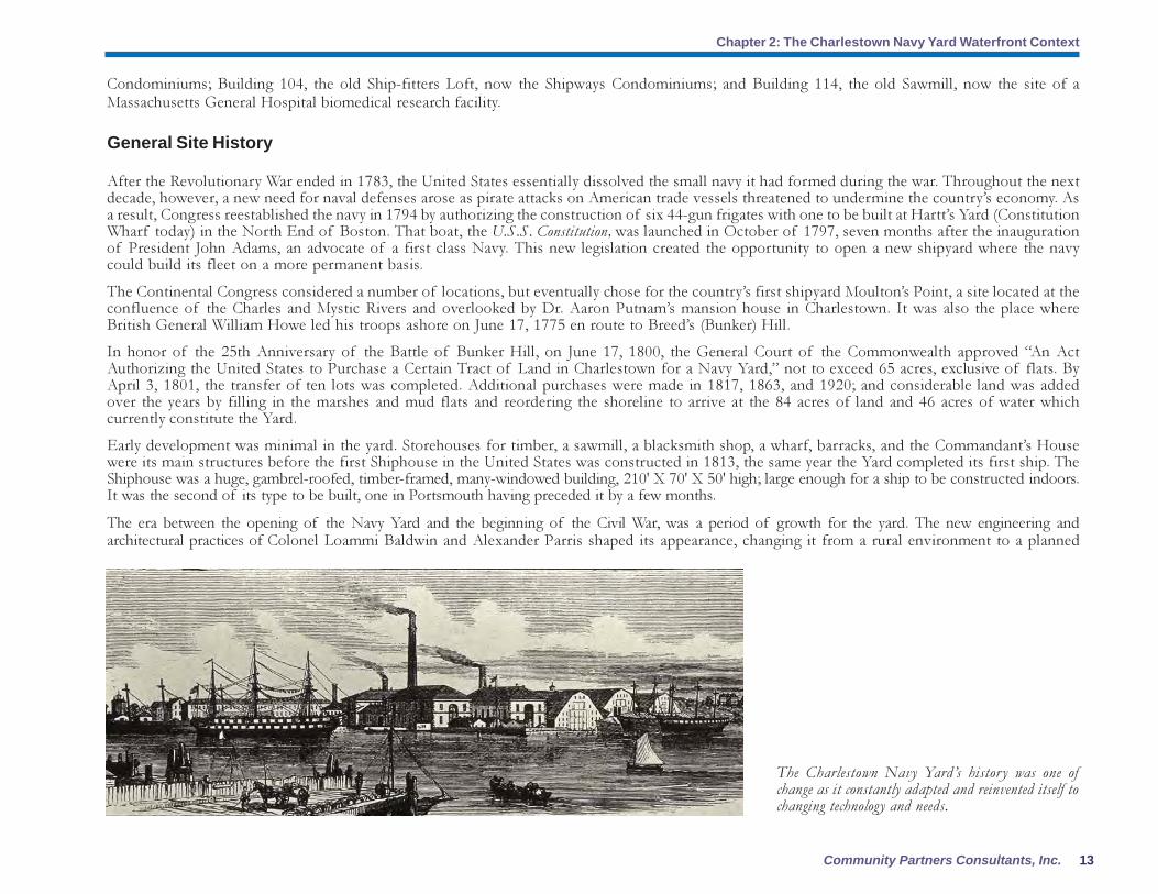
General Site History
After the Revolutionary War ended in 1783, the United States essentially dissolved the small navy it had formed during the war. Throughout the next
decade, however, a new need for naval defenses arose as pirate attacks on American trade vessels threatened to undermine the country’s economy. As
a result, Congress reestablished the navy in 1794 by authorizing the construction of six 44-gun frigates with one to be built at Hartt’s Yard (Constitution
Wharf today) in the North End of Boston. That boat, the U.S.S. Constitution, was launched in October of 1797, seven months after the inauguration
of President John Adams, an advocate of a first class Navy. This new legislation created the opportunity to open a new shipyard where the navy
could build its fleet on a more permanent basis.
The Continental Congress considered a number of locations, but eventually chose for the country’s first shipyard Moulton’s Point, a site located at the
confluence of the Charles and Mystic Rivers and overlooked by Dr. Aaron Putnam’s mansion house in Charlestown. It was also the place where
British General William Howe led his troops ashore on June 17, 1775 en route to Breed’s (Bunker) Hill.
In honor of the 25th Anniversary of the Battle of Bunker Hill, on June 17, 1800, the General Court of the Commonwealth approved “An Act
Authorizing the United States to Purchase a Certain Tract of Land in Charlestown for a Navy Yard,” not to exceed 65 acres, exclusive of flats. By
April 3, 1801, the transfer of ten lots was completed. Additional purchases were made in 1817, 1863, and 1920; and considerable land was added
over the years by filling in the marshes and mud flats and reordering the shoreline to arrive at the 84 acres of land and 46 acres of water which
currently constitute the Yard.
Early development was minimal in the yard. Storehouses for timber, a sawmill, a blacksmith shop, a wharf, barracks, and the Commandant’s House
were its main structures before the first Shiphouse in the United States was constructed in 1813, the same year the Yard completed its first ship. The
Shiphouse was a huge, gambrel-roofed, timber-framed, many-windowed building, 210' X 70' X 50' high; large enough for a ship to be constructed indoors.
It was the second of its type to be built, one in Portsmouth having preceded it by a few months.
The era between the opening of the Navy Yard and the beginning of the Civil War, was a period of growth for the yard. The new engineering and
architectural practices of Colonel Loammi Baldwin and Alexander Parris shaped its appearance, changing it from a rural environment to a planned
The Charlestown Navy Yard’s history was one of
change as it constantly adapted and reinvented itself to
changing technology and needs.

Charlestown Navy Yard Waterfront Activation Network Plan
Chapter 2: The Charlestown Navy Yard Waterfront Context
14
brick and granite neighborhood with services such as a Marine Hospital (later moved to Chelsea)
and all the major elements that organize the Yard today. During this period, the Yard’s stone wall
was designed and built, its streets were planned and laid out, and some of the Yard’s major
historic buildings were constructed, including the Ropewalk, Tarring House, and Hemp House.
The architectural influence of Joseph E. Billings in the 1940s was of particular importance adding
such prominent structures as the Carpenters and Joiners Shop (Building 24) of 1847; the two-story
brick Tinners and Plumbers Shop (Bldg. 28) of 1849-50; the unique octagonal brick Muster House
(Bldg. 31) of 1852-54; the Steam Engineering Building (later the machine Shop and Foundry, Bldg.
42) of 1856-58; the two-story brick Boiler House (Bldg. 79) of 1857; the two-story brick Heavy
Hammer Shop (Bldg. 40) of 1863 (west elevation demolished in 1939-41 for Bldg. 42A); the
three-story, slate-roofed Sail Loft and Joiners Shop (Bldg. 36) of 1866; and the three-story brick
Ordnance Storehouse (Bldg. 39) also of 1866.
After the Civil War, however, the United States
began building modern, steel-hulled warships,
and the Yard was all but shut down except for
equipment production. Its obsolete physical
plant fell into disrepair as the Navy turned more
frequently to private yards to build its ships. By
the end of the nineteenth century, however, this
pattern had begun to change. The Charlestown
Navy Yard attracted a significant amount of
repair work, and by 1903, an extensive building
program was under way that yielded ten new
structures over the next two years (Bldgs. 103,
104, 105, 106, 107, 108, 114, 120, 123, 125).
All were brick with steel or concrete frames, a
pattern that continued through World War I.
The Colonial and Renaissance revival details of
the first 20th century buildings soon gave way
to a stripped-down factory style. During this
period the Yard’s three great Shiphouses were
demolished. To supplement the Yard’s Dry
Docks (Dry Dock #2 was designed and built
between 1898 and 1906), a Marine Railway was
installed in 1918, lacing through the Yard’s
avenues and streets.
The period between the two World Wars saw
another lull in production, enlivened only by
the development of the “Die-Lock Chain.”
Invented by A. M. Leahy and Dr. Charles G.
Lutts, it revitalized the research aspect of the
Yard. Repair work had slowed to a trickle,
however, the physical plant of the Yard
deteriorated steadily.
By the late 1930s, the United States was
preparing for its entrance into World War II.
In 1938, Congress approved President
Roosevelt’s request for $1 billion for naval
defense. That same year, the Charlestown Navy
Yard launched two 1500-ton destroyers, the
USS Mayrant and the USS Trippe, and also began
a construction program of large industrial-style
buildings. Between 1941 and 1942, two
The USS Inca was one of many ships docked in the Yard in 1898 as the Navy Yard began to attract more repair
orders from the US Government.
15Community Partners Consultants, Inc.
Chapter 2: The Charlestown Navy Yard Waterfront Context
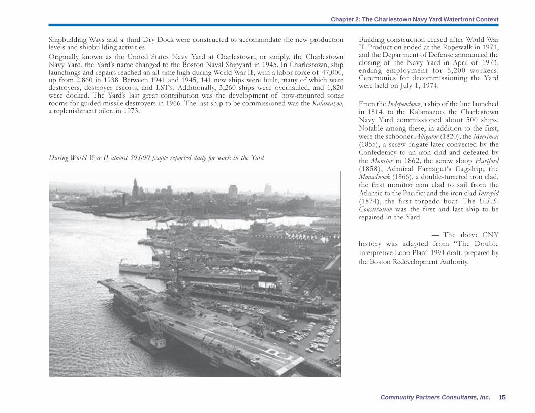
Shipbuilding Ways and a third Dry Dock were constructed to accommodate the new production
levels and shipbuilding activities.
Originally known as the United States Navy Yard at Charlestown, or simply, the Charlestown
Navy Yard, the Yard’s name changed to the Boston Naval Shipyard in 1945. In Charlestown, ship
launchings and repairs reached an all-time high during World War II, with a labor force of 47,000,
up from 2,860 in 1938. Between 1941 and 1945, 141 new ships were built, many of which were
destroyers, destroyer escorts, and LST’s. Additionally, 3,260 ships were overhauled, and 1,820
were docked. The Yard’s last great contribution was the development of bow-mounted sonar
rooms for guided missile destroyers in 1966. The last ship to be commissioned was the Kalamazoo,
a replenishment oiler, in 1973.
During World War II almost 50,000 people reported daily for work in the Yard
Building construction ceased after World War
II. Production ended at the Ropewalk in 1971,
and the Department of Defense announced the
closing of the Navy Yard in April of 1973,
ending employment for 5,200 workers.
Ceremonies for decommissioning the Yard
were held on July 1, 1974.
From the Independence, a ship of the line launched
in 1814, to the Kalamazoo, the Charlestown
Navy Yard commissioned about 500 ships.
Notable among these, in addition to the first,
were the schooner Alligator (1820); the Merrimac
(1855), a screw frigate later converted by the
Confederacy to an iron clad and defeated by
the Monitor in 1862; the screw sloop Hartford
(1858), Admiral Far ragut’s f lagship; the
Monadnock (1866), a double-turreted iron clad,
the first monitor iron clad to sail from the
Atlantic to the Pacific; and the iron clad Intrepid
(1874), the first torpedo boat. The U.S.S.
Constitution was the first and last ship to be
repaired in the Yard.
— The above CNY
history was adapted from “The Double
Interpretive Loop Plan” 1991 draft, prepared by
the Boston Redevelopment Authority.

Charlestown Navy Yard Waterfront Activation Network Plan
Chapter 2: The Charlestown Navy Yard Waterfront Context
16
This analysis drawing of the physical conditions of the Navy Yard shows the barriers and breaks in continuity to enter
the Yard and along the Harborwalk.
The Freedom Trail
The Freedom Trail runs across the Washington Street Bridge from the North End into Charlestown’s City Square, follows Constitution Road to the Navy
Yard, crosses through two sets of barriers and arrives at the U.S.S. Constitution and the Constitution Museum before heading back up to the Bunker Hill
Memorial in the heart of Charlestown. The Trail is an important link between the North End, Charlestown, and the Charlestown Waterfront. Currently the
Trail is cut off on its entrance into the Yard, and within the Yard it is disconnected from the Harborwalk. Additionally, no signage or information kiosks exist
along the Trail that would entice visitors to return and explore other waterfront destinations and amenities. Such information is critical as the Freedom Trail
tends to be an experience unto itself, and it primarily provides an opportunity to make a good first impression.

17Community Partners Consultants, Inc.
Chapter 2: The Charlestown Navy Yard Waterfront Context
Some of the critical points along the Trail for signage and information are at the Gateways to the Yard
(discussed below), the points along Constitution Road where the Freedom Trail and Harborwalk intersect,
and, most importantly, the point where the Trail hits the northeast corner of Shipyard Park and turns to
pass through the Historic Monument Transfer Area. The last location is a critical juncture between the
National Historical Park and the rest of the Yard and is blessed with views down First Avenue, out
across Dry Dock 2 to the Harbor and Boston and back to the HMTA’s historic buildings. With little in
the way of signage, visitors have no clues as to what lies ahead in the Navy Yard.
As visitors leave the USS Constitution area and the museum
no signage or maps indicate what remains to explore in the
Navy Yard. Freedom Trail visitors turn at this point and
head up to the Bunker Hill Monument…never knowing the
Yard is worth another visit on another day.

Charlestown Navy Yard Waterfront Activation Network Plan
Chapter 2: The Charlestown Navy Yard Waterfront Context
18
Gateways to the Yard
City Square
The City Square archeological site is a gateway to both the Charlestown waterfront and to the
neighborhood’s downtown. It represents an opportunity to make a stronger gateway connection to the
Charlestown waterfront (and Navy Yard) and the Harborwalk with a site of historical significance in
the community. It is the only designated archeological landmark district in Boston and it encompasses
nine important archeological sites, including a Native American pottery workshop. The district’s Water
Street boundary traces Charlestown’s earliest shoreline; connecting this boundary to the Harborwalk
would allow visitors to viscerally experience the change from the original waterfront to its current
form. Water Street originally connected City Square to the water, and parts remain intact. It was the site
of an old corduroy road, and old bridge pilings are still visible from the shore. Other important sites
include Hoosac Stores, the warehouses where goods were transported from the East to the Midwest,
the old Mill Pond east of the bridge near what is now Paul Revere Park, and the Tow Path. The
archeological site tells a story that connects each side of the North Washington Street Bridge. This
connection will be strengthened if the current plan to build a pedestrian connection beneath the bridge
when the gas pipe is moved and the bridge is reconstructed is implemented.
Navy Yard Gates
Entrances to the Navy Yard are well-defined by its wall and gatehouses. Gate 1 is located just off of
Constitution Road as it bends back up to meet Chelsea Street. This access point, which is also the point
of entry into the Navy Yard for the Freedom Trail, is currently partially blocked with chain link fence
and concrete barricades. Signage is minimal and unwelcoming. Pedestrian access to this Gate from
Charlestown requires passing through a tunnel beneath the Tobin Bridge before crossing Chelsea Street.
The underpass at Gate 4, which is where the Freedom Trail crosses Chelsea Street to enter Charlestown,
is an equally dismal environment. Gate 5, between the far end of the Ropewalk and the Captain’s
Quarters, and the Sixteenth Street entrance to the Yard are both directly across from playing fields along
the Mystic Channel and represent an important opportunity to connect the activities of the Yard (especially
any recreational programming) with the recreational activities along the Mystic Channel. These entrances
currently service residents near Yard’s End and the Massachusetts General Hospital employees working
in the Yard. No obvious connection exists across Chelsea Street and signage is minimal at best.
The sense of physical disconnection in the Yard belies its close proximity to surrounding areas. The
entire Charlestown waterfront includes about a mile and a half of frontage and three miles of shoreline.
From the northeast corner of Shipyard Park, both Yard’s End and Paul Revere Park are within a 10-
minute walk. This distance feels much longer because pathways are poorly marked and discontinuous.
At three miles, the Harborwalk is too long for most visitors to walk its entire length in any single visit.
Gate 1 is a major entrance to the Navy Yard for visitors
on the Freedom Trail and for Charlestown residents. The
chain link fence, lack of signage with information about
the entire Yard, and concrete barriers provide an
unwelcoming environment.
The Tobin Bridge overpass is one of many barriers to
entry to the Navy Yard. The overpass, busy Chelsea
Street with its few pedestrian crossings, and the brick wall
around the Navy Yard all contribute to the Yard’s character
of a “gated community.”
19Community Partners Consultants, Inc.
Chapter 2: The Charlestown Navy Yard Waterfront Context
In addition, the Harborwalk is lacking amenities
such as picnic benches, seating and play spots that
would make its distance seem more manageable,
especially for families with children.
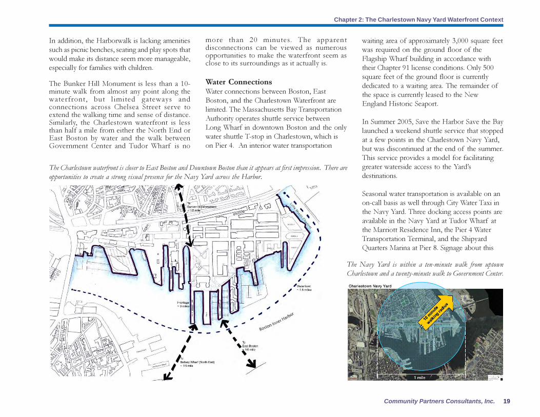
The Bunker Hill Monument is less than a 10-
minute walk from almost any point along the
waterfront, but l imited gateways and
connections across Chelsea Street serve to
extend the walking time and sense of distance.
Similarly, the Charlestown waterfront is less
than half a mile from either the North End or
East Boston by water and the walk between
Government Center and Tudor Wharf is no
The Charlestown waterfront is closer to East Boston and Downtown Boston than it appears at first impression. There are
opportunities to create a strong visual presence for the Navy Yard across the Harbor.
more than 20 minutes. The apparent
disconnections can be viewed as numerous
opportunities to make the waterfront seem as
close to its surroundings as it actually is.
Water Connections
Water connections between Boston, East
Boston, and the Charlestown Waterfront are
limited. The Massachusetts Bay Transportation
Authority operates shuttle service between
Long Wharf in downtown Boston and the only
water shuttle T-stop in Charlestown, which is
on Pier 4. An interior water transportation
waiting area of approximately 3,000 square feet
was required on the ground floor of the
Flagship Wharf building in accordance with
their Chapter 91 license conditions. Only 500
square feet of the ground floor is currently
dedicated to a waiting area. The remainder of
the space is currently leased to the New
England Historic Seaport.
In Summer 2005, Save the Harbor Save the Bay
launched a weekend shuttle service that stopped
at a few points in the Charlestown Navy Yard,
but was discontinued at the end of the summer.
This service provides a model for facilitating
greater waterside access to the Yard’s
destinations.
Seasonal water transportation is available on an
on-call basis as well through City Water Taxi in
the Navy Yard. Three docking access points are
available in the Navy Yard at Tudor Wharf at
the Marriott Residence Inn, the Pier 4 Water
Transportation Terminal, and the Shipyard
Quarters Marina at Pier 8. Signage about this
The Navy Yard is within a ten-minute walk from uptown
Charlestown and a twenty-minute walk to Government Center.

Charlestown Navy Yard Waterfront Activation Network Plan
Chapter 2: The Charlestown Navy Yard Waterfront Context
20
A
B
C
service is limited and the drop-off sites are
widely scattered.
In the short term, no additional water
transportation routes or terminals are planned
for the Navy Yard. In the future, however,
expanded terminals and service is envisioned as
outlined in the Boston Inner Harbor Water
Transportation Study, which was prepared by
TAMs in 2000. The study recommends
expansion of the Pier 4 water transportation
terminal to include a second float to
accommodate low freeboard water taxi and
public touch and go drop off. The study also
recommends a secondary terminal at Pier 10 in
the Yard’s End portion of the Navy Yard to
accommodate public water transportation as
well as water taxi and public touch and go use.
Additionally, an interim docking facility at Parcel
4 was required as part of that site’s Chapter 91
license. Finally, a docking facility for water taxi
and public touch and go traffic is
recommended for Pier 1 in the National
Historic Park area.
Public Transportation
No subway connections exist along the
Charlestown waterfront. Aside from water transit,
the only other public transportation that reaches
the waterfront is the bus. Bus Route 92 connects
the eastern section of Chelsea Street above Tudor
Wharf and Hoosac Pier to Downtown Boston,
Charlestown, and the Assembly Square Mall. Bus
Route 93 connects Sullivan Square to Downtown
Boston and traverses Chelsea Street from Vine
Street to Washington Street with an alternate route
through the Navy Yard. For most residents and
regular visitors of the Navy Yard, the MGH/
Public Destinations and Amenities
Aside from the U.S.S. Constitution, few major
destinations are located within the Charlestown
waterfront area. The destinations that exist are
located along the waterfront are scattered and
disconnected. Tudor Wharf and the Constitution
Marina attract many visitors but the Harborwalk
in their vicinity is poorly marked or nonexistent.
B. Bunker Hill Visitor Center/Freedom
Trail
Run by the National Park Service, this
visitor center serves visitors to the Freedom
Trail. The NPS plans to relocate its visitor
services, including exhibit space on the
history of the Navy Yard (formerly housed
in Building 125 in the Yard) to Building
5 just inside Gate 1 by the USS
Constitution.
A. Tudor Wharf
The Residence Inn at Tudor
Wharf provides FPA space
that includes a café,
interpretive exhibits in the
hotel lobby and along the
Harborwalk, and a pool and
exercise room.
1
Partners shuttle, though private, is the most
convenient form of transportation as it runs from
North Station to a number of stops in the Yard.
The shuttle runs only during working hours on
weekdays.

21Community Partners Consultants, Inc.
Chapter 2: The Charlestown Navy Yard Waterfront Context
E. U.S.S. Constitution Museum
The USS Constitution Museum,
run by the Constitution
Foundation in a building at the
National Historical Park, offers
artifact displays, hands-on exhibits
and computer-simulated
reenactments related to the history
of the USS Constitution, the
sailors that served on the ship, and
the people who have worked on its
restoration. Educational
programming is available at the
museum and classroom programs
are also offered.
D
E
F
G
IJ
K
L
D. U.S.S. Cassin Young
This WWII destroyer built at the
Charlestown Navy Yard first saw
action in the Pacific in April 1944.
The ship survived two attacks by
Kamikaze pilots. It was
decommissioned in 1946 and then
returned to duty in 1951 where it
served mostly in the Atlantic and
Mediterranean. The Cassin Young
is a National Historic Landmark
that was transferred for use as a
museum to the National Park
Service in 1978.
C. U.S.S. Constitution
The oldest commissioned ship in the
US Navy, the USS Constitution
attracts approximately one million
visitors each year and serves the
largest public destination in the Navy
Yard. The challenge is to draw some
of these visitors to explore the rest
of the Yard.
H
5
6
2
4
3
7
Charlestown Navy Yard Waterfront Activation Network Plan
Chapter 2: The Charlestown Navy Yard Waterfront Context
22
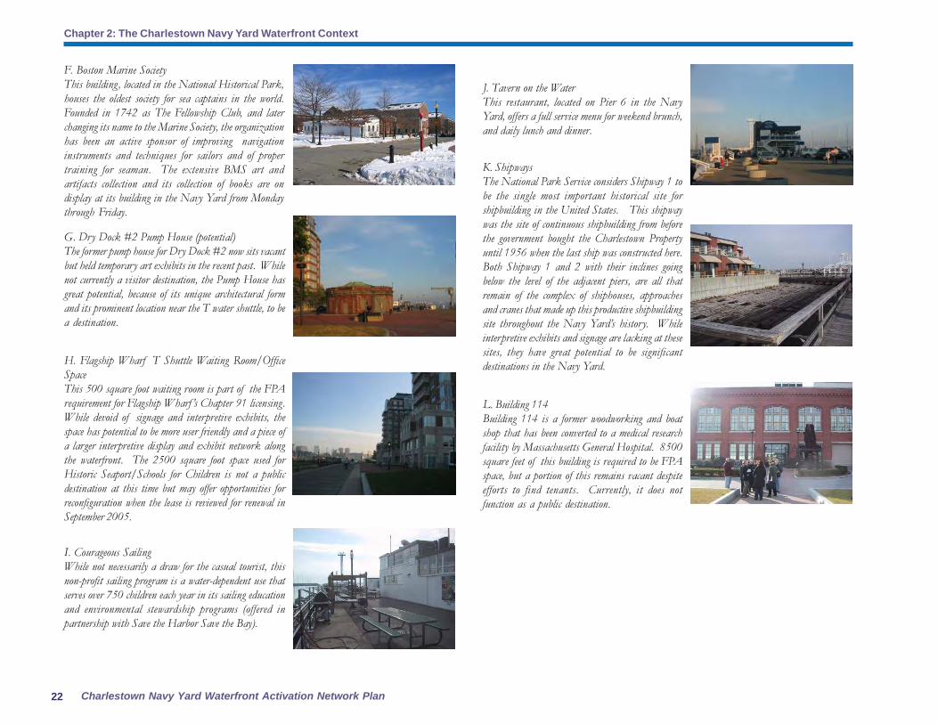
F. Boston Marine Society
This building, located in the National Historical Park,
houses the oldest society for sea captains in the world.
Founded in 1742 as The Fellowship Club, and later
changing its name to the Marine Society, the organization
has been an active sponsor of improving navigation
instruments and techniques for sailors and of proper
training for seaman. The extensive BMS art and
artifacts collection and its collection of books are on
display at its building in the Navy Yard from Monday
through Friday.
H. Flagship Wharf T Shuttle Waiting Room/Office
Space
This 500 square foot waiting room is part of the FPA
requirement for Flagship Wharf ’s Chapter 91 licensing.
While devoid of signage and interpretive exhibits, the
space has potential to be more user friendly and a piece of
a larger interpretive display and exhibit network along
the waterfront. The 2500 square foot space used for
Historic Seaport/Schools for Children is not a public
destination at this time but may offer opportunities for
reconfiguration when the lease is reviewed for renewal in
September 2005.
G. Dry Dock #2 Pump House (potential)
The former pump house for Dry Dock #2 now sits vacant
but held temporary art exhibits in the recent past. While
not currently a visitor destination, the Pump House has
great potential, because of its unique architectural form
and its prominent location near the T water shuttle, to be
a destination.
I. Courageous Sailing
While not necessarily a draw for the casual tourist, this
non-profit sailing program is a water-dependent use that
serves over 750 children each year in its sailing education
and environmental stewardship programs (offered in
partnership with Save the Harbor Save the Bay).
J. Tavern on the Water
This restaurant, located on Pier 6 in the Navy
Yard, offers a full service menu for weekend brunch,
and daily lunch and dinner.
K. Shipways
The National Park Service considers Shipway 1 to
be the single most important historical site for
shipbuilding in the United States. This shipway
was the site of continuous shipbuilding from before
the government bought the Charlestown Property
until 1956 when the last ship was constructed here.
Both Shipway 1 and 2 with their inclines going
below the level of the adjacent piers, are all that
remain of the complex of shiphouses, approaches
and cranes that made up this productive shipbuilding
site throughout the Navy Yard’s history. While
interpretive exhibits and signage are lacking at these
sites, they have great potential to be significant
destinations in the Navy Yard.
L. Building 114
Building 114 is a former woodworking and boat
shop that has been converted to a medical research
facility by Massachusetts General Hospital. 8500
square feet of this building is required to be FPA
space, but a portion of this remains vacant despite
efforts to find tenants. Currently, it does not
function as a public destination.

23Community Partners Consultants, Inc.
Chapter 2: The Charlestown Navy Yard Waterfront Context
Signage and Wayfinding
The destination and amenity map on the previous
page is one piece of a larger story in the Yard.
While many of these sites are scattered, the lack
of coherent signage and a narrative that connects
the waterfront’s various destinations contributes
to the perception that there are conflicting
messages and images in the Navy Yard. What
signage exists along the waterfront and especially
within the Navy Yard is piecemeal and various
business and historic site signs compete for
visitors’ attention. Similarly, interpretive
experiences occur seldom along waterfront, and
taken together, they do not tell a coherent narrative
about the history of the site. This lack of consistent
signage in the Yard contributes greatly to the
mixed image presented to visitors and residents.
The signage in the Yard can be defined in four
categories:
� Gateway
� Wayfinding
� Harborwalk
� Interpretive
Better signage and stronger connections to the
uptown residential and business areas are needed
to transform the Yard and the Harborwalk into
a waterfront neighborhood for all of
Charlestown. Gateway signs at and near the
entrances to the Yard are non-existent. Gate 1,
which is the main gateway along the Freedom
Trail to the National Historical Park, is a
disappointing entrance to the park with no overall
orientation for visitors as to the Navy Yard
context and history.
Once within the Yard, the visitor is met with no
signage or with a mix of signs of varying styles
Signage is a free-for-all at the Navy Yard and the resulting
clutter does a disservice to the businesses and public desti-
nations in the Yard and visitors attempting to find their
way.
This pedestrian connection under the Tobin Bridge overpass,
as well as an additional tunnel connection at Gate 1 are
main routes to the Navy Yard from uptown Charlestown.
These two connections lack signage, lighting and a friendly
design to encourage use and welcome Charlestown residents
to the Yard.
Sites within the National Historical Park (NHP)
are similarly disconnected. In the rest of the Yard,
even the most basic amenities like food and
bathrooms are difficult to find. The largest
destination outside of the NHP in the Navy Yard,
the Courageous Sailing Center, is a model for
building connections between different sites and
programs. The Center’s sailing program is free to
any child in Boston and the Charlestown site
attracts about 750 children per year to sail, fish,
fix boats, etc. In addition, 350 adult members
come every night during summer, and events on
the Pier draw anywhere from 300 to 2000 people.
Courageous actively seeks opportunities to form
partnerships with other related activities such as
environmental or sports and recreation programs
to keep students engaged throughout the day.
However, these programs are open only to
members and do not serve the transient public
for safety and training reasons.
Public amenities shown on the map include:
1. Constitution Marina
2. Shipyard Galley Food Concession (NPS) –
Building 10
3. Store 24
4. Sixth Street bistro
5. Finagle a Bagel
6. Adam’s Café – Building 39
7. Shipyard Quarters Marina.

Charlestown Navy Yard Waterfront Activation Network Plan
Chapter 2: The Charlestown Navy Yard Waterfront Context
24
The Harborwalk: Public Paths, FPAs and SPDFs
Turning the Harborwalk in the Navy Yard into a coherent interpretive pathway can help develop a
public realm that supports other public uses. Its current lack of clarity and completeness provides an
opportunity to fully realize its interpretive potential. The physical gaps in the Harborwalk – across the
parking lot at the Tudor Wharf hotel and Constitution Marina, through the barriers at Hoosac Stores
and the National Historical Park, at Parcel 4 and Yard’s End – are opportunities to develop a temporary
marking system for the Harborwalk that can be used throughout the entire city. Scattered and ineffective
FPAs provide lessons for how such spaces should be planned and developed. The empty FPA space in
Building 114 demonstrates the importance of attracting a market for public uses along the waterfront;;
the office space at Flagship Wharf, which is leased to an educational non-profit, illustrates the need not
Harborwalk signs in the Navy Yard lack a wayfinding
component that directs pedestrians to the next waterfront
destination. Here on Hoosac Pier, these Massport-installed
signs give no information regarding what lies ahead on the
Harborwalk (USS Constitution).
and sizes calling out the locations of businesses and organizations in the Yard. These signs add visual
clutter to the environment and are difficult to read and decipher. No consistent style and size for
wayfinding exists throughout the Yard. If you enter Gate 4 from Chelsea Street, how do you know
how to find Courageous Sailing? The historic Shipways? The NPS visitor center? Signs with maps
throughout the Yard can help to orient the visitor and point out places of discovery just around the next
corner. In addition, street signs should be more legible and consistent throughout the Yard.
The Harborwalk also suffers from lack of clarity. Signage is critical to reassuring pedestrians that they
are where they are allowed to be on the Harborwalk particularly because its three miles of pathway
(when completed) meander, following long piers, disappearing at vacant lots, and passing through
private residential development (in the case of Constellation Wharf). In addition, Harborwalk signs
have no wayfinding component. The signs at Hoosac Pier, for instance, tell the visitor that the Harborwalk
is on Massport property but this does not inform the visitor what is up ahead (the USS Constitution) or
the name of the Pier. Lastly, portions of the Harborwalk disappear, either because of NPS security
concerns surrounding the USS Constitution (at Hoosac Stores) or at vacant lots awaiting development.
The visitor is left with no information about where to go or what lies ahead at these particular spots.
Lastly, the interpretive signage in the Yard is spotty at best. While the NPS offers signage at Dry Dock
#1 and some other sites within the National Historical Park, these signs do little to tie the NHP to the
rest of the Yard and interpretive signage all but disappears as one leaves the area managed by the NPS.
What are those sloping ramps that look like a derelict pier? The Shipways! What are they there for and
what is there significance? What is the significance of the light towers at the end of some of the piers
and at the dry docks? How did uses change in that building during the history of the Navy Yard? What
boats were constructed here during WWII? The Yard is rich with a multi-layered history and lacking in
interpretive signage and exhibits to explain this past.
This major gateway from the National Historical Park to the
rest of the Navy Yard has little interpretive signage and no
overall map of the Yard to help entice and orient visitors.

25Community Partners Consultants, Inc.
Chapter 2: The Charlestown Navy Yard Waterfront Context
The existing public network in the Yard has significant gaps in the Harborwalk as well as at major gateways to the Yard.
only for public uses, but for uses that serve a transient public in the spirit of Chapter 91; and whereas
the Copia (previously MEZE) restaurant and retail developments on the CANA parcel successfully
provide a needed resting point for both visitors and residents, its uses do not tie directly to the waterfront.
The fact that the Harborwalk currently terminates at Building 114 and resumes around the Little Mystic
Channel is both a challenge and a condition that offers significant opportunities. While it is always
Building 125’s remote location makes it a challenge to
draw the public. When an exhibit on the history of
the Navy Yard was housed here, few visitors made the
trip to the end of the Pier to the building.

26 Study for the Boston Redevelopment Authority on Waterfront Facilities of Public Accommodation
difficult to attract people to a place that feels like a “dead end,” that very quality provides an opportunity
to develop a distinct identity for the Navy Yard Harborwalk.
SPDF-like destinations in the Yard are the USS Constitution, the USS Cassin Young, Courageous Sailing
and the Constitution Museum. Evidence suggests that many of the visitors to Old Ironsides come only
to see the ship. Only a fraction of the visitors continue along the Freedom Trail up to the Bunker Hill
memorial, and when Building 125 was open as a Navy Yard history exhibit, the National Park Service
saw only 1500 visitors to that museum each year.
Though the exhibit was seasonal and not centrally
located, it illustrates the major challenge of how
to entice more of the Constitution’s visitors to
return to the Yard and explore it further at another
time.
Public gathering spaces are scattered throughout the Yard. Future development of Pier 5, and Yard’s End could provide more public
gathering space for festivals, public events and performances.

27Community Partners Consultants, Inc.
All in all, as shown in the Existing Public Network
Plan above, there isn’t a sufficient number of
public destinations along the waterfront to draw
more public to the Harborwalk, which in turn,
supports more public uses. This catch-22 situation
is one of the driving forces of this proposed
Amendment to the Municipal Harbor Plan.
Open Spaces
The largest open space along the waterfront is
Shipyard Park, which technically encompasses not
only the actual park but also includes Dry Dock
#2, and Piers 3 and 4. However, as large as this
park is, it is not designed for public gatherings.
Grade changes, the Korean War Memorial,
various structures and play areas make it a true
amenity for the neighborhood but not a space
that is easily programmable for public
events…that role must fall to larger waterfront
spaces existing in the National Historical Park and
at some of the piers and along the Harborwalk.
The waterfront spaces that may be able to
accommodate large events and gatherings are the
parking lots on Hoosac Pier (on weekends when
not used for office building parking), the
waterfront National Historical Park space
between the USS Constitution and the USS Cassin
Young, the ends of Piers 4, 5 and 6, and the open
space at Yard’s End. However, the space at Yard’s
End has some security restrictions based on post-
9/11 Coast Guard regulations. These areas must
be secured from public access if not activated
but temporary, planned events are allowed. In
addition, parcel 5 will be used as a temporary
staging/parking area while condominiums are
built on parcel 4 beginning in the spring of 2005.
The map to the left attempts to put estimates on
capacities for public events. While it is not meant to imply maximum capacities for the Yard, it can
begin to suggest the appropriate scale of events, assuming transportation and parking issues are addressed
in a thoughtful and thorough manner.
Watersheet Activation
Most of water activities occur in three places. The Constitution Marina and the Shipyard Quarters
Marina each offers year-round berths for private boats. However, while docking slips are seemingly
plentiful at these marinas, the number of slips available to transient boaters is significantly fewer.
At the 300-slip Constitution Marina, all vacant or unoccupied slips are used for transient docking when
available; arrangements must be made with the Dockmaster in advance. Shipyard Quarters Marina has
approximately 5,200 linear feet of dock as well as 400 docking slips. It has reserved 300-400 linear feet
for transient docking and additional space is available when unoccupied by a lessee and arrangements
are made in advance with the Marina Manager. Shipyard Quarters Marina is currently planning to
expand its total capacity by adding slips that can accommodate vessels between 50 and 60 feet in length.
In addition, Courageous Sailing is headquartered at Pier 4 and the sailing program it runs is a major
component of year-round watersheet activation in the Navy Yard. In addition to the boats at these
three locations, the docking barge at the National Historical Park accommodates tour boats and other
transient docking of larger vessels. At some point in the near future, the NPS would like to replace the
barge with a permanent dock for this purpose. The T water shuttle stop is near the foot of Pier 4 and
the related waiting room is adjacent on the ground floor of Flagship Wharf. The T water shuttle dock
is also an occasional berthing point for tour boats and some visiting ships and this is managed by the
BRA. In 2004, two ships—one each from Mexico and Brazil—were docked at Pier 4. US Navy ships
also dock in the CNY but these are not open for public viewing. NATO ships also dock in the Yard.
In 2004, six ships were open to the public. Two docked at Pier 1 and four docked at Pier 4. In the
spring of 2005, the BRA will arrange dredging of Pier 4 to allow continued accommodation of tall
ships and deeper vessels in the Yard.
Image of the Yard and Summary of Opportunities and Challenges
The Navy Yard has a nondescript image. Remnants of its industrial past remain in the form of cranes
and light towers on the piers, but they are neither prominent nor consistent enough to create a coherent
image. The disconnect between the NHP and the rest of the Navy Yard creates two distinct environments
(one focused on preserving history and the other marked by current trends in residential and economic
development) with no story that connects them. Very little of the area’s history is communicated through
the environment along the water. Even the Historic Monument Transfer Area feels much more corporate

Charlestown Navy Yard Waterfront Activation Network Plan
Chapter 2: The Charlestown Navy Yard Waterfront Context
28
At the same time, there is much to celebrate and explore in the Navy Yard. Its importance to naval
history could be emphasized in many ways, and its location at the mouths of two rivers in the Boston
Harbor presents an opportunity for it to serve as a site for environmental learning. Additionally, its
proximity to the thriving community of Charlestown presents opportunities to connect the Yard to
neighboring activities already in existence, such as community gardening and local boating. However,
the Yard’s seemingly remote location, the lack of consistent image, and the relatively low-density business
and residential uses present challenges to the creation of a compelling waterfront destination that
acknowledges that the Charlestown Navy Yard waterfront belongs to all.
The Waterfront Activation Network Plan must acknowledge that an overall conceptual framework
must be established that allows the creation of a network of varied public destinations that begin to
build a market to support a vibrant waterfront. These destinations must appeal to Charlestown residents,
regional visitors and tourists while preserving the character and integrity of the Yard. As the destinations
are defined and created, a market will development for additional amenities such as shopping and
dining. And lacking another large anchor/public destination on the scale of the USS Constitution, the
public attraction will be found in a carefully conceived and constructed network of smaller interpretive
sites and destinations. Chapter 4: The Waterfront Activation Network Plan outlines the strategies to
meet these challenges.
than historic. Mixed messages also contribute to the failure to draw USS Constitution visitors further into
the Yard. The visitor view, upon leaving the Constitution Museum, is one of a quiet, corporate
environment with few compelling attractions.

29Community Partners Consultants, Inc.
Chapter 2: The Charlestown Navy Yard Waterfront Context

Charlestown Navy Yard Waterfront Activation Network Plan
Chapter 3: Case Studies
30
Waterfront Activation Case Studies
In creating an active waterfront network for the
Charlestown Navy Yard, research was conducted
to look at waterfront trails, interactive parks and
historical venues around the world. The research
attempted to compare similar contexts and goals,
if any and to draw useful lessons for the Navy
Yard effort. While there are many cases of wa-
terfront parks worldwide, the search quickly nar-
rowed to sites and efforts that had the most simi-
larity to the context of the Charlestown Navy Yard,
the surrounding uses, and the relationship of the
Navy Yard with the city center. All in all, over 30
case studies were reviewed with more in-depth
research focused on the following:
� Saint John Inner Harbour/Harbour Passage,
New Brunswick, Canada
� Point State Park, Pittsburgh, PA
� Ohio and Erie Canal Towpath Trail, Cleve-
land to Philadelphia
� Augustus F. Hawkins Natural Park, Los
Angeles, CA
� Bicentennial Commons at Sawyer Point, Cin-
cinnati Gateway and Riverwalk Peter Rose
Way, Cincinnati, OH
� Brooklyn Heights Promenade, Brooklyn, NY
� Bilbao, Spain
� Piers Park, East Boston, MA
� Liberty State Park, Jersey City, NJ
� Circular Quay, Sydney, Australia
� Main Beach Park and Heisler Park, Laguna
Beach, CA
� Montshire Museum of Science, Norwich,
VT
� Royal Naval Dockyard, Bermuda
� Washington Navy Yard, Washington, DC
� Mystic Seaport, Mystic, CT� Historic Dockyard, Chatham, UK
� University Park, Cambridge, MA
Many of these cases are described in more detail
in the Appendix. Each of the cases found in the
Appendix describes the key groups involved in
implementation, the issues addressed, key
recommendations of the plan, actions, successful
design aspects and specific relevance to the
Charlestown Navy Yard waterfront. Of the cases
studied, four were found to have particularly
relevant elements, including implementation
strategies, interpretive signage, overall conceptual
organization and public art opportunities. These
four are described in more detail below:
Saint John Inner Harbour – Harbour
Passage
Saint John, New Brunswick, Canada
Overview
The vision for the future of Saint John is as a
waterfront defined by a wonderfully
comprehensive system of high quality public open
spaces, linked to one another by Harbour Passage
and connected to Uptown Saint John. To realize
this goal, the first priority of the Saint John
Waterfront Development Partnership was to
improve the city’s most visible and frequented
waterfront district. To that end, they developed
the Harbour Passage, a cranberry red
multipurpose recreational trail winding along Saint
John’s waterfront. The goal of the Passage is to
redefine the image of the Inner Harbour and make
it a point of entry into the St. John region. The
Passage links a series of nationally and
internationally significant historic and cultural
resources, each with their own valuable role to
play in telling the story of the Greater Saint John
Region.
The Harbour Passage provides public access to
the water, with a minimum width of 10 meters
(33 feet). The Passage, created in two phases,
runs for 1.5 miles, which is approximately the
length of the waterfront of the Charlestown Navy
Yard (not including piers). The Harbour Passage
is paved with red brick and features signage,
lighting and seating areas as well as interpretative
structures and panels about various waterfront
related activities. The path creates a series of
interconnected waterfront parks, recreation spaces
and heritage sites. Plowed in the winter, the
Passage is popular all year, featuring the Winter
Lights Celebration to draw visitors in the coldest
months. According to the Partnership, “The City
has embraced it with open arms…Even in winter,
runners and walkers are out.”
A proposed Interpretive Center will have displays
and programming based on the waterfront’s
history and character as well as links to nearby
historic sites and outdoor spaces for events. The
proposed Visitor Center is designed to be highly
Chapter 3: Case Studies

31Community Partners Consultants, Inc.
Chapter 3: Case Studies
The recreational trail at Harbour Passage provides space
for year-round walking, running and recreational use and
ties the interpretive elements of the Passage together. The
red color of the passage is intended to make it easily read-
able in the landscape.
Interpretive signage along the waterfront trail ties the vari-
ous historic sites, views, and activity areas together in Saint
John.
Even in the bleakest winter
months, thoughtful programming
draws crowds to outside spaces
along the Inner Harbour in New
Brunswick and helps activate the
spaces throughout the year.
visible to visitors, with a nine-meter-high sculpture
featuring fish and other sea creatures. The Center
will house information about the Passage and
other area attractions for cruise visitors, bus and
vehicle tours, and special events. In addition,
there is a proposed Round Reef Marine Park and
Bay of Fundy Discovery Centre. The Park will
feature water play and hands-on experience of
the tides, given that the Port of Saint John has the
highest tidal change of any major port in the world
(28 feet) and the phenomenon of the Reversing
Falls. The Discovery Center, in addition to
displays and interactive features, will be a focal
point for advanced marine biology and
aquaculture research and development activities.
Organization
In January of 2001, the Saint John Waterfront
Development Partnership was officially
introduced to the community. This Partnership
consists of the City of Saint John, Saint John
Development Corporation, Uptown Saint John
Inc., Enterprise Saint John, Saint John Board of
Trade and Saint John Port Authority. These six
groups fund the Partnership with the City of Saint
John contributing the majority of the funds. Over
a three year period, more than $535,000 has been
committed by the six partners. All six
organizations are cooperating to launch a new
era of community development focused
predominantly on the city’s waterfront.
Point State Park
Pittsburgh, PA
Overview
Point State Park is a 36-acre park located at the
confluence of three rivers adjacent to downtown
Pittsburgh’s Point State Park is a successful revitalization
of a former wasteland with no beneficial public purpose.
Pittsburgh. The area, which had become a slum
wasteland in the 1950s, was reclaimed and made
a park in the early 1970s. It is now a National
Historic Landmark site that celebrates and
preserves the strategic and historic heritage of
the area during the French and Indian War. Visitors
walk along riverfront promenades and overlooks
for striking views of Pittsburgh, its busy
waterways, many bridges and picturesque hillsides.
Natural landscaping and a majestic fountain
enhance the beauty of this unique park at the
The design of the waterfront walkway includes elements
such as a stepped wall that allows seating and picnicking
along the waterfront.

Charlestown Navy Yard Waterfront Activation Network Plan
Chapter 3: Case Studies
32
“Forks of the Ohio.” The Park is at the meeting
place of rivers – the Monongahela River and the
Allegheny River meet at Point State Park and form
the beginning of the Ohio River. Amenities in the
park include a stepped wall along the Allegheny
River that provides seating for outdoor events.
The bike and in-line skate routes through the Park
connect other regional and local bikeways. The
Fort Pitt Museum, the Fort Pitt Blockhouse and
more than twenty plaques interpret the history
and significance of the area. The Fort Pitt Museum
revives the fateful days of the French and Indian
The fountain is a centerpiece of Point State Park and
incorporates environmentally friendly design.
War in a variety of exciting ways, with life-sized
exhibits depicting events and styles of life on the
Pennsylvania frontier. The fountain is a major
centerpiece of the park – it draws everything
together and gives it a focal point. When the
fountain is in operation, there are over 800,000
gallons of water in the system, which creates a
special fan design symbolizing the three rivers.
Water in the fountain is recirculated, and the
amount lost during fountain operations is replaced
with water taken from a 54-foot deep well that
penetrates sands and gravels under the park. These
sands and gravels are beneath the groundwater
table and are saturated with water that infiltrates
from the nearby rivers.
Organization
The Park is operated by the Pennsylvania
Department of Conservation and Natural
Resources and managed and maintained by the
City of Pittsburgh under a reimbursable
arrangement. The creation of the park was
arranged by the Pittsburgh Regional Planning
Association and the Allegheny Conference on
Community Development, which is composed
of leaders in business, industry, commerce and
government. The Pennsylvania Historical and
Museum Commission administers the Fort Pitt
museum, located in the park.
The Ohio and Erie Canal Towpath Trail
Ohio (from Cleveland to New Philadelphia)
Overview
The Ohio and Erie Canal Towpath Trail is a
shared recreational trail through the Cuyahoga
Valley National Park, following the historic route
of the Ohio and Erie Canal. It is over sixty miles
in length and is accessible via ten trailheads. The
Towpath Trail can be experienced through a
corridor-wide interpretive story. These experiences
reinforce the geography of the corridor by linking
historical and chronological phenomena to the
visible qualities of the landscape.
The interpretive journeys are part of a strategic
framework for the whole of the Heritage
Corridor – this framework is story-driven and
uses the primary theme of “Routes to Prosperity”
to organize and clarify the many resources of the
Corridor. Within that framework, there are four
The towpath of the Ohio and Erie Canal acts as a
continuous interpretive spine through rural and urban areas.
Themes for telling the canal’s story have been developed to
enrich the visitor experience.
Interpretive signage is an important
component of the canal experience
and enhances visitors’ understanding
of history.
main themes: The Land, Moving Along the
Corridor, Prosperous Valleys, and People and
Communities of the Region. There are four
primary interpretive journeys that focus on the
Corridor and illustrate the four themes, and there
are four secondary journeys that emphasize one
or two themes and focus on issues other than
transport. There are signs, waysides, kiosks, maps,
brochures, and audio guides that are associated
with the interpretive journeys.
A sample Primary Interpretive Journey would be
The Industrial Valley and Cleveland Urban
Neighborhoods. This Journey conveys the story

33Community Partners Consultants, Inc.
Chapter 3: Case Studies
Organization
Numerous groups were and are involved in the
implementation, management and marketing of
the Towpath Trail. The Ohio and Erie Canal
Association (OECA) manages the Ohio & Erie
Canal National Heritage Corridor through the
development and implementation of a corridor
management plan. The OECA also oversees a
matching grant program to promote local
implementation of the plan. The OECA Board
includes members from the four counties in the
corridor, the National Park Service and the
primary non-profit partner organizations, namely
the Ohio Canal Corridor and the Ohio and Erie
Canalway Coalition. These partner organizations
have been crucial in getting federal designations,
increasing public awareness through community
outreach, and providing educational programs and
events.
of the technological ingenuity, entrepreneurship
and industrial might that were made possible by
the Canal. It also addresses the evolution of local
communities as immigrant groups were drawn
to the region by these economic forces. In the
northern end, the Journey includes a visit to the
CanalWay Center to visit the Exhibit Hall, which
explores the nature, people, and systems that have
shaped and continue to shape the Cuyahoga River
Valley. Existing interpretive resources for this
journey include the Irishtown Bend
Archaeological District, Old Superior Viaduct,
Cleveland ethnic neighborhoods, Mather Museum
and others. The interpretive approach is a
successful way to recognize that one can see,
perceive and experience an area in a variety of
ways, telling the story of a place while linking that
narrative to the visible landscape.
Augustus F. Hawkins Natural Park
Los Angeles, CA
Overview
Augustus F. Hawkins Natural Park is an 8.5 acre
urban park in Central Los Angeles. The park
was once a cement storage yard, located amidst
an industrial wasteland. Opened in December
of 2000, the park mimics a native California
setting with hills and topographic features. Native
plants continue to bring nature back to the
industrial landscape. The park features strolling
paths, picnic spots, an outdoor amphitheater, and
grassy areas that provide comfortable gathering
places. Given its location in the urban core, the
park has a ranger on site 24 hours and is
surrounded by an eight-foot boundary fence. This
fence, while providing protection, does not act
as a visual barrier as it is artistically decorated with
natural themes.
The Discovery Center located in the park houses
interpretive displays about nature and natural
resource issues. It provides interactive information
about ecosystems and wildlife, the history of the
Park, and information about other Los Angeles
parks. The Center also houses after-school
programs where groups of children gather to
take classes in art, science, gardening, music, and
other aspects of exploring the natural world.
Additionally, there are special interpretive nature
programs for children that are scheduled each
month and are free to area families. The Natural
Park emphasizes the importance of nature as a
teaching tool given the harsh urban setting in which
local residents live. To further that understanding,
the Park undertakes many family and child-
centered programs.
For example, the Camping Program provides
classes on camping and leadership skills as well as
a trip for young people to the mountains for three
days and two nights of hiking, outdoor skills, and
plant and animal programs. The Saturday Bus
Program departs from the Center every Saturday
to take families from the community to explore
a mountain, canyon, stream, beach or meadow,
accompanied by a staff naturalist. The Campfire
Programs occur the first Thursday of every month
with park staff supplying the songs and the
marshmallows while the community provides the
singing and family spirit. Additional activities for
area children include the Junior Ranger Program,
a Homework Club, Saturday Science Classes, and
Gardening and Crafts activities.
Organization
The programs and events at Hawkins Natural
Park are sponsored through a partnership of the
Santa Monica Mountains Conservancy, a state
agency, and the Mountains Recreation and
Conservation Authority, a local government entity.

Charlestown Navy Yard Waterfront Activation Network Plan
Chapter 3: Case Studies
34
While the Augusts Hawkins Park focuses on a more
natural setting, the environmental programming that is
an inherent part of its mission has important lessons for
the Charlestown Navy Yard waterfront.
Lessons Learned
As illustrated above and in the detailed
information in Appendix, there is no single case
that serves as a prototype for the Charlestown
Navy Yard Waterfront Activation Network Plan.
While we examined many interesting features of
projects around the world, we found no specific
example to follow. This is one of the most
valuable lessons learned in the case study analysis.
While this makes the formation of the Activation
Plan more challenging, it also suggests that the
Plan has real potential to be a landmark case in
waterfront development and activation.
The lessons we did learn in our examination range
from organizational structure to climate
considerations to carefully planned and innovative
programming. Some of the most successful cases
that we have found in the urban realm involve
multi-level partnerships, usually with partners at
the state and local levels. These partnerships can
include a national presence as well, with the
National Park Service, National Trust for Historic
Preservation or other Federal agency involvement.
These partnerships allow for community, local,
state, and federal parties to be involved and vested
in the project’s success. Often, the local groups
and community organizations are outside the
government realm, with non-profits playing a
considerable role in the success of many of the
case studies. In Saint John, New Brunswick, the
Saint John Development Partnership was created
to manage waterfront redevelopment. This
Partnership is made up of six entities, including
the City, Board of Trade, and business groups.
The Ohio and Erie Canal Towpath Trail involves
numerous local non-profits as well as city, county,
state and federal government entities. Local partner
organizations led the campaign for the federal
designation of the National Heritage Corridor.
They also work to increase public awareness
through community outreach, educational
activities and fundraising events. These cases
demonstrate the importance of many different
levels of government and community working
together to achieve a common goal.
Another very relatable lesson learned is that winter
weather does not necessarily create dead space.
Instead, it demands thoughtful programming as
well as physical attention. The ability of spaces
to transform from one use in the summer to
another in the winter months has been well
utilized. Also, spaces and walkways must be
treated in the wintertime to provide access to
pedestrians in the snowy months. On Saint John’s
Harbour Passage, advocates were astonished that
“even in winter, runners and walkers were out”
on the plowed path. We have also found many
examples of successful and interesting winter
activities and programs, including:
� Ice rinks and skating are an “ideal amenity for
public spaces…They fill a critical need for activities
in the wintertime.” They can also transform from
a summer water feature into a winter rink.
� Outdoor art installations also draw people in
the colder months. In Portland, OR, a festival
entitled “28 Days of Grey” in the month of
February draws large crowds.
� Many cities have created Winter Kite Festivals
to bring people outdoors and allow the bright
colors of the kites to play off the snow-covered
ground.
� Additional “one-day” festivals can be catered
to families – for example, a “snow day” withcity-
provided sleds and cocoa is successful in some
cities.
� Holiday markets bring people out of doors
to do shopping.
� Ice sculptures can serve as temporal public
art, and they could also be created as part of a
neighborhood contest in the Navy Yard and
Charlestown.
� Additional activities include standard winter
exercise such as sledding, snow shoeing and cross-
country skiing.

35Community Partners Consultants, Inc.
Chapter 3: Case Studies
Creative and thoughtful programming and design can en-
courage year-round use of waterfront parks and trails.
Summer wading pools can transform to winter skating
rinks and empty lots can host winter carnivals.
Another very important programming tool to
increase winter activity includes kiosks that sell hot
soups and hot drinks. Additionally, special lighting
and heating technologies can help make better
use of the potential of winter spaces, making them
more tolerable when the temperature drops. In
Charlestown, the FPA and SPDF spaces along
the water’s edge can serve this purpose (when
properly programmed) with services and rest
spaces away from the chill of the outdoors.
Another element of the year-round management
of space includes careful programming of that
space. We have found that getting local residents
Programming with a twist can help people envision the
waterfront and outdoor spaces differently in the cold winter
months, as demonstrated by this kite festival.
This fog fountain at University Park in Cambridge, MA
draws adults and children with its magical qualities.
involved in the planning and programming
benefits both residents and visitors, drawing a
wide range of age groups. In the case of Augustus
F. Hawkins Natural Park, concerns and desires
of area residents played a big part in the child
and family-centered activities that now draw a
regional audience. The importance of nature as a
teaching tool in this harsh urban setting is
promoted through programs sponsored by local
and state organizations. In this case, the activities
for children and families include camping
programs, Saturday science classes, gardening, and
other nature-related events.
Another magnet for visitors is the use of public
art, which plays a vital role in creating interest in
the area as well as a marketable and recognizable
sense of place. This public art can take many
forms, as we observed in Laguna Beach’s Heisler
Park. In this public park, the artist-designed
benches were created for specific sites, through a
city-sponsored contest. This integration of pub-
lic art in unusual places allows for discovery by
the users.
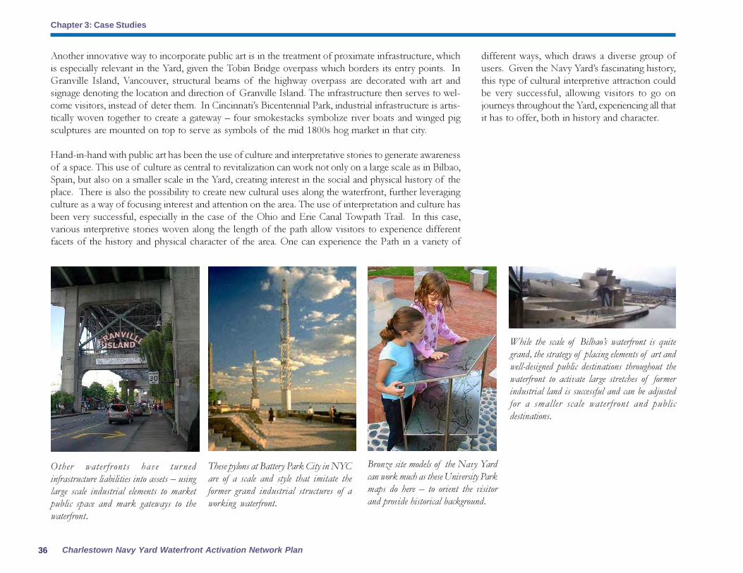
Charlestown Navy Yard Waterfront Activation Network Plan
Chapter 3: Case Studies
36
Other waterfronts have turned
infrastructure liabilities into assets – using
large scale industrial elements to market
public space and mark gateways to the
waterfront.
Another innovative way to incorporate public art is in the treatment of proximate infrastructure, which
is especially relevant in the Yard, given the Tobin Bridge overpass which borders its entry points. In
Granville Island, Vancouver, structural beams of the highway overpass are decorated with art and
signage denoting the location and direction of Granville Island. The infrastructure then serves to wel-
come visitors, instead of deter them. In Cincinnati’s Bicentennial Park, industrial infrastructure is artis-
tically woven together to create a gateway – four smokestacks symbolize river boats and winged pig
sculptures are mounted on top to serve as symbols of the mid 1800s hog market in that city.
Hand-in-hand with public art has been the use of culture and interpretative stories to generate awareness
of a space. This use of culture as central to revitalization can work not only on a large scale as in Bilbao,
Spain, but also on a smaller scale in the Yard, creating interest in the social and physical history of the
place. There is also the possibility to create new cultural uses along the waterfront, further leveraging
culture as a way of focusing interest and attention on the area. The use of interpretation and culture has
been very successful, especially in the case of the Ohio and Erie Canal Towpath Trail. In this case,
various interpretive stories woven along the length of the path allow visitors to experience different
facets of the history and physical character of the area. One can experience the Path in a variety of
These pylons at Battery Park City in NYC
are of a scale and style that imitate the
former grand industrial structures of a
working waterfront.
Bronze site models of the Navy Yard
can work much as these University Park
maps do here – to orient the visitor
and provide historical background.
While the scale of Bilbao’s waterfront is quite
grand, the strategy of placing elements of art and
well-designed public destinations throughout the
waterfront to activate large stretches of former
industrial land is successful and can be adjusted
for a smaller scale waterfront and public
destinations.
different ways, which draws a diverse group of
users. Given the Navy Yard’s fascinating history,
this type of cultural interpretive attraction could
be very successful, allowing visitors to go on
journeys throughout the Yard, experiencing all that
it has to offer, both in history and character.

37Community Partners Consultants, Inc.
Chapter 4: The Waterfront Activation Network Plan

Charlestown Navy Yard Waterfront Activation Network Plan
Chapter 4: The Waterfront Activation Network Plan
38
This chapter outlines the conceptual plan and critical
elements to achieve a vibrant waterfront public realm in
the Charlestown Navy Yard. The analyses of existing
conditions and context combined with a knowledge of
previous planning efforts and objectives have produced
waterfront goals and themes which are described in the
first section of this chapter.
The second section then presents the Waterfront Activation
Plan:
� Conceptual Plan: the Story Loops
� Public destinations and amenities
� Chapter 91 Licensing Requirements for FPAs,
SPDFs, and other spaces
� Chapter 91 Guidelines for Size Requirements and
qualities of a SPDF and FPA
� Activating the Public Realm
� The Harborwalk: a vibrant waterfront
trail
� Opportunities for public art
� Gateways to the Charlestown waterfront
� Signage and interpretation guidelines
� Proposed uses and programming
� Transportation and Parking
� Watersheet activation
Following these elements, requirements for Chapter 91
licensing in the Navy Yard are described and a summary
of public benefits concludes this chapter.
Goals of the Waterfront ActivationNetwork Plan Part 1Consistency with 1991 Municipal Harborpark Plan and
Special Requirement 8
The plan uses the concept of SPDFs to create a
network of destinations in the Navy Yard
concurrent with the goals of Special Requirement
8 of the Harborpark Decision:
� To enhance the destination value of the Navy
Yard by serving significant community needs,
attracting a broad range of people and providing
innovative amenities for public use.
� To encourage diversity in the pattern of uses
and population of users at the waterfront.
� To solicit creative use concepts from the
planning and advocacy community at large in the
choice of facility operators.
� To give special consideration to public and
non-profit organizations that otherwise would be
unable to afford market rates for waterfront space.
� To distribute SPDFs among the respective
subdistricts to offset privatization particularly at
the immediate waterfront and other sites that have
played a significant role in maritime culture of
the Navy Yard.
� To recommend SPDFs of a condition, size
and type that is appropriate to meet needs
identified in the Navy Yard and consistent with
the guidelines for Harborwalk, the proposed
Double Interpretive Loop Plan and other
pedestrian circulation networks.
A major goal of the Waterfront Activation Network
Plan is to create a waterfront that belongs to the entire
Charlestown neighborhood. Currently, there are many
physical and psychological barriers between the Navy Yard
and uptown Charlestown. This pedestrian “tunnel” isn’t
a very pleasant experience for Charlestown residents wishing
to cross Chelsea Street and enjoy the waterfront.
Chapter 4: The Waterfront Activation Network Plan� To further define the requirement of SPDFs
to be concurrent with the development of the
residential uses over flowed tidelands.
� To incorporate other terms and conditions in
a manner analogous to the specification of public
benefit criteria in other City zoning articles such
as the Midtown Cultural District.
Enhancing Destination Value
The network plan helps form a coherent image
of the historic Charlestown Navy Yard by
strengthening connections to and along the
Harborwalk System; it ties the existing scattered
destinations including the National Park Service
Area and the Historic Monument Area to the

43Community Partners Consultants, Inc.
Chapter 4: The Waterfront Activation Network Plan
War
ren
& C
hel
sea
Gat
eway
Mt. V
ernon, C
helse
a &
Constitu
tion G
atew
ay
Tremont, 5th &
Chelsea Gatew
ay
Barry Playground,
16th & Chelsea Gateway
1 2
3
4 5 6
7
8
9
10
11
12
1415
13
16 1719 23
20 21
18
22
24
25
26
28
31
33
34
35
30
7
32
27
Conversion of vacant 3,500-sq ft FPA to special destination possible tenantscould include Hull LIfesaving Museum
4,000 sf SPDF
Ropewalk 26,000 sf subsidized Artist Space + 7,000 sq ft museum
6,000 sq ft SPDF
Minimum 2,000 square foot SPDF, built-out / rent freePossible tenants include Courageous Sailing Program, a maritime exhibit/museum or the City’s Archeology Program
$100,000 to fund restoration of Dry Dock 4 Pump House as a space for wayfinding/water transportation information and concession space.
$1,000,000 to programming and expansion of Courageous Sailing Center as a SPDF on Pier 4. Including a bumper system along Pier 5.
$100,000 to enhance / create gateways to Charlestown Navy Yard
Maritimeinteractive park
Parcel 7
Building 114
Parcel 6
Parcel 5
Chain Forge Building20,000 sq ft of public space
YARD’S END • 13,500 sq ft • $650,000 or annual payments of $50,000 per year for programming/gateway /Dry Dock activation
Water-based and Other Public Amenities
FPA Spaces
SPDF (& non-regulated existing SPDFs)
Public Event / Gathering Areas
Outdoor Exhibit / Interpretive Areas
Water Connections
SPDF - Maritime Interactive Park
Pedestrian Connections/Gateways
Public Destinations
GATEWAYS$100,000 to enhance/create gateways to Charlestown Navy Yard
The Charlestown Navy Yard Waterfront Activation Plan recommends the following:
42,500 Square Foot area-wide* SPDF requirement
Chainforge 20,000 square foot SPDFPier 5 2,000 square foot SPDFParcel 7 4,000 square foot SPDFBuilding 114 3,500 square foot SPDFParcel 5 6,000 square foot SPDFRopewalk 7,000 square foot SPDF
* Plus required payments for SPDF network totaling $1.85 million for programming/open space upgrades/ gateway enhancements/historic preservation/Dry-dock 5 Activation.
BRA’s Beautification and Historic Funds to provide annual programming and completion of gateway improvements.
BostonRedevelopmentAuthority

Charlestown Navy Yard Waterfront Activation Network Plan
Chapter 4: The Waterfront Activation Network Plan
40
The destination value of the Yard will be enhanced
through tourist-oriented guides and promotion.
Special destinations will be built to suit for the proposed tenant. Special destinations are located at
intervals that allow for visual continuity from one public destination to the next. Combined, the special
destinations create a powerful network that supports the Story Loops. The SPDF requirement outlined
in the Secretary’s Decision are allocated to existing open space on the Harborwalk or adjacent to the
Harborwalk to activate areas of the yard that currently have no public destinations specific areas include:
the foot of Dry Dock #2 which act as a gateway from the National Historical Site and Freedom Trail
to the rest of the Navy Yard; Dry Dock #2 Pump House; Grade change and Harborwalk connection
from Chelsea Street to the Little Mystic and Ryan Playground; pedestrian tunnel and walkways to
uptown Charlestown neighborhood; Dry Dock #5 watersheet activation.
Special destinations will at a minimum have public restrooms, seating and dining furniture, interpretive
signage, exhibits and public art; shuttle stop service (water and/or land), gateway markings; identifying
icons for Story Loops and self-guided tours.
Determining SPDF Concurrent with Pier 5 Residential Development
The SPDF and Maritime Interactive Park at Pier 5 will be completed concurrently with the residential
uses. Possible uses include Courageous Sailing Center or the City of Boston Archeology Program. The
3,500 square feet at Building Number 114 is now available for a civic or cultural use. Hull Life Saving
Museum is looking to relocate from their South Boston Facility and may be a good fit for this site. $1.2
million will be provided concurrently with the construction of the residential uses on Pier 5 for pro-
gramming, support of existing anchor destinations, conversion of Dry Dock #2 Pump house into
public space, grade change and Harborwalk connection from Chelsea Street to the Little Mystic and
Ryan Playground; and enhancements to the pedestrian tunnel and walkways to uptown Charlestown
neighborhood. The BRA will lead the formation of the Charlestown Navy Yard partnership.
Incorporating Other Terms and Conditions
The terms and conditions of the Plan are analogous to the public benefit criteria of Article 38 Midtown
Cultural District including the creation of new cultural facilities, rehabilitation of historic buildings and
landmarks and guidelines for maintenance and programming of new open space.
Goals of the Waterfront Activation Network Plan Part 2Clarity, Connectedness, Identity, Interest and Implementation
The overall goals of the Waterfront Activation Network Plan are to create a sense of clarity and
connectivity throughout the Charlestown Navy Yard and to establish an identity that encompasses the
entire Yard. These goals work in collaboration to make the Navy Yard a destination that will be a place
of interest for diverse audiences at varied times of the day and year.
Clarity and connectivity are important goals of
the Plan as they enhance the experience of residents
and visitors. Connectivity is achieved through
enhanced visual connections. The view corridors
that are created will link places of interest, tying
the Harborwalk to destinations in the Navy Yard
and beyond. Points of entry into the Yard will
be strengthened and made more appealing,
Another primary theme of the Charlestown Navy
Yard Waterfront Activation Network Plan is an
enhanced interpretation of historic resources
throughout the entire Navy Yard. It is intended
that this Plan shall activate the waterfront,
improving resident and visitor experiences by
increasing awareness of the Yard’s role in the
military history of the United States. Interpretive
exhibits and signage provide an interactive
richness and diversity of experience that adds to
an understanding of the city as a special place.
Through interpretive stories, the numerous current
and future historical and cultural resources of the
Navy Yard will be marketed and celebrated in a
consistent fashion.
facilitating connectedness to uptown Charlestown
and the Mystic River developments. Visual
connections to the Harbor are created through
an interesting mix of nighttime lighting, public
art, and interpretive signage, making the Navy
Yard visible as a place of fascination on Boston’s
waterfront. Clarity is achieved through improved
signage and symbolism, making clear the
relationship between the neighborhood and the
water, between uptown Charlestown and the
Yard, and between Boston and the Yard.

41Community Partners Consultants, Inc.
Chapter 4: The Waterfront Activation Network Plan
Throughout the Yard,
signage and maps will
orient visitors and
inform them of other
“discoveries” on the
waterfront. This
example shows the
maps at University
Park in Cambridge
that offer a history of
the site and help
visitors get their
bearings.
Interest (for diverse audiences at varied
times of the day and year)
The major visitor attraction in the Navy Yard is
the USS Constitution, which draws one million
There are conflicting images of the Yard. Interpretive
signage such as this panel at Dry Dock 1 along with a
visitor center at the National Historical Park contrasts
sharply with other areas of the Yard such as this portion
of the Harborwalk near Parris Landing that has no
interpretive signage and feels more corporate and residential
to the visitor.
Freedom trail
visitors to return for
another visit as well
as create a year-
round waterfront
amenity for local
and regional
residents.
Identity (for Entire Navy Yard)
An often-heard comment is, “Every time the
landscape changes in the Yard you feel like you
shouldn’t be there again.” This is a result of
conflicting images presented by the Yard—
historic resource and visitor attraction, private
residential community, medical office park. The
Plan presented here provides a unifying identity
for the entire yard. This identity is expressed as a
story that can be read start to finish or as events
that read as chapters. Either way, the identity has
consistent graphics, markers, symbolism, and
infrastructure.
Visitors and residents will be encouraged at the
start of their visit to include more than one Navy
Yard attraction in their visit. At the same time,
parking and transportation options will become
clearer, ensuring that the Yard is not overrun with
visitor vehicles during peak visitor times and
special events and putting a clear shuttle plan in
place to substitute for limited public parking.
In summary, the goals of the Waterfront
Activation Network Plan are embodied in four
overall themes:
Clarity and Connectedness (of the
Harborwalk)
At a very basic level, the Harborwalk must read
as one entity and visitors must be clear of their
location on the Harborwalk and within the Navy
Yard. Efforts here include protecting and
enhancing views, providing consistent signage and
symbolism and providing clear and compelling
land and water gateways to the Yard.
visitors a year. Most come specifically to see the
ship or they visit the National Historical Park as a
stop on the Freedom Trail. This Plan seeks to
attract multiple audiences throughout the entire
Navy Yard:
� The larger Charlestown community —to
ensure the waterfront is the larger neighborhood’s
waterfront
� Residents of the region – to create a place to
go within an hour’s drive for 2-3 hours on a
weekend
� Tourists – to provide a compelling waterfront
destination for out-of-town visitors

Charlestown Navy Yard Waterfront Activation Network Plan
Chapter 4: The Waterfront Activation Network Plan
42
Implementation (of physical and
programmatic elements)
The Charlestown Navy Yard is perceived as being
somewhat difficult to access and remote from
the center of Boston. Coupled with the fact that
the Harborwalk breaks at Building 114 in the Navy
Yard before resuming along the Little Mystic,
there are real challenges to implementing a
Waterfront Activation Network Plan that creates
a vibrant, active waterfront for multiple audiences.
This Plan will only succeed with a practical, far-
reaching implementation strategy involving many
partners and funding sources. Implementation,
described in Chapter 5, includes immediate
actions and temporary uses and programming to
jump-start the Plan.
A key component of the Plan is the formation of an
organizational and programming entity that can coordinate
and market events such as festivals, performances and
markets. These programming efforts must work in parallel
with “bricks and mortar” projects to create a vibrant
waterfront and to create a market for other uses in the
Navy Yard.
The Conceptual Plan: The StoryLoops
The waterfront is 1-1/2 miles from Tudor Wharf
to Building 114 in the Navy Yard. If one walks
along the perimeter of every pier, that distance
grows to almost three miles. A major challenge
to creating a conceptual plan for the waterfront
is to create an identity that can give visitors and
residents choices in their waterfront experience.
While some would choose to walk their dogs,
stroll, or jog along the perimeter and the
Harborwalk, others may wish to visit a few select
historic sites or public destinations. The
Waterfront Activation Network Plan seeks to
provide alternative ways to experience the
waterfront and the Navy Yard within one overall
identity for the yard. This Conceptual Plan is called
The Story Loops. The Plan is based on the
recognition that the Yard comprises a large area
and that the existing public realm of the Yard is
really the street network that exists away from
the Harborwalk—particularly First Avenue. The
Story Loop concept divides the Yard into smaller
story components and links them from First
Avenue to the Harborwalk. The concept is
composed of two elements: The Harborwalk and
the Story Loops.
Public Destinations and Amenities
The goal of the Waterfront Activation Network
Plan is to create major and minor public
destinations and amenities all along the
Charlestown Navy Yard waterfront. Creating a
public plan that activates the entire waterfront will
help even-out public use of the Yard, which
currently concentrates in and around the National
Historical Park and the USS Constitution. This
network of destinations includes interior and
outdoor spaces that will attract a broad-based
public on a year-round basis.
The public destinations plan shown here allocates
space throughout each of the five Story Loops
and indicates as specifically as possible what uses
should be required and/or encouraged to achieve
the potential of the Story Loop concept. This
plan provides input into the specific requirements
for Chapter 91 licensing that are outlined in the
next section of the report. This list below
highlights additional opportunities for public
destinations –some short term, others longer-
term upon parcel re-development, and still others
temporary in nature. This list is keyed to the
numbers on the map and photos/sketches:
Public Destinations Map Key
1. Tudor Wharf2. Constitution Marina3. Hoosac Pier and Constitution Plaza4. 105 Constitution Road5. CNY Visitor Information Center at Bunker Hill Pavilion, 55 Constitution Road6. Hoosac Stores 1 and 27. CNY Visitor Center (proposed)8. National Historical Park Pier and USS Constitution/USS Cassin Young9. USS Constitution Museum10. Riggers Loft, Building 2411. Building 12512. Foot of Dry Dock #213. Boston Marine Society14. Dry Dock #215. Shipyard Park and Open Structure16. Dry Dock #2 Pump House17. Flagship Wharf - T Water Shuttle Waiting Area(list continued on page 36)

43Community Partners Consultants, Inc.
Chapter 4: The Waterfront Activation Network Plan

Charlestown Navy Yard Waterfront Activation Network Plan
Chapter 4: The Waterfront Activation Network Plan
44
The Story Loops
The second component of the Waterfront
Activation Network Plan is comprised of the Story
Loops. The loops are intended to create thematic
areas within the yard and to provide choices for
visitor and resident experiences. The loops are
small enough to do in an afternoon – recognizing
the fact that at some point in the future, there will
be too many destinations to visit on any one day
in the Yard. These loops offer the choice between
the three-mile long future Harborwalk trail and
smaller paths within the Yard. They give choices
– one can go the long way or take a short loop:
each is a rich experience and can be done
independent of the other. They offer an
experience within the larger Navy Yard experience.
Each loop runs from the Harborwalk through
the Yard to the perimeter wall at Chelsea Street
and passes through the active public realm of
First Avenue.
Public Destinations Map Key
18. Pier 4/Courageous Sailing19. Flagship Wharf Second Level Plaza20. Flagship Wharf Harborwalk21.Flagship Wharf FPA Space22. Pier 523. Parris Landing Harborwalk24. Pier 6 - The Tavern on the Water25. Constellation Wharf26. Shipways27. Shipyard Quarters Marina28. Parcel 4 - The Harborview Point30. Yard’s End Parcel 531. Yard’s End Parcels 6 and 732. Building 11433. Fifth Avenue and 16th Street34. Chain Forge, Building 10535. Rope Walk, Building 58
Chapter 91 requirements:
Chapter 91 Licensing requires that public access
and enjoyment of the waterfront be preserved.
As residential uses become more common on
waterfront property, new measures must be taken
to preserve public access and prevent privatization
of the water’s edge. This Waterfront Activation
Network Plan seeks to provide a vibrant public
realm linked to public destinations along the
Charlestown waterfront to support the unique
amenity of the Navy Yard. Specific
recommendations outlined in this chapter meet
both the letter and the spirit of Chapter 91 at the
Charlestown Waterfront:
� Uses acceptable for FPAs, SPDFs and
other public destinations in each Story
Loop (other than retail and restaurant
that support the community);
The Harborwalk
The Harborwalk presents one story within the
Waterfront Activation Network Plan. When
completed, the Harborwalk will provide almost
three miles of waterfront experience from Tudor
Wharf to Building 114. This experience provides
interpretive elements regarding:
� The Navy Yard’s connection with the
entire city;
� The Boston Harbor cleanup;
� The changing role of the harbor in history
� Critical views across the harbor and to
Charlestown;
� The Navy Yard throughout its history.
The Harborwalk also provides recreation and
exercise options for residents and visitors and
provides a link with Paul Revere Park and the
Charles River at Tudor Wharf and future bike
and pedestrian paths along the Little Mystic River
at Building 114.
� Guidelines for size requirements of FPA
and SPDF spaces;
� Harborwalk design, amenities and
programming.
The Harborwalk Story

45Community Partners Consultants, Inc.
Chapter 4: The Waterfront Activation Network Plan
It should be stressed that these are suggestions for the stories. Upon further study and planning, the themes could change and coordination and collaboration
with the National Park Service and Boston Landmarks Commission as well as other groups and agencies will be critical to fully developing the stories. What
is important here is the organizational concept of the Waterfront Activation Network Plan. In addition, breaking down the Navy Yard experience into
smaller components has the added benefit of allowing the themes to offer targeted opportunities for corporate and philanthropic sponsorship. This will be
discussed more in Chapter 5 - Implementation. Below are details on the stories for each loop and how they fit the Navy Yard context.
The Story Loops:
The image illustrates suggested themes for the Navy Yard
stories. Rather than focus on chronological organization,
the stories are lenses, presenting aspects of the Navy Yard
and Boston Harbor History in discrete elements that span
time and many changes in history.

Charlestown Navy Yard Waterfront Activation Network Plan
Chapter 4: The Waterfront Activation Network Plan
46
Story Loop 1: Commerce and Trade
Story Loop 1 is composed of Tudor Wharf and Hoosac Pier. Within this loop lies a rich history of
waterfront activity that was the backbone of Boston’s commerce and trade in the nineteenth and early
twentieth centuries. Hoosac Stores 1 & 2, owned by the National Park Service and officially part of the
National Historical Park, are thought to be one of just a few surviving structures of their type along the
entire Boston waterfront . These warehouses are compelling historic evidence of Boston’s role in the
industrial revolution. Hoosac Stores 1& 2, and the privately owned Hoosac Stores 3, along with the
railroad right of way, are physical examples of the once thriving complex of docks, wharves, grain
elevator, warehouses and related structures that comprised this portion of the Charlestown waterfront.
This Story Loop offers opportunities to provide rich interpretive experiences related to commerce and
trade in 19th
and early 20th
century Boston that also include the history of Frederick Tudor’s rise as the
“Ice King” and the strength and importance of the Fitchburg Railroad and Hoosac Tunnel. The area
was also tied to the well-known red-ware potters of Charlestown and housed 17th
and 18th
pottery
warehouses with kilns nearby. By the end of the 1800s, more than 50% of the freight (mostly grain and
livestock) exported from the city was exported from Hoosac Docks. Today, there are other possible
links to Boston’s commerce and trade. Views of the Coast Guard base in the North End, the Logan
Airport control tower, and of tankers coming and going in Boston Harbor all offer opportunities to tell
the story of the role of the site, the Harbor, and the city in commerce and trade throughout Boston’s
history.
Uses acceptable for FPAs, SPDFs and other public
destinations in each Story Loop (other than retail and
restaurants that support the community)
A list of acceptable uses for each Story Loop
seeks to clarify the role of major and minor public
destinations in the overall vibrancy and success
of the waterfront. Some of these uses are
outdoor destinations, others are possible FPAs
and still others are recommended SPDFs for sites
that are to be developed or redeveloped. In some
Story Loops, such as Loop 1, there are no current
redevelopment opportunities. In these cases,
acceptable uses are listed to guide future
redevelopment, if it occurs, and outdoor uses
become critical in activating existing spaces along
the waterfront. In all cases, these uses are intended
to create layers of stories and spaces for varied
destinations and interest areas that explore and
reveal the Navy Yard over time.

47Community Partners Consultants, Inc.
Chapter 4: The Waterfront Activation Network Plan
Public Destinations and Amenities
1: Tudor Wharf Exhibit and Signage
2: Constitution Marina
As a water-dependent use, the
Constitution Marina has no FPA
requirements. The Marina is leased by
Massport to Bosport, the marina
operator. Bosport is preliminarily
proposing a small restaurant upon the
water at the southwest corner of the
watersheet at the water’s edge within the
area used for the Marina and fairway
closest to the rip rap edge. Requirements
for permitting changes to the size of the
Marina and/or uses on the site should
include:
� Completion of the Harborwalk along
the edge of the waterfront, connecting
the Residence Inn to Hoosac Pier
Harborwalk;
� Addition of Harborwalk signs (could be
done sooner with outside funding
source);
� Sponsorship of major public art piece
at Harborwalk on axis with main
entrance to parking lot;
� Interpretive signage along the
Harborwalk;
� Interpretive signage and displays in
lobby and at exterior entrance of any
new uses such as a floating restaurant.
3: Hoosac Pier and Constitution Plaza
Office Buildings
Massport owns this site and leases these
office buildings to National Development
(lease runs to the year 2061). Massport
maintains the Harborwalk. These properties
have no FPA spaces but there are temporary
uses that would be appropriate in activating
the waterfront here:
� Weekend use of the parking lot between
the two office buildings and of the
Harborwalk for a weekly public market
or flea market, and as special event space
to accommodate an annual Ice Festival.
In addition, enhancements to the
Harborwalk should include:
� Wayfinding signage added to Harborwalk
signs;
� Interpretive signage at areas with
significant views of Bunker Hill
Monument, USS Constitution, Logan
Airport Control Tower;
This little-used section of the Harborwalk at Hoosac Pier and the
adjacent office parking lot could be transformed into a vibrant public
market on weekends.

Charlestown Navy Yard Waterfront Activation Network Plan
Chapter 4: The Waterfront Activation Network Plan
48
� Provision of public restrooms (possibly accessible from the exterior of the building) for use
during weekends (weekly public market or special public events).
5: Charlestown Navy Yard Visitor Information Center at Bunker Hill Pavilion, 55 Constitution
Road
The Visitor Center is currently owned and operated by the National Park Service. The NPS plans
to relocate the visitor center to Building 5 just inside Gate 1 of the Navy Yard with work beginning
in 2006. It has been discussed that this building and site will be available for lease from the NPS
after the center is relocated. While the NPS is not required to follow Chapter 91 licensing
requirements, it is suggested that the following be considered if this site is redeveloped/leased:
� A non-profit tenant that can support the area as a visitor destination such as a trade and/or
vocational school (ceramics, wood craftsmanship, etc.)
� Provision of public restrooms (possibly accessible from the exterior of the building) for use
during weekends (weekly public market or special public events)
6: Hoosac Stores 1 & 2
The owner of the property, the National Park Service, issued a Request for Proposals (RFP) in
2004 for the reuse of the six story red brick warehouse builidng, and they continue to seek
requests for development proposals. The Hoosac Store building was built in 1895 and was part
of a bustling complex of warehouses, docks and wharves, where good were stored before
being transferred from steamships to trains bound to the American West. Overlooking the USS
Consitution, the Hoosac Stores building could be successfully redeveloped as civic, hotel,
cultural, or educational uses designed to provide activity and vitality to the west end of the Navy
Yard.
A major sculpture or public art piece on axis with the
main entrance to the Residence Inn and Hoosac Pier
Parking areas could act as a powerful gateway to the
waterfront. This sculpture for South Boston is an example
of the scale of a piece that could be installed, with a
commerce and trade theme, in Story Loop 1.
Visitors to the Freedom Trail are blocked access to the
Paul Revere landing marker located on the other side
of this fence at the back of Hoosac Stores. It is
recommended that the existing marker be moved and
this barrier be removed to allow easier access.
� Sponsorship of major public art piece at Harborwalk on axis with main entrance to parking lot;
� Public art and bronze map of Navy Yard/Charlestown waterfront as Navy Yard and National
Historical Park come into view to orient visitor and to offer an overview of Navy Yard offerings.
Future redevelopment of buildings on the site should require:
� SPDF that focuses on Commerce and Trade (see list of possible uses for each Story Loop
destination later in this section).
4: 105 Constitution Road
This Massport-owned property is up for redevelopment with National Development being the
new lease holder on the property. Office space is one of the proposed new uses for the
property. In redevelopment of this property, it is suggested that there be:

49Community Partners Consultants, Inc.
Chapter 4: The Waterfront Activation Network Plan
Re-development and occupancy of this building is suggested to include:
� Extensive interpretive signage and displays on the building exterior along the Harborwalk.
Currently, a marker signifying Paul Revere’s Landing is located behind Hoosac Stores along
the closed section of Harborwalk that connects Hoosac Pier to the USS Constitution. When
the Harborwalk reopens to the USS Constitution it would be desirable to move this marker
and provide additional interpretive materials accentuating the view to Old North Church in
the North End, between Hoosac Stores and the proposed new NPS Visitor Center in
Building 5. This would allow better visibility from both the Harborwalk and the Freedom
Trail.
The first of these will be listed by Story Loop and the second two will be revisited later in the chapter.
Uses acceptable for FPAs, SPDFs and other public destinations
SPDFs:
� Coast Guard and/or Homeland security exhibit focusing on the harbor and issues of security
and protection throughout Boston’s history
� Exhibit on the role of Boston in commerce and shipping from past through the present. A
Massport collaboration is possible here with an exhibit on Boston’s current port operations
on the waterfront and on Logan Airport.
FPAs or other public destinations:
� Non-profit trade and craftsmanship schools that have a public exhibit, workshop, and/or
lecture component. An example might be the North Bennet Street School which offers courses
and public workshops in bookbinding, fine cabinetry, preservation carpentry and violin making
and restoration as well as others. Trade and apprentice schools are a part of the Navy Yard’s
history and these uses were once housed in buildings 79 and 34.
� Floating restaurant at the Constitution Marina
� Pottery or ceramics center such as Mud Flat Studios in Somerville. This type of use would be
open to the public on a membership basis and would build on previous uses and history on the
site.
� Restaurant on the water that would provide visitors at this end of the waterfront an opportunity
to rest and enjoy the views across the Harbor.
Story Loop 2: National Historical Park
The National Historical Park in the Charlestown Navy Yard is owned and managed by the National
Park Service. Here, approximately one million visitors come each year to see the USS Constitution, the
oldest commissioned ship in the US Navy. The Freedom Trail also passes through this section of the
Navy Yard before turning through the gate and heading up to the Bunker Hill Monument. While

Charlestown Navy Yard Waterfront Activation Network Plan
Chapter 4: The Waterfront Activation Network Plan
50
visitors to the USS Constitution don’t appear to explore beyond the confines of the National Historical
Park, this section of the Navy Yard clearly has the potential to act as the starting point for any visitor
experience in the Yard. In the coming years, when the new Visitor Center opens in Building 5, there will
be increased space and visibility for visitor orientation, not only for the Historical Park but for the entire
Navy Yard. In addition, there are future leasing possibilities in the Yard and while it is outside the
purview of this Plan to dictate management to the NPS, it is hoped that leasing decisions in buildings
such as Building 125 and improvements to infrastructure will support more active public use and
destinations along the waterfront. Stronger physical and programmatic connections are also a possibility
here as the Plan develops and efforts are made to entice visitors to the rest of the Yard.
Public Destinations and Amenities
7: Charlestown Navy Yard Visitor Center (proposed) in Building 5
The NPS is proposing a new Navy Yard visitor center here which will include exhibits on the
history of the entire Navy Yard, as well as a gift shop and tour maps and information. It is
suggested that:
� The visitor center should be
transparent to both the Freedom Trail
and Harborwalk sides of the building
to provide a connection between the
two walks.
� The visitor center be the starting point
for walking tours throughout the
entire Navy Yard.
� Audio tour guides, either on tapes or
as cell-phone based guides, can be
picked up or ordered here to begin
entire Navy Yard self-guided tours or
specific Story Loop tours.
8: National Historical Park Pier and USS
Constitution/USS Cassin Young sites
This area forms the core of the National
Historical Park. The USS Constitution
draws approximately 1 million visitors
each year and the USS Cassin Young is also
open to public visits. Much of the pier is
an expanse of asphalt with a small
concessions building located in the
middle portion of the area. It is
suggested that the concession area have
higher visibility for visitors and that some
sort of protective structure be added to
shield visitors from the elements. The
Harborwalk is not well defined in this
area and should be constructed and
signed to provide a clear pathway and
interpretive signage for visitors. This pier
is an ideal area for public gatherings and
events/performances.

51Community Partners Consultants, Inc.
Chapter 4: The Waterfront Activation Network Plan
The International Yacht Restoration School in
Newport, RI has second story galleries in the main
work building that allow the public to visit year-round
and watch students at work on boat restoration. A
similar arrangement could make the Riggers Loft,
Building 24 or Building 125 accessible for public visits.
Photo source: IYRS web site
9: USS Constitution Museum
This museum acts as a gateway to the rest of the Navy Yard outside of the National Historical
Park. Better signage at its exits, including a site map of the entire Navy Yard, can help direct
visitors to other destinations along the waterfront.
10: Riggers Loft, Building 24
Currently leased by the US Navy for wooden boat repairs, the building is not open to the
public. In the short-term, it is suggested that interpretive signage and photographs be
provided that explain the activities that occur in the building, including previous repairs to the
USS Constitution. In the future, it is suggested that provisions be made to open this building to
public visits or viewing. This could be done by the use of openings in the building to allow
visitors to see repair operations or perhaps a public catwalk system such as the kind used in
facilities such as the International Yacht Restoration School (IYRS) on the Newport RI
waterfront.
11: Building 125
This building has been used by the National Park Service to house an exhibit on the history of
the entire Navy Yard. This exhibit, now closed, was open seasonally and attracted approximately
1500 people each year. When the visitor center moves to Building #5, the exhibit will be
installed there and the Park Service will investigate leasing this building to a private user. Given
its location along Dry Dock #2, this building would be an ideal location for a public destination
or use that enhances the public’s enjoyment of the waterfront and builds upon the history of
the Navy Yard.
Uses acceptable for FPAs, SPDFs and other public destinations
This Story Loop is completely under the jurisdiction of the National Park Service and not subject to
Chapter 91 licensing requirements. However, a strong network of destinations in the NHP serves not
only this area but also benefits the entire Navy Yard. The following are some suggestions for uses in
this area of the Navy Yard:
� Visitor information at Gate 1 on Constitution Road would provide visitor “passports” that
would then be stamped at destinations and interpretive sites throughout the Navy Yard.
Returning completed passports to a central site, such as a visitor center in Loop 3 or the USS
Constitution Museum would earn the visitor a map or other souvenir of the visit;
� Interpretive signage and exhibit highlighting the British landing site for Bunker Hill (located near
the USS Constitution);
Uses acceptable for FPAs, SPDFs and other public
destinations (continued)
� Exhibit highlighting the history of the
entire Navy Yard (located in the
renovated building 5 visitor center);
� Dry Dock #1 leased for boat repairs…an
opportunity for the public to see the dry
dock work in action;
� Walkway at the end of Dry Dock #1 to
connect to buildings along Baxter Road;
� Pier 3 to have water access to the Harbor
Islands and workboat access as well;
� ICA Vita Brevis programming to
continue.

Charlestown Navy Yard Waterfront Activation Network Plan
Chapter 4: The Waterfront Activation Network Plan
52
Story Loop 3: Seamanship
This loop starts at the boundary of the National Historical Park at Dry Dock #2 and Fifth Street and
continues through Shipyard Park and Piers 4, 5 and 6. A major piece of the waterfront in this Story
Loop is Courageous Sailing – a non-profit sailing center that serves over 700 Boston children each year
in its free sailing program. Located on Pier 4, Courageous Sailing’s program has been growing rapidly
(15-20% in the past few years according to the director) and is space constrained. Courageous is also
teamed with Save the Harbor/Save the Bay in an environmental summer youth program. They offer
sailing three seasons of the year and have high-school and after-school sailing programs and would be
willing to expand lessons and demonstrations for
the public to promote the seamanship theme of
the Story Loop. Courageous also sees close ties
with Story Loop 5.
Other components of this loop include Dry Dock
#2 which is part of Shipyard Park and is owned
by the BRA. The foot of the Dry Dock contains
a large open space that can act as a gateway to the
rest of the Yard from the National Historical Park.
The pump house for Dry Dock #2 stands near
the “T” water shuttle dock and waiting room and
is currently vacant.
Public Destinations and Amenities
12: Foot of Dry Dock #2
Currently this area acts as the gateway
from the National Historical Park to the
remainder of the Navy Yard. As visitors
leave the USS Constitution Museum and
turn to continue on the Freedom Trail to
Bunker Hill this area offers an opportunity
to provide information about the entire
Yard and to entice visitors to return
another day to explore the waterfront.
This plan suggests that the foot of Dry
Dock #2 play host to a portion of an
outdoor maritime interactive park.
13: Boston Marine Society
As the world’s oldest continuing sea
captains’ association, the Boston Marine
Society offers an opportunity for visitors
to explore exhibits and records that chart
the advocacy efforts of this association to
support seamanship and to provide
support for sea captains. The exterior area
adjacent to the building could act as a

53Community Partners Consultants, Inc.
Chapter 4: The Waterfront Activation Network Plan
continuation of the maritime interactive park across the street at the foot of Dry Dock #2
while also informing the public of the Marine Society’s mission and exhibits, which could be
featured in a new Navy Yard SPDF.
14: Dry Dock #2
This Dry Dock is not functioning but could serve as a protected water demonstration and
learning center for public waterborne activities such as kayaking lessons, sailing demonstrations,
and canoeing. It would also be an ideal location for SNUBA activities, which are a cross between
snorkeling and SCUBA by which visitors might explore underwater exhibits related to historical
Navy Yard activities (e.g. the degaussing station where ships were demagnetized with an
assortment of submerged instruments). It could also become a location for public art exhibitsor
nighttime lighting displays to draw visitors.
15: Shipyard Park and related Open Structure
Shipyard Park is a two-acre open space that serves residents of the Navy Yard, uptown
Charlestown and visitors. While its design is not conducive to large public gatherings, the open
structure along Dry Dock #2 could serve as a type of Dry Dock activities center. It is
envisioned that this structure could act as a seasonal center for kayak rentals, sailing
demonstration registrations and other activities that would occur in the protected waters of the
Dry Dock.
16: Dry Dock #2 Pump House
The former pump house has been used for exhibits in the past but currently remains vacant.
Given the pump house’s location adjacent to the T water shuttle dock and to the foot of Dry
The foot of Dry Dock #2 is part of Shipyard Park and can serve as a compelling gateway to the Navy Yard. It is
proposed that a Maritime Interactive Park be planned for the Yard with its components spread out in interior and
exterior spaces along the waterfront to create a series of public destinations and activity centers. Envision knot tying
stations, sail hoisting, virtual kayaking, and other interactive elements here at the Dry Dock.
The gems in the Marine Society’s collection could be
made more available to the public through an outdoor
exhibit and/or signage that explains the history of the
Society and ties the Society’s mission to the seamanship
theme of Story Loop #3.
Shipyard Park structure

Charlestown Navy Yard Waterfront Activation Network Plan
Chapter 4: The Waterfront Activation Network Plan
54
The protected waters of the Dry Dock could make an
ideal environment for kayaking lessons and public
sailing demonstrations provided by Courageous Sailing
instructors. A collaborative venture with the Island
Alliance might allow that organization’s more advanced
kayaking trips to start day-long adventures from this
point.
Dock #2 (and the gateway from the National Historical Site to the rest of the Navy Yard) and
its visibility from the entrance/exit to the NHP, the pump house could serve as an ideal visitor
booth and concession stand. Similar to the role of the Hood milk bottle on Fort Point Channel,
this small building could offer snacks, drinks and visitor orientation and maps for Navy Yard
visitors. It would also help to mark the water gateway to the Navy Yard from the T water
shuttle stop.
17: Flagship Wharf – T Water Shuttle Waiting Area
This 500 square foot indoor shuttle waiting area is a welcome shelter in inclement weather but it
is poorly signed and lacks amenities as basic as seating. The waiting area should also have better
exterior signage at the building and at the T shuttle dock, and it should provide a signaling
system to alert passengers to the water shuttle’s arrival. The waiting room should also house
exhibit space, particularly involving the role of the Harbor in providing transportation
throughout its history.
18: Pier 4/Courageous Sailing
Pier 4 is part of Shipyard Park and houses the non-profit Courageous Sailing Center.
Supported by the City of Boston’s Parks and Recreation Department, Courageous Sailing is a
destination for the youth and adults who are members of the center and the organization is
water-dependent. However, the Sailing Center could use additional signage about the
organization’s history, mission and future plans. The environmental partnership between
Courageous and Save the Harbor/Save the Bay is also a hidden component of the role of these
two organizations and the environmental education and programming could have a greater
public visibility at this site and in Story Loop 5: The Environment.
19: Flagship Wharf Second Level Public Plaza
This public plaza was provided as part of the Chapter 91 licensing agreement for Flagship
wharf. However, its remote location and small signage discourage public use. It is suggested
that interpretive signage and better public access signs be provided to make this a true public
area.
20: Flagship Wharf Harborwalk
The Harborwalk in front of Flagship Wharf could provide space for a component of the
maritime interactive park that can string along the waterfront throughout the Navy Yard. The
Seamanship theme of Story Loop 3 can continue with exterior sculpture exhibits and interactive
displays that include knot-tying, sailing, hoisting, and binocular stations to identify ships in the
harbor and other activities and learning experiences for the public.

55Community Partners Consultants, Inc.
Chapter 4: The Waterfront Activation Network Plan
By dispersing public destinations and interactive
elements along the entire Navy Yard waterfront, public
activation of the Harborwalk is less dependent on one
large public use and can be more realistically achieved
through smaller venues and exhibits such as a “safety
suit station” and ship identification charts and exhibits
with binoculars.
The SPDF space at Pier 5 should embody the
seamanship theme of Story Loop #3 and could provide
opportunities to explore the rules and challenges of
sailing the seas. A new implementing entity in the
Navy Yard would work to develop the themes of the
exhibits and to attract major sponsors.
21: Flagship FPA Space
Currently Historic Seaport/Schools for Children, Inc. occupies 2500 square feet in Flagship
Wharf (this was supposed to be part of a 3000 square foot shuttle waiting area that was
reduced to 500 square feet with the remainder going to the organization for a minimum of ten
years which ended on September 11, 2005). The offices housing Historic Seaport/Schools for
Children does not serve as a public destination along the waterfront. It is suggested that this
space be converted to a SPDF or FPA-type destination if and when the organization vacates the
space. The BRA should work with this non-profit to find them an appropriate location within
the Navy Yard. The waterside of Flagship Wharf is occupied by privatized spaces and does not
contribute to enhancing public access and enjoyment of the waterfront.
22: Pier 5
The Charlestown Navy Yard Master Plan recommended residential use on this currently vacant
and inaccessible pier. The approved Harborpark Plan allows residential use on Pier 5 with the
provision that no less than 50% of the ground floor be dedicated to Facilities of Public
Accommodation including to an extent deemed appropriate in accordance to Requirement 8,
special public destination facilities. Although residential uses are not allowed on the ground floor
they are permitted on the second floor provided that they are accompanied by a commensurate
increase in one or a combination of public open space, building setbacks, interior facilities of
public accommodation, or water-based public activities. Based upon the proposed residential use
on Pier 5, the City is required to revise the Harborpark Plan to include a network of special public
destination facilities within the interior spaces along the Charlestown Navy Yard waterfront. The
Knot tying stations, sculptures
and interactive flags, signal
and ship identification games
can be used along the entire
length of the Harborwalk to
activate the waterfront and to
create a market for
complementary indoor uses in
FPAs and SPDFs.

Charlestown Navy Yard Waterfront Activation Network Plan
Chapter 4: The Waterfront Activation Network Plan
56
With spectacular views across the harbor, Pier 6 offers an
ideal opportunity to connect the history of the Navy Yard
with Boston Harbor. Signage such as that pictured above
can point out landmarks of past and present.
quantity of the aggregate special destination facilities is based on the gross square feet of residential
use proposed on Pier 5.
The current development proposal for Pier 5 includes 89 residences, and no less than 75% of the
ground floor dedicated to facilities of public accommodation, a bed and breakfast and café and special
public destination facilities. The project will extend Harborwalk along Pier 5 to new open space. The
exterior space will be designed and programmed as an Interactive Martime Park as suggested by this
Plan.
Pier 5 benefits from its adjacency to a well used segment of Harborwalk and being located between
two piers that contain very active public uses, including the MBTA water transportation terminal,
Courageous Sailing Center, and the Tavern on the Water.
23: Parris Landing Harborwalk
This space, similar to the Harborwalk in front of Flagship Wharf, has sufficient space to house
components of a maritime interactive park.
24: Pier 6
This pier is currently home to the popular restaurant Tavern on the Water and to seating and
interpretive displays at the end of the pier. The views across the Harbor (including a view to the
entrance of the New Convention Center in South Boston) are extraordinary and provide an ideal
opportunity to develop the pier end as a public destination. A graphic light feature such as a large-
scale structure displaying each Pier’s number would be especially stunning at Pier 6, which is highly
visible from McKay’s Clippership docks, East Boston, and Boston Harbor.
Uses acceptable for FPAs, SPDFs and other public destinations
� Courageous Sailing – proposed expansion with 7200 SF boathouse on two levels (classrooms,
boat space, offices). The portion of this expansion that provides interpretive exhibits, public
uses and sailing demonstrations would be considered a SPDF; classroom space, offices, and
boat storage would not be included in public destination space but is supporting a water-
dependent use.
� Visitor and orientation center for the entire Navy Yard providing:
o Map (perhaps as bronze sculpture or an image board) of the Entire Yard with all
public destinations and Story Loops marked);
o Self-guided tour brochures and tour tapes rentals;
o Brochures on Navy Yard attractions;
o Interpretive history exhibits;

57Community Partners Consultants, Inc.
Chapter 4: The Waterfront Activation Network Plan
o Possible concession space for souvenirs, snacks and drinks;
o Sale of water shuttle tickets, tickets for other cultural and tourist venues (aquarium,
deer island tours, ICA, Kennedy Library, etc.);
o Information on special events and transportation/parking.
� Maritime Interactive Park with the following uses/spaces (some of these should be outdoor
spaces along the Harborwalk but others should be indoors):
o Sail hoisting,
o Knot tying stations,
o Nautical chart reading,
o Binocular stations,
o Signal flag identification stations,
o Kayaking lessons, and
o Sailing demonstrations.
� Model ship exhibit space and retail shop. A partnership with a university or organization that
has a collection of model ships could make this destination possible. The USS Constitution
Museum Model Shipwright Guild exhibit is one example of the type of exhibit that could be
permanently displayed in SPDF space in this Story Loop. MIT also has a collection of ship
models. Private retail galleries that might consider an annex or Charlestown extension include
the American Marine Model Gallery in Salem and Boston’s own Lannan Ship Model Gallery.
FPAs and other public destinations:
� Restaurants
� Reception and special event/function spaces
� Bed and Breakfast
Outdoor spaces:
� Public demonstrations of sailing principles
� Kayaking and canoeing opportunities in Dry Dock #2;
� SNUBA (a cross between snorkeling and SCUBA) in Dry Dock #2
� Boston Marine Society expansion of exhibit space and signage to outdoor space adjacent to
building
� Maritime interactive park spaces with uses and exhibits as outlined above under SPDFs.
� Public gathering space with electrical, water and data hookups and event lighting.
Story Loop 4: Maritime Technology and Science
This loop encompasses two of the last remaining vacant buildings in the Yard and these buildings
have great historical significance for the role the Navy Yard played in maritime technological
advances. The Chain Forge and the Rope Walk provide opportunities to incorporate interpretive
experiences in this Story Loop regarding the making of rope for the US Navy and the innovative
The public viewing signs are either too small or are
placed in areas that aren’t immediately apparent to
visitors.
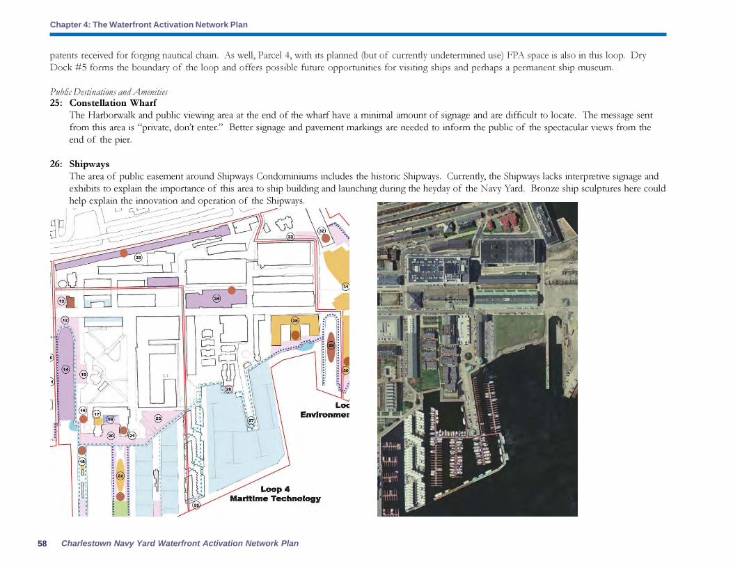
Charlestown Navy Yard Waterfront Activation Network Plan
Chapter 4: The Waterfront Activation Network Plan
58
25: Constellation Wharf
The Harborwalk and public viewing area at the end of the wharf have a minimal amount of signage and are difficult to locate. The message sent
from this area is “private, don’t enter.” Better signage and pavement markings are needed to inform the public of the spectacular views from the
end of the pier.
26: Shipways
The area of public easement around Shipways Condominiums includes the historic Shipways. Currently, the Shipways lacks interpretive signage and
exhibits to explain the importance of this area to ship building and launching during the heyday of the Navy Yard. Bronze ship sculptures here could
help explain the innovation and operation of the Shipways.
patents received for forging nautical chain. As well, Parcel 4, with its planned (but of currently undetermined use) FPA space is also in this loop. Dry
Dock #5 forms the boundary of the loop and offers possible future opportunities for visiting ships and perhaps a permanent ship museum.
Public Destinations and Amenities

59Community Partners Consultants, Inc.
Chapter 4: The Waterfront Activation Network Plan
27: Shipyard Quarters Marina
The Marina is the second-largest marina in the City of Boston. Currently the pier is used mostly
for marina activities and parking. Because parking lots can disrupt the continuity of the
Harborwalk, a clear pathway should be marked as Harborwalk for public access.
28: Parcel 4/Harborview Point
The BRA approved the construction of a 425,000-SF residential development known as Harborview
Point on Parcel 4, which should be completed in 2007. In addition to housing 224 residential
condominium units, the new development will add nearly 40,000-SF of ground floor retail and
restaurants uses which will help to activate the Navy Yard by serving visitors and residents alike.
The development also includes 92,500-SF of structured parking for 340 spaces. Additionally, 1.3
acres of open space will enhance the public realm. In addition, over 550 feet of Harborwalk with
pedestrian amenities such as benches, lighting, and landscaping will enhance the public realm. This
represents a major challenge because the findings of a BRA-commissioned retail demand analysis
indicate that there is not a strong retail market in this location. While it is not the perview of this
Plan, it is recommended that incentives be offered to the project proponent to re-allocate FPA
Parking is currently the primary use of this Shipyard
Quarters pier.
Dry Dock 5 currently exists as under-utilized space.
space to SPDF space in return for a
negotiated reduction in overall ground floor
public space. A SPDF in this location would
help the creation of a network of public
destinations on the waterfront to generate
the foot traffic necessary to support public
uses in this location. Thoughts on this
exchange of FPA for SPDF space are given
in the next section.
29: Dry Dock #5
Dry Dock #5 is in disrepair and its future
is uncertain. Given the Dry Dock’s
strategic location at Yard’s End and its
unique character, it is suggested that this
area be included in Story Loop #4 and be
a highlight of the maritime technology and

Charlestown Navy Yard Waterfront Activation Network Plan
Chapter 4: The Waterfront Activation Network Plan
60
Story Loop 5: The Environment
At the end of the Navy Yard stands Yard’s End, a
compelling site with great visibility both from and
of Boston Harbor. This Story Loop encompasses
Yard’s End and Building 114 and offers
opportunities for strong connections to the
cleanup of Boston Harbor. The Harbor is the
major destination here, along with public space
and destinations that will be required of future
development on parcels 5, 6 and 7. Possible
shuttle connections to Deer Island and the Boston
Harbor Islands can link environmental
programming to projects and sites across the
Harbor.
science theme of this area. The Dry Dock could be a major docking area for both permanent
and visiting vessels and it can serve to draw the public to this now-remote end of the Navy
Yard. The Dry Dock’s proximity adjacent to potential public gathering and open space in
future development at Parcel 5 fits well with the development of this area as a major destination
in the Navy Yard.
34: Chain Forge, Building 105
Reuse of this vacant building is being planned by the BRA but faces large obstacles including
environmental cleanup. The National Park Service is in possession of the chain forge
equipment and enough historical artifacts exist to prepare a full exhibit on the technology
advances made in this building. A special public destination facility (SPDF) here would support
the Story Loop 4 theme of technology and science and the BRA supports the public use of
approximately 20,000 SF of space in this structure for a museum and exhibit space.
35: Rope Walk, Building 58
The BRA is currently working on a grant to use this building for possible incubator space, including
artist studios. The unique nature of the Rope Walk makes it an ideal candidate for a special public
destination facility (SPDF) that ties current uses to the building’s historic role in the Yard’s rope
making operations. The BRA has earmarked approximately 7,000 SF in this building for a possible
museum.
Uses acceptable for FPAs, SPDFs and other public destinations
SPDFs:
� A Maritime Technology and Science Discovery Center that provides:
o Ship tracking stations for traffic in the harbor,
o Ship/boat identification exhibits and binocular stations,
o Navigation systems from sextants to GPS;
� Peabody-Essex Museum annex;
� Ship building and/or repair school such as one modeled after:
o on scale and model of IYRS in Newport, RI,
o Lowell Boat works in Merrimack Valley,
o Hull Lifesaving Museum;
� Ship models display/store;
� Sail loft;
� Artist in residency program in Chain Forge and/or Rope Walk Buildings (managed by ICA or
other arts institution);
� Ship and boat museums including permanent and temporary docking facilities:
o Warships, tugboats, sailing vessels, lobster boats and other fishing vessels. Parcels 4 and 5 in the Charlestown Navy Yard.
FPAs and other public destinations:
� Bunker Hill Community College.
Outdoor spaces:
� Harborwalk interactive sculpture that
explores the Story Loop theme.

61Community Partners Consultants, Inc.
Chapter 4: The Waterfront Activation Network Plan
Public Destinations and Amenities
30: Yard’s End Parcels 5 and 6/Spaulding Rehabilitation Facility
It is estimated that development on these parcels would require 35,000 square feet of FPA
space on the ground floor. It is suggested that a portion of this be required to be SPDF space
to help create the necklace of destinations along the waterfront. This parcel is also in a key
location to host a signature construction of some kind that draws attention to the waterfront
and creates a design statement at the Head of the Harbor.
31: Yard’s End Parcel 7
This parcel would be required to provide approximately 61,000 square feet of FPA space if
developed under current Navy Yard zoning. Again, required FPA space could be renegotiated
to include some SPDF space at this remote end of the Yard.
32: Building 114
Required FPA space in the building is vacant, but the building itself features public bathrooms,
an outdoor Bandsaw exhibit and indoor interpretive exhibit. These amenities make this an ideal
location for SPDF development, and the
empty FPA space could be converted to a
SPDF designation and filled accordingly.
33: Fifth Avenue and 16th
Street
This area is a transition area from the
Harborwalk to the historic area of the
Navy Yard, including the Rope Walk and
Chain Forge buildings. Interpretive
signage and public art should be included
in this area to direct visitors to other Navy
Yard sites of interest that are remote from
the waterfront.

Charlestown Navy Yard Waterfront Activation Network Plan
Chapter 4: The Waterfront Activation Network Plan
62
36: Chelsea Street Connection to Ryan Playground
A new connection across Chelsea Street that welcomes Charlestown residents to the Navy Yard
and encourages Navy Yard visitors to explore other Charlestown amenities along the waterfront
should be developed here to tie the environmental theme of Loop 5 to the outdoor, recreational
environment of neighboring Ryan Playground.
Uses acceptable for FPAs, SPDFs and other public destinations
SPDFs:
� Harbor/Environment Discovery Center with the following possible spaces/uses:
o Interactive displays and exhibits on unique features of the Harbor’s geology and marine
ecology
o Weather watch station
� Space for Save the Harbor/Save the Bay environmental partnership with Courageous Sailing:
fishing program, water quality monitoring…all happening in a more public way with signage
and public participation stations, harbor cleanup
� Space for non-profit advanced marine biology and aquaculture research and development
activities with possibilities for annexes or extensions of the following organizations and
institutions:
o Woods Hole Oceanographic Institute
o Boston Science Museum
o New England Aquarium
o New Bedford Whaling Museum
FPAs and other public destinations:
� Signature restaurant/catering hall and event space with water views (unlike any other space
currently found in Boston)
� Bunker Hill Community College extension and continuing education
� Lobster/fishing trips
� Sailboat rides
Outdoor spaces:
� Flexible open space that can be used for recreation as well as for public festivals and performances.
Space to be provided with electrical, water and data hookups.
� Interior space for storage for arts and performance groups using adjacent outdoor space
� Spray pond with ice skating in the winter
� Docking space and shuttle connection to Deer Island and Boston Harbor Islands with interpretive
displays on Harbor cleanup efforts and results
� Recreational uses (including skating and a summer spray pond) that link uses to Ryan Playground
north of the Tobin Bridge.
Requirements for Story Loops, SPDFsand FPAS
Each Story Loop in the Navy Yard should
contain:
•Harborwalk creation, marking and signage
•Major destination (SPDFs, FPAs)
•Minor destinations
•Public restrooms
•Food and dining opportunities
•Seating and dining furniture (for brown
baggers)
•Interpretive signage, exhibits, public art
•Shuttle stop/service (water and/or land)
•Gateway markings
•Identifying icons for loops (in signs and maps)
•Self-guided tours
In addition, two levels of requirements exist for
development and improvements (requirements
for each can be found on page 61):
Level One (mandatory for all)
•Harborwalk
•Special consideration for cultural, educational,
non-profit uses that create destinations in the
Yard (space build-out and/or free or subsidized
rent)
•Public restrooms, seating, dining furniture
•Interpretive signage, wayfinding
•Shuttle service support (land and/or water for
weekends and special events)
Level Two (a minimum to be provided based
on project particulars)
•Selected public art opportunities
•Maritime Interactive Park Elements
•Support for public gathering and event spaces
(electrical, water and data hookups)
•Additional interpretive signage and wayfinding
•Other (CNY gateway improvements,
marketing support, etc.)

63Community Partners Consultants, Inc.
Chapter 4: The Waterfront Activation Network Plan
The Harborwalk: A Vibrant Waterfront Trail
Currently, the Charlestown Harborwalk suffers from lack of clarity and connection between points of
interest along the waterfront. While interpretive signage is offered at select locations, the great majority
of the Navy Yard Harborwalk is devoid of consistent signage and wayfinding assistance, and lacks links
back to Navy Yard history. The Waterfront Activation Network Plan proposes that the Harborwalk be
a compelling path, both real and imagined, that moves along the waterfront to let people experience the
past, present, and future in many ways. As it weaves through the five Story Loops, the Harborwalk
highlights a series of “discoveries” along the waterfront, which the transient visitor might read as
chapters of the waterfront’s story. As the connecting spine to the Loops, the Harborwalk itself reads as
a “volume” existing as one part of a series that winds through Boston’s waterfront neighborhoods. To
act as this interpretive spine or “volume,” the Harborwalk should provide multiple kinds of experiences,
or lenses, for diverse audiences that offer visitors and residents views onto distant histories, current
context and everything in between. Interpretive signage, public art and public destinations are the
vehicles by which visitors may explore layers of waterfront and Navy Yard experiences including lenses
on the maritime, industrial, military, political, economic, social and scientific.
Harborwalk Clarity and Connectedness
To achieve Harborwalk clarity, it is proposed that the existing Harborwalk signs be adapted to include a
wayfinding addition at the bottom of the sign. Temporary signage is also recommended. In this way,
pedestrians will know where they are and where they are heading. Enhanced pavement markings are
also recommended. These signs and markings are illustrated and described in the section on signage
found later in this chapter. Connectedness should be improved by enhancing visual connections and
corridors with binocular stations and signature structures that signal the locations of major destinations
along the path.
Elements of the Harborwalk
In addition to signage and pavement markings, the Harborwalk will consistently need public amenities
to make it user-friendly and to encourage use by residents and visitors alike. These should be
supplemented by routine maintenance to keep the path welcoming and pleasant, especially during winter
months when snow must be plowed and the benches cleared. The amenities that should be provided
along the Harborwalk include:
� Seating options
� Picnic Benches
� Interpretive signage
� Binoculars at viewing stations with signage
� Plantings
� Trash receptacles and mutt mitt stations
for dog owners
� Heated outdoor spaces at buildings along
the Harborwalk
� Shade and wind shelters
� Strong focal features at the end of every
pier (public art is one possibility)
The existing Flags at Sea signage at the Navy Yard could
be expanded to include interactive signage and identification
games for Harborwalk visitors. Photo source: The Boston
Harbor Association (TBHA)]
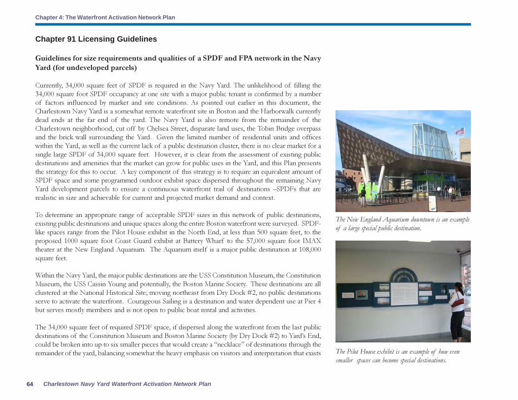
Charlestown Navy Yard Waterfront Activation Network Plan
Chapter 4: The Waterfront Activation Network Plan
64
Chapter 91 Licensing Guidelines
Guidelines for size requirements and qualities of a SPDF and FPA network in the Navy
Yard (for undeveloped parcels)
Currently, 34,000 square feet of SPDF is required in the Navy Yard. The unlikelihood of filling the
34,000 square foot SPDF occupancy at one site with a major public tenant is confirmed by a number
of factors influenced by market and site conditions. As pointed out earlier in this document, the
Charlestown Navy Yard is a somewhat remote waterfront site in Boston and the Harborwalk currently
dead ends at the far end of the yard. The Navy Yard is also remote from the remainder of the
Charlestown neighborhood, cut off by Chelsea Street, disparate land uses, the Tobin Bridge overpass
and the brick wall surrounding the Yard. Given the limited number of residential units and offices
within the Yard, as well as the current lack of a public destination cluster, there is no clear market for a
single large SPDF of 34,000 square feet. However, it is clear from the assessment of existing public
destinations and amenities that the market can grow for public uses in the Yard, and this Plan presents
the strategy for this to occur. A key component of this strategy is to require an equivalent amount of
SPDF space and some programmed outdoor exhibit space dispersed throughout the remaining Navy
Yard development parcels to ensure a continuous waterfront trail of destinations –SPDFs that are
realistic in size and achievable for current and projected market demand and context.
To determine an appropriate range of acceptable SPDF sizes in this network of public destinations,
existing public destinations and unique spaces along the entire Boston waterfront were surveyed. SPDF-
like spaces range from the Pilot House exhibit in the North End, at less than 500 square feet, to the
proposed 1000 square foot Coast Guard exhibit at Battery Wharf to the 57,000 square foot IMAX
theater at the New England Aquarium. The Aquarium itself is a major public destination at 108,000
square feet.
Within the Navy Yard, the major public destinations are the USS Constitution Museum, the Constitution
Museum, the USS Cassin Young and potentially, the Boston Marine Society. These destinations are all
clustered at the National Historical Site; moving northeast from Dry Dock #2, no public destinations
serve to activate the waterfront. Courageous Sailing is a destination and water dependent use at Pier 4
but serves mostly members and is not open to public boat rental and activities.
The 34,000 square feet of required SPDF space, if dispersed along the waterfront from the last public
destinations of the Constitution Museum and Boston Marine Society (by Dry Dock #2) to Yard’s End,
could be broken into up to six smaller pieces that would create a “necklace” of destinations through the
remainder of the yard, balancing somewhat the heavy emphasis on visitors and interpretation that exists
The New England Aquarium downtown is an example
of a large special public destination.
The Pilot House exhibit is an example of how even
smaller spaces can become special destinations.
65Community Partners Consultants, Inc.
Chapter 4: The Waterfront Activation Network Plan
in the western half of the Yard. In reality, SPDFs of 500-1000 square feet may make sense occasionally
in well-trafficked areas but it appears that a minimum size of approximately 2000-6000 square feet
should be the goal for Navy Yard destinations in order to obtain the exhibit space and/or public uses
that will draw people to the waterfront.
To summarize these recommended requirements, the chart below looks at the development parcels in
the Yard and shows current estimated FPA requirements based on build-out under HarborPark Zoning:
Parcel Total estimated development SPDF/FPA portion
Pier 5 application – 170,800 SF 34,000 SF SPDF/FPA
Parcel 4 - Haborview Point under construction 40,995 SF FPA
Parcel 5 no current plans – 175,000 SF (est.) 35,000 SF FPA
Parcels 6 & 7 - Spaulding approximately 305,000 SF (est) 61,000 SF FPA
Totals 170,995 SF
Total public destination space of: 170,995 square feet of FPA space on all remaining development
parcels. Of this total, 34,000 square feet is required to be SPDF-quality.
This Plan is charged by the Commonwealth of Massachusetts to develop a network of SPDF space
throughout the Charlestown Navy Yard waterfront. Allocating some of the 34,000 SF of required
SPDF space throughout all of the remaining development parcels (not including Parcel 4 - Harborview
Point which is close to completion)supports the Story Loop concept by achieving the goal of activating
the entire Navy Yard waterfront with compelling and unique destinations. Below is detailed description
of recommended SPDF/FPA requirements for remaining development as well as a map showing
recommended SPDF locations/sizes and outdoor spaces.
In the following recommendations, the allocated SPDF requirements are outlined and guidelines are
given for additional monetary contributions for the support and development of an Interactive Maritime
Park and SPDF network on open space on the Harborwalk or adjacent to the Harborwalk on the
development parcel in question, or at specified locations (shown on page 56). As this Interactive
Maritime Park is developed, dedicated indoor space (either FPA or SPDF) becomes even more necessary
to provide year-round spaces and activities that complement the outdoor exhibits. Thoughtful
development of this outdoor network is seen as a very visible complement to the interior space and a
critical component of creating a market for public uses in the Yard.

Charlestown Navy Yard Waterfront Activation Network Plan
Chapter 4: The Waterfront Activation Network Plan
66
The recommended sizes were determined by
reviewing existing SPDFs and SPDF-type spaces
along the waterfront and in the City of Boston
and an FPA study on commercial demand. These
sizes and quality/location requirements were also
determined with the following criteria in mind:
� Ideally, there should be a SPDF at the
end of every pier in the Navy Yard (either
interior space, Maritime Interactive
exterior park space, or both).
� SPDFs should be located at intervals that
allow visual continuity from one public
destination to the next.
� Smaller SPDFs create a powerful
network when clustered with other
smaller SPDFs to create a network that
supports the Story Loops.
� A SPDF need not be a large, freestanding
cultural facility. It could be a small exhibit
or public use that is tied to a network of
exhibits so the entire network becomes
a destination or a use that is unique or
site-specific enough to appeal to a wide
audience and activate the waterfront as a
destination.
� Additional monetary provisions should
be allocated to existing open space on
the Harborwalk or adjacent to the
Harborwalk to activate areas of the Yard
that currently have no public destinations.
These specific areas where SPDF improvements can be provided are:
� The expansion of Courageous Sailing.
� The foot of Dry Dock #2 which acts as a gateway from the National Historical Site to
the rest of the Navy Yard
� Dry Dock #2 Pump House
� The grade change and connection from Chelsea Street to the Harborwalk at the Little
Mystic and Ryan Street Playground connections
� The pedestrian tunnel and walkway across Chelsea street to uptown Charlestown
neighborhood
� Dry Dock #5 watersheet activation with historic vessel/floating museum
These guidelines are intended to create an interpretive network of public spaces that creates a unified sense of place at
the Charlestown waterfront and connects that waterfront back to the Charlestown neighborhood and to the City of
Boston.

67Community Partners Consultants, Inc.
Chapter 4: The Waterfront Activation Network Plan
SPDF Requirements
Project proponents must provide all SPDF space built-out and rent free, including utilities, for the
duration of the Chapter 91 license.
Pier 5
Uses: Seamanship exhibit, interior and exterior Interactive Maritime Park
Location/Quality: primary - end of pier in building, secondary - foot of pier in building. Also along
Harborwalk and end of pier
SPDF Goal: 2,000 square feet
A minimum of 2,000 SF is required to be at the end of Pier 5. This space could be available to
Courageous Sailing or the City’s Archeology program provided it is managed as a public facility with
basic SPDF amenities including bathrooms and interpretive signage or for another SPDF use.
Additional funds of $1.2 million will be contributed to enhance the Interactive Maritime Park and open
space network, which will be used for the following:
� $100,000 to a fund to restore Dry Dock #2 Pump House as a space for visitor
information, concessions, and transportation information.
� $100,000 to enhance Chelsea Street gateways to the Navy Yard through the provision
of public art and interpretive signage and wayfinding.
� $1 million to support existing cultural anchors and the overall Navy Yard SPDF
network and programing. This can include support for the creation of an Interactive
Maritime Park along the waterfront.
Parcel 4 / Harborview Point
Uses: Maritime Technology & Science exhibit (interior space only)
Location/Quality: interior of building along the Harborwalk
Current SPDF requirement: none
To encourage SPDF uses along the entire waterfront in efforts to build a strong public waterfront
network, it is recommended that changes be made to the regulations requiring the provision of FPA
space. It is recommended that the project proponent may have the option, in this project, to convert
up to the total required FPA space to SPDF space. The project proponent would be allowed to reduce
the total public space provided on the ground floor by a negotiated percentage (the recommended
maximum is 50%). For example, if a 50 % reduction in public space would be allowed, the project
proponent would provide the remaining space
as a SPDF. No additional FPA space would be
required. The SPDF space must be provided built-
out and rent and utility free for the duration of
the Chapter 91 license. It is also recommended
that to take advantage of this public space
reduction, the project proponent must provide a
minimum of 8,000 SF of SPDF for a single use/
tenant. All FPA and SPDF space must be provided
along the Harborwalk. This option, while not
under the purview of this Waterfront Activation
Network Plan, is recommended as an incentive
for developers to work closely with the City of
Boston and a possible Navy Yard Partnership to
identify suitable SPDF tenants and uses for
waterfront development.

Charlestown Navy Yard Waterfront Activation Network Plan
Chapter 4: The Waterfront Activation Network Plan
68
Parcel 5Uses: Environment and the Harbor exhibit, maritime interactive park, trade school, university continuing
education facility or extension school, performing arts, public function or signature public space, yacht
or boat restoration school/facility
Location/Quality: primary – along Dry Dock #5 and at the Head of the Harbor
SPDF Goal: 6,000 square feet
In addition to SPDF space, outdoor public gathering and event space will be provided along the
remainder of Dry Dock #5 and along the Harborwalk. $650,000 and any additional annual subsidy
payments required by the Department of Environmental Protection for extended license terms would
support the creation of an Interactive Maritime Park in the following ways:
� Funds for Dry Dock #5 activation in the form of support for a historic vessel/floating
museum..
� Funds to enhance Chelsea Street gateways to the Navy Yard through the provision of public art
and interpretive signage and wayfinding.
� Funds to support the overall Navy Yard SPDF network and programing. This can include
support for the creation of an Interactive Maritime Park along the waterfront.
SPDF space must be provided at the end of Parcel 5 at the Head of the Harbor and along Dry Dock
#5.
Parcel 6 / Spaulding Rehabilitation FacilityUses: Environmental and Harbor exhibit, maritime interactive park
Location/Quality: primary - end of First Avenue view corridor, along pedestrian pathways connecting
the site and existing pedestrian paths in the Navy Yard to the Harborwalk and along the Harborwalk
Current SPDF requirement: none
The BRA is continuing its development review process currently in the urban design phase for the
construction of a 240,000-SF 150-bed inpatient rehabilitation facility. The Spaulding Rehabilitaion
Facility will include a gymnasium, therapy rooms, and the SRH’s innovative Charles H. Weingarten
Adaptive Sports and Recreation Program. This program encourages patients to participate in sports
and activities including canoeing, rowing, kayaking, sailing, paddleboating, and windsurfing. The location
of this sports therapy and recreation program along the Harbor at the Navy Yard’s End will make
active use of the waterfront and watersheet. The facility will also include 300 parking spots. Construction
is anticipated to start in 2008. Various suggestions for enhancing the Spaulding Rehabilitation Facility
from community organizations and local non-profits such as The Boston Harbor Association have
included:
� Enhancing the water-dependent use of the
proposed Charles H. Weingarten Adaptive Sports
and Recreation Program by: (a) pursuing an
exemption to the Harbor Line at that location,
similar to the legislation which permitted the boat
dock on the Charles River at the existing hospital
site; (b) seeking approval to conduct the
Weingarten program at the BRA’s Dry Dock on
Parcel 5; and (c) interim use by collaborating with
Courageous Sailing Center to conduct sailing
programs from the Courageous dock, perhaps
storing the Hospital’s specially-designed
watercrafts at the Courageous dock and bringing
Spaulding patients by van to the Courageous
facility.
� Incorporating universal design into the
Harborwalk in order to make the Hospital’s
Harborwalk a model for 21st century
development on the waterfront. Examples of
universal design elements include a Braille and/
or audio handrail system, tactile interpretive
displays on glass, and wayfinding elements along
the Harborwalk which help guide users with
disabilities.
Parcel 7Uses: Environment and the Harbor exhibit,
maritime interactive park, trade school, university
continuing education facility or extension school
Location/Quality: primary – along pedestrian
pathways connecting the site and existing
pedestrian paths in the Navy Yard to the
Harborwalk and along the Harborwalk
SPDF Requirement: 4,000 square feet
SPDF space to support the new network of
public uses along the Navy Yard waterfront will

69Community Partners Consultants, Inc.
Chapter 4: The Waterfront Activation Network Plan
perfected for production in 1926. Die-lock chain
was the strongest chain ever produced and for
the next five decades, most of the anchor chain
use by Navy ships was made in the Chain Forge.
The historic reuse of the building will ensure that
the building’s history is preserved. The
monumental scale of the building lends itself well
to commercial, residential, or institutional uses or
a combination of uses.
Extended License TermThe BRA requests that the Commonwealth of
Massachusetts Department of Environmental
Protection (DEP) consult with the City regarding
implementation of the Charlestown Navy Yard
Waterfront Activation Network Plan and the Boston
Inner Harbor Passenger Water Transportation Plan as
the basis for an extended license term.
If DEP determines that additional public benefits
above those directly provided through the
implementation of the Network Plan are required
for extended license terms, such benefits should
be directed to support the Waterfront Network
Fund and the Maritime Interactive Park as
referenced in the Charlestown Navy Yard Waterfront
Activation Network Plan. Such benefits should also
be applied to support water transportation
service, including subsidies, in the Charlestown
Navy Yard. Such benefits may be provided in
be provided built-out and rent free, including utilities, for the duration of the Chapter 91 license.
Building 114Uses: Environment and the Harbor exhibit, maritime interactive park, museum
Location/Quality: existing FPA space
SPDF Requirement: 3,500 square feet
The existing FPA space in Building 114 will be converted to SPDF space to support the new network
of public uses along the Navy Yard waterfront. This space will be provided built-out and rent free,
including utilities, for the duration of the Chapter 91 license.
Ropewalk / Building 58
Uses: Historical and Harbor exhibit, artist live/work space, cultural and civic organizations, maritime
interactive park, trade school, university continuing education facility or extension school
The BRA is working with a local architect to devise potential redevelopment schemes for architect
Alexander Parris’ best-known building, the quarter-mile long 33,000-SF Ropewalk Building, which was
built in 1837. The reuse of the building could potentially include artists’ work space as well as office
space for cultural and civic organizations. This historic building was where the Charlestown Navy Yard
manufactured most of the cordage for over a hundred years that was used by Navy ships ranging in
size from destroyer escorts to aircraft carriers. The BRA’s plans for redeveloping the building will
ensure that the rehabiliation and reuse of the building will preserve the architectural and historic character
of the building as well as allow for the general public’s continued enjoyment of it.
The redevelopment schemes also include enhancing the public realm and pedestrian experience along
Flirtation Walk as well as highlighting its history. The Flirtation Walk was a landscaped boardwalk which
was built in the 1890s and that followed a line of mature trees south of the Ropewalk Building. The
boardwalk was the connecting walkway between gate 4 and the lower yard officers’ quarters. Flirtation
walk remained until World War II, when buildings 31, 108, and 120 were expanded. In addition, the
redevelopment of the Ropewalk will include approximately 6,000 square feet of exhibit space highlighting
the ropemaking process and its importance to the maritime uses of the Yard.
Chain Forge / Building 105
Uses: Historical and Harbor exhibit, maritime interactive park, trade school, university continuing education
facility or extension school
The BRA is working toward devising potential redevelopment schemes that will incorporate the historic
machinery within the envelope of the 20,000-SF Chain Forge building and allow it to remain open to
the public. The Chain Forge was built in 1904 and is where die-lock chain technology was invented and

Charlestown Navy Yard Waterfront Activation Network Plan
Chapter 4: The Waterfront Activation Network Plan
70
SPDF Requirements Summary Chart
Site SPDF FPA Additional Funds forFPA req’mt req’mt SPDF network
Pier 5 0 2,000 32,000 $1.2 million and free SPDF build out, rent and utilities
FPA is estimated as no development is pending:
Parcel 5 35,000 6,000 29,000 $650,000 plus annual subsidy (see “Extended License Term”, above)
and free SPDF build out, rent and utilities
Parcel 7 61,000 4,000 57,000 Free SPDF build out, rent and utilities
Bldg 114 3,500 3,500 none Free SPDF build out, rent and utilities
Ropewalk 0 7,000 26,000 Subsidized artists’ work space and free SPDF build out, rent
and utilities
Chain Forge 0 20,000 none Free SPDF build, rent and utilities
Totals 99,500 42,500 144,000 $1.85 million and free SPDF build out, rent
and utilities
This SPDF network plan and requirements provides for 186,500 SF of public ground floor space along the waterfront in these six development
parcels. In addition, all SPDF space in the Navy Yard must be provided by project proponents built out and rent free, including utilities
to ensure affordability by cultural and non-profit uses and to increase the likelihood these spaces will be filled with special public destinations
that activate the waterfront.
the form of an annual subsidy subsequent to the granting of a Chapter 91 License.
Summary of Possible SPDF/FPA Build-Out Scenarios
The chart on the next page shows possible SPDF/FPA scenarios. Upon full build-out of the Navy Yard, using approximate estimations for FPA requirements
for some parcels, projects could have the following amounts of SPDF and FPA space with the designated funds used to support the overall Navy Yard
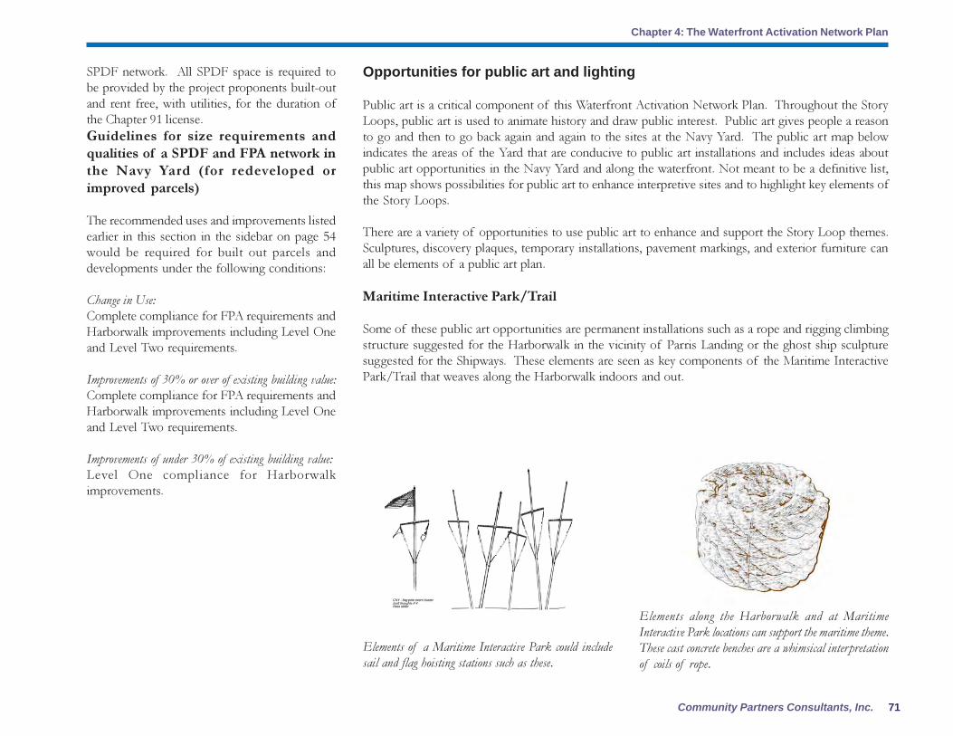
71Community Partners Consultants, Inc.
Chapter 4: The Waterfront Activation Network Plan
Opportunities for public art and lighting
Public art is a critical component of this Waterfront Activation Network Plan. Throughout the Story
Loops, public art is used to animate history and draw public interest. Public art gives people a reason
to go and then to go back again and again to the sites at the Navy Yard. The public art map below
indicates the areas of the Yard that are conducive to public art installations and includes ideas about
public art opportunities in the Navy Yard and along the waterfront. Not meant to be a definitive list,
this map shows possibilities for public art to enhance interpretive sites and to highlight key elements of
the Story Loops.
There are a variety of opportunities to use public art to enhance and support the Story Loop themes.
Sculptures, discovery plaques, temporary installations, pavement markings, and exterior furniture can
all be elements of a public art plan.
Maritime Interactive Park/Trail
Some of these public art opportunities are permanent installations such as a rope and rigging climbing
structure suggested for the Harborwalk in the vicinity of Parris Landing or the ghost ship sculpture
suggested for the Shipways. These elements are seen as key components of the Maritime Interactive
Park/Trail that weaves along the Harborwalk indoors and out.
Elements of a Maritime Interactive Park could include
sail and flag hoisting stations such as these.
Elements along the Harborwalk and at Maritime
Interactive Park locations can support the maritime theme.
These cast concrete benches are a whimsical interpretation
of coils of rope.
SPDF network. All SPDF space is required to
be provided by the project proponents built-out
and rent free, with utilities, for the duration of
the Chapter 91 license.
Guidelines for size requirements and
qualities of a SPDF and FPA network in
the Navy Yard (for redeveloped or
improved parcels)
The recommended uses and improvements listed
earlier in this section in the sidebar on page 54
would be required for built out parcels and
developments under the following conditions:
Change in Use:
Complete compliance for FPA requirements and
Harborwalk improvements including Level One
and Level Two requirements.
Improvements of 30% or over of existing building value:
Complete compliance for FPA requirements and
Harborwalk improvements including Level One
and Level Two requirements.
Improvements of under 30% of existing building value:
Level One compliance for Harborwalk
improvements.

Charlestown Navy Yard Waterfront Activation Network Plan
Chapter 4: The Waterfront Activation Network Plan
72
Taking advantage of a variety of public art opportunities is essential for creating a coherent interpretive experience in the Charlestown Navy Yard. The Charlestown waterfront’s rich
history and beautiful setting create the potential for a dense network of public art that ties together the five Story Loops.

73Community Partners Consultants, Inc.
Chapter 4: The Waterfront Activation Network Plan
First Avenue
Because the Story Loops seek to connect the existing public realm of First Avenue to
the Harborwalk and to draw people to the waterfront, public art opportunities are
highlighted along this street as a means of developing “gateways” to the Story Loops
and waterfront. The map shows suggestions including a knot wall display, sail shape
display (flapping fabric) and some seats and benches in boat shapes.
Public Gathering/Temporary Installations and Programming
Temporary installations and gatherings are a way that public art can help keep the Yard
vibrant and dynamic. Sites like those at the end of Pier 4 and on Parcel 5 at Yard’s End
would be ideal places to provide space for temporary opportunities such as art
installations or public events or festivals. While these are site-specific recommendations,
other temporary public art opportunities capture synergy from artist residencies and
public programming. These opportunities could have homes throughout the Navy
Yard and might include an artist-in-residence program like the current Vita Brevis
program co-sponsored by the Institute for Contemporary Art and the National Park
Service, new artist studio space in the Rope Walk, educational programs as part of
Bunker Hill Community College or other educational institutions.
Public art opportunities can also expand to include water shuttle service that connects
the Navy Yard waterfront to other cultural venues, such as the ICA, Kennedy Library,
and Aquarium.
Lighting
Lighting is a key component of the public art and activation strategies for the Navy
Yard. Goals for lighting in the Yard include:
� Use of existing light towers to create an identity for the CNY on and across the
waterfront.
� Nighttime lighting that ties the National Historic Park to the rest of Navy Yard
and creates a “light” event in the CNY.
� Use of lighting to highlight the remaining marine-industrial armature or
infrastructure along the Harborwalk.
Public art can provide support for the Story Loops by introducing new
elements into the public’s experience as well as by using historical elements,
such as the bandsaw used at Building 114, to tell the story of the Navy
Yard. Source: TBHA.
There are various techniques that can be used to accentuate the light towers
and call attention to the marine infrastructure of the Navy Yard. These
photos illustrate possibilities that include lighting the end of the piers with
lights that indicate the pier numbers across the harbor (but don’t reflect back
into the Navy Yard and create glare for residential uses) and special lighting
to be used during events and public gatherings.

Charlestown Navy Yard Waterfront Activation Network Plan
Chapter 4: The Waterfront Activation Network Plan
74
The NPS has completed a lighting plan for the National Historical Park. This Plan should be studied
and extended to include the entire Navy Yard, and indeed, Tudor Wharf and Hoosac Pier as well.
Specific examples of lighting opportunities include using the light towers on Pier 3 along Baxter Road
and at the ends of Piers 4 and 6 to create signature elements for the Navy Yard to be enjoyed from the
Yard and from across the Harbor.
Other marine infrastructure that can be accentuated with lighting includes the cranes in the Navy Yard.
and the piers and dry docks.
Existing light structures can also be used as armatures for light nets that can be used to imply the
presence of “ghost ships” in the Yard, alluding to the early days of the Yard and the building of sailing
ships such as the Constitution.
Special lighting can be used to highlight the marine-industrial infrastructure of the Yard both on a nightly basis and for special events.
The three light towers on Baxter Road, adjacent to Dry Dock #2, could play host to a light net that implies the presence of the masts and rigging of a ghost ship in the Yard. This light
net technique can be used at other locations along the Waterfront, perhaps at Shipways and Dry Dock #5, to support the interpretive signage and Story Loops.
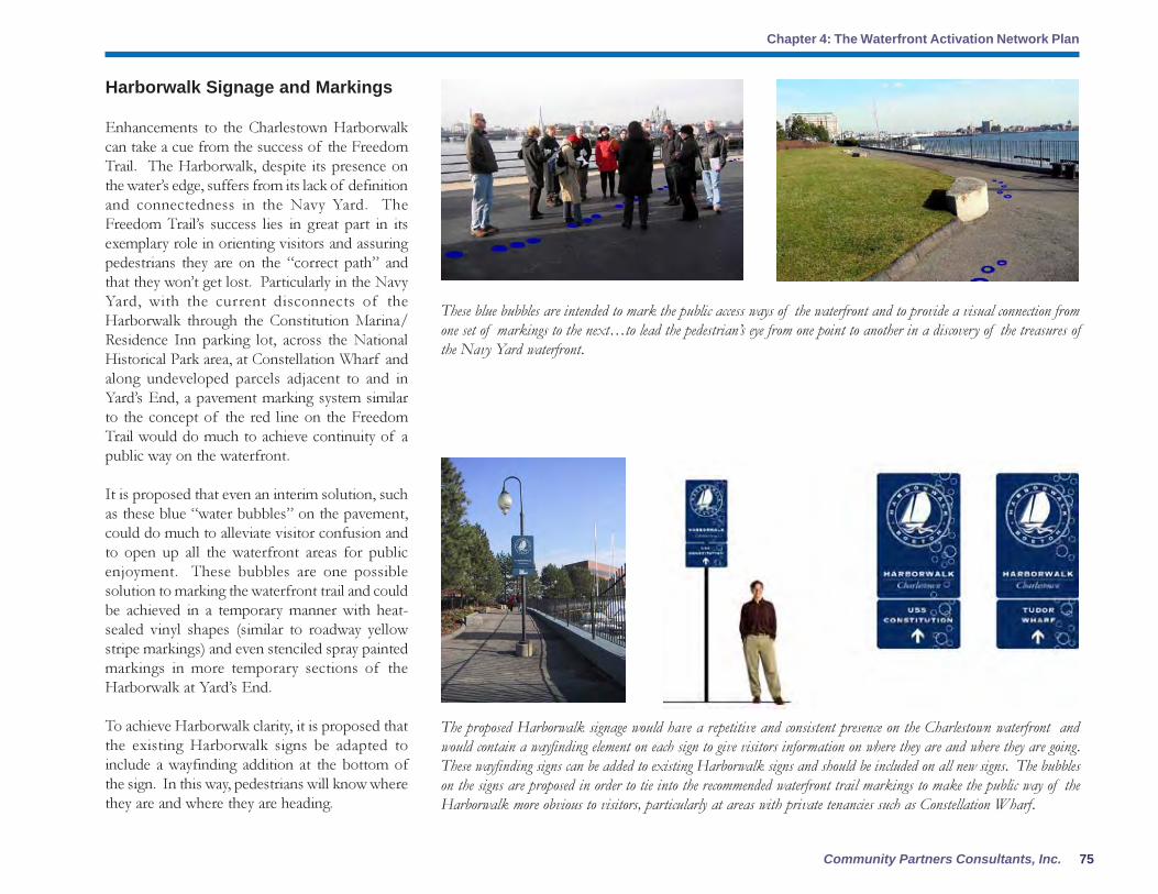
75Community Partners Consultants, Inc.
Chapter 4: The Waterfront Activation Network Plan
Harborwalk Signage and Markings
Enhancements to the Charlestown Harborwalk
can take a cue from the success of the Freedom
Trail. The Harborwalk, despite its presence on
the water’s edge, suffers from its lack of definition
and connectedness in the Navy Yard. The
Freedom Trail’s success lies in great part in its
exemplary role in orienting visitors and assuring
pedestrians they are on the “correct path” and
that they won’t get lost. Particularly in the Navy
Yard, with the current disconnects of the
Harborwalk through the Constitution Marina/
Residence Inn parking lot, across the National
Historical Park area, at Constellation Wharf and
along undeveloped parcels adjacent to and in
Yard’s End, a pavement marking system similar
to the concept of the red line on the Freedom
Trail would do much to achieve continuity of a
public way on the waterfront.
It is proposed that even an interim solution, such
as these blue “water bubbles” on the pavement,
could do much to alleviate visitor confusion and
to open up all the waterfront areas for public
enjoyment. These bubbles are one possible
solution to marking the waterfront trail and could
be achieved in a temporary manner with heat-
sealed vinyl shapes (similar to roadway yellow
stripe markings) and even stenciled spray painted
markings in more temporary sections of the
Harborwalk at Yard’s End.
To achieve Harborwalk clarity, it is proposed that
the existing Harborwalk signs be adapted to
include a wayfinding addition at the bottom of
the sign. In this way, pedestrians will know where
they are and where they are heading.
These blue bubbles are intended to mark the public access ways of the waterfront and to provide a visual connection from
one set of markings to the next…to lead the pedestrian’s eye from one point to another in a discovery of the treasures of
the Navy Yard waterfront.
The proposed Harborwalk signage would have a repetitive and consistent presence on the Charlestown waterfront and
would contain a wayfinding element on each sign to give visitors information on where they are and where they are going.
These wayfinding signs can be added to existing Harborwalk signs and should be included on all new signs. The bubbles
on the signs are proposed in order to tie into the recommended waterfront trail markings to make the public way of the
Harborwalk more obvious to visitors, particularly at areas with private tenancies such as Constellation Wharf.

Charlestown Navy Yard Waterfront Activation Network Plan
Chapter 4: The Waterfront Activation Network Plan
76
As changes are made in public pathways,
temporary signage should also be employed to
redirect pedestrians along the Harborwalk.
Specifically, the area of the Harborwalk that has
been cut off between Hoosac Stores and the USS
Constitution, because of post-9/11 security
concerns, should have temporary signage in place
to transform this area from a confusing junction
to a clear path for visitors.
These temporary signs can also be used during
public events, times when visiting ships are docked
in the Navy Yard, and special festivals to direct
visitors to venues and along modified pedestrian
routes.
Interpretive Signage
Currently, most interpretive signage is located in
the National Historical Park. Interpretive signage
in the form of panels, signs, discovery trails, public
art elements and maps/brochures is needed
throughout the Yard to inform visitors of the
history of the Yard and its relationship to the City
of Boston and the Harbor. It is recommended
that Chapter 91 licensing require interpretive
exhibits in public areas of buildings such as
lobbies, waiting areas and public-use conference
rooms. Signage should also be required along the
Harborwalk and at outdoor gathering spaces and
public entrance points. It is suggested that a logo
or icon be developed for each Story Loop and
that these standard graphics be used on
interpretive signs to inform the visitor of which
Story Loop he or she is in at the moment.
In addition to traditional signs, maps and
brochures of the Navy Yard and individual Story
Temporary signage in the form of sandwich boards can be employed to redirect pedestrians where construction work is
underway or where there are other temporary deviations in the public waterfront pathway.
Standardized interpretive signage along the Harborwalk and throughout the Navy Yard can give a sense of order to the
visitor experience and help to illustrate the Story Loops. These suggestions for panoramic interpretive signs along the
Harborwalk emphasize the role of the Navy Yard in the commerce, trade, culture and recreation of the entire city.

77Community Partners Consultants, Inc.
Chapter 4: The Waterfront Activation Network Plan
Loops will play an important role in the visitor experience. These maps should be exhibited on panels
at key places in the Yard such as gateways from First Avenue and the Harborwalk to each Story Loop
and should also be available in printed form at visitor centers in the Yard.
Navy Yard Wayfinding
A standardized wayfinding system in the Navy Yard can eliminate sign clutter, support the visibility of
Yard businesses and point visitors toward the Story Loops and specific public destinations. It is proposed
that the wayfinding system consist of simple black and white signs that echo the industrial character of
the Yard by using industrial fonts and simple fastening systems to avoid clutter. Signs should be attached
to existing structures wherever possible to avoid the installation of numerous sign poles throughout the
Yard.
In addition to being located at the major thresholds at Gates One, Four and Six, and destinations,
wayfinding signs should also be provided at major intersections throughout the Yard. Signs intended to
guide drivers should be larger and emphasize locations of parking, Story Loops and major destinations.
Those geared toward pedestrians may be smaller and more detailed.
A complete pedestrian map showing all public destinations and amenities such as restrooms should be
provided at Yard visitor centers and on panels at key gateways to the Yard. Transition areas such as Dry
Dock #2 should also have panels showing a complete map of the Yard. The maps produced by
WalkBoston are good examples of a user-friendly format and design that can open hidden treasures in
the Yard to visitors and workers alike.
Navy Yard Gateway Signage and Markings
There are four major types of Gateways to the Yard and all suffer from lack of clarity and an inviting
design:
Auto gateways along Chelsea Street
The Navy Yard is separated from Chelsea Street by a brick wall and entrance “gates.” While the gates
are simply openings in the wall, they hearken back to a time when workers poured into the yard at these
points. As with the buildings throughout the Yard, the gates are numbered and people in the Yard still
refer to these numbers. Large numbers at each gate could be one way to mark the Yard entrances.
Wayfinding signs should be simple and clear so as not to
compete with interpretive and gateway signage. The simple
fonts of the marine-industrial infrastructure of the Yard
should be used as a guide in the creation of a wayfinding
system.
Wayfinding signs should be attached to existing structures
wherever possible and should be simple in design to provide
visitors with a recognizable system to locate businesses and
destinations throughout the Yard.

Charlestown Navy Yard Waterfront Activation Network Plan
Chapter 4: The Waterfront Activation Network Plan
78
Pedestrian gateways along the Freedom Trail
and across Chelsea Street into the Yard
Pedestrians use mostly the same gateways as autos
with the exception of Gate One which is for
pedestrian use only. All entrances would benefit
from better signage indicating the gate number
and the Navy Yard. In addition, the entrance to
the National Historical Park at Gate One along
the Freedom Trail would benefit from a redesign
to soften the harsh image now presented by chain
link fence and concrete barriers. At all gateways,
signage showing an entire map of the Navy Yard
and the Story Loops should be installed for
pedestrians.
Pedestrian gateways pose a particular challenge
for uptown Charlestown residents who are cut
off from the Yard by vehicular and structural
barriers. The two main pedestrian links under
the Tobin Bridge overpass are bare environments
devoid of signage. In each case, the addition of
interpretive signage celebrating the contribution
of Charlestown residents to the day-to-day
wartime workings of the Navy Yard and maps
that connect activities within the Navy Yard to
those nearby in Charlestown, such as community
gardens and “Little Montego Bay” would help
establish greater connections. The installation of
public art that links the residential neighborhood
across Chelsea Street to the Yard could go a long
way to welcoming residents to the Yard and
informing visitors of important historical
connections.
Water gateways at the landing dock in the
NHP and at the T Shuttle landing on Pier 4
As development occurs on the remaining Navy
Yard parcels and as public destinations are
The two major pedestrian connections under the Tobin
Bridge overpass from uptown Charlestown to the Navy
Yard are bleak environments. Public art and interpretive
signage such as these found at the Cambridge Public
Library could improve these connections and help establish
the waterfront as the “neighborhood’s waterfront.” Source:
TBHA
Marking the pedestrian pathways from the residential areas of Charlestown to the Navy Yard can be accomplished in
numerous ways. These sketches illustrate some possibilities for creating user-friendly connections including the addition
of model ship sculptures, interpretive signage, and possible life-size statues of World War II workers walking to the
Navy Yard with lunch pails and tools, ready to begin another day of shipbuilding. These statues could meander from
the residential areas across Chelsea Street and into the Yard at key points – creating fascinating points of visual and
historical interest.
The T water shuttle dock at Pier 4 has the potential to be a
major gateway to the Yard. Better signage, including a public
art installation, can make it an icon on the waterfront and
easier to find for commuters and visitors.

79Community Partners Consultants, Inc.
Chapter 4: The Waterfront Activation Network Plan
provided, the importance of water shuttle
connections for commuters, visitors and tour
boats will grow over time. The points marking
these water gateways should be clearly marked
on pedestrian and city maps and can be physically
marked with public art and large-scale signage –
offering visual interest from the water and across
the Harbor at key points.
Electronic gateways, such as web sites
Current web sites for the Freedom Trail and
National Park Service highlight selected areas of
the Navy Yard but no single web site exists that
highlights the history of the entire Yard. More
detailed information is provided in Chapter 5
Implementation that discusses the importance of
an overall organizing entity to coordinate the many
aspects of the Yard. One such task would be the
creation and maintenance of a web site that would
introduce the Yard to visitors and provide
information on the Story Loops, special events,
walking tours and all public destinations. Other
web sites would be linked to this main Navy Yard
web site.
Programming
A key component of this Waterfront Activation Network Plan is public programming. A new Navy
Yard organization will be responsible for programming public events and coordinating special exhibits
and performances in the Yard. The public programming component of the Activation Plan will always
be an important element of the Navy Yard but is critically important in the near future; the lack of a
network of public destinations calls for programmed events to raise public consciousness about the
Yard and to create a market for other uses in the Yard that will grow support for more permanent public
destinations.
Programming tasks include everything from the development of age-appropriate curriculum guides
for school children, creation of audio tours such as acoustic-guides (on MP3 players or by cell phone
access), to the planning of historical reenactments and outdoor performances and festivals. Programming
could also include temporary plans to fill vacant FPA space with “storefront artists” such as what is
being done in Pittsfield, MA and Downtown Crossing, Boston. Additionally, special sites throughout
the Yard could be designated at various times for artist “hacks” or events/installations.
The NPS is seen as a critical partner for programming in the Navy Yard and future endeavors should
support and continue efforts over the years that have allowed performing arts ventures in the Yard such
as:
� Handel & Haydn Society (Handel’s Music for the Royal Fireworks)
� Boston Academy of Music (HMS Pinafore) (South Pacific)
� Boston Landmarks Orchestra (South Pacific)
The Story Loops provide ample framework for the organization of special events including a possible
ice festival in Story Loop #1. This event might be called the Ice King Festival and could be held on or
near January 22nd
. According to the journal of Fredrick Tudor, the Ice King, this day was the coldest
day in 1828, and a turning point in his business that year. There are many such opportunities to link
public programming to historical events in the Yard.
Temporary programming can draw the public to the
waterfront like this gathering at Long Wharf for an
impromptu dance performance.

Charlestown Navy Yard Waterfront Activation Network Plan
Chapter 4: The Waterfront Activation Network Plan
80
Transportation and Parking
With the growth of public destinations in the Yard over time, limited public parking and nearby public
transportation will create the necessity to provide alternate plans for Yard visitors. Currently, special
events such as musical performances or Harbor festivals create traffic and parking congestion in the
residential areas surrounding the Yard. These have been isolated incidents thus far because of the
limited number of major events. However, as the success of the public network plan grows, a plan for
parking and transportation must be in place to meet public demand and maintain quality of life for
Navy Yard and uptown residents and businesses.
The parking and transportation plan for the Navy Yard has three components:
� Public parking provisions
� Shuttle service between T stations and the Yard
� Enhanced water shuttle service during weekends and/or special events
These two BRA-owned lots near the Navy Yard on
Terminal Street could be used for public parking during
weekends and special events.
The limited number of public parking spaces in
the Navy Yard requires the identification of
supplemental parking areas for use during
weekends and special events. Two BRA-owned
lots on Terminal Street could be used for overflow
parking on weekends and during special events.
These lots contain a public boat ramp and one
of the lots is currently subleased to Massport for
the Boston Auto Port. While these lots are close
to Gates 5 and 6 in the Yard, it is recommended
that shuttle service be provided to points
throughout the Yard in continuous loops on the
weekends.

81Community Partners Consultants, Inc.
Chapter 4: The Waterfront Activation Network Plan
Marinas and Transient Docking:
Constitution Marina at Tudor Wharf
Despite the fact that Tudor Wharf built out berths
specifically designated for transient docking, most
of these have been taken over by the marina for
permanent docking of boats. This is a critical
gateway to the eastern-most portion of the
Charlestown Waterfront, and it is important to
maintain transient berths so the public can access
the Harborwalk and waterfront from the waterside
as well as landside. This is particularly important
because automobile parking is scarce in the Yard.
Shipyard Quarters Marina
This marina is located at Piers 6 and 8, but its
presence makes Piers 5 and 7 useless for boat
docking of large ships because it needs the
navigation room to get smaller boats out. This
limits the possibilities for watersheet activation
on those piers.
Visiting Ship Berths/Docks:
National Park Service
Ideally visiting ships would be able to dock at the
end of Pier 1. This may not be possible because
of the security restrictions of the US Navy.
Pier 2 and Pier 3
These piers are also affected by the Navy’s security
restrictions. The 300 -foot security zone around
the USS Constitution, enacted by the US Navy as
part of the Homeland Security initiative, would
impact Pier 2 if the Constitution were moved to
the end of Pier 1. Pier 3, built over filled tidelands,
is currently closed to the public because of
deterioration.
Watersheet activation
The Navy Yard’s greatest asset is the water, and successful activation of the landside public realm must
be coordinated with existing and enhanced activation of the surrounding watersheet. With the second-
largest marina in Boston, and the USS Constitution, the Navy Yard already has an active watersheet, but
its uses are not currently coordinated to support existing or potential activation of the landside public
realm. The Yard’s unique location at the mouths of both the Charles and Mystic Rivers and its three
Dry Docks give it a surprising mix of watersheet characteristics from the locks of the Charles to the
Mystic Channel to the open Harbor to the protected waters of the Dry Docks, and this allows for a
variety of potential uses.
Permanent Ship Berths:
Pier 1
The USS Constitution is a major tourist draw, but it also continues to be run and maintained by the US
Navy, and its location has created a security challenge post 9-11. As large swaths of Pier 1 have been
closed to the public, the public realm of the Pier has become more confusing and uninviting. If the
Constitution’s location were switched with that of the USS Cassin Young, the Navy would be better able to
secure its operations without greatly impacting the public’s experience of the Yard.
Dry Dock #5 at Yard’s End
Dry Dock #5 could potentially be a permanent berth for a new ship that could act as a major tourist
destination at the farthest edge of the Yard.
Free shuttle service can also run between the Navy Yard and Haymarket and Community College “T”
stations. This service can be funded by contributions from developers and Navy Yard tenants and can
be provided by a private transportation service such as Patriot or Paul Revere. It may also be possible
to continue MGH shuttle service on weekends to provide transportation links between North Station
and the Yard for visitors.
The Navy Yard web site (to be developed) and National Park Service sites should highlight the existence
of the lots and of the T Station shuttle links. All promotional literature for public destinations and
special events should also clearly state that public parking in the Yard is limited and should highlight
remote parking and T shuttle connections whenever possible.

Charlestown Navy Yard Waterfront Activation Network Plan
Chapter 4: The Waterfront Activation Network Plan
82
Pier 4
This Pier might be a potential location for visiting ships on the side opposite from Courageous Sailing’s
docking area. The BRA has an agreement with the US Navy to dock vessels there and it intends to
dredge this area.
Parcel 4
Visiting boats may be able to dock in front of Parcel 4 between Pier 8 and Dry Dock #5. The front of
Pier 11 might also be used if it does not interfere with navigation from Little Mystic Channel and
Mystic Pier (MassPort).
Dry Dock Usage:
NPS Dry Dock #1
This Dry Dock should be leased for active dry dock usage to keep that aspect of the Navy Yard’s
working waterfront alive. Pre-arranged public viewings and tours of the Dry Dock will allow the public
to learn about the Yard’s history as a center of boat building and repair and will connect waterside and
landside uses.
Dry Dock #2
This Dry Dock is owned by the BRA and is part of Shipyard Park. It should be restored and either
leased to berth small vessels or for boat demonstrations. If it is used only temporarily, other temporary
recreational and/or educational uses could also help keep the space activated. The protected waters
make the Dry Dock an ideal space for kayaking and/or boat demonstrations and instruction.
Dry Dock #5
If necessary repairs are made to Dry Dock #5, it could berth permanent or visiting vessels and
complement a landside destination with watersheet activity.
Commuter/Tour Boats:
NPS Harbor Island Tours
The Harbor Islands are a major destination on the Boston Harbor. The National Park Service could run
tours from Pier 3 to the Islands to connect the Navy Yard to the wider Harbor (taken from NPS Master
Plan).

83Community Partners Consultants, Inc.
Chapter 5: Making it Happen: Implementa-tion
The Recommendations highlighted in the previous
chapter offer a conceptual framework for the creation of
a vibrant Charlestown Navy Yard waterfront. These
recommendations represent careful consideration of
previous planning efforts in the Navy Yard and also
take into account the current Municipal Harbor
planning process and input during public meetings in
Charlestown.
Clearly there is no shortage of creative ideas for
waterfront activation. To be successful , a rational and
clear road map must clearly define the goals to be
achieved. Turning this Waterfront Activation Network
Plan into reality will involve concerted effort among all
parties who have participated in its evolution to date. In
this regard, the BRA will continue to provide support
for the further coordination and collaboration of all
stakeholders. To assist this effort as it moves forward,
some of the key components necessary to “make it
happen” are highlighted, including:
� Implementing entity or organization
� Funding possibilities
� Recommended build out phasing and temporary uses
Implementing Entity
This waterfront activation network plan proposes
a number of tangible recommendations for
making the Charlestown Navy Yard engaging,
lively, and well-used and a continuing benefit to
residents, neighbors, and visitors to Boston. In
order to make the plan a reality, however, an
implementing entity is proposed to ensure long-
term commitment to desirable use of the
waterfront. This entity, called the Charlestown
Navy Yard Partnership (CNYP) for the purposes
of this report, would concentrate on the
Charlestown waterfront and would coordinate
with other waterfront organizations, such as
Friends of Fort Point Channel and others to
coordinate activities, focus, and impact, as
appropriate.
The CNYP initially would be responsible for
coordinating programming, use, interpretation
and access to the waterfront. Realistically this
group would not have the funding or mandate to
initiate the creation or construction of major
public destinations but it would be a key advocate
to ensure that waterfront activation and public
destinations occur as envisioned. The CNYP
could be conceived as a combination of a “Friends
of the Park” and a “Waterfront Improvement
District” or “Business Improvement District”
concept (without the required service district fee
imposed).1
Collaborating Partners
The CNYP would be composed of members
acting as collaborating partners. These members
would be existing organizations and entities who
already demonstrate their commitment to the area
and have specific responsibilities and roles. Such
groups include:
� The City of Boston and all relevant
departments (Boston Landmarks
Commission, City Archeologist, etc.)
� The Boston Redevelopment Authority
� National Park Service
� Charlestown Neighborhood
Association
� Charlestown Waterfront Coalition
� Friends of the Navy Yard
� Freedom Trail Foundation
� Charlestown Navy Yard Property
Owners
� Massachusetts General Hospital
� Boston Marine Society
� Charlestown Museum
� USS Constitution Museum
Foundation,
Inc.
� Courageous Sailing
� Bunker Hill Community College
� The Boston Harbor Association
� The Boston Harbor Islands Alliance
Chapter 5: Making It Happen: Implementation
1
Business improvement districts are prevalent in many communities around the country and often are generated by downtown
merchants, public or private entities seeking added investment in their commercial district for marketing, special events, programming,
and improved maintenance. They are typically funded by fees or tax assessments by property owners in the district.

Charlestown Navy Yard Waterfront Activation Plan
Chapter 5: Making It Happen: Implementation
84
strategies to connect Boston audiences to
contemporary art.2
This Summer of 2005, for example, the artist
Jerry Beck, Founder and Director of the
Revolving Museum, will be an Institute of
Contemporary Art Artists in Residence at the
Boston National Historical Park developing an
interactive environment for the Charlestown Navy
Yard, described as addressing “the impact of the
current military conflict on our everyday lives, and
will be built partially from the creative reuse of
the Yard’s industrial and marine materials.” This
project is the fifth installment of the ICA’s
collaboration with the National Park Service in
Boston.
Other groups could lead walking tours, such as
WalkBoston or neighborhood associations. The
Charlestown Working Theater could lead family
programming or theatrical productions. The
Island Alliance or Outward Bound could offer
environmental and experiential learning.
Courageous Sailing continues to be an important
and critical anchor to the Charlestown waterfront
and for recreational and educational opportunities
for people in the broader Boston community. The
National Park Service and the Constitution
Museum are natural and continued partners for
waterfront activation. Specifically, the National
Park Service is seen as the major programming
� Charlestown Catholica Elementary
School
� Charlestown Historical Society
� Charlestown Preservation Society
� Charlestown Working Theater, Inc.
� Holden School
� McLauglin House
� Mishawum Park Tenants Association
� MotionArt, Inc.
� New England Historic Seaport, Inc.
� Officina Hispana
Representatives of these groups, among others,
would be key participants in the CNYP. Within
the organization, members would take on roles
based on expertise. Major employers in the Navy
Yard should be strongly encouraged to take a
major role in helping to activate the waterfront
for the benefit of the community as well as their
own employees.
The CNYP may choose to contract out specific
public art, programming or educational activities
with organizations with unique expertise in that
area. Creation of public art opportunities, for
example, could be inspired or actually
implemented by Vita Brevis, an independent
organization created in 1997 to “produce artworks
in unusual places; ponds and parks, historic sites,
riverbanks, and abandoned buildings. It was
established by following the lead of artists, was
fortified by learning from the best practice in the
field, and responded to the need to build audiences
for art outside the mainstream museums. The
overarching goal of Vita Brevis: to find innovative
This sculpture at the Paul Revere House by artists Laura
Baring-Gould and Michael Dowling was part of the
ICA’s 2001 Vita Brevis program. The Vita Brevis
programs at the Boston NHP can be models for public
art initiatives throughout the Navy Yard.
Source: The Boston Foundation web site.
2
Jill Medvedow, James Sachs Plaut Director, Institute of Contemporary Art, “Contours and Context: Five Years of Vita Brevis”
in Vita Brevis: History, Landscape and Art 1998-2003 by Jill Medvedow and Carole Anne Meeham.
partner, bringing its expertise in interpretation,
programming and curriculum development to the
Navy Yard waterfront activation network plan.
Voluntary membership fees would help support
the initial efforts toward programming with the
intention that fundraising and corporate
sponsorship would enhance this at a later date
(see section on funding below).

85Community Partners Consultants, Inc.
Chapter 5: Making it Happen: Implementa-tion
Organizational Structure and
Responsibilities
The CNYP structure is modeled, in part, on the
experience and impact of other non-profit
organizations created to guide the use and
enjoyment of waterfront or public park areas
around the country. Close to home, for example,
is the model of the Friends of Fort Point Channel,
Inc., a non-profit organization that was
incorporated in 2004 with the following mission:
� To establish and maintain the Fort
Point Channel and watersheet as the next
great place in Boston for residents and
visitors;
� To promote the historical, recreational,
cultural, environmental and community
use of the Fort Point Channel; and
� To support the growth of the area
adjacent to the Fort Point Channel in a
manner that enhances economic
revitalization, public use and access.
The Friends of Fort Point Channel operates with
a small staff and standing committees including
the Executive, Finance, Marketing and Promotion,
Program, and Environmental Quality
Committees. It’s Board of Directors includes
public agencies, advocacy organization, residents,
artists, and community organizations serving
Boston’s neighborhoods.
Other non-profit parks organizations are
structured in a similar way but with a different
configuration of standing committees.
Partnership for Parks, a non-profit organization
created to provide support and technical
assistance leading to improved public parks in
New York City,
recommends the following configuration of
committees for local parks organizations they
advise:
� Beautification (gardening and
cleaning),
� Membership (recruitment and
management),
� Fundraising/Finance,
� Publicity and Public Relations (deals
with press, advertises events),
� Safety (locks the park at night, works
with police),
� Ecology (concerned with restoration
and education in natural parks),
� Newsletter,
� Event Planning.
Another local example of a relevant
organization is the Emerald Park Conservancy.
A public-private partnership, the Conservancy
was formed in 1996 and incorporated in 1998
as a non-profit organization to “bring together
government, business, residential and
institutional representatives, community leaders
and organizations, and environmental and park
advocates in support of the Olmsted legacy.”
Their programs focus on:
� Parks restoration and maintenance;
� Public education including
presentations, exhibits and
publications:
� Constituency-building and park
advocacy:
� Volunteer and other activities that
promote parks stewardship;
� Improvement of public access to and
through the park system, among other
activities.
Another relevant model is the Freedom Trail
Foundation. Incorporated in 1964, the
Foundation was run for 34 years by volunteer
support. Currently the Foundation has a staff of
five and works in the areas of education,
marketing, capital improvements and income-
generating projects. They offer tours with
costumed historical characters, educational
programs for schoolchildren, special events,
programming, and help preserve 16 national
historical sites on the Trail. The Freedom Trail
Foundation could be an important collaborator
with the National Park Service and other partner
organizations under the umbrella of an
implementing entity for the Charlestown Navy
Yard.
For Charlestown Navy Yard implementation,
subcommittees should be established to address
issues of fundraising, event programming,
marketing, coordination and interpretive exhibit/
destination planning. The committees would
consist of:
� Fundraising,
� Marketing,
� Event programming,
� Cultural and Historical Exhibits and
Destinations.
In the interest of activating the waterfront as soon
as possible, the Cultural Committee should be set
up immediately. This committee should be
composed of organizations and entities such as:
� Massachusetts Historic Commission,
� Boston Landmark Commission,
� City of Boston Archeologist,
� Charlestown Historic Society,
� Bostonian Society,
� Maritime History Committee,
� National Park Service,

Charlestown Navy Yard Waterfront Activation Plan
Chapter 5: Making It Happen: Implementation
86
� Freedom Trail,
� Maritime Society,
� Institute for Contemporary Arts
� Urban Arts,
� Interested universities particularly
Bunker Hill Community College,
� Other arts, theatrical, and other
cultural organizations.
The Cultural Committee would begin to
coordinate exhibit and interpretative materials
from a wide variety of sources to inventory the
“mothballed” exhibits and artifacts to showcase
in SPDF spaces. A survey of existing historical
Funding Implementation
Implementationcapital projects, event programming,
marketing, historic interpretation, new venues
and destinations, fundraising
Philanthropy$$$$
Chapter 91 Licensing
$$$$
VoluntaryMembership
$$$$
CorporateSponsorship
$$$$
Funding Possibilities
Implementation funding and resources can come
from five sources:
� Public Sources;
� Chapter 91 Licensing Requirements;
Public Sources
� Boston Redevelopment Authority
� State
� Federal
� City
Chapter 91 Licensing Requirements
While more detailed information on Chapter 91
Licensing requirements is provided in Chapter 4:
The Waterfront Activation Network Plan, this
section summarizes some of the resources and
funding that would come from new development
requiring Chapter 91 licenses. New development
on the waterfront would provide Harborwalk
construction and maintenance, FPA and/or
SPDF space as outlined in the map and charts in
Chapter 3, space and possible funding for
interpretive signage and exhibits. These
developments could also provide special lighting,
public space for events and other elements as
shown in Chapter 3. A list of amenities tied to
Chapter 91 licensing includes:
� Harborwalk construction, signage and
maintenance
� FPA/SPDF space to support story loops
� Reduction in lease cost of space to SPDF
tenants
artifacts and exhibits would be useful in planning
for interpretive destinations along the Navy Yard
waterfront. The committee could also act as a
clearinghouse for FPA and SPDF exhibits in new
and existing development and it can address some
of the challenges of exhibit security, conservancy
and management.
� Boston Redevelopment Authority
article 80 Project Review funds;
� Membership dues of major tenants,
property owners and organizations;
� Corporate sponsorship of story loops
and individual components;
� Grants and philanthropic support.

87Community Partners Consultants, Inc.
Chapter 5: Making it Happen: Implementa-tion
Membership dues
The CNYP would be composed of voluntary
membership of organizations, agencies and
landowners. Annual membership dues, based on
a sliding scale, to be determined, would support a
core staff of director and support person
(perhaps part-time to start). The director would
be responsible for undertaking or contracting the
basic operations of the organization. These
operations would include:
� Programming of events
� Marketing efforts
� Print brochures, website, special events
marketing
� Self-guided tours and walking maps, audio
tours
� The organization could provide additional
funding support to the NPS to take on some
of these roles within the Navy Yard
� Fundraising
� Attracting corporate sponsorship and
philanthropic support
Corporate sponsorship:
The story loops of the Navy Yard make ideal
components to offer for corporate sponsorship.
In addition, corporations can give financial
support for a Navy Yard wayfinding plan, a public
art plan, historic interpretation and gateway
signage. Special events may also require corporate
sponsorship and partnerships. Components of
the plan to be sponsored include:
� A story loop (signage, SPDF, interpretation,
marketing)
� A single destination within a story loop (SPDF,
exhibit)
� Gateway signage (Chelsea Street gateways
and story loop gateways along First Avenue
and on the Harborwalk)
� Wayfinding throughout the Navy Yard
� Lighting throughout the Navy Yard
� Special events and performances
Philanthropic Support:
Grants and financial assistance from philanthropic
organizations can also provide support for all
those elements with which corporate sponsorship
can help. In particular, grants can also provide
support for the work necessary to develop an
extensive network of interpretive exhibits,
signage, tours, marketing and educational
materials to celebrate the story loops.
The Story Loops: Possible Sponsors and
Support:
The following abbreviated list is provided to offer
some suggestions for possible support of the
� Build out of space in some cases
� Public restrooms
� Public seating areas
� Public art sponsorship
� Special event and pier lighting and public
gathering space infrastructure
� Electrical and water hookups for public events
and temporary art installations
� Date hookups in certain areas
� Ongoing contributions to shuttle service fund
� Shuttle on weekends and for special events
from remote parking lots
� Shuttle from T stations
� Water shuttles for special events and weekends
� Overall Navy Yard coordination story loops in the Navy Yard. It would be one of
the first tasks of the CNYP to begin work on
fundraising:
� Trade and Commerce
o Massport
o US Coast Guard
o Boston Chamber of
Commerce
o Boston Visitors and
Convention Bureau
� National Historic Site/Charlestown
Navy Yard History
o US Navy
o National Park Service
� Seamanship
o Peabody-Essex Museum –
sponsorship of a satellite
facility (possibility for
sponsorship in another loop)
o Ship Model Associations and/
or merchants
� Maritime Technology and
Construction
o Raytheon
o Defense contractors
o Boat builders
� The Environment
o Massachusetts Institute of
Technology -- environmental
and technology programs and
centers
o Woods Hole Oceanographic
Institute (satellite sponsorship)
o Legal Sea Foods waterfront
restaurant and event facility
with related interactive exhibits

Charlestown Navy Yard Waterfront Activation Plan
Chapter 5: Making It Happen: Implementation
88
Recommended Build-out Phasing and TemporaryUses
Short-term Actions and Temporary Uses
A key concern of stakeholders is the short term AND long term
feasibility of this plan. As such, the phasing of plan recommendations
and actions, and the implementation of short-term and temporary
uses will be critical to the plan’s success. Some ideas can be
implemented in the immediate future (action plan) for very little
money. Others will require more planning, funding and coordination.
The following short-term actions are recommended for the next year
to ensure implementation of this plan:
Temporary Uses and Programming
As a complement to the short-term actions recommended above,
there are temporary uses and programming opportunities that should
be pursued to raise public awareness of the Charlestown Waterfront
and to increase public use. These temporary uses and programming
opportunities are ways to begin implementing aspects of the
Waterfront Activation Network Plan without substantial investment
in “bricks and mortar” type projects.
Longer Term Actions and Programming
Over the long term, stable funding for programming and maintenance should be
secured. Designated open spaces should develop consistent, regularly scheduled
programming to allow a public audience to grow over time. Once the implementing
entity is formed, it should reach out to possible partners and sponsors immediately
to build relationships and explore opportunities for permanent interpretive exhibits
and destinations. The new entity should also meet with developers and work with
them to fill FPA and SPDF spaces with uses that serve a transient public at the
waterfront. The BRA should take a lead role in the creation of a new signage and
wayfinding system for the Yard that can be replicated (with minor modification) in
other waterfront neighborhoods. Improvements to the Yard’s major gateways should
also be a top priority of the BRA as their current condition does not invite visitation.
possible other spaces
/DEP