water resources technical report - managed lanes project
TRANSCRIPT

Water Resources Technical Report
The Southern Gateway Managed Lanes Project Dallas District I-35E from US 67 to Reunion Boulevard and US 67 from I-20 to I-35E CSJs: 0442-02-088, 0196-03-269, 0261-03-030 Dallas County, Texas Prepared by: HNTB Corporation
February 2016
The environmental review, consultation, and other actions required by applicable Federal environmental laws for this project are being,
or have been, carried-out by TxDOT pursuant to 23 U.S.C. 327 and a Memorandum of Understanding dated December 16, 2014, and
executed by FHWA and TxDOT.

Water Resources Technical Report The Southern Gateway Project Managed Lanes Project I-35E and US 67
CSJs: 0442-02-088, etc. i February 2016
TABLE OF CONTENTS
1. Project Description ................................................................................................................. 1
1.1. Existing Facility ............................................................................................................... 1
1.2. Proposed Facility ............................................................................................................ 1
2. Water Resources ................................................................................................................... 2
2.1. Methodology ................................................................................................................... 2
2.2. Resource Description in Study Area ............................................................................... 3
2.2.1. Groundwater ............................................................................................................ 3
2.2.2. Lakes, Rivers, Streams ........................................................................................... 3
2.2.3. Waters of the U.S., including Wetlands ................................................................... 3
2.2.4. Water Quality ........................................................................................................... 5
2.2.5. Floodplains .............................................................................................................. 6
2.3. Effects of the Proposed Project ...................................................................................... 6
2.3.1. Groundwater ............................................................................................................ 6
2.3.2. Lakes, Rivers, Streams ........................................................................................... 6
2.3.3. Waters of the U.S., including Wetlands ................................................................... 7
2.3.4. Water Quality ........................................................................................................... 9
2.3.5. Floodplains ............................................................................................................ 10
2.4. Permitting and Mitigation Requirements ....................................................................... 11
TABLE Table 1: Potential Waters of the U.S. within Existing ROW, Proposed ROW, and Easement ..... 8
ATTACHMENTS ATTACHMENT A: Exhibits
ATTACHMENT B: Field Data
ATTACHMENT C: Photographs
Water Resources Technical Report The Southern Gateway Project Managed Lanes Project I-35E and US 67
CSJs: 0442-02-088, etc. 1 February 2016
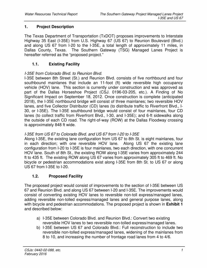
1. Project Description The Texas Department of Transportation (TxDOT) proposes improvements to Interstate Highway 35 East (I-35E) from U.S. Highway 67 (US 67) to Reunion Boulevard (Blvd.) and along US 67 from I-20 to the I-35E, a total length of approximately 11 miles, in Dallas County, Texas. The Southern Gateway (TSG) Managed Lanes Project is hereafter referred as the “proposed project.”
1.1. Existing Facility I-35E from Colorado Blvd. to Reunion Blvd. I-35E between 8th Street (St.) and Reunion Blvd. consists of five northbound and four southbound mainlanes that include an 11-foot (ft) wide reversible high occupancy vehicle (HOV) lane. This section is currently under construction and was approved as part of the Dallas Horseshoe Project (CSJ. 0196-03-205, etc.). A Finding of No Significant Impact on September 18, 2012. Once construction is complete (anticipated 2018), the I-35E northbound bridge will consist of three mainlanes; two reversible HOV lanes, and five Collector Distributor (CD) lanes (to distribute traffic to Riverfront Blvd., I-30, or I-35E). The I-35E southbound bridge would consist of four mainlanes, four CD lanes (to collect traffic from Riverfront Blvd., I-30, and I-35E); and 6-ft sidewalks along the outside of each CD road. The right-of-way (ROW) at the Dallas Floodway crossing is approximately 848 ft wide. I-35E from US 67 to Colorado Blvd. and US 67 from I-20 to I-35E Along I-35E, the existing lane configuration from US 67 to 8th St. is eight mainlanes, four in each direction; with one reversible HOV lane. Along US 67 the existing lane configuration from I-20 to I-35E is four mainlanes, two each direction, with one concurrent HOV lane. South of 8th St., the existing ROW along I-35E varies from approximately 244 ft to 435 ft. The existing ROW along US 67 varies from approximately 305 ft to 469 ft. No bicycle or pedestrian accommodations exist along I-35E from 8th St. to US 67 or along US 67 from I-35E to I-20.
1.2. Proposed Facility The proposed project would consist of improvements to the section of I-35E between US 67 and Reunion Blvd. and along US 67 between I-20 and I-35E. The improvements would consist of converting existing HOV lanes to reversible non-toll express/managed lanes, adding reversible non-tolled express/managed lanes and general purpose lanes, along with bicycle and pedestrian accommodations. The proposed project is shown in Exhibit 1 and described below:
a) I-35E between Colorado Blvd. and Reunion Blvd.: Convert two existing reversible HOV lanes to two reversible non-tolled express/managed lanes.
b) I-35E between US 67 and Colorado Blvd.: Full reconstruction to include two reversible non-tolled express/managed lanes, widening of the mainlanes from 8 to 10, and increasing the number of frontage road lanes from 4 to 4/6.

Water Resources Technical Report The Southern Gateway Project Managed Lanes Project I-35E and US 67
CSJs: 0442-02-088, etc. 2 February 2016
c) US 67 from I-20 to I-35E: Partial reconstruction to change the existing concurrent HOV lane to one reversible non-tolled express/managed lane within the existing median and widening the mainlanes from 4 to 6 along with slip ramp modifications.
The Dallas Horseshoe Project, under construction along I-35E will consist, once completed, of two reversible non-tolled HOV lanes with 10 mainlanes that will tie into the proposed Southern Gateway Managed Lanes Project at Colorado Blvd., providing a continuous corridor connection to Reunion Blvd. The non-toll express/managed lanes would be open to all users including HOVs and would function as a general purpose lane with limited access. As a managed lane, the operations could change over time (i.e., only allow HOVs during peak hour or only trucks at night.) 2. Water Resources The study area for water resources encompasses the areas that could incur temporary and/or permanent impacts resulting from the construction of the proposed project. The study area encompasses the existing and proposed ROW limits. A permanent drainage easement is needed for the proposed stormwater pipe along Ewing Rd. including the outfall to Cedar Creek. The proposed project is located within several regional watersheds including the Upper Fivemile Creek, Cedar Creek, Dallas West Bank, and Dallas East Bank.
2.1. Methodology Water resources occurring in the study area were researched by desktop review of web resources from United States Geological Survey National Hydrological Dataset (USGS-NHD), the TCEQ, TWDB, Federal Emergency Management Agency National Flood Insurance Program (FEMA-NFIP), United States Fish and Wildlife Service (USFWS) National Wetland Inventory (NWI) mapping, and aerial photography. Desktop mapping of water resources was performed using a Geographic Information System (GIS) mapping program utilizing spatial data obtained from the USGS, FEMA, and USFWS. Field reconnaissance was performed on March 25 and 26, 2014 to examine and assess resources identified during desktop review and to identify and document the water and wetland resources present in the study area. Stream data forms were completed for the water features. No wetland data forms were needed for the proposed project. Stream data forms are included in Attachment B. GPS data and photographs were recorded for each potentially jurisdictional water and wetland feature encountered during the field visit. The USACE approved Jurisdictional Determination for the Dallas Trinity River Floodway (USACE Project Number SWF-2011-00049) was utilized to identify the jurisdictional

Water Resources Technical Report The Southern Gateway Project Managed Lanes Project I-35E and US 67
CSJs: 0442-02-088, etc. 3 February 2016
features within the study area in the Dallas Floodway. This area is currently temporarily impacted due to the construction of the Dallas Horseshoe project. Because no construction would occur in the Dallas Floodway as part of the proposed project, no additional investigation of these areas occurred. The USACE Approved J.D. is valid until March 24, 2016.
2.2. Resource Description in Study Area
2.2.1. Groundwater Southern Dallas County is underlain by the Trinity Aquifer subcrop and the Woodbine subcrop. The aquifer is used for municipal and industrial purposes. The study area is within Groundwater Management Area 8. Groundwater Conservation Districts (GCD), established by the Texas Water Development Board (TWDB), are responsible for enforcement of abandoned water well plugging within their respective jurisdictions, under the auspices of Texas Occupations Code, Title 12, Subtitle A, Subchapter F, Section 1901.255. The study area does not occur within GCD jurisdiction; however, is still subject to Texas Water Code (TWC) regulations for abandoned water well plugging.
2.2.2. Lakes, Rivers, Streams The waterways in the study area are associated with the Trinity River Basin. The waterways include the Historic Trinity River Channel, the Upper Trinity River, Cedar Creek, Fivemile Creek, Woody Branch, and associated tributaries. The Upper Trinity River is a man-made channel that re-routed the hydraulic conveyance from the Historic Trinity River Channel to the present-day alignment and location. Cedar Creek is a perennial, first order stream located just south of Zang Blvd. along I-35E. Fivemile Creek is a perennial, second order stream located north of Loop 12 along I-35E and US 67. Woody Branch is a perennial, first order stream located just north of Westmoreland St. along US 67.
2.2.3. Waters of the U.S., including Wetlands Pursuant to EO 11990 (Protection of Wetlands), Section 404 of the Clean Water Act (CWA), and Section 10 of the Rivers and Harbors Act of 1899, an investigation was conducted to identify potential jurisdictional waters of the U.S., including wetlands, within the study area. According to the USACE, the federal agency having authority over waters of the U.S., wetlands are those areas that are inundated or saturated by surface or ground water at a frequency and duration sufficient to support, and that under normal circumstances do support, a prevalence of vegetation typically adapted for life in saturated soil conditions. The Fish and Wildlife Coordination Act (FWCA) (also 48 Stat. 401 as amended 16 USC 661 et seq.) mandates review of Section 404 Permits by the USFWS and/or the National Oceanic and Atmospheric Administration (NOAA) Fisheries.

Water Resources Technical Report The Southern Gateway Project Managed Lanes Project I-35E and US 67
CSJs: 0442-02-088, etc. 4 February 2016
Two manuals [1987 Corps of Engineers Wetland Delineation Manual (Technical Report Y-87-1) and the Regional Supplement to the Corps of Engineers Wetland Delineation Manual: Great Plains Region] were used for identifying potential waters of the U.S. and wetlands based on the presence of hydrophytic vegetation, hydric soils, and wetland hydrology. NWI maps, GIS data, USGS maps, FEMA floodplain maps, and field observations on March 25 and 26, 2014 and December 21, 2015 were utilized to determine the features that are considered potentially jurisdictional waters and wetlands. A total of 11 features were identified within the study area, eight water features and three wetland features. All eight of the water features noted during the field investigation were also identified as mapped waterbodies (blue lines) on the USGS topographic maps. The water and wetland features total approximately 15.16 acres. The features identified within the study area consist of emergent wetlands and perennial, intermittent, and ephemeral streams. Photographs of the water features are in Attachment C. There are six water features (Features 1, 3, 4, 5, 9, and 11) that are currently bridged by the existing facility. All of the bridged water features have a natural, or earthen, streambed. These features have been allowed to revegetate to a more natural state and contain a mixture of woody and herbaceous vegetation. The amount of woody vegetation present is dependent upon the amount of space available in the ROW. Dominant woody vegetation observed at these features consists of box elder (Acer negundo), chinaberry (Melia azedarach), black willow (Salix nigra), green ash (Fraxinus pennsylvanica), cottonwood (Populus deltoides), cedar elm (Ulmus crassifolia), and American elm (Ulmus americana). Other dominant vegetation species consists of southern dewberry (Rubus trivialis), silver bluestem (Bothriochloa saccharoides), giant ragweed (Ambrosia trifida), greenbriar (Smilax sp.), cattail (Typha angustifolia), dallisgrass (Paspalum dilatatum), and Bermuda grass (Cynodon dactylon). There is one water feature (Feature 2) contained within a culvert in the study area. The feature within a culvert primarily has herbaceous vegetation outside the limits of the culvert. The dominant vegetation consisted of southern dewberry, silver bluestem, giant ragweed, greenbriar, dallisgrass, and Bermuda grass. Feature 6 is contained within a natural, or earthen, streambed. A mixture of herbaceous and woody vegetation is present along the banks of the feature. Dominant woody vegetation observed at this feature consists of box elder, chinaberry, black willow, cedar elm, and American elm. Other dominant vegetation species consists of giant ragweed, greenbriar, and Bermuda grass. The three wetland features (Features 7, 8, and 10) are located within the Dallas Floodway. These features are emergent wetlands and contain typical vegetation species such as curly dock (Rumex crispus), spike rush (Eleocharis sp.), smartweed (Polygonum sp.), cattail, and giant ragweed.

Water Resources Technical Report The Southern Gateway Project Managed Lanes Project I-35E and US 67
CSJs: 0442-02-088, etc. 5 February 2016
Upland drainage features are also present within the study area. These are man-made features constructed in uplands to collect and drain stormwater runoff from the roadways and adjacent developed areas. Small areas within the drainage features may allow water to pool for short periods allowing growth of hydrophytic vegetation. However, these are considered upland drainage features and not water or wetland features. Construction staging areas, stockpiling areas, etc. would be selected by the contractor who would be responsible for any Section 404 impacts. These areas could be located outside of the study area. Therefore, water and wetland features beyond the existing ROW, proposed ROW, and easement were not included in these calculations. The total areas of the potentially jurisdictional features within the study area were calculated and are described in Table 1 and their locations are shown on Exhibit 2. A brief description of the existing condition of each feature within the study area is also included in Table 1.
2.2.4. Water Quality Stormwater runoff from this proposed construction would flow into several creeks which flow into the Trinity River of the Upper Trinity River Basin. The water quality of wetlands and waters in the state shall be maintained in accordance with all applicable provisions of the Texas Surface Water Quality Standards including the General, Narrative, and Numerical Criteria. Impaired Waters Based on the 2014 Texas Integrated Report of Surface Water Quality, formerly called the Texas Water Quality Inventory and 303(d) List, the project crosses one impaired waterbody, the Upper Trinity River (Segment 0805_04). This segment is from the confluence of Cedar Creek upstream to the confluence of the Elm Fork Trinity River and is located within the Trinity River Basin within the Upper Trinity watershed. The total maximum daily load (TMDL) for the waterbody is classified as underway, scheduled, or will be scheduled for one or more parameters for the water body. The runoff from the proposed improvements would discharge to this segment of the Upper Trinity River which is listed as threatened/impaired for dioxin in edible tissue and polychlorinated biphenyls (PCBs) in edible tissue. Texas Pollutant Discharge Elimination System (TPDES) This project would include five or more acres of earth disturbance. TxDOT would comply with TCEQ’s TPDES Construction General Permit (CGP). A Storm Water Pollution Prevention Plan (SW3P) would be implemented, and a construction site notice would be posted on the construction site. A Notice of Intent (NOI) and a Notice of Termination (NOT) would be required. TCEQ Section 401 Best Management Practices (BMPs) To meet the requirements of Section 401 Water Quality Certifications, the proposed project would be required to utilize Tier I Erosion Control, Post-Construction Total

Water Resources Technical Report The Southern Gateway Project Managed Lanes Project I-35E and US 67
CSJs: 0442-02-088, etc. 6 February 2016
Suspended Solids (TSS) Control and Sedimentation Control BMPs. Appropriate Erosion Control BMPs would be implemented and maintained until construction is complete. Erosion Control BMPs that could be used include temporary vegetation, blankets/matting, mulch, sod, interceptor swales, and/or diversion dikes. Appropriate Post-Construction TSS Control BMPs would be implemented upon completion of the project. Post-Construction TSS Control devices that may be used include retention/irrigation system, extended detention basins, vegetative filter strips, constructed wetlands, wet basins, vegetation lined drainage ditches, grassy swales, or sand filter systems. In addition, appropriate Sedimentation Control BMPs would be maintained and remain in place until completion of the project. Sedimentation Control devices that may be used include sand bag berms, silt fences, triangular filter dikes, rock berms and hay bale dikes, brush berms, stone outlet sediment traps, or sediment basins.
2.2.5. Floodplains FEMA FIRMs were reviewed to determine flood zones within the area for the proposed project. I-35E and US 67 cross five areas which are designated as special flood hazard areas inundated by the 100-year flood as Zone AE, base elevations determined. There are approximately 49 acres of 100-year floodplain within the study area. The floodplain areas are located where I-35E and US 67 cross the waterways listed below.
Woody Branch: FEMA Map Number 48113C0490K, July 7, 2014
South Prong of Fivemile Creek: FEMA Map Number 48113C0490K, July 7, 2014
Cedar Creek: FEMA Map Number 48113C0480K, July 7, 2014
South Branch of Cedar Creek: FEMA Map Number 48113C0480K, July 7, 2014
Trinity River: FEMA Map Number 48113C0345J, August 23, 2001 Other areas are designated as Zone X, areas determined to be outside the 500-year floodplain. Dallas County and the City of Dallas are participants in the NFIP. The 100-year floodplain areas are shown on Exhibit 2.
2.3. Effects of the Proposed Project
2.3.1. Groundwater Unknown active or abandoned wells are unlikely to occur within the study area due to the project corridor already being highly developed. Any wells, if encountered, would need to be properly plugged in accordance with state statutes.
2.3.2. Lakes, Rivers, Streams The Trinity River and the Historic Trinity River Channel are considered navigable waterways. The Dallas Horseshoe Project, under construction along I-35E over the Trinity River, consists of two reversible non-tolled HOV lanes with 10 mainlanes that will tie into the proposed Southern Gateway Managed Lanes Project at Colorado Blvd.

Water Resources Technical Report The Southern Gateway Project Managed Lanes Project I-35E and US 67
CSJs: 0442-02-088, etc. 7 February 2016
providing a continuous corridor connection to Reunion Blvd. The remaining waterways crossed by I-35E and US 67 are not considered navigable waterways. A navigational clearance under the General Bridge Act of 1946 and Section 9 of the Rivers and Harbors Act of 1899 (administered by the US Coast Guard [USCG]), and Section 10 of the Rivers and Harbors Act of 1899 (administered by the US Army Corps of Engineers [USACE]) would not be required as the proposed project would not construct a bridge across a navigable waterway. Coordination with the USCG (for Section 9 and the General Bridge Act) and the USACE (for Section 10) would not be required.
2.3.3. Waters of the U.S., including Wetlands Based on the field observations on March 25 and 26, 2014 and December 21, 2015 and review of other sources, a total of 11 features were identified within the study area, eight water features and three wetland features. None of the water features are considered part of a braided stream system and the project does not repeatedly crisscross any one waterbody. Two creeks, Woody Branch and Fivemile Creek, are crossed by both I-35E and U.S. 67. Each potentially jurisdictional feature is considered a single and complete crossing. The following describes the anticipated permanent and temporary impacts to the potentially jurisdictional features. Table 1 provides a summary of each feature and anticipated impacts. Permanent and temporary impacts would occur to Features 1, 4, and 6 as a result of the proposed project. Permanent impacts to Features 1 and 4 would result from the placement of bridge piers within the delineated boundary of the features. Temporary impacts would result from the construction of a 50 ft. wide temporary crossing at Features 1 and 4 to facilitate the construction of the proposed bridge structures. Permanent impacts to Feature 6 would result from the placement of rock rip-rap or velocity dissipaters at the outfall of a new culvert. It is anticipated that construction activities would occur within the stream channel. Temporary impacts to Feature 6 would result from the placement of temporary fill within the delineated boundary of the feature. The area between Clarendon Dr. and the rail line may incur temporary impacts due to the proposed stormwater outfall at Cedar Creek. No permanent or temporary impacts are anticipated to Features 7, 8, 9, 10, and 11 as a result of the proposed improvements. The proposed improvements at Features 7, 8, 9, 10, and 11 consist of the conversion of HOV lanes to non-toll express/managed lanes. No construction activities would occur at these locations as part of the proposed project. Temporary impacts are anticipated to Features 3 and 5. A 50 ft wide temporary crossing at each feature is provided to facilitate the construction of the new bridge structures. Feature 2 is contained within a culvert through the study area. No permanent or temporary impacts are anticipated. The proposed improvements would construct the non-toll express/managed lanes within the median of the existing facility.

Water Resources Technical Report The Southern Gateway Project Managed Lanes Project I-35E and US 67
CSJs: 0442-02-088, etc. 8 February 2016
Table 1: Potential Waters of the U.S. within Existing ROW, Proposed ROW, and Easement
Feature ID
Feature Name Delineated
Acres/Linear Feet Existing Condition
Permanent Impacts Acres/Linear Feet
Temporary Impacts Acres/Linear Feet
Proposed Work or Structure Proposed
Permit
1 Woody Branch
(on US 67) 0.264 / 426.9
Feature bridged with earthen channel.
0.002 / 34 0.042 / 50
Construction of bridge. Bridge columns may be placed within the OHWM.
Temporary work within the water may be necessary during construction activities.
NWP 14
2 Tributary to Woody Branch 0.093 / 344.3 Culvert under roadway. 0 / 0 0 / 0 Managed lanes will be installed within
median of existing facility. N/A
3 Fivemile Creek
(on U.S. 67) 0.234 / 370.5
Feature bridged with earthen channel.
0 / 0 0.047 / 50
Construction of bridge. Bridge columns would not be placed within the OHWM.
Temporary work within the water may be necessary during construction activities.
NWP 14
4 Tributary to Cedar Creek 0.188 / 399.7 Feature bridged with an
earthen channel. 0.001 / 15 0.027 / 50
Construction of bridge. Bridge columns would not be placed within the OHWM.
Temporary work within the water may be necessary during construction activities.
NWP 14
5 Cedar Creek
(South of Clarendon Drive) 0.16 / 354.4
Feature bridged with an earthen channel.
0 / 0 0.029 / 50
Construction of bridge. Bridge columns may be placed within the OHWM.
Temporary work within the water may be necessary during construction activities.
NWP 14
6 Cedar Creek
(At Ewing Ave. and Clarendon Dr.)
0.126 / 200
Feature contained within culvert under Ewing Ave. and Clarendon Dr. which outfalls
into earthen channel.
0.001 / 15 0.125 / 200
Construction of a pipe and associated outfall structure. Temporary work within
the water may be necessary during construction activities.
NWP 14
7* Emergent Wetland 3.242 / 762.4 Feature bridged within the
Dallas Floodway. 0 / N/A 0 / 0
Proposed improvements consist of converting HOV lanes to managed
lanes. No construction activities would occur at this feature.
N/A
8* Emergent Wetland 1.353 / 316.0 Feature bridged within the
Dallas Floodway. 0 / N/A 0 / 0
Proposed improvements consist of converting HOV lanes to managed
lanes. No construction activities would occur at this feature.
N/A
9* Trinity River 4.878 / 877.5 Feature bridged with earthen man-made channel between
the Dallas Levees. 0 / 0 0 / 0
Proposed improvements consist of converting HOV lanes to managed
lanes. No construction activities would occur at this feature.
N/A
10* Emergent Wetland 4.154 / 954.2 Feature bridged within the
Dallas Floodway. 0 / N/A 0 / 0
Proposed improvements consist of converting HOV lanes to managed
lanes. No construction activities would occur at this feature.
N/A
11* Historic Trinity River
Channel 0.463 / 1,669.5 Feature bridged by I-35E. 0 / 0 0 / 0
Proposed improvements consist of converting HOV lanes to managed
lanes. No construction activities would occur at this feature.
N/A
TOTALS 15.029 / 6,475.4 -- 0.004 / 64 0.270 / 400 -- NWP 14
Source: HNTB Project Team and Design, December 2015. *Feature ID number and acreage are based on USACE Approved Jurisdictional Determination for the Dallas Trinity Floodway [USACE Project Number SWF-2011-00049]

Water Resources Technical Report The Southern Gateway Project Managed Lanes Project I-35E and US 67
CSJs: 0442-02-088, etc. 9 February 2016
It is estimated that approximately 0.004 acre of permanent fill impacts to three potentially jurisdictional waters (Features 1, 4 and 6). Permanent and temporary impacts would be authorized by a Nationwide Permit (NWP) 14 – Linear Transportation Crossings without a Preconstruction Notification (PCN). Mitigation would not be required for the permanent impacts to Features 1, 4 and 6. Temporary impacts to potential jurisdictional waters would result from temporary fills needed to construct the proposed project and would be authorized by NWP 14 without a PCN. In areas where temporary fills are needed, the affected areas would be returned to their pre-existing contours. If it is necessary for heavy machinery to work in a wetland then the placement of mats would occur to minimize soil disturbance. If design changes occur prior to construction, a re-assessment of impacts to each potentially jurisdictional feature would be necessary. If impacts to potentially jurisdictional features are identified after the proposed project is let for construction due to the construction contractor’s elected construction methodologies or activities, the contractor would be responsible for obtaining the appropriate Section 404 permit from the USACE. Because the schematic design has not been approved at this time, impacts to water and wetland features may change as the project design progresses. Based on the best available information obtained by the study team during the preparation of this report (December 2015 schematic plans), the proposed project would not have a significant impact to the water and wetland resources within the study area.
2.3.4. Water Quality Surface waters within the study area can be affected in numerous ways by the operations of a highway. Impacts to surface water quality would arise during construction activities. During construction, spills would be mainly limited to fuels (i.e., petrochemicals) and lubricants used for construction equipment. Construction in the immediate area of wetlands and waters can be assumed to generate additional sediment loads to the waterbodies if bare earth is exposed for an extended period of time and not controlled using erosion control facilities. During operation, the use of fertilizers, herbicides and/or pesticides could result in reduce water quality due to runoff. The impaired segment unit does not currently have an EPA-approved TMDL. The project and associated activities will be implemented, operated, and maintained using appropriate BMPs to control the discharge of pollutants from the project site, including the stormwater outfall into Cedar Creek. BMPs would comply with the CGP (SW3P) and Section 401 Water Quality Certifications requirements. Wherever and whenever necessary, feasible and practical BMPs would be incorporated during construction of the proposed project. For example, permanent vegetation (seeding mix) would be utilized for stabilization where necessary for erosion control.

Water Resources Technical Report The Southern Gateway Project Managed Lanes Project I-35E and US 67
CSJs: 0442-02-088, etc. 10 February 2016
2.3.5. Floodplains The hydraulic design for this project would be in accordance with current FHWA and TxDOT design policies. The proposed project would be in compliance with 23 C.F.R. 650 regarding location and hydraulic design of highway encroachments within the floodplains. The proposed project would comply with EO 11988 which requires federal agencies to avoid to the extent possible the long- and short-term adverse impacts associated with the occupancy and modification of floodplains and to avoid direct and indirect support of floodplain development wherever there is a practicable alternative. The facility would permit the conveyance of the 100-year flood, inundation of the roadway being acceptable, without causing significant damage to the facility, stream, or other property. The proposed project would not increase the base flood elevation to a level that would violate applicable floodplain regulations and ordinances. Trinity River Corridor Development The proposed project is located within the Trinity River Corridor Development Certificate Regulatory Zone. A corridor development certificate would not be required because proposed work within the regulated zone is operational - conversion of HOV lanes to non-toll express/managed lanes. No new construction activities would occur within the regulatory zone. The floodplain assessment compares the amount of floodplain encroachment anticipated by the preferred build alternative and includes a discussion of the flooding risks, beneficial functions and values, and measures taken to avoid and minimize potential impacts. FIRMs were obtained for Dallas County showing the regulatory base floodplains for the study area. GIS software was used to identify floodplains in the study area and quantify the extent of the 100-year floodplain located within the study area. 23 CFR 650.113 requires that encroachments on floodplains be the only practicable alternative, supported by the following information:
The reasons why the proposed action must be in the floodplain;
The alternatives considered and why they were not practicable; and
A statement indicating whether the action conforms to applicable state or local floodplain protection standards.
In accordance with EO 11988, the alternative considered during the course of project development that would avoid encroachment on floodplains was the no-build alternative. This was determined to be not practicable and would not meet the purpose and need of the proposed project. Moreover, the proposed project would conform to state floodplain protection standards. The proposed project is being designed to avoid impacts to floodplains to the maximum extent feasible and practicable. Roadway encroachments on floodplains would be analyzed to determine any effects caused by the proposed facility should a 100-year flood occur. Inundation of the

Water Resources Technical Report The Southern Gateway Project Managed Lanes Project I-35E and US 67
CSJs: 0442-02-088, etc. 11 February 2016
approaches, without causing significant damage to the approach roadway, is considered acceptable. The hydraulic design practices of this project would be in accordance with current TxDOT and FHWA design policies, laws, regulations, and standards. For these reasons, the proposed project is not anticipated to create a significant encroachment on any area floodplains as defined in 23 CFR 650. If it is determined during design, that the proposed project would result in an increase of more than 1 ft of the base flood elevation, a conditional letter of map revision and coordination with the FEMA and the USACE would be required.
2.4. Permitting and Mitigation Requirements Lakes, Rivers, and Streams The proposed project does not include construction activities over a navigable water of the U.S., therefore Section 9 and Section 10 of the Rivers and Harbors Act does not apply. Waters of the U.S., including Wetlands A NWP 14 would authorize the permanent and temporary impacts of the proposed project. A PCN would not be required. If temporary fills are needed in jurisdictional waters or wetlands then the affected areas would be returned to their pre-existing elevations. If it is necessary for heavy machinery to work in a wetland then the placement of mats would occur to minimize soil disturbance. Floodplains The proposed project is located within a FEMA designated 100-year floodplain within the City of Dallas in Dallas County, both participants of the NFIP. Therefore, coordination with the local floodplain administrator would be required. The proposed project is located within the Trinity River Corridor Development Certificate Regulatory Zone. A corridor development certificate would not be required because no new construction activities would occur within the regulatory zone. Water Quality The runoff from proposed improvements would discharge directly to the Upper Trinity River (Segment 0805_04), which is listed as threatened/impaired in the 2014 Texas Integrated Report of Surface Water Quality. Coordination with TCEQ would be required. Impacts to stormwater would be minimized as much as possible by utilizing approved temporary and permanent erosion and sediment control BMPs as specified by TCEQ CGP (TXR 150000). The CGP requires that a SW3P, NOI, and NOT be prepared for the proposed project. The proposed project is located within the boundaries of the City of Dallas and TxDOT’s MS4 Phase I permits, and TxDOT would need to comply with the applicable MS4 requirements.

Water Resources Technical Report The Southern Gateway Project Managed Lanes Project I-35E and US 67
CSJs: 0442-02-088, etc. 12 February 2016
Construction equipment, spoil material, supplies, forms, and building shall not be placed or stored in the floodway during construction activities. Any item that may be transported by flood flows shall not be stored within the floodway. Locations of construction trailers and stockpile areas shall be included on project plans and approved by USACE and the City of Dallas.

ATTACHMENT A

Danieldale Rd
Ledbetter Dr
!(180
!(342
Kiest Blvd
Za
ng
Blv
d
!(408
Colorado Blvd
!(12
0167
DALLAS
LANCASTER
DESOTO
DUNCANVILLE
I-35E from Colorado Blvd. to Reunion Blvd.:Change 2 Rever. HOV Lanes to
2 Rever. non-tolled express/managed lanes(No added capacity)
CSJs. 0196-03-269 & 0442-02-088
I-35E from US 67 and Colorado Blvd.:Full reconstruction including change of
1 exist. Rever. HOV lane to 2 Rever. non-tolled express/managed lanes, and widening of GPs from 8 to 10 lanes and
FRs from 4 to 4/6 lanes.Reconstruction of the I-35E/US 67 Interchange.
CSJ. 0442-02-088
US 67 from I-20 to I-35E:Reconstruction to change 1 exist. Concur. HOV lane
to 1 Rever. non-tolled express/managed lane within the median and
widening of GPs from 4 to 6 lanes.CSJ. 0261-03-030
§̈¦35E
§̈¦20
§̈¦30
§̈¦45
0 1 2
Miles
Dallas County
Ellis County
Collin County
TarrantCounty
Denton County
KaufmanCounty
RockwallCounty
±
Sources: NCTCOG GIS Data - counties,
cities, streets, rivers, and lakes
LEGEND
Project Limits
EXHIBIT 1PROJECT LOCATION MAP
The Southern Gateway Managed Lanes Project
I-35E from US 67 to Reunion Blvd. and
US 67 from I-20 to I-35E
Water Resources Technical ReportDallas County, Texas

0 600 1,200300
Feet
35E
30
45
20
67
Sheet Index EXHIBIT 2
WATER RESOURCESSHEET 1 OF 6
THE SOUTHERN GATEWAY MANAGED LANES PROJECT
I-35E: FROM US 67 TO REUNION BLVD.US 67 : FROM FM I-20 TO I-35E
DALLAS COUNTY, TEXAS
LEGEND
Existing ROW
Proposed ROW*The extent of each
sheet is highlighted
below in RED.
Llewellyn Ave
Sa
ne
r A
ve
35E
Zang BlvdLlewellyn Ave
Illino
is A
ve
Toluca Ave
Toluca Ave
Lo
uis
ian
a A
ve
Project Limit
35E
ckleberry Cir
Fair
sh
op
Dr
Beckley Ave
Ove
rton
Rd
Kie
st
Blv
d
Eisenhower Dr
Water Feature
Wetland Feature
100-Year Floodplain
Proposed Pavement
Proposed Easement
Proposed Culvert
Note: Based on the December 2015 Schematic Plans

0 600 1,200300
Feet
35E
30
45
20
67
Sheet Index EXHIBIT 2
WATER RESOURCESSHEET 2 OF 6
THE SOUTHERN GATEWAY MANAGED LANES PROJECT
I-35E: FROM US 67 TO REUNION BLVD.US 67 : FROM FM I-20 TO I-35E
DALLAS COUNTY, TEXAS
LEGEND
Existing ROW
Proposed ROW*The extent of each
sheet is highlighted
below in RED.
Page A
ve
35E
12th St
Mars
alis
Ave
Lanca
ster Ave
13th
St
Ewin
g Ave
Betterton C
t
9th St
Brookhaven Dr
Circ
le D
r
McClure Pl
35EBrookhaven Dr
Zang Blvd
Cla
ren
do
n D
r
Beckley AveP
em
bro
ke A
ve
Zang Blvd
Pa
ge
Av
e
2th
St
4
5
Water Feature
Wetland Feature
100-Year Floodplain
Proposed Pavement
Proposed Easement
Proposed Culvert
Note: Based on the December 2015 Schematic Plans

0 600 1,200300
Feet
35E
30
45
20
67
Sheet Index EXHIBIT 2
WATER RESOURCESSHEET 3 OF 6
THE SOUTHERN GATEWAY MANAGED LANES PROJECT
I-35E: FROM US 67 TO REUNION BLVD.US 67 : FROM FM I-20 TO I-35E
DALLAS COUNTY, TEXAS
LEGEND
Existing ROW
Proposed ROW*The extent of each
sheet is highlighted
below in RED.
Eads Ave
Co
mal S
t
Co
lora
do
Blv
d
35E
Riv
erf
ront B
lvd
Cadiz St
Ho
tel S
t
9
11
10
87
7
35E
Ewing Ave
8th
St
Bette
rton
Ct
9th
St
Eads Ave
Jefferson Blvd
Eads Ave
Co
mal S
t
7th
St
Clarendon Dr
6
Water Feature
Wetland Feature
100-Year Floodplain
Proposed Pavement
Proposed Easement
Proposed Culvert
Note: Based on the December 2015 Schematic Plans

0 600 1,200300
Feet
35E
30
45
20
67
Sheet Index EXHIBIT 2
WATER RESOURCESSHEET 4 OF 6
THE SOUTHERN GATEWAY MANAGED LANES PROJECT
I-35E: FROM US 67 TO REUNION BLVD.US 67 : FROM FM I-20 TO I-35E
DALLAS COUNTY, TEXAS
LEGEND
Existing ROW
Proposed ROW*The extent of each
sheet is highlighted
below in RED.
Project Limit
67
20
Cam
p W
isdom
Rd
Vir
gin
ia D
r
Center Mall Rd
Project Limit
35ERiverfront Blvd
Cad
iz S
t
35E
Reu
nio
n B
lvd
30
Com
merc
e S
t
Riverfront B
lvd
11
Water Feature
Wetland Feature
100-Year Floodplain
Proposed Pavement
Proposed Easement
Proposed Culvert
Note: Based on the December 2015 Schematic Plans

0 600 1,200300
Feet
35E
30
45
20
67
Sheet Index EXHIBIT 2
WATER RESOURCESSHEET 5 OF 6
THE SOUTHERN GATEWAY MANAGED LANES PROJECT
I-35E: FROM US 67 TO REUNION BLVD.US 67 : FROM FM I-20 TO I-35E
DALLAS COUNTY, TEXAS
LEGEND
Existing ROW
Proposed ROW*The extent of each
sheet is highlighted
below in RED.
Su
nny G
len
Dr
Sw
an
se
e S
t
Hampto
n Rd
Marblehead Dr
Clubview Dr
672
67
Club Wood DrRed Bird Ln Ham
pton R
d
1
Water Feature
Wetland Feature
100-Year Floodplain
Proposed Pavement
Proposed Easement
Proposed Culvert
Note: Based on the December 2015 Schematic Plans

0 600 1,200300
Feet
35E
30
45
20
67
Sheet Index EXHIBIT 2
WATER RESOURCESSHEET 6 OF 6
THE SOUTHERN GATEWAY MANAGED LANES PROJECT
I-35E: FROM US 67 TO REUNION BLVD.US 67 : FROM FM I-20 TO I-35E
DALLAS COUNTY, TEXAS
LEGEND
Existing ROW
Proposed ROW*The extent of each
sheet is highlighted
below in RED.
67
Eis
enh
ow
er
Dr
S
Vernon A
ve Kiest B
lvd
Llewellyn Ave
San
er Ave
35E
67
Polk S
t
Tyler S
t
Pen
tagon P
kwy
Led
better D
r
3
Water Feature
Wetland Feature
100-Year Floodplain
Proposed Pavement
Proposed Easement
Proposed Culvert
Note: Based on the December 2015 Schematic Plans

ATTACHMENT C

Page 1 of 2
Stream Data Form Surveyor(s): SI, AMS, MAB Date of Field Work: 3/26/2014
USGS Stream Name: Woody Branch County/State: Dallas County, TX
USGS Topo Quad Name: Oak Cliff Stream Number [303(d) List]:
Associated Wetland(s): GPS Data: 32.667566N -96.864938W
Stream Type: Perennial Characteristics Manipulated/Altered. Explain: Rock gabions on side slopes.
Bank Stability (e.g. highly eroding, sloughing banks, etc.): stable
Stream Flow Direction: Southeast
OHWM Width (ft): 15 OHWM Height (in): 1-8
Stream Bottom composition:
Silts Cobbles Concrete Other:
Sands Bedrock Muck
Gravel Vegetation Type: <Select Veg. Type> Percent Cover
Stream has the following characteristics:
Bed and banks
OHWM (check all indicators that apply):
clear, natural line impressed on the bank the presence of litter and debris
changes in the character of soil destruction of terrestrial vegetation
shelving the presence of wrack line
vegetation matted down, bent, or absent sediment sorting
leaf litter disturbed or washed away scour
sediment deposition multiple observed or predicted flow events
water staining abrupt change in plant community
other (list):
Water Quality:
Clear Slightly Turbid Turbid Very Turbid Oily film High organic content
Other characteristics (pollutants, etc.)
Aquatic Organisms: List all species observed. This would include waterfowl, fish, snakes, turtles, frogs, invertebrates, etc.
None
Riparian Vegetation: List species observed.
curly dock, queen anne's lace, dewberry, dalis grass
T&E Species/Suitable Habitat: List T&E species observed or which species the habitat is suitable for.
None
Stream Data Form #: 1
Project Name: TSG Managed Lanes Project
CSJ: 0442-02-088, etc.
Aquatic Habitat: Indicate all types present within proposed ROW/project limits.
Sand bar Sand/Gravel beach/bar Gravel riffles Aquatic vegetation
Overhanging
trees/shrubs
Deep pool/ hole/
channel Other:

Page 2 of 2
Stream Data Form (continued)
Please provide a plan and section view sketch of the stream channel.
Sketch should include:
Directional arrow;
Width of channel from top of bank to top of bank;
Depth of channel,
Approximate side slope; and,
Width of stream from water edge to water edge.
Plan View
Stream Data Form #: 1
Project Name: TSG Managed Lanes Project CSJ: 0442-02-088, etc.

Page 1 of 3
Stream Data Form Surveyor(s): SI, AMS, MAB Date of Field Work: 3/26/2014
USGS Stream Name: Unnamed (Tributary to Woody Branch) County/State: Dallas County, TX
USGS Topo Quad Name: Oak Cliff Stream Number [303(d) List]:
Associated Wetland(s): GPS Data: 32.679927N -96.854045W
Stream Type: Ephemeral
Characteristics Manipulated/Altered. Explain: Concrete lined channel on
southbound side
Bank Stability (e.g. highly eroding, sloughing banks, etc.): Eroding on northbound side
Stream Flow Direction: Southeast
OHWM Width (ft): 1-5 OHWM Height (in): 1-3
Stream Bottom composition:
Silts Cobbles Concrete Other:
Sands Bedrock Muck
Gravel Vegetation Type: <Select Veg. Type> Percent Cover
Stream has the following characteristics:
Bed and banks
OHWM (check all indicators that apply):
clear, natural line impressed on the bank the presence of litter and debris
changes in the character of soil destruction of terrestrial vegetation
shelving the presence of wrack line
vegetation matted down, bent, or absent sediment sorting
leaf litter disturbed or washed away scour
sediment deposition multiple observed or predicted flow events
water staining abrupt change in plant community
other (list):
Water Quality:
Clear Slightly Turbid Turbid Very Turbid Oily film High organic content
Other characteristics (pollutants, etc.)
Aquatic Organisms: List all species observed. This would include waterfowl, fish, snakes, turtles, frogs, invertebrates, etc.
None
Riparian Vegetation: List species observed.
dalis grass, clover
T&E Species/Suitable Habitat: List T&E species observed or which species the habitat is suitable for.
None
Stream Data Form #: 2Project Name: TSG Managed Lanes Project CSJ: 0442-02-088, etc.
Aquatic Habitat: Indicate all types present within proposed ROW/project limits.
Sand bar Sand/Gravel beach/bar Gravel riffles Aquatic vegetation
Overhanging
trees/shrubs
Deep pool/ hole/
channel Other:

Page 3 of 3
Stream Data Form (continued)
Please provide a plan and section view sketch of the stream channel.
Sketch should include:
Directional arrow;
Width of channel from top of bank to top of bank;
Depth of channel,
Approximate side slope; and,
Width of stream from water edge to water edge.
Plan View
Stream Data Form #: 2Project Name: TSG Managed Lanes Project CSJ: 0442-02-088, etc.

Page 1 of 3
Stream Data Form Surveyor(s): SI, AMS, MAB Date of Field Work: 3/26/2014
USGS Stream Name: Fivemile Creek County/State: Dallas County, TX
USGS Topo Quad Name: Oak Cliff Stream Number [303(d) List]:
Associated Wetland(s): GPS Data: 32.695697N -96.842851W
Stream Type: Perennial
Characteristics Manipulated/Altered. Explain: Gabion rip-rap along the sides
of the creek.
Bank Stability (e.g. highly eroding, sloughing banks, etc.): stable
Stream Flow Direction: <Select Dir>
OHWM Width (ft): 10-20 OHWM Height (in): 2-12
Stream Bottom composition:
Silts Cobbles Concrete Other:
Sands Bedrock Muck
Gravel Vegetation Type: <Select Veg. Type> Percent Cover
Stream has the following characteristics:
Bed and banks
OHWM (check all indicators that apply):
clear, natural line impressed on the bank the presence of litter and debris
changes in the character of soil destruction of terrestrial vegetation
shelving the presence of wrack line
vegetation matted down, bent, or absent sediment sorting
leaf litter disturbed or washed away scour
sediment deposition multiple observed or predicted flow events
water staining abrupt change in plant community
other (list):
Water Quality:
Clear Slightly Turbid Turbid Very Turbid Oily film High organic content
Other characteristics (pollutants, etc.)
Aquatic Organisms: List all species observed. This would include waterfowl, fish, snakes, turtles, frogs, invertebrates, etc.
None
Riparian Vegetation: List species observed.
windged elm, bermuda grass, various forbs
T&E Species/Suitable Habitat: List T&E species observed or which species the habitat is suitable for.
None
Stream Data Form #: 3Project Name: TSG Managed Lanes Project CSJ: 0442-02-088, etc.
Aquatic Habitat: Indicate all types present within proposed ROW/project limits.
Sand bar Sand/Gravel beach/bar Gravel riffles Aquatic vegetation
Overhanging
trees/shrubs
Deep pool/ hole/
channel Other:

Page 3 of 3
Stream Data Form (continued)
Please provide a plan and section view sketch of the stream channel.
Sketch should include:
Directional arrow;
Width of channel from top of bank to top of bank;
Depth of channel,
Approximate side slope; and,
Width of stream from water edge to water edge.
Plan View
Stream Data Form #: 3Project Name: TSG Managed Lanes Project CSJ: 0442-02-088, etc.

Page 1 of 2
Stream Data Form Surveyor(s): SI, AMS, MAB Date of Field Work: 3/25/2014
USGS Stream Name: Unnamed (Tributary to Cedar Creek) County/State: Dallas County, TX
USGS Topo Quad Name: Oak Cliff Stream Number [303(d) List]:
Associated Wetland(s): GPS Data: 32.730751N -96.825111W
Stream Type: Intermittent Characteristics Natural
Bank Stability (e.g. highly eroding, sloughing banks, etc.): highly eroding
Stream Flow Direction: Northeast
OHWM Width (ft): 20 OHWM Height (in): 1-5
Stream Bottom composition:
Silts Cobbles Concrete Other:
Sands Bedrock Muck
Gravel Vegetation Type: <Select Veg. Type> Percent Cover
Stream has the following characteristics:
Bed and banks
OHWM (check all indicators that apply):
clear, natural line impressed on the bank the presence of litter and debris
changes in the character of soil destruction of terrestrial vegetation
shelving the presence of wrack line
vegetation matted down, bent, or absent sediment sorting
leaf litter disturbed or washed away scour
sediment deposition multiple observed or predicted flow events
water staining abrupt change in plant community
other (list):
Water Quality:
Clear Slightly Turbid Turbid Very Turbid Oily film High organic content
Other characteristics (pollutants, etc.) trash throughout the creek and on side of the roadway
Aquatic Organisms: List all species observed. This would include waterfowl, fish, snakes, turtles, frogs, invertebrates, etc.
None
Riparian Vegetation: List species observed.
Yaupon, cedar elm, red cedar, American elm
T&E Species/Suitable Habitat: List T&E species observed or which species the habitat is suitable for.
None
Stream Data Form #: 4
Project Name: TSG Managed Lanes Project CSJ: 0442-02-088, etc.
Aquatic Habitat: Indicate all types present within proposed ROW/project limits.
Sand bar Sand/Gravel beach/bar Gravel riffles Aquatic vegetation
Overhanging
trees/shrubs
Deep pool/ hole/
channel Other:

Page 2 of 2
Stream Data Form (continued)
Please provide a plan and section view sketch of the stream channel.
Sketch should include:
Directional arrow;
Width of channel from top of bank to top of bank;
Depth of channel,
Approximate side slope; and,
Width of stream from water edge to water edge.
Plan View
Stream Data Form #: 4
Project Name: TSG Managed Lanes Project CSJ: 0442-02-088, etc.

Page 1 of 2
Stream Data Form Surveyor(s): SI, AMS, MAB Date of Field Work: 3/25/2014
USGS Stream Name: Cedar Creek County/State: Dallas County, TX
USGS Topo Quad Name: Oak Cliff Stream Number [303(d) List]:
Associated Wetland(s): GPS Data: 32.732401N -96.824657W
Stream Type: Perennial Characteristics Natural
Bank Stability (e.g. highly eroding, sloughing banks, etc.): highly eroding
Stream Flow Direction: East
OHWM Width (ft): 20-30 OHWM Height (in): 1-5
Stream Bottom composition:
Silts Cobbles Concrete Other:
Sands Bedrock Muck
Gravel Vegetation Type: <Select Veg. Type> Percent Cover
Stream has the following characteristics:
Bed and banks
OHWM (check all indicators that apply):
clear, natural line impressed on the bank the presence of litter and debris
changes in the character of soil destruction of terrestrial vegetation
shelving the presence of wrack line
vegetation matted down, bent, or absent sediment sorting
leaf litter disturbed or washed away scour
sediment deposition multiple observed or predicted flow events
water staining abrupt change in plant community
other (list):
Water Quality:
Clear Slightly Turbid Turbid Very Turbid Oily film High organic content
Other characteristics (pollutants, etc.) trash
Aquatic Organisms: List all species observed. This would include waterfowl, fish, snakes, turtles, frogs, invertebrates, etc.
none
Riparian Vegetation: List species observed.
Cedar elm, Green briar
T&E Species/Suitable Habitat: List T&E species observed or which species the habitat is suitable for.
none
Stream Data Form #: 5
Project Name: TSG Managed Lanes Project CSJ: 0442-02-088, etc.
Aquatic Habitat: Indicate all types present within proposed ROW/project limits.
Sand bar Sand/Gravel beach/bar Gravel riffles Aquatic vegetation
Overhanging
trees/shrubs
Deep pool/ hole/
channel Other:

Page 2 of 2
Stream Data Form (continued)
Please provide a plan and section view sketch of the stream channel.
Sketch should include:
Directional arrow;
Width of channel from top of bank to top of bank;
Depth of channel,
Approximate side slope; and,
Width of stream from water edge to water edge.
Plan View
Stream Data Form #: 5
Project Name: TSG Managed Lanes Project CSJ: 0442-02-088, etc.

Page 1 of 2
Stream Data Form Surveyor(s): SI Date of Field Work: 12/21/2015
USGS Stream Name: Cedar Creek County/State: Dallas County, TX
USGS Topo Quad Name: Oak Cliff Stream Number [303(d) List]:
Associated Wetland(s): GPS Data: 32.741989N -96.812038W
Stream Type: Perennial Characteristics Natural
Bank Stability (e.g. highly eroding, sloughing banks, etc.): eroding
Stream Flow Direction: Southeast
OHWM Width (ft): 20-30 OHWM Height (in): 8-12
Stream Bottom composition:
Silts Cobbles Concrete Other:
Sands Bedrock Muck
Gravel Vegetation Type: <Select Veg. Type> Percent Cover
Stream has the following characteristics: Bed and banks OHWM (check all indicators that apply):
clear, natural line impressed on the bank the presence of litter and debris changes in the character of soil destruction of terrestrial vegetation shelving the presence of wrack line vegetation matted down, bent, or absent sediment sorting leaf litter disturbed or washed away scour sediment deposition multiple observed or predicted flow events water staining abrupt change in plant community other (list):
Water Quality: Clear Slightly Turbid Turbid Very Turbid Oily film High organic content Other characteristics (pollutants, etc.) Trash throughout stream
Aquatic Organisms: List all species observed. This would include waterfowl, fish, snakes, turtles, frogs, invertebrates, etc.
None
Riparian Vegetation: List species observed.
bermuda grass, box elder, greenbrier, chinaberry tree, black locust, American elm, cedar elm
T&E Species/Suitable Habitat: List T&E species observed or which species the habitat is suitable for.
sunfish, turtles
Stream Data Form #: 6
Project Name: TSG Managed Lanes
Project
CSJ: 0442-02-088, etc.
Aquatic Habitat: Indicate all types present within proposed ROW/project limits. Sand bar Sand/Gravel beach/bar Gravel riffles Aquatic vegetation
Overhanging
trees/shrubs
Deep pool/ hole/
channel Other:


ATTACHMENT C

Page 1 of 2
Attachment C FEATURE PHOTOGRAPHS
Looking west at Feature 1 under US 67 northbound frontage road.
Looking west at Feature 3 from US 67 main lanes.
Looking south at Feature 2, along US 67 southbound frontage road.
Photographs taken on March 25 & 26, 2014
The Southern Gateway
Managed Lanes Project
Looking west at Feature 4 from under I-35E/Brookhaven Drive.

Page 2 of 2
Attachment C FEATURE PHOTOGRAPHS
Looking west at Feature 5 from I-35E.
The Southern Gateway
Managed Lanes Project
Photographs taken on March 25 & 26, 2014 and December 21, 2015
Looking west at Feature 6 from DART Rail.