water framework directive - faolex.fao.org
TRANSCRIPT
Gibraltar River Basin Management Plan 2015 – 2021 Main Report Water Framework Directive September 2015
Produced in collaboration with Amec Foster Wheeler Environment and infrastructure UK Limited
rogram
ia 2 © HM Government of Gibraltar
August 2015 Doc Ref. 36145\Cedi\019ii
Report for
HM Government of Gibraltar Department of the Environment and Climate Change Duke of Kent House Line Wall Road Gibraltar
Main contributors
Alexia Chapman Ilona Kirhenstein Susie Roy
Issued by
................................................................................. Alexia Chapman
Approved by
................................................................................. John Pomfret
Amec Foster Wheeler
Doherty Innovation Centre Pentlands Science Park Bush Loan Penicuik Midlothian EH26 0PZ United Kingdom Tel +44 (0)131 448 1150 Doc Ref. 36145\Cedi\019ii This document should be cited as: Department of the Environment & Climate Change. 2015. Gibraltar River Basin Management Plan 2015-2021 Main Report. HM Government of Gibraltar. Cover photos (top left to right): Niskin bottle being used by the Department of the Environment and Climate Change for water sampling: Jonathan Kay Sunset from the eastside of Gibraltar: Kevin Gomila Bluefin tuna at the southern waters of Gibraltar’s SAC: Nicholas Ferrary Department of the Environment and Climate Change’s Dive Team carrying out a survey over the Northwest Artificial Reef Gibraltar: Clive Crisp Shoal of Boops boops over Europa Reef: Clive Crisp Serranus cabrilla in Seven Sisters Reef: Dr Darren Fa
Third-party disclaimer
Any disclosure of this report to a third party is subject to this disclaimer. The report was prepared by Amec Foster Wheeler at the instruction of, and for use by, our client named on the front of the report. It does not in any way constitute advice to any third party who is able to access it by any means. Amec Foster Wheeler excludes to the fullest extent lawfully permitted all liability whatsoever for any loss or damage howsoever arising from reliance on the contents of this report. We do not however exclude our liability (if any) for personal injury or death resulting from our negligence, for fraud or any other matter in relation to which we cannot legally exclude liability.
Management systems
This document has been produced by Amec Foster Wheeler Environment & Infrastructure UK Limited in full compliance with the management systems, which have been certified to ISO 9001, ISO 14001 and OHSAS 18001 by LRQA.
Document revisions
No. Details Date
i First draft to client July 2015
ii Consultation draft to client Sept 2015
3 © AMEC Environment & Infrastructure UK Limited
August 2015
Contents
1. Introduction 5
1.1 Background 5
1.2 Structure of the Report 5
2. Gibraltar River Basin District 7
2.1 Overview 7
2.2 Water Bodies within the District 7
3. Summary of Changes and Assessment of Progress 9
3.1 Changes since First Cycle 9 Failure of Chemical Status in the HMWB 9 Bathing Waters 10
3.2 Assessment of Progress 10
3.3 Measures 10
3.4 Summary of Additional, Interim Measures 10
4. Status Classification 12
4.1 Classification of surface water body status 12 Overview 12 Ecological Status 12 Chemical Status 15 Overall Status 15 Heavily Modified Water Bodies 16
4.2 Classification of groundwater body status 17 Quantitative Status 18 Qualitative Status 18
4.3 Protected Areas 20
4.4 Current surface water body status 20 Gibraltar Coastal Waters 20 Gibraltar Harbour and Marine Bay HMWB 22
4.5 Current groundwater body status 22
5. Pressures and Impacts of Human Activities 23
5.1 Pressures within Gibraltar’s RBD 23
5.2 Pressures on Coastal Water Bodies 23
5.3 Pressures on Groundwater Bodies 25
6. Economic Analysis of Water Use 26
6.1 Introduction 26
6.2 Economic Significance of Water Use 26 Provision of Water Services – Water Abstraction and Storage 26 Water Supply and Use 27 The Relative Importance of Different Sectors of the Economy 27
6.3 Costs of Water Services 27 Financial Costs 27 Environmental and resource costs 28
4 © AMEC Environment & Infrastructure UK Limited
August 2015
7. Programme of Measures 30
7.1 Introduction 30
7.2 Basic Measures 30
7.3 Supplementary Measures 32 Business as usual 32 Remedial dredging 32 Monitoring Programmes 32
7.4 Cost Effectiveness and Cost Benefit Analysis 33 Cost-effectiveness (CEA), Cost-benefit (CBA) and Disproportionate Cost Assessments (DCA) 33 Appraisal of Supplementary Measures 33 Justification of Derogations 34
8. Objectives 36
8.1 Approach to setting objectives 36
8.2 Objectives for surface water bodies 36 Objectives for Coastal Water Body 36 Objectives for Heavily Modified Water Body 36
8.3 Objectives for groundwater Bodies 37
9. References 38
Table 4.1 Elements used in the Surface Water classification of ecological status 14 Table 4.2 Priority substances used in the surface water classification of chemical status in Gibraltar 15 Table 7.1 Existing policy and legislation for environmental protection in Gibraltar 30
Figure 2.1 Water Bodies in Gibraltar 8 Figure 4.1 Components used for Surface Water Body classification 12 Figure 4.2 Decision tree for determining Ecological Status of surface water bodies. 14 Figure 4.3 Approach to determine overall status of Surface Water Bodies 16 Figure 4.4 UKTAG approach for Groundwater Body Status Classification 17 Figure 4.5 Approach taken for determining overall status for Gibraltar’s groundwater bodies. 20 Figure 4.6 Water body status of Gibraltar Coastal Waters 21
Annex A Water Bodies in Gibraltar Annex B Pressures and Risks Annex C Economic Analysis of Water Use Annex D Current State of Waters Annex E Water Body Status Objectives Annex F Protected Areas Annex G Climate Change Annex H Programme of Measures Annex I Planning Review Annex J Consultation and Engagement Annex K Competent Authorities Annex K References
5 © AMEC Environment & Infrastructure UK Limited
August 2015
1. Introduction
Under Article 13 of the Water Framework Directive (2000/60/EC) (the WFD), Member
States are required to submit River Basin Management Plans for each river basin district
within their territory. These plans must be reviewed and updated every six years and the
first review cycle ended in 2015. This Plan has been prepared to cover the second six-year
cycle from 2015 to 2021. At that point the plan will be updated again and subjected to
further planning and consultation.
1.1 Background
The aim of the WFD is to establish a framework for the protection of all inland, groundwater and coastal
water bodies to:
prevent deterioration and to protect and enhance aquatic ecosystems;
promote sustainable use of water to protect water resources in the long term;
enhance protection and improvement of the water environment through a progressive reduction
in pollution;
mitigate the effects of floods and droughts.
River Basin Districts (RBDs) are the main areas used to co-ordinate the management of the water
environment through the WFD. The term is used to delineate areas that combine river basins and their
associated transitional waters and coastal waters. The Gibraltar RBD (although a slightly misleading term, as
there are no rivers) encompasses the whole of Gibraltar and coastal waters extending out to one nautical
mile from the coast. This report summarises the Gibraltar RBD status, pressures and impacts on water
quality and the objectives for water body classification up to 2027, as required by the WFD.
This report has been produced on behalf of the Government of Gibraltar, who has primary responsibility for
carrying out compliance with the WFD and reporting the findings to the European Commission.
The River Basin Management Plan (RBMP) follows previous reports submitted under Article 5 of the WFD,
on the initial characterisation of the Gibraltar RBD, and on Significant Water Management Issues in the
district. As required under Article 9 of the WFD, data on the coastal monitoring programme was also
submitted to the European Commission.
1.2 Structure of the Report
The main section of the report summarises the findings of the RBMP assessment.
Section 2 provides an overview of the Gibraltar River Basin District and the water bodies (which only include
coastal and groundwater bodies).
Section 3 provides an update from the first cycle of river basin management planning.
Section 4 summarises the classification methods and the status of the water bodies.
Section 5 updates the pressure and risk assessment previously carried out in the initial characterisation, to
identify if water bodies are at risk from various pressures that might lead to less than good status.
Section 6 presents a summary of the economic analysis of water use, as required by Article 9 of the
Directive.
Section 7 summarises the programme of measures (or actions) required to meet WFD, it also includes Cost-
Effectiveness and Cost-Benefit Analysis and justification of derogations.
6 © AMEC Environment & Infrastructure UK Limited
August 2015
Section 8 summarises the objectives for the Gibraltar RBD.
The report is supplemented with more detail in Annexes A to M, listed below.
Annex A: Water Bodies in Gibraltar
Annex B: Pressures and Risks
Annex C: Economic Analysis of Water Use
Annex D: Current State of Waters
Annex E: Water Body Status Objectives
Annex F: Protected Areas
Annex G: Climate Change
Annex H: Programme of Measures
Annex I: Planning Review
Annex J: Consultation and Engagement
Annex K: Competent Authorities
7 © AMEC Environment & Infrastructure UK Limited
August 2015
2. Gibraltar River Basin District
The Gibraltar RBD contains a unique coastal environment due to its position between the
Atlantic Ocean and the Mediterranean Sea. Waters within the Straits of Gibraltar
experience substantial flow and mixing of the warmer, more saline Mediterranean waters
with the cooler Atlantic waters. The rich diversity in species and habitats together with the
sea cliffs, caves, reefs and sandy marine habitats have led to the classification of the
Southern Waters as a Special Area of Conservation (SAC) under the Habitats Directive.
The SAC extends out three nautical miles from the coastline.
2.1 Overview
The environment and climate are largely influenced by the Rock, which occupies the majority of the surface
area of Gibraltar. It rises steeply up to more than 400 m, with a precipitous east coast facing the
Mediterranean. The more gently sloping western side faces the Bay of Gibraltar and contains the town and
harbour area. The Rock is made of interbedded dolomite and limestone bedrock from the Jurassic era that
contain extensive cave systems, with mudstones, limestone and chert on the eastern side. The Isthmus is
the area of land connecting the district to the Spanish mainland from the northern face of the Rock, and
mainly comprises the airport runway and terminal buildings. The underlying geology comprises superficial
(drift) marine sands and gravels known as the Isthmus Sands.
The district is unusual in that it does not contain any rivers or inland waters. The land area of Gibraltar is only
6.8 km2 and as such there is no opportunity for river systems to develop. For most of the year there is very
little rainfall, with most of the annual rainfall volume falling in the winter months. Rain falling onto the land
either seeps into the rock or is discharged directly to the sea through man-made drainage systems.
Both potable and sea water are supplied using a dual network system. Potable water is produced by means
of sea water desalination using reverse osmosis plants. Sea water supply is primarily used for sanitary and
firefighting purposes.
Gibraltar has a population of approximately 32,000 persons and caters for approximately 11.1 million tourists
a year, the vast majority of which are day visitors1. The main industries are retail, tourism and shipping. The
Port of Gibraltar is one of the busiest in the Mediterranean with regard to bunkering of ships in the sheltered
waters of the Bay of Gibraltar and is a major cruise ship destination.
2.2 Water Bodies within the District
The WFD defines the water environment as being rivers, lakes, groundwaters, transitional waters (estuaries)
and coastal waters. These types of waters are then further divided into water bodies, to facilitate
determination of existing water quality and management of the objectives and actions required. Four water
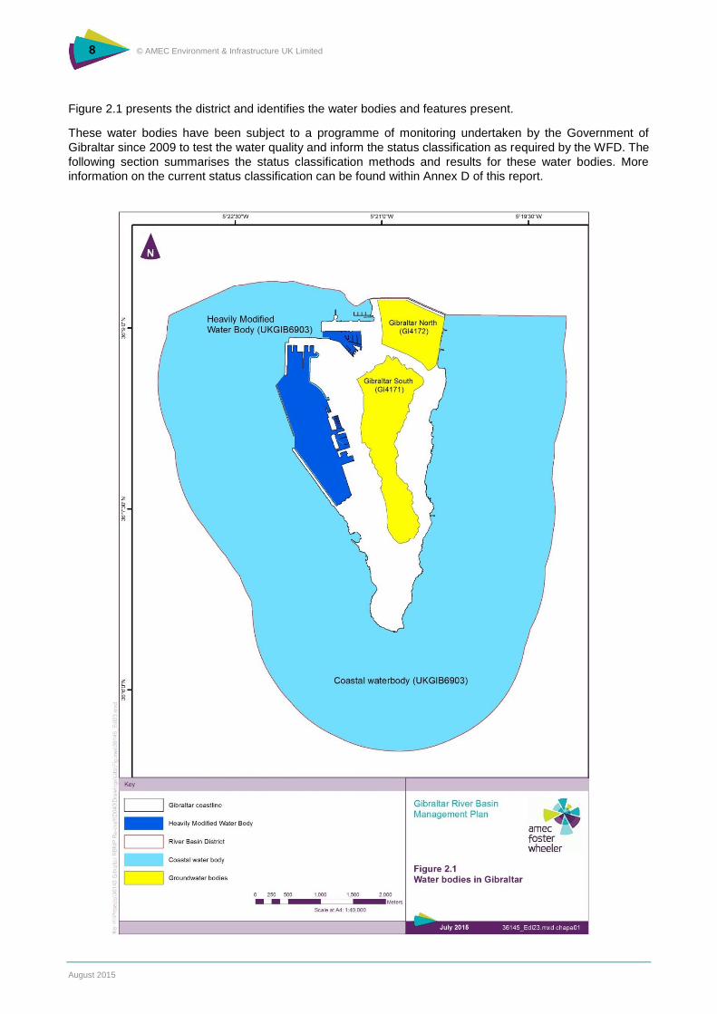
bodies have been identified within the Gibraltar district. These are:
the ‘Northern Groundwater Body’, within the Isthmus Sands upper aquifer2;
the ‘Southern Groundwater Body’, within the limestone bedrock aquifer;
the ‘Coastal Water Body’, for waters outside the harbour up to one mile from the coast; and
the ‘Gibraltar Harbour and Marina Bay’ Heavily Modified Coastal Water Body (HMWB),
comprising the harbour and marina bay.
1 HM Government of Gibraltar (2014). Abstract of Statistics 2013. Statistics Office 2 An aquifer is the name given to a rock formation which is capable of storing significant volumes of water.
8 © AMEC Environment & Infrastructure UK Limited
August 2015
Figure 2.1 presents the district and identifies the water bodies and features present.
These water bodies have been subject to a programme of monitoring undertaken by the Government of
Gibraltar since 2009 to test the water quality and inform the status classification as required by the WFD. The
following section summarises the status classification methods and results for these water bodies. More
information on the current status classification can be found within Annex D of this report.
9 © AMEC Environment & Infrastructure UK Limited
August 2015
3. Summary of Changes and Assessment of Progress
Under section B of Annex VII of the WFD, Member States are required to include the
following in the first update of the RBMP, and in all subsequent updates:
1. a summary of any changes or updates since the publication of the previous RBMP, including a
summary of the review required under Article 4(4), (5), (6), and (7);
2. an assessment of progress made towards the achievement of environmental objectives,
including presentation of the monitoring result for the period of the previous plan in map form;
3. a summary of, and an explanation for, any measures foreseen in the earlier version of the
RBMP which have not been undertaken; and
4. a summary of any additional interim measures adopted under Article 11(5).
This section addresses the requirements of section B of Annex VII.
3.1 Changes since First Cycle
Water body status classifications are based on a set of building blocks. These building blocks are:
the water body and monitoring networks;
the designation of artificial and heavily modified water bodies;
the standards and boundaries used in assessment; and
the tools used to derive classification results for individual elements from monitoring data.
One significant change to these building blocks has been introduced for the second cycle of river basin
management planning that affects Gibraltar. This is as follows.
Updated standards are being used to determine good status for nutrients and some chemical
substances. Some of these new standards were developed as part of a UK-wide collaboration
and have been widely consulted upon. Other updated standards arise from adoption of a new
WFD ‘daughter’ directive by the EU. These new standards have been used for water body
classification in Gibraltar.
In Gibraltar, the size and shape of the water bodies have not changed since the first cycle of RBMP. In
addition, there have been no changes, or extensions, made to the objective deadlines. There has been no
deterioration in the status of the surface water bodies and groundwater bodies.
Failure of Chemical Status in the HMWB
Where an element is classified as being at less than good status an assessment is needed of the measures
that could be taken to improve the status to good. In order to identify appropriate measures it is first
necessary to understand the pressure causing of the failure. In addition to identifying the pressure, the type
and source of the problem are also identified.
Initial monitoring of Gibraltar’s surface water bodies identified a failure in chemical status within the HMWB
caused by high levels of tributyltin (TBT). These high levels of TBT were observed within Gibraltar’s harbour.
It was originally thought that the source of TBT was from anti-fouling paints used on vessels prior to their ban
in 2008 under the International Convention on the Control of Harmful Anti-fouling Systems on Ships. Before
the ban on its use, residues of paint from vessels could have entered the harbour waters through routine
maintenance at the shipyard or general leaching of paint from the ships’ hulls. Over the years, paint
10 © AMEC Environment & Infrastructure UK Limited
August 2015
scrapings from the shipyard will have been washed out into the harbour and accumulated within the
sediment. Disturbance of the sediment through dredging or strong currents and waves (such as those
produced during storms) will disturb the sediments, releasing TBT into the water column.
The Programme of Measures in the first RBMP stated the need for undertaking investigative monitoring
during the first cycle to determine the source of TBT. This investigative monitoring included:
monitoring of TBT in the water column in the monthly surveys (originally monitored on a
quarterly basis);
monitoring of two additional sites in the harbour;
monitoring of sediments at each surface water sampling location; and
determining with laboratories if an improved detection limit could be achieved for TBT, as
current TBT Limits of Detection (LoD) were higher than the Environmental Quality Standard
(EQS).
The increase in monitoring locations and monitoring of sediments have determined that the source of TBT is
historical contamination of sediment, with the highest concentration of TBT in sediments found at the
southern end of the harbour, directly in front of the shipyard. This further confirms the theory that the original
source of TBT is anti-fouling paint used on vessel hulls, which would have been scraped off during routine
maintenance and discharged into the harbour.
Bathing Waters
Until the end of 2014, the objective for bathing waters designated under the previous Bathing Waters
Directive 76/160/EEC was to protect the environment and public health whilst bathing. From 2015 onwards,
the objectives under the current Bathing Waters Directive (2006/7/EC) are to preserve, protect and improve
the quality of the environment and to protect human health by complementing the WFD.
Since 2010, Western Beach has failed to meet mandatory values set under the previous Directive. The poor
quality of Western Beach has been attributed to an intermittent point source discharge of sewage from the
neighbouring town of La Linea, Spain. This has been ongoing since 2010 and has had a significant negative
impact on Western Beach. The matter has now been taken up by the European Commission. Until the
problem is resolved, extensive bathing water quality monitoring will continue to take place. In the past,
Western Beach has been closed due to the poor water quality; this measure may be required should water
quality fall again in the future”.
3.2 Assessment of Progress
The water bodies within Gibraltar’s RBD have been re-classified based on the monitoring results collected
during the first cycle of RBMP and, therefore, the progress made towards the achievement of the
environmental objectives has been assessed. Results from the classification, including presentation of
results in map form, are detailed in chapter 4 of this report and Annex D.
All objectives set in the first RBMP have been met.
3.3 Measures
An explanation should be provided of the summary of measures foreseen in the first RBMP that have not
been undertaken. All measured outlines in the first RBMP have been undertaken.
3.4 Summary of Additional, Interim Measures
Under Article 11(5), where monitoring data indicate that the objectives set under Article 4 for the water body
are unlikely to be achieved, Member States shall ensure that:

11 © AMEC Environment & Infrastructure UK Limited
August 2015
the causes of possible failure are investigated;
relevant permits and authorisations are examined and reviewed as appropriate;
the monitoring programmes are reviewed and adjusted as appropriate; and
additional measures are established as necessary.
All objectives set out in the first RBMP have been met; therefore, no additional, interim measures have been
established.
12 © AMEC Environment & Infrastructure UK Limited
August 2015
4. Status Classification
The WFD sets a target of achieving ‘good status’ in all water bodies by the year 2015, and
introduces the principle of preventing any further deterioration of status. Exemptions can
be applied to the objectives that allow for less stringent objectives, extension of deadline
beyond 2015 or implementation of new projects, provided a set of conditions is fulfilled.
The methods used to determine the status of the four water bodies in Gibraltar is first
described below, followed by a summary of the overall status classifications.
4.1 Classification of surface water body status
Overview
For surface waters there are two separate classifications for water bodies: ecological and chemical. For a
water body to be in overall ‘good’ status, the water body must meet both good ecological status (GES) and
good chemical status. Both are determined by the worst scoring component. This is the ‘one-out all-out’
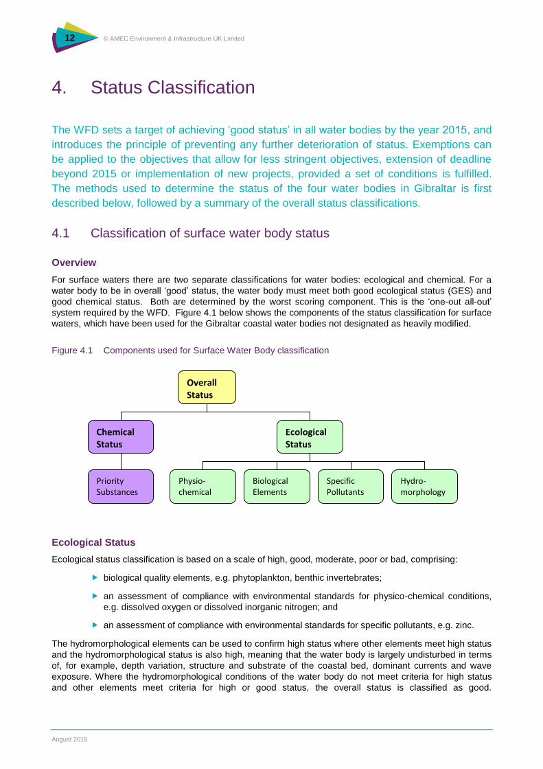
system required by the WFD. Figure 4.1 below shows the components of the status classification for surface
waters, which have been used for the Gibraltar coastal water bodies not designated as heavily modified.
Figure 4.1 Components used for Surface Water Body classification
Ecological Status
Ecological status classification is based on a scale of high, good, moderate, poor or bad, comprising:
biological quality elements, e.g. phytoplankton, benthic invertebrates;
an assessment of compliance with environmental standards for physico-chemical conditions,
e.g. dissolved oxygen or dissolved inorganic nitrogen; and
an assessment of compliance with environmental standards for specific pollutants, e.g. zinc.
The hydromorphological elements can be used to confirm high status where other elements meet high status
and the hydromorphological status is also high, meaning that the water body is largely undisturbed in terms
of, for example, depth variation, structure and substrate of the coastal bed, dominant currents and wave
exposure. Where the hydromorphological conditions of the water body do not meet criteria for high status
and other elements meet criteria for high or good status, the overall status is classified as good.
Overall Status
Chemical Status
Ecological Status
Priority Substances
Physio-chemical
Biological Elements
Specific Pollutants
Hydro-morphology
13 © AMEC Environment & Infrastructure UK Limited
August 2015
Hydromorphological elements were deemed to be of a sufficient level to support good ecological status in
the Gibraltar coastal waters.
Biological Elements
The WFD requires all water bodies to be classified with the aim of achieving ‘good status’ in all water bodies
within the European Union and has been set up as a framework of river basin planning to cater for
international boundaries that might cross water body boundaries. Aquatic eco-systems differ widely across
Europe, so to ensure that each Member State has comparable results for water body classification, the EU
published an intercalibration decision (2008/915/EC) for the biological element of the Ecological Status
classification. This assessed biological monitoring results from each distinct Geographical Region in the EU
and focussed on defining the upper and lower boundaries of ‘good status’ to use in each region when
classifying biological elements. This Decision was used in the biological classification of phytoplankton
recorded between January 2012 and July 2014 for the Gibraltar RBD, using standards for waters of Type IIA
(salinity 34.5-37.5). The 2008 intercalibration decision has now been repealed and replaced by an updated
decision (2013/480/EU), to be implemented from December 2016, but this does not change the coastal
water typology applicable for plankton classification in the Mediterranean Sea and the marginally updated
chlorophyll targets do not change the classification results obtained for Gibraltar’s coastal waters using the
2008 decision.
The Intercalibration Phase 2 exercise for the WFD reviewed standards for benthic macro-invertebrates within
the Mediterranean region and initially recommended use of the MEDOCC index (a derivative of the AMBI
system used in Atlantic waters) for classification of status for marine macro-invertebrates in Mediterranean
waters off Spain and this was adopted in decision 2008/915/EC. However, in the more recent EU WFD
Intercalibration Phase 2, Milestone 3 Report, the expert group recommended that, while MEDOCC should
continue to be used for the Spanish coastal waters of Catalunya and the Balearic Islands, the simpler
Benthic Opportunistic Polychaetes Amphipods (BOPA)3 should be adopted for use in the Spanish regions of
Valencia, Murcia and Andalucía. This recommendation has been formally adopted in decision 2013/480/EU.
As Gibraltar abuts parts of the Spanish Andalucian coast, the BOPA index has therefore been used for the
classification of benthic invertebrates monitored in the Gibraltar coastal waters.
Physico-chemical Elements
The UK Technical Advisory Group on WFD (UKTAG), which was set up to support the implementation of the
WFD in the UK, has prepared a set of recommendations for the classification of physico-chemical elements
of UK coastal water bodies and these have been implemented through UK Government directions (The River
Basin Districts Typology, Standards and Groundwater threshold values (Water Framework Directive)
(England and Wales) Directions 2010) and Scottish Government directions (The Scotland River Basin
District (Standards) Directions 2014). These have been used as the basis for physico-chemical classification
whilst taking into account the specific characteristics of Gibraltar coastal waters. The coastal waters
surrounding Gibraltar have a higher salinity than UK waters, due to the higher salinities prevailing in the
largely enclosed Mediterranean Sea, so the formulae given in the 2010 Directions have been used to take
account of these higher salinities.
The following physico-chemical elements have been used for the classification of Gibraltar’s water bodies:
dissolved oxygen: threshold values are adjusted to take account of the variation of solubility of
oxygen with salinity, according to formulas given in the Directions:
dissolved inorganic nitrogen (DIN): the observed results are adjusted to take account of salinity
before comparing with the threshold values based on reference or background conditions. This
takes account of the fact that the main sources of nitrogen are freshwater inputs and
concentrations in the sea are influenced by the amount of dilution that has occurred at the point
of measurement. The UKTAG report on UK Environmental Standards and Conditions
(Phase 2), March 2008 provides further information on how boundary values were derived for
the UK based on a linear dilution line for dissolved inorganic nitrogen over different salinity
ranges.
3 Dauvin, J.C., & Ruellet, T. (2007). Polychaete/amphipod ratio revisited. Mar. Poll. Bull. 55, 215-224.
14 © AMEC Environment & Infrastructure UK Limited
August 2015
Specific Pollutants
Environmental standards for specific pollutants are established by Member States based on toxicity data and
are therefore reasonably transferable. For this plan, the standards derived in the UK and set out in the River
Basin Districts Typology, Standards and Groundwater threshold values (Water Framework Directive)
(England and Wales) Directions 2010 and as updated by UKTAG (2014) have been used for the specific
pollutant elements of the ecological status classification.
Table 4.1 summarises the elements supporting ecological status used in the ecological classification of
surface waters in Gibraltar.
Table 4.1 Elements used in the Surface Water classification of ecological status
Element Individual element Source of Threshold Values, Standards and Reference Conditions
Biological Phytoplankton (chlorophyll a)
Intercalibration Decision (2013/480/EU) for threshold values Instrucción de la Planificación Hidrológica (IPH) for reference conditions (Orden ARM/2656/2008)
Benthic macro-invertebrates BOPA Index as informed by the WFD Intercalibration Phase 2, Milestone 3 Report and implemented in Intercalibration Decision (2013/480/EU).
Physio-chemical Dissolved oxygen River Basin District Typology Directions 2010.
Dissolved inorganic nitrogen (winter mean)
River Basin District Typology Directions 2010.
Specific Pollutants Ammonia Chromium VI Copper Zinc
River Basin District Typology Directions 2010. UKTAG (2014) Updated Recommendations on Environmental Standards, River Basin management (2015-21).
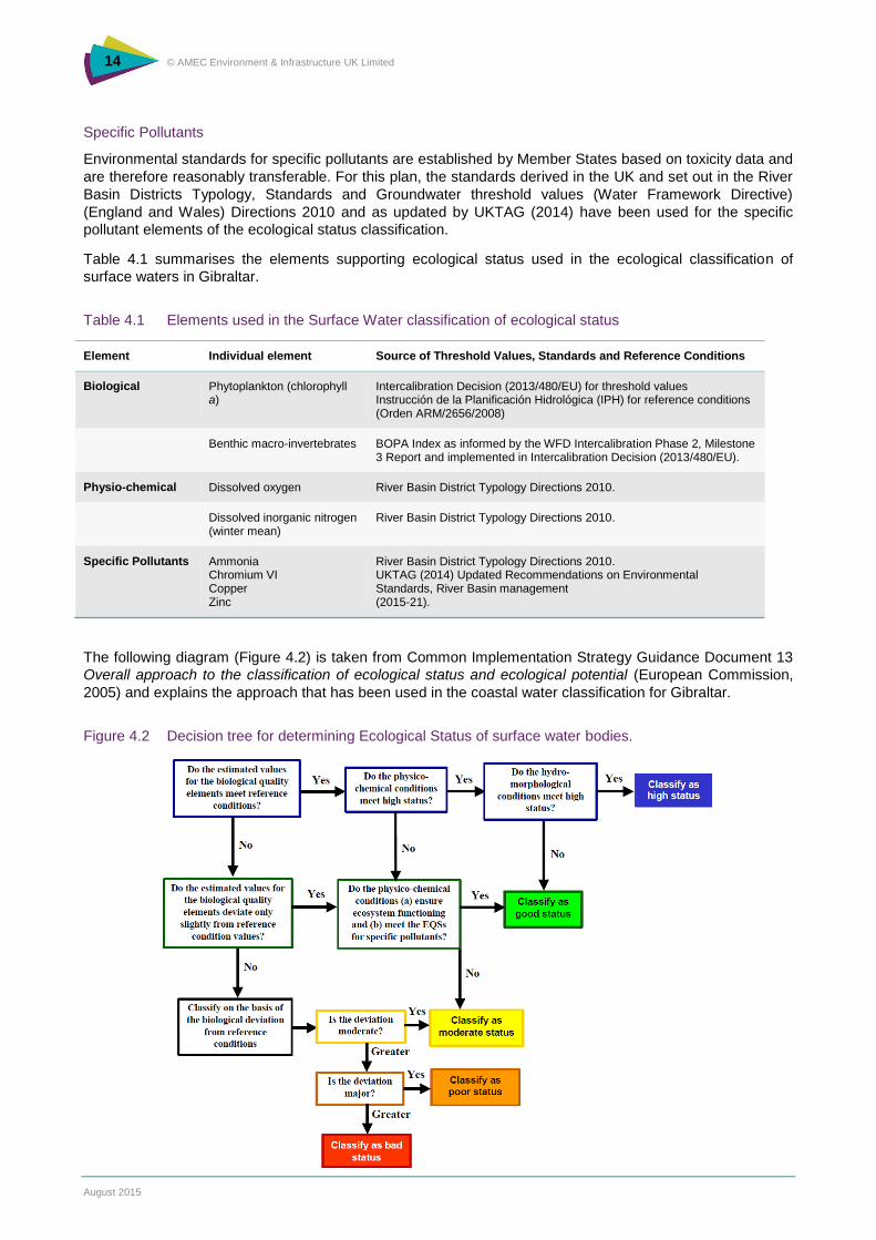
The following diagram (Figure 4.2) is taken from Common Implementation Strategy Guidance Document 13
Overall approach to the classification of ecological status and ecological potential (European Commission,
2005) and explains the approach that has been used in the coastal water classification for Gibraltar.
Figure 4.2 Decision tree for determining Ecological Status of surface water bodies.
15 © AMEC Environment & Infrastructure UK Limited
August 2015
Chemical Status
Chemical status is recorded as “good” or “fail” based on compliance with environmental standards for priority
substances listed in Annex X of the WFD. Surface water body classification for Gibraltar has been carried out
against standards set out in the WFD daughter Directive (2008/105/EC) on environmental quality standards
in the field of water policy, amending and subsequently repealing Council Directives 82/176/EEC,
83/513/EEC, 84/156/EEC, 84/491/EEC, 86/280/EEC and amending Directive 2000/60/EC of the European
Parliament and of the Council (the ‘EQS Directive’, also known as the ‘Priority Substances Directive’).
Directive 2008/105/EC has since been amended by Directive 2013/39/EU amending Directives 2000/60/EC
and 2008/105/EC as regards priority substances in the field of water policy. This new EQS Directive amends
the previous Directives by introducing 12 new priority substances and revises a number of existing EQS. The
revised EQS for existing priority substances should be taken into account for the first time in the second
cycle river basin management plans (2015-21) and good chemical status should be achieved by 2021. The
newly identified priority substances and their EQS should be taken into account in the establishment of
supplementary monitoring programmes and in preliminary programmes of measures to be submitted by 2018
and good chemical status should be achieved by 2027.
This Directive is supported by Directive 2009/90/EC of 31 July 2009 laying down, pursuant to Directive
2000/60/EC of the European Parliament and of the Council, technical specifications for chemical analysis
and monitoring of water use (Chemical Analysis Directive). The objective of this Directive is to establish
common quality rules for chemical analysis and monitoring of water, sediment and biota carried out by
Member States.
An extensive range of priority substances was monitored in Gibraltar coastal waters during surveillance
monitoring undertaken since 2009 for use in the classification of the surface waters. The list of substances
monitored is given in Annex D. Most were recorded as being at concentrations below the laboratories’ limit of
detection (LoD). Table 3.2 lists those substances that were detected during the monitoring.
Table 4.2 Priority substances used in the surface water classification of chemical status in Gibraltar
Status Element Individual element Standard
Chemical Priority Substances
Benzene Di(2-ethylhexyl)phthalate (DEHP)* Lead Nickel Nonylphenols* Tributyl tin (TBT)*
WFD Daughter Directive (2008/105/EC)
* also identified as a priority hazardous substance
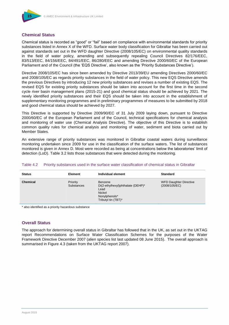
Overall Status
The approach for determining overall status in Gibraltar has followed that in the UK, as set out in the UKTAG
report Recommendations on Surface Water Classification Schemes for the purposes of the Water
Framework Directive December 2007 (alien species list last updated 08 June 2015). The overall approach is
summarised in Figure 4.3 (taken from the UKTAG report 2007).
16 © AMEC Environment & Infrastructure UK Limited
August 2015
Figure 4.3 Approach to determine overall status of Surface Water Bodies
Heavily Modified Water Bodies
The WFD acknowledges that in some water bodies it may be impossible to achieve good ecological status
because of modifications to their hydromorphological characteristics resulting from engineering works to
support uses such as navigation, recreation, water storage and flood protection, which provide valuable
economic and social benefit. If the modifications prevent achievement of GES and removal of such
modifications could potentially have a major negative effect on the use of the water body and the social and
economic benefits, Member States are required to aim to achieve good ecological potential (GEP) instead of
GES. The objective of GEP is similar to GES but takes into account the constraints imposed by the physical
modifications to support social or economic uses. Bodies in this category are known as heavily modified
water bodies (HMWB). Similar considerations are applied to artificial water bodies (AWB) that cannot meet
GES as a result of their artificial nature.
The Common Implementation Strategy (CIS) of the Water Framework Directive Guidance Document number
4 (2003) “Identification and Designation of Heavily Modified and Artificial Water Bodies” provides guidance
on designation of such water bodies. This guidance has been used formally to designate such water bodies
in the Gibraltar RBD.
The method set out in Guidance on the Classification of Ecological Potential for Heavily Modified Water
Bodies and Artificial Water Bodies (Haskoning, 2008) has then been used to identify the ecological potential
of the Heavily Modified Water Body. This approach is known as the ‘mitigation measures approach’. It firstly
assesses if actions to mitigate the impact of physical modification are in place. If this mitigation is in place,
then the water body may be classified as achieving good or better ecological potential, after cross checking
the potential with biological and physico-chemical parameters (classified using the methods described in
17 © AMEC Environment & Infrastructure UK Limited
August 2015
Section 3.1.4). Without any mitigation in place the water body will be classed as moderate or worse
ecological potential. If the biological quality shows signs of damage from pressures other than
hydromorphological alterations (for example, because of nutrient pressures) the water body will be classified
as having poor ecological potential.
The approach outlined above in Section 4.1 has been used to assess the Chemical Status of Gibraltar’s
Heavily Modified Water Body.
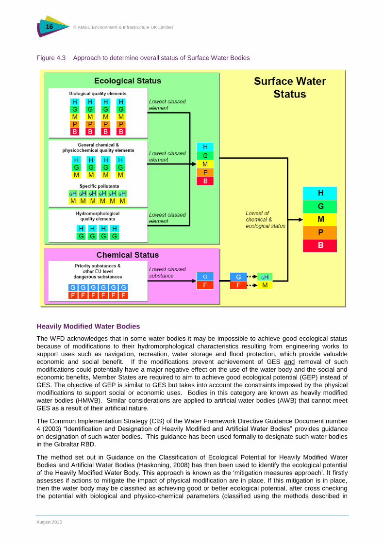
4.2 Classification of groundwater body status
The method used to identify the quantitative and qualitative status of the Gibraltar River Basin District
northern and southern groundwater bodies follows that used by the Environment Agency (England) and
Natural Resources Wales for groundwater body status classification. This approach is based on UKTAG
guidance and summarised in Figure 4.4 below.
Two groundwater bodies have been defined within the Gibraltar RBD, in the north and south of Gibraltar.
These two bodies have been defined as WFD aquifers, as they are of sufficient porosity and permeability to
allow significant flow of groundwater or the abstraction of significant quantities of groundwater, as defined in
the WFD. There are no groundwater dependent surface water features or terrestrial ecosystems on Gibraltar
and therefore the definition has been based purely on the flow characteristics of the geology. These two
groundwater bodies are not in direct contact, as the aquifers are defined by different geology types: the
Southern Groundwater Body is delineated by the limestone bedrock and the Isthmus Sands geology forms
the Northern Groundwater Body.
The two groundwater bodies have been classified as having good or poor status under a series of
quantitative and qualitative tests and the confidence in the classification is given as high or low. A summary
of the tests used and the reasons why is presented in the following sections.
Figure 4.4 UKTAG approach for Groundwater Body Status Classification
Overall Status
Qualitative Status
Quantitative Status
Saline Intrusion Saline Intrusion
Surface Water Body ecological status
Groundwater Dependent Terrestrial Ecosystems
Groundwater Body Resource
Groundwater Impacts on Surface Water
Drinking Water Protected Areas
General Chemical Assessment
18 © AMEC Environment & Infrastructure UK Limited
August 2015
Quantitative Status
The four tests for quantitative status consider the impacts of groundwater abstraction both on the
groundwater body itself, and also on the ecological receptors which depend on it, and include:
a test for saline intrusion;
an assessment of deterioration of surface water body ecological status;
an assessment of deterioration of groundwater dependant terrestrial ecosystems (GWDTEs)
ecological status; and
a test of groundwater body water resource balance.
The lowest status classification from all four tests is taken as the finally combined quantitative status. In the
case of the Gibraltar RBD there are no GWDTEs or freshwater surface water bodies.
The Southern Groundwater Body is known to be naturally brackish. In the Northern Groundwater Body, up to
12% of the total recharge has been abstracted in the past for human consumption and other purposes.
Saline intrusion has occurred in this groundwater body in the past but since large scale abstraction stopped
in 2009, there is no current risk and the Northern groundwater body is likely to recover. The saline intrusion
test has therefore not been carried out for the Gibraltar RBD and only the groundwater body resource
balance has been carried out.
The groundwater body resource test comprises of a comparison of abstraction with recharge to the
groundwater body to assess if water abstraction is too high. The test is undertaken for both fully licensed and
actual abstraction rates. There have been no recent abstractions from the Southern Groundwater Body, and
the Northern Groundwater Body only has two minor abstractions. One abstraction for a laundry business,
rarely exceeds 10 m3 per day, and abstraction data for the period 2010 to 2013 suggests rates of close to
2 m3/d. The other abstraction is for the Gibraltar cemetery, which is estimated as abstracting less than 1 m3
per day.
Summary
In accordance with the WFD, groundwater bodies where abstraction exceeds recharge would be classified at
poor quantitative status (with high confidence). The second part of the groundwater body resource balance
test compares the impacts of groundwater abstraction with environmental flow indicator-based low flow
abstraction limits aggregated for all of the surface water bodies draining (i.e. supported by) the groundwater
body. If neither part of the test produces a failure, the groundwater body is assigned a good status.
In the case of the Gibraltar RBD there are no surface water bodies which are supported directly by the
discharge of groundwater and, therefore, only the former test has been carried out.
Qualitative Status
The criteria for good groundwater chemical status and the associated tests are:
there must be no saline or other intrusion present - Saline or other Intrusion;
there must be no significant reduction in the chemical or ecological quality of associated surface
waters - Surface Water Ecological/Chemical status;
there must be no significant damage to groundwater dependent terrestrial ecosystems –
Groundwater Dependant Terrestrial Ecosystem (GWDTE);
the groundwater body must meet drinking water protected area objectives – Drinking Water
Protected Area (DrWPA); and
there must be no significant impairment of human uses and no significant environmental risk
from chemical impacts across a groundwater body - General Chemical Assessment.
19 © AMEC Environment & Infrastructure UK Limited
August 2015
There is also a trend objective under Article 5(1) of the WFD which requires the identification of significant
and sustained upward trends in concentrations of pollutants in groundwater bodies identified as being at risk.
Trends should be identified to allow programmes of measures to be implemented to reduce pollution and
avoid deterioration of groundwater quality (UKTAG, 2012a).
For groundwater bodies at risk of not meeting good status (as determined from river basin characterisation),
threshold values must be set and reported. This must be done for each chemical test where a risk is
identified. The threshold values are triggers for further investigation to confirm whether the conditions for
good status have been met.
Saline Intrusion
For the reasons given above regarding saline intrusion in the Gibraltar RBD this test has not been carried out
for qualitative status assessment.
GWDTE and Surface Water
There are no groundwater dependant terrestrial ecosystems and no freshwater surface water bodies
receiving groundwater discharge from the Gibraltar RBD. Therefore the assessment of groundwater body
quality in relation to groundwater dependant water bodies and surface water body status is not required.
Trend Assessment and DrWPAs
Article 5 of the WFD requires that trends in groundwater quality are also assessed in order to identify any
significant upward trends in poor water quality that could lead to future failure of status objectives. For water
bodies with upward trends there will be a requirement to reverse these trends within a specified river basin
cycle (2015 or 2027). During the assessment of trends it is important to use a statistically robust dataset to
ensure that confidence in the identification of significant trends is high. UKTAG guidance (2012a) states:
“For assessment of anthropogenically induced upward trends in pollutant concentrations, monitoring data for
a period of between 6 and 10 years, prior to the date at which assessment is being made, should be used for
identifying the presence of an upward trend. A longer period may be used if reliable data are available and
where the conceptual model indicates that the changes induced by pressures have been consistent. Where
data are inadequate, then no trend assessment should be carried out and an explanation recorded.”
Groundwater quality data for monitoring points in the groundwater bodies making up the Gibraltar RBD are
available for the period 2008-2014 and therefore considered adequate for the purposes trend assessment.
The Northern Groundwater Body (GWB) was designated as a DrWPA in the Characterisation report (Entec,
2005). However, it is noted that abstraction from the Northern GWB for the purposes of human consumption
ceased in 2009 due to the construction of a new reverse osmosis plant. Abstraction for potable water supply
is not likely to recommence within this river basin cycle. The test for DrWPA has therefore not been carried
out as part of the classification.
General Chemical Assessment
This test identifies groundwater bodies where widespread deterioration in quality has, or will, compromise
strategic use of groundwater. Status is poor if the areal extent of groundwater in the body that exceeds a
relevant groundwater threshold value or quality standard is significant (UKTAG 2012b - Paper 11b (i)). The
confidence in the assessment is, therefore, linked to the number of monitoring points in the GWB. In the UK,
any assessment of general chemical quality based on 6 or fewer monitoring points is recorded as having low
confidence (or low certainty), although, the UKTAG guidance on monitoring network design does not
stipulate a lower limit on the number of monitoring points in a GWB which would link to low confidence in
status classification (UKTAG, 2007a). It is noted that neither of the Gibraltar GWBs have more than 6
monitoring points but that the water bodies are relatively small, i.e. less than 1 hectare in size, compared to
UK groundwater bodies. Given the small footprint of the Northern GWB and considering that it contains four
monitoring locations, the chemical assessment result is given with high confidence. As the Southern GWB is
a larger aquifer and there is only one monitoring location, the chemical assessment result is given a low
confidence.
20 © AMEC Environment & Infrastructure UK Limited
August 2015
The test comprises a comparison of the six yearly mean (2009 to 2014) of concentrations of pollutants at an
individual monitoring point with relevant threshold values. If there is any exceedance of these values then
the mean pollutant concentration is calculated for the groundwater body and this is compared with the
threshold value. This quantifies the extent of the problem and whether there are any significant risks to the
environment or impairment to human use.
Where the impact on groundwater is shown to extend over more than one third of the groundwater body,
based on pressure or land-use, representative monitoring point data or other evidence, the groundwater
body is at poor status.
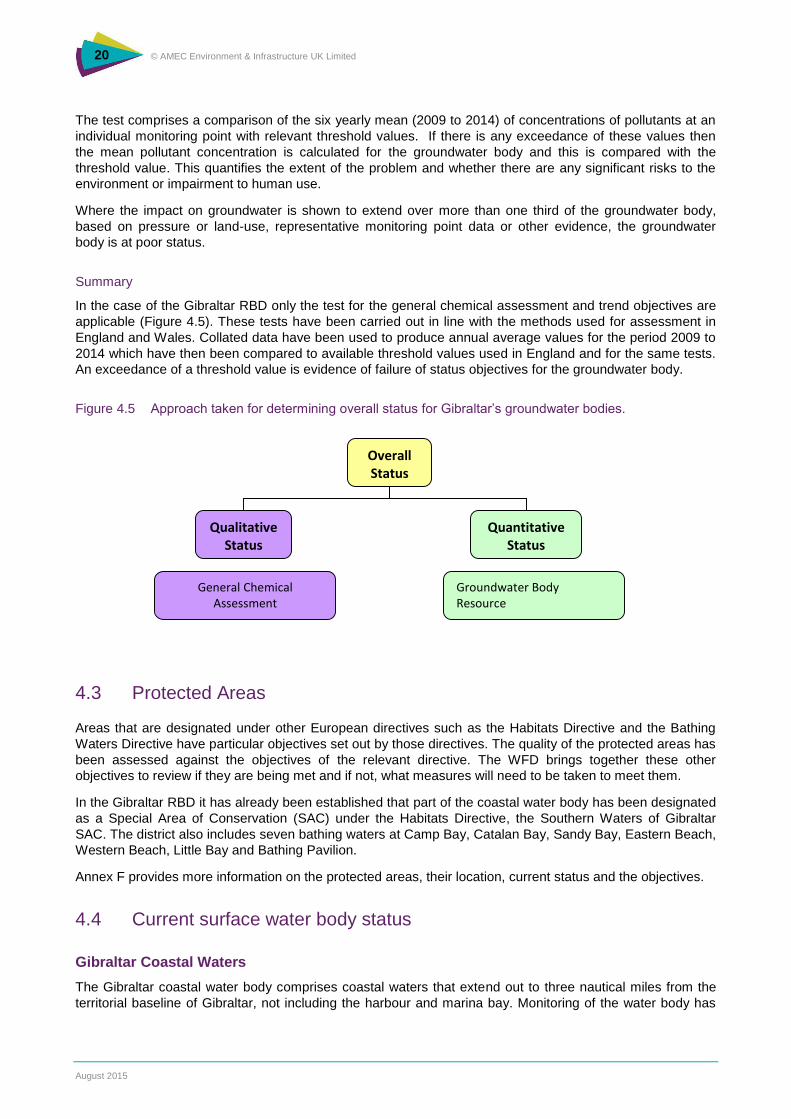
Summary
In the case of the Gibraltar RBD only the test for the general chemical assessment and trend objectives are
applicable (Figure 4.5). These tests have been carried out in line with the methods used for assessment in
England and Wales. Collated data have been used to produce annual average values for the period 2009 to
2014 which have then been compared to available threshold values used in England and for the same tests.
An exceedance of a threshold value is evidence of failure of status objectives for the groundwater body.
Figure 4.5 Approach taken for determining overall status for Gibraltar’s groundwater bodies.
4.3 Protected Areas
Areas that are designated under other European directives such as the Habitats Directive and the Bathing
Waters Directive have particular objectives set out by those directives. The quality of the protected areas has
been assessed against the objectives of the relevant directive. The WFD brings together these other
objectives to review if they are being met and if not, what measures will need to be taken to meet them.
In the Gibraltar RBD it has already been established that part of the coastal water body has been designated
as a Special Area of Conservation (SAC) under the Habitats Directive, the Southern Waters of Gibraltar
SAC. The district also includes seven bathing waters at Camp Bay, Catalan Bay, Sandy Bay, Eastern Beach,
Western Beach, Little Bay and Bathing Pavilion.
Annex F provides more information on the protected areas, their location, current status and the objectives.
4.4 Current surface water body status
Gibraltar Coastal Waters
The Gibraltar coastal water body comprises coastal waters that extend out to three nautical miles from the
territorial baseline of Gibraltar, not including the harbour and marina bay. Monitoring of the water body has
Overall Status
Qualitative Status
Quantitative Status
Groundwater Body Resource
General Chemical Assessment
21 © AMEC Environment & Infrastructure UK Limited
August 2015
been ongoing since July 2009 at three locations, offshore from Caleta Palace, Camp Bay and in the outer
harbour (north east of the North Mole and north of the airport runway).
Waters within the Gibraltar Coastal Water Body have unique characteristics as a result of the mixing
between the Atlantic Ocean and the Mediterranean Sea. The Coastal Water Body includes six bathing water
sites at Eastern Beach, Catalan Bay, Sandy Bay, Little Bay, Camp Bay and Western Beach. Part of the
Southern Waters of Gibraltar SAC is also located within this water body.
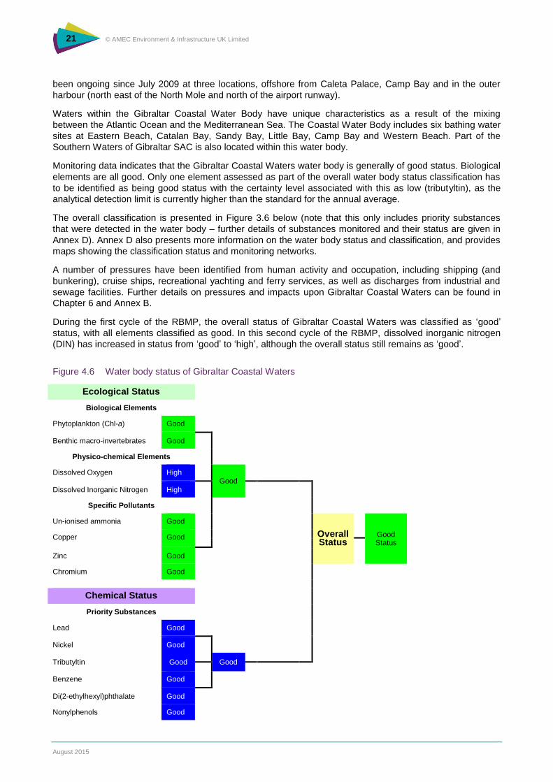
Monitoring data indicates that the Gibraltar Coastal Waters water body is generally of good status. Biological
elements are all good. Only one element assessed as part of the overall water body status classification has
to be identified as being good status with the certainty level associated with this as low (tributyltin), as the
analytical detection limit is currently higher than the standard for the annual average.
The overall classification is presented in Figure 3.6 below (note that this only includes priority substances
that were detected in the water body – further details of substances monitored and their status are given in
Annex D). Annex D also presents more information on the water body status and classification, and provides
maps showing the classification status and monitoring networks.
A number of pressures have been identified from human activity and occupation, including shipping (and
bunkering), cruise ships, recreational yachting and ferry services, as well as discharges from industrial and
sewage facilities. Further details on pressures and impacts upon Gibraltar Coastal Waters can be found in
Chapter 6 and Annex B.
During the first cycle of the RBMP, the overall status of Gibraltar Coastal Waters was classified as ‘good’
status, with all elements classified as good. In this second cycle of the RBMP, dissolved inorganic nitrogen
(DIN) has increased in status from ‘good’ to ‘high’, although the overall status still remains as ‘good’.
Figure 4.6 Water body status of Gibraltar Coastal Waters
Ecological Status
Biological Elements
Phytoplankton (Chl-a) Good
Benthic macro-invertebrates Good
Physico-chemical Elements
Dissolved Oxygen High Good
Dissolved Inorganic Nitrogen High
Specific Pollutants
Un-ionised ammonia Good
Overall Status
Good Status
Copper Good
Zinc Good
Chromium Good
Chemical Status
Priority Substances
Lead Good
Nickel Good
Tributyltin Good
Good
Benzene Good
Di(2-ethylhexyl)phthalate Good
Nonylphenols Good
22 © AMEC Environment & Infrastructure UK Limited
August 2015
Gibraltar Harbour and Marine Bay HMWB
The Gibraltar Harbour and Marina Bay water body has been designated as a HMWB, as the water body is
modified to allow use for navigation and recreation and to achieve flood protection, with the reclaimed land
and man-made harbour moles obviously modifying its hydro-morphological characteristics. As for the
Gibraltar Coastal Waters water body, the Gibraltar Harbour and Marina Bay water body meets good status
for the biological, physico-chemical and specific pollutants elements supporting ecological status and, using
the mitigation measures approach, the water body is classified as having Good Ecological Potential as
hydromorphological mitigation measures are in place without significantly affecting the use of the water body
or the environment. The identified mitigation measures include a strategy for dredging and disposal of
dredged material and management of vessel movement.
With regard to the status of the water quality for the chemical assessment, the HMWB fails to meet good
chemical status with high confidence due to the elevated levels of tributyltin (TBT). TBT is a compound that
has been used historically in anti-fouling paints, applied to the hulls (base) of vessels to maintain their
condition. Anti-foul paints containing TBT and other hazardous substances were banned in 2008 under the
International Convention on the Control of Harmful Anti-fouling Systems on Ships. Although these
substances were originally considered useful for controlling certain organisms, they are now considered to
be chemicals that are so toxic to some marine organisms and the aquatic environment that their use can no
longer be justified.
Investigative monitoring carried out between 2012 and 2014 has determined that historically contaminated
sediments are the source of TBT in the water column, with TBT concentrations in sediments highest at the
southern-end of the harbour, directly in front of the shipyard. Prior to the ban of TBT, paint flakes and
residues from vessels could have entered the harbour waters and sediments during routine maintenance at
the shipyard or from general leaching whilst vessels were afloat.
Ships are still able to obtain certification under the Convention if they are coated with TBT containing paints,
provided this paint layer is adequately sealed by an appropriate outer paint layer. Thus there is still potential
for waste paint containing TBT to be generated in shipyards maintaining such vessels. Any maintenance or
boat repair facility now must dispose of paint chippings that potentially contain banned substances to a
licensed facility for dealing with hazardous waste.
Further information is presented in Annex D.
4.5 Current groundwater body status
The assessments prepared for this plan identify that the two groundwater bodies in the district are at ‘good
status’. The monitoring data available indicate that both water bodies pass the general chemical
assessment. The general chemical assessment result is given a high confidence of meeting good qualitative
status in the Northern GWB but a low confidence for the Southern GWB, due to the number of monitoring
points available. However, this is based on UK guidance which does not specify the size of an aquifer
against which to compare the required levels of monitoring points for a high confidence assessment. It is
recognised that both groundwater bodies are relatively small.
As the Northern GWB is no longer used for public supply, and the only licensed abstractions are less than
1.1 m3 per day, the quantitative status is also assessed as being good. The Southern GWB is also classified
as meeting good status for the resource balance test (i.e. quantitative status), as there are no licensed
abstractions; therefore, there will be no depletion in resources compared to the natural recharge rates.
These classifications will be used as the ‘baseline’ – the current state of the water environment – from which
to measure future changes and ensure there is no deterioration in line with the aims of the WFD.
23 © AMEC Environment & Infrastructure UK Limited
August 2015
5. Pressures and Impacts of Human Activities
The WFD requires the management of risk to the environment caused by human activity
and pressures. The consideration of pressures and risks helps to build up an evidence
base that can justify the objectives and the actions to deliver them. The Significant Water
Management Issues report for Gibraltar discussed a series of environmental pressures in
the RBD, namely point source discharges, physical modifications, diffuse pollution,
abstraction, transboundary impacts and climate change.
It is important to identify which activities could lead to these different pressures on the
water environment and could potentially impact the ‘good status’ classification. A summary
of the issues is presented below, but more detail is provided within Annex B, which
presents an update on the pressures facing the water environment in Gibraltar, and
Annex G, which summarises predicted climate change impacts and their effect on the
water environment and existing pressures.
5.1 Pressures within Gibraltar’s RBD
Specific pressures that have been identified to exist in the Gibraltar River Basin District include:
point source discharges (e.g. sewage outfalls and industrial discharges);
diffuse pollution (including shipping);
abstraction;
physical modifications (land reclamation, urban development);
transboundary impacts; and
climate change.
5.2 Pressures on Coastal Water Bodies
Currently, untreated sewage effluent is discharged into the Coastal Water Body at Europa Point, at the
southern tip of Gibraltar. To date the untreated sewage effluent has not caused any degradation of the
Coastal Water Body, neither has it caused the nearby bathing waters of Little Bay, Camp Bay and Sandy
Bay to fail. This has been largely due to the sewage discharge point being located in an area of high natural
dispersion. Nevertheless, the Government of Gibraltar has commissioned an Urban Waste Water Treatment
Plant to be built at Europa Point by 2017. Once built, the treatment plant will provide secondary treatment.
There are numerous industries present in the Bay of Gibraltar but there are no major heavy industries in
Gibraltar itself. Other point source discharges are from desalination plants at Waterport, with the seawater
intake located at the North Mole, at Camp Bay, and at Governor’s Beach where saline water is disposed of
from the plants. In addition, Gibraltar is the largest bunkering port in the Mediterranean, with bunkers
delivered either by barge, while the vessel is at anchor, or from shore.
During periods of prolonged and intense rain, overflows operate on the sewer network, which result in a
discharge of rainwater, surface/road run-off and, on rare occasions, sewage within the Harbour and Marina
Bay. Individually, these sources may not cause a significant pressure on the environment but collectively the
diffuse pressure could be significant. Other diffuse pressures include pollutants from shipping and yachting
from antifouling paints, such as TBT. Although the use of paints with TBT was banned in 2008 by the
24 © AMEC Environment & Infrastructure UK Limited
August 2015
International Convention on the Control of Antifouling on Ships, ships may still have undercoats on their hulls
that contain TBT. Any boats entering the shipyards in Gibraltar must be certified to show that the top coat of
paint on the hull does not contain TBT. All ships must now have, in accordance with International Maritime
Organisation (IMO) and EU obligations, an International Anti-Fouling System Certificate which is reviewed
and maintained by the Ship’s Classification Society i.e. Lloyds and other 3rd Party associates. The
certificates will state where non-compliant anti-fouling coat has been covered up by an appropriate sealer
coat, although since 2003, there may be very few ships left in practice that fall into this category.
Grit used during paint removal works is removed from the dock floor using mechanised sweepers. Any grit
collected is treated as hazardous waste and then disposed in a licensed hazardous waste facility in line with
the requirements of Part VA of the Public Health Act which transposes the EU Waste Framework Directive.
Investigative monitoring has established that the source of TBT is historical contamination in the harbour
sediments, particularly at the southern end of the harbour directly in front of the shipyard. Any disturbance of
sediments from ship movements, dredging or strong currents (particularly during storms) releases TBT into
the water column. Whilst this historic source is difficult to identify and clean up, the trend should be for TBT
to reduce in time as fewer and fewer ships have TBT paint anywhere on their hulls.
The physical alteration of the coastline has taken place throughout the history of occupation in Gibraltar, for
the purposes of navigation, to create the port, for land reclamation and for the construction of flood defences
(shoreline reinforcement). The original natural coastline of Gibraltar in the harbour area is now some way
from the current shoreline of the harbour. The land reclamation has been essential in order to allow the
physical and economic growth of Gibraltar, as limited land is available due to the topography of the Rock.
The Gibraltar Harbour and Marina Bay have therefore been designated as being a Heavily Modified Water
Body due to these physical modifications.
Dredging does not often occur in Gibraltar waters but when it does it is regulated by the Gibraltar Port
Authority and the Department of the Environment and Climate Change4. Justification for the need to dredge
and appropriate disposal techniques must be provided to ensure appropriate handling of material, if
contaminated, and to prevent any detrimental impacts from re-disposal within the sea (if uncontaminated).
Specific pressures that have been identified above can be controlled where necessary by local
organisations. However, transboundary activities could also be leading to pressures on the environment that
could affect water bodies in Gibraltar. Continuing discussions are taking place between the relative
authorities to identify and control transboundary issues that might affect Gibraltar waters. Monitoring of water
quality will also continue.
The predicted effects of climate change in the Europe region (including the Western Mediterranean) are
described in detail in Annex G. Climate change impacts include lower river flows in summer and subsequent
decreased discharge of freshwater from Spain into the Bay will affect the sea temperature, salinity, CO2,
nitrate and phosphate concentrations within the marine environment. This will in turn have a knock on effect
on marine flora and fauna as well as the supporting terrestrial populations. Furthermore, higher temperatures
will dry soils and increase salinization and generate a higher incidence of wind-blown soil erosion.
Replacement sea defences have been constructed in the harbour to repair damage from a severe storm in
2008. The new defences have taken account of potential sea level rise from climate change impacts so that
the height of the sea wall is greater than predicted future sea levels. The moles forming the harbour area are
also above this predicted future level, and therefore afford continuing protection to the harbour and town
area from future flood risk.
Other areas outside the harbour that are low lying may be at risk of future flooding from sea level rise. Where
development is proposed in such areas, it will need to be demonstrated how the proposed development shall
be protected from inundation and how any defence works have considered environmental impact before
development will be permitted.
4 Dredging guidance is available from the Department of Environment website (www.gibraltar.gov.gi/new/environment)
25 © AMEC Environment & Infrastructure UK Limited
August 2015
5.3 Pressures on Groundwater Bodies
There have been previous cases of point source discharges of hydrocarbons into groundwater beneath the
Rock, which could potentially occur again in the future from accidental spillages although it has to be stated
that such facilities and pipelines are not currently in use and their potential future use is presently under
review. For the Northern GWB, there are potential point sources of pollution from the airport and presence of
fuel tanks and hydrocarbons. However, the monitoring data used for the classification does not show any
standards being exceeded in the Northern GWB quality. Continued monitoring will be used to review
groundwater quality.
The urban land use of the Isthmus puts pressure on the groundwater quality in the Northern GWB. Potential
diffuse pollution from the cemetery could be present. Continued monitoring will take place to review the
water quality.
26 © AMEC Environment & Infrastructure UK Limited
August 2015
6. Economic Analysis of Water Use
To achieve the environmental objectives of the WFD and promote integrated river basin
management, the Directive requires that economic principles (such as polluter-pays
principle), economic approaches and tools (such as cost-effectiveness analysis) and
economic instruments (such as water pricing) are applied. This section provides a
summary of the economic analysis undertaken.
6.1 Introduction
The economic analysis of water use presented here has included:
an overview of the socio-economic importance of water uses in Gibraltar (updated assessment
where possible);
an assessment of the current level of financial cost recovery for water services (updated
assessment where possible); and
economic assessment of the programme of measures, including cost-effectiveness and cost-
benefit analysis of potential measures aimed to mitigate current failures.
6.2 Economic Significance of Water Use
The assessment of economic significance of water use aims to provide an indication of the importance of
water to the economy and society as a whole. On one hand, an analysis of how water is used in Gibraltar
indicates the importance of water to the economy and wellbeing of people in Gibraltar; on the other hand it
potentially points towards significant pressures. The assessment of economic significance of water use helps
us understand the nature of water use, as well as informing the development of programme of measures as
required by the Water Framework Directive.
Provision of Water Services – Water Abstraction and Storage
Raw and desalinated seawater constitutes the major source of water supply in Gibraltar, with potable water
accounting for about 40% of total water supply on average. There are no public groundwater abstractions in
Gibraltar and only one private groundwater abstraction accounting for 0.05% of potable water supply.
Potable and seawater are stored in a number of reservoirs and distributed to different users.
Waste water is collected through the sewerage system, with responsibilities split between AquaGib and the
Government (Technical Services).
Sewage collected (in pumping stations) and discharged is not metered. For billing purposes, AquaGib
calculate that all of the potable and sea water supplied is subsequently discharged as sewage, except for
potable water supplied to ships.
In the past, wastewater was discharged directly into the sea where it was dispersed by the currents.
Currently, a secondary biological wastewater treatment plant is planned for construction in 2017.
In addition to the public sewage network, storm water is either collected and kept separate in some areas of
Gibraltar or is collected through a combined wastewater and storm water sewers in other areas.
Gibraltar also features a range of engineering activity including harbours and marinas, sea walls and flood
defences, where natural water courses or seas are altered to provide or protect human interests.
27 © AMEC Environment & Infrastructure UK Limited
August 2015
Water Supply and Use
In Gibraltar, seawater is abstracted for water supply to domestic, commercial and industrial consumers.
When considering changes in potable water supply from 2009 to 2013, volume of potable water supplied has
increased from 1.287 million cubic metres in 2009 to 1.381 million cubic metres in 2013 which is equivalent
to 7.3% growth rate5.
Seawater supply has increased from 1.938 million cubic metres in 2009 to 2.045 million cubic metres in 2013
which is equivalent to 5.5% growth rate.
Domestic use of potable water by far is the most significant use accounting for more than 64% in 2013, a
2% increase from 2009.
Commercial and institutional (including public and governmental organisations) potable water supply
account for 24%, with hotels accounting for 4% of potable water supply in 2009. In 2013, commercial and
institutional sector account for 23%, with hotels accounting for 4% of potable water supply.
Finally, industrial users and shipping accounted for 10% and 8% of potable water supply in 2009 and 2013
respectively.
While the estimates of potable water supply are based on meter readings, the supply of sea water to each
sector is estimated according to their use of potable water. Salt water is used directly for firefighting, street
cleaning, flushing of sewers, flushing of toilets and other sanitary purposes where the use of potable water is
not essential.
The Relative Importance of Different Sectors of the Economy
The relative importance of different sectors of the economy is considered in terms of contribution to the
national economy, measured as percentage of gross domestic product (GDP). In 2011/2012 GDP was
£1,169 million while a provisional estimate for 2012/2013 is £1,280 million. In comparison to 2008/2009 GDP
of £896 million this represents a total growth of 42.8% or 10.7% on annual basis.
The economy of Gibraltar is dominated by services (including financial), retail and public sector in terms of
GDP with the sectors jointly accounting for about two thirds of Gibraltar’s GDP.
Similarly to the sectoral contribution to GDP, services (including financial), retail and public sector jointly
accounted for a significant share of the total employment totalling to 77% in 2013.
6.3 Costs of Water Services
Financial Costs
Article 9 of the WFD requires Member States to ensure the implementation of the principle of cost recovery
of water services including financial, environmental and resource costs. The Directive also stipulates that
water pricing has to provide an incentive for the rational water use by 2010. Furthermore, the programme of
measures under the RBMP also needs to include steps planned to ensure the compliance with the principle
of cost recovery if relevant.
According to the WFD, water services include water abstraction, impoundment, storage, treatment and
distribution as well as collection, treatment and discharge of wastewater. Water services, therefore, cover
public and private water supply and wastewater collection and treatment.
All potable water use is metered, and charges include a standing monthly fee and a volumetric charge. While
the standing charge has been constant since 2005, volumetric charge has increased by more than 19%
since 2005.
A two-tier volumetric charge for potable water is applied to domestic water users, with one rate for the first
4,500 litres used each month, and a higher rate for volumes above this level. The difference between the
5 HM Government of Gibraltar, data from AquaGib

28 © AMEC Environment & Infrastructure UK Limited
August 2015
primary and secondary rate is 2.5 times. The design of such a charge incorporates the incentive properties
that allow affecting large water consumers while respecting the basic needs for potable water. According to
the information on potable water use in 2013 by different sectors, domestic use accounted for more than
64% of water supply followed by commercial and industrial uses. Industrial and all other users are charged
for potable water based on a single volumetric rate.
The average cost of supplying potable water is the highest per cubic metre (compared to supply of sea water
and sewerage services), which would fit with expectations given the high costs of desalinating the water.
Costs for supplying sea water are lower, as these relate only to abstraction and maintenance of the
distribution system. Overall, the cost of potable water is £0.448 per 100 litres.
The volumetric charges imposed on each user group (2014/2015) are then compared to the average costs
per cubic metre. The average cost of production is an appropriate estimate of the costs of supply to all
sectors, as the abstraction and treatment requirements do not differ by sector. In the majority of cases, the
sector pays more than the average cost of production. Domestic (primary) water use rates are the exception
to this.
The lack of the data on the water company’s financial costs and revenues from provision of different water
services since 2004/2005 precludes the update of cost recovery ratio calculations. In 2004, the calculated
cost recovery ratio for potable water supply was 107%, the lowest in comparison to sea water and sewage
pumping. The cost recovery ratio for sewage pumping was 142% and 139% for sea water pumping.
Environmental and resource costs
Environmental costs are defined as residual environmental damage costs, after the current mitigation costs.
The resource costs, on the other hand, reflect current and future water availability (in terms of quantity and
quality). In the context of the WFD both these costs occur only when the status of water bodies is below
good.
Resource costs are typically related to the depletion of water sources; as virtually all of the water supplied is
taken from the sea, resources costs attributed to water services in Gibraltar are likely to be negligible or none
at all.
Provision of different water services in Gibraltar, on the other hand, potentially may give raise to some
environmental costs.
First of all, sea water desalination is likely to have some adverse environmental impacts, in particular
associated with additional energy use and carbon emissions. Sea and brackish water desalination is one of
the most carbon intensive water supply options with treatment of seawater claimed to be twice as energy
intensive as treatment of brackish water.
Using 2.66 kg of CO2e per m3 as an indicative figure, the carbon emissions associated with potable water
production in Gibraltar in 2013 were calculated. In particular, in 2013 potable water production was
1,415,737 m3 resulting in 3,766 tonnes of CO2e emissions.
The latest valuation of the cost of carbon (Department of Energy and Climate Change, 20096) for non-traded
sectors (non EU Emissions Trading Scheme) could be used to assess these emissions in monetary terms.
The central estimate for the social costs of CO2 is £54/t for 2013 (this, however, increases over time).
Therefore, any measures that result in a reduction of potable water production and supply from seawater
desalination would result in energy saving and hence carbon emission reduction. In particular, according to
the Climate Change Programme for Gibraltar (2005), an ongoing modernisation programme of all fresh water
distribution system will result in leakage reduction. Furthermore, it is noted that the continued use of
seawater instead of fresh water (the ratio is about 1.5:1) where it is not essential such as for firefighting is
contributing to energy savings. In particular, sea water is used for firefighting and toilet flushing representing
a considerable reduction in the requirements for desalination and the consequent CO2 emissions if potable
water were to be used for such purposes.
6 DECC (2009). Carbon Valuation in UK Policy Appraisal: A Revised Approach, Climate Change Economics, Department of Energy and Climate Change July 2009
29 © AMEC Environment & Infrastructure UK Limited
August 2015
It should be noted the forthcoming construction and operation of the new sewage treatment plant in Gibraltar
will also be associated with embodied and operational carbon emissions.
Secondly, wastewater discharges to the sea are expected to result in negligible to zero environmental costs
due to discharges into an area of high natural dispersion. Furthermore, in order to ensure compliance with
the Urban Wastewater Treatment Directive, a secondary wastewater treatment plant is planned in 2018
further reducing any potential environmental risk associated with sewage discharges.
30 © AMEC Environment & Infrastructure UK Limited
August 2015
7. Programme of Measures
The WFD requires the identification of a programme of measures, which identifies actions
that will be taken to enable objectives to be met. This section summarises the actions for
the Gibraltar RBD.
7.1 Introduction
Actions have been identified for pressures considered to be in some way a potential risk to the water bodies
in the Gibraltar RBD. A number of measures and mechanisms are already in place driven by other directives
or local regulations outside the WFD. Some actions have also been identified and are already planned to
take place. Some actions are being proposed in response to the chemical status failure of the HMWB due to
TBT. This section summarises the actions for the Gibraltar RBD and should be read in conjunction with
Annex H, which has more in-depth details on the programme of measures, cost-effectiveness analysis (CEA)
and cost-benefit analysis (CBA).
7.2 Basic Measures
The existing actions that are in place to protect the environment are listed in Annex H and include policies
and legislative requirements for environmental protection and regulations or consents for certain activities. In
most cases these existing and planned legislation and policy, outside of the WFD, are sufficient to meet the
default WFD objectives for each the ecological and chemical status for the coastal water body and for the
chemical status and quantitative status of the two groundwater bodies. Table 7.1 summarises the current
policy and legislation for environmental protection in Gibraltar and the lead authority.
Table 7.1 Existing policy and legislation for environmental protection in Gibraltar
Driver Action Lead authority
Pollution Prevention and Control Act 2001 Guidelines for the Assessment of Dredged Material
Consent for discharge to the marine environment. Ensure dredging is only undertaken when necessary and does not impact on the environment
HM Government of Gibraltar Gibraltar Port Authority
Pollution Prevention and Control Act 2001
HM Government of Gibraltar
Urban Wastewater Treatment Directive (91/271/EEC, as amended by 98/15/EC)
Primary sewage treatment at Europa Point (Gibraltar Coastal Waters).
HM Government of Gibraltar
Integrated Pollution Prevention and Control Directive (2008/1/EC)
Consent for discharge from industrial developments. HM Government of Gibraltar
EIA Directive (2014/52/EEC) and amendments Town Planning (Environmental Impact Assessment) Regulations 2000 (as amended)
Planning applications for certain projects to comply with EIA requirements and assessment impact of development on the environment.
HM Government of Gibraltar
Strategic Environmental Requires the environmental effects of a broad range of HM Government of Gibraltar
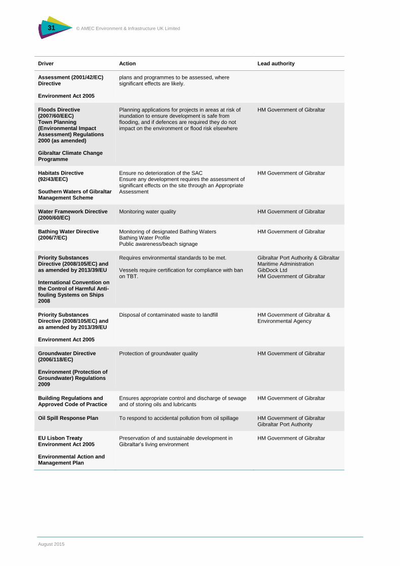
31 © AMEC Environment & Infrastructure UK Limited
August 2015
Driver Action Lead authority
Assessment (2001/42/EC) Directive Environment Act 2005
plans and programmes to be assessed, where significant effects are likely.
Floods Directive (2007/60/EEC) Town Planning (Environmental Impact Assessment) Regulations 2000 (as amended) Gibraltar Climate Change Programme
Planning applications for projects in areas at risk of inundation to ensure development is safe from flooding, and if defences are required they do not impact on the environment or flood risk elsewhere
HM Government of Gibraltar
Habitats Directive (92/43/EEC) Southern Waters of Gibraltar Management Scheme
Ensure no deterioration of the SAC Ensure any development requires the assessment of significant effects on the site through an Appropriate Assessment
HM Government of Gibraltar
Water Framework Directive (2000/60/EC)
Monitoring water quality
HM Government of Gibraltar
Bathing Water Directive (2006/7/EC)
Monitoring of designated Bathing Waters Bathing Water Profile Public awareness/beach signage
HM Government of Gibraltar
Priority Substances Directive (2008/105/EC) and as amended by 2013/39/EU International Convention on the Control of Harmful Anti-fouling Systems on Ships 2008
Requires environmental standards to be met. Vessels require certification for compliance with ban on TBT.
Gibraltar Port Authority & Gibraltar Maritime Administration GibDock Ltd HM Government of Gibraltar
Priority Substances Directive (2008/105/EC) and as amended by 2013/39/EU Environment Act 2005
Disposal of contaminated waste to landfill HM Government of Gibraltar & Environmental Agency
Groundwater Directive (2006/118/EC) Environment (Protection of Groundwater) Regulations 2009
Protection of groundwater quality HM Government of Gibraltar
Building Regulations and Approved Code of Practice
Ensures appropriate control and discharge of sewage and of storing oils and lubricants
HM Government of Gibraltar
Oil Spill Response Plan To respond to accidental pollution from oil spillage HM Government of Gibraltar Gibraltar Port Authority
EU Lisbon Treaty Environment Act 2005 Environmental Action and Management Plan
Preservation of and sustainable development in Gibraltar’s living environment
HM Government of Gibraltar
32 © AMEC Environment & Infrastructure UK Limited
August 2015
7.3 Supplementary Measures
Gibraltar’s HMWB fails the chemical status with high confidence due to the elevated levels of TBT.
Investigative monitoring shows that the source of TBT is historical sediment contamination, with the highest
levels in the southern section of the harbour, in front of the shipyard. This strongly suggests that the
historical contamination of TBT arises from hull anti-foul paint, which historically contained TBT. During
routine maintenance, the vessel would be stripped of any old TBT, with paint residues and flakes being
washed out into the harbour where they have accumulated in the sediment.
Tributyltin compounds are considered to be sufficiently toxic to many marine organisms at low concentrations
and several studies have shown their effects to lead to shell malformations in oysters, imposex in marine
snails (whereby female gastropods develop male sex organs), reduced resistance to infections (e.g. in
flounder) and effects on the human immune system.
Two options were considered for addressing the TBT issue in the harbour: business as usual and remedial
dredging.
Business as usual
As the title suggests, no additional measures are currently taken to reduce the levels of TBT in the water
body, apart from what is already being undertaken in the basic measures outlined in section 7.2 and
Annex H. Six years of monitoring data collected were graphed to determine if there is any increasing or
decreasing trend in TBT levels. Data show that there has been a gradual decrease in TBT levels over the
years. Continual (operational) monitoring will verify if this is the case.
The Government of Gibraltar is also conducting investigations into reopening of culverts located on the south
mole of the harbour. The intention is to increase water circulation and flushing with the aim of improving
water quality through increasing the distribution and dilution of contaminants and thus accelerate the natural
process of breakdown of TBT in the water column.
Remedial dredging
Remedial or clean-up dredging, is a form of dredging designed to remove contaminated sediments, thus
improving water quality and restoring the health of aquatic ecosystems. It is not without adverse effects,
however. The very act of dredging causes resuspension of contaminated sediments which sustains the risk
for remobilization of TBT to the water phase. It is estimated that an area of approximately 550,000 m2,
approximately half the harbour, would have to be dredged to a depth of 1 m. This would equate to about
1,100,000 tonnes/m3 of sediment.
Whilst it is arguable that there is a benefit in trying to bring forward the reduction of TBT levels through
options such as remedial dredging, there is a strong case against this due to the adverse environmental
impacts associated with activities such as dredging. Direct effects include the removal or destruction of
habitat and benthos, changes to bathymetry/topography and the removal or destruction of any
archaeological assets. Indirect effects include smothering of sensitive species from the re-suspension of
sediment and increase in turbidity causing potentially negative effects on sensitive species such as fish.
Previous studies in the harbour have also identified the presence of protected species, such as the sea pen
Pinna nobilis (listed in Annex IV of the Habitats Directive), and Pinna rudis (listed in Annexe II of the
Barcelona Convention and in the Bern Conventions).
Once the contaminated sediment has been dredged from the harbour, the sediment will have to be treated
and cleaned for safe disposal. In practice, the dredged sediments would need to be shipped/transported to
Europe for treatment and disposal due to lack of space and treatment facilities in Gibraltar.
Monitoring Programmes
For the second cycle of the RBMP, the following monitoring regimes are proposed:
operational monitoring undertaken at the HMWB to determine the status of water body
following implementation of the supplementary measures;
33 © AMEC Environment & Infrastructure UK Limited
August 2015
surveillance monitoring is continued to be carried out of the coastal water body at the same
locations and sampling frequency as in the first cycle of the RBMP.
The list of priority substances monitoring will also be updated according to Priority Substances Directive
2013/39/EU, which introduces 12 new priority substances. These will be reviewed in the second cycle of
RBMP for inclusion in the third cycle.
7.4 Cost Effectiveness and Cost Benefit Analysis
Cost-effectiveness (CEA), Cost-benefit (CBA) and Disproportionate Cost Assessments (DCA)
The WFD calls for extensive application of economic appraisal tools to support water management and
policy decisions, and in particular for the application of cost-effectiveness and cost-benefit analysis. Annex III
of the Directive stipulates that the most cost-effective combination of measures should be included in the
programme of measures based on estimates of potential costs of such measures.
In the context of the WFD, cost-effectiveness analysis (CEA) is used to make judgements about the most
cost-effective programme of measures which could be implemented to achieve the target EQS. In general
terms, CEA of identified alternative supplementary measures would result in their relative ranking in terms of
cost-effectiveness (i.e. identifying the least cost pathway to ensure set environmental objectives are met).
However, even the most cost-effective set of measures may still be associated with disproportionate costs.
While the main objective of the WFD is to ensure that all waters reach ‘good status’, the Directive recognises
that achievement of this aim in all water bodies might be unrealistic. Article 4 of the WFD envisages the
possibility of exemptions, or in other words the setting of alternative objectives, when good status in a body
of water cannot be achieved due to natural processes/conditions, lack of technical feasibility or
disproportionate costs of available measures.
In general terms, Article 4 allows for extension of the deadline for achievement of the objectives or setting
less stringent environmental objectives that can be justified on the basis of disproportionality analysis.
Appraisal of Supplementary Measures
The first cycle of river basin management planning in Gibraltar included only investigative and monitoring
activities in the programme of measures. Following the collection of additional data, failure of Gibraltar’s
HMWB to comply with good chemical status has been confirmed due to elevated levels of TBT.
Importantly, the source of the TBT causing failure is thought to be historical, from antifouling paints applied to
the hulls of vessels. Regular ship maintenance activities carried out in dry docks have historically resulted in
discharging the TBT-based antifoul paint scrapings into the harbour and accumulating in the sediments over
time.
Two potential options have been identified to address the TBT issue in the harbour:
business as usual, or
remedial dredging.
Business as Usual
Analysis of the past trends and forecasting of TBT levels to the year 2021 suggest anticipated continuous
reduction of TBT levels in the coastal water body. It is, however, noted that, assuming that the current trend
continues, forecast TBT levels in December 2021 would be 0.000981 µg/l (versus the annual average (AA)
EQS of 0.0002 µg/l).
At the same time, ongoing activities by the Government of Gibraltar aimed at reopening of culverts located
on the south mole of the harbour would result in an increased water circulation thereby accelerating the
natural process of TBT breakdown. At this stage it is unclear as to the feasibility of reopening the culverts. If
34 © AMEC Environment & Infrastructure UK Limited
August 2015
the culverts are reopened, it is anticipated that this would aid in reducing TBT levels in the water column and
thus helping achieve EQS. However, it is difficult to determine at this stage just how effective this will be, and
improvement in water quality through a reduction in TBT will only be determined through operational
monitoring. Therefore, it is difficult to comment whether the reopening of the culverts will assist in the HMWB
achieving good status by 2027.
The Government of Gibraltar is commencing investigation works to assess the current state of the culverts.
The costs of reopening culverts will be contingent on the findings of investigative studies. In general terms,
the costs of investigation and manual cleaning versus the costs of investigation and use of underwater
machinery could range from 10,000 to 50,000 Euro, based on average costs of diver surveys and use of
remotely operated vehicles (ROVs).
Remedial Dredging
The second, alternative course of action to ensure achievement of the environmental objectives set would
include remedial dredging which involves the removal and appropriate treatment of contaminated sediments.
In order to remove contaminated sediments about half of the harbour would need to be dredged resulting in
an estimated 0.55 million m3 of sediment being removed.
Costs of dredging can range substantially; with estimated total costs of dredging TBT contaminated
sediments ranging from 19 to 360 million Euro (one-off).
Following dredging TBT contaminated sediments would need to be transported and treated abroad (due to
lack of space and treatment facilities in Gibraltar). Depending on the choice of remediation technique, total
costs of treating dredged sediments could range from 34 to 75 million Euro.
In total, estimated costs of dredging and treating contaminated TBT sediments could range from 53 to 435
million Euro.
Justification of Derogations
The WFD sets out a complex and strict procedure for justification of exemptions and the argument of
technical feasibility constitutes the first test. In assessing technical feasibility, one should take into account
complexities and uncertainties pertaining to the natural systems and interactions between natural and human
environments and make a judgement on whether the measures proposed would result in achieving the target
objective.
Disproportionality analysis constitutes the second test and plays a major role in the justification of alternative
objectives. In the UK, a combined approach of Net Present Value for the programs of measures, assessment
of economic viability and impacts on the sectors as well as distributional assessment of costs and benefits is
used in river basin management planning.
Carrying out remedial dredging in Gibraltar would be technically feasible, however, financial and
environmental costs of such approach would be excessive.
In particular, total, estimated costs of dredging and treating contaminated TBT sediments could range from
53 to 435 million Euro. Secondly, it is widely recognised that the removal of sediments through dredging may
have adverse impacts on marine species and habitats. Impacts may be due to physical or chemical changes
in the environment at the dredging site. The extent of such impacts depend on the characteristics and
sensitivity of the area dredged, as well as the dredging technique used.
During remediation dredging the main impact upon the environment occurs during excavation and removal of
sediment and the vertical transport of the dredged material to the surface of the water, with the potential for
increasing turbidity and release of TBT into the water column. Whilst the latter can be minimised through
careful consideration of the type of equipment used, the former (removal of sediment) cannot be mitigated.
Previous studies have identified the presence of protected species (the sea pen P. nobilis and P. rudis),
which would be destroyed through the dredging process. Alternatively, these organisms can be translocated
but there is no guarantee the translocation process would not also have an adverse impact upon the
protected species.
35 © AMEC Environment & Infrastructure UK Limited
August 2015
Aside from the negative impact on protected species, the ecological status of the HMWB would also be
negatively affected by the dredging process. Currently the HMWB achieves GEP; remedial dredging would
result in significant deterioration in ecological potential of the water body through the removal of half of the
upper layer of sediment in the harbour.
36 © AMEC Environment & Infrastructure UK Limited
August 2015
8. Objectives
The classification of the water bodies is presented in Annex D, and pressures identified
are summarised in Annex B. Further detail on the setting of objectives can be found in
Annex E.
8.1 Approach to setting objectives
In identifying and setting realistic objectives for Gibraltar’s four water bodies, the procedure outlined below
has been followed:
identify default objectives as set by the WFD;
identify and assess pressures and risks of failing to meet default objectives;
identification and appraisal of actions needed to meet default objectives; and
setting of specific objectives for the Gibraltar RBD.
The methodology used to set the specific objectives for Gibraltar’s River Basin Districts (RBD) is taken from
the UK River Basin Management Plans. This approach uses the Common Implementation Strategy (CIS)
Guidance Document Number 20 (EC, 2009) and the River Basin Planning Guidance published by Defra and
Welsh Assembly Government in the UK in 2006 and 2008.
8.2 Objectives for surface water bodies
Objectives for Coastal Water Body
The classification, based on available monitoring data, identifies that the Coastal Water Body is at good
status overall, with low certainty associated with the chemical status as a result of the analytical level of
detection.
The objectives for this surface water body are:
prevent deterioration in status;
aim to maintain good status;
comply with objectives and standards for protected areas where relevant; and
reduce pollution from priority substances and cease discharges, emissions and losses of
priority hazardous substances.
Objectives for Heavily Modified Water Body
The current moderate potential for the HMWB results from the failure to meet the EQS for TBT, within the
priority substances element of chemical status. The overall target of good potential for the HMWB is delayed
until 2027.
The objectives for the HMWB are:
prevent deterioration in status for the HMWB;
achieve good ecological potential by 2027; and
reduce pollution from priority substances and cease discharges, emissions and losses of
priority hazardous substances.
37 © AMEC Environment & Infrastructure UK Limited
August 2015
8.3 Objectives for groundwater Bodies
The classification, based on available monitoring data, identifies that the two groundwater bodies are at good
status overall, with both quantitative and chemical status being good.
The default WFD objectives are, therefore, appropriate. These include the following objectives that are
relevant to Gibraltar:
prevent deterioration in the status of groundwater bodies; and
prevent or limit the input of pollutants into groundwater.
38 © AMEC Environment & Infrastructure UK Limited
August 2015
9. References
Entec UK Limited, Northumbrian Water Ltd and AquaGib Ltd, 2005. Gibraltar River Basin District - Initial
Characterisation, Summary report of the characterisation, impacts and economics analyses required by
Article 5 of the Water Framework Directive.
Environment Agency, 2008. Greenhouse gas emissions of water supply and demand management options.
Science Report – SC070010, prepared by Halcrow Group Ltd, July 2008.
European Commission, 2003. Guidance document no 4: Identification and Designation of Heavily Modified
and Artificial Water Bodies. Common Implementation Strategy of the Water Framework Directive.
European Commission, 2005. Guidance Document No. 13: Overall approach to the classification of
ecological status and ecological potential. Common Implementation Strategy of the Water Framework
Directive.
European Commission, 2009. Guidance Document No. 20: Guidance Document on Exemptions to the
Environmental Objectives. Common Implementation Strategy of the Water Framework Directive.
European Commission Joint Research Centre, 2010. WFD Intercalibration Phase 2: Milestone 3 report,
Coastal Water/MED GIG/ Benthic macroinvertebrates.
Dauvin J.C. & Ruellet T., 2007. Polychaete/amphipod ratio revisited. Mar. Poll. Bull. 55, 215-224
Defra, 2007. Guidelines to Defra's GHG Conversion Factors for Company Reporting. June 2007.
Defra, 2008. River Basin Planning Guidance, Volume 2. The Department for Environment, Food and Rural
Affairs, London
Department of Energy and Climate Change, 2009. Carbon Valuation in UK Policy Appraisal: A Revised
Approach Climate Change Economics. Department of Energy and Climate Change, July 2009.
Department of the Environment and Climate Change, HM Government of Gibraltar, 2008. The Gibraltar
Climate Change Programme 2008.
Department of the Environment and Climate Change, HM Government of Gibraltar, 2008. Significant Water
Management Issues 2008.
Department of the Environment and Climate Change, HM Government of Gibraltar, 2010. Southern Waters
of Gibraltar Management Scheme.
Department of the Environment and Climate Change, HM Government of Gibraltar. Guidelines for the
Assessment of Dredged Material.
Ministry for the Environment, HM Government of Gibraltar. Environmental Action and Management Plan.
Royal Haskoning UK Ltd, 2008. Guidance on the Classification of Ecological Potential for Heavily Modified
Water Bodies and Artificial Water Bodies. UKTAG Guidance.
Rose E.P.F., Mather J.D. & Perez, M., 2004. British attempts to develop groundwater and water supply on
Gibraltar 1800-1985, from 200 Years of British Hydrogeology. Geological Society, London, Special
Publications, 225, 239-262.
The River Basin Districts Typology, Standards and Groundwater threshold values (Water Framework
Directive) (England and Wales) Directions 2010.
UK Technical Advisory Group, 2004. Draft principles for an objective setting framework for river basin
management planning in accordance with the Water Framework Directive.
UK Technical Advisory Group, 2007a. Proposals for a Groundwater Classification System and Its Application
in Regulation, Final Report.
39 © AMEC Environment & Infrastructure UK Limited
August 2015
UK Technical Advisory Group, 2007b. Recommendations on Surface Water Classification Schemes for the
purposes of the Water Framework Directive
UK Technical Advisory Group, 2008. UK Environmental Standards and Conditions (Phase 2).
UK Technical Advisory Group, 2012a. Groundwater Trend Assessment, working draft v0.4.
UK Technical Advisory Group 2012b. Paper 11b(i): Groundwater Chemical Classification for the purposes of
the Water Framework Directive and the Groundwater Directive. Final version.
UK Technical Advisory Group, 2014. Updated Recommendations on Environmental Standards, River Basin
management (2015-21), Final Report.
Wright E.P., Rose E.P.F. & Perez, M., 1994. Hydrogeological Studies on the Rock of Gibraltar, Quarterly
Journal of Engineering Geology and Hydrogeology, 27; 15-29.
2008/915/EC: Commission Decision of 20 September 2013 establishing, pursuant to Directive 2000/60/EC of
the European Parliament and of the Council, the values of the Member State monitoring system
classifications as a result of the intercalibration exercise (notified under document number C(2008) 6016)
(Text with EEA relevance).
2013/480/EU Commission Decision of 30 October 2008 establishing, pursuant to Directive 2000/60/EC of
the European Parliament and of the Council, the values of the Member State monitoring system
classifications as a result of the intercalibration exercise and repealing Decision 2008/915/EC (notified under
document number C(2013) 5915) (Text with EEA relevance).