watagans national park and jilliby state …
TRANSCRIPT

WATAGANS NATIONAL PARK AND JILLIBY STATE CONSERVATION AREA
DRAFT PLAN OF MANAGEMENT NSW National Parks and Wildlife Service Part of the Department of Environment and Climate Change (NSW) November 2008

Acknowledgments This plan of management was prepared by staff of the Central Coast Hunter Range Region of NPWS, Parks and Wildlife Group, Department of Environment and Climate Change. Information and comments were provided by NPWS specialists, the Central Coast- Hunter Range Regional Advisory Committee, Plan of Management Focus Group Members and members of the public. Disclaimer: Any representation, statement, opinion, advice, information or date, expressed or implied in this publication is made in good faith but on the basis that the State of NSW, its agents and employees are not liable (whether by reason of negligence, lack of care or otherwise) to any person for any damage or loss what so ever which has occurred or may occur in relation to that person taking or not taking (as the case may be) action in respect of any representation, statement, advice, information or data referred to above. © Department of Environment and Climate Change (NSW) 2008: Use permitted with appropriate acknowledgment. ISBN 1 7413 7868 0 For additional information or enquiries about any aspect of the plan, contact the NPWS Lakes Area Office, off Elizabeth Bay Drive, Lake Munmorah, or by phone on (02) 4358 0402.

INVITATION TO COMMENT The National Parks and Wildlife Act 1974 (NPW Act) requires that a plan of management be prepared that outlines how an area will be managed by the NSW National Parks and Wildlife Service (NPWS), part of the Department of Environment and Climate Change. The procedures for the exhibition and consultation on plans of management are specified in the NPW Act and involve the following stages: • The draft plan is placed on public exhibition for at least 90 days and any person
may comment on it; • The plan and submissions received on the plan are referred to the Regional
Advisory Committee for consideration; • The plan, submissions and any advice from the Regional Advisory Committee are
referred to the National Parks and Wildlife Advisory Council for consideration; • The plan, submissions and the recommendations of the Advisory Council are
referred to the Minister for Climate Change and the Environment, and a copy referred to the Regional Advisory Committee;
• After considering the submissions, the recommendations of the Advisory Council and any advice from the Regional Advisory Committee, the Minister may adopt the plan or may refer the plan back to the NPWS and Council for further consideration.
Members of the public, whether as individuals or as members of community interest groups, are invited to comment on this plan of management. Submissions should be in writing, and as detailed and specific as possible; however any comments, no matter how brief, are welcome. Comments should be forwarded in writing to: Planning Officer NPWS PO Box 1477 Gosford NSW 2250 Or by email to [email protected] The closing date for comments on the plan is Monday 30th March 2009. All submissions received by NPWS are a matter of public record and are available for public inspection upon request to NPWS. Your comments on this draft plan of management may contain information that is defined as “personal information” under the NSW Privacy and Personal Information Protection Act 1998. The submission of personal information with your comments is voluntary.

CONTENTS
1. INTRODUCTION................................................................................................................................ 1 1.1 LOCATION, GAZETTAL AND REGIONAL SETTING ................................................................. 1 1.2 LANDSCAPE ............................................................................................................................... 4
2. MANAGEMENT CONTEXT ............................................................................................................... 5 2.1 LEGISLATIVE AND POLICY FRAMEWORK .............................................................................. 5 2.2 MANAGEMENT PRINCIPLES AND OBJECTIVES..................................................................... 5
3. KEY VALUES AND MANAGEMENT DIRECTIONS ......................................................................... 7 3.1 VALUES OF THE AREA.............................................................................................................. 7 3.2 MANAGEMENT DIRECTIONS .................................................................................................... 8
4. CONSERVATION OF NATURAL AND CULTURAL HERITAGE..................................................... 9 4.1 GEOLOGY, SOILS AND LANDFORM......................................................................................... 9 4.2 NATIVE PLANTS ....................................................................................................................... 11 4.3 NATIVE ANIMALS ..................................................................................................................... 15 4.4 ABORIGINAL HERITAGE.......................................................................................................... 19 4.5 HISTORIC HERITAGE............................................................................................................... 21
5. PARK PROTECTION....................................................................................................................... 26 5.1 WATER QUALITY AND CATCHMENT MANAGEMENT .......................................................... 26 5.2 INTRODUCED SPECIES........................................................................................................... 26 5.3 FIRE MANAGEMENT ................................................................................................................ 31
6. VISITOR OPPORTUNITIES AND EDUCATION ............................................................................. 34 6.1 INFORMATION PROVISION..................................................................................................... 34 6.2 RECREATION OPPORTUNITIES ............................................................................................. 36
7. PARK ROADS, MANAGEMENT TRAILS AND VEHICLE ACCESS ............................................. 44 7.1 TRACK AND TRAIL CLASSIFICATION .................................................................................... 44 7.2 TRACK AND TRAIL CLOSURE................................................................................................. 44 7.3 SPECIFIC TRACKS AND TRAILS............................................................................................. 45
8. RESEARCH AND MONITORING.................................................................................................... 48 9. OTHER USES .................................................................................................................................. 50
9.1 EASEMENTS AND OTHER OCCUPANCIES ........................................................................... 50 9.2 MINING INTERESTS................................................................................................................. 50 9.3 ACCESS REQUIREMENTS ...................................................................................................... 53 9.4 COMMERCIAL INTERESTS...................................................................................................... 53
10. PLAN IMPLEMENTATION ............................................................................................................ 55 11. ABBREVIATIONS.......................................................................................................................... 59 12. REFERENCES............................................................................................................................... 60 APPENDIX 1. VEGETATION COMMUNITY INFORMATION............................................................. 63 APPENDIX 2. EUROPEAN CULTURAL HERITAGE ITEMS AND INVENTORY SHEETS............... 66 FIGURE 5A. ROADS AND TRAILS IN WATAGANS NP & JILLIBY SCA (NORTHERN SECTION). 72 FIGURE 5B. ROADS AND TRAILS IN JILLIBY SCA (CENTRAL AND SOUTHERN SECTIONS) ... 73
1
1. INTRODUCTION 1.1 LOCATION, GAZETTAL AND REGIONAL SETTING Watagans National Park (NP) and Jilliby State Conservation Area (SCA) (collectively called “the reserves” in this plan) form a near contiguous reserved area from the northern escarpment of the Myall Range overlooking Cessnock, to just north of Ourimbah township 45 kilometres to the south. The reserves are located near a number of major population centres and straddle the Cessnock, Wyong and Lake Macquarie Local Government Areas (LGAs). The boundaries of these reserves are located 60 kilometres north of Sydney, 31 kilometres west of Newcastle, 15 kilometres south of Cessnock, 9 kilometres north-west of Wyong and 10 kilometres north of Gosford (see Figure 1, page 2). Watagans NP (7798 hectares) was created through the enactment of the Forestry and National Park Estate Act 1998 on 1 January 1999. It is comprised of parts of the former Olney (2260 hectares), Watagan (5490 hectares) and Heaton (1 hectare) State Forests. Reservation of the area occurred as an outcome of the Lower North East Regional Forest Agreement 2000 (RFA) which saw many former State Forests become part of the National Parks and Wildlife Service (NPWS) reserve system. Jilliby SCA (12159 hectares) was identified as an icon forest area in the RFA, however, it was not reserved through this process. After being at the heart of a high profile environmental debate the reserve was created on 1 July 2003 through enactment of the National Park Estate (Reservations) Act 2003. The reserve was formerly part of Olney (4423 hectares), Wyong (3842 hectares), Ourimbah (3836 hectares) and Watagan (58 hectares) State Forests. Watagans NP and Jilliby SCA are located along the eastern edge of the Watagan Mountains, part of the Great Dividing Range. Surrounding land use is predominantly forestry with grazing and a growing number of smaller rural residential and “hobby” farm lots in the foothills and valleys below. The reserves also link to the adjacent Heaton, Olney, Awaba, Watagan, Wyong and Ourimbah State Forests. In the context of a regional system of reserves, Watagans NP and Jilliby SCA form part of a significant ecological corridor stretching along the coastal ranges from the Hunter River estuary in the north to the Hawkesbury River estuary in the south. The reserves complement the large, predominantly sandstone reserves of the Greater Blue Mountains World Heritage Area to the west and Popran and Brisbane Water National Parks to the south. To the northwest, on the floor of the Hunter Valley, are Werakata National Park and Belford Nature Reserve and to the east the significant coastal reserves of Lake Macquarie, the Central Coast and Newcastle.

2
Figure 1. Regional Context

3
Both reserves contain Ministerial roads (Table 1) that are vested in the Minister for Climate Change and the Environment on behalf of the Crown under Part 11 of the National Parks and Wildlife Act 1974 (NPW Act). These Ministerial roads were created under the Forestry and National Park Estate Act 1998 to provide for the continuation of access arrangements that existed before the creation of the reserves (primarily for timber hauling and private property access). Table 1. Ministerial roads within the planning area Road / Trail Name Classification Watagans NP Harris Fire Rd. Secondary Access Road Unnamed FT off Owens Rd Martinsville. Management Trail Four Horizons Access Rd Management Trail Unnamed FT off Lane Q9 Quorrobolong Management Trail Sandy Knob Fire Trail Public Access Jilliby SCA Prestons Ridge Rd Secondary Access Road Public Access Red Hill Rd Secondary Access Road Public Access Moores Pt Rd Management Trail Transgrid Rd Management Trail Tooheys Rd Secondary Access Road Public Access Wild dog Rd Management Trail Footes Pt Rd Management Trail Duffys Pt Rd Management Trail Stinsons Pt Rd Management Trail Lardies Pt Rd Management Trail Siding Rd Secondary Access Road Public Access Ravensdale Rd (top section – unsealed). Management Trail Martinsville Hill Rd. Primary Access Prickly Ridge Rd. Primary Access Part Watagan Forest Rd. Primary Access
The management of these roads is subject to the provisions of this plan, the National Parks and Wildlife Regulation (NPW Regulation), the requirements of the Environmental Planning and Assessment Act 1979 (EPA Act) and a Memorandum of Understanding between the Department of Environment and Climate Change (DECC) and Forests NSW. Two Part 11 (NPW Act) gravel quarries are also located in the reserves and are subject to similar provisions (Red Hill Road and German Point Road). These Part 11 areas are not gazetted as part of the reserves. Lands reserved under the NPW Act are managed under the provisions of this Act and the associated regulation. It is the intent that all lands reserved under this legislation be zoned accordingly in Council Local Environment Plans (LEPs). Due to the fairly recent establishment of these reserves, particularly Jilliby SCA, and the infrequent amending of LEPs, a large percentage of the reserves are zoned incorrectly. Current zoning and proposed zoning changes are shown in Table 2 (page 4).

4
Table 2. Local Government zoning for planning area LGA Current zoning Notes / Proposed changes Wyong 1(f) forestry
(Wyong LEP 1991) To be changed to 8(a) national parks under future amendments to LEP (S Duncan [Wyong Council] 2005 pers. comm.)
Lake Macquarie 8 National Park 9 Natural Resources
Local Environment Plan 2002 – Adopted 1/9/2003
Cessnock 1 (f) forestry (Cessnock LEP 2003)
Advice pending - Cessnock City Council.
1.2 LANDSCAPE Watagans NP and Jilliby SCA protect important areas of remnant forest ecosystems at the head of major water catchments. Some areas have not been significantly logged and contain important biodiversity values and intact natural landscapes. Abundant natural resources supported Aboriginal people in the region for thousands of years and evidence of this is found throughout the reserves at sites and places, such as occupation and art sites, engravings and axe grinding grooves. The Awabakal and Darkinjung Aboriginal peoples are the original inhabitants of the Watagans area. The Darkinjung, Koompahtoo and Awabakal Local Aboriginal Land Councils (LALCs) and the Awabakal Descendants Group represent Aboriginal interests in the area today. European settlement in the region was driven by the need for coal, agricultural land and timber. By the 1820-30s timber removal was common place, including harvesting of red cedar. Gold rushes, coal mining and railway line construction, and the associated building boom, turned the resources of the ranges into a valuable commodity. Timber extraction continued until their reservation under the NPW Act. Visitors now value the area as a place to escape for relaxation and exercise in a peaceful, beautiful setting. In this plan natural and cultural heritage, threats and use of the parks are discussed as separate issues, however, the plan recognises their interactions and takes these into account.

5
2. MANAGEMENT CONTEXT 2.1 LEGISLATIVE AND POLICY FRAMEWORK The management of national parks and state conservation areas in NSW is in the context of a legislative and policy framework, primarily the NPW Act, the NPW Regulation, the Threatened Species Conservation Act 1995 (TSC Act) and the policies of the NPWS, now part of the Department of Environment and Climate Change (DECC). Section 72AA of the NPW Act lists the matters to be considered in the preparation of a plan of management. The policies arise from the legislative background and internationally accepted principles of park management. They relate to nature conservation, Aboriginal and historic heritage conservation, recreation, commercial use, research and communication. Other legislation, international agreements and charters may also apply to management of the area. In particular, the EPA Act may require the assessment and mitigation of the environmental impacts of works proposed in this plan. Once adopted by the Minister for Climate Change and the Environment, this plan becomes a statutory document and DECC is obliged to manage the reserves consistent with the provisions of the plan, to implement the actions it contains and to refrain from management actions that are contrary to its provisions. 2.2 MANAGEMENT PRINCIPLES AND OBJECTIVES 2.2.1 National Parks in New South Wales National parks are reserved under the NPW Act to protect and conserve areas containing outstanding or representative ecosystems, natural or cultural features or landscapes or phenomena that provide opportunities for public appreciation and inspiration and sustainable visitor use. Under the Act (Section 30E), national parks are managed to: • conserve biodiversity, maintain ecosystem functions, protect geological and
geomorphological features and natural phenomena and maintain natural landscapes;
• conserve places, objects, features and landscapes of cultural value; • protect the ecological integrity of one or more ecosystems for present and future
generations; • promote public appreciation and understanding of the park’s natural and cultural
values; • provide for sustainable visitor use and enjoyment that is compatible with
conservation of natural and cultural values; • provide for sustainable use (including adaptive reuse) of any buildings or
structures or modified natural areas having regard to conservation of natural and cultural values; and
• provide for appropriate research and monitoring.
6
2.2.2 State Conservation Areas in New South Wales State conservation areas are reserved under the NPW Act to protect and conserve areas that contain significant or representative ecosystems, landforms or natural phenomena or places of cultural significance; that are capable of providing opportunities for sustainable visitor use and enjoyment, the sustainable use of buildings and structures or research; and that are capable of providing opportunities for uses permitted under other provisions of the Act. Under the Act (Section 30G), state conservation areas are managed to: • conserve biodiversity, maintain ecosystem functions, protect natural phenomena
and maintain natural landscapes; • conserve places, objects and features of cultural value; • provide for the undertaking of uses permitted under other provisions of the NPW
Act (including uses permitted under section 47J such as mineral exploration and mining), having regard to the conservation of the natural and cultural values of the state conservation area;
• provide for sustainable visitor use and enjoyment that is compatible with conservation of the area’s natural and cultural values and with uses permitted in the area;
• provide for sustainable use (including adaptive reuse) of any buildings or structures or modified natural areas having regard to conservation of the area’s natural and cultural values and with other uses permitted in the area; and
• provide for appropriate research and monitoring. The Act also requires review of the classification of SCAs every 5 years, in consultation with the Minister administering the Mining Act 1992, to determine whether they should receive either a national park or nature reserve classification. Due to the significant natural and cultural features of Jilliby SCA it will be managed in accordance with the same management purposes and principles as Watagans NP, except for issues relating to mineral titles, exploration and mining interests. 2.2.3 Regional Forest Agreements Both Watagans NP and Jilliby SCA were created as a result of the Lower North East RFA. Under the RFA all forest managers must demonstrate ecologically sustainable forest management practices (ESFM). ESFM aims to maintain or increase the values for which the reserves were created including factors such as: • ecosystem biodiversity, health, vitality, productive capacity and functional
processes; • soil and water productive capacity and functional processes; • long term social and economic benefit; and • natural and cultural heritage values. ESFM is an over-riding management principle and will be applied to all ecosystem types within the reserves, not just forests. It will be implemented primarily through monitoring of key performance indicators such as pest and weed management to provide feedback on the success of reserve management programs, and to highlight directions for future adaptive management.

7
3. KEY VALUES AND MANAGEMENT DIRECTIONS 3.1 VALUES OF THE AREA Watagans NP and Jilliby SCA are of significance for their contribution to a comprehensive, adequate and representative national reserve system and for their cultural heritage, landscape and recreational values. Key natural values include: • Watagans NP and Jilliby SCA contain significant and diverse forest ecosystems
and are located at an ecotone between the moist and ecologically rich forests of the mid north coast and the drier forests of the Sydney sandstone landscapes;
• the reserves contain a range of vegetation communities including tall moist forest, warm temperate rainforest and drier tall forests and woodlands, and at least one endangered ecological community.
• two threatened plant species (TSC Act) and at least five rare species are found within the reserves. An additional five threatened plant species have been recorded within 1 kilometre of the reserves and it is likely that they occur in similar habitats present in the reserves.
• Watagans NP and Jilliby SCA provide habitat for over 150 native animal species, of which 16 are listed as threatened under the schedules of the TSC Act (4 Endangered, 12 Vulnerable). Of high significance are the populations of endangered brush-tailed rock wallaby, yellow-bellied glider, giant barred frog and stuttering frog.
Significant scenic values include: • the Watagan Ranges provides a scenic backdrop to the highly urbanised areas of
Lake Macquarie, Wyong, and to a lesser extent, Gosford. • vantage points with scenic views are located along many of the ridgetop roads
within the reserves and provide views northwest into the Hunter Valley and to the east along the coastline.
The key cultural heritage values comprise: • importance to the Awabakal and Darkinjung Aboriginal people represented by the
Darkinjung, Awabakal and Koompahtoo Local Aboriginal Land Councils. • a diversity of Aboriginal sites and places, including axe grinding grooves, art sites
and open campsites. • a resource for interpreting the significance of the forested areas along the range
as a basis for industry and the expansion of early colonial Sydney. At least 33 European heritage items have been recorded in the reserves, primarily associated with the logging history of the region.
Major recreation and tourism values include: • the southern part of Jilliby SCA and the northern end of Watagans NP contain
sections of the Great North Walk. • Watagans NP and Jilliby SCA contribute to the diversity of recreational
opportunities available in the Newcastle, Lake Macquarie, Central Coast and greater Sydney regions.

8
Research and educational values: • the reserves provide a valuable educational and research resource being in close
proximity to a number of urban areas; 3.2 MANAGEMENT DIRECTIONS In addition to the general objectives for the management of national parks and state conservation areas (refer section 2.2), the management of Watagans NP and Jilliby SCA will be consistent with the following principles: • The reserves will be managed to conserve their natural and cultural heritage while
providing opportunities for sustainable public use. Only areas that can sustain use will be promoted through provision of access and facilities. Conservation will have priority over public use where conflict between the two occurs.
• There will be some closure and downgrading of former forestry roads to reduce
impacts such as erosion, weeds and pest animals. Cycling and horse riding will be permitted on all retained roads and other suitable trails (see section 7.2 for details).
• Close liaison will be maintained with adjacent land managers and neighbours to
facilitate cooperative management programs and resource and information sharing. The community will be kept informed about major management programs and will be consulted and involved in relevant programs.
• Consultation with the Aboriginal community will be maintained and mechanisms
for promoting traditional use and cooperative management of areas of cultural significance to the Aboriginal community will be developed and implemented.
• Ecologically sustainable forest management principles will be implemented to
ensure the maintenance or improvement of the values for which the reserves were created to protect. Specific priority will be given to the maintenance, and where necessary recovery, of populations and habitats of forest dependant fauna species such as the yellow-bellied glider, powerful owl and sooty owl. Additional priority species include the brush-tailed rock wallaby, parma wallaby, giant barred frog, and stuttering frog.

9
4. CONSERVATION OF NATURAL AND CULTURAL HERITAGE 4.1 GEOLOGY, SOILS AND LANDFORM The geology of the reserves is characterised by sedimentary formations of the Narrabeen Group and Hawkesbury Sandstone, with some smaller areas of Quaternary Alluviums. Common rock types are sandstone, claystone, siltstone and conglomerate. Soil landscape mapping has been carried out for the entire planning area on the Singleton 1:250,000 sheet (Kovak & Lawrie 1991) and the Gosford 1:100,000 sheet (Murphy & Tille 1993). Over both reserves the Watagan soil landscape covers 68% (13,538 hectares), the Sydney Town soil landscape 13% (2,637 hectares) and the Mandalong soil landscape 6.5% (1,261 hectares). The remainder of the 2,474 hectares is covered by 12 minor soil landscapes. The dominant Watagan soil landscape is made up of Lithosols, Siliceous Sands, Yellow Earths and Red and Yellow Podzolics. The Sydney Town soil landscape contains Yellow Earths, Earthy and Siliceous Sands. The Mandalong soil landscape contains Red, Brown and Yellow Podzolics. A summary of soil landscapes characteristics is provided in Table 3. The majority of Watagans NP and Jilliby SCA is well vegetated with natural forest and woodlands, and a small number of isolated non native plantations. The erosion potential of soils in these areas is relatively low, though severe sheet and gully erosion can occur on steep slopes, especially after high rainfall or where the ground surface has been disturbed. All roads and trails in Watagans NP and Jilliby SCA are unsealed gravel roads that require a high level of maintenance. Many roads and trails have steep sections that have required the installation of pipes, culverts and surface drains. Where road surfaces are not regularly maintained, rill, rut and sheet erosion occur alongside and below mitre, table and rollover drains. Earth batters above roads and car parks are also prone to slumping. Erosion control work has been undertaken in Watagans NP at Slippery Rock Road, Sandy Knob Fire Trail and Bangalow Road. In Jilliby SCA, the sawmill site (bordered by Watagan Forest and Martinsville Hill Roads), Yambo Forest Road, Prickly Ridge Forest Road, Lemon Tree and Scout Roads require erosion control work. Illegal trail bike tracks exist, mostly in Jilliby SCA, and require rehabilitation to restrict further access and kerb escalating erosion. Large coal seams underlie both reserves. Above ground mining and associated activities are not permitted in national parks. Jilliby SCA is covered by a number of exploration licences for coal, petroleum, natural gas and gold (refer section 9.2) and some above ground activities associated with exploration and extraction are permissible in SCAs. The planning area is a significant landscape feature in the region.

10
Table 3. Summary of soil landscapes (after Kovak and Lawrie (1991) & Murphy and Tille (1993))
Soil Landscape Area (hectares)
Localities Landscape features Main Soil Types
Watagan 13538 Throughout Rolling to very steep hills on fine grained Narrabeen Group sediments.
Lithosols, Siliceous Sands, Yellow Earths, Yellow and Red Podzolics
Sydney Town 2637 Boarding House Dam to Clearwater Gully, Mangrove Mountain to Ourimbah
Undulating to low rolling hills and slopes on edge on quartz sandstone (Hawkesbury Sandstone and Terrigal Formation: Narrabeen Group) along edge of Somersby Plateau and as ridges and crests in Watagan Mountains.
Yellow Earths, Earthy and Siliceous Sands
Mandalong 1261 Mainly eastern sections from Mt Nellinda to Little Jilliby
Rolling to steep low hills on Patonga Claystone Formation.
Red, Brown and Yellow Podzolics
Erina 737 Footslopes of Wyong and Jilliby Creeks and crests and ridges in Jilliby SCA
Undulating to rolling rises and low hills on Terrigal Formation.
Yellow Podzolics and Yellow Earths
Ogilvie 621 Quorrobolong, Georges Road area
Steep hills and escarpments on Narrabeen Sandstone.
Lithosols and Brown Solodic Soils
Woodbury’s Bridge
317 Eastern edge of Jilliby SCA - footslopes of Jilliby Ck
Gently undulating rises and rolling low hills on Patonga Claystone.
Red and Yellow Podzolics and Soloths
Awaba 278 Congewai and Martinsville Valleys, Mt Nellinda
Rolling low hills on coarse-grained sediments of Narrabeen Group and Newcastle Coal Measures.
Brown and Yellow Podzolics, Lithosols and Soloths
Quorrobolong 186 Barraba Lane, Congewai Valley
Undulating low hills on Mulbring Siltstone and Branxton Formation.
Prairie Soils, Wiesenboden, Yellow Podzolics and Soloths.
Hawkesbury 144 Mangrove Mountain and Congewai Valley
Steep, rugged Hawkesbury Sandstone slopes and ridges.
Siliceous Sands, Lithosols, Yellow Earths and Yellow Podzolics
Gorokan 74 Lemon Tree Undulating low hills and rises on lithic sandstones of the Tuggerah Formation.
Soloths, Yellow and Grey-brown Podsolic
Yarramalong 49 Small pockets on boundary from Martinsville to Ourimbah
Level to gently undulating dissected alluvial plain on Quaternary sediments.
Alluvial Soils and Siliceous Sands
Somersby 32 Mangrove Mountain Gently undulating to rolling rises on deeply weathered Hawkesbury sandstone plateau.
Yellow and Grey Earths and Earthy Sands
Laguna 15 Congewai Valley Undulating to rolling footslopes on Terrigal Formation flanking Watagan Creek, Wollombi Brook and their tributaries.
Yellow and Red Podsolic
Doyalson 2 Mt Nellinda Gently undulating rises on Munmorah conglomerate.
Yellow Podzolic, Yellow Earths and Soloths
Wollombi Brook <1 Congewai Valley Narrow floodplains and terraces on Quaternary alluvium along Wollombi Brook and tributaries.
Alluvial Soils

11
Desired Outcomes • The scenic values of the reserves, and in particular lookouts providing regional
views, are protected.
• Reserve values in Jilliby SCA are not compromised by mineral exploration. Strategies • Selective trimming of trees obscuring vantage points at reserve lookouts may be
carried out to maintain views.
• Locate and design management and visitor facilities to minimise their visual impact from public access roads, lookouts and other vantage points.
• Liaise with neighbours and authorities to minimise the impact of adjacent land use on the scenic values of key locations in the park.
4.2 NATIVE PLANTS Watagans NP and Jilliby SCA are in an area where the ecologically rich and productive moist forests of the mid north coast give way to the drier forests of the Sydney sandstone country. As a result, many species are found growing at the limit of their distribution. This meeting of vegetation types provides a broad range of habitat for native fauna and flora. Some areas have been modified by forestry practices, such as regular low intensity burning regimes and timber harvesting, and may exhibit less diversity in species and maturity. Areas with more difficult access retain “old growth” forests with a diverse range of habitat niches. 4.2.1 Vegetation Communities Tall moist eucalypt forests are widespread in the reserves, commonly containing turpentine (Syncarpia glomulifera), mountain blue gum (Eucalyptus deanei), white mahogany (E. acmenoides), Sydney blue gum (E. saligna), blue-leaved stringybark (E. agglomerata), blackbutt (E. pilularis) and grey gum (E. propinqua) with warm temperate rainforest influences dominating the understorey of these communities. Forest oak (Allocasuarina torulosa), Sydney peppermint (E. piperita), broad-leaved white mahogany (E. umbra), large fruited red mahogany (E. scias subsp. scias), smooth-barked apple (Angophora costata) and red bloodwood (Corymbia gummifera) are common in the drier forest areas with understoreys varying from open dry and grassy, to dense shrubbery. Smaller areas of warm-temperate sub-tropical rainforest and paperbark palm forests occur in sheltered gullies and creek-lines. Typical rainforest species include lilly pilly (Acmena smithii), sassafras (Doryphora sassafras), brush cherry (Syzygium australe), wild quince (Guioa semiglauca), coachwood (Ceratopetalum apetalum) with tree ferns (Cyathea australis, C. leichhardtiana, C. cooperi), climbing vines and epiphytes common beneath the canopy. Isolated stands of red cedar (Toona ciliata) and Illawarra flame trees (Brachychiton acerifolius) remain in more remote areas. The paperbark palm forests contain a number of melaleuca species (Melaleuca
12
biconvexa and M. linariifolia) with white bottlebrush (Callistemon salignus) and cabbage tree palms (Livistona australis). A number of vegetation survey and mapping programs have been undertaken in the reserves including studies for the Morisset Forestry District Environmental Impact Statement (Binns 1996) and the Lower Hunter Central Coast Regional Environmental Management Strategy (LHCCREMS) (NPWS 2000; LHCCREMS 2003). Both of these vegetation surveys had a limited number of floristic survey plots located in the reserves and covered large areas. The distribution of vegetation communities was modelled across the landscape and the resulting vegetation maps were broad in their application. Additional full floristic plots (Bell 2002; 2005) and a large number of rapid assessment plots have since been undertaken in the reserves. Bell and Driscoll (2006) have produced a vegetation map, based mainly on ground-truthed rather than modelled data. Twelve vegetation communities identified in the LHCCREMS project were identified, as well as a number of variations to these communities. Table 4 lists the vegetation communities (and see Appendix 1 for additional information). 4.2.2 Threatened and significant plants and communities An area of Hunter Lowland Redgum Forest has been mapped in the north west part of Watagans NP in the vicinity of Barraba Lane. This community is listed as an Endangered Ecological Community (EEC) under the TSC Act. Further investigation is required to confirm whether this community exists in its own right or is actually a variant of a different community. A number of variants to LHCCREMS map unit 1, Coastal Wet Gully Forest, have been mapped in the reserves. Some of these variants potentially fall within the Lowland Rainforest in the NSW North Coast and Sydney Basin Bioregions EEC. Further investigation is required to confirm the presence and extent of this EEC within the reserves. Figure 2 (Page 23) shows the extent of vegetation communities mapped as Hunter Lowland Redgum Forest EEC and potentially within Lowland Rainforest EEC. Two plant species listed as threatened under the TSC Act are confirmed to occur in the reserves and several others have been found within 1 kilometre of the reserve boundaries. Suitable habitat for these species occurs in the reserves and it is expected that detailed surveys would locate most of them within the reserves. These species are listed in Table 5. Five additional Rare or Threatened Australian Plant (ROTAP) species have also been identified within the reserves. These are shown in Table 6. Recovery plans, threat abatement plans and priority action statements may be prepared for threatened species and communities listed under the TSC Act and will be used to guide management of threatened species and EECs in the area.

13
Table 4. Vegetation communities mapped in the reserves NPWS (2000), Bell and Driscoll (2006). LHCCREMS Map Unit and Base Community
Bell and Driscoll Map Unit and Community or Variant
1 Coastal Wet Gully Forest 1 Coastal Wet Gully Forest 1a Coastal Warm Temperate – Sub-tropical Rainforest 1b Red Cedar – Stinging Tree – Fig Subtropical Rainforest 1c Grey Myrtle – Paperbark Dry Rainforest 1d Coastal Grassy Bluegum Forest 1e Water Gum – Coachwood – Sassafras Riparian
Rainforest 1f Carex Sedgeland 6 Coastal Narrabeen Moist Forest 6 Coastal Narrabeen Bluegum Ridge Forest 6a Coastal Narrabeen Spotted Gum - Bluegum Forest 6b Coastal Narrabeen Mahogany – Bluegum forest 9 Coastal Ranges Open Forest 9a Coastal Ranges Mesic Blackbutt Forest 9b Coastal Ranges Dry Blackbutt Forest 9c Coastal Ranges Mesic Spotted Gum – Blackbutt Forest 9d Coastal Ranges Dry Spotted Gum - Blackbutt Forest 9e Coastal Ranges Mesic Peppermint Forest 9f Coastal Ranges Dry Peppermint – Blackbutt Forest 9g Coastal Ranges Mesic Grey Gum – Ironbark Forest 9h Coastal Ranges Dry Tallowwood – Blackbutt Forest 9I Coastal Ranges Mesic Stringybark – Mahogany Forest 9j Coastal Ranges Dry Stringybark – Mahogany Forest 12 Hunter Valley Moist Forest 12 Hunter Valley Moist Spotted Gum – Ironbark Forest 12a Hunter Valley Moist Spotted Gum – Blackbutt Forest 12b Hunter Valley Moist Spotted Gum – Turpentine Forest 15 Coastal Foothills Spotted Gum Ironbark Forest
15 Coastal Foothills Spotted Gum - Ironbark Forest
15b Coastal Foothills Dry Grey Gum - Ironbark Forest 15c Coastal Foothills Moist Grey Gum – Mahogany Forest 19 Hunter Lowlands Redgum Forest
19 Hunter Lowlands Redgum Forest
21 Hunter Range Grey Gum Forest 21a Hunter Range Dry Escarpment Apple Forest 21b Hunter Range Dry Stringybark – Grey Gum Forest 21c Hunter Range Moist Mahogany – Grey Gum Forest 21d Hunter Range Dry Ironbark – Grey Gum Forest 21e Hunter Range Dry Mahogany – Grey Gum Forest 21f Hunter Range Dry Mahogany - Apple Forest 21g Hunter Range Dry Stringybark – Blackbutt Forest 21h Hunter Range Dry Mahogany – Bloodwood Forest 22 Coastal Narrabeen Shrub Forest 22a Coastal Narrabeen Dry Blackbutt – Apple – Forest Oak
Forest 21b Coastal Narrabeen Dry Bloodwood – Apple – Mahogany
Forest 25 Sheltered Dry Hawkesbury Woodland
25a Hawkesbury Peppermint – Apple Sheltered Forest
26 Exposed Hawkesbury Woodland 26 Exposed Hawkesbury Bloodwood – Scribbly Gum Woodland
26a Exposed Hawkesbury Silvertop Ash – Bloodwood Forest 26b Exposed Hawkesbury Apple – Turpentine – Bloodwood
Forest 29 Hawkesbury Coastal Banksia Woodland
29 Hawkesbury Coastal Banksia Scrub-Woodland
54 Hawkesbury Hanging Swamps 54 Hawkesbury Hanging Swamps X Plantation areas P Plantation areas

14
Table 5. Threatened species records from planning area and within a 1 kilometre radius of reserve boundaries.
Family Name Species Name Legal status Potential habitat within the reserves (NPWS 2000)
Lamiaceae Prostanthera askania Endangered* Coastal Wet Gully Forest Myrtaceae Melaleuca biconvexa Vulnerable* Drainage lines particularly on the
eastern foot slopes of Jilliby SCA Myrtaceae Syzygium paniculatum Vulnerable* Coastal Wet Gully Forest Proteaceae Grevillea parviflora Vulnerable* Coastal Foothills Spotted Gum-
Ironbark Forest Rutaceae Bosistoa transversa Vulnerable* Potential habitat information not
available Known record from Watagans NP
Tremandraceae Tetratheca juncea Vulnerable Hunter Range Grey Gum Forest Tremandraceae Tetratheca glandulosa Vulnerable* Sheltered Dry Hawkesbury
Woodland, Exposed Hawkesbury Woodland. Known records from within Jilliby SCA
* denotes that the species is also listed as Endangered / Vulnerable under the Commonwealth Environment Protection and Biodiversity Conservation Act 1999 Table 6. ROTAP species within planning area (as per Briggs and Leigh 1995).
Family name Species name ROTAP code *
Reserve Location
Fabaceae: Mimosoideae
Acacia prominens 2RCa Watagans Slippery Rock Road
Myrtaceae Callistemon shiressii 3RC Jilliby SCA Null Point, LemonTree and Daniels Point
Myrtaceae Darwinia procera 2RCa Jilliby SCA Hallards Creek Myrtaceae Eucalyptus fergusonii
subsp. fergusonii 3KC Watagans NP Muirs Lookout, Null Pt and
Slippery Rock Road area Myrtaceae Eucalyptus hypostomatica 3RC Watagans NP Georges Road escarpment
* ROTAP codes
CATEGORY CODING DEFINITION 2 Restricted distribution - range extending over less than
100km Plant Distribution
3 Range more than 100km but in small populations R Rare but with no current identifiable threat Conservation Status K Poorly known species suspected of being at risk C Species is known to occur within a proclaimed reserve Reservation Status a Species is considered to be adequately reserved. 1000 or
more plants occur within a proclaimed reserve Desired Outcomes • The full range of native plant species found in Watagans NP and Jilliby SCA are
conserved. • Structural diversity and habitat values are conserved, and are restored where
subject to past logging and clearing. • The endangered ecological communities are conserved. • The habitat and populations of all significant plant species are protected. • Park neighbours support conservation of remaining areas of privately owned
native vegetation near the park.
15
• Native vegetation will be managed to conserve biodiversity and ecosystems within the reserves.
Strategies • Ensure that management and visitor facilities do not affect significant plant
species or restricted plant communities.
• Allow natural regeneration of past cleared and logged areas, apart from maintenance of visitor facilities.
• Implement relevant recovery plans and threat abatement plans.
• Undertake additional vegetation surveys for threatened plant species present in the reserves and to check for additional significant species.
• Introduce a program to monitor the status of the significant communities and threatened plant species and to evaluate the success of management programs.
• Investigate the existence of Hunter Lowland Redgum Forest Endangered Ecological Communities in the reserves and develop basic management guidelines.
• Investigate the existence of Lowland Rainforest Endangered Ecological Community in the reserves and develop basic management guidelines. Where required under NPWS policy, environmental impact assessment will be undertaken.
• Work with reserve neighbours and local environmental and community groups to encourage conservation of remnant vegetation on private lands in the vicinity of the reserves. Current Conservation Partners programs such as Land for Wildlife, wildlife refuges and Voluntary Conservation Agreements will be promoted where appropriate.
• Endemic plants propagated from seed or endemic seed from sources as close as possible to planting locations, will be used in any landscaping, revegetation and rehabilitation work except where non endemic species are essential for initial stabilisation and present no risk of infestation.
4.3 NATIVE ANIMALS Watagans NP and Jilliby SCA provide important habitat for over 150 native animal species including wallabies, gliders, brush and ring-tailed possums, amphibians and reptiles and more than 130 species of birds (Atlas of NSW Wildlife 2006). The area has not been systematically surveyed for native animals since its transfer to NPWS. Fauna surveys undertaken as part of the Comprehensive Regional Assessments (CRA) in 1996 and 1997 surveyed some sections of the reserves and NSW State Forests conducted a number of specialised surveys in 1994 and 1995 throughout the Morisset Forestry District for an environmental impact statement (State Forests 1995). Several of those fauna plots are in the reserves.

16
4.3.1 Threatened Fauna Species Sixteen species of native animals listed as either vulnerable or endangered under the TSC Act have been recorded throughout the reserves (Table 7 & Figure 2). Table 7. Threatened species recorded in the reserves (Source: Atlas of NSW Wildlife 2006) Common name Scientific name Reserve TSC Act
status Giant barred frog Mixophyes iteratus Watagans and Jilliby E *1 Giant burrowing frog Heleioporus australiacus Jilliby V *2 Stuttering frog Mixophyes balbus Watagans and Jilliby E *2 Stephens banded snake Hoplocephalus stephensi Jilliby V Barking owl Ninox connivens Watagans V Bush stone-curlew Burhinus grallarius Jilliby E Glossy black cockatoo Calyptorhynchus lathami Watagans and Jilliby V Masked owl Tyto novaehollandiae Watagans and Jilliby V Powerful owl Ninox strenua Jilliby V Sooty owl Tyto tenebricosa Watagans and Jilliby V Brush-tailed rock-wallaby Petrogale penicillata Watagans E *2 Yellow-bellied glider Petaurus australis Watagans and Jilliby V Koala Phascolarctos cinereus Watagans and Jilliby V Large-eared pied bat Chalinolobus dwyeri Watagans V Spotted-tailed quoll Dasyurus maculatus Watagans V Yellow-bellied sheathtail-bat Saccolaimus flaviventris Jilliby V
Additionally there are a number of other threatened species which have been recorded within 1 kilometre of the reserves and for which suitable habitat occurs in the reserves (Atlas of NSW Wildlife 2006). They include the green-thighed frog (Litoria brevipalmata), Littlejohns tree frog (Litoria littlejohni)*2, red-crowned toadlet (Pseudophryne australis), parma wallaby (Macropus parma), little bent-wing bat (Miniopterus australis), squirrel glider (Petaurus norfolcensis), grey-headed flying fox (Pteropus poliocephalus)*2 and the regent honeyeater (Xanthomyza phrygia)*1. Upper and Lower North-East CRA (NPWS 1998) fauna models identified predicted habitat for a further 8 threatened species. They are the olive whistler (Pachycephala olivacea), turquoise parrot (Neophema pulchella), long-nosed potoroo (Potorous tridactylus), red-legged pademelon (Thylogale stigmatica), eastern false pipistrelle (Falsistrellus tasmaniensis), large-footed myotis (Myotis adversus), greater broad-nosed bat (Scoteanax rueppellii) and pale-headed snake (Hoplocephalus bitorquatus). Although the NPWS has not carried out systematic fauna surveys in the reserves there is substantial background data from previous CRA and State Forest fauna surveys. Priorities for future survey include threatened species for which recovery plans have been prepared, and those for which suitable habitat occurs but have not been located through other surveys. 1 Species is also listed as Endangered in the Commonwealth’s Environment Protection and Biodiversity Conservation Act, 1999 indicating the species is endangered nationally 2 Species is also listed as Vulnerable in the Commonwealth’s Environment Protection and Biodiversity Conservation Act, 1999 indicating the species is vulnerable nationally.
17
The Australian Museum and NPWS (as part of the CRA process), analysed distribution data for endemic invertebrate species to identify centres of endemism (NPWS 1998). Jilliby SCA contains around 287 hectares identified as a centre of invertebrate endemism, near Mangrove Mountain and Palm Grove. Desired outcomes • Native fauna and their habitats are conserved in Watagans NP and Jilliby SCA.
• Local extinctions of ‘common’ species will not occur in the reserves.
• Structural diversity and habitat values are restored in areas degraded by logging.
• Threatened fauna species are conserved in the reserves and are able to contribute to genetic diversity by natural dispersal and movement along ecological corridors throughout and beyond the reserves.
• Knowledge gained about the distribution, habitat requirements and ecology of threatened species, populations and communities in the reserves is used to guide management practices and decisions.
Strategies • Threatened species and their habitats will be protected.
• Management priority will be given to threatened species and their habitat.
• A review of existing information on threatened fauna species in the reserves will be conducted to establish management guidelines and highlight any actions required to ensure the ongoing persistence of these species in the reserves.
• Baseline information on ‘common’ species will be gathered and collated ancillary to threatened species data collection and monitoring to ensure that any decline in these species is highlighted, potential threats are identified, and appropriate management actions are implemented.
• Where a recovery plan exists for a threatened species known and/or thought to occur in the reserves, appropriate management recommendations in the plan will be implemented.
• Native amphibians, reptiles, birds and mammals will not be introduced to the reserves unless under the provisions of an approved recovery plan.
• Research projects examining the distribution, habitat requirements and ecology of threatened species, populations and communities will be encouraged as part of the strategies developed in Section 8 Research and Monitoring.
• Encourage and promote contributions to the Atlas of NSW wildlife by members of local community, environmental groups and other users.
• Local and regional bird observers and other environmental groups will be encouraged to carry out surveys and field days within the reserves.

18
Figure 2. Endangered Ecological Communities and threatened fauna records, Watagans NP and Jilliby SCA (Bell and Driscoll (2006), Atlas of NSW Wildlife (2006)).
19
4.4 ABORIGINAL HERITAGE The strong attachment of Aboriginal people to the land is acknowledged. They may have cultural links with whole landscapes and specific locations. Individual places of significance may include living places, art sites, ceremonial sites, spiritual places and contact sites. Aboriginal sites and places may also be important to non-Aboriginal people. The Awabakal and Darkinjung Aboriginal people were the original inhabitants of the Watagan Range. The Darkinjung territory extended from the Hawkesbury River northwards to Wollombi and the southern drainage of the Hunter River. The coastal Awabakal were centred around Newcastle and Lake Macquarie to the east. The Wonaruah occupied the Hunter Valley, inland from Awabakal territory. Exact boundaries between groups are unknown. The Watagan Range and surrounding lands provided a rich range of food items. Plant foods included fruit (cabbage palm, macrozamia, lilly pilly, geebung), acacia and grass seeds, nectar and roots and tubers. Fish and crayfish and freshwater shellfish from the rivers, insects, wallabies, kangaroos, possums, wombats, bats, rats, birds, snakes and lizards were all eaten (Attenbrow cited in Kinhill 1995). Early Aboriginal history of the area derives from two main sources: archaeological evidence and records made after 1825 by the Reverend Lance Threlkeld who was a missionary in the area for many years. Archaeological investigation of Aboriginal sites in the wider region (Loggers shelter, Mangrove Creek) indicates that people were living on the Central Coast at least 11,000 years ago. Attenbrow, Vinnicombe and Bennett (cited in Kinhill 1995) found evidence of travel by the Aborigines of the region, primarily from the north to the south, but also between the inland and the coast. Not a great deal is known of the traditions of the Awabakal because in the early years of settlement and dispossession no concerted effort was made to record their beliefs. Threlkeld, who was the first free European to make his home in the Lake Macquarie area (Clouten 1967), is the source of the majority of the earliest records, however his observations were made more than a generation after the European settlement of New South Wales and twenty years after the settlement of Newcastle as a convict penal settlement. There are more than 40 recorded Aboriginal sites in Watagans NP and Jilliby SCA including art sites, axe grinding grooves and open camp sites. A significant engraving site, one of only six such sites known in the wider Sydney region, has also been recorded in the Watagans NP and is remarkable for the large number (more than 100) of non figurative motifs engraved on the walls of a rock shelter. No doubt there are more unrecorded sites in the reserves.

20
While the NPWS presently has legal responsibility for the protection of Aboriginal sites and places, it acknowledges the right of Aboriginal people to make decisions about their own heritage. It is therefore policy that Aboriginal communities be consulted and involved in the management of Aboriginal sites, places and related issues and the promotion and presentation of Aboriginal culture and history. The reserves are within the area of the Awabakal, Koompahtoo and Darkinjung Local Aboriginal Land Councils. There may also be other Aboriginal community organisations and individuals with an interest in the use and management of the parks. Desired Outcomes • Aboriginal sites and places are protected from damage by human activities.
• Aboriginal people are involved in management of Aboriginal cultural values in the park.
• Aboriginal sites and places in the reserves are conserved and managed in consultation with the local Aboriginal community.
• Aboriginal sites and places are conserved and managed to minimise natural deterioration and to prevent impacts from management and visitor activities.
• Research into the Aboriginal heritage of the reserves is undertaken.
• New Aboriginal sites when located are recorded. Known but as yet unrecorded sites are documented.
Strategies • The Awabakal, Koompahtoo and Darkinjung Local Aboriginal Land Councils, the
Central Coast Hunter Range (CCHR) Regional Aboriginal Co-management Committee and other relevant Aboriginal organisations, individuals and communities will be consulted and actively involved in all aspects of management of Aboriginal sites and values in the reserves.
• Management activities that have the potential to impact on Aboriginal sites will be preceded by survey work to locate any existing sites in the area of impact and an impact assessment undertaken in consultation with the relevant Aboriginal land council/s and the Co-management committee.
• Aboriginal sites identified on previous State Forest inventories but not previously known to the NPWS as identified by the Kinhill report (1995) will be investigated. If these sites have not been recorded in the NPWS Aboriginal sites register they will be located in the field and recorded.
• Recording of new sites will be undertaken with appropriate NPWS staff, archaeologists and representatives of the relevant Local Aboriginal Land Council/s and CCHR Co-management Committee.
21
• If visitor impacts to known Aboriginal sites become evident, assessment and either preventative or remedial action will be taken in consultation with the relevant Local Aboriginal Land Councils and the CCHR Co-management Committee.
• Aboriginal people will be invited to have input to programs, activities and information which interpret the Aboriginal heritage of the planning area.
• The location of Aboriginal sites will not be publicised except where; - Interpretation of Aboriginal sites has been done in consultation with the
CCHR Co-management Committee; - the CCHR Co-management Committee and relevant Local Aboriginal Land
Council request promotion; and - a conservation study has been prepared and any management works
necessary to protect the site from damage have been implemented.
• A simple monitoring program to track the condition of a proportion of Aboriginal sites within the reserves will be developed and implemented in conjunction with the Co-management Committee.
• The CCHR Aboriginal Co-management Committee will be consulted regarding appropriate cultural activities and involvement of the Aboriginal community in the management of the reserves.
4.5 HISTORIC HERITAGE 4.5.1 European Settlement of the Region The mountainous ranges and heavily timbered gullies of the Watagan Range provided a physical barrier to the exploration and development that was increasing on the western side of Lake Macquarie as the colony of Sydney began to expand. It soon became obvious that these ranges provided valuable, marketable timber and nearby waterways for transport. Free settlers moved to Wyong, Dooralong Valley, Dora Creek, Cooranbong, Cessnock, Kurri Kurri, Wollombi and surrounding localities during the late 1820s to early 1930s. Government licences were issued to a small number of sawyers to cut red cedar in the ranges west of Tuggerah and Macquarie Lakes. The ease with which these logs could be taken to navigable waterways, and lack of policing, led to a number of cedar gangs operating without licence. These gangs were said to contain persons of disreputable character and were a menace to many of the free settlers of the area. The demand for timber drove the development of much of the area and has remained entwined in its use and management until recently. The early (colonial cedar) trade saw most of the cedar shipped off to England to supply an insatiable market for fine softwoods. Hardwood fed a building boom from the 1860s fuelled by the prosperity of the gold rushes. Shingle cutting was soon outdated by the use of roofing iron, but was quickly replaced by the demand for mining timber and pit props to supply the growing number of coal mines.

22
In the 1870s and 1880s Lake Macquarie saw-millers received substantial contracts for the supply of railway sleeper timbers to construct railway lines, the Sydney/Newcastle line opening in 1889 (Clouten 1967, Saxon 1988). A wharf at Dora Creek was used to load ketches to take timber to Newcastle and Sydney. At the height of the boom, four sawmills operated full time between Dora Creek and Cooranbong (Nilsen 1985). The railways were completed at the same time as a severe economic depression hit the colony. The saw mills closed down and hundreds of people, previously dependant on the timber industry, found themselves out of work. In order to find work for these people the government funded a project to employ a large number of men to construct a road leading to Mt Faulk. The road led nowhere and became known as the “unemployed road”. Seventy years later in 1961 its construction was continued and completed, and it is now known as Mount Faulk Road. 4.5.2 History of the forests (Source: EJE Group 1995) Watagans and Olney forests Cedar was cut from the area from the 1830s with stands virtually exhausted by the 1890s. By the 1920s reports indicate that some of the forests had all valuable timber removed. In the 1880s Ben Epsley built a flying fox near Martinsville, on a low spur in Gap Creek Valley, to move timber from the mountain top to the valley floor. Nearby an enormous outcrop of rock became known as Slippery Rock, where a steep section necessitated chains to lock the wheels of the bullock wagons to prevent them running away. The wagon wheels wore grooves in the rock that can still be seen today. In 1899 Thomas Barnier, a saw-miller from Mt Vincent, set out to explore the mountains south from Brunkerville and found the area was covered with a dense forest of mature trees. Barnier applied for a land grant and constructed a road from Freemans Waterhole to the site, now known as Boarding House Dam, where he established a sawmill and an earth and timber dam. Boarding House Dam was used as a logging camp in later years. Roads were constructed along most of the mountain ridges during the sawmill’s operation. Around 1920 the sawmill and surrounding land grant were sold to William Lewis for the agistment of cattle. In 1936 the then Forestry Department resumed Barnier’s land and proclaimed the whole mountain as a forest reserve for the growth of timber. In the early 1920s American Frederick Carson relocated a sawmill from Yarramalong to the junction of Cedar Brush and Ravensdale Creeks. He had been granted a licence to log timber in the area known as “The Null”, a spur of high country that terminated above the junction of Ravensdale Creek and Gavenlock Gully. Initially logs were snigged out and transported by bullock wagon along a trail on the eastern side of the Null. In the mid to late 1920s a flying fox was built, later superseded by a tramway that continued to be used until 1934 when the mill closed.

23
Ourimbah forest This forest was created through Forest Reservations in 1882, 1891 and 1916. Reports prior to 1920 indicate that the area had been heavily exploited and that there was little mature or maturing timber. Forestry activities in following years focussed on the production of milling pile and pole hardwood and the milling of brushwoods. Wyong forest Just prior to dedication in 1916, the forest was reported to be in generally poor condition due to fire having devastated the area and it was recommended that it be classified as being without regrowth below pole stage. Over the next ten years a number of tracks were put in over the bulk of the forest. From the 1920s, the forest supplied a number of sawmills and maintained the employment of 5-6 sleeper cutters until at least 1930. 4.5.3 Heritage Sites Evidence of this history is found at a number of places in the reserves. Some evidence is obvious, such as Boarding House Dam and Slippery Rock, but much has little surface evidence, or is mainly archaeological, such as transient logging camps and log dumps. The five main sites with visible evidence, which are suitable for visitor access and interpretation are listed in Table 8. The locations of recorded heritage sites are shown in Figure 3 and more detail is contained in Appendix 2. Table 8. Key European cultural heritage items in the planning area. Heritage Item Reserve Boarding House Dam Watagans NP O'Hara's Sawmill Watagans NP Slippery Rock Watagans NP Slippery Rock road Watagans NP The Null Tramway Jilliby SCA
The Central Coast Hunter Range Regional Cultural Heritage Management Strategy lists places for management priority or further assessment, and sets out guidelines for managing historic heritage. The following strategies reflect the Regional Strategy.

24
Figure 3. European heritage sites (EJE Report 1995).

25
Desired Outcomes • Structures, objects and sites of historic importance are recorded and if significant,
conserved.
• Visitors have opportunities to appreciate the history of the reserves.
• The opportunity will remain for historical research into the use of the reserves since European settlement.
Strategies • Works with the potential to affect significant historical archaeological evidence will
be preceded by an impact assessment in accordance with NPWS policy and consistent with the Heritage Act 1977.
• Known historic sites that are not already entered on the Heritage Register as per section 170 of the Heritage Act 1977 will be recorded and entered to the register.
• European Cultural Heritage sites in Watagans NP and Jilliby SCA will be managed in accordance with the Central Coast Hunter Range Regional Cultural Heritage Management Strategy.
• Physical evidence of timber and gravel extraction will not be removed or rehabilitated unless contributing to erosion.
• Buildings or structures will not be removed from the reserves without prior assessment of their historical significance, unless they are less than 25 years old.
• Signs indicating tree species and planting date of previous State Forest plantations will be retained as they provide a focus on their previous use.
• Interpretation material will be developed to allow public appreciation of appropriate Heritage Items.
• Research into the history of the reserves will be encouraged, ideally culminating in one publication that will focus on the Watagan Mountains and bring together the many strands of information that exist, (i.e. newspaper clippings, historical accounts, forestry reports, anecdotes etc). Support for any grant applications to the Royal Australian Historical Society will be provided for suitable projects.

26
5. PARK PROTECTION 5.1 WATER QUALITY AND CATCHMENT MANAGEMENT Watagans NP and Jilliby SCA contribute to catchment protection and water quality. The north and northwest sections of Watagans NP provide water to Congewai and Wollombi Brook which flow northwards into the Hunter River. Jilliby SCA protects the upper headwaters of the Ourimbah and Jilliby Jilliby Creeks and the Wyong River. These catchments provide 50% of the domestic water supply for the Central Coast. The catchment significance of this area was a main consideration in the establishment of the reserve. The Catchment Management Act 1989 provides a framework for achieving cleaner water, less soil erosion, improved vegetation cover, the maintenance of ecological processes and a balanced and healthier environment. It also seeks to balance conservation needs and development pressures and encourage a more aware and involved community. An important means of achieving these aims is the formation and support of local catchment management authorities. The reserves are in the area of the Hunter Central Rivers Catchment Management Authority. Desired Outcomes • The catchment values and the water quality and health of streams in the reserves
are maintained. Strategies • Design and undertake all works in a manner that minimises water pollution.
• Liaise with local government and other authorities as needed to maintain the water quality of the catchments within the reserves.
5.2 INTRODUCED SPECIES 5.2.1 Introduced Animals Introduced animal species are a concern as they damage native vegetation, disturb, kill and displace native animals and may transmit disease to native populations. Introduced mammal species recorded in the park include the house mouse (Mus musculus), black rat (Rattus rattus), red fox (Vulpes vulpes), feral cats (Felis cattus) and dogs (Canis lupis familiaris). Goats (Capra hircus) have been reported in the area of Monkey Face Lookout and Bowmans Road. The proximity of rural development also means domestic dogs and cats can enter the reserves. Predation by foxes and feral cats has been listed as a key threatening process under the TSC Act. Foxes have been attributed with causing, or contributing to, the extinction and decline of medium sized ground dwelling and semi arboreal mammals,

27
ground nesting birds and chelid tortoises. Feral, domestic and stray cats are a threat to smaller ground dwelling mammals and birds. The NPWS is required to produce a threat abatement plan for key threatening process listed under the TSC Act. The Predation by the Red Fox Threat Abatement Plan (Fox TAP) (NPWS 2001) aims to reduce the impact of red foxes on threatened species and to conserve biodiversity more generally. The plan recommends collaborative fox control programs across the landscape, provides best-practice guidelines for fox control and outlines monitoring programs to measure the response of threatened species to fox control. The Fox TAP recognises the brush-tailed rock wallaby and bush stone-curlew, both threatened species found within the reserves, as being at risk of further decline if foxes are not controlled. Wild dogs, including dingos, have been declared as pest animals under the Rural Lands Protection Act 1998 (RLP Act) throughout NSW, and land managers are required to control them on their holdings. However, this Act provides for public lands considered to contain high quality dingo habitat, to be listed as dingo management areas, in which wild dogs are to be controlled and dingos conserved. Watagans NP and the former Wyong, Watagans and Olney State Forests are listed as dingo management areas. The section of the former Ourimbah State Forest now in Jilliby SCA is not listed. The requirement for control of wild dogs and conservation of dingos will be addressed though the preparation of a wild dog management plan. A fox baiting program is underway in the Congewai Valley and on the adjacent southern escarpment leading into Watagans NP, to protect populations of brush-tailed rock wallabies. Although the site is just outside the park this program is supported by the NPWS and carried out by Rural Lands Protection Board and contractors. The baiting regime and guidelines for the program will be considered in planning any future fox baiting in Watagans NP or Jilliby SCA. Forests NSW undertook a feral dog program in Ourimbah State Forest in 2002/03 and fox control, as part of the Fox TAP, in Watagan State Forest. NPWS has conducted further baiting programs in the same area. No recent work has been undertaken in Olney or Wyong State Forests. There have been reports of wild dogs and foxes in Wyong State Forest (Gavenloch 2005 pers. comm.). The NPWS has been involved in broad scale baiting for wild dogs in the Kulnura and Ourimbah Creek areas, on private land and NPWS reserves. This program for wild dog control in the south of Jilliby SCA will be on-going. NPWS is preparing a TAP for feral cats to assist in reducing their impact on threatened species. Future management actions to control feral cats in the planning area will be guided by the Feral Cat TAP. There are no recorded feral European honeybee colonies in the reserves. Competition from feral honeybees (as opposed to hives maintained by beekeepers) is also recognised as a key threatening process under the TSC Act. Feral bees impact on native species by competing for tree hollows and food. There is the potential for feral colonies to occur in the reserves and reports of colonies will be investigated.

28
5.2 2 Introduced Plants The reserves have not been systematically surveyed for weeds. The most serious weeds known in the reserves are lantana (Lantana camera), Crofton weed (Ageratina adenophora), wild tobacco bush (Solanum mauritianum) and narrow-leaved cotton bush (Gomphocarpus fruticosus). In Watagans NP, Gap Creek and sections of Click Creek fire trail (particularly the northern end), have heavy infestations of these weeds. Under s18 of the Noxious Weeds Act 1993, NPWS has a legal obligation to control weeds declared as noxious under this Act in accordance with their control category. A full list of noxious and environmental weeds known from the reserves is in Table 9. Table 9. Noxious and environmental weeds known in the planning area.
Common name Scientific name Control category and LGA declared
Blackberry Rubus fruticosus W4 -.Ck, .LM, .Wy Crofton Weed Ageratina adenophora W4 – Ck, LM, Wy Lantana Lantana camara W4 - Ck W5 - LM, Wy Mother of Millions Bryphyllum delagoense W3 - Ck W4 – LM, Wy Pampas Grass Cortaderia selloana W4 - Ck, LM, Wy Prickly Pear Opuntia stricta W4 - Ck, LM, Wy Asparagus Fern Protasparagus aethiopicus and
Asparagus officinalis NDN
Blackberry Nightshade Solanum nigrum NDN Camphor Laurel Cinnamomum camphora NDN Cassia Senna pendula NDN Castor Oil Plant Ricinus communis NDN Cats Ear Hypochoeris radicata NDN Cobblers Peg Bidens pilosa NDN Couch Cynodon dactylon NDN Cud weed Gnaphalium coarctatum NDN Dandelion Taraxacum officinale NDN Fireweed Senecio madagascariensis NDN Fleabane Conyza bonariensis NDN Honeysuckle Lonicera japonica NDN Indian Weed Sigesbeckia orientalis NDN Inkweed Phytolacca octandra NDN Kikuyu Pennisetum clandestinum NDN Madeira Vine Anredera cordifolia NDN Mickey Mouse Plant Ochna serrulata NDN Milk Thistle Sonchus oleraceus NDN Moth Vine Araujia horturum NDN Narrow-leaved Cotton Bush Gomphocarpus fruticosus NDN Paddy’s Lucerne Sida rhombifolia NDN Paspalum Paspalum dilatum NDN Pennywort Hydrocotyle bonariensis NDN Scotch Thistle Cirsium vulgare NDN Small Leaf Privet Ligustrum lucidum NDN Stinking Roger Targetes minuta NDN Whisky Grass Andropogon virginicus NDN Wild Tobacco Bush Solanum mauritianum NDN
Noxious weeds declared within Local Government Areas under the Noxious Weeds Act 1993. LGA abbreviations: Ck=Cessnock, .LM=Lake Macquarie, .Wy=Wyong Noxious Weed W3 = Plant must be fully and continuously suppressed or destroyed. Control Category: W4 = Growth and spread of plant must be controlled in accordance with weed management plan. W5 = Requirements in Noxious Weeds Act 1993 for notifiable weed must be complied with.
NDN = Not Declared Noxious

29
Invasion of native plant communities by exotic perennial grasses has been listed as a key threatening process under the TSC Act. Exotic grasses compete with and displace native species, adversely affecting native plant communities and native vertebrate and invertebrate fauna dependent on these communities. Whisky grass, kikuyu and giant parramatta grass are specified in this listing and are all known to occur in the reserves. The Lower Hunter and Central Coast Weeds Advisory Committee (LHCCWAC), comprising representatives from the regional local government councils and state and regional authorities, including NPWS, has developed a regional weed management strategy (LHCCWAC 2001). This strategy aims to provide a coordinated response to weed management with closer cooperation between local government, state authorities, the corporate sector and community. One of the outcomes of this strategy was the development of a provisional list of 20 weeds of regional significance and management plans to combat them. Blackberry, crofton weed, lantana, giant parramatta grass, mother of millions, camphor laurel and madeira vine are all on this list and found in the reserves. Weed management in the planning area will aim to incorporate recommendations of the weed management plans. Weed programs will initially focus on noxious species requiring control under legislation, and those weeds listed as key threatening processes under the TSC Act. Other weeds will be included as part of these programs where feasible. Elsewhere the focus for weed control will be on species of regional significance, or those that are threatening significant vegetation communities or habitat, or have the potential to spread from the planning area to neighbouring properties. NPWS staff, contractors and volunteers have carried out co-operative weed removal operations in areas of heavy lantana infestation at Gap Creek since 2003. More work involving NPWS staff, contractors and community volunteers is planned. The success of such work relies on secondary follow up work. Given the extent of weed infestation along reserve boundary and interfaces, additional resources to those of the NPWS are required if long term control programs are to be successful. Desired Outcomes • The impact of introduced plant and animal species on native species and
ecological communities is minimised.
• The impact of introduced plant and animal species on neighbouring lands is minimised.
• Fox predation on brush-tailed rock wallabies and bush stone-curlews is minimised.
• The local community recognise the NPWS as actively managing the problem of introduced species within NPWS reserves.
• By taking an active role in pest species control programs and community education the NPWS provides a lead role and encourages other landholders to take a pro-active role in the control and eradication of introduced species.

30
• Priority for weed control will be: weeds declared noxious in the Cessnock, Lake Macquarie and Wyong LGAs; weeds of regional or national significance; weeds recognised as being key threatening processes; and weed infestations in significant vegetation communities.
Strategies • Weed survey and weed mapping will be undertaken in 2008/2009 to identify the
nature and scale of the weed problem in the reserves.
• Based on information from the survey, results and activities under the current program and any recommendations arising from the regional weed management plans (LHCCWAC), long term weed management strategies will be defined and the annual program revised where required.
• Short to medium term priorities for weed control in the reserves are: - Identify and treat priority areas for control of noxious weeds (crofton weed,
blackberry, lantana, mother of millions, pampas grass and prickly pear). - Control of wild tobacco bush and narrow-leaved cotton bush where heavy
infestations exist.
• Community and environmental groups (i.e. Landcare, National Parks Association, NEFA, etc) will be approached and encouraged to participate in planned weed control and regeneration projects.
• A vertebrate pest control strategy for the reserves will be developed taking into account the regional NPWS program, any current Rural Lands Protection Board / private landholders programs and Forests NSW programs.
• Vertebrate pest control programs as part of the wider regional program will continue.
• Assist in the preparation and implementation of a wild dog management plan in accordance with the RLP Act.
• Implement actions in the Red Fox TAP.
• Implement actions in subsequent TAPs which are relevant to the reserves.
• Reactive vertebrate pest control will be carried out to combat outbreaks / reports of pest animal activity and address neighbours concerns.
• Research projects examining introduced species and their interactions / effects on native species and communities in the planning area will be encouraged as part of the actions arising from Section 8 Research and Monitoring.
• Domestic pets (excluding horses) will not be permitted in the reserves with the exception of guide dogs and registered assistance dogs.
• ‘No Domestic Pets’ signs will be erected at strategic locations throughout the reserves.
• Cooperation with other agencies and neighbouring landholders in implementing joint weed and feral animal control programs will continue.
31
5.3 FIRE MANAGEMENT Fire is a natural feature of the environment and is essential to the survival of some plant and animal communities. However, fire at inappropriate intervals and/or intensity can damage natural and cultural heritage and endanger park visitors and neighbours. Management of fire in the reserves is a complex issue. It must aim to achieve long-term conservation of native plant and animal communities and protection of life and property within and adjacent to the reserves. 5.3.1 Background to NPWS Fire Management Policy The NPWS is both a public authority and a fire authority under the Rural Fires Act 1997 (RF Act). It is responsible for fire management on lands reserved under the NPW Act and for protecting life, property and natural and cultural heritage. This includes the control and suppression of fires, the implementation of fire management programs and the maintenance of fire trails. Under the RF Act, fire management arrangements are coordinated through the Bush Fire Coordinating Committee and provide for the establishment of Local Bush Fire Management Committees. The NPWS is a member of the Lake Macquarie, Hunter Zone and Wyong Bush Fire Management Committees, each of which has a bush fire risk management plan and plan of operations. In accordance with Sections 63 and 64 of the RF Act and the NPW Act, the primary objectives for fire management in NPWS reserves are to:
• protect life, property and community assets from the adverse impacts of fire; • develop and implement cooperative and coordinated fire management
arrangements with other fire authorities, reserve neighbours and the community;
• manage fire regimes within reserves to maintain and enhance biodiversity; • protect Aboriginal sites known to exist within NSW and historic places and
culturally significant features known to exist within reserves from damage by fire; and
• assist other fire agencies, land management authorities and landholders in developing fire management practices to conserve biodiversity and cultural heritage across the landscape.
The NPWS aims to meet these fire management and conservation objectives by preparing detailed fire management strategies for all fire prone reserves that protect natural and cultural heritage. 5.3.2 Ecological requirements Bushfire regimes are a major determinant of the distribution and abundance of plants and animals in the reserves. They also affect nutrient cycles, erosion patterns and hydrological regimes. High frequency fire, resulting in the disruption of life cycle processes in plants and animals and loss of vegetation structure and composition, has been recognised as a key threatening process under the TSC Act. Ecological research suggests the following requirements for biodiversity conservation:

32
• variability of fire intervals and area burnt is important to conserve floristic diversity and provide diversity of habitat for animals; fire at regular intervals will lead to loss of species;
• most plant species and communities require infrequent fires of moderate to high intensity to achieve regeneration but patchy burns are better for fauna as they retain shelter and food;
• fires during the breeding season are the most damaging to fauna because of direct killing of young and increased exposure to predators;
The NPWS has compiled a database detailing fire responses of different plant species. This has enabled the production of fire interval guidelines for broad vegetation types to promote biodiversity conservation (NPWS 2003). The guidelines for the vegetation communities in Watagans NP and Jilliby SCA identify a minimum fire interval of 5-7 years for sclerophyll woodlands and forests, up to 25 years for wet sclerophyll forest, with fire to be avoided in rainforest communities. Fire management strategies have been prepared for these reserves and establish a fire regime, in line with fire response requirements of the vegetation, to produce a mosaic of habitats of different age classes, to protect native plants and animals. Fire can also damage Aboriginal sites and historic places. Scarred trees, structures and implements can be damaged or destroyed by wildfire. Other sites can be damaged by use of heavy machinery for fire suppression activities. 5.3.3 Fire and the reserves The reserve fire history has been used to identify areas requiring hazard reductions and specific fire management regimes. The vast majority of wildfires in the reserves appear to have been caused by arson or as a result of vehicle arson. Most fires are lit along roadsides, trails and walking tracks, often in times of dry to extreme weather conditions when fires are difficult to suppress and are more destructive. Continued Police and NPWS joint law enforcement operations may have the added benefit of reducing arson. Fire trails in the reserves are classified and maintained according to access requirements for different sized fire fighting vehicles. Trails classified as dormant in section 7.2 will be allowed to regenerate, but can be reopened when required for fire fighting. A number of dams were constructed by Forests NSW to capture run off throughout the reserves. They are useful for fire fighting and will be mapped and maintained for this purpose, if this is not in conflict with any other management strategies. Desired Outcomes • Life and property are protected from bushfire.
• Biodiversity, cultural values and the recreational resources of the reserves are conserved.
• Fire regimes are appropriate for the conservation of plant and animal species.

33
• Community understanding of the management of fire in the reserves is increased and arson decreased.
• An increased knowledge of the interactions between fire and the natural ecology is gained through the process of preparing the fire management strategy and through other research.
Strategies • A detailed fire history will be maintained for fire management planning. Fire will
also be managed in accordance with the Fire Management Strategy and fire regime thresholds for the major plant communities.
• Existing water storage dams will be maintained if previously identified as strategic fire fighting resources.
• Hazard reduction works will be carried out in accordance with the fire management strategy, relevant bush fire risk management plans (Hunter, Lake Macquarie and Wyong), NPWS policies, Plans of Operations and will be subject to appropriate environmental impact assessment.
• Management trails will be maintained to appropriate standards depending on their fire classification in the reserves’ Fire Management Strategies.
• Continue to participate in Wyong, Lake Macquarie and Hunter Bush Fire Management Committees. Maintain co-ordination and co-operation with local Rural Fire Service brigades, Rural Fire Service fire control officers and neighbours with regard to fuel management and fire suppression.
• Education into the role of fire and the management of fire by NPWS in the reserves will be provided through interaction with local Rural Fire Service brigades, media releases when required and input into local school educational programs.
• Achieve a variety of fire regimes that maintain fire thresholds for each vegetation community in accordance with the Fire Management Strategy.
• Avoid use of heavy machinery for fire suppression in areas of rare plants, Aboriginal sites and historic places.
• Rehabilitate areas disturbed by fire suppression operations as soon as practical after fire.
• Encourage research into the ecological effects of fire in the park, particularly the fire response of significant plant species and the fire requirements of the vegetation communities in the reserves.
• Carry out fuel management in cooperation with neighbours for mutual protection.
• Close the park to public use during periods of extreme fire danger.
• Undertake fuel reduction programs, trail maintenance, research and monitoring programs in accordance with the policies outlined above and the Fire Management Strategy.
34
6. VISITOR OPPORTUNITIES AND EDUCATION 6.1 INFORMATION PROVISION The NPWS aims to provide opportunities to enjoy, appreciate and understand the value of our natural and cultural heritage. Recreation in the Watagans NP and Jilliby SCA ranges from 4WD touring, to camping and picnicking, to bushwalking and bird watching. It is a management objective to encourage educational programs and research into the values and management of bushland in conjunction with educational, research and community organisations such as the University of Newcastle, TAFE and volunteer community environmental groups. There are many visitor attractions including Boarding House Dam, Gap Creek Falls, numerous lookouts such as Monkey Face, Muirs, and “The Narrow Place”, as well as spectacular trees and a variety of native plants and animals. Such features will be interpreted to promote enjoyment and an understanding of their values. Provision of information about Watagans NP and Jilliby SCA will involve three levels: • increase general community awareness of the existence of the reserves, their
conservation importance and visitor opportunities; • orientation and regulatory information in the reserves; and • interpretation of special features of the reserves and their environments in order
to increase visitor understanding of the reserves’ values and of the environment in general.
NPWS Discovery activities are a great way of conveying the values of the reserves to the public. Discovery programs have included children’s activities at Boarding House Dam, 4WD tag along tours and interpretive walks along sections of the Great North Walk. Future activities are planned to highlight the heritage values of the Watagans, such as visits to mill sites and lookouts. Forestry signs have been gradually updated with NPWS signs, but outdated signs are still in place in the more recently gazetted Jilliby SCA. Joint interpretation with Forests NSW would be an effective way of reaching the majority of visitors to the area. Several locations on Forests NSW and NPWS would be suitable for signs and maps, including opposite the Old Olney HQ camping area, Mt Faulk Road and the intersection of Walkers Ridge Road, Wollombi Forest Road and Watagan Forest Road. Reserve name signs have been erected at all major public road entries to Jilliby SCA and Watagans NP. The feasibility of joint signs and other opportunities for interpretation are being discussed with Forests NSW. A colour brochure and map has been produced for Watagans NP and Jilliby SCA and includes other reserves west of Lake Macquarie and the lower Hunter Valley.

35
Desired Outcomes • Widespread community understanding and appreciation of the parks natural and
cultural values.
• Visitors are aware of the parks recreational opportunities and can easily find their way to park facilities.
• The reserves are a useful educational resource for local schools and community organisations.
Strategies • Produce media releases and organise/or attend meetings with neighbours and
community organisations to promote community understanding of park values and management strategies.
• Promote public appreciation of the reserves environmental and cultural values, encourage support and foster a sense of ownership, promotion of the reserves will be undertaken based on key values including:
- The scenic landscape; - The diversity and importance of native plant communities; - The value of threatened species and their habitats; - Appropriate recreation; and - Educational opportunities
• Distribute the park brochures to tourist information centres and other appropriate locations, and update the brochures as needed.
• Provide additional directional signposting within the reserve as facilities are upgraded.
• Continue upgrade of signs in the more recent reserve additions (particularly Jilliby SCA) and continue investigation of joint interpretation signs with Forests NSW.
• Involve the local Aboriginal community in development of material and programs for interpretation of Aboriginal culture.
• Support and assist educational use of the park by schools, community groups and individuals through provision of information and programs such as walks and talks and discovery programs.
• Carry out visitor surveys and use results to inform management planning.
• Continue to develop Discovery programs throughout the reserves.
• Promote visitation to the park and participation in Discovery programs with local tourism organisations in Cessnock, Wyong and Lake Macquarie.
• Update and maintain neighbour and stakeholder database as a basis for targeted information dissemination, education and emergency contact.

36
6.2 RECREATION OPPORTUNITIES Visitor opportunities provided in national parks and state conservation areas are generally those at the low-key end of the spectrum, in natural and relatively undeveloped settings. Recreational uses which are ecologically sustainable and which directly contribute to the visitor’s understanding and appreciation of the park are considered appropriate in these reserves. Management of visitor use to be ecologically sustainable requires: placing limits on the number of access points; design of facilities to ensure that numbers of visitors and the style of use is appropriate for the site; and promotion of minimal impact use. The provisions below are designed to maintain the low-key, scenic, natural settings which are the special features of the reserves, and to provide for future use in a manner which protects ecological integrity and cultural heritage values. Watagans NP and Jilliby SCA contribute to the diversity of recreational opportunities in the Sydney, Newcastle, Lake Macquarie and Central Coast areas. For many years large numbers of people and groups have used areas of the Watagans NP and Jilliby SCA for private, organised or commercial recreational activities. Management of the reserves aims to balance recreational use with conservation of the natural and cultural values of the area. Recreational uses in the parks include:
• Picnicking • Camping • Bushwalking • Mountain bike riding • Horse riding • 4 wheel driving • Trail bike riding • Nature and scenery appreciation • Rock climbing / Abseiling • Rogaining / cross country runs • Archery
The management of Watagans NP and Jilliby SCA offers the chance for a co-operative approach between the NPWS, recreational groups and conservation groups. Some achievements have already been made with four wheel drivers from several clubs assisting with the removal of hundreds of dumped tyres and car bodies in Jilliby SCA. Rock climbers have assisted with weed removal and track repair at Bangalow in Watagans NP. It is anticipated that communication and planning with recreation groups in the future will allow the reserves to continue to provide for these pursuits, whilst maintaining and enhancing their intrinsic natural and cultural values.
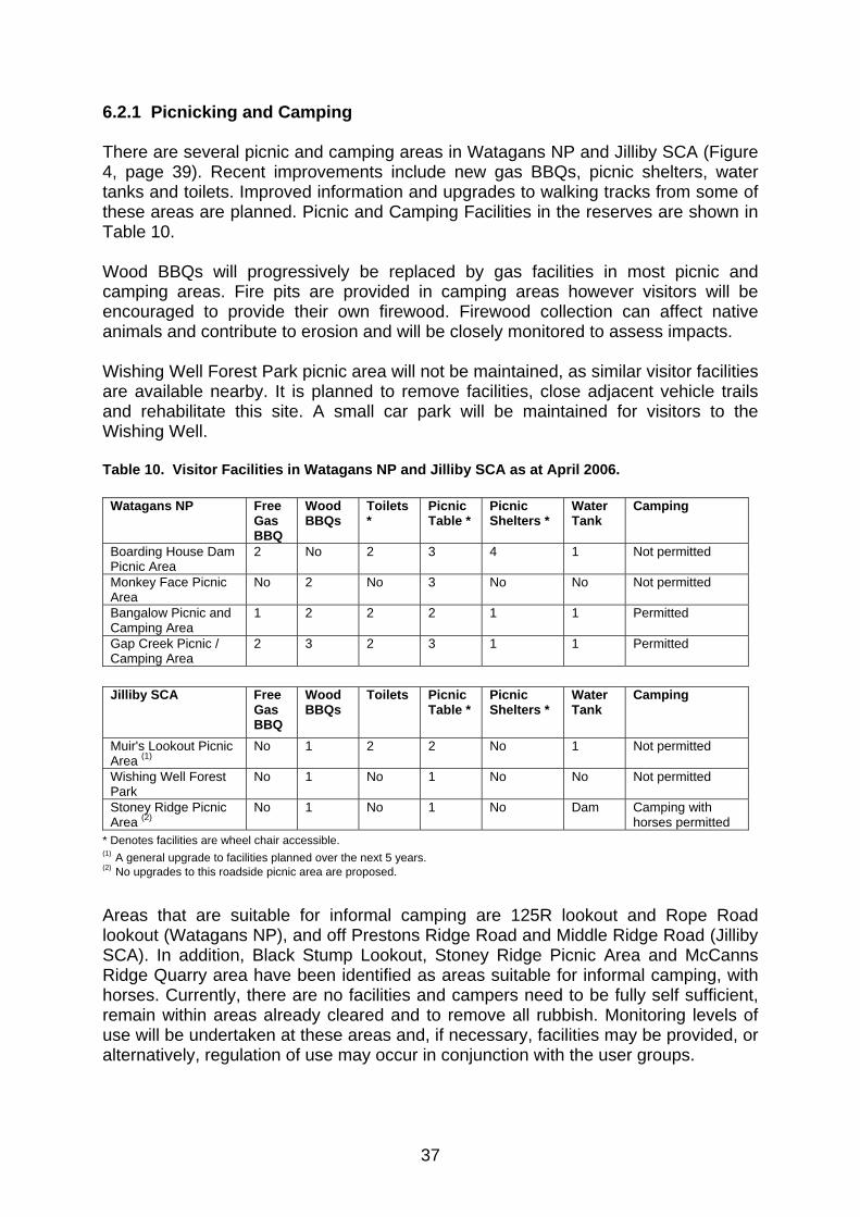
37
6.2.1 Picnicking and Camping There are several picnic and camping areas in Watagans NP and Jilliby SCA (Figure 4, page 39). Recent improvements include new gas BBQs, picnic shelters, water tanks and toilets. Improved information and upgrades to walking tracks from some of these areas are planned. Picnic and Camping Facilities in the reserves are shown in Table 10. Wood BBQs will progressively be replaced by gas facilities in most picnic and camping areas. Fire pits are provided in camping areas however visitors will be encouraged to provide their own firewood. Firewood collection can affect native animals and contribute to erosion and will be closely monitored to assess impacts. Wishing Well Forest Park picnic area will not be maintained, as similar visitor facilities are available nearby. It is planned to remove facilities, close adjacent vehicle trails and rehabilitate this site. A small car park will be maintained for visitors to the Wishing Well. Table 10. Visitor Facilities in Watagans NP and Jilliby SCA as at April 2006.
Watagans NP Free Gas BBQ
Wood BBQs
Toilets *
Picnic Table *
Picnic Shelters *
Water Tank
Camping
Boarding House Dam Picnic Area
2 No 2 3 4 1 Not permitted
Monkey Face Picnic Area
No 2 No 3 No No Not permitted
Bangalow Picnic and Camping Area
1 2 2 2 1 1 Permitted
Gap Creek Picnic / Camping Area
2 3 2 3 1 1 Permitted
Jilliby SCA Free
Gas BBQ
Wood BBQs
Toilets Picnic Table *
Picnic Shelters *
Water Tank
Camping
Muir's Lookout Picnic Area (1)
No 1 2 2 No 1 Not permitted
Wishing Well Forest Park
No 1 No 1 No No Not permitted
Stoney Ridge Picnic Area (2)
No 1 No 1 No Dam Camping with horses permitted
* Denotes facilities are wheel chair accessible. (1) A general upgrade to facilities planned over the next 5 years. (2) No upgrades to this roadside picnic area are proposed. Areas that are suitable for informal camping are 125R lookout and Rope Road lookout (Watagans NP), and off Prestons Ridge Road and Middle Ridge Road (Jilliby SCA). In addition, Black Stump Lookout, Stoney Ridge Picnic Area and McCanns Ridge Quarry area have been identified as areas suitable for informal camping, with horses. Currently, there are no facilities and campers need to be fully self sufficient, remain within areas already cleared and to remove all rubbish. Monitoring levels of use will be undertaken at these areas and, if necessary, facilities may be provided, or alternatively, regulation of use may occur in conjunction with the user groups.
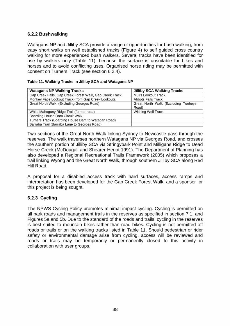
38
6.2.2 Bushwalking Watagans NP and Jilliby SCA provide a range of opportunities for bush walking, from easy short walks on well established tracks (Figure 4) to self guided cross country walking for more experienced bush walkers. Several tracks have been identified for use by walkers only (Table 11), because the surface is unsuitable for bikes and horses and to avoid conflicting uses. Organised horse riding may be permitted with consent on Turners Track (see section 6.2.4). Table 11. Walking Tracks in Jilliby SCA and Watagans NP Watagans NP Walking Tracks Jilliby SCA Walking Tracks Gap Creek Falls, Gap Creek Forest Walk, Gap Creek Track. Muirs Lookout Track. Monkey Face Lookout Track (from Gap Creek Lookout). Abbots Falls Track. Great North Walk (Excluding Georges Road) Great North Walk (Excluding Tooheys
Road) White Mahogany Ridge Trail (former road) Wishing Well Track Boarding House Dam Circuit Walk Turners Track (Boarding House Dam to Watagan Road) Barraba Trail (Barraba Lane to Georges Road)
Two sections of the Great North Walk linking Sydney to Newcastle pass through the reserves. The walk traverses northern Watagans NP via Georges Road, and crosses the southern portion of Jilliby SCA via Stringybark Point and Milligans Ridge to Dead Horse Creek (McDougall and Shearer-Heriot 1991). The Department of Planning has also developed a Regional Recreational Trails Framework (2005) which proposes a trail linking Wyong and the Great North Walk, through southern Jilliby SCA along Red Hill Road. A proposal for a disabled access track with hard surfaces, access ramps and interpretation has been developed for the Gap Creek Forest Walk, and a sponsor for this project is being sought. 6.2.3 Cycling The NPWS Cycling Policy promotes minimal impact cycling. Cycling is permitted on all park roads and management trails in the reserves as specified in section 7.1, and Figures 5a and 5b. Due to the standard of the roads and trails, cycling in the reserves is best suited to mountain bikes rather than road bikes. Cycling is not permitted off roads or trails or on the walking tracks listed in Table 11. Should pedestrian or rider safety or environmental damage arise from cycling, access will be reviewed and roads or trails may be temporarily or permanently closed to this activity in collaboration with user groups.

39
Figure 4. Picnic Areas, Camping Areas and Walking Tracks in Watagans NP and Jilliby SCA
40
6.2.4 Horse Riding Horses are permitted on all park roads and management trails in the reserves including Slippery Rock Link Track, Congewai Link Track and Bowmans Link Track. (section 7.1, and Figures 5a and 5b). Horses are not permitted off established trails, or in the picnic and camping areas at Boarding House Dam, Monkey Face Lookout, Bangalow, Gap Creek and Muirs Lookout. Horses are not permitted on walking tracks listed in Table 11, with the exception of Turners Track which is used infrequently as part of an organised and marshalled event under consent from NPWS. Camping with horses is permitted at Stoney Ridge Picnic Area, McCanns Ridge Quarry and Black Stump Lookout, however horses are not permitted to roam freely overnight. All dams in the reserves for fire fighting purposes are available as horse watering points. An annual competitive horse ride in the reserves will continue to be permitted with consent from the NPWS and in accordance with the code of conduct for endurance rides. Several horse riding clubs use the reserves and may conduct group rides with consent subject to consistency with relevant policy. 6.2.5 Vehicle Access The major roads in the reserves are accessible by two wheel drive (2WD) vehicles in most weather conditions. Four wheel driving (4WD) is popular in the reserves and adjoining State Forests. Vehicles may use the park roads, refer Section 7.1, but are not permitted on management trails. Some roads may need to be temporarily closed at times for maintenance, or to prevent damage pending maintenance, especially after prolonged wet weather. When roads are temporarily closed, signs will be posted at entrances to that road. Permanent road closure will be considered following consultation with 4WD NSW and ACT Inc. if the condition of the road is problematic and not repairable. For example, Slippery Rock Link Track (2.0 km), Bowmans Link Track (1.3 km) and Congewai Link Track (3.4 km) have been permanently closed to motorised traffic. Closure of these trails is discussed further in Section 7.2. 6.2.6 Organised Car Rallying Organised car rallies were held in the former State Forests, and NPWS consent for car rallies was provided as a transitional arrangement for several years. However, NPWS has since adopted a policy that prohibits time and/or speed based rallies in any NPWS reserve and therefore no more such events will be permitted. This policy applies to organised motorbike/trail bike endurance events as well. 6.2.7 Trail Bike Riding Licensed riders on registered bikes are permitted on the park roads listed in Figures 5a and 5b and specified in section 7.1. Motor bikes are not permitted on walking tracks or management trails i.e. Slippery Rock Link Track, Congewai Link Track or Bowmans Link Track.

41
The co-operation of trail bike clubs, in ensuring that members only use designated roads and remain off walking tracks and closed trails, will ensure that the majority of riders can continue to use and enjoy the parks. Unauthorised use of tracks and trails and natural areas causes erosion and presents a hazard for other visitors. In the past several years there has been an increase in the creation of illegal bike tracks in both National Park and State Forest areas. If high levels of illegal trail bike activity continue then some roads may need to be closed to public access. Other unwelcome impacts from unauthorised bike use include noise, which may affect native animals and can detract from the enjoyment of other park visitors. Additionally some riders are unlicensed with unregistered, uninsured bikes which is illegal. Since 2003 NPWS, Forests NSW and the NSW Police have been conducting operations targeting illegal vehicle use. A Memorandum of Understanding between NPWS and the NSW Police to continue these joint operations was signed in January 2007. 6.2.8 Nature and Scenery Appreciation The Watagans NP and Jilliby SCA provide opportunities for visitors to enjoy scenery and picnics, walks and camping in lovely forests. Animals and birds can be seen in the reserves and Tobins Road (Jilliby SCA), Bangalow Road, Gap Creek and Boarding House Dam (Watagans NP) are great bird watching sites. Vantage points with scenic views are found from many of the ridge top roads. The moist valleys contain rainforest and towering trees in contrast to the sandstone escarpments and cliff-lines above. In the Watagans NP, Gap Creek and Monkey Face Lookouts, above Gap Creek, give views of the Martinsville Valley, while Muirs Lookout on the eastern boundary of Jilliby SCA overlooks Mandalong, Lake Macquarie and Lake Munmorah to the coastline. No new lookouts are currently planned in the reserves. Selective trimming of trees obscuring vantage points at existing lookouts will be carried out as required. 6.2.9 Rock Climbing and Abseiling Rock climbing and abseiling are popular in the Monkey Mountain area of Watagans NP with climbing clubs, commercial climbing operations, individuals and scout / youth groups. The popularity of the site has led to some deterioration of walking tracks, linking the climbing sites, and damage to rock surfaces. Other locations, including sites along Georges Road, are also used. Rock climbing and abseiling are classified as high risk activities in the NPWS Adventure Activities Policy. The Policy recognises that there are safety issues for those engaged in the sport and potentially for bystanders. In addition, the NPWS Visitor Safety Policy states that the NPWS Deputy Director-General has a responsibility to address the safety of persons using rock climbing and abseiling areas by implementing measures to prevent harm. By licensing users the NPWS can help to ensure that groups have appropriate levels of expertise, care and
42
professionalism. Groups of 10 or more are required to apply for consent to undertake these activities in Watagans NP and Jilliby SCA. A code of conduct is to be prepared with local groups to promote safe, professional and sustainable climbing practises. Signs promoting and advising of the code will be displayed in the rock climbing areas. It is also proposed to promote the code through the membership of supporting organisations. 6.2.10 Rogaining/Orienteering/Cross Country Runs Rogaining events have been held in the reserves for many years with Forests NSW and NPWS consent. The NPWS Orienteering and Rogaining Policy recognises these activities as appropriate in most national parks. Application for consent to run such events must be made to the NPWS Regional Manager and be in accordance with the guidelines set out in the policy. 6.2.11 Archery A field archery range operates in Jilliby SCA under an annually renewable Occupation Permit established between the Tuggerah Lakes Bowhunters and Forests NSW. The range and associated buildings are not appropriate in a natural area managed for conservation and creates semi-exclusive use of the reserve by one group. It also potentially creates safety issues being adjacent to a public access road and close to the Great North Walk. It is proposed to licence the club for two years following adoption of this plan, after which the club will be required to vacate and rehabilitate the site. The NPWS has worked with the club to address issues, such as safety for walkers, as interim measures. 6.2.12 Hang Gliding There are no sites in the planning area with an established use for hang gliding (Newcastle Hang Gliding Club 2003). Several locations in nearby state forests are used as launch sites. The NPWS Hang Gliding and Paragliding Policy permits these activities in NPWS reserves under certain conditions and in suitable areas. Any such use in future would need to be consistent with this policy and any developments for hang gliding would require an amendment to this plan. Desired outcomes • Visitor use is ecologically sustainable and in accordance with the NPW Act and
the NPW Regulation.
• Environmental values are protected.
• Existing recreational opportunities, where ecologically sustainable, are retained and/or enhanced.
• Information on appropriate and minimal impact recreational use is available and easily accessible through either NPWS or associated user groups.
• All visitors enjoy their own particular experience of the reserves without conflicting uses marring that experience.

43
• Information on visitor facilities, walking trails, maps of roads and any trail closures is available and easily accessible.
• Public appreciation and understanding of the reserves’ environmental and cultural values is improved.
• Opportunities are provided for community groups and individuals to participate in the management of the reserves and in research projects.
Strategies • Work with relevant user groups / organisations to develop codes of conduct
particular to their activity where these have not already been completed.
• Erect signs and barriers on dedicated walking tracks indicating that they are for walkers only and that motor bikes, bicycles and horses are not permitted.
• Erect signs on management trails stating that walkers, horse riders and bicycles are permitted but private vehicles and trail bikes are not.
• Review existing signs on walking trails to ensure that track route information is available.
• Implement licensing requirements for abseiling and rock climbing groups with more than 10 participants.
• Ensure that information about recreation in the reserves is available in brochures and on the NPWS website.
• Management activities will be promoted by means of fliers, press releases, pamphlets, NPWS website and signs etc at appropriate times (i.e. hazard reductions, pest species programs, temporary road closures).
• Update the Watagans NP and Jilliby SCA information on the NPWS website with links to the “Caring for parks” – “Be a considerate park visitor” page which provides information on minimal impact strategies for walking, camping and vehicle travel.
• Complete upgrades of visitor facilities at picnic and camping areas as outlined in the picnicking and camping section.
• Gradually remove outdated picnic facilities at Wishing Well Forest Park picnic area and rehabilitate the site.
• Monitor levels of use and visitor impacts at all informal camping areas. If environmental damage is occurring or issues such as sanitation become evident manage impacts by installing facilities or regulating use as appropriate.
• Review and update the MOU with Forests NSW and NSW Police regarding law enforcement targeting illegal trail bike use.
• Undertake selective tree trimming at designated lookouts in the reserves.
• Licence the Tuggerah Lakes Field Archery Club for two years following adoption of this plan and request the club to remove facilities and rehabilitate the site following cessation of the licence.
44
7. PARK ROADS, MANAGEMENT TRAILS AND VEHICLE ACCESS 7.1 TRACK AND TRAIL CLASSIFICATION There are over 350 kilometres of park roads and management trails in Watagans NP and Jilliby SCA. They vary from disused logging roads, trails and snig trails to more frequently used routes which link major roads, provide access to private property or are used for recreation or park management. Rationalisation of the road and trail network is needed throughout the parks for environmental protection reasons, to ensure all access routes are safe and to reduce ongoing maintenance costs. A number of the roads and trails are shortcuts or dead ends and do not lead to features of recreational interest, and can have significant, unnecessary environmental impacts. An assessment was undertaken of all roads and trails which identified their condition and use and classified them according to ongoing maintenance requirements. Consideration was also given to requirements for access for recreation, fire management, pest management, research, private property and proximity to features of conservation significance. Additional consideration was also given to the following: • Roads and trails can provide access for introduced carnivores, especially foxes,
which prey on wildlife, affect the movement of small animals across the landscape and can introduce and spread weeds and pathogens;
• Minimising the extent of access aids in reducing sedimentation and runoff; • Roads on ridges provide the most effective access for fire management and
reduce the impact on sub-surface drainage; • Access not required for private property, recreation or park management is a
burden on the financial resources of the NPWS and thus the community; and • Road construction and maintenance creates edge effects that may impact on the
environment well beyond the edges of the road. The NPWS and Forests NSW operate under a memorandum of understanding (MOU) for joint maintenance of the major roads and management trails in Watagans NP. The roads currently covered by this agreement are Watagan Forest Road, Mt Faulk Road, Martinsville Hill Road, Watagan Road, Bowmans Road / fire trail and Harris fire trail. The MOU for Watagans NP will be expanded to include the main access roads in Jilliby SCA, as appropriate. 7.2 TRACK AND TRAIL CLOSURE The NPWS is committed to sustainable visitor use and enjoyment that is compatible with the conservation of the reserves’ natural and cultural values. Watagans NP and Jilliby SCA provide an opportunity to balance conservation priorities with recreation.
45
In order to reduce environmental impacts and maintenance costs, access that is not essential for private property, recreation or management purposes will be closed and allowed to regenerate naturally. These are classified as dormant trails and can be reopened for fire fighting purposes. No public access is permitted on dormant trails, including cycling, walking, horse riding and private vehicles. Other roads will be downgraded to a state that is negotiable for 4WD, fire management and emergency access. Primary access roads in the reserves will be maintained to an all weather 2WD standard and the NPWS will aim to maintain all other park roads and management trails to a standard suitable for small 4WD fire fighting units. Road classification in the reserves is shown in Figures 5a and 5b (inside back cover of plan). In Watagans NP the Congewai Link Track (3.4 km), Slippery Rock Link Track (2.0 km) and Bowmans Link Track (1.3 km) will be closed to motorised traffic for environmental protection and to improve safety. Alternate vehicle access to the park exists and the tracks will remain open to walkers, horse riders, cyclists and management vehicles. Congewai Link Track follows the Congewai Creek from Congewai Road, crossing the creek and rising steeply up the escarpment to Georges Road joining the Great North Walk. Considerable damage has been done to this track by vehicles, including trail bikes. Closure of this track from the national park boundary adjacent to Congewai Creek to Georges Road will protect the natural values and water quality of the Congewai Creek catchment. Alternative vehicular access to the park from the Congewai Valley is from Congewai Road via the Click Creek fire trail to Rope Road. The Slippery Rock link track runs between Slippery Rock Road and the Watagan Forest Road. 4WD and trail bike use has resulted in erosion and drainage problems. Slippery Rock is a European Heritage Site identified in section 4.5.2 / Table 8 and will be managed accordingly. Alternative vehicle access to the park from the Martinsville Valley remains available via Slippery Rock Road. Bowmans Link Track is a very steep track which runs from New Mill Road on the boundary of Watagans NP, across Watagan Creek, and up to Bowmans Road. Overuse by 4WD vehicles and motorbikes has caused steep steps and rock damage on the track. Deep rutting has also occurred on the creek crossing. New Mill Road links with Watagan Forest Road which is a major access road into Watagans NP. 7.3 SPECIFIC TRACKS AND TRAILS 7.3.1 Watagans NP Bowmans Road / Harris fire trail These roads provide 4WD access between the Corrabare and Watagans SF and the Watagans NP. About 1.6 km of the Harris fire trail is located on private property and the permission of the owners is required to use this trail.

46
Click Creek fire trail This road links Rope Road and the Congewai Valley and sustains vehicle damage after rain. Drainage culverts will be installed at the northern end of the track. Slippery Rock Road This road provides access from Owens Road to Watagan Forest Road. Vehicles and trail bike damage following wet weather has necessitated numerous closures. It is proposed to erect gates to restrict traffic while road work is in progress and to permit temporary closure to allow the road to dry out and minimise damage. Should continued damage occur, the road will be permanently closed. Quorrobolong area Tracks reopened along Barraba Lane during fires in 2002 / 2003 have allowed access to the northern portion of the Watagans NP. Illegal activities such as trail bike riding and firewood collection are occurring in this area. It is proposed to continue to erect boundary fencing, with the co-operation of neighbours, to exclude vehicles and to rehabilitate these tracks. Owens Road It is proposed to link Owens Road with fire trails on neighbouring properties south of Gap Creek in Martinsville, to enhance fire protection. Turners Road It is proposed to close Turners Road between Watagan Road and the Watagan Forest Headquarters. The trail will be retained as a walking track linking to Boarding House Dam. White Mahogany Ridge Road Will be closed to public vehicle access. The road will be retained as a walking track. 7.3.2 JILLIBY SCA Dooralong Area Whitemans Lane - side tracks off the eastern end of this road in the vicinity of Lowers Gully will be maintained as walking tracks only. Lemon Tree Area Trails emanating from Lemon Tree Road will be closed to reduce repair costs from vehicle damage. Yambo Forest Road will be maintained as a through link to Mandalong Road. Phil Tunks Fire Trail will be maintained as 4WD access only. Side tracks will be closed to vehicles.

47
Desired Outcomes • Vehicle use within the reserves is ecologically sustainable.
• Visitors can access the majority of existing recreational areas on a well maintained trail network.
• Vehicles and motor bikes use authorised park trails and roads safely.
• Roads and trails are maintained to a suitable standard.
• Old logging snig trails that are not required for management purposes naturally close over and rehabilitate.
• Maintenance and repair costs to roads are minimised.
• Adequate emergency and management access to the reserves is retained.
• A well maintained network of management trails is available for fire fighting. • Strategies • Continue MOU negotiations with Forests NSW (Department of Primary
Industries) for management of roads and trails in Jilliby SCA.
• Maintain management trails in accordance with their current bushfire classification.
• If use of dormant trails becomes evident, investigate options to prevent access.
• If high level illegal trail bike use continues investigate closure of trails.
• Erect gates on Slippery Rock Road and Click Creek Fire Trail that can be locked to prevent access during maintenance or wet weather.
• Ensure appropriate signs to indicate temporary closures of any trails.
• Continue fencing and other work in the Barraba Lane area.
• Erect fire trail identification signs on main tracks.
• Erect barrier/gate to prevent vehicle access along Turners Road and manage for walking access only.
• Erect barriers/gates to prevent vehicle access to Slippery Rock Link Track, Congewai Link Track and Bowmans Link Track.
• Install drainage culverts at northern end of Click Creek Fire Trail.
48
8. RESEARCH AND MONITORING The purpose of scientific study in national parks and state conservation areas is to improve understanding of their natural and cultural heritage values and the processes which affect them. Research also establishes the requirements for management of particular species and may assist the NPWS to improve its management practices Desirable research projects are not limited to flora and fauna. The Aboriginal and European Cultural Heritage values of sections of the reserves are poorly known to the NPWS. Further research will assist in management and interpretation of values. Planning for visitor facilities also requires a better understanding of visitor numbers and requirements. A visitor survey is planned for 2008 to assist in the preparation of a visitor profile and improve planning for visitor facilities. The NPWS does not have the resources to undertake a large amount of research in the reserves. A list outlining desired research areas and topics will be prepared to encourage participation of research organisations. Under the Lower North East RFA all forest managers, including NPWS, must demonstrate ecologically sustainable forest management (ESFM) via annual ESFM reports. ESFM aims to maintain or increase the full suite of forest values for present and future generations across the NSW native forest estate, including: • ecosystem biodiversity, health, vitality, productive capacity and functional
processes; • soil and water productive capacity and functional processes; • long term social and economic benefit; and • natural and cultural heritage values. ESFM will be implemented primarily through monitoring of management programs using performance indicators developed to assess the impact of management actions on ecological functions. Remedial management actions will then be undertaken as required. Research priorities identified under the RFA will be pursued along with topics identified in this plan of management. Key areas of research and monitoring will be: • validating the presence of native plants, animals and ecological communities
listed under the TSC Act; • survey and monitoring of threatened plants and animals (as identified by species
recovery plans and priority action statements); • assess the impacts of recreation and management activities on park values eg.
Aboriginal sites, threatened plant and animal populations; • undertake surveys to increase knowledge of native plant and animal species
occurring; • undertake survey to assess extent and impacts of introduced species; • investigate visitor numbers and attitudes.

49
Research by other organisations and students may also provide valuable information for management. A prospectus will be prepared, consistent with the DECC Science Investment and Management Plan (2006), to encourage the involvement of other organisations in priority research areas. The results of research and monitoring will be used to guide management programs. Desired Outcomes • Research is undertaken that enhances the information base and assists
management of the reserves.
• Research causes minimal environmental damage.
• Monitoring programs are in place to detect any changes in park values. Strategies • Use the principles of Ecologically Sustainable Forest Management to guide
management operations. Work with other authorities and stakeholders in implementing ESFM principles across the landscape.
• Undertake research to provide information about the reserves’ natural and cultural heritage and visitor use in order to facilitate effective management.
• Promote research by other organisations and individuals especially research that is useful for management.
• Require any research structures and long term markers to be placed in locations that will minimise their visual impact and require their removal upon completion of the research.
• Develop a prospectus of research projects through the NPWS - Central Coast Hunter Range Region’s Research and Monitoring Group, which has links with Newcastle University, as well as other organisations and candidates.
• Develop and promote a list of projects that community, environmental and recreational users may be interested to support.
• Encourage bird watchers and similar groups to pass on information gathered in the reserves.
• Continue to permit and promote appropriate research and educational activities in the reserves by educational institutions and other government agencies.

50
9. OTHER USES 9.1 EASEMENTS AND OTHER OCCUPANCIES A number of existing grazing leases, under Forest NSW occupation permits, existed in Jilliby SCA at gazettal. These were terminated at the end of 2005 under an agreement between the NSW Farmers Association, Forests NSW and NPWS, to allow occupiers in the new Jilliby SCA time to remove grazing stock and related structures. An occupation permit in Jilliby SCA covers a dam and pump shed, off Tooheys Road in Milligans Gully, to supply water to an adjacent orchard. It is intended that the permit will be renewed to the end August 2007. Several high voltage power lines traverse Jilliby SCA from east to west. The underground Sydney Newcastle Oil and Gas pipeline also crosses the southern end of the reserve in the vicinity of Prestons Ridge. Figure 6 shows the location of these utilities. The field archery range in Jilliby SCA operates under the provisions of an occupation permit issued by Forests NSW, discussed in Section 6.2.11. Until June 2003, the Scout Association of NSW maintained a meeting hall, campsite and related facilities at the end of Scout Road and Lemon Tree Road, also under an occupation permit. The site is in poor condition and its future use will be considered via a heritage and safety assessment. 9.2 MINING INTERESTS There are currently four known mineral title interests affecting Jilliby SCA, listed in Table 12 and shown in Figure 7. New applications and granted licences occur on a regular basis. Table 12. Mineral title interests over Jilliby SCA.
Title identification
Type of title Holder Status Expiry date
PEL0002 Petroleum Title Sydney Gas Operations Pty Ltd Current 28/03/2011 PEL0267 Petroleum Title Sydney Gas Operations Pty Ltd Current 19/01/2012 EL4969 Exploration licence – Coal Centennial Mandalong Pty Ltd Current 31/07/2012 EL6317 Exploration licence – Coal Centennial Mandalong Pty Ltd Current 8/08/2009 EL4911 Exploration licence – Coal Kores Australia Pty Ltd Current 26/10/2010 AUTH0405 Authorisation – Coal Kores Australia Pty Ltd Current 8/08/2009

51
Figure 6. Transmission lines and Sydney Newcastle Oil and Gas Pipeline traversing Jilliby SCA.

52
Figure 7. Mineral title interests and water monitoring locations in Jilliby SCA.
53
The Wallarah No. 2 Coal Project proposed by Wyong Areas Coal Joint Venture is located between the Dooralong and Yarramalong valleys. Kores Australia Pty Ltd are the majority shareholders of the Venture, and hold the relevant coal authorisation and exploration titles (Table 12 and Figure 7). The proposed area of longwall mining lies partly under Jilliby SCA. An application under Part 3A of the EPA Act was submitted for the project in November 2007. Wyong Coal monitor two ground-water bores on Maculata Road in Jilliby SCA. The locations of mineral licences and water monitoring bores are shown on Figure 6. DPI (Mineral Resources) is the lead authority for mining, mineral exploration and mine site rehabilitation. DPI (Mineral Resources) is required under the EPA Act to undertake environmental assessments for mining and exploration activities within SCAs. The MOU between NPWS and DPI (Mineral Resources) describes the management and consultative arrangements associated with exploration and mining in SCAs. 9.3 ACCESS REQUIREMENTS A number of private land owners gain access to their properties via the reserves, many via public roads. Access agreements are required for access via management trails. Access agreements exist for several of these properties (including some Ministerial roads) and discussions are under way to finalise the remaining agreements. Access agreements may also be required for infrastructure maintenance, such as the gas pipeline, water monitoring points and power-line easements. These will be assessed and established where required. 9.4 COMMERCIAL INTERESTS A number of tourism operators and educational institutions operate under commercial licensing arrangements in the reserves. Operators with current licences are listed in Table 13. Renewal of current licences and consideration of new ones will be undertaken in accordance with NPWS Policy regarding commercial operators. Table 13. Commercial Operators within the Reserves. Commercial Tour Operator Reserve Comments Avondale College Watagans NP Current Bushtrack Tours Watagans NP Current Great Aussie Bush Camps Watagans NP Current Great Divide Tours Watagans NP Current Watagans Trail Bike Tours Watagans NP and Jilliby SCA Current

54
Desired Outcomes • The natural and cultural values of the reserves are protected and retained while
allowing permissible use and maintenance of utilities or other activities under occupancies, easements or approved mining activities.
• NPWS officers have a clear understanding of the details of any existing occupancies, easements or utilities within the reserves.
• Management activities have no negative impact on these utilities.
• Commercial use of the reserves is sustainable.
Strategies • Implement a 5 year conditional permit for the irrigation dam in Milligans Gully,
subject to satisfactory operation within the current licence provisions.
• Investigate suitable options for the Old Scout Camp in Jilliby SCA.
• Investigate mineral exploration proposals and their potential impact on the reserves.
• Application for, or renewal of, mining leases affecting Jilliby SCA require the concurrence of the Minister for the Environment and Climate Change.
• Mining and exploration activities undertaken in Jilliby SCA require environmental assessment by DPI (Mineral Resources) and concurrence of the Minister for the Environment and Climate Change.
• Formalise an agreement with Wyong Coal in relation to continued ground-water monitoring in Jilliby SCA.
• Investigate and confirm the extent and terms of easements relating to the transmission lines and any agreements, policies or memorandums of understanding that may be in place in relation to maintenance of these lines.
• Investigate and confirm the extent of any easement relating to the Sydney Newcastle Oil and Gas pipeline. Ensure that any relevant agreements for access or maintenance are in place and NPWS staff have full knowledge of any particular issues relating to the presence of the pipeline.
• Investigate, and negotiate as required, access agreements for access into private property via Watagans NP to: Four Horizons property via an unnamed management trail off Georges Road; Sandy Knob fire trail; Harris Fire Road; unnamed fire trail off Owens Road Martinsville; unnamed road off Lane Q9 Quorrobolong.
• Investigate, and negotiate as required, access agreements for access into private property via Jilliby SCA to: Moores Point Road; Transgrid Road; Tooheys Road; Wild Dog Road; Footes Point Road; Duffys Point Road; Stinsons Point Road; Lardies Point Road; Siding Road and the northern unsealed section of Ravensdale Road.
• Monitor commercial operators to ensure compliance with licence conditions. Undertake licence renewal or granting in accordance with NPWS Policy.

55
10. PLAN IMPLEMENTATION This plan of management establishes a scheme of operations for Watagans NP and Jilliby SCA. The plan is part of a system of management developed by the NPWS which includes the NPW Act, management policies, established conservation and recreation philosophies, and strategic planning at corporate, branch and regional levels. Section 81 of the NPW Act requires the implementation of this plan of management. The Act also specifies that no operations shall be undertaken in relation to these reserves unless they are in accordance with the plan. Relative priorities are set out in the implementation table (Table 14). These are determined in the context of branch and regional strategic planning, and are subject to the availability of necessary staff and funds, and any special requirements of the Director-General or Minister. The implementation of the plan will be monitored and its success in achieving the objectives will be assessed. The environmental impact of proposed activities will be assessed to ensure consistency with the desired outcomes stated in this plan. Where impacts are found to be unacceptable, activities will be modified in accordance with the plan policies. This plan of management will stay in force until amended or replaced in accordance with Section 73B of the Act. The plan applies to land currently reserved and to any future additions. Where management strategies or works are proposed for additions (or the existing area) that are not consistent with the plan, an amendment to the plan will be required. Strategies • Undertake an annual review of plan implementation.
• Undertake an assessment 3-4 years post adoption, of the effectiveness this plan in managing the reserves and achievement of objectives.

56
Table 14. Implementation Priorities High priority activities are those imperative to achievement of the objectives and strategies. They must be undertaken in the near future to avoid significant deterioration in natural, cultural or management resources. Medium priority activities are those that are necessary to achieve the objectives and strategies but are not urgent. Low priority activities are desirable to achieve management objectives and strategies but can wait until resources become available. High Priority Actions – to be completed in 2-3 years Item Action / Activity Section 1. Seek advice from Cessnock City Council Cessnock regarding reserve zoning
change from 1 (f) forestry to 8 (a) National Park in the Cessnock LEP. 1.1
2. Work with reserve neighbours and local environmental and community groups to encourage conservation of remnant vegetation on nearby private lands. Promote current Conservation Partners programs i.e. Land for Wildlife, Wildlife Refuges and Voluntary Conservation Agreements.
4.2
3. Finalise comprehensive vegetation survey for reserves and produce final report and maps.
4.2.1
4. Undertake targeted vegetation surveys to confirm existence of Endangered Ecological Communities and threatened plant species within the reserves.
4.2.2
5. Prepare appropriate management guidelines for the communities and individual species if their presence is confirmed.
4.2.2
6. Undertake a review of existing information on threatened fauna species in the reserves and establish management guidelines highlighting any actions required to ensure their ongoing persistence in the reserves.
4.3.1
7. Implement a monitoring program to track the condition of a proportion of aboriginal sites recorded in the site register.
4.4
8. Record and submit known historic sites not already entered on the Heritage Register, as per section 170 of the Heritage Act 1977.
4.5
9. Develop and maintain a reserve vertebrate pest control strategy with the NPWS regional pest management officer, Rural Lands Protection Board, private landholders and Forests NSW.
5.2.1
10. Erect no domestic pets signs in strategic locations in the reserves. 5.2.1 11. Implement vertebrate pest control programs to combat sudden outbreaks and
reports of pest animal activity. 5.2.1
12. Continue to implement actions in Red Fox TAP 5.2.1 13. Undertake a weed survey and mapping project in 2008/09 to identify nature
and scale of weed problem in reserves. 5.2.2
14. Approach and encourage community environmental groups (i.e. Landcare, National Parks Association, NEFA etc) to participate in weed control and regeneration projects.
5.2.2
15. Identify and treat priority areas for noxious weeds and control heavy infestations of wild tobacco, crofton weed and cotton bush.
5.2.2
16. Continue to update detailed fire history of the reserves and periodically review the reserves fire management plan.
5.3
17. Ensure appropriate recreational use information is available in any new brochures and on NPWS / DECC website.
6.2
18. Continue upgrade of reserve signs in the more recent reserve additions Remove outdated signs and plan joint interpretation signs with Forests NSW.
6.2
19. Monitor levels of use and visitor impacts at all informal camping areas. If environmental damage is occurring or issues such as sanitation become evident manage impacts by installing facilities or regulating use as appropriate.
6.2.1
20. Erect appropriate signs on dedicated walking tracks indicating “walkers only” and that motor bikes, bicycles and horses are not permitted.
6.2.2
21. Erect signs and barriers on Slippery Rock link track and Congewai walking track to indicate appropriate use.
6.2.2
22. Complete upgrades of visitor facilities at picnic and camping areas. 6.2.1 23. Replace wood BBQs with gas BBQs at specified picnic and camping areas 6.2.1

57
24. Provide additional directional signposting in the reserves as facilities are upgraded.
6.2.1
25. Review existing walking trail signs to ensure track route information is available.
6.2.2
26. Licence the Tuggerah Lakes Field Archery Club for two years following adoption of this plan and advise club to remove facilities and rehabilitate the site where necessary following cessation of licence.
6.2.11
27. Maintain management trails on a priority basis in accordance with their classification.
7.1
28. Continue MOU negotiations with Forests NSW to determine joint interest roads and trails in Jilliby SCA.
7.1
29. Erect barriers/gates to prevent vehicle access to Slippery Rock Link Track, Congewai Link Track and Bowmans Link Track.
7.3.1
30. Investigate suitable options for the Old Scout Camp in Jilliby SCA. 9.1 31. Undertake an annual review of Plan of Management operations. 10.0
Medium Priority Actions – to be completed in 3-5 years Item Action / Activity Section 32. Undertake selective trimming of trees at vantage points to maintain views. 4.1
33. Encourage research projects that examine the distribution, habitat
requirements and ecology of threatened species, populations and communities.
4.2.2 and 4.3.1
34. Undertake fauna surveys targeting threatened species but also with a view to establishing good baseline data on the distribution and abundance of ‘common species’ in the reserves.
4.3
35. Contact and encourage local and regional bird observers groups to carry out surveys and field days in the reserves.
4.3 8.0
36. Investigate, locate and record any Aboriginal sites identified from previous State Forest surveys but not previously known to NPWS (as identified by the Kinhill Report 1995).
4.4
37. Modify existing Jilliby SCA signs to include NPWS identification wording on additional panel or nearby location.
6.1
38. Promote visitation to the reserves and participation in Discovery programs with local tourism organisations in Cessnock, Wyong and Lake Macquarie.
6.2
39. Update the Watagans NP and Jilliby SCA information on the NPWS website with cross links to the “Caring for parks” – “Be a considerate park visitor” pages.
6.2
40. Carry out visitor survey and implement results in future management planning. 6.2 41. Review and update MOU with Forests NSW and NSW Police every 3 years
regarding law enforcement targeting illegal trail bike use. 6.2.7
42. Continue boundary fencing works in the Barraba Lane area of Watagans NP. 7.0 43. Erect fire trail identification signs on main tracks to aid location. 7.0 44. Ensure appropriate signs are displayed to indicate temporary closures of any
fire trails or roads. 7.2
45. Investigate options for preventing access and damage to dormant trails. 7.2 46. Continue boundary fencing with reserve neighbours subject to available
funding and in accordance with NPWS Policy conditions. 7.3
47. Erect barrier/gate to prevent vehicle access along Turners Road and manage for walking access only.
7.3.1
48. Erect gates on Slippery Rock Road and Click Creek Fire Trail that can be temporarily locked to prevent vehicle access during maintenance periods or extended wet weather.
7.3.1
49. Develop research prospectus with specific projects and possible funding sources via the NPWS and CCHR Region’s Research and Monitoring Group.
8.0
50. Develop a list of projects that community, environmental and recreational user groups may be interested to support.
8.0
51. Implement access agreements with private property owners requiring access through park.
9

58
52. Investigate the extent of any easement relating to the Sydney Newcastle Oil and Gas pipeline. Ensure relevant agreements for access and maintenance are in place.
9.1
53. Investigate the extent and terms of easements relating to electricity transmission lines in Jilliby SCA.
9.1
54. Formalise an agreement between Wyong Coal and NPWS in relation to continued ground-water monitoring in Jilliby SCA.
9.1
55. Implement a 5-year conditional licence in regard to the irrigation dam in Milligans Gully.
9.1
56. Undertake and assessment, after 5 years, of the effectiveness of this plan in managing the reserves and achievement of objectives.
10.0
Low Priority Actions – to be completed in 5-10 years if resources available Item Action / Activity Section 57. Encourage local history groups and individual historians to carry out research
in the reserves, ideally culminating in one publication that will focus on the Watagan Mountains. Support grant applications to the Royal Australian Historical Society for suitable projects.
4.5
58. Cooperate with other agencies and neighbouring landholders to implement joint weed and feral animal control programs.
5.2
59. Erect appropriate warning signs to advise of track closures. 6 60. Work with relevant recreation user groups / organisations to develop codes of
conduct for their activity. 6.2
61. Gradually remove outdated picnic facilities at Wishing Well Forest Park picnic area and rehabilitate the site.
6.2.1
62. Construct disabled access track at Gap Creek Forest Walk. 6.2.2 63. Plan fire management trails with Owens Road neighbours to link with
Bangalow Road (Watagans NP). 7.0
Ongoing Actions Item Action / Activity Section 64. Liaise with neighbours and authorities to minimise the impact of adjacent land
uses on the scenic values of key sections of the park. 4.1
65. Implement relevant recovery plans and threat abatement plans. 4.2.2/4.3.1
66. Undertake impact assessment prior to any works being done in the reserves. All 67. Encourage contributions to the Atlas of NSW Wildlife by local community and
environmental groups. 4.3
68. Management priority to threatened fauna species and their habitat. 4.3.1 69. Local Aboriginal Land Councils and other Aboriginal organisations, individuals
and communities will be consulted and actively involved in all aspects of management of Aboriginal sites and values within the reserves.
4.4
70. Liaise with local government and other authorities as needed to maintain the water quality of the catchments in the reserves.
5.1
71. Participate in relevant Bush Fire Management Committees and maintain cooperation and coordination with other fire authorities and neighbours with regards to fire suppression and fuel management.
5.3.
72. Update neighbours database. 6.1 73. Continue to develop Discovery programs throughout the reserves and promote
program with local tourism organisations. 6.2
74. Use the principles of Ecologically Sustainable Forest Management to guide management operations. Work with other authorities and stakeholders in implementing ESFM principles across the landscape.
8.0

59
11. ABBREVIATIONS CRA Comprehensive Regional Assessment CCHR Central Coast Hunter Range DECC Department of Environment and Climate Change EEC Endangered Ecological Community ESFM Ecologically Sustainable Forest Management LALC Local Aboriginal Land Council LEP Local Environment Plan LGA Local Government Area LHCCREMS Lower Hunter and Central Coast Regional Environment Management Strategy LHCCWAC Lower Hunter and Central Coast Weeds Advisory Committee NP National Park NPWS NSW National Parks and Wildlife Service RFA Regional Forest Agreement ROTAP Rare or Threatened Australian Plant SCA State Conservation Area TAP Threat Abatement Plan Names of Acts abbreviated: EPA Act Environmental Planning and Assessment Act 1979 NPW Act National Parks and Wildlife Act 1974 NPW Regulation National Parks and Wildlife Regulation 2002 RF Act Rural Fires Act 1997 RLP Act Rural Lands Protection Act 1998 TSC Act Threatened Species Conservation Act 1995
60
12. REFERENCES CITED REFERENCES Bell, S.A.J. (2002) The natural vegetation of the Wyong Local Government Area, Central Coast, New South Wales. Parts 1 and 2. Unpublished Report to Wyong Shire Council. Eastcoast Flora Survey. Bell, S.A.J (2005) Vegetation Survey of Watagans National Park and Jilliby State Conservation Area. Parts 1 and 2. Unpublished Draft Reports to National Parks and Wildlife Service. Eastcoast Flora Survey. Bell, S.A.J. and Driscoll, C. (2006) Vegetation mapping of Watagans National Park and Jilliby State Conservation Area. Summary Report to Parks and Wildlife Division, Department of Environment and Conservation, Eastcoast Flora Survey. Binns, D. (1996) Morisset Forestry District EIS Supporting Document No.3 - Flora Survey Morisset Forestry District, Central Region, New South Wales. Research Division, Forests NSW of New South Wales, Sydney. Briggs J.D. and Leigh J.H. (1995) Rare or Threatened Australian Plants. Centre for plant biodiversity research. CSIRO Publications, Melbourne. Cessnock City Council (2003) Cessnock Local Environmental Plan. Cessnock City Council. Cessnock. Clouten, K.H. (1967) Reid’s Mistake – The story of Lake Macquarie from its discovery until 1890. Lake Macquarie Shire Council, Lake Macquarie. EJE Group (1995) Morisset Forestry District EIS Supporting Document No.9 – European cultural heritage study. Prepared for State Forests NSW, Central Region, Taree. Forests NSW, Pennant Hills. Kinhill Engineers Pty Ltd (1995) Morisset Forestry District EIS Supporting Document No.8 – An assessment of Aboriginal archaeological sites. Prepared for State Forests NSW, Central Region, Taree. Forests NSW, Pennant Hills. Kovak, M. and Lawrie, J.W. (1991) Soil Landscapes of the Singleton 1:250 000 Sheet. Soil Conservation Service of NSW, Sydney. Lake Macquarie City Council (2003) Lake Macquarie Local Environmental Plan. Lake Macquarie City Council. Lake Macquarie. Lower Hunter and Central Coast Weeds Advisory Committee. (2001) A strategic plan to enhance cooperation and coordination of weed management in the Hunter and Central Coast region. Lower Hunter and Central Coast Weeds Advisory Committee. Lower Hunter and Central Coast Regional Environment Management Strategy (2003) Lower Hunter and Central Coast Regional Biodiversity Conservation Strategy - Updated extant vegetation community map. Prepared by Eco-Logical Pty Ltd for Lower Hunter and Central Coast Regional Environment Management Strategy. McDougall Garry and Shearer-Heriot Leigh (1991) The Great North Walk. Kangaroo Press. Victoria. Murphy, C.L. and Tille, P.J. (1993) Soil landscapes of the Gosford 1:100,000 sheet. NSW Department of Conservation and Land Management. Sydney.

61
Newcastle Hang Gliding Club (2003) NHGC site guide. Unpublished spreadsheet provided to National Parks by Newcastle Hang Gliding Club. Nilsen, L. (ed) (1985) Lake Macquarie: Past and Present. Report prepared as part of Lake Macquarie City Council Community Employment Program. NSW National Parks and Wildlife Service (1998) Comprehensive Regional Assessments. CRA Unit, Sydney Zone, NPWS, Hurstville. NSW National Parks and Wildlife Service (1998) Derivation and delineation of centres of endemism for Upper North East and Lower North East CRA regions. Report prepared by NPWS for NSW CRA Environment and Heritage Technical Committee. NSW National Parks and Wildlife Service (2000) Vegetation survey, classification and mapping Lower Hunter and Central Coast Region. Project undertaken for the Lower Hunter and Central Coast Regional Environment Management Strategy. CRA Unit, Sydney Zone, Hurstville. NSW National Parks and Wildlife Service (2001) Threat abatement plan for predation by the Red Fox (Vulpes vulpes). NSW National Parks and Wildlife Service, Hurstville. NSW National Parks and Wildlife Service (2003) Fire interval guidelines for broad vegetation types. NSW National Parks and Wildlife Service, Hurstville. Saxon, D (1988) Pit Props and Sleepers – The Story of Awaba. Awaba Public School Parents and Citizens Association. State Forests (1995) Proposed forestry operations in the Morisset Forestry District – Environmental Impact Statement, December 1995. NSW State Forests, Pennant Hills. Wyong Shire Council (1991) Wyong Local Environmental Plan. Wyong Shire Council. Wyong. OTHER REFERENECES Browne G,W. (1997) A wander through the Watagans. G.W. Browne. Central Coast Catchment Management Board (2002) Integrated catchment management plan for the Central Coast. NSW Department of Land and Water Conservation. Sydney. Cessnock Bush Fire Management Committee (2000) Cessnock Bush Fire Risk Management Plan. Prepared by the Bush Fire Management Committee; pursuant to section 52 of the Rural Fires Act, 1997. Cessnock City Council (2003) The Cessnock City Wide Settlement Strategy – draft 2003. Cessnock City Council. Cessnock. Hunter Cooperative Statement (2003) Hunter Cooperative Statement. Coalition for The Lower Hunter Biodiversity Conservation Corridor. Newcastle. Hunter Catchment Management Trust (2002) Integrated catchment management plan for the Hunter catchment. NSW Department of Land and Water Conservation. Sydney.

62
Koettig, M (2001) Boolwarah. Unpublished report by National Parks and Wildlife Service, Central Aboriginal Heritage Unit. Lake Macquarie Bush Fire Management Committee (2002) Lake Macquarie District Bush Fire Risk Management Plan. Prepared by the Bush Fire Management Committee; pursuant to section 52 of the Rural Fires Act, 1997. Turner, J. and Blyton, G. (1995) The Aboriginals of Lake Macquarie – A brief history. Lake Macquarie City Council. Lake Macquarie. Wyong Shire Council (2003) Draft Wyong conservation strategy. Wyong Shire Council. Wyong Bush Fire Management Committee (2001) Wyong Bush Fire Risk Management Plan. Prepared by the Bush Fire Management Committee; pursuant to section 52 of the Rural Fires Act, 1997. PERSONAL COMMUNICATIONS Duncan, S (2004) Strategic land use planner, Wyong Shire Council. Gaverloch, C (2003) Resource Protection Officer, Forests NSW, Native Forests Division, Hunter Region.
63
Appendix 1. Vegetation Community Information LHCCREMS Map Unit and Base Community
Bell and Driscoll Map Unit and Community/Variant
General information and example locations
1 Coastal Wet Gully Forest 1 Coastal Wet Gully Forest Occupies most sheltered gullies within both reserves. Example areas: Watagans NP and Jilliby SCA - most moist gullies in sheltered locations
1a Coastal Warm Temperate – Sub-tropical Rainforest
Occurs in well-protected gullies. Example areas: Watagans NP and Jilliby SCA - most moist gullies; Boarding House Dam; Gap Creek
1b Red Cedar – Stinging Tree – Fig Subtropical Rainforest
Known from one location on a northerly-facing slope within a boulder rockfall, immediately above drier Spotted Gum forest. Example areas: Watagans NP, between Georges Road and Barraba Lane
1c Grey Myrtle – Paperbark Dry Rainforest
Simple dry rainforest, known from one site in an incised gully line. Example areas: Watagans NP, far northern boundary along Barraba Lane.
1d Coastal Grassy Bluegum Forest
Occurs on lower western footslopes in drier locations. Example areas: Watagans NP, along the western boundary at Congewoi Valley.
1e Water Gum – Coachwood – Sassafras Riparian Rainforest
Known from upper Ourimbah Creek in the riparian zone, but likely to occur elsewhere. Example areas: Jilliby SCA, upper reaches of Ourimbah Creek
1f Carex Sedgeland Small sedgeland occurring within rainforest, in very impeded, swampy soils. Example areas: Jilliby SCA, one section of Dillions Gully adjacent to fire trail.
6 Coastal Narrabeen Moist Forest
6 Coastal Narrabeen Bluegum Ridge Forest
Generally present as ridgetops of Bluegums with a well-developed rainforest understorey. Difficult to distinguish from Unit 1 in places. Several areas have been converted to plantations under previous SFNSW management. Example areas: Watagans NP and Jilliby SCA - The Null Road; above Gap Creek
6a Coastal Narrabeen Spotted Gum - Bluegum Forest
Old growth sheltered forest with very old Spotted Gums and White Mahoganys, over a mesic rainforest understorey. Possibly sub-unit of MU1. Example areas: Watagans NP - Watagan Ck below escarpment
6b Coastal Narrabeen Mahogany – Bluegum forest
A drier form of MU6, supporting a moist shrub layer but without the presence of typical rainforest small tree and shrub species. Example areas: Jilliby SCA – Watagan Forest and Siding Roads in the south
9 Coastal Ranges Open Forest
9a Coastal Ranges Mesic Blackbutt Forest
A tall forest where E. pilularis is clearly dominant, and with a mesic understorey of semi-rainforest species. Example areas: Watagans NP and Jilliby SCA - Watagan Forest Road
9b Coastal Ranges Dry Blackbutt Forest
A drier tall open forest clearly dominated by Eucalyptus pilularis, over a grassy or dry shrubby understorey. Some areas have distinctive understorey of Xanthorrhoea macronema and Patersonia glabrata. Example areas: Watagans NP and Jilliby SCA - Watagan Forest Road
9c Coastal Ranges Mesic Spotted Gum – Blackbutt Forest
Typically occurring as a broad ecotone between MU’s 9a and 15, elements of both communities are evident. Example areas: Watagans NP and Jilliby SCA - spurs off Bowmans Road; Whitemans Road
9d Coastal Ranges Dry Spotted Gum - Blackbutt Forest
A dry, grassy variant which may represent a disturbed form of MU 9b, again occurring in the vicinity of MU’s 9a and 15, which may itself be an ecotonal community. Present in only a few locations on the eastern side of Jilliby SCA. Example areas: Jilliby SCA - Cut Rock Road
9e Coastal Ranges Mesic Peppermint Forest
A moist variant very similar to MU9c, may represent ecotonal areas between this community and the bluegum forests of the sheltered slopes. Example areas: Jilliby SCA - German Point Road
9f Coastal Ranges Dry Peppermint – Blackbutt Forest
An unusual community with strong sandstone influence, with species such as Banksia serrata, E. piperita and several understorey species more typical of Hawkesbury Sandstone geology are present. E. pilularis
64
is also generally present in most areas. Example areas: Jilliby SCA - Watagan Forest Road, 9 Coastal Ranges Open Forest
9g Coastal Ranges Mesic Grey Gum – Ironbark Forest
Occupies lower slopes in a few locations south of the Scout Camp off Lemon Tree Road. A moist understorey of Lomandra longifolia and herbs/grasses, with occasional mesic shrub species. Possibly an artefact of logging, but requires statistical analysis. Example areas: Jilliby SCA - south of Scout Camp
9h Coastal Ranges Dry Tallowwood – Blackbutt Forest
A variant of MU 9a but where Eucalyptus microcorys is characteristic. Understorey vegetation is generally similar to MU9a, Example areas: Jilliby SCA - Cut Rock Road
9I Coastal Ranges Mesic Stringybark – Mahogany Forest
A tall open forest, currently known only from one spur (Andersons Point) in south-western Jilliby SCA. May represent a variant of MU21g, but the presence of the key canopy species is consistent. This area recently selectively logged, but good condition areas are present off the end of the spur. Example areas: Jilliby SCA – Andersons Point Road
9j Coastal Ranges Dry Stringybark – Mahogany Forest
Occurs on ridges and slopes in the far south of Jilliby. Some of this could be the same as 9i or 21g, but 9j tends to be drier. Example areas: Jilliby SCA , end of Forest Road Kulnura.
12 Hunter Valley Moist Forest
12 Hunter Valley Moist Spotted Gum – Ironbark Forest
A moist open forest on sheltered upper slopes, generally in the vicinity of MU15. E. punctata may be locally present but is not consistent. Example areas: Watagans NP – southerly spurs off Georges Road
12a Hunter Valley Moist Spotted Gum – Blackbutt Forest
May be a variant of MU12, but the presence of E. pilularis is prominent. Further investigation required. Example areas: Watagans NP - Bowman and Carrolls Road
12b Hunter Valley Moist Spotted Gum – Turpentine Forest
Recorded only on a single spur off Maculata Road. May not differ sufficiently from MU12, but full sampling is required. Example areas: Jilliby SCA - spur off Maculata Road
15 Coastal Foothills Spotted Gum Ironbark Forest
15 Coastal Foothills Spotted Gum - Ironbark Forest
An open forest occurring on the drier western and southern ridges and spurs, typically with an understorey of prickly shrubs such as Daviesia ulicifolia and Podolobium aciculiferum, and several grass species. Example areas: Watagans NP and Jilliby SCA - Georges Road; Yambo Forest Road
15b Coastal Foothills Dry Grey Gum - Ironbark Forest
Principally on the ridges and slopes along Watagan Forest Road in the south of Jilliby SCA, this community possibly represents a variation of MU15, where Spotted Gum is replaced by Small-fruited Grey Gum, but all other components are essentially the same. Example areas: Jilliby SCA - Watagan Forest Road in the far south
15c Coastal Foothills Moist Grey Gum – Mahogany Forest
Potentially a variant of MU12, but further investigation required. Occurs on sheltered slopes in areas between MU’s 15 and 15b. Example areas: Jilliby SCA - Watagan Forest Road in the far south
19 Hunter Lowlands Redgum Forest
19 Hunter Lowlands Redgum Forest
One gully line only in the extreme north of Watagans NP. This delineation may be incorrect, and it may be a form of Unit 15. Example areas: Watagans NP, far north near Barraba Lane
21 Hunter Range Grey Gum Forest
21a Hunter Range Dry Escarpment Apple Forest
Occurs on exposed and rocky sandstone escarpment edges. Understorey species are sparsely distributed. Example areas: Watagans NP and Jilliby SCA – western end of Georges Road
21b Hunter Range Dry Stringybark – Grey Gum Forest
Principally on exposed northern aspects on the northern rim of Watagans NP, E. agglomerata and E. punctata are characteristic. Similar to MU 21g, but that community supports E. pilularis and not C. maculata. Example areas: Watagans NP and Jilliby SCA - Georges Road
21c Hunter Range Moist Mahogany – Grey Gum Forest
A moist, grassy forest that may be a variant of MU9, but further investigation is required. Example areas: Watagans NP – western ends of Ingles and Carrolls Roads
21d Hunter Range Dry Ironbark – Grey Gum Forest
Occurs on dry ridges and slopes. Example areas: Jilliby SCA, German Point
21e Hunter Range Dry Mahogany – Grey Gum Forest
Around the Lemon Tree Road/ Prickly Ridge Road intersection, a dry, rocky low forest occurs with many eucalypts present but no clear dominants. This community may represent a dry, rocky variant of MU6c, which occurs further to the south. Further investigation is also required to compare this type against MU21f. Example areas: Jilliby SCA - around Lemon Tree Road intersection

65
21 Hunter Range Grey Gum Forest
21f Hunter Range Dry Mahogany - Apple Forest
A variable community that generally supports E. umbra as the dominant species. Generally best developed on exposed rocky spur ends. At The Null in Jilliby SCA, E. umbra, A. floribunda and E. placita dominate, while north of the Lemon Tree Road/ Prickly Ridge Road intersection, small areas of Corymbia gummifera are present. At Beecamp Point, dense stands of Eucalyptus umbra occur over species such as Acacia terminalis, Caustis flexuosa and Patersonia glabrata. Example areas: Jilliby SCA - The Null; north of Lemon Tree Road intersection; Beecamp Point.
21h Hunter Range Dry Stringybark – Blackbutt Forest
Similar to MU’s 21b and 21f, however MU21b does not support E. pilularis but does support Corymbia maculata. While E. agglomerata is occasionally present in MU21f, it is clearly not a dominant feature as it is in MU21g, but is instead dominated by E. umbra. Red Bloodwood (Corymbia gummifera) is scattered in some locations. Example areas: Watagan NP and Jilliby SCA - near Wishing Well Forest Park; German Point; Hitchcocks Point Road
21I Hunter Range Dry Mahogany – Bloodwood Forest
Similar to MU 21g but the dominance of E. agglomerata is replaced by E. umbra, and Corymbia gummifera and Angophora costata are also present. Example areas: Jilliby SCA – end of a spur off Hitchcocks Point Road
22 Coastal Narrabeen Shrub Forest
22a Coastal Narrabeen Dry Blackbutt – Apple – Forest Oak Forest
Limited in extent to ridgetops. May end up being the same as 22a, but with a differing canopy mix. Example areas: far southern Jilliby SCA, along Prestons Ridge Road.
22b Coastal Narrabeen Dry Bloodwood – Apple – Mahogany Forest
Limited in extent to ridgetops. May end up being the same as 22, but with a differing canopy mix. Example areas: far southern Jilliby SCA, along Prestons Ridge Road.
25 Sheltered Dry Hawkesbury Woodland
25 Hawkesbury Peppermint – Apple Sheltered Forest
Occurs in sheltered gullies on Hawkesbury Sandstone, but also on southerly running ridges and spurs. Example areas: Jilliby SCA, Bill Jacks Point Road, Tooheys Road.
26 Exposed Hawkesbury Woodland
26 Exposed Hawkesbury Bloodwood – Scribbly Gum Woodland
Occurs on crests and ridges of Hawkesbury Sandstone geology. Highly diverse understorey vegetation. Example areas: Jilliby SCA, end of Forest Road at boundary, start of Tooheys Road.
26a Exposed Hawkesbury Silvertop Ash – Bloodwood Forest [not split of in mapping]
Similar to Unit 26, and insufficient examples to enable a confident depiction of this community, hence not mapped at this stage. Typically present on the Kulnura Plateau on orangey-red soils with ironstone. Example areas: start of Jilliby SCA at the end of Forest Road.
26 Exposed Hawkesbury Woodland
26b Exposed Hawkesbury Apple – Turpentine – Bloodwood Forest
Occurs on shale bands on Hawkesbury Sandstone, where it merges into Narrabeen Sandstone. A very distinctive forest type with a grassy/ herbaceous understorey, some shrubs but with an obvious abundance of Doryanthes sieberi. Example areas: Jilliby SCA, ridges around upper Ourimbah and Hallards Creeks
29 Hawkesbury Coastal Banksia Woodland
29 Hawkesbury Coastal Banksia Scrub-Woodland
An often very dense vegetation type where Banksia ericifolia can be overly-dominant, or a scattered member of the shrub layer, dependant on fire history. Emergent eucalypts normally widely spaced. Example areas: Jilliby SCA, south of Forest Road Kulnura.
54 Hawkesbury Hanging Swamps
54 Hawkesbury Hanging Swamps
Occurs in areas of impeded drainage on Hawkesbury Sandstone geology, typically at the top of a break in slope. Dependant on fire history, some swamps form a successional stage of Unit 29. Example areas: Jilliby SCA, around Hallards Creek.
X Plantation areas
P Plantation areas Any combination of Eucalyptus agglomerata, E. saligna, E. deanei, or E. pilularis in obvious plantation arrangements. Example areas: Watagan NP – Carrolls Road

66
Appendix 2. European Cultural Heritage Items and Inventory Sheets
Source Morisset EIS, EJE Report 1995
Heritage Item Forestry Inventory Code
Reserve
Barniers Sawmill site HSF2 Watagans NP Boarding House Dam WSF1 Watagans NP Egtons Road OSF29 Watagans NP Epsleys flying fox OSF5 Watagans NP Experimental plantation and pole dump WYSF1 Jilliby SCA Flood Gum trial planting’s WYSF2 Jilliby SCA Forestry Commission tree HSF9 Watagans NP Log tossing site WSF5 Watagans NP Mt Faulk road OSF4 Watagans NP O'Hara's Sawmill WSF2 Watagans NP Olney road camp and shield tree OSF20 Jilliby SCA Original Forest House site OSF15 Jilliby SCA Slippery Rock OSF2 Watagans NP Slippery Rock road OSF1 Watagans NP The Null Flying Fox OSF21 Jilliby SCA The Null Tramway OSF22 Jilliby SCA The Wishing Well OSF26 Jilliby SCA Red Hill Quarry OUSF1 Jilliby SCA Congewai Creek logging camp N/A Watagans NP Crumps Retreat N/A Watagans NP Gap Creek Falls N/A Watagans NP Gap Creek Lookout N/A Watagans NP German Point N/A Jilliby SCA House site – Bowmans road N/A Watagans NP Jew Boy Mountain and 125R Lookout N/A Watagans NP Lemon Tree – Red Cedar forest (Congewai Creek)
N/A Watagans NP
Monkey Face Lookout N/A Watagans NP Monkey Mountain N/A Watagans NP Muirs Lookout N/A Jilliby SCA Red Cedar forest (Click Creek) N/A Watagans NP Red Hill Quarry N/A Jilliby SCA Saw mill site (Cnr Martinsville Hill and Watagan Forest Roads)
N/A Jilliby SCA
The Narrow Place Lookout N/A Watagans NP Inventory Sheets for Key European Heritage Sites Heritage Item Forestry
Inventory Code Reserve
Boarding House Dam WSF1 Watagans NP O'Hara's Sawmill WSF2 Watagans NP Slippery Rock OSF2 Watagans NP Slippery Rock Road OSF1 Watagans NP The Null Tramway OSF22 Jilliby SCA
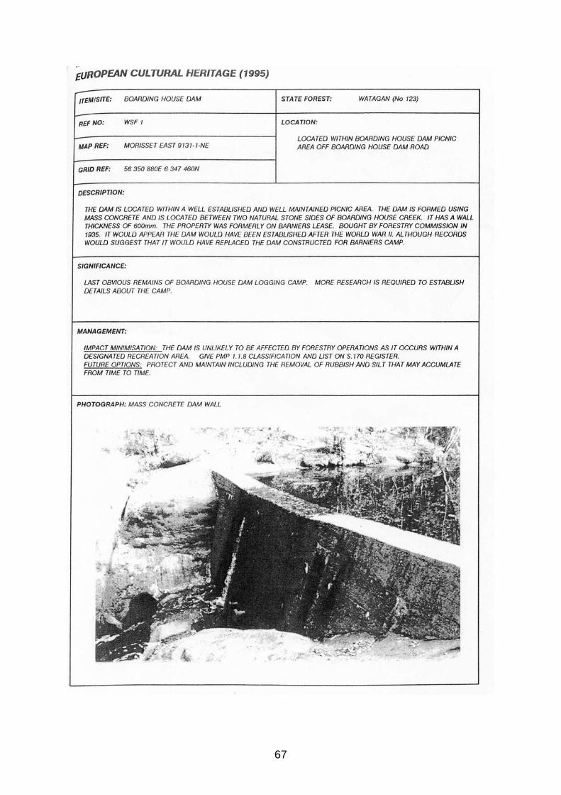
67

68
69
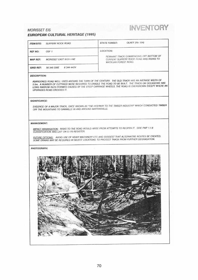
70

71
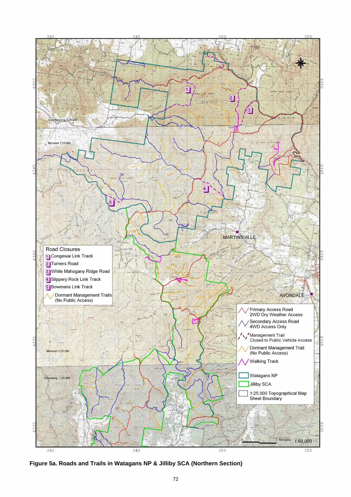
72
Figure 5a. Roads and Trails in Watagans NP & Jilliby SCA (Northern Section)
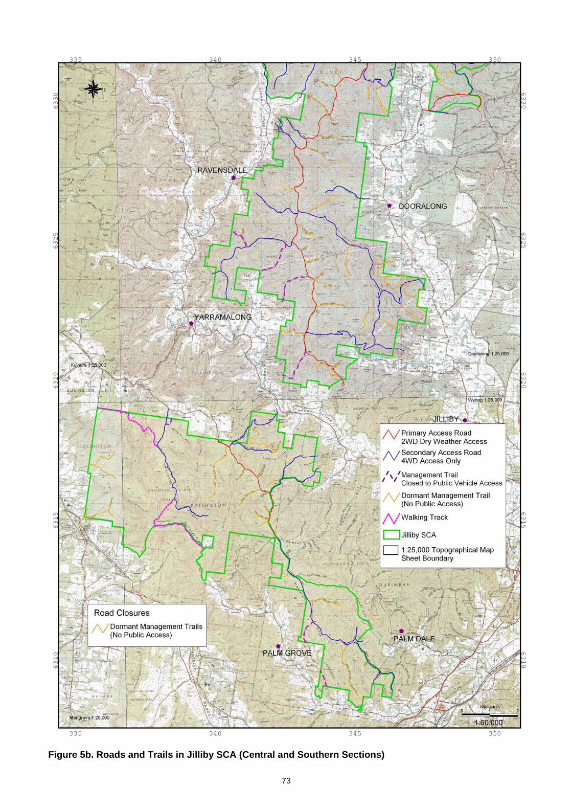
73
Figure 5b. Roads and Trails in Jilliby SCA (Central and Southern Sections)