washington state airport guide · wsdot administrative and engineering publications ... the...
TRANSCRIPT

Aviation Division
Washington State Airport GuideM 3049


Aviation Division PO Box 3367 Arlington, WA 98223
360-651-6300 1-800-552-0666 (inside WA only) Fax 360-651-6319
www.wsdot.wa.gov/aviation
Washington State Airport GuideM 3049
September 2009
Foreword Page ii
Washington State Department of Transportation (WSDOT) Aviation is responsible for the development of the Washington State Airport Guide. The primary purpose of the guide is to promote the use of the state’s aviation system by providing basic and user friendly information regarding airport facilities.
As pilot in command, you are responsible for the safety of your flight. WSDOT Aviation does not assume responsibility for incomplete or inaccurate information contained herein due to ever-changing airport conditions and service facilities.
For complete information regarding airport facilities, pilots should consult the current FAA Airport Facility Directory (AFD) and current navigation charts. In addition, it is recommended that pilots contact a Flight Service Station (FSS) to determine conditions at an unfamiliar airport.
Foreword
Editor This version of the
Washington State Airport Guide was edited by WSDOT Aviation
Acknowledgements WSDOT Aviation wishes to thank the following
for their assistance in the preparation of this guide.
WSDOT Administrative and Engineering Publications Washington State Department of Printing
Flying Fish Helicopters Moitek Aerial Imaging
Big Country Helicopters Aerolist Photographers
Airport Sponsors
Revision September 2009

Message From WSDOT Aviation Page iii
On behalf of WSDOT Aviation, welcome to the Washington State airport system, one of the most geographically diverse systems in the nation. Our state boasts a variety of unique airports including mountain strips, seaplane bases, and a beach airport at Copalis.
Here are a few facts about Washington’s airports:
We have 138 public use airports in our state classified as 16 commercial, 19 regional, 23 community, 33 local service, 38 rural essential, and 9 seaplane. The airports are operated by local jurisdictions such as cities, counties, ports, state, and private parties. Many airports are unstaffed and maintained by airport volunteers. Sixty-five of these airports are included in the federal system and are eligible for federal grants. The remaining airports are smaller and rely on exclusively state and local funding. 136 of these airports are featured in this guide.
Recently the state completed a Long-Term Air Transportation Study to update the aviation system plan and identify future challenges. What are the challenges facing the airport system in the next 25 years?
• Funding to maintain and improve the airport system.
• Protecting airports from incompatible land use.
• Preventing airport closures.
• Sustaining air service to small communities.
• Planning for future airport capacity needs statewide.
• Building new airports where gaps exist in the system.
• Educating the public on the value of air transportation.
While the state is responsible for planning the aviation system and providing financial assistance to airports, most challenges must be addressed locally by the airport owner. In order to preserve the airport system for future generations, aviators of all backgrounds must be engaged in the issues affecting their local airports.
The Washington State Airport Guide is a tool for you to explore our system of airports and understand first hand the value they bring to Washington State. Please share your experience with others and continue to highlight the importance of the state’s aviation system.
Message From WSDOT Aviation

Page iv

Contents Page v
Page
Foreword . . . . . . . . . . . . . . . . . . . . . . . . . . . . . . . . . . . . . . . . . . . . . . . . . . . . . . . . ii
Message From WSDOT Aviation . . . . . . . . . . . . . . . . . . . . . . . . . . . . . . . . . . . . . . . iii
Weather Data Sources . . . . . . . . . . . . . . . . . . . . . . . . . . . . . . . . . . . . . . . . . . . . . . viWest of the Cascades . . . . . . . . . . . . . . . . . . . . . . . . . . . . . . . . . . . . . . . . . . . . viEast of the Cascades . . . . . . . . . . . . . . . . . . . . . . . . . . . . . . . . . . . . . . . . . . . . . vii
State Managed Airports . . . . . . . . . . . . . . . . . . . . . . . . . . . . . . . . . . . . . . . . . . . . . viiiState Airports . . . . . . . . . . . . . . . . . . . . . . . . . . . . . . . . . . . . . . . . . . . . . . . . . . ix
Instructions on Using Frequency and Outlet Maps . . . . . . . . . . . . . . . . . . . . . . . . . . x
Seattle Center Frequency Locator Map . . . . . . . . . . . . . . . . . . . . . . . . . . . . . . . . . . xi
Remote Communications Outlet Map . . . . . . . . . . . . . . . . . . . . . . . . . . . . . . . . . . . xii
Flight Watch and Pilot Weather Reports . . . . . . . . . . . . . . . . . . . . . . . . . . . . . . . . . xiii
Runway Incursions . . . . . . . . . . . . . . . . . . . . . . . . . . . . . . . . . . . . . . . . . . . . . . . . . xiv
Accidents, Incidents, and Safety Investigations . . . . . . . . . . . . . . . . . . . . . . . . . . . . xv
Emergency Locator Transmitter Reporting Instructions . . . . . . . . . . . . . . . . . . . . . . xvi
Wildfire Reporting Instructions . . . . . . . . . . . . . . . . . . . . . . . . . . . . . . . . . . . . . . . . xvii
Abbreviations . . . . . . . . . . . . . . . . . . . . . . . . . . . . . . . . . . . . . . . . . . . . . . . . . . . . . xviii
Airport Managers Phone Numbers . . . . . . . . . . . . . . . . . . . . . . . . . . . . . . . . . . . . . xixA-M . . . . . . . . . . . . . . . . . . . . . . . . . . . . . . . . . . . . . . . . . . . . . . . . . . . . . . . . . xixO-W . . . . . . . . . . . . . . . . . . . . . . . . . . . . . . . . . . . . . . . . . . . . . . . . . . . . . . . . . xx
Washington State Airports – Alphabetical by Airport . . . . . . . . . . . . . . . . . . . . . . . . xxiA-E . . . . . . . . . . . . . . . . . . . . . . . . . . . . . . . . . . . . . . . . . . . . . . . . . . . . . . . . . . xxiF-M . . . . . . . . . . . . . . . . . . . . . . . . . . . . . . . . . . . . . . . . . . . . . . . . . . . . . . . . . . xxiiO-S . . . . . . . . . . . . . . . . . . . . . . . . . . . . . . . . . . . . . . . . . . . . . . . . . . . . . . . . . . xxiiiS-W . . . . . . . . . . . . . . . . . . . . . . . . . . . . . . . . . . . . . . . . . . . . . . . . . . . . . . . . . . xxiv
Washington State Airports – Alphabetical by City . . . . . . . . . . . . . . . . . . . . . . . . . . . xxvA-E . . . . . . . . . . . . . . . . . . . . . . . . . . . . . . . . . . . . . . . . . . . . . . . . . . . . . . . . . . xxvE-M . . . . . . . . . . . . . . . . . . . . . . . . . . . . . . . . . . . . . . . . . . . . . . . . . . . . . . . . . . xxviO-S . . . . . . . . . . . . . . . . . . . . . . . . . . . . . . . . . . . . . . . . . . . . . . . . . . . . . . . . . . xxviiS-Y . . . . . . . . . . . . . . . . . . . . . . . . . . . . . . . . . . . . . . . . . . . . . . . . . . . . . . . . . . xxviii
Contents
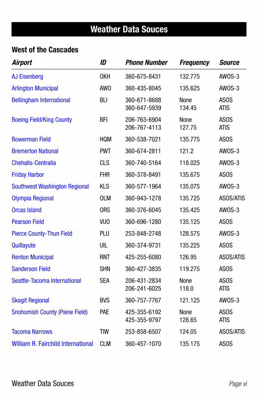
Weather Data Souces Page vi
West of the Cascades
Airport ID Phone Number Frequency Source
AJ Eisenberg OKH 360-675-8431 132.775 AWOS-3
Arlington Municipal AWO 360-435-8045 135.625 AWOS-3
Bellingham International BLI 360-671-8688 None ASOS 360-647-5939 134.45 ATIS
Boeing Field/King County BFI 206-763-6904 None ASOS 206-767-4113 127.75 ATIS
Bowerman Field HQM 360-538-7021 135.775 ASOS
Bremerton National PWT 360-674-2811 121.2 AWOS-3
Chehalis-Centralia CLS 360-740-5164 118.025 AWOS-3
Friday Harbor FHR 360-378-8491 135.675 ASOS
Southwest Washington Regional KLS 360-577-1964 135.075 AWOS-3
Olympia Regional OLM 360-943-1278 135.725 ASOS/ATIS
Orcas Island ORS 360-376-6045 135.425 AWOS-3
Pearson Field VUO 360-696-1280 135.125 ASOS
Pierce County-Thun Field PLU 253-848-2748 128.575 AWOS-3
Quillayute UIL 360-374-9731 135.225 ASOS
Renton Municipal RNT 425-255-6080 126.95 ASOS/ATIS
Sanderson Field SHN 360-427-3835 119.275 ASOS
Seattle-Tacoma International SEA 206-431-2834 None ASOS 206-241-6025 118.0 ATIS
Skagit Regional BVS 360-757-7767 121.125 AWOS-3
Snohomish County (Paine Field) PAE 425-355-6192 None ASOS 425-355-9797 128.65 ATIS
Tacoma Narrows TIW 253-858-6507 124.05 ASOS/ATIS
William R. Fairchild International CLM 360-457-1070 135.175 ASOS
Weather Data Souces
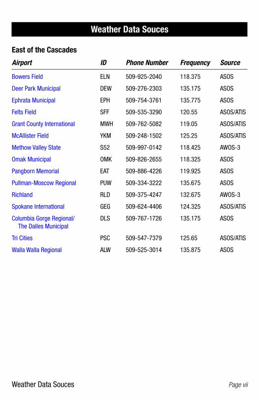
Weather Data Souces Page vii
East of the Cascades
Airport ID Phone Number Frequency Source
Bowers Field ELN 509-925-2040 118.375 ASOS
Deer Park Municipal DEW 509-276-2303 135.175 ASOS
Ephrata Municipal EPH 509-754-3761 135.775 ASOS
Felts Field SFF 509-535-3290 120.55 ASOS/ATIS
Grant County International MWH 509-762-5082 119.05 ASOS/ATIS
McAllister Field YKM 509-248-1502 125.25 ASOS/ATIS
Methow Valley State S52 509-997-0142 118.425 AWOS-3
Omak Municipal OMK 509-826-2655 118.325 ASOS
Pangborn Memorial EAT 509-886-4226 119.925 ASOS
Pullman-Moscow Regional PUW 509-334-3222 135.675 ASOS
Richland RLD 509-375-4247 132.675 AWOS-3
Spokane International GEG 509-624-4406 124.325 ASOS/ATIS
Columbia Gorge Regional/ DLS 509-767-1726 135.175 ASOS The Dalles Municipal
Tri Cities PSC 509-547-7379 125.65 ASOS/ATIS
Walla Walla Regional ALW 509-525-3014 135.875 ASOS
Weather Data Souces
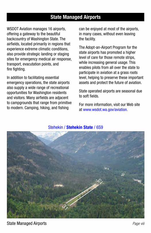
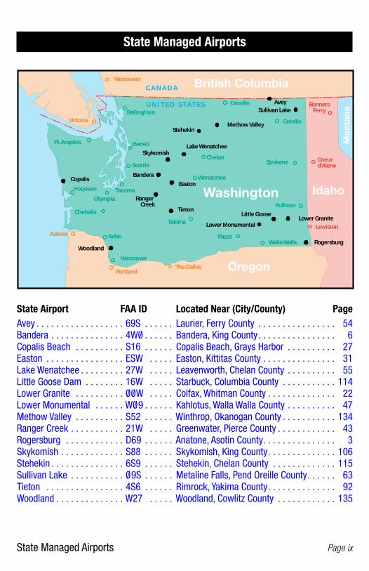
State Managed Airports Page viii
State Managed Airports
WSDOT Aviation manages 16 airports, offering a gateway to the beautiful backcountry of Washington State. The airfields, located primarily in regions that experience extreme climatic conditions, also provide strategic landing or staging sites for emergency medical air response, transport, evacutation points, and fire fighting.
In addition to facilitating essential emergency operations, the state airports also supply a wide range of recreational opportunities for Washington residents and visitors. Many airfields are adjacent to campgrounds that range from primitive to modern. Camping, hiking, and fishing
can be enjoyed at most of the airports, in many cases, without even leaving the facility.
The Adopt-an-Airport Program for the state airports has promoted a higher level of care for those remote strips, while increasing general usage. This enables pilots from all over the state to participate in aviation at a grass roots level, helping to preserve these important assets and protect the future of aviation.
State operated airports are seasonal due to soft fields.
For more information, visit our Web site at www.wsdot.wa.gov/aviation.
Stehekin / Stehekin State / 6S9
State Managed Airports Page ix
125.1 C A N A D A
Kelso
Wenatchee
Chelan
Bellingham
Chehalis
Hoquiam
Pt Angeles
OlympiaTacoma
Astoria
Pullman
PascoWalla Walla
Lewiston
Colville
BonnersFerry
Coeur d'Alene
Oroville
Vancouver
Yakima
Portland
VancouverThe Dalles
Washington
Oregon
Idaho
British Columbia
Victoria
Seattle
Mo
ntan
a
Everett
Spokane
Avey
BanderaCopalis
Easton
Lake Wenatchee
Little GooseLower Granite
Lower Monumental
Methow Valley
Skykomish
Stehekin
Sullivan Lake
Tieton
Woodland
Ranger Creek
U N I T E D S T A T E S
Rogersburg
State Airport FAA ID Located Near (City/County) PageAvey . . . . . . . . . . . . . . . . . . 69S . . . . . . Laurier, Ferry County . . . . . . . . . . . . . . . . 54Bandera . . . . . . . . . . . . . . . 4W0/ . . . . . . Bandera, King County . . . . . . . . . . . . . . . . 6Copalis Beach . . . . . . . . . . S16 . . . . . . Copalis Beach, Grays Harbor . . . . . . . . . . 27Easton . . . . . . . . . . . . . . . . ESW . . . . . Easton, Kittitas County . . . . . . . . . . . . . . . 31Lake Wenatchee . . . . . . . . . 27W . . . . . Leavenworth, Chelan County . . . . . . . . . . 55Little Goose Dam . . . . . . . . 16W . . . . . Starbuck, Columbia County . . . . . . . . . . . 114Lower Granite . . . . . . . . . . 0/ 0/ W . . . . . Colfax, Whitman County . . . . . . . . . . . . . . 22Lower Monumental . . . . . . W0/ 9 . . . . . . Kahlotus, Walla Walla County . . . . . . . . . . 47Methow Valley . . . . . . . . . . S52 . . . . . . Winthrop, Okanogan County . . . . . . . . . . . 134Ranger Creek . . . . . . . . . . . 21W . . . . . Greenwater, Pierce County . . . . . . . . . . . . 43Rogersburg . . . . . . . . . . . . D69 . . . . . . Anatone, Asotin County . . . . . . . . . . . . . . . 3Skykomish . . . . . . . . . . . . . S88 . . . . . . Skykomish, King County . . . . . . . . . . . . . . 106Stehekin . . . . . . . . . . . . . . . 6S9 . . . . . . Stehekin, Chelan County . . . . . . . . . . . . . 115Sullivan Lake . . . . . . . . . . . 0/ 9S . . . . . . Metaline Falls, Pend Oreille County . . . . . . 63Tieton . . . . . . . . . . . . . . . . 4S6 . . . . . . Rimrock, Yakima County . . . . . . . . . . . . . . 92Woodland . . . . . . . . . . . . . . W27 . . . . . Woodland, Cowlitz County . . . . . . . . . . . . 135
State Managed Airports
Instructions on Using Frequency and Outlet Maps Page x
Instructions on Using Frequency and Outlet Maps
Seattle Center Frequency Locator MapThe Seattle Center frequency locator map identifies Seattle Center frequencies by sector to be used for “Flight Following” (radar traffic advisories). This allows pilots to be in contact with controllers to promote safety and enhance awareness of air traffic.
How to Use Locate your position in reference to sector and the corresponding center frequency. Keep in mind that Seattle Center just needs to know the basics: who you are, what type of aircraft you are flying, where you are, and your request.
Example“Seattle Center, N9053C, a C182RG, 5 miles east of Arlington requesting VFR flight following to Spokane.” (At that point, the controller will give you a squawk code and ask for your altitude.)
Remote Communications Outlet (RCO) MapRemote Communications Outlets are established to extend the communication capabilities of Flight Service Stations (FSS) for doing the following:
1. Opening, closing, or altering visual flight rules (VFR) flight plans. (Note: Filing a flight plan is considered a “preflight” function and therefore should be done via telephone 1-800-992-7433, unless in cases of emergency.)
2. For relaying instrument flight rules (IFR) and special visual flight rules (SVFR) clearances to aircraft on the ground in areas where the Center’s frequencies do not reach.
3. Weather updates or pilot reports. (Note: For use before or after the hours of 6 a.m. to 10 p.m. Otherwise call Flight Watch – EFAS on 122.0)
4. Inquiring about special use airspace (Restricted Areas, Military Operations Area, etc.).
How to UsePilots calling a FSS should give their position (with reference to a RCO name, nearby airport or VOR) and the frequency being used.
Example“Seattle Radio, Cessna N72613, Badger Mountain RCO, listening 122.3”

Seattle Center Frequency Locator Map
Page xi
120.3
126.6
128.3
126.1
125.1
134.95
132.6
125.1
124.2
123.95
Washington
Oregon
Idaho
British Columbia
Mon
tana
C A N A D A
U N I T E D S TAT E S
TOU
YYJ
YVR HUH
OLM
BTG
MLP
ALW
PDT
135.52
AST
LTJ
PAE
HQM
SEA
TCM
PDX
EAT
ELN
YKM
EPH
MWH
PSC
PUW
GEG
MQG
119.65
128.5 SFC to50
132.7 (Victoria Terminal) Seattle Center Frequency Locator Map

Remote Com
munications Outlet M
ap Page xii
Remote Com
munications Outlet M
ap125.1
Vancouver
Washington
Oregon
Idaho
British Columbia
Victoria
Mon
tana
KLS 122.55
ELN 122.2
JUMPOFF JOE122.4
EAT 122.6
BLI 122.15
HQM 122.2
CLM 122.6
BUCKHORN 122.2PUW 122.6
WALLULA122.6
MWH122.4
LWS 122.35
YKM 122.5
SFF122.2
122.55122.65
MULLENPASS
122.15
COEURD'ALENE
122.05
OMK 122.2
BADGERMTN 122.3
VANC 122.35
DLS 122.65
TOU122.25
OCEANSHORES
122.4
PAE 122.55
BFI 123.65EPH 122.2
PDX122.6 ENTERPRISE
122.5
PDT122.2
LGD122.5
AST122.3
122.3AUGSPURGER
ALW 122.3
SEA 122.5
MMV 122.45
BOI 122.6122.2
MT. CONSTITUTION122.3
C A N A D A
U N I T E D S TAT E S
Flight Watch and Pilot Weather Reports Page xiii
Flight Watch — Enroute Flight Advisory Services (EFAS)
What is Flight Watch used for?Receiving updated weather information while in flight, or giving a pilot weather report (PIREP).
How to UseWhile in flight, call Flight Watch on 122.0 between 6 a.m. and 10 p.m. (After hours, call the appropriate flight service station frequency.)
Example“Flight Watch, Malibu N28BR”, 15 North of Ephrata VOR”
Pilot Weather Reports (PIREPs)
What are Pilot Weather Reports for?To supplement weather briefings based on ground observations and forecasts, pilots are encouraged to file in-flight weather reports (PIREPs) to Flight Service, Flight Watch or ATC. PIREPs are real-time, actual observations of weather encountered aloft that are made available to other pilots.
How to UseElements of a PIREP include Aircraft Type, Location (relative to a VOR or airport), Altitude (flight level), Time (in Zulu) and Weather Conditions (Sky Cover, Flight visibility, Precipitation, Restrictions to visibility, Temperature, Wind direction and speed in degrees magnetic and knots, Turbulence, Icing and Pilot remarks).
When giving a PIREP just remember “who, where, when and what.”
ExampleOnce initial contact has been made “Cessna 77HG is a Skylane 182, 21 nm out on the Olympia VORTAC 151 degree radial at 6,500 feet. There is a broken layer above at 9,000 feet and visibility is about 5 miles in haze. The temperature is 9 degrees Celsius and the ride is smooth.”
Flight Watch and Pilot Weather Reports
Runway Incursions Page xiv
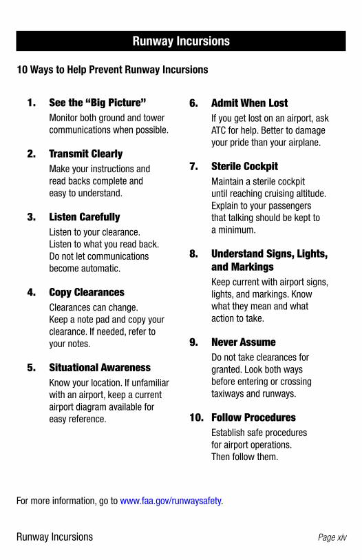
Runway Incursions
10 Ways to Help Prevent Runway Incursions
1. See the “Big Picture” Monitor both ground and tower
communications when possible.
2. Transmit Clearly Make your instructions and
read backs complete and easy to understand.
3. Listen Carefully Listen to your clearance.
Listen to what you read back. Do not let communications become automatic.
4. Copy Clearances Clearances can change.
Keep a note pad and copy your clearance. If needed, refer to your notes.
5. Situational Awareness Know your location. If unfamiliar
with an airport, keep a current airport diagram available for easy reference.
For more information, go to www.faa.gov/runwaysafety.
6. Admit When Lost If you get lost on an airport, ask
ATC for help. Better to damage your pride than your airplane.
7. Sterile Cockpit Maintain a sterile cockpit
until reaching cruising altitude. Explain to your passengers that talking should be kept to a minimum.
8. Understand Signs, Lights, and Markings
Keep current with airport signs, lights, and markings. Know what they mean and what action to take.
9. Never Assume Do not take clearances for
granted. Look both ways before entering or crossing taxiways and runways.
10. Follow Procedures Establish safe procedures
for airport operations. Then follow them.

Accidents, Incidents, and Safety Investigations Page xv
Accidents, Incidents, and Safety Investigations
Rules Pertaining to Aircraft Accidents, Incidents, Overdue Aircraft, and Safety Investigations
(National Transportation Safety Board, Procedural Regulation, 49 CFR 830 (in part))
Reports of accidents or incidents should be made to the Regional Office associated with the state in which the accident or incident occurred. For Idaho, Montana, Oregon, Utah, and Washington: Northwest Regional Office, 19518 Pacific Highway S, Suite 201, Seattle, WA 98188, 206-870-2200, fax 206-870-2219, 8-4:30 (PT). For more infor-mation, go to www.ntsb.gov/ (select Aviation, then Reporting an Accident to the NTSB).
1. Immediate Notification
The operator of an aircraft shall immediately, and by the most expeditious means available, notify the nearest National Transportation Board, Bureau of Aviation Safety Field Office when:
A. An aircraft accident of any of the following listed incidents occur:
(1) Flight control system malfunction or failure.
(2) Inability of any required flight crew member to perform normal flight duties as a result of injuries or illness.
(3) Turbine engine rotor failures excluding compressor blades and turbine buckets.
(4) In-flight fire.
(5) Aircraft collide in flight.
B. An aircraft is overdue and is believed to have been involved in an accident.
2. Manner of Notification
The most expeditious method of notification to the National Transportation Board by the operator will be determined by the circumstances existing at that time.
The National Transportation Safety Board has advised that any of the following would be considered examples of the type of notification that would be acceptable:
A. Director telephone notification.
B. Telegraphic notification.
C. Notification of the Federal Aviation Administration who would in turn notify the NTSB by direct communication; i.e., dispatch or telephone.
3. Reports
A. The operator shall file a report on NTSB Form 6120.1 or 7120.2 available from the National Transportation Safety Board, Washington, D.C. 20594.
(1) Within ten (10) days after an occurrence for which notification is required in 1(a) or (b) above.
(2) When after seven (7) days, an overdue aircraft is still missing.
(3) Upon request of an authorized representative of the National Transportation Safety Board.
a. Each crew member, if physically able at the time the report is submitted, shall attach thereto a statement setting forth the facts, conditions and circumstances relating to the accident or occurrence as they appear to him/her. If the crew member is incapacitated, he/she shall submit the statement as soon as he/she is physically able.

Emergency Locator Transmitter Reporting Instructions Page xvi
Emergency Locator Transmitter Reporting Instructions
WSDOT Aviation responds to about 400 emergency locator transmitter (ELT) distress signals each year. Many times, ELTs are mistakenly activated due to operator error or improper care. Responding to false alarms is extremely costly and detracts from vital air search and rescue resources needed during actual emergencies.
You can help us in two ways.
1. Listen to 121.5 just before you shut down your aircraft to see if you have accidentally activated your ELT.
2. Listen to 121.5 periodically during your flight to detect an ELT.
What if you hear an ELT on the ground?If you are on the ground and hear an ELT, call Flight Service at 800-WX-BRIEF. Tell them where you are and where you hear the signal.
What if you hear an ELT in the air?If you are in the air and hear an ELT, note your current location and altitude (the higher you are, the further you can hear the signal).
1. If you have GPS, note the latitude and longitude of your position. If you do not have GPS, then use a VOR radial and DME for your location.
2. If you are working with the air route traffic control center or approach control, then relay the information to them.
3. If you are not working with air traffic control, call Flight Watch or Flight Service at 800-WX-BRIEF.
4. If you are unable to establish radio contact, call Flight Service as soon as you land.
Please note that even though other pilots may have reported the ELT, multiple reports may assist in narrowing down the location and saving lives.

Wildfire Reporting Instructions Page xvii
Wildfire Reporting Instructions
Private and commercial pilot reports of wildfire have played a major role in helping land management agencies protect the timber, wildlife, wilderness, and other property values in Washington State.
Contact the Seattle Air Route Traffic Control Center, Approach Control, nearest Airport Traffic Control Tower, Flight Service Station, or Flight Watch and report the geographic location of the fire.
If you cannot report the fire via radio, upon arrival, please call 800-562-6010 (toll free from anywhere in Washington State) and furnish the following information:
1. The latitude and longitude from a GPS.
2. Alternative method is a VOR and DME fix.
3. Approximate size of the fire, estimate the best you can. If you can’t estimate acres, use other comparisons such as the size of a football field.
4. Report fire behavior: lots of open flame, smoldering, heavy smoke, or no smoke.
5. Report what is burning: slash, brush, mature trees, etc.
6. Report any personnel, logging equipment, fire trucks, etc., around the site.
Your timely reporting of the fire helps save property and resources.

Abbreviations Page xviii
The following abbreviations are used in this guide.
AGL ....... Above Ground Level ARTCC ....... Air Route Traffic Control Center ASOS ....... Automatic Surface Observing System ASPH ....... Asphalt ATIS ....... Automated Terminal Information Service AWOS ....... Automated Weather Observation System BCN ....... Beacon CL DEL .......Clearance Delivery CONC ....... Concrete CTAF ....... Common Traffice Advisory Frequency DSPLD. THRLD. ....... Displaced Threshold GRND ....... Ground Control HIRL ....... High Intensity Runway Lights LIRL ....... Low Intensity Runway Lights MALSR ....... Medium Intensity Approach Lighting System MIRL ....... Medium Intensity Runway Lights MSL ....... Mean Sea Level NM ....... Nautical Miles NSTD ....... Non Standard ODALS ....... Omni Directional Approach Lighting System PCL ....... Pilot Controlled Lighting RCO ....... Remote Communications Outlet REIL ....... Runway End Identifier Lights RWY ....... Runway SFC ....... Surface SPB ....... Seaplane Base TPA ....... Traffic Pattern Altitude (MSL) TWR ....... Tower TWY ....... Taxiway UNICOM ....... Radio Advisory VASI ....... Visual Approach Slope Indicator
Abbreviations
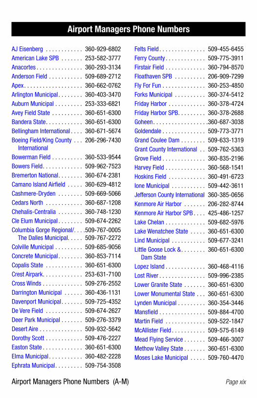
Airport Managers Phone Numbers (A-M) Page xix
AJ Eisenberg . . . . . . . . . . . . 360-929-6802American Lake SPB . . . . . . . 253-582-3777Anacortes . . . . . . . . . . . . . . . 360-293-3134Anderson Field . . . . . . . . . . . 509-689-2712Apex . . . . . . . . . . . . . . . . . . . 360-662-0762Arlington Municipal . . . . . . . . 360-403-3470Auburn Municipal . . . . . . . . . 253-333-6821Avey Field State . . . . . . . . . . 360-651-6300Bandera State . . . . . . . . . . . . 360-651-6300Bellingham International . . . . 360-671-5674Boeing Field/King County . . . 206-296-7430 InternationalBowerman Field . . . . . . . . . . 360-533-9544Bowers Field . . . . . . . . . . . . . 509-962-7523Bremerton National . . . . . . . . 360-674-2381Camano Island Airfield . . . . . 360-629-4812Cashmere-Dryden . . . . . . . . 509-669-5066Cedars North . . . . . . . . . . . . 360-687-1208Chehalis-Centralia . . . . . . . . 360-748-1230Cle Elum Municipal . . . . . . . . 509-674-2262Columbia Gorge Regional/ . . . .509-767-0005 The Dalles Municipal. . . . . 509-767-2272Colville Municipal . . . . . . . . . 509-685-9056Concrete Municipal . . . . . . . . 360-853-7114Copalis State . . . . . . . . . . . . 360-651-6300Crest Airpark . . . . . . . . . . . . . 253-631-7100Cross Winds . . . . . . . . . . . . . 509-276-2552Darrington Municipal . . . . . . 360-436-1131Davenport Municipal . . . . . . . 509-725-4352De Vere Field . . . . . . . . . . . . 509-674-2627Deer Park Municipal . . . . . . . 509-276-3379Desert Aire . . . . . . . . . . . . . . 509-932-5642Dorothy Scott . . . . . . . . . . . . 509-476-2227Easton State . . . . . . . . . . . . . 360-651-6300Elma Municipal . . . . . . . . . . . 360-482-2228Ephrata Municipal . . . . . . . . . 509-754-3508
Airport Managers Phone Numbers
Felts Field . . . . . . . . . . . . . . . 509-455-6455Ferry County . . . . . . . . . . . . . 509-775-3911Firstair Field . . . . . . . . . . . . . 360-794-8570Floathaven SPB . . . . . . . . . . 206-909-7299Fly For Fun . . . . . . . . . . . . . . 360-253-4850Forks Municipal . . . . . . . . . . 360-374-5412Friday Harbor . . . . . . . . . . . . 360-378-4724Friday Harbor SPB . . . . . . . . . 360-378-2688Goheen . . . . . . . . . . . . . . . . . .360-687-3038Goldendale . . . . . . . . . . . . . . 509-773-3771Grand Coulee Dam . . . . . . . . 509-633-1319Grant County International . . 509-762-5363Grove Field . . . . . . . . . . . . . . 360-835-2196Harvey Field . . . . . . . . . . . . . 360-568-1541Hoskins Field . . . . . . . . . . . . 360-491-6723Ione Municipal . . . . . . . . . . . 509-442-3611Jefferson County International 360-385-0656Kenmore Air Harbor . . . . . . . 206-282-8744Kenmore Air Harbor SPB . . . . 425-486-1257 Lake Chelan . . . . . . . . . . . . . 509-682-5976Lake Wenatchee State . . . . . 360-651-6300Lind Municipal . . . . . . . . . . . 509-677-3241Little Goose Lock & . . . . . . . . 360-651-6300 Dam StateLopez Island . . . . . . . . . . . . . 360-468-4116Lost River . . . . . . . . . . . . . . . 509-996-2385Lower Granite State . . . . . . . 360-651-6300Lower Monumental State . . . 360-651-6300Lynden Municipal . . . . . . . . . 360-354-3446Mansfield . . . . . . . . . . . . . . . 509-884-4700Martin Field . . . . . . . . . . . . . 509-522-1847McAllister Field . . . . . . . . . . . 509-575-6149Mead Flying Service . . . . . . . 509-466-3007Methow Valley State . . . . . . . 360-651-6300Moses Lake Municipal . . . . . 509-760-4470

Airport Managers Phone Numbers (O-W) Page xx
Ocean Shores Municipal . . . . 360-289-2754Odessa Municipal . . . . . . . . . 509-660-3024Okanogan Legion . . . . . . . . . 509-422-3600Olympia Regional . . . . . . . . . 360-528-8079Omak Municipal . . . . . . . . . . 509-322-4046Orcas Island . . . . . . . . . . . . . 360-376-5285Othello Municipal . . . . . . . . . 509-488-2544Packwood . . . . . . . . . . . . . . . 360-864-4966Pangborn Memorial. . . . . . . . 509-884-2494Pearson Field . . . . . . . . . . . . 360-619-1295Pierce County-Thun Field . . . 253-841-3779 253-789-7109Point Roberts Airpark . . . . . . 360-945-3139Port of Ilwaco . . . . . . . . . . . . 360-642-3143Port of Poulsbo SPB . . . . . . . 360-779-9905Port of Whitman Business . . . 509-397-2061 Air CenterProsser . . . . . . . . . . . . . . . . . 509-375-3060Pru Field . . . . . . . . . . . . . . . . 509-659-1930Pullman-Moscow Regional . . 509-338-3223Quillayute . . . . . . . . (ext. 245) 360-374-5412Quincy Municipal . . . . . . . . . 509-787-3715R & K Skyranch . . . . . . . . . . . 360-273-9893Ranger Creek State . . . . . . . . 360-651-6300Renton Municipal . . . . . . . . . 425-430-7471Richland . . . . . . . . . . . . . . . . 509-375-3060Roche Harbor SPB . . . . . . . . 360-378-3500Rogersburg State . . . . . . . . . 360-651-6300Rosalia Municipal . . . . . . . . . 509-523-3498Rosario SPB . . . . . . . . . . . . . 360-376-2222Sand Canyon . . . . . . . . . . . . 509-935-4852Sanderson Field . . . . . . . . . . 360-426-1151Seattle Seaplanes SPB . . . . . 206-329-9638Seattle-Tacoma International 206-431-4994Sekiu . . . . . . . . . . . . . . . . . . 360-457-1138Sequim Valley . . . . . . . . . . . . 360-683-4444
Shady Acres . . . . . . . . . . . . . 253-874-2777Skagit Regional . . . . . . . . . . . 360-757-0011Sky Harbor . . . . . . . . . . . . . . 425-359-4625Skykomish State . . . . . . . . . . 360-651-6300Skyline SPB . . . . . . . . . . . . . 360-293-5134Snohomish County Paine Field 425-353-2110South Lewis County . . . . . . . 360-864-4966 360-985-2776Southwest Washington . . . . . 360-414-4333 RegionalSpokane International . . . . . . 509-455-6419Stehekin State . . . . . . . . . . . 360-651-6300Strom Field . . . . . . . . . . . . . . 360-496-5210Sullivan Lake State . . . . . . . . 360-651-6300Sunnyside Municipal . . . . . . . 509-837-5206Swanson Field . . . . . . . . . . . 360-832-3431Tacoma Narrows . . . . . . . . . . 253-853-5844Tieton State . . . . . . . . . . . . . 360-651-6300Tonasket Municipal . . . . . . . . 509-486-4664Tri-Cities . . . . . . . . . . . . . . . . 509-547-6352Twisp Municipal . . . . . . . . . . 509-341-4800Vashon Municipal . . . . . . . . . 206-436-1638Vista Field . . . . . . . . . . . . . . . 509-586-1187Walla Walla Regional . . . . . . . 509-525-3100Warden . . . . . . . . . . . . . . . . . 509-349-2033Waterville . . . . . . . . . . . . . . . 509-884-4700Westport . . . . . . . . . . . . . . . 360-268-0131Whidbey Airpark . . . . . . . . . . 360-341-5531Wilbur Municipal . . . . . . . . . . 509-647-2441Will Rogers/Wiley Post . . . . . 425-430-7471 Memorial SPBWillapa Harbor . . . . . . . . . . . 360-942-3422Willard Field . . . . . . . . . . . . . 509-284-3861Wilson Creek . . . . . . . . . . . . 509-345-2350Wm R. Fairchild International 360-457-1138Woodland State . . . . . . . . . . 360-651-6300
Airport Managers Phone Numbers

Washington State Airports – Alphabetical by Airport (A-E) Page xxi
AJ Eisenberg . . . . . . . . . . . . . . . . . . . . . . Oak Harbor . . . . . . . . . . . . . . OKH . . . . . . . . 68American Lake SPB . . . . . . . . . . . . . . . . Lakewood . . . . . . . . . . . . . . . W37 . . . . . . . . 52Anacortes . . . . . . . . . . . . . . . . . . . . . . . . Anacortes . . . . . . . . . . . . . . . 74S . . . . . . . . . 1Anderson Field . . . . . . . . . . . . . . . . . . . . Brewster . . . . . . . . . . . . . . . . S97 . . . . . . . . 12Apex . . . . . . . . . . . . . . . . . . . . . . . . . . . . Silverdale . . . . . . . . . . . . . . . . 8W5 . . . . . . . 105Arlington Municipal . . . . . . . . . . . . . . . . Arlington . . . . . . . . . . . . . . . . AWO . . . . . . . . . 4Auburn Municipal . . . . . . . . . . . . . . . . . . Auburn . . . . . . . . . . . . . . . . . . S50/ . . . . . . . . . 5Avey Field State . . . . . . . . . . . . . . . . . . . Laurier . . . . . . . . . . . . . . . . . . 69S . . . . . . . . 54
Bandera State . . . . . . . . . . . . . . . . . . . . . Bandera . . . . . . . . . . . . . . . . . 4W0/ . . . . . . . . . 6Bellingham International . . . . . . . . . . . . Bellingham . . . . . . . . . . . . . . . BLI . . . . . . . . . . 9Boeing Field/King County International . Seattle . . . . . . . . . . . . . . . . . . BFI . . . . . . . . . 98Bowerman Field . . . . . . . . . . . . . . . . . . . Hoquiam . . . . . . . . . . . . . . . . HQM . . . . . . . . 44Bowers Field . . . . . . . . . . . . . . . . . . . . . . Ellensburg . . . . . . . . . . . . . . . ELN . . . . . . . . 35Bremerton National . . . . . . . . . . . . . . . . Bremerton . . . . . . . . . . . . . . . PWT . . . . . . . . 11
Camano Island Airfield . . . . . . . . . . . . . . Stanwood . . . . . . . . . . . . . . . 13W . . . . . . . 113Cashmere-Dryden . . . . . . . . . . . . . . . . . . Cashmere . . . . . . . . . . . . . . . 8S2 . . . . . . . . 15Cedars North . . . . . . . . . . . . . . . . . . . . . . Battle Ground . . . . . . . . . . . . . W58 . . . . . . . . . 7Chehalis-Centralia . . . . . . . . . . . . . . . . . Chehalis . . . . . . . . . . . . . . . . . CLS . . . . . . . . 16Cle Elum Municipal . . . . . . . . . . . . . . . . . Cle Elum . . . . . . . . . . . . . . . . S93 . . . . . . . . 20Columbia Gorge Regional/ . . . . . . . . . . The Dalles, Oregon . . . . . . . . DLS . . . . . . . 120 The Dalles MunicipalColville Municipal . . . . . . . . . . . . . . . . . . Colville . . . . . . . . . . . . . . . . . . 63S . . . . . . . . 25Concrete Municipal . . . . . . . . . . . . . . . . Concrete . . . . . . . . . . . . . . . . 3W5 . . . . . . . . 26Copalis State . . . . . . . . . . . . . . . . . . . . . Copalis Beach . . . . . . . . . . . . S16 . . . . . . . . 27Crest Airpark . . . . . . . . . . . . . . . . . . . . . Kent . . . . . . . . . . . . . . . . . . . S36 . . . . . . . . 51Cross Winds . . . . . . . . . . . . . . . . . . . . . . Clayton . . . . . . . . . . . . . . . . . C72 . . . . . . . . 19
Darrington Municipal . . . . . . . . . . . . . . . Darrington . . . . . . . . . . . . . . . 1S2 . . . . . . . . 28Davenport Municipal . . . . . . . . . . . . . . . Davenport . . . . . . . . . . . . . . . 68S . . . . . . . . 29De Vere Field . . . . . . . . . . . . . . . . . . . . . . Cle Elum . . . . . . . . . . . . . . . . 2W1 . . . . . . . . 21Deer Park Municipal . . . . . . . . . . . . . . . . Deer Park . . . . . . . . . . . . . . . DEW . . . . . . . . 30Desert Aire . . . . . . . . . . . . . . . . . . . . . . . Mattawa . . . . . . . . . . . . . . . . M94 . . . . . . . . 60Dorothy Scott . . . . . . . . . . . . . . . . . . . . . Oroville . . . . . . . . . . . . . . . . . 0/ S7 . . . . . . . . 75
Easton State . . . . . . . . . . . . . . . . . . . . . . Easton . . . . . . . . . . . . . . . . . . ESW . . . . . . . . 31Elma Municipal . . . . . . . . . . . . . . . . . . . . Elma . . . . . . . . . . . . . . . . . . . 4W8 . . . . . . . . 36Ephrata Municipal . . . . . . . . . . . . . . . . . Ephrata . . . . . . . . . . . . . . . . . EPH . . . . . . . . 37
Washington State Airports – Alphabetical by AirportAirport City FAA ID Page

Washington State Airports – Alphabetical by Airport (F-M) Page xxii
Felts Field . . . . . . . . . . . . . . . . . . . . . . . . Spokane . . . . . . . . . . . . . . . . SFF . . . . . . . 111Ferry County . . . . . . . . . . . . . . . . . . . . . . Republic . . . . . . . . . . . . . . . . R49 . . . . . . . . 90Firstair Field . . . . . . . . . . . . . . . . . . . . . . Monroe . . . . . . . . . . . . . . . . . W16 . . . . . . . . 64Floathaven SPB . . . . . . . . . . . . . . . . . . . Bellingham . . . . . . . . . . . . . . 0/ W7 . . . . . . . . 10Fly For Fun . . . . . . . . . . . . . . . . . . . . . . . Vancouver . . . . . . . . . . . . . . . W56 . . . . . . . 124Forks Municipal . . . . . . . . . . . . . . . . . . . Forks . . . . . . . . . . . . . . . . . . . S18 . . . . . . . . 39Friday Harbor . . . . . . . . . . . . . . . . . . . . . Friday Harbor . . . . . . . . . . . . . FHR . . . . . . . . 40Friday Harbor SPB . . . . . . . . . . . . . . . . . Friday Harbor . . . . . . . . . . . . . W33 . . . . . . . . 41
Goheen . . . . . . . . . . . . . . . . . . . . . . . . . . Battle Ground . . . . . . . . . . . . . W52 . . . . . . . . . 8Goldendale . . . . . . . . . . . . . . . . . . . . . . . Goldendale . . . . . . . . . . . . . . . S20/ . . . . . . . . 42Grand Coulee Dam . . . . . . . . . . . . . . . . . Electric City . . . . . . . . . . . . . . 3W7 . . . . . . . . 34Grant County International . . . . . . . . . . Moses Lake . . . . . . . . . . . . . . MWH . . . . . . . 66Grove Field . . . . . . . . . . . . . . . . . . . . . . . Camas . . . . . . . . . . . . . . . . . . 1W1 . . . . . . . . 14
Harvey Field . . . . . . . . . . . . . . . . . . . . . . Snohomish . . . . . . . . . . . . . . S43 . . . . . . . 107Hoskins Field . . . . . . . . . . . . . . . . . . . . . Olympia . . . . . . . . . . . . . . . . . 44T . . . . . . . . 72
Ione Municipal . . . . . . . . . . . . . . . . . . . . Ione . . . . . . . . . . . . . . . . . . . . S23 . . . . . . . . 46
Jefferson County International . . . . . . . Port Townsend . . . . . . . . . . . . 0/ S9 . . . . . . . . 81
Kenmore Air Harbor SPB . . . . . . . . . . . . Kenmore (Lake Washington) . . S60/ . . . . . . . . 49Kenmore Air Harbor SPB . . . . . . . . . . . . Seattle (Lake Union) . . . . . . . . W55 . . . . . . . . 99
Lake Chelan . . . . . . . . . . . . . . . . . . . . . . Chelan . . . . . . . . . . . . . . . . . . S10/ . . . . . . . . 17Lake Wenatchee State . . . . . . . . . . . . . . Leavenworth . . . . . . . . . . . . . 27W . . . . . . . . 55Lind Municipal . . . . . . . . . . . . . . . . . . . . Lind . . . . . . . . . . . . . . . . . . . . 0/ S0/ . . . . . . . . 56Little Goose Lock & Dam State . . . . . . . Starbuck . . . . . . . . . . . . . . . . 16W . . . . . . . 114Lopez Island . . . . . . . . . . . . . . . . . . . . . . Lopez . . . . . . . . . . . . . . . . . . . S31 . . . . . . . . 57Lost River . . . . . . . . . . . . . . . . . . . . . . . . Mazama . . . . . . . . . . . . . . . . . W12 . . . . . . . . 61Lower Granite State . . . . . . . . . . . . . . . . Colfax . . . . . . . . . . . . . . . . . . 0/ 0/ W . . . . . . . . 22Lower Monumental State . . . . . . . . . . . . Kahlotus . . . . . . . . . . . . . . . . . W0/ 9 . . . . . . . . 47Lynden Municipal . . . . . . . . . . . . . . . . . . Lynden . . . . . . . . . . . . . . . . . 38W . . . . . . . . 58
Mansfield . . . . . . . . . . . . . . . . . . . . . . . . Mansfield . . . . . . . . . . . . . . . 8W3 . . . . . . . . 59Martin Field . . . . . . . . . . . . . . . . . . . . . . College Place . . . . . . . . . . . . . S95 . . . . . . . . 24McAllister Field . . . . . . . . . . . . . . . . . . . Yakima . . . . . . . . . . . . . . . . . YKM . . . . . . . 136Mead Flying Service . . . . . . . . . . . . . . . . Mead . . . . . . . . . . . . . . . . . . . 70/ S . . . . . . . . 62Methow Valley State . . . . . . . . . . . . . . . Winthrop . . . . . . . . . . . . . . . . S52 . . . . . . . 134Moses Lake Municipal . . . . . . . . . . . . . . Moses Lake . . . . . . . . . . . . . . W20/ . . . . . . . . 67
Washington State Airports – Alphabetical by AirportAirport City FAA ID Page
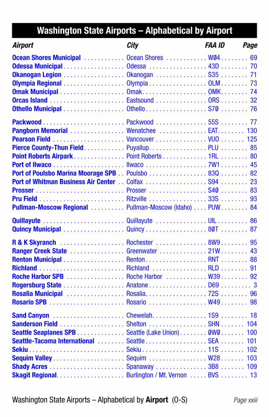
Washington State Airports – Alphabetical by Airport (O-S) Page xxiii
Ocean Shores Municipal . . . . . . . . . . . . Ocean Shores . . . . . . . . . . . . W0/ 4 . . . . . . . . 69Odessa Municipal . . . . . . . . . . . . . . . . . . Odessa . . . . . . . . . . . . . . . . . 43D . . . . . . . . 70Okanogan Legion . . . . . . . . . . . . . . . . . . Okanogan . . . . . . . . . . . . . . . S35 . . . . . . . . 71Olympia Regional . . . . . . . . . . . . . . . . . . Olympia . . . . . . . . . . . . . . . . . OLM . . . . . . . . 73Omak Municipal . . . . . . . . . . . . . . . . . . . Omak . . . . . . . . . . . . . . . . . . . OMK . . . . . . . . 74Orcas Island . . . . . . . . . . . . . . . . . . . . . . Eastsound . . . . . . . . . . . . . . . ORS . . . . . . . . 32Othello Municipal . . . . . . . . . . . . . . . . . . Othello . . . . . . . . . . . . . . . . . . S70/ . . . . . . . . 76
Packwood . . . . . . . . . . . . . . . . . . . . . . . . Packwood . . . . . . . . . . . . . . . 55S . . . . . . . . 77Pangborn Memorial . . . . . . . . . . . . . . . . Wenatchee . . . . . . . . . . . . . . EAT. . . . . . . . 130Pearson Field . . . . . . . . . . . . . . . . . . . . . Vancouver . . . . . . . . . . . . . . . VUO . . . . . . . 125Pierce County-Thun Field . . . . . . . . . . . . Puyallup . . . . . . . . . . . . . . . . . PLU . . . . . . . . 85Point Roberts Airpark . . . . . . . . . . . . . . . Point Roberts . . . . . . . . . . . . . 1RL . . . . . . . . 80Port of Ilwaco . . . . . . . . . . . . . . . . . . . . . Ilwaco . . . . . . . . . . . . . . . . . . 7W1 . . . . . . . . 45Port of Poulsbo Marina Moorage SPB . . Poulsbo . . . . . . . . . . . . . . . . . 83Q . . . . . . . . 82Port of Whitman Business Air Center . . Colfax . . . . . . . . . . . . . . . . . . S94 . . . . . . . . 23Prosser . . . . . . . . . . . . . . . . . . . . . . . . . . Prosser . . . . . . . . . . . . . . . . . S40/ . . . . . . . . 83Pru Field . . . . . . . . . . . . . . . . . . . . . . . . . Ritzville . . . . . . . . . . . . . . . . . 33S . . . . . . . . 93Pullman-Moscow Regional . . . . . . . . . . Pullman-Moscow (Idaho) . . . . PUW . . . . . . . . 84
Quillayute . . . . . . . . . . . . . . . . . . . . . . . . Quillayute . . . . . . . . . . . . . . . UIL . . . . . . . . . 86Quincy Municipal . . . . . . . . . . . . . . . . . . Quincy . . . . . . . . . . . . . . . . . . 80/ T . . . . . . . . 87
R & K Skyranch . . . . . . . . . . . . . . . . . . . Rochester . . . . . . . . . . . . . . . 8W9 . . . . . . . . 95Ranger Creek State . . . . . . . . . . . . . . . . Greenwater . . . . . . . . . . . . . . 21W . . . . . . . . 43Renton Municipal . . . . . . . . . . . . . . . . . . Renton . . . . . . . . . . . . . . . . . . RNT . . . . . . . . 88Richland . . . . . . . . . . . . . . . . . . . . . . . . . Richland . . . . . . . . . . . . . . . . RLD . . . . . . . . 91Roche Harbor SPB . . . . . . . . . . . . . . . . . Roche Harbor . . . . . . . . . . . . W39 . . . . . . . . 92Rogersburg State . . . . . . . . . . . . . . . . . . Anatone . . . . . . . . . . . . . . . . . D69 . . . . . . . . . 3Rosalia Municipal . . . . . . . . . . . . . . . . . Rosalia . . . . . . . . . . . . . . . . . . 72S . . . . . . . . 96Rosario SPB . . . . . . . . . . . . . . . . . . . . . . Rosario . . . . . . . . . . . . . . . . . W49 . . . . . . . . 98
Sand Canyon . . . . . . . . . . . . . . . . . . . . . Chewelah . . . . . . . . . . . . . . . . 1S9 . . . . . . . . 18Sanderson Field . . . . . . . . . . . . . . . . . . . Shelton . . . . . . . . . . . . . . . . . SHN . . . . . . . 104Seattle Seaplanes SPB . . . . . . . . . . . . . . Seattle (Lake Union) . . . . . . . . 0/ W0/ . . . . . . . 100Seattle-Tacoma International . . . . . . . . Seattle . . . . . . . . . . . . . . . . . . SEA . . . . . . . 101Sekiu . . . . . . . . . . . . . . . . . . . . . . . . . . . . Sekiu . . . . . . . . . . . . . . . . . . . 11S . . . . . . . 102Sequim Valley . . . . . . . . . . . . . . . . . . . . . Sequim . . . . . . . . . . . . . . . . . W28 . . . . . . . 103Shady Acres . . . . . . . . . . . . . . . . . . . . . . Spanaway . . . . . . . . . . . . . . . 3B8 . . . . . . . 109Skagit Regional . . . . . . . . . . . . . . . . . . . . Burlington / Mt. Vernon . . . . . BVS . . . . . . . . 13
Washington State Airports – Alphabetical by AirportAirport City FAA ID Page
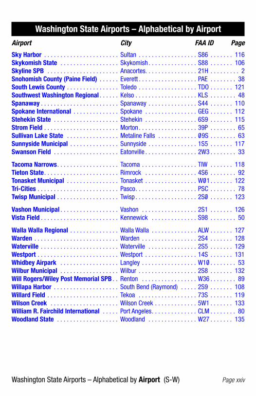
Washington State Airports – Alphabetical by Airport (S-W) Page xxiv
Sky Harbor . . . . . . . . . . . . . . . . . . . . . . . Sultan . . . . . . . . . . . . . . . . . . S86 . . . . . . . 116Skykomish State . . . . . . . . . . . . . . . . . . Skykomish . . . . . . . . . . . . . . . S88 . . . . . . . 106Skyline SPB . . . . . . . . . . . . . . . . . . . . . . Anacortes. . . . . . . . . . . . . . . . 21H . . . . . . . . . 2Snohomish County (Paine Field) . . . . . . Everett . . . . . . . . . . . . . . . . . . PAE . . . . . . . . 38South Lewis County . . . . . . . . . . . . . . . . Toledo . . . . . . . . . . . . . . . . . . TDO . . . . . . . 121Southwest Washington Regional . . . . . . Kelso . . . . . . . . . . . . . . . . . . . KLS . . . . . . . . 48Spanaway . . . . . . . . . . . . . . . . . . . . . . . . Spanaway . . . . . . . . . . . . . . . S44 . . . . . . . 110Spokane International . . . . . . . . . . . . . . Spokane . . . . . . . . . . . . . . . . GEG . . . . . . . 112Stehekin State . . . . . . . . . . . . . . . . . . . . Stehekin . . . . . . . . . . . . . . . . 6S9 . . . . . . . 115Strom Field . . . . . . . . . . . . . . . . . . . . . . . Morton . . . . . . . . . . . . . . . . . . 39P . . . . . . . . 65Sullivan Lake State . . . . . . . . . . . . . . . . Metaline Falls . . . . . . . . . . . . 0/ 9S . . . . . . . . 63Sunnyside Municipal . . . . . . . . . . . . . . . Sunnyside . . . . . . . . . . . . . . . 1S5 . . . . . . . 117Swanson Field . . . . . . . . . . . . . . . . . . . . Eatonville . . . . . . . . . . . . . . . . 2W3 . . . . . . . . 33
Tacoma Narrows . . . . . . . . . . . . . . . . . . . Tacoma . . . . . . . . . . . . . . . . . TIW . . . . . . . 118Tieton State . . . . . . . . . . . . . . . . . . . . . . . Rimrock . . . . . . . . . . . . . . . . 4S6 . . . . . . . . 92Tonasket Municipal . . . . . . . . . . . . . . . . Tonasket . . . . . . . . . . . . . . . . W0/ 1 . . . . . . . 122Tri-Cities . . . . . . . . . . . . . . . . . . . . . . . . . Pasco . . . . . . . . . . . . . . . . . . . PSC . . . . . . . . 78Twisp Municipal . . . . . . . . . . . . . . . . . . . Twisp . . . . . . . . . . . . . . . . . . . 2S0/ . . . . . . . 123
Vashon Municipal . . . . . . . . . . . . . . . . . . Vashon . . . . . . . . . . . . . . . . . 2S1 . . . . . . . 126Vista Field . . . . . . . . . . . . . . . . . . . . . . . . Kennewick . . . . . . . . . . . . . . S98 . . . . . . . . 50
Walla Walla Regional . . . . . . . . . . . . . . . Walla Walla . . . . . . . . . . . . . . ALW . . . . . . . 127Warden . . . . . . . . . . . . . . . . . . . . . . . . . . Warden . . . . . . . . . . . . . . . . . 2S4 . . . . . . . 128Waterville . . . . . . . . . . . . . . . . . . . . . . . . Waterville . . . . . . . . . . . . . . . 2S5 . . . . . . . 129Westport . . . . . . . . . . . . . . . . . . . . . . . . . Westport . . . . . . . . . . . . . . . . 14S . . . . . . . 131Whidbey Airpark . . . . . . . . . . . . . . . . . . Langley . . . . . . . . . . . . . . . . . W10/ . . . . . . . . 53Wilbur Municipal . . . . . . . . . . . . . . . . . . Wilbur . . . . . . . . . . . . . . . . . . 2S8 . . . . . . . 132Will Rogers/Wiley Post Memorial SPB . . Renton . . . . . . . . . . . . . . . . . W36 . . . . . . . . 89Willapa Harbor . . . . . . . . . . . . . . . . . . . . South Bend (Raymond) . . . . . 2S9 . . . . . . . 108Willard Field . . . . . . . . . . . . . . . . . . . . . . Tekoa . . . . . . . . . . . . . . . . . . 73S . . . . . . . 119Wilson Creek . . . . . . . . . . . . . . . . . . . . . Wilson Creek . . . . . . . . . . . . . 5W1 . . . . . . . 133William R. Fairchild International . . . . . Port Angeles . . . . . . . . . . . . . . CLM . . . . . . . . 80Woodland State . . . . . . . . . . . . . . . . . . . Woodland . . . . . . . . . . . . . . . W27 . . . . . . . 135
Washington State Airports – Alphabetical by AirportAirport City FAA ID Page

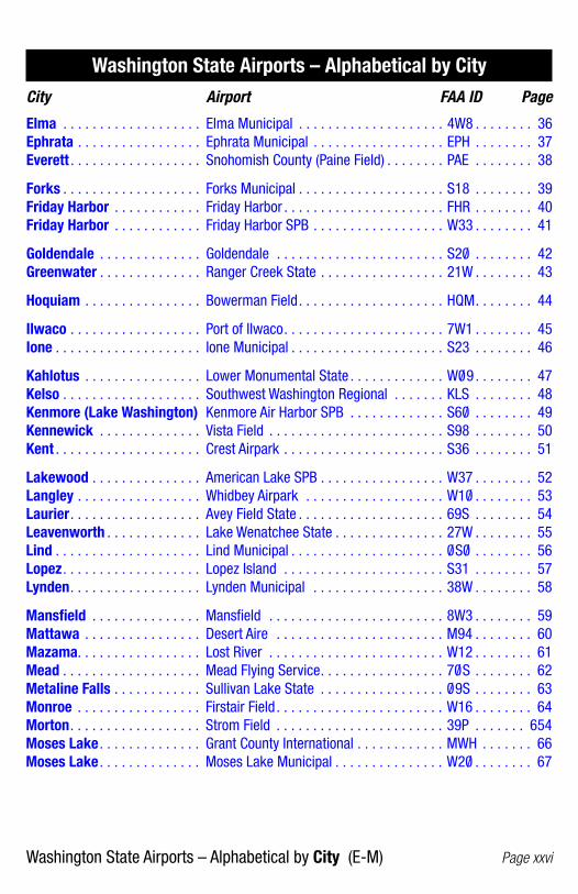
Washington State Airports – Alphabetical by City (A-E) Page xxv
Anacortes . . . . . . . . . . . . . . . Anacortes . . . . . . . . . . . . . . . . . . . . . . . . 74S . . . . . . . . . 1Anacortes . . . . . . . . . . . . . . . Skyline SPB . . . . . . . . . . . . . . . . . . . . . . . 21H . . . . . . . . . 2Anatone . . . . . . . . . . . . . . . . . Rogersburg State . . . . . . . . . . . . . . . . . . . D69 . . . . . . . . . 3Arlington . . . . . . . . . . . . . . . . Arlington Municipal . . . . . . . . . . . . . . . . . AWO . . . . . . . . . 4Auburn. . . . . . . . . . . . . . . . . . Auburn Municipal . . . . . . . . . . . . . . . . . . S50/ . . . . . . . . . 5
Bandera . . . . . . . . . . . . . . . . . Bandera State . . . . . . . . . . . . . . . . . . . . . 4W0/ . . . . . . . . . 6Battle Ground . . . . . . . . . . . . Cedars North . . . . . . . . . . . . . . . . . . . . . . W58 . . . . . . . . . 7Battle Ground . . . . . . . . . . . . Goheen . . . . . . . . . . . . . . . . . . . . . . . . . . W52 . . . . . . . . . 8Bellingham . . . . . . . . . . . . . . Bellingham International . . . . . . . . . . . . . BLI . . . . . . . . . . 9Bellingham . . . . . . . . . . . . . . Floathaven SPB . . . . . . . . . . . . . . . . . . . . 0/ W7 . . . . . . . . 10Bremerton . . . . . . . . . . . . . . . Bremerton National . . . . . . . . . . . . . . . . . PWT . . . . . . . . 11Brewster . . . . . . . . . . . . . . . . Anderson Field . . . . . . . . . . . . . . . . . . . . . S97 . . . . . . . . 12Burlington / Mt. Vernon . . . . Skagit Regional . . . . . . . . . . . . . . . . . . . . BVS . . . . . . . . 13
Camas . . . . . . . . . . . . . . . . . . Grove Field . . . . . . . . . . . . . . . . . . . . . . . 1W1 . . . . . . . . 14Cashmere . . . . . . . . . . . . . . . Cashmere-Dryden . . . . . . . . . . . . . . . . . . 8S2 . . . . . . . . 15Chehalis . . . . . . . . . . . . . . . . Chehalis-Centralia . . . . . . . . . . . . . . . . . . CLS . . . . . . . . 16Chelan . . . . . . . . . . . . . . . . . . Lake Chelan . . . . . . . . . . . . . . . . . . . . . . . S10/ . . . . . . . . 17Chewelah . . . . . . . . . . . . . . . Sand Canyon . . . . . . . . . . . . . . . . . . . . . . 1S9 . . . . . . . . 18Clayton . . . . . . . . . . . . . . . . . Cross Winds . . . . . . . . . . . . . . . . . . . . . . C72 . . . . . . . . 19Cle Elum . . . . . . . . . . . . . . . . Cle Elum Municipal . . . . . . . . . . . . . . . . . S93 . . . . . . . . 20Cle Elum . . . . . . . . . . . . . . . . De Vere Field . . . . . . . . . . . . . . . . . . . . . . 2W1 . . . . . . . . 21Colfax . . . . . . . . . . . . . . . . . . Lower Granite State . . . . . . . . . . . . . . . . . 0/ 0/ W . . . . . . . . 22Colfax . . . . . . . . . . . . . . . . . . Port of Whitman Business Air Center . . . . S94 . . . . . . . . 23College Place . . . . . . . . . . . . Martin Field . . . . . . . . . . . . . . . . . . . . . . . S95 . . . . . . . . 24Colville. . . . . . . . . . . . . . . . . . Colville Municipal . . . . . . . . . . . . . . . . . . 63S . . . . . . . . 25Concrete . . . . . . . . . . . . . . . . Concrete Municipal . . . . . . . . . . . . . . . . . 3W5 . . . . . . . . 26Copalis Beach . . . . . . . . . . . . Copalis State . . . . . . . . . . . . . . . . . . . . . . S16 . . . . . . . . 27
Darrington . . . . . . . . . . . . . . . Darrington Municipal . . . . . . . . . . . . . . . . 1S2 . . . . . . . . 28Davenport . . . . . . . . . . . . . . . Davenport Municipal . . . . . . . . . . . . . . . . 68S . . . . . . . . 29Deer Park . . . . . . . . . . . . . . . Deer Park Municipal . . . . . . . . . . . . . . . . DEW . . . . . . . . 30
Easton . . . . . . . . . . . . . . . . . . Easton State . . . . . . . . . . . . . . . . . . . . . . ESW . . . . . . . . 31Eastsound . . . . . . . . . . . . . . . Orcas Island . . . . . . . . . . . . . . . . . . . . . . ORS . . . . . . . . 32Eatonville . . . . . . . . . . . . . . . Swanson Field . . . . . . . . . . . . . . . . . . . . . 2W3 . . . . . . . . 33Electric City . . . . . . . . . . . . . . Grand Coulee Dam . . . . . . . . . . . . . . . . . . 3W7 . . . . . . . . 34Ellensburg . . . . . . . . . . . . . . . Bowers Field . . . . . . . . . . . . . . . . . . . . . . ELN . . . . . . . . 35
Washington State Airports – Alphabetical by CityCity Airport FAA ID Page
Washington State Airports – Alphabetical by City (E-M) Page xxvi
Washington State Airports – Alphabetical by CityCity Airport FAA ID Page
Elma . . . . . . . . . . . . . . . . . . . Elma Municipal . . . . . . . . . . . . . . . . . . . . 4W8 . . . . . . . . 36Ephrata . . . . . . . . . . . . . . . . . Ephrata Municipal . . . . . . . . . . . . . . . . . . EPH . . . . . . . . 37Everett . . . . . . . . . . . . . . . . . . Snohomish County (Paine Field) . . . . . . . . PAE . . . . . . . . 38
Forks . . . . . . . . . . . . . . . . . . . Forks Municipal . . . . . . . . . . . . . . . . . . . . S18 . . . . . . . . 39Friday Harbor . . . . . . . . . . . . Friday Harbor . . . . . . . . . . . . . . . . . . . . . . FHR . . . . . . . . 40Friday Harbor . . . . . . . . . . . . Friday Harbor SPB . . . . . . . . . . . . . . . . . . W33 . . . . . . . . 41
Goldendale . . . . . . . . . . . . . . Goldendale . . . . . . . . . . . . . . . . . . . . . . . S20/ . . . . . . . . 42Greenwater . . . . . . . . . . . . . . Ranger Creek State . . . . . . . . . . . . . . . . . 21W . . . . . . . . 43
Hoquiam . . . . . . . . . . . . . . . . Bowerman Field . . . . . . . . . . . . . . . . . . . . HQM . . . . . . . . 44
Ilwaco . . . . . . . . . . . . . . . . . . Port of Ilwaco . . . . . . . . . . . . . . . . . . . . . . 7W1 . . . . . . . . 45Ione . . . . . . . . . . . . . . . . . . . . Ione Municipal . . . . . . . . . . . . . . . . . . . . . S23 . . . . . . . . 46
Kahlotus . . . . . . . . . . . . . . . . Lower Monumental State . . . . . . . . . . . . . W0/ 9 . . . . . . . . 47Kelso . . . . . . . . . . . . . . . . . . . Southwest Washington Regional . . . . . . . KLS . . . . . . . . 48Kenmore (Lake Washington) Kenmore Air Harbor SPB . . . . . . . . . . . . . S60/ . . . . . . . . 49Kennewick . . . . . . . . . . . . . . Vista Field . . . . . . . . . . . . . . . . . . . . . . . . S98 . . . . . . . . 50Kent . . . . . . . . . . . . . . . . . . . . Crest Airpark . . . . . . . . . . . . . . . . . . . . . . S36 . . . . . . . . 51
Lakewood . . . . . . . . . . . . . . . American Lake SPB . . . . . . . . . . . . . . . . . W37 . . . . . . . . 52Langley . . . . . . . . . . . . . . . . . Whidbey Airpark . . . . . . . . . . . . . . . . . . . W10/ . . . . . . . . 53Laurier . . . . . . . . . . . . . . . . . . Avey Field State . . . . . . . . . . . . . . . . . . . . 69S . . . . . . . . 54Leavenworth . . . . . . . . . . . . . Lake Wenatchee State . . . . . . . . . . . . . . . 27W . . . . . . . . 55Lind . . . . . . . . . . . . . . . . . . . . Lind Municipal . . . . . . . . . . . . . . . . . . . . . 0/ S0/ . . . . . . . . 56Lopez . . . . . . . . . . . . . . . . . . . Lopez Island . . . . . . . . . . . . . . . . . . . . . . S31 . . . . . . . . 57Lynden . . . . . . . . . . . . . . . . . . Lynden Municipal . . . . . . . . . . . . . . . . . . 38W . . . . . . . . 58
Mansfield . . . . . . . . . . . . . . . Mansfield . . . . . . . . . . . . . . . . . . . . . . . . 8W3 . . . . . . . . 59Mattawa . . . . . . . . . . . . . . . . Desert Aire . . . . . . . . . . . . . . . . . . . . . . . M94 . . . . . . . . 60Mazama. . . . . . . . . . . . . . . . . Lost River . . . . . . . . . . . . . . . . . . . . . . . . W12 . . . . . . . . 61Mead . . . . . . . . . . . . . . . . . . . Mead Flying Service . . . . . . . . . . . . . . . . . 70/ S . . . . . . . . 62Metaline Falls . . . . . . . . . . . . Sullivan Lake State . . . . . . . . . . . . . . . . . 0/ 9S . . . . . . . . 63Monroe . . . . . . . . . . . . . . . . . Firstair Field . . . . . . . . . . . . . . . . . . . . . . . W16 . . . . . . . . 64Morton . . . . . . . . . . . . . . . . . . Strom Field . . . . . . . . . . . . . . . . . . . . . . . 39P . . . . . . . 654Moses Lake . . . . . . . . . . . . . . Grant County International . . . . . . . . . . . . MWH . . . . . . . 66Moses Lake . . . . . . . . . . . . . . Moses Lake Municipal . . . . . . . . . . . . . . . W20/ . . . . . . . . 67

Washington State Airports – Alphabetical by City (O-S) Page xxvii
Washington State Airports – Alphabetical by CityCity Airport FAA ID Page
Oak Harbor . . . . . . . . . . . . . . AJ Eisenberg . . . . . . . . . . . . . . . . . . . . . . OKH . . . . . . . . 68Ocean Shores . . . . . . . . . . . . Ocean Shores Municipal . . . . . . . . . . . . . W0/ 4 . . . . . . . . 69Odessa. . . . . . . . . . . . . . . . . . Odessa Municipal . . . . . . . . . . . . . . . . . . 43D . . . . . . . . 70Okanogan . . . . . . . . . . . . . . . Okanogan Legion . . . . . . . . . . . . . . . . . . S35 . . . . . . . . 71Olympia . . . . . . . . . . . . . . . . . Hoskins Field . . . . . . . . . . . . . . . . . . . . . . 44T . . . . . . . . 72Olympia . . . . . . . . . . . . . . . . . Olympia Regional . . . . . . . . . . . . . . . . . . OLM . . . . . . . . 73Omak . . . . . . . . . . . . . . . . . . . Omak Municipal . . . . . . . . . . . . . . . . . . . OMK . . . . . . . . 74Oroville . . . . . . . . . . . . . . . . . Dorothy Scott . . . . . . . . . . . . . . . . . . . . . 0/ S7 . . . . . . . . 75Othello . . . . . . . . . . . . . . . . . . Othello Municipal . . . . . . . . . . . . . . . . . . . S70/ . . . . . . . . 76
Packwood . . . . . . . . . . . . . . . Packwood . . . . . . . . . . . . . . . . . . . . . . . . 55S . . . . . . . . 77Pasco . . . . . . . . . . . . . . . . . . . Tri-Cities . . . . . . . . . . . . . . . . . . . . . . . . . PSC . . . . . . . . 78Point Roberts . . . . . . . . . . . . Point Roberts Airpark . . . . . . . . . . . . . . . . 1RL . . . . . . . . 79Port Angeles . . . . . . . . . . . . . William R. Fairchild International . . . . . . . CLM . . . . . . . . 80Port Townsend . . . . . . . . . . . Jefferson County International . . . . . . . . . 0/ S9 . . . . . . . . 81Poulsbo . . . . . . . . . . . . . . . . . Port of Poulsbo Marina Moorage SPB . . . . 83Q . . . . . . . . 82Prosser . . . . . . . . . . . . . . . . . Prosser . . . . . . . . . . . . . . . . . . . . . . . . . . S40/ . . . . . . . . 83Pullman-Moscow (Idaho) . . . Pullman-Moscow Regional . . . . . . . . . . . . PUW . . . . . . . . 84Puyallup . . . . . . . . . . . . . . . . Pierce County-Thun Field . . . . . . . . . . . . . PLU . . . . . . . . 85
Quillayute . . . . . . . . . . . . . . . Quillayute . . . . . . . . . . . . . . . . . . . . . . . . UIL . . . . . . . . . 86Quincy . . . . . . . . . . . . . . . . . . Quincy Municipal . . . . . . . . . . . . . . . . . . . 80/ T . . . . . . . . 87
Renton . . . . . . . . . . . . . . . . . . Renton Municipal . . . . . . . . . . . . . . . . . . . RNT . . . . . . . . 88Renton . . . . . . . . . . . . . . . . . . Will Rogers/Wiley Post Memorial SPB . . . . W36 . . . . . . . . 89Republic . . . . . . . . . . . . . . . . Ferry County . . . . . . . . . . . . . . . . . . . . . . R49 . . . . . . . . 90Richland . . . . . . . . . . . . . . . . Richland . . . . . . . . . . . . . . . . . . . . . . . . . RLD . . . . . . . . 91Rimrock . . . . . . . . . . . . . . . . . Tieton State . . . . . . . . . . . . . . . . . . . . . . . 4S6 . . . . . . . . 92Ritzville . . . . . . . . . . . . . . . . . Pru Field . . . . . . . . . . . . . . . . . . . . . . . . . 33S . . . . . . . . 93Roche Harbor . . . . . . . . . . . . Roche Harbor SPB . . . . . . . . . . . . . . . . . . W39 . . . . . . . . 94Rochester . . . . . . . . . . . . . . . R & K Skyranch . . . . . . . . . . . . . . . . . . . . 8W9 . . . . . . . . 95Rosalia . . . . . . . . . . . . . . . . . Rosalia Municipal . . . . . . . . . . . . . . . . . . . 72S . . . . . . . . 96Rosario . . . . . . . . . . . . . . . . . Rosario SPB . . . . . . . . . . . . . . . . . . . . . . . W49 . . . . . . . . 97
Seattle . . . . . . . . . . . . . . . . . . Boeing Field/King County International . . . BFI . . . . . . . . . 98Seattle (Lake Union) . . . . . . . Kenmore Air Harbor SPB . . . . . . . . . . . . . W55 . . . . . . . . 99Seattle (Lake Union) . . . . . . . Seattle Seaplanes SPB . . . . . . . . . . . . . . 0/ W0/ . . . . . . . 100Seattle . . . . . . . . . . . . . . . . . . Seattle-Tacoma International . . . . . . . . . . SEA . . . . . . . 101Sekiu . . . . . . . . . . . . . . . . . . . Sekiu . . . . . . . . . . . . . . . . . . . . . . . . . . . . 11S . . . . . . . 102Sequim . . . . . . . . . . . . . . . . . Sequim Valley . . . . . . . . . . . . . . . . . . . . . W28 . . . . . . . 103

Washington State Airports – Alphabetical by City (S-Y) Page xxviii
Washington State Airports – Alphabetical by CityCity Airport FAA ID Page
Shelton . . . . . . . . . . . . . . . . . Sanderson Field . . . . . . . . . . . . . . . . . . . . SHN . . . . . . . 104Silverdale . . . . . . . . . . . . . . . Apex . . . . . . . . . . . . . . . . . . . . . . . . . . . . 8W5 . . . . . . . 105Skykomish . . . . . . . . . . . . . . Skykomish State . . . . . . . . . . . . . . . . . . . S88 . . . . . . . 106Snohomish . . . . . . . . . . . . . . Harvey Field . . . . . . . . . . . . . . . . . . . . . . S43 . . . . . . . 107South Bend (Raymond) . . . . . Willapa Harbor . . . . . . . . . . . . . . . . . . . . . 2S9 . . . . . . . 108Spanaway . . . . . . . . . . . . . . . Shady Acres . . . . . . . . . . . . . . . . . . . . . . 3B8 . . . . . . . 109Spanaway . . . . . . . . . . . . . . . Spanaway . . . . . . . . . . . . . . . . . . . . . . . . S44 . . . . . . . 110Spokane . . . . . . . . . . . . . . . . Felts Field . . . . . . . . . . . . . . . . . . . . . . . . SFF . . . . . . . 111Spokane . . . . . . . . . . . . . . . . Spokane International . . . . . . . . . . . . . . . GEG . . . . . . . 112Stanwood . . . . . . . . . . . . . . . Camano Island Airfield . . . . . . . . . . . . . . . 13W . . . . . . . 113Starbuck . . . . . . . . . . . . . . . . Little Goose Lock & Dam State . . . . . . . . 16W . . . . . . . 114Stehekin . . . . . . . . . . . . . . . . Stehekin State . . . . . . . . . . . . . . . . . . . . . 6S9 . . . . . . . 115Sultan . . . . . . . . . . . . . . . . . . Sky Harbor . . . . . . . . . . . . . . . . . . . . . . . S86 . . . . . . . 116Sunnyside . . . . . . . . . . . . . . . Sunnyside Municipal . . . . . . . . . . . . . . . . 1S5 . . . . . . . 117Tacoma . . . . . . . . . . . . . . . . . Tacoma Narrows . . . . . . . . . . . . . . . . . . . TIW . . . . . . . 118Tekoa . . . . . . . . . . . . . . . . . . . Willard Field . . . . . . . . . . . . . . . . . . . . . . 73S . . . . . . . 119The Dalles, Oregon . . . . . . . . Columbia Gorge Regional/ . . . . . . . . . . . . DLS . . . . . . . 120 The Dalles MunicipalToledo . . . . . . . . . . . . . . . . . . South Lewis County . . . . . . . . . . . . . . . . . TDO . . . . . . . 121Tonasket . . . . . . . . . . . . . . . . Tonasket Municipal . . . . . . . . . . . . . . . . . W0/ 1 . . . . . . . 122Twisp . . . . . . . . . . . . . . . . . . . Twisp Municipal . . . . . . . . . . . . . . . . . . . . 2S0/ . . . . . . . 123
Vancouver . . . . . . . . . . . . . . . Fly For Fun . . . . . . . . . . . . . . . . . . . . . . . W56 . . . . . . . 124Vancouver . . . . . . . . . . . . . . . Pearson Field . . . . . . . . . . . . . . . . . . . . . VUO . . . . . . . 125Vashon . . . . . . . . . . . . . . . . . Vashon Municipal . . . . . . . . . . . . . . . . . . 2S1 . . . . . . . 126
Walla Walla . . . . . . . . . . . . . . Walla Walla Regional . . . . . . . . . . . . . . . . ALW . . . . . . . 127Warden . . . . . . . . . . . . . . . . . Warden . . . . . . . . . . . . . . . . . . . . . . . . . . 2S4 . . . . . . . 128Waterville . . . . . . . . . . . . . . . Waterville . . . . . . . . . . . . . . . . . . . . . . . . 2S5 . . . . . . . 129Wenatchee . . . . . . . . . . . . . . Pangborn Memorial . . . . . . . . . . . . . . . . . EAT. . . . . . . . 130Westport . . . . . . . . . . . . . . . . Westport . . . . . . . . . . . . . . . . . . . . . . . . . 14S . . . . . . . 131Wilbur . . . . . . . . . . . . . . . . . . Wilbur Municipal . . . . . . . . . . . . . . . . . . . 2S8 . . . . . . . 132Wilson Creek . . . . . . . . . . . . . Wilson Creek . . . . . . . . . . . . . . . . . . . . . . 5W1 . . . . . . . 133Winthrop . . . . . . . . . . . . . . . . Methow Valley State . . . . . . . . . . . . . . . . S52 . . . . . . . 134Woodland . . . . . . . . . . . . . . . Woodland State . . . . . . . . . . . . . . . . . . . . W27 . . . . . . . 135
Yakima . . . . . . . . . . . . . . . . . McAllister Field . . . . . . . . . . . . . . . . . . . . YKM . . . . . . . 136

Anacortes / Anacortes / 74S
Anacortes / Anacortes / 74S Page 1
Communications
CTAF ................. 128.25PCL ................... CTAF (For MIRL & REILs)
Navigation
Elevation ........... 241′ MSLTPA ................... 1241′ MSL (1000′ AGL)Runway ............ 18/36; 3015′x60′; ASPHLights ............... Dusk-dawn, MIRLLatitude ............ N 48° 49.94′Longitude ......... W122° 39.74′
Services
Fuel .................. 100LL, Jet A (24-hour credit card fuel services for 100LL)
Right hand traffic runway 18. No touch and go landings. Noise abatement procedure in effect, contact airport manager. Runway 36 preferred.
Notes
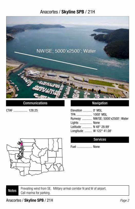
Anacortes / Skyline SPB / 21H
Anacortes / Skyline SPB / 21H Page 2
Communications
CTAF ................. 128.25
Navigation
Elevation ........... 0′ MSLTPA ................... 1000′ MSLRunway ............ NW/SE; 5000′x2500′; WaterLights ............... NoneLatitude ............ N 48° 28.99′Longitude ......... W 122° 41.08′
Services
Fuel .................. None
Prevailing wind from SE. Military arrival corridor N and W of airport. Call marina for parking.
Notes

Anatone / Rogersburg State / D69
Anatone / Rogersberg State / D69 Page 3
Communications
CTAF ................. 122.9
Navigation
Elevation ........... 869′ MSLTPA ................... 1869′ MSL (1000′ AGL)Runway ............ 09/27; 1471′x50′; TURFLights ............... NoneLatitude ............ N 46° 04.47′Longitude ......... W 116° 57.97′
Services
Fuel .................. None
Check the AF/D and NOTAMS. Call WSDOT Aviation (360-651-6300 or 1-800-552-0666) for additional information prior to use. Use at own risk.
Notes
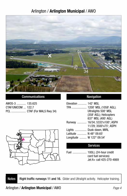
Arlington / Arlington Municipal / AWO
Arlington / Arlington Municipal / AWO Page 4
Communications
AWOS-3 ............ 135.625CTAF/UNICOM ... 122.7PCL ................... CTAF (For MALS Rwy 34)
Navigation
Elevation ........... 142′ MSLTPA ................... 1200′ MSL (1058′ AGL); Ultralights 500′ MSL (358′ AGL); Helicopters 637′ MSL (495′ AGL)Runway ............ 16/34; 5333′x100′; ASPH 11/29; 3500′x75′; ASPHLights ............... Dusk-dawn, MIRLLatitude ............ N 48° 09.65′Longitude ......... W 122° 09.54′
Services
Fuel .................. 100LL (24-hour credit card fuel services) Jet A+ call 425-270-4869
Right traffic runways 11 and 16. Glider and Ultralight activity. Helicopter training.Notes

Auburn / Auburn Municipal / S5O/
Auburn / Auburn Municipal / S50/ Page 5
Communications
CTAF/UNICOM ... 122.8PCL ................... CTAF (For VASI & REIL Rwy 34)
Navigation
Elevation ........... 63′ MSLTPA ................... 1063′ MSL (1000′ AGL)Runway ............ 16/34; 3400′x75′; ASPHLights ............... Dusk-dawn, MIRLLatitude ............ N 47° 19.66′Longitude ......... W 122° 13.60′
Services
Fuel .................. 100LL (24-hour credit card fuel services)
Right hand traffic runway 16. Rotocraft traffic pattern; RH RWY 34, LH RWY 16. Plan approach and departures to avoid noise. Sensitive residential area east of airport. Super Unicom click 3 times for advisory.
Notes
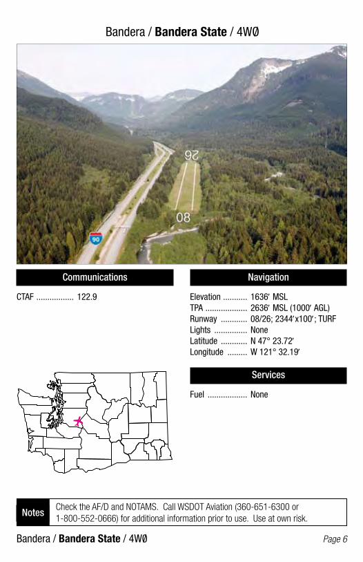
Bandera / Bandera State / 4WO/
Bandera / Bandera State / 4W0/ Page 6
Communications
CTAF ................. 122.9
Navigation
Elevation ........... 1636′ MSLTPA ................... 2636′ MSL (1000′ AGL)Runway ............ 08/26; 2344′x100′; TURFLights ............... NoneLatitude ............ N 47° 23.72′Longitude ......... W 121° 32.19′
Services
Fuel .................. None
Check the AF/D and NOTAMS. Call WSDOT Aviation (360-651-6300 or 1-800-552-0666) for additional information prior to use. Use at own risk.
Notes

Battle Ground / Cedars North / W58
Battle Ground / Cedars North / W58 Page 7
Communications
CTAF ................. 122.9
Navigation
Elevation ........... 275′ MSLTPA ................... 1275′ MSL (1000′ AGL)Runway ............ 08/26; 1960′x50′; TURFLights ............... NoneLatitude ............ N 45° 45.87′Longitude ......... W 122° 30.91′
Services
Fuel .................. None
Unattended. Transition between rwy and twy on marked twys only.Notes
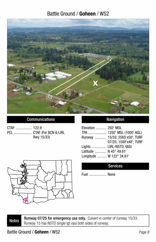
Battle Ground / Goheen / W52
Battle Ground / Goheen / W52 Page 8
Communications
CTAF ................. 122.9PCL ................... CTAF (For BCN & LIRL Rwy 15/33)
Navigation
Elevation ........... 292′ MSLTPA ................... 1292′ MSL (1000′ AGL)Runway ............ 15/33; 2565′x50′; TURF 07/25; 1500′x48′; TURFLights ............... LIRL-NSTD, VASILatitude ............ N 45° 49.61′Longitude ......... W 122° 34.61′
Services
Fuel .................. None
Runway 07/25 for emergency use only. Culvert in center of runway 15/33. Runway 15 has NSTD single lgt vasi both sides of runway.
Notes
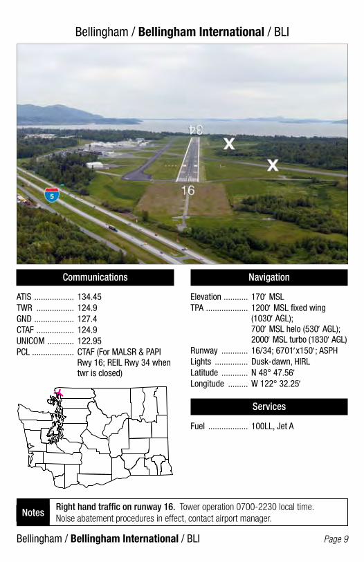
Bellingham / Bellingham International / BLI
Bellingham / Bellingham International / BLI Page 9
Communications
ATIS .................. 134.45TWR ................. 124.9GND .................. 127.4CTAF ................. 124.9UNICOM ............ 122.95PCL ................... CTAF (For MALSR & PAPI Rwy 16; REIL Rwy 34 when twr is closed)
Navigation
Elevation ........... 170′ MSLTPA ................... 1200′ MSL fixed wing (1030′ AGL); 700′ MSL helo (530′ AGL); 2000′ MSL turbo (1830′ AGL)Runway ............ 16/34; 6701′x150′; ASPHLights ............... Dusk-dawn, HIRLLatitude ............ N 48° 47.56′Longitude ......... W 122° 32.25′
Services
Fuel .................. 100LL, Jet A
Right hand traffic on runway 16. Tower operation 0700-2230 local time. Noise abatement procedures in effect, contact airport manager.
Notes

Bellingham / Floathaven SPB / 0W7
Bellingham / Floathaven SPB / 0W7 Page 10
Communications
CTAF ................. 122.9
Navigation
Elevation ........... 307′ MSLTPA ................... 1107′ MSL (800′ AGL)Runway ............ 12/30; 10000′x4000′; WaterLights ............... NoneLatitude ............ N 48° 43.69′Longitude ......... W 122° 20.16′
Services
Fuel .................. None
Watch for canoe, sailboat, and hang glider activity. Land and takeoff in the center of the lake. Avoid flying over noise sensitive area during takeoff and landing.
Notes
Seaplane Float
/
/

Bremerton / Bremerton National / PWT
Bremerton / Bremerton National / PWT Page 11
Communications
AWOS-3 ............ 121.2 CTAF/UNICOM .... 123.05PCL ................... CTAF (For MALSR Rwy 19; PAPI Rwy 01/19)
Navigation
Elevation ........... 444′ MSLTPA ................... 1444′ MSL (1000′ AGL)Runway ............ 01/19; 6000′x150′; ASPHLights ............... Dusk-dawn, HIRLLatitude ............ N 47° 29.42′Longitude ......... W 122° 45.89′
Services
Fuel .................. 100LL, Jet A (24-hour credit card fuel services)
Right hand traffic on runway 01. Runway 01/19 closed to ultralights. Runway 19 designated calm wind runway. Rotorcraft use right traffic pattern.
Notes
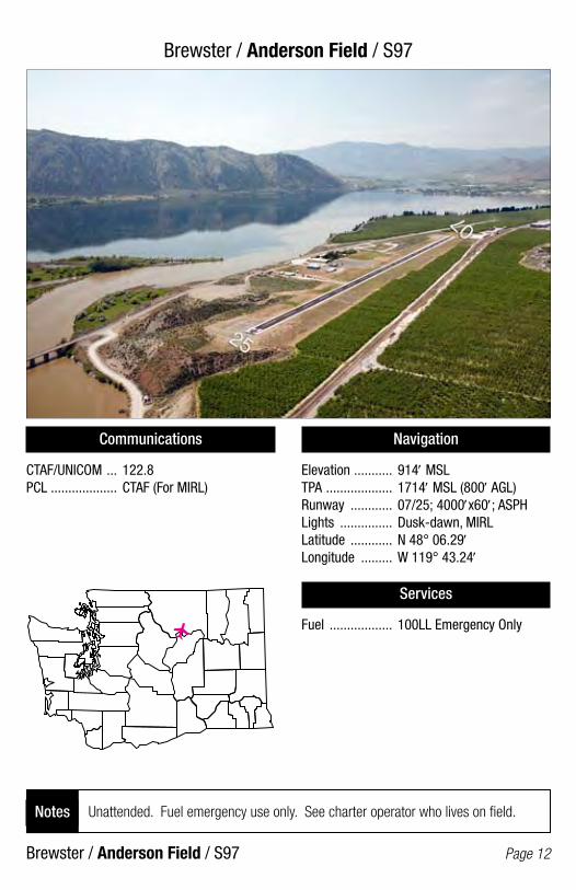
Brewster / Anderson Field / S97
Brewster / Anderson Field / S97 Page 12
Communications
CTAF/UNICOM ... 122.8PCL ................... CTAF (For MIRL)
Navigation
Elevation ........... 914′ MSLTPA ................... 1714′ MSL (800′ AGL)Runway ............ 07/25; 4000′x60′; ASPHLights ............... Dusk-dawn, MIRLLatitude ............ N 48° 06.29′Longitude ......... W 119° 43.24′
Services
Fuel .................. 100LL Emergency Only
Unattended. Fuel emergency use only. See charter operator who lives on field. Notes

Burlington / Mt. Vernon / Skagit Regional / BVS
Burlington / Mt. Vernon / Skagit Regional / BVS Page 13
Communications
AWOS-3 ............ 121.125CTAF/UNICOM ... 123.075PCL ................... CTAF (For MIRL, REILs, & VASIs Rwy 10/28; LIRL Rwy 04/22)
Navigation
Elevation ........... 144′ MSLTPA ................... 1144′ MSL (1000′ AGL); Ultralights 644′ MSL (500′ AGL)Runway ............ 10/28; 5477′x100′; ASPH 04/22; 3000′x60′; ASPHLights ............... Dusk-dawn, MIRL, LIRLLatitude ............ N 48° 28.25′Longitude ......... W 122° 25.25′
Services
Fuel .................. 100LL, Jet A (24-hour credit card fuel services)
Deer and birds on and in vicinity of runways. Helicopter training ops on airport with autorotations on runways.
Notes

Camas / Grove Field / 1W1
Camas / Grove Field / 1W1 Page 14
Communications
CTAF ................. 122.9PCL CTAF (For BCN & MIRL)
Navigation
Elevation ........... 429′ MSLTPA ................... 1229′ MSL (800′ AGL)Runway ............ 07/25; 2710′x40′; ASPHLights ............... MIRLLatitude ............ N 45° 37.67′Longitude ......... W 122° 24.26′
Services
Fuel .................. 100LL, 80 (24-hour credit card fuel services for 100LL)
Dspld. thrld. Rwy 07 - 493′ - 2217′ avail. Dspld. thrld. Rwy 25 - 413′ - 2297′ avail. Rwy lighted only between dspld. thrld. 1,804′ at night. Noise abatement procedures, contact Port of Camas at 360-835-2196.
Notes
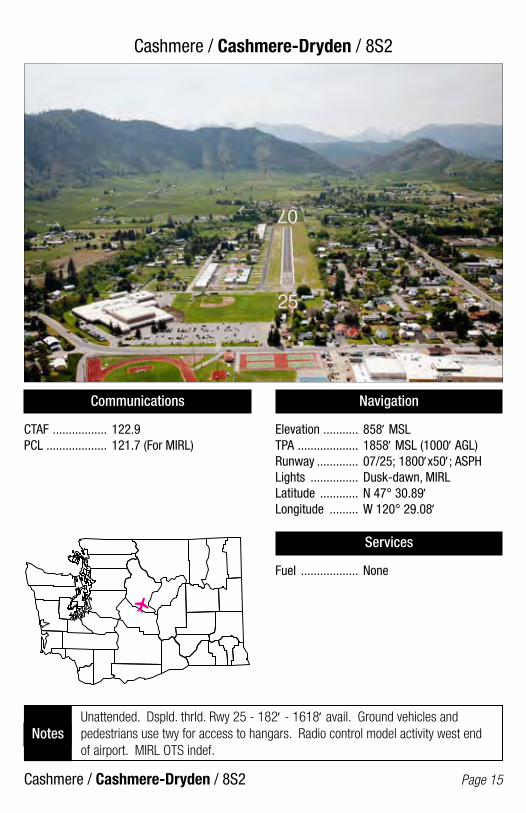
Cashmere / Cashmere-Dryden / 8S2
Cashmere / Cashmere-Dryden / 8S2 Page 15
Communications
CTAF ................. 122.9PCL ................... 121.7 (For MIRL)
Navigation
Elevation ........... 858′ MSLTPA ................... 1858′ MSL (1000′ AGL)Runway ............. 07/25; 1800′x50′; ASPHLights ............... Dusk-dawn, MIRLLatitude ............ N 47° 30.89′Longitude ......... W 120° 29.08′
Services
Fuel .................. None
Unattended. Dspld. thrld. Rwy 25 - 182′ - 1618′ avail. Ground vehicles and pedestrians use twy for access to hangars. Radio control model activity west end of airport. MIRL OTS indef.
Notes
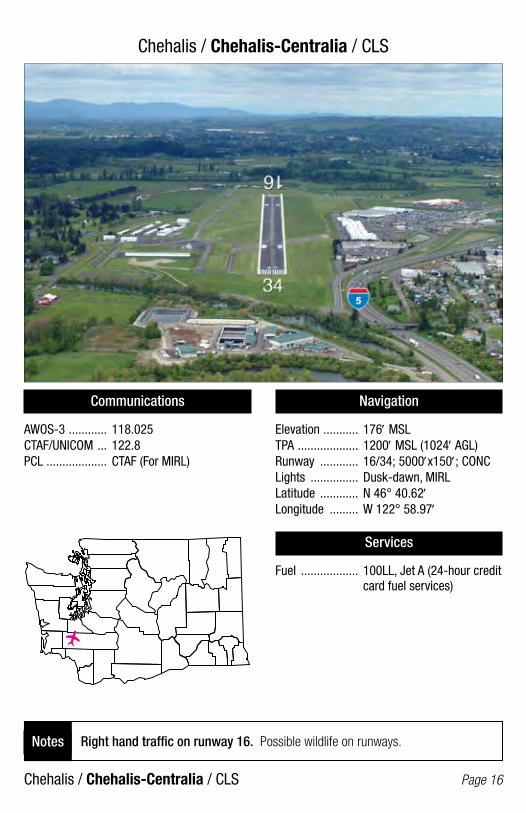
Chehalis / Chehalis-Centralia / CLS
Chehalis / Chehalis-Centralia / CLS Page 16
Communications
AWOS-3 ............ 118.025CTAF/UNICOM ... 122.8PCL ................... CTAF (For MIRL)
Navigation
Elevation ........... 176′ MSLTPA ................... 1200′ MSL (1024′ AGL)Runway ............ 16/34; 5000′x150′; CONCLights ............... Dusk-dawn, MIRLLatitude ............ N 46° 40.62′Longitude ......... W 122° 58.97′
Services
Fuel .................. 100LL, Jet A (24-hour credit card fuel services)
Right hand traffic on runway 16. Possible wildlife on runways.Notes
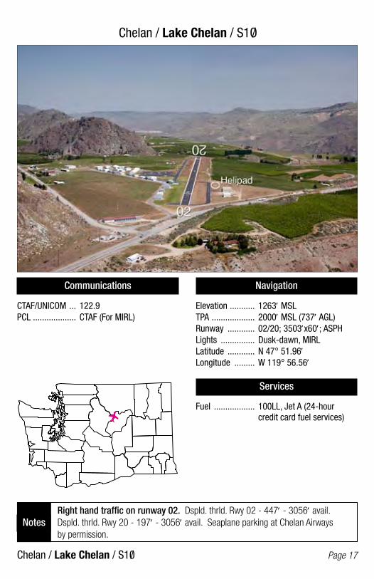
Chelan / Lake Chelan / S1O/
Chelan / Lake Chelan / S10/ Page 17
Communications
CTAF/UNICOM ... 122.9PCL ................... CTAF (For MIRL)
Navigation
Elevation ........... 1263′ MSLTPA ................... 2000′ MSL (737′ AGL)Runway ............ 02/20; 3503′x60′; ASPHLights ............... Dusk-dawn, MIRLLatitude ............ N 47° 51.96′Longitude ......... W 119° 56.56′
Services
Fuel .................. 100LL, Jet A (24-hour credit card fuel services)
Right hand traffic on runway 02. Dspld. thrld. Rwy 02 - 447′ - 3056′ avail. Dspld. thrld. Rwy 20 - 197′ - 3056′ avail. Seaplane parking at Chelan Airways by permission.
Notes
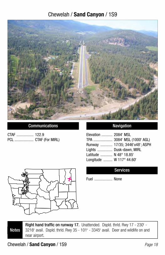
Chewelah / Sand Canyon / 1S9
Chewelah / Sand Canyon / 1S9 Page 18
Communications
CTAF ................. 122.9PCL ................... CTAF (For MIRL)
Navigation
Elevation ........... 2084′ MSLTPA ................... 3084′ MSL (1000′ AGL)Runway ............ 17/35; 3446′x48′; ASPHLights ............... Dusk-dawn, MIRLLatitude ............ N 48° 18.85′Longitude ......... W 117° 44.60′
Services
Fuel .................. None
Right hand traffic on runway 17. Unattended. Dspld. thrld. Rwy 17 - 230′ - 3216′ avail. Dspld. thrld. Rwy 35 - 101′ - 3345′ avail. Deer and wildlife on and near airport.
Notes
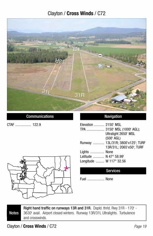
Clayton / Cross Winds / C72
Clayton / Cross Winds / C72 Page 19
Communications
CTAF ................. 122.9
Navigation
Elevation ........... 2150′ MSLTPA ................... 3150′ MSL (1000′ AGL); Ultralight 2650′ MSL (500′ AGL)Runway ............ 13L/31R; 3800′x125′; TURF 13R/31L; 2065′x50′; TURFLights ............... NoneLatitude ............ N 47° 58.99′Longitude ......... W 117° 32.56
Services
Fuel .................. None
Right hand traffic on runways 13R and 31R. Dspld. thrld. Rwy 31R - 170′ - 3630′ avail. Airport closed winters. Runway 13R/31L Ultralights. Turbulence and crosswinds.
Notes

Cle Elum / Cle Elum Municipal / S93
Cle Elum / Cle Elum Municipal / S93 Page 20
Communications
CTAF ................. 122.9PCL ................... CTAF (For BCN & MIRL)
Navigation
Elevation ........... 1944′ MSLTPA ................... 2944′ MSL (1000′ AGL)Runway ............ 07/25; 2552′x40′; ASPHLight ................. MIRLLatitude ............ N 47° 11.66′Longitude ......... W 120° 53.01′
Services
Fuel .................. None
Right hand traffic on runway 07.Notes

Cle Elum / De Vere Field / 2W1
Cle Elum / De Vere Field / 2W1 Page 21
Communications
CTAF ................. 122.9
Navigation
Elevation ........... 1800′ MSLTPA ................... 2800′ MSL (1000′ AGL)Runway ............ 08/26; 2055′x30′; ASPHLights ............... Phone request - LIRL 509-674-2627Latitude ............ N 47° 10.66′Longitude ......... W 120° 51.16′
Services
Fuel .................. None
Right hand traffic on runway 08. Field occasionally closed in winter. Wildlife on and in vicinity of runway.
Notes
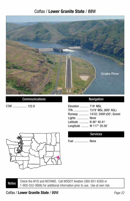
Colfax / Lower Granite State / 00W
Colfax / Lower Granite State / 00W Page 22
Communications
CTAF ................. 122.9
Navigation
Elevation ........... 719′ MSLTPA ................... 1519′ MSL (800′ AGL)Runway ............ 14/32; 3400′x50′; GravelLights ............... NoneLatitude ............ N 46° 40.41′Longitude ......... W 117° 26.56′
Services
Fuel .................. None
Check the AF/D and NOTAMS. Call WSDOT Aviation (360-651-6300 or 1-800-552-0666) for additional information prior to use. Use at own risk.
Notes
/ /
/ /
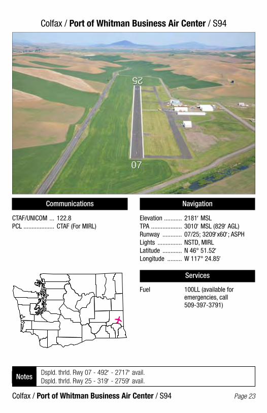
Colfax / Port of Whitman Business Air Center / S94
Colfax / Port of Whitman Business Air Center / S94 Page 23
Communications
CTAF/UNICOM ... 122.8PCL ................... CTAF (For MIRL)
Navigation
Elevation ........... 2181′ MSLTPA ................... 3010′ MSL (829′ AGL)Runway ............ 07/25; 3209′x60′; ASPHLights ............... NSTD, MIRLLatitude ............ N 46° 51.52′Longitude ......... W 117° 24.85′
Services
Fuel 100LL (available for emergencies, call 509-397-3791)
Dspld. thrld. Rwy 07 - 492′ - 2717′ avail. Dspld. thrld. Rwy 25 - 319′ - 2759′ avail.
Notes
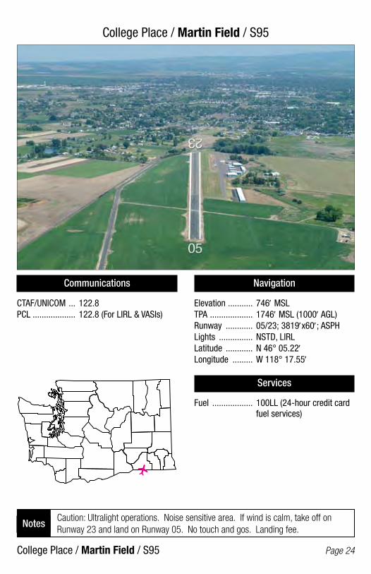
College Place / Martin Field / S95
College Place / Martin Field / S95 Page 24
Communications
CTAF/UNICOM ... 122.8PCL ................... 122.8 (For LIRL & VASIs)
Navigation
Elevation ........... 746′ MSLTPA ................... 1746′ MSL (1000′ AGL)Runway ............ 05/23; 3819′x60′; ASPHLights ............... NSTD, LIRLLatitude ............ N 46° 05.22′Longitude ......... W 118° 17.55′
Services
Fuel .................. 100LL (24-hour credit card fuel services)
Caution: Ultralight operations. Noise sensitive area. If wind is calm, take off on Runway 23 and land on Runway 05. No touch and gos. Landing fee.
Notes
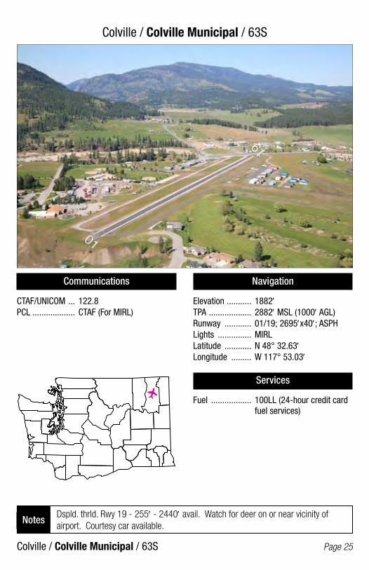
Colville / Colville Municipal / 63S
Colville / Colville Municipal / 63S Page 25
Communications
CTAF/UNICOM ... 122.8PCL ................... CTAF (For MIRL)
Navigation
Elevation ........... 1882′TPA ................... 2882′ MSL (1000′ AGL)Runway ............ 01/19; 2695′x40′; ASPHLights ............... MIRLLatitude ............ N 48° 32.63′Longitude ......... W 117° 53.03′
Services
Fuel .................. 100LL (24-hour credit card fuel services)
Dspld. thrld. Rwy 19 - 255′ - 2440′ avail. Watch for deer on or near vicinity of airport. Courtesy car available.
Notes
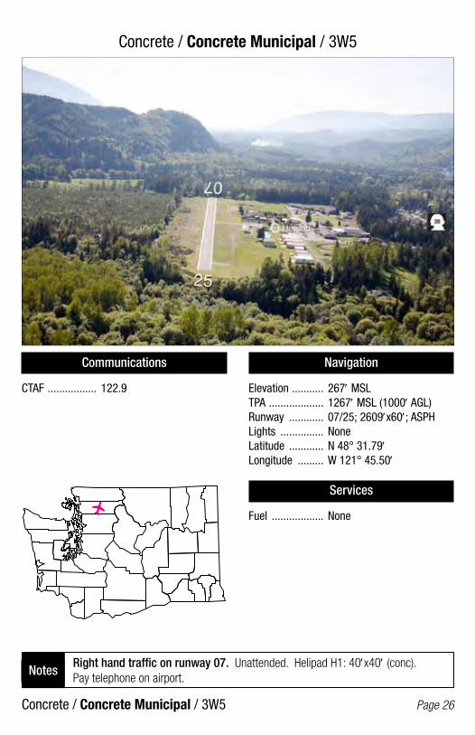
Concrete / Concrete Municipal / 3W5
Concrete / Concrete Municipal / 3W5 Page 26
Communications
CTAF ................. 122.9
Navigation
Elevation ........... 267′ MSLTPA ................... 1267′ MSL (1000′ AGL)Runway ............ 07/25; 2609′x60′; ASPHLights ............... NoneLatitude ............ N 48° 31.79′Longitude ......... W 121° 45.50′
Services
Fuel .................. None
Right hand traffic on runway 07. Unattended. Helipad H1: 40′x40′ (conc). Pay telephone on airport.
Notes
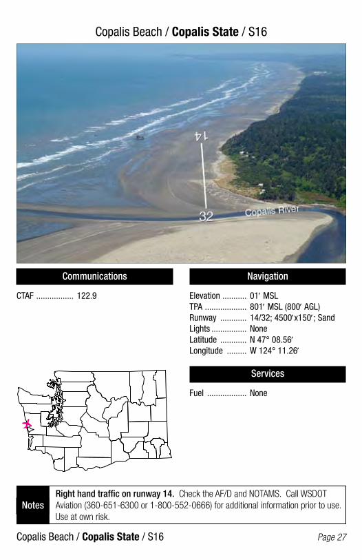
Copalis Beach / Copalis State / S16
Copalis Beach / Copalis State / S16 Page 27
Communications
CTAF ................. 122.9
Navigation
Elevation ........... 01′ MSLTPA ................... 801′ MSL (800′ AGL)Runway ............ 14/32; 4500′x150′; SandLights ................ NoneLatitude ............ N 47° 08.56′Longitude ......... W 124° 11.26′
Services
Fuel .................. None
Right hand traffic on runway 14. Check the AF/D and NOTAMS. Call WSDOT Aviation (360-651-6300 or 1-800-552-0666) for additional information prior to use. Use at own risk.
Notes
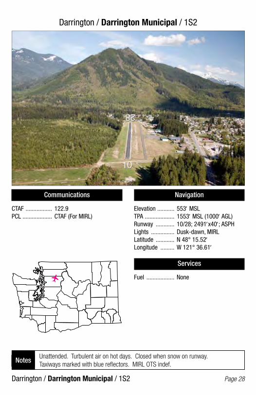
Darrington / Darrington Municipal / 1S2
Darrington / Darrington Municipal / 1S2 Page 28
Communications
CTAF ................. 122.9PCL ................... CTAF (For MIRL)
Navigation
Elevation ........... 553′ MSLTPA ................... 1553′ MSL (1000′ AGL)Runway ............ 10/28; 2491′x40′; ASPHLights ............... Dusk-dawn, MIRLLatitude ............ N 48° 15.52′Longitude ......... W 121° 36.61′
Services
Fuel .................. None
Unattended. Turbulent air on hot days. Closed when snow on runway. Taxiways marked with blue reflectors. MIRL OTS indef.
Notes
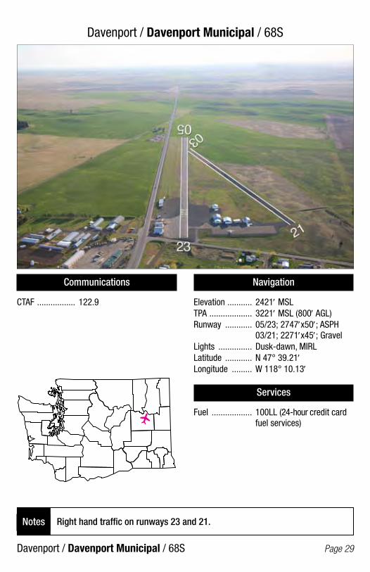
Davenport / Davenport Municipal / 68S
Davenport / Davenport Municipal / 68S Page 29
Communications
CTAF ................. 122.9
Navigation
Elevation ........... 2421′ MSLTPA ................... 3221′ MSL (800′ AGL)Runway ............ 05/23; 2747′x50′; ASPH 03/21; 2271′x45′; GravelLights ............... Dusk-dawn, MIRLLatitude ............ N 47° 39.21′Longitude ......... W 118° 10.13′
Services
Fuel .................. 100LL (24-hour credit card fuel services)
Right hand traffic on runways 23 and 21.Notes

Deer Park / Deer Park Municipal / DEW
Deer Park / Deer Park Municipal / DEW Page 30
Communications
ASOS ................ 135.175 CTAF/UNICOM ... 123.0PCL ................... CTAF (For runway lights)
Navigation
Elevation ........... 2210′ MSLTPA ................... 3210′ MSL (1000′ AGL)Runway ............ 16/34; 6100′x75′; ASPH 04/22; 3200′x60′; ASPHLights ............... Pilot controlled, MIRLLatitude ............ N 47° 58.00′Longitude ......... W 117° 25.60′
Services
Fuel .................. 100LL, Jet A (24-hour credit card fuel services) Call ahead for Jet A.
Model airplane activity. Heavy glider activity. Noise abatement procedure. Runway 22 turn left to 180 heading as soon as possible to avoid overflight of city.
Notes
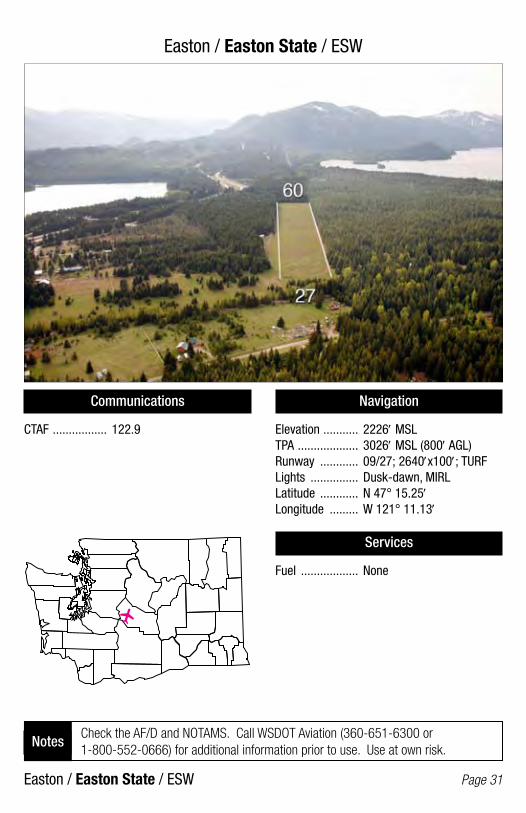
Easton / Easton State / ESW
Easton / Easton State / ESW Page 31
Communications
CTAF ................. 122.9
Navigation
Elevation ........... 2226′ MSLTPA ................... 3026′ MSL (800′ AGL)Runway ............ 09/27; 2640′x100′; TURFLights ............... Dusk-dawn, MIRLLatitude ............ N 47° 15.25′Longitude ......... W 121° 11.13′
Services
Fuel .................. None
Check the AF/D and NOTAMS. Call WSDOT Aviation (360-651-6300 or 1-800-552-0666) for additional information prior to use. Use at own risk.
Notes

Eastsound / Orcas Island / ORS
Eastsound / Orcas Island / ORS Page 32
Communications
AWOS-3 ............ 135.425CTAF ................. 128.25PCL ................... CTAF; Rwy 16 VASI, REILS, TAXIWAY
Navigation
Elevation ........... 31′ MSLTPA ................... 1031′ MSL (1000′ AGL)Runway ............ 16/34; 2900′x60′; ASPHLights ............... Dusk-dawn, MIRLLatitude ............ N 48° 42.49′Longitude ......... W 122° 54.63′
Services
Fuel .................. 100 LL (24-hour credit card fuel services)
Right hand traffic on runway 34. Watch for deer on runway. Observe noise abatement procedures. Camping on field.
Notes
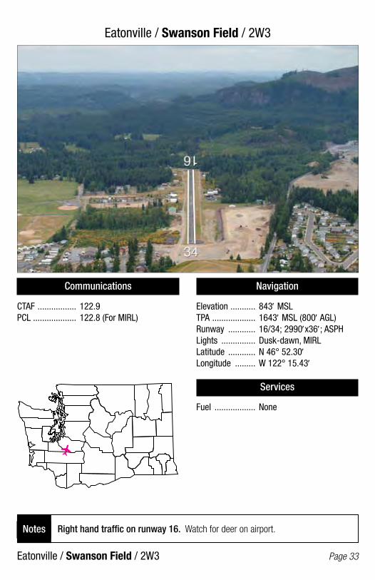
Eatonville / Swanson Field / 2W3
Eatonville / Swanson Field / 2W3 Page 33
Communications
CTAF ................. 122.9PCL ................... 122.8 (For MIRL)
Navigation
Elevation ........... 843′ MSLTPA ................... 1643′ MSL (800′ AGL)Runway ............ 16/34; 2990′x36′; ASPHLights ............... Dusk-dawn, MIRLLatitude ............ N 46° 52.30′Longitude ......... W 122° 15.43′
Services
Fuel .................. None
Right hand traffic on runway 16. Watch for deer on airport.Notes
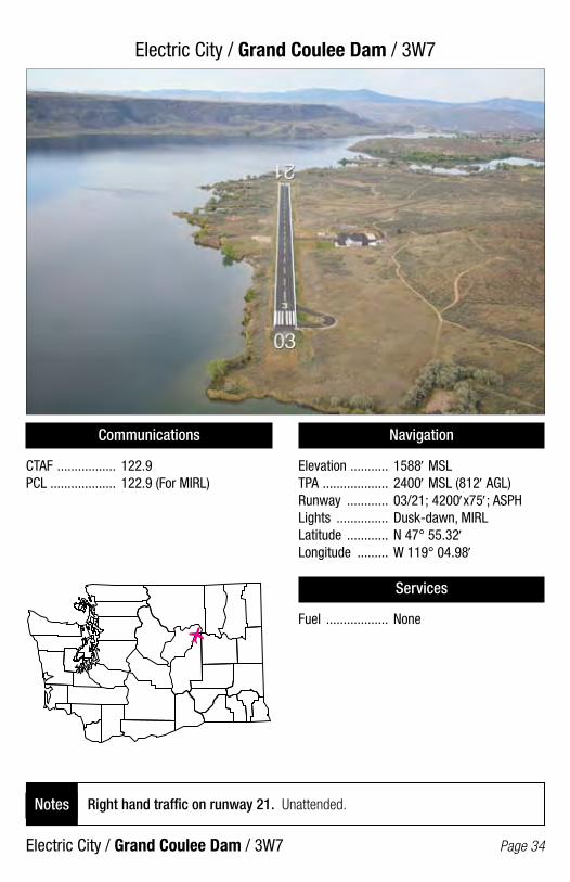
Electric City / Grand Coulee Dam / 3W7
Electric City / Grand Coulee Dam / 3W7 Page 34
Communications
CTAF ................. 122.9PCL ................... 122.9 (For MIRL)
Navigation
Elevation ........... 1588′ MSLTPA ................... 2400′ MSL (812′ AGL)Runway ............ 03/21; 4200′x75′; ASPHLights ............... Dusk-dawn, MIRLLatitude ............ N 47° 55.32′Longitude ......... W 119° 04.98′
Services
Fuel .................. None
Right hand traffic on runway 21. Unattended.Notes
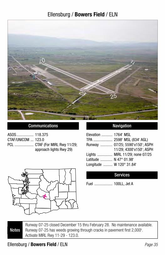
Ellensburg / Bowers Field / ELN
Ellensburg / Bowers Field / ELN Page 35
Communications
ASOS ................. 118.375CTAF/UNICOM ... 123.0PCL ................... CTAF (For MIRL Rwy 11/29; approach lights Rwy 29)
Navigation
Elevation ........... 1764′ MSLTPA ................... 2598′ MSL (834′ AGL)Runway ............ 07/25; 5590′x150′; ASPH 11/29; 4300′x150′; ASPHLights ............... MIRL 11/29; none 07/25Latitude ............ N 47° 01.98′Longitude ......... W 120° 31.84′
Services
Fuel .................. 100LL, Jet A
Runway 07-25 closed December 15 thru February 28. No maintenance available. Runway 07-25 has weeds growing through cracks in pavement first 2,000′. Activate MIRL Rwy 11-29 - 123.0.
Notes

Elma / Elma Municipal / 4W8
Elma / Elma Municipal / 4W8 Page 36
Communications
CTAF/UNICOM ... 122.8PCL ................... CTAF (For MIRL)
Navigation
Elevation ........... 35′ MSLTPA ................... 835′ MSL (800′ AGL)Runway ............ 07/25; 2280′x30′; ASPHLights ................ MIRL, NSTDLatitude ............ N 46° 59.43′Longitude ......... W 123° 25.78′
Services
Fuel .................. None
Right hand traffic on runway 07. Unattended. Dspld. thrld. Rwy 25 - 180′ - 2095′ avail. Runway 07/25 disregard white X’s on runway.
Notes
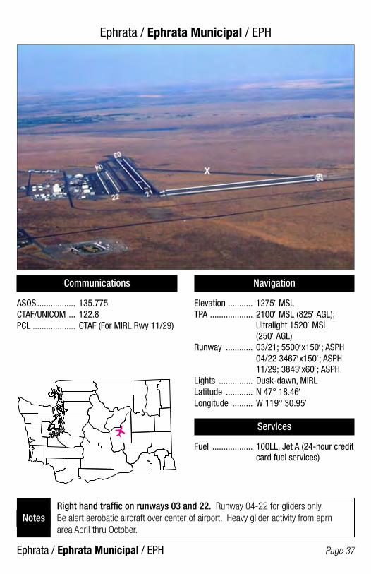
Ephrata / Ephrata Municipal / EPH
Ephrata / Ephrata Municipal / EPH Page 37
Communications
ASOS ................. 135.775CTAF/UNICOM ... 122.8PCL ................... CTAF (For MIRL Rwy 11/29)
Navigation
Elevation ........... 1275′ MSLTPA ................... 2100′ MSL (825′ AGL); Ultralight 1520′ MSL (250′ AGL)Runway ............ 03/21; 5500′x150′; ASPH 04/22 3467′x150′; ASPH 11/29; 3843′x60′; ASPHLights ............... Dusk-dawn, MIRLLatitude ............ N 47° 18.46′Longitude ......... W 119° 30.95′
Services
Fuel .................. 100LL, Jet A (24-hour credit card fuel services)
Right hand traffic on runways 03 and 22. Runway 04-22 for gliders only. Be alert aerobatic aircraft over center of airport. Heavy glider activity from aprn area April thru October.
Notes
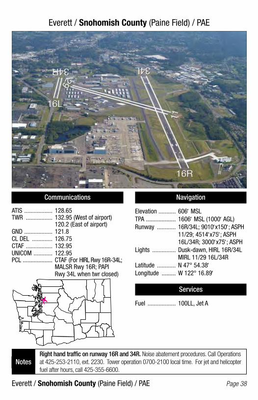
Everett / Snohomish County (Paine Field) / PAE
Everett / Snohomish County (Paine Field) / PAE Page 38
Communications
ATIS .................. 128.65TWR ................. 132.95 (West of airport) 120.2 (East of airport)GND .................. 121.8CL DEL ............. 126.75CTAF ................. 132.95UNICOM ............ 122.95PCL ................... CTAF (For HIRL Rwy 16R-34L; MALSR Rwy 16R; PAPI Rwy 34L when twr closed)
Navigation
Elevation ........... 606′ MSLTPA ................... 1606′ MSL (1000′ AGL)Runway ............ 16R/34L; 9010′x150′; ASPH 11/29; 4514′x75′; ASPH 16L/34R; 3000′x75′; ASPHLights ............... Dusk-dawn, HIRL 16R/34L MIRL 11/29 16L/34RLatitude ............ N 47° 54.38′Longitude ......... W 122° 16.89′
Services
Fuel .................. 100LL, Jet A
Right hand traffic on runway 16R and 34R. Noise abatement procedures. Call Operations at 425-253-2110, ext. 2230. Tower operation 0700-2100 local time. For jet and helicopter fuel after hours, call 425-355-6600.
Notes

Forks / Forks Municipal / S18
Forks / Forks Municipal / S18 Page 39
Communications
CTAF ................. 122.9
Navigation
Elevation ........... 299′ MSLTPA ................... 1299′ MSL (1000′ AGL)Runway ............ 04/22; 2400′x75′; ASPHLights ............... Dusk-dawn, MIRLLatitude ............ N 47° 56.26′Longitude ......... W 124° 23.76′
Services
Fuel .................. None
Right hand traffic on runway 22. Unattended. Wildlife on and in vicinity of airport.Notes

Friday Harbor / Friday Harbor / FHR
Friday Harbor / Friday Harbor / FHR Page 40
Communications
ASOS ................. 135.675CTAF ................. 128.25PCL ................... CTAF (For BCN & MIRL; REIL Rwy 34)
Navigation
Elevation ........... 113′ MSLTPA ................... 1113′ MSL (1000′ AGL)Runway ............ 16/34; 3402′x75′; ASPHLights ............... MIRLLatitude ............ N 48° 31.32′Longitude ......... W 123° 01.46′
Services
Fuel .................. 100LL (24-hour credit card fuel services)
Right hand traffic on runways 16 and 34. Use landing lights when in vicinity of airport. Noise abatement procedures in effect. Limited transient parking during summer.
Notes

Friday Harbor / Friday Harbor SPB / W33
Friday Harbor / Friday Harbor SPB / W33 Page 41
Communications
CTAF ................. 128.25PCL ................... CTAF (For seaplane ops warning lights)
Navigation
Elevation ........... 0′ MSLTPA ................... 800′ MSLRunway ............ 03/21; 10000′x2000′; Water 12/30; 6000′x1000′; WaterLights ............... Warning lightsLatitude ............ N 48° 32.24′Longitude ......... W 123° 00.58′
Services
Fuel .................. None
Unattended. All takeoffs should be performed north of Brown Island. U.S. Customs and Border protection services available (360-378-2080).
Notes

Goldendale / Goldendale / S2O/
Goldendale / Goldendale / S20/ Page 42
Communications
CTAF ................. 122.9
Navigation
Elevation ........... 1678′ MSLTPA ................... 2678′ MSL (1000′ AGL)Runway ............ 07/25; 3491′x40′; ASPHLights ............... Dusk-dawn, MIRLLatitude ............ N 45° 49.93′Longitude ......... W 120° 50.72′
Services
Fuel .................. None
Unattended. Dspld. thrld. Rwy 25 - 330′ - 3161′ avail.Notes

Greenwater / Ranger Creek State / 21W
Greenwater / Ranger Creek State / 21W Page 43
Communications
CTAF ................. 122.9
Navigation
Elevation ........... 2650′ MSLTPA ................... 3450′ MSL (800′ AGL)Runway ............ 15/33; 2875′x30′; ASPHLights ................ NoneLatitude ............ N 47° 00.77′Longitude ......... W 121° 32.02′
Services
Fuel .................. None
Check the AF/D and NOTAMS. Call WSDOT Aviation (360-651-6300 or 1-800-552-0666) for additional information prior to use. Use at own risk.
Notes

Hoquiam / Bowerman Field / HQM
Hoquiam / Bowerman Field / HQM Page 44
Communications
ASOS ................. 135.775CTAF/UNICOM ... 122.7PCL ................... CTAF (For HIRL, MALSR Rwy 24; REIL Rwy 06)
Navigation
Elevation ........... 18′ MSLTPA ................... 1000′ MSL (982′ AGL)Runway ............ 06/24; 5000′x150′; ASPHLights ............... Dusk-dawn, HIRLLatitude ............ N 46° 58.27′Longitude ......... W 123° 56.19′
Services
Fuel .................. 100LL, Jet A1+ (24-hour credit card fuel services for 100LL) Jet A, call 360-533-6655 (1700-0100Z) or 360-310-0201 (0100-1700Z)
Right hand traffic on runway 06. Watch for waterfowl on and in vicinity of airport. Ultralights prohibited without written permission.
Notes
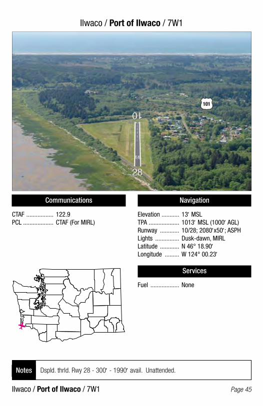
Ilwaco / Port of Ilwaco / 7W1
Ilwaco / Port of Ilwaco / 7W1 Page 45
Communications
CTAF ................. 122.9PCL ................... CTAF (For MIRL)
Navigation
Elevation ........... 13′ MSLTPA ................... 1013′ MSL (1000′ AGL)Runway ............ 10/28; 2080′x50′; ASPHLights ............... Dusk-dawn, MIRLLatitude ............ N 46° 18.90′Longitude ......... W 124° 00.23′
Services
Fuel .................. None
Dspld. thrld. Rwy 28 - 300′ - 1990′ avail. Unattended. Notes
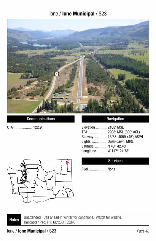
Ione / Ione Municipal / S23
Ione / Ione Municipal / S23 Page 46
Communications
CTAF ................. 122.9
Navigation
Elevation ........... 2108′ MSLTPA ................... 2908′ MSL (800′ AGL)Runway ............ 15/33; 4059′x45′; ASPHLights ............... Dusk-dawn, MIRLLatitude ............ N 48° 42.48′Longitude ......... W 117° 24.78′
Services
Fuel .................. None
Unattended. Call ahead in winter for conditions. Watch for wildlife. Helicopter Pad: H1; 60′x60′; CONC
Notes

Kahlotus / Lower Monumental State / W09
Kahlotus / Lower Monumental State / W09 Page 47
Communications
CTAF ................. 122.9
Navigation
Elevation ........... 813′ MSLTPA ................... 1613′ MSL (800′ AGL)Runway ............ 01/19; 3300′x50′; GravelLights ................ NoneLatitude ............ N 46° 33.03′Longitude ......... W 118° 32.18′
Services
Fuel .................. None
/
/
Check the AF/D and NOTAMS. Call WSDOT Aviation (360-651-6300 or 1-800-552-0666) for additional information prior to use. Use at own risk.
Notes

Kelso / Southwest Washington Regional / KLS
Kelso / Southwest Washington Regional / KLS Page 48
Communications
AWOS-3 ............. 135.075CTAF/UNICOM ... 122.8PCL ................... CTAF (For MIRL)
Navigation
Elevation ........... 20′ MSLTPA ................... 1020′ MSL (1000′ AGL)Runway ............ 12/30; 4391′x100′; ASPHLights ............... NSTD, MIRLLatitude ............ N 46° 07.08′Longitude ......... W 122° 53.90′
Services
Fuel .................. 100LL, Jet A (24-hour credit card fuel services for 100LL)
Right hand traffic on runway 12. Only 4099′ of runway available for night operations.
Notes

Kenmore (Lake Washington) / Kenmore Air Harbor SPB / S6O/
Kenmore (Lake Washington) / Kenmore Air Harbor SPB / S60/ Page 49
Communications
CTAF/UNICOM ... 122.7
Navigation
Elevation ........... 14′ MSLTPA ................... 814′ MSL (800′ AGL)Runway ............ 16/34; 10000′x1000′; Water 18/36; 3000′x1000′; WaterLights ................ NoneLatitude ............ N 47° 45.29′Longitude ......... W 122° 15.56′
Services
Fuel .................. 100LL, Jet A
Contact Kenmore Air for parking permission (425-486-1257).Notes

Kennewick / Vista Field / S98
Kennewick / Vista Field / S98 Page 50
Communications
ATIS .................. 125.65 (Pasco)CTAF ................. 122.9PCL ................... CTAF (For MIRL)
Navigation
Elevation ........... 534′ MSLTPA ................... 1334′ MSL (800′ AGL)Runway ............ 02/20; 4008′x150′; ASPHLights ............... Dusk-dawn, MIRLLatitude ............ N 46° 13.12′Longitude ......... W 119° 12.60′
Services
Fuel .................. 100LL, Jet A (24-hour credit card fuel services)
Attended daylight hours. Use runway 02 when wind is 5 knots or less. Parachute jumping.
Notes

Kent / Crest Airpark / S36
Kent / Crest Airpark / S36 Page 51
Communications
CTAF/UNICOM ... 123.0
Navigation
Elevation ........... 472′ MSLTPA ................... 1472′ MSL (1000′ AGL)Runway ............ 15/33; 3288′x40′; ASPHLights ............... Dusk-dawn, LIRLLatitude ............ N 47° 20.23′Longitude ......... W 122° 06.21′
Services
Fuel .................. 100LL (24-hour credit card fuel services)
Night operations use runway 15, wind permitting. Dspld. thrld. Rwy 33 - 281′ - 3007′ avail.
Notes
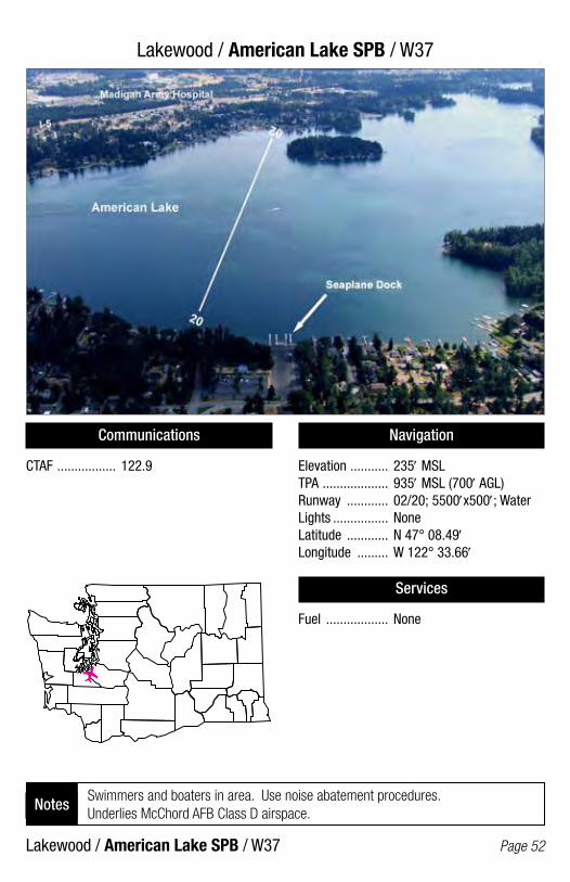
Lakewood / American Lake SPB / W37
Lakewood / American Lake SPB / W37 Page 52
Communications
CTAF ................. 122.9
Navigation
Elevation ........... 235′ MSLTPA ................... 935′ MSL (700′ AGL)Runway ............ 02/20; 5500′x500′; WaterLights ................ NoneLatitude ............ N 47° 08.49′Longitude ......... W 122° 33.66′
Services
Fuel .................. None
Swimmers and boaters in area. Use noise abatement procedures. Underlies McChord AFB Class D airspace.
Notes

Langley / Whidbey Airpark / W1O/
Langley / Whidbey Airpark / W10/ Page 53
Communications
CTAF ................. 122.9
Navigation
Elevation ........... 271′ MSLTPA ................... 1071′ MSL (800′ AGL)Runway ............ 16/34; 2470′x25′; ASPHLights ............... NoneLatitude ............ N 48° 01.05′Longitude ......... W 122° 26.26′
Services
Fuel .................. None
Unattended.Notes
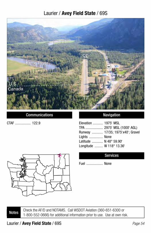
Laurier / Avey Field State / 69S
Laurier / Avey Field State / 69S Page 54
Communications
CTAF ................. 122.9
Navigation
Elevation ........... 1975′ MSLTPA ................... 2975′ MSL (1000′ AGL)Runway ............ 17/35; 1975′x40′; GravelLights ............... NoneLatitude ............ N 48° 59.90′Longitude ......... W 118° 13.36′
Services
Fuel .................. None
Check the AF/D and NOTAMS. Call WSDOT Aviation (360-651-6300 or 1-800-552-0666) for additional information prior to use. Use at own risk.
Notes

Leavenworth / Lake Wenatchee State / 27W
Leavenworth / Lake Wenatchee State / 27W Page 55
Communications
CTAF ................. 122.9
Navigation
Elevation ........... 1939′ MSLTPA ................... 2939′ MSL (1000′ AGL)Runway ............ 09/27; 2473′x100′; TURFLights ................ NoneLatitude ............ N 47° 49.17′Longitude ......... W 120° 43.19′
Services
Fuel .................. None
Check the AF/D and NOTAMS. Call WSDOT Aviation (360-651-6300 or 1-800-552-0666) for additional information prior to use. Use at own risk.
Notes
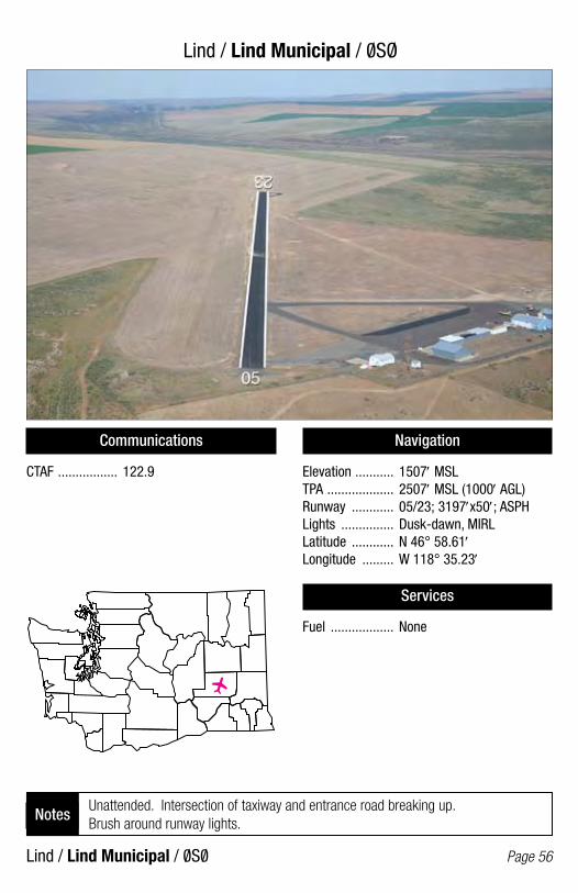
Lind / Lind Municipal / 0SO/
Lind / Lind Municipal / 0S0/ Page 56
Communications
CTAF ................. 122.9
Navigation
Elevation ........... 1507′ MSLTPA ................... 2507′ MSL (1000′ AGL)Runway ............ 05/23; 3197′x50′; ASPHLights ............... Dusk-dawn, MIRLLatitude ............ N 46° 58.61′Longitude ......... W 118° 35.23′
Services
Fuel .................. None
Unattended. Intersection of taxiway and entrance road breaking up. Brush around runway lights.
Notes
/
/

Lopez / Lopez Island / S31
Lopez / Lopez Island / S31 Page 57
Communications
CTAF ................. 128.25
Navigation
Elevation ........... 209′ MSLTPA ................... 1209′ MSL (1000′ AGL)Runway ............ 16/34; 2904′x60′; ASPHLights ............... Dusk-dawn, LIRLLatitude ............ N 48° 29.04′Longitude ......... W 122° 56.26′
Services
Fuel .................. None
Right hand traffic on runway 16. Runway marked with reflectors.Notes

Lynden / Lynden Municipal / 38W
Lynden / Lynden Municipal / 38W Page 58
Communications
CTAF ................. 122.9PCL ................... CTAF (For MIRL & BCN)
Navigation
Elevation ........... 106′ MSLTPA ................... 1106′ MSL (1000′ AGL)Runway ............ 07/25; 2425′x40′; ASPHLights ............... NSTD, MIRLLatitude ............ N 48° 57.35′Longitude ......... W 122° 27.49′
Services
Fuel .................. 100LL (24-hour credit card fuel services)
Night landings should be performed on runway 07, wind permitting. Dspld. thrld. Rwy 7 - 262′ - 2163′ available. Dspld. thrld. Rwy 25 - 433′ - 1992′ available.
Notes

Mansfield / Mansfield / 8W3
Mansfield / Mansfield / 8W3 Page 59
Communications
CTAF ................. 122.9
Navigation
Elevation ........... 2272′ MSLTPA ................... 3272′ MSL (1000′ AGL)Runway ............ 03/21; 2570′x46′; ASPHLights ............... Dusk-dawn, NSTD, MIRLLatitude ............ N 47° 48.56′Longitude ......... W 119° 38.22′
Services
Fuel .................. None
Unattended. Possible turbulence from grain elevators north side of airport.Notes

Mattawa / Desert Aire / M94
Mattawa / Desert Aire / M94 Page 60
Communications
CTAF ................. 122.8PCL ................... CTAF (For MIRL & BCN)
Navigation
Elevation ........... 586′ MSLTPA ................... 1586′ MSL (1000′ AGL)Runway ............ 10/28; 3665′x36′; ASPHLights ............... MIRLLatitude ............ N 46° 41.24′Longitude ......... W 119° 55.18′
Services
Fuel .................. None
Right hand traffic on runway 28. Unattended. Runway 10 preferred low wind. Noise abatement take off procedure posted at airport. Ultralights and Helicopters operate in the area
Notes

Mazama / Lost River / W12
Mazama / Lost River / W12 Page 61
Communications
CTAF ................. 122.9
Navigation
Elevation ........... 2415′ MSLTPA ................... 3415′ MSL (1000′ AGL)Runway ............ 11/29; 3150′x85′; TURF-GravelLights ............... NoneLatitude ............ N 48° 38.98′Longitude ......... W 120° 30.12′
Services
Fuel .................. None
Right hand traffic on runway 11. Unattended. Watch for vehicles on runway. Airport closed November 1 thru April 1.
Notes
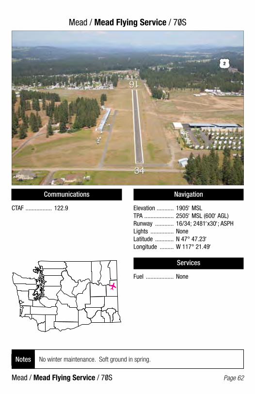
Mead / Mead Flying Service / 70S
Mead / Mead Flying Service / 70S Page 62
Communications
CTAF ................. 122.9
Navigation
Elevation ........... 1905′ MSLTPA ................... 2505′ MSL (600′ AGL)Runway ............ 16/34; 2481′x30′; ASPHLights ............... NoneLatitude ............ N 47° 47.23′Longitude ......... W 117° 21.49′
Services
Fuel .................. None
No winter maintenance. Soft ground in spring.Notes
/
/
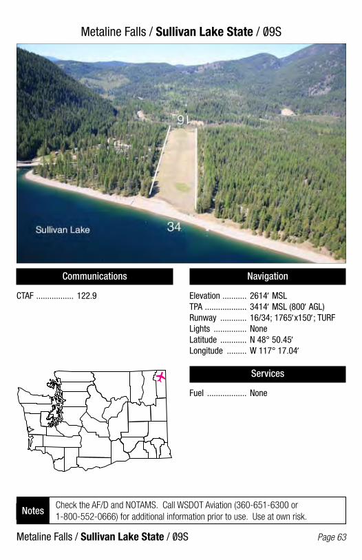
Metaline Falls / Sullivan Lake State / 09S
Metaline Falls / Sullivan Lake State / 09S Page 63
Communications
CTAF ................. 122.9
Navigation
Elevation ........... 2614′ MSLTPA ................... 3414′ MSL (800′ AGL)Runway ............ 16/34; 1765′x150′; TURFLights ............... NoneLatitude ............ N 48° 50.45′Longitude ......... W 117° 17.04′
Services
Fuel .................. None
/
/
Check the AF/D and NOTAMS. Call WSDOT Aviation (360-651-6300 or 1-800-552-0666) for additional information prior to use. Use at own risk.
Notes
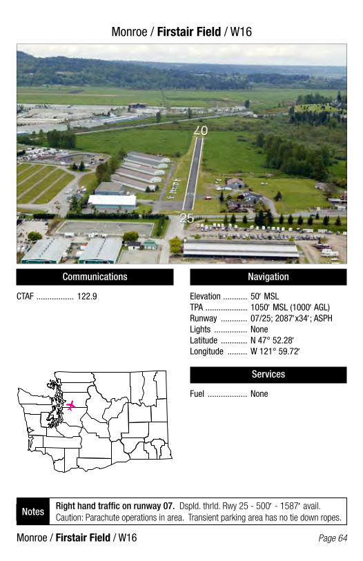
Monroe / Firstair Field / W16
Monroe / Firstair Field / W16 Page 64
Communications
CTAF ................. 122.9
Navigation
Elevation ........... 50′ MSLTPA ................... 1050′ MSL (1000′ AGL)Runway ............ 07/25; 2087′x34′; ASPHLights ............... NoneLatitude ............ N 47° 52.28′Longitude ......... W 121° 59.72′
Services
Fuel .................. None
Right hand traffic on runway 07. Dspld. thrld. Rwy 25 - 500′ - 1587′ avail. Caution: Parachute operations in area. Transient parking area has no tie down ropes.
Notes

Morton / Strom Field / 39P
Morton / Strom Field / 39P Page 65
Communications
CTAF ................. 122.9PCL ................... CTAF (For MIRL & BCN)
Navigation
Elevation ........... 941′ MSLTPA ................... 1941′ MSL (1000′ AGL)Runway ............ 07/25; 1810′x40′; ASPHLights ............... Dusk-dawn, NSTD, MIRLLatitude ............ N 46° 33.02′Longitude ......... W 122° 16.00′
Services
Fuel .................. None
Dspld. thrld. Rwy 07 - 200′ - 1610′ avail. Dspld. thrld. Rwy 25 - 200′ - 1610′ avail. Unattended. Deer and elk on and around runway.
Notes
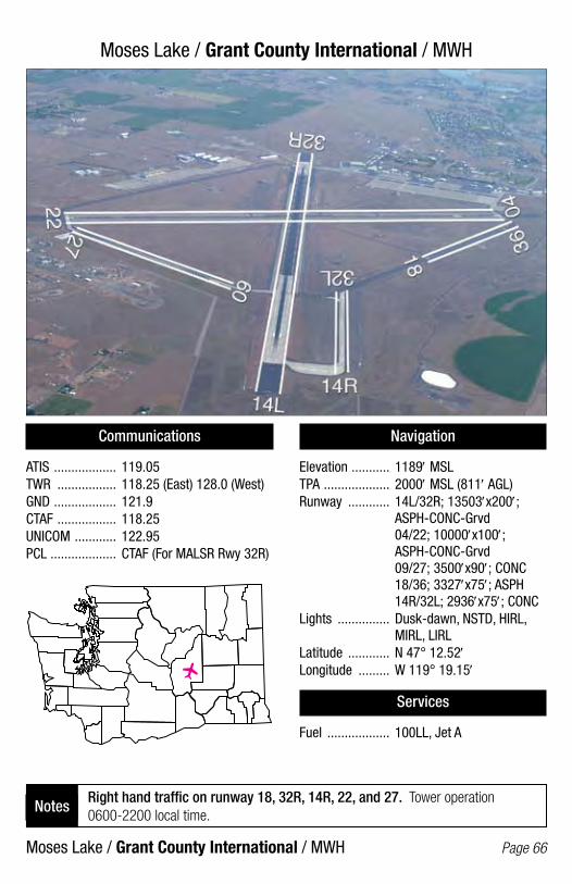
Moses Lake / Grant County International / MWH
Moses Lake / Grant County International / MWH Page 66
Communications
ATIS .................. 119.05TWR ................. 118.25 (East) 128.0 (West)GND .................. 121.9CTAF ................. 118.25UNICOM ............ 122.95PCL ................... CTAF (For MALSR Rwy 32R)
Navigation
Elevation ........... 1189′ MSLTPA ................... 2000′ MSL (811′ AGL)Runway ............ 14L/32R; 13503′x200′; ASPH-CONC-Grvd 04/22; 10000′x100′; ASPH-CONC-Grvd 09/27; 3500′x90′; CONC 18/36; 3327′x75′; ASPH 14R/32L; 2936′x75′; CONCLights ............... Dusk-dawn, NSTD, HIRL, MIRL, LIRLLatitude ............ N 47° 12.52′Longitude ......... W 119° 19.15′
Services
Fuel .................. 100LL, Jet A
Right hand traffic on runway 18, 32R, 14R, 22, and 27. Tower operation 0600-2200 local time.
Notes
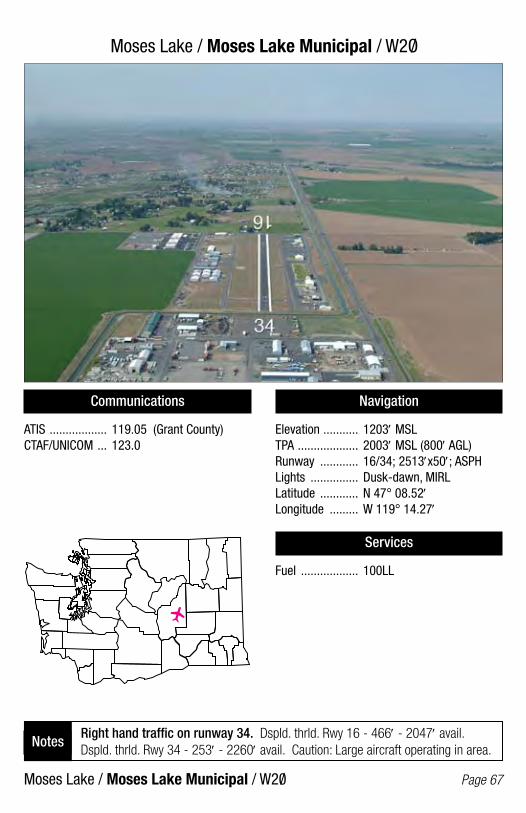
Moses Lake / Moses Lake Municipal / W2O/
Moses Lake / Moses Lake Municipal / W20/ Page 67
Communications
ATIS .................. 119.05 (Grant County)CTAF/UNICOM ... 123.0
Navigation
Elevation ........... 1203′ MSLTPA ................... 2003′ MSL (800′ AGL)Runway ............ 16/34; 2513′x50′; ASPHLights ............... Dusk-dawn, MIRLLatitude ............ N 47° 08.52′Longitude ......... W 119° 14.27′
Services
Fuel .................. 100LL
Right hand traffic on runway 34. Dspld. thrld. Rwy 16 - 466′ - 2047′ avail. Dspld. thrld. Rwy 34 - 253′ - 2260′ avail. Caution: Large aircraft operating in area.
Notes
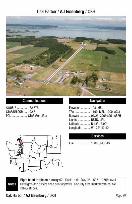
Oak Harbor / AJ Eisenberg / OKH
Oak Harbor / AJ Eisenberg / OKH Page 68
Communications
AWOS-3 ............ 132.775CTAF/UNICOM ... 122.8PCL ................... CTAF (For LIRL)
Navigation
Elevation ........... 193′ MSLTPA ................... 1193′ MSL (1000′ AGL)Runway ............ 07/25; 3265′x25′; ASPHLights ............... NSTD, LIRLLatitude ............ N 48° 15.09′Longitude ......... W 122° 40.42′
Services
Fuel .................. 100LL, MOGAS
Right hand traffic on runway 07. Dspld. thrld. Rwy 07 - 507′ - 2758′ avail. Ultralights and gliders need prior approval. Security area marked with double yellow stripes.
Notes

Ocean Shores / Ocean Shores Municipal / W04
Ocean Shores / Ocean Shores Municipal / W04 Page 69
Communications
CTAF ................. 122.9PCL ................... 122.8 (For LIRL)
Navigation
Elevation ........... 13′ MSLTPA ................... 1000′ MSL (987′ AGL)Runway ............ 15/33; 2700′x50′; ASPHLights ............... Dusk-dawn, LIRLLatitude ............ N 47° 00.22′Longitude ......... W 124° 08.63′
Services
Fuel .................. None
Right hand traffic on runway 33. Unattended. Watch for seabirds. Parking ramp has loose gravel.
Notes
/
/
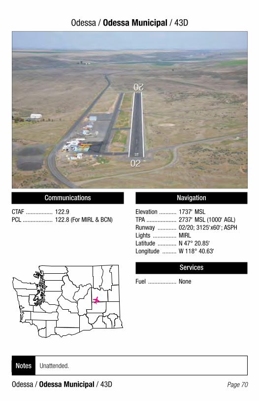
Odessa / Odessa Municipal / 43D
Odessa / Odessa Municipal / 43D Page 70
Communications
CTAF ................. 122.9PCL ................... 122.8 (For MIRL & BCN)
Navigation
Elevation ........... 1737′ MSLTPA ................... 2737′ MSL (1000′ AGL)Runway ............ 02/20; 3125′x60′; ASPHLights ............... MIRLLatitude ............ N 47° 20.85′Longitude ......... W 118° 40.63′
Services
Fuel .................. None
Unattended.Notes
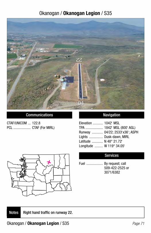
Okanogan / Okanogan Legion / S35
Okanogan / Okanogan Legion / S35 Page 71
Communications
CTAF/UNICOM ... 122.8PCL ................... CTAF (For MIRL)
Navigation
Elevation ........... 1042′ MSLTPA ................... 1842′ MSL (800′ AGL)Runway ............ 04/22; 2533′x36′; ASPHLights ............... Dusk-dawn, MIRLLatitude ............ N 48° 21.72′Longitude ......... W 119° 34.05′
Services
Fuel .................. By request; call 509-422-2525 or 3071/6382
Right hand traffic on runway 22. Notes

Olympia / Hoskins Field / 44T
Olympia / Hoskins Field / 44T Page 72
Communications
CTAF ................. 122.9
Navigation
Elevation ........... 213′ MSLTPA ................... 1213′ MSL (1000′ AGL)Runway ............ 07/25; 2015′x116′; TURFLights ............... NoneLatitude ............ N 46° 59.56′Longitude ......... W 122° 49.66′
Services
Fuel .................. None
Unattended. Noise abatement procedures in effect call airport manager.Notes
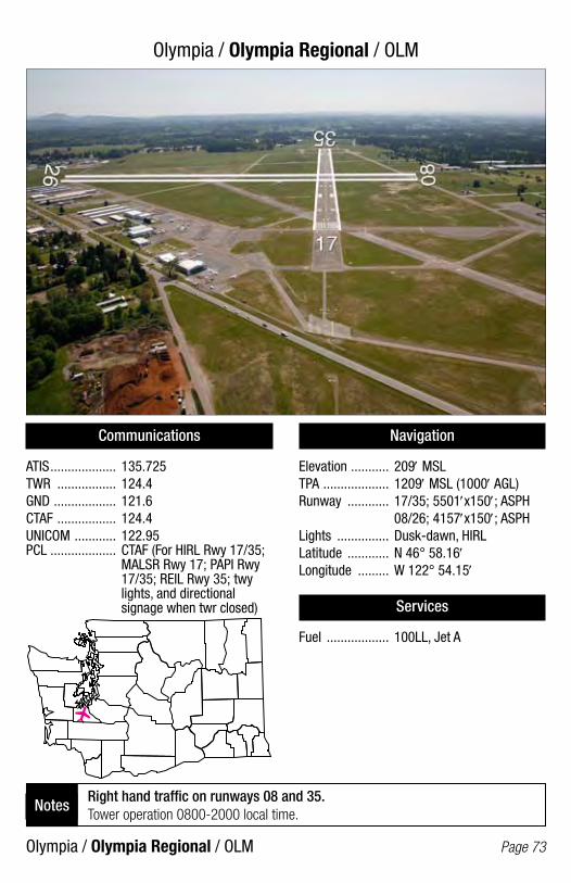
Olympia / Olympia Regional / OLM
Olympia / Olympia Regional / OLM Page 73
Communications
ATIS ................... 135.725TWR ................. 124.4GND .................. 121.6CTAF ................. 124.4UNICOM ............ 122.95PCL ................... CTAF (For HIRL Rwy 17/35; MALSR Rwy 17; PAPI Rwy 17/35; REIL Rwy 35; twy lights, and directional signage when twr closed)
Navigation
Elevation ........... 209′ MSLTPA ................... 1209′ MSL (1000′ AGL)Runway ............ 17/35; 5501′x150′; ASPH 08/26; 4157′x150′; ASPHLights ............... Dusk-dawn, HIRLLatitude ............ N 46° 58.16′Longitude ......... W 122° 54.15′
Services
Fuel .................. 100LL, Jet A
Right hand traffic on runways 08 and 35. Tower operation 0800-2000 local time.
Notes
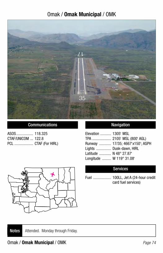
Omak / Omak Municipal / OMK
Omak / Omak Municipal / OMK Page 74
Communications
ASOS ................. 118.325CTAF/UNICOM ... 122.8PCL ................... CTAF (For HIRL)
Navigation
Elevation ........... 1305′ MSLTPA ................... 2105′ MSL (800′ AGL)Runway ............ 17/35; 4667′x150′; ASPHLights ............... Dusk-dawn, HIRLLatitude ............ N 48° 27.87′Longitude ......... W 119° 31.08′
Services
Fuel .................. 100LL, Jet A (24-hour credit card fuel services)
Attended. Monday through Friday.Notes
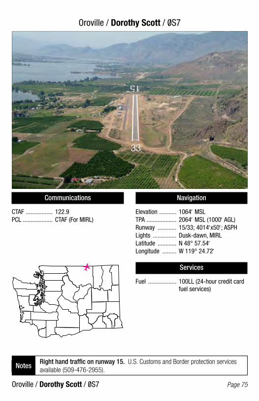
Oroville / Dorothy Scott / 0S7
Oroville / Dorothy Scott / 0S7 Page 75
Communications
CTAF ................. 122.9PCL ................... CTAF (For MIRL)
Navigation
Elevation ........... 1064′ MSLTPA ................... 2064′ MSL (1000′ AGL)Runway ............ 15/33; 4014′x50′; ASPHLights ............... Dusk-dawn, MIRLLatitude ............ N 48° 57.54′Longitude ......... W 119° 24.72′
Services
Fuel .................. 100LL (24-hour credit card fuel services)
Right hand traffic on runway 15. U.S. Customs and Border protection services available (509-476-2955).
Notes
/
/

Othello / Othello Municipal / S7O/
Othello / Othello Municipal / S70/ Page 76
Communications
CTAF ................. 122.9PCL ................... CTAF (For MIRL; PAPI Rwy 25)
Navigation
Elevation ........... 1139′ MSLTPA ................... 1939′ MSL (800′ AGL)Runway ............ 07/25; 3564′x45′; ASPHLights ............... Dusk-dawn, MIRLLatitude ............ N 46° 47.69′Longitude ......... W 119° 04.75′
Services
Fuel .................. 100LL (24-hour credit card fuel services) Jet A, call 509-488-2544
Unattended. Farm machinery in primary sfc south of centerline.Notes

Packwood / Packwood / 55S
Packwood / Packwood / 55S Page 77
Communications
CTAF ................. 122.9PCL ................... CTAF (For MIRL)
Navigation
Elevation ........... 1057′ MSLTPA ................... 2057′ MSL (1000′ AGL)Runway ............ 01/19; 2356′x38′; ASPHLights ............... Dusk-dawn, MIRLLatitude ............ N 46° 36.25′Longitude ......... W 121° 40.67′
Services
Fuel .................. None
Unattended. Use runway for back taxi.Notes
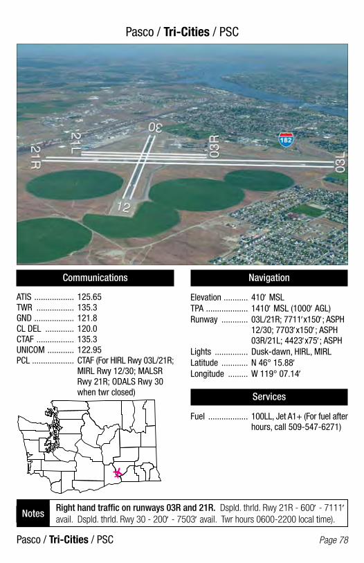
Pasco / Tri-Cities / PSC
Pasco / Tri-Cities / PSC Page 78
Communications
ATIS .................. 125.65TWR ................. 135.3GND .................. 121.8CL DEL ............. 120.0CTAF ................. 135.3UNICOM ............ 122.95PCL ................... CTAF (For HIRL Rwy 03L/21R; MIRL Rwy 12/30; MALSR Rwy 21R; ODALS Rwy 30 when twr closed)
Navigation
Elevation ........... 410′ MSLTPA ................... 1410′ MSL (1000′ AGL)Runway ............ 03L/21R; 7711′x150′; ASPH 12/30; 7703′x150′; ASPH 03R/21L; 4423′x75′; ASPHLights ............... Dusk-dawn, HIRL, MIRLLatitude ............ N 46° 15.88′Longitude ......... W 119° 07.14′
Services
Fuel .................. 100LL, Jet A1+ (For fuel after hours, call 509-547-6271)
Right hand traffic on runways 03R and 21R. Dspld. thrld. Rwy 21R - 600′ - 7111′ avail. Dspld. thrld. Rwy 30 - 200′ - 7503′ avail. Twr hours 0600-2200 local time).
Notes
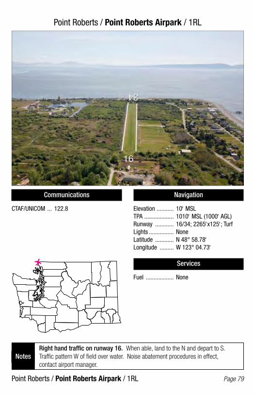
Point Roberts / Point Roberts Airpark / 1RL
Point Roberts / Point Roberts Airpark / 1RL Page 79
Communications
CTAF/UNICOM ... 122.8
Navigation
Elevation ........... 10′ MSLTPA ................... 1010′ MSL (1000′ AGL)Runway ............ 16/34; 2265′x125′; TurfLights ................ NoneLatitude ............ N 48° 58.78′Longitude ......... W 123° 04.73′
Services
Fuel .................. None
Right hand traffic on runway 16. When able, land to the N and depart to S. Traffic pattern W of field over water. Noise abatement procedures in effect, contact airport manager.
Notes
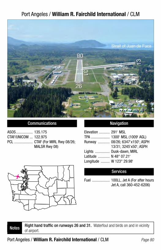
Port Angeles / William R. Fairchild International / CLM
Port Angeles / William R. Fairchild International / CLM Page 80
Communications
ASOS ................. 135.175CTAF/UNICOM ... 122.975PCL ................... CTAF (For MIRL Rwy 08/26; MALSR Rwy 08)
Navigation
Elevation ........... 291′ MSLTPA ................... 1300′ MSL (1009′ AGL)Runway ............ 08/26; 6347′x150′; ASPH 13/31; 3245′x50′; ASPHLights ............... Dusk-dawn, MIRLLatitude ............ N 48° 07.21′Longitude ......... W 123° 29.98′
Services
Fuel .................. 100LL, Jet A (For after hours Jet A, call 360-452-6206)
Right hand traffic on runways 26 and 31. Waterfoul and birds on and in vicinity of airport.
Notes

Port Townsend / Jefferson County International / 0/ S9
Port Townsend / Jefferson County International / 0/ S9 Page 81
Communications
CTAF/UNICOM ... 123.0PCL ................... CTAF (For MIRL)
Navigation
Elevation ........... 108′ MSLTPA ................... 998′ MSL (890′ AGL)Runway ............ 09/27; 3000′x75′; ASPHLights ............... Dusk-dawn, MIRLLatitude ............ N 48° 03.23′Longitude ......... W 122° 48.64′
Services
Fuel .................. 100LL (24-hour credit card fuel services)
Right hand traffic on runway 09. Noise abatement procedures in effect, call airport manager at 360-385-0656.
Notes
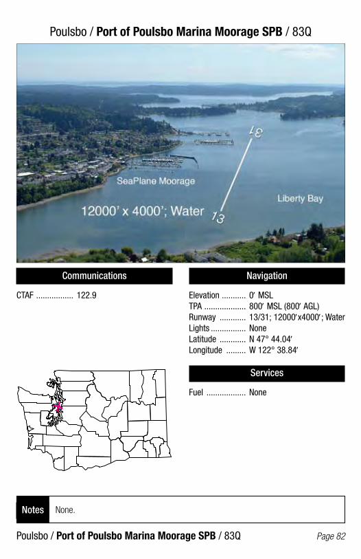
Poulsbo / Port of Poulsbo Marina Moorage SPB / 83Q
Poulsbo / Port of Poulsbo Marina Moorage SPB / 83Q Page 82
Communications
CTAF ................. 122.9
Navigation
Elevation ........... 0′ MSLTPA ................... 800′ MSL (800′ AGL)Runway ............ 13/31; 12000′x4000′; WaterLights ................ NoneLatitude ............ N 47° 44.04′Longitude ......... W 122° 38.84′
Services
Fuel .................. None
None.Notes
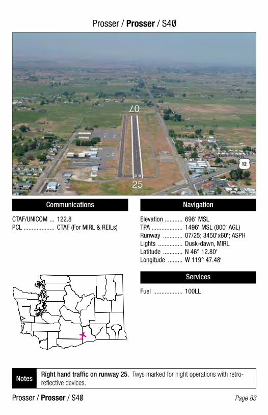
Prosser / Prosser / S4O/
Prosser / Prosser / S40/ Page 83
Communications
CTAF/UNICOM ... 122.8PCL ................... CTAF (For MIRL & REILs)
Navigation
Elevation ........... 696′ MSLTPA ................... 1496′ MSL (800′ AGL)Runway ............ 07/25; 3450′x60′; ASPHLights ............... Dusk-dawn, MIRLLatitude ............ N 46° 12.80′Longitude ......... W 119° 47.48′
Services
Fuel .................. 100LL
Right hand traffic on runway 25. Twys marked for night operations with retro-reflective devices.
Notes
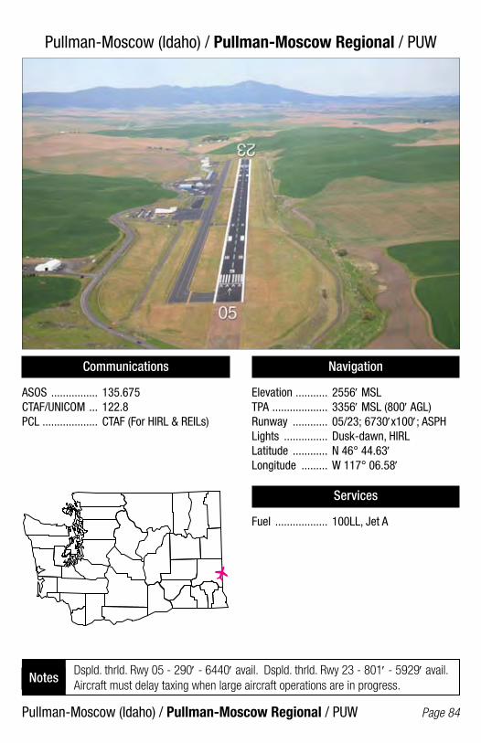
Pullman-Moscow (Idaho) / Pullman-Moscow Regional / PUW
Pullman-Moscow (Idaho) / Pullman-Moscow Regional / PUW Page 84
Communications
ASOS ................ 135.675CTAF/UNICOM ... 122.8PCL ................... CTAF (For HIRL & REILs)
Navigation
Elevation ........... 2556′ MSLTPA ................... 3356′ MSL (800′ AGL)Runway ............ 05/23; 6730′x100′; ASPHLights ............... Dusk-dawn, HIRLLatitude ............ N 46° 44.63′Longitude ......... W 117° 06.58′
Services
Fuel .................. 100LL, Jet A
Dspld. thrld. Rwy 05 - 290′ - 6440′ avail. Dspld. thrld. Rwy 23 - 801′ - 5929′ avail. Aircraft must delay taxing when large aircraft operations are in progress.
Notes

Puyallup / Pierce County-Thun Field / PLU
Puyallup / Pierce County-Thun Field / PLU Page 85
Communications
AWOS-3 ............ 128.575CTAF/UNICOM ... 122.7PCL ................... CTAF (For MIRL)
Navigation
Elevation ........... 538′ MSLTPA ................... 1538′ MSL (1000′ AGL)Runway ............ 16/34; 3650′x60′; ASPHLights ............... Dusk-dawn, MIRLLatitude ............ N 47° 06.24′Longitude ......... W 122° 17.23′
Services
Fuel .................. 100 (24-hour credit card fuel services)
Watch for birds. Ultralights prohibited.Notes
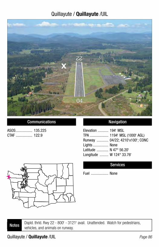
Quillayute / Quillayute /UIL
Quillayute / Quillayute /UIL Page 86
Communications
ASOS ................. 135.225 CTAF ................. 122.9
Navigation
Elevation ........... 194′ MSLTPA ................... 1194′ MSL (1000′ AGL)Runway ............ 04/22; 4210′x100′; CONCLights ................ NoneLatitude ............ N 47° 56.20′Longitude ......... W 124° 33.76′
Services
Fuel .................. None
Dspld. thrld. Rwy 22 - 800′ - 3121′ avail. Unattended. Watch for pedestrians, vehicles, and animals on runway.
Notes
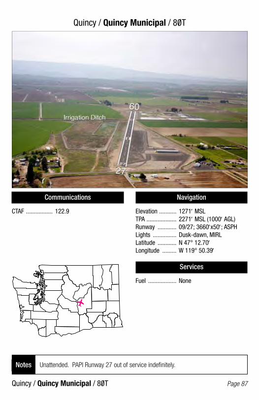
Quincy / Quincy Municipal / 80T
Quincy / Quincy Municipal / 80T Page 87
Communications
CTAF ................. 122.9
Navigation
Elevation ........... 1271′ MSLTPA ................... 2271′ MSL (1000′ AGL)Runway ............ 09/27; 3660′x50′; ASPHLights ............... Dusk-dawn, MIRLLatitude ............ N 47° 12.70′Longitude ......... W 119° 50.39′
Services
Fuel .................. None
Unattended. PAPI Runway 27 out of service indefinitely.Notes
/
/
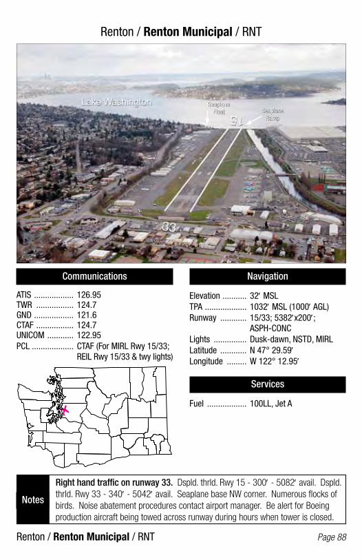
Renton / Renton Municipal / RNT
Renton / Renton Municipal / RNT Page 88
Communications
ATIS .................. 126.95TWR ................. 124.7GND .................. 121.6CTAF ................. 124.7UNICOM ............ 122.95PCL ................... CTAF (For MIRL Rwy 15/33; REIL Rwy 15/33 & twy lights)
Navigation
Elevation ........... 32′ MSLTPA ................... 1032′ MSL (1000′ AGL)Runway ............ 15/33; 5382′x200′; ASPH-CONCLights ............... Dusk-dawn, NSTD, MIRLLatitude ............ N 47° 29.59′Longitude ......... W 122° 12.95′
Services
Fuel .................. 100LL, Jet A
Right hand traffic on runway 33. Dspld. thrld. Rwy 15 - 300′ - 5082′ avail. Dspld. thrld. Rwy 33 - 340′ - 5042′ avail. Seaplane base NW corner. Numerous flocks of birds. Noise abatement procedures contact airport manager. Be alert for Boeing production aircraft being towed across runway during hours when tower is closed.
Notes
Seaplane Float
Seaplane Float Seaplane
RampSeaplane
Ramp
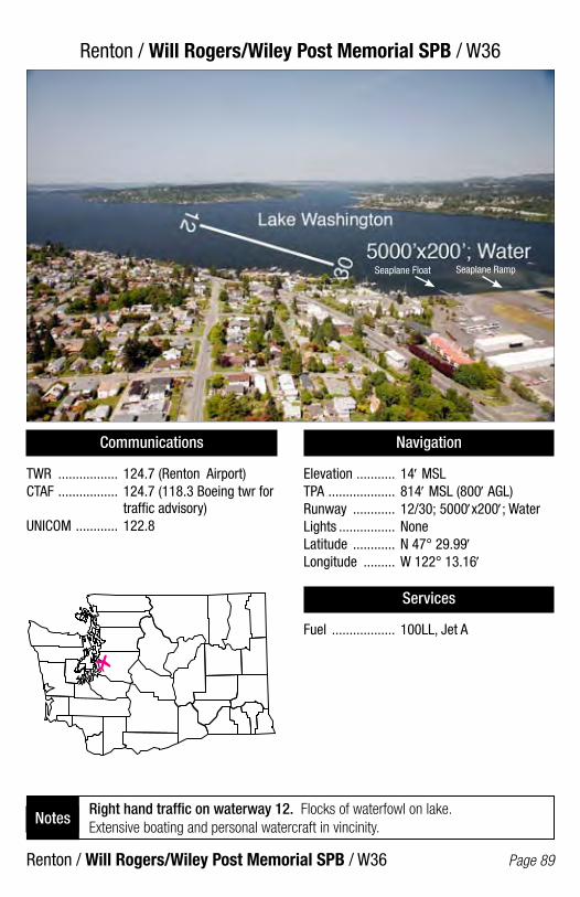
Renton / Will Rogers/Wiley Post Memorial SPB / W36
Renton / Will Rogers/Wiley Post Memorial SPB / W36 Page 89
Communications
TWR ................. 124.7 (Renton Airport)CTAF ................. 124.7 (118.3 Boeing twr for traffic advisory)UNICOM ............ 122.8
Navigation
Elevation ........... 14′ MSLTPA ................... 814′ MSL (800′ AGL)Runway ............ 12/30; 5000′x200′; WaterLights ................ NoneLatitude ............ N 47° 29.99′Longitude ......... W 122° 13.16′
Services
Fuel .................. 100LL, Jet A
Right hand traffic on waterway 12. Flocks of waterfowl on lake. Extensive boating and personal watercraft in vincinity.
Notes
Seaplane Float Seaplane Ramp

Republic / Ferry County / R49
Republic / Ferry County / R49 Page 90
Communications
CTAF ................. 122.9PCL ................... 122.8 (For MIRL & REILs; VASI Rwy 35)
Navigation
Elevation ........... 2522′ MSLTPA ................... 3322′ MSL (800′ AGL)Runway ............ 17/35; 3498′x60′; ASPHLights ............... Dusk-dawn, MIRLLatitude ............ N 48° 43.09′Longitude ......... W 118° 39.39′
Services
Fuel .................. None
Right hand traffic on runway 17. Unattended. Suggest use runway 35 for night operations.
Notes

Richland / Richland / RLD
Richland / Richland / RLD Page 91
Communications
AWOS-3 ............ 132.675CTAF/UNICOM ... 122.7PCL ................... (For MIRL & REILs Rwy 01/19; MALS Rwy 19; ODALS Rwy 08)
Navigation
Elevation ........... 394′ MSLTPA ................... 1200′ MSL (806′ AGL)Runway ............ 19/01; 4009′x75′; ASPH 08/26; 3995′x100′; ASPHLights ............... Dusk-dawn, MIRLLatitude ............ N 46° 18.34′Longitude ......... W 119° 18.25′
Services
Fuel .................. 100LL, Jet A
Right hand traffic on runways 19 and 26. Parachute jumping.Notes
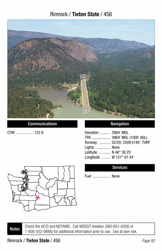
Rimrock / Tieton State / 4S6
Rimrock / Tieton State / 4S6 Page 92
Communications
CTAF ................. 122.9
Navigation
Elevation ........... 2964′ MSLTPA ................... 3964′ MSL (1000′ AGL)Runway ............ 02/20; 2509′x140′; TURFLights ................ NoneLatitude ............ N 46° 38.25′Longitude ......... W 121° 07.44′
Services
Fuel .................. None
Check the AF/D and NOTAMS. Call WSDOT Aviation (360-651-6300 or 1-800-552-0666) for additional information prior to use. Use at own risk.
Notes

Ritzville / Pru Field / 33S
Ritzville / Pru Field / 33S Page 93
Communications
CTAF/UNICOM ... 122.8PCL ................... CTAF (For MIRL)
Navigation
Elevation ........... 1801′ MSLTPA ................... 2801′ MSL (1000′ AGL)Runway ............ 01/19; 3635′x40′; ASPHLights ............... Dusk-dawn, NSTD, MIRLLatitude ............ N 47° 07.39′Longitude ......... W 118° 23.37′
Services
Fuel .................. None
Dspld. thrld. Rwy 01 - 387′ - 3248′ avail. Dspld. thrld. Rwy 19 - 816′ - 2819′ avail. Unattended. Closed when there is snow or ice on runway.
Notes
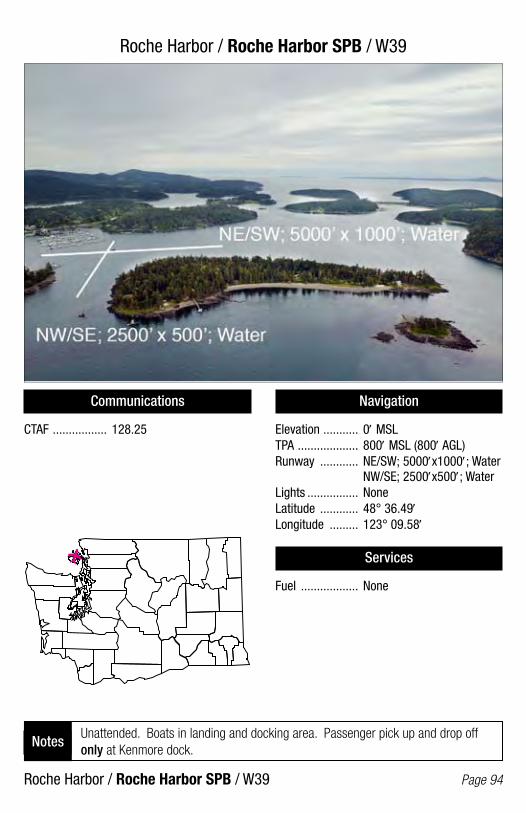
Roche Harbor / Roche Harbor SPB / W39
Roche Harbor / Roche Harbor SPB / W39 Page 94
Communications
CTAF ................. 128.25
Navigation
Elevation ........... 0′ MSLTPA ................... 800′ MSL (800′ AGL)Runway ............ NE/SW; 5000′x1000′; Water NW/SE; 2500′x500′; WaterLights ................ NoneLatitude ............ 48° 36.49′Longitude ......... 123° 09.58′
Services
Fuel .................. None
Unattended. Boats in landing and docking area. Passenger pick up and drop off only at Kenmore dock.
Notes
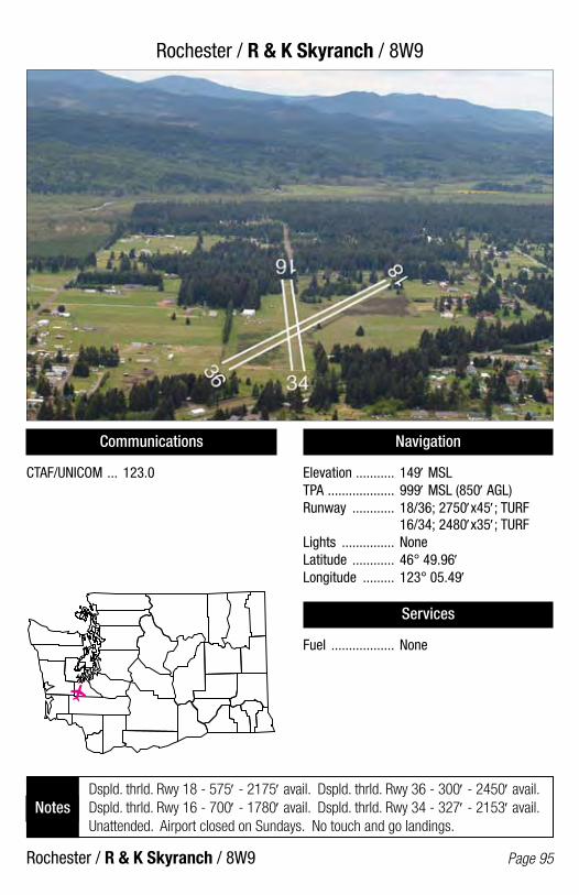
Rochester / R & K Skyranch / 8W9
Rochester / R & K Skyranch / 8W9 Page 95
Communications
CTAF/UNICOM ... 123.0
Navigation
Elevation ........... 149′ MSLTPA ................... 999′ MSL (850′ AGL)Runway ............ 18/36; 2750′x45′; TURF 16/34; 2480′x35′; TURFLights ............... NoneLatitude ............ 46° 49.96′Longitude ......... 123° 05.49′
Services
Fuel .................. None
Dspld. thrld. Rwy 18 - 575′ - 2175′ avail. Dspld. thrld. Rwy 36 - 300′ - 2450′ avail. Dspld. thrld. Rwy 16 - 700′ - 1780′ avail. Dspld. thrld. Rwy 34 - 327′ - 2153′ avail. Unattended. Airport closed on Sundays. No touch and go landings.
Notes
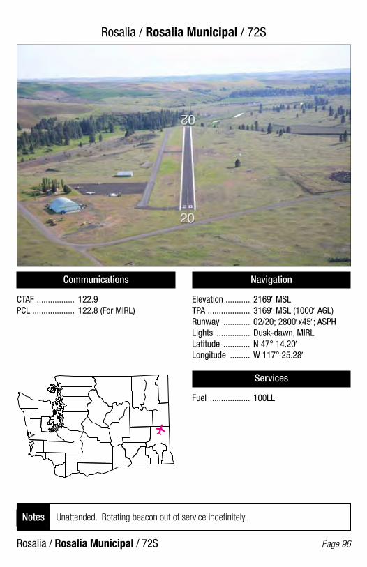
Rosalia / Rosalia Municipal / 72S
Rosalia / Rosalia Municipal / 72S Page 96
Communications
CTAF ................. 122.9PCL ................... 122.8 (For MIRL)
Navigation
Elevation ........... 2169′ MSLTPA ................... 3169′ MSL (1000′ AGL)Runway ............ 02/20; 2800′x45′; ASPHLights ............... Dusk-dawn, MIRLLatitude ............ N 47° 14.20′Longitude ......... W 117° 25.28′
Services
Fuel .................. 100LL
Unattended. Rotating beacon out of service indefinitely.Notes
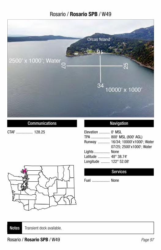
Rosario / Rosario SPB / W49
Rosario / Rosario SPB / W49 Page 97
Communications
CTAF ................. 128.25
Navigation
Elevation ........... 0′ MSLTPA ................... 800′ MSL (800′ AGL)Runway ............ 16/34; 10000′x1000′; Water 07/25; 2500′x1000′; WaterLights ................ NoneLatitude ............ 48° 38.74′Longitude ......... 122° 52.08′
Services
Fuel .................. None
Transient dock available.Notes

Seattle / Boeing Field/King County International / BFI
Seattle / Boeing Field/King County International / BFI Page 98
Communications
ATIS .................. 127.75TWR ................. 120.6 (128-308°) 118.3 (309-127°)GND .................. 121.9CL DEL ............. 132.4UNICOM ............ 122.95
Navigation
Elevation ........... 21′ MSLTPA ................... 13L/31R; 1000′ MSL (979′ AGL) 13R/31L; 800′ MSL (779′ AGL)Runway ............ 13R/31L; 10000′x200′; ASPH 13L/31R; 3710′x100′; ASPHLights ............... Dusk, dawn, MIRL, HIRLLatitude ............ N 47° 31.80′Longitude ......... W 122° 18.12′
Services
Fuel .................. 100LL, Jet A
Right hand traffic on runways 13R and 31R. Dspld. thrld. Rwy 31L - 880′ - 9120′ avail. Dspld. thrld. Rwy 13L - 240′ - 3470′ avail. Dspld. thrld. Rwy 31R - 365′ - 3345′ avail.
Notes

Seattle (Lake Union) / Kenmore Air Harbor SPB / W55
Seattle (Lake Union) / Kenmore Air Harbor SPB / W55 Page 99
Communications
CTAF ................. 122.9
Navigation
Elevation ........... 14′ MSLTPA ................... 814′ MSL (800′ AGL)Runway ............ 16/34; 5000′x500′; WaterLights ................ NoneLatitude ............ N 47° 37.74′Longitude ......... W 122° 20.32′
Services
Fuel .................. None
Special noise abatement rules in effect. Contact Kenmore Air for temporary parking and pattern information. U.S. Customs and Border protection services available.
Notes
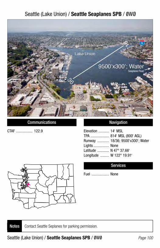
Seattle (Lake Union) / Seattle Seaplanes SPB / 0WO/
Seattle (Lake Union) / Seattle Seaplanes SPB / 0W0/ Page 100
Communications
CTAF ................. 122.9
Navigation
Elevation ........... 14′ MSLTPA ................... 814′ MSL (800′ AGL)Runway ............ 18/36; 9500′x300′; WaterLights ................ NoneLatitude ............ N 47° 37.66′Longitude ......... W 122° 19.91′
Services
Fuel .................. None
Contact Seattle Seplanes for parking permission.Notes
Seaplane Float
/
/
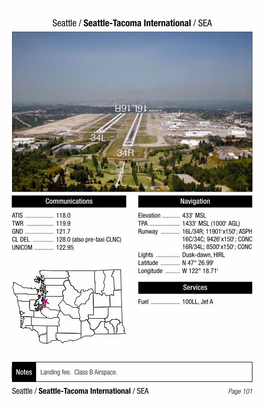
Seattle / Seattle-Tacoma International / SEA
Seattle / Seattle-Tacoma International / SEA Page 101
Communications
ATIS .................. 118.0TWR ................. 119.9GND .................. 121.7CL DEL ............. 128.0 (also pre-taxi CLNC)UNICOM ............ 122.95
Navigation
Elevation ........... 433′ MSLTPA ................... 1433′ MSL (1000′ AGL)Runway ............ 16L/34R; 11901′x150′; ASPH 16C/34C; 9426′x150′; CONC 16R/34L; 8500′x150′; CONCLights ............... Dusk-dawn, HIRLLatitude ............ N 47° 26.99′Longitude ......... W 122° 18.71′
Services
Fuel .................. 100LL, Jet A
Landing fee. Class B Airspace.Notes

Sekiu / Sekiu / 11S
Sekiu / Sekiu / 11S Page 102
Communications
CTAF ................. 122.9
Navigation
Elevation ........... 355′ MSLTPA ................... 1355′ MSL (1000′ AGL)Runway ............ 08/26; 2997′x50′; ASPHLights ............... Dusk-dawn, LIRLLatitude ............ N 48° 15.97′Longitude ......... W 124° 18.84′
Services
Fuel .................. None
Dspld. thrld. Rwy 08 - 900′ - 2097′ avail. Unattended. Notes

Sequim / Sequim Valley / W28
Sequim / Sequim Valley / W28 Page 103
Communications
CTAF/UNICOM ... 122.7
Navigation
Elevation ........... 144′ MSLTPA ................... 1000′ MSL (856′ AGL)Runway ............ 09R/27L; 3510′x40′; ASPH 09L/27R; 3500′x100′; TURFLights ............... Dusk-dawn, LIRLLatitude ............ N 48° 05.89′Longitude ......... W 123° 11.23′
Services
Fuel .................. 100LL
Right hand traffic on runways 09R and 09L. Deer on and in vicinity of airport.Notes
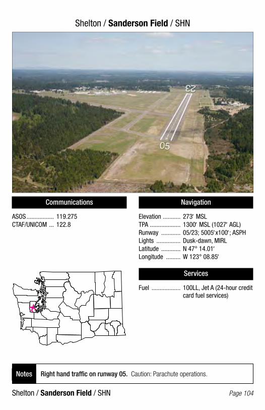
Shelton / Sanderson Field / SHN
Shelton / Sanderson Field / SHN Page 104
Communications
ASOS ................. 119.275 CTAF/UNICOM ... 122.8
Navigation
Elevation ........... 273′ MSLTPA ................... 1300′ MSL (1027′ AGL)Runway ............ 05/23; 5005′x100′; ASPHLights ............... Dusk-dawn, MIRLLatitude ............ N 47° 14.01′Longitude ......... W 123° 08.85′
Services
Fuel .................. 100LL, Jet A (24-hour credit card fuel services)
Right hand traffic on runway 05. Caution: Parachute operations. Notes

Silverdale / Apex / 8W5
Silverdale / Apex / 8W5 Page 105
Communications
CTAF ................. 122.8
Navigation
Elevation ........... 525′ MSLTPA ................... 1525′ MSLRunway ............ 2500′x28′; ASPHLights ............... LIRLLatitude ............ N 47° 39.41′Longitude ......... W 122° 43.99′
Services
Fuel .................. None
Right Hand Traffic on Runway 35. No line of sight between rwy ends. Twy east side rwy. Use caution on twy. Trees, acft, and buildings in transition sfcs.
Notes
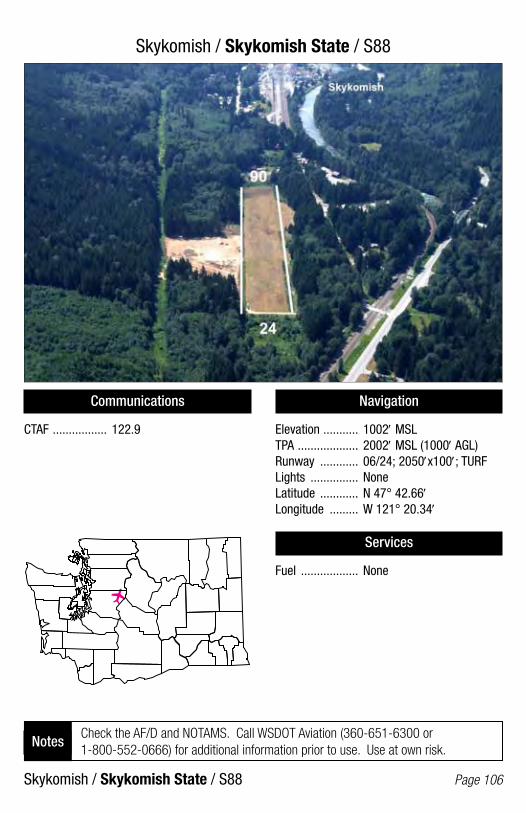
Skykomish / Skykomish State / S88
Skykomish / Skykomish State / S88 Page 106
Communications
CTAF ................. 122.9
Navigation
Elevation ........... 1002′ MSLTPA ................... 2002′ MSL (1000′ AGL)Runway ............ 06/24; 2050′x100′; TURFLights ............... NoneLatitude ............ N 47° 42.66′Longitude ......... W 121° 20.34′
Services
Fuel .................. None
Check the AF/D and NOTAMS. Call WSDOT Aviation (360-651-6300 or 1-800-552-0666) for additional information prior to use. Use at own risk.
Notes
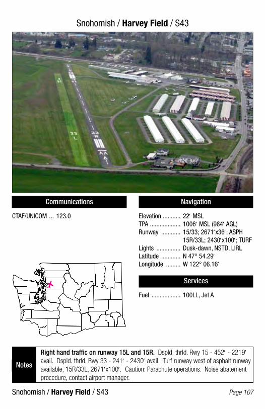
Snohomish / Harvey Field / S43
Snohomish / Harvey Field / S43 Page 107
Communications
CTAF/UNICOM ... 123.0
Navigation
Elevation ........... 22′ MSLTPA ................... 1006′ MSL (984′ AGL)Runway ............ 15/33; 2671′x36′; ASPH 15R/33L; 2430′x100′; TURFLights ............... Dusk-dawn, NSTD, LIRLLatitude ............ N 47° 54.29′Longitude ......... W 122° 06.16′
Services
Fuel .................. 100LL, Jet A
Right hand traffic on runway 15L and 15R. Dspld. thrld. Rwy 15 - 452′ - 2219′ avail. Dspld. thrld. Rwy 33 - 241′ - 2430′ avail. Turf runway west of asphalt runway available, 15R/33L, 2671′x100′. Caution: Parachute operations. Noise abatement procedure, contact airport manager.
Notes

South Bend (Raymond) / Willapa Harbor / 2S9
South Bend (Raymond) / Willapa Harbor / 2S9 Page 108
Communications
CTAF ................. 122.9PCL ................... 122.8 (For MIRL & BCN)
Navigation
Elevation ........... 13′ MSLTPA ................... 1013′ MSL (1000′ AGL)Runway ............ 11/29; 3005′x52′; ASPHLights ............... NSTD, MIRLLatitude ............ N 46° 41.86′Longitude ......... W 123° 49.40′
Services
Fuel .................. 100LL (24-hour credit card fuel services)
Unattended. Watch for elk on and in vicinity of airport. Notes

Spanaway / Shady Acres / 3B8
Spanaway / Shady Acres / 3B8 Page 109
Communications
CTAF ................. 122.9
Navigation
Elevation ........... 445′ MSLTPA ................... 1200′ MSL (755′ AGL)Runway ............ 34/16; 1800′x20′; ASPHLights ............... YesLatitude ............ N 47° 04.22′Longitude ......... W 122° 22.27′
Services
Fuel .................. None
Right hand traffic on runway 34. Dspld. thrld. Rwy 34 - 200′ - 1600′ avail. Unattended.
Notes
34
16
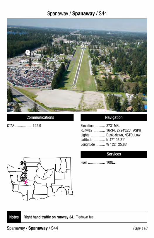
Spanaway / Spanaway / S44
Communications
CTAF ................. 122.9
Navigation
Elevation ........... 373′ MSLRunway ............ 16/34; 2724′x20′; ASPHLights ............... Dusk-dawn, NSTD, LowLatitude ............ N 47° 05.21′Longitude ......... W 122° 25.88′
Services
Fuel .................. 100LL
Right hand traffic on runway 34. Tiedown fee.Notes
Spanaway / Spanaway / S44 Page 110

Spokane / Felts Field / SFF
Spokane / Felts Field / SFF Page 111
Communications
ATIS .................. 120.55TWR ................. 132.5GND .................. 121.7CTAF ................. 132.5UNICOM ............ 122.95PCL ................... CTAF (For MALSR Rwy 21R when twr is closed)
Navigation
Elevation ........... 1953′ MSLTPA ................... 3L/21R 3000′ MSL (1047′ AGL); 3R/21L 2753′ MSL (800′ AGL); Runway ............ 03L/21R; 4500′x150′; CONC 03R/21L; 3059′x75′; ASPH 03W/21W; 6000′x100′; WaterLights ............... Dusk-dawn, MIRLLatitude ............ N 47° 40.97′Longitude ......... W 117° 19.35′
Services
Fuel .................. 100LL, Jet A
Right hand traffic on runways 03R, 21R, and 21W. Dspld. thrld. Rwy 03R - 415′ - 2644′ avail. Seaplane operations advisory service only. Area not visible from tower. Seplane dock on river. Tower operation 0600-2000 local time.
Notes

Spokane / Spokane International / GEG
Spokane / Spokane International / GEG Page 112
Communications
ATIS .................. 124.325TWR ................. 118.3GND .................. 121.9CL DEL ............. 127.55UNICOM ............ 122.95
Navigation
Elevation ........... 2376′ MSLTPA ................... 3200′ MSL (824′ AGL)Runway ............ 03/21; 9001′x150′; ASPH 07/25; 8199′x150′; ASPHLights ............... Dusk-dawn, HIRLLatitude ............ N 47° 37.19′Longitude ......... W 117° 32.03′
Services
Fuel .................. 100LL, Jet A
Right hand traffic on runways 03 and 07. U.S. Customs and Border protection services available.
Notes
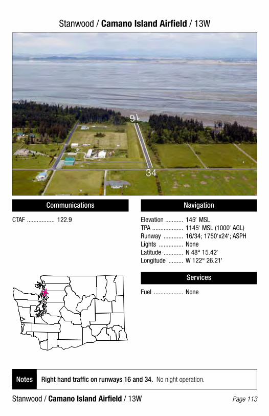
Stanwood / Camano Island Airfield / 13W
Stanwood / Camano Island Airfield / 13W Page 113
Communications
CTAF ................. 122.9
Navigation
Elevation ........... 145′ MSLTPA ................... 1145′ MSL (1000′ AGL)Runway ............ 16/34; 1750′x24′; ASPHLights ............... NoneLatitude ............ N 48° 15.42′Longitude ......... W 122° 26.21′
Services
Fuel .................. None
Right hand traffic on runways 16 and 34. No night operation.Notes

Starbuck / Little Goose Lock & Dam State / 16W
Starbuck / Little Goose Lock & Dam State / 16W Page 114
Communications
CTAF ................. 122.9
Navigation
Elevation ........... 681′ MSLTPA ................... 1681′ MSL (1000′ AGL)Runway ............ 07/25; 3400′x50′; GravelLights ............... NoneLatitude ............ N 46° 34.99′Longitude ......... W 118° 00.06′
Services
Fuel .................. None
Check the AF/D and NOTAMS. Call WSDOT Aviation (360-651-6300 or 1-800-552-0666) for additional information prior to use. Use at own risk.
Notes

Stehekin / Stehekin State / 6S9
Stehekin / Stehekin State / 6S9 Page 115
Communications
CTAF ................. 122.9
Navigation
Elevation ........... 1230′ MSLTPA ................... 2230′ MSL (1000′ AGL)Runway ............ 13/31; 2630′x80′; TURFLights ............... NoneLatitude ............ N 48° 20.74′Longitude ......... W 120° 43.24′
Services
Fuel .................. None
Check the AF/D and NOTAMS. Call WSDOT Aviation (360-651-6300 or 1-800-552-0666) for additional information prior to use. Use at own risk.
Notes

Sultan / Sky Harbor / S86
Sultan / Sky Harbor / S86 Page 116
Communications
CTAF/UNICOM ... 122.9
Navigation
Elevation ........... 282′ MSLTPA ................... 1282′ MSL (1000′ AGL)Runway ............ 07/25; 1930′x100′; TURFLights ............... NoneLatitude ............ N 47° 52.24′Longitude ......... W 121° 47.54′
Services
Fuel .................. None
Avoid airport during high wind conditions. Preferred runway operations, wind permitting, land West, take off East.
Notes
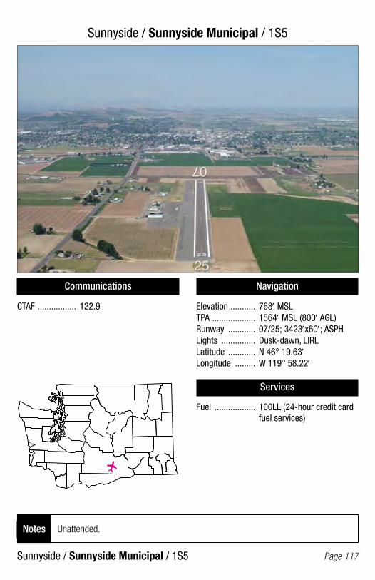
Sunnyside / Sunnyside Municipal / 1S5
Sunnyside / Sunnyside Municipal / 1S5 Page 117
Communications
CTAF ................. 122.9
Navigation
Elevation ........... 768′ MSLTPA ................... 1564′ MSL (800′ AGL)Runway ............ 07/25; 3423′x60′; ASPHLights ............... Dusk-dawn, LIRLLatitude ............ N 46° 19.63′Longitude ......... W 119° 58.22′
Services
Fuel .................. 100LL (24-hour credit card fuel services)
Unattended.Notes
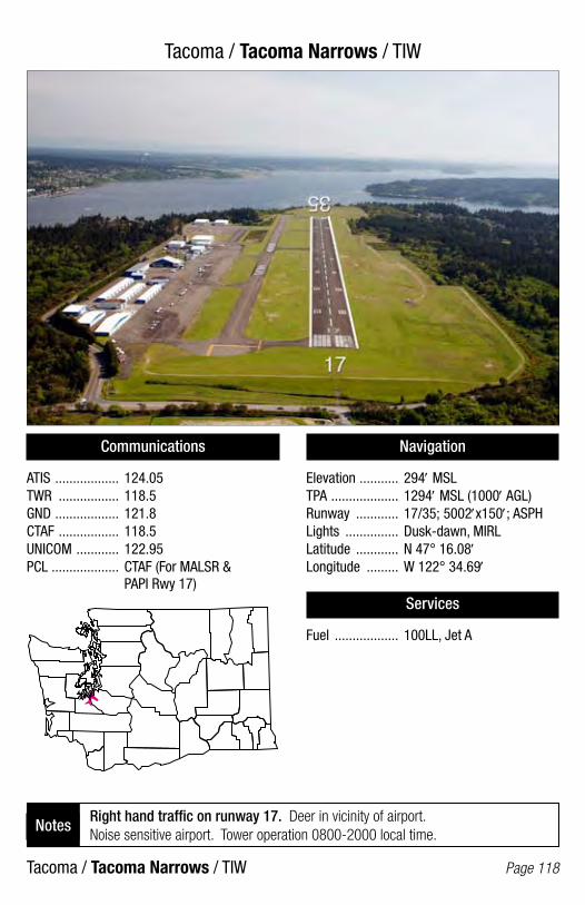
Tacoma / Tacoma Narrows / TIW
Tacoma / Tacoma Narrows / TIW Page 118
Communications
ATIS .................. 124.05TWR ................. 118.5GND .................. 121.8CTAF ................. 118.5UNICOM ............ 122.95PCL ................... CTAF (For MALSR & PAPI Rwy 17)
Navigation
Elevation ........... 294′ MSLTPA ................... 1294′ MSL (1000′ AGL)Runway ............ 17/35; 5002′x150′; ASPHLights ............... Dusk-dawn, MIRLLatitude ............ N 47° 16.08′Longitude ......... W 122° 34.69′
Services
Fuel .................. 100LL, Jet A
Right hand traffic on runway 17. Deer in vicinity of airport. Noise sensitive airport. Tower operation 0800-2000 local time.
Notes

Tekoa / Willard Field / 73S
Tekoa / Willard Field / 73S Page 119
Communications
CTAF ................. 122.9PCL ................... 122.8 (For MIRL)
Navigation
Elevation ........... 2520′ MSLTPA ................... 3520′ MSL (1000′ AGL)Runway ............ 04/22; 2260′x40′; ASPHLights ............... Dusk-dawn, NSTD, MIRLLatitude ............ N 47° 14.13′Longitude ......... W 117° 02.63′
Services
Fuel .................. 100LL (24-hour credit card fuel services)
Unattended. Caution: Parachute jumping.Notes
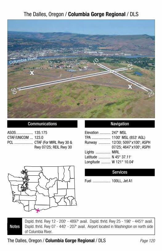
The Dalles, Oregon / Columbia Gorge Regional / DLS
The Dalles, Oregon / Columbia Gorge Regional / DLS Page 120
Communications
ASOS ................. 135.175CTAF/UNICOM ... 123.0PCL ................... CTAF (For MIRL Rwy 30 & Rwy 07/25; REIL Rwy 30
Navigation
Elevation ........... 247′ MSLTPA ................... 1100′ MSL (853′ AGL)Runway ............ 12/30; 5097′x100′; ASPH 07/25; 4647′x100′; ASPHLights ............... MIRLLatitude ............ N 45° 37.11′Longitude ......... W 121° 10.04′
Services
Fuel .................. 100LL, Jet A1
Dspld. thrld. Rwy 12 - 200′ - 4897′ avail. Dspld. thrld. Rwy 25 - 196′ - 4451′ avail. Dspld. thrld. Rwy 07 - 440′ - 207′ avail. Airport located in Washington on north side of Columbia River.
Notes
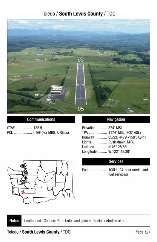
Toledo / South Lewis County / TDO
Toledo / South Lewis County / TDO Page 121
Communications
CTAF ................. 122.9PCL ................... CTAF (For MIRL & REILs)
Navigation
Elevation ........... 374′ MSLTPA ................... 1174′ MSL (800′ AGL)Runway ............ 05/23; 4479′x150′; ASPHLights ............... Dusk-dawn, MIRLLatitude ............ N 46° 28.63′Longitude ......... W 122° 48.39′
Services
Fuel .................. 100LL (24-hour credit card fuel services)
Unattended. Caution: Parachutes and gliders. Radio controlled aircraft.Notes
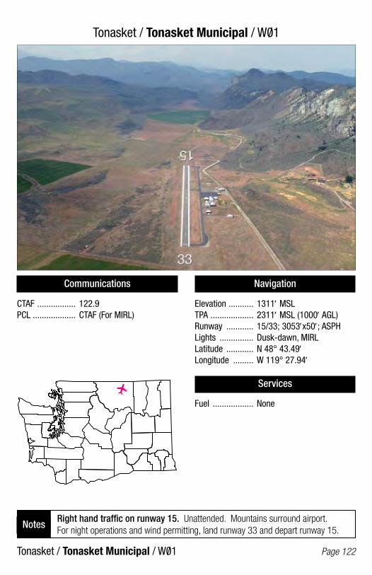
Tonasket / Tonasket Municipal / W01
Tonasket / Tonasket Municipal / W01 Page 122
Communications
CTAF ................. 122.9PCL ................... CTAF (For MIRL)
Navigation
Elevation ........... 1311′ MSLTPA ................... 2311′ MSL (1000′ AGL)Runway ............ 15/33; 3053′x50′; ASPHLights ............... Dusk-dawn, MIRLLatitude ............ N 48° 43.49′Longitude ......... W 119° 27.94′
Services
Fuel .................. None
Right hand traffic on runway 15. Unattended. Mountains surround airport. For night operations and wind permitting, land runway 33 and depart runway 15.
Notes
/
/

Twisp / Twisp Municipal / 2SO/
Twisp / Twisp Municipal / 2S0/ Page 123
Communications
CTAF ................. 122.9PCL ................... CTAF (For BCN & MIRL; PAPI Rwy 28)
Navigation
Elevation ........... 1602′ MSLTPA ................... 2602′ MSL (1000′ AGL)Runway ............ 10/28; 2701′x36′; ASPHLights ............... NSTD, MIRLLatitude ............ N 48° 21.04′Longitude ......... W 120° 05.64′
Services
Fuel .................. None
Dspld. thrld. Rwy 28 - 200′ - 2501′ avail. Unattended. Mountainous terrain surrounds airport. Deer and pedestrians on and in vicinity of airport.
Notes

Vancouver / Fly For Fun / W56
Vancouver / Fly For Fun / W56 Page 124
Communications
CTAF ................. 122.9
Navigation
Elevation ........... 297′ MSLTPA ................... 1300′ MSL (1003′ AGL)Runway ............ 07/25; 2434′x50′; TURFLights ............... NoneLatitude ............ N 45° 41.24′Longitude ......... W 122° 31.31′
Services
Fuel .................. None
Right hand traffic on runway 25. Unattended. Airport is closed Christmas and Easter.
Notes

Vancouver / Pearson Field / VUO
Vancouver / Pearson Field / VUO Page 125
Communications
ASOS ................. 135.125TWR ................. Portland 119.0CTAF/UNICOM ... 123.0PCL ................... CTAF (For MIRL after midnight)
Navigation
Elevation ........... 25′ MSLTPA ................... 1025′ MSL (1000′ AGL)Runway ............ 08/26; 3275′x60′; ASPHLights ............... Dusk-dawn, MIRLLatitude ............ N 45° 37.23′Longitude ......... W 122° 39.39′
Services
Fuel .................. 100LL (24-hour credit card fuel services)
Right hand traffic on runway 26. Dspld. thrld. Rwy 26 - 762′ - 2513′ avail. Bridge towers 0.5 SW. Prior to arrival and departure, contact Portland tower 119.0.Notes

Vashon / Vashon Municipal / 2S1
Vashon / Vashon Municipal / 2S1 Page 126
Communications
CTAF ................. 122.9
Navigation
Elevation ........... 316′ MSLTPA ................... 1299′ MSL (983′ AGL)Runway ............ 17/35; 2001′x60′; TURF-GravelLights ............... Dusk-dawn, NSTD, LIRLLatitude ............ N 47° 27.52′Longitude ......... W 122° 28.45′
Services
Fuel .................. None
Right hand traffic Rwy 17. Unattended. Night operations only for pilots familiar with airport. Close in obstructions. Helipad for emergency use only. Touch and go landings not recommended. Noise abatement procedures climb straight ahead to 700′ AGL.
Notes

Walla Walla / Walla Walla Regional / ALW
Walla Walla / Walla Walla Regional / ALW Page 127
Communications
ASOS ................. 135.875TWR ................. 118.5GND .................. 121.6CTAF ................. 118.5PCL ................... CTAF (For MALSR Rwy 20; REIL & PAPI Rwy 02; HIRL Rwy 02/20 when twr is is closed)
Navigation
Elevation ........... 1194′ MSLTPA ................... 2194′ MSL (1000′ AGL)Runway ............ 02/20; 6527′x150′; ASPH 16/34; 5948′x150′; ASPH-CONC 07/25; 4486′x150′; ASPH-CONCLights ............... Dusk-dawn, HIRLLatitude ............ N 46° 05.69′Longitude ......... W 118° 17.34′
Services
Fuel .................. 100LL, Jet A (24-hour credit card fuel services)
Caution: Parachute jumping in vicinity of airport. Tower operation 0630-1900 local time.
Notes

Warden / Warden / 2S4
Warden / Warden / 2S4 Page 128
Communications
CTAF ................. 122.9
Navigation
Elevation ........... 1276′ MSLTPA ................... 2276′ MSL (1000′ AGL)Runway ............ 17/35; 2811′x60′; ASPHLights ............... Dusk-dawn, MIRLLatitude ............ N 46° 57.95′Longitude ......... W 119° 03.98′
Services
Fuel .................. None
No runway numbers. Dspld. thrld. Rwy 17 - 560′ - 2251′ avail. Unattended.Notes
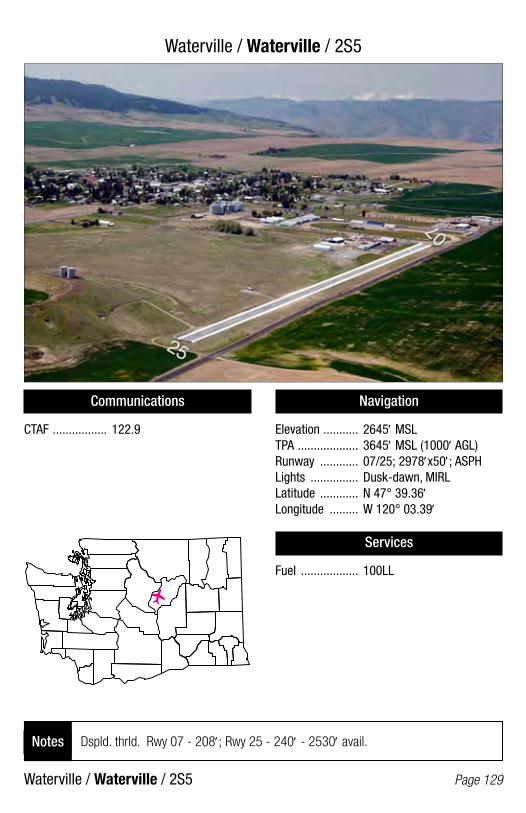
Waterville / Waterville / 2S5
Waterville / Waterville / 2S5 Page 129
Communications
CTAF ................. 122.9
Navigation
Elevation ........... 2645′ MSLTPA ................... 3645′ MSL (1000′ AGL)Runway ............ 07/25; 2978′x50′; ASPHLights ............... Dusk-dawn, MIRLLatitude ............ N 47° 39.36′Longitude ......... W 120° 03.39′
Services
Fuel .................. 100LL
Dspld. thrld. Rwy 07 - 208′; Rwy 25 - 240′ - 2530′ avail.Notes
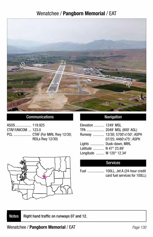
Wenatchee / Pangborn Memorial / EAT
Wenatchee / Pangborn Memorial / EAT Page 130
Communications
ASOS ................. 119.925CTAF/UNICOM ... 123.0PCL ................... CTAF (For MIRL Rwy 12/30; REILs Rwy 12/30)
Navigation
Elevation ........... 1249′ MSLTPA ................... 2049′ MSL (800′ AGL)Runway ............ 12/30; 5700′x150′; ASPH 07/25; 4460′x75′; ASPHLights ............... Dusk-dawn, MIRLLatitude ............ N 47° 23.89′Longitude ......... W 120° 12.34′
Services
Fuel .................. 100LL, Jet A (24-hour credit card fuel services for 100LL)
Right hand traffic on runways 07 and 12. Notes

Westport / Westport / 14S
Westport / Westport / 14S Page 131
Communications
CTAF ................. 122.9
Navigation
Elevation ........... 14′ MSLTPA ................... 1014′ MSL (1000′ AGL)Runway ............ 12/30; 2318′x50′; ASPHLights ............... Dusk-dawn, MIRLLatitude ............ N 46° 53.82′Longitude ......... W 124° 06.05′
Services
Fuel .................. None
Right hand traffic on runway 30.Notes

Wilbur / Wilbur Municipal / 2S8
Wilbur / Wilbur Municipal / 2S8 Page 132
Communications
CTAF ................. 122.9PCL ................... CTAF (For MIRL & BCN)
Navigation
Elevation ........... 2182′ MSLTPA ................... 3182′ MSL (1000′ AGL)Runway ............ 02/20; 3119′x35′; ASPHLights ............... MIRLLatitude ............ N 47° 45.25′Longitude ......... W 118° 44.59′
Services
Fuel .................. 100LL, Jet A
None.Notes

Wilson Creek / Wilson Creek / 5W1
Wilson Creek / Wilson Creek / 5W1 Page 133
Communications
CTAF ................. 122.9
Navigation
Elevation ........... 1440′ MSLTPA ................... 2440′ MSL (1000′ AGL)Runway ............ 10/28; 3074′x50′; ASPHLights ............... NoneLatitude ............ N 47° 25.49′Longitude ......... W 119° 06.90′
Services
Fuel .................. None
Unattended.Notes

Winthrop / Methow Valley State / S52
Winthrop / Methow Valley State / S52 Page 134
Communications
AWOS-3 ............ 118.425CTAF/UNICOM ... 122.8PCL ................... Out of Service
Navigation
Elevation ........... 1706′ MSLTPA ................... 2706′ MSL (1000′ AGL)Runway ............ 13/31; 5049′x75′; ASPHLights ............... Dusk-dawn, MIRLLatitude ............ N 48° 25.50′Longitude ......... W 120° 08.75′
Services
Fuel .................. None
Check the AF/D and NOTAMS. Call WSDOT Aviation (360-651-6300 or 1-800-552-0666) for additional information prior to use. Use at own risk.
Notes
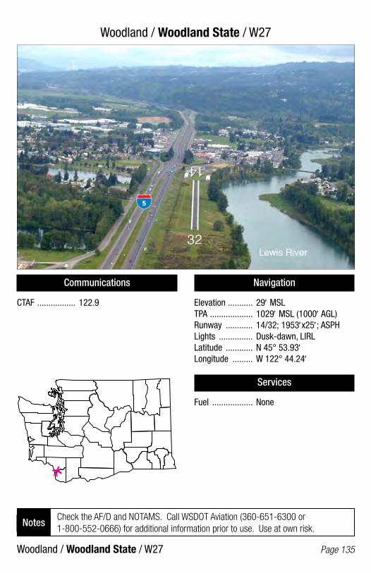
Woodland / Woodland State / W27
Woodland / Woodland State / W27 Page 135
Communications
CTAF ................. 122.9
Navigation
Elevation ........... 29′ MSLTPA ................... 1029′ MSL (1000′ AGL)Runway ............ 14/32; 1953′x25′; ASPHLights ............... Dusk-dawn, LIRLLatitude ............ N 45° 53.93′Longitude ......... W 122° 44.24′
Services
Fuel .................. None
Check the AF/D and NOTAMS. Call WSDOT Aviation (360-651-6300 or 1-800-552-0666) for additional information prior to use. Use at own risk.
Notes

Yakima / McAllister Field / YKM
Yakima / McAllister Field / YKM Page 136
Communications
ATIS .................. 125.25TWR ................. 133.25GND .................. 121.9CTAF ................. 133.25UNICOM ............ 122.95PCL ................... CTAF (For HIRL Rwy 09/27; MALSR Rwy 27 when twr is closed)
Navigation
Elevation ........... 1099′ MSLTPA ................... 2000′ MSL (901′ AGL)Runway ............ 09/27; 7604′x150′; ASPH 04/22; 3835′x150′; ASPHLights ............... Dusk-dawn, HIRLLatitude ............ N 46° 34.09′Longitude ......... W 120° 32.64′
Services
Fuel .................. 100LL, Jet A (24-hour credit card fuel services for 100LL)
Birds in vicinity of Yakima River east of approach to runway 27. Tower operation 0600-2200 local time.
Notes

Notes

Notes