wangapeka track (route guide) - doc.govt.nz · wangapeka history gold was discovered in the...
TRANSCRIPT
Wangapeka historyGold was discovered in the Wangapeka valley in 1859, following a geological survey by Dr Ferdinand Von Hochstetter. This discovery, and the need for access to the West Coast, led to the building of the route between 1862 and 1899 by unemployed gold miners and diggers. Jonathan Brough was put in charge of track gangs working west of the Wangapeka Saddle. In 1898 he built a tabernacle – an ‘A’-framed shelter – on a bend looking down Taipo River to its junction with Karamea River. This became a well-known landmark.
Although the area attracted gold hunters for about 70 years, few fortunes were made. The first pastoral licence for sheep grazing in the Wangapeka valley was granted in 1851. By the late 1860s, sheep had reached the alpine grasslands of the Wangapeka tops, from Mount Gomorrah to Mount Patriarch. Graziers tied small sack-bags of grass seed to the sheep’s necks during summer, thus introducing new grass species to the area. Grazing attempts were abandoned after 1940 because of fierce competition for feed from deer.
The 1929 Murchison earthquake caused severe damage to sections of the Wangapeka Route – and destroyed the Mount Zetland route on the western side of the Little Wanganui Saddle. These sections were rebuilt during the 1930s depression when the Government introduced a gold-mining subsidy scheme for unemployed men. Cecil Kings Hut is a relic of this time. King built the wooden slab hut in 1935. He lived in Lower Hutt and, after his retirement in the 1960s, spent every summer fossicking there until 1981. His family spread his ashes around the hut, following his death in 1982. DOC restored the hut in 1991, and continues to maintain it to preserve its historic value.
Stories in the rocksThe Wangapeka Route passes through mountainous country, ranging from 300 m in the valleys to Mount Patriarch, 1,701 m above sea level. In the late 1940s climbers scaled Mount Patriarch in training for an ascent of mighty Mount Everest.
The area contains some of the country’s oldest rocks, including sandstone, limestone and granite. The sandstone and limestone are sedimentary rocks composed of deposits in horizontal layers on an ancient seafloor. Today they are described as ‘sedimentary belts’ (western, central and eastern) running north–south through the national park.
In the Karamea, pink granite boulders, rounded and with visible crystals, contrast with the fine-grained, generally grey and more angular rocks of the sedimentary belts. Unlike the sedimentary rocks, the Karamea granite was formed when molten rock bubbled up into surrounding rocks and solidified before reaching the surface. It was then exposed by later erosion. Damage from the Murchison earthquake is still visible in the Little Wanganui valley: down the Karamea River, the Luna and Taipo slips indicate just how severe it was.
Abundant vegetationMost of the Wangapeka Route winds through forest. In the damp understorey of the dense red and silver beech forest, double crepe fern (also known as Prince of Wales feathers fern) and kiwakiwa ferns are abundant among the carpet of mosses and lichens. Thickets of mānuka, kānuka and bracken thrive on fire scars, old slips and flood-prone riverbeds. Tussockland is prominent only at Stag Flat and Little Wanganui Saddle, but the route never reaches true alpine heights.
Conservation management The Wangapeka Route runs through part of the Wangapeka/Fyfe whio (blue duck) security site, one of eight DOC sites run in wild backcountry waterways under the Whio Forever project, which aims to secure the survival of this vulnerable species. Just three whio lived on the Wangapeka catchment’s Rolling River when the programme began in 2003; recent surveys show good progress towards a target of 50 breeding pairs in the security site. This population increase is due to sustained predator control, and to the WHIONE (whio nest egg) technique: wild eggs are harvested, and the ducklings are then raised in captivity and released as juveniles into protected waterways.
whioforever.co.nzInterested in becoming a Wangapeka whio volunteer? Contact the DOC Nelson Office on 03 546 9335.
Wangapeka Track (Route Guide)KAHURANGI NATIONAL PARK
The Wangapeka crosses Kahurangi National Park, from the Waimea Basin in the east to the West Coast near Karamea. It crosses two saddles, each of over 1,000 m, and travels through the beautiful beech-forested valleys of the Wangapeka, Karamea, Taipo and Little Wanganui rivers. For a challenging multi-day remote-area tramping experience, the Wangapeka can be walked in conjunction with the Leslie–Karamea Track to link with the Mount Arthur Tableland.
The track from Rolling Junction to Stone Hut following the Wangapeka River is managed as a tramping track. This means the vegetation is regularly cut, and all major river and stream crossings are bridged. The Wangapeka west of Stone Hut is classified as a route – suitable for people with high-level backcountry (remote area) skills and experience. Navigation and survival skills are required. Expect unbridged streams and river crossings. Above-average fitness and sturdy boots are essential.
How to get therePrivate transport
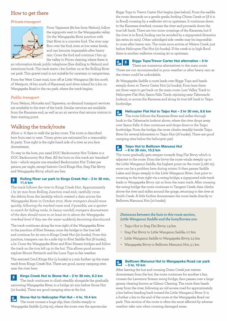
From Tapawera (62 km from Nelson), follow the signposts west to the Wangapeka valley. On the Wangapeka River junction with Dart River is a concrete ford. The river may flow over the ford, even at low water levels, and can become impassable after heavy rain. Cross the ford and continue 7 km up the valley to Prices clearing, where there is
an information kiosk, public telephone (free dialling to Nelson) and intentions book. The track starts 1 km further on at the Rolling River car park. This gravel road is not suitable for caravans or campervans.
From the West Coast road, turn off at Little Wanganui (80 km north of Westport, 18 km south of Karamea) and drive inland for 5 km on Wangapeka Road to the car park, where the track begins.
Public transportFrom Nelson, Motueka and Tapawera, on-demand transport services are available to the start of the track. Similar services are available from the Karamea end, as well as an air service that returns visitors to their starting point.
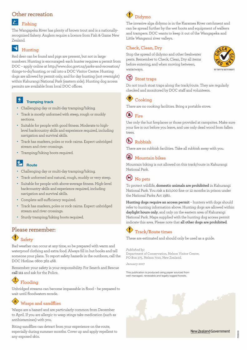
Walking the track/routeAllow 4–6 days to walk the 59-km route. The route is described here from east to west. Times given are estimated for a reasonably-fit party. True right is the right-hand side of a river as you face downstream.
To stay in the huts, you need DOC Backcountry Hut Tickets or a DOC Backcountry Hut Pass. All the huts on this track are ‘standard’ huts – which require one standard Backcountry Hut Ticket per person per night, except historic Cecil Kings Hut, Stag Flat Bivvy and Wangapeka Bivvy, which are free.
Rolling River car park to Kings Creek Hut – 3 hr 30 min, 11.4 km
The track follows the river to Kings Creek Hut. Approximately 1 hr 30 min from Rolling Junction road end, carefully cross the debris from the landslip which created a dam across the Wangapeka River in October 2012. Note: trampers should move quickly, following the marked route and, if possible, use a spotter to watch for falling rocks. In heavy rainfall, trampers downstream of the dam should move to at least 20 m above the Wangapeka riverbed level if they see the water suddenly becoming discoloured.
The track continues along the true right of the Wangapeka River to the junction of Kiwi Stream; cross the bridge to the true left and continue for 30 min to Kings Creek Hut (20 bunks). From this junction, trampers can do a side trip to Kiwi Saddle Hut (6 bunks), 4 hr. Cross the Wangapeka River and Kiwi Stream bridges and follow the track on the true left up to the hut. This allows good access to explore Mount Patriarch and the Luna Tops in fair weather.
The restored Cecil Kings Hut (4 bunks) is 5 min further up the main track from Kings Creek Hut. There are good, sunny camping sites near the river here.
Kings Creek Hut to Stone Hut – 2 hr 30 min, 8.3 kmThe track continues to climb steadily alongside the gradually
narrowing Wangapeka River, to a bridge 30 min before Stone Hut (10 bunks). There are good camping sites at the hut.
Stone Hut to Helicopter Flat Hut – 4 hr, 10.4 kmThe route crosses a huge slip, then climbs steeply to
Wangapeka Saddle (1,009 m), where the route over the spectacular
Biggs Tops to Trevor Carter Hut begins (see below). From the saddle the route descends on a gentle grade, fording Chime Creek or (if it is in flood) crossing by a walkwire 100 m upstream. It continues down to the Karamea riverbed, crosses the river and proceeds down the true left bank. There are two more crossings of the Karamea, but if the river is in flood, fording can be avoided by a signposted diversion (an extra 20 min). Other unbridged side creeks may be impossible to cross after heavy rain. The route soon arrives at Waters Creek, just before Helicopter Flat Hut (10 bunks). If the creek is in high flood there is another walkwire crossing 30 m upstream.
Biggs Tops/Trevor Carter Hut alternative – 5 hrThere are numerous alternatives to the main route.
These are not recommended in poor weather or after heavy rain as the rivers could be unfordable.
At Wangapeka Saddle a route leads over Biggs Tops and heads steeply down to Trevor Carter Hut (12 bunks). From here there are three ways to get back on the main route: Lost Valley Track to Helicopter Flat Hut; Saxon Falls Track, rejoining near Tabernacle lookout; or across the Karamea and along its true left bank to Taipo footbridge.
Helicopter Flat Hut to Taipo Hut – 3 hr 30 min, 8.6 kmThe route follows the Karamea River and sidles through
bush to the Tabernacle lookout above, where the river drops away over Saxon Falls. It then continues and drops down to the Taipo footbridge. From the bridge, the route climbs steadily beside Taipo River for several kilometres to Taipo Hut (16 bunks). There are good camping sites below the helicopter pad.
Taipo Hut to Belltown Manunui Hut – 6 hr 30 min, 10.2 km
The route gradually gets steeper towards Stag Flat Bivvy which is adjacent to the route. From the bivvy the route winds steeply up to the Little Wanganui Saddle, the highest point on the route (1,087 m); snow can be a problem here during winter. It then passes Saddle Lakes and drops steeply to the Little Wanganui River. Just prior to crossing to the true right via a swing bridge, a signposted side-track leads to Wangapeka Bivvy 150 m from the main track. After crossing the swing bridge the route continues to Tangent Creek, then climbs above the river and sidles around the gorge, returning to the river at Smith Creek. A little further downstream the route leads directly to Belltown Manunui Hut (10 bunks).
Distances between the huts in this route section, Little Wanganui Saddle and the huts/bivvies are:
· Taipo Hut to Stag Flat Bivvy, 1.9 km
· Stag Flat Bivvy to Little Wanganui Saddle, 0.7 km
· Little Wanganui Saddle to Wangapeka Bivvy, 2.5 km
· Wangapeka Bivvy to Belltown Manunui Hut, 5.1 km
Belltown Manunui Hut to Wangapeka Road car park – 3 hr, 10 km
After leaving the hut and crossing Drain Creek just metres downstream from the hut, the route continues for another 2 km, crosses the Lawrence Stream swing bridge, then passes over a large grassy clearing known as Gilmor Clearing. The route then heads away from the river, following an old access road for approximately 3 km before heading back toward the Little Wanganui River. It is a further 4 km to the end of the route at the Wangapeka Road car park. This section of the route is often the most affected by adverse weather: take care when crossing damaged areas.
Motueka
TapaweraNelson
St ArnaudWestport
Karamea
DidymoThe invasive alga didymo is in the Karamea River catchment and can be spread further by the wet boots and equipment of walkers and trampers. DOC wants to keep it out of the Wangapeka and Little Wanganui river valleys.
Check, Clean, DryStop the spread of didymo and other freshwater pests. Remember to Check, Clean, Dry all items before entering, and when moving between, waterways.
Stoat trapsDo not touch stoat traps along the track/route. They are regularly checked and monitored by DOC staff and volunteers.
CookingThere are no cooking facilities. Bring a portable stove.
FireUse only the hut fireplaces or those provided at campsites. Make sure your fire is out before you leave, and use only dead wood from fallen trees.
RubbishThere are no rubbish facilities. Take all rubbish away with you.
Mountain bikesMountain biking is not allowed on this track/route in Kahurangi National Park.
No petsTo protect wildlife, domestic animals are prohibited in Kahurangi National Park. You risk a $10,000 fine or 12 months in prison under the National Parks Act 1980.
Hunting dogs require an access permit – hunters with dogs should refer to hunting information above. Hunting dogs are allowed within daylight hours only, and only on the eastern area of Kahurangi National Park. Maps supplied with the hunting dog access permit indicate this area. Please note that all other dogs are prohibited.
Track/Route timesThese are estimated and should only be used as a guide.
This publication is produced using paper sourced from well-managed, renewable and legally logged forests.
Published by: Department of Conservation, Nelson Visitor Centre, PO Box 375, Nelson 7010, New Zealand.
January 2017
Other recreationFishing
The Wangapeka River has plenty of brown trout and is a nationally-recognised fishery. Anglers require a licence from Fish & Game New Zealand.
HuntingRed deer can be found and pigs are present, but not in large numbers. Hunting is encouraged: each hunter requires a permit from DOC – apply online at http://www.doc.govt.nz/parks-and-recreation/things-to-do/hunting, or call into a DOC Visitor Centre. Hunting dogs are allowed by permit only, and for day hunting (not overnight) within Kahurangi National Park (eastern side). Hunting dog access permits are available from local DOC offices.
Tramping track
· Challenging day or multi-day tramping/hiking.
· Track is mostly unformed with steep, rough or muddy sections.
· Suitable for people with good fitness. Moderate to high-level backcountry skills and experience required, including navigation and survival skills.
· Track has markers, poles or rock cairns. Expect unbridged stream and river crossings.
· Tramping/hiking boots required.
Route
· Challenging day or multi-day tramping/hiking.
· Track unformed and natural, rough, muddy or very steep.
· Suitable for people with above-average fitness. High-level backcountry skills and experience required, including navigation and survival skills.
· Complete self-sufficiency required.
· Track has markers, poles or rock cairns. Expect unbridged stream and river crossings.
· Sturdy tramping/hiking boots required.
Please remember:Safety
Bad weather can occur at any time, so be prepared with warm and waterproof clothing and extra food. Always fill in hut books and tell someone your plans. To report safety hazards in the outdoors, call the DOC Hotline: 0800 362 468.
Remember: your safety is your responsibility. For Search and Rescue call 111 and ask for the Police.
FloodingUnbridged streams can become impassable in flood – be prepared to wait until floodwaters recede.
Wasps and sandfliesWasps are a hazard and are particularly common from December to April. If you are allergic to wasp stings take medication (such as antihistamines) with you.
Biting sandflies can detract from your experience on the route, especially during summer months. Cover up and apply repellent to any exposed skin. R
9865
8

This
map
is a
gui
de o
nly.
We
reco
mm
end
you
carr
y To
po50
map
s: BQ
22 K
aram
ea, B
Q23
Wan
gape
ka S
addl
e, BQ
24 T
apaw
era.
To fi
nd o
ut m
ore
Furt
her i
nfor
mat
ion
on K
ahur
angi
Nat
iona
l Par
k ca
n be
fo
und
on th
e D
OC
web
site
ww
w.do
c.gov
t.nz,
or co
ntac
t:
Dep
artm
ent
of C
ons
erva
tion
Nel
son
Vis
itor
Cen
tre
Mill
ers
Acr
e C
entr
e/Ta
ha o
te A
wa
79 T
rafa
lgar
Str
eet,
Nel
son
7010
PO
Box
375
, Nel
son
7040
Ph:
(03)
546
933
9E
mai
l: ne
lson
vc@
doc.
govt
.nz
Kar
amea
Info
rmat
ion
and
Res
our
ce C
entr
eM
arke
t Cro
ssP
O B
ox 9
4, K
aram
ea 7
864
Ph/
Fax:
(03)
782
665
2E
mai
l: in
fo@
kara
mea
info
.co.
nz
Wes
tpo
rt i-
SIT
E V
isito
r C
entr
e12
3 P
alm
erst
on S
tree
tW
estp
ort 7
825
Ph:
(03)
789
665
8 E
mai
l: w
estp
ort.i
nfo@
xtra
.co.
nz
!
!
!
!
!
!
Bel
ltow
n M
anun
ui H
ut
Biv
vy
(1
0 bu
nks) W
anga
peka
Biv
vy(2
bun
ks)
Stag
Fla
t
(2 b
unks
)
Hel
icop
ter F
lat H
ut(1
0 bu
nks)
Taip
o H
ut(1
6 bu
nks)
Trev
or C
arte
r Hut
(12
bunk
s)St
one
Hut
(10
bunk
s)
Kiw
i Sad
dle
Hut
(6 b
unks
)
John
Rei
d H
ut(6
bun
ks)
King
s C
reek
Hut
(20
bunk
s)C
ecil
Kin
gs H
ut(4
bun
ks)
Little
Wan
ganu
iRive
r
TangentCreek
Gilm
or C
lear
ing
Taip
oRiv
er
Kenda
ll Cre
ek
Karamea
River
Ka
ram
ea
Riv
er
Kiwi Stream
Wan
ga
pe
ka
River
RollingRiver
Littl
e W
anga
nui
Sadd
leW
anga
peka
Sadd
le
Rol
ling
Riv
er c
ar pa
rk
Cou
rthou
se F
lat
To T
apaw
ara
and
Nel
son
To K
aram
eaan
d W
estp
ort
Wan
gape
kaR
oad
Sibe
riaC
amps
ite
Wanga
pe
kaRiverRoad
LostValleyCreek
Chummie Creek
Mt L
una
1630
m
Mt A
llen
1510
m
Mt K
enda
ll17
62m
Mt H
erbe
rt15
07m
Nug
get K
nob
1502
m
Mt P
atria
rch
1701
m
Roa
dsid
e ca
mpi
ng is
not
perm
itted
. The
re ar
e D
OC
st
anda
rd c
amps
ites
at S
iber
iaFl
at a
nd C
ourth
ouse
Fla
t
1200
1000 80
0
600
400
200
Altitude (metres)
Altitude (metres)
1200
1000 80
0
600
400
200
5.1
km2.
5 km
0.7 km
1.9
km
Taip
o H
utW
anga
pek
a B
ivvy
Sta
g Fl
at
Biv
vy
Hel
icop
ter
Flat
Hut
Sto
ne H
ut
Cec
il K
ings
Hut
Kin
gs C
reek
Hut
Rol
ling
Riv
erca
r p
ark
Bel
ltow
n M
anun
ui H
ut
Wan
gap
eka
Roa
dca
r p
ark
Litt
le W
anga
nui S
add
le(1
087
m)
Wan
gap
eka
Sad
dle
(100
9 m
)
Bas
e d
ata
sup
plie
d b
y G
eogr
aphx
Ltd
co
pyr
ight
res
erve
d
3 hr
, 10
km6
hr 3
0 m
in, 1
0.2
km3
hr 3
0 m
in, 8
.6 k
m2
hr 3
0 m
in, 8
.6 k
m3
hr 3
0 m
in, 1
1.4
km4
hr, 1
0.4
km
Basi
c hu
t/biv
vy
Shel
ter
Stan
dard
hut
Stan
dard
cam
psite
Foot
brid
ge
Rou
te
Tram
ping
trac
k
Uns
eale
d ro
adC
ar p
ark
Toile
ts
Info
rmat
ion
Picn
icki
ng
Publ
ic p
hone
05
km