wall maps held at the agsl listed alphabetically by ... · europe 1983 national geographic society...
TRANSCRIPT

Wall maps held at the AGSL listed alphabetically by geographic place (January 2019)
TITLE DATE PUBLISHER Geo Place
Africa- Rand McNally
Africa
Africa n.i. Relief-Technik Africa
Africa 1923 Denoyer-Geppert Africa
Africa (in 1940 and 1984) 1984 Denoyer-Geppert Africa
Africa in 1940 and 1974 n.i. Denoyer-Geppert Africa
Africa Natural Vegetation 1956 George Philip & Son, Limited Africa
Africa Physical 1982 Georg Westermann Verlag Africa
Afrika 1953 Justus Perthes Gotha Africa
Afrika, Klima und Vegetation (Africa, Climate and Vegetation) n.i. VEB Hermann Haack, Geographisch-Kartographische Anstalt Gotha/Leipzig
Africa
Denoyer Geppert Series Africa 1967 Denoyer Geppert Co. Africa
Denoyer-Geppert Visual Relief Series: Africa 1965 Denoyer-Geppert Africa
Ghana 1959 The Survey of Ghana Africa
Partition of Africa to 1935 n.i. Denoyer-Geppert Africa
Partition of Africa to 1935 1952 Denoyer-Geppert Africa
Peoples of Africa Ethno-linguistic Map 2001 Congo Basin Art History Research Center Africa
Physical Political Africa n.i. Denoyer-Geppert Africa
Population Density in Africa about 1960 1966 George Westermann Verlag Africa
Visual-Relief Africa n.i. Denoyer-Geppert Africa
Central and East Africa 1960 John Bartholemew & Son Africa
Central and Southern Africa 1970 John Bartholomew & Son, LTD Africa
Philips' Series of Comparative Wall Atlases Africa Natural Vegetation
1968 George Philip & Son, Ltd. Africa
side one: Carte Administrative de Côte-d'Ivoire au 1er novembre 1985 (Administrative map of Côte-d'Ivoire on November 1, 1985) side two: Première Occupation Française (First French Occupation)
1986 Nathan Africa
North-West Africa 1970 John Bartholomew & Son, LTD Africa

Northern Africa 1963 Georg Westermann Africa, northern
Northern Africa 1977 Georg Westermann Africa, northern
Alaska 1955 U.S. Coast and Geodetic Survey Alaska
Alaska Map B 1955 USGS Alaska
History on Parade by Carleton Brown 336 Years of American History at a Glance
1936 The History Institute of America, Inc. America
Pacific Area in World War II, 1941-1945 n.i. Denoyer-Geppert America
Relief and Cultures & Discovery of America / Fisiografia y culturas indigenas & Descubrimiento de America
1942 Denoyer-Geppert Co. America
Hispanic America in 16th Century & Colonial Trade and Government / Hispanoamérica, siglo XVI & Comercio y Gobierno Coloniales
1942 Denoyer-Geppert Co. America
Hispanic America Series Caribbean Exploration and Colonization
1968 Denoyer Geppert Co. America
Hispanic America Series: Immigration, Racial Composition, Commercial Languages, Population Density, Airways, Land Use, Transportation / Serie Hispanoamericana: Inmigración, Composición Ethnica , Lenguas Commericales, Densidad de Population, Aerovías, Explotación de la Terra, Transportatión
1943 Denoyer-Geppert America
Latin America 1970 Denoyer Geppert Co. America
Animals of South & Central America
Denoyer Geppert Co. America
Denoyer Geppert- Antilles Physical/Political 17029
Antilles
Arctic-Antarctic 1970 Denoyer-Geppert Arctic & Antarctic
Argentina n.i. Instituto Geografico Militar Argentina
Argentina 1962 Instituto Geografico Militar Argentina
Nuevo Mapa de la Republica Argentina 1912 W. & A.K. Johnston Argentina
Map of the National Old Trails Road Grand Canyon Route Open 365 Days in the Year Thru the Heart of America to the All-Year-Round Play Ground of America The Backbone of a System of National Highways showing Every City, Town, Village, and Hamlet throughout its Entire Length
1923 National Highways Association Arizona

Asia- Rand McNally
Asia
Asia 1978 National Geographic Society Asia
Asia Actual Temperature: January n.i. George Philip & Son, Ltd. Asia
Asia culture ? ? ? Asia
Asia Population 1968 Vidya Chitr Prakashan Asia
Asian Religions n.i. Denoyer-Geppert Asia
Bangladesh, Political 1973 All India Educational Supply Co. Asia
Denoyer Geppert-East & SouthEast Asia Physical/Political 14080
Asia
Philips Series of Comparative Wall Atlases Asia Density of Population
1956 George Philip & Co Asia
Physical-Political Asia 1957 Denoyer-Geppert Asia
Schulwandkarten: Asien 1922 Verlag List & von Bressensdorf Asia
East and South-East Asia 1966 Georg Westermann Asia
East Asia & Japan 1867? ? ? Asia
East Asia during WWII? ? ? Asia
East Asia? ? ? Asia
Philips' Regional Wall Map of the Near East and Middle East 1958 George Philip & Son Asia
Phillip's Regional Map of the Near East (Land of the 5 Seas) 1945
Asia
Ancient Orient and Palestine n.i. Denoyer-Geppert Asia
The Persian Empire about 500 B.C. n.i. George F. Cram Company Asia
Russian & Japanese Expansion into the Far East- A.J. Nystrom
Asia
Mysore Political 1957 N.C. Kansil & Co Asia
Oriental Empires n.i. Denoyer-Geppert Asia
Philips' Regional Wall Map of the Far East 1961 George Philip & Son Asia
Philips' Regional Wall Map of the Near East and Middle East (Land of the Five Seas)
1941 George Philips & Son, Ltd. Asia
Philips Series of Comparative Wall Atlases Asia Climate May 1-Oct. 31 (Summer Conditions)
1956 George Philip & Co Asia
Tamilnadu 1969 Mudran Kala Mandir Asia
The Far East in 1895 n.i. Denoyer-Geppert Asia

The Mediterranean World in 264 B.C. n.i. George F. Cram Company Asia
Pictorial Relief w/ Merging Colors: Southeast Asia and Australia A. J. Nystrom & Co. Asia & Australia
China-Japanese Domination in the Pacific World, 1905-1945 1969 Denoyer-Geppert Asia, China_ Japan
Denoyer Geppert Austrailia & the Philippines J10rp
Austrailia and Philiippines
Denoyer Geppert-Austrailia Relief Like 15010
Australia
Australia n.i. Denoyer-Geppert Political Series Australia
Australia - New Zealand n.i. Denoyer-Geppert Australia
Australia and Oceania 1978 Denoyer-Geppert Australia
Australia and Oceania n.i. Georg Westermann Australia
Australia and Oceania [1959] George Westermann Verlag Australia
Philips' Comparitive Series of Large School Maps Commonwealth of Australia
n.i. George Philip & Co. Australia
The South Eastern Portion of Australia; complied from the Colonial Surveys, and details furnished by Exploratory Expeditions by John Arrowsmith
n.i. John Arrowsmith Australia
Rand McNally-Austrailia Visual Relief 214-10310-2
Australia
Belgique Oro-Hydrographique n.i. A.-H. Debouverie Belgium
Estado do Rio de Janeiro ?? ?? Brazil, Rio De Janeiro
British Isles n.i. Denoyer-Geppert British Isles
British Isles 1958 Haack-Habenict British Isles
[Bulgaria and neighboring countries] ?? G. Freytag & Berndt Bulgaria
Burma Political 1973 All India Educational Supply Co. Burma
Burma? Myanmar 1956 ? Burma
Canada 1957 Denoyer-Geppert Canada
Canada Political and Industrial 1939 Denoyer-Geppert Canada
Canadian History Series Ch. 10 War between the United States, 1861-1865
n.i. Denoyer-Geppert Co. Canada

Canadian History Series Ch. 11 The Political Evolution of Canada, 1867-1898
n.i. Denoyer-Geppert Co. Canada
Canadian History Series Ch. 13 Canada, 1967 - Century of Confederation
n.i. Denoyer-Geppert Co. Canada
Canadian History Series Ch. 6 British North America, 1800 n.i. Denoyer-Geppert Co. Canada
Canadian History Series Ch. 9 British North America, 1865 n.i. Denoyer-Geppert Co. Canada
Canadian History Series Ch.8 Growth of United States, 1773-1853
n.i. Denoyer-Geppert Co. Canada
Canadian History Series cover sheet n.i. Denoyer-Geppert Co. Canada
Denoyer Geppert Series: Canada 1964 Denoyer Geppert Co. Canada
Glacial Map of Canada 1958 Geological Assoc. of Canada Canada
Canadian History Series Ch. 3 Struggle for a Continent, 1689-1800
n.i. Denoyer-Geppert Co. Canada
Canadian History Series Ch. 12 Canada, 1905 n.i. Denoyer-Geppert Co. Canada
Canadian History Series Ch.1 Original Inhabitants and Routes of Explorers to 1650
n.i. Denoyer-Geppert Co. Canada
Canadian History Series Ch. 4 United States War for Independence, 1775-1783
n.i. Denoyer-Geppert Co. Canada
Canadian History Series Ch. 16 Manufacturing and Minerals n.i. Denoyer-Geppert Co. Canada
Canadian History Series Ch. 14 Growth of Population n.i. Denoyer-Geppert Co. Canada
Canadian History Series Ch. 15 Land Use n.i. Denoyer-Geppert Co. Canada
Canadian History Series Ch. 2 Colonial Settlement and the Seven Years' War
n.i. Denoyer-Geppert Co. Canada
Denoyer Geppert-Caribbean Area Visual Relief S77vr
Caribbean
Cayman Islands 1968 Directorate of Overseas Surveys D.O.S. Cayman Islands
Cayman Islands 1968 Directorate of Overseas Surveys D.O.S. Cayman Islands
Mapa Político Administrativo de Chile 2001 Instituto Geografico Militar Chile
Beiling Urban Image Map n.i. National Geomatics Center of China China
China 2000 Klett-Perthes China
Expansion and Decline of Manchu Power, 1644-1864 1969 Denoyer-Geppert China
The People's Republic of China n.i. Denoyer-Geppert China

Disintegration of Manchu Power, 1865-1905 1969 Denoyer-Geppert China
Republica de Colombia 1967 Georg Westermann Columbia
Costa Rica
Geography Of Costa Rica Institute Costa Rica
Mapa de Costa-Rica 1923 Casa Forest Costa Rica
Mapa de la Isla de Santo Domingo 1938 ?? Dominican Republic
Saxon and Norman England n.i. Denoyer-Geppert England
Tudor and Stuart England n.i. Denoyer-Geppert England
Early English Kingdom n.i. George F. Cram Company England
Industrial England n.i. Denoyer-Geppert England
England and France in the Middle Ages n.i. Denoyer-Geppert England & france
Eurasia n.i. Denoyer-Geppert Eurasia
Eurasia [1975] Denoyer-Geppert Eurasia
Eurasien
Karl Wenschow GmbH Eurasia
Philips Comparative Central & Southern Europe 1938 George Philip & Son Ltd Europe
Europa
Karl Wenschow GmbH Europe
Europa 1700-1789: Europa im Jahrhundert der Französischen Revolution 1700-1789 (Europe 1700-1789: Europe in the Century of the French Revolution 1700-1789)
n.i. Justus Perthes Darmstadt Europe
Europa 1815-1870 n.i. Justus Perthes Darmstadt Europe
Europa im 19.Jahrhundert n.i. Haack-Hertzburg Europe
Europa Politica 1935 Denoyer-Geppert Europe
Europa vor Dem 1. Weltkrec 1871-1914 (Europe before World War I 1871-1914)
n.i. Justus Perthes Darmstadt Europe
Europe- Rand McNally
Europe
Europe- Rand McNally
Europe
14th Century Europe n.i. Denoyer-Geppert Europe
Central Europe After the Peace Settlement, 1918-22 n.i. Denoyer-Geppert Europe
Economic Europe, 1950 n.i. Denoyer-Geppert Europe
Europe n.i. Relief-Technik Europe
Europe n.i. Denoyer-Geppert Europe
Europe n.i. Denoyer-Geppert Europe
Europe n.i. Denoyer-Geppert Europe
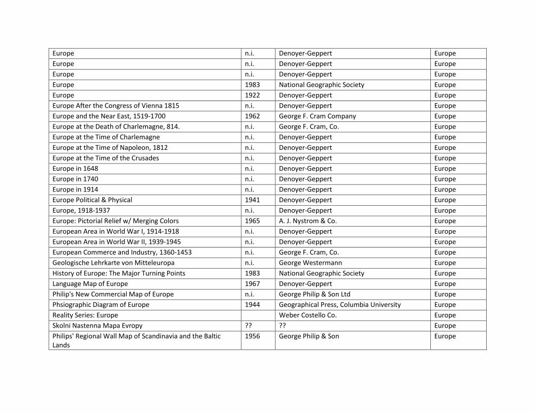
Europe 1983 National Geographic Society Europe
Europe 1922 Denoyer-Geppert Europe
Europe After the Congress of Vienna 1815 n.i. Denoyer-Geppert Europe
Europe and the Near East, 1519-1700 1962 George F. Cram Company Europe
Europe at the Death of Charlemagne, 814. n.i. George F. Cram, Co. Europe
Europe at the Time of Charlemagne n.i. Denoyer-Geppert Europe
Europe at the Time of Napoleon, 1812 n.i. Denoyer-Geppert Europe
Europe at the Time of the Crusades n.i. Denoyer-Geppert Europe
Europe in 1648 n.i. Denoyer-Geppert Europe
Europe in 1740 n.i. Denoyer-Geppert Europe
Europe in 1914 n.i. Denoyer-Geppert Europe
Europe Political & Physical 1941 Denoyer-Geppert Europe
Europe, 1918-1937 n.i. Denoyer-Geppert Europe
Europe: Pictorial Relief w/ Merging Colors 1965 A. J. Nystrom & Co. Europe
European Area in World War I, 1914-1918 n.i. Denoyer-Geppert Europe
European Area in World War II, 1939-1945 n.i. Denoyer-Geppert Europe
European Commerce and Industry, 1360-1453 n.i. George F. Cram, Co. Europe
Geologische Lehrkarte von Mitteleuropa n.i. George Westermann Europe
History of Europe: The Major Turning Points 1983 National Geographic Society Europe
Language Map of Europe 1967 Denoyer-Geppert Europe
Philip's New Commercial Map of Europe n.i. George Philip & Son Ltd Europe
Phsiographic Diagram of Europe 1944 Geographical Press, Columbia University Europe
Reality Series: Europe
Weber Costello Co. Europe
Skolni Nastenna Mapa Evropy ?? ?? Europe
Philips' Regional Wall Map of Scandinavia and the Baltic Lands
1956 George Philip & Son Europe

Atlas ost-und Südosteuropa: Ausstattung der ländlichen Siedlungen in Siebenbürgen mit zentralen Einrichtungen/Atlas of Eastern and Southeasern Europe: Availability of Central Facilities in Rural Settlements of Transylvania
1989 Osterreichisches Ost - und Südosteuropa - Institut
Europe
Atlas ost-und Südosteuropa: Bevölkerungsverteilung in den ländichen Gemeinden Rumäniens ä /Atlas of Eastern and Southeastern Europe: Population Distribuation in the Rural Communes of Romania
1989 Osterreichisches Ost - und Südosteuropa - Institut
Europe
Balkan States 1878-1914- Denoyer Geppert
Europe
Eastern and Germanic Migrations to 486 n.i. George F. Cram Company Europe
Medieval Commerce and Industries n.i. Denoyer-Geppert Europe
Obsequio del Consorcio de Cervecerias "Bavaria" S.A. (Gift of the brewery consortium "Bavaria" S.A.)
1946 n.i. Europe
Osterrich-Ostalpen
Kartographische Anstalt Freytag und Berndt Europe
The Balkan States n.i. Denoyer-Geppert Europe
The Spread of Christianity in the Middle Ages n.i. George F. Cram, Co. Europe
Caesar's Gaul n.i. Denoyer-Geppert Europe
Staaten-und Volkerkarte von Mittel-und Westeuropa n.i. ??? Europe
Westeuropa
Karl Wenschow GmbH Europe
Sever Evropeĭskoĭ Chasti SSSR (uchebnaia carta) Northern European Part of the USSR (School Map)
1948 Glavnoe upravlenie geodezii I kartografii pri Sovte Ministrov SSSR (GUGK) (Head of Office of Geodesy of the Cabinet of Ministers of the USSR) #B120
Europe, northern
Suomi, Finland 1941 Maanmitlaushaalituksen Kartog. (?) Finland
La France 1969 G. Westermann Verlag France
Northern France, Belgium, and the Rhine n.i. Denoyer-Geppert France, Belgium, The Rhine
Aussöhnung im nahen Osten? 1993 Klett-Perthes Germany
Das Reich Des Mittelalters: Kaiser, Fürsten, Städte n.i. Justus Perthes Darmstadt Germany

Deutschalnd Unter der Hitler-Diktatur 1933-1945 (Germany under the Hitler Dictatorship 1933-1945)
1993 Klett-Perthes Germany
Deutsche Demokratische Republik und Westdeutschland n.i. Haack Germany
Deutschland (Germany) n.i. Harms Einheitliches Unterrichtswerk Germany
Deutschland 1273-1437 n.i. Justus Perthes Darmstadt Germany
Deutschland 1428-1555 n.i. Justus Perthes Darmstadt Germany
Deutschland 1555-1648 n.i. Justus Perthes Darmstadt Germany
Deutschland 1648-1739 n.i. Justus Perthes Darmstadt Germany
Deutschland 1740-1801 n.i. Justus Perthes Darmstadt Germany
Deutschland 1789 und Europa bis 1815 1953 Westermann-Geschichiswandkarten? Germany
Deutschland 1790-1871: Der Weg Zur Staatlichen Einigung (Germany 1790-1871: The Road to the State Agreement)
n.i. Justus Perthes Darmstadt Germany
Deutschland 1802-1814 n.i. Justus Perthes Darmstadt Germany
Deutschland 1815-1918 n.i. Justus Perthes Darmstadt Germany
Deutschland Nach Dem 2. Weltkrieg 1945-1975 (Germany after WWII 1945-1975)
n.i. Justus Perthes Darmstadt Germany
Deutschland Seit 1871: Von der Einigung sur Teilung (Germany since 1871: From the Unification to the Division)
n.i. Justus Perthes Darmstadt Germany
Deutschland und angrenzende gebiete (Germany and adjacent areas)
1925
Germany
Deutschland und Italien 1125-1273: Deutschland und Italien im Zeitalter Der Hohenstaufen 1125-1273 (Germany and Italy 1125-1273: Germany and Italy in the Age of the Hohenstaufen 1125-1273)
n.i. Justus Perthes Darmstadt Germany
Die Hanse (The Hanseatic League) n.i. Justus Perthes Darmstadt Germany
Die Landschafsgurtel Der Erde 1958 Haack, Hermann Germany
Die Weimarer Republic 1918-1933 n.i. Justus Perthes Darmstadt Germany
Germany at the Time of the Reformation, 1547 n.i. Denoyer-Geppert Germany
Germany at the Time of the Reformation, 1547 1936 Denoyer-Geppert Co. Germany
Germany: German Text Edition 1929 Denoyer-Geppert Germany

Geschichtlicher Wandatlas (Historic Wall Atlas) Deutschland im Jahre 1789 Staats- und Verwaltungsgrenzen (German state administrative boundaries in 1789)
1952 Atlantik-Verlag Paul List Germany
Growth of Prussia and Modern Germany n.i. Denoyer-Geppert Germany
Kilma-Der Erdee- Climate of the Earth
Justus Perthes (Darmstadt Germany) Germany
Klima Der Erde
Karl Wenschow GmbH Germany
Klimatcheska͡ia karta SSSR (Uchebnai͡a, dlia sredneĭ sckoly) Climatic Map of the USSR (educational (school) for secondary schools)
1954 Glavnoe upravlenie geodezii I kartografii (GUCK) MVD SSSR #B319
Germany
North German Lloyd Bremen: Shipping to all Parts of the World
Germany
Sudasien n.i. Karl Wenschow GmbH Germany
Wandkarte zur Deutschen Geschichte von 911 bis 1125 (Sächsische und Fränkische Kaiser) / Wall Map on German History from 911 to 1125 (Saxon and Frankish Emperors)
n.i. Kartograph Verlagsanstalt von Georg Lang in Leipzig
Germany
Zur Deutschen Geschichte Im 10. U. 11. JH. (On German History In the 10th and 11th century)
n.i. Haack-Gotha? Justus Perthes Darmstadt? Germany
Grand Cayman 1966 Directorate of Overseas Surveys D.O.S. Grand Cayman
Grand Cayman 1965 Directorate of Overseas Surveys D.O.S. Grand Cayman
Ancient Greece n.i. Denoyer-Geppert Greece
Athens 1970 Denoyer-Geppert Greece
Boeotia and Attica 1968 Denoyer-Geppert Greece
Greek and Phoenician Colonies and Commerce n.i. Denoyer-Geppert Greece
Sequence Map of Greece n.i. Denoyer-Geppert Greece
ΚΩΣΤΑ ΓΡΗΓΟYΡΑ ΕΛΛΑΣ (Greece) 1937 Αθηναι (Athena?) Greece
[New map of the Greek Penninsula] 1922? G. Freytag & Berndt Greece
Andhra Pradesh Political n.i. N. C. Kansil & Co India
Bihar, W. Bengal, Assam, Bhutan, Sikkim, Manipur, Tripura, & Nagaland Political and Physical
1968 Vidya Chitr Prakashan India
Buddhist India 1961 Prem Educational Stores India
Central Indian province n.i. N. C. Kansil & Co India

Contains: the Western half the state of the Haryana after 1957
N.C. Kansil & Co India
Dehradun District Map? 1957 A.W. Cornelius/R. Cambray & Co Private Ltd. India
Delhi State 1941 N. C. Kansil & Co India
Golden Period of Ashoka n.i. Orient Educational Stores India
Himachal Pradesh 1957 Commercial Offset Press India
Historical Map of India Rise & Fall of Mahrattas Others During 1662-1823
n.i. Clifton & Co. India
Historical Map of India Rise & Fall of Mahrattas Others During 1662-1823
n.i. Orient Educational Stores India
Illustrated Historical Map of India Ancient and Aryan Period, 5000 B.C. to 500 B.C.
n.i. Vidya Chitr Prakashan India
Illustrated Historical Map of India Gupta Empire 320 A.D. - 500 A.D.
? Vidya Chitr Prakashan India
Illustrated Historical Map of India Rise & Fall of Mohammadans 750 A.D.- 1150 A.D.
n.i. Vidya Chitr Prakashan India
Illustrated Historical Map of India Showing Rise of British Power (1795 A.D.-1835 A.D.
1947 Vidya Chitr Prakashan India
Illustrated Historical Map of India Showing Rise of Mughal Empire 1526 A.D. - 1556 A.D.
n.i. Vidya Chitr Prakashan India
Illustrated Historical Map of India the Mauriyan Empire n.i. Vidya Chitr Prakashan India
India n.i. N. C. Kansil & Co India
India 1398 A.D. Route of Taimurleng's Campaign n.i. Orient Educational Stores India
India Agriculture 1965? Vidya Chitr Prakashan India
India Illustrated Historical Mao Downfall of Pathan Empire 1412 A.D. - 1526 A.D.
n.i. Pustak Mandir India
India Illustrated Historical Map Alexander the Great's Indian Campaign 600 - 323 B.C.
n.i. Pustak Mandir India
India Illustrated Historical Map Ancient & Aryan Period 5000-600 B.C.
n.i. Pustak Mandir India
India Illustrated Historical Map Aryan Period 5000 B.C.-600 B.C.
n.i. N.C. Kansil & Co India

India Illustrated Historical Map British Period 1795 A.D. - 1835 A.D.
1948 N. C. Kansil & Co India
India Illustrated Historical Map Disruption in Rajput Kingdoms 850 A.D.-1030 A.D.
n.i. Pustak Mandir India
India Illustrated Historical Map Gupta Period 300 A.D.-500 A.D.
n.i. N.C. Kansil & Co India
India Illustrated Historical Map Khiliji Empire 1290 A.D. - 1320 A.D.
n.i. Pustak Mandir India
India Illustrated Historical Map Maurya Period 300 B.C.-184 B.C.
n.i. N.C. Kansil & Co India
India Illustrated Historical Map Mogul Period 1500 A.D.-1700 A.D.
n.i. N.C. Kansil & Co India
India Illustrated Historical Map Present Day India 1961ish Pustak Mandir India
India Illustrated Historical Map Rajput India 650 A.D,-850 A.D.
n.i. Pustak Mandir India
India Illustrated Historical Map Rise of British Power 1798 A.D. - 1835 A.D.
n.i. Pustak Mandir India
India Illustrated Historical Map The Empire of Akbar 1556 A.D. - 1605 A.D.
1957 Pustak Mandir India
India Illustrated Historical Map The Empire of Aurangazeb 1605 A.D. - 1707 A.D.
~1950 Pustak Mandir India
India Illustrated Historical Map The Gupta Empire 320 A.D. - 500 A.D.
n.i. Pustak Mandir India
India Illustrated Historical Map The Kushan Empire 72 B.C.-320 B.C.
n.i. Pustak Mandir India
India Illustrated Historical Map The Mauryan Empire 322 B.C. - 185 B.C.
n.i. Pustak Mandir India
India Illustrated Historical Map The Sultanate of Delhi 1030 A.D. - 1290 A.D.
n.i. Pustak Mandir India
India Illustrated Historical Map The Sunga Empire 184 B.C. - 74 B.C.
n.i. Pustak Mandir India
India Illustrated Historical Map Tughlak Empire 1320-1412 A.D.
? Pustak Mandir India

India Illustrated Historical Map, India under British 1855-1947 A.D.
n.i. Pustak Mandir India
India Illustrated Historical Map, Rise of the Mogul, 1526 A.D. - 1556 A.D.
n.i. Pustak Mandir India
India Illustrated History Map The Empire of Harsha 500 A.D. - 650 A.D.
n.i. Pustak Mandir India
India Industries 1965? Vidya Chitr Prakashan India
India Irrigation and Power Projects 1963 Vidya Chitr Prakashan India
India Mean Annual Rainfall 1967 Vidya Chitr Prakashan India
India Minerals 1961 Vidya Chitr Prakashan India
India Natural Vegetation (Forest and Land Uses) 1965 Vidya Chitr Prakashan India
India Pallav, Chalukya and Chaul Empires ? Oriental Educational Stores India
India Population 1965 Vidya Chitr Prakashan India
India Summer Rainfall & Winds 1964 Vidya Chitr Prakashan India
India Winter Rainfall & Winds 1965 Vidya Chitr Prakashan India
India, Pakistan, Burma, Bangladesh and Sri Lanka n.i. Denoyer-Geppert India
India, Pakistan, Ceylon & Burma - Political & Communications 1961 Denoyer-Geppert India
Major Transmission Network of India 2004 International Publications India
Manipur Political 1968 Vidya Chitr Prakashan India
Naga Hills 1957 N. C. Kansil & Co India
Nepal Political 1961 N. C. Kansil & Co India
New Map of Bombay Political n.i. N. C. Kansil & Co India
New Map of Kashmir with Ceasefire Line by U.N.O. n.i. Prem Educational Stores India
New Map of Madras Political 1957 Clifton & Co India
Political Map of India 1956 Brigadier Gambhir Singh, M.I.S. India
Provincial Map of Assam Political n.i. Clifton Co. / N.C. Kansil & Co India
Provincial Map of Orissa Political 1957? Clifton & Co / N. C Kansil & Co. India
Punjab 1957? N.C. Kansil & Co India
Punjab, Haryana, and Himachal Pradesh 1966 Colonel S. K. S. Mudalair India
Railway Map of India 1956 Survey of India, Brigadier Gambhir Singh, M.I.S. India

Rajasthan 1957 ? India
Rajasthan Political 1967 Vidya Chitr Prakashan India
Road Map of India 1956 N. C Kansil & Co. India
Road Map of Madhya Pradesh 1961 Malhotra Book & Stationary Stores India
State Map: Map of Bihar 1957 N.C. Kansil & Co India
Tribal Map of India 1956 N.C. Kansil & Co/ Department of Anthropology, Government of India
India
Uttar Pradesh 1957 ? India
Amritsar District? 1957 N.C. Kansil & Co. India
Ancient Italy n.i. Denoyer-Geppert Italy
General Reference Map of Ancient Italy n.i. George F. Cram Company Italy
Growth of Roman Power in Italy n.i. Denoyer-Geppert Italy
Side one: Italia Politica / Side two: Italia Fisica n.i. Bruno Ghigi Italy
Modern Italy and Central Europe n.i. Denoyer-Geppert Italy & Central Europe
Rome n.i. Denoyer-Geppert Italy, Rome
The City of Rome, about 350 A.D. n.i. George F. Cram, Co. Italy, Rome
Map of Japan n.i. ? Japan
Denoyer-Geppert Visual Relief Series: Japan n.i. Denoyer-Geppert Japan
Denoyer-Geppert Visual Relief Series: Japan 1966 Denoyer-Geppert Japan
Denoyer-Geppert Visual-Relief Series Japan n.i. Denoyer-Geppert Co. Japan
Japan Land Use 1947 Geographical Survey Bureau Japan
Japan population? ? ? Japan
Japan resources? ? ? Japan
Japan Road Map 1963 US Army Map Service Japan
Japan Road Map 1957 U.S. Army Map Service Japan
Japan? ? ? Japan
Japan? n.i. ? Japan
Japan? n.i. ? Japan
Japan? n.i. ? Japan

Japanese Empire n.i. Denoyer-Geppert Co. Japan
The Map of Japan n.i. Heibonsha Co., Ltd. Japan
Southern Japan in 1340? ? ? Japan
Southern Japan? ? ? Japan
Japan in 1664? ? ? Japan
Japan and Korea 2000 Klett-Perthes Japan & Korea
Korea 1945 U.S. Army Korea
Pays Bas- Belgique- Luxemborg 1967 George Westermann Verlag Luxemborg
Alexander's Empire / Rise of Macedonia 359 B.C. - 334 B.C. / Kingdoms of Diadochi About 280 B.C. / Greek Leagues 225 B.C.
n.i. Denoyer-Geppert Macedonia
Malaya, Relief and Communications 1951 George Philips & Son, Ltd. Malaya
3D glasses for the Canyons of Mars 1997 Ambroziak Third Dimension Technologies, Inc. Mars
Map of Cape Cod Massachusetts 1950 F. J. Miller Massacheusetts
Comparative Smaller School Map Mediterranean Lands Physical & Political
1940 George Philip & Son, Limited; Sold and Mounted by Denoyer-Geppert
Mediterranean
Conquest of Mediterranean n.i. Denoyer-Geppert Mediterranean
Denoyer Geppert-Mexico 1967 Visual Relief S67vr
Mexico
Denoyer Geppert-Mexico S67rp
Mexico
Mexico 1947 Denoyer Geppert Co. Mexico
Denoyer Geppert Mexico, Central America & West Indies Visual Relief Mexico, Central America, W. Indies
A. J. Nystrom-Mexico, Central America, & West Indies 1966
Mexico, Central America, W. indies
Topographic Map of Meseong State of Chuuk (Formerly Truk) Federated States of Micronesia
1996 U.S. Geological Survey Micronesia
Topographic Map of Tol South State of Chuuk (Formerly Truk) Federated States of Micronesia
1996 U.S. Geological Survey Micronesia
Mediterranean and Middle East 1976 Westermann Middle East

Middle East 2000 Klett-Perthes Middle East
The Middle East 1958 John Bartholomew & Son Middle East
The Middle East 1956
Middle East
Mongolia and Adjacent Regions 1942 American Museum of Natural History Mongolia
Topographic Map of Glacier National Park Part of Waterton-Glacier International Peace Park Montana
1951 U.S. Geological Survey Montana
Ginn Moon Map 1967 Ginn and Company Moon
Ginn Moon Map 1967 Ginn and Company Moon
New England 1927 Denoyer-Geppert Co. Nepal
D'Entrecarteaux Islands New Guinea 1960s Aeronautical Chart and Information Center, U.S. Air Force
New Guinea
Denoyer Geppert-Austrailia-New Zealand Physical/Political 14010
New Zealand
Map of Newfoundland 1925 Government of Newfoundland Newfoundland
Map of Newfoundland Complied from the Most Recent Surveys
1925 Government of Newfoundland Newfoundland
Map of Newfoundland, compiled by the Most recent Surveys 1925 Government of Newfoundland Newfoundland
Aboriginal Map North America, drawing the Boundaries and the Locations of various Indian Tribes
n.i. Select Committee on the Hudson Bay's Committee
North America
Physical/Political North America
North America
North America n.i. Relief-Technik North America
North America 1922 Denoyer-Geppert Co. North America
North America
Karl Wenschow GmbH North America
North America 1951 George Phillip & Son North America
North America
Haack, Hermann North America
North America (top half) 1922 Denoyer-Geppert North America
North America: Pictorial Relief w/ Merging Colors
A J. Nystrom & Co. North America
Schulwandkarte von Nord-Amerika n.i. G. Freytag & Berndt North America
Schulwandkarten: Nord-Amerika n.i. Verlag List & von Bressensdorf North America
The North America Tapestry of Time and Terrain 2003 U.S. Geological Survey North America
Vegetation of North America 1920 Rand McNally North America
A Tapestry of Time and Terrain 2000 U.S. Geological Survey North America

Physical-Political Pacific Area 1961 Denoyer-Geppert Pacific Ocean
Maybe Pakistan, ????
Pakistan
Pakistan 2002 The Survey of Pakistan Offices Pakistan
Mapa del Peru 1938 Servicio Geografico del Ejercito, Lima Peru
Map of the City of Manilla and Suburbs 1961 J.M. Azucena Publishing Co. Philippines
Philippine Islands 1944 U.S. Army Map Service Philippines
Philippine Islands 1941 Coast and Geodetic Survey Philippines
Philippine Islands, Philippine Education Co. n.i. A.J. Nystrom & Co, Chicago Philippines
Mapa Scienna Polski I krajow osciennych n.i. ?? Poland
Epic India Ramanyana Period & Mahabharta Period n.i. Prem Educational Stores Portugal
Espana y Portugal n.i. ?? Portugal
Brandenburg-Preussen Bis 1807 (Brandenburg-Prussia in 1807)
n.i. Justus Perthes Darmstadt Prussia
Preussen 1915-1945 (Prussia 1915-1945) n.i. Justus Perthes Darmstadt Prussia
Irrigation Department Punjab General Map 1946
Punjab
Irrigation Works Punjab
Punjab
Growth of Russia 1462-1939 n.i. Denoyer-Geppert Russia
Philips' Regional Wall Map of East Africa 1960 George Philip & Son Scandinavia
Srba, Hrvata I Slovenaca 1921? G. Freytag & Berndt Slovenia
A Map of Basutoland n.i. Sunlight Soap? South Africa
Bantu Areas within the Republic of South Africa 2003 George Philip and Map Studio South Africa
Bantu Areas within the Republic of South Africa 1985 George Philip and Map Studio South Africa
Barbarian Migrations n.i. Denoyer-Geppert South Africa
Basutoland 1956 Directorate of Colonial Surveys, D.C.S. 21 South Africa
Basutoland (with part of Union of South Africa) 1956 Directorate of Colonial Surveys, D.C.S. 21 South Africa
Denoyer-Geppert Series: South America 1931 Denoyer-Geppert South America
People of Sout America
Denoyer Geppert Co. South America
Political South America 1962 Denoyer-Geppert South America
South America 1967 Denoyer-Geppert South America
South America n.i. Denoyer-Geppert South America

South America 1922 Denoyer-Geppert South America
South America 1988 National Geographic Society South America
South America 1990 Justus Perthes Darmstadt South America
South America
A. J. Nystrom & Co. South America
South America- Phillips Comparative Series of Large School Maps
1944 George Phillip & Son South America
South America: Pictorial Relief w/ Merging Colors
A. J. Nystrom & Co. South America
Sudamerika
Karl Wenschow GmbH South America
Traders' Map of South America 1915 General Drafting Co. South America
Sowjetunion 1980 Haack Soviet Union
Mapa Geologico de Espana 1932 ?? Spain
Spanien und Portugal 1966 Gotha: Haack Spain & Portugal
Schweitz 1971 Gotha: Haack Switzerland
Suisse Schweiz Svizzera (Switzerland: [Physical with political borders])
1948 Hermann Kümmerly Switzerland
Mongul-Turkish Conquests, Eastern Trade Routes n.i. Oriental Educational Stores Turkey
No title, Easttern USA 1949 Denoyer Geppert Co. United States
Pacific Northwest
A. J.. Nystrom & Co. United States
A Physiographic Diagram of the United States
A. J. Nystrom & Co. United States
Denoyer Geppert Relief-Like Series: United States 1957 Denoyer Geppert Co. United States
Geologic Map of the United States 1960 USGS United States
Hearne Brothers Official Map of These United States n.i. Hearne Brothers United States
Lloyd's New Map of the United States The Canadas And New Brunswick From the latest Surveys Showing Every Railroad & Station Finished to June 1863 And The Atlantic And Gulf Coasts
1863 J.T. Lloyd United States
Origin & Distribution of U. S. Soils 1946 Donald J. Belcher & Assoc. United States
Physical/ Political United States
Denoyer Geppert Co. United States

Space Portrait U.S.A.: The First Color Photomosaic of the Contiguous United States
1976 General Electric/National Geographic Society/National Aeronautics and Space Administration
United States
The United States 1987 National Geographic Society United States
United States 1965 U.S. Geological Survey United States
United States and Possessions 1922 Denoyer-Geppert United States
United States including Territories and Insular Possessions 1927 U.S. Geological Survey United States
United States Landform Sculptural Relief
A. J. Nystrom & Co. United States
Canadian History Series Ch. 5 The United States-Union and Unity
n.i. Denoyer-Geppert Co. United States
Country in Flames, 1861-1865- Rand McNally
United States
Afro-American Historical Population Development
Hearne Bros. United States
Cape Cod from Space n.i. Spaceshots Inc. United States
Colonial Expansion in the Americas 1700s and 1763 & Spain's Northern Frontier 1763-1800 / Expansion Colonial en Las Americas 1700y 1763 & Frontera Española Del Norte
n.i. Denoyer-Geppert United States
General Railway Map 1920 National Railway Publication Co. United States
Map of that portion of Her Majesty's Colonies of New Brunswich and Lower Canada The Title to which is disputed by the government of the U.States with parts of the Adjaccent country
n.i. n.i. United States
one side: Engineer's Official Map San Francisco; other side: Engineer's Official Map Oakland Berkley - Alameda Piedmont, Emeryville Albany, San Leandro Hayward
1960 W. Elliot Judge/W. Campbell Judge United States
Our America: Backgounds & Development Spanish Exploration 1492
1967 Denoyer Geppert Co. United States
The Geographic Face of the Nation-Elevation 2004 U.S. Geological Survey United States
United States with Mexico 1967 Denoyer-Geppert Co. United States & Mexico
Boston from Space 1997 Spaceshots Inc. United States, Boston

Cram's Street Map of Greater Boston (260 Square miles) 1931 George F Cram Company United States, Boston
Cram's Street Map of Greater Boston (280 Square miles) 1939 George F Cram Company United States, Boston
California Physical and Political 1940 Denoyer-Geppert United States, California
Denoyer Geppert Series: Polar Air Age World 1949 Denoyer Geppert Co. United States, California
Denoyer Geppert Visual Relief Series- California 1963 Denoyer Geppert & Co. United States, California
Township and County Map of the Central part of California, Exhibiting the U.S. Land Survey, Schools, Land Districts, Post Offices, Roads and Railroads, Towns, Townships, Cities and Diagrams of the Same. Ranches or Farms and Proprietors Thereof. Rivers, Creeks, Lakes, Mountains, Ditches, Bridges, Ferries, Dams and Tunnels, Placer and Quartz Diggings. Mill, Lodes, or Veins. Ancient Streams or Gravel, and Bedrock Ranges.
n.i. Pacific Map Depot. United States, California
California, Nevada n.i. Relief-Technik United States, California, Nevada
San Diego and Vicinity 1953 U.S. Geological Survey United States, California, San Diego
Map of the British Possessions in North America shewing the manner in which it is intended to direct the trade of Canada to Portland and Boston in the United States
n.i. The House of Commons United States, Canada
Colorado-Jeppeson Natural Color Relief Map 1957 Denver: The Co. United States, Colorado
Denver from Space 1998 Eurimage - Eosat United States, Colorado
A Map of Connecticut from Short Beach to Sachem's Head: Drawn Especially to Show all Mosquito Drainage Ditches
1937 Floyd A Odell United States, Connecticut
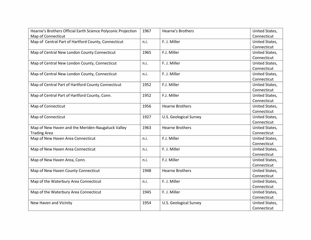
Hearne's Brothers Official Earth Science Polyconic Projection Map of Connecticut
1967 Hearne's Brothers United States, Connecticut
Map of Central Part of Hartford County, Connecticut n.i. F. J. Miller United States, Connecticut
Map of Central New London County Connecticut 1965 F.J. Miller United States, Connecticut
Map of Central New London County, Connecticut n.i. F. J. Miller United States, Connecticut
Map of Central New London County, Connecticut n.i. F. J. Miller United States, Connecticut
Map of Central Part of Hartford County Connecticut 1952 F.J. Miller United States, Connecticut
Map of Central Part of Hartford County, Conn. 1952 F.J. Miller United States, Connecticut
Map of Connecticut 1956 Hearne Brothers United States, Connecticut
Map of Connecticut 1927 U.S. Geological Survey United States, Connecticut
Map of New Haven and the Meriden-Naugatuck Valley Trading Area
1963 Hearne Brothers United States, Connecticut
Map of New Haven Area Connecticut n.i. F.J. Miller United States, Connecticut
Map of New Haven Area Connecticut n.i. F. J. Miller United States, Connecticut
Map of New Haven Area, Conn. n.i. F.J. Miller United States, Connecticut
Map of New Haven County Connecticut 1948 Hearne Brothers United States, Connecticut
Map of the Waterbury Area Connecticut n.i. F. J. Miller United States, Connecticut
Map of the Waterbury Area Connecticut 1945 F. J. Miller United States, Connecticut
New Haven and Vicinity 1954 U.S. Geological Survey United States, Connecticut

Official Hearne Brothers Polyconic Projection Map of New Haven and the Meriden-Naugatuck Valley Trading Area
1961 Hearne Brothers United States, Connecticut
Official Hearne Brothers Polyconic Projection Map of New Haven County Connecticut
1953 Hearne Brothers United States, Connecticut
Official Hearne Brothers Polyconic Projection Map of New Haven County Connecticut
1953 Hearne Brothers United States, Connecticut
State of Connecticut Highway Department 1954 United States Geological Survey United States, Connecticut
Georgia
A. J. Nystrom & Co. United States, Georgia
Indiana 1968 Denoyer Geppert Co. United States, Indiana
Iowa Physical/Political Map
A.J. Nystrom & Co. United States, Iowa
Kentucky & Tennessee
A. J. Nystrom & Co. United States, Kentucky & Tennessee
Louisiana
A.J. Nystrom & Co. United States, Louisiana
Presque Isle, Aroostook County Maine. n.i. Gev. E. Norris, Pub. United States, Maine
Map of Cape Cod, Mass. 1963 F. J. Miller United States, Massachusetts
Map of Cape Cod, Mass. 1965 F. J. Miller United States, Massachusetts
Map of Cape Cod, Massachusetts 1958 F.J. Miller United States, Massachusetts
Map of Massachusetts n.i. Hearne Brothers United States, Massachusetts
Map of the Central Part of Hampden County Massachusetts 1957 F.J. Miller United States, Massachusetts
Map of Surface Formations of Southern Peninsula of Michigan
1955 Dept. of Conservation, Geol. Survey Division United States, Michigan

Michigan
A. J. Nystrom & Co. United States, Michigan
Minneapolis, St. Paul and Vicinity 1952 U.S. Geological Survey United States, Minneapolis
Duluth, Superior, and Vicinity, Minn. - Wisc. 1954 U.S. Geological Survey United States, Minnesota Wisconsin
Physical and Political Nebraska
Denoyer Geppert Co. United States, Nebraska
Soil Map Lancaster County Nebraska
University of Nebraska United States, Nebraska
Official Hearne Brothers Polyconic Projection Map of New Hampshire
1956 Hearne Brothers United States, New Hampshire
The State of New Jersey Surface Geology 1878 Geological Survey of New Jersey United States, New Jersey
Map of British Honduras 1938 George Philip & Son United States, New York
Map of Broome County New York 1930 Dolph & Stewart United States, New York
Map of the City of Mount Vernon, Westchester County, New York
1923 Walter A. Miles United States, New York
Map of Westchester and Putnam Counties, New York, also Adjacent Part of Fairfield County Connecticut
1924 Dolph & Stewart United States, New York
New York
A. J. Nystrom & Co. United States, New York
Physical and Political New York 1939 Denoyer-Geppert Series United States, New York
Denoyer Geppert Visual Relief Series: North Carolina 1961 Denoyer Geppert Co. United States, North Carolina
Ecoregions of Oklahoma 2005 U.S. Environmental Protection Agency United States, Oklahoma
Forest Type Map State of Oregon (Northwest Quarter) 1936 U.S. Geological Survey United States, Oregon

Forest Type Map State of Oregon (Southwest Quarter) 1936 U.S. Geological Survey United States, Oregon
Geologic Map of Pennsylvania 1960 Williams & Heintz United States, Pennsylvania
Map of Dauphin Co Pennsylvania 1962 S.N. & F.W. Beers United States, Pennsylvania
Pennsylvania
A. J. Nystrom & Co. United States, Pennsylvania
Political Map of Pennsylvania and New Jersey & Physical Map of Pennsylvania and New Jersey
1936 Denoyer-Geppert Co. United States, Pennsylvania
Regional Plan for the Philadelphia Tri-State District 1931 Regional Planning Federation of the Philadelphia Tri-State District
United States, Philadelphia
Portland, Oregon and Vicinity n.i. Pittman United States, Portland Or
Map of Providence, R.I. Area 1959 F. J. Miller United States, Rhode Island
Map of the Providence Area 150 Squares Miles Including North Providence, East Providence, Pawtucket, Cranston, Central Falls, Johnston, W. Warwick, Warwick
n.i. Miller & Lord United States, Rhode Island
Official Hearne Brothers Polyconic Projection Map of Rhode Island and Providence Plantations
1956 Hearne Brothers United States, Rhode Island
Official Hearne Brothers Polyconic Projection Map of the State of Maine
1956 Hearne Brothers United States, Rhode Island
Spokane and Vicinity 1950 U.S. Geological Survey United States, Spokane Washington
Salt Lake and Vicinity 1950 U.S. Geological Survey United States, Utah, Salt Lake City
Forest Type Map State of Washington 1936 U.S. Department of Agriculture - Forest Service United States, Washington
Mount St. Helens! Volcanoes! 2001 U.S. Geological Survey United States, Washington

Mount St. Helens! Volcanoes! 2001 U.S. Geological Survey United States, Washington
A. J. Nystrom-Wisconsin IPS48
United States, Wisconsin
Diagram Showing Directions of Movement S.E. Wisconsin 1918 USGS United States, Wisconsin
Geological Map of SE Wisconsin 1917 USGS United States, Wisconsin
Map of Southeastern Wisconsin 1918 USGS United States, Wisconsin
Surficial Deposits in SE Wisconsin 1918 USGS United States, Wisconsin
Visual-Relief Wisconsin 1966 Denoyer-Geppert United States, Wisconsin
Wisconsin 1961 Denoyer Geppert Co. United States, Wisconsin
Wisconsin
Denoyer Geppert Co. United States, Wisconsin
[Written in non-Roman alphabet] 1959 ?? Unsure
Charles V, 1519-1556 n.i. Denoyer-Geppert Unsure
Christians and Mohammedans in 1600 1963 George F. Cram, Co. Unsure
Facsimile of a plan, c. 1597, in the possession of Earl de la Warr OR [A Geographicall description of the Manors of Buckhurst Bolbrooke, parcell of the possessions of the right honorable Sir Thomas Sackville [k]night Lord Buckhurst. [By Thomas Marshall gent., Auditor and Surveighor, etc]
1932 Sussex Record Society Unsure
Mapa de las Colonias y del Trafico Internacional [1924] G. Freytag & Berndt Unsure
Precipitations Annuelles n.i. A.-H. Debouverie Unsure
Relationships of the Animal Kingdom n.i. n.i. Unsure
Struggle For a Continent 1689-1800 n.i. Denoyer-Geppert Unsure
Mapa de la Republica Oriental del Uruguay 1903 ?? Uraguay
Union of Soviet Socialist Republics and Adjacent Lands n.i. Denoyer-Geppert USSR

Битва 3А Днепр (Battle of the Dnieper) 1980 Glavnoe upravlenie geodezii I kartografii pri Sovte Ministrov SSSR (GUGK) (Head of Office of Geodesy of the Cabinet of Ministers of the USSR) #И-2525
USSR
Битва 3А Кавка3 (The Battle for the Caucasus) 1980 Glavnoe upravlenie geodezii I kartografii pri Sovte Ministrov SSSR (GUGK) (Head of Office of Geodesy of the Cabinet of Ministers of the USSR) #И-2521
USSR
Партия Большевиков В Годы Первой Мировой Войны (Август 1914- февраль 1917) (The Bolshevik Party in the Years of the First World War (August 1914-Feburary 1917))
1983 Glavnoe upravlenie geodezii I kartografii pri Sovte Ministrov SSSR (GUGK) (Head of Office of Geodesy of the Cabinet of Ministers of the USSR) #Д-1431
USSR
Партия Большевиков В Революции 1905-1907 гг. (The Bolshevik Party Revolution 1905-1907)
1983 Glavnoe upravlenie geodezii I kartografii pri Sovte Ministrov SSSR (GUGK) (Head of Office of Geodesy of the Cabinet of Ministers of the USSR) #Б-3006
USSR
Поволжье (The Volga Region) 1954 Glavnoe upravlenie geodezii I kartografii (GUGK) MVD SSSR (Dept of Internal Affairs) #V-384
USSR
Сталинградская Битва (Battle of Stalingrad ) 1982 Glavnoe upravlenie geodezii I kartografii pri Sovte Ministrov SSSR (GUGK) (Head of Office of Geodesy of the Cabinet of Ministers of the USSR) #Г-2787
USSR
Pittmon Map of Utah 1949 Pittmon Utah
Expansion of the Roman Empire n.i. George F. Cram Company World
Holy Roman Empire in the 10th and 11th Centuries n.i. Denoyer-Geppert World
Roman Empire n.i. Denoyer-Geppert World
The Roman World 14 A.D. n.i. George F. Cram Company World
General Reference Map of the Roman World 1957 George F. Cram, Co. World
Ancient Empires n.i. George F. Cram Company World
Ancient World Race Distribution About 250 B.C. n.i. Denoyer-Geppert World
Campaigns and Empires of Alexander n.i. George F. Cram, Co. World
Denoyer Geppert Map Reading Series Hemisphere Projections
1943 Denoyer Geppert Co. World

Denoyer Geppert Map Reading Series: Conic Projections 1943 Denoyer Geppert Co. World
Die Alte Welt n.i. Haack World
Distribution Geographique des Densites de Population n.i. A.-H. Debouverie World
Expansion of Islam 622-750 1968 Orient Educational Publishers World
League of Nations 1920-1930 n.i. Denoyer-Geppert world
Photocopy of a Facsimile of the Mappemonde de Sébastien Cabot 1544
1941 Rutgers University Press World
Rise and Growth of Christianity to 325 A.D. 1957 George F. Cram, Co. World
The Achaean World 1500-1200 B.C. n.i. Denoyer-Geppert World
The Ancient Peoples n.i. George F. Cram, Co. World
The Crusades n.i. Denoyer-Geppert World
U.S. Air Force Global Air Distance Chart 1959 U.S. Air Force World
Vegetationsgebiete der Erde 1953 Georg Westermann World
Air Age World n.i. Denoyer-Geppert World
Cartocraft Slated World
Denoyer Geppert Co. World
Copy to scale of a rare facsimile of Martin Behaim's 1492 globe, printed by George Philip & Son, London, 1908
1986 National Geographic Society World
Copy to scale of a rare facsimile of Martin Behaim's 1492 globe, printed by George Philip & Son, London, 1908
1986 National Geographic Society World
Hagstrom's Map of the World 1939 Hagstrom Company, Inc. World
Map of the Mineral Deposits of the World n.i. Verlag von Dietrich Reimer World
Map of the Mineral Deposits of the World n.i. ?? World
Map of the World, Peters Projection 1993 Oxford Cartographers World
Oil & Gas Resources of the World 2001 Oilfield Publications Limited World
Philips' Smaller School-Room Map of the World 1978 Denoyer-Geppert World
Physical-Political World 1961 Denoyer-Geppert World
Physische Erdkarte (Physical Map of the World)
Karl Wenschow GmbH World
Political World n.i. Denoyer-Geppert World
Predominant World Economies n.i. Denoyer-Geppert World
Relief-Like Map of the World n.i. Denoyer-Geppert World

The World 1986 National Geographic Society World
The World Density of Population 1966 G. Westermann Verlag World
The World in 1914 n.i. Denoyer-Geppert World
The World in 1965 n.i. Denoyer-Geppert World
The World Physical 1968 George Westermann Verlag World
W & A.K. Johnston's "Effective" Maps of the World - Land Utilization
n.i. W & A.K. Johnston & G.W. Bacon World
World n.i. Rand McNally World
World
A. J. Nystrom & Co. World
World - Climate n.i. Denoyer-Geppert World
World 1918-1937 n.i. Denoyer-Geppert World
World Commercial 1941 Denoyer-Geppert World
World Exploration and Discovery From mid-13th Through Early 20th Centuries
n.i. Denoyer-Geppert World
World History Map No. 1 Ancient Civilization & Trade Routes n.i. N.C. Kansil & Co World
World History Map No. 2 Development of Oriental Empires, Alexander, Asoka, Roman and Persian Empires (1000 B.C. - 50 A.D.)
n.i. N.C. Kansil & Co World
World History Map No. 3 Growth of Christianity Budhism and Islam Europe at the Age of Charlemagne (50 A.D.-814 A.D.)
n.i. N.C. Kansil & Co. World
World Population and Cultural Patterns 1967 Denoyer-Geppert World
World Relations Natural Vegetation with January Currents 1978 Denoyer-Geppert World
World Relations Relief of Land 1971 Denoyer-Geppert World
World Relations Temperature 1978 Denoyer-Geppert World
World Soils n.i. Denoyer-Geppert World
World-Relations Annual Rainfall - Range of Temperature & July Currents
1978 Denoyer-Geppert World
World-Relations Climate May 1 - Oct. 31 (Northern Summer - Southern Winter)
1973 Denoyer-Geppert World
World-Relations Climate Nov. 1 - April 30 (Northern Winter - Southern Summer)
1978 Denoyer-Geppert World

World-Relations Density of Population 1978 Denoyer-Geppert World
World-Relations Occupations and Principal Air Routes n.i. Denoyer-Geppert World
Fnr Jugoslavija 1961 ?? Yugoslavia