walkability in historic urban spaces: testing the …
TRANSCRIPT
Khairi M. A. Abdulla, Mohamed Gamal Abdelmonem, Gehan Selim Archnet-IJAR, Volume 11 - Issue 3 - November 2017 - (163-177) – Regular Section
Copyright © 2017 | Copyrights are granted to author(s), Archnet-IJAR, and Archnet @ MIT under the terms of the "CC-BY-NC-ND" License.
163
Archnet-IJAR: International Journal of Architectural Research www.archnet-ijar.net/ -- https://archnet.org/collections/34
WALKABILITY IN HISTORIC URBAN SPACES: TESTING THE SAFETY AND SECURITY IN MARTYRS' SQUARE IN TRIPOLI DOI: http://dx.doi.org/10.26687/archnet-ijar.v11i3.1378
Khairi M. A. Abdulla, Mohamed Gamal Abdelmonem, Gehan Selim
Keywords
Abstract
walkability; safety and security; open space; historical space
Much of the built environment design literature focuses on a composite of walkable spaces variables such as density, diversity, and destination accessibility. One of the most effective factors in walkability is “safety and security”. There is an evident gap in understanding the perceived ability of Libyan public spaces to support walkability. This paper aims to investigate the effectiveness of “walkability” in traditional Libyan urban spaces and analyse the relationship between walking, a safe and secure environment, and its impact on a heritage site in Tripoli city centre. The perceived personal safety of 140 users of the heritage site “Martyrs' Square” were measured; this research is studying the quality of environment and users’ interaction with their environmental issues relating to the study area. Mixed methods were used in this research: this study used both quantitative and qualitative methods to gather information; the quantitative took the form of a questionnaire; and the qualitative took the form of observations. Analysis of quantitative data was conducted with SPSS software; the survey was conducted from August 2016 to September 2016. The results of this study are useful for urban planning, to classify the walkable urban space elements, which could improve the level of walkability in Libyan cities and create sustainable and liveable urban spaces.
Khairi M. A. Abdulla*, Mohamed Gamal Abdelmonem, Gehan Selim
K. M. A. Abdulla, Nottingham Trent University, UK M. G. Abdelmonem, Chair in Architecture, Nottingham Trent University, UK. G. Selim, Lecturer in Architecture, University of Leeds, Leeds, UK.
*Corresponding Author’s email address: [email protected]
ArchNet-IJAR is indexed and listed in several databases, including: • Avery Index to Architectural
Periodicals • EBSCO-Current Abstracts-Art
and Architecture • CNKI: China National
Knowledge Infrastructure • DOAJ: Directory of Open
Access Journals • Pro-Quest • Scopus-Elsevier • Web of Science
International Journal of Architectural Research
Khairi M. A. Abdulla, Mohamed Gamal Abdelmonem, Gehan Selim Archnet-IJAR, Volume 11 - Issue 3 - November 2017 - (163-177) – Regular Section
Copyright © 2017 | Copyrights are granted to author(s), Archnet-IJAR, and Archnet @ MIT under the terms of the "CC-BY-NC-ND" License.
164
INTRODUCTION
Walkability and city design have both been studied for a long time, with notable works including The Life and Death of Great American Cities (Jacobs, 1961) followed by Cook (1980), while Gehl (1989) was the first researcher to use walkable streets, street activity and city vitality as an index of successful and growing urban areas. Their approaches towards urban design of communities was not only limited to the design of outside spatial characteristics, but also the activities that happen there. Various studies acknowledge that the level of walkability and other physical activities is positively associated with specific open space design qualities. In the USA, walking is the most common form of physical activity, with national estimates indicating roughly 42% of adults walk during leisure time and 28% walk for transportation purposes in periods of at least 10 min (Kruger et al., 2008).
Child and Falconer (2015) reported that improvements to public spaces could increase footfall and trading by up to 40%, with users of open spaces being more physically active if provided with accessible, safe and attractive areas for exercise, as observed in some walkways used by residents of cities. There are several categories to determine the quality and attractiveness of walkability in public spaces in Libyan cities, most of important of which is safety (Abdulla et al., 2017). This research explores the relationship between safety and walkability in heritage spaces, and how safety-security affects walkability in historic urban spaces, in the context of Tripoli, Libya. It examines the concept of walkability in heritage public spaces within the urban context of Libyan cities. Additionally, the study explores the relationship between safety-security and aspects of the built environment, focusing in particular on the walkability of heritage spaces as determined by the mix of land uses.
Ewing and Cervero (2010) refer to over 200 studies in the relationship between the built environment and travel, as well as more than 13 literature reviews and 2 meta-analyses. (Badoe and Miller, 2000; Cao et al., 2009; Cervero and Duncan, 2003; Crane, 2000; Ewing and Cervero, 2001, 2010; Handy et al., 2005; Heath et al., 2006; McMillan, 2005, 2007; Pont et al., 2009; Saelens et al., 2003; Saelens and Handy, 2008; Leck, 2006). There are different motivations for walking that require different elements from the built environment (Zuniga-Teran et al., 2017). Two primary motivations for walking have been identified by behavioural scientists: recreation, and transportation (Giles-Corti et al., 2005; Saelens and Handy, 2008). Cubukcu (2013) illustrated seven groups of elements from a review of literature that can make a place walkable: land use safety; traffic; crime rate; ease in walking and cycling; accessibility; environmental aesthetics, and others associated with social relations in open places.
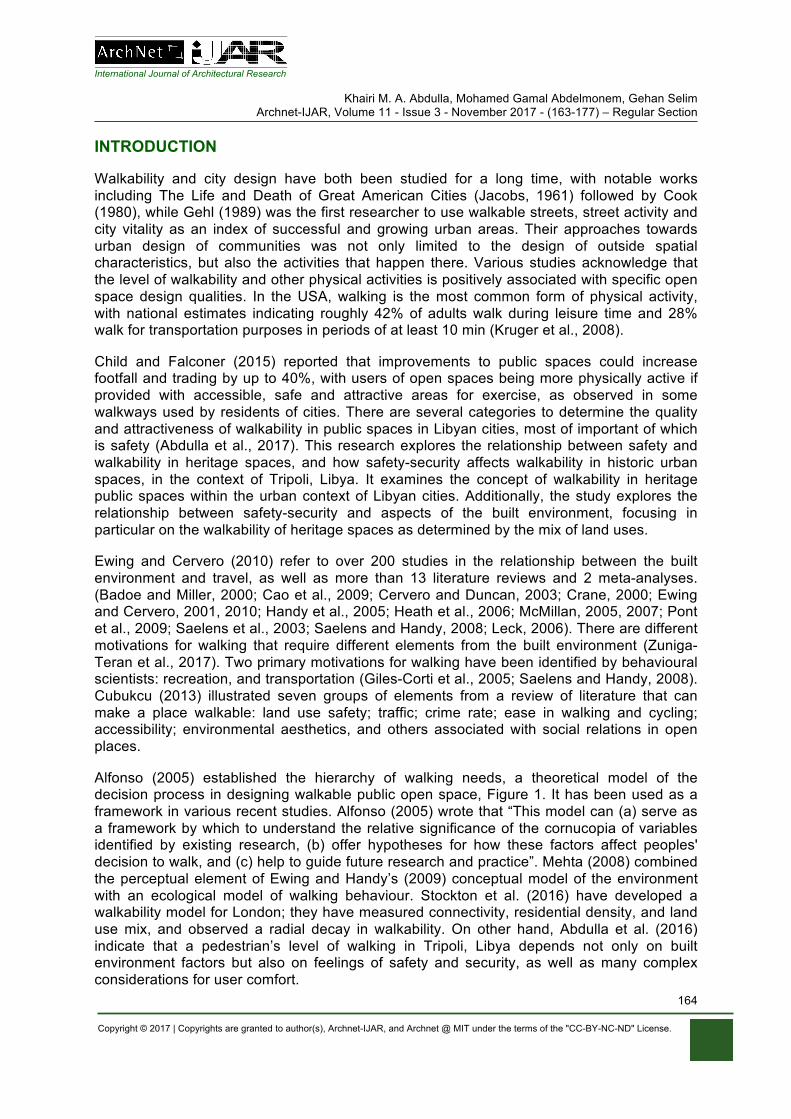
Alfonso (2005) established the hierarchy of walking needs, a theoretical model of the decision process in designing walkable public open space, Figure 1. It has been used as a framework in various recent studies. Alfonso (2005) wrote that “This model can (a) serve as a framework by which to understand the relative significance of the cornucopia of variables identified by existing research, (b) offer hypotheses for how these factors affect peoples' decision to walk, and (c) help to guide future research and practice”. Mehta (2008) combined the perceptual element of Ewing and Handy’s (2009) conceptual model of the environment with an ecological model of walking behaviour. Stockton et al. (2016) have developed a walkability model for London; they have measured connectivity, residential density, and land use mix, and observed a radial decay in walkability. On other hand, Abdulla et al. (2016) indicate that a pedestrian’s level of walking in Tripoli, Libya depends not only on built environment factors but also on feelings of safety and security, as well as many complex considerations for user comfort.
International Journal of Architectural Research
Khairi M. A. Abdulla, Mohamed Gamal Abdelmonem, Gehan Selim Archnet-IJAR, Volume 11 - Issue 3 - November 2017 - (163-177) – Regular Section
Copyright © 2017 | Copyrights are granted to author(s), Archnet-IJAR, and Archnet @ MIT under the terms of the "CC-BY-NC-ND" License.
165
FEASIBILITY
ACCESSIBILITY
SAFETY
COMFORT
PLEASURABILITY
LIMITS
URBAN FORMS
Figure 1. The concept of hierarchy of walking needs (Source: Alfonso, 2005).
ASPECTS OF WALKABILITY IN PUBLIC OPEN SPACES
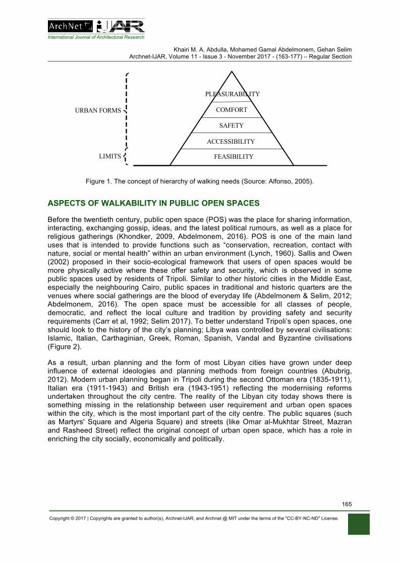
Before the twentieth century, public open space (POS) was the place for sharing information, interacting, exchanging gossip, ideas, and the latest political rumours, as well as a place for religious gatherings (Khondker, 2009, Abdelmonem, 2016). POS is one of the main land uses that is intended to provide functions such as “conservation, recreation, contact with nature, social or mental health” within an urban environment (Lynch, 1960). Sallis and Owen (2002) proposed in their socio-ecological framework that users of open spaces would be more physically active where these offer safety and security, which is observed in some public spaces used by residents of Tripoli. Similar to other historic cities in the Middle East, especially the neighbouring Cairo, public spaces in traditional and historic quarters are the venues where social gatherings are the blood of everyday life (Abdelmonem & Selim, 2012; Abdelmonem, 2016). The open space must be accessible for all classes of people, democratic, and reflect the local culture and tradition by providing safety and security requirements (Carr et al, 1992; Selim 2017). To better understand Tripoli’s open spaces, one should look to the history of the city’s planning; Libya was controlled by several civilisations: Islamic, Italian, Carthaginian, Greek, Roman, Spanish, Vandal and Byzantine civilisations (Figure 2).
As a result, urban planning and the form of most Libyan cities have grown under deep influence of external ideologies and planning methods from foreign countries (Abubrig, 2012). Modern urban planning began in Tripoli during the second Ottoman era (1835-1911), Italian era (1911-1943) and British era (1943-1951) reflecting the modernising reforms undertaken throughout the city centre. The reality of the Libyan city today shows there is something missing in the relationship between user requirement and urban open spaces within the city, which is the most important part of the city centre. The public squares (such as Martyrs' Square and Algeria Square) and streets (like Omar al-Mukhtar Street, Mazran and Rasheed Street) reflect the original concept of urban open space, which has a role in enriching the city socially, economically and politically.
International Journal of Architectural Research
Khairi M. A. Abdulla, Mohamed Gamal Abdelmonem, Gehan Selim Archnet-IJAR, Volume 11 - Issue 3 - November 2017 - (163-177) – Regular Section
Copyright © 2017 | Copyrights are granted to author(s), Archnet-IJAR, and Archnet @ MIT under the terms of the "CC-BY-NC-ND" License.
166
Figure 2. The three-character areas in Tripoli’s city centre: Old Town, Italian Quarter and Garden City, (Source: Remali et al, 2015).
SAFETY AND SECURITY IN PUBLIC OPEN SPACES
Numerous researchers (Echeverria et al., 2004; Kerr et al., 2015; Loukaitou-Sideris and E. Eck, 2007; Abdul Karim and Azmi, 2013) have reviewed the mixed findings regarding the association between walkability and safety-security. Few studies have focused on specific segments of safety-security as the main factor of walkable public spaces. Safety-security in public spaces has become a central concern in cities around the world, specifically with the rise of ethnic, religious, race, and immigration conflict, but in places of armed conflict there has not been enough study. As one of the basic needs, safety needs come right after psychological ones are relatively satisfied (Maslow, 1970). If safety needs are not met properly, then fear comes to the forefront (Tandogan and Ilhan, 2016). Tulu et al. (2013) argued that in developing countries, pedestrian safety is affected by existing conditions such as lack of crossings, the lack of separation between pedestrians and vehicles in busy roads, the presence of roadside vendors, and the combination of poor street lighting and high proportions of pedestrians walking at night.
Safety is considered the most important factor when valuing public spaces, because the perceived safety has a strong influence on the decision by the individual to use the space, or to avoid it (Mehta, 2014). Nasution and Zahrah (2012) agreed that a successful public open space should augment people’s safety. Social interactions in public open spaces in city centres can be increased directly by installing big public displays like digital boards that act

International Journal of Architectural Research
Khairi M. A. Abdulla, Mohamed Gamal Abdelmonem, Gehan Selim Archnet-IJAR, Volume 11 - Issue 3 - November 2017 - (163-177) – Regular Section
Copyright © 2017 | Copyrights are granted to author(s), Archnet-IJAR, and Archnet @ MIT under the terms of the "CC-BY-NC-ND" License.
167
like CCTV (Askari, 2014). On the other hand, creating safe POS is inextricably dependent on both activity and environment responsiveness.
Environment responsiveness is the way to deliver effective lighting systems at night-time, planning effective gathering spaces, and cutting traffic burden (Austin, 2002). Users of POS in Tripoli have concerns about safety, particularly for areas with poor lighting at night, such that women seldom use some open spaces during night periods (Abdulla et al., 2016). Safety’s effect on social interactions and outdoor activities may have positive effects on both psychological and physiological markers of social health, in addition to its potential prevention of psychological stress (Stafford et al., 2007). Nowadays the crime rate in Libya is high, as NUMBEO (2017) illustrated in their reports. The data on the NUMBEO website is based on perceptions of visitors of this website in the past 3 years. The NUMBEO website (www.numbeo.com) scores the quality of life in a city by asking those who have been there to rate various aspects of life there between 0 – very poor – and 100 – excellent. The scores for various aspects of life in Tripoli are shown in Table 1. Safely walking alone during daylight in Tripoli is 60.33%, which is high, while safely walking alone at night is 35.87%, which is low.
Table 1: Crime in Tripoli, Libya (Source: NUMBEO, 2017).
` Crime rates in Tripoli, Libya Safety rates in Tripoli Categories of Crime
Level of crime 63.33% 36.67% High Crime increasing in the past 3 years 68.48% 31.52% High Worries about your home being broken into and things stolen
49.46% 50.54% Moderate
Worries being mugged or robbed 61.96% 38.04% High Worries car stolen 65.00% 35.00% High Worries things from car stolen 56.67% 43.33% Moderate Worries attacked 49.46% 50.54% Moderate Worries being insulted 43.89% 56.11% Moderate Worries being subject to a physical attack because of your skin colour, ethnic origin or religion
42.78% 42.78% Moderate
Problem people using or dealing drugs 64.44% 35.56% High Problem property crimes such as vandalism and theft
53.89% 46.11% Moderate
Problem violent crimes such as assault and armed robbery
61.96% 38.04% High
RESEARCH METHODLOGY
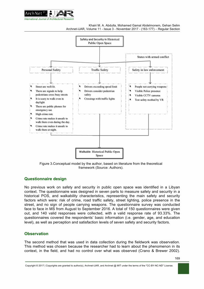
The definition of safety in The Oxford Dictionary is “The condition of being protected from or unlikely to cause danger, risk, or injury”, while security is defined in the same dictionary as “the state of being free from danger or threat” (Oxford Dictionary, 2017). Rahely Namin et al. (2013) state that safety is one of the most influential factors in attracting people to public open spaces. In the same way, Karim and Azmi (2013) clarified that under safety and security attributes there are two sub-attributes, which are personal safety and traffic safety. Abdulla et al. (2016) determined four main factors of safety and security that affect walkability in Libyan public spaces, which were risk of crimes taking place, road traffic safety, street lighting, police presence in the street and no people of carrying weapons. Figure 3 shows the
International Journal of Architectural Research
Khairi M. A. Abdulla, Mohamed Gamal Abdelmonem, Gehan Selim Archnet-IJAR, Volume 11 - Issue 3 - November 2017 - (163-177) – Regular Section
Copyright © 2017 | Copyrights are granted to author(s), Archnet-IJAR, and Archnet @ MIT under the terms of the "CC-BY-NC-ND" License.
168
conceptual model by the authors, based on literature from the theoretical framework. This research is studying the quality of environment, and users’ interaction with their environment issues relating to the study area.
The study used both quantitative and qualitative methods to gather information: the quantitative took the form of a questionnaire and the qualitative took the form of observations. Analysis of data was conducted with the Statistical Package for the Social Sciences (SPSS version 22) and qualitative analysis. The conceptual framework in Figure 3 presents the analysis of the relationship between safety, security and walkability in a historical public open space concerning personal safety, traffic safety and safety in law enforcement.
Libyan cities increased their population by more than 90% during the twentieth century (Saad, 1995). Tripoli has been rapidly growing and its population has tripled in less than 20 years, from 0.5 million in 1993 to 1.5 million in 2013 (Bureau of Statistics and Census-Libya, 2010), as well as most Libyan people wanting to visit historical places in Tripoli (such as the old city and Martyrs' Square). Furthermore, some of Tripoli’s main public open spaces, such as Martyrs’ Square, were extensively used by many people meeting to show their political support for and/or objections against the former regime during the conflict in 2011. Protests, prayers, celebrations, political debate, and the sharing of moments of joy and mourning have all been experienced in these historical symbolic urban public centres (El-Allous, 2016). Moreover, the regulations of land use applied since the 1990s preclude overcoming most of these difficulties. Many open spaces and streets which were for pedestrians have been destroyed under these regulations (Lakhder & Dugeny, 2010). Additionally, the current crisis in Libya has helped the rise of crime, as well as spreading illegal activities, such as parking on pedestrian ways and selling merchandise in the street.
In addition, the lack of clear pedestrian pathways from Martyrs’ Square to Omer Al-Mukhtar Street, and the mix between motor traffic and pedestrian movement, does not improve comfort or aesthetic enjoyment of the central area (Alzklaa, 2016). Martyrs’ Square (MS) is a public open space located in the centre of Tripoli, founded in the 20th century in the time of Italian colonialism, where it was named "Piazza Italia". After the independence of Libya in 1951 it was changed to Independence Square, and then changed to MS and then Green Square in the years of Gaddafi's rule; nowadays it is named MS again. Within the city of Tripoli, MS is located on the coastline, on the northern side of the city.
The square is the centre of the city, bordered by the Al-Saraya Al-Hamra and the seaport columns, and the old city in the North: it is one of the monuments of Tripoli. There are a number of main streets that branch out from it, such as Omar Al-Mukhtar Street, Mezzran Street, and 24 December Street (Zaqlai, 2016). The square has served as a central stage for key political events: from the Italian occupation to Libyan independence, and throughout the rule of Gaddafi, to the violent conflicts in post-Gaddafi Libya. Both pro- as well as anti-government actors have tried to use the square as a stage during these different periods.
International Journal of Architectural Research
Khairi M. A. Abdulla, Mohamed Gamal Abdelmonem, Gehan Selim Archnet-IJAR, Volume 11 - Issue 3 - November 2017 - (163-177) – Regular Section
Copyright © 2017 | Copyrights are granted to author(s), Archnet-IJAR, and Archnet @ MIT under the terms of the "CC-BY-NC-ND" License.
169
SafetyandSecurityinHistorical Public Open Space
Personal Safety Traffic Safety
• Street are well-lit. • There are signals to help
pedestrians cross busy streets• It is scary to walk even in
daylight• There are public phones for
emergency use• High crime rate • Crime rate makes it unsafe to
walk there even during the day.• Crime rate makes it unsafe to
walk there at night.
• Drivers exceeding speed limit• Drivers consider pedestrian
safety• Crossings with traffic lights
WalkableHistorical Public Open Space
Safety in law enforcement
• People not carrying weapons• Visible Police presence• Visible CCTV cameras• Test safety mothed by VR
States with armed conflict
Figure 3.Conceptual model by the author, based on literature from the theoretical
framework (Source: Authors).
Questionnaire design
No previous work on safety and security in public open space was identified in a Libyan context. The questionnaire was designed in seven parts to measure safety and security in a historical POS, and walkability characteristics, representing the main safety and security factors which were: risk of crime, road traffic safety, street lighting, police presence in the street, and no sign of people carrying weapons. The questionnaire survey was conducted face to face in MS from August to September 2016. A total of 150 questionnaires were given out, and 140 valid responses were collected, with a valid response rate of 93.33%. The questionnaires covered the respondents’ basic information (i.e. gender, age, and education level), as well as perception and satisfaction levels of seven safety and security factors.
Observation
The second method that was used in data collection during the fieldwork was observation. This method was chosen because the researcher had to learn about the phenomenon in its context, in the field, and had no control over what was observed (Crano & Brewer 2002).

International Journal of Architectural Research
Khairi M. A. Abdulla, Mohamed Gamal Abdelmonem, Gehan Selim Archnet-IJAR, Volume 11 - Issue 3 - November 2017 - (163-177) – Regular Section
Copyright © 2017 | Copyrights are granted to author(s), Archnet-IJAR, and Archnet @ MIT under the terms of the "CC-BY-NC-ND" License.
170
Whyte (2001) used this method in the context of open space research; this study followed his technique. The observation included recording the day, time and temperature; and mapping where people were walking, sitting or standing, and what activities they were doing. As the record of activities was built up, patterns began to appear; this method was used to gain an understanding of the users’ interaction with their environment issues in the space, and the way they reacted with the built environment. Observations were conducted from different locations in the square. Observation locations were selected strategically to achieve as much visual coverage as possible.
ANALYSIS AND FINDINGS
It is helpful to the researcher to have an understanding of who uses public open spaces, and some of the cultural issues involved. Libyan society is strongly shaped by the gender structure. According to the Bureau of Statistics and Census-Libya (2010), males exceed female in the total population which is 49.810% male and 49.316% female. However, as can be seen in Figure 4 (left), the questionnaire analysis also shows that the number of male users of the case study spaces was higher than that of females; 56% of the respondents were male and 44% were female. As shown in Figure 4 there is therefore a gap between the proportions of participants from the two genders.
Figure 4. (Left) Gender of participants; (Right) Age of participants (Source: Authors).
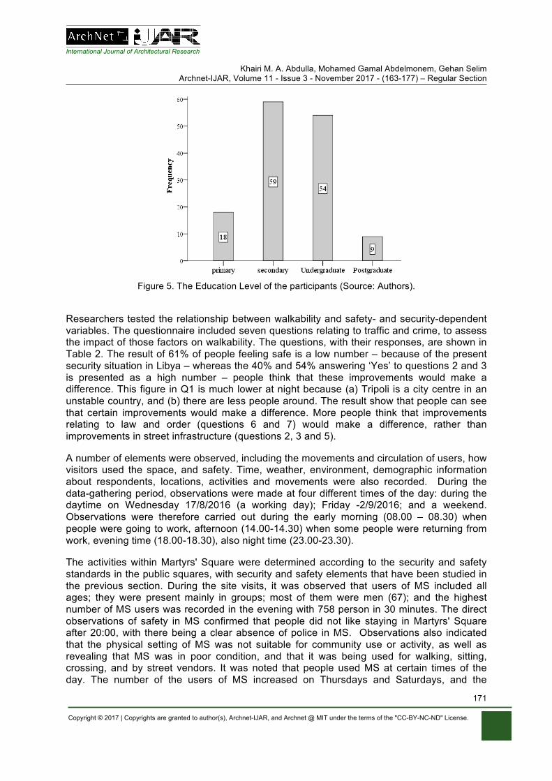
The results in Figure 4 (right) indicate the frequencies of people according to their age groups. Approximately 34% (48) of the participants were 18-29 years old, while 39% of the respondents were 30-39 years old; 20% of the people were 40-59 years old; almost 6% people were 50-59 years old; and nearly 1% who were 60 years old and above. This suggests that the largest group was of young people. The results in Figure 5 illustrate the frequencies of MS users according to their level of education. Approximately 13% of the participants had primary school level education, while 42% of the participants had secondary school level; almost 39% of the participants had an undergraduate degree; and nearly 6% of the participants had postgraduate level, showing that the largest groups had either secondary school level or undergraduate level.
International Journal of Architectural Research
Khairi M. A. Abdulla, Mohamed Gamal Abdelmonem, Gehan Selim Archnet-IJAR, Volume 11 - Issue 3 - November 2017 - (163-177) – Regular Section
Copyright © 2017 | Copyrights are granted to author(s), Archnet-IJAR, and Archnet @ MIT under the terms of the "CC-BY-NC-ND" License.
171
Figure 5. The Education Level of the participants (Source: Authors).
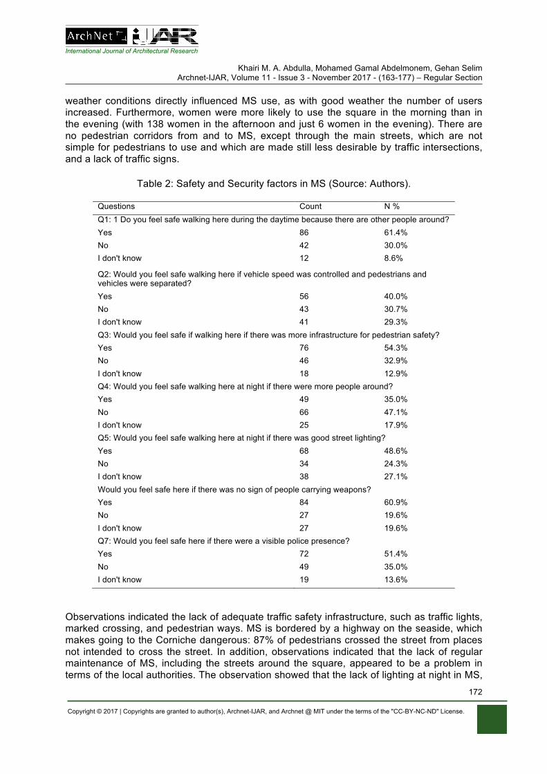
Researchers tested the relationship between walkability and safety- and security-dependent variables. The questionnaire included seven questions relating to traffic and crime, to assess the impact of those factors on walkability. The questions, with their responses, are shown in Table 2. The result of 61% of people feeling safe is a low number – because of the present security situation in Libya – whereas the 40% and 54% answering ‘Yes’ to questions 2 and 3 is presented as a high number – people think that these improvements would make a difference. This figure in Q1 is much lower at night because (a) Tripoli is a city centre in an unstable country, and (b) there are less people around. The result show that people can see that certain improvements would make a difference. More people think that improvements relating to law and order (questions 6 and 7) would make a difference, rather than improvements in street infrastructure (questions 2, 3 and 5).
A number of elements were observed, including the movements and circulation of users, how visitors used the space, and safety. Time, weather, environment, demographic information about respondents, locations, activities and movements were also recorded. During the data-gathering period, observations were made at four different times of the day: during the daytime on Wednesday 17/8/2016 (a working day); Friday -2/9/2016; and a weekend. Observations were therefore carried out during the early morning (08.00 – 08.30) when people were going to work, afternoon (14.00-14.30) when some people were returning from work, evening time (18.00-18.30), also night time (23.00-23.30).
The activities within Martyrs' Square were determined according to the security and safety standards in the public squares, with security and safety elements that have been studied in the previous section. During the site visits, it was observed that users of MS included all ages; they were present mainly in groups; most of them were men (67); and the highest number of MS users was recorded in the evening with 758 person in 30 minutes. The direct observations of safety in MS confirmed that people did not like staying in Martyrs' Square after 20:00, with there being a clear absence of police in MS. Observations also indicated that the physical setting of MS was not suitable for community use or activity, as well as revealing that MS was in poor condition, and that it was being used for walking, sitting, crossing, and by street vendors. It was noted that people used MS at certain times of the day. The number of the users of MS increased on Thursdays and Saturdays, and the
International Journal of Architectural Research
Khairi M. A. Abdulla, Mohamed Gamal Abdelmonem, Gehan Selim Archnet-IJAR, Volume 11 - Issue 3 - November 2017 - (163-177) – Regular Section
Copyright © 2017 | Copyrights are granted to author(s), Archnet-IJAR, and Archnet @ MIT under the terms of the "CC-BY-NC-ND" License.
172
weather conditions directly influenced MS use, as with good weather the number of users increased. Furthermore, women were more likely to use the square in the morning than in the evening (with 138 women in the afternoon and just 6 women in the evening). There are no pedestrian corridors from and to MS, except through the main streets, which are not simple for pedestrians to use and which are made still less desirable by traffic intersections, and a lack of traffic signs.
Table 2: Safety and Security factors in MS (Source: Authors).
Questions Count N % Q1: 1 Do you feel safe walking here during the daytime because there are other people around? Yes 86 61.4% No 42 30.0% I don't know 12 8.6%
Q2: Would you feel safe walking here if vehicle speed was controlled and pedestrians and vehicles were separated? Yes 56 40.0% No 43 30.7% I don't know 41 29.3% Q3: Would you feel safe if walking here if there was more infrastructure for pedestrian safety? Yes 76 54.3% No 46 32.9% I don't know 18 12.9% Q4: Would you feel safe walking here at night if there were more people around? Yes 49 35.0% No 66 47.1% I don't know 25 17.9% Q5: Would you feel safe walking here at night if there was good street lighting? Yes 68 48.6% No 34 24.3% I don't know 38 27.1% Would you feel safe here if there was no sign of people carrying weapons? Yes 84 60.9% No 27 19.6% I don't know 27 19.6% Q7: Would you feel safe here if there were a visible police presence? Yes 72 51.4% No 49 35.0% I don't know 19 13.6%
Observations indicated the lack of adequate traffic safety infrastructure, such as traffic lights, marked crossing, and pedestrian ways. MS is bordered by a highway on the seaside, which makes going to the Corniche dangerous: 87% of pedestrians crossed the street from places not intended to cross the street. In addition, observations indicated that the lack of regular maintenance of MS, including the streets around the square, appeared to be a problem in terms of the local authorities. The observation showed that the lack of lighting at night in MS,

International Journal of Architectural Research
Khairi M. A. Abdulla, Mohamed Gamal Abdelmonem, Gehan Selim Archnet-IJAR, Volume 11 - Issue 3 - November 2017 - (163-177) – Regular Section
Copyright © 2017 | Copyrights are granted to author(s), Archnet-IJAR, and Archnet @ MIT under the terms of the "CC-BY-NC-ND" License.
173
due to power outages for long hours or the lack of regular maintenance of the lamps in MS, gave the users a sense of insecurity.
DISCUSSIONS OF FINDINGS
According to Table 2, the investigation asserted that there are six main safety and security factors underlying people’s evaluation of the characteristics of public open spaces in the context of their appeal for walking. Furthermore, fear is also a social or collective experience, rather than only an individual state (Pain & Smith, 2008). Before 2011, Libya was one of the safest countries in the region, as Khalifa (2010) illustrated in his interview with a tourist in Libya: “It’s very safe; Libya is the safest country in the region. It is worth remembering that this is the only place in the whole region that has not had any bombs. It is not paradise, but Libyans are not extremists”. The main safety and security factors will be discussed in this section.
Firstly, ‘the feeling of safety makes a place more walkable’. Apparently, gender imposes a significant impact on people’s opinions about the length of stay in public open spaces. According to the survey, females who use MS have more fear of crime, where 53% of females feel scared when walking in this place during the day and 70% of females feel scared when walking in MS during the evening or nighttime. Also from the observations, the study found that women take several precautions in MS due to their fear of offences. They never come or stay in the dark and never walk through the old city alone. In general, there is a lack of feeling safe among the users of MS and this is due to the situation in Libya nowadays.
Secondly, imposing a speed limit and separating pedestrians and vehicles would improve walkability; according to the survey results, the vehicle speed limit is also a significant factor on walkability and safety. As can be seen, in general, the majority of participants crossed the highway daily or weekly, and most participants perceived the traffic in the area as dangerous or very dangerous. Moreover, with more pedestrians crossing the intersection, more traffic accidents will be caused, especially on the highway (Corniche Road) which separates MS from the Corniche. Furthermore, due to the absence of law and order in Libya (i.e. the on-going conflict since 2011) drivers do not slow down around MS, which makes walking very risky. The risk of traffic accidents varies across the surrounding streets, as there are more pedestrians using streets leading to/from commercial spaces and buildings.
Thirdly, infrastructure is needed for pedestrian safety; safety elements for pedestrians include traffic signs, curb cuts, pathways and crossings. There was a strong positive and statistically significant relationship between participants’ feelings of safety in MS and infrastructure for pedestrian safety. The existence of signs regarding pedestrian safety such as pedestrian-activated/audible signals, stop signs, and overpass signs was noticed. Over 68% of participants suggested that the local authority should separate pedestrians from traffic on sidewalks, indicating that there were no safety signs for pedestrians, and that the highway between the Corniche and Martyrs’ Square should be removed because this highway is very dangerous for the users of MS.
Fourthly, the proliferation of weapons; since the revolution and overthrow of Gaddafi in 2011, the political and economic conditions of Libya remain extremely fluid. Due to the proliferation of weapons in Libya in general, and in Tripoli in particular, most participants believe that less evidence of weapons being carried makes MS safer; one participant said, "I have been

International Journal of Architectural Research
Khairi M. A. Abdulla, Mohamed Gamal Abdelmonem, Gehan Selim Archnet-IJAR, Volume 11 - Issue 3 - November 2017 - (163-177) – Regular Section
Copyright © 2017 | Copyrights are granted to author(s), Archnet-IJAR, and Archnet @ MIT under the terms of the "CC-BY-NC-ND" License.
174
robbed by being threatened with a gun in this place before”. However, the users of MS have overcome this problem by walking in groups and leaving the square after sunset.
Fifthly, police presence in MS; the extraordinary conditions under which this study was conducted (i.e. the on-going conflict since 2011) means that insecurity and the lack of availability of police on the streets, combined with the spread of crime and absence of respect for the law, exacerbated such problems beyond what one would expect under normal circumstances. Many participants believe that "the return of the police to the street would make them feel safe".
Sixthly, Virtual reality: as a result of the dangers and limitations in the real world, which control the testing of new safety and security methods, it has often been replaced by virtual reality (VR) in safety and security research. In this case, users are able to view these virtual spaces as if they were traveling through them in reality (Badland et al. 2010).
CONCLUSION
As far as this research could establish, this is the first study that examines safety and security in public open spaces in a situation of armed conflict, and their relationships to walkability and physical activity. Furthermore, the inclusion of heritage POS with walkability represents a new contribution. Walkability, and safety and security are important factors in determining urban life on and around public open spaces. Safety infrastructure is one of the safety elements, but it does not completely reflect the potential pedestrian risk in public open spaces. Reflecting on the results of this paper, the absence of police and the proliferation of weapons were the main threats for pedestrians in public open spaces of a city that has armed conflicts. This research demonstrated that walkability is no longer associated with the physical environment only, but safety and security also play an important role in attracting people to public spaces for walking. Moreover, it is considered that security and extending the rule of law should be the foundation for a sustainable city, because with the lack of security, daily activities are becoming risky.
On other hand, in order to promote walkability in POS, there are several elements needed to support a walkable environment. Based on the character of the problems that have been identified in this research, the high level of traffic flow in combination with mobility problems in pedestrian infrastructure and maintenance incites pedestrians to walk in the street or cross outside designated crossings, thus undermining their safety. In conclusion, it is proposed that an increase in pedestrian safety can be achieved by controlling vehicle speed at unprotected mid-block marked crossing; creating footpaths; creating and maintaining traffic signals; and controlling all the junctions around MS and pedestrian crossings by traffic signals. Also, to reduce crime within POS in cities with armed conflict, there are several elements needed, such as setting up activities and encouraging people to walk in groups, installing CCTV, and the police intensifying foot patrols.
REFERENCES
Abdelmonem, M.G. (2016). The Architecture of Home in Cairo: Socio-spatial practice of the Hawari’s Everyday Life. London: Routledge
Abdelmonem, M.G., Selim, G. (2012). Architecture, Memory and Historical Continuity in Old Cairo. The Journal of Architecture, 17(2), 163-189.

International Journal of Architectural Research
Khairi M. A. Abdulla, Mohamed Gamal Abdelmonem, Gehan Selim Archnet-IJAR, Volume 11 - Issue 3 - November 2017 - (163-177) – Regular Section
Copyright © 2017 | Copyrights are granted to author(s), Archnet-IJAR, and Archnet @ MIT under the terms of the "CC-BY-NC-ND" License.
175
Abdulla, K., Abdelmonem, M.G., Selim, G. (2016). Understanding Walkability in the Libyan Urban Space: Policies, Perceptions and Smart Design for Sustainable Tripoli. International Journal of Civil, Environmental, Structural, Construction and Architectural Engineering, 10 (12), 1602-1610.
Abdulla, K., Abdelmonem, M. G., & Selim, G. (2017). Understanding Walkability in the Libyan Urban Space: Policies, Perceptions and Smart Design for Sustainable Tripoli. International Journal of Civil, Environmental, Structural, Construction and Architectural Engineering, 10(12), 1602-161.
Alfonso, M.A. (2005). TO WALK OR NOT TO WALK? The Hierarchy of Walking Needs. Environment & Behavior, 37 (6), 808-836.
Alzklaa, N. (2016). Evaluating Public Squares According to the World Organization for Projects of Public Spaces Case Study: Al-Shuhada Square. Master., University of Tripoli.
Askari, A.H. (2014). Assessment of Urban Public Spaces: Cases Of Kuala Lumpur City Center. Doctor of Philosophy. Universiti Malaya.
Austin, E.K. (2002). The Social Bond and Place: a Study of how the Bureau of Land Management Contributes to Civil Society. Administrative Theory & Praxis (Administrative Theory & Praxis), 24 (2), 355.
Badland, H.M., Opit, S., Witten, K., Kearns, R.A. and Mavoa, S. (2010). Can Virtual Streetscape Audits Reliably Replace Physical Streetscape Audits? Journal of Urban Health, 87(6), 1007-16.
Badoe, D.A., and Miller, E.J. (2000). Transportation–land-use interaction: empirical findings in North America, and their implications for modeling.
Bureau of Statistics and Census-Libya. (2010). Statistics Book. Bureas of Statistics and Census-Libya. Cao, X., Handy, S.L., Mokhtarian, P.L. (2009). Examining the Impacts of Residential Self-Selection on
Travel Behaviour: A Focus on Empirical Findings. Transport Reviews, 29 (3), 359-395. Child, A. & Falconer, R. (2015). Walkability Study. Australia: Arup. Cook, R.S. (1980). Zoning for Downtown Urban Design: How Cities Control Development. First ed.
New York: Lexington Books. Crane, R. (2000). The Influence of Urban Form on Travel: An Interpretive Review. Journal of Planning
Literature, 15 (1), 3. Cubukcu, E. (2013). Walking for Sustainable Living. Echeverria, S.E., Diez-Roux, A. and Link, B.G. (2004). Reliability of self-reported neighborhood
characteristics. Journal of Urban Health: Bulletin of the New York Academy of Medicine, 81 (4), 682-701.
Ewing, R., and Handy, S. (2009). Measuring the Unmeasurable: Urban Design Qualities Related to Walkability. Journal of Urban Design, 14 (1), 65-84.
Ewing, R. & Cervero, R. (2010). Travel and the Built Environment. Journal of the American Planning Association, 76 (3), 265-294.
Ewing, R. & Cervero, R. (2001). Travel and the Built Environment: A Synthesis. Transportation Research Record, 1780 (1), 87–114.
Gehl, J. (1989). A Changing Street Life in a Changing Society. Places Journal, 6 (1). Giles-Corti, B., Timperio, A., Bull, F. and Pikora, T., (2005). Understanding physical activity
environmental correlates increased specificity for ecological models. Exercise and Sport Sciences Reviews, 33 (4), 175-181.
Handy, S., Cao, X. and Mokhtarian, P. (2005). Correlation or causality between the built environment and travel behavior? Evidence from Northern California. Transportation Research: Part D, 10 (6), 427-444.
Heath, G.W., Brownson, R.C., Kruger, J., Miles, R., Powell, K.E. and Ramsey, L.T. (2006). The Effectiveness of Urban Design and Land Use and Transport Policies and Practices to Increase Physical Activity: A Systematic Review. Journal of Physical Activity & Health, 3, S55-S76.
Jacobs, J. (1961). The Death and Life of Great American Cities. New York: Random House. Karim, H.A., and Azmi, D.I. (2013). Convenience and Safety of Walking Experience in Putrajaya
Neighbourhood Area. Kerr, Z., Evenson, K.R., Moore, K., Block, R. and Diez Roux, A.V. (2015). Changes in walking
associated with perceived neighborhood safety and police-recorded crime: The multi-ethnic study of atherosclerosis.
Khondker, H. (2009). Dhaka and the contestation over the public space. City, 13 (1), 129-136.
International Journal of Architectural Research
Khairi M. A. Abdulla, Mohamed Gamal Abdelmonem, Gehan Selim Archnet-IJAR, Volume 11 - Issue 3 - November 2017 - (163-177) – Regular Section
Copyright © 2017 | Copyrights are granted to author(s), Archnet-IJAR, and Archnet @ MIT under the terms of the "CC-BY-NC-ND" License.
176
Kirner, C., Siscoutto, R. (2007). Realidade Virtual e Aumentada Conceitos, Projeto e Aplicaçoes. Mostra de Produtos Prototipos de RV e RA - IX Symposium on Virtual and Augmented Reality -SVR.
Kruger, J., Ham, S.A., Berrigan, D. and Ballard-Barbash, R. (2008). Prevalence of transportation and leisure walking among U.S. adults. Preventive Medicine, 47 (3), 329-334.
Lakhder, A. and Dugeny, F. (2010). Tripoli City Centre’s Urban and Architectural Charter. Tripoli-Libya: Engineering and Consulting Office for Utilities and AKT / IAURIF GROUP.
Leck, E. (2006). The impact of urban form on travel behavior: a metaanalysis . Berkeley Plan, 19, 37–58.
Listerborn, C. (2009). Fear: Critical Geopolitics and Everyday Life. Urban Studies (Sage Publications, Ltd.), 46 (10), 2243-2245.
Loukaitou-Sideris, A., and Eck, J.E. (2007). Crime prevention and active living. American Journal of Health Promotion, 21 (4), 380-389.
Lynch, K. (1960). The image of the city. Cambridge, Mass; London: MIT Press. Maslow, A. (1970). Motivation Personality (2nd ed). USA: Harper & Row. McMillan, T.E., (2007). The relative influence of urban form on a child’s travel mode to school. Mehta, V. (2014). Evaluating Public Space. Journal of Urban Design, 19 (1), 53-88. Mehta, V. (2008). Walkable streets: pedestrian behavior, perceptions and attitudes. Journal of
Urbanism, 1 (3), 217-245. Nasution, A.D., and Zahrah, W. (2012). Public Open Space Privatization and Quality of Life, Case
Study Merdeka Square Medan. Numbeo. (2017). Crime in Tripoli, Libya [online]. Numbeo. Available at:
https://www.numbeo.com/crime/in/Tripoli. NZ Transport Agency. (2009). Pedestrian planning and design guide. Wellington: NZ Transport
Agency. Oxford University Press. (2017). Oxford University Press [online]. Oxford University Press. Pikora, T.J., Bull, F.C.L., Jamrozik, K., Knuiman, M., Giles-Corti, B. and Donovan, R.J. (2002).
Developing a reliable audit instrument to measure the physical environment for physical activity. American Journal of Preventive Medicine, 23 (3), 187-194.
Pont, K., Ziviani, J., Wadley, D., Bennett, S. and Abbott, R. (2009). Environmental correlates of children's active transportation: A systematic literature review.
Rahely Namin, E., Najafpour, H. and Lamit, H. (2013). Public Places and Spaces and Social Urban Interaction (A Case Study of Johor Bahru, Malaysia). International Journal of Current Engineering and Technology, 3 (2), 281-291.
Remali, A.M., Porta, S., Romice, O. & Abudib, H. (2015). Street Quality, Street Life, Street Centrality (pp. 104-129). In: Laura Vaughan (ed.) Suburban Urbanities: Suburbs and the Life of the High Street. London: UCL Press.
Saad, A. (1995). The Libya study in geography. In: Urbanization. Libya: Dar Libya. Saelens, B.E., Sallis, J.F., Frank, L.D. (2003). Environmental Correlates of Walking and Cycling:
Findings from the Transportation, Urban Design, and Planning Literatures. Annals of Behavioral Medicine, 25 (2), 80.
Saelens, B.E., and Handy, S.L. (2008). Built Environment Correlates of Walking: A Review. Medicine & Science in Sports & Exercise, 40, S550-S566.
Sallis, J., Bauman, A. and Pratt, M. (1998). Environmental and policy interventions to promote physical activity. American Journal of Preventive Medicine, 15 (4), 379-397.
Sallis, J.F., and Owen, N. (2002). Ecological models of health behavior (pp. 462-484). In: Karen Glanz, K., Rimer, B.K. and Viswanath, K (ed.). Health Behaviour and Health Education: Theory, Research, and Practice. San Francisco: Jossey-Bass, 2002,
Selim, G. (2017). Unfinished Places: The Politics of Urban Remaking Old Quarters. (Routledge Research in Planning and Urban Design). London: Routeldge.
Stafford, M., Chandola, T. and Marmot, M. (2007). Association between fear of crime and mental health and physical functioning. American Journal of Public Health, 97 (11), 2076-2081.
Stockton, J.C., Duke-Williams, O., Stamatakis, E., Mindell, J.S., Brunner, E.J. and Shelton, N.J. (2016). Development of a novel walkability index for London, United Kingdom: cross-sectional application to the Whitehall II Study. BMC Public Health, 16, 416-416.
International Journal of Architectural Research
Khairi M. A. Abdulla, Mohamed Gamal Abdelmonem, Gehan Selim Archnet-IJAR, Volume 11 - Issue 3 - November 2017 - (163-177) – Regular Section
Copyright © 2017 | Copyrights are granted to author(s), Archnet-IJAR, and Archnet @ MIT under the terms of the "CC-BY-NC-ND" License.
177
Tandogan, O., and Ilhan, B.S. (2016). Fear of Crime in Public Spaces: From the View of Women Living in Cities.
The Mayor of London and Transport for London (2004). Making London a walkable city: The Walking Plan for London. London: Mayor of London&Transport for London.
Tulu, G.S., Washington, S., King, M.J. & Haque, M.M. (2013). Why are Pedestrian Crashes so Different in Developing Countries? A Review of Relevant Factors in Relation to their Impact in Ethiopia. Australasian Transport Research.
Whyte, W. (2001). The Social Life of Small Urban Spaces. New York: Project for Public Spaces Inc. Zuniga-Teran, A.A., Orr, B.J., Gimblett, R.H., Chalfoun, N.V., Marsh, S.E., Guertin, D.P. and Going,
S.B. (2017). Designing healthy communities: Testing the walkability model. Frontiers of Architectural Research, 6 (1), 63-73.