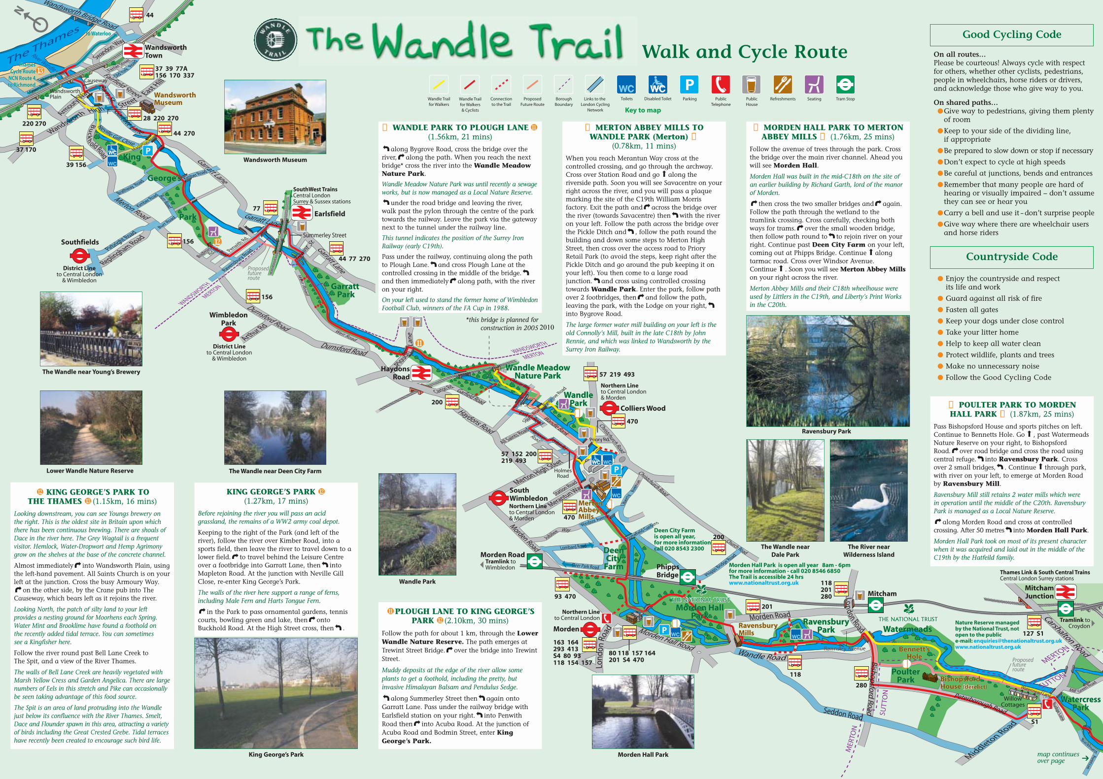
walk and cycle route · walk past the pylon through the centre of the park towards the railway....
TRANSCRIPT
ThamesCycle Route
NCN Route 4to Richmond
ThamesCycle Route
NCN Route 4to Richmond
To WaterlooTo Waterloo
WimbledonPark
SouthWimbledon
Morden
Colliers Wood
Southfields
Earlsfield
HaydonsRoad
MitchamJunction
WandsworthTown
PhippsBridge
Rawnsley AvenueenueRawnsley Avenue
Nature Reserve managedby the National Trust, notopen to the publice-mail: [email protected]
Morden Hall Park is open all year 8am - 6pm for more information - call 020 8546 6850The Trail is accessible 24 hrswww.nationaltrust.org.uk
Deen City Farmis open all year,for more informationcall 020 8543 2300
118
201
200
93 470
57 152 200219 493
470
200
156
156
39 156
37 170
220 270
44
44 270
28 220 270
37 39 77A 156 170 337
77
44 77 270
57 219 493
470
280
118201280
127 S1
S1
118 154 157
80 118 157 164201 S4 470
163 164293 413S4 80 93
Mitcham
Morden RoadTramlink toWimbledon
Northern Lineto Central London
Northern Lineto Central London& Morden
Northern Lineto Central London& Morden
District Lineto Central London
& Wimbledon
District Lineto Central London
& Wimbledon
Tramlink to Croydon
Thames Link & South Central Trains Central London Surrey stations
SouthWest Trains Central LondonSurrey & Sussex stations
Proposedfutureroute
The Thames
Proposedfutureroute
MER
TON
SUT
TON
WANDSWORTH
WANDSWORTH
MERTON
MERTON
SUTTON
MERTON
Fairfield Street
Garratt Lane
Merton Road
Durnsford Road
Durnsford Road
Haydons Road
Morden Road
Leyton Rd.
Christchurch RoadChristchurch Road
Church Road
HanoverRoad
Wandle Bank
Garfield Road
Caxton Rd.
East Road
Chaucer Way
Morden Hall Road
Weir Road
Weir Road
Garratt Lane
Garratt Lane
Garratt Lane
Ram St.
Bridge Road
Wandsworth
High Street East H
ill
Wandsworth
Swandon Way
Armoury W
ay
Plough La
ne
Enterprise Way
Mapleton Road
Ferrier Street
Osiers RoadOld York Road
Penwith Rd.
Ravensbury Road
Windsor Avenue
Homefield Gardens
Phipps Bridge Road
Deer Park Road
Lombard Road
Green Road
Budge Lane
Avenue
Buckhurst
Watermead LaneMill
Liber
ty A
venu
e
Jubilee Way
Arthur Rd
Merton High Steet
North Road
Byegrove Road
South Road
All Saints Road
Station Road
Merantun Way
Burr Road
BodminRd.
Kimber Road
Kimber Road
Brathway Road
Replingham Road
Pirbright Road
Close
Gill
Neville
Middleton Road
Carshalton Road
Bishopsford Road
daoReldnaW
daoRhguorobreteP
daoRnodnoL
daoRno
dnoL
daoRdloh
k cu
B
Burr Road
Acuba Road
HolmesRoad
Priory Rd.
WillowCottages
Morden Road
Trewint S
t.Summerley Street
WandsworthPlain
Causeway
Seddon Road
P
P
P
PoulterPark
Watermeads
Morden HallPark
RavensburyPark
DeenCity
Farm
WandlePark
Wandle MeadowNature Park
Garratt Park
King
George’s
Park
PoulterPark
WatercressPark
WatercressPark
Watermeads
Morden HallPark
RavensburyPark
DeenCity
Farm
WandlePark
Wandle MeadowNature Park
Garratt Park
King
George’s
Park
WildernessIsland
Dale Park
TheGrove
Beddington Park
WaddonPonds
WandlePark
N
MertonAbbeyMills
MertonAbbeyMills
RavensburyMillsRavensburyMills
Bennett’sHole
Bennett’sHole
BishopsfordHouse (der(derelict)BishopsfordHouse (derelict)
Carew Manor
BeddingtonMill
River Wandle
Canon Bridges’bridge
WandsworthMuseumWandsworthMuseum
King George’s Park
Walk and Cycle Route
❼ POULTER PARK TO MORDENHALL PARK ❽ (1.87km, 25 mins)
Pass Bishopsford House and sports pitches on left.Continue to Bennetts Hole. Go , past WatermeadsNature Reserve on your right, to BishopsfordRoad. over road bridge and cross the road usingcentral refuge. into Ravensbury Park. Crossover 2 small bridges, . Continue through park,with river on your left, to emerge at Morden Roadby Ravensbury Mill.
Ravensbury Mill still retains 2 water mills which werein operation until the middle of the C20th. RavensburyPark is managed as a Local Nature Reserve.
along Morden Road and cross at controlledcrossing. After 50 metres into Morden Hall Park.
Morden Hall Park took on most of its present characterwhen it was acquired and laid out in the middle of theC19th by the Hatfeild family.
❽ MORDEN HALL PARK TO MERTONABBEY MILLS ❾ (1.76km, 25 mins)
Follow the avenue of trees through the park. Crossthe bridge over the main river channel. Ahead youwill see Morden Hall.
Morden Hall was built in the mid-C18th on the site ofan earlier building by Richard Garth, lord of the manorof Morden.
then cross the two smaller bridges and again.Follow the path through the wetland to thetramlink crossing. Cross carefully, checking bothways for trams. over the small wooden bridge,then follow path round to to rejoin river on yourright. Continue past Deen City Farm on your left,coming out at Phipps Bridge. Continue alongtarmac road. Cross over Windsor Avenue.Continue . Soon you will see Merton Abbey Millson your right across the river.
Merton Abbey Mills and their C18th wheelhouse wereused by Littlers in the C19th, and Liberty’s Print Worksin the C20th.
❾ MERTON ABBEY MILLS TOWANDLE PARK (Merton) ❿
(0.78km, 11 mins)
When you reach Merantun Way cross at thecontrolled crossing, and go through the archway.Cross over Station Road and go along theriverside path. Soon you will see Savacentre on yourright across the river, and you will pass a plaquemarking the site of the C19th William Morrisfactory. Exit the path and across the bridge overthe river (towards Savacentre) then with the riveron your left. Follow the path across the bridge overthe Pickle Ditch and , follow the path round thebuilding and down some steps to Merton HighStreet, then cross over the access road to PrioryRetail Park (to avoid the steps, keep right after thePickle Ditch and go around the pub keeping it onyour left). You then come to a large roadjunction. and cross using controlled crossingtowards Wandle Park. Enter the park, follow pathover 2 footbridges, then and follow the path,leaving the park, with the Lodge on your right,into Bygrove Road.
The large former water mill building on your left is theold Connolly’s Mill, built in the late C18th by JohnRennie, and which was linked to Wandsworth by theSurrey Iron Railway.
KING GEORGE’S PARK(1.27km, 17 mins)
Before rejoining the river you will pass an acidgrassland, the remains of a WW2 army coal depot.
Keeping to the right of the Park (and left of theriver), follow the river over Kimber Road, into asports field, then leave the river to travel down to alower field. to travel behind the Leisure Centreover a footbridge into Garratt Lane, then intoMapleton Road. At the junction with Neville GillClose, re-enter King George’s Park.
The walls of the river here support a range of ferns,including Male Fern and Harts Tongue Fern.
in the Park to pass ornamental gardens, tenniscourts, bowling green and lake, then ontoBuckhold Road. At the High Street cross, then .
KING GEORGE’S PARK TOTHE THAMES (1.15km, 16 mins)
Looking downstream, you can see Youngs brewery onthe right. This is the oldest site in Britain upon whichthere has been continuous brewing. There are shoals ofDace in the river here. The Grey Wagtail is a frequentvisitor. Hemlock, Water-Dropwort and Hemp Agrimonygrow on the shelves at the base of the concrete channel.
Almost immediately into Wandsworth Plain, usingthe left-hand pavement. All Saints Church is on yourleft at the junction. Cross the busy Armoury Way.
on the other side, by the Crane pub into TheCauseway, which bears left as it rejoins the river.
Looking North, the patch of silty land to your leftprovides a nesting ground for Moorhens each Spring.Water Mint and Brooklime have found a foothold onthe recently added tidal terrace. You can sometimessee a Kingfisher here.
Follow the river round past Bell Lane Creek toThe Spit, and a view of the River Thames.
The walls of Bell Lane Creek are heavily vegetated withMarsh Yellow Cress and Garden Angelica. There are largenumbers of Eels in this stretch and Pike can occasionallybe seen taking advantage of this food source.
The Spit is an area of land protruding into the Wandlejust below its confluence with the River Thames. Smelt,Dace and Flounder spawn in this area, attracting a varietyof birds including the Great Crested Grebe. Tidal terraceshave recently been created to encourage such bird life.
❼
❽
❾
❿
map continuesover page ➔
The Wandle near Young’s Brewery
Lower Wandle Nature Reserve
Morden Hall Park
Ravensbury Park
The River nearWilderness Island
The Wandle nearDale Park
Wandsworth Museum
PBorough
BoundaryParking Public
TelephonePublicHouse
Refreshments SeatingToilets Disabled ToiletLinks to the London Cycling
Network
Wandle Trailfor Walkers& Cyclists
Connectionto the Trail
Wandle Trailfor Walkers
ProposedFuture Route
Tram Stop
Key to map
*this bridge is planned forconstruction in 2005
PLOUGH LANE TO KING GEORGE’SPARK (2.10km, 30 mins)
Follow the path for about 1 km, through the LowerWandle Nature Reserve. The path emerges atTrewint Street Bridge. over the bridge into TrewintStreet.
Muddy deposits at the edge of the river allow someplants to get a foothold, including the pretty, butinvasive Himalayan Balsam and Pendulus Sedge.
along Summerley Street then again ontoGarratt Lane. Pass under the railway bridge withEarlsfield station on your right. into PenwithRoad then into Acuba Road. At the junction ofAcuba Road and Bodmin Street, enter KingGeorge’s Park.
❿ WANDLE PARK TO PLOUGH LANE(1.56km, 21 mins)
along Bygrove Road, cross the bridge over theriver, along the path. When you reach the nextbridge* cross the river into the Wandle MeadowNature Park.
Wandle Meadow Nature Park was until recently a sewageworks, but is now managed as a Local Nature Reserve.
under the road bridge and leaving the river,walk past the pylon through the centre of the parktowards the railway. Leave the park via the gatewaynext to the tunnel under the railway line.
This tunnel indicates the position of the Surrey IronRailway (early C19th).
Pass under the railway, continuing along the pathto Plough Lane. and cross Plough Lane at thecontrolled crossing in the middle of the bridge.and then immediately along path, with the riveron your right.
On your left used to stand the former home of WimbledonFootball Club, winners of the FA Cup in 1988.
The Wandle near Deen City Farm
Wandle Park
On all routes…Please be courteous! Always cycle with respectfor others, whether other cyclists, pedestrians,people in wheelchairs, horse riders or drivers,and acknowledge those who give way to you.
On shared paths…● Give way to pedestrians, giving them plenty
of room
● Keep to your side of the dividing line,if appropriate
● Be prepared to slow down or stop if necessary
● Don’t expect to cycle at high speeds
● Be careful at junctions, bends and entrances
● Remember that many people are hard of hearing or visually impaired – don’t assumethey can see or hear you
● Carry a bell and use it – don’t surprise people
● Give way where there are wheelchair users and horse riders
Good Cycling Code
● Enjoy the countryside and respectits life and work
● Guard against all risk of fire
● Fasten all gates
● Keep your dogs under close control
● Take your litter home
● Help to keep all water clean
● Protect wildlife, plants and trees
● Make no unnecessary noise
● Follow the Good Cycling Code
Countryside Code
2010

ThamesCycle Route
NCN Route 4to Richmond
To Waterloo
Hackbridge
Carshalton
Waddon
East Croydonstation
Wallington
Rawnsley Avenue
151
407 410455 726
407 410 726
455 463
455
289
407 410463 726
127 151 157 410 463 S4
151 410463
127151
127157
127
407 726
Thameslink & South Central trains Central London to Surrey andSussex stations
119 130 94 197 198264 312 367 409 410 466 26 T33
Tramlink to Croydon
Tramlink - Croydon to Wimbledon,Elmers End, New Addington andBeckenham
Wandle Park
Short Cut
SUTTON
SUTTON
CROYDON
Culv
ers
Aven
ue
Culv
ers
Aven
ue
London Road
London Road
London Road
Acre Lane
High Street
North Street
Croydon Road
Croydon Road
Limes Av.Mill LaneWaddon Road
George Street
Crown Hill
Street
Chu
rch
Sylverdale Rd.
Church Rd.
Old Palace Rd.
Lodge Av.
Richmond Green Road
BridlePath
Church LaneWhelan Way
Purley Way
Park LaneHigh StreetSurrey Street
North End
Hilliers Lane
Lane
Plough
Purley Way
Duppas Hill Road
Park Lane
Manor Road
daoRel a
gni t
hgi
N
yawe
suaC
ehT
River
Den
mar
k Ro
ad
Wandle Side
Derek Avenue
Mill
Lan
e
Church Road
Wandle Rd.
Guy Road
Cedars Road
Salcott Road
Lavington Road
Aldwick Rd
The Ridgeway
Vicarage Rd
The Ridgeway
WandleSide
Waddon Court
Court Dr.
Gardens
Avenue
Dale Park
Butter Hill
Wes
tcro
ftRoad
daoRmospE
daoR
droff
atS
daoRyuG
Quinton Cl.
Kingston G ds
Waddon New Rd.
Roman Way
enaLyrrebwartS
Westcroft LeisureCentre
Elms Pond
CarshaltonPonds (Grove Canal)
P
Ruskin Rd.
Bridges Lane
PoulterPark
Watermeads
Morden HallPark
RavensburyPark
DeenCity
Farm
WandlePark
Wandle MeadowNature Park
Garratt Park
King
George’s
Park
WatercressPark
WildernessIsland
Dale Park
TheGrove
Beddington Park
WildernessIsland
Dale Park
TheGrove
Beddington Park
WaddonPonds
WandlePark
WaddonPonds
WandlePark
N
MertonAbbeyMills
Bennett’sHole
BishopsfordHouse (derelict)
Carew Mw ManorCarew Manor
BeddingtononMill
BeddingtonMill
Canon Bridges’bridge
Canon Bridges’bridge
WandsworthMuseum
By train to East Croydon Station(Brighton/Gatwick Airport-London/Luton)(Purley/Tattenham Corner/East Grinstead-London)(south coast-London)
By train to Waddon Station(Dorking/Epsom/Sutton-West Croydon/London)Ring 08457 48 49 50 or visitwww.nationalrail.co.uk for train times.By tram to Wandle Park tram stop/East CroydonStation. Trams run about every 10 minutesRing 020 7222 1234 or visitwww.tfl.gov.uk/trams for details
By bus numbers 64, 119, 130, 194, 197, 198, 312,367, 409, 410, 466, 726 and T33 to East CroydonStationRing 020 7222 1234 for local guides/times or visitwww.tfl.gov.uk/journeyplanner
❷ WADDON PONDS TOCAREW MANOR ❸ (1.44km, 20 mins)
Pass the Ponds on your left, continue alongbridleway. At Mill Lane Trading Estate, take rightfork in path. At Lavington Road , crossfootbridge over river, along Richmond Green.Take left fork in path at junction with PetershamTerrace, follow river. at junction of KingstonGardens and Wandle Road. In front of mill intoBridges Lane. Pass the row of cottages called MountPleasant.
Beddington Mill was probably founded on the site of amedieval mill. During the eighteenth century it was usedto grind corn and later to grind tobacco into snuff.The existing brick mill was built in the 1890s for J andTH Wallis, who ran a bakery as well as a flourmill.
Take riverside footpath between Wandle Court (onleft) and river. At end of path, cross Hilliers Lane atcontrolled crossing, go into Guy Road. 100metres across the bridge. and keep river onyour left, take left fork behind first block of flats.Path curves right into a copse and left at the largecedar tree. When path forks (tarmac path goesright), follow track to left towards Carew Manor.
Carew Manor was the home of the Carews of Beddingtonfor 500 years. The house still contains a Great Hall withan impressive timber arch-braced hammer-beam roof,which dates from around 1500. You can also see theDovecote, dating from the early eighteenth century. It hasnesting boxes for pigeons, which were reared for food.
❸ CAREW MANOR TO ELMS POND ❹(0.86km, 12 mins)
At the end of the brick wall, follow rough pathacross an open space, until it emerges into a carpark. Cross car park, walking past the cottages,then across bridge over river. and continuethrough Beddington Park. Pass Canon Bridges’terracotta bridge on your left.
The Watcombe Pottery, Torquay, built this ornamentalterracotta bridge for Canon Bridges, the Rector ofBeddington, at the end of the nineteenth century. Heacquired the Park in 1859 when the last of theHallowell-Carew family was forced to sell the estate topay gambling debts.
Continue through a gap in a post & rail fence,through a copse, past a small flint bridge on yourleft. Beyond bridge towards the lake. Keep lakeon your left, cross 2 small bridges before coming toa car park. Cross car park diagonally and intothe gardens. Go through gardens and cross DerekAvenue into Lakeside. Go , cross Quinton Closeand into London Road. Cross London Road,using the central refuge. and pass Elms Pond onyour right.
❺ CARSHALTON PONDS TO WILDERNESS ISLAND ❻(0.84km, 12 mins)
Keep the ponds on your left and before the bridge spanning the river.Continue past weir and alongside river on your left to park entrance.Cross bridge here and along shared pedestrian and cycle path betweenhouses and river. Cross Papermill Close, then across the footbridge,then along tarmac path to Butter Hill. across river again. (At this pointshort cut rejoins Wandle Trail) Cross Butter Hill, continue under railwaybridge. Pass the entrance to Wilderness Island.
Wilderness Island is a statutory Local Nature Reserve. Tufted ducks breed on thispart of the River and common darter dragonflies can be seen in the summer.Kingfishers breed along the River between Wilderness Island and BeddingtonPark. Some thirty species of birds have been recorded on the Island, including allthree British woodpeckers, tree creepers and nuthatches.
Useful numbers & Contacts
National Cycle Network Route 22 - see inset below
The Story of the Wandle Trail How to get there
Groundwork Merton Telephone: 020 8687 4050www.groundwork.org.uk/merton
Sustrans Telephone: 0845 113 0065www.nationalcyclenetwork.org.uk
(for interactive mapping)
London Borough of SuttonTelephone: 020 8770 5000
www.sutton.gov.uk
London Borough of MertonTelephone: 020 8274 4901
www.merton.gov.uk
London Borough of WandsworthTelephone: 020 8871 6000www.wandsworth.gov.uk
The River Wandle has two sources, in Waddon andCarshalton, and flows to join the River Thames atWandsworth. In its industrial heyday, it was Britain’s‘hardest working river’, with over 90 mills alongits banks. The Wandle Group, the Wandle Industrial Museumand the riparian London Boroughs have developedthe (20 km/14mile long) Wandle Trail. The Trailallows local people to enjoy the heritage interestand flora and fauna of this typical chalk streamin the heart of some of south London’s mostindustrialised landscape.The route description guides walkers from south(East Croydon) to north (the River Thames), but iseasy to follow in either direction. We have includedestimated walking times for each section. In places, the ground is uneven, making the Traildifficult for wheelchair users. However, the WandleTrail Partners are committed to making it safer andmore accessible for all users. Improvement work isin progress. The text describes alternative routes forwheelchair users and people with limited mobility,where necessary. The map shows both walking and cycling routes,which coincide for much of the way but differ inplaces. It also shows links to other cycle routes andpublic transport. Part of the Trail is National CycleNetwork Route 22. The Wandle Trail Art Programme is providingnumbered gateways, viewing platforms anddistinctive waymarkers. A travelling ‘waste wall’ willbe the focus of community rubbish collection events.Visit www.wandletrail.org for further information. The Wandle Trail partners (the London Boroughsof Sutton, Merton and Wandsworth, GroundworkMerton and Sustrans) have published this mapleaflet. The idea developed from the WandleIndustrial Museum’s earlier map and ‘The WandleGuide’, published by the London Borough of Suttonfor the Wandle Group.
Beddington Park
Waddon Ponds
This leaflet has been produced in partnership with:
Canon Bridges’ bridge
Carew ManorWilderness Island from River Gardens
map continuesover page➔
❺
Walk andCycle Route
Stanley Park RoadBoundary Rd.
Boundary Rd.
Woodmansterne Rd.
The Oaks ParkThe Oaks ParkThe Oaks Park
Oaks Track
(cycling not p
ermitte
d)
From Westcroft Leisure Centre the route continues as part of theNational Cycle Network, viaEpsom Downs to Dorking,Guildford and the South Coast.
For more information seewww.nationalcyclenetwork.org.uk
Route continuesfrom main map-see above
Croydon
London
Printed on 50% recycled paper and pulp from sustainable forests.This paper can be recycled
©2003 The Wandle Trail Partnership Designed by Squiggle Design Partners T: 020 8383 8660 W: www.squiggle.co.uk
❶ EAST CROYDON STATION TOWADDON PONDS ❷ (2.08km, 30 mins*)
Leave station into George Street. Cross Park Laneand continue along George Street. At North Enddown Crown Hill towards church. into OldPalace Road at the Gun Tavern, first into ChurchRoad. 20 metres, down alley towards church,along side of church, past west front. Throughsubway beneath Roman Way, then along StJohn’s Road. First into Sylverdale Road and atend through alleyway, to Waddon New Road.Over footbridge into Wandle Park(Croydon). thennext to leave park, cross tram track by WandlePark tram stop. (To avoid bridge along WaddonNew Road, at lights along Waddon Road. RejoinTrail at Vicarage Road).
Along Vicarage Road, into Waddon Road. Keep .Cross Purley Way, down Mill Lane to WaddonPonds.*Estimated walking time for this and other sections of theTrail, are based on an average walking speed of 4.5kmph
❹ ELMS POND TO CARSHALTONPONDS ❺ (1.26km, 17 mins)
(Short cut: into Butter Hill. At far end, crossbridge and into Mill Lane.)
Cross Butter Hill towards Rose and Crown pub.past shops then into Westcroft Road. 250 metresalong, Westcroft Road is split by bollards -towards Westcroft Leisure Centre. Before you reachfront of leisure centre, across bridge over canalinto Grove Park. Follow path , passing the bowlinggreen on your left. At T-junction of paths andfollow tarmac path past the café and toilets, thenbetween the Council buildings. With the mainbuilding on your right go down slope towardsCarshalton Ponds.
The two ponds at Carshalton were probably created inthe early eighteenth century. The white stone bridgewhere the River leaves the ponds is often attributed tothe Italian architect Giacomo Leoni. It bears the griffinfrom the arms of the Scawen family. They lived in StoneCourt, a large house that stood on the west side of theRiver, one hundred yards downstream.
❻ WILDERNESS ISLAND TOPOULTER PARK ❼ (2.72km, 40 mins)
continues over page
Keep into River Gardens. 150 metres on, just afterRiver Gardens swings left, along riverside publicfootpath. Pass a weir and an industrial estate to agrassed area. Cross this diagonally to NightingaleRoad. over bridge. Cross Nightingale Road andthen onto riverside path (pedestrians can use lefthand path, closer to river). Pass the white bridge onyour left, and continue through a play area, toCulvers Avenue. Cross Culvers Avenue and keepalong shared-use path with houses on right andriver on left. Take left fork in shared-use path, thennext left fork. towards bridge and cross it, thentowards industrial estate. At Budge Lane , thencontinue along shared-use path to Middleton Road.Cross at controlled crossing.
then into Watermead Lane. Pass the cottagesand go into Poulter Park.
The River is most attractive in its semi-rural setting byPoulter Park. The water is much cleaner due to theextensive submerged vegetation filtering it. Reed mace,reed sweet-grass, nettles and creeping thistle grow hereon the banks.
Carshalton Ponds (Grove Canal)
Did you know that walkingcan have benefits for your health?
As well as being a great way to get out in thefresh air and see your surroundings, walkingcan help to:
● Increase your fitness, stamina,confidence and well-being
● Reduce the risk of heart disease● Control body weight● Strengthen bones● Reduce high blood pressure● Reduce stress and anxiety
❹
❻
❸
❷
❶