waitsia gas project stage 2: flora and vegetation
TRANSCRIPT

DOCUMENT NO
P‐WGP2‐054
REVISION
Rev 2
DATE OF REVISION
22/05/2020
Waitsia Gas Project Stage 2: Flora and Vegetation Management
Plan

Waitsia Gas Project Stage 2: Flora and Vegetation Management Plan
P‐WGP2‐054 Rev 2 Page 2 of 36
Disclaimer:
This document is protected by copyright, no part of this document may be reproduced or adapted without the consent of the originator/company owner, all rights are reserved. This document is “uncontrolled when printed”, refer to electronic copy for up to date version.
Waitsia Gas Project Stage 2: Flora and Vegetation Management Plan
P‐WGP2‐054 Rev 2 Page 3 of 36
TABLE OF CONTENTS
1.0 SUMMARY .............................................................................................................. 7
2.0 CONTEXT, SCOPE AND RATIONALE .......................................................................... 8
2.1 Proposal 8
2.2 Key Environmental Factors .......................................................................................................... 14
2.3 Condition Requirements .............................................................................................................. 14
2.4 Rationale and Approach .............................................................................................................. 14
3.0 FLORA AND VEGETATION MANAGEMENT ............................................................. 19
3.1 Flora and Vegetation Management Plan Provisions ................................................................... 19
3.2 Monitoring ................................................................................................................................... 24
3.3 Reporting ..................................................................................................................................... 27
4.0 ADAPTIVE MANAGEMENT ..................................................................................... 28
4.1 Monitoring and Corrective Actions ............................................................................................. 28
4.2 Management Plan Review ........................................................................................................... 28
5.0 STAKEHOLDER CONSULTATION ............................................................................. 29
6.0 REFERENCES .......................................................................................................... 30
APPENDICES .................................................................................................................. 32
Waitsia Gas Project Stage 2: Flora and Vegetation Management Plan
P‐WGP2‐054 Rev 2 Page 4 of 36
LIST OF TABLES
Table 1‐1: Summary of the Proposal .................................................................................................................. 7
Table 2‐1: Proposal Overview ............................................................................................................................ 8
Table 2‐2: Clearing of vegetation as a percentage of overall Development Envelope .................................... 12
Table 2‐3: Summary of key environmental factor – Flora and Vegetation ...................................................... 14
Table 2‐4: Assumptions and Uncertainties ...................................................................................................... 15
Table 3‐1: Environmental Objectives ............................................................................................................... 19
Table 3‐2: Outcome Based Provisions for Flora and Vegetation ..................................................................... 20
Table 3‐3: Environmental Management Approach for Flora and Vegetation ................................................. 22
Table 3‐4: Supplementary Baseline Monitoring Events ................................................................................... 24
Table 3‐5: Weed and Dieback Monitoring Events ........................................................................................... 25
Table 3‐6: Location of Baseline Monitoring Quadrats (GDA 94)…………………………………………………………………..27
LIST OF FIGURES
Figure 2‐1: Regional Setting ............................................................................................................................... 9
Figure 2‐2: Waitsia Gas Project Stage 2 – Development Envelope .................................................................. 13
APPENDICES
APPENDIX 1: Baseline Studies – Flora and Vegetation
APPENDIX 2: WGP2 – Offsets Policy ‐ Supplementary Information (02) to: Waitsia Gas Project Stage 2: Flora
and Vegetation Management Plan
APPENDIX 3: WGP2 ‐ Flora and Vegetation Impact Assessment
Waitsia Gas Project Stage 2: Flora and Vegetation Management Plan
P‐WGP2‐054 Rev 2 Page 5 of 36
TERMS AND DEFINISTIONS
Abbreviation / Terms Definition
AHD Australian Height Datum
ALARP As Low As Reasonably Practicable.
ARI Assessment on Referral Information
AWE Perth Pty Limited AWE Perth Pty Limited is the legal entity, operator of the relevant
Production Licences (L1 and L2), the proponent for the Proposal and
operates under the Mitsui E&P Australia (MEPAU) brand.
BC Act Biodiversity Conservation Act 2016
Clearing envelope The area of native vegetation that is present within the proposal’s
development envelope that may be cleared
DBCA Department of Biodiversity, Conservation and Attractions
DBNGP Dampier Bunbury Natural Gas Pipeline
Development envelope the maximum area within which the proposal footprint will be
located (EPA, 2016b)
DMIRS Department of Mines, Industry Regulation and Safety
DAWE Commonwealth Department of Department of Agriculture, Water
and the Environment
DPLH Department of Planning Lands and Heritage
DWER Department of Water and Environmental Regulation
Environmental Referral
Supporting Report
Detailed information supporting the Waitsia Gas Project Stage 2
referral http://www.epa.wa.gov.au/proposals/waitsia‐gas‐project‐stage‐2
EP Act Environmental Protection Act 1986
EPA Environmental Protection Authority
EPBC Act Environment Protection and Biodiversity Conservation Act 1999
EPs Environmental Plans
Final Flowline Easement Final flowline easement selected once absence or presence of sub‐
surface obstructions has been determined.
Flora “native vascular plants” (EPA, 2016a)
Flowline Pipes that carry raw oil or gas products from the wells to a processing
facility.
General Vegetation Area A subset of the clearing envelope that that comprises vegetation in
poor condition
ha hectares
IBSA Index of Biodiversity Surveys for Assessments
Waitsia Gas Project Stage 2: Flora and Vegetation Management Plan
P‐WGP2‐054 Rev 2 Page 6 of 36
Abbreviation / Terms Definition
Indicative Flowline Easement Construction widths for individual flowline or pipeline installation will
be 30 m for the route. Sub‐surface obstructions (e.g. rocks) may
require flowline deviations – hence the use of the term indicative.
km kilometres
m metres
MEPAU Mitsui E&P Australia Group
AWE Perth Pty Limited is the legal entity, operator of the relevant
Production Licences (L1 and L2), the proponent for the Proposal and
operates under the Mitsui E&P Australia (MEPAU) brand.
mm millimetres
NVCP Native Vegetation Clearing Permit issued under Part V of the EP Act
PGER (E) R Petroleum and Geothermal Energy (Environment) Regulations 2012
Pipeline Pipes that carry processed oil or gas products from a processing
facility to market.
Proposal or Waitsia Gas Project
Stage 2
Waitsia Gas Project Stage 2 (EPA Assessment 2226) as described
Section 2.1
The Plan Waitsia Gas Project Stage 2: Flora and Vegetation Management Plan
The Plant or WGP Waitsia Gas Plant (proposed)
The Proposal The Waitsia Gas Project Stage 2 – referred to the EPA under section
38 of the Environmental Protection Act 1986
The Site The Proposal location within the existing Waitsia Gas field located
approximately 16 km south‐east of Dongara, in the Shire of Irwin,
Western Australia and shown on Figure 2‐1.
TJ terajoule
Vegetation “defined as groupings of different flora patterned across the
landscape that occur in response to environmental conditions”. (EPA,
2016a)
VSAs Vegetation and Substrate Associations
WA Western Australia
Waitsia‐03 Area Vegetation A subset of the clearing envelope that that comprises vegetation in
good condition
Waitsia Gas Field The known gas field resource subject to the existing and proposed
operations
WC Act Wildlife Conservation Act
WGP Waitsia Gas Plant
XPF Xyris Production Facility
Waitsia Gas Project Stage 2: Flora and Vegetation Management Plan
P‐WGP2‐054 Rev 2 Page 7 of 36
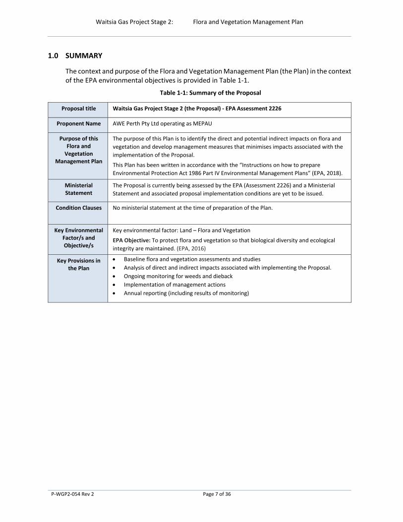
1.0 SUMMARY
The context and purpose of the Flora and Vegetation Management Plan (the Plan) in the context of the EPA environmental objectives is provided in Table 1‐1.
Table 1‐1: Summary of the Proposal
Proposal title Waitsia Gas Project Stage 2 (the Proposal) ‐ EPA Assessment 2226
Proponent Name AWE Perth Pty Ltd operating as MEPAU
Purpose of this Flora and Vegetation
Management Plan
The purpose of this Plan is to identify the direct and potential indirect impacts on flora and
vegetation and develop management measures that minimises impacts associated with the
implementation of the Proposal.
This Plan has been written in accordance with the “Instructions on how to prepare
Environmental Protection Act 1986 Part IV Environmental Management Plans” (EPA, 2018).
Ministerial Statement
The Proposal is currently being assessed by the EPA (Assessment 2226) and a Ministerial
Statement and associated proposal implementation conditions are yet to be issued.
Condition Clauses No ministerial statement at the time of preparation of the Plan.
Key Environmental Factor/s and Objective/s
Key environmental factor: Land – Flora and Vegetation
EPA Objective: To protect flora and vegetation so that biological diversity and ecological
integrity are maintained. (EPA, 2016)
Key Provisions in the Plan
Baseline flora and vegetation assessments and studies
Analysis of direct and indirect impacts associated with implementing the Proposal.
Ongoing monitoring for weeds and dieback
Implementation of management actions
Annual reporting (including results of monitoring)
Waitsia Gas Project Stage 2: Flora and Vegetation Management Plan
P‐WGP2‐054 Rev 2 Page 8 of 36
2.0 CONTEXT, SCOPE AND RATIONALE
This Plan has been prepared by Mitsui E&P Australia (MEPAU)1. This Plan is intended to support the assessment, approval and implementation of the Proposal under Part IV of the Environmental Protection Act 1986 (EP Act).
MEPAU referred the Proposal to the Environmental Protection Authority (EPA) under Part IV of the EP Act on 22 August 2019 (EPA Assessment 2226). The EPA have decided to assess the Proposal as a significant proposal, through Assessment of Referral Information (ARI). The ARI is to include additional information requested under Section 40(2)(a) of the EP Act, including this Plan, which will be subject to a two‐week public review period.
This plan has been written in accordance with the “Instructions on how to prepare Environmental Protection Act 1986 Part IV Environmental Management Plans” (EPA, 2018).
2.1 Proposal
The petroleum exploration and production sector has been continually active in the northern Perth Basin since the 1960s. MEPAU is building on this long‐standing presence and is progressively developing the Waitsia gas field, a free‐flowing2, conventional gas reservoir. The proposal is located in an agricultural area approximately 16 kilometres (km) east‐south‐east of Dongara‐Port Denison townsites in Western Australia (refer Figure 2‐1). It is expected this will continue to provide ongoing operator presence in the region for up to 20 years. The Waitsia Gas Project Stage 1 (Waitsia Stage 1) was commissioned in 2016 and has been producing from two existing wells through the Xyris Production Facility (XPF). The Waitsia Gas Project Stage 1 Expansion is now under construction and will connect an additional existing well to XPF and construct a pipeline connecting XPF to the nearby Dampier to Bunbury Natural Gas Pipeline (DBNGP).
The Proposal (known as the Waitsia Gas Project Stage 2 or WGP2) includes the construction and operation of the Waitsia Gas Plant (WGP), related wells and gas gathering infrastructure. Table 2‐1 provides a summary of the Proposal.
Table 2‐1: Proposal Overview
Proposal Title Waitsia Gas Project Stage 2 (The Proposal)
Proponent Activities Development of a conventional gas reservoir by designing and constructing wells, a
gathering system, gas processing plant and export pipeline to the DBNGP
Short Description The Proposal includes the development of a gas plant, six new production wells, four
hubs and a number of flowlines/pipelines.
The Proposal includes the following components:
Construction and operation of the WGP with a maximum export capacity of 250
terajoules (TJ) per day,
The operation of two existing wells,
1 AWE Perth Pty Limited is the legal entity, operator of the relevant Production Licences (L1 and L2), the proponent for
the Proposal and operates under the Mitsui E&P Australia (MEPAU) brand.
2 No hydraulic fracture stimulation (i.e. no fracking) is proposed given the free‐flowing nature of the Waitsia gas field.

Waitsia Gas Project Stage 2: Flora and Vegetation Management Plan
P‐WGP2‐054 Rev 2 Page 9 of 36
Proposal Title Waitsia Gas Project Stage 2 (The Proposal)
The drilling, completion and connection of up to an additional six wells 3,
A gathering system comprising flowlines and hubs to convey the extracted gas to the
WGP and the gas distribution network, and
Installing a flowline from the WGP to a water re‐injection well to re‐inject produced
formation water into a disused petroleum formation, thus minimising the
requirement for and size of evaporation ponds.
Figure 2‐1: Regional Setting
Waitsia Gas Plant
Gas extracted from the wells will be conveyed to centrally located gas gathering stations, or hubs, then directed via two flowlines to the proposed WGP for processing prior to being exported from WGP to the nearby DBNGP.
The WGP will use the same standard components as those used for processing Waitsia Stage 1 gas from the existing XPF. The WGP comprises the following processing components, which are required to condition the gas to meet the DBNGP pipeline gas quality specifications:
Slug catcher and inlet separation as the gas enters the WGP,
Mercury removal equipment,
3 Another stage of Waitsia gas field development could include drilling of up to an additional eight (8) wells, resulting in
an expected 17 wells in total over the life of the Waitsia gas field. Any additional wells are separate to this Proposal and
will be subject to separate approvals.

Waitsia Gas Project Stage 2: Flora and Vegetation Management Plan
P‐WGP2‐054 Rev 2 Page 10 of 36
Gas refining to remove carbon dioxide (also known as ‘sweetening’),
Hydrocarbon dew‐point control,
Water content control,
Export compression,
Sales gas metering,
Condensate export system,
Produced water treatment; and
Support utilities.
The Plant will be operated 24 hours a day throughout the year, except for maintenance shutdowns.
Gathering System
The Gathering System comprises the flowlines that convey the gas from underground wells to the gas hubs and various items of above‐ground infrastructure.
Wells
Currently, two existing wells (i.e. Waitsia‐01 and Senecio‐03) are operating as Waitsia Stage 1, with gas extracted from these wells transmitted to the existing XPF. The Waitsia Stage 1 Expansion will connect a third existing well (i.e. Waitsia‐02) to XPF.
Two existing wells (i.e. Waitsia‐03 and Waitsia‐04) will be brought on stream as part of the Proposal, with the drilling of up to six additional wells4.
Supporting Utilities
The following supporting utilities will be required for the Proposal:
Fuel gas system,
Electrical Power generation facilities,
Heating medium system,
An instrument air system,
Flare system,
Fire water system,
Utility water system, and
Diesel system.
4 Another stage of Waitsia gas field development could include drilling of up to another eight (8) wells, resulting in an
expected 17 wells in total over the life of the Waitsia gas field. Any additional wells are separate to this Proposal and will
be subject to separate approvals.

Waitsia Gas Project Stage 2: Flora and Vegetation Management Plan
P‐WGP2‐054 Rev 2 Page 11 of 36
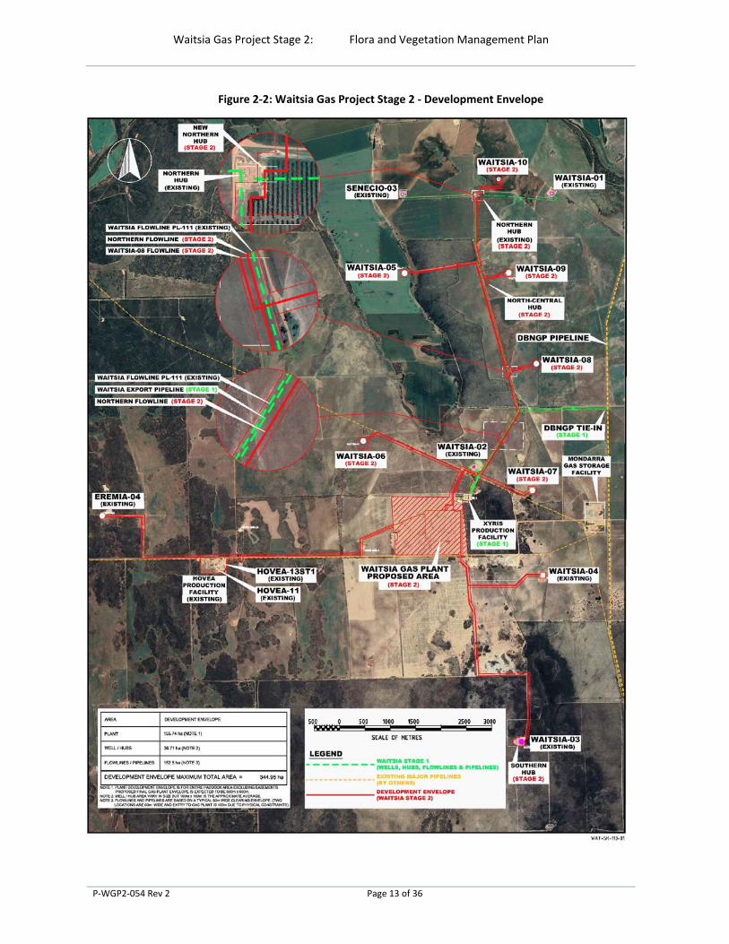
Development Envelope
2.1.5.1 Avoidance and mitigation
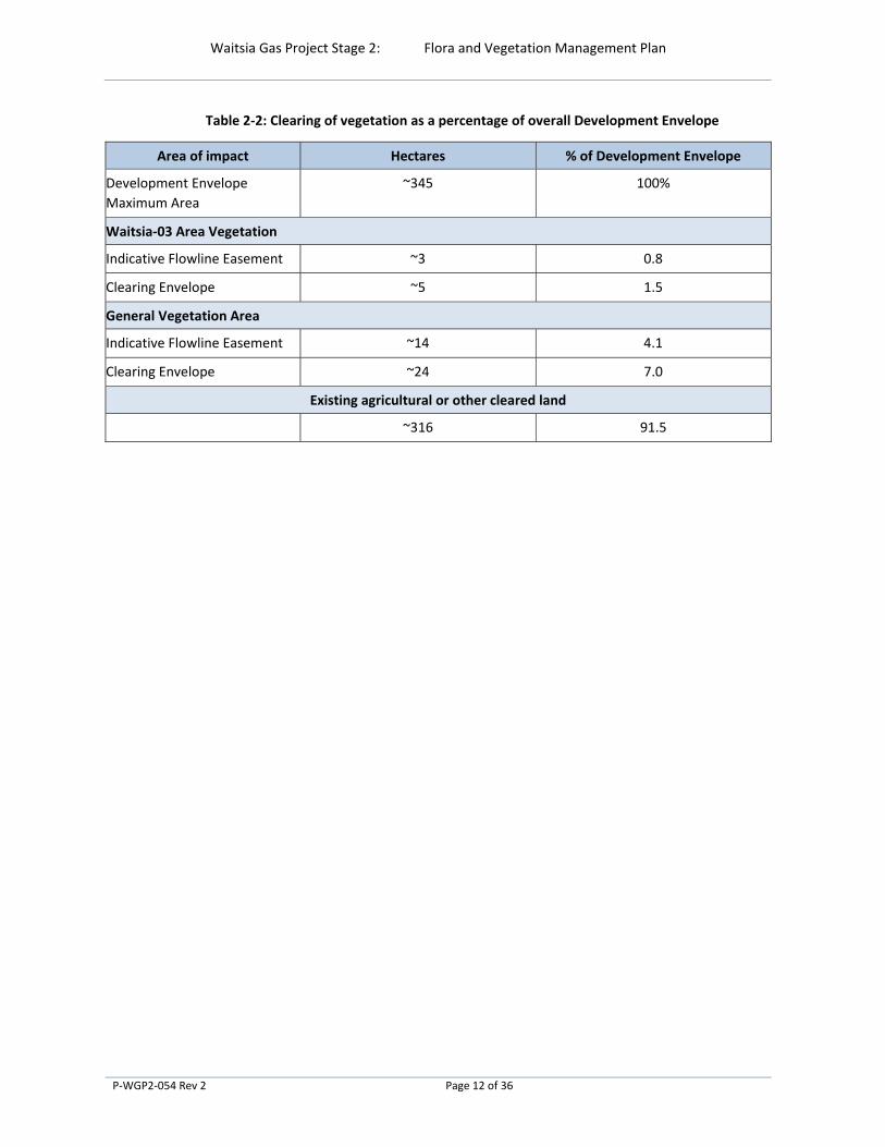
Throughout the scoping phase of this Proposal, MEPAU conducted site selection analysis to, where possible, reduce the environmental footprint of the Proposal. Specifically, the location of the Waitsia Gas Plant and flowline alignments were selected to avoid vegetated areas and minimise the amount of vegetation and flora that was directly impacted by the proposal. As detailed in Table 2‐2, ~91.5 % of the development envelope is located within existing agricultural or other cleared land and only ~1.5 % of the development envelope is situated in good quality native vegetation.
MEPAU has managed to balance the project needs, whilst locating the Development Envelope in a location that has reduced the direct vegetation and flora impacts to a level that is as low as reasonably practicable (ALARP).
2.1.5.2 Development Envelope area
The total area of the development envelope for the Proposal area is ~345 ha (Figure 2‐2).
Although the area of impact has been minimised to the lowest practicable extent by utilising existing cleared areas to locate infrastructure, the proposal will result in a direct loss of vegetation and flora through clearing to construct access roads and flowlines.
The areas where vegetation clearing is proposed is described Table 2‐2. APPENDIX H of the Environmental Referral Supporting Report (MEPAU, 2019) provides figures detailing affected areas. The direct impacts of this Proposal are:
The construction of access tracks and flowlines will result in clearing of approximately:
~3 ha (or 0.8% of the Development Envelope) of native vegetation in good condition (known as Waitsia‐03 Area Vegetation);
~14 ha (or 4.1% of the Development Envelope) of native vegetation in poor condition that has been largely degraded over many decades by a mixture of partial clearing, burning and grazing (known as General Vegetation Area); and
Direct loss of individual plants from 4 priority listed taxa5.
5 MEPAU, 2019 states that 5 priority species would be impacted by the Proposal. Austrostipa sp. Cairn Hill (M.E. Trudgen
21176) was recorded by Woodman, 2018a. As detailed in Figure 2, APPENDIX 3 this species does not occur within the
Clearing Envelope.
Waitsia Gas Project Stage 2: Flora and Vegetation Management Plan
P‐WGP2‐054 Rev 2 Page 12 of 36
Table 2‐2: Clearing of vegetation as a percentage of overall Development Envelope
Area of impact Hectares % of Development Envelope
Development Envelope
Maximum Area
~345 100%
Waitsia‐03 Area Vegetation
Indicative Flowline Easement ~3 0.8
Clearing Envelope ~5 1.5
General Vegetation Area
Indicative Flowline Easement ~14 4.1
Clearing Envelope ~24 7.0
Existing agricultural or other cleared land
~316 91.5
Waitsia Gas Project Stage 2: Flora and Vegetation Management Plan
P‐WGP2‐054 Rev 2 Page 13 of 36
Figure 2‐2: Waitsia Gas Project Stage 2 ‐ Development Envelope

Waitsia Gas Project Stage 2: Flora and Vegetation Management Plan
P‐WGP2‐054 Rev 2 Page 14 of 36
2.2 Key Environmental Factors
The preliminary key environmental factors that have been identified by the EPA includes: Air Quality, Flora and Vegetation, Inland Waters, and Social Surroundings. A summary of the Flora and Vegetation factor with a specific focus on the impacts on flora and vegetation by this Proposal are detailed in Table 2‐3. The other preliminary key environmental factors and their management provisions are outlined in separate environmental management plans.
Impacts will be managed via the management measures detailed in Section 3.
Table 2‐3: Summary of key environmental factor – Flora and Vegetation
Flora and Vegetation
EPA Objective To protect flora and vegetation so that biological diversity and ecological integrity
are maintained.
Policy and Guidance Environmental Factor Guideline – Flora and Vegetation 2016
Technical Guidance – Flora and Vegetation Surveys for Environmental Impact
Assessment 2016
Part V of the Environmental Protection Act 1986
Petroleum and Geothermal Energy Resources Act 1967
Petroleum Pipelines (Environment) Regulations 2012
Project activities Clearing of native vegetation for the purposes of flowline and pipeline
construction.
Potential impacts – Direct impacts
Direct loss of vegetation and flora
Accidental disturbance of areas outside of the final flowline envelope
Potential impacts – indirect impacts
Introduction of new weeds and/or spread of existing weeds
Potential introduction of dieback
2.3 Condition Requirements
The Proposal is currently being assessed by the EPA (Assessment 2226) and a Ministerial Statement and associated proposal implementation conditions are yet to be issued.
Should this Proposal be approved for implementation, the conditions relating to Flora and Vegetation management will be included in this section.
2.4 Rationale and Approach
A number of key information sources and aspects inform the rationale and approach of the management provisions outlined in Section 3. The following sub‐sections summarise:
Vegetation and Flora assessments and desktop studies completed and findings (Section 2.4.1);
Key assumptions and uncertainties (Section 2.4.2);
The management approach (Section 2.4.3); and
The rationale for choice of provisions (Section 2.4.4).
Waitsia Gas Project Stage 2: Flora and Vegetation Management Plan
P‐WGP2‐054 Rev 2 Page 15 of 36
Vegetation and Flora Assessments and Desktop Studies Completed and Findings
Several vegetation and flora assessments and desktop studies have been undertaken within the Development Envelope and wider Proposal Area. Assessments that are relevant to the Project were identified and discussed in the Waitsia Gas Project Stage 2 – Environmental Referral Supporting Report (MEPAU 2019) and are detailed in APPENDIX 1.
The key findings of these assessments are:
There are six Vegetation System Associations (VSAs) across the Waitsia area: Agricultural land, Kwongan to open banksia woodland on sand, Riparian shrub‐thicket and woodland on dark peaty‐sand (including wetlands such as Ejarno Spring), Eucalypt/banksia/acacia low forest on sand, York Gum Woodland on red sandy loam and Irwin River Red Gum Woodland. The six VSAs are relatively well represented with more than 45% of pre‐European extent remaining (APPENDIX 3 Table 3‐1).
No riparian vegetation, declared rare flora (Threatened), or threatened ecological communities, as listed under the Biodiversity Conservation Act (BC Act) or threatened species or priority ecological communities as listed under the EPBC Act, have been recorded within the proposed development envelope or the abutting area.
Four flora taxa listed as priority flora by the Department of Biodiversity, Conservation and Attractions (DBCA) are known to occur within the proposed clearing area. All four taxa are known to occur outside the clearing area across relatively large ranges.
Key threatening processes to flora and vegetation include the direct impact of clearing, potential indirect impacts caused by weeds and potential spread of dieback.
Key Assumptions and Uncertainties
The key assumptions and uncertainties relating to the Flora and Vegetation assessments detailed in APPENDIX 1 are summarised in Table 2‐4.
Table 2‐4: Assumptions and Uncertainties
# Assumptions and uncertainties Comment
1 Level of surveys completed
were adequate to assess flora
and vegetation
Where targeted and/or detailed surveys were completed they
were conducted over one field trip at varying times within the peak
flowering season in the Geraldton Sandplains Bioregion. Replicated
quadrats were established in each vegetation pattern identified in
the Study Area. EPA (2016a) indicates that survey may be required
to be undertaken in other seasons.
It is considered that surveys in the peak flowering season only are
adequate, as it considered likely that most taxa that flower outside
the peak flowering season could be identified during the survey
period (Woodman, 2018a)
2 Competency and experience of
consultant/s carrying out the
survey was sufficient to ensure
qualified results
Senior experienced and qualified personnel were involved with all
desktop assessments and/or targeted and/or detailed flora surveys
undertaken. They also had experience in conducting similar
assessments in the bioregion.
Waitsia Gas Project Stage 2: Flora and Vegetation Management Plan
P‐WGP2‐054 Rev 2 Page 16 of 36
# Assumptions and uncertainties Comment
3 Scope (Were the sampling of
flora groups limited because of
any constraints?)
All vascular groups that were present during the targeted and/ or
detailed assessments were sampled. No constraints prevented
appropriate sampling techniques (quadrat establishment, relevés,
targeted searching and opportunistic recording) being undertaken.
4 A sufficient proportion of flora
identified, recorded and /or
collected
In most instances a high proportion of perennial vascular taxa were
recorded based on the intensity and method of survey. A lower
proportion of ephemeral and annual vascular taxa were recorded
based on the below‐average rainfall prior to and the later timing of
the survey (Woodman, 2018a). Unknown vascular taxa were
collected within quadrats, relevés and opportunistically, with
specimens identified at the WA Herbarium
5 Sources of information on
previous surveys was used.
Sources of information used during desktop assessments and/or
targeted and/or detailed surveys included government databases
(e.g. DBCA and Department of Agriculture, Water and the
Environment (DAWE)) and previous reports and unpublished data
from the vicinity of the broader proposal area.
6 The proportion of the task
achieved and further work
which might be needed
Where Targeted and/or Detailed Surveys were completed, the
targeted survey included grid searching for significant flora taxa
throughout the entire Study Area. No further surveys within the
Study Area were considered necessary.
7 Timing/weather/season/cycle
were factored into the surveys
Where Targeted and/or Detailed Surveys were completed the field
survey was conducted in Spring, corresponding with the optimum
flowering period for the Geraldton Sandplains Bioregion. Where
below‐average rainfall in the months prior to the survey and/or
later timing of the survey limited the number of ephemeral and
annual taxa recorded/identified this did not impact the outcomes
of the survey or prevent identification of any potential significant
taxa that may potentially occur in the Study Area.
8 Disturbances (e.g. fire, flood,
accidental human intervention
etc.), which affected results of
survey
Where Targeted and/or Detailed Surveys were completed some
disturbances such as historical clearing and weeds were apparent.
These did not significantly impact the flora taxa present and are
therefore not considered to have affected the results of the
survey.
9 Intensity of survey Where Targeted and/or Detailed Surveys were completed the
survey intensity was considered adequate, with replication of
quadrats in vegetation types and detailed foot searching
(particularly for significant flora) undertaken throughout the Study
Area
10 Completeness and mapping
reliability
Where Targeted and/or Detailed Surveys were completed the
survey of the Study Area is considered complete in terms of
mapping of vegetation types. Specific grid searching for significant
flora taxa was undertaken throughout the entire Study Area.
Waitsia Gas Project Stage 2: Flora and Vegetation Management Plan
P‐WGP2‐054 Rev 2 Page 17 of 36
# Assumptions and uncertainties Comment
Where appropriate foot and/or vehicle transects were employed
to aid in mapping which increased the reliability
11 Remoteness and/or access
problems
Where Targeted and/or Detailed Surveys were completed access
to the Study Area was considered good, given the entire Study
Area was accessible via tracks and firebreaks
12 Survey planning and
implementation
All surveys have been planned and implemented in accordance
with relevant in‐force industry guidance (including the EPA’s
Technical Guidance Flora and Vegetation Surveys for
Environmental Impact Assessment guidance)
Management Approach
MEPAU plan to implement both outcome and management‐based provisions under this Plan.
The reason for this approach is the nature of the risks associated with the implementation of the Proposal where some vegetation will be directly impacted (i.e. cleared under a Part V of the EP Act clearing permit) and where other potential indirect impacts are considered low risk.
APPENDIX 1 provides an assessment of:
the direct impacts on vegetation and priority flora associated with the implementation of the Proposal, and
the potential indirect impacts on vegetation and priority flora associated with the implementation of the Proposal.
The assessment identifies that limited vegetation to be cleared has conservation significance and no VSA will be cleared by more than 0.01%.
Although four priority listed taxa were identified, the potential impact to each of these species is considered small as:
the number of plants impacted for each of these species comprise only a small proportion of the recorded population
each of these species has a wide distribution outside the Development Envelope, including within formal reserves or beyond the Geraldton Sandplains IBRA.
Further details on the assessment of potential impacts associated with the implementation of the Proposal can be found in MEPAU, 2019.
Rationale for Choice of Provisions
The management provisions proposed are based on the following rationale:
Nature of the impact ‐ Throughout the scoping phase of this Proposal, MEPAU conducted site selection analysis to, where possible, reduce the direct impacts from environmental footprint of the Proposal. Specifically, the location of the WGP and flowline alignments were selected to avoid vegetated areas and minimise the amount of vegetation and flora that was directly impacted by the proposal. The area directly impacted from these activities will be minimised following construction to the smallest practicable extent through selective reinstatement / rehabilitation whilst still ensuring that infrastructure

Waitsia Gas Project Stage 2: Flora and Vegetation Management Plan
P‐WGP2‐054 Rev 2 Page 18 of 36
can be safely maintained. Table 2‐2 details the percentage clearing vegetated areas compared to non‐vegetated areas. Specifically, ~91.5 % of the development envelope is located within existing agricultural or other cleared land and only ~1.5 % of the development envelope is situated in good quality native vegetation.
Duration of impact – Given that the clearing of native vegetation and construction of flowlines are short in duration, indirect impacts will be minimised. Operational activities pose minimal indirect impacts that can be managed through adaptive management actions detailed in this Plan.
Expected changes in flora and vegetation – as detailed in APPENDIX 3 the flora and vegetation to be cleared are well represented within the broader proposal area and areas outside of the proposal area.

Waitsia Gas Project Stage 2: Flora and Vegetation Management Plan
P‐WGP2‐054 Rev 2 Page 19 of 36
3.0 FLORA AND VEGETATION MANAGEMENT
A series of environmental objectives have been developed to mitigate environmental impacts on flora and vegetation associated with the implementation of the Proposal. Table 3‐1 details the environmental objectives for this plan.
For each objective, outcome and / or management‐based provisions have been developed to ensure the impacts from the implementation of the Proposal are appropriately managed, targets achieved, and the appropriate monitoring and reporting are completed to support the implementation of the management actions.
Table 3‐1: Environmental Objectives
Potential Impact Environmental Objective
Direct loss of vegetation and flora Minimise impacts to conservation significant flora
Accidental disturbance of areas outside of
the final flowline envelope
Prevent clearing of vegetation and flora outside of final
flowline easement
Minimise disturbance of vegetation and flora outside of the
final flowline envelope
Introduction of new / Declared weeds
and/or spread of existing weeds
Prevent introduction of new / Declared weed species into
adjacent areas of previously uncleared or unimpacted native
vegetation.
Prevent the spread of existing weed species within Waitsia‐
03 Vegetation Area.
Introduction of dieback Prevent introduction of dieback into the Waitsia‐03
Vegetation Area.
3.1 Flora and Vegetation Management Plan Provisions
Table 3‐2 and Table 3‐3 identify the legal outcome and management‐based provisions (respectively) that MEPAU will implement to ensure that the environment outcomes are met during the implementation of the Proposal.
Waitsia Gas Project Stage 2: Flora and Vegetation Management Plan
P‐WGP2‐054 Rev 2 Page 20 of 36
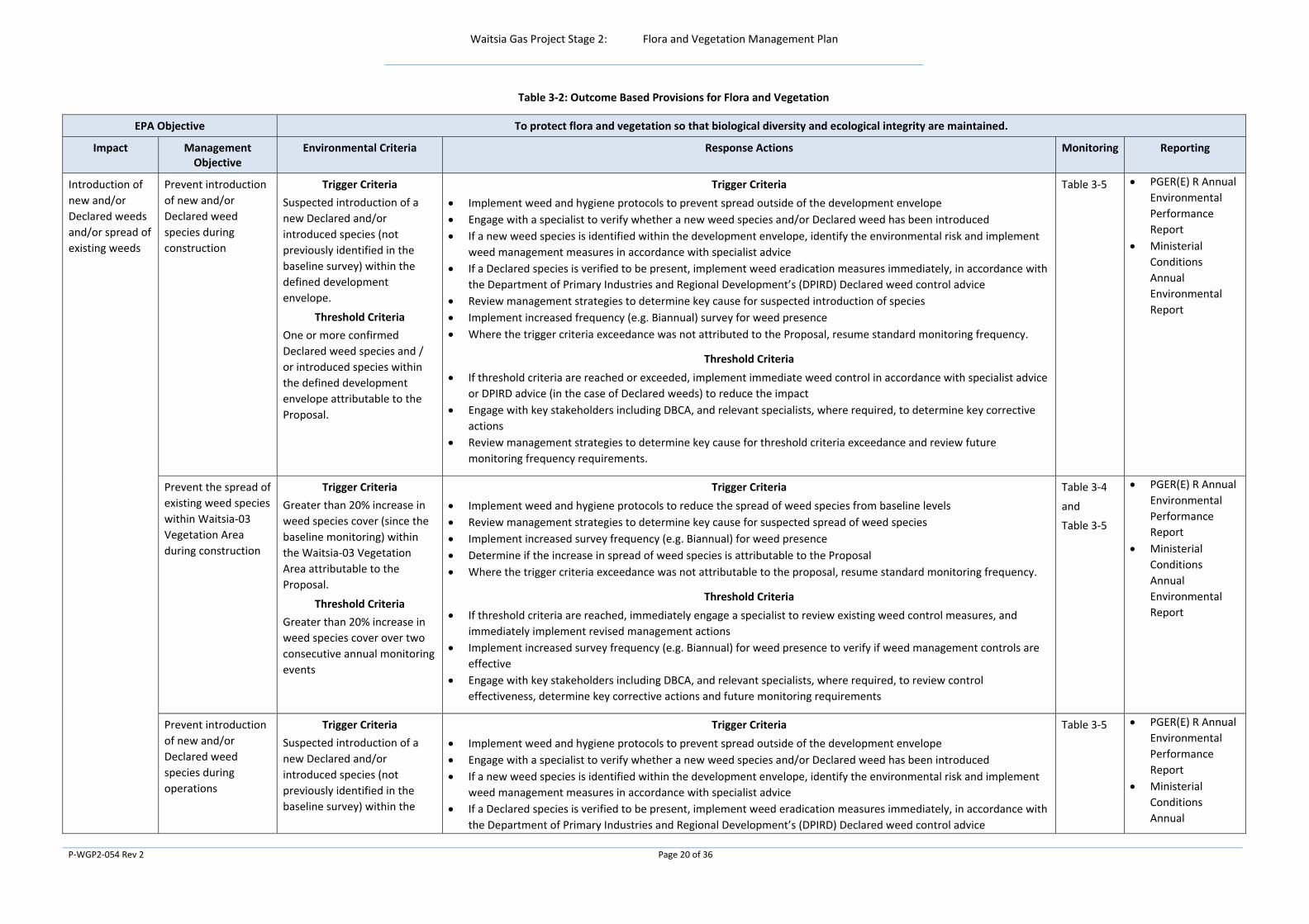
Table 3‐2: Outcome Based Provisions for Flora and Vegetation
EPA Objective To protect flora and vegetation so that biological diversity and ecological integrity are maintained.
Impact Management Objective
Environmental Criteria Response Actions Monitoring Reporting
Introduction of
new and/or
Declared weeds
and/or spread of
existing weeds
Prevent introduction
of new and/or
Declared weed
species during
construction
Trigger Criteria
Suspected introduction of a
new Declared and/or
introduced species (not
previously identified in the
baseline survey) within the
defined development
envelope.
Threshold Criteria
One or more confirmed
Declared weed species and /
or introduced species within
the defined development
envelope attributable to the
Proposal.
Trigger Criteria
Implement weed and hygiene protocols to prevent spread outside of the development envelope
Engage with a specialist to verify whether a new weed species and/or Declared weed has been introduced
If a new weed species is identified within the development envelope, identify the environmental risk and implement
weed management measures in accordance with specialist advice
If a Declared species is verified to be present, implement weed eradication measures immediately, in accordance with
the Department of Primary Industries and Regional Development’s (DPIRD) Declared weed control advice
Review management strategies to determine key cause for suspected introduction of species
Implement increased frequency (e.g. Biannual) survey for weed presence
Where the trigger criteria exceedance was not attributed to the Proposal, resume standard monitoring frequency.
Threshold Criteria
If threshold criteria are reached or exceeded, implement immediate weed control in accordance with specialist advice
or DPIRD advice (in the case of Declared weeds) to reduce the impact
Engage with key stakeholders including DBCA, and relevant specialists, where required, to determine key corrective
actions
Review management strategies to determine key cause for threshold criteria exceedance and review future
monitoring frequency requirements.
Table 3‐5 PGER(E) R Annual
Environmental
Performance
Report
Ministerial
Conditions
Annual
Environmental
Report
Prevent the spread of
existing weed species
within Waitsia‐03
Vegetation Area
during construction
Trigger Criteria
Greater than 20% increase in
weed species cover (since the
baseline monitoring) within
the Waitsia‐03 Vegetation
Area attributable to the
Proposal.
Threshold Criteria
Greater than 20% increase in
weed species cover over two
consecutive annual monitoring
events
Trigger Criteria
Implement weed and hygiene protocols to reduce the spread of weed species from baseline levels
Review management strategies to determine key cause for suspected spread of weed species
Implement increased survey frequency (e.g. Biannual) for weed presence
Determine if the increase in spread of weed species is attributable to the Proposal
Where the trigger criteria exceedance was not attributable to the proposal, resume standard monitoring frequency.
Threshold Criteria
If threshold criteria are reached, immediately engage a specialist to review existing weed control measures, and
immediately implement revised management actions
Implement increased survey frequency (e.g. Biannual) for weed presence to verify if weed management controls are
effective
Engage with key stakeholders including DBCA, and relevant specialists, where required, to review control
effectiveness, determine key corrective actions and future monitoring requirements
Table 3‐4
and
Table 3‐5
PGER(E) R Annual
Environmental
Performance
Report
Ministerial
Conditions
Annual
Environmental
Report
Prevent introduction
of new and/or
Declared weed
species during
operations
Trigger Criteria
Suspected introduction of a
new Declared and/or
introduced species (not
previously identified in the
baseline survey) within the
Trigger Criteria
Implement weed and hygiene protocols to prevent spread outside of the development envelope
Engage with a specialist to verify whether a new weed species and/or Declared weed has been introduced
If a new weed species is identified within the development envelope, identify the environmental risk and implement
weed management measures in accordance with specialist advice
If a Declared species is verified to be present, implement weed eradication measures immediately, in accordance with
the Department of Primary Industries and Regional Development’s (DPIRD) Declared weed control advice
Table 3‐5 PGER(E) R Annual
Environmental
Performance
Report
Ministerial
Conditions
Annual

Waitsia Gas Project Stage 2: Flora and Vegetation Management Plan
P‐WGP2‐054 Rev 2 Page 21 of 36
EPA Objective To protect flora and vegetation so that biological diversity and ecological integrity are maintained.
Impact Management Objective
Environmental Criteria Response Actions Monitoring Reporting
defined development
envelope.
Threshold Criteria
One or more confirmed
Declared weed species and /
or introduced species within
the defined development
envelope
Review management strategies to determine key cause for suspected introduction of species
Implement increased frequency (e.g. Monthly) survey for weed presence
Where the trigger criteria exceedance was not attributed to the Proposal, resume standard monitoring frequency.
Threshold Criteria
If threshold criteria are reached or exceeded, implement immediate weed control in accordance with specialist advice
or DPIRD advice (in the case of Declared weeds) to reduce the impact
Engage with key stakeholders including DBCA, and relevant specialists, where required, to determine key corrective
actions
Review management strategies to determine key cause for threshold criteria exceedance and review future
monitoring frequency requirements.
Environmental
Report
Potential
introduction of
dieback
Prevent introduction
of dieback into the
Waitsia‐03
Vegetation Area
Trigger Criteria
Suspected introduction of
dieback into the dieback free
Waitsia‐03 Vegetation Area
based on visual evidence of
declining health/death of
dieback susceptible species
such as Banksia, Hakea, Zamia
Palms and Xanthorrhoea
species
Threshold Criteria
Confirmed introduction of
dieback into the Waitsia‐03
Vegetation Area as interpreted
by DBCA accredited dieback
interpreters.
Trigger Criteria
Immediate implementation of hygiene protocols to prevent spread of soil vegetation material within and outside of
the suspected dieback contaminated area
Conduct a dieback survey using DBCA accredited dieback interpreters, to verify if dieback has been introduced.
Review management strategies to determine key cause for suspected introduction of dieback
Implement increased frequency (e.g. Annual) Dieback presence monitoring survey for dieback presence
Where the trigger criteria exceedance was not attributable to the proposal, resume standard monitoring frequency.
Threshold Criteria
Engage with key stakeholders including DBCA, and relevant specialists, where required, to determine key corrective
actions
Monitor effectiveness of management / corrective actions. Update / revise management measures if needed (ie. if
impact persists despite management actions)
Table 3‐5 PGER(E) R Annual
Environmental
Performance
Report
Ministerial
Conditions
Annual
Environmental
Report

Waitsia Gas Project Stage 2: Flora and Vegetation Management Plan
P‐WGP2‐054 Rev 2 Page 22 of 36
Table 3‐3: Environmental Management Approach for Flora and Vegetation
EPA Objective To protect flora and vegetation so that biological diversity and ecological integrity are maintained.
Impact Management Objective Management Action Proposal Stage Management Targets Monitoring Reporting
Habitat loss, degradation and fragmentation
Direct loss of
vegetation and
flora
Minimise impacts to
conservation significant
flora
MEPAU will finalise additional targeted flora surveys in General
Vegetation Area and Waitsia‐03 Vegetation Area to ensure no
significant flora species will be significantly impacted by
construction
Gain approval to clear vegetation under Part V of the EP Act
(NVCP).
Construction Compliance with
commitment in the EPA
referral which states no
significant impacts to flora
and vegetation.
None identified Part V NVCP annual
compliance report
Accidental
disturbance of
areas outside of
the final flowline
envelope.
Prevent clearing of
vegetation and flora
outside of final flowline
easement
Ensure final flowline easement is ≤ 30m width within
development envelope.
Vegetation clearing will be undertaken in accordance with a
Land Clearing Procedure. The procedure will include the
following requirements:
An authorised internal clearing permit must be issued prior to
undertaking any vegetation clearing.
Clearing boundaries must be clearly marked and checked to
confirm they are accurate prior to undertaking clearing.
A survey of cleared areas will be undertaken post clearing to
confirm boundaries have been adhered to.
Make all construction personnel aware of the clearing area
boundaries through the induction/ training process
Construction Compliance with pre‐
defined clearing limits and
boundaries described
within the NVCP.
Verification prior to clearing
activities that clearing limits are
clearly defined
Verification following clearing
activities that no clearing
outside of this area has
occurred
Weekly inspections to visually
check/review clearing
boundaries and compliance
Photographic reference points
of clearing to enable
comparison between pre and
post clearing environments
Any clearing
undertaken outside
of the clearing area
will be reported as
required by the EP
Act Part V and
PGER(E) R
requirements in
accordance with
MEPAU’s incident
management
procedure.
Part V NVCP annual
compliance report
Minimise disturbance of
vegetation and flora
outside of the final
flowline envelope
Stockpiling of all soil and vegetative materials from clearing
will be within the final flowline envelope.
Final flowline envelope boundaries in the vicinity of proposed
stockpiling areas must be clearly marked and checked to
confirm they are accurate prior to undertaking clearing.
A survey of stockpiled areas will be undertaken post
stockpiling to confirm boundaries have been adhered to.
Make all construction personnel aware of the final flowline
envelope area boundaries through the induction/ training
process
Vehicles shall be restricted to movement along designated
tracks and cleared areas, unless undertaking clearing.
Vehicle speeds will be restricted (~ 25 km/h) on
unconsolidated surfaces in dry conditions.
Construction Minimal disturbance to
vegetation and flora
outside of final flowline
envelope.
Weekly inspections to visually
check/review:
Stockpiling of all soil and
vegetation materials are within
final flowline envelope.
Compliance with final flowline
envelope and stockpiling area
boundaries.
Vegetation and flora outside of
final flowline envelope has not
been disturbed.
PGER(E) R Annual
Environmental
Performance Report
Ministerial
Conditions Annual
Environmental
Report.

Waitsia Gas Project Stage 2: Flora and Vegetation Management Plan
P‐WGP2‐054 Rev 2 Page 23 of 36
EPA Objective To protect flora and vegetation so that biological diversity and ecological integrity are maintained.
Impact Management Objective Management Action Proposal Stage Management Targets Monitoring Reporting
Invasive Species
Introduction of
new / Declared
weeds and/or
spread of existing
weeds
Prevent introduction of
new / Declared weed
species into adjacent
areas of previously
uncleared or
unimpacted native
vegetation.
MEPAU will:
Develop a weed and dieback hygiene protocol prior to
commencement of construction. This protocol will:
o Describe the requirements and triggers for conducting
a hygiene inspection and vehicle clean‐down.
Specifically,
all vehicles/plant/ equipment prior to
mobilizing to site will be inspected and
cleaned down where they are known to have
been working in, or travelling through areas
with known or potential dieback presence, and
all vehicles/plant/equipment is required to be
inspected prior requirement to accessing
sensitive areas such as the Yardanogo Nature
Reserve
o Describe the process by which construction fill is
evaluated to verify it comprises a low risk of
containing weeds or pathogens
o Describe the requirement for monitoring:
weed presence quarterly
dieback presence annually
dieback biannually with a specialist survey
(specific to the Waitsia‐03 well site access
track)
o Describe weed management methods (such as spot
spraying, boom spraying and vegetation slashing)
relevant to the activity
Make all personnel aware of weed and dieback hygiene
protocol and practices through the induction/ training
processes
Prohibit the importation of soil and vegetation materials to
site unless approved for a specific purpose and is assessed to
comprise a low risk of containing weeds or pathogens.
Implement the weed and dieback hygiene protocol
Construction and
Operations
No new declared weeds or
dieback infestations
introduced into or adjacent
to the Proposal area
attributable to the Proposal
Pre‐clearing baseline flora and
vegetation survey that
identifies weed and dieback
presence
Quarterly observations for
weed presence
Verification that construction
fill bought to site has low risk of
containing weeds or pathogens
Verification that
vehicles/plant/equipment
comply with weed and dieback
hygiene protocol inspection
and clean‐down requirements.
PGER(E) R Annual
Environmental
Performance Report
Ministerial
Conditions Annual
Environmental
Report.
Introduction of
dieback
Prevent introduction of
dieback into the
Waitsia‐03 Vegetation
Area.
Construction and
Operations
Bi‐annual dieback assessment
of access route to Waitsia‐03
well site (flowline route
adjoining Yardanogo Nature
Reserve).
PGER(E) R Annual
Environmental
Performance Report
Ministerial
Conditions Annual
Environmental
Report.

Waitsia Gas Project Stage 2: Flora and Vegetation Management Plan
P‐WGP2‐054 Rev 2 Page 24 of 36
3.2 Monitoring
To clearly understand if the environmental criteria have been met or exceeded, MEPAU has (and will continue) to monitor vegetation adjacent to the development envelope. Specifically, the monitoring program is used to:
Establish presence of existing weed species and dieback infestations
Identify if the presence of weeds and dieback has been impacted by the Proposal
Establish Presence of Existing Weed Species and Dieback Infestations
In addition to the surveys completed specifically to support this Proposal, flora and vegetation composition for the Proposal area and surrounds, are well understood given the numerous surveys that have been conducted for previous oil and gas activities in the area
Based upon these surveys MEPAU has a clear understanding regarding weed and dieback presence within the Development Envelope. Specifically, two weed species known to be declared pests under the Biosecurity and Agriculture Management Act 2007 are known to be present within the Development envelope. These are
Echium plantagineum (Patersons Curse)
Rumex hypogaeus (Doublegee)
No weed species of national significance are known to occur within the Development Envelope.
No dieback infestations are known to be present within the Development Envelope.
In addition to the studies that have been used to inform baseline levels (APPENDIX 1), MEPAU plan to complete supplementary studies to further define weed diversity/density to enable ongoing comparison as required. The details of these studies are provided in Table 3‐4.
Table 3‐4: Supplementary Baseline Monitoring Events
Monitoring event Location Phase Frequency Survey Method
Weed presence
Waitsia‐03
Vegetation
Area
Prior to
construction One‐off
Conduct a Detailed baseline flora and
vegetation survey to set up permanent
sampling points (Table 3‐6) to monitor
potential changes in weed species presence,
density / abundance and vegetation health.
Quadrat sampling techniques are to be used
to provide comparability between future
survey datasets. The survey will also set up
at least two permanent quadrats within the
Yardanogo Nature Reserve to understand
the abundance, density and diversity of
weed species within the Nature Reserve.
Ejarno Spring
floristic diversity
and vegetation
condition
Ejarno
Spring
Prior to
construction One‐off
Conduct a Detailed baseline vegetation
condition survey that details vegetation
quality and diversity prior to the proposal
commencing. The survey will also record
presence and condition of invasive weeds,
having regard to weed density and category

Waitsia Gas Project Stage 2: Flora and Vegetation Management Plan
P‐WGP2‐054 Rev 2 Page 25 of 36
Monitoring event Location Phase Frequency Survey Method
of weed species (i.e. declared, national
significance etc.)
Identify If the Presence of Weeds and Dieback has been Impacted by the Proposal
Prior to commencement of construction, MEPAU will develop a weed and hygiene protocol that will align with existing operational documentation. Specifically, the protocol will describe in greater detail the locations and method for monitoring weed and dieback presence. However, Table 3‐5 provides the basis on which the monitoring program will be developed.
Table 3‐5: Weed and Dieback Monitoring Events
Monitoring event
Location Phase Frequency Survey Method
Dieback
Presence
Waitsia‐03
Vegetation
Area
Construction Quarterly Observations will be undertaken by MEPAU
personnel with a focus on vegetation health
in the vegetation adjacent to the Waitsia‐03
access track and wellsite. Specifically,
observations will focus on the health of
known dieback susceptible species including
Banksia and Hakea species, Zamia palms and
Xanthorrhoea species.
The annual detailed Flora and Vegetation
survey will identify any areas potentially
impacted by dieback, which can then be
confirmed during the biannual monitoring.
During this survey, the following will be
recorded in terms of dieback:
Pathogen attack – visual evidence of
dieback
Plant death
Number of dead shrubs or trees
and a percentage for
grasses/lower storey within
each quadrat
Percentage death of upper, mid
and lower storeys for transects
Operations Annual
Dieback
Presence
Waitsia‐03
Vegetation
Area
Construction and
Operations Bi‐annual
Biannual monitoring for dieback presence
will be performed by a DBCA accredited
dieback interpreter to standards and
procedures defined in FEM047 – The
Phytophthora Dieback Interpreter's Manual
for Lands. A linear assessment along the
Waitsia‐03 access track will be conducted
using standards defined by FEM047
During the assessment, soil and tissue
samples will be collected, if required, to
support any field diagnosis. Sample points
Waitsia Gas Project Stage 2: Flora and Vegetation Management Plan
P‐WGP2‐054 Rev 2 Page 26 of 36
Monitoring event
Location Phase Frequency Survey Method
will be logged, and, when identified,
infestations mapped.
Weed
Presence
Waitsia‐03
Vegetation
Area
and
General
Vegetation
Area
Construction and
operations Quarterly
Observations will be undertaken by MEPAU
personnel within the development envelope
with the focus on verifying areas that
comprise existing declared pests and
opportunistically identifying additional
introduced species. A weed monitoring
procedure will be developed for personnel to
capture the following information:
Date and time of monitoring
Weed species observed at specific
locations within the development
envelope (a visual guide will be
available for identification of
previously recorded Declared and
introduced species). GPS location of
any species not previously
identified and not present within
the visual guide.
Estimate number of plants at each
location
Reproductive status of weed if
possible (eg. Flowering, Non‐
flowering, seed set, seeding)
Observations relevant to the
presence of the new species (ie.
proximity to roads, water sources)
Any control actions taken (ie.
manual removal)
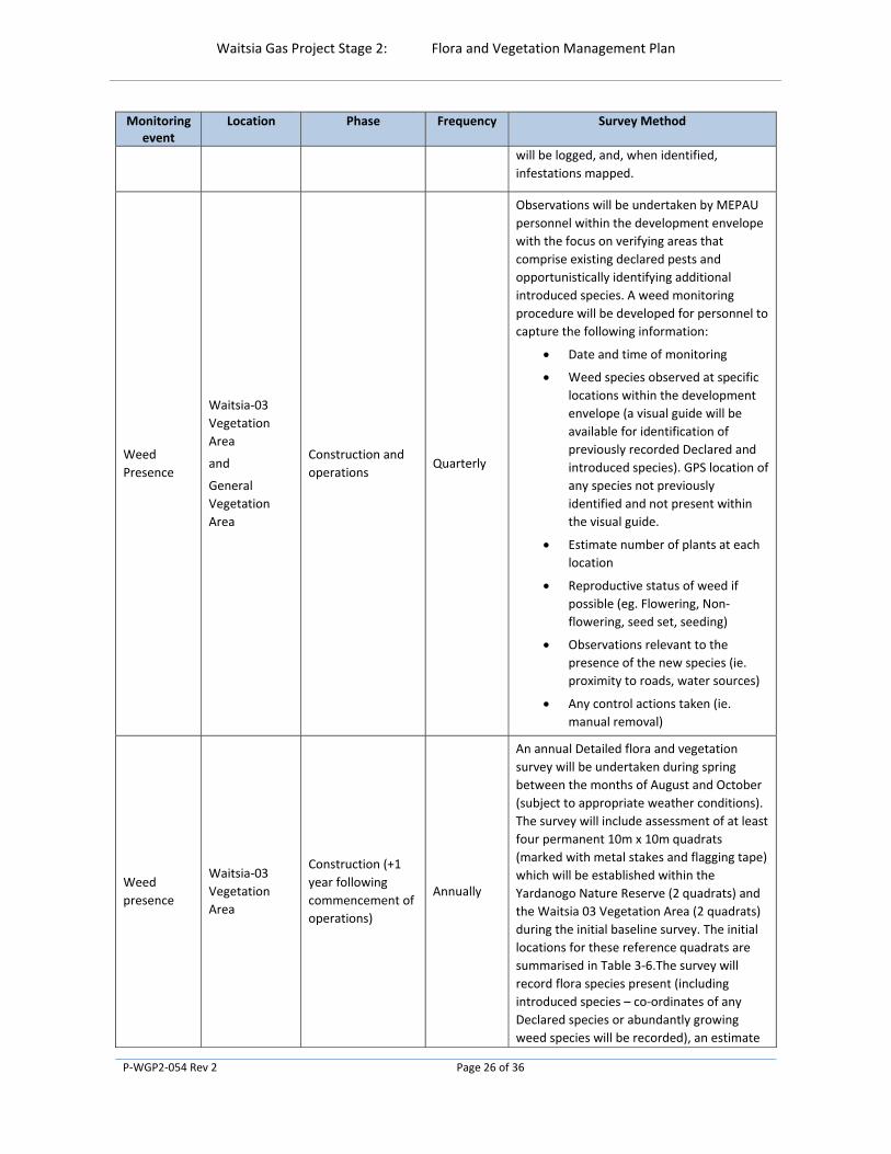
Weed
presence
Waitsia‐03
Vegetation
Area
Construction (+1
year following
commencement of
operations)
Annually
An annual Detailed flora and vegetation
survey will be undertaken during spring
between the months of August and October
(subject to appropriate weather conditions).
The survey will include assessment of at least
four permanent 10m x 10m quadrats
(marked with metal stakes and flagging tape)
which will be established within the
Yardanogo Nature Reserve (2 quadrats) and
the Waitsia 03 Vegetation Area (2 quadrats)
during the initial baseline survey. The initial
locations for these reference quadrats are
summarised in Table 3‐6.The survey will
record flora species present (including
introduced species – co‐ordinates of any
Declared species or abundantly growing
weed species will be recorded), an estimate

Waitsia Gas Project Stage 2: Flora and Vegetation Management Plan
P‐WGP2‐054 Rev 2 Page 27 of 36
Monitoring event
Location Phase Frequency Survey Method
of foliar cover as a percent value, life stage of
the introduced species (ie. flowering, non‐
flowering, seed set, seeding) and vegetation
condition (EPA 2016; Keighery 1994).
Table 3‐6: Location of Baseline Monitoring Quadrats (GDA 94)
Plot
Location
Area ID Easting (X) Northing (Y)
Distance from Project Disturbance Footprint (m)
Vegetation and Substrate Association (WEC,2018)
1 Yardanogo Nature Reserve
YNR_1 115.103603 ‐29.344991 35 VSA‐1
2 Yardanogo Nature Reserve
YNR_2 115.103603 ‐29.339796 25 VSA‐4
3 Waitsia‐03 Vegetation Area
W03_1 115.102227 ‐29.348975 130 VSA‐4
4 Waitsia‐03 Vegetation Area
W03_2 115.104626 ‐29.349702 100 VSA‐1
3.3 Reporting
The environmental outcome will be reported against Trigger and Threshold criteria (Table 3‐2) and management targets (Table 3‐3) for each calendar year in the Annual Compliance Assessment Report (ACAR) for the Proposal.
The annual report will also include a summary of analysis of monitoring data to facilitate adaptive management.
In the event that Trigger and Threshold criteria are exceeded during the reporting period, the annual report will include a description of the effectiveness of any adaptive management actions that have been implemented to manage the impact.

Waitsia Gas Project Stage 2: Flora and Vegetation Management Plan
P‐WGP2‐054 Rev 2 Page 28 of 36
4.0 ADAPTIVE MANAGEMENT
4.1 Monitoring and Corrective Actions
A monitoring program is required to measure the effectiveness of the management actions as defined in this Plan. The outcomes of the monitoring program will be reviewed with an adaptive management approach to ensure all environmental impacts and risks continue to be reduced for the duration of the proposal.
MEPAU will implement adaptive management to learn from the implementation of mitigation measures, monitoring and evaluation against trigger and threshold criteria, to more effectively meet the conditioned environmental outcome.
The following approaches will apply:
Monitoring data will be systematically evaluated and compared to baseline
The effectiveness and relevance of Trigger level and Threshold contingency actions will be evaluated on an annual basis to determine if any changes to management actions are required
Adaptive management practices that will be assessed as part of this approach may include:
Evaluation of the monitoring program, data and comparison to baseline data and reference sites on an annual basis to verify whether responses to project activities are the same or similar to predictions
Re‐evaluation of the identified impacts and revision of risk‐based priorities as a result of monitoring outcomes
Review of data and information gathered over the review period that has increased understanding of site environment in the context of the regional ecosystem
Assessment of changes which are outside the control of the project and the management measures identified (i.e. a new project within the area or region; regional change affecting management).
4.2 Management Plan Review
This Plan is intended to be dynamic and may be updated to reflect changes in management practices and the natural environment over time. This approach will allow flexibility to adopt new approaches/management measures.
Amendments to management actions will be completed on an “as needs” basis. This will include:
amendment of management actions that are not achieving the desired outcomes,
monitoring that identifies additional impacts requiring additional management actions or changes to existing management actions,
changes to relevant legislation that may affect the implementation of management actions, and/or
improvements to management practices to achieve a greater environmental outcome.

Waitsia Gas Project Stage 2: Flora and Vegetation Management Plan
P‐WGP2‐054 Rev 2 Page 29 of 36
5.0 STAKEHOLDER CONSULTATION
Consistent with the EPA’s expectations for this Plan to align with the principles of Environmental Impact Assessment, MEPAU consulted with stakeholders, including but not limited to the Department of Biodiversity, Conservation and Attractions and Department of Water and Environmental Regulation during the development of the EPA referral. MEPAU will continue to maintain effective communication with local and regional stakeholders throughout the delivery of the Proposal.
A summary of stakeholder consultation outcomes completed as of August 2019 is provided in Table 3 1 of the Environmental Referral Supporting Report (MEPAU, 2019).
Any additional consultation regarding this Plan will be captured in subsequent revisions.

Waitsia Gas Project Stage 2: Flora and Vegetation Management Plan
P‐WGP2‐054 Rev 2 Page 30 of 36
6.0 REFERENCES
Department of Parks and Wildlife. (2015). Phytophthora Dieback Interpreter Procedures for lands managed by the department. Working Draft 2. Unpublished.
Environmental Protection Authority (EPA) (2016a). Environmental Factor Guideline – Flora and Vegetation http://www.epa.wa.gov.au/sites/default/files/Policies_and_Guidance/Guideline‐Flora‐Vegetation‐131216_4.pdf
Environmental Protection Authority (EPA) (2016b). Instructions on how to define the key characteristics of a proposal http://www.epa.wa.gov.au/sites/default/files/Forms_and_Templates/PMI_Define%20Key%20Characteristics%20of%20a%20Proposal_131216_0.pdf
Environmental Protection Authority (EPA) (2016c). Technical guidance – Flora and Vegetation Surveys for Environmental Impact Assessment
Environmental Protection Authority (EPA) (2018). Instructions on how to prepare Environmental Protection Act 1986 Part IV Environmental Management Plans.
https://www.epa.wa.gov.au/forms‐templates/instructions‐part‐iv‐environmental‐management‐plans
Gelevan (2018) Dieback Assessment ‐ Mitsui E&P Waitsia.
Maia Environmental Consultancy (2015) AWE Perth Pty Ltd, Waitsia Gas Field: Flora and Vegetation Desktop Study, February 2015.
Maia Environmental Consultancy (2016) Waitsia‐04 Area Level 1 Flora and Vegetation Reconnaissance and Targeted Flora Survey.
Matsuki, M., Gardener, M.R., Smith, A., Howard, R. K., and Grove, A. (2016). Impacts of dust on plant health, survivorship and plant communities in semi‐arid environments in Austral Ecology, February 2016
Mitsui E&P Australia (MEPAU) (2019) Waitsia Gas Project Stage 2 – Environmental Referral Supporting Report
http://www.epa.wa.gov.au/sites/default/files/Referral_Documentation/Supporting%20Document_7.pdf
Woodman Environmental Consulting Pty Ltd (2004a) Proposed Xyris Area Gas Gathering System (XAGGS) Vegetation Assessment. Unpublished report prepared for ARC Energy, December 2004.
Woodman Environmental Consulting Pty Ltd (2004b) Denison 3D Seismic Survey Flora and Vegetation Study. Unpublished report prepared for ARC Energy and Origin Energy, December 2004.
Woodman Environmental Consulting Pty Ltd (2004c) Proposed Xyris Area Gas Gathering System (XAGGS) Vegetation Assessment. Unpublished report prepared for ARC Energy, December 2004.
Woodman Environmental Consulting Pty Ltd (2018a) Waitsia‐03 – Flowline Corridor ‐ Flora, Vegetation and Fauna Assessment

Waitsia Gas Project Stage 2: Flora and Vegetation Management Plan
P‐WGP2‐054 Rev 2 Page 31 of 36
Woodman Environmental Consulting Pty Ltd (2018b) Xyris Lateral Flora and Vegetation Assessment
Woodman Environmental Pty Ltd (2019) Waitsia Gas Project Stage 2 – Xyris West Vegetation Desktop Review
Waitsia Gas Project Stage 2: Flora and Vegetation Management Plan
P‐WGP2‐054 Rev 2 Page 32 of 36
APPENDICES
Waitsia Gas Project Stage 2: Flora and Vegetation Management Plan
P‐WGP2‐054 Rev 2 Page 33 of 36
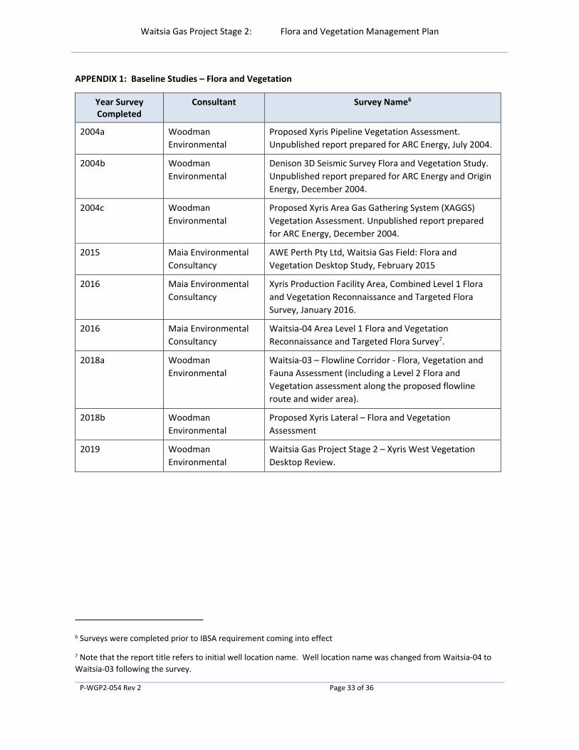
APPENDIX 1: Baseline Studies – Flora and Vegetation
Year Survey Completed
Consultant Survey Name6
2004a Woodman
Environmental
Proposed Xyris Pipeline Vegetation Assessment.
Unpublished report prepared for ARC Energy, July 2004.
2004b Woodman
Environmental
Denison 3D Seismic Survey Flora and Vegetation Study.
Unpublished report prepared for ARC Energy and Origin
Energy, December 2004.
2004c Woodman
Environmental
Proposed Xyris Area Gas Gathering System (XAGGS)
Vegetation Assessment. Unpublished report prepared
for ARC Energy, December 2004.
2015 Maia Environmental
Consultancy
AWE Perth Pty Ltd, Waitsia Gas Field: Flora and
Vegetation Desktop Study, February 2015
2016 Maia Environmental
Consultancy
Xyris Production Facility Area, Combined Level 1 Flora
and Vegetation Reconnaissance and Targeted Flora
Survey, January 2016.
2016 Maia Environmental
Consultancy
Waitsia‐04 Area Level 1 Flora and Vegetation
Reconnaissance and Targeted Flora Survey7.
2018a Woodman
Environmental
Waitsia‐03 – Flowline Corridor ‐ Flora, Vegetation and
Fauna Assessment (including a Level 2 Flora and
Vegetation assessment along the proposed flowline
route and wider area).
2018b Woodman
Environmental
Proposed Xyris Lateral – Flora and Vegetation
Assessment
2019 Woodman
Environmental
Waitsia Gas Project Stage 2 – Xyris West Vegetation
Desktop Review.
6 Surveys were completed prior to IBSA requirement coming into effect
7 Note that the report title refers to initial well location name. Well location name was changed from Waitsia‐04 to
Waitsia‐03 following the survey.

Waitsia Gas Project Stage 2: Flora and Vegetation Management Plan
P‐WGP2‐054 Rev 2 Page 34 of 36
APPENDIX 2: WGP2 – Offsets Policy ‐ Supplementary Information (02) to: Waitsia Gas Project Stage 2:
Flora and Vegetation Management Plan

DOCUMENT NO
P-WGP2 – 071
REVISION
Rev 0
DATE OF REVISION
28/04/2020
OFFSETS POLICY - SUPPLEMENTARY INFORMATION (02) TO: WAITSIA GAS
PROJECT STAGE 2: FLORA AND VEGETATION MANAGEMENT PLAN -
APPENDIX 2 P-WGP2-054
Document Approval Name Signature
Steve McCracken Project Director - Waitsia
REVISION DETAILS
Date Revision No Details Originator Reviewer
28/04/2020 0 Issued for Use A Fertch M Heller
Offsets Policy - Supplementary Information (02) to: Waitsia Gas Project Stage 2: Flora and Vegetation Management Plan - Appendix 2 P-WGP2-054
P-WGP2 – 071 Rev 0 Page 2 of 14
Disclaimer:
This document is protected by copyright, no part of this document may be reproduced or adapted without the consent of the originator/company owner, all rights are reserved. This document is “uncontrolled when printed”, refer to electronic copy for up to date version.
Offsets Policy - Supplementary Information (02) to: Waitsia Gas Project Stage 2: Flora and Vegetation Management Plan - Appendix 2 P-WGP2-054
P-WGP2 – 071 Rev 0 Page 3 of 14
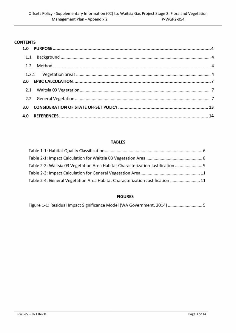
CONTENTS 1.0 PURPOSE ........................................................................................................................... 4
1.1 Background .............................................................................................................................. 4
1.2 Method ..................................................................................................................................... 4
2.0 EPBC CALCULATION ........................................................................................................... 7
2.1 Waitsia 03 Vegetation .............................................................................................................. 7
2.2 General Vegetation .................................................................................................................. 7
3.0 CONSIDERATION OF STATE OFFSET POLICY ...................................................................... 13
4.0 REFERENCES .................................................................................................................... 14
TABLES
Table 1-1: Habitat Quality Classification .................................................................................. 6
Table 2-1: Impact Calculation for Waitsia 03 Vegetation Area ............................................... 8
Table 2-2: Waitsia 03 Vegetation Area Habitat Characterization Justification ....................... 9
Table 2-3: Impact Calculation for General Vegetation Area .................................................. 11
Table 2-4: General Vegetation Area Habitat Characterization Justification ......................... 11
FIGURES
Figure 1-1: Residual Impact Significance Model (WA Government, 2014) ............................. 5

Offsets Policy - Supplementary Information (02) to: Waitsia Gas Project Stage 2: Flora and Vegetation Management Plan - Appendix 2 P-WGP2-054
P-WGP2 – 071 Rev 0 Page 4 of 14
1.0 PURPOSE
This Supplementary Information to: Waitsia Gas Project Stage 2: Flora and Vegetation Management Plan (P-WGP2-054) - Appendix 2 has been developed to address the EPA request to:
• Review the States offset policy against the projects impacts having specific regard to the Bamford Report and Commonwealth offsets calculator.
1.1 Background
The Western Australian Government’s Environmental Offsets Policy (WA Government, 2011) seeks to protect and conserve environmental and biodiversity values for present and future generations. The Western Australian Environmental Offsets Guidelines (WA Government, 2014) details the residual impact significance model (Figure 1-1), and outlines how significance is determined and when an offset is likely, or may be required, in relation to relevant EPA environmental factors.
An assessment against each of the 10 clearing principles was provided as Appendix D to the initial referral (MEPAU, 2019) and determined that even though Carnaby’s Black-Cockatoo were known to be present, the Proposal was not considered to be at variance with Clearing Principle (b) (Bamford Consulting Ecologists, 2018). The reason for this was:
Given the small area of impact associated with this project and the widespread nature of the two VSAs present within the area, the project is considered unlikely to compromise significant habitat for Carnaby’s Black-Cockatoo or any other conservation significant fauna species. The roost site is not likely to be directly impacted and there should be no direct impacts on nearby wetlands. The small scale of the project mitigates impacts on fauna in general.
1.2 Method
In the absence of a state calculator to support MEPAU’s impact determination, the EPBC offset assessment guide (DSEWPaC, 2012) was utilised to provide a quantitative evaluation for the level of impact arising from the Proposal.
The EPBC offset assessment guide was developed to give effect to the EPBC Act Environmental Offsets Policy requirements. It utilises a balance sheet approach to quantify project impacts. Having specific regard to Clearing Principle B and the Proposal’s potential impact to Carnaby’s Black-Cockatoo habitat, the assessment focuses on the Proposal’s disturbance to habitat. Specifically, the EPBC offset assessment guide considers the disturbance footprint against the habitat quality in quantifying the proposals impact.
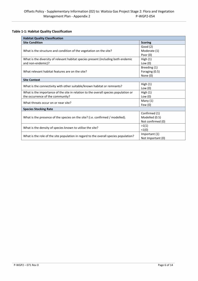
In lieu of clear guidance around how to determine habitat quality, a simple justification method was devised (Table 1-1). This method considers various factors such as site condition, context and species stocking rate in line with the offset calculator guidance.
Vegetation areas
A separate calculation for both the Waitsia 03 and General Vegetation area was undertaken with the results added together to provide an accurate quantum of impact level for the Proposal.

Offsets Policy - Supplementary Information (02) to: Waitsia Gas Project Stage 2: Flora and Vegetation Management Plan - Appendix 2 P-WGP2-054
P-WGP2 – 071 Rev 0 Page 5 of 14
Figure 1-1: Residual Impact Significance Model (WA Government, 2014)
Offsets Policy - Supplementary Information (02) to: Waitsia Gas Project Stage 2: Flora and Vegetation Management Plan - Appendix 2 P-WGP2-054
P-WGP2 – 071 Rev 0 Page 6 of 14
Table 1-1: Habitat Quality Classification
Habitat Quality Classification Site Condition Scoring
What is the structure and condition of the vegetation on the site? Good (2) Moderate (1) Poor (0)
What is the diversity of relevant habitat species present (including both endemic and non-endemic)?
High (1) Low (0)
What relevant habitat features are on the site? Breeding (1) Foraging (0.5) None (0)
Site Context
What is the connectivity with other suitable/known habitat or remnants? High (1) Low (0)
What is the importance of the site in relation to the overall species population or the occurrence of the community?
High (1) Low (0)
What threats occur on or near site? Many (1) Few (0)
Species Stocking Rate
What is the presence of the species on the site? (i.e. confirmed / modelled). Confirmed (1) Modelled (0.5) Not confirmed (0)
What is the density of species known to utilise the site? >1(1) <1(0)
What is the role of the site population in regard to the overall species population? Important (1) Not Important (0)

Offsets Policy - Supplementary Information (02) to: Waitsia Gas Project Stage 2: Flora and Vegetation Management Plan - Appendix 2 P-WGP2-054
P-WGP2 – 071 Rev 0 Page 7 of 14
2.0 EPBC CALCULATION
2.1 Waitsia 03 Vegetation
MEPAU calculated the impact associated with the clearing of vegetation within the Waitsia 03 Vegetation area per Table 2-1. The justification for the habitat quality is provided as Table 2-2.
2.2 General Vegetation
MEPAU calculated the impact associated with the clearing of vegetation within the General Vegetation area per Table 2-3. The justification for the habitat quality is provided as Table 2-4.

Offsets Policy - Supplementary Information (02) to: Waitsia Gas Project Stage 2: Flora and Vegetation Management Plan - Appendix 2 P-WGP2-054
P-WGP2 – 071 Rev 0 Page 8 of 14
Table 2-1: Impact Calculation for Waitsia 03 Vegetation Area
Impact calculator
Impa
ct c
alcu
lato
r
Protected matter attributes
Attribute relevant to case?
Description Quantum of impact Units Information source
Threatened species habitat
Area of habitat Yes The mixed tall shrublands were assessed for their foraging value for Carnaby’s Black-Cockatoo (Bamford 2016) and it was concluded that: 3 ha of such vegetation in the Waitsia-03 Area Vegetation represented 0.31 % of similar vegetation across Yardanogo Nature Reserve; and that 3 ha had a carrying capacity of <0.2 birds/year (based on regional habitat assessments conducted by Williams et al. 2016). The proposal area was visited on 3 October 2016 by Bamford Consulting Ecologists to access the vegetation at the site to gain further information on banksia density and numbers of cones. The banksia shrubland within the Bamford Consulting Ecologists study area was dominated by Banksia attenuate with variable densities of Banksia elegans and a thicket of Banksia prionotes. As a food source, most of the banksias had very few cones at the time of the survey.
Area 3 Hectares Bamford Consulting Ecologists. (2016) MEPAU (2019) Williams et al. (2016)
Quality 7 Scale 0-10 Total quantum of impact
2.10 Adjusted hectares
Number of features e.g. Nest hollows, habitat trees
No Within the Waitsia-03 Area Vegetation, no confirmed nesting trees were observed. A study completed by Bamford Consulting Ecologists (2018) identified four trees that had the potential to support Carnaby’s Black Cockatoo breeding. None of these trees met the Black-Cockatoo nesting-tree criterion of the Department of Sustainability, Environment, Water, Population and Communities (DSEWPaC) (2012) guidelines, as all measured <500mm DBH and none presented nest hollows.
0 Count Bamford Consulting Ecologists (2018) DSEWPaC (2012)
Condition of habitat Change in habitat condition, but no change in extent
No

Offsets Policy - Supplementary Information (02) to: Waitsia Gas Project Stage 2: Flora and Vegetation Management Plan - Appendix 2 P-WGP2-054
P-WGP2 – 071 Rev 0 Page 9 of 14
Table 2-2: Waitsia 03 Vegetation Area Habitat Characterization Justification
Habitat Quality Classification
Site Condition Scoring Waitsia 03 Score Justification
What is the structure and condition of the vegetation on the site?
Good (2) Moderate (1) Poor (0)
2
Woodman Environmental Consulting (2018) characterised the vegetation condition on-site as ranging from Completely Degraded to Excellent, with signs of historical human disturbance such as soil movement and rubbish, in some areas. The proposal area is located on areas originally mapped as VSAs 2 (Kwongan to open Banksia woodland on sand) and 4 (Eucalypt/Banksia/Acacia low forest on sand) (Bamford Consulting Ecologists 2015), which were noted to be of value to Carnaby’s Black-Cockatoo. As such, the structure and condition of vegetation on site has been conservatively been assessed as Good (2).
What is the diversity of relevant habitat species present (including both endemic and non-endemic)?
High (1) Low (0) 1
The floral composition of the entire Study Area itself can be considered moderately diverse, however relevant vegetation types extend beyond the proposal area. As such, the diversity of relevant habitat species present is conservatively considered High (1).
What relevant habitat features are on the site?
Breeding (1) Foraging (1) None (0)
1
A study completed by Bamford Consulting Ecologists (2018) identified four trees that had the potential to support Carnaby’s Black Cockatoo breeding. None of these trees met the Black-Cockatoo nesting-tree criterion of the Department of Sustainability, Environment, Water, Population and Communities (DSEWPaC) (2012) guidelines, as all measured <500mm DBH and none presented nest hollows. Carnaby’s Black-Cockatoo forages in proteaceous heath, Banksia woodlands and Eucalyptus woodlands. Within the proposal area, WEC (2018) identified VSA 1 (Mixed tall shrubland) to be present, which Carnaby’s Black-Cockatoo may use as a seasonal food source. As such, the relevant habitat features on site are classified as Foraging (1).
Site Context
What is the connectivity with other suitable/known habitat or remnants?
High (1) Low (0) 1
The Study Area and proposed flowline route is located in an area of remnant vegetation adjacent to the eastern boundary of the Yardanogo Class C Nature Reserve (C36203) (crown reserve), with remnant vegetation of road reserve, freehold tenure, and crown reserve (water reserve) on the eastern boundaries of the Study Area. Areas to the north and east have been heavily cleared for agriculture. The proposed clearing area is small, and there is a significant extent of remnant vegetation in the immediate vicinity. As such, the connectivity is considered High (1).
What is the importance of the site in relation to the overall species population or the occurrence of the community?
High (1) Low (0) 0
The mixed tall shrublands were assessed for their foraging value for Carnaby’s Black-Cockatoo (Bamford 2016) and it was concluded that: 3 ha of such vegetation in the Waitsia-03 Area Vegetation represented 0.31 % of similar vegetation across Yardanogo Nature Reserve. As such, the importance of the site is considered Low (0).
What threats occur on or near site?
Many (1) Few (0)
1 The key threatening processes to fauna include degradation of habitat due to weed invasion; mortality from operations; increased interactions from feral and native species; and disturbance from dust, light and noise. As such, the potential threats are classed as Many (1).
Species Stocking Rate

Offsets Policy - Supplementary Information (02) to: Waitsia Gas Project Stage 2: Flora and Vegetation Management Plan - Appendix 2 P-WGP2-054
P-WGP2 – 071 Rev 0 Page 10 of 14
Habitat Quality Classification
What is the presence of the species on the site? (i.e. confirmed / modelled).
Confirmed (1) Modelled (0.5) Not confirmed (0)
1
Fauna studies undertaken by Bamford Consulting Ecologists in 2017 determined that Carnaby’s Black Cockatoo occur within the Proposal area. Although Carnaby’s Black-Cockatoo was not observed during this field visit, evidence of use of the area was seen through recent foraging debris below Banksia prionotes trees along the flowline route and within the Hudson Resources Block As such, their presence is Confirmed (1).
What is the density of species known to utilise the site?
>1(1) <1(0) 0
The mixed tall shrublands were assessed for their foraging value for Carnaby’s Black-Cockatoo (Bamford 2016) and it was concluded that 3 ha had a carrying capacity of <0.2 birds/year (based on regional habitat assessments conducted by Williams et al. 2016). As the density is <1, it is given a score of zero (0).
What is the role of the site population in regard to the overall species population?
Important (1) Not Important (0) 0
Carnaby’s Black-Cockatoo may visit the Study Area. Carnaby’s Black-Cockatoo forages in proteaceous heath, Banksia woodlands and Eucalyptus woodlands. Carnaby’s Black-Cockatoo may use VSA 1 (Mixed tall shrubland) as a seasonal food source. Given the small area of impact associated with the proposal area and the widespread nature of the two VSAs present within the area, it is unlikely to compromise significant habitat for Carnaby's Black Cockatoo. As such, the site population is considered Unimportant (0).
Total 7

Offsets Policy - Supplementary Information (02) to: Waitsia Gas Project Stage 2: Flora and Vegetation Management Plan - Appendix 2 P-WGP2-054
P-WGP2 – 071 Rev 0 Page 11 of 14
Table 2-3: Impact Calculation for General Vegetation Area
Impact calculator
Impa
ct c
alcu
lato
r
Protected matter attributes Attribute relevant to case? Description Quantum of impact Units Information source
Threatened species habitat
Area of habitat Yes
The General Vegetation area has been largely historically cleared,
fragmented and/or disturbed (Maia, 2015).
Area 14 Hectares
Maia (2015) MEPAU (2019)
Quality 2 Scale 0-10 Total
quantum of impact
3.4 Adjusted hectares
Protected matter attributes Attribute relevant to case? Description Quantum of impact Units Information source
Number of features e.g. Nest hollows, habitat trees
No
Condition of habitat Change in habitat condition, but no change in extent
No
Table 2-4: General Vegetation Area Habitat Characterization Justification
Habitat Quality Classification
Site Condition Scoring General Vegetation Score
Justification
What is the structure and condition of the vegetation on the site?
Good (2) Moderate (1) Poor (0) 0
Maia (2015) noted that the general vegetation area has been historically cleared. The remnant vegetation within the area has been largely degraded by a mixture of clearing, burning and grazing. The vegetation structure is incomplete due to the historical loss of native vegetation when it was converted to farmland. As such, its quality is considered Poor (0).

Offsets Policy - Supplementary Information (02) to: Waitsia Gas Project Stage 2: Flora and Vegetation Management Plan - Appendix 2 P-WGP2-054
P-WGP2 – 071 Rev 0 Page 12 of 14
What is the diversity of relevant habitat species present (including both endemic and non-endemic)? High (1)
Low (0) 0
Maia (2015) noted that the general vegetation area has been historically cleared. The remnant vegetation within the area has been largely degraded by a mixture of clearing, burning and grazing. The vegetation structure is incomplete due to the historical loss of native vegetation when it was converted to farmland. As such, the diversity of relevant habitat species present is considered Low (0).
What relevant habitat features are on the site?
Breeding (1) Foraging (1) None (0) 1
Within the general vegetation area, there is mixed tall shrubland (Woodman 2018) present which was identified as potential foraging habitat for Carnaby’s Black Cockatoo (Bamford 2016). No nesting trees have been identified. As such, the relevant habitat features on site are classified as Foraging (1).
Site Context
What is the connectivity with other suitable/known habitat or remnants? High (1)
Low (0) 0
The assemblage is incomplete due to the historical loss of native vegetation when it was converted to farmland and the consequent loss of habitats. Areas to the north and east have been heavily cleared for agriculture. As such, the connectivity is considered Low (0)
What is the importance of the site in relation to the overall species population or the occurrence of the community?
High (1) Low (0) 0
Typical of remnants within an agricultural landscape, this vegetation is considered to have negligible local and regional significance due to its fragmented and heavily impacted characteristics. As such, the importance of the site is considered Low (0).
What threats occur on or near site? Many (1) Few (0) 0
As vegetation in this area has been historically cleared, and any residual habitat is isolated patches, their presence would be limited to fleeting foraging or resting on the way to more diverse habitat. Consequently, key threatening processes to fauna in this area would be limited.
Species Stocking Rate
What is the presence of the species on the site? (i.e. confirmed / modelled).
Confirmed (1) Modelled (0.5) Not confirmed (0) 1
Fauna studies undertaken by Bamford Consulting Ecologists in 2017 determined that Carnaby’s Black Cockatoo occur in the vicinity of the general vegetation area. Although Carnaby’s Black-Cockatoo was not observed during this field visit, evidence of use of the area was seen through recent foraging debris. As such, their presence is Confirmed (1).
What is the density of species known to utilise the site? >1(1)
<1(0) 0
Based upon the presence of foraging habitat within the general vegetation area, but noting that the area was comprised of isolated vegetation in generally poor condition, it is concluded that 17 ha had a carrying capacity of <1 birds/year (based on regional habitat assessments conducted by Williams et al. 2016). As the density is <1, it is given a score of zero (0).
What is the role of the site population in regard to the overall species population?
Important (1) Not Important (0) 0
Carnaby’s Black-Cockatoo may visit the area. Although Maia (2015) noted that the general vegetation area has been historically cleared and remnant vegetation has been largely degraded by a mixture of clearing, burning and grazing, isolated trees may provide foraging habitat for Carnaby’s Black-Cockatoo. Any populations would not be entirely supported by the habitat within the generall vegetation area given it’s degraded nature and consequently any site population is considered Unimportant (0).
Total 2

Offsets Policy - Supplementary Information (02) to: Waitsia Gas Project Stage 2: Flora and Vegetation Management Plan - Appendix 2 P-WGP2-054
P-WGP2 – 071 Rev 0 Page 13 of 14
3.0 CONSIDERATION OF STATE OFFSET POLICY
Having regards to the Western Australian Government’s residual impact significance model (Figure 1-1), MEPAU believes that the Proposal will result in residual impacts that are not significant.
As only a small portion of the Proposal area is considered to provide good quality foraging habitat for the Carnaby’s Black-Cockatoo, with the remaining area considered to provide low quality habitat, the proposal is not expected to result in impacts that would likely result in a species or ecosystem requiring protection under statute or increasing the cumulative impact to a critical level.
The output from the EPBC offset assessment guide indicates that the quantum of impact associated with the Proposal’s disturbance to the:
• Waitsia-03 Vegetation Area = 2.10 (Table 2-1), and
• General Vegetation Area = 3.4 (Table 2-3).
To understand the total impact of the Proposal, these two values were added together and the quantum of impact for the Proposal was identified as 5.5.
Although no specific scale is provided for consideration of the final quantum of impact value, MEPAU considered the value in terms of Figure 1-1: Residual Impact Significance Model (WA Government, 2014). As the EBPC calculation resulted in a low quantum of impact value of 5.5, it is reasonable to classify the impact as ‘Residual impacts that are not significant’.

Offsets Policy - Supplementary Information (02) to: Waitsia Gas Project Stage 2: Flora and Vegetation Management Plan - Appendix 2 P-WGP2-054
P-WGP2 – 071 Rev 0 Page 14 of 14
4.0 REFERENCES
Bamford Consulting Ecologists. (2016). AWE Waitsia-03; Significance of site for Black Cockatoos (Unpublished report to AWE).
Bamford Consulting Ecologists. (2018). Fauna Assessment of Waitsia 03 access track and pipeline with regard to the clearing principles detailed in Schedule 5, (WA) Environmental Protection Act 1986. Unpublished report to AWE by Bamford Consulting Ecologists, Perth.
Beard, J.S. (1976). Vegetation of the Dongara Area, Western Australia. Map and Explanatory Memoir, 1:250,000 Series, Vegmap Publications, Perth.
DSEWPaC. (2012). Environment Protection and Biodiversity servation Act 1999 referral guidelines for three threatened black-cockatoo species: Carnaby’s cockatoo (endangered) Calyptorhynchus latirostris, Baudin’s cockatoo (vulnerable) Calyptorhynchus baudinii, Forest red-tailed black cockatoo (vulnerable) Calyptorhynchus banksii naso. Department of Sustainability, Environment, Water, Population and Communities.
Shepherd, DP, Beeston, GR, and Hopkins, AJM (2002). Native Vegetation in Western Australia – Extent, Type and Status, Resource Management Technical Report 249, Perth, Department of Agriculture, Western Australia.
Maia Environmental Consultancy. (2015). AWE Perth Pty Ltd, Waitsia Gas Field: Flora and Vegetation Desktop Study, February 2015. (Unpublished report to AWE).
Mitsui E&P Australia (MEPAU). (2019). Waitsia Gas Project Stage 2 – Environmental Referral Supporting Report http://www.epa.wa.gov.au/sites/default/files/Referral_Documentation/Supporting%20Document_7.pdf
WA Government. (2011). Environment Protection and Biodiversity Conservation Act 1999 Environmental Offsets Policy. Government of Western Australia. Available online at: < http://www.epa.wa.gov.au/sites/default/files/Policies_and_Guidance/WAEnvOffsetsPolicy-270911.pdf>
WA Government. (2014). Western Australian Environmental Offsets Guidelines. Government of Western Australia. Available online at: < http://www.epa.wa.gov.au/sites/default/files/Policies_and_Guidance/WA%20Environmental%20Offsets%20Guideline%20August%202014.pdf>
Williams, M. R., Yates, C.J., Saunders, D.A. and Barret, G.W. (2016). The impact of Hypothetical Landuse Scenarios on the Population Viability of the Endangered Carnaby’s [Black-]Cockatoo. Unpubl. Report.
Woodman Environmental Consulting (WEC) Pty Ltd. (2018). Dongara Exploration Area Exploration Environmental Assessment 2018 Desktop Review, Field Survey and Impact Assessment. Unpublished report (report reference: Tronox17-37-04) prepared for Tronox, February 2018.

Waitsia Gas Project Stage 2: Flora and Vegetation Management Plan
P‐WGP2‐054 Rev 2 Page 35 of 36
APPENDIX 3: WGP2 ‐ Flora and Vegetation Impact Assessment

DOCUMENT NO
APPENDIX 3
REVISION
Rev 1
DATE OF REVISION
17/03/2020
WGP2 – Flora and Vegetation Impact Assessment
WGP2 – Flora and Vegetation Impact Assessment
APPENDIX 3 Rev 1 Page 2 of 24
Disclaimer:
This document is protected by copyright, no part of this document may be reproduced or adapted without the consent of the originator/company owner, all rights are reserved. This document is “uncontrolled when printed”, refer to electronic copy for up to date version.

WGP2 – Flora and Vegetation Impact Assessment
APPENDIX 3 Rev 1 Page 3 of 24
TABLE OF CONTENTS
1.0 PURPOSE ............................................................................................................................. 5
2.0 OBJECTIVES ......................................................................................................................... 6
3.0 VEGETATION SYSTEM ASSOCIATIONS .................................................................................. 7
3.1 General Vegetation ......................................................................................................... 8
3.2 Waitsia-03 Area Vegetation ............................................................................................ 8
4.0 IMPACT ASSESSMENT – DIRECT IMPACTS ............................................................................ 9
4.1 Regional and Local Significance .................................................................................... 10
4.2 Conservation Significant Flora – Priority Flora .............................................................. 10
4.3 Assessment of impacts to Priority Taxon - Baeckea sp. Walkaway ............................... 14
4.4 Assessment of Impacts to Priority Taxon - Banksia elegans ......................................... 14
4.5 Assessment of Impacts to Priority Taxon - Comesperma griffinii .................................. 16
4.6 Assessment of Impacts to Priority Taxon - Stawellia dimorphantha ............................. 16
5.0 IMPACT ASSESSMENT – INDIRECT IMPACTS ...................................................................... 18
5.1 Spread of Weeds ........................................................................................................... 18
5.2 Spread of Phytophthora cinnamomi (Dieback) ............................................................. 18
5.3 Impacts from Dust ........................................................................................................ 19
6.0 REFERENCES ...................................................................................................................... 20
APPENDICES ............................................................................................................................... 22
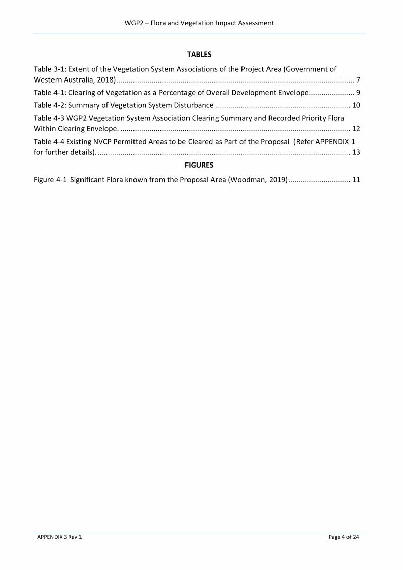
WGP2 – Flora and Vegetation Impact Assessment
APPENDIX 3 Rev 1 Page 4 of 24
TABLES
Table 3-1: Extent of the Vegetation System Associations of the Project Area (Government of
Western Australia, 2018) ................................................................................................................... 7
Table 4-1: Clearing of Vegetation as a Percentage of Overall Development Envelope ...................... 9
Table 4-2: Summary of Vegetation System Disturbance ................................................................. 10
Table 4-3 WGP2 Vegetation System Association Clearing Summary and Recorded Priority Flora
Within Clearing Envelope. ............................................................................................................... 12
Table 4-4 Existing NVCP Permitted Areas to be Cleared as Part of the Proposal (Refer APPENDIX 1
for further details). .......................................................................................................................... 13
FIGURES
Figure 4-1 Significant Flora known from the Proposal Area (Woodman, 2019) .............................. 11
WGP2 – Flora and Vegetation Impact Assessment
APPENDIX 3 Rev 1 Page 5 of 24
1.0 PURPOSE
This document has been written to provide an assessment of direct and potential indirect impacts on flora and vegetation associated with the implementation of the Proposal.

WGP2 – Flora and Vegetation Impact Assessment
APPENDIX 3 Rev 1 Page 6 of 24
2.0 OBJECTIVES
The objectives of this document are to:
• Define and describe the Vegetation System Associations present in the proposal area (refer Section 3.0).
• Define the direct impacts to native Vegetation System Associations from clearing (refer Section 4.0).
• Define the location of priority flora that has been recorded in the areas where native vegetation will be cleared (refer Section 4.2).
• Provide an assessment of the priority flora that will be cleared and the degree of impact to their overall known representation in the broader region (refer Section 4.3 to 4.6).
• Describe the potential indirect impacts to flora and/or vegetation (refer Section 5.0)
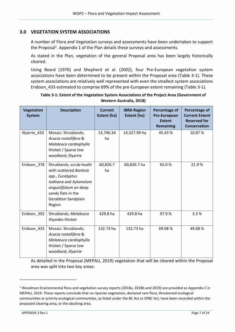
WGP2 – Flora and Vegetation Impact Assessment
APPENDIX 3 Rev 1 Page 7 of 24
3.0 VEGETATION SYSTEM ASSOCIATIONS
A number of Flora and Vegetation surveys and assessments have been undertaken to support the Proposal1. Appendix 1 of the Plan details these surveys and assessments.
As stated in the Plan, vegetation of the general Proposal area has been largely historically cleared.
Using Beard (1976) and Shepherd et al. (2002), four Pre-European vegetation system associations have been determined to be present within the Proposal area (Table 3-1). These system associations are relatively well represented with even the smallest system associations Eridoon_433 estimated to comprise 69% of the pre-European extent remaining (Table 3-1).
Table 3-1: Extent of the Vegetation System Associations of the Project Area (Government of
Western Australia, 2018)
Vegetation System
Description Current Extent (ha)
IBRA Region Extent (ha)
Percentage of Pre-European
Extent Remaining
Percentage of Current Extent Reserved for Conservation
Illyarrie_433 Mosaic: Shrublands;
Acacia rostellifera &
Melaleuca cardiophylla
thicket / Sparse low
woodland; illyarrie
14,746.34
ha
14,327.99 ha 45.43 % 10.87 %
Eridoon_378 Shrublands; scrub-heath
with scattered Banksia
spp., Eucalyptus
todtiana and Xylomelum
angustifolium on deep
sandy flats in the
Geraldton Sandplain
Region
60,826.7
ha
60,826.7 ha 65.0 % 21.9 %
Eridoon_392 Shrublands; Melaleuca
thyoides thicket
429.8 ha 429.8 ha 97.9 % 3.3 %
Eridoon_433 Mosaic: Shrublands;
Acacia rostellifera &
Melaleuca cardiophylla
thicket / Sparse low
woodland; illyarrie
132.73 ha 132.73 ha 69.08 % 49.68 %
As detailed in the Proposal (MEPAU, 2019) vegetation that will be cleared within the Proposal area was split into two key areas:
1 Woodman Environmental flora and vegetation survey reports (2018a, 2018b and 2019) are provided as Appendix C in
MEPAU, 2019. These reports conclude that no riparian vegetation, declared rare flora, threatened ecological
communities or priority ecological communities, as listed under the BC Act or EPBC Act, have been recorded within the
proposed clearing area, or the abutting area.

WGP2 – Flora and Vegetation Impact Assessment
APPENDIX 3 Rev 1 Page 8 of 24
• General Vegetation: areas that have been previously disturbed and/or cleared, and
• Waitsia-03 Area Vegetation: areas that comprise vegetation in good condition.
3.1 General Vegetation
The General Vegetation area has been largely historically cleared, fragmented and/or disturbed (Maia, 2015a). Vegetation within this area consist of Illyarrie_433, Eridoon_433 and Eridoon_378. MEPAU completed additional reconnaissance flora surveys and targeted searches in accordance with the EPA Guidance (EPA, 2016a) in late Spring 2019, to meet the requirements to obtain a Native Vegetation Clearing Permit (NVCP) under Part V of the Environmental Protection Act 1986. The results of these surveys are planned to be available in early 2020. The outcomes of these surveys will be used to further define the potential presence of conservation significant flora taxa, verify the impact assessment included in this report and to meet the requirements to obtain an NVCP.
This assessment will further verify the Vegetation System Associations in these areas and the potential presence of conservation significant flora taxa.
3.2 Waitsia-03 Area Vegetation
The Waitsia-03 Area Vegetation is the largest intact portion of native vegetation. It is located on the southern boundary of the Proposal area (as detailed in Appendix 1). A detailed flora survey and targeted searches were conducted from 6th – 10th November 2017 to assess the flora and vegetation of this area (Woodman, 2018a). The survey verified that although four Vegetation System Associations were present, these broadly matched to the two vegetation types Eridoon_378 and Eridoon_392, noting that the wetland thickets present within the survey area were mapped as Eridoon_392 but did not contain Melaleuca thyoides (Woodman, 2018a). The survey also noted that vegetation within the Waitsia-03 area represented 0.31 % of similar vegetation across Yardanogo Nature Reserve.
MEPAU completed additional detailed flora surveys and targeted searches in accordance with the EPA guidance (EPA, 2016a) of the proposed clearing area in late Spring 2019. The initial, verified, data from these surveys relating to conservation flora are included in Section 4.0. The remainder of the data associated with these surveys are planned to be available in early 2020. The outcomes of these surveys will be used, to further define the potential presence of conservation significant flora taxa, verify the impact assessment included in this report and to meet the requirements to obtain an NVCP.
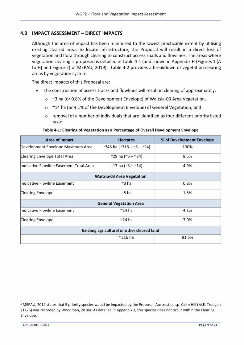
WGP2 – Flora and Vegetation Impact Assessment
APPENDIX 3 Rev 1 Page 9 of 24
4.0 IMPACT ASSESSMENT – DIRECT IMPACTS
Although the area of impact has been minimised to the lowest practicable extent by utilising existing cleared areas to locate infrastructure, the Proposal will result in a direct loss of vegetation and flora through clearing to construct access roads and flowlines. The areas where vegetation clearing is proposed is detailed in Table 4-1 (and shown in Appendix H (Figures 1 [A to H] and Figure 2) of MEPAU, 2019). Table 4-2 provides a breakdown of vegetation clearing areas by vegetation system.
The direct impacts of this Proposal are:
• The construction of access tracks and flowlines will result in clearing of approximately:
o ~3 ha (or 0.8% of the Development Envelope) of Waitsia-03 Area Vegetation,
o ~14 ha (or 4.1% of the Development Envelope) of General Vegetation; and
o removal of a number of individuals that are identified as four different priority listed taxa2.
Table 4-1: Clearing of Vegetation as a Percentage of Overall Development Envelope
Area of impact Hectares % of Development Envelope
Development Envelope Maximum Area ~345 ha (~316 + ~5 + ~24) 100%
Clearing Envelope Total Area ~29 ha (~5 + ~24) 8.5%
Indicative Flowline Easement Total Area ~17 ha (~3 + ~14) 4.9%
Waitsia-03 Area Vegetation
Indicative Flowline Easement ~3 ha 0.8%
Clearing Envelope ~5 ha 1.5%
General Vegetation Area
Indicative Flowline Easement ~14 ha 4.1%
Clearing Envelope ~24 ha 7.0%
Existing agricultural or other cleared land
~316 ha 91.5%
2 MEPAU, 2019 states that 5 priority species would be impacted by the Proposal. Austrostipa sp. Cairn Hill (M.E. Trudgen
21176) was recorded by Woodman, 2018a. As detailed in Appendix 1, this species does not occur within the Clearing
Envelope.

WGP2 – Flora and Vegetation Impact Assessment
APPENDIX 3 Rev 1 Page 10 of 24
Table 4-2: Summary of Vegetation System Disturbance
Vegetation System
Flowline Easement
(Maximum area to be
cleared) (ha)
Clearing Envelope
(ha)
Current Extent (ha) Percentage of Development
Envelope Regarding Regional Current
Extent (%)
Percentage of Clearing Envelope
Regarding Regional Local (IBRA) Extent
(%)
Illyarrie_433 8.1 12.5 14,746.34 0.0005 0.0005
Eridoon_378 6.1 11.6 60,826.7 0.0001 0.0001
Eridoon_392 0.9 2.0 429.8 0.002 0.002
Eridoon_433 1.60 2.87 132.73 0.01 0.01
TOTAL ~17 ha ~29 ha
4.1 Regional and Local Significance
As described in Table 4-2, a total clearing area of ~17 ha is estimated for the Proposal. When broken down by vegetation associations, the direct impact of this proposal is limited to clearing no more than 0.01% of a single vegetation association. Having regard to the extent and distribution of these associations both locally and regionally, the removal of 0.01% of a vegetation association is not considered to be significant.
Of the ~29 ha clearing envelope, ~5 ha is considered to be in good condition, with the remaining vegetation comprised of remnant disturbed vegetation in poor condition. Vegetation that is in good condition is located within the proposed Waitsia-03 vegetation area which in turn is adjacent to the Yardanogo Nature Reserve which is comprised of similar vegetation. When considered in the context of the adjacent reserve, the vegetation associations within the Waitsia-03 area are well represented locally with the adjoining reserve comprising an area of approximately 7,000 ha. The small scale and low impact of the proposed flowline suggest that clearing within this area is not expected to impact the adjoining reserve, nor exacerbate existing habitat fragmentation. Therefore, the loss of vegetation within the Waitsia-03 area of the Proposal area is not considered to result in significant local or regional impacts.
Approximately 14 ha (or 4.1% of the Development Envelope) of General Vegetation, broadly considered as poor-quality native vegetation, will be cleared for access roads and flowline construction. Typical of remnants within an agricultural landscape this vegetation (see Table 4-6 of MEPAU, 2019) is considered to have negligible local and regional significance due to its fragmented and heavily impacted characteristics.
4.2 Conservation Significant Flora – Priority Flora
A total of 13 priority taxa have locations within the Proposal Area (Woodman, 2019). The location of these priority taxa are detailed in Figure 4-1. Four of these priority taxa (as detailed in Table 4-3 and Table 4-4), listed as priority flora by the DBCA (under the Biodiversity Conservation Act 2016), are known to occur within the proposed clearing envelope. The Priority taxa identified during detailed surveys that are known to occur within the clearing envelope are known to have a wider distribution outside of the Geraldton Sandplains IBRA region (DPaW, 2007. With the exception of Comesperma girffinii, all other conservation significant species directly impacted by the Proposal are known to occur within the adjacent Yardanogo Nature

WGP2 – Flora and Vegetation Impact Assessment
APPENDIX 3 Rev 1 Page 11 of 24
Reserve indicating that priority taxa are well represented in the local area. Sections 4.3 to 4.6 provide an assessment of impacts to these priority taxa.
Figure 4-1 Significant Flora known from the Proposal Area (Woodman, 2019)

WGP2 – Flora and Vegetation Impact Assessment
APPENDIX 3 Rev 1 Page 12 of 24
Table 4-3 WGP2 Vegetation System Association Clearing Summary and Recorded Priority Flora Within Clearing Envelope.
Location Reference Reference
Figure
(MEPAU, 2019)
Vegetation Quality Vegetation System Fragmented
remnant
Indicative Flowline
Easement - Maximum
Area to be Cleared
Development Envelope
excluding existing
cleared areas
Priority Flora recorded as present in clearing
envelope - reference
Waitsia-03 Area Vegetation
Waitsia-03 Area - Flowline and
access road easements
Appendix 1 1E Good Eridon_392 Partial 0.9 ha 2.0 ha Woodman, 2019
• Baeckea sp. Walkaway (A.S. George 11249)
• Banksia elegens
• Comesperma griffinii
• Stawellia dimorphantha
ERIDOON_378 1.5 ha 3.3 ha
Sub-Total ~3 ha ~5 ha
General Vegetation
Waitsia-03 and 04 - Flowline and
access road easements
Appendix 1
1D Poor ERIDOON_378 Yes 0.8 ha 1.4 ha Woodman, 2019
None recorded
ERIDOON_433 Yes 1.6 ha 2.9 ha Woodman, 2019
None recorded
Xyris Production Facility North and
Waitsia-07 - Pipeline and flowline
easements
2 Poor (Fragmented) ERIDOON_378 Yes 0.4 ha 0.8 ha Woodman, 2019
• Baeckea sp. Walkaway (A.S. George 11249)
• Banksia elegens
Waitsia 07 - Flowline and access
road easements
1C Poor ERIDOON_378 Yes 1.1 ha 1.6 ha Woodman, 2019
None recorded
Waitsia 05 - Flowline and access
road easements
1B Moderate ERIDOON_378 Yes 2.1 ha 4.1 ha Woodman, 2019
None recorded
PFW re-injection Line -Flowline and
access road easements
1G Poor ILLYARRIE_433 Yes 3.4 ha 3.4 ha Woodman, 2019
None recorded
PFW re-injection Line -Flowline and
access road easements
1H Poor ERIDOON_378 Yes 0.20 ha 0.4 ha Woodman, 2019
None recorded
Sub-Total ~14 ha ~24 ha
TOTAL Clearing ~17 ha ~29 ha

WGP2 – Flora and Vegetation Impact Assessment
APPENDIX 3 Rev 1 Page 13 of 24
Table 4-4 Existing NVCP Permitted Areas to be Cleared3 as Part of the Proposal (Refer APPENDIX 1 for further details).
Location Reference Vegetation Quality Priority Flora recorded as present in clearing envelope - reference
NVCP 6875 (Pipeline and flowline easements Existing flowline corridor north of XPF)
Appendix 1
Poor (Fragmented) Maia, 2015b / Existing NVCP in place – no further clearing required.
NVCP 6875 (WPG1 - pipeline and flowline easements) Poor (Fragmented) Maia, 2015b / NVCP in place
• Baeckea sp. Walkaway (A.S. George 11249)
• Banksia elegens
NVCP 6938 (XPF area) Maia, 2016 / None recorded
Table 4-1: Summary of Significant Flora Taxa Recorded within the Clearing Envelope of the Proposals Development Envelope
LOCATION - Waitsia-03 Area Vegetation - Flowline and access road easements
FLORA SURVEY - Woodman, 2018a, Woodman, 2020
LOCATION - Xyris Production Facility North and Waitsia-07 (General Vegetation) - Pipeline and flowline easements
FLORA SURVEY – Maia, 2015b
Name Conservation Status
Species Distribution (Western Australian
Herbarium, 1998)
Number of Records 4(DPaW,
2007-)
Figure Reference
Number of point locations
recorded in survey area
(survey area 47.6 ha)
Number of individuals recorded in survey area
Number of known point Locations individuals
required to be cleared – Waitsia-03
Figure Reference
Number of point locations
recorded in survey area
(survey area 1.13 ha)
Number of individuals recorded in survey area
Number of known point Locations individuals
required to be cleared – Xyris Production Facility North and
Waitsia-07
Baeckea sp.
Walkaway (A.S.
George 11249)
P3 Recorded within the Avon
Wheatbelt and Geraldton
Sandplains IBRA regions
This species has
been recorded 39
times
Appendix 1
1 5 0
Appendix 1
1 109 2
Banksia elegans P4 Recorded within the Avon
Wheatbelt and Geraldton
Sandplains IBRA regions
This species has
been recorded 46
times
340 3,175 333 1 5 4
Comesperma
griffinii
P2 Recorded within the Avon
Wheatbelt, Esperance
Plains, Geraldton
Sandplains, Mallee and
Swan Coastal Plain IBRA
regions
This species has
been recorded 14
times
3 14 1 Not recorded - -
Stawellia
dimorphantha
P4 Recorded within the Avon
Wheatbelt, Esperance
Plains, Geraldton
Sandplains, Mallee and
Swan Coastal Plain IBRA
regions.
Presence of this
species has been
recorded 67 times
70 141 12 Not recorded - -
3 Area (ha) to be cleared factored into Table 4-1
4 A location can consist of 1 or more individual plants.

WGP2 – Flora and Vegetation Impact Assessment
APPENDIX 3 Rev 1 Page 14 of 24
4.3 Assessment of impacts to Priority Taxon - Baeckea sp. Walkaway
Baeckea sp. Walkaway (A.S. George 11249) (P3) is a dense, multi-stemmed shrub growing up to 2 m high which occurs on undulating plains and hillslopes on yellow/brown or white sand in Kwongan or Banksia woodland/heath (WAHerb, 1998). It has a range of approximately 120 km in Western Australia (where it is endemic), from near Geraldton in the north-west, to south-east of Mullewa in the east and south-east of Dongara in the south. Outside of the Proposal area this taxon is known from 39 records5 (Refer Table 4-3) representing approximately 32 broad localities, five of which occur within conservation reserves including Burma Road Nature Reserve, Indarra Spring Nature Reserve and Yardanogo Nature Reserve (DPaW, 2007) outside of the Proposal area. Figure 4-1 details recorded distribution of Baeckea sp. within the Proposal area (DPaW 2007-, Maia 2016, Woodman Environmental 2004, 2009, 2012, 2018a).
Baeckea sp. Walkaway in Xyris Production Facility North and Waitsia-07 (General Vegetation) Area
Baeckea sp. Walkaway (A.S. George 11249) (P3) was recorded within the Xyris Production Facility North and Waitsia-07 (General Vegetation) area (Maia, 2015b) (Appendix 1), with 109 individuals recorded (Refer Table 4-3). There are a number of known locations of this taxon within the broader Proposal area (DPaW, 2007, Maia, 2016, Woodman Environmental; 2004, 2009, 2018a).
4.3.1.1 Impact Assessment
Based upon the information available for this species (Maia, 2016 and Woodman, 2018a), MEPAU understand that there are at least 114 known individuals that have been previously recorded and reported in the Proposal area. Based upon the clearing footprint of the Proposal, surveys undertaken by MEPAU indicate that approximately 2 individuals will be impacted by the Proposal. This equates to a disturbance of approximately 4% of the known records in this area.
This Proposal is not considered to result in a significant impact to the species as:
• The direct impact equates to a small portion (4%) of known individuals in the surveyed areas (Maia, 2016 and Woodman, 2018a),
• This taxon is also known from 39 records outside of the Proposal area representing approximately 32 broad localities, five of which occur within conservation reserves (DPaW, 2007); and
• The species has a large known distribution indicating that any localised impacts are not expected to affect the wider overall population distribution.
4.4 Assessment of Impacts to Priority Taxon - Banksia elegans
Banksia elegans (P4) is a shrub growing up to 4 m high which occurs on sandplains and low consolidated dunes on yellow, white or red sand (WAHerb 1998-). It has a range of approximately 175 km in Western Australia (where it is endemic), from north-west of Dongara in the north-west, to near Hill River in the south-east. Outside of the Proposal area this taxon
5 The abundance of plants at each known locality varies from four plants, 13 plants and 15 plants to 1,000+. There is likely at least 2,000 plants across all current populations when numbers are estimated from available data on FloraBase (Maia, 2015b).
WGP2 – Flora and Vegetation Impact Assessment
APPENDIX 3 Rev 1 Page 15 of 24
is known from 46 records (Refer Table 4-3) representing approximately 19 broad localities, seven of which occur within conservation reserves including Beekeepers Nature Reserve, Lake Logue Nature Reserve, Lesueur National Park and Yardanogo Nature Reserve (DPaW 2007-). Figure 4-1 details recorded distribution of Banksia elegans within the Proposal area (DPaW 2007-, Maia 2016, Woodman Environmental 2004, 2009, 2012, 2018a).
Banksia elegans in Waitsia-03 Area Vegetation Area
Banksia elegans (P4) was common within the Waitsia-03 Area (Woodman, 2018a), with a total of 340 point locations recorded within the Study Area and 3,175 individuals recorded across these point locations (Woodman, 2018a) (Refer Table 4-3 and Appendix 1).
Banksia elegans in Xyris Production Facility North and Waitsia-07 (General Vegetation) Area
Five Banksia elegans (P4) plants were located in a moderately dense to open remnant in this small survey area6 (Maia, 2015b) (Refer Appendix 1). Woodman, 2018b recorded 99 individual plants, at 14 locations, within 1km of this location (Refer Table 4-3 and Appendix 1).
Impact Assessment
A total of 46 locations have been recorded previously via Naturemap (DPaW, 2007-). A large number of individual plants have been recorded at both the Waitsia-03 Area Vegetation and Xyris Production Facility North and Waitsia-07 (General Vegetation) area.
4.4.3.1 Waitsia-03 Area Vegetation
Based upon the information available for this species (Maia, 2016 and Woodman, 2018a), MEPAU understand that there are at least 3,175 known individuals that have been previously recorded in this area. Based upon the clearing footprint of the Proposal, surveys undertaken by MEPAU indicate that approximately 333 individuals will be directly impacted in the Waitsia-03 Area Vegetation by the Proposal. This equates to a disturbance of approximately 10% of the known records in this area.
4.4.3.2 Xyris Production Facility North and Waitsia-07 (General Vegetation) Area
Based upon the information available for this species (Maia, 2015b and Woodman, 2018a), MEPAU understand that there are at least 104 known individuals that have been previously recorded in this area. Based upon the clearing footprint of the Proposal, surveys undertaken by MEPAU indicate that approximately 4 individuals will be impacted in the Xyris Production Facility North and Waitsia-07 (General Vegetation) area by the Proposal. This equates to a disturbance of approximately 4% of the known records in this area.
4.4.3.3 Impact Assessment conclusion
This Proposal is not considered to result in a significant impact to the species as:
• The direct impact equates to a small portion (10% and 4% respectively) of known individuals in the surveyed areas (Woodman, 2018a and Maia, 2015b)
• This taxon is also known from 46 records outside of the Proposal area, representing approximately 19 broad localities, seven of which are locations within conservation reserves (DPaW, 2007); and
6 Survey undertaken to meet the requirements for NVCP 6875. Survey area, 1.13 ha, comprises the NVCP 6875-1 area.

WGP2 – Flora and Vegetation Impact Assessment
APPENDIX 3 Rev 1 Page 16 of 24
• The species has a large known distribution indicating that any localised impacts are not expected to affect the wider overall population distribution.
4.5 Assessment of Impacts to Priority Taxon - Comesperma griffinii
Comesperma griffinii (P2) is an annual or perennial herb growing to 0.15 m high which occurs on plains on yellow or grey sand (WAHerb 1998-). It has a large range of approximately 830 km in Western Australia (where it is endemic), from east of Geraldton in the north-west, to near Esperance in the south-east. Outside of the Proposal area this taxon is known from 11 records representing approximately 10 broad localities, four of which occur within conservation reserves including Indarra Nature Reserve, Helms Forestry Reserve, Kenwick Wetland and South Eneabba Nature Reserve (DPaW 2007-). Figure 4-1 details recorded distribution of Comesperma griffinii within the Proposal area (DPaW 2007-, Maia, 2016 and Woodman Environmental, 2018a).
Comesperma griffinii in Waitsia-03 Area Vegetation Area
Comesperma griffinii (P2) was recorded at three point locations within the Waitsia-03 Study Area, with 14 individuals recorded across these point locations (Woodman, 2018a) (Refer Table 4-3 and Appendix 1). There is one known location of this taxon approximately 15 km south-east of the broader Proposal area. The next closest record is 60 km south of the Study Area (DPaW, 2007).
4.5.1.1 Impact Assessment
Based upon the information available for this species (Woodman, 2018a), MEPAU understand that there are 14 known individuals that have been previously recorded and reported in the Waitsia-03 Area, with other individuals existing outside of this area. Based upon the clearing footprint of the Proposal, surveys undertaken by MEPAU indicate that approximately 1 individual will be impacted by the Proposal. This equates to a disturbance of approximately 7% of the known records in this area.
This Proposal is not considered to result in a significant impact to the species as:
• the direct impact equates to a small portion (7%) of known individuals in the surveyed areas (Woodman, 2018a),
• This taxon is also known from 11 records outside of the Proposal area, representing 10 broad localities, four of which occur within conservation reserves; and
• The species has a large known range indicating that any localised impacts are not expected to affect the wider overall population distribution.
4.6 Assessment of Impacts to Priority Taxon - Stawellia dimorphantha
Stawellia dimorphantha (P4) is a stilt-rooted perennial herb growing up to 0.2 m high which occurs on white, grey and yellow sand (WAHerb 1998-). It has a range of approximately 89 km in Western Australia (where it is endemic), from north of Dongara in the north, to near Eneabba in the south. This taxon is known from 65 records representing approximately 20 broad localities, 6 of which occur within conservation reserves including Beekeepers Nature Reserve, Lake Logue and Yardanogo Nature Reserve (DPaW 2007-). Figure 4-1 details recorded distribution of Stawellia dimorphantha within the Proposal area (DPaW 2007-, Maia, 2016 and Woodman Environmental, 2018a).

WGP2 – Flora and Vegetation Impact Assessment
APPENDIX 3 Rev 1 Page 17 of 24
Stawellia dimorphantha in Waitsia-03 Area Vegetation Area
Stawellia dimorphantha (P4) was recorded at 70 point locations within the Waitsia-03 Study Area, with 141 individuals recorded across these point locations (Woodman, 2018a). This taxon was relatively common within the Study Area (Woodman, 2018a). There are a number of known locations of this taxon within the broader Proposal area (Refer Table 4-3 and Appendix 1).
4.6.1.1 Impact Assessment
Based upon the information available for this species (Woodman, 2018a), MEPAU understand that there are 141 known individuals that have been previously recorded and reported in the Waitsia-03 Area, with other individuals existing outside of this area. Based upon the clearing footprint of the Proposal, surveys undertaken by MEPAU indicate that approximately 12 individuals will be impacted by the Proposal. This equates to a disturbance of approximately 8% of the known records in this area.
This Proposal is not considered to result in a significant impact to the species as:
• the direct impact equates to a small portion (8%) of known individuals in the surveyed area (Woodman, 2018a),
• This taxon is also known from 65 records outside of the Proposal area representing approximately 20 broad localities, six of which occur within conservation reserves (DPaW, 2007); and
• The species has a large known distribution indicating that any localised impacts are not expected to affect the wider overall population distribution.

WGP2 – Flora and Vegetation Impact Assessment
APPENDIX 3 Rev 1 Page 18 of 24
5.0 IMPACT ASSESSMENT – INDIRECT IMPACTS
The area of potential indirect impacts has been minimised to the lowest practicable extent by utilising existing cleared areas to locate infrastructure. The potential for indirect impacts associated with the implementation of the Proposal exists.
5.1 Spread of Weeds
A search of the DoEE Species Profile and Threats Database (Woodman, 2019) identified four significant invasive flora taxa or habitat for such taxa, that may occur within the broader Proposal area. Woodman (2019) identified four introduced flora taxa via the DBCA NatureMap database search. None of these taxa are listed as Declared Pests under the Biosecurity and Agriculture Management Act 2007.
Vegetation in the majority of the Proposal area (General Vegetation Area) has been subject to weed incursion which can be attributed to the disturbance of the land from historical land clearing, fragmentation of remnants and agricultural practices. Given the disturbed nature of the flora and vegetation in this area and the potential threat of significant invasive weed incursion, standard weed management measures are required during the construction and operation phases of the Proposal (MEPAU, 2019).
The flora and vegetation assessment of the Waitsia-03 Vegetation Area undertaken by Woodman (2018a) stated that no declared weeds or weeds of national significance were recorded within the Study Area. Of the four priority flora that will be impacted by the Proposal only one species has a conservation advice (CwA, 2008)7. However, CwA, 2008 states that the known populations are relatively healthy and threatening processes (e.g. weed infestation) are unlikely to severely impact on the species.
Given this finding, the nature of the flora and vegetation in this area, and the immediate proximity of this area to the Yardanogo Nature Reserve, effective weed assessment, management and monitoring during construction and operation phases of the Proposal is required. This is further supported in Woodman, 2018a.
The risk of spreading weeds through the implementation of the Proposal is credible, as weed species are known to be present within the Development Envelope, but is not considered a significant risk given:
• the spread of weeds is not considered a key threat to identified priority taxon or vegetation systems.
• it is considered a standard construction risk manageable through the implementation of good industry practice and hygiene management actions.
5.2 Spread of Phytophthora cinnamomi (Dieback)
The Proposal area lies at the northern limit of the portion of Western Australia where significant plant disease caused by Phytophthora cinnamomi (Dieback) is known to occur. The environmental conditions of the area significantly affect the pathogens ability to survive or flourish and spread over time. All land with an annual average rainfall of more than 400 millimetres and suitable soil composition (e.g. warm and moist) are considered vulnerable to Dieback (Department of Parks and Wildlife, 2015).
7 No species currently have species recovery plans in place.

WGP2 – Flora and Vegetation Impact Assessment
APPENDIX 3 Rev 1 Page 19 of 24
Given the condition of native vegetation in the General Vegetation Area, average rainfall8 of the Proposal area and the soil composition the threat posed by and impact to vegetation from Dieback is considered as minimal.
A specific dieback assessment was undertaken by subject matter experts (Glevan, 2018) relating to the area depicted in Waitsia-03 Vegetation Area prior to (in 2016) and post drilling of Waitsia-03 well (in 2018). Although the surveys were not able to conclusively verify that Dieback was not present in this area due to a lack of reliable indicator species, Glevan (2018) noted that there was no evidence to suggest that Dieback did occur in this area. Given the condition and species composition of vegetation in the Waitsia-03 Vegetation Area
(Woodman, 2018a) and proximity of this area to the Yardanogo Nature Reserve, the potential
threat of Dieback cannot be excluded as a potential indirect impact from the implementation of the Proposal in this area.
The risk of spreading dieback through the implementation of the Proposal is considered credible in certain areas of the Proposal area (i.e. Waitsia-03 Vegetation Area). Although the known environmental condition requirements for the potential presence of Dieback may be present within the Development Envelope, it is not considered a significant risk given:
• the spread of dieback is not considered a key threat to identified priority taxa. However, some species identified during flora surveys are known to be susceptible
• it is considered a standard construction risk manageable through the implementation of good industry practice and hygiene management actions.
5.3 Impacts from Dust
There is a general belief that dust accumulation on plant surfaces can cause negative impacts to plants. Matsuki et al, 2016 concluded that there was no evidence to support the perception that dust accumulation on plants causes negative impacts. Given the short duration of vegetation clearing and flowline installation works (MEPAU, 2019) impacts from dust on nearby vegetation is considered a low potential.
A long term monitoring program that investigated impacts of dust on vegetation for a significant development in the Pilbara over a 5 year period, where significantly higher volumes of vehicles (heavy and light) and earthworks were present, determined that no adverse impacts occurred to plant health or vegetation communities as a result of construction dust loads (Chevron Australia, 2015). Consequently, any potential impact is also not expected to be permanent. Therefore, no specific mitigation measures are proposed.
8 The average rainfall of the Proposal area is approximately 440 millimetres (BoM, 2020) and declining (DoW, 2015).

WGP2 – Flora and Vegetation Impact Assessment
APPENDIX 3 Rev 1 Page 20 of 24
6.0 REFERENCES
Beard, J.S. (1976). Vegetation of the Dongara Area, Western Australia. Map and Explanatory Memoir, 1:250,000 Series, Vegmap Publications, Perth.
Department of Biodiversity, Conservation and Attractions (DPaW, 2007-). NatureMap: Mapping Western Australia's Biodiversity. Available: https://naturemap.dpaw.wa.gov.au/ . Accessed December 2019.
Bureau of Meteorology (BoM) (2020) Climate statistics for Australian locations - GERALDTON AIRPORT COMPARISON Site number: 008051 http://www.bom.gov.au/climate/averages/tables/cw_008051.shtml
Chevron Australia (2015). Gorgon Gas Development and Jansz Feed Gas Pipeline: Five-year Environmental Performance Report (August, 2015) https://australia.chevron.com/-/media/australia/our-businesses/documents/gorgon-and-jansz-feed-gas-pipeline-5-year-environmental-performance-report-2010-2015.pdf
Commonwealth of Australia (CwA) – Minister/Delegate of the Minister (2008). Approved conservation advice for Stawellia dimorphantha. http://www.environment.gov.au/biodiversity/threatened/species/pubs/3433-conservation-advice.pdf
Department of Water (DoW). (2015). Water Science – Technical Series - Selection of future climate projections for Western Australia (Report WST72). http://www.water.wa.gov.au/__data/assets/pdf_file/0010/8686/109300.pdf
EPA. (2016). Technical Guidance – Flora and Vegetation Surveys for Environmental Impact Assessment. December 2016. Available online from www.EPA.wa.gov.au
Glevan Consulting. (2018) Dieback Assessment - Mitsui E&P Waitsia.
Government of Western Australia. (2018). Statewide Vegetation Statistics incorporating the CAR Reserve Analysis (Full report), Current as of March 2019, Perth Western Australia, Department of Environment and Conservation. Available online from www.data.wa.gov.au
Maia Environmental Consultancy (2015a). AWE Perth Pty Ltd, Waitsia Gas Field: Flora and Vegetation Desktop Study, February 2015. (Unpublished report to AWE).
Maia Environmental Consultancy (2015b). AWE Perth Pty Ltd, Waitsia Gasfield Pipeline Level 1 Flora and Vegetation Reconnaisance and Targeted Flora Survey, December 2015
Maia Environmental Consultancy (2016). Waitsia-04 Area Level 1 Flora and Vegetation Reconnaissance and Targeted Flora Survey. (Unpublished report to AWE).
Mitsui E&P Australia (MEPAU) (2019). Waitsia Gas Project Stage 2 – Environmental Referral Supporting Report http://www.epa.wa.gov.au/sites/default/files/Referral_Documentation/Supporting%20Document_7.pdf
Shepherd, DP, Beeston, GR, and Hopkins, AJM (2002). Native Vegetation in Western Australia – Extent, Type and Status, Resource Management Technical Report 249, Perth, Department of Agriculture, Western Australia.
Woodman Environmental Consulting Pty Ltd (2004). Denison 3D Seismic Survey Flora and Vegetation Study. Unpublished report prepared for ARC Energy and Origin Energy, December 2004.
WGP2 – Flora and Vegetation Impact Assessment
APPENDIX 3 Rev 1 Page 21 of 24
Woodman Environmental Consulting Pty Ltd (2009). Dongara Tenements Flora and Vegetation Studies Regional FCT Analysis. Unpublished report (report reference: Tiwest 07-36) prepared for Tiwest, October 2009.
Woodman Environmental Consulting Pty Ltd (2012). Assessment of Areas disturbed by Exploration Activities under Permit to Take number 47 – 112. Unpublished report (report reference: Tiwest 11-53-01) prepared for Tronox, June 2012.
Woodman Environmental Pty Ltd. (2018a). Waitsia-03 – Flowline Corridor - Flora, Vegetation and Fauna Assessment
Woodman Environmental Pty Ltd. (2018b). Xyris Lateral Flora and Vegetation Assessment
Woodman Environmental Pty Ltd. (2019). Waitsia Gas Project Stage 2 – Xyris West Vegetation Desktop Review
Woodman Environmental Pty Ltd. (2020) Waitsia Gas Project Stage 2 – Waitsia_03 area conservation significant flora – data points. Correspondence 20/01/2020

WGP2 – Flora and Vegetation Impact Assessment
APPENDIX 3 Rev 1 Page 22 of 24
APPENDICIES

WGP2 – Flora and Vegetation Impact Assessment
APPENDIX 3 Rev 1 Page 23 of 24
APPENDIX 1 - Waitsia-03 Area - Flowline and Access Road Easements
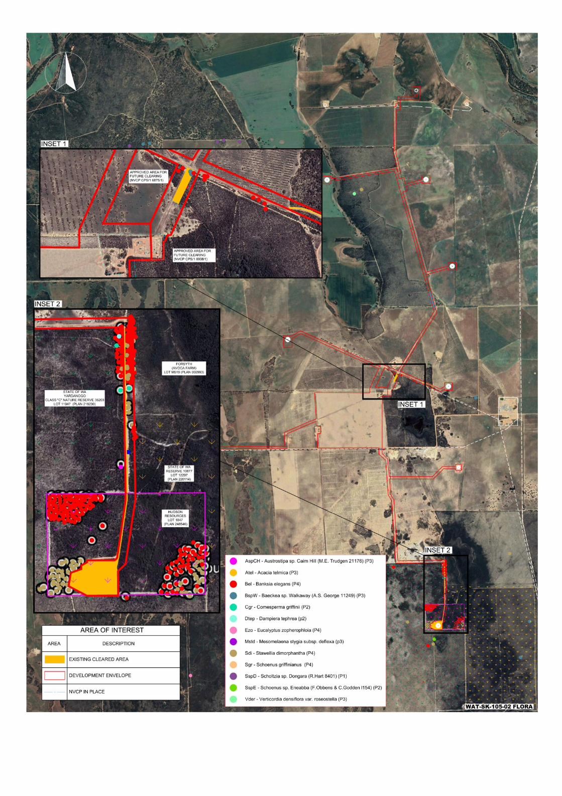

Document Title: Waitsia Gas Project Stage 2: Flora and Vegetation Management Plan
Revision Number: Rev 1
Review Date: 17 March 2020
Item No.
EMP Section No. DWER Comments Proponent Response (Rev 2 update)
12. Table 3.2 Table 3.2 does not provide enough information on trigger and threshold criteria and actions.
The EMP should provide variables to be recorded during monitoring, locations of quadrats and analysis to be undertaken, rather than those being developed at another time.
The variables to be recorded during monitoring have been updated in Table 3‐5. Specifically, reach monitoring event is described in greater detail and includes the parameters that are to be recorded to be undertaken. Further to this, the location of baseline monitoring plots within the Yardanogo Nature Reserve have been identified in Table 3‐6.
13. Table 3.2 “Prevent new weed species introduction” is a management objective in Table 3.2. The EMP does not provide any guidance as how new weeds would be identified.
DWER requests further detail on the proposed methods for identifying new weeds.
Table 3‐5 describes the monitoring events associated with the management plan. In additional to opportunistic identification (which is not included in the EMP). Specifically, two types of methods are proposed:
1. A quarterly visual inspection will be undertaken by MEPAU Personnel. The method in the EMP has been updated to provide an overview of how this will be taken including the materials to be made available to support MEPAU Staff.
2. An Annual detailed flora and vegetation survey for the duration of construction and a year into operations – this will include reanalysis of baseline quadrats within the Yardanogo Nature Reserve and Waitsia 03 vegetation area. Additional information on the methods have been included.
14. Table 3.2 The threshold actions provided for all three management objectives (Table 3.2) would not meet EPA (2020) instructions that “threshold contingency actions must be decisive actions that will bring the impact back below the threshold criteria and trigger criteria quickly”.
Please review and revise threshold contingency actions to detail how they will bring the impact back to below threshold criteria.
MEPAU have benchmarked the EMP against other publicly available EMPs, and reviewed the threshold and contingency actions and have reworked and included additional response actions to ensure that an immediate response will be undertaken. Given the nature of the incidents and that different weed management is dependent on the time of year, weed species and population density – MEPAU still believes it is important to link management responses to specialised advice or Department of Primary Industries and Regional Development (DPIRD) advice.
15. Table 3.2 The trigger criteria for dieback (Table 3.2) requires attribution of the impact to the proposal. Variables monitored and proposed analysis should be provided in the EMP, including how the variables measured would determine if dieback introduction was (or wasn’t) attributable to operations.
MEPAU have removed the “attribution to the proposal” from the Environmental Trigger and Thresholds Criteria thus enabling response actions to be triggered. The response actions will require a DBCA accredited dieback interpreter to survey the area. MEPAU will then assess if an infestation is attributable to the project by investigating if access to the area was required for construction activities and if evidence of access was available to understand the source of the potential infestation. This analysis is qualitative; however the results will be reported to the EPA and DMIRS during standard reporting to enable full transparency of decisions.
16. Table 3.5 Table 3.5 provides for staff to undertake ongoing visual monitoring quarterly and for experts to annually monitor weeds during construction and one‐year post‐construction ‐ potentially two years total.
DWER requests additional information on the proposed annual weed survey is provided for clarity.
Additional information regarding the weed survey methods are included in Table 3‐5.
17. Tables 3.4 and 3.2 Table 3.4 describes an annual weed survey to be undertaken during construction and one year after construction. It is assumed that after that time, the visual monitoring proposed by staff would be the primary monitoring event. It is not clear how the trigger and threshold criteria from Table 3.2 would be measured solely from visual monitoring.
As above, please provide further detail to clarify how the annual weed survey will be undertaken and the proposed methodology for measurement against triggers and thresholds.
MEPAU have tied existing management Objectives to the construction phase, and developed a new management Objective (based upon presence absence) of species to be implemented during the operations phase. This is considered appropriate as the largest risk of weed and dieback spread is during civil / construction activities.
This will enable visual monitoring by MEPAU staff to identify suspected new species and trigger the requirement for response actions and additional specialist surveys if required.