waikato expressway hamilton section - nzta.govt.nz · ruakura interchange – notice of requirement...
TRANSCRIPT

Waikato Expressway Hamilton Section Notice of Requirement to Alter the Designation
Ruakura Interchange
February 2014


Ruakura Interchange – Notice of Requirement i
19 February 2014
Contents
1 Introduction ....................................................................................................... 4
1.1 Overview ............................................................................................................................ 4 1.2 New Zealand Transport Agency ........................................................................................ 4 1.3 Roads of National Significance ......................................................................................... 4 1.4 Waikato Expressway ......................................................................................................... 4 1.5 Waikato Expressway – Hamilton Section ......................................................................... 6 1.6 Project Specific Objectives ................................................................................................ 7
1.7 Ruakura Interchange – Proposed Alteration .................................................................... 7
2 Background ...................................................................................................... 10 2.1 Existing Designations and Conditions ............................................................................ 10
2.2 Alterations to the Designation ........................................................................................ 12 2.3 Resource Consents .......................................................................................................... 12
3 Planning Context ...............................................................................................14 3.1 Local Authority Boundary Changes ................................................................................ 14
3.2 Ruakura Structure Plan .................................................................................................. 14
3.3 Ruakura Development Private Plan Change ................................................................... 15
4 Ruakura Interchange ........................................................................................16 4.1 Form 18 ........................................................................................................................... 16 4.2 Consideration of Alternatives ......................................................................................... 19
4.3 Assessment of Environmental Effects ............................................................................ 19
5 Consultation ..................................................................................................... 66 5.1 Overview .......................................................................................................................... 66 5.2 Ruakura Interchange Consultation ................................................................................. 66 5.3 Tangata Whenua Consultation ....................................................................................... 67
5.4 Affected Landowner Consultation .................................................................................. 68 5.5 Ruakura Structure Plan and the Ruakura Development PPC Consultation ................... 69 5.6 Summary ......................................................................................................................... 69
6 Statutory Assessment ....................................................................................... 70 6.1 Resource Management Act 1991 ..................................................................................... 70 6.2 Part 2 ............................................................................................................................... 72 6.3 National Environmental Standards ................................................................................ 74 6.4 Other Regulations ........................................................................................................... 75 6.5 Regional Policy and Plans ............................................................................................... 76 6.6 Plans and Proposed Plans ............................................................................................... 79 6.7 Other Plans ...................................................................................................................... 83
7 Conclusion ....................................................................................................... 86

Ruakura Interchange – Notice of Requirement ii
19 February 2014
Appendix A – Existing Conditions for the Hamilton Section of the Waikato Expressway
Designation
Appendix B – Certificates of Title
Appendix C – Plans in Support of the Alteration to Designation
Appendix D – Network Connections Summary Report – March 2013
Appendix E – Traffic Assessment Results

Ruakura Interchange – Notice of Requirement iii
19 February 2014
Glossary of Terms:
AEE Assessment of Environmental Effects
Agency New Zealand Transport Agency
CMP Construction Management Plan
GPS Government Policy Statement on Land Transport Funding 2009/10 – 2018/19
HCC Hamilton City Council
HCV Heavy Commercial Vehicle
HPA Historic Places Act 1993
LOS Level of Service
LTMA Land Transport Management Act 2003
NOR Notice of Requirement
NZHPT New Zealand Historic Places Trust
NZS New Zealand Standard
Opus Opus International Consultants
PIR Project Investigation Report
PPC Private Plan Change
Project The Waikato Expressway-Hamilton Section
PT Public Transport
PWRPS Proposed Waikato Regional Policy Statement – also referred to as PRPS
RLTS Waikato Regional Land Transport Strategy 2007
RMA Resource Management Act 1991
RoNS Roads of National Significance
RPS Waikato Regional Policy Statement
SARA Scheme Assessment Report Addendum
SH1 State Highway 1
TDM Travel Demand Management
TGH Tainui Group Holdings Ltd
TWEAR Tangata Whenua Effects Assessment Report
TWWG Tangata Whenua Working Group
vpd Vehicles per day
WDC Waikato District Council
WRC Waikato Regional Council
WRP Waikato Regional Plan
WRPS Waikato Regional Policy Statement (Operative) – also referred to as RPS
WRTM Waikato Regional Transportation Model

Ruakura Interchange – Notice of Requirement 4
19 February 2014
1 Introduction
1.1 Overview
The New Zealand Transport Agency (the Agency) has prepared this Notice of Requirement (NOR) to
alter the designation for the Hamilton Section of the Waikato Expressway (Hamilton Section) in
order to accommodate an interchange at Ruakura, remove the currently designated two north facing
ramps at SH26/Morrinsville Road interchange, and the relocation of Ruakura Road. This alteration
is required should the Inland Port project proceed as described in further detail later in this report.
This report provides the documentation, including an assessment of environmental effects, to
support the NOR to alter the designation.
1.2 New Zealand Transport Agency
The Agency is a Crown entity. The Agency’s objective pursuant to section 94 of the Land Transport
Management Act 2003 (LTMA) is to contribute to an effective, efficient, and safe land transport
system in the public interest.
1.3 Roads of National Significance
In July 2012, the Government Policy Statement on Land Transport Funding (GPS) was released,
which identified seven Roads of National Significance (RoNS), which are considered by the
Government to be the Country’s most important transport routes, requiring significant development
to reduce congestion, improve safety and support economic growth. The Ruakura Interchange forms
part of the Hamilton Section of the Waikato Expressway (the Expressway), which is one of the seven
RoNS.
The purpose of listing particular roads as nationally significant was to ensure these priority roading
projects are taken into account fully in the development of the National Land Transport Programme.
The NZ Government expects that planning for the future development of the land transport network
should reflect the importance of these roads from a national perspective and the need to advance
them quickly.
1.4 Waikato Expressway
The Expressway will extend from the Bombay Hills in the north to just south of Cambridge. The
Expressway has been divided into 12 sections (see Figure 1-1). It is expected the Expressway will:
Improve economic growth and productivity for Auckland, Waikato and Bay of Plenty through
more efficient movement of people and freight between Auckland, Hamilton, Tauranga and
Rotorua;
Improve the reliability of the transport network by providing a more robust and safer road
network between Auckland, Hamilton, Tauranga and Rotorua;
Reduce travel times between Waikato and Auckland; and
Support the growth strategy for the central Waikato.

Ruakura Interchange – Notice of Requirement 5
19 February 2014
Figure 1-1 – Map of the Waikato Expressway

Ruakura Interchange – Notice of Requirement 6
19 February 2014
1.5 Waikato Expressway – Hamilton Section
The Hamilton Section is located on the eastern side of the city of Hamilton. The Hamilton Section
adjoins the recently completed Ngaruawahia Section to the north, and the existing Tamahere
Interchange to the south. It is approximately 22km in length. Figure 1-2 shows the scope of the
Hamilton Section.
Figure 1-2 – Map of the Waikato Expressway (Hamilton Section)

Ruakura Interchange – Notice of Requirement 7
19 February 2014
1.6 Project Specific Objectives
The specific project objectives for the Hamilton Section are as follows:
Contribute to the GPS priorities of national economic growth and productivity;
Take into account the principles of the Treaty of Waitangi;
Form part of an ultimate expressway facility between Auckland and Cambridge;
Provide a high level of service and safety for inter-regional and inter-centre traffic for a
planning horizon of at least 30 years;
Provide for the safe and efficient movement of state highway traffic between Hamilton and
major destinations to the north of Hamilton;
Minimise any adverse impacts and improve where feasible, the natural, physical, cultural and
social environment of the region;
Provide an appropriate return on investment for the project as a whole; and
Maximise the economic viability of the project as measured by its Benefit/Cost Ratio and
general value for money principles.
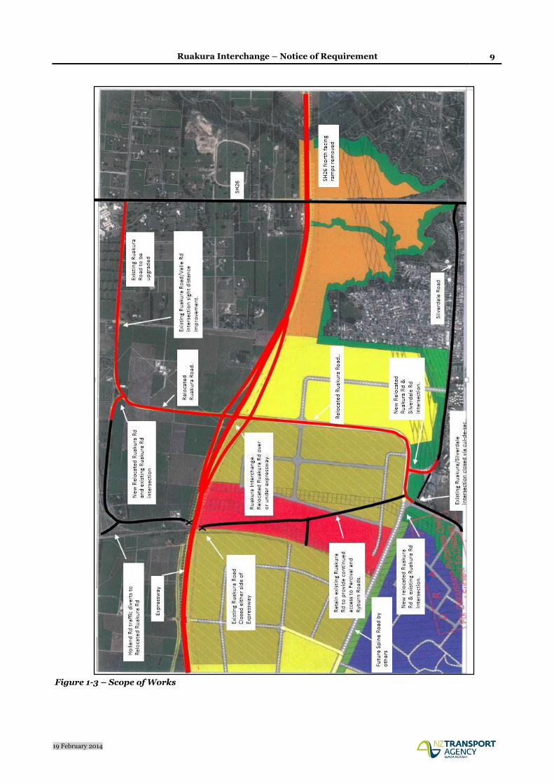
1.7 Ruakura Interchange – Proposed Alteration
The purpose of this NOR is to alter the existing designation and specifically includes the following:
Widening of the designation to accommodate the Ruakura Interchange ramps, connecting
roundabouts, and stormwater wetland;
Closure of the existing Ruakura Road either side of the Expressway and consequently
shortening of the bridge over the rail line;
Retention of Ruakura Road on both sides of the Expressway in order to provide continued
property access;
Relocation of Ruakura Road between the Ruakura Road/Silverdale Road intersection and
the existing Ruakura Road near the Vaile Road intersection to connect with the proposed
Ruakura Interchange, including:
o Existing Ruakura/Silverdale intersection closed via cul-de-sac (road retained for
access) and creation of a new relocated Ruakura Rd/Silverdale Rd intersection
o New relocated Ruakura Road/Existing Ruakura Road (west) intersection
Provision of a tee intersection where the relocated Ruakura Road meets the existing
Ruakura Road (east);
Upgrading the existing Ruakura Road between the new intersection with the relocated
Ruakura Road and the Ruakura Road/SH26 intersection;

Ruakura Interchange – Notice of Requirement 8
19 February 2014
Extension of the designation to cover the existing Ruakura Road (from the intersection with
the relocated Ruakura Road up to SH 26);
Provision for the relocated Ruakura Road to pass either over or under the Expressway; and
Provision for stormwater attenuation and disposal from the relocated Ruakura Road and
Ruakura Interchange.
Refer to Figure 1-3 below for the Scope of Works.
Ruakura Interchange – Notice of Requirement 9
19 February 2014
Figure 1-3 – Scope of Works

Ruakura Interchange – Notice of Requirement 10
19 February 2014
2 Background
2.1 Existing Designations and Conditions
The route selection and alignment of the Hamilton Section was determined as part of a wider project
which commenced in 1995 and covered the long term development of State Highway 1 (SH1) between
Ohinewai and Cambridge. The Notice of Requirement for the original designation was lodged in
2001 and the designation was secured in 2005, following an appeal hearing before the Environment
Court in 2004.
Key aspects of the designated route are:
The need for the Hamilton Section of the Expressway to provide convenient and efficient
connections to the City's arterial network - as well as providing for the efficient and
uninterrupted passage of inter-regional traffic on the nation's primary trunk route;
A decision by the Agency that the Hamilton Section should pass to the east of Hamilton City -
rather than to the west;
A decision by the Agency confirming that the southern end of the route is to link into the
existing State Highway at Tamahere - rather than link directly into the designated Cambridge
Bypass via an alignment generally following the Cambridge Branch rail line. This issue was
the main focus of the appeal hearing in 2004.
Table 1-1 summarises the existing designations for the Hamilton Section and other existing relevant
designations by the Agency.
District District Plan Map No.
Code Activity Location Comments
Waikato 1, 3, 4, 8, 13, 14
J1 State Highway 1 (Limited access except those parts within the former boroughs of Huntly and Ngaruawahia as at October 1989, and that part of Taupiri between Mangawara bridge and Kainui Road)
From Franklin District/Waikato District boundary north of Meremere to Hamilton City/Waikato District boundary at Ruffell Road, and then from Hamilton City/ Waikato District boundary at Newell Road to Waipa District/Waikato District boundary at Racecourse Road
Waikato 14, 15, 19 J3 State Highway 26 (limited access)
From Hamilton City/Waikato District boundary at Matangi Road to Matamata Piako District/Waikato District boundary
Waikato 8, 13, 14, 33, 36, 37
J16 Road for state highway and road for access to state highway (Waikato Expressway, Ngaruawahia Bypass.)
Taupiri to Horotiu

Ruakura Interchange – Notice of Requirement 11
19 February 2014
District District Plan Map No.
Code Activity Location Comments
Waikato 37, 14, 20, 22, 24A
J17 Road for state highway and road for access to state highway (Waikato Expressway, Hamilton Bypass.)
Lake Road to Bollard Road
Designation lapses in 2015
Hamilton 2, 3 90 Hamilton Bypass – State Highway and Access to State Highway
Kay Road to Gordonton Road
10 year designation (lapses 2015)
Hamilton 20, 21, 30, 31, 40, 48, 49
90a To manage the State highway system, including planning, funding, design, supervision, construction, and maintenance and operations, and improvements in accordance with the Land Transport Act 2003 and the Government Roading Powers Act 1989.
Greenhill Road to Mangaonua Gully (rollover from Waikato District Plan)
10 year designation (lapses 2014)
Table 2-1 – Existing Designations
There are two sets of conditions that relate to the existing Hamilton Section designation. These are:
NOR 1 – Waikato District – Horotiu to Tamahere; and
NOR 2 – Hamilton City – Horotiu to Tamahere.
Each set contains ten conditions, and both address the following matters (with some variations in
wording of individual conditions):
Description of works;
Construction Management Plan;
Archaeological/Cultural Matters;
Network Utilities;
Noise;
Landscape and Visual;
Effects of construction on existing drainage works;
Lighting;
Community Liaison; and
Term of Designation.
The conditions were confirmed with the designation in 2005, following the Environment Court
hearing in 2004. The NOR2 conditions only relate to a portion of the designated Expressway
between Kay Road and Horsham Downs Road. These conditions were required because at that time
only this section of the designated Expressway was located within Hamilton City, with the balance
of the designated Expressway being within the Waikato District. Since that time, the boundaries
between the two territorial authorities has changed, but the physical location of the designations has
Ruakura Interchange – Notice of Requirement 12
19 February 2014
remained the same. As a consequence, the NOR1 conditions originally for the designations located
within the Waikato District now apply to some of the designations located within Hamilton City.
Only the NOR1 conditions apply to the designations to be altered by this NOR (J17 –Waikato District
Plan, and 90a Hamilton City Proposed District Plan). A full set of the NOR1 conditions is provided
in Appendix A.
2.2 Alterations to the Designation
On 30 September 2013, the Agency lodged a NOR detailing a series of alterations to the existing
designation. The NOR was divided into two bundles. The first bundle included the following
alterations to the designation, which the Agency requested be publicly notified under s95A(2)(b) of
the Resource Management Act 1991 (RMA). Accordingly these alterations were notified on 20
November 2013. A total of 18 submissions were received.
Alteration Relevant Council
Resolution Drive Interchange (Alteration U) WDC
Puketaha Road Arrangement (Alteration V) WDC
Greenhill Interchange (Alteration W) WDC & HCC
Southern Interchange and Cambridge Road Widening (Alteration Z) WDC
Table 2-2 – Publicly Notified Alterations
The second bundle included twelve minor alterations providing for local widening and narrow
points, and to make provision for stormwater treatment facilities. These alterations were lodged in a
separate bundle under the expectation that they were likely to be non-notified due to their minor
nature.
2.3 Resource Consents
On the same date (30 September 2013), the Agency lodged applications for the necessary resource
consents with Waikato Regional Council (WRC). As with the large alterations, the Agency requested
that these applications be publicly notified under s95A(2)(b) of the RMA. Accordingly these resource
consents were publicly notified on 20 November 2013.
The following resource consents are currently being sought from the WRC:
Land use Undertake earthworks including: soil disturbance, roading, tracking, and vegetation clearance both within and outside of high risk erosion areas; cleanfill and overburden disposal; and, any associated discharges of contaminants to water or air association with the Hamilton Section of the Waikato Expressway
Water permit To dam and divert surface water in the Mangaonua and Mangaharakeke/ Mangaone gullies as a consequence of road construction in association with the Hamilton Section of the Waikato Expressway
Land use Construction, operation, maintenance and removal of temporary bridges over the Mangaonua and Mangaone streams including any associated discharges of contaminants to water or air in association with the Hamilton Section of the Waikato Expressway
Ruakura Interchange – Notice of Requirement 13
19 February 2014
Land use Construction, operation and maintenance of the Mangaonua and Mangaone Stream bridges including any associated discharges of contaminants to water or air in association with the Hamilton Section of the Waikato Expressway.
Water Permit To drill below the water table to install bridge piles in association with the Hamilton Section of the Waikato Expressway.
Water permit To take and divert groundwater and discharge groundwater to water in association with the Hamilton Section of the Waikato Expressway.
Discharge permit
To divert and discharge stormwater into water, and/or into or onto land, including the installation, operation and maintenance of discharge structures in association with the Hamilton Section of the Waikato Expressway.
Land use Construction, operation and maintenance of culverts including any associated discharges of contaminants to water or air in association with the Hamilton Section of the Waikato Expressway
Water Permit To dam and divert surface water in association with culvert construction, operation and maintenance
Table 2-3 – WRC Consent Applications
19 submissions were received in relation to the notified WRC consent applications. A joint hearing
for the alterations and WRC consents is scheduled for April 2014. The alterations and consent
applications do not specifically address the Ruakura Interchange proposal with the exception of the
land use consent for earthworks, which has taken into consideration the requirements for the
Ruakura Interchange. Accordingly, there is a requirement to seek a separate alteration and resource
consents for the new Ruakura Interchange and associated works.

Ruakura Interchange – Notice of Requirement 14
19 February 2014
3 Planning Context
3.1 Local Authority Boundary Changes
The future plan for local authority boundary changes is set out in the Strategic Agreement on Future
Urban Boundaries between the WDC and HCC, dated March 2005. The agreement identifies the
principles, direction and process for transfer of land.
Since the original designation was confirmed, boundary changes have occurred between HCC and
WDC.
The boundary between HCC and WDC generally follows the centreline of the Expressway in the
following locations:
Between Horsham Downs Road and old Borman Road; and
Between Greenhill Road and the Mangaonua Gully.
The rest of the Expressway designation is either wholly within the WDC or HCC jurisdictions as
follows:
Waikato District: Lake Road to Kay Road, Gordonton Road to Greenhill Road, Mangaonua
Gully to Tamahere interchange; and
Hamilton City: between Kay Road and Horsham Downs Road, and between old Borman Road
and Gordonton Road.
In relation to the Ruakura Interchange NOR, it is noted that the jurisdictional boundary generally
follows the centreline of the Expressway from Greenhill Road through to the Mangaonua Gully. The
NOR is therefore to both the WDC and HCC.
3.2 Ruakura Structure Plan
As discussed above, recent boundary changes between HCC and WDC have meant that a significant
area of land at Ruakura is now within the HCC jurisdiction. The development of this land is identified
in a number of high level documents including the Hamilton Urban Growth Strategy, the Access
Hamilton Transport Strategy and the Proposed Regional Policy Statement.
To enable the progressive development of this area, the Ruakura Structure Plan (Structure Plan) was
developed and notified as part of the Hamilton City Proposed District Plan (Proposed District Plan)
in December 2012. Submissions and further submissions have been received, and hearings have been
in progress since late 2013. In the meantime, the planning rules of the WDC’s District Plan still apply
to this area, despite now being within the jurisdiction of the HCC.
The Structure Plan includes an inland port, freight and logistics hub and other industrial land. The
Inland Port as proposed has an intermodal facility so that freight can be transferred to and from road
and rail. The Structure Plan also provides for research and innovation activities, and residential areas
for an eventual population of approximately 1,800 households, including the development of a
neighbourhood centre.
Ruakura Interchange – Notice of Requirement 15
19 February 2014
Development of the Ruakura Logistics Zone and Ruakura Industrial Park Zone is proposed in three
stages which tie in with the Waikato Regional Policy Statement’s (RPS) industrial land allocation in
the Future Proof Area.
At the time of notifying the Structure Plan (as part of the Proposed District Plan), discussions around
the location of an interchange to service the Inland Port were still ongoing and this is reflected in the
wording of the Structure Plan.
The Agency has made a number of submission points in relation to the Structure Plan, as part of its
overall submission on the Proposed District Plan. The Agency is generally supportive of the
Structure Plan and in particular made reference to being in support of an interchange on the Waikato
Expressway in the general vicinity of the Inland Port.
3.3 Ruakura Development Private Plan Change
Tainui Group Holdings Limited (TGH) is the predominant landowner affected by the Structure Plan
and is keen to see it being implemented. However, it was identified that existing planning rules
transferred over from the WDC’s District Plan prohibit any application being made for urban
development within this area. Given that the WDC rules are currently operative, they continue to
apply until the Proposed Hamilton City District Plan (that includes the Structure Plan) has been
made operative. Given the potential for lengthy delays, TGH have sought a Private Plan Change
(PPC) for what is known as the Ruakura Development through the Environmental Protection
Authority (EPA). On 31 July 2013, a ministerial direction was released, referring the PPC request to
a Board of Inquiry (BOI).
The PPC seeks to enable development of up to 389ha of land at Ruakura. This area is only part of the
wider development proposed as part of the Structure Plan. TGH state that the area equates to
approximately 30 years of development and aligns with the RPS industrial land allocations.
The PPC will enable development to occur in the interim, but it is intended that it will be fully
superseded by the Structure Plan once the Proposed District Plan is confirmed. Accordingly the PPC
does not re-zone any land, rather it proposes to adopt mechanisms providing an overlying ‘schedule’.
This allows a range of activities to be undertaken in identified areas, as well as existing rural
activities.
The PPC states that the construction of the Expressway has a direct relationship to land release, and
that the industrial land allocation is limited to 80ha prior to the Expressway being opened.
The PPC was publicly notified on 30 November 2013. Submissions have now closed, and 77 were
received, including one by the Agency. The BOI hearing is scheduled to take place in May 2014.
The Agency’s submission supports in part the PPC, subject to further information and amendments
being made on specific matters as listed in the submission.

Ruakura Interchange – Notice of Requirement 16
19 February 2014
4 Ruakura Interchange
The Agency is seeking to alter the existing designations for the Waikato Expressway (Hamilton
Section) in order to accommodate an interchange at Ruakura. This includes the relocation of
Ruakura Road, and removing the two north facing ramps at the SH26/Morrinsville Road
interchange. Should the Inland Port/Logistics Area and Industrial Area be approved through the
BOI hearing, it is imperative that a direct link is made to the Hamilton Section of the Waikato
Expressway, rather than relying on local roads to accommodate heavy vehicle movements. The
establishment of an interchange at Ruakura that will tie in with the Ruakura Development is the
safest and most efficient way of connecting this area to the wider roading network.
4.1 Form 18
Section 181 Resource Management Act 1991
To: Waikato District Council
Private Bag 544
Ngaruawahia
And Hamilton City Council
Private Bag 3010
Hamilton
1 The NZ Transport Agency (the Agency), a requiring authority pursuant to section 167 of the
Resource Management Act 1991, and having financial responsibility for this proposed public
work, gives notice to both Waikato District and Hamilton City Councils of a requirement for
alterations to the following designations:
J17 (Hamilton Bypass) of the Waikato District Plan; and
90a (Hamilton Bypass) of the Hamilton City Proposed District Plan.
Designation Purpose:
Alteration to J17: Road Purposes - State Highway & Access to State Highway
Alteration to 90a: Road Purposes – Local Road & Access to State Highway
Designation Lapse Period:
Waikato District Plan – 2015
Hamilton City Proposed District Plan – 10 years (2015)
2 The site to which the requirement applies is as follows:
Waikato District Council
Part Lot 3 DPS14267 (SA11D/1380),
Lot 8 DPS66853 (SA53C/665); and
Road Reserve – Ruakura Road, Vaile Road and Davison Road

Ruakura Interchange – Notice of Requirement 17
19 February 2014
Hamilton City Council
Lot 1 DPS77458 (SA61C/243),
Lot 1 DPS78549 (SA61C/246),
Lot 8 DPS66853 (SA53C/665); and
Road Reserve – Ruakura Road and Silverdale Road
Please refer to Appendix B for copies of the Certificates of Title.
3 The nature of the alteration work is as follows:
Widening of the designation to accommodate the Ruakura Interchange ramps,
connecting roundabouts, and a stormwater wetland;
Closure of the existing Ruakura Road either side of the Expressway and consequently
shortening of the bridge over the rail line
Retention of Ruakura Road on both sides of the Expressway in order to provide
continued property access
Relocate Ruakura Road between the Ruakura Road/Silverdale Road intersection and
the existing Ruakura Road near the Vaile Road intersection to connect with the
proposed Ruakura Interchange, including:
o Existing Ruakura/Silverdale intersection closed via cul-de-sac (road retained for
access) and new relocated Ruakura Rd/Silverdale Rd intersection
o New relocated Ruakura Road/Existing Ruakura Road (west) intersection
Provision of a tee intersection where the relocated Ruakura Road meets the existing
Ruakura Road (east)
Upgrading the existing Ruakura Road between the new intersection with the
relocated Ruakura Road and the Ruakura Road/SH26 intersection
Extension of the designation to cover the existing Ruakura Road (from the intersection
with the re-aligned Ruakura Road up to SH 26)
Provision for the relocated Ruakura Road to pass either over or under the Expressway
Provisions for stormwater attenuation and disposal from the relocated Ruakura
Road and Ruakura Interchange
Please refer to Appendix C for plans in support of the NOR.
4 The nature of the proposed restrictions that would apply are:
In context of the assessment of environmental effects that follows, it is considered that the
existing conditions applying to the designation for the Hamilton Section of the Waikato
Expressway (NOR1), will adequately mitigate any potential environmental effects
associated with the alteration. Notwithstanding this, some further mitigation of effects will
need to be addressed in the WRC consents yet to be applied for.

Ruakura Interchange – Notice of Requirement 18
19 February 2014
The existing designation conditions (NOR1) are included in Appendix A of this report and
the Agency requests that these conditions apply to this alteration.
5 The effects that the public work will have on the environment and the ways in which any
adverse effects will be mitigated are:
Please refer to the effects assessment below.
6 Alternative sites have been considered to the following extent:
The Agency has investigated alternatives and undertaken consultation to inform and gain
feedback from the public. Please refer to section 4.2 below.
7 The public work and designation are reasonably necessary for achieving the objectives of the
requiring authority because:
The proposed alteration is the outcome of a Network Connections investigation which
concluded that interchanges at Greenhill and Ruakura best served the area if the Ruakura
Structure Plan and in particular the Inland Port were to proceed. This alteration is lodged
on the basis that the upcoming BOI process for the PPC justifies the establishment of an
interchange at Ruakura.
8 The following resource consents are required from the Waikato Regional Council:
At this time the Agency is only seeking to lodge the NOR for the Ruakura Interchange. The
Agency is aware of the need to seek resource consents from the WRC for a number of
matters including, but not limited to: earthworks, water diversions, water takes, water
discharges, placement of structures within stream beds and stormwater discharges. The
Agency will seek the necessary consents from the WRC in due course.
9 The following consultation has been undertaken with the affected landowners:
Consultation undertaken by the Agency with respect to this NOR is detailed in Section 5 of
this report.
10 The following information is required to be included in this notice by the district plan,
regional plan, or any regulations made under the Resource Management Act 1991:
Notice of requirement assessment of effects;
Notice of requirement alteration plans.

Ruakura Interchange – Notice of Requirement 19
19 February 2014
4.2 Consideration of Alternatives
In early 2013, transport modelling work was undertaken to inform a network connections study to
ascertain the most favourable network between Greenhill Road and SH26, with a view to integrating
the Waikato Expressway connectivity with the proposed Structure Plan and associated generation of
a large number of heavy commercial vehicle movements.
The study identified that interchanges at Greenhill and Ruakura best served the area if the Structure
Plan and in particular the Inland Port were to proceed.
The outcomes were discussed with HCC, WDC and TGH (and generally accepted as appropriate)
prior to being subject to the Agency’s internal approval process.
The assessment was based on the fundamental assumption that an Inland Port would be developed
along with the logistic zone activities. It is therefore expected that the connection at SH26 would be
retained and no connection provided at Ruakura if alternative forms of development were to occur.
This point has been reiterated in the Agency’s submission on the PPC.
The full assessment of options between Greenhill Road and SH26 is contained in the report ‘Network
Connections Summary Report – March 2013 Update’, prepared by Opus and attached as Appendix
D.
4.3 Assessment of Environmental Effects
4.3.1 Baseline for the Environmental Effects Assessment
In terms of assessing the potential environmental effects of the Ruakura Interchange, careful
consideration needs to be given to what constitutes the baseline for the assessment. The sole purpose
for establishing the Ruakura Interchange is to provide an appropriate link between the Ruakura
Development and the Expressway. It follows that if the Ruakura Development does not proceed,
then there is no basis for the Agency to pursue the Ruakura Interchange and development of the
Expressway will continue with the north facing ramps at the SH26 interchange.
Given the trigger effect that the Ruakura Development has on the Ruakura Interchange, it follows
that the baseline for assessing the Ruakura Interchange should include the Ruakura Development.
However, as the PPC will be superseded by the Structure Plan once the Proposed District Plan is
made operative, this NOR has used the Proposed District Plan to form the baseline upon which the
potential environmental effects of the Ruakura Interchange have been assessed. This approach is
considered appropriate given that the land use as set out in the Structure Plan is underpinned by the
policy direction given by the RPS, the Future Proof Strategy, the Hamilton Urban Growth Strategy
and the Access Hamilton Strategy.
The key components of the Proposed District Plan that form the baseline for this assessment include:
Inland Port/Ruakura Logistics (~150ha); and
Industrial Park (~210ha).
It also follows that the Expressway (as currently designated) is included as part of the baseline, as
this will proceed regardless of whether the Structure Plan is given effect to.

Ruakura Interchange – Notice of Requirement 20
19 February 2014
The potential environmental effects associated with the Ruakura Interchange alteration have been
assessed under the following headings: traffic effects, drainage and flooding effects, landscape, visual
amenity and urban design effects, contamination effects, noise effects, ecological effects,
archaeological effects, air quality effects and vibration effects.
4.3.2 Traffic Effects
The potential traffic effects of the Ruakura Interchange and relocated Ruakura Road have been
assessed by a Transportation Engineer familiar with the Expressway project and site. The potential
effects and proposed mitigation are summarised below.
Baseline for Traffic Effects Assessment
For the purpose of this traffic assessment the baseline includes the completed Waikato Expressway
and the Proposed District Plan on the basis that the Ruakura Structure Plan with its Inland Port will
proceed. It includes:
Land use as proposed by the Structure Plan. This includes an Inland Port (shaded red in Figure
4-1 below) and associated activities within the Ruakura Development area, industrial parks and
residential development in the north (Chedworth Park Development).
Relocation of a section of Ruakura Road (between Silverdale Road and Holland Road) to allow
the Ruakura Inland Port to be developed as this relies on direct access to the East Coast Main
Trunk Railway. To achieve this requires stoppage of Ruakura Road either side of the Expressway.
However, to ensure continued access to Percival Road and Ryburn Road, Ruakura Road west of
the Expressway will remain open.
The existing Hamilton Section of the Waikato Expressway designation, which has north facing
ramps at SH26, a full interchange near Greenhill Road (to the north) and south facing ramps at
the Southern Interchange (near Cherry Lane).
For the purpose of the traffic assessment the adopted network baseline is illustrated on Figure 4-1
below.
The only difference between the assumed baseline described above and the Ruakura Interchange
NOR is therefore the replacement of the SH26 north facing ramps with a full interchange on the
relocated Ruakura Road. Note, by year 2041, the Spine Road (future connection between Ruakura
and Greenhill as part of the Structure Plan) is considered to be part of the baseline.

Ruakura Interchange – Notice of Requirement 21
19 February 2014
Figure 4-1: Network Baseline for Traffic Assessment
In year 2012 Ruakura Road carried 5,100vpd between Silverdale Road and Holland Road and
2,900vpd between Holland Road and SH26, based on existing traffic count data. The existing sealed
carriageway width is between 7m and 8m wide consisting of two 3.5m traffic lanes and a narrow
shoulder. The Waikato District Council Plan lists Ruakura Road as an Arterial Road. Hence its main
function is to:
1. form a strategic network of district importance and
2. provide for the collection and distribution of goods significant to the district’s economy.
The District Plan also notes that the through traffic function needs to be balanced against the
property access function. On this basis the use of a section of Ruakura Road to provide connectivity
between SH26 and the Expressway is in our view in line with its intended function.
Methodology
The traffic flows have been extracted using the Waikato Regional Transportation Model (WRTM).
This model has been developed by a consortium of road controlling authorities, known as Local
Authority Shared Services (LASS), which includes the majority of local authorities within the
Waikato Region and the NZTA.

Ruakura Interchange – Notice of Requirement 22
19 February 2014
The WRTM has a validated 2006 network and two forecast years being 2021 and 2041. The model
was peer reviewed as fit for purpose by Flow Transportation Specialists on behalf of LASS. Morning
and afternoon peaks (as 2 hour periods) are modelled in conjunction with an interpeak period (also
2 hours), which when compiled together provide an estimate of the average daily flow. Traffic flows
are available for all-vehicle types or just the heavy vehicle component. The latter has been used to
determine the percentage of Heavy Commercial Vehicles (HCV) for the intersection analysis.
Traffic flows have been extracted from the project models referred to as Network 28 and 29, both of
which have adopted the Structure Plan. Network 28 reflects the existing Hamilton Section
designation including the north facing ramps on SH26. Network 29 includes all the proposed
Alterations to Designation which have already been lodged and publicly notified and includes the
Ruakura Interchange (north and south facing ramps).
Key junctions within the Ruakura area have been subjected to a detailed assessment of the likely
operating level of service (LOS) resulting from the Notice of Requirement (NOR). The key
intersections are considered to be:
Existing intersection of Ruakura Rd/SH26 (cross road),
The new intersection of Relocated Ruakura Rd/Existing Ruakura Road (Tee layout),
the Ruakura Interchange ramp terminal junctions (roundabouts),
The Relocated Ruakura Rd/Silverdale Rd intersection, and
The revised intersection layout at Ruakura Road/Silverdale Road (2021) and when the Spine
Road is added in the year 2041 network.
Intersection capacity and LOS has been determined using the SIDRA modelling software based on
year 2041 peak hour flows. The exception to this is the Ruakura Road/Silverdale Road intersection
which has also been assessed using year 2021 flows, because the junction layout does not include the
Spine Road in year 2021.
The SIDRA modelling parameters adopted for the assessment include:
use of peak hour factors (0.95) with a 30min peak period,
heavy vehicle content based on predictions from the project traffic models,
lane capacity values based on the SIDRA software recommendations,
Level of Service based on the Highway Capacity Manual intersection delays for the intersection
type being assessed.
Although the SIDRA results have been tabulated as per the software output this in no way indicates
a high level of accuracy with the results. Intersection delays include the geometric delay component
associated with turning vehicles negotiating the intersection. A copy of the SIDRA outputs can be
provided in request.
Traffic Flows on the Network
Traffic flow diagrams have been created to illustrate the change in daily 2041 traffic volumes on key
routes most likely to be affected by the Ruakura Interchange. The four figures below represent daily
flows on the following networks:

Ruakura Interchange – Notice of Requirement 23
19 February 2014
Figure 4-2 indicates the ramp flows at SH26 (baseline) and Ruakura Interchange (NOR).
Figure 4-3 indicates the assumed Baseline flows (Network 28). As the figure illustrates this
includes north facing ramps only at SH26 (Morrinsville Road) for local traffic to access the
Expressway.
Figure 4-4 indicates the NOR flows with a Ruakura Interchange and no connection between the
Expressway and SH26 (Network 29).
Figure 4-5 indicates the difference in daily flows between the baseline (Figure 4-3) and NOR
(Figure 4-4).
In all cases the black numbers represent the total daily flow, whilst the number of HCV’s are shown
in red.
Baseline - SH26 North Facing Ramps
NOR – Ruakura Interchange Ramps
Figure 4-2: Year 2041 Traffic Flows on the Interchange Ramps

Ruakura Interchange – Notice of Requirement 24
19 February 2014
Figure 4-3 – 2041 Daily Traffic Flows for Baseline (Network 28)

Ruakura Interchange – Notice of Requirement 25
19 February 2014
Figure 4-4 – 2041 Daily Traffic Flows for NOR (Network 29)

Ruakura Interchange – Notice of Requirement 26
19 February 2014
Figure 4-5 – 2041 Difference in Daily Traffic Flows (Alteration minus Baseline)
Ruakura Interchange – Notice of Requirement 27
19 February 2014
In general the traffic flow diagrams illustrate that:
The Ruakura Interchange attracts an additional 4,900vpd (1,400 HCVs) onto the southern
portion of the Hamilton Section of the Expressway which is an increase of +34%. This is
considered a positive effect as it reduces traffic flows on Cambridge Road and the western end of
SH26.
Similarly, the interchange attracts an additional 2,300vpd (1,500 HCVs) on to the section of
Expressway immediately north of the Ruakura Interchange. Again this is a positive impact as it
significantly reduces traffic on the Spine Road which would otherwise traverse through
residential areas.
As the Ruakura Interchange provides a direct connection onto the Expressway, the relocated
Ruakura Road shows a significant increase in predicted traffic flows either side of the
Expressway. This is not considered to be detrimental as the road is located in an industrial area
and will be constructed to cope with the expected traffic flows. The increase on Ruakura Rd
however is offset by a positive reduction in traffic flows on the Spine Road and the Greenhill
Arterial connection.
Ruakura Road between Vaile Road and SH26 is expected to increase by 1,600 vehicles per day as
traffic from SH26 uses Ruakura Road to access the Ruakura Interchange. The majority of this
increase consists of light vehicles. To improve safety, the Agency will widen Ruakura Road
between the intersection of the Relocated Ruakura Road and SH26 to provide a minimum of two
3.5m traffic lanes with a 1.5m wide shoulder on either side of the road.
Relocated Ruakura Road between the interchange and the main entrance to the proposed port
site will increase by approximately 8,300vpd. A significant portion of this are HCV’s (2,600vpd).
This increase is due to the improved connectivity between the Inland Port and the Expressway,
rather than traffic using the Spine Road and the Greenhill Interchange. This is also evidenced
by the high number of HCV’s using the Ruakura Interchange ramps (Figure 4- 2).
Overall it is concluded that the change in traffic flows on the network resulting from the NOR are no
more than minor. It also encourages the “right traffic” onto the “right roads”. That is, HCV’s have
direct access onto the Expressway and therefore do not need to traverse through city roads to access
the Greenhill Interchange or Southern Interchange.
Traffic Effects Assessment
In terms of traffic effects this assessment considers the proposal in terms of the effects on various
intersections affected by the alteration, property access, alternate transport modes and effects during
construction.
Ruakura Interchange On/Off Ramps
The NOR layout proposes two new roundabouts on Relocated Ruakura Road to serve the Expressway
off and on ramps. The roundabouts are expected to be about 35m in diameter to cater for the large
number of heavy vehicles that are expected to use the interchange. The speed limit on Relocated
Ruakura Road is proposed to be 60km/h west of the eastern roundabout. Intersection sight lines to
and from the intersections will be in accordance with the relevant design standards.
Using the SIDRA software, both the off-ramp and on-ramp configurations can adequately cope with
the excepted year 2041 peak period flows, providing a likely level of service (LOS) B (on a scale of A:
excellent to F: poor) as shown in Table 4-1. The project objective is to ensure a LOS C or better at all
Expressway ramp terminals, hence the proposed roundabouts meet this criteria. Please refer to

Ruakura Interchange – Notice of Requirement 28
19 February 2014
Appendix E – Traffic Assessment Results for detailed analysis of the information provided in the
following tables.
Intersection Approach Movement Demand Flow (vph)
Average Delay
(seconds)
95%ile Queue
(m)
LOS
AM PM AM PM AM PM AM PM
Ea
ste
rn
R
ou
nd
ab
ou
t East Ruakura Road 321 243 8 9 13 13 A A
North – Off Ramp 231 296 14 18 9 18 B B
West Ruakura Road 207 595 9 13 0 0 A B
We
ste
rn
R
ou
nd
ab
ou
t South – Off Ramp 313 152 15 13 21 8 B B
East Ruakura Road 501 363 6 6 0 0 A A
West Ruakura Road 360 879 6 6 14 53 A A
Table 4-1: On and Off Ramp Predicted Intersection Delays at Ruakura Interchange – Year 2041
It is recognised that the addition of two new intersections on Relocated Ruakura Road will pose some
additional safety risk on users of the existing Ruakura Road due to the introduction of new vehicle
conflicts. However, the NOR removes the two Tee intersections on SH26 that were part of the
existing designation. Accordingly, an assessment of the overall safety effect has been conducted using
available crash prediction models. This indicates that although there is a potential for more injury
crashes with the NOR, the lower speed limit on Ruakura Road (60km/h) will result in an overall
lower social cost per injury crash as shown in Table 4-2 below.
Baseline (Two Tee-intersections within 80km/h speed environment)
NOR (Two Roundabout intersections within 60km/h
speed environment) Predicted Injury crashes per year
0.587 0.837
Social Cost per Injury
$427,000 $195,000
Total Cost/yr $251,000 $163,000
Table 4-2-Comparison of Predicted Accident Cost for Baseline and NOR
It should also be noted that traffic modelling indicates more vehicles (light and heavy) use the
Expressway under the NOR than with the Baseline. Hence, we would expect an overall reduction in
crashes with the NOR layout as the vehicles transfer from city roads onto the Expressway, which has
no conflicting intersections or adjoining property access.
Existing Ruakura Road/SH26
Traffic modelling shows that traffic flows and patterns at this intersection will change due to the
NOR. Although the existing intersection has been the site of a number of fatalities over the past three
years, there appears to be no capacity issues. The existing SH26/Ruakura Road/Lissette Road
intersection provides a fully dedicated right turn bay. Site distance is also considered to be more
than adequate for the 80km/h speed environment.

Ruakura Interchange – Notice of Requirement 29
19 February 2014
Figure 4-6: Location Map
The following tables (4-3 to 4-6) summarise the traffic assessment. The green highlighted cells
indicate an improvement, whilst the red cells show a dis-benefit.
In all cases the intersection is expected to operate as well as the existing or slightly better. The
maximum increase in delays is 1sec/vehicle, whereas for some movements the delay reduces by up
to 6sec/vehicle. In reality motorists would not be aware of such a small change. The main change is
the increase in right turn traffic flows into Ruakura Road and the increase in the left turn flows out
of Ruakura Road. This is offset by a decrease in the through flow on SH26.
Approach
Demand Flow (vph) Deg Sat
Average Delay (s/veh) 95% Queue (m)
Baseline NOR Baseline NOR Baseline NOR Baseline NOR
Lissette Rd
Left 5 5 0.04 0.03 19 19 1 1
Through 5 5 0.04 0.03 19 18 1 1
Right 5 5 0.04 0.03 19 18 1 1
Sh26 westbound
Left 5 5 0.26 0.22 11 11 0 0
Through 460 397 0.26 0.22 0 0 0 0
Right 77 145 0.07 0.12 12 12 2 5
Ruakura Rd
Left 24 72 0.03 0.09 15 15 1 3
Through 5 5 0.28 0.18 26 21 9 5
Right 75 65 0.28 0.18 26 21 9 5
Sh26 eastbound
Left 98 62 0.06 0.04 11 11 0 0
Through 241 201 0.14 0.12 2 2 9 6
Right 5 5 0.14 0.12 13 13 9 6
Overall 1006 974 0.28 0.22 5 6 9 6
Table 4-3: Existing Ruakura Road/SH26/Lissette Road Intersection 2021 AM Peak

Ruakura Interchange – Notice of Requirement 30
19 February 2014
Approach Demand Flow (vph)
Deg Sat Average Delay (s/veh)
95% Queue (m)
Baseline NOR Baseline NOR Baseline
NOR Baseline
NOR
Lissette Rd
Left 5 5 0.04 0.04 19 19 1 1
Through 5 5 0.04 0.04 19 18 1 1
Right 5 5 0.04 0.04 19 19 1 1
Sh26 westbound
Left 5 5 0.17 0.15 11 11 0 0
Through 302 264 0.17 0.15 0 0 0 0
Right 35 89 0.04 0.10 13 13 1 3
Ruakura Rd
Left 84 151 0.14 0.25 17 17 4 9
Through 5 5 0.34 0.22 27 21 12 6
Right 91 77 0.34 0.22 27 21 12 6
Sh26 eastbound
Left 68 59 0.05 0.04 11 11 0 0
Through 454 395 0.26 0.22 2 1 16 12
Right 5 5 0.26 0.22 12 12 16 12
Overall 1065 1066 0.34 0.25 6 7 16 12
Table 4-4: Existing Ruakura Road/SH26/Lissette Road Intersection 2021 PM Peak
Approach
Demand Flow (vph) Deg Sat
Average Delay (s/veh) 95% Queue (m)
Baseline NOR Baseline NOR Baseline NOR Baseline NOR
Lissette Rd
Left 5 5 0.04 0.03 19 19 1 1
Through 5 5 0.04 0.03 19 18 1 1
Right 5 5 0.04 0.03 19 18 1 1
Sh26 westbound
Left 5 5 0.23 0.21 11 11 0 0
Through 431 380 0.23 0.21 0 0 0 0
Right 106 146 0.10 0.12 13 12 3 4
Ruakura Rd
Left 35 73 0.05 0.09 15 15 1 3
Through 5 5 0.28 0.22 23 21 8 6
Right 89 82 0.28 0.22 24 21 8 6
Sh26 eastbound
Left 137 99 0.08 0.06 11 11 0 0
Through 269 241 0.15 0.13 2 2 9 7
Right 5 5 0.15 0.13 13 13 9 7
Overall 1099 1053 0.28 0.22 6 6 9 7
Table 4-5: Existing Ruakura Road/SH26/Lissette Road Intersection 2041 AM Peak

Ruakura Interchange – Notice of Requirement 31
19 February 2014
Approach
Demand Flow (vph) Deg Sat
Average Delay (s/veh) 95% Queue (m)
Baseline NOR Baseline NOR Baseline NOR Baseline NOR
Lissette Rd
Left 5 5 0.03 0.03 18 18 1 1
Through 5 5 0.03 0.03 18 18 1 1
Right 5 5 0.03 0.03 18 18 1 1
Sh26 westbound
Left 5 5 0.18 0.16 11 11 0 0
Through 328 297 0.18 0.16 0 0 0 0
Right 49 89 0.05 0.08 13 13 2 3
Ruakura Rd
Left 12 155 0.02 0.23 16 16 1 7
Through 5 5 0.36 0.53 23 24 12 21
Right 127 217 0.36 0.53 23 24 12 21
Sh26 eastbound
Left 72 59 0.04 0.03 11 11 0 0
Through 406 367 0.22 0.2 2 1 13 11
Right 5 5 0.22 0.2 12 12 13 11
Overall 1026 1216 0.36 0.53 6 9 13 21
Table 4-6: Existing Ruakura Road/SH26/Lissette Road Intersection 2041 PM Peak
Over the past 3 years, there have been two fatal crashes and a number of non-injury crashes at this
intersection. Although there is an expected increase in turning traffic volumes, a safety review using
appropriate accident prediction models, indicates that there is virtually no change in the predicted
number of injury crashes. This is because the combination of turning and opposing traffic flows are
virtually the same between the baseline and NOR.
Based on the results of the year 2021 and 2041 traffic assessment the impact of the NOR proposal is
considered to be less than minor on the operational performance of the SH26/Ruakura Road
Intersection, when compared with the Baseline (North facing ramps at SH26). It is noted that the
Agency is looking at improvement options for this intersection to address existing safety concerns.
Relocated Ruakura Road/existing Ruakura Road (East)
The Relocated Ruakura Road/existing Ruakura Road Intersection is located east of the proposed
Ruakura Interchange and resembles a Tee junction layout on a horizontal curve. Relocated Ruakura
Road will be the major road with a speed limit of 80km/h.
Tables 4-7 and 4-8 illustrate that traffic flows at this intersection are expected to increase with the
NOR layout. However, the intersection is expected to operate well within its available capacity with
minimal delays. The overall LOS is B or better hence traffic from Holland Road that needs to divert
through this intersection should not experience any substantial delays (average predicted delay is
12sec/veh in either peak in year 2041).

Ruakura Interchange – Notice of Requirement 32
19 February 2014
Approach
Demand Flow (vph) Deg Sat
Average Delay (s/veh) 95% Queue (m)
Baseline NOR Baseline NOR Baseline NOR Baseline NOR Ruakura Rd Westbound
Through 155 240 0.09 0.14 0 0 0 0
Right 7 12 0.00 0.01 11 11 0 0
Holland Road Extension
Left 9 12 0.06 0.08 11 12 2 2
Right 78 81 0.06 0.08 11 12 2 2
Ruakura Rd Eastbound
Left 32 34 0.07 0.13 11 11 0 0
Through 85 200 0.07 0.13 0 0 0 0
Overall 366 578 0.09 0.14 4 3 2 2
Table 4-7: Relocated Ruakura Road/Existing Ruakura Road East of Expressway - Year 2041 AM
Approach
Demand Flow (vph) Deg Sat
Average Delay (s/veh) 95% Queue (m)
Baseline NOR Baseline NOR Baseline NOR Baseline NOR Ruakura Rd Westbound
Through 96 194 0.06 0.11 0 0 0 0
Right 9 15 0.01 0.01 11 12 0 0
Holland Road Extension
Left 11 14 0.04 0.06 11 12 1 1
Right 48 49 0.04 0.06 12 12 1 1
Ruakura Rd Eastbound
Left 92 82 0.15 0.20 11 11 0 0
Through 176 279 0.15 0.20 0 0 0 0
Overall 432 633 0.15 0.20 4 3 1 1
Table 4-8: Relocated Ruakura Road/Existing Ruakura Road East of Expressway - Year 2041 PM
Relocated Ruakura Road/Silverdale Road
The intersection of Relocated Ruakura Road and Silverdale Road will take the form of a simple Tee
junction with priority given to Relocated Ruakura Road. The intersection will be in a 60km/h posted
speed limit.
Table 4-9 and 4-10 illustrate that traffic flows through this intersection are likely to decrease due to
the NOR. This decrease in vehicle flow has an overall positive effect on the intersection performance
especially in the PM peak.
Approach
Demand Flow (vph) Deg Sat
Average Delay (s/veh) 95% Queue (m)
Baseline NOR Baseline NOR Baseline NOR Baseline NOR
Ruakura Rd NB
Left 36 166 0.15 0.60 60 52 13 55
Through 333 316 0.75 0.56 59 44 80 54
Ruakura Rd SB
Through 461 387 0.22 0.18 12 11 50 33
Right 799 740 0.87 0.86 29 31 239 212
Silverdale Rd
Left 472 482 0.85 0.84 58 49 210 179
Right 55 49 0.59 0.44 73 61 24 18
Overall 2155 2141 0.87 0.86 38 36 239 212
Table 4-9: Relocated Ruakura Road/Silverdale Road Tee Intersection Year 2041 AM

Ruakura Interchange – Notice of Requirement 33
19 February 2014
Approach
Demand Flow (vph) Deg Sat
Average Delay (s/veh) 95% Queue (m)
Baseline NOR Baseline NOR Baseline NOR Baseline NOR
Ruakura Rd - NB
Left 60 72 0.16 0.23 41 44 16 20
Through 585 401 0.83 0.64 44 39 111 63
Ruakura Rd - SB
Through 435 459 0.24 0.23 13 13 42 40
Right 555 553 0.87 0.82 38 29 164 134
Silverdale Rd
Left 535 488 0.87 0.79 47 40 189 153
Right 35 8 0.28 0.07 54 53 11 3
Overall 2204 1981 0.87 0.82 37 31 189 153
Table 4-10: Relocated Ruakura Road/Silverdale Road Tee Intersection Year 2041 PM
Relocated Ruakura Road/Existing Ruakura Road (West)
This intersection of Relocated Ruakura Road and Existing Ruakura Road is located west of the
Expressway and near the existing Silverdale Road intersection. It will take the form of a simple Tee
layout with priority given to Relocated Ruakura Road. The existing Ruakura Road is to be retained
to provide continuous access to Percival and Ryburn Road. Under the Proposed District Plan the
long term solution for this intersection is a set of traffic signals when the Spine Road is connected to
Relocated Ruakura Road. For this reason, it has been necessary to assess both the year 2021 and
2041 junction performance.
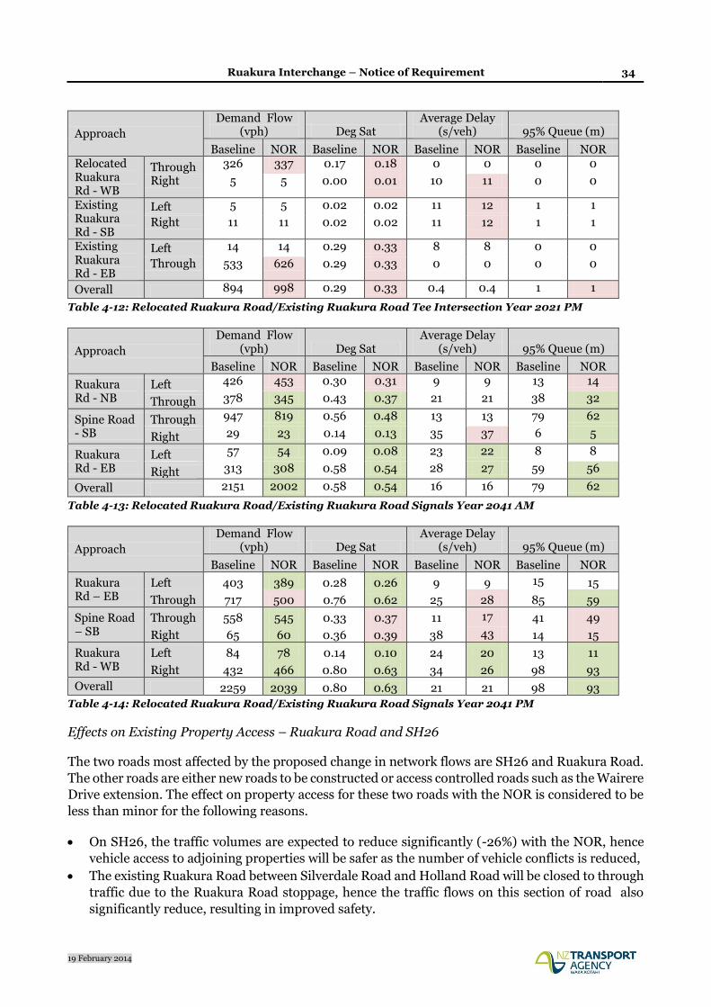
Table 4-11 and 4-12 indicate that through traffic flows in year 2021 on the Relocated Ruakura Road
are predicted to increase slightly due to the NOR. Despite the increase, average vehicle delays are
not expected to increase by more than one seconds. When the Spine Road is constructed the
intersection will be upgraded to traffic signals. Table 4-13 and 4-14 indicate a decrease in traffic flows
through the intersection with no overall change in vehicle delays.
Overall the effects on this intersection are less than minor.
Approach
Demand Flow (vph) Deg Sat
Average Delay (s/veh) 95% Queue (m)
Baseline NOR Baseline NOR Baseline NOR Baseline NOR Relocated Ruakura Rd - WB
Through 501 573 0.26 0.30 0 0 0 0
Right 5 5 0.00 0.00 10 10 0 0
Existing Ruakura Rd - SB
Left 6 6 0.03 0.03 11 12 1 1
Right 15 15 0.03 0.03 11 12 1 1
Existing Ruakura Rd - EB
Left 9 9 0.25 0.25 8 8 0 0
Through 460 471 0.25 0.25 0 0 0 0
Overall 997 1079 0.26 0.30 0.4 0.4 1 1
Table 4-11: Relocated Ruakura Road/Existing Ruakura Road Tee Intersection Year 2021 AM
Ruakura Interchange – Notice of Requirement 34
19 February 2014
Approach
Demand Flow (vph) Deg Sat
Average Delay (s/veh) 95% Queue (m)
Baseline NOR Baseline NOR Baseline NOR Baseline NOR Relocated Ruakura Rd - WB
Through 326 337 0.17 0.18 0 0 0 0
Right 5 5 0.00 0.01 10 11 0 0
Existing Ruakura Rd - SB
Left 5 5 0.02 0.02 11 12 1 1
Right 11 11 0.02 0.02 11 12 1 1
Existing Ruakura Rd - EB
Left 14 14 0.29 0.33 8 8 0 0
Through 533 626 0.29 0.33 0 0 0 0
Overall 894 998 0.29 0.33 0.4 0.4 1 1
Table 4-12: Relocated Ruakura Road/Existing Ruakura Road Tee Intersection Year 2021 PM
Approach
Demand Flow (vph) Deg Sat
Average Delay (s/veh) 95% Queue (m)
Baseline NOR Baseline NOR Baseline NOR Baseline NOR
Ruakura Rd - NB
Left 426 453 0.30 0.31 9 9 13 14
Through 378 345 0.43 0.37 21 21 38 32
Spine Road - SB
Through 947 819 0.56 0.48 13 13 79 62
Right 29 23 0.14 0.13 35 37 6 5
Ruakura Rd - EB
Left 57 54 0.09 0.08 23 22 8 8
Right 313 308 0.58 0.54 28 27 59 56
Overall 2151 2002 0.58 0.54 16 16 79 62
Table 4-13: Relocated Ruakura Road/Existing Ruakura Road Signals Year 2041 AM
Approach
Demand Flow (vph) Deg Sat
Average Delay (s/veh) 95% Queue (m)
Baseline NOR Baseline NOR Baseline NOR Baseline NOR
Ruakura Rd – EB
Left 403 389 0.28 0.26 9 9 15 15
Through 717 500 0.76 0.62 25 28 85 59
Spine Road – SB
Through 558 545 0.33 0.37 11 17 41 49
Right 65 60 0.36 0.39 38 43 14 15
Ruakura Rd - WB
Left 84 78 0.14 0.10 24 20 13 11
Right 432 466 0.80 0.63 34 26 98 93
Overall 2259 2039 0.80 0.63 21 21 98 93
Table 4-14: Relocated Ruakura Road/Existing Ruakura Road Signals Year 2041 PM
Effects on Existing Property Access – Ruakura Road and SH26
The two roads most affected by the proposed change in network flows are SH26 and Ruakura Road.
The other roads are either new roads to be constructed or access controlled roads such as the Wairere
Drive extension. The effect on property access for these two roads with the NOR is considered to be
less than minor for the following reasons.
On SH26, the traffic volumes are expected to reduce significantly (-26%) with the NOR, hence
vehicle access to adjoining properties will be safer as the number of vehicle conflicts is reduced,
The existing Ruakura Road between Silverdale Road and Holland Road will be closed to through
traffic due to the Ruakura Road stoppage, hence the traffic flows on this section of road also
significantly reduce, resulting in improved safety.

Ruakura Interchange – Notice of Requirement 35
19 February 2014
On Ruakura Road between the new intersection of Relocated Ruakura Road and SH26, the traffic
volumes is expected to increase (+64%). The NOR includes road widening to provide a 1.5m
sealed shoulder which can be used by property owners to access their driveways without holding
up the through traffic that may arrive during the execution of the turn. The increase in traffic
volume represents about one extra vehicle on this section of Ruakura Road every 30 to 35 seconds
during the day. Whilst any increase in traffic volumes may be noticeable when operating at
relatively low traffic volumes this increase in flow on Ruakura Road is not expected to affect the
ability of property owners to safely select a gap in the traffic stream to make their turns, or create
any noticeable additional waiting time whilst exiting their driveways.
Effects on Existing Property Access – Percival and Ryburn Roads
In order for TGH to construct the rail siding for the Inland Port as outlined in the Hamilton Proposed
District Plan, Ruakura Road needs to be stopped either side of the Expressway. Due to this
requirement, the Agency has taken the opportunity to shorten the Expressway bridge over the ECMT
railway as it no longer needs to span over Ruakura Road. To ensure it can construct the shorter
bridge, the NOR has included the Ruakura Road Stoppage (of which requires a separate legal
process). Although the access to these roads is the same in both the network baseline and NOR
(hence no effect), a traffic assessment has been undertaken to ensure all affected landowners are
aware of the implications of the closure.
As previously discussed in this report, the section of Ruakura Road between the Expressway and
Silverdale Road will remain open which provides continued access to the City and western
destinations. However, access to the east and south is potentially affected depending on the actual
destination of the trip being made.
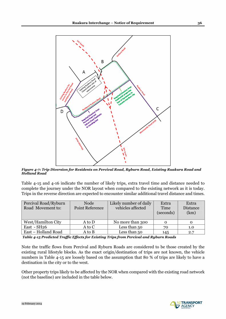
Figure 4-7 below indicates various destinations from Origins A (Percival and Ryburn Roads) and B
(existing Ruakura Road immediately east of the Expressway).
Ruakura Interchange – Notice of Requirement 36
19 February 2014
Figure 4-7: Trip Diversion for Residents on Percival Road, Ryburn Road, Existing Ruakura Road and Holland Road
Table 4-15 and 4-16 indicate the number of likely trips, extra travel time and distance needed to
complete the journey under the NOR layout when compared to the existing network as it is today.
Trips in the reverse direction are expected to encounter similar additional travel distance and times.
Percival Road/Ryburn Road Movement to:
Node Point Reference
Likely number of daily vehicles affected
Extra Time
(seconds)
Extra Distance
(km)
West/Hamilton City A to D No more than 300 0 0 East - SH26 A to C Less than 50 70 1.0 East – Holland Road A to B Less than 50 145 2.7
Table 4-15 Predicted Traffic Effects for Existing Trips from Percival and Ryburn Roads
Note the traffic flows from Percival and Ryburn Roads are considered to be those created by the
existing rural lifestyle blocks. As the exact origin/destination of trips are not known, the vehicle
numbers in Table 4-15 are loosely based on the assumption that 80 % of trips are likely to have a
destination in the city or to the west.
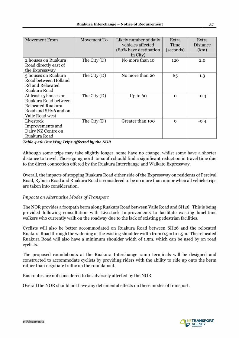
Other property trips likely to be affected by the NOR when compared with the existing road network
(not the baseline) are included in the table below.
Ruakura Interchange – Notice of Requirement 37
19 February 2014
Movement From Movement To Likely number of daily vehicles affected
(80% have destination in City)
Extra Time
(seconds)
Extra Distance
(km)
2 houses on Ruakura Road directly east of the Expressway
The City (D) No more than 10 120 2.0
5 houses on Ruakura Road between Holland Rd and Relocated Ruakura Road
The City (D) No more than 20 85 1.3
At least 15 houses on Ruakura Road between Relocated Ruakura Road and SH26 and on Vaile Road west
The City (D) Up to 60 0 -0.4
Livestock Improvements and Dairy NZ Centre on Ruakura Road
The City (D) Greater than 100 0 -0.4
Table 4-16: One Way Trips Affected by the NOR
Although some trips may take slightly longer, some have no change, whilst some have a shorter
distance to travel. Those going north or south should find a significant reduction in travel time due
to the direct connection offered by the Ruakura Interchange and Waikato Expressway.
Overall, the impacts of stopping Ruakura Road either side of the Expressway on residents of Percival
Road, Ryburn Road and Ruakura Road is considered to be no more than minor when all vehicle trips
are taken into consideration.
Impacts on Alternative Modes of Transport
The NOR provides a footpath berm along Ruakura Road between Vaile Road and SH26. This is being
provided following consultation with Livestock Improvements to facilitate existing lunchtime
walkers who currently walk on the roadway due to the lack of existing pedestrian facilities.
Cyclists will also be better accommodated on Ruakura Road between SH26 and the relocated
Ruakura Road through the widening of the existing shoulder width from 0.5m to 1.5m. The relocated
Ruakura Road will also have a minimum shoulder width of 1.5m, which can be used by on road
cyclists.
The proposed roundabouts at the Ruakura Interchange ramp terminals will be designed and
constructed to accommodate cyclists by providing riders with the ability to ride up onto the berm
rather than negotiate traffic on the roundabout.
Bus routes are not considered to be adversely affected by the NOR.
Overall the NOR should not have any detrimental effects on these modes of transport.

Ruakura Interchange – Notice of Requirement 38
19 February 2014
Construction Traffic Effects
Construction of the Hamilton Section will involve the transport of earthworks material from various
sectors of the Project and the importation of drainage components, bridge elements, pavements
materials, and other materials needed to construct the Expressway.
This section considers the potential traffic effects relating to the earthwork construction, which is
the single most significant aspect of the Project. As a designation is already secured for the Hamilton
Section, traffic effects relate to the additional earthworks required to construct the proposed
alterations.
It is noted that, if the contractor chooses to haul earthwork material via the road network, mitigation
of the adverse traffic and safety effects will need to be addressed by the contractor via development
of a Traffic Management Plan which will be discussed and certified by the WDC and HCC as required
under the current designation conditions. This will ensure the councils are comfortable with the level
of mitigation proposed. Hence, this section concentrates on identification of the potential traffic
demand relating to the additional earthworks needed to construct the proposed alterations.
The NOR involves either raising of the vertical alignment of the Expressway to accommodate a
Relocated Ruakura Road at ground level or retaining the original designation profile with the
Relocated Ruakura Road elevated over the Expressway. At this stage the final decision on whether
Ruakura Road is over or under the Expressway has not been made and may be left to the contractor.
Either way, the fill embankment is similar with a need for approximately 200,000m3 of fill material
required to construct the interchange. The likely source of the material will be from the Tamahere
cut where there is good quality surplus material. If the contractor chooses to use this material it
would involve approx. 20,000 truck and trailer movements over one earthwork season. The likely
route would involve Tauwhare Road, Hoeka Road, SH26 and Ruakura Road in order to access the
interchange site. The mitigation of any adverse traffic effects resulting from carting earthwork
material by road will need to be addressed by the contractor via development of a Traffic
Management Plan. This will be discussed and certified by the WDC as is required by current
designation conditions.
Summary
Overall, the Ruakura Road interchange NOR is considered to have no more than a minimal traffic
and safety impact based on the assessment of effects outlined above. In particular,
The NOR encourages more traffic to use the Expressway, which reduces traffic on local roads
such as Wairere Drive and the future Spine Road which travels through a residential area,
The new intersections on Relocated Ruakura Road are expected to operate with a LOS B (on a
scale of A: excellent to F: poor) in year 2041 during all peak periods,
Any new crashes on Relocated Ruakura Road as a result of the two roundabouts at the ramp
terminals will most likely be offset by the removal of potential crashes on SH26 as a result of not
constructing the two Tee Intersections at the SH26 ramp terminals. There is also a significant
number of vehicles that are transferring from the local road network to the Expressway which
should provide a safety benefit for the local road network,
There is no noticeable change in operating conditions at the existing Ruakura Road/SH26
intersection, or the intersections at Ruakura Road and Silverdale Road,
The extra traffic on Ruakura Road will be accommodated on a widened cross section that
provides two 3.5m lanes with 1.5m shoulder widths,

Ruakura Interchange – Notice of Requirement 39
19 February 2014
Effects on alternative modes of transport are expected to be more than minor. The NOR includes
development of a footpath berm between Vaile Road and SH26 on the eastern side of Ruakura
Road,
There is expected to be a no more than minor effect on property access for residents on Ruakura
Road as a result of increased traffic flows, and
Although property access under the NOR is the same as the baseline case, an assessment of the
existing property access (with Ruakura Road open) against the NOR (Ruakura Road closed)
demonstrates that trip diversions for Percival Road, Ryburn Road or Ruakura Road should have no
more than minor effects.
4.3.3 Drainage and Flooding Effects
The potential drainage and flooding effects of the Ruakura Interchange and relocated Ruakura Road
have been assessed by an Environmental Engineer familiar with the site. The potential effects
associated with drainage and flooding and proposed mitigation are summarised below.
The overall Expressway will create a large area of new pavement and will cause stormwater to run
off the site at a higher rate and in larger volumes than currently occurs. This could result in erosion
of stream banks, and flooding of properties of the various downstream water channels.
The Water Effects Assessment Report prepared in support of the WRC resource consent applications
(lodged 30 September 2013) for the Hamilton Section of the Waikato Expressway identifies that
without mitigation the Expressway has the potential to cause both short-term and long-term adverse
environmental affects that are related to stormwater runoff. These potential effects apply equally to
this alteration to establish the Ruakura Interchange and relocate Ruakura Road. Matters relating to
sediment, pollutants in stormwater runoff, stream erosion and treatment devices will be covered in
the WRC resource consent applications to be lodged with the WRC at a later date. Accordingly, this
effects assessment focuses on drainage and flooding issues associated with the alteration.
Flood attenuation controls are based on the peak discharge rates from less frequent, extremely
intense storms. It ensures that the peak discharge rates following construction of the road do not
exceed the pre-development discharge rates and therefore the peak flood levels downstream will not
be affected.
While peak discharge rates can be mitigated it will not be feasible to reduce the total volume of runoff
discharged from the Ruakura Interchange and relocated Ruakura Road to preconstruction levels due
to low soakage rates in critical sections of the route. This will cause the nearby farm drains to run full
for a longer period of time, but should not increase the peak area affected by ponding.
The same stormwater design philosophy developed for the whole Expressway project, through
consultation with HCC, WDC and WRC, will apply for this alteration to the designation. Stormwater
discharges for the relocated Ruakura Road will be to existing drains with scour protection provided
at the outfalls.
Drainage for the full-diamond interchange (Expressway plus ramps including the wetland) at
Ruakura has already been accounted for in the consent application lodged with the WRC (Ref:
130361). A full copy of the report prepared for that application and titled: Waikato Expressway
Hamilton Section – Assessment of Effects on Water (November 2013) can be provided on request.
Ruakura Interchange – Notice of Requirement 40
19 February 2014
Road runoff from the interchange will be collected and conveyed to a constructed wetland for
treatment and attenuation to meet Agency standards. Peak discharges from the wetland to the
Mangaonua Stream will be no greater than 80% of the pre-development discharges, thus providing
flood mitigation.
The Ruakura Development by TGH has allowed for stormwater management for the section of the
proposed Ruakura Road relocation between Silverdale Rd and the interchange. However, if that
stormwater infrastructure is not operational when the road is required, the Agency will initially
provide for stormwater management along this section. A road drainage solution has been
developed using vegetated swales for treatment and attenuation within the 37m designation width.
This section of road will have two discharges points to existing drains and the altered boundaries of
the designation includes two discharge points, one within TGH land to the west of the Ruakura
Interchange, and the other to the west of Ruakura Road/Silverdale Road roundabout, also within
TGH land.
The new section of Ruakura Road to the east of the Expressway and connecting with the existing
Ruakura Road will require drainage to Agency standards. The road reserve width of 25m will
accommodate drainage works. Approximately 200m of the new road can be conveyed back to the
Expressway wetland for treatment. The balance of the road will use vegetated swales for treatment
and attenuation discharging to an existing farm drain.
Because the section of Ruakura Road between SH26 and where it joins the new Ruakura Road
alignment is existing, additional drainage works are not normally required to be implemented to
Agency standards. The existing drainage system combines both road and land runoff and in some
locations includes discharges from subsurface groundwater.
Similar to the overall Hamilton Section project the effects of stormwater causing flooding to the
receiving environment are assessed as being less than minor with appropriate mitigation measures
being implemented. Such measures will be covered in the WRC consent application to be lodged in
due course.
4.3.4 Landscape, Visual Amenity and Urban Design Effects
The potential landscape/visual effects and urban design effects of the Ruakura Interchange and
relocated Ruakura Road have been assessed by a Landscape Architect familiar with the Expressway
project and site. The potential effects and proposed mitigation are summarised below.
Baseline information through desktop studies, collating background planning information and
existing studies has informed this assessment. The assessment utilises a study area that has been
extended beyond the proposed designation boundary and covers the surrounding area from which
the Interchange and local road network will be visible. In addition, NZTA’s Urban Design Policy1,
and HCC and the Waikato Regional Landscape Assessment2, define a variety of requirements that
are used in this assessment to ensure a context sensitive and appropriate design approach is
achieved.
1 http://www.nzta.govt.nz/resources/urban-design/policy/ 2 Waikato Regional Landscape Assessment prepared for Environmental Waikato by Mary Buckland Landscape Architect, O’Connor Planning Consultants Ltd, Chow: Hill and GHD, February 2010.

Ruakura Interchange – Notice of Requirement 41
19 February 2014
Methodology
The methodology for this assessment is modelled on the NZTA Draft Landscape and Visual
Assessment Guidelines3 and the NZTA Urban Design Assessment Guidelines4. A number of site
visits have been undertaken by the Landscape Architect over the past 24 months to evaluate the
Hamilton Section project and has included the assessment of the Ruakura Interchange landscape
and identification of visual receptors.
The effect of the specific change to the environment in relation to the proposed Ruakura Interchange
and relocated Ruakura Road will be quantified by predicting the magnitude of the change in the
effects on landscape character, amenity and visual receptors. The magnitude of the effect can have
either a positive or negative value depending on their beneficial or adverse effects. The rating will
be utilised to determine the need for and then the degree and extent of landscape mitigation
measures.
The assessment does not attempt to predict the visual effects of seasonal changes throughout the
year, but describes the ‘worst case’ position in terms of the character types or view for receptors.
Context
The proposed Ruakura Interchange is located approximately 800 m south of the East Coast Main
Trunk (ECMT) railway line and Ruakura Road. The study area is located to the east of Hamilton,
between Silverdale Road and Ruakura Road and is currently characterised by flat open pastoral land
that is defined by hedgerows, shelterbelts and a scattering of mature trees across the landscape.
However, the area to the west of the Expressway will be progressively developed as part of the
comprehensive Ruakura Development, which is laid out in the Structure Plan. In the Structure Plan,
the land to the west of the Interchange will contain an Inland Port zone, the Ruakura Logistics area
with building heights up to 20 m, an Industrial Park area with buildings up to 20 m and an open
space area that is located along the western boundary of the proposed Ruakura Development.
A cluster of rural residential houses are currently located along Ruakura Road to the west of the
proposed Hamilton Section, although these will be removed in the future to allow the proposed
Ruakura Development. A further house is situated at 352 Ruakura Road immediately to the east of
the Expressway and two further properties occur at 410 and 414 Ruakura Road adjacent to the
intersection of Ruakura and Holland Road, which are surrounded by mature trees. The residential
suburb of Silverdale is located to the south of the Interchange.
Located between Ryburn and Ruakura Road is the ECMT, which splits into dual railway lines beyond
the property at 352 Ruakura Road. Located within the study area and running parallel to the south
of Ruakura Road are two electricity transmission lines with the towers ranging between 45 to 65 m
in height, which are highly visible from the surrounding area.
3 NZTA Draft Landscape Visual Assessment Guidelines, 2013. 4 Bridging the Gap: NZTA Urban Design Guidelines, October 2013.

Ruakura Interchange – Notice of Requirement 42
19 February 2014
Design Description and Options
The relocation of Ruakura Road will result in the closure of Ruakura Road at the ECMT Expressway
overpass and the re-alignment of Ruakura Road to connect to Silverdale Road, while tying into the
Ruakura Interchange. The re-aligned road will provide a single carriageway arrangement, which will
incorporate two 3.5 m wide traffic lanes. To the west of the Interchange a 1.2 m hard shoulder for
cyclists is provided and a 1.5 m wide pedestrian footpath occurs to the northern side of the road. Due
to space constraints and the rural character to the east of the Interchange, no pedestrian facilities
have been currently been provided. The carriageway will be constructed close to existing grade.
The design options allow for a full diamond Interchange with on and off ramps connecting to the
Ruakura Road roundabouts. Both designs contain an integrated stormwater pond, which is located
to the southeast of the Interchange. The Options are described in more detail as follows:
• Design Option 1: The Expressway overpasses Ruakura Road (refer to Appendix C).
The Expressway overpasses the ECMT at chainage 14350 and continues on fill embankments to
overpass the re-aligned Ruakura Road at chainage 15150 that will be constructed close to existing
grade. The Expressway overbridge will be elevated on embankments and be approximately 8 m
above Ruakura Road, thereafter the Expressway will descend back to existing grade at chainage
15800. The sloping on and off ramps will be on fill and will descend back to existing grade to tie into
the Ruakura Road roundabouts.
• Design Option 2: The Expressway underpasses Ruakura Road (refer to Appendix C).
The Expressway overpasses the ECMT at chainage 14350 and descends in a southerly direction to
underpass Ruakura Road at chainage 15150, which will be approximately 1.7 m above existing grade.
The Expressway will continue south and return to existing grade at chainage 15350. On and off
ramps will be on fill embankments to tie into the roundabouts and approach embankments of the
Ruakura Road underpass bridge, with the bridge structure being approximately 9 m above the
Expressway.
Effects Assessment – Realignment of Ruakura Road
Landscape and Visual Effects
The landscape effects will be the result of the earthworks to form the re-aligned Ruakura Road, which
will also require the removal of a small amount of vegetation and a dwelling located along Ruakura
Road at the eastern end of the relocation. This is considered to have a low landscape effect. The
relocated road will tie in with the grid pattern of the existing fields to the east of the Expressway and
the proposed Structure Plan located to the west of the Expressway. Therefore, the landscape effects
of the re-aligned Ruakura Road will have no more than a low effect.
The properties that occur along Ruakura Road to the east of the Expressway will not discern the re-
aligned road due to the mature vegetation that screens views and contains the properties, and that
the re-aligned road will be constructed close to the existing grade, and will not be apparent.
Therefore, the re-alignment of Ruakura Road will have no more than a low effect. It may be possible
for the residents of the properties to discern traffic utilising the road, although this will be seen in
context of the designated Expressway traffic and will result in a moderate-low visual effect. Where
the re-aligned road is located within the Ruakura Development, this will be seen in the context of the
new road layout and built form and will have no discernable visual effect. The re-aligned Ruakura

Ruakura Interchange – Notice of Requirement 43
19 February 2014
Road will not be discernable to the residential area of Silverdale due to the extent of the built form
of the Ruakura Development, and therefore will have no visual effect relative to this established
residential area.
Urban Design Effects
The urban design aspects of the re-alignment will minimise the loss of productive land to the east of
the Expressway due to its relatively small footprint and will allow optimal future land use and
accessibility to the Ruakura Development. The closure of Ruakura Road at the ECMT overbridge
will have no effect on connectivity, as the relocated Ruakura Road will maintain a direct and efficient
link to Hamilton City and give access directly to the Expressway. The re-alignment of Ruakura Road
will enable efficient future land development and will integrate well with the proposed Ruakura
Development area.
The inclusion of a footpath and shoulder space for cyclists will provide accessibility and the
opportunity for use of alternate transport modes between Hamilton City and the Ruakura
Development. The incorporation of the footpath and shoulder area will be an improvement in
relation to the current Ruakura Road, which does not contain any of these facilities.
Effects Assessment – Design Option 1, Expressway Overpasses Ruakura Road
Landscape and Visual Effects
The landscape and visual effects are related to the placement of the Interchange components
including the approach embankments, the bridge structure, the on and off ramps and associated
roundabouts. The proposed Interchange will have a minor change to land cover as the area is
currently pastoral, although additional land will be required to accommodate the Interchange, the
majority will align with the current Expressway form. The height of the Expressway and the
placement of the on and off ramps will result in a moderate effect on landform as the extent of
Expressway elevated on fill will increase, although it will be in context of the current designated
Expressway scheme. The effects on land use will be low as only a relatively small amount of
additional land will be required to form the on and off ramps.
The visual effect of the increased height of the Expressway and the placement of the Interchange,
including the on and off ramps will be limited to residential properties (410 and 414 Ruakura Road)
and from public roads (Ruakura Road) in close proximity to the east. However, the change in view
and the visual amenity of the residential properties and local roads will be seen in context of the
current designated Expressway form and the built form of the Ruakura Development (Logistics and
Industrial Park) and therefore will result in only a moderate-low visual effect.
For properties located in Silverdale and along Silverdale Road they will not discern the Interchange
as the extent of the proposed Ruakura Development will effectively screen the views from these
locations. The height and extent of the built form within the development will define the visual
aspect of the area, and therefore, the change in relation to the proposed Interchange will result in no
visual effect.
Urban Design Effects
The arrangement of the Interchange with the on and off ramps tying into the at-grade roundabouts
will ensure accessibility to adjacent land, and will enable a good interface with the proposed built

Ruakura Interchange – Notice of Requirement 44
19 February 2014
form of the Ruakura Development. The placement of the Interchange will create an opportunity to
develop a ‘gateway’ entrance to the Ruakura Development.
The benefit of integrating the Ruakura Interchange will mean a more direct and efficient connection
to the Expressway and the broader road network relative to that designated, which will ensure trucks
and heavy transport will be removed from local roads in the area. Pedestrian and cycling facilities
along the western side of the relocated Ruakura Road will integrate into the Interchange to provide
a flat and easy to use cycle and pedestrian facilities that will connect back into the roading structure
of Silverdale and Hamilton City. No facilities are provided to the east of the Interchange as this area
is rural, although future facilities may be considered and could be tied into the proposed pedestrian
and cycle facilities.
Mitigation
As the Ruakura Interchange will form part of the Hamilton Section of the Waikato Expressway it is
appropriate that the same landscaping measures (as mitigation) be applied. The landscape
mitigation will respond to the large scale Ruakura Development to the west of the Expressway and
the rural environment that is situated to the east. Therefore, mitigation to the west of the
Interchange will incorporate planting that creates a defined ‘gateway’ and responds to the urban
development through the use of large growing tree species and mass planted areas on the interchange
embankments.
The eastern aspect of the Expressway will have gentle sloping grass batters to maintain the visual
connection with the open rural landscape. Landscape planting will occur between the on and off
ramps and the Expressway to complement the ‘gateway’ environment of the future Ruakura
Development. The mitigation planting may also provide the opportunity to establish a planting
character that can be extended into the Ruakura Development at a future stage to benefit the
character of the area.
The overpass bridge structure will be designed to contribute to the ‘gateway’ entrance of the Ruakura
Development, which in turn will contribute to the visual amenity of the surrounding land and road
users to the east. The bridge will be designed to have a structure that is slender and elegant relative
to span, with a moderate to high aesthetic quality in form and finish. The bridge will be designed to
integrate with the ‘family’ of bridges that occur along the Expressway.
NOR1 (refer to Appendix A) provides a suite of conditions relating to landscape and visual amenity
mitigation. The conditions are centred on the preparation of the Landscape Management Plan to be
provided prior to construction and requiring the approval of the WDC and HCC where relevant. The
Agency proposes that this alteration be subject to the same conditions, and as such, appropriate
landscaping as approved by the WDC and HCC will need to be implemented.
Effects Assessment – Design Option 2, Expressway Underpasses Ruakura Road
Landscape and Visual Effects
The landscape and visual effects are similar to those of Option 1 with the effects related to the
placement of the Interchange components, including the approach embankments to the local road
bridge structure the sloping on and off ramps and associated ‘elevated’ roundabouts. The proposed
Interchange will have a minor change to land cover as the area is currently pastoral, although
additional land will be required to accommodate the Interchange the majority will align with the
current Expressway form. The height of the Expressway is consistent with the designated

Ruakura Interchange – Notice of Requirement 45
19 February 2014
Expressway scheme and will have no effect on landform. However, the extent of earthworks to form
the on and off ramps, approach embankments and ‘elevated’ roundabouts of the local road underpass
bridge will result in a moderate effect on landform. The effects on land use will be moderate-low as
the increased foot print to accommodate the approach ramps will require more land than compared
to Option 1 where Ruakura Road remains at grade.
The visual effect of the on/off ramps, the approach embankments and ‘elevated’ roundabouts plus
the placement of the local road underpass bridge will be an obvious new feature to the residential
properties (410 and 414 Ruakura Road ) and from public roads (Ruakura Road) in close proximity
to the east. The change in view/amenity of the residential properties and local roads will be seen in
context of the current designated Expressway form and will result in a moderate-low visual effect.
The placement of the underpass bridge will also have a moderate-low visual effect on Expressway
users, as the structure and embankments will be new and obvious features in the landscape.
As outlined for Option 1, the properties located in Silverdale and along Silverdale Road will not
discern the Interchange as the extent of the proposed Ruakura Development will effectively screen
the views from these locations. The height and extent of the built form within the development will
define the visual aspect of the area and therefore the change in relation to the proposed Interchange
will result in no visual effect.
Urban Design Effects
The arrangement of the Interchange with the on and off ramps and roundabouts being elevated on
fill will have a moderate-low negative effect in relation to the accessibility and development potential
of the adjacent land. Direct access from the re-aligned Ruakura Road and the interface of the built
form with the road frontage will be affected by the embankment approaches and is considered as not
being the most optimal arrangement.
As outlined for Option 1, the benefit of integrating the Ruakura Interchange will mean a more direct
and efficient connection to the Expressway and the broader roading network, which will ensure
trucks and heavy transport will be removed from local roads in the area. Although cycle and
pedestrian facilities are limited at this stage to the western side of the relocated Ruakura Road, this
arrangement is not ideal as possible future pedestrian and cyclist facilities will have to go up and over
the local road overbridge.
Mitigation
The landscape mitigation measures will be similar to Option 1 in that they will respond to the
Ruakura development to the west of the Expressway and the rural environment that is situated to
the east. The mitigation planting to the west of the Interchange will incorporate planting that creates
a defined ‘gateway’ and that will respond to the large scale development through the use of large
growing tree species and mass planted areas to the on/off ramps and local road approach
embankments.
The eastern aspect of the on and off ramps will incorporate mass planting to integrate the batters
and ‘anchor’ the approach embankments. Landscape planting will occur between the on and off
ramps and the Expressway to complement the ‘gateway’ environment into the future Ruakura
development and help minimise maintenance requirements. The planting may also provide the
opportunity to establish a planting regime that can be extended into development at a future stage
to benefit the broader landscape character and visual amenity.

Ruakura Interchange – Notice of Requirement 46
19 February 2014
The underpass bridge structure design will be designed to integrate and be consistent with the
‘family’ of bridges that occur along the Expressway and incorporate spill through abutments to
maintain views along the Expressway. The bridge will be designed to have a structure that is slender
and elegant relative to span, with a moderate to high aesthetic quality in form and finish.
As stated above, the intention is to have this alteration subject to the same conditions for the
Hamilton Section of the Waikato Expressway, and therefore a Landscape Management Plan will
need to be prepared and approved prior to construction.
Summary
The relocation of Ruakura Road and the closure at the ECMT overpass location can be achieved
without any effects in relation to the landscape, visual or urban design considerations. The
placement of the relocated Ruakura Road will tie in with the existing patterns and forms within the
area, maintain access and the potential for future land development of adjacent land.
The placement of an Interchange will have a moderate-low landscape and visual effect, which is
limited to residential properties and local roads within the immediate vicinity. In context of the
proposed Ruakura Development, the proposed Interchange will have no effect as the built form of
the development will effectively screen and contain the landscape and visual effects. With both
Interchange design options, the placement of the Interchange will provide a more efficient and direct
access to the Expressway, while removing heavy vehicles from local roads. Option 1 will provide
better cycling and pedestrian facilities and offer better facilities if in the future facilities are extended
to the east of the Interchange, as the paths and hard shoulder will be at grade along the re-aligned
Ruakura Road.
The provision of Design Option 1 with the Interchange close to existing grade will provide the better
relation to adjacent land use, accessibility and future land development in comparison to Design
Option 2. Option 1 will also provide the potential to create a ‘gateway’ entrance and give an
opportunity of extending the planting theme into the Ruakura Development.
Overall, the proposed Interchange and relocated Ruakura Road can be integrated into the Hamilton
Section of the Waikato Expressway with minimal effect on the landscape and visual amenity of the
area, and will effectively tie in with the proposed Ruakura Development, while improving
connectivity and land development opportunities.
4.3.5 Contamination Effects
The potential effects associated with disturbing contaminated land in giving effect to this proposal
have been assessed by an Engineering Geologist familiar with the site and the overall project. The
potential effects and proposed mitigation are summarised below.
Opus has prepared a preliminary site inspection (PSI) report for TGH5 associated with the Ruakura
Development. The Agency has obtained permission from TGH to use the information contained
within that PSI report to inform this NOR in terms of land contamination. The land area covered by
this assessment includes the Ruakura Interchange road corridor area that passes through the
Ruakura Development.
5 Ruakura Development Preliminary Site Inspection Report, number G3132. Tainui Group Holdings Limited. June 2013. Referenced 2-32113.00_G3132.

Ruakura Interchange – Notice of Requirement 47
19 February 2014
It has been established through anecdotal evidence, Council records, and historical aerial
photographs that the site has been subject to the following:
Farming operations and since the 1940’s, agricultural research. Associated with this has been
the storage and application of insecticides, pesticides and herbicides.
In the past five years land to the south of Ruakura Road has been tenanted out as a dairy
farm.
A closed landfill area partially within the Ruakura Interchange footprint has been identified.
This landfill had mostly accepted inert type wastes, but did occasionally include dead
livestock.
An effluent pond is located to the east of the closed landfill, and an area formerly used for
solvent / liquid burning pits is located to the north of the landfill. However, both of these
features are located outside of the Ruakura Interchange footprint.
A water bore is located in the southwest part of the site, also outside of the Ruakura
Interchange footprint.
In preparing the PSI report enquiries were made with the WRC, HCC and WDC with respect to
records held for the subject site. The NOR footprint is not identified by Council records as being a
Hazardous Activities and Industries List (HAIL) site. However, based on the site history and current
site uses, there remains the possibility of contamination being present in the soils and groundwater
below the site.
In accordance with the National Environmental Standard for Assessing and Managing Contaminants
in Soil to Protect Human Health 2011 (NES), a detailed site investigation should be carried out in
order to realise the cost risks to the proposed development and the risks to the identified receptors
(both human health and controlled waters/environment).
Under the NES and to comply with current legislation, all issues associated with the further
investigation, remediation and monitoring of contaminated sites within the footprint of the Ruakura
Interchange and relocated Ruakura Road must be overseen by a Suitably Qualified and Experienced
Practitioner (SQEP). This requirement will be included in the construction contract documents and
the Earthworks Management Plan (EMP). Any NES resource consent required from the WDC and
HCC will be sought at the outline plan approval stage, once the contractors and final design of the
Expressway have been confirmed.
The SQEP will be responsible for ensuring that the investigative and assessment procedures
followed, together with the appropriate remedial actions, and any necessary monitoring plans are
prepared, implemented and in agreement with the NES and consenting requirements.
It may be possible to retain the soils within the designation if the levels of contamination are below
the appropriate published guidance values for such use. Vegetation cover will prevent long term
release of dust and sediment generation by erosion. If buried or effectively capped by the road
construction, long-term migration of contaminants is not an issue and it may be possible to retain
them on site. However, if this were to require long term monitoring to confirm non-migration then
disposal will be the preferred option. If the material cannot be retained on site then disposal to a
suitably consented landfill site will be necessary.
A specific assessment of locations, soil stratigraphy, groundwater levels and contaminant types will
be necessary to assess potential risks to groundwater quality. Where a significant risk is identified
Ruakura Interchange – Notice of Requirement 48
19 February 2014
the simplest means of mitigating long-term risk may be to remove the soils of concern to a suitably
consented landfill. However, where the road is at grade or on embankment the soils of concern may
be effectively capped preventing surface water ingress and limiting or eliminating the potential for
seepage and migration of contaminants to groundwater. Good earthworks practice will limit the risk
of contaminant release and the works will result in a long term net reduction of the risk to
groundwater from contaminated soils along the route.
As part of the WRC consenting procedures an EMP together with, or incorporating an Erosion and
Sediment Control Plan (ESCP) will need to be prepared before works commences. The professional
implementation of these is sufficient to mitigate the potential effects of dust migration and sediment
run-off leading to the uncontrolled spread of potential contaminants beyond the site boundaries.
Contamination can also occur from the spillage of oil or fuel from construction machinery, which
may make its way into surface or groundwater. This may have adverse effects on water quality and
aquatic habitat. A Hazardous Substances Management Plan as part of the EMP will be proposed with
any WRC consenting requirements. Such consents will need to be obtained prior to construction
works commencing. This Plan will set out the procedures to be followed to minimise the risk of
discharging any hazardous materials on the site as the first priority, and to deal with any discharge
that does occur. Examples of techniques used include storing all fuel away from watercourses,
undertaking refuelling away from areas where any accidental spill could enter water, and having
appropriate procedures in place for cleaning machinery that could result in contamination.
Hazardous materials in this context mean any substances that would damage the environment or
injure people if discharged into the environment. It includes, for example, vehicle fuels and
lubricants and cement and lime that might be used in soil stabilisation.
Subject to an EMP and ESCP, it is considered that the Ruakura Interchange alteration will have no
more than minor contaminated land effects as locating, characterising, removing or capping any
contaminated areas potentially has an environmental benefit that will outweigh any short term
effects from disturbance of the material.
4.3.6 Noise Effects
The potential effects associated with construction and traffic noise have been assessed by a Transport
Research and Noise Specialist. The potential effects and proposed mitigation are summarised below.
The noise assessment for the NOR is intended to be read in conjunction with the October 2013 report
“Noise assessment for NOR AEE, Waikato Expressway, Hamilton Section: Assessment of road-traffic
noise and construction noise”. That report presents the noise conditions on the existing designation
and the approach for considering the effects of alterations to that existing designation, namely:
In considering the proposed alterations, the existing noise environment is the one that includes
the existing designation being used for the purposes for which it is granted.
The October 2013 report describes how the noise effects of the proposed alterations are assessed as
noise levels that would occur with the proposed alterations and altered route design in place and also
the mitigation needed to make those noise levels achieve, subject to practicability, the Noise
Guidelines6.
6 “Transit New Zealand’s Guidelines for the Management of Road Traffic Noise” contained in Appendix 6 of the 1999 edition of the Planning Policy Manual

Ruakura Interchange – Notice of Requirement 49
19 February 2014
As per the October 2013 report, to facilitate assessment of the potential effects of the proposed
alteration, it is assumed that the “do-minimum” approach is adopted for the project. For example,
the Expressway and all other roads have been sealed with Grade 3/5 two-coat chipseal as a default
assumption. This is a noisy road surface and roads may in reality be surfaced with a quieter single-
coat chipseal or other road surface.
A copy of the October 2013 report can be provided on request.
Construction Noise
Construction noise effects of the proposed alteration can be practicably managed so that effects will
be less than minor. Key points are:
Generally most road construction activity readily complies with the noise limits in Table 2 of
NZS 68037 where there is more than 40 to 60 metres separation between the main construction
activity and the receiver. This is the situation for the majority of this proposal.
Where receivers are nearest to the proposed alterations, works will be of a nature akin to typical
road maintenance activities of resurfacing and minor realignment.
For other receivers, the proposed alterations result in only small to moderate changes in
separation distance between the construction activity and nearby receivers compared with
separation distances with the existing designation. Therefore it is expected that the ability for
the altered designation to comply with NZS 6803 is little changed from the ability of the existing
designation to comply, and the periods of time for which alternate noise management methods
may need to be used will also be similar.
The conditions of NOR1 include the requirement for a Noise Management Plan to be prepared
and approved prior to construction commencing. Assuming these conditions are applied to this
alteration as proposed by the Agency, appropriate measures will be implemented to address
noise effects during the construction period.
The remainder of this assessment focuses on the road-traffic noise effects of the proposed alteration.
Hamilton Section/SH 26 Interchange
The designated Hamilton Section includes a partial interchange between the Expressway and SH 26.
The proposed alteration would remove this interchange. With the proposed alterations, the
Expressway will pass under SH 26 and there will be no ramp access between the Expressway and
SH 26.
Previous noise assessments of the Hamilton Section/SH 26 interchange options have determined
minor mitigation is likely to be required, either in the form of barriers or sections of low-noise road
surfaces. The interchange ramps were factors in these determinations. The proposed alterations will
have negligible effect on the noise sources of the Expressway and SH 26, but will remove the noise
source of the interchange ramps. Therefore, the extent of mitigation required with the proposed
alteration will be no more, and probably less than, the mitigation required for the designated
Hamilton Section of the Waikato Expressway.
Ruakura Road/SH26
Associated with the proposed removal of any interchange between the Expressway and SH 26, the
proposed alteration will include minor improvements at the Ruakura Road/SH 26 intersection. The
intersection exists and residential receivers near to it are located at 7A Lisette Road (adjacent to
SH 26), 11 Lisette Road, 17 Lisette Road, 309 SH 26, and 598 Ruakura Road.
7 NZS 6803: 1999 Acoustics – Construction Noise
Ruakura Interchange – Notice of Requirement 50
19 February 2014
The nature of the intersection will not be significantly changed from that which currently exists by
the proposed alteration so noise level changes will be small or negligible. The existing road surface
at the Ruakura Road/SH 26 intersection appears to be a chip seal. This is a typical road surface and
would likely be the ‘do-minimum’ road surface for the proposed alteration. However, if the proposed
alteration requires noise mitigation, a stone mastic asphalt road surface would be a “lower noise”
road surface relative to a chip seal and would likely be a practicable option.
The proposed alteration will also increase the traffic volumes using the Ruakura Road connection to
this intersection. There are some properties located adjacent to this section of Ruakura Road, but
generally buildings are set back from the road. The residential building at 3 Vaile Road is located
near the legal road boundary. For this section of Ruakura Road, the total traffic volumes associated
with the proposed alterations are only moderate. Noise effects are not expected, however if the
proposed alteration requires noise mitigation, a section of “lower noise” road surface would likely be
practicable.
The proposed alterations will also alter Ruakura Road to connect to the Ruakura Interchange. This
introduces a section of road which will require acquisition of the 480 Ruakura Road property. It also
introduces a corner near the 495 Ruakura Road property. 495 Ruakura Road is currently near to a
straight section of Ruakura Road and exists with a fence facing Ruakura Road. At this stage, the
habitable spaces of 495 Ruakura Road have not been ascertained. Noise level changes are likely to
be small and noise effects are not expected, however if the proposed alteration requires noise
mitigation, upgrade of the fence (with means of ensuring road-facing gateways are normally closed)
or a section of “lower-noise” road surface would be noise mitigation options.
Ruakura Road/Silverdale Road
The proposed alteration will realign intersections around Ruakura Road/Silverdale Road. There are
few noise-sensitive receivers near to this area; the nearest being the University of Waikato’s Te
Timatanga Hou classrooms. These classrooms are currently located near to the intersection of
Ruakura Road and Silverdale Road and the proposed alterations will move this intersection further
away from the classrooms.
Ruakura Interchange
The proposed alterations include the Ruakura Interchange and there are two design options for that
interchange. The Ruakura Interchange has been assessed in two stages; first considering the design
option of “Ruakura Road over the Expressway”, then considering the other design option of
“Ruakura Road under the Expressway”.
Ruakura Road over the Expressway
Figure 4-8 shows the noise environment with the designated project. This represents the existing
noise environment against which the proposed designation alteration is considered.
Figure 4-9 shows the noise environment with the altered project as the design option of Ruakura
Road passing over the Expressway.
Comparison of Figure 4-8 and Figure 4-9 clearly shows the movement of the Ruakura Road traffic,
from the existing Ruakura Road southwards to a new road connecting to the Ruakura Interchange.
With the proposed alterations, the primary role of the current Ruakura Road becomes property
access (no thoroughfare), with a concomitant decrease in traffic volumes and road-traffic noise levels
for the facades facing the current Ruakura Road.
Figure 4-8 and Figure 4-9 indicate there are few buildings very near to the new west-east Ruakura
Road connecting to the Ruakura Interchange.
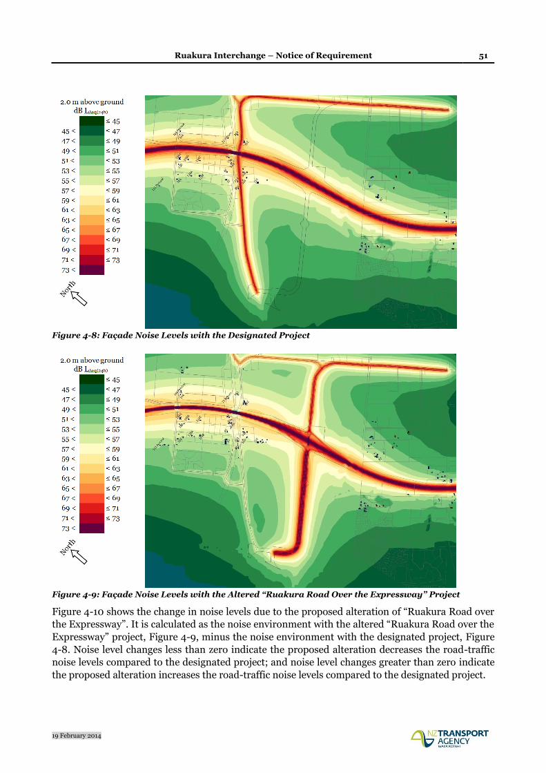
Ruakura Interchange – Notice of Requirement 51
19 February 2014
Figure 4-8: Façade Noise Levels with the Designated Project
Figure 4-9: Façade Noise Levels with the Altered “Ruakura Road Over the Expressway” Project
Figure 4-10 shows the change in noise levels due to the proposed alteration of “Ruakura Road over
the Expressway”. It is calculated as the noise environment with the altered “Ruakura Road over the
Expressway” project, Figure 4-9, minus the noise environment with the designated project, Figure
4-8. Noise level changes less than zero indicate the proposed alteration decreases the road-traffic
noise levels compared to the designated project; and noise level changes greater than zero indicate
the proposed alteration increases the road-traffic noise levels compared to the designated project.
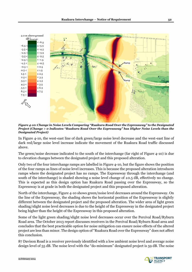
Ruakura Interchange – Notice of Requirement 52
19 February 2014
Figure 4-10: Change in Noise Levels Comparing “Ruakura Road Over the Expressway” to the Designated
Project (Change > 0 Indicates “Ruakura Road Over the Expressway” has Higher Noise Levels than the
Designated Project)
In Figure 4-10, the west-east line of dark green/large noise level decrease and the west-east line of
dark red/large noise level increase indicate the movement of the Ruakura Road traffic discussed
above.
The green/noise decrease indicated to the south of the interchange (far right of Figure 4-10) is due
to elevation changes between the designated project and this proposed alteration.
Only two of the four interchange ramps are labelled in Figure 4-10, but the figure shows the position
of the four ramps as lines of noise level increases. This is because the proposed alteration introduces
ramps where the designated project has no ramps. The Expressway through the interchange (and
south of the interchange) is shaded showing a noise level change of ±0.5 dB, effectively no change.
This is expected as this design option has Ruakura Road passing over the Expressway, so the
Expressway is at grade in both the designated project and this proposed alteration.
North of the interchange, Figure 4-10 shows green/noise level decreases around the Expressway. On
the line of the Expressway, the shading shows the horizontal position of the Expressway is slightly
different between the designated project and the proposed alteration. The wider area of light green
shading/slight noise level decreases is due to the height of the Expressway in the designated project
being higher than the height of the Expressway in this proposed alteration.
Some of the light green shading/slight noise level decreases occur over the Percival Road/Ryburn
Road area. The October 2013 report discusses receivers in the Percival Road/Ryburn Road area and
concludes that the best practicable option for noise mitigation can ensure noise effects of the altered
project are less than minor. The design option of “Ruakura Road over the Expressway” does not affect
this conclusion.
87 Davison Road is a receiver previously identified with a low ambient noise level and average noise
design level of 55 dB. The noise level with the “do-minimum” designated project is 59 dB. The noise
Ramp
Ramp

Ruakura Interchange – Notice of Requirement 53
19 February 2014
level with the “Ruakura Road over the Expressway” design option is just over 58 dB. For both the
designated route and the “Ruakura Road over the Expressway” design option, the best practicable
option for noise mitigation is similar, likely a section of low-noise road surface, but an alternative
would be an out-of-designation barrier and this would be confirmed in final design. Therefore the
noise effects of the designation alterations to provide for the “Ruakura Road over the Expressway”
are less than minor.
Ruakura Road under the Expressway
Figure 4-11 shows the noise environment with the altered project as the design option of Ruakura
Road passing under the Expressway.
Figure 4-12 shows the change in noise levels comparing the proposed alteration of “Ruakura Road
under the Expressway” to “Ruakura Road over the Expressway”. It is calculated as the noise
environment with the altered “Ruakura Road under Expressway” design option, Figure 4-11, minus
the noise environment with the altered “Ruakura Road over the Expressway” design option, Figure
4-9. Noise level changes less than zero indicate the “Ruakura Road under the Expressway” design
option decreases the road-traffic noise levels compared to the “Ruakura Road over the Expressway”
design option; and noise level changes greater than zero indicate the “Ruakura Road under
Expressway” design option increases the road-traffic noise levels compared to the “Ruakura Road
over the Expressway” design option.
Figure 4-11: Façade Noise Levels with the Altered “Ruakura Road Under the Expressway” Project

Ruakura Interchange – Notice of Requirement 54
19 February 2014
Figure 4-12: Change in Noise Levels Comparing “Ruakura Road Under the Expressway” to “Ruakura
Road Over Expressway” (Change > 0 Indicates “Ruakura Road Under Expressway” has Higher Noise
Levels than “Ruakura Road over the Expressway”)
Figure 4-12 indicates only minor noise level changes at the receivers between the “Ruakura Road
under Expressway” design option and the “Ruakura Road over the Expressway” design option.
Therefore, for the majority of the area it is concluded that the Ruakura Interchange configuration
finally selected will not significantly affect the conclusion made based on assessment of the “Ruakura
Road over the Expressway” design option.
87 Davison Road is inspected for confirmation. As stated before, 87 Davison Road is a receiver
previously identified with a low ambient noise level and average noise design level of 55 dB. The
noise level with the do-minimum designated project is 59.0 dB and the noise level with the “Ruakura
Road under Expressway” design option is 58.8 dB. (The noise level with the “Ruakura Road over
Expressway” design option is 58.2 dB.) Therefore the noise effects of the designation alterations to
provide for the “Ruakura Road under Expressway” are negligible.
Summary
The road-traffic noise effects of the proposed alterations for the Ruakura Interchange have been
assessed for two design options, of “Ruakura Road over the Expressway” and “Ruakura Road under
the Expressway”. The assessment undertaken is sufficient to conclude that for both the designated
route and the proposed designation alterations, the Noise Guidelines can be achieved, subject to
practicability, and the extent of mitigation is similar. The best practicable option for road-traffic
noise mitigation will be finalised in detailed design.
It is concluded that the construction noise effects and the road-traffic noise effects of the proposed
alteration for the Ruakura Interchange are less than minor.

Ruakura Interchange – Notice of Requirement 55
19 February 2014
4.3.7 Ecological Effects
The potential ecological effects associated with this proposal have been assessed by an Ecologist
familiar with the site and the wider Expressway project. The potential effects and proposed
mitigation are summarised below.
The ecological effects assessment is based upon:
a combined drive through/walkover survey of the proposed alteration to designation;
discussions with the tenant farmer and Ruakura Research Centre site management regarding
surface drainage in the areas affected by the proposals; and
a review of existing reports relating to the ecology of the area including reports prepared by Opus
International Consultants Ltd for the Assessment of Effects of the Expressway (Opus, 2013) and
those prepared by Boffa Miskell relating to the Ruakura Structure Plan (Boffa Miskell, 2010,
2013 & 2014).
Description of the Existing Environment
Vegetation
The proposed alteration to designation impacts upon an intensively farmed, highly modified
landscape that supports no natural ecosystems. The land is flat or gently undulating and mainly in
pasture used for grazing dairy cattle. For the most part it is extremely open with very few mature
trees or hedgerows.
The only locations where there are appreciable numbers of mature trees are at the existing Silverdale
Road roundabout and at 480 Ruakura Road, where the proposed re-alignment will join it. Around
the Silverdale Road roundabout there is a loose grouping of large deciduous and coniferous exotic
trees. Most of the trees are English oak Quercus robur (up to 1m diameter at breast height - dbh) or
holm oak Quercus ilex (up 2m dbh – a triple stemmed specimen).
At 480 Ruakura Road there is a loose grouping of exotic trees around the property and along the
road reserve boundary. The trees include Acacia spp. eucalypts, copper beech Fagus sylvatica
‘Purpurea’, Lombardy poplar Populus nigra ‘Italica’ and English oak. The latter species is up to 0.7m
dbh with most other specimens in this location of much smaller diameter. There is also a variety of
exotic garden shrubs and also cabbage tree Cordyline australis.
There are virtually no indigenous plants within the proposed alteration to designation and no
indigenous plant communities.
Terrestrial fauna
The bird species present are common native and exotic species typical of highly modified landscapes.
Species recorded during the site visit were: harrier Circus approximans, welcome swallow Hirundo
tahitica, silvereye Zosterops lateralis, house sparrow Passer domesticus, goldfinch Carduelis
carduelis, greenfinch Fringilla chloris, starling Sturnus vulgaris, myna Acridotheres tristis and
magpie Gymnorhina tibicens. It is unlikely that the habitats within the proposed alteration to
designation provide significant habitat for threatened bird species.
Ruakura Interchange – Notice of Requirement 56
19 February 2014
The very open nature of the landscape means that most of the area within the alteration is unlikely
to be used with any frequency by long-tailed bats Chalinolobus tuberculatus. The only locations with
the potential to hold roosting and/or feeding bats are the stand of mature trees around the Ruakura
Road/Silverdale Road roundabout and the mature trees around the property at the proposed
junction with Ruakura Road to the east of the Expressway. However, the Hamilton City Bat Survey
2011-2012 (Le Roux & Le Roux, 2012) found no bats in the parks surveyed to the north of Cobham
Drive and to the east of Galloway Street. This included surveys of the University Campus (c.500m
from the Silverdale Road roundabout) and Chelmsford Park (within 1.5km of both stands of trees).
A subsequent survey by McQuillan (2013) recorded a single bat pass in September 2013 at the
Ruakura Research Centre using a hand-held detector, indicating at least sporadic use of the area by
bats. Surveys of the Ruakura Research Campus and Chelmsford Park by Boffa Miskell using
automatic bat detectors (ABM’s) in January 2014 recorded no bat passes (Dave Slaven pers. comm).
Two of the ABM’s were placed within 250m and 500m of the Silverdale Road roundabout
respectively. The bat surveys that have been undertaken around this area to date suggest that bat
usage of the area is sporadic. These results are consistent with bat surveys of the Hamilton and
Cambridge Sections undertaken by Opus International Consultants Ltd which has found that bat
activity is low or non-existent in open landscape away from substantial stands of mature trees and/or
gully habitat. The results of the various surveys suggest that it is unlikely that the trees around the
Silverdale Road roundabout or property adjacent to Ruakura Road will be regularly used by roosting
or feeding bats.
The habitats present are unlikely to be suitable for threatened lizard species. However, like many
areas in and around the city of Hamilton the common, widespread and non-threatened copper skink
Oligosoma aeneum may be present, particularly around dwellings, field margins and road verges.
Watercourses
The only watercourses crossed by the designation are artificial roadside drains along the existing
Ruakura Road to the east of the Expressway and a short 100m section of roadside drain adjacent to
the Silverdale Road roundabout.
The short section of roadside drain adjacent to the Silverdale Road roundabout was dry at the time
of survey and does not appear to be connected to any of the other surface drains in the near vicinity
(i.e. sections of drain along Ruakura Road). It is unlikely that such a short, isolated section of
roadside drain will support any aquatic life of note, particularly given that it is dry for much of the
year. Riparian vegetation was almost exclusive exotic grasses such as cocksfoot Dactylis glomerata
and weed species spear thistle Cirsium vulgare, with a small patch of kiokio Blechnum novae-
zelandiae the only native vegetation recorded.
Within the proposed designation stormwater from the existing Ruakura Road discharges to both
swales and roadside drains. Examination of Google Earth street view images taken in spring
indicates that the drains along this section of Ruakura Road hold much lower levels of water than
those along Ruakura Road to the west the Ruakura Road/Holland Road junction. There is also
minimal connection between the sections of drain to the west of the junction and those to the south
due to the presence of swales at intervals along this section of road (i.e. there is not a single
continuous connected drain). The sections of drain within the designation appear to be highly
impacted by management (i.e. periodic clearance, or complete neglect). Furthermore, there is little
overhanging vegetation. Overall the condition, low water levels (even during spring when other
drains in the area are near capacity) and lack of connectedness of these sections of drain is such that
they are unlikely to provide significant habitat for aquatic life. Although the Ruakura Road drain to

Ruakura Interchange – Notice of Requirement 57
19 February 2014
the west of the Holland Road junction is known to be inhabited by black mudfish Neochanna
diversus, it is considered unlikely that this species is present in the sections of drain within the
proposed alteration to designation.
The riparian margins of these sections of road drain within the alteration to designation are
dominated by exotic grasses and weed species, and support no indigenous vegetation of any note.
Ecological Values
Indigenous vegetation is virtually non-existent within the proposed alteration to designation and is
confined to a few individual plants found along a drainage ditch and within a residential garden.
Consequently there is no significant indigenous vegetation within the proposed designation
footprint.
It is highly unlikely that the area of the alteration supports significant habitat for indigenous
terrestrial fauna, although stands of mature trees around the Silverdale Road roundabout and
property adjacent to Ruakura Road may provide sporadic habitat for long-tailed bats.
The section of artificial roadside drain adjacent to the Silverdale Road roundabout is isolated, of very
low quality and was dry at the time of survey. It appears to have negligible value for aquatic flora and
fauna.
The sections of artificial roadside drain along Ruakura Road are also of low quality and were dry at
the time of survey. Their poor connectivity with drains to the west of the Holland Road/Ruakura
Road junction, lack of cover and high level of management suggests a low probability that they
provide habitat for black mudfish.
Effects and Avoidance of Effects
Effects on indigenous vegetation
Effects on indigenous vegetation will be negligible.
Effects on long-tailed bats
Effects on feeding and/or roosting long-tailed bats are expected to be minimal. However, tree
removal protocols for potential bat roost trees to be implemented for the construction of the
Expressway should be applied where applicable to this alteration.
Effects on birds and lizards
The effects of construction of the Ruakura Road re-alignment on populations of species of birds and
lizards that are known to or likely to inhabit the proposed alteration to designation are expected to
be negligible.
Effects on fish and other aquatic life
Any impacts of construction upon the section of drain adjacent to the Silverdale Road roundabout
are expected to have negligible effect on aquatic life given its minimal ecological value.
At this stage the nature of any works that may affect these drains have yet to be determined. Such
works may include widening of the seal and creation of a footpath. These works may in turn require

Ruakura Interchange – Notice of Requirement 58
19 February 2014
upgrade of the roadside drains. However, the risk of significant impact on aquatic life, including
mudfish, from such works is considered low.
It is concluded that the potential ecological effects associated with the alteration to the designation
for the Ruakura Interchange are less than minor.
4.3.8 Archaeological Effects
The potential archaeological effects associated with this proposal have been assessed by an
Archaeologist familiar with the site and the wider Expressway project. The potential effects and
proposed mitigation are summarised below.
The archaeological assessment for the Ruakura Interchange is based on a desktop and field
assessment, and includes the following components:
Historic map search;
Search of the New Zealand Archaeological Association (NZAA) database of recorded
archaeological sites;
Field visit.
Historical Setting
Archaeological research for the Hamilton Section (Keith 2013) identified that the study area is within
land confiscated following the Waikato Wars in the 1860s. The land was partitioned into 50 acre
farms and awarded to British soldiers to encourage European settlement in the Waikato. The
allotments were difficult for soldiers to farm as the land generally required draining and only poor
access infrastructure (roads and bridges etc.) was provided by the government. Soldiers often did
not have the skills or the finances to make their allotments payable and either abandoned, or on-sold
their land.
With better technology and greater demand for produce, the late 19th to early 20th century saw areas
such as Ruakura become favourable for farming. This was compounded during WWI and WWII, and
with the advent of freezing technology enabling meat to be transportable to Europe. The land east of
the city was drained and intensive dairy farms were established.
The study area is not known to have been a focus for either domestic or horticultural activity prior to
European settlement. The vast majority of recorded prehistoric archaeological sites and prehistoric
gardening soils occur within 1km of the Waikato River and its tributaries. The study area is c.3km
from the Waikato River and over 1.5 km from the main section of the Mangaonua Stream gully
system.
Archaeological Evidence
Historic plans detailing the allotments has been viewed as part of the research for this assessment.
The earliest plan viewed (SO 143) shows the property boundaries as they were initially planned in
1865. The relocation of Ruakura Road passes through original allotments 243-245. No structures or
buildings are shown on this plan, and no features of pre-European interest are shown.
Ruakura Interchange – Notice of Requirement 59
19 February 2014
A later plan of the Ruakura Agricultural Station (1902) also illustrates the study area (SO 12249).
This plan shows property boundaries and road reserves. No buildings including dwellings or farm
sheds are illustrated on the plan.
Neither of the two historical plans indicate that features of historical or pre-European interest were
present within the study area.
The NZAA online database (Archsite) was viewed to identify if archaeological sites have previously
been recorded in, or close to the study area. The database clearly shows that the vast majority of
archaeological sites in the Hamilton area are located within close proximity to the Waikato and
Waipa Rivers, and their tributaries. There are no recorded archaeological sites close to the study
area. The nearest site is S14/52. This is recorded as a pa and is approximately 700m south-east of
the proposal.
The Site Record Form (SRF) suggests that this pa was located at the end of Nevada Road, on the
western bank of the Mangaonua Stream. Differing information is provided in the SRF by two
individuals. The site was originally recorded in 1974 from aerial photographs and by hearsay. It was
not physically inspected as it was considered to have been destroyed prior to 1968 by a residential
subdivision. However a subsequent reassessment by Owen Wilkes in 1999 suggests that a pa never
existed in this location.
The Archaeologist undertook a field visit on 29 January 2014. Weather and survey conditions were
recorded as being favourable. The survey focus was the portion of land proposed for the Ruakura
Road relocation. This is currently an operating dairy farm and is divided up by modern fencing into
paddocks connected by cattle-races. The fields have been drained and the topography is generally
flat with minor undulations evident. No historical features were identified and no prehistoric
features such as borrow pits were evident. On the basis of the site visit, the likelihood of there being
archaeological sites present in the study area is low.
Summary
Whilst there remains the possibility that subsurface archaeological features, deposits, or sites are
located in the study area concealed below topsoil, this is considered to be minor.
There is no evidence to suggest the study area holds archaeological or historic values, and as such,
there are no known reasons to alter or modify the current proposal on archaeological grounds.
As there are no known archaeological values associated within the area of proposed Ruakura
Interchange alteration, accidental discovery protocol conditions are considered appropriate and with
their implementation any potential effects regarding archaeology will be no more than minor. Such
conditions are included in NOR1, which the Agency seeks to have applied to this alteration.
4.3.9 Air Quality Effects
The potential air effects associated with this proposal have been assessed by an Environmental
Scientist familiar with the site and the wider Expressway project. The potential effects and proposed
mitigation are summarised below.
There are two potential sources of discharges to air associated with the proposed Ruakura
Interchange - dust emissions from earthworks during construction, and vehicle emissions from the
constructed Expressway and connection roads. The effect of this section of the Expressway on the

Ruakura Interchange – Notice of Requirement 60
19 February 2014
local air quality was assessed in the Opus Research report Waikato Expressway: Assessment of Air
Quality Effects 2-31695.00 A20WL (August 2013). A copy of this report can be provided on request.
The vehicle emission dispersion modelling has been undertaken for different sections of the Waikato
Expressway including the Ruakura Interchange and connection roads. Specifically for this area the
modelling took into account the existing and relocated Ruakura Roads, SH 26 and the Ruakura and
Silverdale Road intersection.
Results of the air pollution dispersion modelling show that the effect of the Expressway on residential
properties in this area range from insignificant to less than minor, depending on the location. This
assessment is also applicable to the alteration to designation for the Ruakura Interchange. The
proposed interchange will be located a considerable distance from Ruakura Road and construction
of the interchange will not change the local ambient air quality.
Assessment of Vehicle Emissions
Motor vehicle emissions from the Expressway and the interchange will consist of engine exhaust
emissions, evaporation of fuel, brake dust, tyre wear and road surface dust. The amount of emitted
contaminants will depend on the type of vehicles on the road and driving modes. For some
contaminants such as carbon monoxide and particulates, the highest emissions occur under
congested traffic conditions or at intersections, where emissions are typically much higher than when
compared to free flowing traffic. For oxides of nitrogen, emission rates are highest from free flowing
traffic at high speeds.
The effect of the Expressway and the interchange on the local air quality may be noticeable only for
those houses, located within 50 - 150 m of the Expressway. Air pollution modelling showed that
there were no measureable effects beyond this distance. Regarding connection roads, it is very
unlikely that they will have any effects, because traffic volumes on these roads will be insufficient to
change ambient air quality.
The modelled ambient air concentrations at potentially affected residential dwellings are shown in
Table 4-17 derived from the Opus Research report (August 2013). Properties located at 318 and 352
Ruakura Road are in the immediate vicinity of the Expressway and could be affected by changes in
traffic conditions on the Expressway. However, the modelling shows that these changes will be
insignificant and ambient air quality at these properties will remain within the same air quality
category. Concentrations of air contaminants will remain well within the Ambient Air Quality
Standards (Ministry for the Environment 2005).
The property at 400 Ruakura Road is located far away from the Expressway and the proposed
Interchange. Ambient air concentrations of air contaminants at this dwelling were equal to
background concentrations assumed for the modelling. All other residential dwellings located the
same distance from the Expressway will not be affected by the proposed Interchange.

Ruakura Interchange – Notice of Requirement 61
19 February 2014
Address Distance
to Expressway
m*
Concentration
CO mg/m3
1 hour
NO2 µg/m3
1 hour
PM10 µg/m3
24 hour
PM2.5 µg/m3
annual
Standard/Guideline 30 200 50 25
352 Ruakura Rd 80 0.24 20.4 15.6 10.2
318 Ruakura Rd 120 0.2 15.4 15.3 10.1
400 Ruakura Rd 450 0.1 15.0 15.0 10.0
* The distance shown in the table is the distance between the most exposed side of the house and the Expressway
Table 4-17: Assessed Ambient Air Concentrations at Affected Houses for 2021
The above assessment demonstrates that concentrations of air contaminants in this area will not
exceed the Ambient Air Quality Standards after construction of the Ruakura Interchange and the
Hamilton Section of the Waikato Expressway in 2021.
Assessment of Fugitive Dust Emissions from Construction Activities
Potential fugitive dust emissions from road construction activities consist primarily of dust and
particulate materials (PM10). Fugitive dust emissions may occur within the construction area and can
be generated from soil stockpiles, unpaved access roads, moving construction materials and heavy
trucks and machinery operating on site. Generally sand and materials used in construction are wet
or moist and emissions are most likely to occur during the summer time under dry and windy
weather conditions. A significant part of fugitive dust emissions consists of coarse particles, which
have only limited dispersion and settle within or near the construction site boundary.
In this project, the potentially affected areas are those located from the western and eastern sides of
the Ruakura Interchange. Dust emissions from the construction of the Ruakura Interchange and
relocation of Ruakura Road, may have some short-term effects on agricultural land, such as dust
deposition, if the dust control measures are not implemented properly during construction works.
Based on the reports referenced above, it is anticipated that the effects will be less than minor and
may occur within a distance of 200 metres from the source. The effects can be minimised and
eliminated if appropriate dust control measures are implemented during the construction phase.
Control of Dust Emissions
The potential fugitive dust emissions from the road construction can be controlled very effectively at
the site. There is a number of appropriate dust emission control measures, and these measures if
implemented properly can eliminate dust emissions during construction. Examples of such
appropriate measures to minimise or eliminate the potential impacts of dust on local air quality could
include the following:
A construction site designed in a way that minimises: top soil disturbing areas, stockpiles and
travelled distances on unpaved roads.
Watering truck or some other water spraying facilities should be available on the site to keep
soil handling areas and unpaved roads damp, during windy and dry weather conditions.
Wind fencing can be considered as a dust control measure at the site.

Ruakura Interchange – Notice of Requirement 62
19 February 2014
Trucks used for topsoil stripping and moving soil materials need to be watered specifically
under dry and windy weather conditions.
Earthworks should be limited as far as practicable or restricted under dry and windy weather
conditions.
Vehicle speed within the construction site and on access roads should be controlled and
limited as far as practicable.
Vehicles leaving the site should be watered if there is a risk of these vehicles creating adverse
dust effects off-site.
Liaison with local residents in case of fugitive dust emission complaints, and keeping a log of
all such complaints received and action taken to remediate effects.
Monitoring of dust emissions should be organised, if it would be required, monitoring
methods and a specific location of monitoring sites should be considered on the case by case
basis.
NOR1 includes the requirement for a Construction Management Plan to be prepared and explicit
reference is made to the containment of dust nuisance effects within the boundary of the designation.
Accordingly, the adoption of those conditions for this alteration will ensure that dust nuisance effects
are appropriately addressed.
Summary
The assessment demonstrates that the effect of the proposed Ruakura Interchange on the local air
quality could range from “insignificant to less than minor”, depending on the mitigation measures
adopted where required. It is anticipated that the ambient air concentrations at the nearest
residential dwellings will remain nearly at the same levels after construction of the interchange.
The interchange and connection roads will be constructed within the farmland at the distance of
several hundred metres from residential dwellings. The assessed effects of vehicle emissions from
the Ruakura Interchange and new roads on the nearest residential dwellings are less than minor
due to free flowing traffic conditions, low to moderate traffic volumes and the long distance from
the carriageway.
4.3.10 Vibration Effects
The potential vibration effects associated with this proposal have been assessed by a Wind
Engineering Consultant. The potential effects and proposed mitigation are summarised below.
Methodology
A desk-based methodology, combining previously measured vibration source levels from road
construction activity and traffic operating on state highways, with scala penetrometer derived soil
attenuation coefficients 8 was employed to obtain estimates of ground vibration at occupied
properties closest to the proposed Ruakura Interchange.
8 Refer section 6.2 of NZ Transport Agency Research Report 485, “Ground vibration from road construction,” downloadable from: http://www.nzta.govt.nz/resources/research/reports/485/
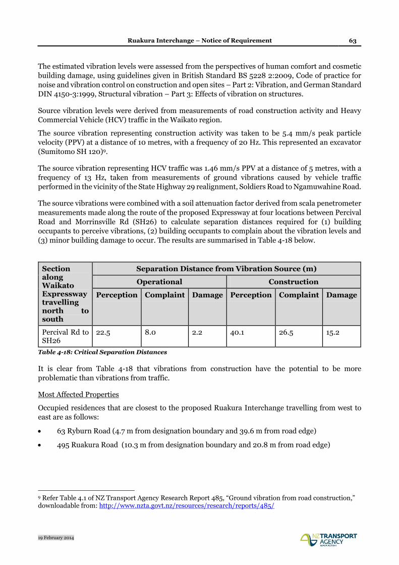
Ruakura Interchange – Notice of Requirement 63
19 February 2014
The estimated vibration levels were assessed from the perspectives of human comfort and cosmetic
building damage, using guidelines given in British Standard BS 5228 2:2009, Code of practice for
noise and vibration control on construction and open sites – Part 2: Vibration, and German Standard
DIN 4150-3:1999, Structural vibration – Part 3: Effects of vibration on structures.
Source vibration levels were derived from measurements of road construction activity and Heavy
Commercial Vehicle (HCV) traffic in the Waikato region.
The source vibration representing construction activity was taken to be 5.4 mm/s peak particle
velocity (PPV) at a distance of 10 metres, with a frequency of 20 Hz. This represented an excavator
(Sumitomo SH 120)9.
The source vibration representing HCV traffic was 1.46 mm/s PPV at a distance of 5 metres, with a
frequency of 13 Hz, taken from measurements of ground vibrations caused by vehicle traffic
performed in the vicinity of the State Highway 29 realignment, Soldiers Road to Ngamuwahine Road.
The source vibrations were combined with a soil attenuation factor derived from scala penetrometer
measurements made along the route of the proposed Expressway at four locations between Percival
Road and Morrinsville Rd (SH26) to calculate separation distances required for (1) building
occupants to perceive vibrations, (2) building occupants to complain about the vibration levels and
(3) minor building damage to occur. The results are summarised in Table 4-18 below.
Section along Waikato Expressway travelling north to south
Separation Distance from Vibration Source (m)
Operational Construction
Perception Complaint Damage Perception Complaint Damage
Percival Rd to SH26
22.5 8.0 2.2 40.1 26.5 15.2
Table 4-18: Critical Separation Distances
It is clear from Table 4-18 that vibrations from construction have the potential to be more
problematic than vibrations from traffic.
Most Affected Properties
Occupied residences that are closest to the proposed Ruakura Interchange travelling from west to
east are as follows:
63 Ryburn Road (4.7 m from designation boundary and 39.6 m from road edge)
495 Ruakura Road (10.3 m from designation boundary and 20.8 m from road edge)
9 Refer Table 4.1 of NZ Transport Agency Research Report 485, “Ground vibration from road construction,” downloadable from: http://www.nzta.govt.nz/resources/research/reports/485/

Ruakura Interchange – Notice of Requirement 64
19 February 2014
Vaile Road ( 5.2 m from designation boundary and 11.2 m from road edge for Vaile Road
frontage and 17.9 m from designation boundary and 23.7 m from road edge for Ruakura Road
frontage)
588 Ruakura Road (16.1 m from designation and 22.4 m from road edge)
188a Morrinsville Road (SH26) (23.0 m from designation boundary and 27.4 m from road
edge).
211 Morrinsville Rd (SH26) (15.8 m from designation boundary and 20.6 m from road edge)
212 Morrinsville Rd (SH26) (13.7 m from designation boundary and 17.8 m from road edge)
215 Morrinsville Rd (SH26) (15.9 m from designation boundary and 20.6 m from road edge)
Traffic induced vibrations once the Expressway is operational is unlikely to be an issue as in all cases
the separation distance from the closest point of a dwelling to the road edge will be well in excess of
the complaint threshold distance of 8 m. In fact, traffic induced vibrations are unlikely to be
perceived at 63 Ryburn Road and 188a Morrinsville Road.
From this analysis, it appears more emphasis on controlling road roughness levels will have to be
placed on local road connections such as Ruakura Road, Vaile Road and SH26 (Morrinsville Road)
than the Hamilton Section due to the proximity of residential dwellings to these local roads.
In contrast, designation boundaries in all cases fall within either the complaint or damage separation
distances for construction activity. Therefore, this brings a potential risk that if road construction
takes place close to the designation boundary, building damage could result if control measures are
not in place.
Over and Under Expressway Options
From a vibrations perspective, there is no difference between the ‘over’ and ‘under’ Expressway
options as a significant amount of earthworks is associated with either option. Therefore, irrespective
of what option is chosen, construction activity will have to be appropriately managed to ensure
mitigation of any vibrations that could be potentially damaging to the nearby properties. NOR1
explicitly requires vibration effects to be addressed in the Construction Management Plan, and as
such, it is appropriate that these existing designation conditions apply to this alteration.
Summary
The potential for problematic vibrations with the proposed Ruakura Road interchange primarily
relate to its construction and not the operation of the Expressway. However, these construction
based vibrations will be only temporary and of limited duration and so can be managed and
controlled through selection of appropriate equipment and scheduling of the construction activity.
Vibration effects arising from the Ruakura Road interchange are considered to be minor provided
any construction activity associated with local road connections, specifically Ryburn Road, Vaile
Road and SH26 (Morrinsville Road), are specifically addressed in the Construction Management
Plan.

Ruakura Interchange – Notice of Requirement 65
19 February 2014
4.3.11 Summary
The effects assessment above has considered the actual and potential effects of the Ruakura
Interchange alteration including the relocation of Ruakura Road. Overall, it is concluded that the
effects will be no more than minor on the environment provided that mitigation measures are
adopted where necessary. The majority of such mitigation can be captured by adopting the Hamilton
Section designation conditions (NOR1) for this alteration as proposed by the Agency. Other
mitigation measures will be better addressed through the WRC consents that will need to be obtained
prior to giving effect to this alteration.

Ruakura Interchange – Notice of Requirement 66
19 February 2014
5 Consultation
5.1 Overview
This alteration is part of the wider Hamilton Section of the Waikato Expressway. Extensive
consultation has been undertaken in relation to this project as a whole, including with statutory
bodies, Tangata Whenua, key stakeholders and people who are affected by, or who have an interest
in, the project. This has been undertaken over the past three years, using various consultation
methods.
A full recount of these consultation activities is not provided here, but can be found in the Project’s
Resource Consent applications (WRC reference 130361).
5.2 Ruakura Interchange Consultation
Over the course of the secondary investigation process (which began late 2010) a number of options
were considered for providing connectivity between Greenhill Road and SH26. These options were
presented to the public at various points through both newsletters and information days.
As a brief summary, the following consultation activities are noted with respect to the Ruakura
Interchange:
Project update newsletters delivered to properties within 200m of the Expressway
designation and to key stakeholders.
o Update 1 (October 2010): The possibility of a Ruakura Interchange was signalled
o Update 2 (December 2010): Advised of up-coming information day and signalled the
possibility of including an interchange at Ruakura
o Update 3 (December 2011): Summarised likely changes to the designation, including
the possibility of a ‘split-diamond’ interchange between Ruakura and SH26.
o Update 4 (September 2012): Presented the possibility of a Fifth Ave interchange and
realigned Holland Road.
o Update 5 (April 2013): Advised of up-coming information day indicated a Ruakura
Interchange located as per this alteration.
o Update 6 (October 2013): Advised that consent applications and alterations had been
lodged and that these alterations excluded the Ruakura Interchange. Also highlighted
the possibility of an alteration for the Ruakura Interchange, subject to the BOI
process.
Project Information Days provided an opportunity for information to be presented and for
the community to discuss the overall project with Agency staff and their consultants:
o Project Information Day (February 2011): Signalled the possibility of an interchange
at Ruakura

Ruakura Interchange – Notice of Requirement 67
19 February 2014
o Ruakura Information Day (September 2011): This was joint with HCC and presented
the option of the Ruakura/SH26 split diamond interchange.
o Fifth Ave Information Day (September 2012): Presented the option of a Fifth Ave
Interchange (instead of a Ruakura Interchange).
o Project Information Day (April 2013): Presented a Ruakura Interchange located as
per this alteration.
On 6 June 2013 meetings were held with Livestock Improvement and Dairy NZ, both of whom
are based on Ruakura Road and employ 530 and 130 staff on-site respectively. The Ruakura
Interchange and link to Ruakura Road was explained to senior management of both
companies.
In addition to the project update letters, on 10 February 2014 a letter was delivered to all
properties located in the vicinity of Ruakura, Davison, Vaile (in part), Ryburn and Percival
Roads, to advise landowners of the imminent lodgement of a NOR to provide for the Ruakura
Interchange and relocation of Ruakura Road. The same letter was sent to a number of key
stakeholders including the University of Waikato.
The Agency issued a press release on 12 February 2014 outlining the same information
delivered to properties on 10 February 2014.
The summary above demonstrates that consultation has occurred over the previous three years
regarding the Ruakura Interchange alteration.
5.3 Tangata Whenua Consultation
The following summarises the consultation undertaken with Tangata Whenua for the project as a
whole.
A Statement of Identified Māori Interests (SIMI) was prepared in accordance with Agency
requirements in October 2010. The SIMI identified the Tangata Whenua groups to consult with in
relation to the Hamilton Section of the Waikato Expressway.
An initial workshop was held with Tangata Whenua representatives on 21 October 2010.
Waikato Tainui and the Agency entered into detailed discussions in early 2011 with a view to forming
a high level contract enabling a partnership to be established for the Hamilton Section. Through that
process, an appointee from Waikato Tainui established responsibility for determining who the
project team should engage with and how that should occur. As a result, a Hamilton Section specific
Tangata Whenua Working Group (TWWG) was established in late 2011.
A working paper was prepared by the TWWG on 11 December 2011 as a means of expressing the key
issues for Tangata Whenua. This paper was updated in March 2012 following more detailed
discussions with Tangata Whenua.
A site visit was held on 2 March 2012 during which the TWWG and other representatives visited the
southern areas of the Project. The site visit had a particular focus on the gully systems as these have
been identified as areas of particular interest to Tangata Whenua. A workshop was also held on 9
March 2012 to discuss the particular issues around bridge piers, gullies and waterways.

Ruakura Interchange – Notice of Requirement 68
19 February 2014
In December 2012, the TWWG presented the Draft Tangata Whenua Effects Assessment Report
(TWEAR). Following the delivery of this document, the project team held a meeting with the TWWG
in February 2013 and provided a preliminary response to the issues raised in the document.
Another site visit was held on 15 March 2013, followed by a series of workshops addressing key issues
for the TWWG. The workshops were held on 22 March, 4, 5 and 17 April 2013. During these
workshops the project team and the TWWG were able to reach agreement on some of the key issues.
A ‘mitigation document’ was also drawn up at these workshops, which captures the requests of the
TWWG (as expressed in the TWEAR), the response of the Agency, and matters for further discussion
or action. This is a living document and reflects the current state of discussion between the two
parties.
The key issues being worked through with the TWWG are in relation to:
Gully crossings (and in particular the matter of piers in the floodplain);
Effects on gully flora and fauna;
Earthworks;
Water treatment;
Waahi Tapu sites;
Effects on groundwater; and
Training and employment.
The TWWG (through its connection with TGH) is very aware of the Ruakura Interchange and have
supported its inclusion as part of the Expressway throughout the period of consultation.
5.4 Affected Landowner Consultation
In order to give effect to this alteration land will need to be taken from the following entities:
WDC
HCC
WRC
TGH
Landowner – 11 Davison Road
A Ruakura Transport Reference Group was established, consisting of representatives from the three
Councils, the Agency, and TGH. The purpose of this group was to meet and deal with issues in
respect to the timing and planning of the Expressway, and identify and work through any local
roading issues. Through these discussions all parties have been aware of the need to alter the current
designations in order to provide for the Ruakura Interchange.
The landowner at 11 Davison Road was contacted by Opus on behalf of the Agency and a meeting at
the property was held on 4 February 2014, where the proposal and the requirement to take a portion
of her land adjacent to Ruakura Road was explained. The additional land is required to improve
sight visibility for vehicles turning onto Ruakura Road from Davison Road. Negotiations with the
landowner were continuing at the time of writing this report.

Ruakura Interchange – Notice of Requirement 69
19 February 2014
5.5 Ruakura Structure Plan and the Ruakura Development PPC
Consultation
As a part of the Ruakura Development, a series of consultation activities have been undertaken.
These have been implemented primarily by the HCC as a statutory requirement, and also by TGH.
Following feedback on the Draft Hamilton City District Plan in April 2011, TGH facilitated (under
observation from HCC) two public forums held at the University of Waikato, prior to the Proposed
District Plan being notified. Invitations to this event were sent to approximately 8,000 households
in the catchment area. Further to this event, a site visit to the Highbrook Industrial Park in Auckland
was undertaken to show people a working example of an industrial park. 16 residents attended the
site visit.
An initial Ruakura Structure Plan “Open Day” was held in December 2011 (led by TGH), as an
initiation to the Structure Plan process. A further three “Open Days‟ were held in May 2012, led by
HCC as part of consultation on the Draft Hamilton City District Plan. These featured information
panels/graphics outlining details of the Structure Plan, and project representatives from HCC and
TGH were in attendance to answer questions.
5.6 Summary
The descriptions above demonstrate that the Agency has undertaken extensive consultation
regarding the Ruakura Interchange, either as part of the overall Hamilton Section of the Waikato
Expressway, or in specifically addressing the proposed Ruakura Interchange and link to Ruakura
Road. Furthermore, awareness of the need for the Ruakura Interchange has been expressed through
consultation on the Structure Plan and PPC.

Ruakura Interchange – Notice of Requirement 70
19 February 2014
6 Statutory Assessment
6.1 Resource Management Act 1991
The RMA governs the use and development of New Zealand’s natural and physical resources. Part 2
establishes the Purpose and Principles of the RMA. The following section outlines the relevant
sections of the RMA that have been considered with this alteration.
6.1.1 Section 181 – Alteration of Designation
To be processed as an alteration to designation under section 181 of the RMA, the following must be
satisfied:
(1) A requiring authority that is responsible for a designation may at any time give notice to
the territorial authority of its requirement to alter the designation;
(2) Subject to subsection (3), sections 168 to 179 shall, with all necessary modifications, apply
to a requirement referred to in subsection (1) as if it were a requirement for a new
designation;
(3) A territorial authority may at any time alter a designation in its district plan [or a
requirement in its proposed district plan] if—
(a) The alteration—
(i) Involves no more than a minor change to the effects on the environment associated
with the use or proposed use of land or any water concerned; or
(ii) Involves only minor changes or adjustments to the boundaries of the designation
[or requirement]; and
(b) Written notice of the proposed alteration has been given to every owner or occupier of
the land directly affected and those owners or occupiers agree with the alteration; and
(c) Both the territorial authority and the requiring authority agree with the alteration —
and sections 168 to 179 shall not apply to any such [alteration].
(4) This section shall apply, with all necessary modifications, to a requirement by a territorial
authority to alter its own designation [[or requirement]] within its own district.
Assessment
Section 181(3)(a)(i) makes reference to the alteration involving a no more than minor change to the
effects on the environment associated with the use, or proposed use, of land. In the context of the
Expressway and the Structure Plan, which form the ‘baseline’ for the purposes of this alteration, the
proposal will result in a no more than minor change to the effects on the environment. This point is
further emphasised given that the Ruakura Interchange proceeding will result in the two north facing
ramps between the Expressway and SH26 being removed from the overall proposal. So in total, the
proposal only results in the addition of a half diamond interchange to the Expressway and the
relocation of Ruakura Road, east of the Ruakura Interchange.
Section 181(3)(b) requires that every owner and occupier of land directly affected by the proposed
alteration be given written notice of, and agree to, the alteration. At the time of lodgement, the
Agency is still seeking approval from the owner/occupiers of the land in question.

Ruakura Interchange – Notice of Requirement 71
19 February 2014
The Agency is also requesting that the alteration be publicly notified (in accordance with section
95A(2)(b) of the RMA and is anticipating a section 92 request for further information given that the
application needed to be prepared in a very short timeframe.
As it is not possible to meet all the requirements of section 181(3) the alteration will need to be
processed in accordance with section 181(2), and sections 168 to 179 shall apply with all necessary
modifications as if it were a requirement for a new designation. This NOR has been prepared
accordingly.
6.1.2 Section 171 – Recommendation by Territorial Authority
In accordance with section 171 of the RMA, a territorial authority must take into account the
following:
(1A) When considering a requirement and any submissions received, a territorial authority
must not have regard to trade competition or the effects of trade competition;
(1) When considering a requirement and any submissions received, a territorial authority
must, subject to Part 2, consider the effects on the environment of allowing the requirement,
having particular regard to:
(a) Any relevant provisions of:
(i) A national policy statement;
(ii) A New Zealand coastal policy statement;
(iii) A regional policy statement or proposed regional policy statement;
(iv) A plan or proposed plan; and
Consideration of the proposed alteration with regard to relevant environmental standards, policies
and plans, and Part 2 is provided below.
(b) Whether adequate consideration has been given to alternative sites, routes, or methods
of undertaking the work if:
(i) The requiring authority does not have an interest in the land sufficient for
undertaking the work; or
(ii) It is likely that the work will have a significant adverse effect on the environment;
and
The Agency as the requiring authority does not have an interest in the land sufficient for undertaking
the proposed works. Accordingly, due consideration has been given to alternatives as discussed in
section 4.2 of this report.
(c) Whether the work and designation are reasonably necessary for achieving the objectives
of the requiring authority for which the designation is sought; and
The proposed alteration is the outcome of a Network Connections investigation which concluded
that interchanges at Greenhill and Ruakura best served the area if the Ruakura Structure Plan (and
in particular the Inland Port) were to proceed. This alteration is lodged on the basis that the Ruakura
Development (including the Inland Port) is given approval through the EPA process, which is
currently in progress. The report on the Network Connections investigation is provided in
Appendix D.

Ruakura Interchange – Notice of Requirement 72
19 February 2014
(d) Any other matter the territorial authority considers reasonably necessary in order to
make a recommendation on the requirement.
(2) The territorial authority may recommend to the requiring authority that it:
(a) Confirm the requirement:
(b) Modify the requirement:
(c) Impose conditions:
(d) Withdraw the requirement.
(3) The territorial authority must give reasons for its recommendation under subsection (2).
6.2 Part 2
6.2.1 Section 5 – Purpose of the RMA
The purpose of the RMA is to promote the sustainable management of natural and physical
resources. Sustainable management is defined in section 5(2) as:
“Managing the use, development, and protection of natural and physical resources in a way, or
at a rate, which enables people and communities to provide for their social, economic, and
cultural well-being and for their health and safety while—
(a) Sustaining the potential of natural and physical resources (excluding minerals) to meet
the reasonably foreseeable needs of future generations; and
(b) Safeguarding the life-supporting capacity of air, water, soil, and ecosystems; and
(c) Avoiding, remedying, or mitigating any adverse effects of activities on the environment.”
Assessment
The proposed alteration will allow the construction of an interchange and associated connections at
Ruakura, providing an efficient connection with the Ruakura Inland Port (which has been deemed
to be a project of national significance through the EPA process). This alteration is considered to
represent the use and development of natural and physical resources in a way which enables people
and communities to provide for their social and economic wellbeing. At the same time the proposal
incorporates measures to avoid, remedy or mitigate adverse effects to ensure that resources are
sustained and the life-supporting capacity of air, water, soils and ecosystems are safeguarded.
6.2.2 Section 6 – Matters of National Importance
Section 6 of the RMA sets out matters of national importance, which shall be recognised and
provided for as follows:
“In achieving the purpose of this Act, all persons exercising functions and powers under it, in
relation to managing the use, development, and protection of natural and physical resources,
shall recognise and provide for the following matters of national importance:
…
(e) The relationship of Maori and their culture and traditions with their ancestral lands,
water, sites, waahi tapu, and other taonga:
…

Ruakura Interchange – Notice of Requirement 73
19 February 2014
Assessment
Section 6(e) is the only matter which is considered to have direct relevance to the Ruakura alteration.
The extensive consultation undertaken with Tangata Whenua during development of the Hamilton
Section of the Waikato Expressway has recognised and provided for the relationship of Maori and
their cultures and traditions with their ancestral lands, and has ensured that any values identified
are avoided or protected as appropriate. Throughout this process Tangata Whenua have
demonstrated their support for the interchange.
6.2.3 Section 7 – Other Matters
Section 7 of the RMA lists certain matters to which particular regard is to be had in making resource
management decisions. Section 7 provides:
“In achieving the purpose of this Act, all persons exercising functions and powers under it, in
relation to managing the use, development, and protection of natural and physical resources,
shall have particular regard to—
(a) Kaitiakitanga:
…
(b) The efficient use and development of natural and physical resources:
…
(c) The maintenance and enhancement of amenity values:
…
(i) the effects of climate change.”
Assessment
The following matters are considered relevant to this alteration and have been provided for as
described:
Section 7(a) - Kaitiakitanga through the extensive consultation undertaken with Tangata Whenua
during development of the Hamilton Section of the Waikato Expressway.
Section 7(b) - The efficient use and development of the State highway and local road networks
through improvements to connections with local road networks and with planned land use.
Section 7(c) - The maintenance and enhancement of amenity values and the quality of the
environment by applying the existing designation conditions which address matters such as noise,
vibration, dust and landscaping.
Section 7(i) - The effects of climate change by providing capacity for increased rainfall and associated
management of stormwater runoff from the proposal.
6.2.4 Section 8 – Treaty of Waitangi
Section 8 of the RMA requires those exercising powers or functions under the RMA to take into
account the principles of the Treaty of Waitangi as follows:

Ruakura Interchange – Notice of Requirement 74
19 February 2014
“In achieving the purpose of this Act, all persons exercising functions and powers under it, in
relation to managing the use, development, and protection of natural and physical resources,
shall take into account the principles of the Treaty of Waitangi (Te Tiriti o Waitangi)”.
Assessment
The Agency has facilitated Tangata Whenua’s participation in the consultation process to enable the
latter to contribute fully to the investigation and assessment of the overall project and thereby enable
them to take steps to protect their interests. Furthermore, the Agency’s consultation with the
commercial arm of Waikato Tainui (TGH) has ensured that recognition is provided to the iwi’s
economic and development interests. The Treaty signifies a partnership and requires the Crown and
Maori partners to act toward each other reasonably and with the utmost good faith (Waitangi
Tribunal, 1991). The Agency and Tangata Whenua have acted reasonably and with good faith. In
order for a Treaty partner to act in good faith, fairly and reasonably towards the other, it is obliged
to make informed decisions. NZTA has consulted with the Tangata Whenua about the effects of the
alteration on the latter’s interests and considers that it has sufficient information to make an
informed decisions about the overall project. Therefore, the proposed alteration is in accordance
with the purpose of section 8 of the RMA.
6.3 National Environmental Standards
6.3.1 Air Quality (2004)
The NES for Air Quality includes three ambient (outdoor) air quality standards, which relate to air
emissions from motor vehicles and are therefore relevant to his alteration. Schedule 1 of the NES
sets out ambient air quality concentration limits for carbon monoxide (CO), nitrogen dioxide (NO2),
and fine particulate matter, that is, less than 10 micron in diameter (PM10).
Assessment
The construction and operation of the Ruakura Interchange and relocation of Ruakura Road will
result in construction dust and vehicle emissions, being discharged to air. The air quality effects and
mitigation measures are discussed under section 4 of this report.
The assessment identifies that the additional contribution of air contaminants at the nearest
residential dwelling will remain nearly at the same levels as without the Ruakura Interchange
progressing. It concludes the air quality effects will range from “insignificant to less than minor”,
and therefore will not exceed any of the relevant standards within the NES.
6.3.2 Assessing and Managing Contaminants in Soil to Protect Human
Health (2011)
The NES for Assessing and Managing Contaminants in Soil to Protect Human Health, provides a
nationally consistent set of planning controls and soil contaminant values. It also ensures that land
affected by contaminants in soil is appropriately identified and assessed before it is developed and if
necessary, the land is remediated or the contaminants contained to make the land safe for human
use.
The NES mandates the methods for setting applicable numerical standards for contaminants in soil
that have the potential to impact on human health. Applicable standards for 12 contaminants (called
“priority contaminants” in regulation 7(2) of the NES) were derived and must be used if the land use
Ruakura Interchange – Notice of Requirement 75
19 February 2014
fits within the particular exposure scenario. All territorial authorities (district and city councils) are
required to give effect to and enforce the requirements of the NES. The NES does not affect existing
land uses.
Assessment
The contamination effects and potential mitigation measures associated with this alteration are
discussed in section 4 of this report. It is noted that the alignment of the Ruakura Road and part of
the interchange pass over a landfill and that agricultural land use may have led to contaminants
being present in the soil across the site. Any consents required under the NES will be sought at the
outline plan approval stage, once the contractors and final design of the Expressway have been
confirmed.
6.4 Other Regulations
6.4.1 Waikato-Tainui Raupatu Claims (Waikato River) Settlement Act 2010
On 25 November 2010, the Waikato-Tainui Raupatu Claims (Waikato River) Settlement Act 2010
(the Settlement Act) came into force in its entirety. The Settlement Act effectively creates Iwi co-
management of the Waikato River in partnership with the Crown.
The overarching purpose of the Settlement Act is to restore and protect the health and wellbeing of
the Waikato River for future generations. Although this project is not located directly on or adjacent
to the Waikato River, section 6 of the Settlement Act clearly defines the Waikato River as: “The
Waikato River and its catchments including all water courses, tributaries, streams, and watercourses
flowing into the River”.
Te Ture Whaimana o Te Awa o Waikato – the Vision and Strategy for the Waikato River is set out in
Schedule 2 of the Settlement Act. The Vision and Strategy is the primary direction-setting document
for the Waikato and Waipa Rivers and their catchments. Under the Settlement Act, the Vision and
Strategy is deemed, in its entirety, to be part of the Regional Policy Statement.
Many of the actions taken by the Agency in response to the objectives and strategies of the Settlement
Act are relevant in the context of the resource consent applications already made to the WRC to give
effect to the Hamilton Section of the Waikato Expressway. Those resource consents covered matters
such as effects on streams and indigenous vegetation. Any further resource consents required for
this alteration will be applied for in due course and the Agency will apply the same principles to give
effect to the purpose of the Settlement Act. It is anticipated that with appropriate mitigation
measures in place, the alteration will not result in any adverse effects on the health and well-being
of the Waikato River.
It is noted that engagement with the TWWG has been undertaken throughout the overall project,
including with regard to the Ruakura Interchange, which has been supported by the TWWG in their
TWEAR document.
Overall, the proposed alteration is considered to be consistent with the Vision and Strategy for the
Waikato River.

Ruakura Interchange – Notice of Requirement 76
19 February 2014
6.4.2 Historic Places Act 1993
There are no recorded archaeological sites within the area of the Ruakura Interchange alteration as
demonstrated in the archaeological effects assessment in section 4 of this report. Existing conditions
on the designation (NOR 1), provide a process to be followed should any archaeological matter be
discovered during construction. If necessary, the appropriate authorities would be sought from the
Historic Places Trust.
Accordingly, the proposed alteration is in accordance with the requirements of the Historic Places
Act.
6.5 Regional Policy and Plans
6.5.1 Waikato Regional Policy Statement (October 2000)
The Operative RPS sets out issues, objectives and policies relating to the natural and physical
resources of the Waikato Region. District and Regional Plans must give effect to the Operative RPS.
The Operative RPS addresses a wide variety of significant resource management issues.
Those considered relevant to the alteration are discussed below.
3.3.8 Soil Contamination
Objective: The range of existing and foreseeable uses of the soil resource is not reduced as a result
of the contamination of soils.
Policy One: Discharges of contaminants into or onto land should be carried out in a manner
designed to avoid any adverse effects on the soil resource.
Assessment
The proposed alteration does not involve any direct contamination of soils. During the construction
phase there is potential for the accidental release of hazardous substances, however actions to be
taken when accidental spills occur will be covered in WRC consent conditions and also through the
implementation of the Construction Management Plan. Where existing contaminated sites are
affected, earthworks will be managed to address the potential for release of contaminated materials
into the environment.
The proposal is considered to be consistent with the Operative RPS.
6.5.2 Proposed Waikato Regional Policy Statement (February 2013)
The Proposed Waikato RPS sets out issues, objectives and policies relating to the natural and physical
resources of the Waikato Region. It is noted that some parts of the Proposed RPS are still under
appeal, including Table 6-2, which relates to industrial land use allocation and includes Ruakura.
The following Proposed RPS objectives and policies are relevant to the alterations:
Objective 3.1A Resource Use and Development
The sustainable management of natural and physical resources, and of their use and development,
recognises the social, economic and cultural benefits to the regional and national community.

Ruakura Interchange – Notice of Requirement 77
19 February 2014
Assessment
The proposed alteration is part of the wider Waikato Expressway project which is a significant
infrastructure development, expected to deliver multiple social and economic benefits to the region
and nation, whilst ensuring sustainable management of natural and physical resources.
Furthermore, the alteration is required to support the Ruakura Development, which the EPA has
identified as a project of national significance.
Objective 3.8 Relationship of Tāngata Whenua with the Environment
The relationship of tāngata whenua with the environment is recognised and provided for,
including:
a) The use and enjoyment of natural and physical resources in accordance with tikanga Māori,
including mātauranga Māori;
b) The role of tāngata whenua as kaitiaki.
Assessment
The Hamilton Section of the Waikato Expressway project has recognised the relationship of Tangata
Whenua with the environment, through consultation with the TWWG, mandated on behalf of the
local hapu. Matters of relevance to Tangata Whenua have been taken into account during the
development of this entire project.
Objective 3.11 Built Environment
Development of the built environment (including transport and other infrastructure) and
associated land use occurs in an integrated, sustainable and planned manner which provides for
positive environmental, social, cultural and economic outcomes, including by:
a) Promoting positive indigenous biodiversity outcomes;
b) Integrating land use and infrastructure planning, including by ensuring that development of
the built environment does not compromise the safe, efficient and effective operation of
infrastructure corridors;
c) Recognising and protecting the value and long-term benefits of regionally significant
infrastructure;
e) Minimising land use conflicts, including minimising potential for reverse sensitivity;
f) Anticipating and responding to changing land use pressures outside the Waikato region which
may impact on the built environment within the region;
Assessment
The Hamilton Section of the Waikato Expressway (including necessary alterations) is considered to
be regionally significant infrastructure which will provide for positive environmental, social, cultural
and economic outcomes. The planning of the project has been integrated with the planning of the
environs of Hamilton; both Future Proof and the Proposed RPS recognise and provide for the
proposal (see Map 6.1A in the Proposed RPS). The proposed alterations are necessary to protect the
value and long-term benefits of the Expressway as regionally significant infrastructure. In addition,
the Ruakura Interchange alteration represents integration of land use and infrastructure planning,
whilst still protecting the benefits of the Expressway as an important piece of regionally significant
infrastructure.

Ruakura Interchange – Notice of Requirement 78
19 February 2014
Policy 6.1 Planned and Co-ordinated Development
Development of the built environment, including transport, occurs in a planned and co-ordinated
manner which:
a) Has regard to the principles in section 6A;
b) Recognises and addresses potential cumulative effects of development; and
c) Is based on sufficient information to allow assessment of the potential long-term effects of
development.
Assessment
The Project, including the Ruakura Interchange alteration is considered to have regard to the
relevant principles in section 6A of the Proposed RPS, in particular it will:
support the existing urban area of Hamilton and connect well with existing and planned
development and infrastructure through the strategic location of interchanges – the Ruakura
Interchange alteration is specifically required for this purpose; and
tie into existing and planned infrastructure, thereby not compromising the safe, efficient and
effective operation and use of existing and planned infrastructure.
Policy 6.3 Co-ordinating Growth and Infrastructure
Management of the built environment ensures:
a) The nature, timing and sequencing of new development is co-ordinated with the development,
funding, implementation and operation of transport and other infrastructure, in order to:
i) Optimise the efficient and affordable provision of both the development and the
infrastructure;
ii) Maintain or enhance the operational effectiveness, viability and safety of existing and
planned infrastructure;
iii) Protect investment in existing infrastructure; and
iv) Ensure new development does not occur until provision for appropriate infrastructure is in
place;
b) The spatial pattern of land use development, as it is likely to develop over at least a 30-year
period, is understood sufficiently to inform reviews of the Regional Land Transport Strategy.
As a minimum, this will require the development and maintenance of growth strategies where
strong population growth is anticipated;
c) The efficient and effective functioning of infrastructure, including transport corridors, is
maintained, and the ability to maintain and upgrade that infrastructure is retained; and
d) A co-ordinated and integrated approach across regional and district boundaries and between
agencies.
Assessment
The Agency is working closely with the WDC, HCC and TGH in order to ensure the appropriate
coordination with development of the surrounding local road network and the Ruakura
Development, should this go ahead. This will provide the opportunity to optimise the efficient and
affordable provision of future infrastructure.

Ruakura Interchange – Notice of Requirement 79
19 February 2014
The Ruakura Interchange alteration is necessary to achieve the policy above, in that it represents a
co-ordinated and integrated approach to infrastructure and land use development.
Policy 6.6 Significant infrastructure and energy resources
a) Management of the built environment ensures that the effectiveness and efficiency of existing
and planned regionally significant infrastructure is protected.
b) Regard is given to the benefits that can be gained from the development and use of regionally
significant infrastructure and energy resources, recognising and providing for the particular
benefits of renewable electricity generation.
Assessment
The Project as a whole (including the Ruakura Interchange alteration) is considered to result in
regional and national benefits. Protection of the areas required as alterations to the designation will
ensure that the effectiveness and efficiency of the planned Expressway is protected.
Overall, the proposed alteration is considered to be consistent with the provisions of the Proposed
RPS.
6.5.3 Waikato Regional Plan
The Waikato Regional Plan (WRP) became operative on 30 August 2007, except those parts of the
plan subject to Proposed Variation Numbers 2 (Geothermal Module), 5 (Lake Taupo Catchment), 6
(Water Allocation) and 7 (Minor Variation and Geothermal Maps). The WRP is intended to provide
direction regarding the use, development, and protection of natural and physical resources in the
Waikato Region. It gives effect to the Operative and Proposed RPS and focuses on WRC’s statutory
functions under the RMA. The WRP contains modules covering Matters of Significance to Maori,
Water, River and Lake Beds, Land and Soil, Air, and Geothermal Resources.
Assessment
Water and discharge permits, along with land use resource consents will be required from the WRC
and applications will be lodged in due course to enable the alteration to proceed.
6.6 Plans and Proposed Plans
6.6.1 Waikato District Plan (Operative April 2013)
The Waikato District Plan promotes the sustainable management of natural and physical resources
in the Waikato District, primarily by managing the effects of land use on the environment.
The eastern portion of the proposed Ruakura Interchange alteration falls within the WDC’s
jurisdiction, and is within the Rural Zone.
The following objectives and policies are relevant to the alteration:
Natural Resources
Objective 4.2.1 Physical, chemical and biological properties necessary for maintaining the life
supporting capacity and productive use of the soil, especially high quality soil, are retained.
Ruakura Interchange – Notice of Requirement 80
19 February 2014
Assessment
The location of the proposed alteration is largely a product of the existing designation. Whilst the
proposal will result in some additional loss of high quality soils, this loss is considered minor in the
context of the existing designation.
Natural Hazards
Objective 5.2.1 Risks from natural hazards to health, safety and property, resulting from use,
development or protection of land, are minimised.
Policy 5.2.5 Development should minimise impervious surfaces, provide adequate stormwater
drainage, and mitigate the off-site effects of stormwater drained from the site.
Assessment
The proposed alteration will result in some increase to the area of impervious surface – e.g. through
additional ramps at the interchange and roading upgrades. However, adequate stormwater drainage
is provided through the comprehensive stormwater management strategy for the Hamilton Section
of the Waikato Expressway. It has been demonstrated that adequate stormwater management for
the relocation of Ruakura Road can be provided for and any consents required to give effect to this
will be applied for in due course.
Land Transport Network
Objective 8.2.1 An integrated, safe, responsive and sustainable land transport network is
maintained, improved and protected.
Policy 8.2.2 Design, construction and operation of roads should be consistent with their function
in the road hierarchy.
Policy 8.4.1 Land transport networks are provided, while not compromising the qualities and
character of surrounding environments.
Policy 8.4.2 Road and rail maintenance, construction and operation should minimise adverse
effects on people, communities and the environment by managing:
(a) discharge of stormwater
(b) effects of contamination, including discharge of stock effluent
(c) disturbance to natural landforms, soil resources, indigenous vegetation and habitats, and
cultural and heritage sites
(d) severance of property and communities
(e) road surface noise
(f) connections between communities
(g) glare and light spill from street lighting.
Assessment
The Hamilton Section of the Waikato Expressway represents an improvement to the land transport
network, and the alteration for the Ruakura Interchange enables an improvement to the planned

Ruakura Interchange – Notice of Requirement 81
19 February 2014
network that will integrate with future land use. The design, construction and operation of the
Expressway, including this alteration, will be consistent with its status as a Road of National
Significance. The Project (including this alteration) will be constructed and operated in such a way
as to not compromise the qualities and character of surrounding environments, through measures
such as landscaping, stormwater management, and the remediation and management of
contaminated sites crossed by the project. The existing conditions will be applied to the alterations,
and provide controls to manage effects.
Contaminated Land
Objective 9.2.1 Human health or the environment is not harmed by the use or development of
contaminated land.
Policy 9.2.4 Remediation of contaminated land should not pose a more significant risk to human
health or the environment than if remediation had not occurred.
Policy 9.2.5 Material removed from contaminated land should be disposed of in a manner that
avoids further adverse effects on human health or on the environment.
Policy 9.2.7 Development or use of land known to have been occupied by a potentially
contaminating activity should not occur until any risk to human health or the environment has
been investigated.
Assessment
Where the proposal crosses contaminated land, contaminated soils will either need to be removed,
or capped and buried. Specific management and mitigation measures and any subsequent
consenting requirements will be addressed at a later date once the proposed alignment is confirmed.
Subject to the recommended controls, the construction of the road is not expected to result in harm
to human health or the environment, and in some cases, locating, characterising and removing
contaminated soil may have an environmental benefit.
Social, cultural and economic wellbeing
Objective 11.2.1 Towns, villages, neighbourhoods and localities have social coherence and a sense
of place.
Policy 11.2.6 Activities should avoid breaking up community and neighbourhood coherence, having
particular regard to the cumulative effects of activities.
Objective 11.4.1 Cultural practices and beliefs of tangata whenua are respected.
Policy 11.4.2 Subdivision, use and development should not compromise the cultural and spiritual
significance of areas, including waahi tapu, urupa, maunga and other landforms, mahinga kai,
and indigenous flora and fauna.
Assessment
The proposal includes the stopping of Ruakura Road beneath the Expressway and its relocation to
coincide with the Ruakura Interchange. Whilst this will result in a detoured route for vehicles using

Ruakura Interchange – Notice of Requirement 82
19 February 2014
Ruakura Road, the changes will not result in the breaking up of communities or affect neighbourhood
coherence.
The Project has recognised the relationship of Tangata Whenua with the environment, through
consultation with the TWWG, mandated on behalf of the local hapu. Matters of relevance to Tangata
Whenua have been taken into account during the development of the overall project.
Amenity Values
Objective 13.2.1 Adverse effects of activities on amenity values are managed so that the qualities
and character of the surrounding environment are not unreasonably compromised.
Policy 13.2.2 Adverse effects associated with lighting, litter, electromagnetic radiation, vermin,
traffic, spray drift, and noise should be contained within the site where they are generated.
Policy 13.2.3 Adverse effects associated with offensive or objectionable dust, smoke and odour
should be contained within the site where they are generated.
Policy 13.2.4 Adverse effects that cannot be contained on the site where they are generated must be
remedied or mitigated.
Policy 13.2.5 Amenity values, health and safety should be protected from adverse traffic effects
including:
(a) noise, vibration, dust, lighting and glare
(b) vehicle emissions
(c) accelerated or contaminated stormwater runoff
(d) visual effects of parking and loading areas
(e) traffic safety and congestion.
Assessment
Effects of the proposed alteration with respect to changes in noise, air quality and vibration have
been addressed in section 4, where it is concluded that such effects will be less than minor, subject
to mitigation measures being implemented where necessary. Visual mitigation will be provided in
accordance with the existing conditions on the designation relating to these matters.
Overall, the proposal is considered to be consistent with the Waikato District Plan.
6.6.2 Hamilton City Operative District Plan (July 2012)
The Hamilton City Operative District Plan (Operative District Plan) provides a framework of
resource management policy and implementation methods to manage the effects of the use,
development or protection of land and associated natural and physical resources in the city.
The Operative District Plan is not relevant to the Ruakura Interchange alteration. Therefore no
further assessment is provided of the objectives and policies of this plan.

Ruakura Interchange – Notice of Requirement 83
19 February 2014
6.6.3 Hamilton City Proposed District Plan
The Hamilton City Proposed District Plan (Proposed District Plan) was notified in December 2012.
The Proposed District Plan sets the rules for future city development and defines how and where the
city grows and how its natural and physical resources are managed. The Proposed District Plan
includes the Ruakura Structure Plan.
The Proposed District Plan is still in the public process, with hearings currently underway.
The Proposed District Plan is relevant to the proposed alteration, as the area of the alteration to the
west of the existing designation is within the Ruakura Structure Plan area.
The following objectives and policies of the Proposed District Plan are relevant to the alteration:
Structure Plans
Objective 3.3.1 Optimised, long-term, positive environmental, economic, social and cultural effects
of greenfield development.
Policy 3.3.1a Development should be in general accordance with the relevant Structure Plan
Policy 3.3.1d Interim land use and development should not compromise the integrity and viability
of the long-term vision for the relevant Structure Plan
Assessment
The alteration to the designation is consistent with the Ruakura Structure Plan as notified with the
Proposed Hamilton City District Plan. The Structure Plan identifies this location as a possible area
for an interchange. The development of the Expressway as per the proposed alteration will therefore
not compromise the integrity and viability of the long-term vision for the Ruakura Structure Plan.
Conversely, the inclusion of the interchange is supported by the key stakeholders (HCC and TGH)
and is essential to the Inland Port development.
6.7 Other Plans
6.7.1 Regional Land Transport Strategy 2011-2041 (RLTS)
The RLTS is a statutory document prepared under the LTMA. The RLTS examines the transport
outcomes for the Waikato Region and sets in place a strategic plan to achieve those outcomes over a
30-year period. The strategic approach for the RLTS is strategic corridors, road safety, and managing
demand and encouraging alternative modes of transport.
Assessment
The strategic corridors aspect is directly relevant to the project, as the Waikato Expressway is
identified in the strategy as the principal strategic transport project for the Waikato Region. The
Project, including alterations proposed, is therefore consistent with the strategic approach of the
RLTS.

Ruakura Interchange – Notice of Requirement 84
19 February 2014
6.7.2 Future Proof Growth Strategy and Implementation Plan 2009
The Future Proof Growth Strategy and Implementation Plan 2009 (Future Proof) is a 50 year growth
strategy for the Hamilton, Waikato, and Waipa sub-region. The strategy focuses on managing growth
within the sub-region, and creating more compact urban areas based around Hamilton and existing
rural townships and villages.
Future Proof provides a high level blueprint for development in the form of a preferred settlement
pattern. Future Proof is not a statutory document, but has informed planning and decision making
processes and the key principles of Future Proof have been given statutory weight in the RPS. Future
Proof examines the issues associated with growth, including future urban and rural land use, natural
and cultural resources, roads, and other essential infrastructure and promotes a settlement pattern
aimed at managing these issues.
With respect to future growth, the Proposed RPS also sets out land use and population targets for
the Waikato Region through to 2061. Version 7 of the Waikato Regional Transportation Model
(WRTM v7) is based on the Proposed RPS land use and population projections. However, the Future
Proof project is continuing to refine land use and population projections and update the WRTM
accordingly.
Assessment
The strategy identifies the Expressway as the pre-eminent and key transport project for both the sub-
region and the Waikato region. The location of the Expressway designation is identified on the Future
Proof settlement pattern map, and roughly forms the boundary between the City and the District
(urban and rural). The completion of the Expressway is one of the key assumptions underpinning
the settlement pattern, and progressive implementation of the Expressway as the highest priority
strategic transport corridor, and road of national significance, forms one of the actions to achieve the
strategy.
The Future Proof strategy therefore provides the high level strategic context for development and
growth within the sub-region, including the development of the Expressway corridor. The Ruakura
Interchange will serve the Inland Port development proposed at Ruakura. This development is also
supported by and reflected in the Future Proof Strategy, as a strategic employment area for the
growth of the City, and Ruakura is also recognised in Table 6-2 of the PRPS for industrial land use
allocation.
6.7.3 Access Hamilton Strategy
The purpose of Access Hamilton is to meet the changing travel demands of the city by providing an
affordable, safe, responsive and sustainable transport system that contributes to Hamilton’s strategic
vision and achieves community outcomes in a way that is consistent with national and regional
objectives.
Access Hamilton is one of Hamilton’s eight key strategies that assist the HCC to achieve its strategic
objectives. It guides the city’s development and transport infrastructure planning over the next thirty
years. It is a high-level integrated transport strategy that identifies the strategic transport aspirations
of the city to deliver HCC objectives, and contributes to national goals and regional priorities. Access
Hamilton will meet the changing travel demands of the city by providing an affordable, safe,
responsive and sustainable transport system. Hamilton’s strategic objectives have a long term focus
Ruakura Interchange – Notice of Requirement 85
19 February 2014
and are consistent with the objectives of the Land Transport Management Amendment Act and the
NZ Transport Strategy.
In broad terms, Access Hamilton aims to:
Support Hamilton’s economic, social, environmental and cultural well-being;
Support the land use, sustainability and economic development objectives for a compact city
with consolidation and intensification around key nodes and a vibrant city centre;
Manage incremental change in the transport and land use system necessary to achieve
Hamilton’s strategic objectives; and
Position infrastructure and land development to meet the city’s long term needs.
To contribute to Hamilton’s strategic vision, Access Hamilton must address transport challenges
over the next 30 years that relate to existing and foreseeable problems, and their exacerbation due
to city growth, demography, technology, employment patterns and the wider economy.
Assessment
The Hamilton Section of the Waikato Expressway is recognised in the Access Hamilton Strategy as a
Major Arterial Road. The Strategy also recognises the proposed future development at Ruakura and
therefore the alteration will assist in meeting the purpose of the Access Hamilton Strategy as it relates
to providing a safe, responsive, and sustainable transport system.

Ruakura Interchange – Notice of Requirement 86
19 February 2014
7 Conclusion
The Agency proposes to alter the existing designation for the Hamilton Section of the Waikato
Expressway in order to provide for an interchange at Ruakura that will service development of land
identified under the Ruakura Structure Plan (and PPC by TGH) for an Inland Port/Logistics and
Industrial area.
The Agency is a Crown entity and its objective pursuant to section 94 of the Land Transport
Management Act 2003 is to contribute to an effective, efficient, and safe land transport system in the
public interest.
The GPS was released in July 2012 and identified the Waikato Expressway as one of seven RoNS,
which are considered by the Government to be the Country’s most important transport routes
requiring significant development to reduce congestion, improve safety and support economic
growth. The Ruakura Interchange will be an integral component of the overall Expressway if the
Ruakura Development proceeds.
TGH is pursuing their PPC for the Ruakura Development through the EPA and a BOI will be hearing
this application in May 2014. As the Ruakura Interchange will be a vital component of giving effect
to the Ruakura Development, it is necessary for the Agency to demonstrate its intent to proceed with
the interchange, should the outcome of the BOI justify one being established. Lodging this NOR
serves that purpose.
This NOR has assessed the potential environmental effects of the Ruakura Interchange and
relocation of the Ruakura Road using the existing designation and the Ruakura Structure Plan land
use as the baseline for the effects assessment. The only exception to this has been the traffic effects
assessment which assumed that Ruakura Road has been relocated, as this must occur to give effect
to the Inland Port. This baseline approach is considered appropriate given that the Expressway has
been approved, and that the Ruakura Interchange will only proceed if the BOI justifies an
interchange being established.
The effects assessment has demonstrated that the proposed alteration can proceed having a no more
than minor change in effects compared with the current designations. This can be achieved through
the implementation of mitigation measures which can be applied by adopting the conditions (NOR1)
that already apply to the designations to be altered.
It is acknowledged that the Agency is yet to apply to the WRC for any necessary consents to give
effect to the alteration and these will be applied for in due course.
The Agency has been involved in consultation with the public and key stakeholders regarding the
Expressway and possible Ruakura Interchange for over three years and that consultation is on-going.
To date, that consultation has assisted the Agency in shaping its proposal and in its consideration of
alternatives.
This assessment has demonstrated that the alteration upholds the sustainable management purpose
of the Resource Management Act 1991, adequately provides for Part 2 matters, and is consistent with
the relevant policy statements and plans.
