w o o d l a n d s - glasgow
TRANSCRIPT

W O O D L A N D Sconservation area appraisal
June 17 2014

Cover images - St Georges Mansions, Woodlands Rd
DRS/2014/1
C O N T E N T S
2 INTRODUCTION
Definition of a Conservation Area What Does Conservation Area Status Mean? Purpose of a Conservation Area Appraisal Designation
4 HISTORICAL DEVELOPMENT 19th Century 1840s - 1860s 1870s - 1880s 1890 1900- Present
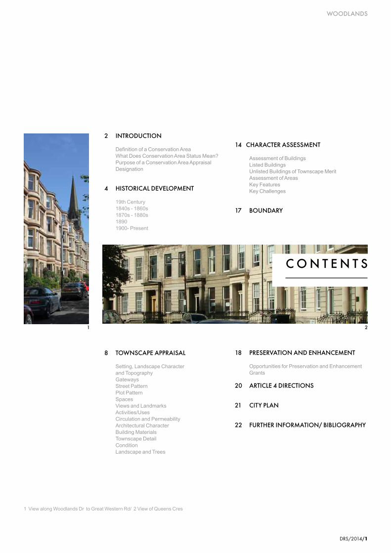
1 View along Woodlands Dr to Great Western Rd/ 2 View of Queens Cres
14 CHARACTER ASSESSMENT Assessment of Buildings Listed Buildings Unlisted Buildings of Townscape Merit Assessment of Areas Key Features Key Challenges
17 BOUNDARY
8 TOWNSCAPE APPRAISAL
Setting, Landscape Character and Topography Gateways Street Pattern Plot Pattern Spaces Views and Landmarks Activities/Uses Circulation and Permeability Architectural Character Building Materials Townscape Detail Condition Landscape and Trees
18 PRESERVATION AND ENHANCEMENT Opportunities for Preservation and Enhancement Grants
20 ARTICLE 4 DIRECTIONS
21 CITY PLAN
22 FURTHER INFORMATION/ BIBLIOGRAPHY
1 2
WOODLANDS
DRS/2014/1
WOODLANDS
2/DRS/2014
INTRODUCTION
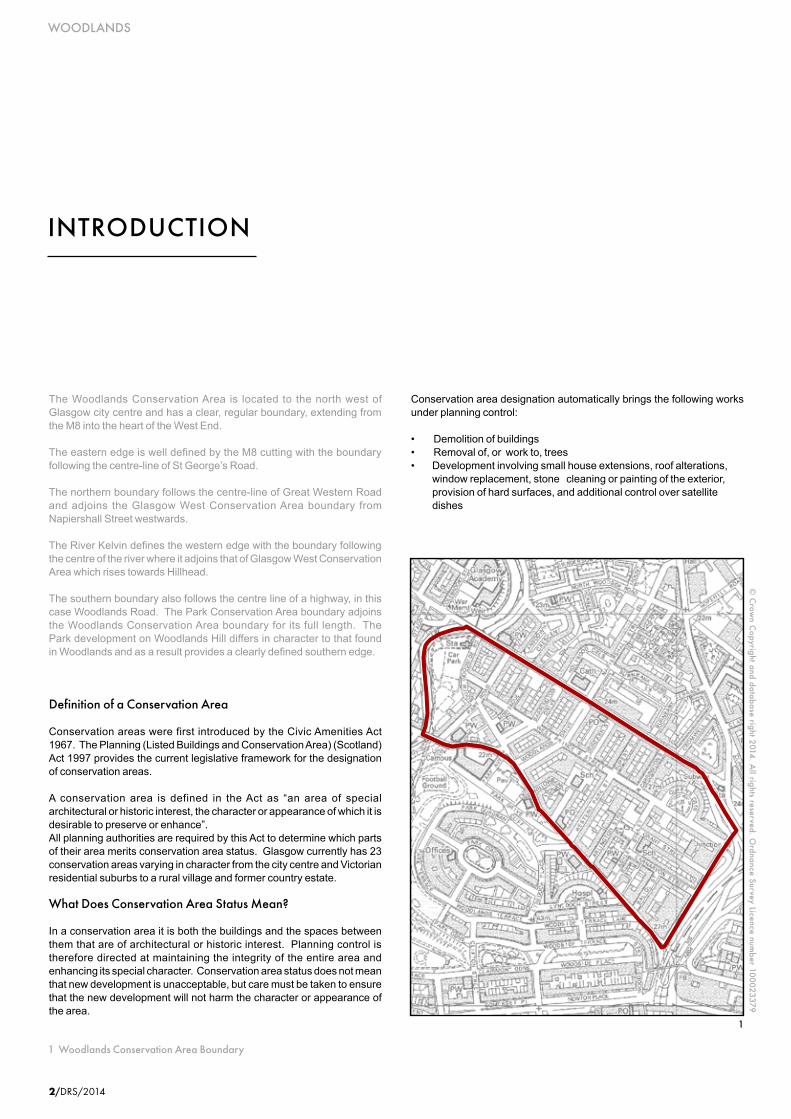
1 Woodlands Conservation Area Boundary
© C
rown C
opyright and database right 2014. All rights reserved. O
rdnance Survey Licence number 100023379
1
The Woodlands Conservation Area is located to the north west of Glasgow city centre and has a clear, regular boundary, extending from the M8 into the heart of the West End.
The eastern edge is well defined by the M8 cutting with the boundary following the centre-line of St George’s Road.
The northern boundary follows the centre-line of Great Western Road and adjoins the Glasgow West Conservation Area boundary from Napiershall Street westwards.
The River Kelvin defines the western edge with the boundary following the centre of the river where it adjoins that of Glasgow West Conservation Area which rises towards Hillhead.
The southern boundary also follows the centre line of a highway, in this case Woodlands Road. The Park Conservation Area boundary adjoins the Woodlands Conservation Area boundary for its full length. The Park development on Woodlands Hill differs in character to that found in Woodlands and as a result provides a clearly defined southern edge.
Definition of a Conservation Area
Conservation areas were first introduced by the Civic Amenities Act 1967. The Planning (Listed Buildings and Conservation Area) (Scotland) Act 1997 provides the current legislative framework for the designation of conservation areas.
A conservation area is defined in the Act as “an area of special architectural or historic interest, the character or appearance of which it is desirable to preserve or enhance”. All planning authorities are required by this Act to determine which parts of their area merits conservation area status. Glasgow currently has 23 conservation areas varying in character from the city centre and Victorian residential suburbs to a rural village and former country estate.
What Does Conservation Area Status Mean?
In a conservation area it is both the buildings and the spaces between them that are of architectural or historic interest. Planning control is therefore directed at maintaining the integrity of the entire area and enhancing its special character. Conservation area status does not mean that new development is unacceptable, but care must be taken to ensure that the new development will not harm the character or appearance of the area.
Conservation area designation automatically brings the following works under planning control:
• Demolitionofbuildings• Removalof,orworkto,trees• Developmentinvolvingsmallhouseextensions,roofalterations, window replacement, stone cleaning or painting of the exterior, provision of hard surfaces, and additional control over satellite dishes

DRS/2014/3
WOODLANDS
2 View of communal garden, Woodlands Dr/ 3 Tenement detail, Woodlands Rd - Baliol St
Where a development would, in the opinion of the planning authority, affect the character or appearance of a conservation area, the application for planning permission will be advertised in the local press providing an opportunity for public comment. Views expressed are taken into account by the local planning authority when making a decision on the application.
In order to protect the conservation areas, designation requires the City Council to formulate and publish proposals for their preservation and enhancement.
Local residents and property owners also have a major role to play in protecting and enhancing the character and appearance of the conservation area by ensuring that properties are regularly maintained and original features retained.
Purpose of a Conservation Area Appraisal
Conservation area designation should be regarded as the first positive step towards an area’s protection and enhancement.
Planning authorities and the Scottish Government are required by law to protect conservation areas from development which would be detrimental to their character. It is
necessary therefore for planning authorities, residents and property owners to be aware of the key features which together create the area’s special character and appearance.
The purpose of this conservation area appraisal is to define what is important about its character and appearance; to identify its important characteristics and ensure that there is a full understanding of what is worthy of preservation. It identifies the area’s special features and changing needs through a process which includes researching its historical development, carrying out a detailed townscape analysis and preparing a character assessment.
Conservation area appraisals provide an opportunity to reassess current boundaries, to make certain that they accurately reflect what is of special interest and ensure that they are logically drawn. This document will provide a framework for the controlled and positive management of change in the Woodlands Conservation Area and form a basis on which planning decisions in the area are made. It will also identify opportunities and priorities for enhancement. This appraisal should however be regarded as supplementary to the policies set out in the Glasgow City Plan 2 (2009).
I t is recognised that the successful management of conservation areas can only
be achieved with the support and input from stakeholders, and in particular local residents and property owners.
Designation
Glasgow Dis t r ic t Counc i l or ig ina l ly approved the designation of the Woodlands Conservation Area on 18 October 1984 encompassing the mainly tenemental area stretching from Arlington Street/east side of Carrington Street to the River Kelvin. Designation procedures were completed on 24 May 1985 with notices appearing in the Evening Times and Edinburgh Gazette. It was extended on 22 February 1991 to include Queen’s Crescent and East Woodlands.
(Prior to this Queen’s Crescent was designated as a conservation area in its own right. The original Queen’s Crescent Conservation Area was approved by Glasgow Corporation on 7 February 1972 and included all property in the Crescent, Melrose Street and that part of West Princes Street facing the Crescent (known as Queen’s Terrace). Designation procedures were completed 23 May 1972. Following the adoption of the Woodlands Local Plan in October 1984, the Queen’s Crescent Conservation Area was extended on 24 May 1985 to include all West Princes Street property between the Crescent and St George’s Road.)
2 3

WOODLANDS
4/DRS/2014
HISTORICALDEVELOPMENT
4
3
2
1
The flat area of ground on the east bank of the River Kelvin between Great Western Road and Gibson Street – known as South Woodside, was an important early industrial site. A grain mill may have operated here from at least the early 1600s. It was later the site of Glasgow’s first and only water-driven cotton mill opened by William Gillespie in 1790. Associated bleach fields and print fields would also have been located in this area.
Woodlands, as we know it today was constructed on the lands of Blythswood Estate. Richard’s map of 1795 shows the lands of Blythswood Estate to be open countryside, but on Forrest’s map of 1816, early development in the form of groups of independent country houses is evident. Some small mines and quarries were also being worked at that time.
1 St Georges Mansions, Woodlands Rd 1902/ 2 Woodlands Rd 1908/ 3 Woodside Public School 1916/ 4 Willowbank Crescent Primary School 1964

DRS/2014/5
WOODLANDS
19th Century
At the beginning of the 19th Century Glasgow was rapidly expanding with city merchants and businessmen seeking homes away from the centre of the city. A feuing plan was drawn up in 1817. One of the earliest speculative developments was at Rosehall Street (later to become St George’s Road) where freestanding villas were constructed on either side of the Street, in 1828. (A surviving villa can still be found at 361-367 St George’s Road – outwith the Woodlands Conservation Area)
The alignment of Woodlands Road, St George’s Road and Garscube Road in the early 1800s was to strongly influence the layout of development applied to surrounding estates. Similarly, the opening of Great Western Road in 1841 including the construction of the Great Western Road turnpike bridge over the River Kelvin (built 1838-41) was to lead to major residential expansion to the west of the city. The turnpike bridge surmounted an earlier estate bridge built around 1825.
1840s - 1860s
In general the oldest buildings dating from the 1840’s are to be found in the eastern part of the area with development expanding westwards along Great Western Road and Woodlands Road. The central core area of Woodlands was last to be developed.
Construction began with Queen’s Crescent in 1840 on several of the feued Blythswood plots. It consisted of two curved classical terraces of grey sandstone town houses designed by John Bryce, centred on gardens and a fountain. The fountain is sited over the entrance to an old mine.
The construction of No’s 24-40 Westend Park Street also took place around 1840 but these tenement properties stood in splendid isolation
for nearly three decades before the remaining buildings in the street were completed around 1870.
Building continued to the south and east of West Princes Street with three, twin villas constructed in West Cumberland Street (now Ashley Street) in 1850, which still survive today. Bryce also designed Queens Terrace on the south side of West Princes Street, overlooking the Crescent. This was completed in 1852. By the late 1850s development in the area had all but halted.
To the west, Woodside Quarry provided yellow sandstone for the construction of the expanding western suburbs.
Around the late 1850s Robert Bruce converted the cotton mill at South Woodside into a paper mill. Rows of workers cottages were sited immediately to the east between the river and Park Road which was laid out in the early 1860s. St Silas English Church at the junction of Park Road and Eldon Street, designed by John Honeyman was completed in 1864.
1870s - 1880s
Between 1869 and 1874 development continued to take place to the west near the River Kelvin and to the east around Queen’s Crescent.
The physical well-being and education of the residents was addressed with the opening of John Burnet Snr’s Arlington Baths in Arlington Street, in 1871 and the completion of H & D Barclay’s Albany Academy (now The Albany Learning & Conference Centre) in nearby Ashley Street in 1875.
At the western end of the area development included the construction of a Thomsonesque tenement located at 78–104 Park Road dating from 1880 with a later extension at 9 South Woodside Road completed in
1 Historical Map c.1860
1

WOODLANDS
6/DRS/2014
1897. Nearby, the former Woodlands Public School and janitor’s house occupying a large site adjacent to St Silas English Church at the junction of Woodlands Road and Eldon Street were built in 1882 and designed by Robert Dalgleish.
1890s
The present bridges over the River Kelvin were constructed in the 1890s. The Great Western Road Bridge was completed in 1891 on the site of the turnpike bridge. Fragments of the piers of the old structure still survive. The single arch Eldon Street Bridge linking Gibson Street and Eldon Street was completed in 1895.
The remaining large middle band of land with frontages to both Great Western Road and Woodlands Road was built on between 1892 and 1901 retaining West Princes Street, the axis first established by Bryce.
Development took the form of planned streets lined with yellow and red sandstone tenements. As development spread westwards the streets became more spacious with tenements overlooking long narrow amenity gardens.
St Silas Church hall in Park Road was completed in 1894/5 and it was around this time that the South Kelvinside Paper Mills were demolished.
The Glasgow Underground opened in 1896 with stations at St George’s Cross and Kelvinbridge serving Woodlands. The Glasgow Central Line skirted the western boundary of the area emerging from tunnels under Kelvingrove Park and Great Western Road on the haugh beside the River Kelvin.
1900 – Present
The imposing St George’s Mansions which tower over the junction of St George’s Road and Woodlands Road were designed by Burnet & Boston.
Willowbank Primary School, designed by Alexander Petrie also opened in 1900 to serve the surrounding community. It was built on the site of a bowling green. The building is currently vacant and being marketed as a development site by City Property.
During the 1900s a goods and mineral yard was developed on ground adjacent to the Glasgow Central Line dealing mainly in coal. Passenger services to the Caledonian Railway Company’s Kelvinbridge Station
1 Historical Map c.1895/ 2 View of Queens Cres/ 3 Historical Map c. 1912
1
2

DRS/2014/7
WOODLANDS
3
ceased in 1952 although the mineral yard remained in use until 1964.
The First Lanark Rifles Volunteers Regiment opened a drill hall and gymnasium at 261-269 West Princes Street in 1897 in the heart of the tenement area. The red sandstone headquarters building fronting onto West Princes Street was completed in 1906.
Demolition of villas in St George’s Road took place mainly in the 1920s and early 30s although the Norwood Ballroom, formerly a villa which was set back from St George’s Road was still in existence in the mid 1930s.
The town houses in the northern part of Ashley Street eventually disappeared in the 1960s. In the early 1970s Woodlands fell out of favour with lending institutions due to structural problems in the area created by the earlier mining and quarrying activity. This made it difficult to buy and sell property. Prices slumped and the area fell into decline. In 1976 however the residents of West Woodlands initiated a comprehensive programme of repairs and environmental improvements using a combination of private finance, Environmental Improvement Grants, and Housing Repair Grants from Glasgow District Council which affected almost every property in Woodlands – their efforts were subsequently
recognised by Civic Trust Awards in 1979-80.
During the 1970s and 80s the area south of Queens Crescent suffered extensive demolition, again, principally because of the instability of ground conditions. In 1985 the Woodlands Community Development Trust was set up with a budget of £16m to spend over five years. Considerable rebuilding has taken place and the gaps in the building line restored with the construction of mainly brick buildings of varying design and quality.
The drill hall was vacated by 201 Squadron, Royal Artillery Territorial Army Reserve in the early 1970s and re-opened in 1979 as the headquarters for Scottish Ballet. Further refurbishment took place in the late 1980s with the Robin Anderson Theatre opening in 1988. The complex lay vacant for a number of years but has recently been redeveloped including demolition of the drill hall, refurbishment and alteration of the main building and the construction of two student residential blocks.
After lying unused for many years the former Woodside Public School Albany Annexe was refurbished in 1999 and opened as a Gaelic Primary School in April 2000. The Gaelic Primary School vacated the premises in 2006, and it is now occupied by The Albany Learning and Conference Centre.
The site on the corner of Great Western Road and Montague Street was originally occupied by Woodside Church and later a petrol filling station before it too was demolished. A contemporary mixed use development featuring flats and retail units is nearing completion at this site.
Finally as part of the 1999 - City of Architecture and Design, a Millennium Park was created on an area of ground located between Ashley Street and Arlington Street.

WOODLANDS
8/DRS/2014
2
Setting, Landscape Character and Topography
The Woodlands Conservation Area is set on a relatively level area of ground with the drumlins of Woodlands Hill and Garnethill rising to the south and east. To the west the land slopes down to the flood plain of the River Kelvin, the lowest point in the area, where the river creates a natural meandering boundary. The flood plain is overlooked from the west by a variety of buildings located on the higher ground of Hillhead. The scale of the Garnethill drumlin is accentuated by the motorway cutting which forms a man-made boundary to the conservation area. Woodlands is defined by the main routes of Great Western Road and Woodlands Road which form a wedge shaped development of tenements and terraces with commercial premises on the periphery. To the north of Great Western Road the terraces and tenements of the Glasgow West Conservation Area complement the predominantly tenemental development of Woodlands, which in turn, contrasts with the planned prestigious terraces and dramatic towers on Woodlands Hill to the south.
Gateways
Streets breaking the strong tenement building line provide numerous access points into the area, however the lack of any special identifying features means they cannot be regarded as “gateways”.
It is worth noting however that emerging from the depths of St George’s Cross Underground Station into Queens Crescent forms a dramatic approach to the conservation area for pedestrians.
Street Pattern
The original street pattern survives largely unaltered. The axis established by Bryce at Queen’s Crescent and Queens Terrace has been maintained in the development of the rest of the area. West Princes Street acts as a central spine with streets branching off either side. The street blocks are regularly laid out between Great Western Road and Woodlands Road which follows the base of Woodlands Hill. South Woodside Road is located on the edge of the river flood plain and still retains the
TOWNSCAPE APPRAISAL
1
1 Detail of roofscape St Georges Mansions, Burnet and Boston , 1902, Woodlands Rd - St Georges Rd/ 2 Communal Gardens, Queens Cres

DRS/2014/9
WOODLANDS
historic street surfacing of granite setts and stone tram tracks. Queens Crescent and the “U” created by Willowbank Street and Willowbank Crescent provide the only deviation from this layout. Back lanes serve individual tenement blocks with only Baliol Lane and the roughly cobbled Ashley Lane providing through access.
New developments respect the original street pattern.
Some streets have been closed to through traffic. These ‘road blocks’ are created by mosaic-covered bollards and planters which have been in place for many years.
Plot Pattern
Where original tenements, terraces and villas remain the plots are of a regular size. Plot size varies where use deviates from residential e.g. the St Georges Road frontage and where schools, swimming pools, petrol stations and churches have been built. Changes have occurred at the River Kelvin flood plain, where early mills and cottages were replaced by a railway goods yards and stations, before finally becoming a park and car park. Also, the clearing of buildings between Ashley Street and Arlington Street led to the creation of the Millennium Park.
Spaces
The Woodlands area is fortunate in having a variety of open spaces within the densely developed urban area. In east Woodlands, Queens Crescent is built around a small formal private garden with an Italianate fountain as a centrepiece. The fountain no longer operates and its basins are used as plant containers. The surrounding area is grassed with narrow footpaths, mature shrubs and trees and bounded by a small stone retaining wall with railings.
Between Ashley Street and Arlington Street there are three distinctly modern areas of open space occupying a cleared site:
• theMillenniumPark,providingagrassedsittingareawithpolishedgranite seating, a lit, timber walkway and a small play area with colourful play equipment
• anarrow,fenced,all-weatherplayingsurface
• aninformalsunkenareasurroundedbygrassymoundsandtrees and shrubs
Other areas of public open space include a small incidental play area at the corner of Willowbank Street/Crescent with play equipment and timber sculpture, overlooked by tenements, while a large low-lying grassed area at Kelvinbridge includes the route of the Kelvin Walkway adjacent to the River Kelvin and Kelvinbridge Underground Station. Kelvingrove Park lies to the south west. A former railway bridge has been transformed into a broad footbridge over the Kelvin adjacent to the Great Western Road Bridge. Barrington Drive, Woodlands Drive and Dunearn Street all have central private ‘Pleasure Gardens’.
In west Woodlands long narrow amenity gardens, dominated by deciduous trees of various sizes and stages of maturity, are located between tenement blocks. These complement the small private gardens fronting the tenements and also an area of grass and trees located between West Princes Street and the rear of the former Willowbank Primary School.
Small areas of amenity ground consisting of shrubs and small trees can be found to the north east of Queens Crescent at the entrance to St Georges Underground station and where West Graham Street merges with Great Western Road.
Volunteers have transformed a derelict gap site at 91–111 West Princes Street, vacant since the 1970s into a thriving community garden with over 20 plots – Woodlands Community Garden.
The long standing gap site on the corner of Ashley St and 127 West Princes St is also the subject of proposals being developed and evaluated by the Woodlands Community Development Trust in conjunction with Glasgow City Council.
Views and Landmarks
The principal landmark within the conservation area is the impressive St Georges Mansions which marks the entrance to the area from the city centre.
There are a many fine views out and across Woodlands including:-
• SouthwardsdownArlingtonStreetandWestendParkStreet/RupertStreet where the strong tenemental building line frames views of the magnificent spires and towers of Woodlands Road and Woodlands Hill.
• ViewsalongWestPrincesStreetwhichencapsulatesthecharacterof the area with the undulating bay windows and strong corner features of tenement blocks repeated the length of the street and softened by garden planting.
• Churchspires(whichlieoutwiththeconservationarea)alongGreat Western Road and Woodlands Road.
• FormerWoodsidePrimarySchoolformingafocalpointatthe junction of Woodlands Road and Eldon Street.
• GreatWesternBridgeobservedfromSouthWoodsideRoadand Great Western Road.
3
1 Decorative stone chimney stack

WOODLANDS
10/DRS/2014
Vistas are created by the street pattern, the most interesting of which can be found in Willowbank Street where the Primary School closes the vista.
Other important views include those looking out of the area to Garnethill in the east and Speirs Wharf to the north east.
The majority of short views are framed by the strong tenement walls. Exceptions can be found at the western edge of the area with views from Park Road across the park and River Kelvin to properties fronting Otago Street and views north and south from the Eldon Street Bridge and Great Western Road Bridge respectively offering more open views characterised by trees and other plants along the banks of the meandering river. Glasgow University’s St Andrews Building terminates southerly views from Barrington Drive.
Emerging views of Queens Crescent can be experienced when rising from the St George’s Cross Underground Station.
Despite being a densely developed urban area, trees and planting feature in the majority of important views.
While the significant views have been identified, it is anticipated that other views requiring protection may emerge through the development management process.
Activities/Uses
Woodlands is predominantly an area of tenement flats with shops, car showrooms, pubs, petrol station, cafes, consultation rooms and restaurants confined to the edges of the area, along Woodlands Road, Park Road, Great Western Road and St George’s Road. Retail frontages provide visual interest and variety while generating considerable pedestrian activity. The cultural diversity of the community is reflected in the number of specialist shops found in the area.
Other uses found within the residential core include a school, swimming baths, various religious uses and a Day Care Centre. Institutional and professional uses are concentrated in Queens Crescent. The two Underground stations act as magnets drawing pedestrians from the surrounding area. Kelvinbridge is also a Park and Ride Station which means that vehicles from outwith the immediate area regularly enter
the conservation area and utilise the car park created on the former goods yard. There are two gap sites in West Princes Street in the vicinity of Queens Crescent, one of which is now a Community Garden.
Circulation and Permeability
The majority of Woodlands is easily permeated by pedestrians from all directions due to the grid street pattern. The exception to this is Willowbank Street, Willowbank Crescent and the former Willowbank Primary School which can only be accessed from Woodlands Road. Vehicular circulation is more limited with direct access through the area from Woodlands Road to Great Western Road restricted. Traffic management takes various forms including one way systems, street narrowing, rumble strips and streets “stopped up” with concrete planters and mosaic bollards. The location of the St Georges Cross (adjacent to the conservation area) and Kelvinbridge Underground stations at the eastern and western extremities and major bus routes encircling the area means that Woodlands is easily accessible with good links to other parts of the city.
1
1 Listed Buildings

DRS/2014/11
WOODLANDS
1
two storey car showrooms traditional tenements and modern brick interpretations. The strong building line provides the cohesion along the west side of St Georges Road.
In West Woodlands, the well proportioned four storey tenements give a strong sense of containment. The blocks were built to a formal street pattern, some in red sandstone, others plain yellow and some are yellow sandstone banded with red string courses. Greek motifs are quite common on the older yellow blocks, whilst many of the later buildings feature baronial style corner turrets, especially along West Princes Street. They nevertheless knit together to form a cohesive and clearly defined urban residential neighbourhood. In the centre of Woodlands, leafy stretches of communal garden add to the greenery already created by the well stocked tenement gardens. The yellow sandstone tenements tend to be older than the red sandstone tenements and the flats are smaller. Later tenements have bow windows. Railings tend to be of simple modern design.
The public buildings in Woodlands e.g. the Arlington Baths, former Willowbank School and several churches were originally designed within the strong street pattern with little in the way of significant features to mark their existence apart from their traditional cast-iron railings. They were effectively hidden amongst the residential property. Demolition of townhouses and tenements provides an open aspect for the Arlington Baths which was not originally designed to be viewed this way.
Apart from the inappropriately designed brown brick Underground Stat ion at Kelvinbridge the only other modern incursions in West Woodlands can be found in Park Road where a gap in the tenement wall has been plugged with a modern interpretation of tenement development; Eldon Street where a recent block of flats has been erected adjacent to St Silas Church and the former Woodside Public School with its small janitors house, and the recent development of the former petrol station site on Great Western Road at Montague Street which generated considerable local objection with respect its design and impact on the Conservation Area.
Shops are confined to the periphery of the area on the ground floor of tenements. Some original fascias are still visible while others have either been replaced or covered with a modern frontage
Back lanes are mainly unsurfaced and, with the exception of Baliol Lane and Ashley Lane, do not provide through access. Some are gated for security purposes and to prevent fly-tipping. Distinctive bespoke gates have been erected on the north side of West Princes Street between Dunearn Street and Rupert Street.
The Kelvin Walkway provides pedestrian and cycle routes along the banks of the river.
Architectural Character
Woodlands is a fine example of the mid/late 19th Century tenement development so typical of Victorian Glasgow. There are two distinct character areas – East Woodlands and West Woodlands.
East Woodlands, the earlier development, consists primarily of 3/4 storey yellow sandstone tenements, terraces and townhouses. Many retain original details including sash and case windows, flying staircases, decorative cast iron railings and separate stairways to basements. Generally there is little or no garden area to the front of these buildings creating a hard urban environment. The only deviation from the straight building line can be found at Queens Crescent where the half circle formed by the buildings encloses central gardens creating an area of green space Queens Crescent comprise two-storey terraces with basements and attics, terminated at the street corners and in Melrose Street with three storey pavilions. Queens Terrace repeats this arrangement but with the addition of a three storey centrepiece. Highly decorative cast iron railings still survive, but in varying states of repair.
Numerous gap sites have been developed over the years, varying in style and quality, and using brick as the main material. At No 11-15 Carnarvon Street an attempt has been made to replicate the scale and detailing of adjacent tenements, while on other sites a more liberal interpretation of the “tenement” has been adopted with the introduction of different colours of brick, different scales, textures and details including iron balconies, stained glass, sculpted details around windows and entrances, a clock and cats. In the majority of cases however the new development observes the strong building line and height of adjacent property retaining the dense urban form.
The eastern edge of the area consists of a variety of architectural styles from different periods, single, two, three and four storey including the exuberant St Georges Mansions,
1 View of Woodlands Rd/ 2 View along Park Rd looking towards Great Western Rd
2

WOODLANDS
12/DRS/2014
Building Materials
The traditional building materials found in Woodlands include: -
• Yellow/redsandstone• Slate• Castiron• Timber• Glass/stainedglass/paintedglass• Clay/terracotta• Granitesetts• Copper• Lead• Cobbles
Townscape Detail
The Woodlands Conservation Area is enriched by unique townscape details including:-
• Heavy cast-iron stairways at KelvinBridge and Eldon Street Bridge, including Coat of Arms
• Decorative ironwork e.g. railings atWoodlands School, Queens Crescent and the east end of West Princes Street, finials and ridge details
• Exampleofstonetramtracks(SouthWoodside Road)
• Tramwireholdersonbuildings
• Paintedglasspanels
• Uniquedesignof gates andartworkto back lane off West Princes Street, between Dunearn Street and Carrington Street
• Datestonesonnewandoldbuildings
• Clocks
• Pre-cast detailing found onmodern development e.g. cat detail located between 2nd and 3rd floor at corner of Woodlands Road and West End Park Street
• Glasgow Corporat ion Elect r ic i ty Department installations
• CobbledlanesincludingAshleyLane, the lane between Park Road and Montague Street and the lane between Woodlands Drive and Dunearn Street.
1
5
3
2
4
1 Stairway at South Woodside Rd/ 2 Architectural detail St Georges Mansions/ 3 Fence detail at former Woodside Public School,Woodside Rd4 Modern Detail West End Park St/ 5 Cobbled Detail South Woodside Rd

DRS/2014/13
WOODLANDS
• Whin/granite setts found in SouthWoodside Road and edges of other highways in the area
• Fountain,QueensCrescent gardens
• Traditionalwindowpatterns
• Sculptureincludingtheportraitheadsand masks at The Albany Learning & Conference Centre in Ashley Street, and Sean Taylor’s four Woodlands Men (1989) mounted on the Ashley Street and Carnarvon Street elevations of contemporary housing
• Commemorativeplaque,dated1979,to Dorothy Henderson of Woodlands Residents Association at 18 Montague Street
• Muralwithtransporttheme
• Mosaicbollardsandplantersdesignedby local children
Condition
Environmental improvement schemes carried out in west Woodlands during the 1970’s included external repairs to the fabric of the building as well as backcourt improvements and upgrading of closes. While the buildings were cleaned and made wind and water tight, concrete tiles replaced slate roofs and many chimney stacks were rebuilt in brick, rendered, reduced in height or removed altogether. The quality of the repair work varied and now many of the properties are in need of general maintenance.
Also, bracing is evident on the gable walls of some tenements, reflecting the ground conditions created by the early mining/quarrying works.
Pavement surfaces are generally poor and consist of patched concrete but occasionally, where new build occurs concrete slabs may front the development e.g. West End Park Street.
Woodland Community Development Trust has supported residents in an ongoing programme of lane improvements, clearing mud to reveal the cobbles.
Landscape and Trees
There are three, very different, large landscaped areas in Woodlands:
7
8
6
• QueensCrescentGardensenclosedbyalow ashlar wall and modern railings. The ornamental,tiered, High Renaissance fountain is the centrepiece (now used as planter) with grass, footpaths and simple planting surrounding it.
• MillenniumParkandadjacentplayareascombine both hard and soft landscaping. The Millennium Park consists of a modern sitting area constructed in a variety of materials including concrete slabs and timber decking with adjacent fenced play park and separate all-weather court. The quality of the sitting area has suffered due to vandalism. To the north, trees surround a grassed area which has been excavated with the earth mounds forming an integral part of the simple design.
• KelvinWalkwayandassociatedparkarea. The banks of the River Kelvin provide a natural leafy backdrop to the walkway which consists of a narrow paths winding through grassed areas secluded by mature shrubs and trees. To the south, limited play facilities are provided within an open area of grass and tarmac.
A more recent addition to the above list is the Community Garden which has been created on a gap-site at 91/117 West Princes Street by the Woodlands Community Development Trust.
Other small green areas include the play park in Willowbank Crescent, mature trees on a small site between Nos. 211 and 235 West Princes Street and along Woodlands Road where mature trees screen rear elevations of tenements to 353-359 West Princes Street.
The above provide a welcome contrast to the rectilinear geometry of surrounding streets and augment the natural elements created by small tenement and amenity gardens found in West Woodlands. The condition of tenement front gardens varies with some well stocked and tended, while others are neglected and collect litter. Generally however, trees and vegetation have a complementary function in softening the urban character and in adding texture and colour.
After examining the townscape of Woodlands it is now possible to identify those features which contribute to its character and appearance as an area of special architectural and historic interest.
6 Communal Garden, Queens Cres/ 7 Stone Carving Albany Centre, Ashley St/ 8 Painted glass panel, Woodlands Dr

WOODLANDS
14/DRS/2014
Assessment of Buildings
An important part of character assessment involves the evaluation of buildings, identifying those that make a valuable contribution to the character and appearance of the conservation area, as well as those which make no positive contribution or which detract from the character and appearance of the area.
Listed Buildings
Buildings that are “listed” have already been assessed by Historic Scotland as being of special architectural or historic interest and are included on the Scottish Minister’s statutory list.
There are currently 28 listed buildings in Woodlands, reflecting the history and architectural quality of the area. Listed buildings
contribute positively to the appearance of the conservation area, provide points of interest and enrich the areas special character.
The Arlington Baths building on Arlington Street/Westend Park Street has recently been upgraded to an A listing by Historic Scotland. It is considered to be an outstanding example of an early private members swimming bath, with Turkish Baths and other facilities and survives largely as it was built at the turn of the 20th century. It has a quality interior and was designed by one of the leading architects of the period, reputedly being the oldest private swimming club in continuous operation in Britain since it opened in 1871.
Unlisted Buildings of Townscape Merit
These are buildings which, although unlisted, make a positive, visual contribution to the character and appearance of the conservation area. In Woodlands these tend to be traditional tenements which unify the townscape through their design, materials and age, as well as maintaining the visual rhythm created by the repetition of details.
Listed buildings and unlisted buildings of townscape merit are identified in the attached map.
Assessment of Areas
While buildings of various types dominate the conservation area they are interspersed with small areas of land, and spaces which vary in quality and character. These also require assessment, identifying areas which make a positive contribution to the character and appearance of the conservation area, and those which do not.
CHARACTER ASSESSMENT
1

DRS/2014/15
WOODLANDS
Key Features and Key Challenges
Having carried out a detailed assessment of buildings and areas it is now possible to identify:-
• The Key Features which define thespecial architectural and historic character of the area and
• TheKeyChallenges,inappropriateelements which detract from the character and appearance of the areas
Key Features
Architectural Quality - This is an area of fine Victorian buildings. Many of the traditional tenements, town houses, terraces and public buildings successfully retain their architectural integrity with traditional materials, fine detailing and original features contributing to the overall quality. There is a presumption within the City Plan that these buildings will be retained and reused wherever possible.
Street Pattern - The survival of the original grid street pattern is an essential element of the area’s character. It provides the framework within which the buildings of the conservation area sit. This has been recognised throughout the redevelopment which has taken place, principally in East Woodlands.
Building Line - The street pattern is reinforced by a consistent building line. The majority of tenement properties have either small front gardens or, more predominantly in East Woodlands, open basement areas. Properties fronting busy thoroughfares e.g. Woodlands Road, Great Western Road and St George’s Road emerge directly from the heel of the pavement.
The numerous res ident ia l gap s i te developments acknowledge the importance of the building line and this has contributed to their integration into the streetscape.
Views in, through and out of Woodlands are an essential part of the areas character and are guided and framed by the position of buildings on either side of the street. Observance of the building line emphasises the length of views and forms closed vistas and focal points.
Traditional Materials - The majority of the buildings within the conservation area were constructed in stone, with slate roofs, timber doors and sash-and-case windows with cast iron railings. The fact that many traditional properties survive largely intact ensures that the unique character of the area is conserved. Traditional materials give the area a feeling of permanency and sense of history, reinforced by the survival of historic street surfaces including granite setts, cobbles and stone tram tracks.
Original Architectural and Townscape Details - Despite the introduction of modern materials on some buildings, a rich diversity of original details still survive, e.g. storm doors, sash and case windows, ironwork, decorative stone work sculpture/statuary, clocks, finials and shopfronts, which provide townscape interest as well as strengthening the areas depth of character. The importance of architectural details is reflected in the introduction of art work and sculpted detailing at the design stage of new buildings.
Uniformity and Repetition - The uniformity and repetition of features such as chimney stacks, projecting window architraves, bay windows and corner features on tenement blocks of similar size reinforces the strength of character.
Combination and Distribution of Uses -The combination and distribution of uses plays an important part in creating the special character of Woodlands. The main vehicular routes coupled with the pedestrian activity centred on the commercial uses and Underground stations helps create an air of bustling activity. This contrasts with the quiet residential character which forms the inner core of the area. It is essential to the character of the conservation area that these activities and uses are maintained and that buildings, and in particular shop units are fully occupied.
2
3
1 Fence detail, Queens Cres - West Princes St2 Typical Storm doors Woodlands Dr3 Arlington Baths, Arlington St/Westend Park St

WOODLANDS
16/DRS/2014
Skyline - The skyline is generally consistent with very little projecting above the height of the standard 4 storey tenement. St George’s Mansions, the tallest building in the area, is 4 storey with attics.
Parks, Gardens, Hedging and Trees - Parks, gardens, hedging and trees introduce green elements into a very urban streetscape, softening the strong building lines and enhancing the setting of the buildings.
River Kelvin - The river and its banks of abundant vegetation create an attractive natural feature within the densely developed urban area.
Key Challenges
Loss of original architectural detail - Original architectural detail makes a defining contribution to the character and appearance of the Conservation Area. Its retention and repair is therefore an important aspect of its preservation and enhancement. By contrast, inappropriate replacement doors, windows, roof coverings and loss of chimney stacks have to some extent eroded the special character of the Woodlands Conservation Area. It is important to reverse this trend.
number of frontages which have been replaced with those of different proportions, materials and signage. It is important to reverse this trend if the character and appearance of the area is to be retained.
Gardens - Gardens are an attractive townscape feature but in some cases the level of maintenance is poor, boundary treatments are unsympathetic and low masonry walls painted, detracting rather than contributing to the special character of the area. Where the repair or re-introduction of traditional boundary treatments such as cast-iron railings set into stone boundary walls has taken place the quality of character is enhanced.
Backlanes - Many of the privately owned back lanes are in a poor state of repair. The situation is made worse by the proliferation of refuse.
Use of inappropriate materials - The use of traditional materials in the Woodlands Conservation Area is another important element of its character and appearance. While the historic fabric is generally in a good state of repair the introduction of modern materials has lead to some erosion of the areas character. A common example is the replacement of original timber windows with modern plastic substitutes which are not in keeping with the character of the buildings.
The Public Realm -The quality and upkeep of the public realm within the conservation area is important. Damage to paving surfaces by utilities and other contractors, design and location of street furniture, street lighting, proliferation of street signs and the maintenance of amenity spaces, all need to be addressed, to ensure the character and appearance of the conservation area is maintained. While it is recognised that traffic calming measures are necessary, the various elements, including the proliferation of signage, bollards and surface treatments can detract from the character of the conservation area.
Shopfronts, Signs and Adverts - Some original shopfronts and signs survive, contributing to the character of the area. However there are a
1 Townscape CharacterAssessment map
1
DRS/2014/17
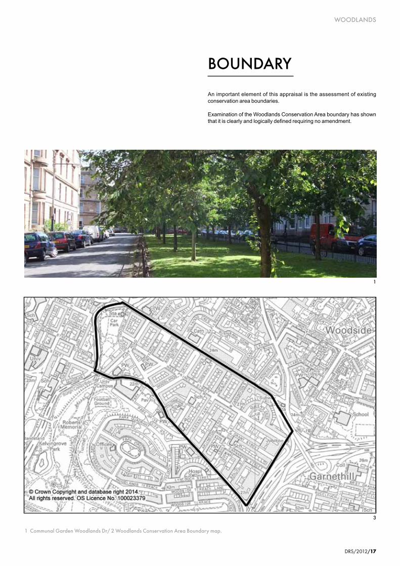
An important element of this appraisal is the assessment of existing conservation area boundaries.
Examination of the Woodlands Conservation Area boundary has shown that it is clearly and logically defined requiring no amendment.
BOUNDARY
3
1 Communal Garden Woodlands Dr/ 2 Woodlands Conservation Area Boundary map.
WOODLANDS
DRS/2012/17
1

WOODLANDS
18/DRS/2014
PRESERVATION AND ENHANCEMENT
1
WOODLANDS
Detailed examination of the conservation area’s character has highlighted opportunities for its preservation and enhancement.
Opportunities for Preservation and Enhancement
Maintenance - The best means of preserving the character and appearance of the Woodlands Conservation Area is through the routine maintenance of buildings. Roofs, domes, statuary, chimneys, windows, doors, guttering, stonework, entrance steps, need regular attention to prolong their life, secure the future of the building and enhance its setting. Regular, coordinated maintenance programmes can help reduce costs in the long term. Parts of Queens Crescent including the garden and fountain are in particular need of focused attention.
Development - Minor works such as the removal of chimneys and replacement or alteration of traditional windows, doors, and roofs with modern styles and materials are evident and can have the cumulative effect of eroding the character and appearance of the conservation area. The City Council, is committed to the preservation of the areas unique character through the application of City Plan policies. Information relating to the key policies which promote the sympathetic design, repair and maintenance of property canbefoundinGLASGOWCITYPLAN2(2009) which is available to view online at www.glasgow.gov.uk/cityplan and at Enquiries, 231 George Street, Glasgow, G1 1RX.
Information and Advice - Property owners and residents have a major role to play in the preservation and enhancement of the Woodlands Conservation Area. To encourage participation the City Council will distribute information leaflets explaining the implications of living in a conservation area and/or listed
1 Detail Queens Cres
18/DRS/2012

DRS/2014/19
WOODLANDS
building. In addition specific guidance for residents/owners wishing to carry out repairs and alterations to their property will be prepared. This information will be available on the Council’s website. Useful names, addresses and contact details are listed at the end of this document
Street Furniture - The rationalisation and coordination of street furniture such as street planters, bollards, pedestrian barriers, litter bins, street signage, street name panels, phone boxes and traffic control boxes would complement the formal lines of the prevailing architecture and reinforce the character of the conservation area. The unique mosaic bollards located throughout the area, while not of traditional design are of local significance being designed by local residents and sponsored by local businesses as part of a community arts project led by Impact Arts.
Stopped-up Streets - The closing of streets to through traffic has been well established for a number of years. The quality of landscaping in these areas requires upgrading and in particular, a maintenance plan for the series of planters should be developed.
Pavements - Repeated excavations by statutory undertakers has resulted in their gradual removal/destruction, so that today the pavement surface generally is a very poor mix of concrete patching and tarmac. Quality surfacing would significantly improve the setting of the buildings and the character and appearance of the conservation area generally. Development Opportunities - The vacant site on the eastern corner of Ashley Street and West Princes Street provides an opportunity for qual i ty new development wi th in Woodlands.
Shopfront Design - Unsympathetic shopfront
designs have a detrimental impact on the architectural integrity of the buildings. The shopfront design policy needs to be applied to prevent the erosion of historical detail and encourage sympathetic designs.
Front Gardens and Railings - The original cast iron railings were largely removed as part of the Second World War effort. Some examples however did survive. Encouragement should be given to the removal of timber fencing, screen walling and treatments which erode the character of the conservation area and the enclosure of front gardens with the re-introduction of original railings/hedging. The restoration of stone boundary/retaining walls would also enhance the character and appearance of the area. The restoration and upgrading of front gardens would improve the setting of the buildings.
Back Lanes - Many of the privately owned back lanes are unsurfaced and in a poor state of repair. The situation is further exacerbated by the proliferation of refuse. While interesting examples of designed gates have been introduced to help reduce the incidence of fly tipping this is still a recurring problem in many areas. At present the City Council offers technical assistance for the upgrading of lanes with costs having to be met from other sources.
Street Lighting - It is important that street lighting fixtures complement the architectural and historical character of the area. All lighting fixtures will be assessed on their merit. The Council’s Land & Environmental Services and Development & Regeneration Services must be satisfied that lighting proposals meet the Council’s design standards with regard to light quality and enhancement of the historic environment.
Kelvinbridge. - While the mature planting and grassed areas provide pleasant walking and
resting areas along the banks of the river, there is still potential for the improvement of the play facilities, the tarmac kick-about space and area around the Kelvinbridge Underground Station.
Graffiti - Graffiti is found throughout the area but is particularly visible on brick walls around the park and on buildings at Kelvinbridge. It is the stone built buildings however that suffer longer-term damage due to the permeability of this natural material. Regularly targeted buildings suffer repeated cleaning to remove the offending graffiti which can have a detrimental affect on the stonework.
Petrol Station, Woodlands Road - This use disrupts the continuity of frontage and street containment in Woodlands Road. Any future plans for this site should seek sensitive design solutions to resolve these issues.
Mil lennium Park - The maintenance/upgrading of surfaces and features within the park, including lighting, is required.
Grants
Owners of historic buildings in the Woodlands Conservation Area may get help with the cost of repairs from the Glasgow City Heritage Trust and Historic Scotland. Eligible works include:-
• repair or reinstatement of originalarchitectural features such as windows, decorative work and railings.
• repairofstructuralelementsincludingmasonry, roofs and joinery.
For further information contact the Glasgow City Heritage Trust, 54 Bell Street, Glasgow, G1 1LQ. Phone: 0141 552 1331. Email:[email protected]

WOODLANDS
20/DRS/2014
ARTICLE 4DIRECTIONS
In addition to the specific conservation area controls mentioned above, further controls apply in the Woodlands Conservation Area called Article 4 Directions. These Directions however only apply to properties within the original Woodlands and Queens Crescent Conservation Areas as shown. The effect of a Direction is to control minor works which, over time, could erode the character and appearance of the conservation area. Article 4 Directions do not preclude the carrying out of these works but planning permission must be sought.
The current Article 4 Directions cover the erection or construction of gates, fences, walls or other means of enclosure and the painting of the exterior of any building. (Class ii of the Town and Country Planning (General Development)(Scotland) Order 1975 and 1981)
Historically, Article 4 Directions have been used as a further way of ensuring that a conservation area maintains its character and appearance. The effect of a Direction is to control minor works which, over time, could erode the character and appearance of a conservation area. In February 2012 however, the Town and Country Planning (Gene ra l Pe rm i t t ed Deve lopmen t ) (Scotland) Amendment Order 2011 came in to force, removing householder Permitted Development Rights within conservation areas.
Properties within conservation areas now have no permitted development rights and therefore all changes to the external appearance of a building, particularly changes to windows, roof materials and painting external walls
now require formal Planning approval if the property is within a conservation area. There are one or two minor exceptions which do not require consent; these include small sheds and decking (neither greater than 4 square metres in floor area) in rear garden areas. The Scottish Ministers have published a guide (Circular 1/2012) which can be found at the following web address http://www.scotland.gov.uk/Publications/2012/02/9140
Article 4 Directions already in place cover the following Classes of Development:-
• Class1Theenlargement,improvementor other alteration of a dwelling house.
• Class3Theprovisionwithinthecurtilageof a dwelling house of any building or enclosure, swimming or other pool required for a purpose incidental to the enjoyment of the dwelling house, or the maintenance, improvement or other alteration of such a building or enclosure.
• Class 7 The erection, construction,maintenance, improvement or other alteration of a gate, fence, wall or other means of enclosure.
• Class 27 The carrying out on landwithin the boundaries of a private road or private way of works required for the maintenance or improvement of the road or way.

DRS/2014/21
WOODLANDS
CITY PLAN
1 Entrance detail, Woodlands Dr
1
Context
The quality and character of the Woodlands Conservation Area will be maintained through the implementation of policies contained within Glasgow City Plan 2 (2009).

WOODLANDS
22/DRS/2014
Useful Publications:-
Glasgow City Council
Glasgow City Plan 2is available on the Council website and details all policies designed to protect and enhance the historic and natural environment. www.glasgow.gov.uk/
Historic Scotland
INFORM Guides, available from Historic Scotland or downloadable from their website. These leaflets give owners of traditional buildings information on repair and maintenance. A series of Guidance Notes on Managing Change in the Historic Environment are also available. www.historic-scotland.gov.uk
Useful Contacts:-
For all planning, conservation, landscape, tree, building control and public safety related enquiries :Development & Regeneration ServicesPhone 0141 287 8555. www.glasgow.gov.uk www.glasgow.gov.uk/heritageanddesign
For all grant enquiries:Glasgow City Heritage TrustPhone 0141 552 1331www.glasgowheritage.org.uk
Additional enquiries:Historic ScotlandPhone 0131 668 8600www.historic-scotland.gov.uk
FURTHER INFORMATION
1 Fence detail, West Princes St
WOODLANDS
22/DRS/2012

DRS/2014/23
WOODLANDS
1 Fence detail, West Princes St
Reed, Peter – Glasgow, The Forming of the City. Edinburgh University Press, 1999.
Urquhart, Gordon R. - Along Great Western Road An Illustrated History of Glasgow’s West End, Stenlake Publishing, 2000
Glasgow District Council - Woodlands Local Plan, May 1984
Tang, Tommy - Victorian Suburbanisation of Glasgow 1830s-1910s, Volume 1(a), Submission for Doctor of Philosophy Degree, University of Strathclyde, Department of Architecture and Building Science, 1995
Williamson, Elizabeth, Riches Anne and Higgs, Malcolm – The Buildings of Scotland, Glasgow. Penguin Books, 1990.
BIBLIOGRAPHY
WOODLANDS
1
DRS/2012/23


For further information and advice relating to conservation areas or heritage issues generally contact :
Planning Services: City Design GroupDevelopment and Regeneration Services
Glasgow City Council229 George Street
GlasgowG1 1QU
Phone : 0141 287 8683
This publication is available in a variety of formats.

Planning Services: City Design GroupDevelopment and Regeneration ServicesGlasgow City Council229 George StreetGlasgowG1 1QUPhone : 0141 287 8683