voyager quarry perth, wa - mundogeo€¦ · voyager quarry perth, wa gatewing and position partners...
TRANSCRIPT

Voyager QuarryPerth, WA
Gatewing and Position PartnersGatewing’s revolutionary mapping system continues to evolve to meet the demands of the Australian user, driven by Position Partners’ commitment to increasing productivity for our customers and building lasting business relationships around high calibre positioning activities.
Our customers’ participation in this evolution has highlighted the interest in, and versatility of, the Gatewing X100 as a rapid response surveying and mapping tool.
Project OverviewThe Voyager Quarry is a crushed granite quarry located near Perth, Western Australia. Its structure is typical of hard rock mines, making it a suitable site to confirm the accuracy of imagery and digital terrain modelling using the Gatewing X100 Unmanned Aerial System (UAS).
Image acquisition and post processing workflow was also validated for a typical volumetric survey conducted with the Gatewing X100. Comparison was then made with a terrestrial laser scan of the quarry.
Project DetailsThe area photographed is approximately 1000m x 600m. In total, 408 images were captured to include adjacent waste dump and processing area.
Ten control points were pre-marked in and around the quarry, to be used as primary and check control; five of those points served as control for the terrestrial laser scan survey.
The pit itself covers an area of approximately 600m x 360m and is approximately 80m deep.
Gatewing OutputOutputs of the Gatewing X100 post processing are georeferenced .tif files for both the orthorectified image and digital elevation model. In this case the Pix4D Cloud solution was utilised to achieve the highest accuracy possible from the imagery.
The accompanying statistical report highlighted the integrity of the ground control and its fit to the photogrammetric block, yielding root mean square (RMS) values of 0.06m in X, Y and Z, which was within expectations. The .tif files were opened in Global Mapper. The orthorectified image was of high quality with seamless joins, good contrast and colour.
Want to find out more? Contact us today:
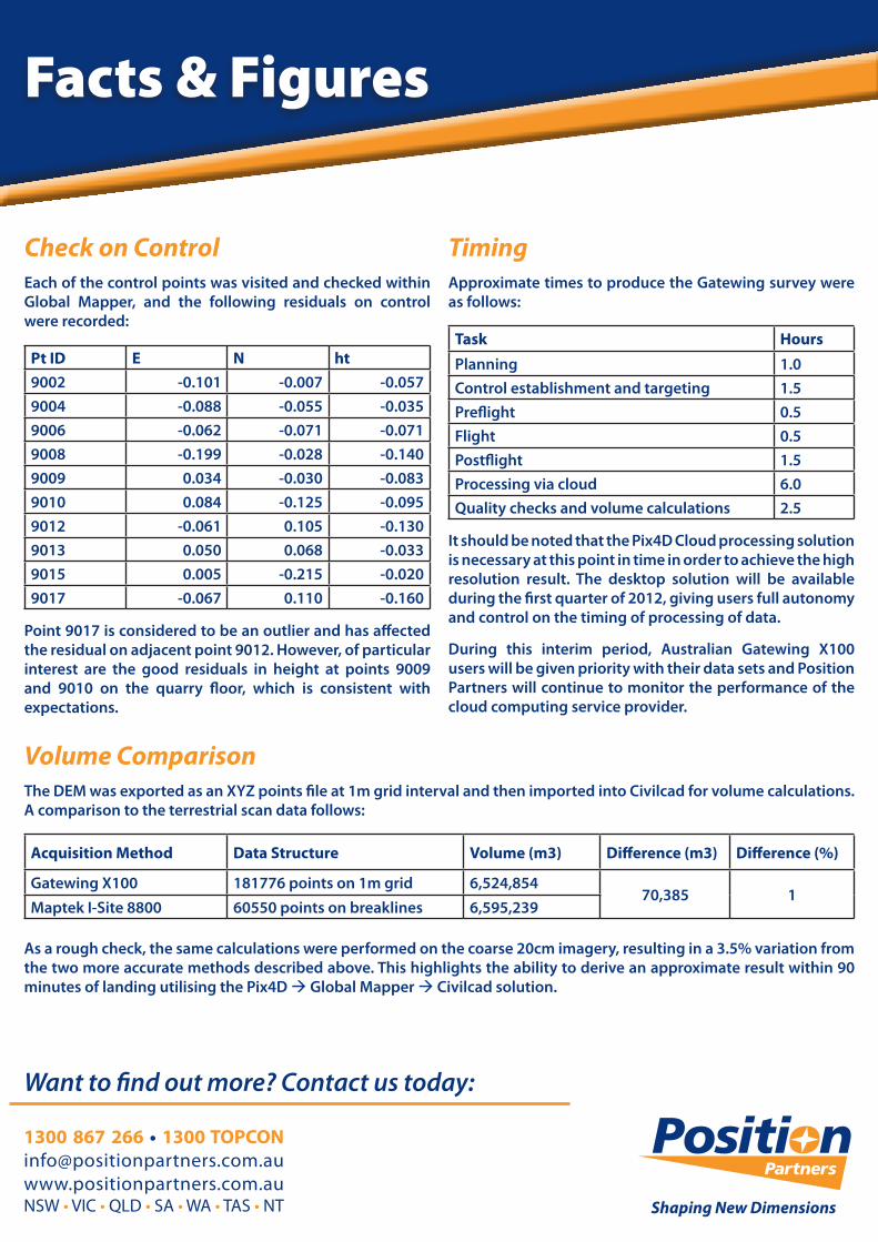
Check on ControlEach of the control points was visited and checked within Global Mapper, and the following residuals on control were recorded:
Pt ID E N ht9002 -0.101 -0.007 -0.0579004 -0.088 -0.055 -0.0359006 -0.062 -0.071 -0.0719008 -0.199 -0.028 -0.1409009 0.034 -0.030 -0.0839010 0.084 -0.125 -0.0959012 -0.061 0.105 -0.1309013 0.050 0.068 -0.0339015 0.005 -0.215 -0.0209017 -0.067 0.110 -0.160
Point 9017 is considered to be an outlier and has affected the residual on adjacent point 9012. However, of particular interest are the good residuals in height at points 9009 and 9010 on the quarry floor, which is consistent with expectations.
TimingApproximate times to produce the Gatewing survey were as follows:
Task HoursPlanning 1.0Control establishment and targeting 1.5Preflight 0.5Flight 0.5Postflight 1.5Processing via cloud 6.0Quality checks and volume calculations 2.5
It should be noted that the Pix4D Cloud processing solution is necessary at this point in time in order to achieve the high resolution result. The desktop solution will be available during the first quarter of 2012, giving users full autonomy and control on the timing of processing of data.
During this interim period, Australian Gatewing X100 users will be given priority with their data sets and Position Partners will continue to monitor the performance of the cloud computing service provider.
Volume ComparisonThe DEM was exported as an XYZ points file at 1m grid interval and then imported into Civilcad for volume calculations. A comparison to the terrestrial scan data follows:
Acquisition Method Data Structure Volume (m3) Difference (m3) Difference (%)
Gatewing X100 181776 points on 1m grid 6,524,85470,385 1
Maptek I-Site 8800 60550 points on breaklines 6,595,239
As a rough check, the same calculations were performed on the coarse 20cm imagery, resulting in a 3.5% variation from the two more accurate methods described above. This highlights the ability to derive an approximate result within 90 minutes of landing utilising the Pix4D à Global Mapper à Civilcad solution.