volume xxxii — reports of international arbitral awards
TRANSCRIPT

REPORTS OF INTERNATIONAL ARBITRAL AWARDS
RECUEIL DES SENTENCES ARBITRALES
VOLUME XXXII

ST/LEG/RIAA/32(The first twenty-two volumes in this series
were issued without a document symbol.)
UNITED NATIONS PUBLICATIONSales No. B.19.V.16
ISBN 978-92-1-130381-0eISBN: 978-92-1-004075-4
ISSN: 0251-7833eISSN: 2412-088X
Copyright © 2019 United NationsAll rights reserved
Manufactured in the United States of America

REPORTS OF INTERNATIONALARBITRAL AWARDS
RECUEIL DES SENTENCES ARBITRALES
VOLUME XXXII
UNITED NATIONS — NATIONS UNIES


v
TABLE OF CONTENTS
TABLE DES MATIÈRES
Foreword . . . . . . . . . . . . . . . . . . . . . . . . . . . . . . . . . . . . . . . . . . . . . . . viiAvant-propos . . . . . . . . . . . . . . . . . . . . . . . . . . . . . . . . . . . . . . . . . . . . . ix
PART I — PARTIE I
The Bay of Bengal Maritime Boundary Arbitration between the People’s Republic of Bangladesh and the Republic of India, Award of 7 July 2014 . . . . . . . . . . . . . . . . . . . . . . . . . . . . . . . . . . . . 1
Arbitrage entre la République populaire du Bangladesh et la République de l’Inde concernant la frontière maritime dans le golfe du Bengale, sentence du 7 juillet 2014. . . . . . . . . . . . . . . . . 1Concurring and Dissenting Opinion of Dr. P.S. Rao . . . . . . . . . . 161Opinion concordante et dissidente du Dr. P.S. Rao . . . . . . . . . . . 161
PART II — PARTIE II
Award in the Arbitration regarding the Arctic Sunrise . . . . . . . . . . . 183Sentence arbitrale relative à l’affaire de l’Arctic Sunrise. . . . . . . . . . . 183
Award on Jurisdiction, 26 November 2014 . . . . . . . . . . . . . . . . . . 185Sentence sur la compétence, 26 novembre 2014 . . . . . . . . . . . . . 185Award on the Merits, 14 August 2015 . . . . . . . . . . . . . . . . . . . . . . 205Sentence sur le fond, 14 août 2015 . . . . . . . . . . . . . . . . . . . . . . . . . 205Award on Compensation, 10 July 2017 . . . . . . . . . . . . . . . . . . . . . 315Sentence sur la compensation, 10 juillet 2017 . . . . . . . . . . . . . . . 315


vii
FOREWORDThe present volume reproduces the awards in two arbitration cases, name-
ly, the Bay of Bengal Maritime Boundary Arbitration, between Bangladesh and India, and the case between the Netherlands and the Russian Federation in the matter of the Arctic Sunrise.
This publication was originally conceived in 1948 as a collection of inter-national awards or decisions rendered between States, including cases involv-ing espousing or respondent Governments on behalf of individual claim-ants. In principle, awards between a private individual or body and a State or international organization were excluded. However, some awards between a State and other entities, or between non-State entities, have exceptionally been included, given the significance of the issues of general international law addressed.
In accordance with the practice followed in this series, the awards are presented in chronological order. Awards in English or French are published in the original language, as long as the original language text was available. Those in both languages are published in one of the original languages. Awards in other languages are published in English. A footnote indicates when the text reproduced is a translation made by the Secretariat. In order to facilitate con-sultation of the awards, headnotes are provided in both English and French. In line with previous volumes, only typographical errors made in the original awards have been edited by the Secretariat, with the remainder of the Award reproduced as in its original form of publication. A selection of maps consid-ered by the Arbitral Tribunal in the Bay of Bengal Maritime Boundary case is to be found in the front and back pockets.
This volume was prepared by the Codification Division of the Office of Legal Affairs, in collaboration with the Secretariat of the Permanent Court of Arbitration. Further information and electronic copies of each volume can be found at http://legal.un.org/riaa/.


ix
AVANT-PROPOSLe présent volume reproduit les sentences rendues dans deux procé-
dures d’arbitrage, à savoir celle opposant le Bangladesh et l’Inde concernant la délimitation de la frontière maritime du golfe du Bengale et celle opposant les Pays-Bas et la Fédération de Russie dans l’affaire de l’Arctic Sunrise.
La présente publication a été conçue en 1948 en tant que Recueil de sen-tences et de décisions internationales rendues dans des affaires opposant des États, y compris celles dans lesquelles des gouvernements prenaient fait et cause pour des particuliers ou se portaient défendeurs à leur place. En étaient en principe exclues les sentences rendues dans les affaires opposant une per-sonne de droit privé à un État ou à une organisation internationale. Certaines sentences rendues dans des affaires opposant un État à d’autres entités ou des entités non étatiques entre elles y ont toutefois été exceptionnellement inclus-es, compte tenu de l’importance des questions de droit international général qu’elles soulevaient.
Conformément à la pratique suivie dans le présent Recueil, les sentences sont reproduites ci-après par ordre chronologique. Les sentences rendues en anglais ou en français sont publiées dans la langue originale, dès lors que cette version originale était disponible. Celles qui ont été rendues en anglais et en français ont été reproduites dans une des deux langues originales. Le Recueil fournit une version anglaise des sentences rendues dans d’autres langues en spécifiant, dans une note de bas de page, si la traduction émane du Secrétar-iat de l’Organisation des Nations Unies. Pour faciliter autant que possible la consultation des sentences, celles-ci sont précédées d’un sommaire publié à la fois en anglais et en français. Comme dans les volumes précédents, seules les erreurs typographiques relevées dans les versions originales ont été corrigées par le Secrétariat, les sentences étant pour le reste reproduites telles quelles. Une sélection de cartes examinées par le tribunal arbitral dans l’affaire concer-nant la frontière maritime dans le golfe du Bengale se trouve dans les poches avant et arrière.
Le présent volume a été compilé par la Division de la codification du Bureau des affaires juridiques, en collaboration avec le secrétariat de la Cour permanente d’arbitrage. Des informations complémentaires et la version élec-tronique de chaque volume sont disponibles à l’adresse http://legal.un.org/riaa/.

PART I
The Bay of Bengal Maritime Boundary Arbitration between the People’s Republic of Bangladesh and
the Republic of India
Award of 7 July 2014
PARTIE I
Arbitrage entre la République populaire du Bangladesh et la République de l’Inde concernant la frontière maritime
dans le golfe du Bengale
Sentence du 7 juillet 2014


The Bay of Bengal Maritime Boundary Arbitration between the People’s Republic of Bangladesh and the
Republic of India, Award of 7 July 2014
Arbitrage entre la République populaire du Bangladesh et la République de l’Inde concernant la frontière
maritime dans le golfe du Bengale, sentence du 7 juillet 2014
1. The DisputeDelimitation of maritime boundary under article 15 of UNCLOS—Delimitation
of exclusive economic zone under article 74 of UNCLOS—Delimitation of continental shelf under article 83 of UNCLOS—Overall objective of delimitation to achieve equi-table solution.
2. Tribunal’s jurisdictionBangladesh and India are parties to UNCLOS—Dispute settlement provi-
sions in Part XV are binding—In absence of declaration under paragraph 1 of arti-cle 287 of UNCLOS parties deemed to have accepted arbitration in accordance with Annex VII—Both parties put forward overlapping claims to continental shelf beyond 200 nm—Both parties agree that Tribunal has jurisdiction to delimit continental shelf beyond 200 nm—Delimitation of lateral boundary of continental shelf by an interna-tional court or tribunal is without prejudice to delineation of outer limits of that shelf on basis of recommendation of Commission on the Limits of the Continental Shelf—Tribunal has jurisdiction to identify land boundary terminus and delimit territorial sea, exclusive economic zone, and continental shelf between parties within and beyond 200 nm in areas where claims of the parties overlap.
3. Delimitation of land boundary terminusDetermination of land boundary terminus as starting point of maritime bound-
ary delimitation—1947 Radcliffe Award as basis for determination of land boundary terminus—Dispute between parties as to interpretation of Radcliffe Award—uti possi-detis juris principle does not contribute to determination of land boundary terminus.
Concern is physical reality at time of delimitation—Delimitation of maritime spaces different from determination of land boundary terminus—Tribunal to delimit territorial sea, exclusive economic zone, and continental shelf by choosing base points appropriate at time of delimitation—Potential effect of climate change on coastlines in future not relevant—Possibility of changing maritime boundary would defeat purpose of delimitation—Appropriate base points determined by reference to physical geogra-phy at time of delimitation and to low-water line of relevant coasts.
4 Bangladesh/India
4. Selection of base points and delimitation of territorial seaArticle 15 of UNCLOS applicable—Parties disagree on interpretation and exist-
ence of “special circumstances” and method of delimitation—General configuration of coast in Bay of Bengal not relevant to delimitation of narrow belt of territorial sea—Construction of equidistance line by identifying base points relevant for delimitation of territorial sea and then identifying median/equidistance line—No special circum-stances requiring approach other than median/equidistance line.
Delimitation of territorial sea to start from land boundary terminus—Low-tide ele-vations used as baselines for measuring breadth of territorial sea (article 13 of UNCLOS) not necessarily appropriate for maritime delimitations between States with adjacent or opposite coasts—Alternative base points situated on coastline of parties to be preferred to base points located on low-tide elevations—Concavity of Bay of Bengal does not pro-duce significant cut-off to qualify as special circumstances warranting adjustment of median line—Need to connect land boundary terminus to median line constructed by Tribunal for delimitation of territorial sea constitutes special circumstances.
5. Relevant coasts and relevant area for delimitation beyond territorial seaConcept of “relevant coasts” plays role in process of maritime boundary delim-
itation—Identification of relevant coasts for delimitation in general and depiction of general direction of coast when applying angle-bisector method are two distinct operations—Necessary to identify relevant coasts in order to determine overlapping claims—Relevant coasts also to be ascertained in order to determine, in third and final stage of delimitation process, existence of disproportionality in ratios of coastal length of each State and maritime areas falling either side of delimitation line—Axiomatic for delimitation of maritime boundary that “land dominates the sea”—Coastal projec-tions in seaward direction generate maritime claims—In order to be considered rele-vant for purpose of delimitation coast must generate projections which overlap with projections from coast of other party—Submarine extension of any part of coast of one party which, because of its geographic situation, cannot overlap with extension of coast of other, to be excluded from consideration—In practice, relevance of any segment of coast of a party depends upon identification of projections generated by that coast.
Parties agree with respect to coast of Bangladesh but disagree on relevant seg-ments of Indian coast—Relevant coast of Bangladesh extends from land boundary ter-minus with India to that with Myanmar along points identified by International Tri-bunal of the Sea—In determining relevant coast of India, no basis for distinguishing between projections within 200 nm and those beyond—Indian coast relevant to extent that its projection generates overlap with projection generated by coast of Bangladesh, irrespective of where overlap occurs—Establishment of projection generated by coast of a State through ascertainment of whether coastal frontages abut as a whole upon disputed area by a radial or directional presence relevant to delimitation—Projection of coast of one party may be overlapped by projections of multiple segments of coast of the other—Task of Tribunal to identify those sections of coast that generate overlap-ping projections—Projections from coast of Andaman Islands overlapping with coast of Bangladesh also to be taken into account in calculation of relevant area—Determi-nation of relevant coast of India—Identification of relevant area on basis of relevant coasts as determined by Tribunal.
Bay of Bengal Maritime Boundary Arbitration 5
6. Delimitation of exclusive economic zone and continental shelf within and beyond 200 nm
Articles 74, paragraph 1, and 83, paragraph 1, of UNCLOS govern delimitation of exclusive economic zone and continental shelf within 200 nm—Construction of equidistance line is first step of delimitation process—Parties disagree on centrality of equidistance method and circumstances necessitating angle-bisector method—Tribu-nal to consider existence of a presumption in favour of equidistance/relevant circum-stances method, and application of such method in present case.
In absence of indication in articles 74 and 83 of UNCLOS as to specific method of delimitation international courts and tribunals to be guided by paramount objec-tive that method chosen is designed to lead to an equitable result, and that such result be achieved—International case law constitutes an acquis judiciare, and should be read into article 74 and 83—First stage of equidistance/relevant circumstances meth-od involves identification of a provisional equidistance line using methods that are geometrically objective and also appropriate for geography of area—Second stage calls for consideration of relevant circumstances necessitating adjustment of provisional equidistance line in order to achieve equitable result—Third stage consists of ex post facto check of non-disproportionality of result reached at second stage—Advantage of equidistance/relevant circumstances method over angle-bisector methods is that former is more transparent since equidistance line is based on geometrically objective criteria, while account is taken of geography of area through selection of appropriate base points—Depicting relevant coasts as straight lines under angle-bisector meth-od involves subjective considerations—Equidistance/relevant circumstances method preferable unless there are factors which make application of equidistance method inappropriate—Application of equidistance/relevant circumstances method appropri-ate in present case.
In identifying base points for establishing provisional equidistance line in exclu-sive economic zone and continental shelf within 200 nm Tribunal must assess appro-priateness of base points chosen by parties or choose different base points—Provision-al equidistance line determined on basis of some of base points proposed by parties together with additional base points determined by Tribunal.
Purpose of adjusting an equidistance line not to refashion geography, or to com-pensate for inequalities of nature; no question of distributive justice—In determining existence of relevant circumstances necessitating adjustment of an equidistance line, fact that any delimitation results in exercise of coastal States’ sovereign rights over continental shelf off its coast to full extent authorized by international law has to be borne in mind—Instability of coast not relevant circumstance justifying adjustment of provisional equidistance line—Only present geophysical conditions relevant—Future changes of coast, including those resulting from climate change, cannot be taken into account in adjusting a provisional equidistance line—Concavity of a coast does not necessarily constitute a relevant circumstance requiring adjustment of a provisional equidistance line—Existence of cut-off effect to be established on an objective basis and in a transparent manner, taking into account whole area in which competing claims have been made—Configuration and extent of parties’ entitlements to areas of conti-nental shelf beyond 200 nm may equally be of relevance—Coast of Bangladesh mani-festly concave—As result of concavity of coast provisional equidistance line produces a

6 Bangladesh/India
cut-off effect on seaward projections of Bangladesh coast—Cut-off constitutes relevant circumstance requiring adjustment of provisional equidistance line—In determining extent of adjustment entitlement of a State to reach continental shelf beyond 200 nm is not only relevant consideration—Tribunal must examine geographic situation as a whole—Judgment of ITLOS in Bangladesh/Myanmar is res inter alios acta—Cut-off produced by provisional equidistance line must meet two criteria to warrant adjust-ment of provisional equidistance line—First, line must prevent a coastal State from extending its maritime boundary as far seaward as international law permits—Second, line must be such that – if not adjusted – it would fail to achieve equitable solution required by articles 74 and 83 of UNCLOS—Requires assessment of where disadvan-tage of cut-off materializes and of its seriousness, with due regard given to avoiding encroachment on entitlements of third States and that of India, including that arising from Andaman Islands—Provisional equidistance line in present case does not pro-duce an equitable result and must be adjusted in order to avoid unreasonable cut-off effect to detriment of Bangladesh—Insufficient evidence of dependence on fishing in Bay of Bengal to justify adjustment of provisional equidistance line—Extent of adjust-ment to be determined taking into account also any cut-off in area beyond 200 nm.
Article 83 of UNCLOS applicable to delimitation of continental shelf beyond 200 nm—Delimitation also calls for interpretation of article 76 of UNCLOS—Tribunal only to establish delimitation line in area beyond 200 nm where entitlements overlap—Tribunal to assess appropriateness of base points chosen by parties or choose different base points—Same method for delimitation of continental shelf within 200 nm (equi-distance/relevant circumstances) applicable to continental shelf beyond 200 nm—International jurisprudence on delimitation of continental shelf does not recognize general rights of coastal States to maximum reach of their entitlements, irrespective of geographical situation and rights of other coastal States—As with continental shelf and exclusive economic zone within 200 nm, area attributed to Bangladesh in area beyond 200 nm limited in scope in comparison to area in which entitlements of parties over-lap—Coastal State has an entitlement if its coast projects in area claimed—Accord-ingly, provisional equidistance line requires adjustment beyond (as well as within) 200 nm to produce equitable result—In determining such adjustment Tribunal to seek to ameliorate excessive negative consequences provisional equidistance line would have on entitlement of Bangladesh, both within and beyond 200 nm, in a manner that does not unreasonably encroach on entitlement of India—Adjustment of provisional equidistance line must also not infringe upon rights of third States—Tribunal estab-lishes adjusted line delimiting exclusive economic zone and continental shelf between Bangladesh and India within and beyond 200 nm.
Final step in delimitation process involves ensuring delimitation line does not yield disproportionate result—Disproportionality test compares ratio of relevant mari-time space accorded to each party to ratio of parties’ relevant coastal lengths—Propor-tionality not a mathematical exercise that results in attribution of maritime areas as a function of length of coasts or other ratio calculations—Maritime delimitation is not designed to produce a correlation between lengths of parties’ relevant coasts and their respective shares of relevant area—Not function of Tribunal to refashion nature—Responsibility of Tribunal to check, ex post facto, equitableness of delimitation line it has constructed—What constitutes disproportionality varies from case to case—Sig-nificant disproportionality to be avoided—Tribunal to assess existence of significant

Bay of Bengal Maritime Boundary Arbitration 7
disproportionality by reference to overall geography of area—Ratio of allocated areas in comparison to ratio between lengths of relevant coasts in present case does not produce significant disproportion to require alteration of adjusted equidistance line.
Tribunal’s delimitation gives rise to “grey area” east of line beyond 200 nm of Bangladesh coast but within 200 nm of Indian coast—Since grey area lies beyond 200 nm Bangladesh has no entitlement to exclusive econom-ic zone—Tribunal only to delimit overlapping entitlements—No delimitation in grey area, except with respect to continental shelf—Within area beyond 200 nm of coast of Bangladesh and within 200 nm of that of India, boundary identified by Tribunal delimits parties’ sovereign rights to explore continental shelf and to exploit mineral and other non-living resources of seabed and sub-soil together with living organisms belonging to sedentary species (article 77 of UNCLOS)—Within grey area, boundary does not otherwise limit India’s sovereign rights to exclusive economic zone in superjacent waters—Delimita-tion without prejudice to rights of India vis-à-vis Myanmar in respect of water column in area where exclusive economic zone claims of India and Myanmar overlap—UNCLOS envisages possibility of shared rights and duties of parties to be exercised with due regard to rights and duties of other States—For parties to determine appropriate measures, including through conclusion of further agreements or cooperative arrangements.
1. DifférendDélimitation de la frontière maritime conformément à l’article 15 de la Conven-
tion des Nations Unies sur le droit de la mer—Délimitation de la zone économique exclusive conformément à l’article 74 de la Convention—Délimitation du plateau con-tinental conformément à l’article 83 de la Convention—Objectif général de la délimi-tation étant d’aboutir à une solution équitable.
2. Compétence du tribunalLe Bangladesh et l’Inde sont parties à la Convention des Nations Unies sur le
droit de la mer—Les dispositions de la partie XV relatives au règlement des différends sont contraignantes—En l’absence de déclaration faite en application du paragraphe 1 de l’article 287 de la Convention, les parties sont réputées avoir accepté la procédure d’arbitrage prévue à l’annexe VII de la Convention—Les deux parties ont émis des revendications concurrentes sur le plateau continental au-delà de 200 milles marins—Les deux parties conviennent que le tribunal a compétence pour délimiter le plateau continental au-delà de 200 milles marins—La délimitation des limites latérales du plateau continental par une cour ou un tribunal international est sans préjudice de la délimitation de la limite extérieure de ce plateau sur recommandation de la Com-mission des limites du plateau continental—Le tribunal est compétent pour définir le point terminal de la frontière terrestre et pour délimiter la mer territoriale, la zone économique exclusive et le plateau continental entre les parties en deçà et au-delà de 200 milles marins dans les zones où se chevauchent les revendications des parties.

8 Bangladesh/India
3. Délimitation du point terminal de la frontière terrestreDétermination du point terminal de la frontière terrestre comme point de départ
de la délimitation de la frontière maritime—La détermination du point terminal de la frontière terrestre se fonde sur la Sentence Radcliffe de 1947—Différend entre les par-ties quant à l’interprétation de la sentence Radcliffe—Principe de l’uti possidetis juris sans intérêt pour déterminer le point terminal de la frontière terrestre.
Ce qui compte, c’est la réalité physique au moment de la délimitation—La délim-itation des espaces maritimes est différente de la détermination du point terminal de la frontière terrestre—Il appartient au tribunal de délimiter la mer territoriale, la zone économique exclusive et le plateau continental en choisissant les points de base appro-priés au moment de la délimitation—L’effet potentiel des changements climatiques sur les côtes à l’avenir est indifférent—La possibilité de modifier la frontière maritime ferait échec au but de la délimitation—Les points de base appropriés doivent être déter-minés par référence à la géographie physique au moment de la délimitation et au niveau de la laisse de basse mer des côtes pertinentes.
4. Choix des points de base et délimitation de la mer territorialeL’article 15 de la Convention est applicable—Les parties s’opposent sur l’inter-
prétation et l’existence de « circonstances spéciales » et sur la méthode de délimitation—La configuration générale de la côte dans le golfe du Bengale est indifférente pour la délimitation de l’étroite bande de mer territoriale—La construction de ligne d’équidis-tance passe par la définition des points de base pertinents pour la délimitation de la mer territoriale puis par la détermination de la ligne médiane/d’équidistance—Il n’existe pas de circonstances spéciales nécessitant une méthode autre que celle de l’équidistance.
La délimitation de la mer territoriale doit être tracée à partir du point terminal de la frontière terrestre—Les hauts-fonds découvrants utilisés comme ligne de base pour mesurer la largeur de la mer territoriale (article 13 de la Convention) ne sont pas néces-sairement appropriés pour délimiter les zones maritimes entre États dont les côtes sont adjacentes ou se font face—D’autres points de base situés sur le littoral des parties doivent être préférés aux points de base situés sur les hauts-fonds découvrants—Le caractère concave du golfe du Bengale ne produit pas un effet d’amputation suffisant pour être considéré comme des circonstances spéciales justifiant un ajustement de la ligne médiane—La nécessité de relier le point terminal de la frontière terrestre à la ligne médiane construite par le tribunal pour délimiter la mer territoriale constitue des circonstances spéciales.
5. Côtes et zone pertinentes pour la délimitation au-delà de la mer territorialeLa notion de « côtes pertinentes » joue un rôle dans le processus de délimitation
de la frontière maritime—La définition des côtes pertinentes pour la délimitation en général et la représentation de la direction générale des côtes lors de l’application de la méthode de la bissectrice sont deux opérations distinctes—Il est nécessaire de définir les côtes pertinentes pour statuer sur les prétentions concurrentes—Les côtes pertinentes doivent également être définies pour déterminer, au troisième et dernier stade du pro-cessus de délimitation, s’il y a disproportion entre le rapport des longueurs des côtes de chaque partie et celui des zones maritimes situées de part et d’autre de la ligne de délimitation—En matière de délimitation des frontières maritimes, il est de règle que

Bay of Bengal Maritime Boundary Arbitration 9
« la terre domine la mer »—Les projections côtières vers la mer font naître des revendi-cations maritimes—Pour qu’une côte soit considérée pertinente dans une délimitation maritime, il faut qu’elle produise des projections qui chevauchent celles de la côte d’une autre partie—Le prolongement sous-marin de toute portion de côte d’une partie qui, du fait de sa situation géographique, ne peut chevaucher le prolongement de la côte de l’autre partie, doit être exclu de l’examen—Dans la pratique, la pertinence d’un segment de la côte d’une partie dépend de la détermination des projections produites par cette côte.
Les parties s’accordent sur la côte du Bangladesh mais s’opposent sur les segments pertinents de la côte de l’Inde—La côte pertinente du Bangladesh s’étend du point ter-minal de la frontière terrestre avec l’Inde à celle avec le Myanmar le long des points déterminés par le Tribunal international du droit de la mer—Pour déterminer la côte pertinente de l’Inde, il n’y a aucune raison de distinguer les projections en deçà des 200 milles marins et au-delà—La côte de l’Inde est pertinente dans la mesure où sa projection produit un chevauchement avec celle produite par la côte du Bangladesh, quel que soit le lieu de chevauchement—Pour établir la projection produite par la côte d’un État, il faut vérifier si les façades côtières dans l’ensemble sont contiguës à la zone en litige par une présence radiale ou directionnelle pertinente pour la délimitation—La projection de la côte d’une partie peut être recouverte par les projections de multiples segments de côte de l’autre—Il appartient au tribunal de définir les sections de côte qui produisent des pro-jections qui se chevauchent—Les projections de la côte des îles Andaman chevauchant la côte du Bangladesh doivent également être prises en compte dans le calcul de la zone pertinente—Détermination de la côte pertinente de l’Inde—La zone pertinente doit être définie à partir des côtes pertinente déterminées par le tribunal.
6. Délimitation de la zone économique exclusive et du plateau continental en deçà et au delà de 200 milles marins
Le paragraphe 1 de l’article 74 et le paragraphe 1 de l’article 83 de la Convention régissent la délimitation de la zone économique exclusive et du plateau continental en deçà de 200 milles marins—La construction d’une ligne d’équidistance est la première étape du processus de délimitation—Les parties s’opposent sur le caractère central de la méthode de l’équidistance et sur les circonstances nécessitant l’application de la méthode de la bissectrice—Le tribunal doit examiner l’existence d’une présomption en faveur de la méthode de l’équidistance/des circonstances pertinentes et son application en l’espèce.
Les articles 74 et 83 de la Convention étant muets quant à la méthode spécifique de délimitation, les cours et tribunaux internationaux doivent être guidés par l’ob-jectif primordial selon lequel la méthode choisie doit être conçue pour aboutir à un résultat équitable et que ce résultat doit être atteint—La jurisprudence internationale constitue un acquis judiciaire et doit être considérée comme faisant partie des arti-cles 74 et 83 de la Convention—La première étape de la méthode de l’équidistance/des circonstances pertinentes consiste à établir une ligne d’équidistance provisoire en utilisant des méthodes objectives d’un point de vue géométrique et adaptées à la géographie de la zone à délimiter—La deuxième étape consiste à examiner les fac-teurs appelant un ajustement de la ligne d’équidistance provisoire afin de parvenir à un résultat équitable—La troisième étape consiste à vérifier a posteriori l’absence de disproportion du résultat atteint à la deuxième étape—L’avantage de la méthode de l’équidistance/des circonstances pertinentes par rapport à la méthode de la bissectrice

10 Bangladesh/India
est que la première est plus transparente dans la mesure où la ligne d’équidistance repose sur des critères objectifs d’un point de vue géométrique tout en tenant compte de la géographie de la zone par le choix de points de base appropriés—La description des côtes pertinentes comme des lignes droites selon la méthode de la bissectrice com-porte des considérations subjectives—La méthode de l’équidistance/des circonstances pertinentes est préférable sauf s’il existe des facteurs qui en rendent l’application ina-daptée—L’application de la méthode de l’équidistance/des circonstances pertinentes est adaptée en l’espèce.
Pour déterminer les points de base nécessaires à l’établissement d’une ligne d’équidistance provisoire dans la zone économique exclusive et sur le plateau conti-nental en deçà de 200 milles marins, le tribunal doit apprécier la pertinence des points de base choisis par les parties ou en choisir d’autres—La ligne d’équidistance provi-soire est déterminée à partir de certains des points de base proposés par les parties et de points de base supplémentaires déterminés par le tribunal.
L’ajustement d’une ligne d’équidistance n’a pas pour but de refaçonner la géogra-phie ou de compenser les inégalités naturelles ; il n’est pas question de justice distrib-utive—Lors de la détermination de l’existence de circonstances pertinentes appelant l’ajustement d’une ligne d’équidistance, le fait que toute délimitation entraîne l’exercice des droits souverains des États côtiers sur le plateau continental au large de leur côte dans toute la mesure autorisée par le droit international doit être pris en compte—L’in-stabilité de la côte n’est pas une circonstance pertinente justifiant l’ajustement de la ligne d’équidistance provisoire—Seules les conditions géophysiques présentes sont pertinentes—Les changements futurs du littoral, y compris ceux qui résultent des changements climatiques, ne peuvent pas être pris en compte pour ajuster une ligne d’équidistance provisoire—Le caractère concave d’une côte ne constitue pas néces-sairement une circonstance pertinente appelant l’ajustement d’une ligne d’équidistance provisoire—L’existence d’un effet d’amputation doit être établie de manière objective et transparente, compte tenu de l’ensemble de la zone faisant l’objet de revendications concurrentes—La configuration et l’étendue des droits des parties sur les zones du pla-teau continental au-delà de 200 milles marins peuvent également être pertinentes—La côte du Bangladesh est manifestement concave—Du fait de la concavité de la côte, la ligne d’équidistance provisoire produit un effet d’amputation sur les projections mar-itimes de la côte du Bangladesh—L’amputation constitue une circonstance pertinente appelant un ajustement de la ligne d’équidistance provisoire—Pour déterminer l’éten-due de l’ajustement, le droit d’un État sur le plateau continental au-delà de 200 milles marins n’est pas le seul élément à prendre en considération—Le tribunal doit examiner la situation géographique dans son ensemble—L’arrêt rendu par le Tribunal interna-tional du droit de la mer dans l’affaire opposant le Bangladesh et le Myanmar est res inter alios acta—Deux conditions doivent être remplies pour que l’amputation produite par la ligne d’équidistance provisoire justifie un ajustement de la ligne d’équidistance provisoire—Premièrement, la ligne doit empêcher un État côtier d’étendre sa frontière maritime aussi loin au large que le permet le droit international—Deuxièmement, la ligne doit être telle que, faute d’ajustement, elle n’aboutirait pas à la solution équitable exigée par les articles 74 et 83 de la Convention—Il convient d’évaluer le lieu de matéri-alisation de l’amputation et sa gravité, compte dûment tenu de la nécessité d’éviter tout empiètement sur les titres des États tiers et sur ceux de l’Inde, y compris ceux décou-lant des îles Andaman—La ligne d’équidistance provisoire en l’espèce ne produit pas
Bay of Bengal Maritime Boundary Arbitration 11
un résultat équitable et doit être ajustée afin d’éviter un effet d’amputation excessif au détriment du Bangladesh—Les preuves de dépendance vis-à-vis de la pêche dans le golfe du Bengale sont insuffisantes pour justifier un ajustement de la ligne d’équidistance provisoire—L’étendue de l’ajustement doit être déterminée en tenant compte également de toute amputation dans la zone au-delà de 200 milles marins.
L’article 83 de la Convention des Nations Unies sur le droit de la mer est applicable à la délimitation du plateau continental au-delà de 200 milles marins—La délimitation exige également d’interpréter l’article 76 de la Convention—Il appartient seulement au tribunal d’établir la ligne de délimitation dans la zone au-delà de 200 milles marins où les titres se chevauchent—Le tribunal doit apprécier la pertinence des points de base choisis par les parties ou en choisir d’autres—La méthode utilisée pour délimiter le plateau continental en deçà de 200 milles marins (équidistance/circonstances per-tinentes) est applicable au plateau continental au delà de 200 milles marins—La juris-prudence internationale sur la délimitation du plateau continental ne reconnaît pas le droit général des États côtiers à la portée maximale de leurs titres, indépendamment de la situation géographique et des titres des autres États côtiers—Comme dans le cas du plateau continental et de la zone économique exclusive en deçà de 200 milles marins, la zone attribuée au Bangladesh dans la zone au-delà de 200 milles marins a une portée limitée par rapport à la zone de chevauchement des titres des parties—L’État côtier a un titre si sa côte se projette dans la zone revendiquée—En conséquence, la ligne d’équidistance provisoire doit être ajustée au-delà (ainsi qu’en deçà) de 200 milles marins pour aboutir à un résultat équitable—Pour déterminer cet ajustement, le tribu-nal doit chercher à atténuer les conséquences négatives excessives que la ligne d’équi-distance provisoire pourrait avoir sur les titres du Bangladesh, tant en deçà qu’au-delà de 200 milles marins, d’une manière qui n’empiète pas excessivement sur les titres de l’Inde—L’ajustement de la ligne équidistante provisoire ne doit pas non plus porter atteinte aux droits des États tiers—Le tribunal établit une ligne ajustée délimitant la zone économique exclusive et le plateau continental entre le Bangladesh et l’Inde en deçà et au-delà de 200 milles marins.
L’étape finale du processus de délimitation consiste à vérifier que la ligne de délimitation ne produit pas un résultat disproportionné—La vérification de l’ab-sence de disproportion consiste à comparer le rapport de l’espace maritime pertinent accordé à chaque partie au rapport des longueurs des côtes des parties—La proportion n’est pas une opération mathématique qui entraîne l’attribution de zones maritimes selon la longueur des côtes ou autres calculs—La délimitation maritime ne vise pas à établir une corrélation entre les longueurs des côtes pertinentes des parties et leurs parts respectives de la zone pertinente—Il n’appartient pas au tribunal de remodeler la nature—Il incombe au tribunal de vérifier a posteriori le caractère équitable de ligne de délimitation qu’il a retenue—La définition de l’absence de proportion varie d’un cas à l’autre—Toute disproportion marquée doit être évitée—Le tribunal évalue l’existence de disproportion marquée par rapport à la géographie générale de la zone—Le rapport des zones attribuées comparé au rapport entre les longueurs des côtes pertinentes en l’espèce ne produit pas une disproportion marquée appelant une modification de la ligne d’équidistance ajustée.
La délimitation du tribunal donne lieu à une « zone grise » à l’est de la ligne au-delà de 200 milles marins de la côte du Bangladesh mais en deçà de 200 milles marins de la côte de l’Inde—La zone grise étant située au-delà de 200 milles marins, le Bangladesh

12 Bangladesh/India
n’a pas droit à une zone économique exclusive—Il appartient seulement au tribunal de statuer sur les titres qui se chevauchent—Il n’y a pas de délimitation dans la zone grise, sauf en ce qui concerne le plateau continental—Dans la zone située au-delà des 200 milles marins de la côte du Bangladesh et en deçà des 200 milles marins de celle de l’Inde, la frontière déterminée par le tribunal délimite les droits souverains des parties à explorer le plateau continental et à exploiter les ressources minérales et autres res-sources non biologiques des fonds marins et de leur sous-sol, ainsi que les organismes vivants qui appartiennent aux espèces sédentaires (art. 77 de la Convention)—Dans la zone grise, la frontière ne limite pas d’une autre manière les droits souverains de l’Inde à une zone économique exclusive dans les eaux surjacentes—La délimitation est sans préjudice des droits de l’Inde vis-à-vis du Myanmar en ce qui concerne la colonne d’eau dans la zone de chevauchement des revendications de l’Inde et du Myanmar relatives à la zone économique exclusive—La Convention envisage la possibilité que les droits et obligations partagés des parties soient exercés en tenant dûment compte des droits et obligations des autres États—Il appartient aux parties de déterminer les mesures appro-priées, notamment par la conclusion d’autres accords ou arrangements de coopération.
* * * * *
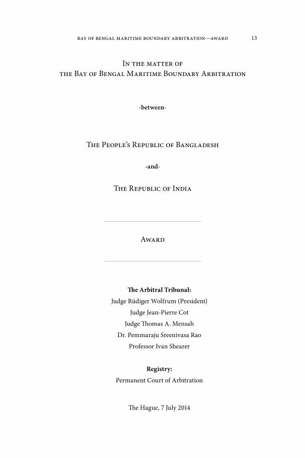
Bay of Bengal Maritime Boundary Arbitration—Award 13
In the matter of the Bay of Bengal Maritime Boundary Arbitration
-between-
The People’s Republic of Bangladesh
-and-
The Republic of India
Award
The Arbitral Tribunal:
Judge Rüdiger Wolfrum (President)
Judge Jean-Pierre Cot
Judge Thomas A. Mensah
Dr. Pemmaraju Sreenivasa Rao
Professor Ivan Shearer
Registry:
Permanent Court of Arbitration
The Hague, 7 July 2014
14 Bangladesh/India
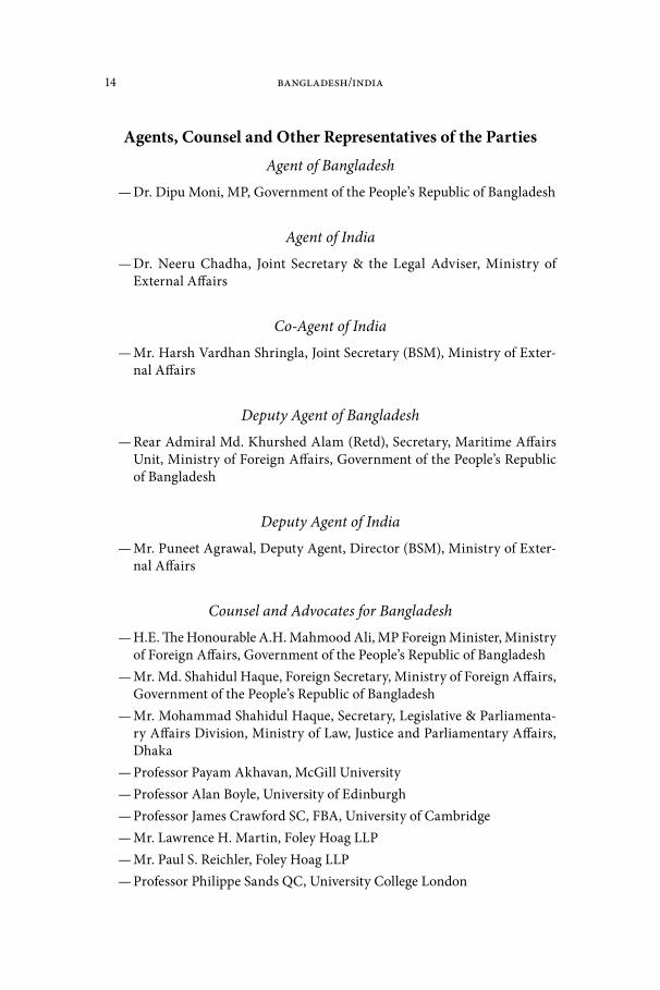
Agents, Counsel and Other Representatives of the PartiesAgent of Bangladesh
— Dr. Dipu Moni, MP, Government of the People’s Republic of Bangladesh
Agent of India
— Dr. Neeru Chadha, Joint Secretary & the Legal Adviser, Ministry of External Affairs
Co-Agent of India
— Mr. Harsh Vardhan Shringla, Joint Secretary (BSM), Ministry of Exter-nal Affairs
Deputy Agent of Bangladesh
— Rear Admiral Md. Khurshed Alam (Retd), Secretary, Maritime Affairs Unit, Ministry of Foreign Affairs, Government of the People’s Republic of Bangladesh
Deputy Agent of India
— Mr. Puneet Agrawal, Deputy Agent, Director (BSM), Ministry of Exter-nal Affairs
Counsel and Advocates for Bangladesh
— H.E. The Honourable A.H. Mahmood Ali, MP Foreign Minister, Ministry of Foreign Affairs, Government of the People’s Republic of Bangladesh
— Mr. Md. Shahidul Haque, Foreign Secretary, Ministry of Foreign Affairs, Government of the People’s Republic of Bangladesh
— Mr. Mohammad Shahidul Haque, Secretary, Legislative & Parliamenta-ry Affairs Division, Ministry of Law, Justice and Parliamentary Affairs, Dhaka
— Professor Payam Akhavan, McGill University— Professor Alan Boyle, University of Edinburgh— Professor James Crawford SC, FBA, University of Cambridge— Mr. Lawrence H. Martin, Foley Hoag LLP— Mr. Paul S. Reichler, Foley Hoag LLP— Professor Philippe Sands QC, University College London
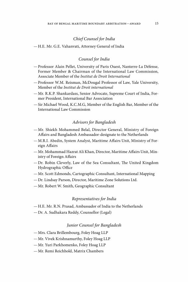
Bay of Bengal Maritime Boundary Arbitration—Award 15
Chief Counsel for India— H.E. Mr. G.E. Vahanvati, Attorney General of India
Counsel for India— Professor Alain Pellet, University of Paris Ouest, Nanterre-La Défense,
Former Member & Chairman of the International Law Commission, Associate Member of the Institut de Droit International
— Professor W.M. Reisman, McDougal Professor of Law, Yale University, Member of the Institut de Droit international
— Mr. R.K.P. Shankardass, Senior Advocate, Supreme Court of India, For-mer President, International Bar Association
— Sir Michael Wood, K.C.M.G, Member of the English Bar, Member of the International Law Commission
Advisors for Bangladesh— Mr. Shiekh Mohammed Belal, Director General, Ministry of Foreign
Affairs and Bangladesh Ambassador-designate to the Netherlands— M.R.I. Abedin, System Analyst, Maritime Affairs Unit, Ministry of For-
eign Affairs— Mr. Mohammad Hazrat Ali Khan, Director, Maritime Affairs Unit, Min-
istry of Foreign Affairs— Dr. Robin Cleverly, Law of the Sea Consultant, The United Kingdom
Hydrographic Office— Mr. Scott Edmonds, Cartographic Consultant, International Mapping— Dr. Lindsay Parson, Director, Maritime Zone Solutions Ltd.— Mr. Robert W. Smith, Geographic Consultant
Representatives for India— H.E. Mr. R.N. Prasad, Ambassador of India to the Netherlands— Dr. A. Sudhakara Reddy, Counsellor (Legal)
Junior Counsel for Bangladesh— Mrs. Clara Brillembourg, Foley Hoag LLP— Mr. Vivek Krishnamurthy, Foley Hoag LLP— Mr. Yuri Parkhomenko, Foley Hoag LLP— Mr. Remi Reichhold, Matrix Chambers

16 Bangladesh/India
Junior Counsel for India— Mr. Devadatt Kamat, Assistant Counsel to Attorney General of India— Mr. Benjamin Samson, University of Paris Ouest— Mr. Eran Sthoeger, New York University
Scientific & Technical Advisors for India— Vice Admiral S.K. Jha, Chief Hydrographer to the Government of India— Rear Admiral K.M. Nair, Joint Chief Hydrographer, National Hydro-
graphic Office (NHO)— Prof. Martin Pratt, Expert Cartographer, Director of Research, Interna-
tional Boundary Research Unit (IBRU), Durham University— Commodore Adhir Arora, Principal Director of Hydrography, NHO— Captain Peush Pawsey, Director of Hydrography (Ops.), NHO— Dr. Dhananjay Pandey, Scientist, National Centre for Antarctic & Ocean
Research (NCAOR)— Mr. R. C. Samota, Cartographic Assistant, NHO
Research Associates for India— Mr. K. S. Mohammed Hussain, Legal Officer, Ministry of External Affairs— Ms. Héloise Bajer-Pellet, Member of the Paris Bar

Bay of Bengal Maritime Boundary Arbitration—Award 17
TABLE OF CONTENTS
Chapter I. Procedural History . . . . . . . . . . . . . . . . . . . . . . . . . . . . 21
A. Initiation of this Arbitration. . . . . . . . . . . . . . . . . . . . . . . . . . . . . . 21B. Constitution of the Arbitral Tribunal . . . . . . . . . . . . . . . . . . . . . . 21C. The First Procedural Meeting and the Adoption of the Rules of
Procedure . . . . . . . . . . . . . . . . . . . . . . . . . . . . . . . . . . . . . . . . . . . . . 22D. Appointment of Expert Hydrographer . . . . . . . . . . . . . . . . . . . . . 22E. Site Visit. . . . . . . . . . . . . . . . . . . . . . . . . . . . . . . . . . . . . . . . . . . . . . . 23F. The Parties’ Written Submissions on the Merits . . . . . . . . . . . . . 27G. The Hearing on the Merits . . . . . . . . . . . . . . . . . . . . . . . . . . . . . . . 28
Chapter II. Introduction . . . . . . . . . . . . . . . . . . . . . . . . . . . . . . . . . . 32
A. Geography. . . . . . . . . . . . . . . . . . . . . . . . . . . . . . . . . . . . . . . . . . . . . 32B. Historical Background of the Dispute. . . . . . . . . . . . . . . . . . . . . . 32C. The Dispute between the Parties . . . . . . . . . . . . . . . . . . . . . . . . . . 33
Chapter III. The Tribunal’s Jurisdiction . . . . . . . . . . . . . . . . . . . . 36
A. The Submission of the Dispute to Arbitration under the Convention . . . . . . . . . . . . . . . . . . . . . . . . . . . . . . . . . . . . . . . . . . . . 36
B. Jurisdiction and the Delimitation of the Continental Shelf beyond 200 nm. . . . . . . . . . . . . . . . . . . . . . . . . . . . . . . . . . . . . . . . . 37
Chapter IV. The Land Boundary Terminus . . . . . . . . . . . . . . . . . . 40
A. Interpretation of Annexure A of the Radcliffe Award . . . . . . . . 411. “the main channel … of the rivers Ichhamati and Kalindi,
Raimangal and Haribhanga till it meets the Bay” . . . . . . . . . 412. “for the time being” and the relevance of the Bagge Award . 42
B. The 1951 Exchange of Letters. . . . . . . . . . . . . . . . . . . . . . . . . . . . . 44C. Map Evidence Presented by the Parties . . . . . . . . . . . . . . . . . . . . 46
1. The Radcliffe Map . . . . . . . . . . . . . . . . . . . . . . . . . . . . . . . . . . . 462. British Admiralty Chart 859 . . . . . . . . . . . . . . . . . . . . . . . . . . . 503. Satellite Imagery . . . . . . . . . . . . . . . . . . . . . . . . . . . . . . . . . . . . . 54
D. Commander Kennedy’s Report . . . . . . . . . . . . . . . . . . . . . . . . . . . 55E. The Relevance of uti possidetis juris. . . . . . . . . . . . . . . . . . . . . . . . 56F. “the midstream of the main channel” . . . . . . . . . . . . . . . . . . . . . . 56G. “the point where that boundary meets the Bay of Bengal” . . . . 58H. The Tribunal’s Decision on the Land Boundary Terminus . . . . 60
18 Bangladesh/India
Chapter V. The Selection of Base Points and the Delimita-tion of the Territorial Sea . . . . . . . . . . . . . . . . . . . . . . . . . . . . . 68
A. General Considerations concerning a Maritime Boundary. . . . 68B. General Considerations concerning the Selection of Base
Points . . . . . . . . . . . . . . . . . . . . . . . . . . . . . . . . . . . . . . . . . . . . . . . 68C. The Parties’ Approaches to the Territorial Sea. . . . . . . . . . . . . . . 76
1. Applicable law for the delimitation of the territorial seas and method of delimitation . . . . . . . . . . . . . . . . . . . . . . . . . . . 76
2. The delimitation lines proposed by the Parties . . . . . . . . . . . 79D. The Tribunal’s Delimitation of the Territorial Sea. . . . . . . . . . . . 82
1. Location of Base Points in the Territorial Sea . . . . . . . . . . . . 832. Establishment of the median/equidistance line in the terri-
torial sea . . . . . . . . . . . . . . . . . . . . . . . . . . . . . . . . . . . . . . . . . . . 863. Adjustment of the median line in the territorial sea . . . . . . . 86
Chapter VI. Relevant Coasts and Relevant Area for Delim-itation beyond the Territorial Sea . . . . . . . . . . . . . . . . . . . . . . 88
A. The Relevant Coast of Bangladesh. . . . . . . . . . . . . . . . . . . . . . . . . 89B. The Relevant Coast of India . . . . . . . . . . . . . . . . . . . . . . . . . . . . . . 90C. The Relevant Area . . . . . . . . . . . . . . . . . . . . . . . . . . . . . . . . . . . . . . 95
Chapter VII. Delimitation of the Exclusive Economic Zone and the Continental Shelf Within 200 nm . . . . . . . . . . . . . . . 98
A. Methodology . . . . . . . . . . . . . . . . . . . . . . . . . . . . . . . . . . . . . . . . . . 981. Applicability of the equidistance method . . . . . . . . . . . . . . . . 982. Applicability of the angle-bisector method . . . . . . . . . . . . . . 1003. The Tribunal’s Decision on Methodology . . . . . . . . . . . . . . . 104
B. The Provisional Equidistance Line . . . . . . . . . . . . . . . . . . . . . . . . 1071. Base points for the equidistance line within 200 nm . . . . . . 1082. The Tribunal’s Provisional Equidistance Line . . . . . . . . . . . . 110
C. Relevant Circumstances . . . . . . . . . . . . . . . . . . . . . . . . . . . . . . . . . 1121. Coastal instability. . . . . . . . . . . . . . . . . . . . . . . . . . . . . . . . . . . . 1122. Concavity and Cut-Off Effects . . . . . . . . . . . . . . . . . . . . . . . . . 1143. Other circumstances . . . . . . . . . . . . . . . . . . . . . . . . . . . . . . . . . 1184. The Tribunal’s Decision on Relevant Circumstances . . . . . . 119
D. The Parties’ Views on the Adjustment of the Provisional Equidistance Line within 200 nm . . . . . . . . . . . . . . . . . . . . . . . . . 126
E. The Tribunal’s Decision on the Adjustment of the Provisional Equidistance Line within 200 nm . . . . . . . . . . . . . . . . . . . . . . . . . 130

Bay of Bengal Maritime Boundary Arbitration—Award 19
Chapter VIII. Delimitation of the Continental Shelf Be-yond 200 nm . . . . . . . . . . . . . . . . . . . . . . . . . . . . . . . . . . . . . . . . . . . . . 132
A. Methodology . . . . . . . . . . . . . . . . . . . . . . . . . . . . . . . . . . . . . . . . . . 132B. The Parties’ Proposed Delimitation Lines Beyond 200 nm . . . . 132C. The Tribunal’s Delimitation of the Continental Shelf beyond
200 nm . . . . . . . . . . . . . . . . . . . . . . . . . . . . . . . . . . . . . . . . . . . . . . . 1381. Base points for the equidistance line beyond 200 nm . . . . . 1392. Provisional equidistance line beyond 200 nm . . . . . . . . . . . . 1393. Relevant circumstances . . . . . . . . . . . . . . . . . . . . . . . . . . . . . . . 139
Chapter IX. Adjustment of the Provisional Equidistance Line within and beyond 200 nm . . . . . . . . . . . . . . . . . . . . . . . . . . 142
A. The Tribunal’s Considerations in Adjusting the Provisional Equidistance Line. . . . . . . . . . . . . . . . . . . . . . . . . . . . . . . . . . . . . . . 142
B. The Tribunal’s Adjustment of the Provisional Equidistance Line . . 142
Chapter X. Disproportionality Test . . . . . . . . . . . . . . . . . . . . . . . 143
Chapter XI. Grey Area . . . . . . . . . . . . . . . . . . . . . . . . . . . . . . . . . . . . . 147
Chapter XII. Dispositif . . . . . . . . . . . . . . . . . . . . . . . . . . . . . . . . . . . . . 150
Appendix. Technical Report of the Tribunal’s Hydrographer . 152
FIGURES AND MAPS
Bangladesh’s Memorial, Figure 2.1*
Bangladesh’s Reply, Figure R5.7*
India’s Rejoinder, Figure RJ 7.1 . . . . . . . . . . . . . . . . . . . . . . . . . . . . . . 35India’s Rejoinder, Figure RJ 2.2*
Bangladesh’s Reply, Figure R3.6 . . . . . . . . . . . . . . . . . . . . . . . . . . . . . 50India’s Rejoinder, Figure RJ 2.5A . . . . . . . . . . . . . . . . . . . . . . . . . . . . . 53India’s Rejoinder, Figure RJ 2.6 . . . . . . . . . . . . . . . . . . . . . . . . . . . . . . 54Bangladesh’s Hearing Folder, Tab 4.7 . . . . . . . . . . . . . . . . . . . . . . . 59India’s Rejoinder, Figure RJ 2.1 . . . . . . . . . . . . . . . . . . . . . . . . . . . . . . 60Map 1*
Map 2*
Map 3 . . . . . . . . . . . . . . . . . . . . . . . . . . . . . . . . . . . . . . . . . . . . . . . . . . . . . 87Bangladesh’s Reply, Figure R5.10*
India’s Counter-Memorial, Sketch Map No. 6.6*
* Secretariat note: maps and diagrams located in the front pocket.

20 Bangladesh/India
Bangladesh’sMemorial, Figure 7.5*
Map 4 . . . . . . . . . . . . . . . . . . . . . . . . . . . . . . . . . . . . . . . . . . . . . . . . . . . . . 97Bangladesh’s Reply, Figure R4.12*
India’s Counter-Memorial, Figure 6.12*
Map 5 . . . . . . . . . . . . . . . . . . . . . . . . . . . . . . . . . . . . . . . . . . . . . . . . . . . . . 111Reply of Bangladesh, Figure R4.16A–D**
Map 6 . . . . . . . . . . . . . . . . . . . . . . . . . . . . . . . . . . . . . . . . . . . . . . . . . . . . . 122Bangladesh’sMemorial, Figure 6.17**
Bangladesh’s Arbitrators Folder, Tab 3.4 . . . . . . . . . . . . . . . . . . . 128India’s Rejoinder, Figure RJ 6.3 . . . . . . . . . . . . . . . . . . . . . . . . . . . . . . 131Bangladesh’s Reply, Figure R5.1**
Counter-Memorial of India, Sketch Map No. 7.6**
India’s Rejoinder, Figure RJ 7.2 . . . . . . . . . . . . . . . . . . . . . . . . . . . . . . 137Map 7**
Map 8**
Map 9**
Map 10**
Map 11**
Map 12**
* Secretariat note: maps and diagrams located in the front pocket.** Secretariat note: maps and diagrams located in the back pocket.

Bay of Bengal Maritime Boundary Arbitration—Award 21
Chapter I. Procedural History
A. Initiation of this Arbitration1. By a Notification and Statement of Claim dated 8 October 2009, the
People’s Republic of Bangladesh initiated arbitral proceedings against the Republic of India, pursuant to article 287 of the 1982 United Nations Con-vention on the Law of the Sea (the “Convention”) and in accordance with Annex VII to the Convention. Bangladesh and India (the “Parties”) ratified the Convention on 27 July 2001 and 26 June 1995, respectively.
2. In its Notification and Statement of Claim, Bangladesh sought the following relief:
Bangladesh requests the Tribunal to delimit, in accordance with the principles and rules set forth in UNCLOS, the maritime boundary between Bangladesh and India in the Bay of Bengal, in the territorial sea, the EEZ, and the continental shelf, including the portion of the continental shelf pertaining to Bangladesh that lies more than 200 nau-tical miles from the baselines from which its territorial sea is measured.1
B. Constitution of the Arbitral Tribunal3. The Arbitral Tribunal (the “Tribunal”) was established pursuant
to article 3, Annex VII of the Convention. Subparagraph (a) of article 3 of Annex VII calls for the appointment of five members of the Tribunal.
4. On 8 October 2009, Bangladesh appointed Professor Vaughan Lowe QC as a member of the Tribunal in accordance with subparagraph (b) of article 3 of Annex VII.
5. On 6 November 2009, India appointed Dr. Pemmaraju Sreenivasa Rao as a member of the Tribunal in accordance with subparagraph (c) of arti-cle 3 of Annex VII.
6. In the absence of an agreement between the Parties on the appoint-ment of the remaining members of the Tribunal, after consultation with the Parties in accordance with subparagraph (e) of article 3 of Annex VII, the Pres-ident of the International Tribunal for the Law of the Sea on 10 February 2010 appointed Judge Rüdiger Wolfrum, Professor Ivan Shearer, and Professor Tullio Treves as members of the Tribunal, with Judge Rüdiger Wolfrum as President.
7. The members of the Tribunal signed declarations of independence and impartiality, which were communicated to the Parties on 16 June and 23 July 2010.
8. On 23 August 2010, the PCA informed the Parties that Professor Vaughan Lowe QC had announced his withdrawal from the proceedings on 18 August 2010 with immediate effect. On 13 September 2010, Bangladesh appointed Judge Thom-
1 Bangladesh’s Notification and Statement of Claim, paragraph 21.

22 Bangladesh/India
as A. Mensah in replacement of Professor Vaughan Lowe QC in accordance with article 6(1)(a) of the Rules of Procedure (discussed below).
9. On 17 June 2013, the PCA communicated to the Parties Professor Tullio Treves’ decision to withdraw from his position as arbitrator on 16 June 2013. On 18 July 2013, the President of the International Tribunal for the Law of the Sea appointed Judge Jean-Pierre Cot in accordance with article 6(1)(b) of the Rules of Procedure.
C. The First Procedural Meeting and the Adoption of the Rules of Procedure
10. On 24 March 2010, the President of the Tribunal wrote to the Sec-retary-General of the Permanent Court of Arbitration (the “PCA”) to inquire whether the PCA would serve as Registry in these proceedings, and whether it would attend a First Procedural Meeting between the Parties and the Tribunal to be held at the Max Planck Institute for Comparative Public Law and Inter-national Law in Heidelberg, Germany.
11. On 25 March 2010, the Secretary-General of the PCA confirmed the PCA’s willingness to assume the function of Registry and to attend the first procedural meeting.
12. On 8 April 2010, the President of the Tribunal informed the Sec-retary-General of the PCA of both Parties’ approval to entrust the PCA with the function of Registry in the current proceedings. Mr. Brooks W. Daly was subsequently appointed to serve as Registrar.
13. On 26 May 2010, the First Procedural Meeting was held in Heidel-berg, Germany, during which the Tribunal adopted its Rules of Procedure with the consent of the Parties.2
14. Thereafter, the draft Terms of Appointment agreed upon at the Meeting were sent to the Parties for their approval. In the absence of objec-tions of the Parties, the Terms of Appointment were signed by the Parties, the President of the Tribunal, and the Secretary-General of the PCA, with effect from 19 November 2010.
D. Appointment of Expert Hydrographer15. On 22 February 2011, the PCA informed the Parties that the Tri-
bunal was considering the appointment of Mr. David H. Gray as an expert hydrographer, pursuant to article 12(4) of the Rules of Procedure, and invited their comments on this appointment. A copy of Mr. Gray’s curriculum vitae and a draft of the Tribunal’s proposed Terms of Reference for the hydrographer were enclosed with this communication.
2 The Rules of Procedure are available at http://www.pca-cpa.org.

Bay of Bengal Maritime Boundary Arbitration—Award 23
16. On 13 and 22 March 2011, respectively, Bangladesh and India con-firmed their agreement to the appointment of Mr. Gray as expert hydrographer.
17. On 18 April 2011, the Tribunal appointed Mr. Gray as expert hydrog-rapher in these proceedings. The PCA transmitted to the Parties a copy of the Terms of Reference, as signed by the hydrographer and the President of the Tribu-nal, and requested that the hydrographer be copied on all future correspondence.
E. Site Visit18. Article 6(b) of Annex VII to the United Nations Convention on the
Law of the Sea provides that “[t]he parties to the dispute shall facilitate the work of the arbitral tribunal” and shall “enable it when necessary […] to visit the localities to which the case relates”.
19. On 11 February 2013, the Tribunal communicated to the Parties its decision to conduct a site visit and invited the Parties to confer and agree upon a joint itinerary for the site visit. The Parties exchanged views on 3 May, 30 June and 8 July 2013.
20. Having considered the Parties’ views on the site visit itinerary, the Tribunal wrote to the Parties on 11 July 2013 with a proposal for the itiner-ary and invited the Parties’ further comments. The Parties’ comments were received on 26 July and 5 August 2013.
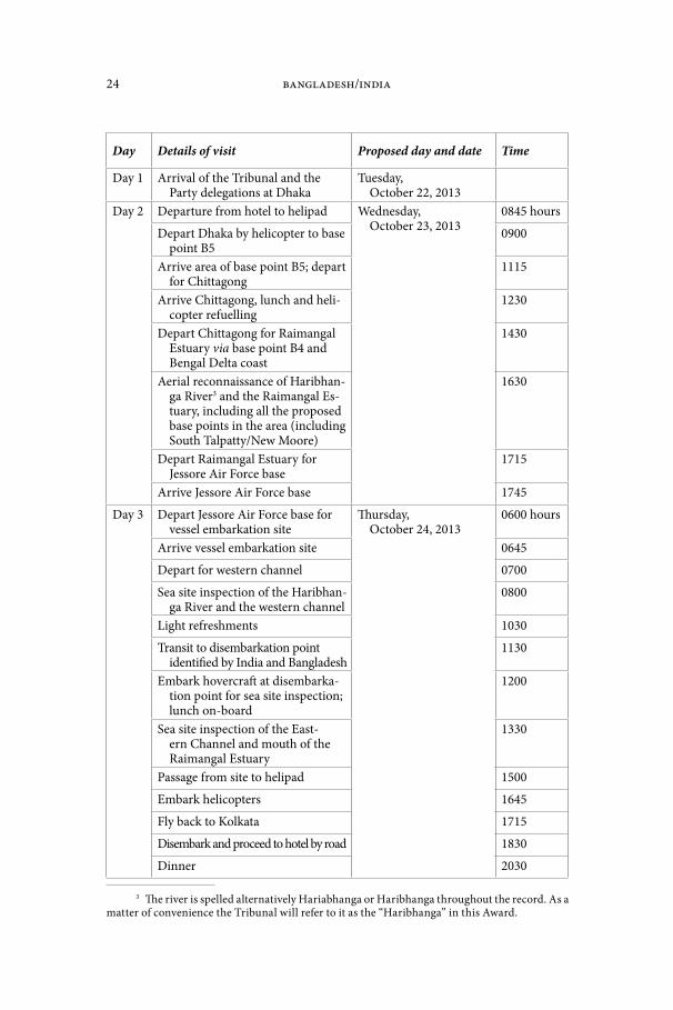
21. Having considered the comments of the Parties on the details of the itinerary and further comments on a draft Procedural Order sent to the Parties on 16 August 2013, the Tribunal issued Procedural Order No. 1 (Concerning the Site Visit of October 2013) on 28 August 2013. The Procedural Order estab-lished the itinerary of the proposed visit and the size of the delegations, and also dealt with matters concerning the confidentiality of the site visit and the manner in which the costs were to be apportioned between the Parties. Proce-dural Order No. 1 sets out the site visit itinerary as follows:
1. The Site Visit Itinerary 1.1 The Tribunal records that after consulting the Parties, it had ear-
lier set aside October 22–26, 2013 for the conduct of the site visit, with October 22 and 26 being dates of arrival to and departure from the region. The Tribunal hereby fixes these dates.
1.2 The Tribunal takes note of Bangladesh’s correspondence dat-ed May 3 and June 30, 2013 as well as India’s correspondence dated July 8 and 26, 2013, in which they outline their respec-tive views on the proper itinerary for this site visit. The Parties agree that Bangladesh will host the delegations on October 23 and the first half of October 24; India will host the delegations from the second half of October 24 and October 25. Having considered the Parties’ further views on the matter, the Tribu-nal hereby adopts the following itinerary:
24 Bangladesh/India
Day Details of visit Proposed day and date Time
Day 1 Arrival of the Tribunal and the Party delegations at Dhaka
Tuesday, October 22, 2013
Day 2 Departure from hotel to helipad Wednesday, October 23, 2013
0845 hours
Depart Dhaka by helicopter to base point B5
0900
Arrive area of base point B5; depart for Chittagong
1115
Arrive Chittagong, lunch and heli-copter refuelling
1230
Depart Chittagong for Raimangal Estuary via base point B4 and Bengal Delta coast
1430
Aerial reconnaissance of Haribhan-ga River3 and the Raimangal Es-tuary, including all the proposed base points in the area (including South Talpatty/New Moore)
1630
Depart Raimangal Estuary for Jessore Air Force base
1715
Arrive Jessore Air Force base 1745
Day 3 Depart Jessore Air Force base for vessel embarkation site
Thursday, October 24, 2013
0600 hours
Arrive vessel embarkation site 0645
Depart for western channel 0700
Sea site inspection of the Haribhan-ga River and the western channel
0800
Light refreshments 1030
Transit to disembarkation point identified by India and Bangladesh
1130
Embark hovercraft at disembarka-tion point for sea site inspection; lunch on-board
1200
Sea site inspection of the East-ern Channel and mouth of the Raimangal Estuary
1330
Passage from site to helipad 1500
Embark helicopters 1645
Fly back to Kolkata 1715
Disembark and proceed to hotel by road 1830
Dinner 2030
3 The river is spelled alternatively Hariabhanga or Haribhanga throughout the record. As a matter of convenience the Tribunal will refer to it as the “Haribhanga” in this Award.

Bay of Bengal Maritime Boundary Arbitration—Award 25
Day 4 Departure from hotel to helipad Friday, October 25, 2013
0800 hours
Embark helicopters 0810
Aerial inspection of relevant coast (east coast of India)
0830
Refueling Halt; light refreshments 0930
Aerial inspection of relevant coast (including base points proposed by India and Bangladesh; east coast of India)
1030
Refueling halt; lunch 1230
Aerial inspection of relevant coast and base points
1330
Aerial inspection of eastern chan-nel and mouth of the Raimangal estuary
1430
Passage to helipad, Kolkata 1500
Disembark and proceed to hotel 1530
Dinner at hotel 2000
Day 5 Departure of the Tribunal and Party delegations from Kolkata to their respective destinations
Saturday, October 26, 2013
3
22. From 22 to 25 October 2013, the Tribunal and the Parties visited relevant areas of the Bay of Bengal pursuant to the above itinerary. The site visit included viewing all of the base points proposed by the Parties. The Registry prepared a video and photographic record of the visit.
23. On 14 November 2013, Bangladesh expressed its concern regarding certain activities carried out by India during the site visit. Following India’s comments dated 27 November 2013, the Tribunal indicated that it did not intend to exclude material from the proceedings, but would determine the relevance, materiality, and weight of all evidence pursuant to article 12(1) of the Rules of Procedure.
24. On 20 November 2013, the Tribunal issued Procedural Order No. 3 (Concerning the Record of the Site Visit), which established the manner in which photographs and video recordings of the site visit would be admitted into evidence. The operative parts of this Order state as follows:
1. Introduction 1.1 This Order provides for the manner in which photographs and
video recordings of the site visit may be admitted into evidence.2. Transmission of the Site Visit Record
3 The river .............

26 Bangladesh/India
2.1 On behalf of the Tribunal, the Registry has prepared a record of the site visit (the “Site Visit Record”), composed of:
(a) the photographic record, chronologically arranged, of the site visit, with each photograph being numbered sequentially; and
(b) an edited video recording of the site visit. 2.2 Digital copies of the Site Visit Record have been transmitted
to the Parties via courier on Friday, 15 November 2013 for paragraph 2.1(a) above, and Wednesday, 20 November 2013 for paragraph 2.1(b) above.
2.3 The Parties are invited to review the Site Visit Record carefully upon receipt.
3. Admission of the Site Visit Record into Evidence 3.1 Photographs: Should any Party wish to introduce any of the
photographs included in the Site Visit Record into evidence for use in the present proceedings, including during the hear-ing on the merits, it shall so indicate by identifying the pho-tograph(s) by number and providing the Tribunal, the other Party, and the Registry with a copy thereof (via e-mail and courier) by no later than Wednesday, 27 November 2013. Each photograph shall be captioned and accompanied by a brief description of the subject(s) depicted and the purpose for which it is sought to be introduced into evidence. The oth-er Party shall thereafter be given an opportunity to provide any comments and/or objections it may have to those pho-tograph(s)’ admission into evidence, by no later than Wednes-day, 4 December 2013.
3.2 Video: Should any Party wish to introduce any segment of the Site Visit Record’s video recording into evidence for use in the present proceedings, including during the hearing on the merits, it shall so indicate by providing the Tribunal, the other Party, and the Registry with the start and end time periods of the video corresponding to the segment(s) it wishes to pres-ent, together with a copy thereof (via e-mail and courier), by no later than Wednesday, 27 November 2013. Each segment shall be captioned and accompanied by a brief description of the subject(s) depicted and the purpose for which it is sought to be introduced into evidence. The other Party shall thereaf-ter be given an opportunity to provide any comments and/or objections they may have to those segment(s)’ admission into evidence, by no later than Wednesday, 4 December 2013.
3.3 Any part of the Site Visit Record so submitted by a Party that is not objected to by the other Party may be accepted into evi-dence by the Tribunal. If so accepted, such photographs and video segments shall be duly marked pursuant to Article 12(2)

Bay of Bengal Maritime Boundary Arbitration—Award 27
of the Rules of Procedure, and their admission into evidence shall be confirmed by procedural order.
3.4 In case a Party raises an objection to the introduction of a particular photograph and/or video segment, the Tribunal shall resolve the dispute prior to the commencement of the hearing, guided by the “the admissibility, relevance, materi-ality and weight” (Rules of Procedure, Article 12(1)) of the evidence proffered.
25. By their letters dated 27 November and 5 December 2013 respective-ly, Bangladesh and India identified the photographs and video segments of the Site Visit Record that they wished to introduce into evidence. Neither Party expressed any objection to the admission into evidence of those photographs and video segments identified by the other Party.
26. On 6 December 2013, the Tribunal issued Procedural Order No. 4 (Concerning Admission of the Site Visit Record into Evidence), which con-firmed the admission into evidence of those photographs and video segments identified by Bangladesh and India in their respective letters dated 27 Novem-ber and 5 December 2013. The operative parts of this Order state as follows:
1. Pursuant to paragraph 3.3 of Procedural Order No. 3, all photo-graphs and video segments of the site visit listed in Bangladesh’s letter to the Tribunal dated 27 November 2013 and India’s letter to the Tribunal dated 2 December 2013 are admitted into evidence.2. When cited by the Parties, these photographs and video segments shall be duly marked in accordance with Article 12(2) of the Rules of Procedure, which provides that “[e]ach document submitted to the Tri-bunal shall be given a number (for Bangladesh’s documents, B-1, B-2 etc; for India’s documents, IN-1, IN-2 etc); and each page of each document shall be numbered.”
F. The Parties’ Written Submissions on the Merits27. On 31 May 2011, Bangladesh submitted its Memorial.28. By communications dated 30 November, 19 December and
26 December 2011, the Parties agreed that the deadline for India to submit its Counter-Memorial be extended from 31 May to 31 July 2012.
29. On 31 July 2012, India submitted its Counter-Memorial.30. By communications dated 5 September and 13 September 2012, the Par-
ties further agreed that the deadline for the submission of the Reply and Rejoinder be extended for two months, i.e. to 31 January 2013 and 31 July 2013, respectively.
31. On 31 January 2013, Bangladesh submitted its Reply.32. On 11 February 2013, the Tribunal requested additional informa-
tion from the Parties concerning charts, maps, and hydrographic surveys of

28 Bangladesh/India
the area that is the subject of the dispute, as well as shipping, navigation and fishing activities in the area relevant to the dispute.
33. By their letters dated 4 March and 30 April 2013 respectively, Bang-ladesh and India provided the Tribunal with information requested in the Tri-bunal’s letter of 11 February 2013.
34. On 30 July 2013, India submitted its Rejoinder.35. On 4 November 2013, the Tribunal informed the Parties that it
wished them to elaborate further on issues concerning base points and the Radcliffe Award and Map, either by brief written submissions or during the oral hearing.
36. By letter dated 2 December 2013, India submitted a brief written statement on the issues mentioned in the Tribunal’s letter of 4 November. By letter dated 3 December 2013, Bangladesh stated that it would address these issues during the oral hearing.
G. The Hearing on the Merits37. On 28 January 2013, the Tribunal informed the Parties that it had
reserved the period of 9–18 December 2013 for the hearing.38. The Rules of Procedure adopted on 26 May 2010 concerned, inter alia,
the conduct of hearings. By letter dated 11 February 2013, the Tribunal amend-ed certain provisions of the Rules of Procedure, including the time limit for the Tribunal to conduct hearings after the submission of the Rejoinder.
39. On 6 November 2013, the Tribunal issued Procedural Order No. 2 (Concerning the Hearing on the Merits), which was corrected on 8 and 12 November 2013. This Order set out, inter alia, the time and place of the hearing, the schedule of the hearing, and the degree of confidentiality for the proceedings.
40. By letter dated 20 November 2013, the Tribunal clarified the purpose of the 15-minute period allocated to each Party for “Introductory Remarks” in Paragraph 2.4 of Procedural Order No. 2. India indicated that it intended to give a general overview of the case during this 15-minute period, Bangladesh stated that it had no objection to India’s intended use of the 15-minute period.
41. The hearing on the merits took place from 9 to 18 December 2013 in the Peace Palace, The Hague, the Netherlands. The following individuals participated on behalf of the Parties:
Bangladesh
— H.E. Dr. Dipu Moni, MP, Agent of Bangladesh and Former Foreign Min-ister, Government of the People’s Republic of Bangladesh
Bay of Bengal Maritime Boundary Arbitration—Award 29
— Rear Admiral (Retd) Mohammad Khurshed Alam Mphil, ndc, psc, Dep-uty Agent of Bangladesh & Secretary (Maritime Affairs Unit), Ministry of Foreign Affairs, Dhaka
Counsel and Advocates
— H.E. The Honourable A.H. Mahmood Ali, MP Foreign Minister, Govern-ment of the People’s Republic of Bangladesh
— Mr. Mohammad Shahidul Haque, Secretary, Legislative & Parliamentary Affairs Division, Ministry of Law, Justice and Parliamentary Affairs, Dhaka
— Professor Payam Akhavan, McGill University— Professor Alan Boyle, University of Edinburgh— Professor James Crawford AC, SC, FBA, University of Cambridge— Mr. Lawrence H. Martin, Foley Hoag LLP— Mr. Paul S. Reichler, Foley Hoag LLP— Professor Philippe Sands QC, University College London
Advisors
— Mr. Shiekh Mohammed Belal, Director General, Ministry of Foreign Affairs and Bangladesh Ambassador-designate to the Netherlands
— Ms. Ishrat Jahan, Counsellor & CDA, ad. i, Embassy of Bangladesh, The Hague— Mr. Mohammad Shaheen Iqbal, Bangladesh Navy— M.R.I. Abedin, System Analyst, Ministry of Foreign Affairs— Mr. Mohammad Hazrat Ali Khan, Director Ministry of Foreign Affairs— Md. Abdullah Al Mamun, Bangladesh Army— Md. Abu Rayhan, Bangladesh Air Force— Md. Abdul Moktader, Private Secretary to the Foreign Minister, Ministry
of Foreign Affairs— Mr. Syed Shah Saad Andalib, Assistant Secretary, Ministry of For-
eign Affairs— Mr. Haripada Chandra Nag, Assistant Secretary, Ministry of For-
eign Affairs— Dr. Robin Cleverly, Law of the Sea Consultant, The United Kingdom
Hydrographic Office— Mr. Scott Edmonds, Cartographic Consultant, International Mapping— Mr. Thomas Frogh, Senior Cartographer, International Mapping— Dr. Lindsay Parson, Director, Maritime Zone Solutions Ltd.— Mr. Robert W. Smith, Geographic Consultant
30 Bangladesh/India
Junior Counsel
— Mrs. Clara Brillembourg, Foley Hoag LLP— Mr. Vivek Krishnamurthy, Foley Hoag LLP— Mr. Yuri Parkhomenko, Foley Hoag LLP— Mr. Remi Reichhold, Matrix Chambers
Legal Assistants
— Mr. Dara In, University College London— Ms. Nancy Lopez, Foley Hoag LLP— Mr. Rodrigo Tranamil, Foley Hoag LLP
India— Dr. Neeru Chadha, Agent, Joint Secretary & the Legal Adviser, Ministry
of External Affairs, Government of India— Mr. Harsh Vardhan Shringla, Co-Agent, Joint Secretary (BSM), Ministry
of External Affairs— Mr. Puneet Agrawal, Deputy Agent, Director (BSM), Ministry of Exter-
nal Affairs
Chief Counsel
— H.E. Mr. G.E. Vahanvati, Attorney General of India
Counsel
— Professor Alain Pellet, University of Paris Ouest, Nanterre-La Défense— Professor W. Michael Reisman, Yale University— Mr. R.K.P. Shankardass, Senior Advocate, Supreme Court of India— Sir Michael Wood, KCMG, 20 Essex Street
Representatives
— H.E. Mr. R.N. Prasad, Ambassador of India to the Netherlands— Dr. A. Sudhakara Reddy, Counsellor (Legal)
Junior Counsel
— Mr. Devadatt Kamat, Assistant Counsel to the Attorney General— Mr. Benjamin Samson, University of Paris Ouest— Mr. Eran Sthoeger, New York University

Bay of Bengal Maritime Boundary Arbitration—Award 31
Scientific & Technical Advisors
— Vice Admiral S.K. Jha, Chief Hydrographer to the Government of India— Rear Admiral K.M. Nair, Joint Chief Hydrographer, National Hydro-
graphic Office (NHO)— Professor Martin Pratt, Expert Cartographer, International Boundary
Research Unit, Durham University— Commodore Adhir Arora, Principal Director of Hydrography, NHO— Capt. Peush Pawsey, Director of Hydrography (Ops), NHO— Dr. Dhananjay Pandey, Scientist, National Centre for Antarctic and
Ocean Research (NCAOR)— Mr. R.C. Samota, Cartographic Assistant, NHO
Research Associates
— Mr. K. S. Mohammed Hussain, Legal Officer, Ministry of External Affairs— Ms. Héloise Bajer-Pellet, Member of the Paris Bar
42. On 9 December 2013, the Rules of Procedure and the Tribunal’s Procedural Orders were published on the PCA website pursuant to para-graph 3.4(a) of Procedural Order No. 2. On the same day, the PCA issued a press release on the commencement of the hearing on the merits in accordance with paragraph 3.4(b) of Procedural Order No. 2.
43. By letter dated 10 December 2013, India asked the Tribunal’s per-mission to use certain photographs of South Talpatty/New Moore Island taken in April 2004 in its first round of oral pleadings. Having considered Bangladesh’s letter dated 11 December stating that it had no objection to India’s request, the Tribunal informed the Parties on 11 December that the photographs accompa-nying India’s 10 December letter would be admitted into the record.
44. On 11 December 2013, Bangladesh corrected the record of its oral pleading on 10 December 2013. The Tribunal informed the Parties that it had taken note of the correction of the record by Bangladesh. The Tribunal also took note of India’s correction of the record of its oral pleading on 12 December 2013.
45. On 18 December 2013, the PCA issued a press release on the con-clusion of the hearing on the merits in accordance with paragraph 3.4(b) of Procedural Order No. 2.
46. On 23 December 2013, the Parties each wrote to the Tribunal in response to certain technical questions posed by the Tribunal’s Expert Hydrographer on 18 December 2013, at the close of the hearing.

32 Bangladesh/India
Chapter II. Introduction
A. Geography[…]*
47. The Bay of Bengal is situated in the north-eastern Indian Ocean, covering an area of approximately 2.2 million square kilometres, and is bor-dered by India, Bangladesh, Myanmar and Sri Lanka. The maritime area to be delimited in the present case lies in the northern part of the Bay.
48. The land territory of Bangladesh encompasses approximately 147,570 square kilometres, and its coast extends from the land boundary ter-minus with India to the land boundary terminus with Myanmar. The popula-tion of Bangladesh is approximately 160 million.
49. The land territory of India encompasses approximately 3.3 million square kilometres, including both mainland and island territories, such as the Andaman Islands. The coast of India extends from the land boundary with Bangladesh in the east around peninsular India to the land boundary with Pakistan, and also includes the Andaman Islands. The population of India is over 1.2 billion.
B. Historical Background of the Dispute50. This dispute originates from the partition of British India into the
two States of India and Pakistan by the Indian Independence Act, 1947 of the United Kingdom (the “Act”).4 Section 2 of the Act specified, inter alia, that the newly formed province of East Bengal became part of Pakistan while the newly formed province of West Bengal remained part of India.5 Provisional bounda-ries between East Bengal and West Bengal were drawn in Section 3 of the Act, paragraph 3 of which provided for the final boundaries to be determined by the award of a boundary commission appointed by the Governor-General of India.6
51. The Bengal Boundary Commission was established on 30 June 1947 and tasked with the demarcation of the boundaries between East Bengal and West Bengal. The Commission, chaired by Sir Cyril Radcliffe, submitted its Report, known as the “Radcliffe Award”, on 13 August 1947.7 The Radcliffe Award described the boundary line between East and West Bengal in its Annexure A and delineated the line on the map in Annexure B.8
52. Paragraph 8 of Annexure A to the Radcliffe Award sets out the final segment of the boundary line between East and West Bengal which is of rele-vance in this case. It reads:
* Secretariat note: See map located in the front pocket (Bangladesh’s Memorial, Figure 2.1).4 Bangladesh’s Memorial, paragraph 3.3; India’s Counter-Memorial, paragraph 3.3.5 Bangladesh’s Memorial, paragraph 3.3; India’s Counter-Memorial, paragraph 3.4.6 Bangladesh’s Memorial, paragraph 3.4; India’s Counter-Memorial, paragraph 3.4.7 Bangladesh’s Memorial, paragraph 3.6; India’s Counter-Memorial, paragraph 3.5.8 Bangladesh’s Memorial, paragraph 3.6; India’s Counter-Memorial, paragraph 3.6.

Bay of Bengal Maritime Boundary Arbitration—Award 33
The line shall then run southwards along the boundary between the districts of Khulna and 24 Parganas to the point where that boundary meets the Bay of Bengal.
53. The pre-existing boundary between the districts of Khulna and 24 Parganas was described in Notification No. 964 Jur., issued by the Governor of Bengal on 24 January 1925, as
pass[ing] along the south-western boundary of Chandanpur … till it meets the midstream of the main channel of the river Ichhamati, then along the midstream of the main channel for the time being of the rivers Ichhamati and Kalindi, Raimangal and Haribhanga till it meets the Bay.
54. In light of disputes over the interpretation of the Radcliffe Award, an Indo-Pakistan Boundary Disputes Tribunal (known as the “Bagge Tribu-nal” after its chairman, Justice Algot Bagge of Sweden) was established by a special agreement and issued a decision in January 1950.9 This award dealt with other segments of the boundary than the one of relevance in this case.
55. On 26 March 1971, Bangladesh declared its independence from Paki-stan and succeeded to the territory of the former East Pakistan and its boundaries.10
C. The Dispute between the Parties56. The Parties are in dispute regarding the delimitation of the mar-
itime boundary between them in the territorial sea, the exclusive economic zone and the continental shelf within and beyond 200 nm in the Bay of Bengal.
57. In the absence of agreement between the Parties, the delimitation of the territorial sea is governed by article 15 of the Convention. The delimitation of the exclusive economic zone and the continental shelf is governed by arti-cle 74 and article 83, respectively, of the Convention. The Parties disagree on the interpretation of these provisions, and on their application.
58. The Parties agree that the land boundary terminus is to be used as the starting point of the maritime boundary between them. The Parties further agree that the land boundary terminus is to be established on the basis of the Radcliffe Award, and that the Tribunal has jurisdiction to identify it on that basis.
59. The Parties disagree, however, on the interpretation of the Radcliffe Award and on the location of the land boundary terminus determined by it.
60. In its final submissions, Bangladesh requests the Tribunal to declare and adjudge that:
(1) The maritime boundary between Bangladesh and India follows a line with a geodesic azimuth of 180° from the location of the land boundary terminus at 21° 38´ 14˝N – 89° 06´ 39˝E to the point located at 17° 49´ 36˝N – 89° 06´ 39˝E;
9 Bangladesh’s Memorial, paragraph 3.17; India’s Counter-Memorial, paragraph 3.5.10 Bangladesh’s Memorial, paragraph 3.18; India’s Counter-Memorial, paragraph 3.11.

34 Bangladesh/India
(2) from the latter point, the maritime boundary between Bangladesh and India follows a line with a geodesic azimuth of 214° until it meets the outer limits of the continental shelf of Bangladesh as established on the basis of the recommendations of the Commission on the Limits of the Continental Shelf (“CLCS”);(3) from the point located at 16° 40´ 57˝N – 89° 24´ 05˝E, which marks the intersection of the geodesic line as adjudged by the International Tribunal for the Law of the Sea in the Dispute Concerning Delimita-tion of the Maritime Boundary between Bangladesh and Myanmar in the Bay of Bengal (Bangladesh/Myanmar) with the limits of the claim submitted by India to the Commission on the Limits of the Continental Shelf on May 2009, the maritime boundary between Bangladesh and India follows the same geodesic line until it meets the outer limits of the continental shelf of Bangladesh as established on the basis of the recommendations of the CLCS; and(4) from the points specified in Submissions (2) and (3), and along the outer limits of the continental shelf of Bangladesh as established on the basis of the recommendations of the CLCS.
61. Bangladesh’s claim is depicted graphically as follows:[…]*
62. In its final submissions, India requests the Tribunal to declare and adjudge that:
Having regard to the facts and law set out in its Counter-Memorial, its Rejoinder and during the oral proceedings, the Republic of India requests the Tribunal to adjudge and declare that the maritime boundary between India and Bangladesh (in WGS 84 datum terms) runs as follows:
– Starting from the land boundary terminus at Point L with co-ordinates 21° 38´ 40.4˝N, 89° 10´ 13.8˝E, the boundary follows a geodetic azimuth of 149.3° until it reaches Point T1, with the co-ordinates 21° 37´ 15.7˝N, 89° 11́ 07.6˝E.
– From Point T1, the boundary follows a geodetic azimuth of 129.4° until it reaches Point T2, with co-ordinates 21° 35́ 12.7˝N, 89° 13´ 47.5˝E.
– From Point T2, the boundary follows a geodetic azimuth of 144.2° until it reaches Point T3, with co-ordinates 21° 32́ 25.7˝N, 89° 15́ 56.5˝E.
– From Point T3, the boundary follows a geodetic azimuth of 168.6° until it reaches Point T4, with the co-ordinates 20° 30´ 17.9˝N, 89° 29´ 20.9˝E.
– From Point T4, the boundary follows a geodetic azimuth of 157.0° until it reaches Point T5, with the co-ordinates 19° 26´ 40.6˝N, 89° 57´ 54.9˝E.
* Secretariat note: See map located in the front pocket (Bangladesh’s Reply, Figure R5.7).
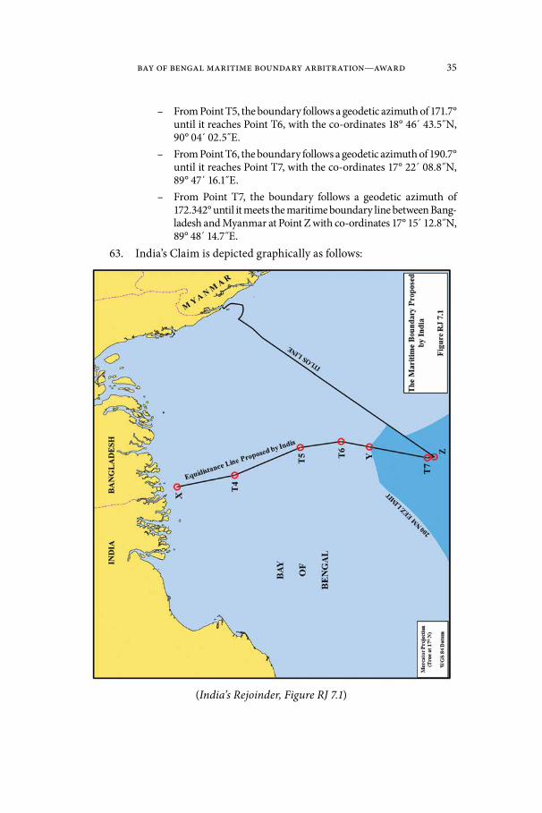
Bay of Bengal Maritime Boundary Arbitration—Award 35
– From Point T5, the boundary follows a geodetic azimuth of 171.7° until it reaches Point T6, with the co-ordinates 18° 46́ 43.5˝N, 90° 04́ 02.5˝E.
– From Point T6, the boundary follows a geodetic azimuth of 190.7° until it reaches Point T7, with the co-ordinates 17° 22´ 08.8˝N, 89° 47´ 16.1̋ E.
– From Point T7, the boundary follows a geodetic azimuth of 172.342° until it meets the maritime boundary line between Bang-ladesh and Myanmar at Point Z with co-ordinates 17° 15́ 12.8˝N, 89° 48́ 14.7˝E.
63. India’s Claim is depicted graphically as follows:
(India’s Rejoinder, Figure RJ 7.1)

36 Bangladesh/India
Chapter III. The Tribunal’s Jurisdiction64. The Tribunal begins by addressing its jurisdiction to hear and decide
the dispute before it, noting that neither Party has objected to its jurisdiction.
A. The Submission of the Dispute to Arbitration under the Convention
65. The Tribunal recalls that both Bangladesh and India are parties to the Convention. Accordingly, both are bound by the dispute settlement procedures in Part XV of the Convention in respect of a dispute between them concern-ing the interpretation or application of the Convention. Section 2 of Part XV provides for compulsory procedures entailing binding decisions. Article 287 of the Convention provides that States may choose by written declaration among several binding procedures for the settlement of their disputes. It reads in part:
Article 287
Choice of procedure
1. When signing, ratifying or acceding to this Convention or at any time thereafter, a State shall be free to choose, by means of a written dec-laration, one or more of the following means for the settlement of dis-putes concerning the interpretation or application of this Convention:(a) the International Tribunal for the Law of the Sea established in accordance with Annex VI;(b) the International Court of Justice;(c) an arbitral tribunal constituted in accordance with Annex VII;(d) a special arbitral tribunal constituted in accordance with Annex VIII for one or more of the categories of disputes specified therein.2. A declaration made under paragraph 1 shall not affect or be affected by the obligation of a State Party to accept the jurisdiction of the Seabed Disputes Chamber of the International Tribunal for the Law of the Sea to the extent and in the manner provided for in Part XI, section 5.3. A State Party, which is a party to a dispute not covered by a declara-tion in force, shall be deemed to have accepted arbitration in accordance with Annex VII.4. If the parties to a dispute have accepted the same procedure for the settlement of the dispute, it may be submitted only to that procedure, unless the parties otherwise agree.5. If the parties to a dispute have not accepted the same procedure for the settlement of the dispute, it may be submitted only to arbitration in accordance with Annex VII, unless the parties otherwise agree.[…]

Bay of Bengal Maritime Boundary Arbitration—Award 37
66. Neither Party has made a declaration pursuant to paragraph 3 of article 287. This means that the Parties are deemed to have accepted arbitration in accordance with Annex VII.
67. The Tribunal notes the agreement between the Parties that it has jurisdiction to identify the location of the land boundary terminus on the basis of the Radcliffe Award of 1947.11
68. The Tribunal concludes that a dispute between the Parties concern-ing the interpretation and application of the Convention may be submitted to an arbitral tribunal for binding decision in accordance with Annex VII to the Convention. Such a submission is not subject to any limitation other than those contained in the terms of Part XV and Annex VII.
69. Article 298 of the Convention permits a State party to exclude cer-tain categories of disputes from the procedures set out in Section 2 of Part XV of the Convention by means of a written declaration. Neither Party has made such a declaration.
70. The Tribunal must now consider whether the dispute has properly been submitted to it in accordance with the Convention. The requirements for the submission of a dispute to the Tribunal are set out in Annex VII of the Convention.
71. Article 1 of Annex VII of the Convention states that any party to the dispute may submit the dispute to arbitration by written notification, accom-panied by a statement of the claim and the grounds on which it is based. Bang-ladesh filed its written notification on 8 October 2009, accompanied by the required statement and grounds.
72. Article 283 of the Convention provides that, when a dispute arises, the “parties to the dispute shall proceed expeditiously to an exchange of views regarding its settlement by negotiation or other peaceful means”. The Tribu-nal notes that the Parties have sought to reach an agreement on the delimita-tion of their maritime zones in 11 rounds of negotiations since 1974 without success. Although India has suggested that these negotiations were close to agreement, it does not claim that article 283 of the Convention has not been complied with.
73. Accordingly, the Tribunal finds that Bangladesh has complied with the requirements of the Convention for the submission of the dispute to arbi-tration under Annex VII.
B. Jurisdiction and the Delimitation of the Continental Shelf beyond 200 nm
74. Both Parties agree that the Tribunal has jurisdiction to delimit the continental shelf beyond 200 nm.
11 India’s Counter-Memorial, paragraph 4.1; Bangladesh’s Reply, paragraph 3.7.

38 Bangladesh/India
75. The Tribunal observes that international jurisprudence on the delimitation of the continental shelf beyond 200 nm is rather limited. In this connection, the Tribunal takes note of the Award of 11 April 2006 by the Arbi-tral Tribunal in the case between Barbados and Trinidad and Tobago (RIAA, Vol. XXVII, p. 147), the Judgment of 14 March 2012 of the International Tri-bunal for the Law of the Sea on the Dispute Concerning the Delimitation of the Maritime Boundary between Bangladesh and Myanmar in the Bay of Bengal (Bangladesh/Myanmar), and the Judgment of 19 November 2012 of the Inter-national Court of Justice in the Territorial and Maritime Dispute (Nicaragua v. Colombia) (Judgment, I.C.J. Reports 2012, p. 624).
76. The Tribunal notes that in the present case, the outer limits of the continental shelf have not yet been established in accordance with article 76 and Annex II to the Convention, concerning the Commission on the Limits of the Continental Shelf (the “CLCS”). However, recalling the reasoning of the International Tribunal for the Law of the Sea in Bangladesh/Myanmar (Judg-ment of 14 March 2012, paragraphs 369–394), the Tribunal sees no grounds why it should refrain from exercising its jurisdiction to decide on the lateral delimitation of the continental shelf beyond 200 nm before its outer limits have been established.
77. The Tribunal emphasizes that article 76 of the Convention embodies the concept of a single continental shelf. This is confirmed by article 77, para-graphs 1 and 2 of the Convention, according to which a coastal State exercises exclusive sovereign rights over the continental shelf in its entirety. No distinc-tion is made in these provisions between the continental shelf within 200 nm and the shelf beyond that limit. Article 83 of the Convention, concerning the delimitation of the continental shelf between States with opposite or adjacent coasts, likewise makes no such distinction. This view is in line with the obser-vation of the tribunal in Barbados/Trinidad and Tobago that “there is in law only a single ‘continental shelf ’ rather than an inner continental shelf and a separate extended or outer continental shelf” (Award of 11 April 2006, RIAA, Vol. XXVII, p. 147, at pp. 208–209, paragraph 213).
78. In the present case both Parties have put forward claims to the con-tinental shelf beyond 200 nm where they overlap. Both Parties agree that they have entitlements, and neither Party denies that there is a continental shelf beyond 200 nm in the Bay of Bengal.
79. The Convention assigns to different bodies functions regarding decisions on the entitlement of coastal States to the continental shelf beyond 200 nm. The coastal State is given the power to establish final and binding limits of its continental shelf. To realize this right, the coastal State is required to submit information on the limits of its continental shelf beyond 200 nm to the CLCS, which has the mandate to make recommendations to the coastal State. According to article 76, paragraph 8, of the Convention the coastal State concerned may, on the basis of the recommendations of the CLCS, establish the outer limits of its continental shelf which will be final and binding.

Bay of Bengal Maritime Boundary Arbitration—Award 39
80. There is a clear distinction in the Convention between the delimita-tion of the continental shelf under article 83 of the Convention and the delin-eation of its outer limits under article 76 (Bangladesh/Myanmar, Judgment of 14 March 2012, paragraph 376; Territorial and Maritime Dispute (Nicaragua v. Colombia), Judgment of 19 November 2012, I.C.J. Reports 2012, p. 624 at p. 669, paragraph 129). Whilst the function of settling disputes with respect to the delimitation of maritime boundaries between adjacent or opposite States is entrusted to the dispute settlement procedures under Part XV of the Convention, the CLCS plays an indispensable role in the delineation of the continental shelf beyond 200 nm. On the one hand, the recommendations of the CLCS “shall not prejudice matters relating to delimitation of boundaries”, (Convention, Annex III, art. 9), and on the other hand, the decision of an inter-national court or tribunal delimiting the lateral boundary of the continental shelf beyond 200 nm is without prejudice to the delineation of the outer limits of that shelf. In short, the mandates of these bodies complement one another.
81. In the present case, the Tribunal notes that India made a submis-sion to the CLCS on 11 May 2009 in respect of its claims beyond 200 nm. On 29 October 2009, Bangladesh notified the Secretary General of the Unit-ed Nations of its objections to India’s claim. Taking into account Bangladesh’s position, the CLCS deferred consideration of the submission made by India (Statement by the Chairman of the Commission on the Progress of Work in the Commission, UN Document CLCS/68, 17 September 2010). Thereafter, Bangladesh made a submission to the CLCS on 25 February 2011. India did not object to the CLCS considering Bangladesh’s submission. However, the CLCS decided to defer consideration (Statement by the Chairman of the Commission on the progress of work in the Commission, CLCS/72, 16 September 2011).
82. In the view of the Tribunal, the consequence of these decisions by the CLCS is such that, if the Tribunal were to decline to delimit the conti-nental shelf beyond 200 nm, the outer limits of the continental shelf of each of the Parties would remain unresolved, unless the Parties were able to reach an agreement. In light of the many previous rounds of unsuccessful negotia-tions between them, the Tribunal does not see that such an agreement is likely. Accordingly, far from enabling action by the CLCS, inaction by this Tribunal would in practice leave the Parties in a position in which they would likely be unable to benefit fully from their rights over the continental shelf. The Tribu-nal does not consider that such an outcome would be consistent with the object and purpose of the Convention.
*
83. For the foregoing reasons, the Tribunal finds that it has jurisdiction to adjudicate the present case, to identify the land boundary terminus and to delimit the territorial sea, the exclusive economic zone, and the continental shelf between the Parties within and beyond 200 nm in the areas where the claims of the Parties overlap.

40 Bangladesh/India
Chapter IV. The Land Boundary Terminus84. The Tribunal will now turn to the determination of the precise loca-
tion of the land boundary terminus between India and Bangladesh in the Bay of Bengal, since it is from that point that the Tribunal must proceed in delim-iting the maritime boundaries between the Parties.
85. As stated above and agreed by the Parties, the location of the land boundary terminus is to be determined by application of the Radcliffe Award of 1947, which drew the boundaries between India and the new State of Pakistan.
86. As stated above, Sir Cyril Radcliffe12 was appointed by the pre-in-dependence Government of India to chair the Bengal Boundary Commission, which was tasked to draw the boundaries between India and what would become East Pakistan. In accordance with the terms of section 3 of the Indian Independence Act, 1947 (UK), in the absence of a consensus of its five mem-bers, Sir Cyril had the sole power of decision. It is not the function of this Tri-bunal to consider the total boundary line, but only that portion which pertains to the point at which the land boundary enters the Bay of Bengal.
87. The Parties agree that, within the area of the land boundary termi-nus, the Radcliffe Award adopted the pre-partition district boundary between the districts of Khulna and 24 Parganas in the following terms:
The line shall then run southwards along the boundary between the Districts of Khulna and 24 Parganas, to the point where that boundary meets the Bay of Bengal.13
88. The district boundary, in turn, had been delimited in 1925 by Noti-fication No. 964 Jur. of the Governor of Bengal as follows:
Notification No. 964 Jur.
[T]he western boundary of district Khulna passes along the south-west-ern boundary of Chandanpur … till it meets the midstream of the main channel of the river Ichhamati, then along the midstream of the main
12 Sir Cyril Radcliffe (1899–1977), later the Right Honourable Viscount Radcliffe, GBE, PC, QC, was a distinguished British lawyer. Soon after the outbreak of the Second World War he was appointed Director-General of the Ministry of Information in the British Government. He was knighted in 1944. In 1947 he was appointed by the Viceroy of India to head the bound-ary commissions that bear his name. In view of his eminence, and notwithstanding his lack of previous service as a judge, he was made a member of the UK’s highest court as a Lord of Appeal in Ordinary from 1949 to 1964. A hereditary peerage as Viscount Radcliffe was conferred on him in 1962. It is reported that he was so distressed at the violence that followed the partition of India, he returned the fee he had been offered for his services. See Lucy P. Chester, Borders and Conflict in South Asia: The Radcliffe Boundary Commission and the Partition of Punjab, at p. 180.
13 Bengal Boundary Commission, Report to His Excellency the Governor General, Annex-ure A at paragraph 8 (12 August 1947).
Bay of Bengal Maritime Boundary Arbitration—Award 41
channel for the time being of the rivers Ichhamati and Kalindi, Raiman-gal and Haribhanga till it meets the Bay.14
89. The Radcliffe Award includes as Annexure B a map of Bengal, indi-cating the boundary determined by the Commission. In the area of concern to the Tribunal, the map shows a black dash-dot-dash line descending from the Haribhanga River to the Bay of Bengal, highlighted in green and red on either side. Sir Cyril’s introductory report states that the map was “for purposes of illustration, and if there should be any divergence between the boundary as described in Annexure A and as delineated in Annexure B, the description in Annexure A is to prevail”.
90. The Parties disagree on the interpretation of Annexure A to the Rad-cliffe Award and the text of the Governor of Bengal’s Notification referenced therein. They disagree also on the relevance and the interpretation of the Map in Annexure B. The Tribunal will discuss each area of disagreement in turn.
A. Interpretation of Annexure A of the Radcliffe Award91. The Parties disagree on the meaning of two phrases in Annexure
A and in the corresponding provision of Notification No. 964 Jur, namely: (1) “the main channel … of the rivers Ichhamati and Kalindi, Raimangal and Haribhanga till it meets the Bay” and (2) “for the time being”.
1. “the main channel … of the rivers Ichhamati and Kalindi, Raimangal and Haribhanga till it meets the Bay”
92. Bangladesh contends that the course of the boundary through the rivers “Ichhamati and Kalindi, Raimangal and Haribhanga” is sequential.15 Accordingly, the land boundary terminus lies where the midstream of the main channel of the river Haribhanga meets the Bay of Bengal.
93. According to Bangladesh, the placement of the word “and” in the phrase “Raimangal and Haribhanga” does not imply the “twinning” of the riv-ers or a conjoined channel, but simply ends a series of more than three objects. The earlier use of the word “and” in the phrase “Ichhamati and Kalindi” is, in Bangladesh’s view, nothing more than a stylistic choice.16 Used here, the word “and” cannot indicate a conjoined channel as “there is no such conjoined channel between the Ichhamati and the Kalindi Rivers”.17 In other words, “the Ichhamati branches between the Ichhamati and the Kalindi, and the boundary
14 Government of Bengal, Notification 964 Jur. (24 January 1925), reprinted in The Calcut-ta Gazette at p. 178 (29 January 1925).
15 Bangladesh’s Memorial, paragraph 5.9.16 Hearing Tr., 84:20 to 85:11.17 Hearing Tr., 85:15–16.

42 Bangladesh/India
follows the latter; the Raimangal branches between the Raimangal and the Haribhanga, and here too the boundary follows the latter”.18
94. According to Bangladesh, this interpretation is also consistent with the geographic reality depicted by British Admiralty Chart 859, which shows that the channels of the Raimangal and Haribhanga were separate and did not meet until they were about half a mile south of where the river boundary met the Bay of Bengal.19 “In 1947”, Bangladesh argues, “there was no single channel formed by the Raimangal and Haribhanga rivers in the area in question”.20
*
95. India emphasizes the double placement of the word “and” in the phrase “the rivers Ichhamati and Kalindi, Raimangal and Haribhanga till it meets the Bay”. According to India, “Bangladesh has ignored the ‘twinning’ of each set of rivers and has simply assumed that the relevant river is the last in the series, i.e., the Haribhanga”.21 The earlier use of “and” was not a stylistic choice as the drafters of such a regulation would have taken care in the use of words.22 Rather, it reflects the fact that the Ichhamati River joins the Kalindi, requiring the word “and”.23
96. In India’s view, the result of this construction is that the boundary follows the conjoined channel of the Raimangal and Haribhanga and that its terminus lies where that channel meets the bay. India argues, however, that both the main channel of the Haribhanga and the conjoined channel “meet [the Bay] at the same point east of New Moore Island”.24
2. “for the time being” and the relevance of the Bagge Award
97. Another point of difference between the Parties regarding the interpretation of the 1925 Notification No. 964 Jur. (and thus of the Radcliffe Award) is on the meaning of the words “for the time being”.
98. Bangladesh accepts that the use of the phrase “for the time being” in Notification 964 Jur. may have contemplated a fluid district boundary, shifting to the extent that the main channel of the river shifted. According to Bang-ladesh, however, this changed when the district boundary was incorporated into the Radcliffe Award. “August 1947”, Bangladesh argues, “is the crucial moment. … whatever change occurred subsequently could not alter the loca-
18 Hearing Tr., 85:3–6.19 Hearing Tr., 87:1–2.20 Hearing Tr., 88:10–11.21 India’s Counter-Memorial, paragraph 4.17.22 Hearing Tr., 312:10–11.23 Hearing Tr., 578:21 to 579:2.24 India’s Counter-Memorial, paragraph 4.17.
Bay of Bengal Maritime Boundary Arbitration—Award 43
tion of the boundary as then determined and the land boundary terminus as then determined”.25
99. In support of the position that the Radcliffe Award fixed the bound-ary and its terminus in August 1947, Bangladesh refers to the award of the Indo-Pakistan Boundary Disputes Tribunal, i.e., the “Bagge Tribunal”, which was constituted by an agreement between India and Pakistan in Decem-ber 1948 to address disagreement in the application of the Radcliffe Award. The Bagge Tribunal consisted of a member nominated by each of the Domin-ions of India and Pakistan and a neutral chairman. In case of disagreement among the members, the decision of the chairman was to prevail. In consider-ing the river boundary located by Sir Cyril Radcliffe in the midstream of the main channel of the Ganges, the Bagge Award found that the boundary had been fixed “as it was at the time of the award given by Sir Cyril Radcliffe in his Report of August 12th, 1947”.26
100. Bangladesh adopts the reasoning of the Indian member of the Bag-ge Tribunal (Justice Aiyar),27 who stated as follows:
The overriding purpose or object of the division must be borne in mind in construing the award. The idea was to bring into existence two inde-pendent Sovereign States which would have nothing more to do with each other except as the result of treaty or agreement or adjustment. The interpretation of the boundary on the basis of a fluid line would defi-nitely frustrate this idea if the river changes its course. Pakistan territory might become Indian territory and vice versa; and pockets might be cre-ated in each State of what must be regarded as foreign territory. … Sure-ly, a person of the eminence and experience of Sir Cyril Radcliffe must have envisaged all these difficulties and made up his mind to provide for definite and inflexible boundaries.[…]The very Delhi agreement under which the Tribunal is constituted con-templates elaborate demarcation operations in connection with the boundary line to be conducted by experts of both the States. What is there to demarcate, if the boundary is a fluid one liable to change or alteration at any moment? Is all the trouble to be taken only to ascertain what the boundary is on a particular date, knowing full well that it may not be a boundary the next day? Surveys of the river, cadastral or other-wise, will then be a futile endeavour; and topographical maps prepared at elaborate expense and cost by means of aerial photographs have to be thrown aside every time the river changes. It is very difficult to see the purpose behind so much trouble or the usefulness of such undertakings, if Sir Cyril intended a fluid boundary.
25 Hearing Tr., 67:20 to 68:2.26 Hearing Tr., 78:12–13.27 Hearing Tr., 79:24.
44 Bangladesh/India
(Case concerning boundary disputes between India and Pakistan relating to the interpretation of the report of the Bengal Boundary Commission, 12 and 13 August 1947, Decision of 26 January 1950, RIAA, Vol. XXI, p. 1 at p. 21–22, paragraphs 23, 31).
*
101. According to India, the use in Notification 964 Jur. of the phrase “for the time being” is consistent with the Parties’ subsequent agreement (addressed at paragraph 104 below) for the river boundary between them in the districts of Khulna and 24 Parganas to be fluid.28
102. Moreover, India disagrees with Bangladesh’s characterization of the Bagge Award and its relevance. According to India, although Justice Aiyar held the view set out by Bangladesh, the Indian and Pakistani members of the tribunal disagreed, and the binding decision was taken by Justice Bagge alone. While Justice Bagge accepted the idea of a fixed boundary, as advocated by Justice Aiyar, he also qualified it in the following terms:
If the demarcation of this line is found to be impossible, the boundary between India and Pakistan in this area shall then be a line consisting of the land portion of the above mentioned boundary and of the boundary following the course of the midstream of the main channel of the river Ganges as determined on the date of demarcation and not as it was on the date of the Award …(Case concerning boundary disputes between India and Pakistan relating to the interpretation of the report of the Bengal Boundary Commission, 12 and 13 August 1947, Decision of 26 January 1950, RIAA, Vol. XXI, p. 1 at p. 12).
103. In India’s view, the Bagge Award in fact provides for the river boundary to be determined on the date of demarcation, unless its location in 1947 can be clearly established.
B. The 1951 Exchange of Letters104. In support of its position that the boundary was not definitively
fixed in 1947, India refers to an exchange of letters between the Government of Pakistan and the Government of India which it considers to be a subsequent agreement as to the implementation of the Radcliffe Award. This exchange was initiated by Pakistan. In a letter dated 7 February 1951, A.A. Shah on behalf of the Secretary to the Government of Pakistan wrote as follows to the Secretary to the Government of India, Ministry of External Affairs, New Delhi:
Sub. Demarcation of undisputed boundary between East Bengal and West Bengal.Sir, With reference to correspondence resting [sic] with telegram from the Government of Pakistan, Ministry of Foreign Affairs and Common-
28 Hearing Tr., 265:1–5, 16–18.

Bay of Bengal Maritime Boundary Arbitration—Award 45
wealth Relations dated the 5th January 1951, I am directed to say that the Government of Pakistan have very carefully considered the ques-tion of river boundary between Khulna ad 24 Parganas, and they are of the opinion that the boundary in this section should be fluctuating. It is hoped that the Government of India will agree and issue necessary instructions to the authorities concerned.(Letter from the Secretary to the Government of Pakistan to the Secretary to the Government of India, Ministry of External Affairs, No. 1(1).3/10/50, 7 February 1951, India’s Rejoinder, Annex RJ-1).
105. India replied by an express letter dated 13 March 1951 from “For-eign, New Delhi to Foreign, Karachi”, stating as follows:
Reference your letter No. 1(1).3/10/50 dated the 7th February 1951 regarding demarcation of undisputed portion of West Bengal-East Bengal boundary.2. We agree that the boundary between Khulna and 24 Parganas run-ning along the midstream of the rivers should be a fluid one and are issuing necessary instructions to the authorities concerned. Kindly issue instructions to East Bengal also.(Copy of Express Letter from Foreign, New Delhi to Foreign, Karachi, No. F. 20/50-Pak.III, 13 March 1951, India’s Rejoinder, Annex RJ-2).
106. The reply of India was unsigned but contained the notation “The issue of the above has been authorised”.
*
107. Bangladesh characterizes the foregoing correspondence as nothing more than “an exchange of letters between two civil servants, one of whom is identified, the other (the Indian) is not”.29 In Bangladesh’s view, it is simply not credible that an “anonymous, unknown Indian civil servant could some-how have bound India to an agreement on its land and maritime boundary, by means of a single three-sentence letter”.30 Moreover, Bangladesh argues, “India has not been able to produce any evidence to show that any actions were actually taken by India or by Pakistan, or by Bangladesh in reliance on that momentary and fleeting proposition”.31
108. With respect to the legal value of this exchange, Bangladesh recalls the holding of the International Court of Justice in Nicaragua v. Honduras to the effect that “[t]he establishment of a permanent maritime boundary is a matter of grave importance and agreement is not easily to be presumed” (Territorial and Maritime Dispute between Nicaragua and Honduras in the Caribbean Sea (Nicaragua v. Honduras), Judgment, I.C.J. Reports 2007, p. 735, paragraph 253). Bangladesh further notes that the exchange of letters was not registered with the United Nations as a treaty and argues that it would fall
29 Hearing Tr., 472:3–4.30 Hearing Tr., 472:15–17.31 Hearing Tr., 73:4–6.

46 Bangladesh/India
short of the standard adopted by the International Tribunal for the Law of the Sea for the existence of a binding agreement. (Bangladesh/Myanmar, Judgment of 14 March 2012 at paras. 95–99). In short, Bangladesh argues, “it is plain that there was no such agreement”.32
*
109. According to India, the exchange of letters indicates that India and Pakistan “at first accepted the Radcliffe Award, found it impracticable to apply in certain aspects and simply mutually agreed to change the position from treating the boundary between Khulna and 24-Parganas as a fixed boundary and treating it instead as a ‘fluid’ boundary”.33
110. India notes that negotiations on the demarcation of its boundary with East Pakistan and, more recently, with Bangladesh, have continued since independence and have involved “many routine agreements”.34 India considers the 1951 agreement to be unexceptional, and argues that it “has no reason to doubt this Pakistani governmental communication”.35
111. With respect to the legal significance of the letters, India submits thatIf one applies by analogy the customary rules on treaty interpretation, as reflected in the Vienna Convention, the agreement concluded in 1951 would be a subsequent agreement between the parties regarding the interpretation of the Radcliffe Award or the application of its provisions, within the meaning of article 31.3(a) of the Vienna Convention.36
112. India concludes that, “the midstream of the main channel, until the Award [of this Tribunal] fixes it permanently, … is a fluid boundary in accordance with the agreement of the Parties and remains so until the Tribunal fixes it”.37
C. Map Evidence Presented by the Parties113. In keeping with their differing interpretations of the Radcliffe
Award, the Parties have relied on different maps in locating the land bound-ary terminus. Each contests the evidentiary value of the maps relied upon by the other.
1. The Radcliffe Map114. India submitted a “certified copy” of the Radcliffe Award map in its
Counter-Memorial,38 and “a true copy of the original prepared by the Radcliffe
32 Hearing Tr., 473:6–7.33 Hearing Tr., 264:17–20.34 Hearing Tr., 580:8.35 Hearing Tr., 324:5–6.36 Hearing Tr., 581:6–10.37 Hearing Tr., 576:11–13.38 India’s Counter-Memorial, paragraphs 3.9, 4.25.

Bay of Bengal Maritime Boundary Arbitration—Award 47
Commission” in its Rejoinder.39 According to India, the true copy is identical on all points with the copy India had adduced in its Counter-Memorial with the exception of a red dotted line on the certified copy. India explains that this was “inserted by an Indian official on a facsimile used in the Bagge proceedings”.40 A section of the second, “true” copy of the Radcliffe Map is depicted as follows:
[…]*
115. Without access to a certified copy of the original Radcliffe Award map, Bangladesh submitted (1) a “Map Showing the Boundaries between East and West Bengal & Sylhet District of Assam” published in the Gazette of Pakistan of 17 August 1947 and (2) a map showing “Partition Boundaries in Bengal and Assam” produced by the British Foreign Office.41 Bangladesh admits that these maps cannot depict the course of the boundary with precision, but asserts that they can “identify the same boundary as described in the text of the [Radcliffe] Award”.42
*
116. Bangladesh challenges the authenticity of the first copy of the Rad-cliffe Map produced by India, noting that the red dotted line depicted on it differs from the historical records indicating that the boundary was delimited with a solid red line. With respect to the second copy of the Radcliffe Map, Bangladesh states that it “is not in a position to confirm the authenticity of this latest map, or to challenge it. Nor is Bangladesh able to express any view on whether it is, as the Tribunal asks, ‘an authentic reproduction of the origi-nal map’”.43 In Bangladesh’s view, authenticating India’s Radcliffe Map would require expert evidence that has not been presented to the Tribunal.44
117. Even if the Radcliffe Map is authentic, Bangladesh submits that it is “not sufficient to allow the Tribunal to determine with any degree of preci-sion the location of the north-south axis along the midstream of the channel of Haribhanga River”.45 Bangladesh offers four reasons that militate against reliance on the Radcliffe Map.
118. First, Bangladesh argues that no copy of the Radcliffe Map depicts the land boundary terminus with sufficient precision. “Due to the scale of the map on which the line is drawn”, Bangladesh notes, “the line depicted in India’s original ‘true’ copy of the map, filed with the Counter-Memorial, was more than one mile wide and covered 20 percent of the estuary’s opening. The width of the line in the second ‘true’ copy is 0.6 miles”.46 “For this reason
39 India’s Rejoinder, paragraph 2.61.40 India’s Rejoinder, paragraph 2.61. * Secretariat note: See map located in the front pocket (India’s Rejoinder, Figure RJ 2.2).41 Bangladesh’s Memorial, paragraph 5.7; Bangladesh’s Reply, paragraph 3.27.42 Bangladesh’s Memorial, paragraph 5.8.43 Hearing Tr., 61:17 to 62:1.44 Hearing Tr., 62:1–3.45 Hearing Tr., 62:10–12.46 Hearing Tr., 62:15–18.

48 Bangladesh/India
alone”, Bangladesh concludes “India cannot rely on these maps to accurately determine the location of the land boundary terminus”.47
119. Second, Bangladesh observes that the Radcliffe Award itself provides that the description of the boundary is authoritative, and the Map merely illustrative.
120. Third, Bangladesh questions the accuracy of the Radcliffe Map in the area of the estuary, noting that the Haribhanga River is incorrectly iden-tified as the “Haringhata”. When faced with a similar difficulty in respect of the Mathabanga River, Bangladesh notes, the Bagge Tribunal “declined to give precedence to the map (as India had urged), and instead it relied on the Award’s description, combined with contemporaneous evidence of the geo-graphical circumstances of the river boundary in 1948”.48 Bangladesh consid-ers the same approach appropriate here.
121. Fourth and finally, Bangladesh considers that the small scale of the Radcliffe Map makes it inappropriate for delimitation. In Bangladesh’s view, the Radcliffe Map is “nothing more than a general reference map prepared by the Bengal Drawing Office in 1944; it shows political subdivisions, but it shows no hydrographic or bathymetric information. The Bengal Drawing Office apparently drew the line described in the Radcliffe Award on its 1944 map to illustrate the division of the territory. It is a line of attribution—showing roughly which State got what territory—not a line of delimitation”.49 Accord-ing to Bangladesh, to “delimit the boundary in the estuary Sir Cyril Radcliffe and the Bengal Drawing Office would have needed a larger scale nautical chart, not a small-scale general reference map”.50
122. The Tribunal notes that, in 1944, the Bengal Drawing Office would not have been aware that the line it was drawing might in the future constitute an international boundary.
*
123. India submits that the Radcliffe Map is an integral part of the award and is “admissible as an authentic and authoritative illustration of the boundary”.51 For India, any doubts as to the authenticity of the map presented during the hearing are addressed by the handwritten certification by Sir Cyril Radcliffe, which reads “Certified as Annexure B of my report dated 12th August 1947, Cyril Radcliffe, Chairman—Bengal Boundary Commission”.52 A stamp and the writing above the legend of the map also indicate that it was submitted in the Bagge arbitration.53
47 Hearing Tr., 62:18–20.48 Hearing Tr., 63:13–16.49 Hearing Tr., 63:23 to 64:5.50 Hearing Tr., 64:5–7.51 India’s Rejoinder, paragraph 2.70.52 India’s Rejoinder, paragraph 2.24.53 India’s Rejoinder, paragraph 2.24.

Bay of Bengal Maritime Boundary Arbitration—Award 49
124. In India’s view, as an Annex to the Radcliffe Award, the map forms part of the Award’s context in the sense of article 31 of the Vienna Convention on the Law of Treaties.54 According to India, Bangladesh misapprehends the import of the Radcliffe Award’s own treatment of the comparative value of the description of the boundary and of the map. India argues that the Radcliffe Award should be understood to have indicated that, where there is no diver-gence between the boundary line on the map and the description of the bound-ary in Annexure A, “the map should be conclusive as to the meaning of the text of the Award”.55 The land boundary depicted on the Map, India submits, does not diverge from the boundary described in the Radcliffe Award and depicts a main channel that lies to the east of South Talpatty/New Moore Island.56
125. In support of its view, India relies on the Frontier Dispute case, in which the International Court of Justice discussed the evidentiary value of maps and stated that maps may acquire legal force “when [they] are annexed to an official text of which they form an integral part” (Frontier Dispute (Bur-kina Faso/Mali), Judgment, I.C.J. Reports 1986, p. 582, paragraph 54). India considers the Radcliffe Map to have acquired such legal force.57 India considers the International Court of Justice to have maintained this jurisprudence in its treatment of map evidence in the recent decision in Burkina Faso/Niger. (Fron-tier Dispute (Burkina Faso/Niger), Judgment of 13 April 2013, paragraph 64).
126. Turning to the usefulness of the Radcliffe Map in the present pro-ceedings, India rejects the suggestions that the map is “roughly drawn”. It is not, India emphasizes, a sketch map prepared by Sir Cyril himself, but a “pro-fessionally prepared government map” issued by the Bengal Drawing Office in 1944.58 The district boundaries were printed in black and highlighted in green in the original printing by the Bengal Drawing Office.59 Sir Cyril then added a red highlight to indicate the boundary being decided by the Commission, but “Radcliffe, or whoever he authorized to prepare the map for his signature, did not draw a ‘new line’. There is no Radcliffe line in that sense in the section of the boundary that interests us; the Award’s line simply traces the specific, pre-existing district boundary between Khulna and 24 Parganas which was already inscribed on the 1944 map.”60
127. As to the scale of the Radcliffe Map, India submits that Bangla-desh “mistakes the evidentiary relevance of the Radcliffe Map in this case. The function of the Map was not to show ‘the exact location of the boundary along the midstream of the main channel’; it could only identify the main channel,
54 India’s Rejoinder, paragraph 2.25.55 India’s Rejoinder, paragraph 2.30.56 India’s Rejoinder, paragraph 2.32.57 India’s Rejoinder, paragraph 2.27.58 Hearing Tr., 318:4.59 Hearing Tr., 319:3–11.60 Hearing Tr., 319:13–17.
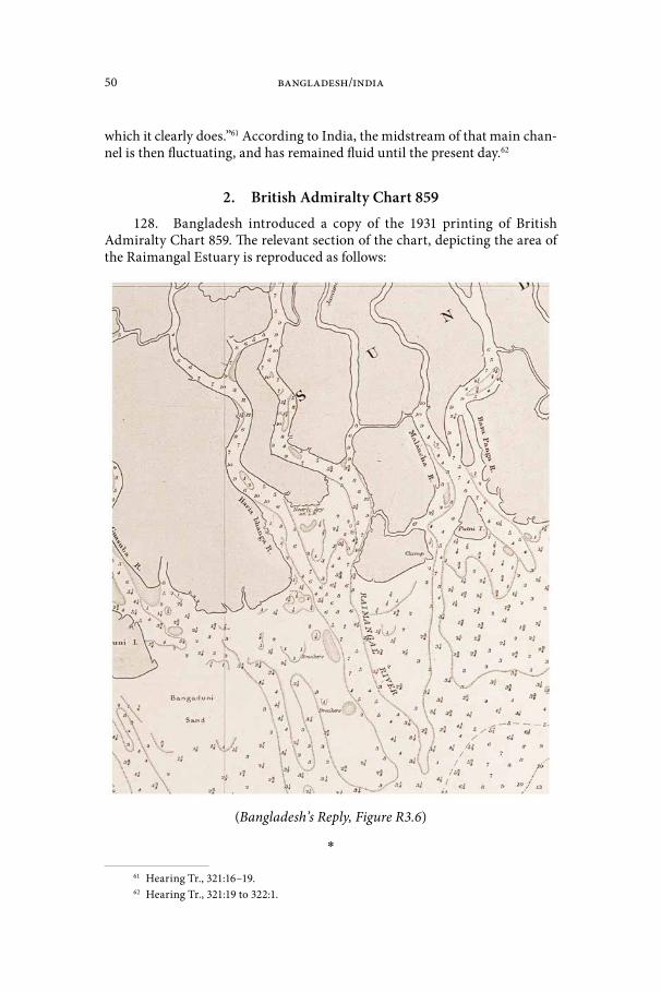
50 Bangladesh/India
which it clearly does.”61 According to India, the midstream of that main chan-nel is then fluctuating, and has remained fluid until the present day.62
2. British Admiralty Chart 859128. Bangladesh introduced a copy of the 1931 printing of British
Admiralty Chart 859. The relevant section of the chart, depicting the area of the Raimangal Estuary is reproduced as follows:
(Bangladesh’s Reply, Figure R3.6)
*
61 Hearing Tr., 321:16–19.62 Hearing Tr., 321:19 to 322:1.
Bay of Bengal Maritime Boundary Arbitration—Award 51
129. To determine the location of the land boundary terminus, Bangla-desh relies on the 1931 printing of British Admiralty (“BA”) Chart 859 as “the most authoritative chart”, noting that it was “available and current” at the time of the Radcliffe Award of 1947.63 According to Bangladesh, this Chart clearly shows two distinct channels in the Raimangal Estuary: the channel of the Haribhanga River (western side of the estuary) and the channel formed by the Raimangal and Jamuna River (eastern side of the estuary).64 Bangladesh notes that the BA Chart 859 of 1953 and BA Chart 829 of 1959 also show the separation of channels in the estuary.65
130. In Bangladesh’s view, BA Chart 859 provides the details lacking in the Radcliffe Map itself, and makes it possible to locate the land boundary terminus as it was in 1947. According to Bangladesh,
This is a task that could have been carried out in 1947, and it can be carried out just as easily today by reference to the situation that pre-vailed back then. Your task is simply to determine the location of the land boundary terminus as Sir Cyril Radcliffe and his team would have done in 1947. … Armed with the Radcliffe Award, and the 1931 edition of BA 859, you can identify the location of the “midstream of the main channel” of the Haribhanga River, and the closing line that separates the Raimangal Estuary from the Bay of Bengal, as at the critical date.66
131. Recourse to such contemporaneous evidence, Bangladesh argues, is entirely appropriate. In Bangladesh’s view, the Radcliffe Map “merely describes the course of the land boundary; and it offers no coordinates. It tells us how to find the terminus, but it does not tell us where it is. To locate it with precision, one must turn to other contemporaneous charts and material that would have been available at that time.”67
132. According to Bangladesh, this approach is consistent with the practice of the International Court of Justice regarding analogous rivers. Bang-ladesh submits that
The Court has consistently determined the location of international riv-er boundaries by using evidence that is contemporaneous to the critical date on which that boundary was established—and specifically contem-poraneous charts—unless the course of the river was identical in the present-day, in which case modern evidence might be used to determine the location of the river boundary as of the date of independence.68
133. In the Frontier Dispute (Benin/Niger) case, the International Court of Justice relied on contemporaneous evidence to determine that the bound-ary followed the “main navigable channel of the River Niger as it existed at
63 Bangladesh’s Memorial, paragraph 5.9; Bangladesh’s Reply, paragraph 3.31.64 Bangladesh’s Reply, paragraph 3.31.65 Bangladesh’s Reply, paragraph 3.32.66 Hearing Tr., 477:9–17.67 Hearing Tr., 69:12–15.68 Hearing Tr., 73:11–16.

52 Bangladesh/India
the dates of independence” and the median line of the River Mekrou. (Fron-tier Dispute (Benin/Niger), Judgment, I.C.J. Reports 2005, p. 90 at p. 133, par-agraph 33). Bangladesh points out that, in that case, later evidence showing the circumstances of the river boundary following independence was con-sidered to be irrelevant unless it served as proof of the parties’ agreement. In the case concerning Kasikili/Sedudu Island, the International Court of Justice employed as its reference point the Chobe River as it existed at the time of the particular treaty establishing the boundary. While the International Court of Justice ultimately consulted modern documents, this was only because both parties agreed that the channels had “remained relatively stable throughout that period of time”. (Kasikili/Sedudu Island (Botswana/Namibia), Judgment, I.C.J. Reports 1999, p. 1065 at paragraph 31). Similarly, in El Salvador/Hon-duras, the International Court of Justice considered the contemporaneous evidence of the river’s course at that time when reaching its final determina-tion, and held that “since what is important is the course of the river in 1821, more significance must be attached to evidence nearer to that date”.69 (Frontier Dispute (Benin/Niger), Judgment, paragraph 26; Land, Island and Maritime Frontier Dispute (El Salvador/Honduras: Nicaragua Intervening), Judgment, I.C.J. Reports 1993 at paragraph 313). Bangladesh also asserts that this same approach was adopted by the Bagge Tribunal when it determined the location of other river boundaries established by the same Radcliffe Award.70
*
134. India questions the accuracy and relevance of BA Chart 859. Although issued in 1931, India points out that the surveys on which this chart was based were conducted in 1879, using survey methods that India considers “rudimentary”.71 In light of the survey dates, India argues that BA 859 is not, in fact, contemporaneous with 1947. In India’s view, the Radcliffe Map consti-tutes the contemporaneous evidence before the Tribunal.
135. India further disagrees with the view that only contemporaneous charts, rather than subsequent cartographic evidence, can be used to ascertain the exact location of the main channel.72 According to India, if the location has not changed over time—which India contends is the case—subsequent cartographic evidence should be preferable and accorded more weight because it provides the best evidence of the facts.73 India notes that in Kasikili/Sedudu Island, the International Court of Justice used modern documents because the course of the river in question had not changed. Moreover, India argues, the International Court of Justice in El Salvador/Honduras gave weight to evidence near to 1829 specifically because both parties acknowledged that the course of
69 Bangladesh’s Reply, paragraph 3.23.70 Hearing Tr., 9 December 2013, at p. 77:11–15.71 India’s Rejoinder, paragraph 2.48.72 India’s Rejoinder, paragraph 2.48.73 India’s Rejoinder, paragraph 2.48.
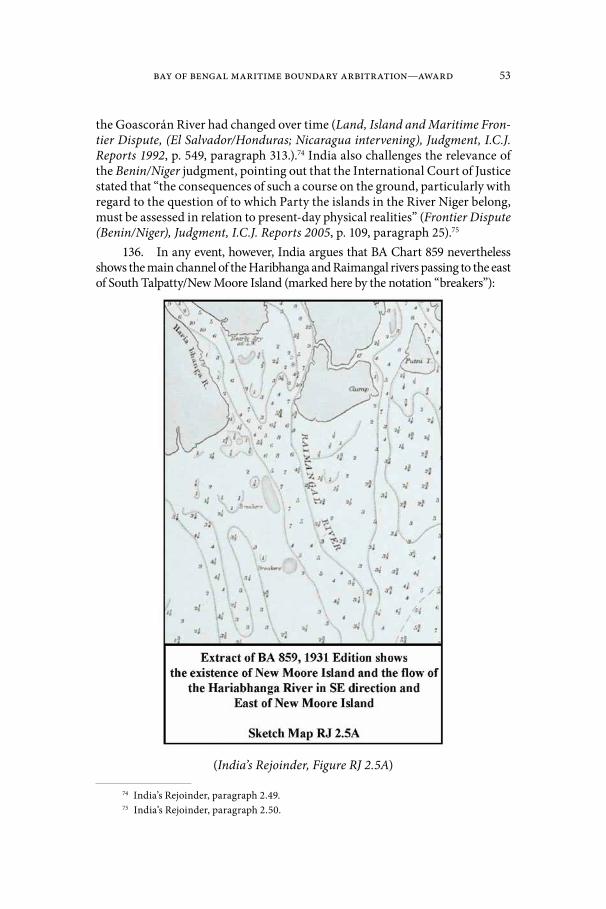
Bay of Bengal Maritime Boundary Arbitration—Award 53
the Goascorán River had changed over time (Land, Island and Maritime Fron-tier Dispute, (El Salvador/Honduras; Nicaragua intervening), Judgment, I.C.J. Reports 1992, p. 549, paragraph 313.).74 India also challenges the relevance of the Benin/Niger judgment, pointing out that the International Court of Justice stated that “the consequences of such a course on the ground, particularly with regard to the question of to which Party the islands in the River Niger belong, must be assessed in relation to present-day physical realities” (Frontier Dispute (Benin/Niger), Judgment, I.C.J. Reports 2005, p. 109, paragraph 25).75
136. In any event, however, India argues that BA Chart 859 nevertheless shows the main channel of the Haribhanga and Raimangal rivers passing to the east of South Talpatty/New Moore Island (marked here by the notation “breakers”):
(India’s Rejoinder, Figure RJ 2.5A)
74 India’s Rejoinder, paragraph 2.49.75 India’s Rejoinder, paragraph 2.50.

54 Bangladesh/India
3. Satellite Imagery137. With a view to demonstrate the location of the relevant channel, India
has submitted a satellite image of the estuary, which is reproduced as follows:
(India’s Rejoinder, Figure RJ 2.6)
*
Bay of Bengal Maritime Boundary Arbitration—Award 55
138. Bangladesh submits that reliance on modern satellite imagery demonstrates “disregard of the contemporaneous charts available at the time of the 1947 Radcliffe Award”76 and is in any event inconclusive. Satellite images do not show the depth of the water (only its colour) and cannot identify the main channel. 77 Nevertheless, in Bangladesh’s view, the image “clearly shows the channel of the Hariabhanga River lying to the west and entirely separate from the combined Raimangal/Jamuna channel”.78
*
139. India submits thatcartographic and satellite evidence after 1947 is admissible and proba-tive. Moreover, it is a matter of common sense: where the area has not changed but better data is available, as compared to the rudimentary hydrographic, bathymetric and cartographic methods in use 134 years ago, surely one will turn to the better data.79
According to India,satellite imagery of 4 February 2013 shows in the most dramatic fash-ion that the main channel is to the east of New Moore Island, precisely where the bathymetric soundings of all the charts, including Bangla-desh’s own charts, place it. And it is consistent with the bathymetric data of the other charts which are before you.80
D. Commander Kennedy’s Report140. India further refers to a study of 48 bays and estuaries prepared by
Commander R.H. Kennedy in 1957 for the United Nations First Conference on the Law of the Sea. The study includes a description and sketch map of the Raimangal Estuary.
*
141. Bangladesh accepts the relevance of Commander Kennedy’s study, but submits that it supports Bangladesh’s view that the Haribhanga and Raimangal meet the bay separately. Bangladesh notes that Commander Kennedy described the course of the rivers as each running “towards the side of the estuary, leaving a shallow bank between and south of the island separating the rivers”.81 Bangladesh further notes Commander Kennedy’s description that “[s]eaward of the entrance [to the estuary], the channels unite to form a single approach over a distance of
76 Bangladesh’s Reply, paragraph 3.3.77 Bangladesh’s Reply, paragraph 3.35.78 Bangladesh’s Reply, paragraph 3.34.79 Hearing Tr., 316:23 to 317:3.80 Hearing Tr., 329:9–13.81 Hearing Tr., 86:14–15.
56 Bangladesh/India
about 15 miles between the coastal banks”.82 In Bangladesh’s view, “Commander Kennedy directly contradicts India’s contention, and makes it unquestionably clear that in 1958 still the channels did not conjoin until seaward of the point where Cyril Radcliffe’s boundary met the Bay”.83
*
142. India draws attention to Commander Kennedy’s statement that the Haribhanga and Raimangal “meet in a common estuary”.84 According to India, “[t]here is no question that Commander Kennedy’s description in his 1957 study and all the maps of the Estuary show the Raimangal and Haribhanga joining just before the point at which India proposes as its land boundary terminus.”85
E. The Relevance of uti possidetis juris143. Both Parties refer to the principle of uti possidetis juris. They differ
as to the interpretation of this principle and its potential relevance for the determination of the land boundary terminus.
144. Since the Tribunal is of the view that the uti possidetis juris princi-ple does not contribute to the determination of the land boundary terminus, it refrains from considering the arguments advanced by the Parties.
F. “the midstream of the main channel”145. On the basis of their differing interpretations of the Radcliffe
Award and the available evidence, each Party identifies a different “midstream of the main channel” for the purpose of identifying the location of the land boundary terminus.
*
146. Following its interpretation of the Radcliffe Award and the evi-dence reviewed above, Bangladesh locates “the midstream of the main chan-nel” of the Haribhanga on the basis of the 1931 printing of BA Chart 859.86
147. Bangladesh submits that “the Hariabhanga River (and its ‘main channel’), and the estuary and the coast, have changed significantly in the intervening seven decades”,87 and that “modern evidence cannot serve as a snapshot of the course of the river channel as it was on August 15, 1947”.88
82 Hearing Tr., 87:19–21.83 Hearing Tr., 88:1–4.84 Hearing Tr., 311:19.85 Hearing Tr., 578:12–15.86 Hearing Tr., 93:5–11.87 Hearing Tr., 467:21–22.88 Hearing Tr., 76:2–3.

Bay of Bengal Maritime Boundary Arbitration—Award 57
148. Nor, in Bangladesh’s view, need the Tribunal consider other fac-tors. According to Bangladesh, “‘[e]quitable’ considerations can have no role in determining the location of the land boundary or its terminus”.89 Social and economic factors, including navigability, are likewise irrelevant in the context of the Radcliffe Award and were never mentioned.90 Nor would there be any basis on which to split the difference between the Parties.91
*
149. India submits that “[t]he Radcliffe Map clearly marks the location of the main channel and, inasmuch as it is consistent with the verbal descrip-tion in Annexure A, it is an authoritative illustration.”92 According to India, the main channel indicated on the Radcliffe Map is the conjoined channel of the Haribhanga and Raimangal and flows to the east of South Talpatty/New Moore Island. On the basis of the Parties’ 1951 agreement, however, the midstream of that channel remains fluid and may be located on the basis of present day evidence.93
150. With respect to change in the geographic situation, India asserts that its position “is not that no change whatsoever has taken place in the Estu-ary”.94 Rather, its position is that “with respect to the profile of the Estuary and its major features, successive and increasingly refined maps and satellite imagines confirm a remarkable stability in the profile of the Estuary and the location of its rivers”.95
151. Finally, India points out that if the Tribunal concludes that the western channel is the main channel and accepts Bangladesh’s proposed land boundary terminus, the internal sector of this part of India will be effective-ly land-locked, inasmuch as the western channel is not navigable south of Bangladesh’s proposed land boundary terminus. Simultaneously, the eastern channel will be closed to India, as it will have become Bangladesh’s internal waters through which no right of innocent passage avails.96 In contrast, if the Tribunal confirms that the eastern channel is the main channel and accepts India’s proposed land boundary terminus, both India and Bangladesh will have fluvial access to and egress from the Bay of Bengal. Bangladesh will also have access to the eastern channel because its midstream will be the boundary between the two States.97
89 Hearing Tr., 470:6–8.90 Bangladesh’s Reply, paragraph 3.37.91 Hearing Tr., 470:9–12.92 Hearing Tr. 325:5–7.93 Hearing Tr., 576:11–13.94 Hearing Tr., 583:6–7.95 Hearing Tr., 583:8–10.96 Hearing Tr., 588:3–10.97 Hearing Tr., 588:11–16.
58 Bangladesh/India
G. “the point where that boundary meets the Bay of Bengal”152. The Parties also disagree on “the point where that boundary meets
the Bay of Bengal”.
*
153. Following from its interpretation of the Radcliffe Award, Bangla-desh locates the point where the main channel of the Haribhanga meets the Bay of Bengal on the basis of a closing line drawn on BA Chart 859. “In accord-ance with established practice at that time”, Bangladesh argues, “as at 1947 the line dividing British India’s internal waters from the sea was the closing line across the mouth of the Raimangal Estuary.”98
154. Bangladesh submits that the precise coordinates for points where the horizontal line meets the headlands in the graphic are 21° 38´ 09.8˝N, 89° 05´ 15˝E and 21° 38´ 09.8˝N, 89° 11́ 01˝E, referenced to BA Chart 859.99 Bangladesh’s depiction of the closing line is set out as follows [Bangladesh’s Hearing Folder, Tab 4.7, reproduced on the following page].
*
155. India agrees with Bangladesh regarding the applicability of the inter fauces terrae doctrine, but plots its closing line on the basis of Indian charts issued in 2011. India submits that the precise coordinates for points where the horizontal line meets the headlands in the graphic are 21° 37´ 56.0˝N, 89° 05́ 10.6˝E and 21° 39´ 00.2˝N, 89° 12´ 29.2˝E (WGS-84), depicted graph-ically in the following chart [India’s Rejoinder, Figure RJ 2.1, reproduced on page 60].
156. India notes, however, that it cannot follow the modern World Geo-detic System 1984 (“WGS-84”) coordinates offered by Bangladesh in trans-posing its closing line from BA Chart 859. According to India, “[o]n the three modern charts, the closing point supposedly on Mandarbaria Island now plots at sea and this, in turn, must infect the land boundary terminus.”100
98 Hearing Tr., 91:5–7.99 Hearing Tr., 92:16–17; 478:4–7.100 Hearing Tr., 574:13–14.

Bay of Bengal Maritime Boundary Arbitration—Award 59
(Bangladesh’s Hearing Folder, Tab 4.7)
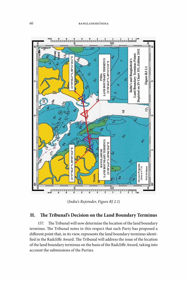
60 Bangladesh/India
(India’s Rejoinder, Figure RJ 2.1)
H. The Tribunal’s Decision on the Land Boundary Terminus157. The Tribunal will now determine the location of the land boundary
terminus. The Tribunal notes in this respect that each Party has proposed a different point that, in its view, represents the land boundary terminus identi-fied in the Radcliffe Award. The Tribunal will address the issue of the location of the land boundary terminus on the basis of the Radcliffe Award, taking into account the submissions of the Parties.

Bay of Bengal Maritime Boundary Arbitration—Award 61
158. As far as the “twinning” of the rivers Ichhamati and Kalindi, Raimangal and Haribhanga is concerned, the Tribunal observes that the four rivers all flow south (see the section of the Radcliffe Map*). The first two flow at separate points into the Raimangal which in turn flows partly into the Har-ibhanga. The Raimangal and Haribhanga then proceed southward separately and roughly in parallel, until they reach the Bay of Bengal at separate points. It appears clear that the 1925 determination was intended to refer only to the midstream of the main channel of the Haribhanga River as it entered the Bay.
159. Another point of difference between the Parties in the interpreta-tion of the 1925 Notification (and thus of the Radcliffe Award) is the meaning of the phrase “for the time being”. This phrase is indeed, on the face of it, ambiguous. “For the time being” might mean “as at present” (i.e. in 1925), or it might mean “from time to time” as the main channel of the rivers might move as a result of natural fluctuations in the deepest channel, which would mean a fluid boundary.
160. Both Parties refer in this context to the Bagge Award. The Tribunal notes that passages from the proceedings of the Bagge Tribunal were argued with the view to interpret the general meaning of the Radcliffe Award. Regard-ing river boundaries, Pakistan’s nominee to the tribunal (Mr. Justice Shahabud-din) urged an interpretation of the midstream of the River Ganges that was “flexible and not rigid … subject only to such geographical variations as may result from changes occurring in the course of the river Ganges” (Case con-cerning boundary disputes between India and Pakistan relating to the interpre-tation of the report of the Bengal Boundary Commission, 12 and 13 August 1947, Decision of 26 January 1950, RIAA, Vol. XXI, p. 1 at p. 12) This was opposed by India’s nominee (Mr. Justice Chandrasekhara Aiyar), who argued as follows:
The overriding purpose or object of the division must be borne in mind in construing the award. The idea was to bring into existence two inde-pendent Sovereign States which would have nothing more to do with each other except as the result of treaty or agreement or adjustment. The interpretation of the boundary on the basis of a fluid line would defi-nitely frustrate this idea if the river changes its course. Pakistan territory might become Indian territory and vice versa; and pockets might be cre-ated in each State of what must be regarded as foreign territory. How is the government to be carried on of such areas? What is to happen to the administration, and what would be the method of approach to the pock-ets situated in the centre of one State surrounded on all sides by an area belonging to an alien State? Surely, a person of the eminence and expe-rience of Sir Cyril Radcliffe must have envisaged all these difficulties and made up his mind to provide for definite and inflexible boundaries.(Case concerning boundary disputes between India and Pakistan relating to the interpretation of the report of the Bengal Boundary Commission, 12 and 13 August 1947, Decision of 26 January 1950, RIAA, Vol. XXI, paragraph 23).
* Secretariat note: See map located in the front pocket (India’s Rejoinder, Figure RJ 2.2).
62 Bangladesh/India
161. Justice Aiyar’s argument in this respect was adopted by Chairman Bagge, who concluded that “the course of the midstream of the main channel of the River Ganges as it was at the time of the Award given by Sir Cyril Radcliffe in his report of August 12th 1947 is the boundary between India and Pakistan to be demarcated on the site” (Case concerning boundary disputes between India and Pakistan relating to the interpretation of the report of the Bengal Bound-ary Commission, 12 and 13 August 1947, Decision of 26 January 1950, RIAA, Vol. XXI, p. 1 at p. 12 (emphasis added)). The Chairman’s decision continued: “If the demarcation of this line is found to be impossible, the boundary between India and Pakistan in this area shall then be a line consisting of the land portion of the above-mentioned boundary and of the boundary following the course of the midstream of the main channel of the river Ganges as determined on the date of demarcation and not as it was on the date of the Award. The demarca-tion of this line shall be made as soon as possible and at the latest within one year from the date of the publication of this decision” (ibid. at p. 12).
162. No evidence was presented to the Tribunal that demarcation of the line was found to be impossible, or that any demarcation of the river boundary, in such forms as marker posts or buoys, was in fact carried out.
163. In the view of the present Tribunal, the Bagge Award establishes clearly that the determination of the midstream of the main channel of the Haribhanga River must be as it was in 1947 at the time of the Radcliffe Award, and not as it might become at later times.
164. In the present proceeding, India also sought to strengthen its argu-ment for a “fluid” land boundary terminus by reference to the exchange of cor-respondence between officers of India and Pakistan in 1951 (see paragraph 109 above), whereas Bangladesh rejected the significance of the exchange of letters.
165. The Tribunal is not convinced that the clear determination of the Bagge Award was undone by the exchange of correspondence between officials of the two governments in 1951. As noted by Bangladesh, the Indian letter was unsigned. While recognizing that a subsequent agreement in the sense of article 31(3)(a) of the Vienna Convention on the Law of Treaties need not itself possess all the formalities of a treaty (see International Law Commission, Report on the Sixty-Fifth Session, UN Document A/68/10 at p. 32 (2013)), the Tribunal does not consider the exchange of letters to be sufficiently authori-tative to constitute such a subsequent agreement between the Parties. Above all, it is difficult for the present Tribunal to accept that such a low-level and brief exchange of correspondence between civil servants, purporting to reverse an important general determination of the formal Indo-Pakistani Boundary Disputes Tribunal established by a solemn agreement at the Inter-Dominion Conference at New Delhi on 14 December 1948, represents an authentic agree-ment of the Parties.
166. The Parties also referred to a 1957 report prepared by Commander R.H. Kennedy for the United Nations First Conference on the Law of the Sea that includes a description of the area of the land boundary terminus. Drafted
Bay of Bengal Maritime Boundary Arbitration—Award 63
with reference to BA Chart 859 and the Bay of Bengal Pilot (8th edition, 1953), Commander Kennedy’s report states that “[t]he boundary between India and East Pakistan reaches the sea in the vicinity of the mouths of the Haribhanga and Raimangal Rivers, two of the rivers forming part of the delta of the Riv-er Ganges. These two rivers meet in a common estuary.” (Kennedy Report, UN Document A/CONF.13/151 at p. 209.) In the Tribunal’s view, Command-er Kennedy’s report offers no greater precision as to the location of the land boundary terminus which he identifies with the words “in the vicinity of”.
167. Finally, the Tribunal notes that the uses of the rivers shed no light on the meaning of the Radcliffe Award. Neither Party adduced evidence regarding the history of navigation or other uses of the rivers concerned, especially during the period 1947–1951. With respect to current uses, Bang-ladesh has stated that “[t]here are virtually no shipping or navigation activi-ties around the mouth and length of the Hariabhanga and Raimangal rivers.” (Bangladesh’s Letter to the Tribunal dated 4 March 2013 at paragraph 7.) India concurs, stating as follows:
Because of the sensitive nature of the area and existence of the present dispute, there are currently no commercial shipping or navigation activ-ities within and around mouth of the Hariabanga and Raimangal Rivers up to Biharikhal (latitude 21 Deg 57 Min 36.986 Secs and longitude 89 Deg 04 Min 10.728 Secs) upstream of the mouth, except movement of our border security agency / coast guard and Forest department and West Bengal Police etc. Biharikhal is the point on the India-Bangladesh International Boundary that lies along the existing India-Bangladesh Protocol Route (Haldia-Mongla) under the Protocol on Inland Water Trade and Transit (PIWTT) between India and Bangladesh. […]However shipping, navigation and fishing activities take place along Haria-banga and Raimangal Rivers north of the India-Bangladesh Protocol Route.(India’s Letter to the Tribunal dated 30 April 2013 at paragraphs 4–5).
168. The Parties provided no further details when questioned regarding historical navigation.101
*
169. On the basis of the foregoing, the Tribunal concludes that the mid-stream of the main channel of the Haribhanga River must be located as it was in 1947 at the time of the Radcliffe Award. It also considers that the Radcliffe Award, incorporating the 1925 Notification, referred to the Haribhanga River alone and not to the combined waters of the Haribhanga and Raimangal Rivers as they meet the Bay of Bengal.
170. In identifying the location of the land boundary terminal at a crit-ical date—here, 1947—reference must be had to the “photograph of the terri-
101 Hearing Tr., 334:9–18.
64 Bangladesh/India
tory” at that time (Frontier Dispute (Burkina Faso/Mali), Judgment, 1986 I.C.J. Reports, p. 568, paragraph 30). As the Chamber of the Court noted in 2005:
The Chamber cannot exclude a priori the possibility that maps, research or other documents subsequent to that date may be relevant in order to establish, in application of the uti possidetis juris principle, the situation that existed at the time. In any event, since the effect of the uti possidetis principle is to freeze the territorial title [reference to Burkina Faso/Mali, para. 29], the examination of documents posterior to independence can-not lead to any modification of the “photograph of the territory” at the critical date unless, of course, such documents clearly express the Par-ties’ agreement to such a change.Frontier Dispute (Benin/Niger), Judgment, 2005 I.C.J. Reports, p. 109, paragraph 26.
171. The Tribunal will locate the land boundary terminus as it was decided in 1947 on the basis of the available information at the time and sup-plemented by more recent information as to the situation at the critical date. The Tribunal considers that determination of this point, including the drawing of a closing line across the entrance to the Bay, requires reference to charts drawn at different times.
172. In addition to their differences as to the interpretation of the Rad-cliffe Award, the Parties make use of different charts to identify the location of the land boundary terminus. Whereas Bangladesh used the 1931 printing of BA Chart 859, India based itself on the Radcliffe Map. This difference requires the Tribunal to address the question of what charts should be used for identi-fying the exact location of the land boundary terminus.
173. As far as the charts presented to the Tribunal by the Parties are concerned, it is to be noted that no survey of the Haribhanga River was carried out in 1947. The difficulty of taking a “photograph” of the river in 1947 is com-pounded by the evident change over the last century of the major geographical features of the estuary (including receding coastlines, possible changes in the course of the main channel, etc.). The Tribunal is nevertheless in possession of evidence, as described below, allowing it to locate the land boundary terminus as it was in 1947.
174. The Tribunal has available to it (1) the 1931 Reprint of BA Chart 859 provided by Bangladesh, which is based on a survey conducted in or before 1879; (2) the 2011 edition of Indian Navy Chart 351 submitted by India, reflecting a survey done by the Indian Navy in 1998–2004; and (3) the Radcliffe Map. It goes without saying that the Indian Navy Chart 351 was prepared much lat-er than in 1947. There is no evidence that BA Chart 859 was relied upon by Sir Cyril; otherwise, the Radcliffe Award would have referred to BA Chart 859. Neither chart is thus decisive.
175. As far as BA Chart 859 is concerned, the Tribunal does not consider that it gives a reliable “photograph” of the Raimangal Estuary as it existed in 1947. BA Chart 859 was first issued on 18 July 1880, with new editions issued in 1886,

Bay of Bengal Maritime Boundary Arbitration—Award 65
1887, 1903 and 1904. The chart itself states that the surveys were compiled in 1879, which in the view of the Tribunal means they were conducted even earlier.
176. The Tribunal notes also that there is some uncertainty in the plead-ing of Bangladesh as to how coordinates on this chart were to be transformed to the modern WGS-84 datum. In this regard, the Tribunal notes that in its letter of 23 December 2013, Bangladesh stated that it would not rely on the method that it had used to calculate the transposition to WGS-84 in its plead-ings, but did not offer an alternative shift or new WGS-84 coordinates derived from a comparison of established points of reference.
177. Although the Tribunal could undertake the conversion of BA Chart 859 to WGS-84 itself, in light of the fact that BA Chart 859 was in any event based on surveys undertaken many years before the critical date, i.e. 1947, and taking into account the instability of the coast in the relevant area (on this see paragraphs 372–379 below) the Tribunal does not consider this chart to form a primary source for identifying the land boundary terminus.
178. As far as the Radcliffe Map is concerned, the Tribunal notes that Bangladesh, amongst others, questions the authenticity of this map. Consid-ering that the Radcliffe Map displayed at the hearing showed the signature of Sir Cyril Radcliffe and an indication that it was used by the Bagge tribunal, the Tribunal has no doubt that this map was the authentic Radcliffe Map.
179. As far as concerns the survey on which this map is based, the Tri-bunal accepts that, as recorded in the Bagge Award, the Radcliffe Map was compiled from a survey conducted in 1915–1916. The Radcliffe Map depicts the river boundary between the districts of 24 Parganas and Khulna as a black dash-dot-dash line. Like other district boundaries on the map, the dash-dot-dash line was highlighted on one side in green. The boundary determined by Sir Cyril was then indicated by a red highlight along the other side of the black dash-dot-dash line.
180. With regard to the argument of Bangladesh that the scale of the Radcliffe Map makes it unsuitable for establishing the land boundary ter-minus, the Tribunal notes that the scale indicated on the Radcliffe Map is 1 inch = 8 miles, or 1:506,880. With respect to precision at this scale, the Tri-bunal recalls that the maximum precision with which a map point can be plot-ted is generally considered as being within 1/100th of an inch. Applied to the Radcliffe Map, this equates to a maximum precision of within approximately 128 meters. This is—contrary to the arguments advanced by Bangladesh—suf-ficiently precise to justify the use of this map.
181. The Radcliffe Map does not indicate the datum on which its coordi-nates are based. Considering the surveys undertaken in India, however, it may be assumed that the Indian Datum was used. The shift necessary to transform that datum to WGS-84 is a constant set of mathematical parameters and has been published by the International Hydrographic Organization in its “User’s Handbook on Datum Transformations Involving WGS-84”.
66 Bangladesh/India
182. The Tribunal notes that the river and maritime aspects of the Rad-cliffe Map lack the precision of most nautical charts. The Map does not, for example, depict river depths that would enable the Tribunal to confirm that the boundary line drawn on the map does in fact follow the “midstream of the main channel” of the Haribhanga as it “meets the Bay”. Apart from that, the Map was based on a survey conducted in 1915–16 and thus does not fully reflect the situation at the critical date. The members of the Bagge Tribunal had similar reservations. For example, Justice Shahabbudin observed that “[t]he map which was used by Sir Cyril was based on the Survey of 1915–16” and considered that “it did not represent the actual state of the river on the date of the award”. (Case concerning boundary disputes between India and Pakistan relating to the interpretation of the report of the Bengal Boundary Commission, 12 and 13 August 1947, Decision of 26 January 1950, RIAA, Vol. XXI, p. 1 at p. 25). Similarly, Justice Bagge stated that
concerning the part of the district boundaries which are following the mid-stream of the river Ganges difficulties arise in making use of the map […].The map […] does not reproduce the position of the river at the time of the notifications but at the time of the survey. The map, in fact, does on the stretch which is following the river Ganges not reproduce any other district boundaries than those determined by the position of the river Ganges at the time about thirty years ago when the survey maps were made on which the map in Annexure B is based.(Ibid. at p. 28–29).
183. The Tribunal nevertheless emphasizes that the lack of references in the Radcliffe Map to river depths does not mean that this information was not available to those who drew the map. The district boundaries set out on the map sometimes follow the midstream and sometimes carefully follow one or the other river bank. It may therefore be assumed that the end of the black dash-dot-dash line indicates the midstream of the main channel of the Harib-hanga River. In this context the Tribunal notes that Bangladesh has not estab-lished that the boundary depicted on the Radcliffe Map—and this includes its endpoint—departs from the description of the boundary in the Radcliffe Award. The Tribunal also recalls that the Radcliffe Map was based upon a survey much closer to the critical date than BA Chart 859 and that this survey obviously was acceptable to Sir Cyril Radcliffe.
184. A critical reason for the Tribunal to use the Radcliffe Map to estab-lish the land boundary terminus is the fact that Sir Cyril himself had found the Map reliable enough to use and incorporate into his award. The Tribunal considers that it should not attempt to establish the land boundary terminus on the basis of the wording of the Radcliffe Award without giving due regard to the attached map.
185. Turning to the coordinates of the land boundary terminus indi-cated on the Radcliffe Map, the Tribunal concludes that a closing line can be drawn with its western end located at 21° 38’ 24.3”N; 89° 06’ 17.4”E (Indian

Bay of Bengal Maritime Boundary Arbitration—Award 67
Datum) on the map, equivalent to 21° 38’ 27.3”N; 89° 06’ 08.0”E (WGS-84), and its eastern end at 21° 38’ 50.1”N; 89° 12’ 42.8”E (Indian Datum), equiva-lent to 21° 38’ 53.1”N; 89° 12’ 33.3”E (WGS-84). This closing line is depicted graphically in Map 1.*
186. The terminus of the black dash-dot-dash line of the district bound-ary itself plots to 21° 38’ 37.2”N, 89° 09’ 29.4”E (Indian Datum), equivalent to 21° 38’ 40.2”N; 89° 09’ 20.0”E (WGS-84). This point is on the closing line as it would have been drawn in 1947.
187. Transposed to a modern chart, the ends of the closing line and the land boundary terminus indicated on the Radcliffe Map are depicted in Map 2** (with the difference between the closing line of the Radcliffe Map and the present shoreline representing erosion in the time since the 1915–1916 sur-vey was undertaken).
188. The resulting position of the land boundary terminus is 21° 38’40.2”N, 89° 09’ 20.0”E (WGS-84).
189. The Tribunal has reviewed the location of the land boundary ter-minus reached in this manner through comparison to the modern charts before it (see Kasikili/Sedudu Island at paragraph 20). Nothing in these charts contradicts the Tribunal’s location of the land boundary terminus; they rather confirm its accuracy.
* Secretariat note: See map located in the front pocket (Map 1).** Secretariat note: See map located in the front pocket (Map 2).

68 Bangladesh/India
Chapter V. The Selection of Base Points and the Delimitation of the Territorial Sea
A. General Considerations concerning a Maritime Boundary190. Both Parties, in their final submissions, asked the Tribunal to draw a
maritime boundary delimiting their respective territorial seas, exclusive econom-ic zones and the continental shelf within and beyond 200 nm in the disputed area.
191. In delimiting the various maritime spaces, however, different con-siderations need to be taken into account. In the delimitation of the territorial sea, for instance, it is of considerable significance that the rights of the coastal State are not functional, but territorial, and entail sovereignty over the seabed, the superjacent waters and the air column (see Maritime Delimitation and Ter-ritorial Questions between Qatar and Bahrain (Qatar v. Bahrain), Merits, Judg-ment, I.C.J. Reports 2001, p. 93, paragraph 173–174, referring to Delimitation of the Maritime Boundary in the Gulf of Maine Area, I.C.J. Reports 1984, p. 327, paragraph 194). Further to seaward, sovereign rights, rather than sovereignty itself, are at issue, and the relevant considerations differ. For this reason, the Tribunal will deal with the delimitation of the territorial seas, the exclusive economic zones and the continental shelf within and beyond 200 nm sepa-rately. Before doing so, however, the Tribunal considers it appropriate to first address the role of base points in the delimitation of maritime areas and the manner in which they should be selected.
B. General Considerations concerning the Selection of Base Points
192. Although the Parties disagree regarding the appropriate method-ology for the delimitation of the territorial sea, exclusive economic zone, and continental shelf, each has proposed base points for the construction of a pro-visional equidistance line.
193. Bangladesh proposes the following base points in respect of its own coast and the coast of India (all coordinates in WGS-84):102
102 Bangladesh’s Reply, paragraph 4.57; Letter from Bangladesh dated 5 March 2013 (cor-recting coordinates of Shahpuri Point).

Bay of Bengal Maritime Boundary Arbitration—Award 69
No. Location Latitude Longitude
B-1 Clump Island 21° 39´ 04˝N 89° 12´ 40˝EB-2 Clump Island 21° 39´ 08˝N 89° 14´ 45˝EB-3 Putney Island 21° 40´ 15˝N 89° 19´ 56˝EB-4 Pussur Point 21° 42´ 42˝N 89° 35´ 00˝EB-5 Shahpuri Point 20° 43´ 26.3˝N 92° 19´ 45.5˝E
I-1 Moore Island 21° 37´ 00˝N 89° 05´ 35˝EI-2 Bhangaduni Island 21° 32´ 21˝N 88° 53´ 13˝EI-3 False Point 20° 20´ 29˝N 86° 47´ 07˝EI-4 Devi Point 19° 57´ 33˝N 86° 24´ 20˝E
194. India proposes the following base points in respect of its own coast and the coast of Bangladesh (all coordinates in WGS-84):103
No. Location Latitude Longitude
B-1 Clump Island 21° 38´ 56.0˝N 89° 12´ 41.8˝EB-2 Clump Island 21° 38´ 57.4˝N 89° 14´ 47.6˝EB-3 Putney Island 21° 37´ 32.7˝N 89° 20´ 25.5˝EB-4 Andar Char Island 21° 38´ 00.5˝N 90° 33´ 32.0˝EB-5 Shahpuri Point 20° 43´ 38.6˝N 92° 19´ 30.2˝E
I-1 South Talpatty/New Moore Island
21° 37´ 50.7˝N 89° 08´ 49.9˝E
I-2 South Talpatty/New Moore Island
21° 35´ 30.0˝N 89° 09´ 40.6˝E
I-3 West Spit—Dalhou-sie Sand
21° 22´ 47.6˝N 88° 43´ 43.7˝E
I-4 Devi Point 19° 57´ 33.1˝N 86° 24´ 20.0˝E
195. Each Party takes issue with the base points proposed by the other.
*
196. Bangladesh objects to India’s base points I-1, I-2, I-3, B-3, and B-4 on the grounds that they are located on alleged low-tide elevations, the exist-ence of which Bangladesh disputes.
197. Bangladesh’s objection to base points I-1 and I-2 is particularly acute. First, Bangladesh challenges the existence of South Talpatty/New Moore Island on which the points are located. In Bangladesh’s view, the island dis-
103 India’s Rejoinder, paragraphs 4A.2 – 4A.10.
70 Bangladesh/India
appeared permanently below the surface in the late 1980s or early 1990s.104 Bangladesh submits that South Talpatty/New Moore Island is absent on any satellite images after 1989,105 and recalls that nothing more than breakers was seen during the site visit, despite multiple trips to the area.106
198. According to Bangladesh, even if South Talpatty/New Moore Island does exist as a low-tide elevation, it is “on the Bangladesh side of any conceivable boundary line” and inappropriate for a base point.107 In this respect Bangladesh notes that in Qatar v. Bahrain, the International Court of Justice held that low-tide elevations situated in the zone of overlapping claims must be disregarded for the purpose of drawing the equidistance line.108 In Bangladesh/Myanmar, the Parties respected this practice and no low-tide elevations for base points were proposed in the delimitation of the territorial sea. 109
199. Sovereignty over South Talpatty/New Moore Island, Bangla-desh argues, can only be determined by reference to the delimitation line as “a coastal State has sovereignty over low-tide elevations which are situated within its territorial sea” (Maritime Delimitation and Territorial Questions between Qatar and Bahrain, Merits, Judgment, I.C.J. Reports 2001, p. 40 at p. 101, paragraph 204). Bangladesh notes the decision in the Nicaragua v. Colombia case that low-tide elevations may not be appropriated, (Nicaragua v. Colombia, Judgment of 19 November 2012, paragraph 26) as well as decisions in the Malaysia/Singapore and Nicaragua v. Honduras cases in which the Court declined to determine sovereignty over the low-tide elevations in dispute (Case Concerning Sovereignty Over Pedra Branca/Pulau Batu Puteh, Middle Rocks and South Ledge (Malaysia/Singapore), Judgment, I.C.J. Reports 2008, paras. 291–299; Territorial and Maritime Dispute between Nicaragua and Honduras in the Caribbean Sea (Nicaragua v. Honduras), Judgment, I.C.J. Reports 2007, paragraphs 144–145).
200. In addition, Bangladesh submits that South Talpatty/New Moore is “far too insignificant, and its stability far too suspect, to be accorded such importance in this delimitation”.110 Citing the Black Sea and Gulf of Maine decisions, Bangladesh argues that “the International Court of Justice has made it clear on several occasions that what it refers to as ‘minor geographical fea-tures’ should not be used as the basis for delimiting a maritime boundary” (Maritime Delimitation in the Black Sea (Romania/Ukraine) I.C.J Reports 2009, p. 61, paragraph 137; Delimitation of the Maritime Boundary in the Gulf of Maine Area (Canada/USA), I.C.J. Reports 1984, p. 329, paragraphs 201, 210). In the Black Sea case in particular, Bangladesh further observes, the Internation-
104 Bangladesh’s Reply, paragraph 3.77.105 Bangladesh’s Reply, paragraph 3.78.106 Hearing Tr., 99:21 to 101:3.107 Bangladesh’s Reply, paragraph 3.72.108 Bangladesh’s Reply, paragraph 3.73.109 Bangladesh’s Reply, paragraph 3.74.110 Bangladesh’s Reply, paragraph 4.33.

Bay of Bengal Maritime Boundary Arbitration—Award 71
al Court of Justice declined to place a base point on Serpent’s Island, a much larger and more prominent feature than South Talpatty/New Moore.111 Similar small islands were disregarded in Libya/Malta and Nicaragua v. Colombia.
201. Bangladesh raises similar objections to India’s proposed base points I-3, B-3, and B-4, disputing the existence of each alleged low-tide eleva-tion. Noting that none were observable during the site visit, Bangladesh sub-mits that “[i]t is plainly visible that all of these base points are out at sea”.112
202. Finally, although not located on low-tide elevations, Bangladesh objects to the locations of India’s proposed base points B-1 and B-2. Although Bangladesh itself placed base points on Mandarbaria/Clump Island, it submits that the island is receding due to “constant and extensive coastal erosion”, placing the coordinates of India’s points under water.113
203. In contrast to what it considers India’s “capricious and subjective” approach to the location of base points,114 Bangladesh submits that all of the base points it has proposed are located on the coastline. In its view, “[t]hese base points are less unstable than those of India”. Nevertheless, Bangladesh notes, “they are still inherently unstable because of massive erosion in the Bengal Delta”.115
*
204. India rejects Bangladesh’s critique of its selection of base points, and argues that there is extensive State practice to support “the use of the low-water lines on low-tide elevations as the baseline for measuring the terri-torial sea, and the use of base points on such low-water lines for the purposes of delimitation”.116 India quotes article 13 of the Convention, which provides in part as follows:
Where a low-tide elevation is situated wholly or partly at a distance not exceeding the breadth of the territorial sea from the mainland or an island, the low-water line on that elevation may be used as the baseline for measuring the breadth of the territorial sea.117
205. With respect to the visibility of India’s low-tide elevation base points during the site visit, India makes three submissions. First, India asserts that it had repeatedly warned that sighting the low-tide elevations was uncer-tain because the days of the site visit coincided with neap tides.118 Second, in India’s view, it would not have been possible for the Parties and the Tribunal to view the low-tide elevation of South Talpatty/New Moore given that it would
111 Bangladesh’s Reply, paragraph 4.34.112 Hearing Tr., 95:15.113 Bangladesh’s Reply, paragraph 3.80; Hearing Tr., 95:17–20.114 Bangladesh’s Reply, paragraph 4.43.115 Hearing Tr., 102:14–15.116 India’s Counter-Memorial, paragraph 5.50.117 India’s Rejoinder, paragraph 4.52.118 Hearing Tr., 298:21–299:9.

72 Bangladesh/India
have been visible only at 6:30 am and 6:30 pm, neither of which coincided with the Tribunal’s visit to the area.119 Third, India asserts that another reason for the lack of visibility of the low-tide elevations was the bad weather and poor meteorological conditions.120 In any event, India argues, it is universal prac-tice to select base points in accordance with maritime charts, and all modern charts depict South Talpatty/New Moore as a low-tide elevation.121
206. According to India, South Talpatty/New Moore has demonstrat-ed stability over the years and, having been an island from 1970 onwards, is now a low-tide elevation according to satellite images from 2012.122 Once the location of the land boundary terminus is fixed by the Tribunal, sovereignty over South Talpatty/New Moore Island will become evident and any concerns arising from disputed sovereignty will evaporate.123 India argues that the deci-sion of the International Court of Justice to disregard low-tide elevations in Qatar v. Bahrain was specific to the circumstances of that case, especially with regard to the issue of disputed sovereignty. In India’s view, the same concerns do not apply here.124
207. With respect to its base points B-1 and B-2, India argues that these base points are just south of the low-water line of Mandarbaria/Clump Island and demonstrate the relative stability of the coastline.125 Rather than repre-senting erosion, India argues that the different locations of the Parties’ base points on the Island reflect different source data, differences in survey tech-nology and errors inherent in the transformation from the local datum to the global WGS-84 Datum.126
*
208. For its part, the Tribunal notes that, initially, the Parties’ positions on base points were entirely at odds. Bangladesh argued, in its Memorial, that the identification of base points was not feasible and that the construction of a provisional equidistance line was not appropriate. According to Bangladesh, the instability of the coast precluded any firm location of base points, whether on the coastline or on low tide elevations. Bangladesh therefore resorted to a 180° angle bisector for the delimitation.
209. In contrast, India constructed a provisional equidistance line in its Counter-Memorial, choosing for some of its base points low-tide elevations located at some distance from the coast.
119 Hearing Tr., 299:11–23.120 Hearing Tr., 300:3–18.121 Hearing Tr., 299:20–23.122 India’s Rejoinder, paragraph 4.49.123 India’s Rejoinder, paragraph 4.54.124 India’s Counter-Memorial, paragraphs 5.51–5.52.125 India’s Rejoinder, paragraph 4.62.126 Hearing Tr., 385:8–16.

Bay of Bengal Maritime Boundary Arbitration—Award 73
210. Following the decision of the International Tribunal for the Law of the Sea in the Maritime Boundary between Bangladesh and Myanmar in the Bay of Bengal, Bangladesh changed its position in its Reply. Bangladesh’s principal argument in its Reply remained that an angle bisector would be the most appropriate method of delimitation. But it added its own construction of a provisional equidistance line in the alternative, locating its base points on the low-water line of the coasts concerned, and proposed an adjustment of the provisional line.
211. Prior to the oral proceedings, the Tribunal referred the Parties to the jurisprudence of the International Court of Justice and indicated that it would “welcome further arguments from the Parties concerning their selec-tion of base points”. The Tribunal referred in particular to the decision in the Black Sea case, which states that equidistance lines “are to be constructed from the most appropriate points on the coasts of the two States concerned, with particular attention being paid to those protuberant coastal points situated nearest to the area to [be] delimited” (Judgment, I.C.J. Reports 2009, p. 61 at p. 101, paragraph 117). In that decision, the International Court of Justice further identified the appropriate points as those “which mark a significant change in the direction of the coast, in such a way that the geometrical figure formed by the line connecting all these points reflects the general direction of the coastlines” (ibid., at p. 105, paragraph 127). In response, India referred to articles 13 and 15 of the Convention and maintained its selection of base points situated on low-tide elevations. Bangladesh confirmed its choice of base points located on the low-water line of the coasts concerned.
212. The Tribunal emphasizes that the delimitation of the maritime spaces in the Bay of Bengal is a different exercise from the determination of the location of the land boundary terminus. The Tribunal’s task is not to iden-tify the geographical features and the coast line as they were in 1947. Neither Party suggests that the Radcliffe Award purported to delimit the territorial sea, much less the exclusive economic zone and continental shelf. The task of the Tribunal is to delimit de novo the territorial sea, exclusive economic zone, and continental shelf. The Tribunal must therefore choose base points that are appropriate in reference to the time of the delimitation, i.e. the date of its Award.
213. Bangladesh argues that the instability of the coastline is a major factor weighing against the use of the provisional equidistance/relevant cir-cumstances method, in particular in view of the potential effect of climate change and sea level rise in the Bay of Bengal. Within a few years, Bangladesh submits, the low tide elevations chosen by India will likely have changed or disappeared. Even the coastal locations of the base points chosen by Bangla-desh will probably be submerged.
214. In the view of the Tribunal, this argument is not relevant. The issue is not whether the coastlines of the Parties will be affected by climate change in the years or centuries to come. It is rather whether the choice of base points

74 Bangladesh/India
located on the coastline and reflecting the general direction of the coast is feasible in the present case and at the present time. As the International Court of Justice stated in the Black Sea case:
In this respect, the Court observes that the geometrical nature of the first stage of the delimitation exercise leads it to use as base points those which the geography of the coast identifies as a physical reality at the time of the delimitation. That geographical reality covers not only the physical elements produced by geodynamics and the movements of the sea, but also any other material factors that are present.(Judgment, I.C.J. Reports 2009, p. 61, at p. 106, paragraph 131)
215. The Tribunal is concerned with the “physical reality at the time of the delimitation” (ibid.). It need not address the issue of the future instability of the coastline.
216. The Tribunal notes that maritime delimitations, like land bounda-ries, must be stable and definitive to ensure a peaceful relationship between the States concerned in the long term. As the International Court of Justice noted in its decision in the Temple of Preah Vihear case, “[i]n general, when two coun-tries establish a frontier between them, one of the primary objects is to achieve stability and finality” (Merits, Judgment of 15 June 1962, I.C.J. Reports 1962, p. 6 at p. 34). The same consideration applies to maritime boundaries.
217. In the view of the Tribunal, neither the prospect of climate change nor its possible effects can jeopardize the large number of settled maritime bound-aries throughout the world. This applies equally to maritime boundaries agreed between States and to those established through international adjudication.
218. The importance of stable and definitive maritime boundaries is all the more essential when the exploration and exploitation of the resources of the continental shelf are at stake. Such ventures call for important investments and the construction of off-shore installations, including those governed by the Convention in Parts VI and XI and in article 60. Bangladesh rightly points out the importance of such resources to a heavily populated State with limited natural resources. In the view of the Tribunal, the sovereign rights of coastal States, and therefore the maritime boundaries between them, must be deter-mined with precision to allow for development and investment. The possibility of change in the maritime boundary established in the present case would defeat the very purpose of the delimitation.
219. The Tribunal further notes that the problem has been greatly simpli-fied by modern technology. Whereas it was important in the past to rely on per-manent coastal features for the identification of boundaries at sea, satellite nav-igation systems now allow users of the oceans to easily locate any geodetic point without resorting to the actual physical features used at the date of delimitation.
220. As indicated above (at paragraphs 193–194), both Parties consid-ered the selection of appropriate base points to be feasible (even as they differed as to the advisability of such an approach). Both Parties identified base points

Bay of Bengal Maritime Boundary Arbitration—Award 75
and constructed a provisional equidistance line. The Tribunal observes that the provisional equidistance lines proposed by Bangladesh and by India are in close proximity to each other. The principal difference between them stems from disagreement on the location of the land boundary terminus. The close similarity in the lines proposed by the Parties demonstrates that it is feasible to construct an equidistance line using base points that reflect the general direction of the coast.
221. In the present case, both Parties have proposed base points, but both also recognize that it is open to the Tribunal to choose its own base points. As the International Tribunal for the Law of the Sea noted:
The Tribunal observes that, while coastal States are entitled to deter-mine their base points for the purpose of delimitation, the Tribunal is not obliged, when called upon to delimit a maritime boundary between the parties to a dispute, to accept base points indicated by either or both of them. The Tribunal may establish its own base points, on the basis of the geographical facts of the case.(Bangladesh/Myanmar, Judgment, 14 March 2012, paragraph 264).
222. In identifying base points, the Tribunal stresses thatdetermining the baseline for the purpose of measuring the breadth of the continental shelf and the exclusive economic zone and the issue of identifying base points for drawing an equidistance/median line for the purpose of delimiting the continental shelf and the exclusive economic zone between adjacent/opposite States are two different issues.(Maritime Delimitation in the Black Sea (Romania v. Ukraine), I.C.J. Reports 2009, p. 61 at p. 108, paragraph 137).
As the Court added in the same case:In … the delimitation of the maritime areas involving two or more States, the Court should not base itself solely on the choice of base points made by one of those Parties. The Court must, when delimiting the con-tinental shelf and exclusive economic zones, select base points by refer-ence to the physical geography of the relevant coasts.(Ibid.).
223. The Tribunal will determine the appropriate base points by ref-erence to the physical geography at the time of the delimitation and to the low-water line of the relevant coasts. The Tribunal recalls the decision in the Eritrea/Yemen (Maritime Delimitation) case that
the use of the low-water line is laid down by a general international rule in the Convention’s article 5, and that both Parties have agreed that the Tri-bunal is to take into account the provisions of the Convention in deciding the present case. The median line boundary will, therefore, be measured from the low-water line, shown on the officially recognized charts … , in accordance with the provision in Article 5 of the Convention.

76 Bangladesh/India
(Award of the Arbitral Tribunal in the second stage of the proceed-ings between Eritrea and Yemen (Maritime Delimitation), Decision of 17 December 1999 at paragraph 135, PCA Award Series at p. 40, RIAA, Vol. XXII, p. 335 at p. 366).
224. The Parties have presented opposing views on the accuracy of the maps and charts produced, due in particular to the rapid erosion of the coast-line. The Tribunal will avail itself of the most reliable evidence, resulting from the latest surveys and incorporated in the most recent large scale charts offi-cially recognized by the Parties in accordance with article 5 of the Convention.
225. As different base points control the course of an equidistance line though the territorial sea, the exclusive economic zone, and the continental shelf within and beyond 200 nm, the Tribunal will consider the specific points pro-posed by the Parties in connection with its discussion of each maritime zone.
C. The Parties’ Approaches to the Territorial Sea1. Applicable law for the delimitation of the territorial seas and
method of delimitation226. Both Parties agree that article 15 of the Convention governs the
delimitation of territorial sea in this case. Article 15 provides that:Where the coasts of two States are opposite or adjacent to each other, nei-ther of the two States is entitled, failing agreement between them to the contrary, to extend its territorial sea beyond the median line every point of which is equidistant from the nearest points on the baselines from which the breadth of the territorial seas of each of the two States is meas-ured. The above provision does not apply, however, where it is necessary by reason of historic title or other special circumstances to delimit the territorial seas of the two States in a way which is at variance therewith.
227. Neither Party claims the existence of any agreement between them on the delimitation of the territorial sea or a “historic title” within the meaning of article 15 in the area to be delimited.127 The Parties, however, disagree on the interpretation of “special circumstances” as referred to in article 15 of the Convention and whether they are applicable in this case. They equally disagree on the appropriate method of delimitation under article 15.
*
228. Bangladesh recalls that the concept of “special circumstances” in article 15 was imported from article 6 of the Convention on the Continental Shelf (1958), which employed the same language.128 It further notes that the Court of Arbitration in the Anglo/French Continental Shelf case concluded
127 Bangladesh’s Memorial, paragraph 5.16; India’s Counter-Memorial, paragraph 5.5; Bangladesh’s Reply, paragraph 3.46.
128 Bangladesh’s Memorial, paragraph 5.30.
Bay of Bengal Maritime Boundary Arbitration—Award 77
that the concept “special circumstances” was included in article 6 to provide a remedy to potentially inequitable results arising from the application of the equidistance principle in areas with “particular geographical features or con-figurations”.129 Under article 15, Bangladesh goes on to argue, the equidistance method is to be used where it would lead to an equitable solution; where it would not, “an alternative method of delimitation is to be utilized”.130
229. Bangladesh contends that the equidistance/special circumstances rule should be applied flexibly, and notes that this approach is supported by the International Law Commission’s commentary on the parallel provisions of the Convention on the Territorial Sea and the Contiguous Zone and the Convention on the Continental Shelf.131 Bangladesh also recalls the Court’s observation in the North Sea Continental Shelf Cases and Libya/Malta, that any distorting effect of an equidistance line in a situation of adjacent coasts is potentially magnified.132
230. Bangladesh challenges India’s assertion that recent case law on the territorial sea demonstrates a shift away from an expansive understanding of special circumstances and toward the equidistance rule.133 To the contrary, Bangladesh relies on the decision of the International Court of Justice in Nica-ragua v. Honduras which declined to accord the equidistance method automatic priority over other methods of delimitation and rejected its application in the territorial sea as a result of special circumstances. (Territorial and Maritime Dispute between Nicaragua and Honduras in the Caribbean Sea (Nicaragua v. Honduras), Judgment, I.C.J. Reports 2007, p. 659 at p. 741, paragraph 272). The special circumstances recognized by the International Court of Justice, Bang-ladesh argues, included the close proximity of base points, active morpho-dy-namism of the delta and coastline, the absence of viable base points claimed or accepted by the parties, and the difficulty in identifying reliable base points.134 In its analysis, the International Court of Justice took the view that article 15 does not per se preclude geomorphological problems from being “special cir-cumstances”, nor does it provide that “special circumstances” may only be used to correct a line already drawn. (Territorial and Maritime Dispute between Nic-aragua and Honduras in the Caribbean Sea (Nicaragua v. Honduras), Judgment, I.C.J. Reports 2007, p. 659 at p. 743, paragraphs 280–281). The Court further concluded that the wording of the special circumstance exception envisages the possibility that a special configuration of the coast may require a different delimitation method (ibid.)135 Bangladesh recalls that, in Nicaragua v. Hondu-ras, the Court ultimately concluded that the “very active morpho-dynamism”
129 Bangladesh’s Memorial, paragraph 5.31.130 Bangladesh’s Memorial, paragraph 5.32.131 Bangladesh’s Memorial, paragraph 5.33.132 Bangladesh’s Memorial, paragraph 5.34.133 Bangladesh’s Reply, paragraph 3.51.134 Bangladesh’s Memorial, paragraph 5.37.135 Bangladesh’s Memorial, paragraph 5.38.

78 Bangladesh/India
of the delta of the River Coco “might render any equidistance line so construct-ed today arbitrary and unreasonable in the near future”.136
231. Finally, Bangladesh submits that there is no inconsistency between its view of special circumstances in this arbitration and the position it recently took before the International Tribunal for the Law of the Sea in Bangladesh/Myanmar. In that case, Bangladesh argued against treating Saint Martin’s Island as a special circumstance, but no question of coastal instability or con-cavity was at issue.137
*
232. India submits that recent international jurisprudence demon-strates a shift from an expansive understanding of special circumstances and favours the use of equidistance.138 According to India “the equidistance/rele-vant circumstances method is to be applied unless it is impossible to identi-fy appropriate base points, rendering it unfeasible to construct a provisional equidistance line”.139 In India’s view, Bangladesh misuses the Nicaragua v. Honduras decision: the mere presence of deltaic coasts does not make an equi-distance line unfeasible.140 Rather, in that case, the geographical configuration of the needle-like Cape made it impossible to identify base points on the tip of the needle.141 Relying on the judgment in the Black Sea case, India argues that the proper role of special circumstances is in the second stage of the delimita-tion, after a provisional equidistance line is drawn.142 According to India, only if there are “compelling reasons” why an equidistance line is unfeasible does Nicaragua v. Honduras support abandoning the method entirely.143
233. India contends that, although Bangladesh now argues that equidis-tance lacks a priori character, Bangladesh recently endorsed the opposite posi-tion in Bangladesh/Myanmar, where it had recognized the priority of “equidis-tance” over “special circumstances”.144 Indeed, India recalls, Bangladesh has conceded even in these proceedings that “the median line method is accorded primacy under UNCLOS”.145
136 Hearing Tr., 114:7–10.137 Bangladesh’s Reply, paragraph 3.54.138 India’s Counter-Memorial, paragraph 5.6, India’s Rejoinder, paragraph 6.5.139 India’s Counter-Memorial, paragraph 5.9.140 India’s Counter-Memorial, paragraph 5.19.141 India’s Counter-Memorial, paragraph 5.17.142 India’s Rejoinder, paragraphs 5.9–5.10.143 India’s Rejoinder, paragraph 4.10.144 India’s Counter-Memorial, paragraph 5.7.145 India’s Rejoinder, paragraph 6.5.
Bay of Bengal Maritime Boundary Arbitration—Award 79
2. The delimitation lines proposed by the Parties234. Bangladesh proposes the use of an angle-bisector line in light of
the prevailing coastal instability and concavity in the Bay of Bengal.146 India insists on the use of the median line on the ground that Bangladesh has failed to prove the existence of special circumstances within the meaning of arti-cle 15 to justify a departure from the median line.147
235. Given that many issues concerning the appropriateness of the angle-bisector method are also discussed by the Parties in relation to the delimitation of the exclusive economic zone and continental shelf, the Tribu-nal will, in this Chapter, only address the issues that relate specifically to the delimitation of the territorial sea, and leave issues that relate also the exclusive economic zone or continental shelf for subsequent consideration.
*
236. Bangladesh objects to India’s proposed equidistance line on the ground that the incorrect location of the land boundary terminus claimed by India results in an incorrect starting point for the proposed line.148 Bangladesh also contends that, as explained above, the base points selected by India are inappropriately located, which leads to an erroneous equidistance line con-structed from these points.149
237. Bangladesh asserts that there is scientific evidence of extreme coast-al instability in the Bengal Delta,150 and that this constitutes a “special circum-stance” within the meaning of article 15 of the Convention.151 Bangladesh cites various studies on coastal erosion in the Bengal Delta and argues that arti-cle 7(2) of the Convention, concerning the drawing of straight baselines, was adopted by States with the specific instability of the Bengal Delta in mind.152 Accordingly, Bangladesh submits that the “unrebutted evidence” of extreme coastal instability in the Bengal Delta qualifies as a “special circumstance” and that base points on that coastline are “unstable” and would become “uncertain within a short period of time (if they are not already uncertain)”.153 Bangladesh, therefore, submits that in the present case any equidistance line would become “arbitrary and unreasonable in the near future”154 and that the angle-bisector methodology is the more appropriate rule to apply.155 Thus Bangladesh submits
146 Bangladesh’s Memorial, paragraph 5.48.147 India’s Counter-Memorial, paragraphs 5.33–5.45.148 Bangladesh’s Reply, paragraph 3.83.149 Bangladesh’s Reply, paragraph 3.83.150 Hearing Tr., 106 to 112.151 Hearing Tr., 113:3–7.152 Hearing Tr., 117:1 to 118:16.153 Hearing Tr., 114:19 to 115:3.154 Hearing Tr., 115:3–4.155 Hearing Tr., 119:3–4.

80 Bangladesh/India
that the maritime boundary “follows a line with a geodesic azimuth of 180° from the location of the land boundary terminus at 21° 38´ 14˝N, 89° 06́ 39˝E”.156
238. In response to India’s argument that Nicaragua v. Honduras can be distinguished on the basis that in that case it was not feasible to draw an equi-distance line, Bangladesh argues that in the present case just one or two base points on each coast control the entire equidistance line and that all of these points are unstable. Bangladesh also argues that all of India’s base points are either submerged or will almost certainly be submerged in the near future.157 According to Bangladesh, unstable base points will result in an “arbitrary or unreasonable” line in the near future.158
239. Bangladesh also submits that its coastal concavity constitutes a special circumstance. Bangladesh challenges India’s position that concavity may not be a significant factor in the context of a narrow belt such as the 12 nm territorial sea, arguing that the impact of the application of an equidistance line in the territorial sea is on the entire course of the maritime boundary.159 Bangladesh reiterates that concavity is one of the recognized special circum-stances where equidistance does not offer an equitable result, and recalls that a situation similar to that of Bangladesh was invoked by Germany in the North Sea Continental Shelf Cases.160
240. Bangladesh rejects India’s contention that the area in which the terri-torial sea is to be delimited is not located in a concavity, referring to the decisions of the Guinea/Guinea Bissau tribunal and the International Tribunal for the Law of the Sea in Bangladesh/Myanmar, where the focus on macro-geography was endorsed even in relation to the territorial sea. Accordingly, Bangladesh argues, that the delimitation should take overall account of the shape of the coast.161
*
241. India argues that the territorial sea should be delimited on the basis of a median line constructed using the base points identified above. India’s proposed line follows a course such that:
(i) Starting from the land boundary terminus at Point L (21° 38´ 40.4˝N; 89° 10´ 13.8˝E), the boundary follows a geo-detic azimuth of 149.3° until it reaches Point T1, with the co-ordinates 21° 37´ 15.7˝N, 89° 11́ 07.6˝E.
(ii) From Point T1, the boundary follows a geodetic azimuth of 129.4° until it reaches Point T2, with the co-ordinates 21° 35́ 12.7˝N, 89° 13́ 47.5˝E.
156 Hearing Tr., 560:20–22.157 Hearing Tr., 115:19 to 116:5.158 Hearing Tr., 116:6–14.159 Bangladesh’s Reply, paragraph 3.66.160 Bangladesh’s Reply, paragraph 3.66.161 Bangladesh’s Reply, paragraph 3.67.

Bay of Bengal Maritime Boundary Arbitration—Award 81
(iii) From Point T2, the boundary follows a geodetic azimuth of 144.2° until it reaches Point T3, with the co-ordinates 21° 32´ 25.7˝N, 89° 15́ 56.5˝E.
(iv) From point T3, the boundary follows a geodetic azimuth of 168.6°, until it reaches the end of the delimitation line in the territorial sea, at a distance of 12 nautical miles from the low water line of both States’ coast.162
242. India submits that the Tribunal should not apply the angle-bisector method, as there are no circumstances in the present case that would make it impossible to delimit the territorial sea using equidistance and special circum-stances.163 In India’s view, Bangladesh’s reliance on Nicaragua v. Honduras dis-torts the reasoning of that case.164 According to India, the coastal geography in the Bay of Bengal is nothing like that of the River Coco. India argues that the Tri-bunal must not lower the threshold for considering coastal instability as relevant in delimitation.165 India points out that in Nicaragua v. Honduras, the coastal configuration was such that there were only two possible locations for appropri-ate base points, both of which were highly unstable and were unusually close to each other. In India’s view, it was this particular coastal configuration that made it impossible for the Court to construct an equidistance line in the river mouth because there were no other controlling points available to the Court.166
243. In contrast, India asserts that even if the Tribunal in the present case were to find one or more of the base points selected by the Parties inappro-priate, there are other prominent base points that reflect the general direction of the coasts to choose from. Thus, India submits that the requirement that the construction of an equidistance line be impossible is not satisfied.167 Addition-ally, India observes that if the physical geography of the coastline will change as dramatically as Bangladesh argues, a fixed angle-bisector will be no less arbitrary than a fixed equidistance line.168
244. India also rejects the relevance Bangladesh attributes to concavity in the context of delimiting the 12 nm territorial sea, arguing that in that nar-row area neither Party’s relevant coast indicates any considerable concavity.169
245. Finally, in response to Bangladesh’s reliance on article 7(2) of the Convention to suggest that the instability of the Bengal Delta has been widely recognized, India makes three points. First, India notes that article 7(2) is a general provision that does not refer to the Bengal Delta. Second, India argues
162 India’s Counter-Memorial, paragraph 5.58.163 India’s Rejoinder, paragraph 6.9.164 Hearing Tr., 369:7 to 371:7.165 Hearing Tr., 369:13–15.166 Hearing Tr., 370:18–23.167 Hearing Tr., 371:27 to 372:4.168 Hearing Tr., 373:3–4.169 India’s Counter-Memorial, paragraph 5.40.

82 Bangladesh/India
that article 7(2) cannot establish as a matter of law that the Bengal Delta is highly unstable; stability or instability is not a matter to be determined by trea-ty. Third, according to India, the States Parties when negotiating article 7(2) merely agreed on a form of words as part of the overall political package con-cluded at the Conference; they did not agree specifically to the application of an angle-bisector.170
D. The Tribunal’s Delimitation of the Territorial Sea246. The Tribunal notes that the methods governing the delimitation of
the territorial sea are more clearly articulated in international law than those used for the other, more functional maritime areas. It emphasizes that in the first sentence of article 15, the Convention refers specifically to the median/equi-distance line method for the delimitation of the territorial sea failing an agree-ment between the parties concerned. In Maritime Delimitation and Territorial Questions between Qatar and Bahrain the International Court of Justice stated:
The most logical and widely practised approach is first to draw pro-visionally an equidistance line and then to consider whether that line must be adjusted in the light of the existence of special circumstances.(Qatar v. Bahrain), Judgment of 16 March 2001, I.C.J. Reports 2001, p. 94, paragraph 176.
247. The Tribunal observes that in its second sentence article 15 of the Convention provides for the possibility of an alternative solution where this is necessary by reason of historic title—which neither Party claims—or “other special circumstances”.
248. On the basis of this interpretation of article 15 of the Convention, the Tribunal has assessed the arguments advanced by Bangladesh. The Tribu-nal notes that, as Bangladesh has done following the decision in Bangladesh/Myanmar, it is possible to identify appropriate base points on the basis of which an equidistance line can be constructed. Bangladesh invoked no further con-siderations which would in the view of the Tribunal justify a deviation from the application of the median line/equidistance method. Given the Tribunal’s concern with the “physical reality at the time of the delimitation”, discussed in connection with the selection of base points (see paragraph 215 above), the Tribunal need not consider whether instability could in some instances qualify as a special circumstance under article 15. The Tribunal also does not consider that the general configuration of the coast in the Bay of Bengal is relevant to the delimitation of the narrow belt of the territorial sea. To the extent Bangladesh refers to the specific geographic particularities of the area in question—the Raimangal estuary—the Tribunal notes that these geographic particularities apply equally to the territorial seas of both Parties in the area
170 Hearing Tr., 610:11 to 611:4.

Bay of Bengal Maritime Boundary Arbitration—Award 83
and therefore cannot be invoked by either Party to justify adjustments of the equidistance line established below.
249. The Tribunal will now turn to the construction of the equidistance line in the territorial sea between Bangladesh and India. It will proceed to do so in two steps. First it will identify the base points relevant for the delimitation of the territorial sea. Thereafter it will identify the median/equidistance line.
1. Location of Base Points in the Territorial Sea250. The Tribunal notes that both Parties have agreed that the delim-
itation of the territorial sea should start from the land boundary terminus. They also agree not to rely on the straight baselines established by them for delimitation of the outer limit of their territorial seas. Instead, they both have identified base points specifically for the present lateral delimitation.
251. Article 15 of the Convention defines the median line as a line “every point of which is equidistant from the nearest points on the baselines from which the breadth of the territorial seas of each of the two States is measured”.
252. The Tribunal recalls the dictum of the International Court of Jus-tice in the Fisheries case that “[t]he delimitation of sea areas has always an international aspect; it cannot be dependent merely upon the will of the coast-al State …” ((United Kingdom v. Norway), Judgment, 18 December 1951, I.C.J. Reports 1951, p. 116 at p. 132). This point is all the more relevant in relation to a delimitation between States with adjacent or opposite coasts. The possible distortions consequent on a unilateral choice of base points or baselines are just as true within the territorial sea as within the exclusive economic zone or continental shelf.
253. The Tribunal will choose the base points it considers appropriate for the present delimitation of the territorial sea. It will naturally begin by considering the base points proposed by the Parties.
254. On its own coast, Bangladesh has proposed the following base points:
— base point B-1, located on the low-water line of the coastline of Mandar-baria/Clump Island;
— base point B-2, also located on the low-water line of the coastline of Man-darbaria/Clump Island;255. On the coast of India, Bangladesh has proposed the following
base points:— base point I-1, said to be on the low-water line of Moore Island;171
171 Bangladesh has referred to the area of India’s coast immediately adjacent to the estuary as “Moore Island”, although this name does not appear on charts of the area and at points in the proceedings, the name Baghmarah Island was also used. For the sake of consistency, the Tribunal will refer to area as Moore Island.
84 Bangladesh/India
256. On the coast of Bangladesh, India has proposed the following base points:
— base points B-1 and B-2, said to be on the low-water line of Mandarbaria/Clump Island.
— base point B-3, located on the south-western edge of a low-tide elevation lying south-east of Putney Island.257. On its own coast, India has proposed the following base points:
— base points I-1 and I-2, located on South Talpatty/New Moore Island.258. The differing selection of base points by the Parties directly raises the
question of whether base points located on low tide elevations are appropriate.259. Low-tide elevations may certainly be used as baselines for meas-
uring the breadth of the territorial sea. Article 13 of the Convention provides:
Article 13
Low-tide elevations.
1. A low-tide elevation is a naturally formed area of land which is sur-rounded by and above water at low tide but submerged at high tide. Where a low-tide elevation is situated wholly or partly at a distance not exceeding the breadth of the territorial sea from the mainland or an island, the low-water line on that elevation may be used as the baseline for measuring the breadth of the territorial sea.2. When a low-tide elevation is wholly situated at a distance exceeding the breadth of the territorial sea from the mainland or an island, it has no territorial sea of its own.
260. It does not necessarily follow, however, that low-tide elevations should be considered as appropriate base points for use by a court or tribunal in delimiting a maritime boundary between adjacent coastlines. Article 13 specifically deals with the measurement of the breadth of the territorial sea. It does not address the use of low-tide elevations in maritime delimitations between States with adjacent or opposite coasts.
261. The Tribunal considers that base points located on low-tide eleva-tions do not fit the criteria elaborated by the International Court of Justice in the Black Sea case and confirmed in more recent cases. In the Black Sea case, the International Court of Justice described the selection of base points as follows:
Equidistance and median lines are to be constructed from the most appropriate points on the coasts of the two States concerned, with par-ticular attention being paid to those protuberant coastal points situat-ed nearest to the area to the delimited. The Court considers elsewhere the extent to which the Court may, when constructing a single-purpose delimitation line, deviate from the base points selected by the Parties for their territorial seas. When construction of a provisional equidis-
Bay of Bengal Maritime Boundary Arbitration—Award 85
tance line between adjacent States is called for, the Court will have in mind considerations relating to both Parties’ coastlines when choosing its own base points for this purpose. The line thus adopted is heavily dependent on the physical geography and the most seaward points of the two coasts.In this stage of the delimitation exercise, the Court will identify the appropriate points on the Parties’ relevant coast or coasts which mark a significant change in the direction of the coast, in such a way that the geometrical figure formed by the line connecting all these points reflects the general direction of the coastlines. The points thus selected on each coast will have an effect on the provisional equidistance line that takes due account of the geography.(Judgment, I.C.J. Reports 2009, p. 61 at p. 101, 105, paragraphs 117, 127)
262. If alternative base points situated on the coastline of the parties are available, they should be preferred to base points located on low-tide ele-vations. Such is the case in the present instance.
263. The site visit by the Tribunal and representatives of both Parties confirmed the location, visibility and protuberance of the base points located on the respective coastlines of Bangladesh and India identified by the Parties. It did not confirm the visibility of the base points located on low tide eleva-tions, with the possible exception of the base point situated on South Talpatty/New Moore Island. Breakers observed in that area did signal the existence of a feature, although it was not apparent whether the feature was permanently submerged or constituted a low-tide elevation. In any event, whatever feature existed could in no way be considered as situated on the coastline, much less as a “protuberant coastal point”, to use the expression of the International Court of Justice (Maritime Delimitation in the Black Sea, Judgment, I.C.J. Reports 2009, p. 61 at p. 101, paragraph 117). In the opinion of the Tribunal, South Talpatty/New Moore Island is not a suitable geographical feature for the location of a base point.
264. The Tribunal has decided that it will not rely on base points locat-ed on low tide elevations detached from the coast in the present case for the purpose of delimitation of the territorial seas of the two Parties. It concludes, therefore, that the locations of India’s proposed base points I-1, I-2, and B-3 are not acceptable.
265. India has also proposed base points B-1 and B-2, which are said to be located on the low water line of Mandarbaria/Clump Island. While a base point on such a location is acceptable, the Tribunal notes that the coordinates proposed by India in fact plot to seaward of the low-water line.
266. Bangladesh has also proposed base points B-1 and B-2 on the low water line of Mandarbaria/Clump Island. Bangladesh has further proposed base point I-1, which it claims to be situated on the low-water line of the coast of Moore Island. While this location is acceptable, the coordinates proposed by Bangladesh plot to seaward of the low-water line.
86 Bangladesh/India
267. Having reviewed the additional base points proposed by the Par-ties, the Tribunal decides that the following base points are appropriate for construction of the median/equidistance line in the territorial sea.
268. On the coast of Bangladesh:— base point B-1 as proposed by Bangladesh at 21° 39´ 04˝N; 89° 12´ 40˝E
269. On the coast of India:— a point located on the low-water line of Moore Island at 21° 38´ 06˝N;
89° 05́ 36˝E.
2. Establishment of the median/equidistance line in the territorial sea
270. The provisional median/equidistance line in the territorial sea starts at the mid-point between B-1 and I-1; namely, at:
Prov-0 = 21° 38’ 35.0”N, 89° 09’ 08.0”Eand continues along the geodetic line at an initial azimuth of 171° 40’ 32.81” until it reaches the territorial sea limits of Bangladesh and India, separately.
3. Adjustment of the median line in the territorial sea271. The Tribunal has already declined the argument of Bangladesh that
“special circumstances” called for an approach other than the median/equidis-tance line (see paragraph 248 above).
272. The Tribunal is equally of the view that Bangladesh did not adduce facts substantiating sufficiently its arguments that special circumstances exist which call for an adjustment of the median line in the delimitation of the terri-torial sea. Accordingly, the Tribunal takes the view that, within the 12 nm lim-it of the territorial sea, the concavity of the coastline of the Bay of Bengal does not produce a significant cut-off that warrants adjustment of the median line.
273. The Tribunal, however, notes that the land boundary terminus it has identified by reference to the Radcliffe Award (see paragraph 188 above) is not at a point equidistant from the base points selected by the Tribunal for the delimitation of the territorial sea. Since the delimitation of the territorial sea begins from equidistance line between the Parties, using the land boundary terminus in this case would not begin the delimitation on the “median line” as called for by article 15 of the Convention.
274. The Tribunal considers that the need to connect the land boundary terminus to the median line constructed by the Tribunal for the delimitation of the territorial sea constitutes a special circumstance in the present context.
275. This circumstance is similar to that faced by the tribunal in Guy-ana v. Suriname, where the seaward terminus of a previous delimitation of the three-nautical mile (3 nm) wide territorial sea was not on the median line in

Bay of Bengal Maritime Boundary Arbitration—Award 87
the sense of article 15 and had to be connected to the tribunal’s delimitation line based on equidistance (Guyana v. Suriname, Award of 17 September 2007, RIAA, Vol. XXX, p. 1 at p. 90, paragraph 323).
276. Bearing this special circumstance in mind, the Tribunal decides that the boundary should take the form of a 12 nm long geodetic line contin-uing from the land boundary terminus in a generally southerly direction to meet the median line at 21° 26’ 43.6”N; 89° 10’ 59.2”E. This line avoids any sudden crossing of the area of access to the Haribhanga River and interposes a gradual transition from the land boundary terminus to the median line. The connecting line may be depicted graphically in Map 3.

88 Bangladesh/India
Chapter VI. Relevant Coasts and Relevant Area for Delimitation beyond the Territorial Sea
277. Both Parties have set out what they consider to be the relevant portions of their coasts for the purpose of delimitation by the Tribunal. Both Parties also agree that the concept of relevant coasts plays multiple roles in the process of maritime boundary delimitation and that “the identification of the relevant coasts for the delimitation in general and the depiction of the general direction of the coast when applying the angle-bisector method are two dis-tinctly different operations”.172
278. The Tribunal notes that the Parties are broadly in agreement in their submissions with respect to the coast of Bangladesh. However, they differ significantly as to which segments of the Indian coastline are relevant. The Tribunal will address the coast of each State in turn. Before doing so, however, the Tribunal considers it helpful to recall the differing purposes served by the identification of the relevant coasts. As the International Court of Justice noted in the Black Sea case,
[t]he role of relevant coasts can have two different though closely related legal aspects in relation to the delimitation of the continental shelf and the exclusive economic zone. First, it is necessary to identify the relevant coasts in order to determine what constitutes in the specific context of a case the overlapping claims to these zones. Second, the relevant coasts need to be ascertained in order to check, in the third and final stage of the delimitation process, whether any disproportionality exists in the ratios of the coastal length of each State and the maritime areas falling either side of the delimitation line.(Judgment of 3 February 2009, I.C.J. Reports 2009, p. 61 at p. 89, para-graph 78.)
279. The Tribunal further observes that the principles underpinning the identification of the relevant coast are well established. First, it is axiomatic to the delimitation of a maritime boundary that the “land dominates the sea”, (North Sea Continental Shelf (Federal Republic of Germany/Denmark; Federal Republic of Germany/Netherlands), Judgment, I.C.J. Reports 1969, p. 51, para-graph 96) such that “coastal projections in the seaward direction generate mar-itime claims” (Maritime Delimitation in the Black Sea (Romania v. Ukraine), Judgment, I.C.J. Reports 2009, pp. 96–97, paragraph 99). Second, “the coast, in order to be considered as relevant for the purpose of the delimitation, must generate projections which overlap with projections from the coast of the other Party” (ibid.). At the same time, “the submarine extension of any part of the coast of one Party which, because of its geographic situation, cannot overlap with the extension of the coast of the other, is to be excluded from further consideration” (Maritime Delimitation in the Black Sea (Romania v. Ukraine), Judgment, I.C.J. Reports 2009, pp. 96–97, paragraph 99). In practice, therefore,
172 India’s Counter-Memorial, paragraph 6.28; see also Bangladesh’s Reply, paragraph 5.67.

Bay of Bengal Maritime Boundary Arbitration—Award 89
the relevance of any segment of the coast of a Party depends upon the identi-fication of the projections generated by that coast.
A. The Relevant Coast of Bangladesh280. With respect to Bangladesh, the Parties are in agreement that the
entire coast, extending from the land boundary terminus with India to the land boundary terminus with Myanmar at the mouth of the Naaf River, is relevant to this delimitation.173 The Parties differ only as to the length of Bang-ladesh’s coast.174
*
281. Bangladesh accepts the decision by the International Tribunal for the Law of the Sea that the correct method of calculating Bangladesh’s relevant coast, in light of the sinuosity of the coastline, is as a straight line from the land boundary terminus with Myanmar at the mouth of the Naaf River to the light-house on Kutubdia Island and as a second straight line from Kutubdia Island to the land boundary with India.175 Bangladesh also accepts India’s determina-tion that the length of this line, if calculated to a point on Mandarbaria/Clump Island near the mouth of the Raimangal Estuary is 417 kilometres.176
282. In Bangladesh’s view, however, India has “measured the Bangladesh coast from the wrong land boundary terminus”.177 According to Bangladesh, rath-er than stopping at a point on Mandarbaria/Clump Island near the land boundary terminus, the relevant coastal length should be extended to the actual land bound-ary terminus, which Bangladesh places 7 kilometres to the west.178 Bangladesh therefore considers the length of its relevant coast to be 424 kilometres.179
*
283. India submits that “the conclusion of the ITLOS” regarding Bang-ladesh’s relevant coast “is equally applicable in the instant case”.180 According to India however, the line drawn by the International Tribunal for the Law of the Sea measures 417 kilometres in length (4 kilometres longer than the measurement set out in the decision) (Dispute Concerning Delimitation of the Maritime Boundary between Bangladesh and Myanmar in the Bay of Bengal (Bangladesh/Myanmar), Judgment of 14 March 2012, para. 202).
173 India’s Counter-Memorial, paragraph 6.37; Bangladesh’s Reply, paragraph 5.61.174 Bangladesh’s Reply, paragraph 5.61.175 Bangladesh’s Reply, paragraph 5.61; India’s Counter-Memorial, paragraph 6.37.176 Bangladesh’s Reply, paragraph 5.62.177 Bangladesh’s Reply, paragraph 5.62.178 Bangladesh’s Reply, paragraph 5.62.179 Bangladesh’s Reply, paragraph 5.62.180 India’s Counter-Memorial, paragraph 6.36.

90 Bangladesh/India
284. India notes that the only difference between the Parties with respect to Bangladesh’s relevant coast concerns the location of the land bound-ary terminus.181 In India’s view, however, the minor differences between the lengths calculated by the International Tribunal for the Law of the Sea, India, and Bangladesh (413 km / 417 km / 424 km) “are immaterial in the context of applying the non-disproportionality test”.182
*
285. The Tribunal notes the Parties’ agreement that the entire coast of Bangladesh is relevant for the purpose of its delimitation. The minor difference between the Parties with respect to the length of Bangladesh’s coast stems entirely from their differing views on the location of the land boundary termi-nus. The Tribunal has now determined the exact location of the land boundary terminus from which the maritime boundary in the Bay of Bengal between Bangladesh and India will be drawn (see paragraph 188 above).
286. Accordingly, the Tribunal concludes that the first segment of the coastline of Bangladesh will extend from the land boundary terminus with India to the lighthouse on Kutubdia Island identified by the International Tri-bunal for the Law of the Sea in its decision. The second segment of the Bang-ladesh coastline will then extend from the said point on Kutubdia Island to the land boundary terminus with Myanmar in the Naaf River. As a result, the length of Bangladesh’s relevant coast is 418.6 kilometres.
B. The Relevant Coast of India287. Bangladesh submits, citing the decision by the International Tri-
bunal for the Law of the Sea, that the test for whether a coast is relevant for the purpose of delimitation is whether it “generate[s] projections which over-lap with those of another party”183 (Dispute concerning Delimitation of the Maritime Boundary between Bangladesh and Myanmar in the Bay of Bengal (Bangladesh/Myanmar), Judgment of 14 March 2012, para. 198). Applying this standard to the coastline of India, Bangladesh argues that the relevant coast “extend[s] the entire length of coast that faces onto the area to be delimited”, including in areas where the projection of the coast of Bangladesh extends beyond 200 nm.184
288. In concrete terms, Bangladesh agrees with the relevance of the first three segments of India’s coast identified by India. Bangladesh disagrees, how-ever, with India’s location of the land boundary terminus and argues that the length of these three segments should be measured at 404 kilometres, rather
181 India’s Rejoinder, paragraph 3.15.182 India’s Rejoinder, paragraph 3.16.183 Hearing Tr., 229:18–19.184 Hearing Tr., 231:6–8.

Bay of Bengal Maritime Boundary Arbitration—Award 91
than the 411 kilometres calculated by India (the difference corresponding to the 7 kilometre difference between the Parties with respect to the length of Bangladesh’s relevant coast).185
289. Further, Bangladesh does not agree that India’s relevant coast stops at Devi Point. According to Bangladesh, the relevant coast includes a fourth segment, running from Devi Point in a south-west direction until it reaches Sandy Point.186 In this area, the projection from India’s coast overlaps with the projection extending beyond 200 nm from Bangladesh’s coast. Including this additional segment, Bangladesh submits that India’s relevant coast would amount to 708 kilometres.187 India’s relevant coast, according to Bangladesh, is depicted graphically in the following chart from Bangladesh’s Reply:188
[…]*
290. In Bangladesh’s view, this approach directly follows the approach taken by the International Tribunal for the Law of the Sea, which calculated the relevant coast of Myanmar as extending up to Cape Negrais, including coastline from which a projection would overlap only with Bangladesh’s claim to the continental shelf beyond 200 nm.189 According to Bangladesh, there is “no reason to adopt a different approach in this case”, and “it would be rather anomalous to do so, given the geographic similarities of the case”.190 Defining the relevant coasts of the two Parties as only those from which the projections overlap within 200 nm, Bangladesh argues, would be “wholly artificial”.191 In Bangladesh’s view
The area in dispute in this case includes substantial areas that are beyond 200 miles. Indeed, it is one of the most critical issues in dispute. That being the case, the relevant coasts must also include the coasts that project into those areas.192
*
291. India describes the first three segments of its coast (between the land boundary terminus and Devi Point) as follows:
— the first segment runs in a westerly direction from the land boundary terminus with Bangladesh to a point close to and due south of Haripur in the vicinity of the city of Balasore;
185 Bangladesh’s Reply, paragraph 5.63.186 Bangladesh’s Reply, paragraphs 5.64–5.65.187 Bangladesh’s Reply, paragraphs 5.64–5.65.188 Bangladesh’s Reply, Volume II, Figure R5.10. * Secretariat note: See map located in the front pocket (Bangladesh’s Reply, Figure R5.10).189 Hearing Tr., 230:10–15.190 Hearing Tr., 230:16–17.191 Hearing Tr., 232:13.192 Hearing Tr., 232:13–16.

92 Bangladesh/India
— from that point, the coastline turns radically to proceed in a north/south direction up to Maipura Point (second segment);
— from Maipura Point the coast runs in a north-east/south-west direction until it reaches Devi Point (third segment).193
292. These are the same segments accepted in principle by Bangladesh. In light of where India locates the land boundary terminus, however, India measures the length of these three segments at 411 kilometres.
293. According to India, however, these segments comprise the entirety of India’s relevant coast. In India’s view, there is no basis for a fourth segment between Devi Point and Sandy Point, the selection of which is “entirely arbitrary”.194
294. In particular, India argues that the decision of the International Tribunal for the Law of the Sea in Bangladesh/Myanmar does not support the approach adopted by Bangladesh for identifying India’s relevant coast. Although the International Tribunal for the Law of the Sea did consider the coastline of Myanmar beyond 200 nm to be relevant, India argues that “[t]he fact that there was an overlapping area of continental shelf beyond 200 nautical miles did not affect the calculation of the relevant coast.”195 Considering the decision, India notes that the International Tribunal for the Law of the Sea stated only that
The Tribunal finds that the coast of Myanmar from the terminus of its land boundary with Bangladesh to Cape Negrais does, contrary to Bangladesh’s contention, indeed generate projections that overlap pro-jections from Bangladesh’s coast.196
(Dispute Concerning Delimitation of the Maritime Boundary between Bangladesh and Myanmar in the Bay of Bengal (Bangladesh/Myanmar), Judgment of 14 March 2012, para. 203.)
295. Although the International Tribunal for the Law of the Sea did not give any further reasons why it considered this section of the Myanmar coast to be relevant, India submits that the area of overlapping projections referred to “cannot have been throughout the area within 200 nautical miles projected from the stretch of coast beyond Bhiff Cape to the south”.197 In India’s view, the mere fact that a line can be drawn from a section of coast to overlap with the projection from the coast of the other State is insufficient, without more, to render that coast relevant. In the case of Myanmar, India suggests that the coast between Bhiff Cape and Cape Negrais was considered relevant because it faces “back into the relevant area and towards the coast of Bangladesh”.198
296. India contends that “the coast between Devi Point and Sandy Point, … faces” “in a south-easterly direction, not back into the head of
193 India’s Counter-Memorial, paragraph 6.40.194 Hearing Tr., 356:3–4.195 India’s Rejoinder, paragraph 3.23.196 Hearing Tr., 355:1–3.197 Hearing Tr., 355:5–7.198 Hearing Tr., 355:9–10.

Bay of Bengal Maritime Boundary Arbitration—Award 93
the Bay”.199 Moreover, although a line drawn from the coast between Devi Point and Sandy Point can overlap with the area of continental shelf beyond 200 nm claimed by Bangladesh, the same can be said of the coast beyond Sandy Point, which also projects onto the continental shelf beyond 200 nm. In India’s view, “there is no reason to choose one point over another” and the selection of Sandy Point is arbitrary.200
297. In advancing this view, India recognizes that Bangladesh has, in its submission to the CLCS, claimed areas of the continental shelf beyond 200 nm. However, it argues that there is “no need to extend India’s coast beyond Devi Point to reflect any entitlements beyond 200 nautical miles”.201 According to India, the projection of Bangladesh’s coast beyond 200 nm is already overlapped by the projection from the Indian coast north of Devi Point. In other words,
If the Bangladesh coast that generates overlapping projections with India within 200 nautical miles generates these projections beyond 200 nautical miles, then India’s relevant coast up to Devi Point can also generate overlapping maritime projections both within and beyond 200 nautical miles.202
298. In light of this, India sees no basis and no authority to support the extension of its relevant coast beyond Devi Point. India’s depiction of the rele-vant coast is represented graphically in the following sketch map from India’s Counter-Memorial:203
[…]*
*
299. In evaluating the Parties’ respective contentions, the Tribu-nal recalls that its task is to identify the coast that “generate[s] projections which overlap with projections from the coast of the other Party” (Black Sea (Romania v. Ukraine), Judgment of 3 February 2009, I.C.J. Reports 2009, p. 61 at pp. 96–97, paragraph 99). In keeping with its view that there is a single continental shelf (see paragraph 77 above), this Tribunal sees no basis for dis-tinguishing between projections within 200 nm and those beyond that point. Accordingly, the Tribunal considers the Indian coast to be relevant to the extent that its projection generates any overlap with the projection generated by the coast of Bangladesh. That being so, the coast is relevant, irrespective of whether that overlap occurs within 200 nm of both coasts, beyond 200 nm of both coasts, or within 200 nm of one and beyond 200 nm of the other. The
199 Hearing Tr., 355:17–19.200 India’s Rejoinder, paragraph 3.21.201 Hearing Tr., 355:22–23.202 Hearing Tr., 355:23–27.203 India’s Counter-Memorial, Sketch Map 6.6. * Secretariat note: See map located in the front pocket (India’s Counter-Memorial, Sketch
Map No. 6.6).

94 Bangladesh/India
question facing the Tribunal is therefore whether the Indian coast between Devi Point and Sandy Point generates a projection that overlaps with a projec-tion generated by the coast of Bangladesh.
300. To establish the projection generated by the coast of a State, the Tribunal considers that “what matters is whether [the coastal frontages] abut as a whole upon the disputed area by a radial or directional presence relevant to the delimitation” (Arbitration between Barbados and the Republic of Trini-dad and Tobago, Award of 11 April 2006, RIAA, Vol. XXVII, p. 147 at p. 235, paragraph 331). Between Devi Point and Sandy Point, the Indian coast faces directly on the projection of the continental shelf beyond 200 nm claimed by Bangladesh. Accordingly, the Tribunal has no difficulty in determining that the Indian coast between Devi Point and Sandy Point generates a projection that overlaps with a projection from the coast of Bangladesh and is therefore relevant to the delimitation to be effected by the Tribunal.
301. In reaching this decision, the Tribunal recognizes, as India argues, that the Indian coast north of Devi Point can also generate projections that overlap with the areas beyond 200 nm claimed by Bangladesh. In the Tribunal’s view, however, this has no bearing on the relevance of the Indian coast between Devi Point and Sandy Point. The projection of the coast of one Party can easily be overlapped by the projections of multiple segments of the coast of the other. The task facing the Tribunal is simply to identify those sections of coast that generate projections overlapping those of the coast of the other party.
302. The Tribunal further recognises that a radial line drawn to the north-east from a point south of Sandy Point would also overlap with the pro-jection of the coast of Bangladesh beyond 200 nm. In the Tribunal’s view, there is a margin of appreciation in determining the projections generated by a segment of coastline and a point at which a line drawn at an acute angle to the general direction of the coast can no longer be fairly said to represent the seaward projection of that coast. Between Devi Point and Sandy Point, this question does not arise, as the overlapping projection extends in a nearly per-pendicular line from the coast. Beyond Sandy Point, neither Party has suggest-ed that the Indian coastline remains relevant. Accordingly, the Tribunal need not determine whether a line drawn to overlap with the projection generated by the coast of Bangladesh would represent the projection of that coast.
303. The Tribunal notes that the coast of India’s Andaman Islands also generates projections that overlap with those of the coast of Bangladesh. Although India considers that Bangladesh’s entitlements should not extend so far as to conflict with India’s entitlement on the basis of the Andaman Islands, it maintains the view that “India is entitled to a continental shelf beyond 200 nautical miles both off its mainland coast and off the Andaman Islands.”204 That projections of the coast of the northern islands of the Andaman chain
204 India’s Counter-Memorial, paragraph 7.54(iii); see also India’s Rejoinder, paragraph 7.3, n. 393.

Bay of Bengal Maritime Boundary Arbitration—Award 95
overlap with those of the coast of Bangladesh can also clearly be seen in the following figure from Bangladesh’s Memorial, which indicates the respective projections from the coast of mainland India and from the Andaman Islands:
[…]*
The Tribunal is aware that the projection of the coast from the northern islands of the Andaman chain also overlaps with the projection of the mainland coast of India. This will be taken into account in the calculation of the relevant area.
304. The Tribunal concludes that the relevant coast of the Andaman Islands is the western coast of the northern half of the island chain, running from Interview Island in the south to Landfall Island in the north, and meas-ures 97.3 kilometres. As with the coast of mainland India to the south of Sandy Point, the Tribunal excludes the coast of the island chain to the south of Inter-view Island (as well as the Nicobar Islands further to the south). In the view of the Tribunal these islands lie too far to the south to be fairly considered to generate projections that overlap with those of the coast of Bangladesh.
305. For the foregoing reasons, the Tribunal determines that the rele-vant coast of mainland India runs from the land boundary terminus to Sandy Point and measures 706.4 kilometres. This is combined with the relevant coast of the Andaman Islands measuring 97.3 kilometres to produce a total of 803.7 kilometres of relevant coast for India. By this decision, the Tribunal takes no position at this stage on the delimitation of the maritime boundary on the basis of article 83 of the Convention (for this see paragraph 478 below).
C. The Relevant Area306. The Tribunal now turns to the question of the relevant area. On
this question, the Parties’ differing views on the extent of the relevant area stem entirely from their differing appreciation of the relevant coasts. Having identi-fied what it considers to be the relevant coasts of the Parties, it remains for the Tribunal only to identify the area resulting from the projections of those coasts.
307. To the west, north, and north-east, the relevant area is bounded by the coasts of India and Bangladesh identified above, running in six segments from Sandy Point along the coast of India, through the terminus of the land boundary between Bangladesh and India, and along the coast of Bangladesh until the terminus of the land boundary between Bangladesh and Myanmar at the mouth of the Naaf River.
308. To the east, the relevant area is bounded by the delimitation line between the maritime areas of Bangladesh and Myanmar identified by the International Tribunal for the Law of the Sea in that decision until it reaches the 200 nm limit from the coast of Myanmar (Dispute Concerning Delimitation
* Secretariat note: See map located in the front pocket (Bangladesh’s Memorial, Figure 7.5).

96 Bangladesh/India
of the Maritime Boundary between Bangladesh and Myanmar in the Bay of Ben-gal (Bangladesh/Myanmar), Judgment of 14 March 2012, paragraphs 500–505). From there, the relevant area is bounded by the 200 nm limit from the coast of Myanmar until it reaches the limit of Bangladesh’s submission to the CLCS.
309. To the south, the relevant area is bounded by the limit of Bangla-desh’s submission to the CLCS (see Government of Bangladesh, Submission by the People’s Republic of Bangladesh to the Commission on the Limits of the Continental Shelf: Executive Summary (February 2011) at pp. 14–17), from the point where it intersects with the 200 nm limit from the coast of Myanmar to the point where it joins the 200 nautical mile line drawn from the coast of India.
310. To the south-west, the Tribunal considers that the simplest solution is to connect the limit of Bangladesh’s submission to the CLCS to the coast by way of a straight line. The relevant area is therefore bounded by a line run-ning from the point where the limit of Bangladesh’s submission to the CLCS intersects with the 200 nautical mile line drawn from the coast of India until it reaches the relevant coast of India at Sandy Point.
311. The relevant area is depicted graphically in Map 4 [reproduced on the following page]. Within these limits, the size of the relevant area is calcu-lated to be approximately 406,833 square kilometres.

Bay of Bengal Maritime Boundary Arbitration—Award 97
98 Bangladesh/India
Chapter VII. Delimitation of the Exclusive Economic Zone and the Continental Shelf Within
200 nm
A. Methodology312. The Parties agree that articles 74(1) and 83(1) of the Convention
govern the delimitation of the exclusive economic zone and the continental shelf within 200 nm. These articles provide in the same terms that the delim-itation “shall be effected by agreement on the basis of international law, as referred to in article 38 of the Statute of the International Court of Justice, in order to achieve an equitable solution”.
313. While the Parties agree that the construction of an equidistance line is the first step of the delimitation process,205 they disagree on the central-ity of the equidistance method and the circumstances that would call for the application of the angle-bisector method.
1. Applicability of the equidistance method
314. Bangladesh submits that there is no presumption in favour of the equidistance rule in international jurisprudence206 and attributes the use of equidistance as a starting point to factors such as “practical convenience” and “certainty of application”.207 In its view, the International Court of Justice has recognized the unfair results that would have been produced by the equidis-tance methodology in the North Sea Continental Shelf Cases, Libya/Malta, Gulf of Maine, and Nicaragua v. Honduras.208
315. Bangladesh argues that of the judgments of courts and tribunals delim-iting maritime boundaries since the North Sea Continental Shelf Cases (1969), only two have drawn a line based purely on equidistance. In all other cases, either an adjusted equidistance line was used or an entirely different methodology was employed.209
316. According to Bangladesh, this remains true of the most recent cas-es of Bangladesh/Myanmar and Nicaragua v. Colombia.210 While both deci-sions nominally adopted the three-stage equidistance/relevant circumstances method, the ultimate delimitations departed significantly from equidistance and, in Bangladesh’s view, reinforce its position. Bangladesh submits that in Bangladesh/Myanmar, the International Tribunal for the Law of the Sea effec-
205 India’s Counter-Memorial, paragraph 6.5; Bangladesh’s Reply, paragraphs 4.27, 4.31.206 Bangladesh’s Memorial, paragraphs 6.22–6.23.207 Bangladesh’s Memorial, paragraph 6.24.208 Bangladesh’s Memorial, paragraphs 6.25–6.28.209 Bangladesh’s Memorial, paragraph 6.31.210 Bangladesh’s Reply, paragraphs 4.2–4.29.
Bay of Bengal Maritime Boundary Arbitration—Award 99
tively applied an angle bisector, albeit without so stating.211 Bangladesh notes that the 215° azimuth that was ultimately adopted to adjust the equidistance line was the same as the bisector proposed by Bangladesh.212 The lines differ only in the point of departure.213
317. Turning to Nicaragua v. Colombia, Bangladesh recalls the Court’s observation that the construction of a provisional equidistance line is “noth-ing more than a first step and in no way prejudges the ultimate solution which must be designed to achieve an equitable result” (Territorial and Maritime Dis-pute (Nicaragua v. Colombia), Judgment of 19 November 2012, paragraph 196). According to Bangladesh,
The Court’s mixing of different methodologies, none of them equidis-tance, starkly refutes India’s argument according to which the ICJ sup-posedly made clear in the Black Sea case that “equity” and “relevant cir-cumstances” may, “in appropriate circumstances, call for the adjustment or shift of a provisional equidistance line, but never its abandonment.”214
318. Bangladesh disputes India’s view that the law has shifted from sub-jective consideration of equity to more objective criteria through the equidis-tance method.215 Bangladesh argues that, as the International Court of Justice stated in Nicaragua v. Colombia, the function of relevant circumstances is to verify that the provisional line is not “perceived as inequitable” given the par-ticular circumstances of the case (Territorial and Maritime Dispute (Nicaragua v. Colombia), Judgment of 19 November 2012, paragraph 205).216 Bangladesh maintains that articles 74 and 83 call for an equitable solution by their express terms; thus, it is equity infra legem, not equity in a generalized sense, that is required by law.217 Nevertheless, Bangladesh argues, the question of what will be “perceived as inequitable” involves a significant margin of appreciation.218
*
319. India notes that no particular method is specified by articles 74(1) and 83(1) to achieve an equitable solution. However, India relies on Guyana v. Suriname and Bangladesh/Myanmar to argue that international jurisprudence has developed in favour of equidistance.219 India quotes the arbitral tribunal’s finding in Guyana v. Suriname that in the course of the last two decades inter-national courts and tribunals dealing with maritime delimitation “have come
211 Bangladesh’s Reply, paragraph 4.8.212 Bangladesh’s Reply, paragraph 4.7.213 Bangladesh’s Reply, paragraph 4.7.214 Bangladesh’s Reply, paragraph 4.25 (emphasis by Bangladesh).215 Bangladesh’s Reply, paragraph 4.16.216 Bangladesh’s Reply, paragraph 4.15.217 Bangladesh’s Reply, paragraph 4.17.218 Bangladesh’s Reply, paragraph 4.18.219 India’s Counter-Memorial, paragraph 6.4; Hearing Tr., 392:4–12.

100 Bangladesh/India
to embrace a clear role for equidistance”.220 India also submits that the equidsi-tance/relevant circumstances rule, as developed in Black Sea and Bangladesh/Myanmar, must be applied.221
320. India notes that more recent jurisprudence does not depart from this approach, which the International Court of Justice confirmed in Nicara-gua v. Colombia.222 Although, in that case, the Court shifted the provisional equidistance line and enclaved certain islands, India considers that this merely represents the second stage of the equidistance/relevant circumstances meth-od and was a consequence of certain relevant circumstances.223
321. India explains that the first stage of the three-stage method entails the establishment of a provisional equidistance line using methods that are “geometrically objective and also appropriate for the geography of the area”.224 Having noted that equity does not raise any concern at the first stage, India challenges Bangladesh’s argument that instability and concavity render an equidistance line inappropriate. According to India, such “special/relevant circumstances” come into play only in the second stage of the methodology and differ from “compelling reasons” that may lead international courts and tribunals to abandon equidistance entirely.225
322. India emphasizes that relevant circumstances must not be con-fused with the factors rendering the construction of an equidistance line unfeasible.226 In Nicaragua v. Honduras, a provisional equidistance line was rejected only because it was unfeasible to construct such a line.227 This, accord-ing to India, is the standard, and India contends that the compelling reasons that would render the establishment of an equidistance line unfeasible are purely objective—namely, the drawing of the line must not be possible.228
2. Applicability of the angle-bisector method323. Bangladesh argues for the application of the angle bisector meth-
od. Relying on Nicaragua v. Honduras, Bangladesh recalls that the angle-bisec-tor method begins with rendering the Parties’ relevant coasts as straight lines depicting their general direction, and moves to bisect the angle formed by the intersection of these straight lines to yield the direction of the delimitation line.229 In Bangladesh’s view, this method focuses on macro-geographical rath-
220 Hearing Tr., 392:9–12.221 India’s Counter-Memorial, paragraph 6.5.222 India’s Rejoinder, paragraph 4.6.223 Hearing Tr., 436:2–5.224 India’s Counter-Memorial, paragraph 6.8.225 India’s Rejoinder, paragraphs 4.9–4.10.226 Hearing Tr., 395:17–18.227 India’s Counter-Memorial, paragraph 6.10.228 Hearing Tr., 395:18–20.229 Bangladesh’s Memorial, paragraphs 6.86–6.87.

Bay of Bengal Maritime Boundary Arbitration—Award 101
er than micro-geographical features, and produces results that correspond to the dominant geographic circumstances since it relies on straight-line coastal façades rather than actual coastlines.230
324. Bangladesh notes that the angle-bisector method has been used on several occasions by international courts and tribunals. In the Gulf of Maine case, a chamber of the International Court of Justice, in opting for the angle-bisector approach, noted the inappropriateness of making minor geo-graphical features the basis for the determination of the dividing line.231 In that judgment, different bisectors were used to delimit separate segments of the maritime boundary.232 Bangladesh emphasizes that the decision does not suggest that it was impossible to locate base points.233
325. More recently, faced with an unstable coast characterized by a very active morpho-dynamism in Nicaragua v. Honduras, the International Court of Justice deployed the angle-bisector approach by drawing two straight-line coastal fronts and bisecting the angle formed by their intersection.234 Bangla-desh stresses the Court’s finding that an angle-bisector is a viable method in circumstances where equidistance is “not possible or appropriate”.235 In Bang-ladesh’s view, the test applied in Nicaragua v. Honduras is not one requiring impossibility, but one of impossibility or inappropriateness, either of which will suffice.236 To support its argument, Bangladesh quotes the Court’s obser-vation in Nicaragua v. Colombia that “it will not be appropriate in every case to begin with a provisional equidistance line”,237 as well as the statement by the International Tribunal for the Law of the Sea in Bangladesh/Myanmar that the angle-bisector method has been applied by courts and tribunals “where recourse to [equidistance] has not been possible or appropriate”.238
326. Bangladesh also cites the decision of the arbitral tribunal in Guinea/Guinea-Bissau, which employed the angle-bisector method (Delimitation of the maritime boundary between Guinea and Guinea-Bissau, Award of 14 February 1985, RIAA, Vol. XIX p. 149).239 Bangladesh maintains that the arbitral tribunal intended to produce a delimitation line “suitable for equitable integration into the existing delimitations of the West African region” as well as future delim-itations.240 The arbitral tribunal, in rejecting the equidistance method due to coastal concavity, noted that the equidistance method may result in “the middle
230 Bangladesh’s Memorial, paragraph 6.87.231 Bangladesh’s Memorial, paragraph 6.88.232 Bangladesh’s Memorial, paragraphs 6.89–6.90.233 Hearing Tr., 177:18 to 178:1.234 Bangladesh’s Memorial, paragraph 6.91.235 Hearing Tr., 172:16–19.236 Hearing Tr., 172:20 to 173:2.237 Hearing Tr., 173:11–12.238 Hearing Tr., 174:9–11.239 Bangladesh’s Memorial, paragraph 6.92.240 Bangladesh’s Memorial, paragraph 6.93.

102 Bangladesh/India
country being enclaved by the other two and thus prevented from extending its maritime territory as far seaward as international law permits”.241 The tri-bunal drew a single straight line across the coastal fronts of the five States in the region to approximate the maritime façade of the coast of the whole West Africa, and drew a perpendicular (a 180º angle-bisector) to this straight line façade.242 Apart from concavity, Bangladesh adds that Guinea/Guinea-Bissau also shares other similarities to the geography of this case, such as the presence of mangrove swamps, river deltas, coastal islands that join together at low tide, and a continental shelf “which bears the traces of successive coast lines”.243
327. In Bangladesh’s view, all of the reasons that have previously favoured the adoption of the angle-bisector method are present in its dispute with India. Like the highly irregular coast in the Gulf of Maine, the Bengal Delta coast is deeply indented with offshore islands and low-tide elevations.244 The risk of enclaving Bangladesh through equidistance lines resembles the situation in Guinea/Guinea-Bissau, where the coast in the region is concave in shape.245 Finally, active morpho-dynamism of the Bengal Delta recalls the shifting coastline in Nicaragua v. Honduras.246
328. Indeed, Bangladesh argues, Nicaragua v. Honduras and the present case present multiple similarities. In both cases, there are unstable coastlines and difficulties in identifying agreed base points.247 Both also feature concavity that renders the equidistance line more inappropriate the further the bound-ary extends from the coastline.248 Even the Parties’ present dispute regarding the Radcliffe Award recalls the difficulties in Nicaragua v. Honduras concern-ing the arbitral award addressing sovereignty over the islets formed near the mouth of the River Coco.249
329. Bangladesh concludes that the angle-bisector method produces a more equitable solution in those cases where it has been employed because it produces a more effective reflection of the coastal relationships and a result that constitutes a better expression of the principle of equal division of the areas in dispute.250 Bangladesh adds that the angle-bisector method is more consistent with the non-encroachment principle and prevents, as far as possi-ble, any cut-off of the seaward projection of the coast of the States concerned.251
*
241 Bangladesh’s Memorial, paragraph 6.94.242 Bangladesh’s Memorial, paragraph 6.95.243 Hearing Tr., 505:11–14.244 Bangladesh’s Memorial, paragraph 6.97.245 Bangladesh’s Memorial, paragraph 6.98.246 Bangladesh’s Memorial, paragraph 6.99.247 Hearing Tr., 180:4–7.248 Hearing Tr., 180:7–11.249 Hearing Tr., 181:14–16, 182:5–7.250 Hearing Tr., 183:1–4.251 Hearing Tr., 183:5–7.

Bay of Bengal Maritime Boundary Arbitration—Award 103
330. India submits that the leading authority for the modern law on maritime delimitation is the Black Sea judgment and challenges the relevance of Guinea/Guinea-Bissau on the basis that it was a special case and has not sub-sequently been followed.252 India contests Bangladesh’s interpretation of Gulf of Maine, arguing that the Court’s main reason for choosing the angle-bisector method was that an equidistance line would be controlled by base points locat-ed on features over which sovereignty was disputed.253
331. India objects to the heavy reliance that Bangladesh would have the Tribunal place on the International Court of Justice’s decision in Nicaragua v. Honduras, which in India’s view, Bangladesh takes “out of context”.254 According to India, the principal reason for the Court’s decision to apply an angle bisector was that the geographic configuration of the needle-shaped Cape Gracias a Dios rendered the identification of base points impossible. According to India,
if any two base points were to have been used for the purposes of gen-erating a provisional equidistance line, the Court would have had to select two points along opposite sides of the needle-like Cape. Even if two such base points could have been forced upon the geography of the Cape, they would have formed the base for a completely arbitrary equi-distance line.255
332. The changing geography of the Cape, or its morpho-dynamism, were in India’s view only secondary considerations for the Court: “it was not the mere presence of deltaic coasts that thwarted the drawing of an equidis-tance line; the accretion of sediment along the delta merely made evident the arbitrariness of using ‘two sides of a needle’ as base points.”256 In any event, India notes, the degree of accretion and advance of the coast were unlike any-thing to be seen in the mouth of the Raimangal Estuary.257 India points out that, in sharp contrast to the present case, both Nicaragua and Honduras rec-ognized the significance of the advancing coastline. Moreover, neither advo-cated for the use of equidistance.258
333. According to India, “[t]he decisive factor, at this step of the delim-itation process, is not whether the relevant coasts of the Parties are stable or not throughout their whole length, but whether base points appropriate for drawing an equidistance line can be determined on these coasts.”259 Aban-doning the high threshold of “impossibility” set by the Court as a criterion for departing from the equidistance/relevant circumstances method would, India argues, “put in question the difficult and long, but most fortunate, decisive
252 India’s Counter-Memorial, paragraph 5.10.253 India’s Counter-Memorial, paragraph 5.11.254 India’s Counter-Memorial, paragraph 5.12.255 India’s Counter-Memorial, paragraph 5.17.256 India’s Counter-Memorial, paragraph 5.19.257 India’s Counter-Memorial, paragraph 5.15.258 India’s Rejoinder, paragraph 4.15.259 India’s Counter-Memorial, paragraph 5.16.
104 Bangladesh/India
trend towards more objectivity and more predictability of the law of maritime delimitation”, and “open[] the door to full subjectivity”.260
334. Turning to other jurisprudence, India observes that in Nicaragua v. Colombia the International Court of Justice rejected Nicaragua’s argument in favour of a departure from equidistance, stating that, unlike Nicaragua v. Honduras, “this is not a case in which the construction of such a line is not feasible” (Territorial and Maritime Dispute (Nicaragua v. Colombia), Judgment of 19 November 2012, paragraph 195).261 In India’s view, the circumstances of the present case more closely resemble those of Nicaragua v. Colombia. There, as here, the coastline involved a long stretch of the mainland and a set of islands,262 and no morpho-dynamism that would preclude the selection of base points is in evidence. 263
335. In sum, India concludes that Bangladesh is attempting to reawaken outdated jurisprudence, the angle-bisector having been applied only once in the 13 cases decided after Libya/Malta, which was rendered almost 30 years ago.264 According to India, under modern jurisprudence, and in the absence of any compelling reason, a provisional equidistance line must be drawn first. Relevant circumstances—if any—play a role only during the second phase of the three-stage methodology.265
3. The Tribunal’s Decision on Methodology336. The Parties disagree on the centrality of the equidistance/relevant
circumstances method in the delimitation process and on the circumstances that would call for an alternative method in the form of an angle-bisector. In this respect they draw different conclusions from the judgments and awards issued by international courts and tribunals in other delimitation cases. The Parties further disagree on whether, if the equidistance/relevant circumstanc-es method is used, the provisional equidistance line will require adjustment.
337. In the view of the Tribunal two different, although interrelated, issues must be addressed. The first is whether a presumption exists in favour of the equidistance/relevant circumstances method for the delimitation of the exclusive economic zone and the continental shelf within 200 nm. The second is the application of this method in this particular case. The Tribunal will address each of these issues in turn.
338. The Tribunal notes that articles 74 and 83 of the Convention, which govern the delimitation of the exclusive economic zone and the continental
260 Hearing Tr., 397:17–21.261 India’s Rejoinder, paragraph 4.10 (emphasis by India).262 Hearing Tr., 396:6–11.263 Hearing Tr., 396:12–15.264 Hearing Tr., 400:3–12.265 Hearing Tr., 400:13–16.

Bay of Bengal Maritime Boundary Arbitration—Award 105
shelf respectively, do not refer to a specific method of delimitation. The refer-ence in article 15 to the median line as method of delimitation cannot be read into articles 74 and 83 of the Convention
339. Since articles 74 and 83 of the Convention do not provide for a par-ticular method of delimitation, the appropriate delimitation method—if the States concerned cannot agree—is left to be determined through the mecha-nisms for the peaceful settlement of disputes. In addressing this question, inter-national courts and tribunals are guided by a paramount objective, namely, that the method chosen be designed so as to lead to an equitable result and that, at the end of the process, an equitable result be achieved. In this connection, the Tribunal recalls the principles stated by the International Tribunal for the Law of the Sea in its judgment in Bangladesh/Myanmar (Judgment of 14 March 2012, paragraph 235). This Tribunal wishes to add that transparency and the predictability of the delimitation process as a whole are additional objectives to be achieved in the process. The ensuing—and still developing—international case law constitutes, in the view of the Tribunal, an acquis judiciaire, a source of international law under article 38(1)(d) of the Statute of the International Court of Justice, and should be read into articles 74 and 83 of the Convention.
340. The Tribunal will now discuss the two methods advocated by the Parties, namely the equidistance/relevant circumstances method and the angle-bisector method for the delimitation of the exclusive economic zone/continental shelf within 200 nm.
341. The Tribunal recalls that the first stage of the equidistance/relevant circumstances method involves the identification of a provisional equidistance line “using methods that are geometrically objective and also appropriate for the geography of the area in which the delimitation is to take place” (Maritime Delimitation in the Black Sea (Romania v. Ukraine), Judgment of 3 February 2009, I.C.J. Reports 2009, p. 61 at p. 101, paragraph 116 referring also to the Continental Shelf case (Libyan Arab Jamahiriya/Malta), Judgment 3 June 1985, I.C.J Reports 1985, p. 13, paragraph 60 et seq.). The second stage calls for the consideration of relevant circumstances that may call for the adjustment of the provisional equidistance line in order to achieve an equitable result. The third stage consists of an ex post facto check of non-disproportionality of the result reached at the second stage.
342. Relying on the judgment of the International Court of Justice in the Territorial and Maritime Dispute between Nicaragua and Honduras in the Caribbean Sea ((Nicaragua v. Honduras), Judgment, I.C.J. Reports 2007, p. 659), Bangladesh notes that the angle-bisector method starts with rendering the Parties’ relevant coasts as straight lines depicting their general direction. The angle formed by the intersection of these straight lines is then bisected to yield the direction of the delimitation line.
343. The International Court of Justice noted in the Nicaragua v. Hon-duras that the angle-bisector method is meant to generalize irregular coastal features through a linear approximation of the relevant coasts. The Tribunal

106 Bangladesh/India
notes that the equidistance/relevant circumstances and angle-bisector meth-ods are both based upon geometric techniques. In the view of the Tribunal, the advantage of the equidistance/relevant circumstances method lies in the fact that it clearly separates the steps to be taken and is thus more transparent. The identification of a provisional equidistance line is based on geometrical-ly objective criteria, while at the same time account is taken of the geogra-phy of the area through the selection of appropriate base points. By contrast, depicting the relevant coasts as straight lines under the angle-bisector meth-od involves subjective considerations. As the present case demonstrates, there may be more than one way of depicting the relevant coast with straight lines.
344. In the second stage of the equidistance/relevant circumstances method, the provisional equidistance line may be adjusted to reflect the par-ticularities of the case. International jurisprudence gives some guidance on the considerations relevant in this process. The Tribunal is aware that the deci-sion whether to adjust a provisional equidistance line, as well as the decisions on how much and in which direction the line should be adjusted, requires an assessment by the Tribunal of the facts and the probable impact of the provisional equidistance line. While such an assessment is largely a matter of appreciation, the Tribunal is of the view that, by separating the first and second stages in the application of the equidistance/relevant circumstances method, a high degree of transparency can be achieved. Transparency is, of course, also dependent on the reasoning given for any particular decision. However, the Tribunal considers that, even if clearly reasoned, a decision based on the angle-bisector method does not possess the same structure or the same degree of transparency.
345. For these reasons, the Tribunal considers that equidistance/rele-vant circumstances method is preferable unless, as the International Court of Justice stated in Nicaragua v. Honduras, there are “factors which make the application of the equidistance method inappropriate” (Judgment, I.C.J. Reports 2007, p. 659 at p. 741, paragraph 272).
346. This is not the case here. Bangladesh was able to identify base points on its coast, as well as on the coast of India. The argument of Bangla-desh that the “coastal configuration renders the identification of equidistance base points impractical or unreliable” is not sustainable. Nor does the Tribunal find the depiction of the coastal façade proposed by Bangladesh to be con-vincing as it does not reflect the geography of the northern part of the Bay of Bengal. For this reason also, the Tribunal considers it appropriate to apply the equidistance/relevant circumstances method in this case.

Bay of Bengal Maritime Boundary Arbitration—Award 107
B. The Provisional Equidistance Line347. The Parties agree that the appropriate first step in this delimitation
process is the construction of a provisional equidistance line.266 Bangladesh emphasizes that the construction of such a line neither prejudges the ultimate solution nor precludes substantial adjustment to, or shifting of, the provisional line. Bangladesh also stresses that it does not preclude the adoption of a differ-ent delimitation method.267
*
348. Bangladesh submits that base point B-1 controls the course of the provisional equidistance line between 5 nm and 17 nm from the shore; base point B-2 controls between 17 nm and up to 130 nm; base point B-3 controls between 130 nm and 154 nm; base point B-4 controls between 154 nm and 173 nm; and base point B-5 controls beyond a distance of 173 nm.268 Bangla-desh explains that base points I-1 and I-2 control the course of the line between 2 nm and 223 nm from the coast; base points I-3 controls the line between 223 nm and 255 nm; and base point I-4 controls the line from 255 nm until it meets the Bangladesh and Myanmar delimitation drawn by the International Tribunal for the Law of the Sea.269
349. Accordingly, Bangladesh submits the precise location of the turn-ing points on the provisional equidistance line described above as follows:
No Latitude Longitude Controlling points
1 21° 38´ 14˝N 89° 06´ 39˝E LBT
2 21° 36´ 21˝N 89° 07´ 48˝E LBT, I-1
3 21° 34´ 25˝N 89° 10´ 20˝E LBT, B-1, I-1
4 21° 22´ 14˝N 89° 14´ 22˝E B-1, B-2, I-1
5 20° 23´ 53˝N 89° 29´ 40˝E B-2, I-1, I-2
6 19° 31´ 37˝N 89° 48´ 06˝E B-2, B-3, I-2
7 19° 09´ 14˝N 89° 55´ 26˝E B-3, B-4, I-2
8 18° 51´ 13˝N 90° 00´ 22˝E B-4, B-5, I-2
9 17° 53´ 57˝N 89° 45´ 32˝E B-5, I-2, I-3
10 17° 15´ 18˝N 89° 48´ 27˝E B-5, I-3, I-4 (inter-section with ITLOS judgment)
266 Bangladesh’s Reply, paragraph 4.31.267 Bangladesh’s Reply, paragraph 4.28.268 Bangladesh’s Reply, paragraph 4.46–4.51.269 Bangladesh’s Reply, paragraph 4.55–4.56.
108 Bangladesh/India
350. Bangladesh’s provisional equidistance line is depicted graphically as follows:
[…]*
*
351. India submits that the provisional equidistance line is to be con-structed as follows:
— from Point X, the delimitation line described at paragraph 6.25 above continues along the geodetic azimuth of 168.6° until it reaches Point T4, with co-ordinates 20° 30´ 17.9” N, 89° 29´ 20.9˝E, which is equidistant from base points I-2, I-3 and B-3;
— from Point T4, the line continues in a south direction and follows a geodetic azimuth of 157.0° until it meets Point T5, with co-ordinates 19° 26́ 40.6˝N, 89° 57´ 54.9˝E, which is equidistant from base points I-3, B-3 and B-4;
— from Point T5, the line takes a broadly south direction and follows a geodetic azimuth of 171.7° until it reaches Point T6, with co-ordinates 18° 46́ 43.5˝N, 90° 04́ 02.5˝E, which is equidistant from base points I-3, B-4 and B-5;
— from Point T6, the equidistance line follows a geodetic azimuth of 190.7° until it reaches the limit of 200 nautical miles at point Y, with co-ordi-nates 18° 19´ 06.7˝N, 89° 58´ 32.1˝E.270
352. India’s provisional equidistance line is depicted graphically as follows:[…]**
1. Base points for the equidistance line within 200 nm353. The Tribunal will now turn to the identification of the base points
for establishing the provisional equidistance line. Here again, as with the delimitation of the territorial sea, the Tribunal must assess the appropriate-ness of the base points chosen by the Parties or choose different base points, as the case may be. In this respect, the Tribunal refers to its considerations on the selection of base points for the delimitation of the territorial sea (see para-graphs 222–223, 263–264 above).
354. On its own coast, Bangladesh has proposed the following base points:— base point B-1, located on the low-water line of the coastline of Mandar-
baria/Clump Island;— base point B-2, also located on the low-water line of the coastline of Man-
darbaria/Clump Island;
* Secretariat note: See map located in the front pocket (Bangladesh’s Reply, Figure R4.12).270 India’s Rejoinder, paragraph 7.11. ** Secretariat note: See map located in the front pocket (India’s Counter-Memorial,
Figure 6.12).
Bay of Bengal Maritime Boundary Arbitration—Award 109
— base point B-3, located on the low-water line of Putney Island;— base point B-4, said to be located on the low-water line at Pussur Point;— base point B-5, said to be on the low-water line at Shahpuri Point, in the
vicinity of the boundary with Myanmar.355. In the view of the Tribunal, based on the criteria for the selection
of base points as set out above (see paragraphs 222–223, 263–264), all these locations are acceptable. The Tribunal notes, however, that the effect on the equidistance line of base point B-3 is quite minor, and that the coordinates proposed by Bangladesh for base points B-4 and B-5 plot to seaward of the low water line.
356. On the coast of India, Bangladesh has proposed the following base points:
— base point I-1, said to be on the low-water line of Moore Island (but already rejected by the Tribunal in relation to the territorial sea);
— base point I-2, located on the low-water line of Bhangaduni Island;— base point I-3, located on the low-water line at False Point;
357. As point I-4 (Devi Point) only has effect beyond 200 nm, the Par-ties’ proposals and the Tribunal’s decision are discussed below in the section on the equidistance line beyond 200 nm.
358. In the view of the Tribunal, the locations of base point I-2 and base point I-3 are acceptable with regard to the criteria set out above (see par-agraphs 222–223, 263–264). As discussed in relation to the delimitation of the territorial sea (see above at paragraph 255), however, the coordinates proposed by Bangladesh for base point I-1 plot to seaward of the low-water line.
359. On the coast of Bangladesh, India has proposed the following base points:
— base points B-1 and B-2, said to be on the low-water line of Mandarbaria/Clump Island (but rejected by the Tribunal in relation to the territorial sea);
— base point B-3, located on the south-western edge of a low-tide elevation lying south-east of Putney Island (but rejected by the Tribunal in relation to the territorial sea);
— base point B-4, located on the southern tip of a low-tide elevation located south-east of Andar Char Island;
— base point B-5, said to be on the low-water line at Shahpuri Point in the vicinity of the boundary with Myanmar.360. In the view of the Tribunal, the locations proposed by India for
points B-1, B-2, and B-5 are acceptable in principle. For each of these points, however, the coordinates proposed by India plot to seaward of the low-water line. India’s proposed base points B-3 and B-4 are located on detached low-tide elevations and are accordingly not acceptable.
361. On its own coast, India has proposed the following base points:

110 Bangladesh/India
— base points I-1 and I-2, located on South Talpatty/New Moore Island (but rejected by the Tribunal in relation to the territorial sea);
— base point I-3, located on the low-tide elevation south of Dalhousie Island.362. In the view of the Tribunal, India’s proposed base points are not
acceptable because they are located on low-tide elevations.363. The Tribunal has already decided (see paragraphs 267–269 above) that
a point located on the low-water line at Moore Island (at 21° 38́ 06˝N; 89° 05́ 36˝E) and base point B-1 as proposed by Bangladesh (at 21° 39́ 04˝N; 89° 12́ 40˝E) are appropriate for the construction of the provisional equidistance line in the territo-rial sea. These points remain appropriate with respect to the equidistance line for the exclusive economic zone and continental shelf within 200 nm.
364. Having thus reviewed the base points proposed by the Parties, the Tribunal decides that the following additional base points are appropriate for the construction of the provisional equidistance line in the exclusive economic zone and continental shelf within 200 nm.
365. On the coast of Bangladesh:— Base point B-2 as proposed by Bangladesh at 21° 39´ 08˝N; 89° 14´ 45˝E;— A point located on the low-water line at Pussur Point at 21° 42´ 45˝N;
89° 35́ 00˝E;— A point located on the low-water line at Shahpuri Point at 20° 43´ 39˝N;
92° 20´ 33˝E.366. On the coast of India:
— Base point I-2 as proposed by Bangladesh at 21° 32´ 21˝N; 88° 53´ 13˝E;— Base point I-3 as proposed by Bangladesh at 20° 20´ 29˝N; 86° 47´ 07˝E.
367. As both Parties decided not to locate a base point on Saint Martin’s Island, the Tribunal will not address the issue.
2. The Tribunal’s Provisional Equidistance Line368. The provisional equidistance line within 200 nm of the territorial
sea baselines starts where the geodetic line from the point Prov-0 (described in paragraph 270, above) having an initial azimuth of 171° 40’ 32.81” intersects the territorial sea limits of Bangladesh and India, separately, and continues along the same line to:
Number Controlling Points Latitude Longitude
Prov-3 I-2, I-1, B-1 21° 07’ 44.8”N 89° 13’ 56.5”E
369. From point Prov-3, the provisional equidistance line is the geodetic lines joining the following points in the order given until the 200 nm limits of Bangladesh and India, separately, are reached.

Bay of Bengal Maritime Boundary Arbitration—Award 111
Number Controlling Points Latitude Longitude
Prov-4 I-2, B-1, B-2 21° 05’ 11.3”N 89° 14’ 56.7”E
Prov-5 I-2, B-2, B-4 19° 12’ 29.5”N 89° 54’ 43.2”E
Prov-6 I-2, B-4, B-5 18° 50’ 16.7”N 90° 00’ 49.6”E
Prov-7 I-3, I-2, B-5 17° 52’ 42.7”N 89° 46’ 00.3”E
370. The Tribunal’s provisional equidistance line is represented graph-ically in Map 5:

112 Bangladesh/India
C. Relevant Circumstances371. Bangladesh argues that the instability and concavity of its coastline
constitute relevant circumstances in the context of articles 74 and 83 of the Convention. India disagrees.
1. Coastal instability
372. Bangladesh submits that the coastline of the Bengal Delta is highly unstable and that this instability constitutes a special circumstance requiring an adjustment of the provisional equidistance line.
373. According to Bangladesh, “the forces that have created—and con-tinue to create—the Bengal Delta render it one of the most unstable coastlines in the world.”271 The Ganges and Brahmaputra Rivers transport massive quan-tities of the sediment into the Delta each year, while the change in the main course of the Ganges from the Hooghly River to the Meghna River has created a situation in which the western portions of the Delta are rapidly eroding, while sediment and the resulting accretion are directed eastwards. As Bang-ladesh describes it, “[t]he western two-thirds of the Bengal Delta (from Bang-ladesh’s Haringhata River to the mouth of India’s Hooghly River) has been eroding for at least two centuries now. Moreover, erosion of this deltaic front is now well above the long-term historic rate, due to sea level rise.”272
374. Bangladesh notes that the International Court of Justice paid spe-cial attention in the Nicaragua v. Honduras case to the “geomorphological changes” which it considered to be a “special circumstance”, necessitating the use of an angle bisector.273 As in Nicaragua v. Honduras, Bangladesh argues that its unstable coast will inevitably change the location of the base points used for the purpose of the equidistance line.274 According to Bangladesh, all of the base points selected by India are now underwater,275 and it would be against equity and common sense to draw a permanent boundary line using base points on an unstable coast.276 Bangladesh also notes that the instability of its coastline was the rationale behind its 1974 straight baselines claim.277
375. In Bangladesh’s view, the maps and satellite images in the record provide concrete proof of the instability of the coast. The very fact that South Talpatty/New Moore appeared as an island before receding below the waves demonstrates this, as does the significant erosion of Mandarbaria/Clump
271 Hearing Tr., 49:8–9.272 Bangladesh’s Reply, paragraph 3.59.273 Bangladesh’s Memorial, paragraph 5.41.274 Bangladesh’s Memorial, paragraph 6.77.275 Hearing Tr., 164:13–14, 166:14–15, 170:2.276 Bangladesh’s Memorial, paragraph 6.83.277 Bangladesh’s Memorial, paragraph 5.44.

Bay of Bengal Maritime Boundary Arbitration—Award 113
Island over the years.278 Bangladesh also notes significant erosion of India’s Sagar Island near the mouth of the Hooghly River.279
376. In any event, Bangladesh argues, the changes taking place in the Bengal Delta are accelerating with sea-level rise, and recent predictions antic-ipate major changes to the coastline by 2100.280 According to Bangladesh, the International Court of Justice’s decision in Tunisia/Libya in no way diminishes the relevance of such future changes. While the Court was reluctant to accord significance to geologic circumstances prevailing millions of years ago, the changes anticipated in the Delta will take place within the life span of Bangla-deshi and Indian citizens alive today.281
*
377. India disputes Bangladesh’s factual assertions concerning the instability of its coastline. On the contrary, India argues that “the coast of the Bay of Bengal does not present an unusual case of coastal fluctuation and … has demonstrated relative stability over the years, maintaining the general configuration of the coast.”282
378. More importantly, India argues, that any instability is simply irrel-evant to the issue before the Tribunal. As the International Court of Justice stated in Tunisia/Libya, what needs to be taken into account for the purpose of delimitation are “the physical circumstances as they are today” and “the geo-graphical configuration of the present-day coasts” (Continental Shelf (Tunisia/Libyan Arab Jamahiriya), Judgment, I.C.J. Reports 1982, p. 18 at p. 54, para-graph 61).283 Accordingly, India argues, “[w]hat the Tribunal has to do in the present case is to identify appropriate base points for drawing an equidistance line; it is not required to ascertain whether the relevant coasts of the Parties are stable or not throughout their whole length.”284 India notes that in the case of Guyana v. Suriname, the tribunal rejected Suriname’s argument that coastal instability favoured the use of an angle-bisector, and—in contrast to Nicaragua v. Honduras—base points along the coast of the Bengal Delta can be located with “no great challenge”.285 India observes that even Bangladesh was able to construct an equidistance line using the most stable base points.286
379. To the extent that instability were relevant, India submits that Bangladesh’s evidence is “pseudo-scientific” and “no more than specula-
278 Bangladesh’s Reply, paragraph 3.58.279 Bangladesh’s Reply, paragraph 3.59.280 Bangladesh’s Reply, paragraphs 4.116–4.117.281 Bangladesh’s Reply, paragraph 4.117.282 India’s Counter-Memorial, paragraph 5.35.283 India’s Counter-Memorial, paragraph 5.24.284 India’s Counter-Memorial, paragraph 5.37.285 India’s Counter-Memorial, paragraph 5.38.286 India’s Rejoinder, paragraph 4.44.

114 Bangladesh/India
tion”.287 “[S]cientific research”, India argues, “has concluded that the Sundar-bans, the world’s largest mangrove forest, have a stabilizing effect on the coast and slow the erosion process down considerably.”288 India also notes that only the Meghna Estuary, to the east of the Delta is significantly affected by insta-bility.289 In India’s view, the “[s]elective speculation” evident in Bangladesh’s submissions is “a weak premise on which to base an argument for coastal insta-bility as a legally-relevant compelling reason to discard the usual delimitation method. The end results of natural processes and human behaviour are unpre-dictable, subject to changes and shifts and by their very nature speculative.”290
2. Concavity and Cut-Off Effects380. According to Bangladesh, the Parties agree that (i) Bangladesh’s
entire coast is concave, (ii) Bangladesh’s coast has a concavity within a con-cavity, (iii) coastal concavity can be a relevant circumstance, where the State with a concave coast is pinched between two other States, or where the con-cavity causes a cut-off effect, (iv) the International Tribunal for the Law of the Sea determined that Bangladesh’s coastal concavity was a relevant circum-stance justifying a departure from equidistance, (v) Bangladesh’s concavity, even after the judgment in Bangladesh/Myanmar, cuts off Bangladesh from its maritime entitlements.291
381. Bangladesh contends that the “double concavity” of its coastline constitutes a relevant circumstance that justifies a departure from equidis-tance in favour of an angle bisector, or in the alternative, a substantial adjust-ment to the provisional equidistance line.292 As a result of the double concavity, Bangladesh notes, the two equidistance lines claimed by India and Myanmar form a narrowing wedge that truncates Bangladesh’s maritime entitlement before it reaches the 200 nm limit.293 Bangladesh notes the similarity of the present situation with that faced by Germany in the North Sea Continental Shelf Cases,294 and describes the tapering wedge of its maritime entitlement. Starting from a coastal opening of 188 nm, with the potential to extend to approximately 390 nm,
the maritime space equidistance would leave to Bangladesh narrows rap-idly the further off shore the proposed boundary goes. At just 75 m from shore, the breadth of Bangladesh’s maritime space has been reduced by nearly 40%, from 188 m to just 117 m. At 150 m from shore, it is far worse:
287 India’s Rejoinder, paragraph 4.32.288 India’s Rejoinder, paragraph 4.35.289 India’s Rejoinder, paragraph 4.42.290 India’s Rejoinder, paragraph 4.41.291 Hearing Tr., 527:5–14.292 Hearing Tr., 528:11–15.293 Bangladesh’s Memorial, paragraphs 6.37–6.39; Bangladesh’s Reply, paragraph 4.71.294 Hearing Tr., 43:20 to 44:2.

Bay of Bengal Maritime Boundary Arbitration—Award 115
the breadth has been reduced to a mere 45 m, only 24% of the near-shore figure. At 200 m, it is just 26 m, less [than] 1/7th as much as its original extent. And at approximately 235 m, it terminates completely.295
382. According to Bangladesh, any delimitation that would deny its rights in the outer continental shelf is also manifestly inequitable.296
383. While the provisional equidistance line juts across the seaward projection of Bangladesh’s coast, Bangladesh notes, this line at the same time opens up a larger amount of maritime space for India, as is readily apparent in the following graphical presentation:297
[…]*
384. In response to the argument that both Parties (and not Bangla-desh alone) have concave coasts, Bangladesh emphasizes that the concavity of India’s coasts does not produce an inequitable effect on the boundary.298 In Bangladesh’s view, a concavity is relevant when a State is situated in the middle of a concavity between two other States: as the International Court of Justice noted in the North Sea Continental Shelf Cases, “the effect of the use of the equidistance method” in such situations is “to pull the line of the boundary inwards, in the direction of the concavity”, with the “middle coun-try being enclaved by the other two” (North Sea Continental Shelf, Judgment, I.C.J. Reports 1969, p. 3 at p. 17, paragraph 8).299 Given that India only has one land boundary terminus within the concavity, Bangladesh argues, the effect of base points on India’s Bhangaduni Island (I-2) and at False Point (I-3) is to remove any effect of the concavity on the equidistance line.300 India’s maritime space cannot be pinched off and can be extended as far seaward as interna-tional law permits until it reaches the maritime boundary with Sri Lanka.301
385. Bangladesh further rejects the suggestion that concavity is no longer an issue on the ground that the Bangladesh/Myanmar judgment elim-inated any cut-off effect.302 According to Bangladesh, it remains appreciably cut off by the equidistance line, notwithstanding the Bangladesh/Myanmar judgment, and the cut-off effect is most obvious in the continental shelf beyond 200 nm where the equidistance line would allocate to Bangladesh only a small wedge of space.303 Moreover, in Bangladesh’s view, the North Sea Continental Shelf Cases directly address the situation of three States situated in a concavity
295 Bangladesh’s Reply, paragraph 4.79.296 Bangladesh’s Memorial, paragraph 6.73.297 Bangladesh’s Reply, paragraph 4.80. * Secretariat note: See map located in the back pocket (Reply of Bangladesh, Figure
R4.16A–D).298 Bangladesh’s Reply, paragraph 4.69; Hearing Tr., 44:18 to 45:4; Hearing Tr., 529:6.299 Bangladesh’s Reply, paragraph 4.70.300 Hearing Tr., 529: 13–16.301 Bangladesh’s Reply, paragraph 4.72; Hearing Tr., 44:18 to 45:4.302 Bangladesh’s Reply, paragraphs 4.75–4.76; Hearing Tr., 45:19 to 46:9.303 Bangladesh’s Reply, paragraph 4.76; Hearing Tr., 45:5–18.
116 Bangladesh/India
and the interplay between two separate cases. In such a situation, the Court observed “neither of the lines in question, taken by itself, would produce this [cut-off] effect, but only both of them together”304 and “although two separate delimitations are in question, they involve—indeed actually give rise to—a single situation”.305 The Court’s judgment alleviated the cut-off to Germany in both directions to a roughly equivalent degree.306
386. Bangladesh then goes on to review seven decisions of international courts and tribunals in which measures were taken to abate a cut-off effect: Anglo-French Continental Shelf, Qatar/Bahrain, Newfoundland/Nova Scotia, Dubai/Sharjah, Black Sea, Bangladesh/Myanmar, and Nicaragua v. Colombia. Based on these cases, Bangladesh argues that where an anomalous geographi-cal feature exerts an excessive influence on a delimitation line in such manner as to produce an inequitable cut-off of a State’s maritime entitlements, the fea-ture is eliminated from consideration in the construction of the final delimita-tion line, even where that line is based on equidistance.307 Although islands are different from coastal concavities, Bangladesh maintains that their treatment in the jurisprudence is the same, highlighting that the issue is whether they cause cut-offs, and whether those cut-offs are inequitable.308 Moreover, looking specifically at cut-off arising from coastal concavity, Bangladesh observes that in two of the three relevant cases (i.e., North Sea Continental Shelf Cases and Guinea/Guinea Bissau), equidistance was rejected altogether.
*
387. India disputes Bangladesh’s claim that concavity constitutes a rel-evant circumstance. In India’s view, the Parties agree only that both Parties’ coasts are concave and, India emphasizes, that concavity per se is not neces-sarily a relevant circumstance.309
388. According to India, a coastal concavity does not become a rele-vant circumstance merely because a State with a concave coast is “pinched” between two other States.310 Rather, what matters in India’s view is the relation-ship between the coasts of the States concerned.311 Accordingly, even when a State is located between two others, any concavity could constitute a relevant circumstance with respect to one neighbour without necessarily being so in respect of the other.312
304 Bangladesh’s Reply, paragraph 4.85.305 Bangladesh’s Reply, paragraph 4.85.306 Bangladesh’s Reply, paragraph 4.87.307 Hearing Tr., 144:4–7.308 Hearing Tr., 535:15–17.309 Hearing Tr., 622:13–16.310 Hearing Tr., 623:9–11.311 Hearing Tr., 624:1–2.312 Hearing Tr., 624:4–6.

Bay of Bengal Maritime Boundary Arbitration—Award 117
389. In India’s view, concavity becomes a relevant circumstance only when adjustment is necessary to avoid treating States in a grossly unequal manner. India notes in particular the observation of the International Court of Justice in the North Sea Continental Shelf Cases that “[i]t is therefore not a question of totally refashioning geography whatever the facts of the situa-tion but, given a geographical situation of quasi-equality as between a number of States, of abating the effects of an incidental special feature from which an unjustifiable difference of treatment could result” (North Sea Continental Shelf, Judgment, 20 February 1969, I.C.J. Reports 1969, pp. 49–50, para. 91). Thus, India considers, in Cameroon v. Nigeria the International Court of Jus-tice declined to adjust the provisional equidistance line notwithstanding that, as a result of the concavity of its coast, Cameroon was cut-off to a far greater extent than is Bangladesh in the instant case. India recalls the Court’s obser-vation in that case, “[t]he geographical configuration of the maritime areas that the Court is called upon to delimit is a given. It is not an element open to modification by the Court but a fact on the basis of which the Court must effect the delimitation” (Land and Maritime Boundary between Cameroon and Nigeria (Cameroon v. Nigeria: Equatorial Guinea intervening), Judgment, I.C.J. Reports 2002, p. 303 at pp. 443–444, paragraph 295).
390. In the present case, India accepts that the coast of Bangladesh is concave, but emphasizes that its coast is also concave, not convex, and the Bay of Balasore is a “concavity within the concavity”.313 As it is, India argues, Bangladesh’s coastal concavity is balanced by the comparable concavity of the Indian coast.314 Taken together, India submits, “these two concavities do not produce a distortion of the limit drawn in accordance with the equidistance line which would entail a grossly unequal treatment between both States”.315 Rather, India argues, the cut-off effect produced by the equidistance line is shared by the Parties in a mutually balanced way, and both Parties enjoy rea-sonable entitlements in the areas into which their coasts project.316
391. In the absence of gross inequality or “an unjustifiable difference of treatment”, India considers that treating concavity as a relevant circumstance, and adjusting the equidistance line accordingly, would amount to the Tribu-nal refashioning nature.317 Although India recognizes that the International Tribunal for the Law of the Sea considered the concavity of the Bay of Bengal to be a relevant circumstance in Bangladesh/Myanmar (Judgment of 14 March 2012, paragraph 297), it submits that the circumstances of that case differ from the present one. In particular, India argues that, in contrast to the situation prevailing in Bangladesh/Myanmar, its land boundary terminus with Bangla-desh is located in an area where the coast is relatively straight, and both States
313 India’s Counter-Memorial, paragraph 6.75.314 Hearing Tr., 413:24–25.315 Hearing Tr., 417:6–8.316 India’s Rejoinder, paragraph 5.25.317 Hearing Tr., 414:3–7.

118 Bangladesh/India
are located in the northern end of the Bay of Bengal. Moreover, to the extent that Bangladesh was cut-off by the concavity of the Bay, India considers that the Bangladesh/Myanmar decision to have rectified that situation. According to the International Tribunal for the Law of the Sea, India notes, “such an adjustment, … remedies the cut-off effect on the southward projection of the coast of Bangladesh with respect to both the exclusive economic zone and the continental shelf” (Bangladesh/Myanmar, Judgment of 14 March 2012, para-graph 335).318 The judgment in Bangladesh/Myanmar, India notes, also already permits Bangladesh access to the continental shelf beyond 200 nm.319
392. India further rejects the suggestion that adjustment of the line is necessary in light of Bangladesh’s alleged “need for access to its entitlement in the outer continental shelf”.320 In India’s view, this argument is circular: “If a ‘need for access to its entitlement’ were a valid argument, it would equally apply to any maritime claim … But then articles 74(1) and 83(1) of UNCLOS would be meaningless since both States would have in such a situation over-lapping rights—and not claims.”321 Nor, India argues, does international juris-prudence support the principle that delimitation must be such as to allocate to a State the area required to achieve the “maximum reach” of its entitlement.322
3. Other circumstances393. Bangladesh submits that its people depend heavily on fish from the
Bay of Bengal, which exacerbates the inequitableness of limiting Bangladesh to the narrow wedge of maritime space resulting from the application of an equidistance line.323
*
394. India contends that economic considerations are only relevant when they entail “catastrophic repercussions” for the livelihood and economic well-being of the people.324 India maintains that a State Party must produce strong and well-documented evidence to justify the relevance of economic considerations, referring to Barbados/Trinidad and Tobago, in which the arbi-tral tribunal stated that the weight of evidence presented by Barbados did not sustain its contention.325 According to India, the published study produced by Bangladesh is insufficient to show the alleged dependence of the Bangladeshi people on fisheries in the Bay of Bengal, because the authors point out the great-
318 Hearing Tr., 412:12–14.319 India’s Counter-Memorial, paragraph 6.84.320 India’s Counter-Memorial, paragraph 6.77.321 India’s Counter-Memorial, paragraph 6.80 (emphasis by India).322 Hearing Tr., 634:15–17.323 Bangladesh’s Memorial, paragraph 6.63.324 India’s Counter-Memorial, paragraph 6.103.325 India’s Counter-Memorial, paragraph 6.104.

Bay of Bengal Maritime Boundary Arbitration—Award 119
er importance of Bangladesh’s inland waters for fish production.326 India notes that in Bangladesh/Myanmar, the International Tribunal for the Law of the Sea did not find it necessary to consider marine resources in its delimitation.327
4. The Tribunal’s Decision on Relevant Circumstances395. The Tribunal will now turn to the question whether relevant cir-
cumstances exist and call for an alternative delimitation method, or for an adjustment of the provisional equidistance line established on the basis of the equidistance/relevant circumstances method.
396. Having noted the arguments of the Parties, the Tribunal affirms its decision to use the equidistance/relevant circumstances method (see par-agraph 345 above). Before dealing with the arguments concerning relevant circumstances, the Tribunal considers it necessary to make a general observa-tion in this respect.
397. The overarching objective of the delimitation process is to achieve an equitable solution. The Tribunal notes that a considerable jurisprudence has been developed as to which circumstances may be considered as relevant. This jurisprudence has also established the purpose and limits for the adjustment of an equidistance line. In line with this jurisprudence, the Tribunal empha-sizes that the purpose of adjusting an equidistance line is not to refashion geography, or to compensate for the inequalities of nature; there can be no question of distributive justice (see Continental Shelf (Libyan Arab Jamahariya/Malta), Judgment of 3 June 1985, I.C.J. Reports 1985, p. 13, paragraph 46). In this context, the Tribunal notes the statement of the International Court of Justice in the North Sea Continental Shelf Cases on what is meant by “refash-ioning nature”. The International Court of Justice decided that “equity does not require that a State without access to the sea should be allotted an area of continental shelf, any more than there could be a question of rendering the situation of a State with an extensive coastline similar to that of a State with a restricted coastline” (I.C.J. Reports 1969, p. 3 at paragraph 91). The Internation-al Court of Justice added that
It is therefore not a question of totally refashioning geography what-ever the facts of the situation but, given a geographical situation of quasi-equality as between a number of States, of abating the effects of an incidental special feature from which an unjustifiable difference of treatment could result.(I.C.J. Reports 1969, p. 3 at paragraph 91)
398. The Tribunal further points out that any delimitation—with or without adjusting an equidistance line—results in limiting the exercise of coastal States’ sovereign rights over the continental shelf off its coast to the
326 India’s Counter-Memorial, paragraph 6.105.327 India’s Counter-Memorial, paragraph 6.106.

120 Bangladesh/India
full extent authorized by international law. These limits have to be borne in mind when assessing whether relevant circumstances exist, whether they call for an adjustment of the equidistance line and, if so, to what extent.
*
399. The Tribunal will first address the instability of the coast of the Raimangal and Haribhanga estuary. It notes that the relevant coast of Bang-ladesh is unstable. In coming to this conclusion, the Tribunal is guided by the documented changes in the size and shape of some formations in the Raiman-gal estuary. South Talpatty/New Moore Island is one example. The Tribunal does not consider it necessary, however, to go into any detail on this issue, since it does not consider this instability to be a relevant circumstance that would justify adjustment of the provisional equidistance line in the delimita-tion of the exclusive economic zone and continental shelf. This decision of the Tribunal is not at variance with the judgment of the International Court of Jus-tice in the Territorial and Maritime Dispute between Nicaragua and Honduras in the Caribbean Sea ((Nicaragua v. Honduras), Judgment, I.C.J. Reports 2007, p. 659 at p. 745, paragraph 281). That judgment considered the instability of a coast solely with respect to whether the establishment of base points was feasi-ble. Moreover, as this Tribunal has emphasized in respect of the territorial sea (see paragraphs 214–219, 248 above), only the present geophysical conditions are of relevance. Natural evolution, uncertainty and lack of predictability as to the impact of climate change on the marine environment, particularly the coastal front of States, make all predictions concerning the amount of coast-al erosion or accretion unpredictable. Future changes of the coast, including those resulting from climate change, cannot be taken into account in adjusting a provisional equidistance line.
*
400. The Tribunal will now consider whether the concavity of the coast of Bangladesh constitutes a relevant circumstance warranting an adjustment of the provisional equidistance line. It notes that the configuration of the coast, in particular concavity, has been invoked frequently as a relevant circumstance.
401. The Tribunal notes the various arguments and counter arguments advanced by the Parties in reliance on various cases decided by international courts and tribunals. Before dealing with the question of concavity in this case, however, the Tribunal considers some general remarks to be in order.
402. The Tribunal notes the common view in international jurispru-dence that concavity as such does not necessarily constitute a relevant cir-cumstance requiring the adjustment of a provisional equidistance line. The Tribunal recalls in this respect the Judgment of the International Tribunal for the Law of the Sea in Bangladesh/Myanmar:
The Tribunal notes that in the delimitation of the exclusive economic zone and the continental shelf, concavity per se is not necessarily a rele-
Bay of Bengal Maritime Boundary Arbitration—Award 121
vant circumstance. However, when an equidistance line drawn between two States produces a cut-off effect on the maritime entitlement of one of those States, as a result of the concavity of the coast, then an adjustment of that line may be necessary in order to reach an equitable result.(Judgment of 14 March 2012, paragraph 292).
The Tribunal also notes the judgment of the International Court of Justice in Cameroon v. Nigeria (I.C.J. Reports 2002, p. 303, paragraph 272).
403. In the view of the Tribunal, one of the decisive questions separat-ing the Parties is the definition of what is—and conversely what is not—to be considered a “cut-off” effect. In other words, is a State “cut-off” only if its enti-tlement to an exclusive economic zone and continental shelf does not reach the 200 nm limit, or is it equally “cut-off” if its entitlement does not reach the the-oretical outer limit of the continental shelf beyond 200 nm? Also, is a State cut-off if its entitlement reaches the limit beyond 200 nm, but is limited in extent?
404. The Tribunal considers that the existence of a cut-off effect should be established on an objective basis and in a transparent manner. Further, the Tribunal emphasizes that a decision as to the existence of a cut-off effect must take into account the whole area in which competing claims have been made. The Tribunal proceeds from the position that there is only a single continen-tal shelf and it is, therefore, inappropriate to make a distinction between the continental shelf within and beyond 200 nm. In the view of the Tribunal, the configuration and extent of the Parties’ entitlements to areas of the continental shelf beyond 200 nm may equally be of relevance.
405. The Tribunal is aware that an equidistance line for the delimita-tion of marine areas in a geographic situation marked by concavity will often result in a cut-off of the maritime entitlements of one or more of the States concerned. Whether any such cut-off requires adjustment of the provisional equidistance line is a different issue and will be dealt with separately.
406. The coast of Bangladesh is manifestly concave and is often used as an example for concave coasts, as in the Memorial of Germany in the North Sea Continental Shelf Case ((Federal Republic of Germany v. Denmark), Memo-rial of the Federal Republic of Germany at pp. 42, 44, 1968 I.C.J. Pleadings, Oral Arguments, Documents).
407. The Tribunal notes that, in the present case, the seaward projec-tions of the west-facing coast of Bangladesh on the north-eastern margins of the Bay of Bengal (from Kutubdia Island to the land boundary terminus with Myanmar) are affected by the provisional equidistance line. The effect is even more pronounced in respect of the southward projection of the south facing coast of Bangladesh (from the land boundary terminus with India to Kutubdia Island) as far as the area beyond 200 nm is concerned. The cut-off effect is evidently more pronounced from point Prov-3 southwards, where the provisional equidistance line bends eastwards to the detriment of Bangladesh, influenced by base point I-2 on the Indian coast and the receding coast of

122 Bangladesh/India
Bangladesh in the inner part of the Bay. The Tribunal finally notes that the sea-ward projections of the coast of Bangladesh decrease, whereas the projections of the south-facing as well as the south-east-facing coasts of India progressively increase, as the provisional equidistance line travels further southward from the shore. The effect of the provisional equidistance line is depicted graphically in Map 6:
Bay of Bengal Maritime Boundary Arbitration—Award 123
408. On the basis of the foregoing, the Tribunal concludes that, as a result of the concavity of the coast, the provisional equidistance line it con-structed in fact produces a cut-off effect on the seaward projections of the coast of Bangladesh. For that reason, the Tribunal considers the cut-off to constitute a relevant circumstance which may require the adjustment of the provisional equidistance line it constructed.
409. The Tribunal will now consider the extent to which the cut-off effect it has identified requires adjustment of the provisional equidistance line, bearing in mind the parameters for adjusting a provisional equidistance line set out above (see paragraphs 397–398 above). In addressing this question, the Tribunal must first consider India’s argument that no adjustment in favour of Bangladesh is required because the cut-off effect produced by the concavity of the Bay has already been ameliorated by the Judgment of the International Tri-bunal for the Law of the Sea. (Dispute Concerning Delimitation of the Maritime Boundary between Bangladesh and Myanmar in the Bay of Bengal (Bangladesh/Myanmar), Judgment of 14 March 2012, paragraphs 331–336).
410. In this respect, the Tribunal notes that the Judgment in Bangla-desh/Myanmar has established the entitlement of Bangladesh to the continen-tal shelf beyond 200 nm. But the entitlement of a State to reach the continental shelf beyond 200 nm is not the only relevant consideration. The Tribunal must examine the geographic situation as a whole.
411. More fundamentally, the Tribunal wishes to emphasize that the case before the International Tribunal for the Law of the Sea between Myan-mar and Bangladesh and the present arbitration are independent of each other. They involve different Parties, separate proceedings, and different fora. Accordingly, the Tribunal must consider the Judgment of the Interna-tional Tribunal for the Law of the Sea as res inter alios acta. This Tribunal will, therefore, base its decision solely on consideration of the relationship between Bangladesh and India and their respective coastlines. This decision is in line with the award in the case of Barbados/Trinidad and Tobago, where the arbitral tribunal refused to take into consideration a delimitation agree-ment between Trinidad and Tobago and Venezuela (Award of 11 April 2006, RIAA, Vol. XXVII, p. 238, paragraph 346). The Tribunal will, however, take into account any compensation Bangladesh claims it is entitled to due to any inequity it suffers in its relation to India as a result of its concave coast and its location in the middle of two other States, sitting on top of the concavity of the Bay of Bengal.
412. The Tribunal will now consider the relevance of the cut-off effect of the provisional equidistance line.
413. That the establishment of an equidistance line may produce a cut-off effect has been recognized since the decision in the North Sea Continental Shelf Cases, in which the International Court of Justice explained that:

124 Bangladesh/India
it has been seen in the case of con cave or convex coastlines that if the equidistance method is employed, then the greater the irregularity and the further from the coastline the area to be delimited, the more unreasonable are the results produced. So great an exaggeration of the consequences of a natural geographical feature must be remedied or compensated for as far as possible, being of itself creative of inequity.(North Sea Continental Shelf, Judgment, I.C.J. Reports 1969, p. 3, at p. 49, paragraph 89).
414. Moreover, as the distance from the coastline grows, the inequity of the resulting line becomes increasingly severe (North Sea Continental Shelf, Judgment, I.C.J. Reports 1969, p. 3, at p. 49, paragraph 89).
415. In this regard, the International Court of Justice further observed that “in the case of a concave or recess ing coast … , the effect of the use of the equidistance method is to pull the line of the boundary inwards, in the direc-tion of the concavity”, causing the area enclosed by the equidistance lines “to take the form approximately of a triangle with its apex to seaward and, as it was put on behalf of the Federal Republic, ‘cutting off’ the coastal State from the further areas of the conti nental shelf outside of and beyond this triangle” (ibid. at p. 17, paragraph 8). The Tribunal notes that the North Sea Continental Shelf Cases dealt with the situation of a State situated between two other States along a concave coastline. In Guinea/Guinea-Bissau, the arbitral tribunal stated that “[w]hen in fact … there are three adjacent States along a concave coastline, the equidistance method has the other drawback of resulting in the middle country being enclaved by the other two and thus prevented from extending its maritime territory as far seaward as international law permits” (Decision of 14 February 1985, ILR, Vol. 77, p. 635, at p. 682, paragraph 104).
416. In its judgment in Bangladesh/Myanmar, the International Tri-bunal for the Law of the Sea noted that, on account of the concavity of the coast in question, the provisional equidistance line it constructed produced a cut-off effect on the maritime projection of Bangladesh and hence required an adjustment to produce an equitable solution (Judgment of 14 March 2012, paragraph 293).
417. The Tribunal considers that a cut-off produced by a provisional equidistance line must meet two criteria to warrant adjustment of the provi-sional equidistance line. First, the line must prevent a coastal State from extend-ing its maritime boundary as far seaward as international law permits. Second, the line must be such that—if not adjusted—it would fail to achieve the equi-table solution required by articles 74 and 83 of the Convention. This requires an assessment of where the disadvantage of the cut-off materializes and of its seriousness. In adjusting the provisional equidistance line in the present case, the Tribunal must give due consideration to the need to avoid encroaching on the entitlements of third States and also the entitlement of India, including the entitlement arising from the presence of the Andaman Islands.

Bay of Bengal Maritime Boundary Arbitration—Award 125
418. With respect to the first criterion, the provisional equidistance line prevents Bangladesh from extending its maritime boundary as far seaward as international law permits. Equally it is to be noted that the area allocated to Bangladesh narrows distinctively as it extends from the coast. This area forms, generally speaking a triangle standing on the tip of one narrow angle. This configuration is typical for the cut-off of a State located between two States in a concave coastline, as is the position of Bangladesh in the present case. Second, and as noted above, from point Prov-3 the provisional equidistance line bends markedly eastward to the detriment of Bangladesh. Accordingly, the Tribunal concludes that the provisional equidistance line does not produce an equitable result in delimiting the exclusive economic zone and continental shelf area within 200 nm where the entitlements of the two Parties overlap.
419. The Tribunal is mindful that the provisional equidistance line—in particular if adjusted—may produce a cut-off of the south-eastward and south-ward projection of the Indian coast. Adjusting the equidistance line would not improve the situation if it were merely to transfer the cut-off from one Party to the other. Accordingly, the Tribunal must ensure that any adjustment in favour of Bangladesh will not produce an unreasonable result for India.
420. The Tribunal considers the geographic reality, however, to be that most of the southeast-facing coast of India (the coast running north-east from Sandy Point) as well as its south-facing coast (India’s part of the delta) are not significantly affected by the provisional equidistance line. Whether an adjust-ment of that line may have unreasonable consequences for India will have to be addressed in the context of a possible adjustment.
421. On the basis of the foregoing, the Tribunal comes to the conclusion that the provisional equidistance line it has constructed must be adjusted in order to avoid an unreasonable cut-off effect to the detriment of Bangladesh. Since this adjustment will have to take into account also any cut-off in the area beyond 200 nm, the nature and extent of the adjustment will be indicated following the Tribunal’s examination of the Parties arguments on the appro-priate adjustment of the provisional equidistance line within 200 nm and on the delimitation in the area beyond 200 nm.
*
422. The Tribunal will now turn to a further argument advanced by Bangladesh, namely that its people depend heavily on fish from the Bay of Bengal and that this dependency exacerbates the inequitableness of limiting Bangladesh to the narrow wedge of maritime space produced by the provision-al equidistance line.
423. The Tribunal notes that fishing interests were taken into consid-eration for the establishment of a delimitation line in the Jan Mayen case (Case Concerning Maritime Delimitation in the Area between Greenland and Jan Mayen (Denmark v. Norway), Judgment of 14 June 1993, I.C.J. Reports 1993, p. 38). Quoting the judgment of the Chamber in the Gulf of Maine, the Interna-

126 Bangladesh/India
tional Court of Justice stated that it was necessary to “take account of the effects of the delimitation on the Parties’ respective fishing activities by ensuring that the delimitation should not entail ‘catastrophic repercussions for the liveli-hood and economic well-being of the population of the countries concerned’” (ibid. at p. 71, paragraph 75, quoting Delimitation of the Maritime Boundary in the Gulf of Maine Area, Judgment, I.C.J. Reports 1984, p. 342, paragraph 237). The International Court of Justice then adjusted the provisional equidistance line on the basis of migration patterns, so as to give Denmark equitable access to the fish stocks concerned (ibid. at p. 72, paragraph 76). In Barbados and Trinidad and Tobago, however, the tribunal declined to adjust the provisional equidistance line to accommodate the interests of the fishermen from Bar-bados, holding that evidence indicated that the practice of fishing in the area was not longstanding and that the result of the delimitation would not be catastrophic (Barbados/Trinidad and Tobago, Award of 11 April 2006, RIAA, Vol. XXVII, p. 147 at pp. 221–223, paragraphs 264–271).
424. In view of the jurisprudence cited above, the Tribunal concludes that Bangladesh has not submitted sufficient evidence of its dependence on fishing in the Bay of Bengal to justify an adjustment of the provisional equidistance line.
D. The Parties’ Views on the Adjustment of the Provisional Equidistance Line within 200 nm
425. Bangladesh submits that the boundary line should be a line on an azimuth of 180°, which can be adopted directly as an angle bisector or “indi-rectly by using the angle bisector as a vehicle to determine the adjustment to the equidistance line that is required to produce an equitable solution”.328 India maintains that the delimitation line should be the equidistance line, which should not be adjusted.
*
426. Bangladesh argues for the adjustment of the provisional equidis-tance line to the 180° azimuth (i.e., an adjustment by way of an angle bisector) for the same reasons it advocated the use of the angle-bisector method in the first instance (see above at paragraph 323 et seq.). Whereas an equidistance line is affected by every irregular or anomalous feature, an angle-bisector line can be drawn according to the macro-geographic depiction of the coastline.329 In Bangladesh’s view, this approach is therefore more appropriate in the case of an unstable and irregular coastline.
427. With respect to identifying the appropriate angle-bisector, Bang-ladesh argues that the Tribunal may follow either of two approaches. First, Bangladesh submits that the Tribunal could identify the general direction of
328 Bangladesh’s Reply, paragraph 4.113.329 Bangladesh’s Reply, paragraph 3.88.

Bay of Bengal Maritime Boundary Arbitration—Award 127
the coast of each Party and then bisect the angle formed by the two lines, as was done most recently by the International Court of Justice in Nicaragua v. Honduras. Bangladesh’s application of this approach to the present delimita-tion is depicted as follows:
[…]*
428. Alternatively, Bangladesh submits, it would be open to the Tri-bunal to follow the approach adopted in Guinea/Guinea-Bissau, and employ an angle bisector in a way that a perpendicular is drawn to a single straight line that depicts the general direction of the coast as viewed from a regional perspective.330 Bangladesh’s application of this approach to the present delim-itation is depicted as follows [Bangladesh’s Arbitrators Folder, Tab 3.4, repro-duced on the following page].
429. Under either method, Bangladesh submits that the result is a 180° angle-bisector extending south from the land boundary terminus.331 The purpose of describing two complementary bisector methods, Bangladesh argues, was to demonstrate that “no matter how one views the coasts of the Parties, whether on a larger or smaller scale, the solution suggested by the angle-bisector method is the same”.332 According to Bangladesh, another rea-son for choosing the 180° angle-bisector is that Bangladesh has consistently exercised jurisdiction up to the 180° line out to 200 nm since the adoption of the Territorial Water and Maritime Zones Act in 1974.333
430. With regard to the equitableness of a 180° bisector line, Bangladesh argues that it would grant Bangladesh a meaningful outlet to the 200 nm limit, and corresponding access to its entitlement in the outer continental shelf.334 In Bangladesh’s view, the difference between India’s proposed equidistance line and a 180° line is so significant because the latter affords Bangladesh a signifi-cant opening onto the 200 nm limit.335 According to Bangladesh, the 180° line guarantees that Bangladesh will receive an equitable share of its potential enti-tlement in the outer continental shelf without materially reducing India’s mar-itime space. A 180° line, Bangladesh observes, would leave India with about 98 percent of the maritime area it claims, thus achieving the goal of sharing in a reasonable and mutually balanced way.336
* Secretariat note: See map located in the back pocket (Bangladesh’s Memorial, Figure 6.17).
330 Bangladesh’s Memorial, paragraph 6.106.331 Bangladesh’s Memorial, paragraph 6.109.332 Bangladesh’s Reply, paragraph 4.122.333 Hearing Tr., 184:18–22.334 Bangladesh’s Memorial, paragraph 6.118.335 Bangladesh’s Reply, paragraph 4.142.336 Bangladesh’s Reply, paragraphs 4.139, 4.144.

128 Bangladesh/India
(Bangladesh’s Arbitrators Folder, Tab 3.4)

Bay of Bengal Maritime Boundary Arbitration—Award 129
431. Within 200 nm, a 180° line abates, but does not eliminate, the prejudicial effects of the concavity of the Bay of Bengal. Bangladesh is still left with only a tapering wedge of maritime space.337 Nevertheless Bangladesh considers that the 180° line produces a delimitation that would be suitable for equitable integration into the existing and future delimitations in the region.338 A 180° line, Bangladesh notes, would also be easy to administer.339 Bangladesh refers to the decision of the Gulf of Maine, in which the International Court of Justice observed that exploitation of fishery resources needs clear boundaries that do not require fishermen to constantly check their position “in relation to the complicated path of the line to be respected”.340
432. Finally, Bangladesh argues that a straight line bisector, akin in practice to the approach in Bangladesh/Myanmar, would ensure harmony between these two related cases.341 Adjusting the provisional equidistance line to the 180° line would grant Bangladesh comparable measures of relief from the concavity from both India and Myanmar.342 In comparing the degree of relief from the concavity on the India side and on the Myanmar side, Bang-ladesh finds that the 180° line would grant to Bangladesh 25,069 square kilo-metres beyond the equidistance line, an amount smaller than the 25,654 square kilometres resulting from the adjustment of line in Bangladesh/Myanmar.343
*
433. India submits that Bangladesh’s positions on angle bisectors are inconsistent and that it has misapplied the method. In India’s view, Bangladesh distorts the concept of relevant coasts in order to obtain an artificial angle and to construct its favoured bisector line.344 In Bangladesh’s first construction of a bisector, India notes, the two starting points of the coastal façade do not coincide, because Bangladesh moves the starting point of its claimed coastal façade northward and that of India southward.345 India observes that Bangla-desh appeared to abandon this method during the hearing.346
434. Turning to the alternative bisector method in the form of a straight line in the general direction of the parties’ respective coastlines, India main-tains that Bangladesh’s proposed straight line does not correlate with the coast but runs over the sea, leaving more than 11,463 square kilometres of sea north
337 Bangladesh’s Reply, paragraph 4.135.338 Bangladesh’s Memorial, paragraph 6.119.339 Bangladesh’s Memorial, paragraph 6.120.340 Bangladesh’s Memorial, paragraph 6.120.341 Bangladesh’s Reply, paragraph 4.147.342 Bangladesh’s Reply, paragraph 4.147.343 Bangladesh’s Reply, paragraph 4.148.344 India’s Counter-Memorial, paragraph 5.42; India’s Rejoinder, paragraph 6.10.345 India’s Counter-Memorial, paragraph 5.42.346 Hearing Tr., 420:27–29.

130 Bangladesh/India
of that straight line.347 India argues that the straight line is entirely disconnected from the general direction of the coast and the resulting perpendicular is unjus-tified.348 India submits that a proper application of the angle-bisector method would result in a line that runs in a south-easterly direction at 168.8°.349
435. India also disputes Bangladesh’s assertion that a 180° angle-bisec-tor line would have a de minimis effect on India’s maritime space. In India’s view, its entitlement to a large maritime space results from its geographical circumstances; and its maritime areas that are not subject to overlapping claims are irrelevant for the purpose of delimitation.350 India also disagrees with Bangladesh’s description of how the angle-bisector ensures the equita-ble sharing of the cut-off effect between the Parties.351 India submits that the blocking effect can be seen in figure RJ 6.3 from India’s Rejoinder [India’s Rejoinder, Figure RJ 6.3, reproduced on the following page].
436. India submits that the angle-bisector line is not geographically justified and is inconsistent with the methodology under international law.352 It also submits that the angle-bisector line would not be an equitable delim-itation line between the Parties.353 Finally, India maintains that there is no compelling reason to find the drawing of an equidistance line unfeasible or “inappropriate”, nor are there relevant circumstances requiring the adjust-ment of the provisional equidistance line. Accordingly, India submits that the Tribunal’s final delimitation should follow the equidistance line.
E. The Tribunal’s Decision on the Adjustment of the Provisional Equidistance Line within 200 nm
437. Since the Tribunal is of the view that, consistent with the concept of a single continental shelf (see paragraph 77 above), any adjustment of the provisional equidistance line within 200 nm should result in a delimitation line extending into the area beyond 200 nm, its decision on this question will be considered below in Chapter IX.
347 India’s Counter-Memorial, paragraph 5.43.348 India’s Counter-Memorial, paragraph 5.43.349 India’s Counter-Memorial, paragraph 5.44; India’s Rejoinder, paragraph 6.10.350 India’s Rejoinder, paragraph 6.18.351 India’s Rejoinder, paragraph 6.19.352 India’s Rejoinder, paragraph 6.21.353 India’s Rejoinder, paragraph 6.21.

Bay of Bengal Maritime Boundary Arbitration—Award 131
(India’s Rejoinder, Figure RJ 6.3)

132 Bangladesh/India
Chapter VIII. Delimitation of the Continental Shelf Beyond 200 nm
A. Methodology438. The Parties agree that they both have entitlements to the continen-
tal shelf beyond 200 nm. Both Parties have made submissions to the CLCS.354 The Parties also agree that the law applicable to the delimitation of the conti-nental shelf beyond 200 nm is article 83 of the Convention,355 which provides that the delimitation “shall be effected by agreement on the basis of interna-tional law, as referred to in article 38 of the Statute of the International Court of Justice, in order to achieve an equitable solution”.
439. Bangladesh has withdrawn the argument advanced in its Memorial that the continental shelf beyond 200 nm is geologically the “most natural pro-longation” of its coast, noting that this view was rejected by the International Tribunal for the Law of the Sea in Bangladesh/Myanmar.356 Bangladesh recalls the finding in that case that “the reference to natural prolongation … should be understood in light of the subsequent provisions of the article defining the continental shelf and the continental margin. Entitle ment to a continental shelf beyond 200 nm should thus be determined by reference to the outer edge of the continental margin” (Judgment of 14 March 2012, paragraph 437).357 Bangladesh accepts that the outer limits of the Parties’ entitlements beyond 200 nm are determined by application of article 76(4) of the Convention, and that neither Party is entitled to claim a superior entitlement based on geologi-cal or geomorphological factors in the overlapping area.358
B. The Parties’ Proposed Delimitation Lines Beyond 200 nm440. Bangladesh submits that the concavity of its coast constitutes a
relevant circumstance for the purpose of delimitation of the continental shelf beyond 200 nm, in much the same fashion as it considers concavity to be a relevant circumstance within 200 nm.359 Bangladesh notes in particular the finding in Bangladesh/Myanmar that “[h]aving considered the concavity of the Bangladesh coast to be a relevant circumstance for the purpose of delimit-ing the exclusive economic zone and the continental shelf within 200 nm, the
354 Bangladesh’s Reply, paragraph 5.13; India’s Rejoinder, paragraph 7.3.355 India’s Counter-Memorial, paragraph 7.45; Bangladesh’s Reply, paragraph 5.13; India’s
Rejoinder, paragraph 7.3.356 Bangladesh’s Reply, paragraph 5.10.357 Bangladesh’s Reply, paragraph 5.9.358 Bangladesh’s Reply, paragraph 5.11.359 Bangladesh’s Reply, paragraph 5.12.

Bay of Bengal Maritime Boundary Arbitration—Award 133
Tribunal finds that this relevant circumstance has a continuing effect beyond 200 nm” (Judgment of 14 March 2012, paragraph 461).360
441. Bangladesh emphasizes that, in the case of a concave coast, the results of the equidistance method become more unreasonable as the equi-distance line moves further from the coast.361 In Bangladesh’s view, India’s proposed equidistance line in the continental shelf beyond 200 nm would not produce an equitable solution and would be inconsistent with the judgment in Bangladesh/Myanmar.362 Beyond 200 nm, Bangladesh argues, the equidistance line cuts Bangladesh off from most of its potential entitlement in that part of the continental shelf and leaves it only a small triangle that terminates a full 140 nm short of the claimed outer limits it submitted to the CLCS.363
442. Moreover, Bangladesh notes, an equidistance line would allocate to India areas in the outer continental shelf that India has never claimed before the CLCS, and which were claimed by Bangladesh and Myanmar.364 In light of the decision in Bangladesh/Myanmar, the provisional equidistance line in the present case runs to the east of the outer limits of India’s submission to the CLCS. In effect, Bangladesh argues, India’s proposed line would delimit an area beyond 200 nm that India has never claimed, allocating to Bangladesh only that which already belongs to it, while granting India a larger area than its full claim to the CLCS.365 This discrepancy is depicted graphically in fig-ure R5.1 from Bangladesh’s Reply.*
443. Bangladesh agrees with India that the key delimitation principles are applicable “irrespective of the nature of maritime zones to be delimited or the method applied to the delimitation”.366 In Bangladesh’s view, however, the fact that there is only one continental shelf in law does not mean that the line adopted within 200 nm must necessarily be extended unchanged through the area beyond 200 nm, because, as the International Tribunal for the Law of the Sea observed in Bangladesh/Myanmar, “the method to be followed should be one that, under the prevailing geographic realities and the particular circum-stances of each case, can lead to an equitable result” (Judgment of 14 March 2012, paragraph 235).367 According to Bangladesh, a delimitation line that is equitable in one part of the delimitation area is not per se equitable in other parts.368 Bangladesh further recalls the finding in Bangladesh/Myanmar that the equidistance/relevant circumstances method “can, and does in this case,
360 Bangladesh’s Reply, paragraph 5.2.361 Bangladesh’s Reply, paragraph 5.16.362 Bangladesh’s Reply, paragraph 5.15.363 Bangladesh’s Reply, paragraph 5.4.364 Bangladesh’s Reply, paragraph 5.5.365 Bangladesh’s Reply, paragraph 5.5. * Secretariat note: See map located in the back pocket (Bangladesh’s Reply, Figure R5.1).366 Bangladesh’s Reply, paragraph 5.27.367 Bangladesh’s Reply, paragraph 5.28.368 Bangladesh’s Reply, paragraph 5.29.

134 Bangladesh/India
permit resolution also beyond 200 miles of the problem of the cut-off effect that can be created by an equidistance line where the coast of one party is markedly concave” (Judgment of 14 March 2012, paragraph 455).369
444. Based on the foregoing, Bangladesh submits that, when the 180° line reaches the 200 nm limit, it should bend and run along an azimuth of 215° parallel to the Bangladesh-Myanmar delimitation line up to the outer limit of Bangladesh’s continental shelf.370 Bangladesh’s proposed delimitation beyond 200 nm is presented graphically in Figure R5.7 from Bangladesh’s Reply*.
445. With respect to the eastern extent of this area along the 215° azi-muth identified by the International Tribunal for the Law of the Sea, Bang-ladesh recalls the finding in Bangladesh/Myanmar that the 215° line should extend until it reaches the area where the rights of third States may be affected. Although its approach would extend the azimuth into the area where Bangla-desh, India, and Myanmar all maintain claims, Bangladesh states that, in any event, the 215° line should “continue to mark the limits of its maritime juris-diction” and it “makes no claim to anything east of the line”.371 If any portions of this area are later determined to appertain to India, Bangladesh accepts, the same 215° line shall equally delimit the area between India and Bangladesh.372
446. Bangladesh argues that its proposed delimitation would equitably abate the cut-off effect and avoid the highly prejudicial effect of concavity in the areas furthest from shore.373 Bangladesh also argues that this approach would be consistent with the Bangladesh/Myanmar judgment and the general directional axis of the Bay.374 Bangladesh explains that nature has oriented the Bay along an axis running from the head of the Bay to the point where the Indian coast turns in a more southerly direction nearer Sri Lanka, the direc-tion of which is approximately 214°/215°, virtually identical to the Bangladesh/Myanmar delimitation line.375
447. Furthermore, Bangladesh maintains that this approach corre-sponds to the State practice of according a maritime corridor out to the nat-ural limits of entitlements to States trapped in the middle of a concavity, as well as Professor Charney’s principle of “maximum reach”.376 According to Bangladesh, the “maximum reach” principle provides that maritime bounda-ries are delimited in a way that “all disputants are allotted some access to the areas approaching the maximum distance from the coast permitted for each
369 Hearing Tr., 201: 11–13.370 Bangladesh’s Reply, paragraph 5.41. * Secretariat note: See map located in the front pocket (Bangladesh’s Reply, Figure R5.7).371 Bangladesh’s Reply, paragraph 5.54.372 Bangladesh’s Reply, paragraph 5.54.373 Bangladesh’s Reply, paragraphs 5.42–5.43.374 Bangladesh’s Reply, paragraph 5.44.375 Bangladesh’s Reply, paragraph 5.44.376 Bangladesh’s Reply, paragraphs 5.47–5.48.
Bay of Bengal Maritime Boundary Arbitration—Award 135
zone”.377 Bangladesh submits that the North Sea Continental Shelf Cases, Gulf of Fonseca, St. Pierre & Miquelon, Guinea/Guinea-Bissau, and Nicaragua v. Colombia are all instances in which the principle of maximum reach implicitly constituted a factor in the decision-making of the relevant court or tribunal.
448. Finally, Bangladesh notes the observation in Bangladesh/Myanmar that an equitable solution requires that any adjustment not have “a converse distorting effect on the seaward projection” of the coast of the other Party.378 In other words, any adjustment in favour of Bangladesh must not be such as to subject India to a cut-off. In Bangladesh’s view, however, this principle would readily be met: even if the Tribunal granted Bangladesh the entire overlap-ping area beyond 200 nm, India would still be entitled to the substantial area beyond 200 nm to the south of the outer limit of Bangladesh’s claim.379
*
449. India disagrees that different legal regimes apply within and beyond 200 nm of the continental shelf, and submits that the maritime bound-ary beyond 200 nm is the prolongation of the boundary within 200 nm and must be drawn in accordance with the standard equidistance/relevant circum-stances method.380
450. India points to Bangladesh/Myanmar, in which the International Tribunal for the Law of the Sea decided that the delimitation method for the outer continental shelf should not differ from that within 200 nm and that the equidistance/relevant circumstances method would continue to apply to the delimitation of the outer continental shelf.381 India quotes the Bangladesh/Myanmar judgment, which provides as follows:
the adjusted equidistance line delimiting both the exclusive econom-ic zone and the continental shelf within 200 nm between the Par-ties … continues in the same direction beyond the 200 nm limit of Bangladesh until it reaches the area where the rights of third States may be affected.382
451. India submits that the delimitation line for the continental shelf beyond 200 nm should remain the equidistance line and should “continue[] from point Y along the same azimuth until it meets point T7 with co-ordi-nates 17° 22´ 08.8˝N, 89° 47´ 16.1˝E, which is equidistant from base points I-3, I-4 and B-5”.383 From point T7, “the boundary follows a geodetic azimuth of 172.342° until it meets the maritime boundary line between Bangladesh and
377 Bangladesh’s Reply, paragraph 5.48.378 Bangladesh’s Reply, paragraph 5.39.379 Bangladesh’s Reply, paragraph 5.40.380 Hearing Tr., 434:10–11; Hearing Tr., 437:15–17.381 India’s Counter-Memorial, paragraph 7.49; Hearing Tr., 435:17.382 India’s Rejoinder, paragraph 7.6.383 India’s Counter-Memorial, paragraph 7.51.

136 Bangladesh/India
Myanmar at Point Z with co-ordinates 17° 15́ 12.8˝N, 89° 48´ 14.7˝E.” India’s proposed approach can be seen in the following figure:
[…]*
452. In response to Bangladesh’s argument that this proposed line would allocate to India areas in the outer continental shelf it has not claimed before the CLCS, India explains that, at the time of its submission (11 May 2009), it assumed that maritime boundaries in the Bay of Bengal would be comprised of two equidistance lines, which would leave Bangladesh no access to the continental shelf beyond 200 nm.384 India assumed that the same prin-ciple of equidistance would apply between India and Myanmar, and therefore submitted the equidistance line between India’s peninsular coast and Myan-mar’s Rakhine coast as the outer limit of India’s claim before the CLCS.385 Although India had not yet included this area in its submission to the CLCS, India challenges Bangladesh’s argument that this area already belongs to Bangladesh.386 According to India, submissions to the CLCS cannot prejudice matters relating to maritime boundary delimitations, and Bangladesh has no pre-existing rights in this area to which both Parties have overlapping enti-tlement.387 India also emphasizes that it has sent a Note Verbale to the Unit-ed Nations Secretary-General, stating that “the outer limits of the continental shelf of India beyond 200 M in the Bay of Bengal as provided by India in its Submission to the CLCS may have to be modified” and that “India would be making an amended Submission to the partial submission of 11 May 2009” (Note Verbale PM/NY/443/1/2013 from the Permanent Mission of India to the United Nations to the Secretary-General of the United Nations, 16 July 2013).
453. Turning to Bangladesh’s proposed deflection of the delimitation line, India rejects the idea of a line running parallel to the maritime boundary between Bangladesh and Myanmar up to the outer limit of the continental shelf claimed by Bangladesh.388 India first contests existence of the allegedly dramatic cut-off effect produced by an equidistance line to justify such a sec-ond deflection of the delimitation line.389 According to India, the Internation-al Tribunal for the Law of the Sea did not apply a second deflection to the delimitation line between Bangladesh and Myanmar but simply decided that the line would continue in the same direction.390 India contends that Bangla-desh cannot rely on its coastal concavity to claim repeated deflections of the
* Secretariat note: See map located in the back pocket (Counter-Memorial of India, Sketch Map No. 7.6).
384 India’s Rejoinder, paragraph 7.26.385 India’s Rejoinder, paragraph 7.26.386 India’s Rejoinder, paragraph 7.27.387 India’s Rejoinder, paragraph 7.27.388 India’s Rejoinder, paragraph 7.16.389 India’s Rejoinder, paragraph 7.17.390 India’s Rejoinder, paragraph 7.17.
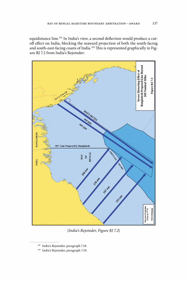
Bay of Bengal Maritime Boundary Arbitration—Award 137
equidistance line.391 In India’s view, a second deflection would produce a cut-off effect on India, blocking the seaward projection of both the south-facing and south-east-facing coasts of India.392 This is represented graphically in Fig-ure RJ 7.2 from India’s Rejoinder:
(India’s Rejoinder, Figure RJ 7.2)
391 India’s Rejoinder, paragraph 7.18.392 India’s Rejoinder, paragraph 7.19.

138 Bangladesh/India
454. India rejects the validity of a “maximum reach principle” and dif-fers from Bangladesh in its interpretation of the jurisprudence from which Bangladesh attempts to draw such a principle. According to India, the North Sea Continental Shelf Cases do not support a maximum reach principle, as it was the subsequent negotiation agreement, not the judgment, that achieved that purpose.393 India similarly distinguishes the St. Pierre & Miquelon case, on the grounds that France was not given a corridor, but rather that its mar-itime areas were reduced to a corridor.394 Nor, in India’s view, is a maximum reach principle evident in Nicaragua v. Colombia.395
455. India also contests Bangladesh’s automatic extension of the Bang-ladesh/Myanmar azimuth up to 390 nm and into the area in which Bangla-desh, India, and Myanmar all have claims.396 In India’s view, the Bangladesh/Myanmar judgment does not bind third States and, as a result, does not affect India397 or its claim to a 350 nm continental shelf from its Andaman Islands.398
C. The Tribunal’s Delimitation of the Continental Shelf beyond 200 nm
456. The Tribunal will now turn to the delimitation of the continental shelf beyond 200 nm. This task requires the interpretation and application of article 76 as well as article 83 of the Convention.
457. The Tribunal notes the Parties’ agreement that both States have entitlements beyond 200 nm, and both have made submissions to the CLCS. The Parties also agree that their entitlements beyond 200 nm are determined by application of article 76, paragraph 4, of the Convention, and that neither may claim a superior entitlement based on geological or geomorphological factors in the overlapping area.
458. The Tribunal further notes the judgment of the International Tri-bunal for the Law of the Sea in Bangladesh/Myanmar which ruled that the delimitation of the continental shelf beyond 200 nm through judicial set-tlement was in conformity with article 76 of the Convention (Judgment of 14 March 2012, paragraphs 439–449). On the basis of the foregoing, it remains for this Tribunal only to establish the delimitation line in the area beyond 200 nm where the entitlements of the Parties overlap, as set out in Map 7.*
393 Hearing Tr., 633:5–9.394 Hearing Tr., 633:20–21.395 Hearing Tr., 634:2–12.396 India’s Rejoinder, paragraph 7.24.397 India’s Rejoinder, paragraph 7.24.398 India’s Rejoinder, paragraph 7.24. * Secretariat note: See map located in the back pocket (Map 7).

Bay of Bengal Maritime Boundary Arbitration—Award 139
1. Base points for the equidistance line beyond 200 nm459. As with delimitation of the exclusive economic zone and continental
shelf within 200 nm, the Tribunal must assess the appropriateness of the base points chosen by the Parties or choose different base points, as the case may be.
460. In addition to the base points discussed earlier, both Parties have proposed a further base point I-4 on the Indian coast, located on the low-water line at Devi Point that has effect only beyond 200 nm. The coordinates pro-posed by the Parties respectively for this point differ slightly.
461. In the view of the Tribunal, this location is acceptable with regard to the criteria for the selection of base points as set out above (see para-graphs 222–223 above).
462. The Tribunal has already decided (see paragraphs 365–366 above) that a point on the low-water line at Shahpuri Point on the coast of Bangla-desh (at 20° 43´ 39˝N; 92° 20´ 33˝E) and base point I-3 on the coast of India, as proposed by Bangladesh (at 20° 20´ 29˝N; 86° 47´ 07˝E), are appropriate for the construction of the provisional equidistance line. These points continue to affect the equidistance line beyond 200 nm and remain appropriate.
463. Further, the Tribunal decides that the following additional base point is appropriate for construction of the provisional equidistance line beyond 200 nm:
— Base point I-4 as proposed by India at 19° 57´ 33.1˝N; 86° 24´ 20.0˝E.
2. Provisional equidistance line beyond 200 nm464. Starting at the intersection of the 200 nm limits of Bangladesh
and India and the provisional equidistance line segment between Prov-6 and Prov-7, the provisional equidistance line continues along the remainder of the geodetic line to Prov-7 and then along the geodetic line from Prov-7 which has an initial azimuth of 175° 50´ 50.30˝ until it meets the maritime boundary established by the International Tribunal for the Law of the Sea in its judgment in the (Bangladesh/Myanmar).
3. Relevant circumstances465. The Parties and the Tribunal agree that there is a single continen-
tal shelf. The Tribunal considers that the appropriate method for delimiting the continental shelf remains the same, irrespective of whether the area to be delimited lies within or beyond 200 nm. Having adopted the equidistance/relevant circumstances method for the delimitation of the continental shelf within 200 nm, the Tribunal will use the same method to delimit the conti-nental shelf beyond 200 nm.
466. Each Party disagrees with the delimitation lines proposed by the other*.
* Secretariat note: See map located in the front pocket (Bangladesh’s Reply, Figure R5.7).

140 Bangladesh/India
467. Bangladesh submits that, beyond 200 nm, the provisional equi-distance line does not produce an equitable solution and that, without adjust-ment, its use would be inconsistent with the judgment in Bangladesh/Myan-mar. Bangladesh reiterates that the results produced by an equidistance line in the case of a concave coast become more unreasonable as the line moves fur-ther from the coast. Bangladesh submits that a substantial departure from the provisional equidistance line beyond 200 nm is required. It challenges India’s argument that the equidistance line within 200 nm should simply be extended into the continental shelf beyond 200 nm.
468. India disagrees with the arguments advanced by Bangladesh. It contends that the provisional equidistance line does not call for adjustment and should be prolonged into the area beyond 200 nm until it meets the delim-itation line established by the International Tribunal for the Law of the Sea in the case between Bangladesh and Myanmar [reproduced on page 35].
469. The Tribunal has examined the delimitation line as advocated by Bangladesh. In the Tribunal’s view the implementation of this approach would lead to a significant cut-off to the detriment of India’s entitlement to the area beyond 200 nm and cannot be accepted for that reason. The Tribunal wishes to point out in this context that international jurisprudence on the delimitation of the continental shelf does not recognize a general right of coastal States to the maximum reach of their entitlements, irrespective of the geographical situation and the rights of other coastal States.
470. The Tribunal has further examined the result of the delimitation process if it were to accept India’s contention that no adjustment should be made to the provisional equidistance line. The Tribunal considers that this approach would provide no redress to Bangladesh from the cut-off resulting from the concavity of its coast, and cannot be accepted for this reason.
471. In this context, the Tribunal takes note of the decision the Interna-tional Tribunal for the Law of the Sea which stated:
Having considered the concavity of the Bangladesh coast to be a relevant circumstance for the purpose of delimiting the exclusive economic zone and the continental shelf within 200 nm, the Tribunal finds that this relevant circumstance has a continuing effect beyond 200 nm.(Judgment of 14 March 2012, paragraph 461).
472. The International Tribunal for the Law of the Sea continued:The Tribunal therefore decides that the adjusted equidistance line delimiting both the exclusive economic zone and the continental shelf within 200 nm between the Parties as referred to in paragraphs 337–340 continues in the same direction beyond the 200 nm limit of Bangladesh until it reaches the area where the rights of third States may be affected.(Ibid. at paragraph 462).
473. The Tribunal has already noted (see paragraphs 400–408 above) that the continental shelf and exclusive economic zone area within 200 nm

Bay of Bengal Maritime Boundary Arbitration—Award 141
attributed to Bangladesh is, due to the particular geographic configuration of the inner part of the Bay of Bengal, limited in scope in comparison to the area in which the entitlements of Bangladesh and India overlap. In a like manner, it is to be noted that the area attributed to Bangladesh in the area beyond 200 nm is limited in scope in comparison to the area in which the entitlements of the Parties overlap.
474. The Tribunal reiterates that a coastal State has an entitlement if its coast projects into the area claimed. This is the case here. In particular, the south facing coast of Bangladesh is given insufficient weight by the provisional equidistance line from Point Prov-3 to the south. The effect of the provisional equidistance line is depicted graphically in Map 8.*
475. The above considerations lead the Tribunal to the conclusion that the provisional equidistance line requires adjustment beyond (as well as within) 200 nm to produce an equitable result.
* Secretariat note: See map located in the back pocket (Map 8).

142 Bangladesh/India
Chapter IX. Adjustment of the Provisional Equidistance Line within and beyond 200 nm
476. The Parties views on the appropriate adjustment of the provisional equidistance line are set out above with respect to the area within (see par-agraphs 425 to 436) and beyond 200 nm (see paragraphs 440 to 455). In the paragraphs that follow, the Tribunal will set out what it considers to be the appropriate adjustment of the provisional equidistance line.
A. The Tribunal’s Considerations in Adjusting the Provisional Equidistance Line
477. In deciding on the adjustment of the provisional equidistance line, the Tribunal is guided by the following considerations. The Tribunal should seek to ameliorate excessive negative consequences the provisional equidis-tance line would have for Bangladesh in the areas within and beyond 200 nm, but it must not do so in a way that unreasonably encroaches on the entitlement of India in that area. Such adjustment will allow the “coasts of the Parties to produce their effects, in terms of maritime entitlements, in a reasonable and mutually balanced way” (Maritime Delimitation in the Black Sea (Romania v. Ukraine), Judgment of 3 February 2009, I.C.J. Reports 2009, p. 61 at p. 127, par-agraph 201). Further the adjustment of the provisional equidistance line must not infringe upon the rights of third States.
B. The Tribunal’s Adjustment of the Provisional Equidistance Line
478. To ameliorate the excessive negative impact the implementation of the provisional equidistance line would have on the entitlement of Bangla-desh to the continental shelf/exclusive economic zone and the continental shelf beyond 200 nm and to achieve an equitable result, the Tribunal decides that, from point Prov-3, the adjusted line delimiting the exclusive economic zone and the continental shelf between Bangladesh and India within and beyond 200 nm is a geodetic line with an initial azimuth of 177° 30´ 00˝ until this line meets with the maritime boundary established by the International Tribunal for the Law of the Sea to delimit the exclusive economic zone and the continental shelf between Bangladesh and Myanmar within and beyond 200 nm. The Tribunal’s adjustment is depicted graphically in Map 9.*
479. As far as the whole area in dispute is concerned the Tribunal considers that the adjusted delimitation line does not unreasonably limit the entitlement of India.
480. The Tribunal would like to point out that this adjusted delimitation line avoids turning points and is thus simpler to implement and administer by the Parties.
* Secretariat note: See map located in the back pocket (Map 9).

Bay of Bengal Maritime Boundary Arbitration—Award 143
Chapter X. Disproportionality Test481. The Parties agree that the final step in the delimitation process
involves a test to ensure that the delimitation line does not yield a dispropor-tionate result.399 The disproportionality test compares the ratio of the relevant maritime space accorded to each Party to the ratio of the Parties’ relevant coastal lengths.
*
482. Bangladesh emphasizes that the disproportionality test is only employed at the third stage of the delimitation process and does not work backwards to influence the Tribunal’s consideration of relevant circumstanc-es at the second stage.400 In Bangladesh’s view, India improperly attempts to import the disproportionality analysis into the second stage, arguing that if no disproportionality is to be found, no relevant circumstances can justify the adjustment of the provisional equidistance line.
483. Bangladesh refers to the decision in Nicaragua v. Colombia, in which the International Court of Justice considered the purpose of this test to be a final check for any result that is “tainted by some form of gross dispro-portion”, and stated that this final check is performed by the basis of “only approximate” numbers (Territorial and Maritime Delimitation (Nicaragua v. Colombia), Judgement of 19 November 2012, paragraph 241). Bangladesh maintains that the proportionality test during the third stage of the delimita-tion process differs from the role of proportionality during the second stage. While proportionality can play a legitimate role in the examination of relevant circumstances, its use in the second stage involves a margin of appreciation to make sure that the delimitation line allows each State to enjoy reasonable maritime entitlements in the areas into which its coasts project.”401
484. Bangladesh argues that the International Court of Justice made clear in Nicaragua v. Colombia that the broader notion of proportionality comes into play at the second stage, concluding that the provisional equidistance line in that case would have inequitably cut Nicaragua off from three quarters of its entitlement. In Bangladesh’s view, this amounts to stating that Nicaragua was “disproportionately deprived … of maritime areas to which it was potentially entitled” by the provisional line.402 Similarly, Bangladesh interprets the Court’s statement that extending the “equiratio” line (a line drawn by giving propor-tionally more weight to the base points of one party) would “still leave Colom-bia with a significantly larger share of the relevant area than that accorded to Nicaragua” as meaning that the result would not have been proportionate.403
399 Bangladesh’s Reply, paragraph 4.150; India’s Counter-Memorial, paragraph 6.108.400 Bangladesh’s Reply, paragraph 4.159.401 Bangladesh’s Reply, paragraph 4.156.402 Bangladesh’s Reply, paragraph 4.157.403 Bangladesh’s Reply, paragraph 4.158.
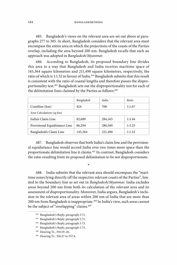
144 Bangladesh/India
485. Bangladesh’s views on the relevant area are set out above at para-graphs 277 to 305. In short, Bangladesh considers that the relevant area must encompass the entire area in which the projections of the coasts of the Parties overlap, including the area beyond 200 nm. Bangladesh recalls that such an approach was adopted in Bangladesh/Myanmar.
486. According to Bangladesh, its proposed boundary line divides this area in a way that Bangladesh and India receives maritime space of 145,364 square kilometres and 211,490 square kilometres, respectively, the ratio of which is 1:1.52 in favour of India.404 Bangladesh submits that this result is consistent with the ratio of coastal lengths and therefore passes the dispro-portionality test.405 Bangladesh sets out the disproportionality test for each of the delimitation lines claimed by the Parties as follows:406
Bangladesh India Ratio
Coastline (km) 424 708 1:1.67
Area Calculations (sq km)
India’s Claim Line 82,689 284,165 1:3.44
Provisional Equidistance Line 86,294 280,560 1:3.25
Bangladesh’s Claim Line 145,364 221,490 1:1.52
487. Bangladesh observes that both India’s claim line and the provision-al equidistance line would accord India over two times more space than the proportionate delimitation line it claims.407 In contrast, Bangladesh considers the ratio resulting from its proposed delimitation to be not disproportionate.
*
488. India submits that the relevant area should encompass the “mari-time zones lying directly off the respective relevant coasts of the Parties”, lim-ited to the boundary line as set out in Bangladesh/Myanmar. India excludes areas beyond 200 nm from both its calculation of the relevant area and its assessment of disproportionality. Moreover, India argues, Bangladesh’s inclu-sion in the relevant area of areas within 200 nm of India that are more than 200 nm from Bangladesh is inappropriate.408 In India’s view, such areas cannot be the subject of “overlapping” claims.409
404 Bangladesh’s Reply, paragraph 5.71.405 Bangladesh’s Reply, paragraph 5.71.406 Bangladesh’s Reply, paragraph 5.73.407 Bangladesh’s Reply, paragraph 5.73.408 Hearing Tr., 356:19–26.409 Hearing Tr., 356:27 to 357:4.

Bay of Bengal Maritime Boundary Arbitration—Award 145
489. India measures what it considers to be the relevant area at 172,219.7 square kilometres and submits that its proposed line satisfies the test insofar as the ratio of the relevant coasts of the Parties is 1:1.015 and the ratio of the relevant areas result from India’s proposed line is 1:0.942.410 India notes that only marked differences in the ratio between the coastal lengths require the adjustment of the delimitation line.411 In Romania/Ukraine, India argues, the International Court of Justice found that the delimitation line satisfied the test when the ratio of the respective coastal lengths for the parties is approximately 1:2.8 and the ratio of the relevant area between them is approximately 1:2.1.412 According to India, it is where courts and tribunals have found substantial dis-crepancies in the ratio between the Parties’ relevant coasts and their delimited share of relevant area that the disproportionality test has not been met.
* * *
490. The Tribunal’s views on the relevant area are set out above at par-agraphs 306 to 311. As described above, the relevant area encompasses all of the areas, within and beyond 200 nm in which the seaward projections of the Parties’ relevant coasts overlap.
491. The Tribunal begins its consideration of the disproportionality test by noting that
The test of disproportionality is not in itself a method of delimitation. It is rather a means of checking whether the delimitation line arrived at by other means needs adjustment because of a significant disproportionali-ty in the ratios between the maritime areas which would fall to one party or other by virtue of the delimitation line arrived at by other means, and the lengths of their respective coasts.(Maritime Delimitation in the Black Sea (Romania v. Ukraine), Judgment of 3 February 2009, I.C.J. Reports 2009, p. 61 at pp 99–100, paragraph 110)
492. The Tribunal emphasizes that proportionality is not a mathemat-ical exercise that results in the attribution of maritime areas as a function of the length of the coasts of the Parties or other such ratio calculations. As the International Court of Justice stated in Nicaragua v. Colombia “[m]aritime delimitation is not designed to produce a correlation between the lengths of the Parties’ relevant coasts and their respective shares of the relevant area” (Judgment of 19 November 2012, paragraph 240). In the view of the Tribunal such an approach could itself produce inequity. In particular it is not the func-tion of the Tribunal to refashion nature. It is rather the responsibility of the Tribunal to check, ex post facto, the equitableness of the delimitation line it has constructed (see also Delimitation of the maritime boundary between Guinea
410 India’s Counter-Memorial, paragraph 6.111.411 India’s Counter-Memorial, paragraph 6.112.412 India’s Counter-Memorial, paragraph 6.110.

146 Bangladesh/India
and Guinea-Bissau, RIAA, Vol. XIX, pp. 183–184, paragraphs 94–95). What constitutes such disproportionality may vary from case to case.
493. The Tribunal notes the international jurisprudence concerning the disproportionality test. As the International Court of Justice stated in its judg-ments in Romania v. Ukraine (Judgment, I.C.J. Reports 2009, p. 61 at p. 129, paragraph 210) and Nicaragua v. Colombia (Judgment of 19 November 2012, paragraphs 239, 242 and 243), a significant disproportionality is to be avoided.
494. Whether or not significant disproportionality exists remains a matter for the Tribunal’s appreciation, which it will exercise by reference to the overall geography of the area.
495. As set out above, the length of the relevant coast of Bangladesh is 418.6 kilometres. The length of the relevant coast of India is 803.7 kilometres. The ratio between the lengths of the relevant coasts of the parties is thus 1:1.92.
496. As set out above, the relevant area comprises 406,833 square kilo-metres. Having adjusted the provisional equidistance line, the Tribunal’s delimitation lines allocates approximately 106,613 square kilometres of the rel-evant area to Bangladesh and approximately 300,220 square kilometres of the relevant area to India. The ratio of the allocated areas is approximately 1: 2.81.
497. The Tribunal finds that this ratio does not produce any significant dis-proportion in the allocation of maritime areas to the Parties that would require alteration of the adjusted equidistance line to ensure an equitable solution.

Bay of Bengal Maritime Boundary Arbitration—Award 147
Chapter XI. Grey Area498. The Tribunal’s delimitation of the Parties’ exclusive economic zones
and of the continental shelf within and beyond 200 nm gives rise to an area that lies beyond 200 nm from the coast of Bangladesh and within 200 nm from the coast of India, and yet lies to the east of the Tribunal’s delimitation line. The resulting “grey area” is a practical consequence of the delimitation process. Such an area will arise whenever the entitlements of two States to the continen-tal shelf extend beyond 200 nm and relevant circumstances call for a boundary at other than the equidistance line at or beyond the 200 nm limit in order to provide an equitable delimitation. The grey area resulting from the Tribunal’s delimitation in the present case is depicted in Map 10.*
499. A similar situation arose between Bangladesh and Myanmar as a result of the delimitation line drawn by the International Tribunal for the Law of the Sea. The judgment in that case held that
in the area beyond Bangladesh’s exclusive economic zone that is within the limits of Myanmar’s exclusive economic zone, the maritime bound-ary delimits the Parties’ rights with respect to the seabed and subsoil of the continental shelf but does not otherwise limit Myanmar’s rights with respect to the exclusive economic zone, notably those with respect to the superjacent waters.Delimitation of the Maritime Boundary between Bangladesh and Myan-mar in the Bay of Bengal (Bangladesh/Myanmar), Judgment of 14 March 2012, paragraph 474.
500. The International Tribunal for the Law of the Sea went on to note, with respect to the division of rights in the grey area, that
There are many ways in which the Parties may ensure the discharge of their obligations in this respect, including the conclusion of specific agreements or the establishment of appropriate cooperative arrange-ments. It is for the Parties to determine the measures that they consider appropriate for this purpose.Delimitation of the Maritime Boundary between Bangladesh and Myan-mar in the Bay of Bengal (Bangladesh/Myanmar), Judgment of 14 March 2012, paragraph 476.
*
501. In its written submissions, Bangladesh endorsed the approach adopted by the International Tribunal for the Law of the Sea and considered it appropriate in the present case:
Bangladesh submits that the Arbitral Tribunal should adopt the same solution in this case. The area beyond 200 m from Bangladesh but with-in 200 m from India should be continental shelf as to Bangladesh and
* Secretariat note: See map located in the back pocket (Map 10).
148 Bangladesh/India
EEZ as to India. Beyond 200 m from India, the boundary would be a pure continental shelf boundary.413
502. As India was of the view that no relevant circumstances called for an adjustment of a provisional equidistance line, it did not address the ques-tion of the grey area.
*
503. The Tribunal emphasizes that beyond 200 nm from Bangladesh’s coast, it has an entitlement only to the seabed and its subsoil pursuant to the legal regime governing the continental shelf. Within the grey area, Bangladesh has no entitlement to an exclusive economic zone that would give it sovereign rights in the water column or over the living resources therein. As the Tribu-nal’s power to delimit the respective entitlements of the Parties exists only where those entitlements overlap, there can be no question of delimiting enti-tlements in the grey area, except with respect to the continental shelf.
504. The Tribunal notes that, in the grey area, the exclusive economic zone to which India is entitled includes rights to the seabed and subsoil pur-suant to article 56(1)(a) of the Convention that also fall within the regime for the continental shelf. In practice, however, the Convention distinguishes between the rights that arise under multiple regimes and those that pertain only to the exclusive economic zone. Article 56(3) provides that rights with respect to the seabed and subsoil in the exclusive economic zone are to be exercised in accordance with the regime for the continental shelf. Article 68 excludes sedentary species from the provisions relating to the exclusive eco-nomic zone altogether.
505. Accordingly, within the area beyond 200 nm from the coast of Bangladesh and within 200 nm of the coast of India, the boundary identified by the Tribunal delimits only the Parties’ sovereign rights to explore the con-tinental shelf and to exploit the “mineral and other non-living resources of the seabed and subsoil together with living organisms belonging to sedentary species” as set out in article 77 of the Convention. Within this area, however, the boundary does not otherwise limit India’s sovereign rights to the exclusive economic zone in the superjacent waters.
506. The Tribunal notes that the grey area it has described overlaps in part with the grey area described in Bangladesh/Myanmar. The present delim-itation does not prejudice the rights of India vis-a-vis Myanmar in respect of the water column in the area where the exclusive economic zone claims of India and Myanmar overlap. This overlap of grey areas is depicted graphically in Map 11.*
507. The establishment of a maritime area in which the States concerned have shared rights is not unknown under the Convention. The Convention is
413 Bangladesh’s Reply, paragraph 5.58. * Secretariat note: See map located in the back pocket (Map 11).

Bay of Bengal Maritime Boundary Arbitration—Award 149
replete with provisions that recognize to a greater or lesser degree the rights of one State within the maritime zones of another. Within the provisions of the Convention relating to the exclusive economic zone and continental shelf, articles 56, 58, 78, and 79 all call for States to exercise their rights and perform their duties with due regard to the rights and duties of other States.
508. It is for the Parties to determine the measures they consider appro-priate in this respect, including through the conclusion of further agreements or the creation of a cooperative arrangement. The Tribunal is confident that the Parties will act, both jointly and individually, to ensure that each is able to exercise its rights and perform its duties within this area.

150 Bangladesh/India
Chapter XII. Dispositif509. For the foregoing reasons, the Tribunal:
(1) Decides unanimously that it has jurisdiction to adjudicate the pres-ent case, to identify the land boundary terminus and to delimit the territorial sea, the exclusive economic zone, and the continental shelf between the Parties within and beyond 200 nautical miles in the areas where the claims of the Parties overlap.
(2) Determines, unanimously, that the terminus of the land boundary between Bangladesh and India is located at 21° 38’ 40.2”N, 89° 09’ 20.0”E (WGS-84).
(3) Decides, by four votes to one, that the maritime boundary between Bangladesh and India is a series of geodetic lines joining the follow-ing points in the order listed and shown for illustrative purposes only in Map 12 (all coordinates in WGS-84):*
Point No. Latitude Longitude
Land Boundary Terminus (Delimitation Point 1)
21° 38’ 40.2”N, 89° 09’ 20.0”E
Delimitation Point 2 21° 26’ 43.6”N, 89° 10’ 59.2”E
Delimitation Point 3 21° 07’ 44.8”N, 89° 13’ 56.5”E
then along a geodetic line that has an initial azimuth of 177° 30’ 00” until it meets the maritime boundary established by the International Tribunal for the Law of the Sea in paragraph 505 of its judgment of 14 March 2012 in the Delimitation of the Maritime Boundary between Bangladesh and Myanmar in the Bay of Bengal (Bangladesh/Myanmar).
Done at The Hague, this 7th day of July 2014.
[Signed] Judge Rüdiger Wolfrum, President
[Signed] Judge Jean-Pierre Cot
[Signed] Judge Thomas A. Mensah
[Signed] Dr. Pemmaraju Sreenivasa Rao [concurring in part and dissenting in part]
* Secretariat note: See map located in the back pocket (Map 12).

Bay of Bengal Maritime Boundary Arbitration—Award 151
[Signed] Professor Ivan Shearer
[Signed] Mr. Brooks W. Daly, Registrar

152 Bangladesh/India
AppendixTechnical Report of the Tribunal’s Hydrographer
David H. GrayM.A.Sc., P.Eng., C.L.S.
1. The full description of the line of delimitation, together with the necessary geographical coordinates, is given in the Award. All computations have been made on the Geodetic Reference System (1980) ellipsoid and all geographical coordinates are referenced to the World Geodetic System 1984 (WGS-84) unless otherwise indicated. The International Nautical Mile (nm) of 1852 metres has been used. Azimuths are clockwise from North.
Land Boundary Terminus2. The Radcliffe Map was prepared in the Bengal Drawing Office in
1944 but based on surveys done in 1915–16. According to Mr. Justice H. Chan-drasekhara Aiyar of the 1949 Bengal Boundary Commission, the parties to that proceeding agreed that
it [the map] was prepared on the basis of a Survey in the year 1915–16. Neither side is able to tell us how Sir Cyril got this map and from whom. There is not much point however in harping on these deficiencies. As arbitrator, Sir Cyril used this map and drew the boundary line in it between East and West Bengal in red ink. We are bound by it, except as far as any discrepancy or divergence between the boundary line as shown in the map and the line as specified in Annexure A in which event the latter has to prevail.414
3. Although the folds in the original map and folds in the copies provid-ed in Volume 2 of the Rejoinder somewhat limit the precision of points plotted from the Radcliffe Map, the Land Boundary Terminus can be plotted at the position 21° 38’ 37.2”N, 89° 09’ 29.4”E.
4. As a map of land territory produced in 1915–1916, the Radcliffe Map can reasonably be assumed to have used geographic coordinates based on the Indian Datum in use at that time and can be converted to WGS-84 on the basis of this assumption. The datum used in the Radcliffe Map can also be con-firmed through a comparison of the coordinates of cultural features identified on both the Radcliffe Map and modern maps.
Conversion of the Land Boundary Terminus to WGS-84
5. Using a position of 21° 38’ 37.2”N, 89° 09’ 29.4”E (Indian Datum) for the Land Boundary Terminus and the datum shift parameters from the IHO User’s
414 Boundary disputes between India and Pakistan relating to the interpretation of the report of the Bengal Boundary Commission, Report of International Arbitral Awards, United Nations, 2006, Volume XXI, pp 1–51, 26 January 1950, page 18.

Bay of Bengal Maritime Boundary Arbitration—Award 153
Handbook on Datum Transformations Involving WGS 84415, the resulting WGS-84 position is 21° 38’ 40.20766”N, 89° 09’ 19.96488”E. The mathematical constants are:
— Indian Datum uses the Everest Ellipsoid of 1830, which has an equatorial semi-diameter of 6,377,276.345 m and a flattening of 1/300.8017, which means that the pole-to-pole semi-diameter is 6,356,075.413 m.
— World Geodetic System 1984 uses an ellipsoid with an equatorial semi-di-ameter of 6,378,137.000 m and a flattening of 1/298.257,223,563, which means that the pole-to-pole semi-diameter is 6,356,752.231 m.
— The relationship of the centre of the Indian Datum in the area of Bangla-desh to the centre of the WGS-84 datum is: ΔX = -282 m, ΔY = -726 m, and ΔZ = -254 m. The positive X-axis is from the centre of the ellipsoid towards the 0° meridian at the Equator, the positive Y-axis is from the centre of the ellipsoid towards the 90°E meridian at the Equator, and the positive Z-axis is from the centre of the ellipsoid to towards the North Pole.
The Closing Line
6. The most probable closing line that would have been drawn using the Radcliffe Map is between the following points:
Point Map Latitude Map Longitude
West 21° 38’ 24.3”N 89° 06’ 17.4”N
East 21° 38’ 50.1”N 89° 12’ 42.8”E
7. This equates to the following coordinates in WGS-84 using the IHO Handbook on Datum Transformations method of conversion described above:
Point WGS-84 Latitude WGS-84 Longitude
West 21° 38’ 27.31”N 89° 06’ 07.99”E
East 21° 38’ 53.11”N 89° 12’ 33.34”E
8. Map 1 of the Award* depicts the closing line plotted on the Radcliffe Map. Map 2 of the Award** depicts the same closing line transferred to Bang-ladesh Navy Chart 7501.
9. Using the position for the Land Boundary Terminus reached above, the Land Boundary Terminus is located 0.4 m off this closing line. It is there-fore reasonable to say that the scaled Land Boundary Terminus is on the clos-
415 International Hydrographic Organization, 2003: User’s Handbook on Datum Transfor-mations Involving WGS 84, Special Publication No. 60, 3rd Edition, Monaco.
* Secretariat note: See map located in the front pocket (Map 1). ** Secretariat note: See map located in the front pocket (Map 2).

154 Bangladesh/India
ing line. The Land Boundary Terminus is 5534.5 m from the west end of the Radcliffe Map closing line and 5574.6 m from the east end.
*
10. The Land Boundary Terminus has a position of 21° 38’ 40.20766”N, 89° 09’ 19.96488”E (WGS-84).416 This position is 1548 metres at 269° 47’ (roughly west) from India’s claimed position of the Land Boundary Terminus and 4698 m at 80° 07’ (roughly east) from Bangladesh’s claimed position of the Land Boundary Terminus.
Base points for provisional equidistance line11. Since neither Party accepted the coordinate values proposed by the
other Party for all base points, or in some cases even the geographic location for the proposed point, the Tribunal evaluated each location separately and decided on the geodetic coordinate values to be assigned to each location. In its assessment of the base points, the Tribunal consulted the nautical charts provided by the Parties for their respective coasts.
12. For the base points along the coast of Bangladesh, the Tribunal decided on the following points (all positions in WGS-84):
No. Physical location Source Latitude Longitude
B-1 Mandarbaria Island Bangladesh Reply 21° 39’ 04”N 89° 12’ 40”E
B-2 Mandarbaria Island Bangladesh Reply 21° 39’ 08”N 89° 14’ 45”E
B-4 Pussur Island BN chart 7501 21° 42’ 45”N 89° 35’ 00”E
B-5 Shahpuri Point BN chart 35001 20° 43’ 39”N 92° 20’ 33”E
13. For the base points along the coast of India, the Tribunal decided on the following points (all positions in WGS-84):
No. Physical location Source Latitude Longitude
I-1 Moore Island IN chart 351 21° 38’ 06”N 89° 05’ 36”E
I-2 Bhangaduni Island Bangladesh Reply 21° 32’ 21”N 88° 53’ 13”E
I-3 False Point Bangladesh Reply 20° 20’ 29”N 86° 47’ 07”E
I-4 Devi Point India Counter Mem.
19° 57’ 33.1”N 86° 24’ 20.0”E
416 The Land Boundary Terminus is also referred to as Delimitation Point 1 in the Disposi-tif of the Award, and as point Prov-1 in the construction of the provisional equidistance line.
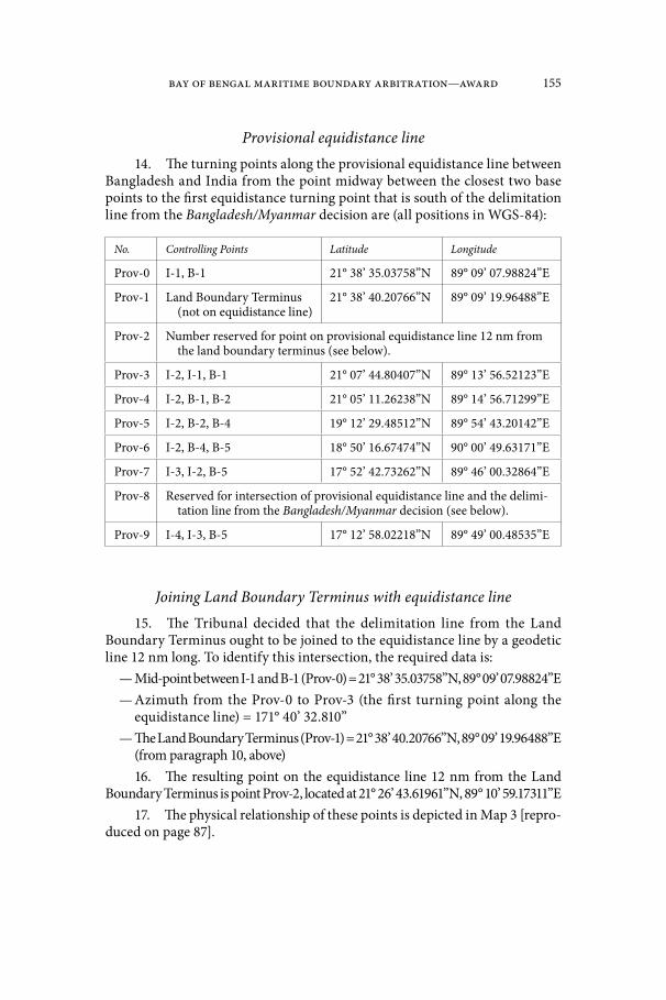
Bay of Bengal Maritime Boundary Arbitration—Award 155
Provisional equidistance line14. The turning points along the provisional equidistance line between
Bangladesh and India from the point midway between the closest two base points to the first equidistance turning point that is south of the delimitation line from the Bangladesh/Myanmar decision are (all positions in WGS-84):
No. Controlling Points Latitude Longitude
Prov-0 I-1, B-1 21° 38’ 35.03758”N 89° 09’ 07.98824”E
Prov-1 Land Boundary Terminus (not on equidistance line)
21° 38’ 40.20766”N 89° 09’ 19.96488”E
Prov-2 Number reserved for point on provisional equidistance line 12 nm from the land boundary terminus (see below).
Prov-3 I-2, I-1, B-1 21° 07’ 44.80407”N 89° 13’ 56.52123”E
Prov-4 I-2, B-1, B-2 21° 05’ 11.26238”N 89° 14’ 56.71299”E
Prov-5 I-2, B-2, B-4 19° 12’ 29.48512”N 89° 54’ 43.20142”E
Prov-6 I-2, B-4, B-5 18° 50’ 16.67474”N 90° 00’ 49.63171”E
Prov-7 I-3, I-2, B-5 17° 52’ 42.73262”N 89° 46’ 00.32864”E
Prov-8 Reserved for intersection of provisional equidistance line and the delimi-tation line from the Bangladesh/Myanmar decision (see below).
Prov-9 I-4, I-3, B-5 17° 12’ 58.02218”N 89° 49’ 00.48535”E
Joining Land Boundary Terminus with equidistance line15. The Tribunal decided that the delimitation line from the Land
Boundary Terminus ought to be joined to the equidistance line by a geodetic line 12 nm long. To identify this intersection, the required data is:
— Mid-point between I-1 and B-1 (Prov-0) = 21° 38’ 35.03758”N, 89° 09’ 07.98824”E— Azimuth from the Prov-0 to Prov-3 (the first turning point along the
equidistance line) = 171° 40’ 32.810”— The Land Boundary Terminus (Prov-1) = 21° 38’ 40.20766”N, 89° 09’ 19.96488”E
(from paragraph 10, above)16. The resulting point on the equidistance line 12 nm from the Land
Boundary Terminus is point Prov-2, located at 21° 26’ 43.61961”N, 89° 10’ 59.17311”E17. The physical relationship of these points is depicted in Map 3 [repro-
duced on page 87].
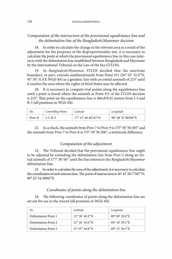
156 Bangladesh/India
Computation of the intersection of the provisional equidistance line and the delimitation line of the Bangladesh/Myanmar decision
18. In order to calculate the change in the relevant area as a result of the adjustment for the purposes of the disproportionality test, it is necessary to calculate the point at which the provisional equidistance line in this case inter-sects with the delimitation line established between Bangladesh and Myanmar by the International Tribunal on the Law of the Sea (ITLOS).
19. In Bangladesh/Myanmar, ITLOS decided that the maritime boundary, in part, extends southwestwards from Point #11 (20° 03’ 32.0”N, 91° 50’ 31.8’E WGS-84) as a geodetic line with an initial azimuth of 215° until it reaches the area where the rights of third States may be affected.
20. It is necessary to compute trial points along the equidistance line until a point is found where the azimuth at Point #11 of the ITLOS decision is 215°. That point on the equidistance line is 466,870.41 metres from I-3 and B-5 (all positions in WGS-84):
No. Controlling Points Latitude Longitude
Prov-8 I-3, B-5 17° 15’ 46.46743”N 89° 48’ 47.80306”E
21. As a check, the azimuth from Prov-7 to Prov-9 is 175° 50’ 50.305” and the azimuth from Prov-7 to Prov-8 is 175° 50’ 50.306”, a miniscule difference.
Computation of the adjustment22. The Tribunal decided that the provisional equidistance line ought
to be adjusted by extending the delimitation line from Prov-3 along an ini-tial azimuth of 177° 30’ 00” until the line intersects the Bangladesh/Myanmar delimitation line.
23. In order to calculate the area of the adjustment, it is necessary to calculate the coordinates of such intersection. The point of intersection is 16° 43’ 28.77187”N, 89° 25’ 54.39092”E
Coordinates of points along the delimitation line24. The following coordinates of points along the delimitation line are
set out for use in the Award (all positions in WGS-84):
No. Latitude Longitude
Delimitation Point 1 21° 38’ 40.2”N 89° 09’ 20.0”E
Delimitation Point 2 21° 26’ 43.6”N 89° 10’ 59.2”E
Delimitation Point 3 21° 07’ 44.8”N 89° 13’ 56.5”E
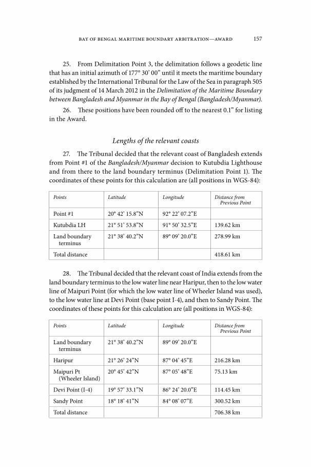
Bay of Bengal Maritime Boundary Arbitration—Award 157
25. From Delimitation Point 3, the delimitation follows a geodetic line that has an initial azimuth of 177° 30’ 00” until it meets the maritime boundary established by the International Tribunal for the Law of the Sea in paragraph 505 of its judgment of 14 March 2012 in the Delimitation of the Maritime Boundary between Bangladesh and Myanmar in the Bay of Bengal (Bangladesh/Myanmar).
26. These positions have been rounded off to the nearest 0.1” for listing in the Award.
Lengths of the relevant coasts
27. The Tribunal decided that the relevant coast of Bangladesh extends from Point #1 of the Bangladesh/Myanmar decision to Kutubdia Lighthouse and from there to the land boundary terminus (Delimitation Point 1). The coordinates of these points for this calculation are (all positions in WGS-84):
Points Latitude Longitude Distance from Previous Point
Point #1 20° 42’ 15.8”N 92° 22’ 07.2”E
Kutubdia LH 21° 51’ 53.8”N 91° 50’ 32.5”E 139.62 km
Land boundary terminus
21° 38’ 40.2”N 89° 09’ 20.0”E 278.99 km
Total distance 418.61 km
28. The Tribunal decided that the relevant coast of India extends from the land boundary terminus to the low water line near Haripur, then to the low water line of Maipuri Point (for which the low water line of Wheeler Island was used), to the low water line at Devi Point (base point I-4), and then to Sandy Point. The coordinates of these points for this calculation are (all positions in WGS-84):
Points Latitude Longitude Distance from Previous Point
Land boundary terminus
21° 38’ 40.2”N 89° 09’ 20.0”E
Haripur 21° 26’ 24”N 87° 04’ 45”E 216.28 km
Maipuri Pt (Wheeler Island)
20° 45’ 42”N 87° 05’ 48”E 75.13 km
Devi Point (I-4) 19° 57’ 33.1”N 86° 24’ 20.0”E 114.45 km
Sandy Point 18° 18’ 41”N 84° 08’ 07”E 300.52 km
Total distance 706.38 km

158 Bangladesh/India
29. The Tribunal decided that the relevant coast of India’s Andaman Islands extends from the southwest extremity of Interview Island to the north-west extremity of Landfall Island. The coordinates of these points for this cal-culation are (all positions in WGS-84):
Points Latitude Longitude Distance from Previous Point
Interview Island 12° 51’ 00”N 92° 39’ 00”E
Landfall Island 13° 40’ 00”N 92° 59’ 00”E 97.30 km
Computation of the relevant areas30. To be able to calculate areas, the location of 200 nm limits of India,
the Andaman Islands (India), Bangladesh, and Myanmar were sometimes needed. Published territorial sea baselines were not considered. The points along the low water line of mainland, islands and detached low tide elevations within 12 nm of mainland or an island were scaled from the official nautical charts provided by the Parties. Where charts were not available, the ETOPO2 shoreline that is available in the CARIS LOTS™ software was used.
31. The limits of the continental shelf as submitted to the Commis-sion on the Limits of the Continental Shelf (CLCS) were abstracted from the Executive Summaries deposited with the CLCS and are available on the Unit-ed Nations Division of Ocean Affairs and Law of the Sea (DOALOS) website.
32. The relevant area of Bangladesh for a disproportionality/propor-tionality test is the enclosed area bounded on the north and east sides by the lines describing the relevant coasts in paragraph 27, above, the decision line from the Bangladesh/Myanmar case on the southeast, and the provisional equidistance line on the west, described in paragraphs 11 to 14, above, or the delimitation line, described in paragraph 24 to 25, above.
33. The relevant area of India for the disproportionality/proportionality test is the enclosed area bounded on the north and northwest sides by the lines describing the relevant coasts in paragraph 28, above, the line joining Sandy Point to the point of intersection of India’s 200 nm limit and outer limit of Bangladesh’s continental shelf in its submission to the Commission on the Limits of the Continental Shelf on the southwest, that outer limit on the south, the 200 nm limit of the Andaman Islands and of Myanmar on the southeast, the decision line from the Bangladesh/Myanmar case on the southeast, and the provisional equidistance line on the west, described in Paragraphs 11 to 14, above, or the delimitation line, described in Paragraph 24 to 25, above.
34. The following areas can be computed on the basis of the provisional equidistance line, prior to the Tribunal’s adjustment of it:

Bay of Bengal Maritime Boundary Arbitration—Award 159
— The area appertaining to Bangladesh east of the provisional equidistance line is 87,145 sq. km.
— The area appertaining to India west of the provisional equidistance line is 319,688 sq. km.35. The following areas can be computed on the basis of the Tribunal’s
delimitation line, following the adjustment of the provisional equidistance line:— The area appertaining to Bangladesh east of the delimitation line is
106,613 sq. km.— The area appertaining to India west of the delimitation line is 300,220 sq. km.
36. This means that the adjustment done to the provisional equidistance line increased Bangladesh’s maritime area by 19,467 sq. km.
Proportionality test37. The ratio of the relevant coasts is: 418.48 to 803.68 (Bangladesh to India).
Expressed as a ratio, this equates to 1:1.92, or as a percentage to 34.2%: 65.8%.38. The ratio of the relevant areas before any adjustment is 87,145 to
319,688 (Bangladesh to India). Expressed as a ratio, this equates to 1:3.67, or as a percentage to 21.4%: 78.6%.
39. The ratio of the relevant areas after the adjustment is 106,613 to 300,220 (Bangladesh to India). Expressed as a ratio, this equate to 1:2.81, or as a percentage to 26.2%: 73.8%.


The Bay of Bengal Maritime Boundary Arbitration
between Bangladesh and India
Concurring and Dissenting Opinion
Dr. P.S. Rao
1. This arbitration, concerning the delimitation of the maritime bound-ary between Bangladesh and India in the Bay of Bengal, has raised many issues, including the interpretation of legal principles concerning the law of maritime delimitation. The Tribunal’s mandate included the determination of the land boundary terminus, the selection of suitable base points for the purpose of delimitation, the selection of the appropriate method or methods of delimitation, the identification of relevant coasts and the maritime area to be delimited, and the identification of relevant circumstances for the delimitation of the continental shelf, in particular for areas beyond 200 nm.1
2. I happily concur with my colleagues in the Tribunal on the determi-nation of the land boundary terminus, the delimitation of the territorial sea, and the identification of suitable base points for the construction of a provision-al equidistance line in the exclusive economic zone and the continental shelf.
3. I also concur with the decision to reject the angle bisector method as a basis to delimit the maritime area within 200 nm and the continental shelf beyond 200 nm. Bangladesh could not offer any compelling reason2 to dispense with the otherwise standard three-stage method, which relies on the establish-
1 This is the second time a Tribunal has had occasion to delimit continental shelf beyond 200 nm. The first such occasion occurred in the case concerning the delimitation of maritime boundary between Bangladesh and Myanmar decided by the ITLOS in March 2012. See Delim-itation of the maritime boundary in the Bay of Bengal (Bangladesh/Myanmar), Judgment of 14 March 2012. For a note on the case, see D. H. Anderson, “International Decision: Delimitation of the Maritime Boundary in the Bay of Bengal (Bangladesh/Myanmar)”, 106 A.J.I.L. 817 (2012).
2 The test of compelling reasons is laid down in the Nicaragua v. Honduras case. See Terri-torial and Maritime Dispute between Nicaragua and Honduras in the Caribbean Sea (Nicaragua v. Honduras), Judgment, I.C.J. Reports 2007, pp. 659–764, para. 287. The Court adopted the angle bisector method, after a gap of nearly 25 years, and saw this as a necessary exception to the standard method of adopting a provisional equidistance method and adjusting the same where relevant circumstances so demanded. For a comment on this case, see D. Bodansky, “Territorial and Maritime Dispute Between Nicaragua and Honduras in the Caribbean Sea (Nicaragua v. Honduras)”, 102 A.J.I.L. 113 (2008).
162 Bangladesh/India
ment of a provisional equidistance line that is open to adjustment if “relevant circumstances”3 so require “in order to achieve an equitable solution”.4
4. The ultimate objective of a maritime delimitation thus is to achieve an equitable solution, applying “equity”, or “equitable principles”. In this con-nection, legitimate questions have been raised as to the nature, content and scope of “equity” or “equitable principles” and their relationship to rules of law in general, and in the context of maritime delimitation, to the equidistance and special circumstances rule incorporated in Article 6 of the 1958 Geneva Con-vention on the Continental Shelf. The ICJ in the North Sea Continental Shelf Cases (1969) found sanction for the principle of “equity” or “equitable princi-ples” in customary international law. The [US] Truman Declaration, which ini-tially sowed the seeds for the flowering of the concept of the continental shelf through widespread State practice during 19451958, first invoked the principle of equity for the settlement of maritime boundaries. It must be noted, how-ever, that while almost all the unilateral declarations on the continental shelf followed the example of the Truman Declaration in claiming sovereign rights over the same on the basis of continuity of land mass or natural prolongation, few referred to the issue of maritime boundary delimitation, much less sought the same on the basis of equitable principles. In contrast, some States—in par-ticular Denmark and the Netherlands in the North Sea Cases—preferred a line based on the “equidistance and special circumstances” formula stressing that it was the most objective and easily verifiable method for the delimitation of maritime boundaries. This method of delimitation was incorporated in Arti-cle 6 of the 1958 Convention on the Continental Shelf on the basis of draft arti-cles prepared by the International Law Commission (“ILC”) in the early 1950s, which did not give much attention to the principle of equity, despite a brief mention at an initial stage of the ILC’s work. Sir Elihu Lauterpacht described the background as follows: a Committee of Experts composed not of lawyers, but cartographers, appointed in 1953 to assist the ILC in its work suggested that “the strict application of the concept of equidistance might in certain cir-cumstances give rise to an inequitable situation”. Even though no elaboration of what was meant by inequitable was forthcoming from the Committee of
3 See the Land and Maritime Boundary between Cameroon and Nigeria Case (Cameroon v. Nigeria), I.C.J. Reports 2002, pp. 303–458, para. 288 where the Court noted that there is no difference between the “special circumstances” and “relevant circumstances” which the case law consistently examines to see if the delimitation on the basis of equidistance method requires adjustment to achieve an equitable solution. Islands, peninsulas, major bays, island fringes, or other such configurations low-tide elevations or major protrusions, among others, that dramat-ically skew the course of an equidistance line are considered as “special circumstances”. See Guyana v. Suriname, Award, PCA Awards Series (2007), para. 375. More general information on “relevant circumstances”, see M. Evans, Relevant Circumstances and Maritime Delimitation (Oxford: Clarendon Press, 1989).
4 Articles 74(1) and 83(1) of the 1982 UN Convention on the Law of the Sea state that achieving an equitable solution is the main objective of any exercise on the delimitation of mar-itime boundary. For a reference to drafting history and clarification of these provisions, see Continental Shelf (Tunisia/Libya), Dissenting Opinion of Judge Shigeru Oda, I.C.J. Reports 1982, pp. 246–247, paras. 144–145.
Bay of Bengal Maritime Boundary Arbitration— Concurring and Dissenting Opinion of Dr. P.S. Rao 163
Experts, from the ILC, or from the Geneva Conference, the ICJ “felt itself able in 1969 to identify the concept of equity as being a rule of customary interna-tional law to be applied to the delimitation of adjacent and opposite continen-tal shelves. And the Court attached controlling importance to that concept”.5
5. It may be recalled that in 1969 while dealing with the Continental Shelf Cases between the Federal Republic of Germany on the one hand and Denmark and Netherlands on the other, the Court did not consider the method of delim-itation by equidistance as part of customary law. It noted that, although that method possessed practical convenience and certainty of application, those fac-tors were not sufficient “of themselves to convert what is a ‘method’ into a rule of law”.6 Referring in this connection to the pronouncement of the Court to the effect that delimitation in that instant case should be effected by “agreement … arrived at in accordance with equitable principles”,7 in the sense not “simply as matter of abstract justice, but of applying a rule of law which itself requires application of equitable principles”,8 Jennings observed thus:
The legal rule, as expounded by the Court, seems to be merely a rule of law that equitable principles must be applied. Well, if equity is, as it surely must be, part of the law, it must be applied anyway. The idea that a special legal rule is needed in the law of the continental shelf, in order to ensure the application of equity seems on the face of it novel, otiose, and unexplained9.
Continuing his exposition, Jennings noted that in effect what the Court was suggesting, after rejecting the principle of equidistance, was that for delimiting maritime boundaries we may have recourse to “a bag of tools (the so-called ‘methods’) which the courts may choose or reject at their discretion in their pursuit of a result in accord with ‘equitable principles’, undefined, and unlist-ed, but apparently indistinguishable from ‘equity’ in general”.10 This will lead us to the inescapable result, according to Jennings, “that what the litigants get is in effect a decision ex aequo et bono, whether they wanted it or not”. He asks in this connection a rather troubling question: “At any rate the very serious question arises of what exactly is the difference between a decision according to equitable principles and a decision ex aequo et bono?”11 He suggested, in
5 E. Lauterpacht, “Equity, Evasion, Equivocation and Evolution in International Law”, Proceedings of the American Branch of the ILA (1977–1978), pp. 33–47, p. 35.
6 North Sea Continental Shelf, Judgment, I.C.J. Reports 1969, pp. 3–56, para. 23.7 Ibid., para. 88.8 Ibid., para. 85.9 Robert Y. Jennings, “The Principles Governing Marine Boundaries”, in: Kay Hailbron-
ner et al. (eds.) Stoat und Volkerrechtsordnung—Festschrift fur Karl Doehringm (1989), p. 401.10 Ibid. As to the vagueness of “equity” or “equitable principles” as a concept of law, Sir
Elihu Lauterpacht observed that “[T]hey are intended to refer to elements in legal decision which have no objectively identified normative content”. See E. Lauterpacht, supra note 5, p. 33.
11 E. Lauterpacht comes to the same conclusion when he noted that when one refers to equity or equitable principles, as opposed to what is fair or reasonable, which in some cases may seem synonymous, “we are occupied with much vaguer or more relative, and more closely

164 Bangladesh/India
answering this question, that the distinction, if any, lies in “why” such a deci-sion is to be made and not “how” it is made, “or indeed does it leave any room for any difference in the practical results of the two supposedly distinct pro-cesses”.12 It is apt to refer to this highly reflective and thought provoking line of argument here at the outset of this opinion for two reasons. It represents the opinions or comments from a wide cross-section of decision-makers involved in the maritime delimitation and commentators who studiously followed the process of decision-making concerning the delimitation of maritime bounda-ries from 1969 through to today.13 Second, it is necessary to find some way out or solution to this inevitable problem arising from the indispensable recourse to the principles of equity. For this we could return to Jennings himself who indicated in another context, that the way out lies in attempting to establish “a structured and a predictable system of equitable procedures” as an “essential framework for the only kind of equity that a court of law that has not been giv-en competence to decide ex aequo et bono, may properly contemplate”.14 This, in essence, is the yardstick by which the majority’s decision concerning the adjustment of the provisional equidistance line in this case—like in all other cases where adjustments on grounds of equity were and will be made—would be judged.15 I regret to say that while the Award sets out well many of the rele-
comparable with the concept of ex aequo bono as it appears in Article 38(2) of the Statue of the International Court of Justice”. Ibid., p. 34.
12 Ibid.13 See P. Weil, The Law of Maritime Delimitation—Reflections (Cambridge: Grotius Pub-
lications, 1989); Gulf of Maine (Canada/United States), Dissenting Opinion of Judge Gros, I.C.J. Reports 1984, pp. 360–390; Continental Shelf (Libya/Malta), Dissenting Opinion of Judge Oda, I.C.J. Reports 1985, pp. 123–171; D.W. Bowett, “The Arbitration between the United Kingdom and France concerning the Continental Shelf Boundary in the English Channel and South-Western Approaches”, B.Y.I.L. 49 (1) (1978), pp. 1–29; E. Lauterpacht, supra note 5; J. Charney, “Ocean Boundaries between Nations: A Theory for Progress”, 78 A.J.I.L. 582 (1984).
14 See R.Y. Jennings, “Equity and Equitable Principles”, in: Annuaire suisse de droit inter-national, Vol. XLII (1986), pp. 27–38, p. 38. E. Lauterpacht makes in this regard what he himself considered as a novel suggestion when it comes to make adjustments on the basis of equity. He suggested that arbitrators, judges or conciliators involved in resolving maritime bounda-ry disputes might consider “a two-stage procedure—a procedure which involves not only the traditional techniques of written and oral pleadings but also a preliminary assessment by the Court of the main elements of the case, which, in its judgment, are going to affect its decision. And that preliminary assessment could be conveyed privately to the parties. They could be given an opportunity for further argument specifically related to the issues which appear to control the court’s decision. Then and only then will the court be sufficiently informed to decide on the equities of the matter”. E. Lauterpacht, supra note 5, p. 46. It is a very interesting suggestion which promotes a more interactive engagement between the members of the Tribunal and the parties to the dispute. It resembles more a procedure of conciliation. But, if not taken in the right spirit, it could also delay the proceedings of the Tribunal from reaching its logical conclusion in an expeditious manner and could even be counter-productive, if the parties were to repeat their earlier positions. Nevertheless, this is a suggestion that is open to further evaluation and even adoption in a suitable case.
15 Judge Oscar Schachter, judge in the case concerning the delimitation of maritime are-as between Canada and France, echoes much of what Judges Jennings and Oda in general are concerned about in the “subjectivity” of delimitation decisions based on principles of equity. He notes in particular that, citing the ICJ award in 1985 in the case of Libya/Malta, both equity and
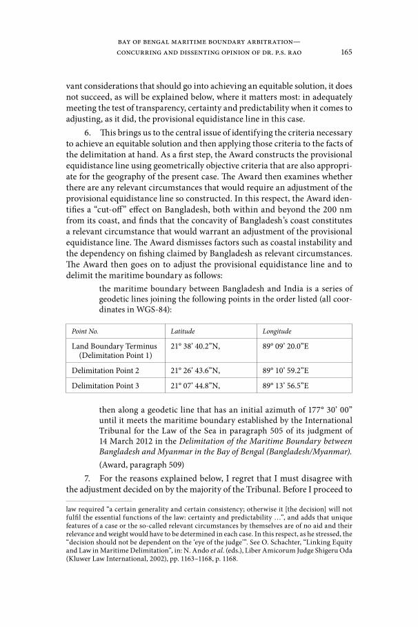
Bay of Bengal Maritime Boundary Arbitration— Concurring and Dissenting Opinion of Dr. P.S. Rao 165
vant considerations that should go into achieving an equitable solution, it does not succeed, as will be explained below, where it matters most: in adequately meeting the test of transparency, certainty and predictability when it comes to adjusting, as it did, the provisional equidistance line in this case.
6. This brings us to the central issue of identifying the criteria necessary to achieve an equitable solution and then applying those criteria to the facts of the delimitation at hand. As a first step, the Award constructs the provisional equidistance line using geometrically objective criteria that are also appropri-ate for the geography of the present case. The Award then examines whether there are any relevant circumstances that would require an adjustment of the provisional equidistance line so constructed. In this respect, the Award iden-tifies a “cut-off” effect on Bangladesh, both within and beyond the 200 nm from its coast, and finds that the concavity of Bangladesh’s coast constitutes a relevant circumstance that would warrant an adjustment of the provisional equidistance line. The Award dismisses factors such as coastal instability and the dependency on fishing claimed by Bangladesh as relevant circumstances. The Award then goes on to adjust the provisional equidistance line and to delimit the maritime boundary as follows:
the maritime boundary between Bangladesh and India is a series of geodetic lines joining the following points in the order listed (all coor-dinates in WGS-84):
Point No. Latitude Longitude
Land Boundary Terminus (Delimitation Point 1)
21° 38’ 40.2”N, 89° 09’ 20.0”E
Delimitation Point 2 21° 26’ 43.6”N, 89° 10’ 59.2”E
Delimitation Point 3 21° 07’ 44.8”N, 89° 13’ 56.5”E
then along a geodetic line that has an initial azimuth of 177° 30’ 00” until it meets the maritime boundary established by the International Tribunal for the Law of the Sea in paragraph 505 of its judgment of 14 March 2012 in the Delimitation of the Maritime Boundary between Bangladesh and Myanmar in the Bay of Bengal (Bangladesh/Myanmar).(Award, paragraph 509)
7. For the reasons explained below, I regret that I must disagree with the adjustment decided on by the majority of the Tribunal. Before I proceed to
law required “a certain generality and certain consistency; otherwise it [the decision] will not fulfil the essential functions of the law: certainty and predictability …”, and adds that unique features of a case or the so-called relevant circumstances by themselves are of no aid and their relevance and weight would have to be determined in each case. In this respect, as he stressed, the “decision should not be dependent on the ‘eye of the judge’”. See O. Schachter, “Linking Equity and Law in Maritime Delimitation”, in: N. Ando et al. (eds.), Liber Amicorum Judge Shigeru Oda (Kluwer Law International, 2002), pp. 1163–1168, p. 1168.

166 Bangladesh/India
elaborate further, I must register my reservation, if not total disagreement, on the matter of selection of appropriate coastlines and relevant area as part of the process of achieving an equitable solution. It is now well-established that, as a preliminary step in arriving at an equitable solution on the basis of inter-national law, the Tribunal should first identify the relevant coastal segments which in turn would establish the relevant area to be delimited. At the outset, it must be acknowledged that the process of selecting the relevant coasts and relevant areas cannot be too precise or exact, but involves some measure of discretion. The main purpose of this exercise is, first, to provide a rough idea of the disputed area and, second, to provide a reference point for the conduct of the “disproportionality” test in terms of the ratios of the relevant coasts and the areas allotted, eventually as a result of the decision, to the parties. Nev-ertheless, the construction of the relevant area should first of all correspond to the disputed area and should exclude that which is clearly not disputed. It should not include in addition any areas in which the interests of third parties are likely to be affected. Further, as a minimum, there are certain well-estab-lished principles that govern this initial phase of the selection of relevant coasts for the purpose of identifying the relevant area. The applicable jurisprudence on this matter is stated by the ICJ in the Black Sea case thus:
first, that the “land dominates the sea” in such a way that coastal pro-jections in the seaward direction generate maritime claims […]; second, that the coast, in order to be considered as relevant for the purpose of the delimitation, must generate projections which overlap with projections from the coast of the other Party. Consequently “the submarine exten-sion of any part of the coast of one Party which, because of its geograph-ic situation, cannot overlap with the extension of the coast of the other, is to be excluded from further consideration by the Court” […]. The Court therefore cannot accept Ukraine’s contention that the coasts of Karkinits’ka Gulf form part of the relevant coast. The coasts of this gulf face each other and their submarine extension cannot overlap with the extensions of Romania’s coast. The coasts of Karkinits’ka Gulf do not project in the area to be delimited. Therefore, these coasts are excluded from further consideration by the Court. The coastline of Yahorlyts’ka Gulf and Dnieper Firth is to be excluded for the same reason.16
8. The majority generally, but not quite, follows these principles in the construction of the relevant area. For example, the majority in selecting the rele-vant Indian coast begins from the land boundary terminus with Bangladesh and extends the relevant coast up to the Sandy Point, a point further to the southwest of Devi Point. The majority does this, even though Devi Point is recognized to have projections not only to the east, towards the coast of Bangladesh, but also towards the southern portion of the Bay of Bengal, overlapping with projections from that coast of Bangladesh within and also beyond 200 nm.17 Accordingly,
16 Maritime Delimitation in the Black Sea (Romania v. Ukraine), Judgment, I.C.J. Reports 2009, pp. 61–134, paras. 99–100.
17 For illustration, see India’s Counter Memorial, sketch map No. 6.7, p. 143 [not repro-duced herein].

Bay of Bengal Maritime Boundary Arbitration— Concurring and Dissenting Opinion of Dr. P.S. Rao 167
the Court could have chosen to limit the relevant area on the Indian side at Devi Point, instead of including the section from that point to Sandy Point. The Tri-bunal’s explanation, at paragraph 301 for choosing Sandy Point is obscure, even as it admits that the “projection of the coast of one Party can easily be overlapped by projections of multiple segments of the coast of the other. The task facing the Tribunal is simply to identify those sections of coast that generate projections overlapping those of the coast of the other party”. And the main reason, by the same token, the coastline further southwest of Sandy Point was rejected, accord-ing to the Award, is that the angles at which these projections emanate are too acute “to the general direction of the coast”. This is a consideration which is not part of the aquis judiciare, as noted above. The important point is to construct the relevant area as strictly as possible to denote the disputed area as closely as possible and not inflate it with figures which in the end would not do proper justice for the conduct of the so-called “disproportionality test”. Equally, pro-jections from the northern tip of the Andaman Islands would not, in my view, qualify for inclusion in the relevant area for the purpose of delimitation, given the fact that that coastal front is neither adjacent nor opposite to the coast of Bangladesh. For these reasons, I consider that the construction of the relevant coasts and the relevant area for the purpose of delimitation is not as accurate as it should have been. This is a different matter, however. Whichever way the relevant area is constructed, as the Award rightly notes, it has no bearing on the merits of the claims of the Parties, and the main purpose of the relevant area is in any case, as noted, already very limited.
9. In the event, my main objection relates to the considerations that gov-erned the adjustment of the provisional equidistance line. First, I differ with the majority on the finding that the adjustment should start at Delimitation Point 3 (21° 07’ 44.8”N, 89° 13’ 56.5”E), as that point lies well before a significant “cut-off” effect occurs. Second, I am not convinced that the Award has reasoned its justification of the azimuth of the adjusted line (177° 30’ 00”) in a satisfactory manner. Third, the azimuth chosen by the majority (177° 30’ 00”) incidentally is similar to the azimuth of the bisector line proposed by Bangladesh, (180°). This is, in my view, arbitrary and intrinsically runs counter to the majority’s own reasoning which effectively rejected a bisector as a matter of law.
10. Finally, I strongly disagree both as a matter of law and policy with the creation of a “grey area” as a result of the adjustment the majority made to the provisional equidistance line, in a not-insignificant expanse of the Bay of Bengal. In this respect the majority takes inspiration from the only other case in which such a grey area was created by a Tribunal as part of achieving an equitable solution, that is, the ITLOS decision in the Bangladesh/Myanmar case (2012).
11. Before elaborating on these four points, I will briefly discuss the legal principles that have guided the International Court of Justice in adjusting the provisional equidistance line drawn in prior delimitations. At the outset, it must be emphasized that the adjustment of the provisional equidistance line is an exer-cise that is governed by law and has to be conducted within the limits set by the

168 Bangladesh/India
geographical context and coastal configuration. Different methods or techniques may play a role in achieving an equitable solution. Where islands or other anom-alous features have been involved, they have been ignored where appropriate,18 enclaved in some cases, or given half, full or greater than full effect in others.19 In the case of a State with a concave coast and situated in the middle of two oth-er neighboring States, the ICJ in the North Sea Continental Shelf cases analyzed the “cut-off” effect that would result from boundary lines drawn on the basis of equidistance.20 In that case, the ICJ described a “cut-off” as an area in “the form approximately of a triangle with its apex seaward and, as it was put on behalf of the Federal Republic, ‘cutting-off’ the coastal State from the further areas of the continental shelf outside of and beyond this triangle”.21 The ICJ decided that, when an equidistance method produces “extraordinary, unnatural or unreason-able” results, delimitation methods other than equidistance should be considered or adjustments should be made to the provisional equidistance line.22
12. While it endorsed the principle of delimitation on the basis of equi-ty, the ICJ in Tunisia/Libya laid down several principles to limit or restrict the role that equity could play in the adjustment of a provisional equidistance line, emphasizing that the application of equitable principles should not amount to a decision ex aequo et bono.23 These principles are also well-expressed by the ICJ in Libya/Malta, which emphatically rejected the idea that equity could amount to a refashioning of geography or the inequalities inherent in nature:
That equitable principles are expressed in terms of general application, is immediately apparent from a glance at some well-known examples: the principle that there is to be no question of refashioning geography, or compensating for the inequalities of nature; the related principle of non-encroachment by one party on the natural prolongation of the oth-er, which is no more than the negative expression of the positive rule that the coastal State enjoys sovereign rights over the continental shelf off its coasts to the full extent authorized by international law in the relevant circumstances; the principle of respect due to all such relevant circumstances; the principle that although all States are equal before the law and are entitled to equal treatment, “equity does not necessarily imply equality” (I.C.J. Reports 1969, p. 49, para. 9), nor does it seek to make equal what nature has made unequal; and the principle that there can be no question of distributive justice.24
18 For instance, Saint Martin’s Island was ignored by ITLOS for the purpose of delimita-tion in Bangladesh/Myanmar. See Bangladesh/Myanmar, supra note 1, para. 319.
19 Territorial and Maritime Dispute (Nicaragua v. Colombia), Judgment, I.C.J. Reports 2012, pp. 624–720, paras. 180 & 183; Anglo-French Continental Shelf Arbitration (France/United King-dom), 54 ILR 11 (1977), para. 249.
20 North Sea Continental Shelf, supra note 6, para. 8.21 Ibid.22 Ibid.23 Continental Shelf (Tunisia/Libya), Judgment, I.C.J. Reports 1982, pp. 18–94, para. 71.24 Continental Shelf (Libya/Malta), Judgment, I.C.J. Reports 1985, pp. 13–58, para. 46.
Bay of Bengal Maritime Boundary Arbitration— Concurring and Dissenting Opinion of Dr. P.S. Rao 169
13. These are not merely general principles; they are criteria that oper-ate as limits within which an equitable solution can and should be lawfully achieved. When properly applied, they contribute to transparency, certainty and predictability, goals that properly distinguish equity in law from ex aequo et bono. The Award itself recognizes several of these principles as appropriate in the present case and stresses that maritime delimitation should not impinge upon the interests of third parties.25
Delimitation Point 314 Against the above background it is appropriate to examine the specif-
ic terms of adjustment. To begin, I quote from the arbitral tribunal’s finding in Barbados v. Trinidad and Tobago: “[t]here is next the question of where precisely the adjustment should take place. There are no magic formulas for making such a determination and it is here that the Tribunal’s discretion must be exercised within the limits set out by the applicable law”.26 I also recall the ITLOS decision in Bangladesh/Myanmar that “in view of the geographical circumstances in the present case, the provisional equidistance line is to be deflected at the point where it begins to cut off the seaward projection of the Bangladesh coast”.27
15. In the Award, the adjustment of the provisional equidistance line starts at Delimitation Point 3 (21° 07’ 44.8”N, 89° 13’ 56.5”E). This adjustment is justified on the ground that there is a gradual decrease in the area allotted to Bangladesh as the equidistance line proceeds seaward, producing a full “cut-off” on the southward projection of Bangladesh’s coast when the provisional equidistance line meets the ITLOS delimitation line in the continental shelf beyond 200 nm. In the view of the majority, the decrease in the area allotted to Bangladesh is noticeable from Delimitation Point 3 on the provisional equi-distance line. But at this stage the majority did not make any effort to assess the size of areas that are allocated to Bangladesh and India on the basis of the provisional equidistance line. Yet, the majority favoured adjusting the equidis-tance line from that point.
16. With great respect, I disagree with the majority that Delimitation Point 3 represents the point at which the provisional equidistance line requires adjustment. While it is evident that a State with a concave coast and situated in the middle of two other coastal States would suffer a “cut-off”, it is necessary to examine the nature of cut-off and where in the disputed area it actually occurs. In the context of adjustment, the Award itself explains that it is only an unrea-
25 On the importance of protection of the third party interests, see Romania v. Ukraine, supra note 16, paras. 112 & 114; Nicaragua v. Colombia, Declaration of Judge Xue, I.C.J. Reports 2012, pp. 746–750, paras. 11–14; Nicaragua v. Colombia, Separate opinion of Judge Donoghue, I.C.J. Reports 2012, pp. 751–761, para. 29; Nicaragua v. Colombia, Declaration of Judge ad hoc Mensah, I.C.J. Reports 2012, pp. 762–767, para. 13; and Nicaragua v. Colombia, Declaration of Judge ad hoc Cot, I.C.J. Reports 2012, pp. 768–771, paras. 9–13.
26 Barbados v. Trinidad and Tobago, Award, PCA Awards Series (2006), para. 373.27 Bangladesh/Myanmar, supra note 1, para. 329.

170 Bangladesh/India
sonable “cut-off” that may warrant a departure from the provisional equidis-tance line and that the Tribunal must nevertheless take care to avoid creating a new “cut-off” as a result of the adjustment (Award, paragraphs 419–421). Dur-ing the oral hearing, even Bangladesh noted that a “cut-off” is one of degree and that there is no generic prohibition against cut-off, which is an inevitable conse-quence of the delimitation process under certain geographical circumstances28. As noted above, the ICJ in the North Sea Continental Shelf cases supported this view and found that a “cut-off” merits adjustment when the equidistance method produces “extraordinary, unnatural or unreasonable” results.
17. In the present case, the cut-off occurs at a point anywhere from 240–290 nm depending on the point chosen along the coast of Bangladesh to measure the distance (for instance, Kutubdiya lighthouse lies 290 nm from the point at which the cut-off occurs). Whereas some deflection is noticeable in the direction of the provisional equidistance line from point Prov-3 to the east, it is situated closer to the coast and far from the 200 nm limit of Bang-ladesh beyond which the only actual cut-off occurs. Even more significant is the fact that Delimitation Point 3 is situated in an area in which, when viewed with reference to points on the eastern and western shores, the provisional equidistance line actually allocates to Bangladesh a greater share of the bay than to India. This observation can be demonstrated by the sketch map below:
28 See statement of Professor James Crawford, Hearing Tr., 554: 18–19.

Bay of Bengal Maritime Boundary Arbitration— Concurring and Dissenting Opinion of Dr. P.S. Rao 171
18. Further, there are situations where a “cut-off” may occur as a result of other factors, even when the coast involved is not concave, but among other things, because of the existence of a maritime boundary with a third State. As the ICJ observed in the North Sea Continental Shelf Cases, “[t]he effect of concavity could of course equally be produced for a country with a straight coastline if the coasts of adjacent countries protruded immediately on either side of it.”29 Therefore, in the present case where both the concavity of Bang-ladesh’s coast and its maritime boundary with Myanmar are relevant factors, the resulting “cut-off” effect cannot be entirely attributed to the concavity of the coast, while according to the Award it is that cut-off alone that warrants adjustment, and then only to the extent that the cut-off is “unreasonable”. In comparison, the cut-off that the Court in the Continental Shelf Cases (1969) found to merit adjustment occurred at 80 nm, close to the German coast (which, incidentally, is twice as long as the combined coasts of its two neigh-bors). One important message of this case, which is often referred to by the Parties, must be noted. That is, cut-offs that occur closer to the coast merit, taking into consideration other relevant circumstances, greater adjustment on account of equity than do cut-offs that occur further to seaward. In other words, common sense and good judgment both postulate that the greater the distance from the coast at which a cut-off occurs, the lesser the area it requires by way of an adjustment to accomplish equity.
19. As depicted in the sketch map above, the provisional equidistance line as it travels southward from point Prov-3 exhibits a deflection towards the eastern coast of Bangladesh with effects that become a bit more pronounced at a point below provisional point Prov-4 and above provisional point Prov-5. From there on, the provisional equidistance line has an increasingly prominent effect on the seaward projection of the coast of Bangladesh, thanks to the maritime boundary it now has with Myanmar, until it cuts Bangladesh off entirely and terminates at a distance of roughly 250 nm from the coast where it meets that boundary set by the decision of the ITLOS. In my view, it is only from this point at which the line’s effects become pronounced (20° 09’ 00”N, 89° 34’ 50”E) that the provisional equidistance line should have been adjusted, even if we follow the logic of the majority, which I could have been persuaded to accept to achieve an equitable solution. I come to this conclusion, not because Bangladesh is los-ing significantly in the Bay on account of the provisional equidistance line, which appears in fact to be more favorable to Bangladesh than to India, or because the cut-off it suffers at a distance of 250 nm from its coast comes any closer to being “extraordinary, unnatural or unreasonable”, to meet the test laid down by the Continental Shelf Cases (1969), but because the exercise of a margin of appreciation by the majority may then appear more defensible as an exercise to achieve equity within bounds of law.30 On this more below.
29 North Sea Continental Shelf cases, supra note 6, para. 8.30 In exercising its margin of appreciation, the majority appears to have kept in view the
proposals for adjustment made by Bangladesh. It may be noted that Bangladesh’s proposal, by

172 Bangladesh/India
The 177° 30’ 00” Azimuth and the 180° Bisector
20. With respect to the manner in which the adjustment of the provision-al equidistance line is made, paragraph 478 of the Award provides as follows:
To ameliorate the excessive negative impact the implementation of the provisional equidistance line would have on the entitlement of Bangla-desh to the continental shelf/exclusive economic zone and the continen-tal shelf beyond 200 nm and to achieve an equitable result, the Tribunal decides that the adjusted line delimiting the exclusive economic zone and the continental shelf between Bangladesh and India within and beyond 200 nm is the azimuth of 177° 30´ 00˝ from Prov-3 until this line meets with the maritime boundary established by the International Tribunal for the Law of the Sea to delimit the exclusive economic zone and the continental shelf between Bangladesh and Myanmar within and beyond 200 nm.
21. It is self-evident from the text above that the Award offers no expla-nation for choosing the 177° 30’ 00” azimuth and leaves one to guess at the loss to Bangladesh arising from the provisional equidistance line, which the Award termed as causing “excessive negative impact” on it. It is, after all, common knowledge that not all coastal States are endowed with wide and generous coast-al fronts (not to speak of those landlocked States with no coast whatsoever), which would benefit from the maritime delimitation to the same extent as those with such long coasts. In addition, the presence of anomalous features and the protruding coastlines of adjacent States limit the extent of the area a coastal State would receive by way of delimitation. Take the case of Germany itself, which giv-en its geographic situation, could not extend its maritime area beyond 200 nm because it has to share the available maritime area not only with adjacent States but also with the United Kingdom which is has an opposing coast across the North Sea. Under the circumstances, the simplistic explanation offered for this azimuth in the Award is highly unsatisfactory. This will be left, in the absence of any verifiable factors or criteria of what the Tribunal did, to one’s imagination. This difficulty is compounded, in my view, by the fact that this azimuth effective-ly directs from Delimitation Point 3 the rest of the course of the final boundary line. If an azimuth of 177° 30’ 00” could achieve an equitable solution in the present case, why cannot an azimuth of 177° 20’ 00” or 177° 40’ 00” achieve the same objective? In this respect, I note that the 177° 30’ 00” azimuth line nearly matches a geodetic line connecting Delimitation Point 3 with the intersection of the ITLOS delimitation line and India’s submission to the Commission on the Limits of the Continental Shelf (the “CLCS”). The difference in azimuth between these two lines is less than 0.5°.
way of adjustment of the 180 degree bisector angle, which it favored as an initial or provisional line of delimitation, would give it an additional area of 25, 069 sq. km. This is similar to the space which Bangladesh gained to the east abutting Myanmar, which is about of 25,654 as a result of the decision by ITLOS. See Bangladesh’s Reply, para. 4.148.

Bay of Bengal Maritime Boundary Arbitration— Concurring and Dissenting Opinion of Dr. P.S. Rao 173
22. Further, the 177° 30’ 00” azimuth constructed by the majority comes very close to (and indeed nearly matches) the 180° bisector claimed by Bangladesh. In my view, it is unacceptable for the Tribunal, to adopt, by way of adjustment, a line that so closely approximates a 180° bisector which it rejected as a method of delimitation. As stated by Judge Cot in his separate opinion in Bangladesh/Myanmar, “[t]he re-introduction of the azimuth method deriving from the angle-bisector theory results in mixing disparate concepts and rein-forces the elements of subjectivity and unpredictability that the equidistance/relevant circumstances method is aimed at reducing”.31 For the same reasons, I find the final adjusted maritime boundary line, given the similarity between the azimuth chosen by the majority (177° 30’ 00”) and the azimuth of the bisec-tor line proposed by Bangladesh (180°), to be flawed.
Adjustment of the Provisional Equidistance Line23. I understand and can sympathize with the purpose of the adjust-
ment (i.e. the 177° 30’ 00” azimuth) evident in the Award: to allocate to Bang-ladesh an area that the majority considered reasonable and workable for the purpose of exploring and exploiting the resources of the exclusive economic zone and continental shelf. But cases may be cited where the adjustments made created, as in the case of St Pierre et Miquelon case, only narrow corridors for the purposes of access. In addition, the areas allotted as a result of adjust-ment must be seen in the light of the over-all areas allotted in the exercise of delimitation and not in isolation. I cannot underscore, therefore, with greater emphasis that these considerations are purely arbitrary and cannot be justi-fied by any principle of law. I accept that the task of adjusting a provisional equidistance line requires that the Tribunal be accorded a certain margin of appreciation. But it appears here that the majority has not been guided by the general principles governing the application of equity that has, in other cases, restricted the range within which an equitable solution could be achieved. I have described these principles above. Indeed, the Award itself records these principles, but does not give them any real weight or consideration in fashion-ing the adjustment. Instead, the majority subjectively shifted the provisional equidistance line to the 177° 30’ 00” azimuth, the direction of which was not mandated by any observable criteria.
Grey Area24. As described in paragraphs 498–508 of the Award, the line so
adjusted creates a “grey area”, i.e., an area that falls within the continental shelf of Bangladesh and also within the 200 nm EEZ of India. Apart from the diffi-culties inherent in having concurrent sovereign rights affecting a single area, one further unintended and problematic consequence of this grey area is that
31 Bangladesh/Myanmar, Separate opinion of Judge Cot, p. 8.

174 Bangladesh/India
it actually overlaps in part with the grey area created by the ITLOS decision in Bangladesh/Myanmar. As a result, within this overlapping portion of the grey areas (or “double grey area”, if you will), Bangladesh would have exclu-sive rights over the continental shelf and India and Myanmar would have to share or agree to apportion the rights concerning the EEZ. I cannot accept the notion of a grey area, or the prospect of utilizing it as convenient legal device to provide by way of adjustment an area which is otherwise beyond the grasp of the Tribunal to award in the present case (indeed, even going so far as to per-mit the existence of a double grey area). The creation of a grey area is entirely contrary to law and the policies underlying the decision taken in UNCLOS to create the EEZ as one single, common maritime zone within 200 nm which effectively incorporates the regime of the continental shelf within it.
25. I note that in creating a grey area, the Award is obviously influ-enced by the only instance of this that we have until now, that is the decision of the ITLOS in Bangladesh/Myanmar (see Award, paragraphs 499–508). The majority substantially borrows the rationale adopted by the ITLOS judgment in support of its own action. As in the case of the ITLOS decision, the bound-ary line in the grey area delimits only the continental shelves of the Parties, on the grounds that Bangladesh has no entitlement to an EEZ in this area.32 The Award also echoes ITLOS in noting that, pursuant to article 56(3) of the Convention, the rights of a coastal State in respect of the seabed and subsoil in the EEZ are to be exercised in accordance with the regime for the continental shelf.33 Further, it notes that article 63 excludes sedentary species from the regime of EEZ.34 With respect to practical matters concerning the grey area, the Award, like the ITLOS decision, encourages the Parties to conclude fur-ther agreements or to create a cooperative arrangement in order to ensure the proper exercise of their respective rights in that area.35
26. With great respect, in my view, the ITLOS decision on the grey area was ill-conceived, in as much as the majority treated it as a by-product of the adjustment that they thought fit to make, which awarded to Bangladesh an area of continental shelf beyond 200 nm. In so doing they did not have much support from either of the parties, and both seemed to have even expressed their opposition to the concept.36 In the process that Tribunal appears to have
32 Bangladesh/Myanmar, supra note 1, para. 471.33 Ibid., para. 473.34 Ibid.35 Ibid., para. 476.36 The ITLOS decision notes “The Parties differ on the status and treatment of the
above-mentioned “grey area”. For Bangladesh, this problem cannot be a reason for adhering to an equidistance line, nor can it be resolved by giving priority to the exclusive economic zone over the continental shelf or by allocating water column rights over that area to Myanmar and con-tinental shelf rights to Bangladesh” (Ibid., para. 465). For Myanmar, “the solution submitted by Bangladesh is untenable, the problem of a “grey area” does not arise in the present case, because equitable delimitation does not extend beyond 200 nm” (Ibid., para. 470).

Bay of Bengal Maritime Boundary Arbitration— Concurring and Dissenting Opinion of Dr. P.S. Rao 175
misconstrued the true nature and juridical significance of the EEZ. That Tri-bunal justified the creation of a grey area thus: (i) the judgment is only delimiting the continental shelves com-
mon to both the Parties and not addressing the parties’ EEZ rights in the superjacent waters, suggesting thereby that such rights are different and separable;
(ii) the grey area arises as a consequence of delimitation; and any delimitation may give rise to complex legal and practical prob-lems, such as those involving transboundary resources;
(iii) the judgment refers to different articles dealing in some respects with the exercise of high sea freedoms, and others dealing with specific resources of the continental shelf and sedentary fisher-ies and its delimitation, suggesting one or two things. First that the rights States enjoy over the continental shelf are different from the rights they have over the resources of the EEZ. Second, it is common under the law of the sea for different regimes to operate in the same area.
As these are the same arguments this Tribunal has also made in support of the creation of the grey area in this case, they require a thorough review.
27. Ever since the concept of the EEZ has emerged as a concept of inter-national law and as part of the law of the sea, it has been a sui generis concept, which acquired the status of customary international law in the shortest time span possible, even as the Third UN Conference to the Law of the Sea was putting the final touches on the Convention in 1981.37 The EEZ is a single jurid-ical entity that combines three different resource regimes: living resources, non-living resources, and other uses involving or generating economic value out of this area. When the Court in the Continental Shelf (Libya and Tuni-sia) case attempted to delimit only the continental shelf and was not ready to accept that the same delimitation applies to the EEZ (which by that time, as Oda noted, acquired the status customary law), Judge Evensen, also a prom-inent player in the Third UN Conference on the Law of the Sea, had this say:
The emergence of the 200-mile Exclusive Economic Zone concept in Part V of the draft convention is not based on the concept of natural pro-longation, but on the concept that a coastal State should have functional sovereign rights over the natural resources in a belt of water and sea-bed 200 miles seawards whether the coastal State concerned possesses a continental shelf in the traditional sense or not. This new development has been accepted in recent State practice. This 200-mile economic zone concept refers not only to the resources of the seas (living or non-living),
37 See observations of S. Oda, who noted that “[E]ven apart from the provisions of the 1981 draft convention, the Court need have qualms in acknowledging the general concept of the exclusive economic zone as having entered the realm of customary international law.” Shigeru Oda, “Delimitation of a Single Maritime Boundary: The Contribution of Equidistance to Geo-graphical Equity in the Interrelated Domains of the Continental Shelf and the Exclusive Eco-nomic Zone”, in: International Law at the Time of Its Codification: Essays in Honour of Roberto Ago, Vol. II (1987), pp. 349–362, p. 353.

176 Bangladesh/India
but also to the natural resources on or in the sea-bed. To this extent it is also in practice a continental shelf concept.38
28. “Note should likewise be taken of the fact”, Judge Evensen pointed out, “that the provisions concerning the delimitation of the Exclusive Econom-ic Zones in Article 74 of the [then] draft convention and the provisions on the delimitation of continental shelves between States with opposite or adjacent coasts, contained in Article 83, are identical. Certain questions appear to arise because of the inter-relation between the new concept of exclusive economic zones and the continental shelf concept, the more so since certain new trends in Article 76 of the draft convention seem to strengthen this inter-relation and interdependence.”39 “The first question which may be raised”, according to Judge Evensen, “is whether the concept of natural prolongation has not been weakened by these recent trends within the 200-mile zone”.40 Another ques-tion, he noted, which appears to arise is “whether different lines of delimitation are conceivable for the Exclusive Economic Zone and the continental shelf in such a case, bearing in mind that the exclusive economic zone concept laid down in Part V of the draft convention also comprises the natural mineral resources of the sea-bed and its subsoil, that is the natural resources of the continental shelf”.41
29. The development of the exclusive economic zone concept, Judge Evensen continued,
is not an insignificant element in this respect and might perhaps influence the practical method of delimitation. In this context, note should be tak-en of a development in the Law of the Sea Conference and in the domain of State practice which has weakened the practical impact of the concept of natural prolongation through the development of that of the 200-mile economic zone; this aside from the practical difficulties of basing a line of delimitation for a joint shelf on the natural prolongation thereof when the two adjacent countries also share the same landmass. […] I feel that it is hardly conceivable in the present case to draw a different line of delim-itation for the exclusive economic zone and for the continental shelf. The areas to be delimited will in both instances be situated well inside the 200 nautical miles “from the baselines from which the breadth of the territorial sea is measured”. To my mind, it is somewhat doubtful that a practical method for the delimitation of the areas concerned should be based solely or mainly on continental shelf considerations.42
30. Thus, it may perhaps be a too restrictive approach in the present case to maintain, as Judge Evensen concluded, that “the ‘principles and rules
38 Continental Shelf (Tunisia/Libya), Dissenting Opinion of Judge Evensen, I.C.J. Reports 1982, pp. 278–323, para. 9.
39 Ibid.40 Ibid.41 Ibid.42 Ibid., para. 10.

Bay of Bengal Maritime Boundary Arbitration— Concurring and Dissenting Opinion of Dr. P.S. Rao 177
of international law which may be applied’ for the delimitation of continental shelf areas must be derived from the concept of the continental shelf itself”.43
31. It is clear from the above, within 200 nm from the coast, the sov-ereign rights of a coastal State over the water column and the seabed and its subsoil are considered as two indispensable and inseparable parts of the coastal State’s rights in the EEZ.44 As is now evident, the entitlement of coastal States no longer rests either on the concept of natural prolongation and adjacency or on depth or exploitability criterion, but is solely dependent on the 200 nm dis-tance criterion.45 This more than anything else unites the legal regimes of the exclusive economic zone and the continental shelf, within 200 nm, since the adoption of the 1982 Law of the Sea Convention. The unity of this legal basis is now well-recognized, with States and Tribunals engaged in the delimitation of the EEZ and the continental shelf routinely seeking or establishing a common maritime boundary, without regard to the differing nature of the resources of the superjacent waters, the seabed and its subsoil.
32. That the legal regulation of the resources in the superjacent water column differs from the legal regulation of the resources of the seabed and subsoil under the Convention simply reflects the fact that the differing nature of these resources requires different forms of regulation. The same holds true for natural resources within the national jurisdiction of a coastal State. In this regard, it is apt to quote the ICJ’s observation in the Libya/Malta case:
Although the institutions of the continental shelf and the exclusive eco-nomic zone are different and distinct, the rights which the exclusive economic zone entails over the sea-bed of the zone are defined by refer-ence to the regime laid down for the continental shelf. Although there can be a continental shelf, where there is no exclusive economic zone, there cannot be an exclusive economic zone without corresponding continental shelf. It follows that, for juridical and practical reasons, the
43 Ibid.44 Continental Shelf (Tunisia/Libya), Separate Opinion of Judge Jiménez de Aréchaga, I.C.J.
Reports 1982, pp. 100–142, para. 55.45 See J. Charney, “International Maritime Boundaries for the Continental Shelf: The Rel-
evance of Natural Prolongation”, in: N. Ando et al. (eds.), Liber Amicorum for Judge Shigeru Oda, (Kluwer Law International, 2002), pp. 1011–1029. Referring to the use of the concept of natural prolongation as part of the definition of the continental shelf in Article 76(1) of 1982 LOS Convention, and relying on the examination of the drafting history of that article by Judge Shigeru Oda in his dissenting opinion in the Libya/Malta case, Charney noted thus: “He (Oda, J.) concludes accurately that the language of Article 76(1) was intended to provide all coastal States an entitlement to a continental shelf of 200 nautical miles regardless of the geology and geomor-phology of the sea-bed and subsoil. That basis for the entitlement consequently conditions the relevant considerations for defining maritime boundaries between States with overlapping enti-tlements to exclude geology and geomorphology from consideration, as Judge Oda also argued in his dissent. … While all international maritime boundaries are indeed unique, rights to the resources of areas within 200 nautical miles of a coastal State’s coastline are now merely a func-tion of distance from the shore” (pp. 1026–1027).

178 Bangladesh/India
distance criterion must now apply to the continental shelf as well as to the exclusive economic zone.46
This clear statement on the juridical concept of the EEZ negates any conclu-sions the Award draws to the effect that the continental shelf is a single unit and that no distinct inner continental shelf and an outer continental shelf exist. That is only true partially, insofar as the resources the shelf encompass-es and any regulation that goes with them. It cannot, however, hold true as far as it concerns the indivisibility of the coastal State’s sovereign rights over the resources of the EEZ, as noted above.
33. It is suggested that any delimitation may give rise to complex legal and practical problems, such as those involving transboundary resources. It is not unusual, according to this argument, in such cases for States to enter into agree-ments or cooperative arrangements to deal with problems resulting from the delimitation. This is not a proper analogy, in my view. Transboundary resourc-es are a natural phenomenon, and they do not admit in some cases to a neat division. Straddling resources require common arrangements in the interest of economy and efficiency. The situation with respect to the grey area, however, is not comparable with that of the straddling resources, as grey areas are creatures of convenience and purely man-made. Delimitation to achieve an equitable solu-tion must in any case respect legal limitations and certainly should avoid violat-ing the existing rights of States to create new rights for other States.
34. As for the point that under the law of the sea, it is not uncommon for different regimes to operate in the same area, it may be noted that these are freedoms States enjoy over the high seas. They are inclusive rights.47 In con-trast, the rights accorded to coastal States over the EEZ are sovereign rights and exclusive rights. These have been accepted, as part of evolution of law, while preserving the freedoms of the high seas. In other words, by their very nature, they are different types of rights which admit co-existence. The same cannot be said for dividing sovereign and exclusive rights and control over resources, living and non-living as well as of economic value, in respect of which we ever so often witness disagreements and even serious political conflicts.
35. Further, as a matter of policy, international courts and tribunals should avoid delimiting boundaries in a way that leaves room for potential conflicts between the parties. The entire purpose of delimitation is to settle inter-State disputes definitively by allocating particular areas where one party can effectively exercise sovereign rights (such as exploitation) without the need for permission of another sovereign. Grey areas do precisely the opposite. The Award is itself conscious of this fact and for that reason urges the Parties, when exercising rights and duties under the Convention, to give due regard to the rights and duties of other States (Award, paragraph 507). The Award leaves it to
46 Libya/Malta, supra note 24, para. 34.47 On the concept of inclusive uses and their co-existence with the exclusive uses of the EEZ,
see P. Sreenivasa Rao, The Public Order of the Ocean Resources: A critique of the contemporary law of the sea (The MIT Press, 1975), ch.3 on Limits for National jurisdiction, pp. 47–75, p. 74.
Bay of Bengal Maritime Boundary Arbitration— Concurring and Dissenting Opinion of Dr. P.S. Rao 179
the Parties to determine the appropriate measures associated with the concept of “due regard”, which includes the conclusion of further agreements or the establishment of a cooperative agreement.
36. I respectfully disagree with this approach, on the basis that, first, it may not be possible in practice to divide the EEZ and separate the rights of one coastal State in the water column from the rights of another over the seabed and its subsoil. Second, inviting the Parties to negotiate a solution in the grey area may lead to further problems and may be considered as a failure on the Tribunal’s part to delimit the maritime areas in a definitive manner. When it comes to economic and energy resources, even States with very good bilateral relations may disagree as to which should have priority for a particular purpose within the same maritime zone. Third, the grey area created by the Award will not only divide the single maritime zone (i.e. the EEZ) between two parties as in the case of ITLOS decision but among three States. It is worth noting that the risk of potential conflict in the grey area will only compound the already exist-ing potential for conflict resulting from competing interests involving security, navigation, marine scientific research, as well as the protection and preserva-tion of the marine environment.48 Moreover, installations for the exploitation of the resources in the seabed and its subsoil inevitably affect the water column. The grey area may thus create more problems for the Parties—who are now forced to co-habit the same area—than the benefits it could potentially offer.
37. To conclude, I disagree with the majority’s decision to draw a boundary line that creates a grey area based on both legal principles and poli-cy considerations. In my view, the grey area would ill serve the purpose of the efficient, economical and ecologically sound management of ocean resources. The grey area also has the potential to exacerbate bilateral relations and pose avoidable security problems. I hope that future maritime delimitation arrange-ments will examine this problem more carefully and refrain from creating grey areas unless exceptional conditions so warrant, and then only with the full consent of all the parties involved. It is a pity that the Tribunal in this case did not seek the specific views of India which rightly or not assumed on the merits that this problem would not arise (Award, paragraph 502).
My Proposed Line of Delimitation
38. For the reasons explained above, I consider that the line of adjustment constructed by the majority is not supported by the general principles governing delimitation on the basis of equity; it is also not in conformity with the inter-national law governing the sovereign rights of coastal States within 200 nm. As regards the ITLOS decision in Bangladesh/Myanmar, I differ with its reasoning and cannot share the view of the majority on its persuasiveness. Any decision
48 On multiple uses and conflicts, see Ibid., ch.5, pp. 109–165.

180 Bangladesh/India
on maritime boundaries should help a neat and final allocation of the maritime areas to the parties involved, and avoid the creation of the potential for conflict.
39. Having explained that the grey area should best be avoided, I will now turn to the question of how to draw a boundary line that would effectively eliminate the grey area in the present case, and yet meet the concerns of the majority to achieve an equitable solution. As the ICJ stated in the Libya/Malta case, “[t]he legal basis of that which is to be delimited, and of entitlement to it, cannot be other than pertinent to that delimitation”.49 It is clear from the Con-vention that the entitlement to the EEZ is based solely on distance from the coast and does not depend on other factors.50 By contrast, the entitlement to the continental shelf beyond 200 nm is based on natural prolongation which is in turn explained and conditioned with reference to the foot of the continental slope. From the foot of the continental slope, the entitlement to the continental shelf beyond 200 nm may extend seaward a further 60 nm, or as far as “the outermost fixed points at each of which the thickness of sedimentary rocks is at least 1 per cent of the shortest distance from such point to the foot of the continental slope”.51 According to the Convention, the entitlement to the con-tinental shelf beyond 200 nm is further subject to one of two alternative lim-itations, namely, that the outer limits of the continental shelf shall not exceed 350 nm from the baselines or shall not exceed 100 nm from a point at which the depth of the water is 2,500 meters.52 Having calculated the outer limits of its continental shelf, the coastal State shall submit details of the calculation to the Commission of the Limits of the Continental Shelf, the role of which is to examine the submission and to make recommendations to the coastal State.53 The coastal State will then establish the outer limits of the continental shelf on the basis of such recommendations, which limits shall be final and binding.54
40. This complicated method to calculate the outer limits of the con-tinental shelf suggests that the entitlement to the continental shelf beyond 200 nm depends on different factors and is not as absolute as the entitlement to the EEZ. It follows that the entitlement to the EEZ takes priority over the entitlement to the continental shelf beyond 200 nm. Accordingly, the line of adjustment should run from point R-1 (20° 09’ 00”N, 89° 34’ 50”E) to the inter-section of Bangladesh’s 200 nm limit and Myanmar’s 200 nm limit (point R-2: 18° 19’ 32.0”N, 89° 36’ 31.8”E), and then to the intersection of Myanmar’s 200 nm limit and India’s 200 nm limit (point R-3: 18° 10’ 18”N, 89° 43’ 54”E). After the line enters the maritime area beyond 200 nm from the coast of any of the three States involved, it would turn to follow a geodetic line until it meets the point of intersection created by the ITLOS line of delimitation with
49 Libya/Malta, supra note 24, para. 27.50 UNCLOS, Article 57.51 UNCLOS, Article 76 (4) (a).52 UNCLOS, Article 76 (5).53 UNCLOS, Article 76 (8).54 UNCLOS, Article 76 (8).

Bay of Bengal Maritime Boundary Arbitration— Concurring and Dissenting Opinion of Dr. P.S. Rao 181
India’s submission to the CLCS (at point R-4: 16° 40’ 54”N, 89° 24’ 05”E). The proposed line is depicted in the diagram on the final page of this opinion.*
41. The area resulting from this adjustment would allocate to Bangla-desh 7,948 square kilometers more than what would result from the unadjust-ed application of the provisional equidistance line established by the Award. The line so adjusted also meets the disproportionality test. This adjustment would allocate the relevant area identified by the Tribunal between Bangladesh and India in a proportion of 1:3.28. This is in comparison to the proportion of 1:1.92 between the relevant coasts of the two States, and the proportion of 1:2.81 achieved by the delimitation line constructed by the majority.
42. The difference between these two approaches should be evaluated not in terms of who gets what area and how much, but in terms of the prin-ciples on which they are based. It is a matter of satisfaction in this respect that both proposals are united behind the concept of protecting the interests of third parties. My approach and that of the majority differ because of the attempt on my part to stay within what I consider the limits set by the princi-ples governing equity and the lack of necessary legal sanction for the creation of a grey area. In addition to legal compulsions, it is my humble submission that for practical and policy reasons the creation of such grey areas as part of maritime delimitation is not justified. I strongly believe that the methods and means used or to be used to achieve an equitable solution cannot be open ended but must be governed by principles of law that now form the acquis judiciare. The methods and means used in delimitation should also be in con-formity with the well-established sovereign rights of coastal States over the resources of the EEZ which cannot and should not be bifurcated, even if we all agree there is only one continental shelf when it comes to the exploration and exploitation of the resources of the seabed and subsoil and the conservation and management of the sedentary fisheries traditionally associated with the resources of the continental shelf.
43. In conclusion, I wish to record my deep appreciation and respect for my very distinguished colleagues on the Tribunal, working with whom was a pleasant learning experience. I very much regret that I found myself unable to join them on all the issues on which this Award now pronounces.
Dated: 7 July 2014
[Signed] Dr. Pemmaraju Sreenivasa Rao
* Secretariat note: See map located in the back pocket (Map illustrating Dr. P.S. Rao’s dissenting opinion—Map 13).


PART II
Award in the Arbitration regarding the Arctic Sunrise
Award on Jurisdiction of 26 November 2014
Award on the Merits of 14 August 2015
Award on Compensation of 10 July 2017
PARTIE II
Sentence arbitrale relative à l’affaire de l’Arctic Sunrise
Sentence sur la compétence du 26 novembre 2014
Sentence sur le fond du 14 août 2015
Sentence sur la compensation du 10 juillet 2017


Award in the Arbitration regarding the Arctic Sunrise
Sentence arbitrale relative à l’affaire de l’Arctic Sunrise
Award on JurisdictionActions taken on 18 September 2013 by the Russian Federation against
the Arctic Sunrise, vessel flying the flag of the Netherlands, and persons on board—Request for declaratory judgment, formal apology and compensation for financial losses incurred as result of Russian actions.
Consideration of Plea Concerning Jurisdiction by the Russian Federa-tion—Both the Netherlands and the Russian Federation bound by Part XV of the United Nations Convention on the Law of the Sea (UNCLOS)—Dis-pute between the Parties concerning the interpretation and application of UNCLOS—Dispute submitted to arbitration in accordance with Annex VII of UNCLOS.
Declaration by the Russian Federation cannot exclude dispute concern-ing “law-enforcement activities in regard to the exercise of sovereign rights or jurisdiction”, unless dispute also excluded from the jurisdiction of a court or tribunal under Article 297, paragraph 2 or 3—State party may only exclude the legal effect of a provision of UNCLOS when such exclusion is expressly permit-ted by a provision of UNCLOS—Russian Declaration cannot create exclusion wider in scope that that permitted by Article 298(1)(b)—Russian actions were not “law enforcement activities in regard to the exercise of sovereign rights or jurisdiction” within the scope of Article 298(1)(b)—Russian Declaration does not exclude dispute from jurisdiction of the Tribunal.
Sentence sur la compétenceMesures prises le 18 septembre 2013 par la Fédération de Russie à l’égard
de l’Arctic Sunrise, navire battant pavillon néerlandais, et des personnes qui se trouvaient à son bord—demande de jugement déclaratoire, d’excuses officielles et de réparation pour les pertes financières subies en raison des mesures prises par la Russie.
Examen de l’exception d’incompétence soulevée par la Fédération de Russie—les Pays-Bas et la Fédération de Russie sont tous deux liés par la part-ie XV de la Convention des Nations Unies sur le droit de la mer (la « Conven-tion »)—différend entre les parties relatif à l’interprétation et à l’application de la Convention—différend soumis à la procédure d’arbitrage prévue à l’an-nexe VII de la Convention.
La déclaration de la Fédération de Russie ne peut venir exclure un dif-férend concernant les « actes d’exécution forcée accomplis dans l’exercice de
186 the Netherlands/the Russian Federation
droits souverains ou de la juridiction » que l’article 297, paragraphe 2 ou 3, de la Convention exclut également le différend de la compétence d’une cour ou d’un tribunal—un État partie ne peut priver d’effet juridique une disposition de la Convention que si une autre disposition de la Convention l’y autorise expressément—la Fédération de Russie ne peut créer une exclusion de portée plus large que celle autorisée par l’article 298, paragraphe 1, alinéa b)—les mesures prises par la Russie n’étaient pas des « actes d’exécution forcée accom-plis dans l’exercice de droits souverains ou de la juridiction » au sens de l’arti-cle 298, paragraphe 1, alinéa b)—la déclaration de la Fédération de Russie ne soustrait pas le différend de la compétence du Tribunal.
* * * * *

Arctic Sunrise Arbitration—Award on Jurisdiction 187
In the matter of the Arctic Sunrise Arbitration
-before-
an Arbitral Tribunal Constituted under Annex VII to the 1982 United Nations Convention on
the Law of the Sea
-between-
The Kingdom of the Netherlands
-and-
The Russian Federation
Award on Jurisdiction
Arbitral Tribunal:
Judge Thomas A. Mensah (President)
Mr. Henry Burmester
Professor Alfred H.A. Soons
Professor Janusz Symonides
Dr. Alberto Székely
Registry:
Permanent Court of Arbitration
26 November 2014

188 the Netherlands/the Russian Federation
TABLE OF CONTENTS
I. Introduction . . . . . . . . . . . . . . . . . . . . . . . . . . . . . . . . . . . . . . . . . . . 190
II. Procedural History . . . . . . . . . . . . . . . . . . . . . . . . . . . . . . . . . . . . 191
A. Initiation of the Arbitration . . . . . . . . . . . . . . . . . . . . . . . . . . . . . . 191B. Application to ITLOS for Provisional Measures . . . . . . . . . . . . . 191C. Constitution of the Tribunal. . . . . . . . . . . . . . . . . . . . . . . . . . . . . . 192D. First Procedural Meeting; Adoption of Terms of Appointment,
Rules of Procedure and Timetable. . . . . . . . . . . . . . . . . . . . . . . . . 193E. Deposit for the Costs of Arbitration . . . . . . . . . . . . . . . . . . . . . . . 194F. The Netherlands’ Initial Written Submissions; Greenpeace’s
Application to Make Amicus Curiae Submissions. . . . . . . . . . . . 195G. Bifurcation . . . . . . . . . . . . . . . . . . . . . . . . . . . . . . . . . . . . . . . . . . . . 196
III. The Parties’ Submissions on Russia’s Plea Concerning Jurisdiction . . . . . . . . . . . . . . . . . . . . . . . . . . . . . . . . . . . . . . . . . . . . 196
A. Submissions of Russia . . . . . . . . . . . . . . . . . . . . . . . . . . . . . . . . . . . 196B. Submissions of the Netherlands. . . . . . . . . . . . . . . . . . . . . . . . . . . 196
IV. The Tribunal’s Analysis . . . . . . . . . . . . . . . . . . . . . . . . . . . . . . . . . 198
A. Certain Matters Pertaining to Jurisdiction. . . . . . . . . . . . . . . . . . 198B. Russia’s Plea Concerning Jurisdiction . . . . . . . . . . . . . . . . . . . . . . 200
V. Decision . . . . . . . . . . . . . . . . . . . . . . . . . . . . . . . . . . . . . . . . . . . . . . . . 204

Arctic Sunrise Arbitration—Award on Jurisdiction 189
Glossary of Defined Terms
Convention United Nations Convention on the Law of the Sea, 1982
Declaration Declaration made by Russia upon ratification of the Convention
Greenpeace Greenpeace International (Stichting Greenpeace Council)
ITLOS International Tribunal for the Law of the Sea
ITLOS Order Order prescribing provisional measures issued by ITLOS on 22 November 2013 in the “Arctic Sunrise” case (King-dom of the Netherlands v. Russian Federation)
Memorial Netherlands’ Memorial dated 31 August 2014
the Netherlands The Kingdom of the Netherlands, the claimant in this arbitration
Plea Concerning Jurisdiction
Russia’s plea concerning jurisdiction, first made in a Note Verbale dated 22 October 2013 and conveyed to this Tribunal by Note Verbale dated 27 February 2014
PCA Permanent Court of Arbitration
Parties The Kingdom of the Netherlands and the Russian Federation
Russia The Russian Federation, the respondent in this arbitration
Statement of Claim The Netherlands’ Notification and Statement of the Claim and the Grounds on which it is Based dated 4 October 2013
Supplementary Submission
The Netherlands’ Supplementary Written Pleadings on Reparation for Injury dated 30 September 2014

190 the Netherlands/the Russian Federation
I. Introduction1. The Kingdom of the Netherlands (“the Netherlands”) is the claimant
in the arbitration. It is represented by Professor Dr. Liesbeth Lijnzaad (Agent), Legal Advisor of the Netherlands’ Ministry of Foreign Affairs, and Professor Dr. René Lefeber (Co-Agent), Deputy Legal Advisor of the Netherlands’ Min-istry of Foreign Affairs.
2. The Russian Federation (“Russia”) is the respondent. Russia has not appointed agents or representatives in the proceedings.
3. The arbitration concerns actions taken by Russia against the Arctic Sunrise, a vessel flying the flag of the Netherlands, and persons on board the vessel. As recounted by the Netherlands, on 18 September 2013, Greenpeace International (Stichting Greenpeace Council) (“Greenpeace”), the charterer and operator of the Arctic Sunrise, used the vessel to stage a protest against the Russian offshore oil platform Prirazlomnaya, located in the Pechora Sea within the exclusive economic zone of Russia. On 19 September 2013, in response to the protest, the Arctic Sunrise was boarded and detained by Russian authorities. Subsequently, the Arctic Sunrise was towed to Murmansk (a Northern Russian port city) and detained there, in spite of requests from the Netherlands for its release. The persons on board were arrested, charged with criminal offences, and held in custody. They were released on bail in late November 2013 and were subsequently granted amnesty by decree of the Russian State Duma on 18 December 2013. The non-Russian nationals were permitted to leave Russia shortly thereafter. On 6 June 2014, the arrest of the Arctic Sunrise was lifted and, on 1 August 2014, the ship departed from Murmansk, arriving in Amster-dam on 9 August 2014.
4. The Netherlands claims that, in taking the actions described above against the Arctic Sunrise and the persons on board, Russia violated its obli-gations toward the Netherlands under the United Nations Convention on the Law of the Sea (“Convention”),1 the International Covenant on Civil and Polit-ical Rights,2 and customary international law. The Netherlands also claims that Russia has violated the Convention by failing to fully comply with the Order of the International Tribunal for the Law of the Sea (“ITLOS”) prescribing provi-sional measures in the case, and by failing to participate in these arbitral pro-ceedings. The Netherlands seeks, inter alia, a declaratory judgment confirming the wrongfulness of Russia’s conduct, a formal apology, and compensation for financial losses incurred as a result of Russia’s actions.
5. Russia, in the only communication submitted to this Tribunal, referred to its declaration upon the ratification of the Convention (“Decla-ration”), in which it stated that it did not accept binding dispute resolution under the Convention with regard to disputes “concerning law-enforcement
1 1982, 1833 UNTS 3.2 1966, 999 UNTS 171.

Arctic Sunrise Arbitration—Award on Jurisdiction 191
activities in regard to the exercise of sovereign rights or jurisdiction” (“Plea Concerning Jurisdiction”).
6. In this Award on Jurisdiction, the Tribunal will only decide on Rus-sia’s Plea Concerning Jurisdiction.
II. Procedural History
A. Initiation of the Arbitration7. By Notification and Statement of the Claim and the Grounds on
which it is Based dated 4 October 2013 (“Statement of Claim”),3 the Neth-erlands initiated this arbitration against Russia pursuant to Article 287 and Annex VII to the Convention.
B. Application to ITLOS for Provisional Measures8. Pending constitution of the Tribunal, the Netherlands submitted, on
21 October 2013, an application to ITLOS for the prescription of provisional measures, pursuant to article 290(5) of the Convention.
9. By a Note Verbale dated 22 October 2013 addressed to ITLOS, Russia stated its position with respect to the arbitration in the following terms:
The investigative activities related to the vessel Arctic Sunrise and its crew have been and are being conducted by the Russian authorities, since under the [Convention], as the authorities of the coastal State, they have jurisdiction, including criminal jurisdiction, to enforce compliance with the legislation of the Russian Federation.Upon ratification of the Convention on 26 February 1997 the Russian Federation drew up a declaration stating inter alia that it did not accept “the procedures provided for in section 2 of Part XV of the Conven-tion, entailing binding decisions with respect to disputes … concerning law-enforcement activities in regard to the exercise of sovereign rights or jurisdiction.”On the basis of the above, the Russian Federation does not accept the arbitration proceedings proposed by the Kingdom of the Netherlands under Annex VII [of the Convention] in the case of Arctic Sunrise and does not intend to participate in the hearing by the [ITLOS] of the request of the Kingdom of the Netherlands to prescribe provisional measures pursuant to article 290, paragraph 5 of the Convention.4
3 Annex N-1.4 Reproduced here is the English translation (from the original Russian) of the Note Ver-
bale from Russia to the Netherlands submitted by the Netherlands as Annex N-17. The Note Ver-bale from Russia to ITLOS (Annex N-18) contains the same text in a different English translation. Unless otherwise indicated, a reference hereafter to an Annex with a prefix N is a reference to an Annex to the Memorial of the Netherlands.

192 the Netherlands/the Russian Federation
10. ITLOS sought the written views of the Parties on the Netherlands’ application for provisional measures. The Netherlands provided its written views, but Russia did not provide any views. Having requested additional materials from the Netherlands, ITLOS held a hearing on the Netherlands’ application. Both Parties were invited to the hearing. The Netherlands partici-pated in the hearing, but Russia did not attend. On 22 November 2013, ITLOS issued an Order prescribing provisional measures (“ITLOS Order”) as follows:
(a) The Russian Federation shall immediately release the vessel Arctic Sunrise and all persons who have been detained, upon the posting of a bond or other financial security by the Netherlands which shall be in the amount of 3,600,000 euros, to be posted with the Russian Federation in the form of a bank guarantee;(b) Upon the posting of the bond or other financial security referred to above, the Russian Federation shall ensure that the vessel Arctic Sunrise and all persons who have been detained are allowed to leave the territory and maritime areas under the jurisdiction of the Russian Federation.5
11. According to the Netherlands, Russia did not fully comply with the provisional measures prescribed by ITLOS.6
C. Constitution of the Tribunal12. In its Statement of Claim, the Netherlands appointed Professor
A.H.A. Soons, a Dutch national, as a member of the Tribunal, in accordance with Article 3(b) of Annex VII to the Convention.
13. Russia failed to appoint a second member of the Tribunal within 30 days of receiving the Statement of Claim. Consequently, on 15 November 2013, the Netherlands requested the President of ITLOS to appoint one member of the Tribunal pursuant to article 3(c) and (e) of Annex VII to the Convention.7
14. On 13 December 2013, the President of ITLOS appointed Dr. Alber-to Székely, a Mexican national, as a member of the Tribunal.8
15. By letter dated 13 December 2013, the Netherlands requested the President of ITLOS to appoint the three remaining members of the Tribu-nal and designate one of them as president pursuant to article 3(d) and (e) of Annex VII.9
16. On 10 January 2014, the President of ITLOS appointed Mr. Hen-ry Burmester, an Australian national, Professor Janusz Symonides, a Polish
5 https://www.itlos.org/fileadmin/itlos/documents/cases/case_no.22/published/C22_Order_221113.pdf.
6 Memorial, paras. 355–365.7 Annex N-26.8 Annex N-29.9 Annex N-29, Letter from the Netherlands to ITLOS, 13 December 2013; Annex N-30,
Letter from the President of ITLOS to the Netherlands, 10 January 2014.

Arctic Sunrise Arbitration—Award on Jurisdiction 193
national, and Judge Thomas A. Mensah, a Ghanaian national, as members of the Tribunal.10 On the same day, the President of ITLOS designated Judge Thomas A. Mensah as President of the Tribunal.
D. First Procedural Meeting; Adoption of Terms of Appointment, Rules of Procedure and Timetable
17. By letter from the Permanent Court of Arbitration (“PCA”) to the Parties dated 11 February 2014, the Tribunal proposed to hold a first procedur-al meeting with the Parties in March 2014, and invited the Parties to comment on draft Rules of Procedure and the draft Procedural Order No. 1 (Terms of Appointment) attached to the letter.
18. On 27 February 2014, the Netherlands provided comments on the draft Rules of Procedure and the draft Procedural Order No. 1. The Nether-lands noted, inter alia, that it considered the statement of Russia in its Note Verbale dated 22 October 2013 to be “a plea concerning the jurisdiction of the Arbitral Tribunal.”
19. On 3 March 2014, by Note Verbale dated 27 February 2014, Russia referred again to its Note Verbale of 22 October 2013 and confirmed its “refusal to take part in this arbitration.”
20. By letter from the PCA dated 12 March 2014, the Tribunal informed the Parties that the first procedural meeting would take place on 17 March 2014 in Bonn, Germany, and conveyed to them revised drafts of the Rules of Procedure and Procedural Order No. 1 (Terms of Appointment) for consider-ation in advance of the meeting.
21. The first procedural meeting was held on 17 March 2014 in Bonn, Germany. The five members of the Tribunal participated in the meeting (with Mr. Burmester participating by teleconference). The Netherlands was repre-sented by Professor Lijnzaad (Agent) and Professor Lefeber (Co-Agent). Russia was not represented at the meeting. The PCA was represented by Dr. Aloysius P. Llamzon (participating by teleconference), Ms. Evgeniya Goriatcheva, and Ms. Yanying Li.
22. The PCA subsequently circulated a full transcript of the meeting to the Tribunal and the Parties.
23. At the first procedural meeting, the Tribunal adopted the Rules of Procedure and Procedural Order No. 1 (Terms of Appointment), as well as the initial procedural timetable for the proceedings. With the concurrence of the Netherlands, the Tribunal decided that Vienna would be the venue of the arbitration. It was also confirmed that the International Bureau of the PCA would act as Registry for the arbitral proceedings and that the Secretary-Gen-eral of the PCA would appoint a legal officer of the PCA as Registrar.
10 Annex N-30.

194 the Netherlands/the Russian Federation
24. Referring to article 9 of Annex VII to the Convention and to arti-cle 25(1) of the Rules of Procedure of the Tribunal, the Netherlands requested the Tribunal “to continue with the proceedings and to make its award.” This request was subsequently formalised by a letter dated 31 March 2014 from the Netherlands.
25. The Netherlands also referred to article 20(3) of the Rules of Proce-dure and requested that the Tribunal bifurcate the proceedings, with “a sepa-rate stage on jurisdiction” and “a later stage on admissibility and merits.”
26. By letter dated 18 March 2014, the Secretary-General of the PCA appointed Dr. Aloysius P. Llamzon as Registrar for the proceedings. Upon the conclusion of Dr. Llamzon’s term of employment with the PCA, the Sec-retary-General appointed Ms. Sarah Grimmer as Registrar by letter dated 16 October 2014.
27. By letter dated 21 March 2014, the PCA on behalf of the Tribunal forwarded to the Parties final signed copies of Procedural Order No. 1 (Terms of Appointment) and Procedural Order No. 2 (Rules of Procedure and Ini-tial Procedural Timetable). Procedural Order No. 2 provided, inter alia, that: (i) the Netherlands would submit a Memorial on “all issues including mat-ters relating to jurisdiction, admissibility, and the merits of the dispute” by 31 August 2014; (ii) Russia would indicate within 15 days of receipt of the Memorial if it intended to submit a Counter-Memorial; and (iii) should Russia wish to submit a Counter-Memorial, it would do so by 15 February 2015.
28. On 10 April 2014, pursuant to article 4 of the Rules of Procedure, the Netherlands formally notified the Tribunal of the appointment of Profes-sor Lijnzaad and Professor Lefeber as the Netherlands’ Agent and Co-Agent, respectively, for the purposes of the arbitration.
29. On 14 May 2014, the PCA sent to the Parties “Declarations of Acceptance and Statements of Independence and Impartiality” duly complet-ed and signed by each member of the Tribunal, together with the curriculum vitae of each member.
E. Deposit for the Costs of Arbitration30. Article 33 of the Rules of Procedure states that the PCA may from
time to time request the Parties to deposit equal amounts as advances for the costs of arbitration. Should either Party fail to make the requested deposit within 45 days, the Tribunal may so inform the Parties in order that one of them may make the payment.
31. By letter dated 3 March 2014, the PCA on behalf of the Tribunal request-ed the Parties to each make an initial deposit of EUR 150,000. On 11 March 2014, the PCA acknowledged receipt of EUR 150,000 from the Netherlands.
Arctic Sunrise Arbitration—Award on Jurisdiction 195
32. By letter dated 13 May 2014, the Tribunal noted that Russia had not paid its share of the initial deposit and invited the Netherlands to pay the outstanding amount of EUR 150,000. On 27 May 2014, the PCA acknowledged receipt from the Netherlands of EUR 150,000, representing Russia’s share of the initial deposit.
F. The Netherlands’ Initial Written Submissions; Greenpeace’s Application to Make Amicus Curiae Submissions
33. On 30 August 2014, at the request of the Netherlands and after hav-ing sought the views of Russia, the Tribunal granted the Netherlands an addi-tional month to submit supplementary pleadings on reparation for injury, in addition to its Memorial.
34. On 1 September 2014, the Netherlands submitted its Memorial dat-ed 31 August 2014 (“Memorial”), in accordance with Procedural Order No. 2.
35. On 16 September 2014, Greenpeace sent to the Tribunal a letter requesting permission to file an amicus curiae submission “addressing the legal issues relating to international human rights law which may arise in the proceeding.” A copy of the submission was attached to the letter.
36. On 19 September 2014, the PCA on behalf of the Tribunal trans-mitted to the Parties the letter of application and the submission from Green-peace, and invited the Parties’ comments. Pending the Tribunal’s decision on the application of Greenpeace, the amicus curiae submission of Greenpeace was not transmitted to the members of the Tribunal.
37. On 30 September 2014, the Netherlands filed its Supplementary Written Pleadings on Reparation for Injury (“Supplementary Submission”).
38. By letter dated 3 October 2014, the Netherlands advised the Tribu-nal that it had informally notified Greenpeace that it had no objections to the application of Greenpeace to file an amicus curiae submission.
39. On 8 October 2014, the Tribunal unanimously decided that it did not find sufficient reason to grant the application of Greenpeace to file an amicus curiae submission in the proceedings. The Tribunal issued Procedural Order No. 3 (Greenpeace International’s Request to Make an Amicus Curiae Submission) which determined that Greenpeace’s application to file an amicus curiae submission in the proceedings was denied.
40. On 8 October 2014, the Tribunal informed the Parties that due to the 30-day extension granted to the Netherlands to submit the Supplementary Submission, “the 15-day time limit set in Procedural Order No. 2 for Russia to indicate whether it intends to submit a Counter-Memorial would expire on 14 October 2014.”

196 the Netherlands/the Russian Federation
G. Bifurcation41. In paragraph 59 of its Memorial, the Netherlands re-iterated its
request for a bifurcation of the proceedings in the following terms:The Kingdom of the Netherlands remains hopeful that the Russian Fed-eration will reconsider its position and participate in these arbitral pro-ceedings. For this reason, the Netherlands considers it vitally important that the Tribunal bifurcates the proceedings, considers the Russian Fed-eration’s diplomatic notes of 22 October 2013 (Annex N-17) and 27 Feb-ruary 2014 (Annex N-34) as a plea concerning jurisdiction, and rules on the plea as a preliminary question in accordance with article 20.3 of the Tribunal’s Rules of Procedure.
42. By letter dated 6 November 2014, the Tribunal invited Russia to com-ment on the request of the Netherlands for a bifurcation of the proceedings.
43. No response was received from Russia.44. On 14 November 2014, the Tribunal sent to the Parties a draft Proce-
dural Order No. 4 (Bifurcation), and requested comments thereon. The draft Pro-cedural Order No. 4 stated, inter alia, that the Tribunal would rule on Russia’s Plea Concerning Jurisdiction as a preliminary question, without holding a hearing.
45. By letter dated 18 November 2014, the Netherlands stated that it supported the draft Order.
46. No comment or response was received from Russia.47. On 21 November 2014, the Tribunal issued Procedural Order No. 4
(Bifurcation) which stated, inter alia, that the Tribunal would rule on Russia’s Plea Concerning Jurisdiction as a preliminary question, without holding a hearing.
III. The Parties’ Submissions on Russia’s Plea Concerning Jurisdiction
A. Submissions of Russia48. Russia’s Plea Concerning Jurisdiction, conveyed to the Tribunal by
Note Verbale dated 27 February 2014, is set out in full at paragraph 9 above.
B. Submissions of the Netherlands49. Before addressing Russia’s Plea Concerning Jurisdiction, the Neth-
erlands notes that the Convention entered into force on 11 April 1997 for the Netherlands and on 28 July 1997 for Russia.11 Russia, upon signing the Convention, chose “an arbitral tribunal constituted in accordance with Annex VII” as the means for the settlement of disputes under the Convention, while the Netherlands, upon ratification, chose the International Court of Jus-
11 Statement of Claim, para. 8; Memorial, para. 60.

Arctic Sunrise Arbitration—Award on Jurisdiction 197
tice as the means for the settlement of disputes under the Convention.12 The Netherlands submits that, pursuant to article 287(5) of the Convention, which provides that “[i]f the parties to a dispute have not accepted the same proce-dure for the settlement of the dispute, it may be submitted only to arbitration in accordance with Annex VII,” this Tribunal has jurisdiction over the present dispute between the Parties.13
50. Further, the Netherlands submits that the Declaration made by Russia upon ratification of the Convention does not affect the Tribunal’s jurisdiction.14
51. The Netherlands recalls that, upon ratification, Russia declared that:in accordance with article 298 of the [Convention], it does not accept the procedures provided for in section 2 of Part XV of the Convention, entailing binding decisions with respect to … disputes concerning law-enforcement activities in regard to the exercise of sovereign rights or jurisdiction.15
52. The Netherlands also refers to articles 297, 298, 309, and 310 of the Convention. Article 297(1)(a) provides that a dispute shall be subject to bind-ing dispute resolution when it is alleged “that a coastal State has acted in con-travention of the provisions of this Convention in regard to the freedoms and rights of navigation … or in regard to other internationally lawful uses of the sea specified in article 58.”16
53. Article 298 permits State parties to exclude from binding dispute settlement a “limited number of categories of disputes.”17 According to arti-cle 298(b) of the Convention, “disputes concerning law enforcement activities in regard to the exercise of sovereign rights or jurisdiction excluded from the jurisdiction of a court or tribunal under article 297, paragraph 2 or 3” are a cat-egory of disputes that may be excluded from the jurisdiction of the procedures in Section 2 of Part XV of the Convention.18
54. Article 309 of the Convention states that “[n]o reservations or exceptions may be made to the Convention unless expressly permitted by oth-er articles of this Convention.”19Article 310 provides that:
Article 309 does not preclude a State, when signing, ratifying or acced-ing to this Convention, from making declarations or statements, how-ever phrased or named … provided that such declarations or statements
12 Statement of Claim, paras. 9–10; Memorial, paras. 62–63.13 Statement of Claim, paras. 11–12; Memorial, paras. 64–65.14 Statement of Claim, para. 13; Memorial, para. 66.15 Statement of Claim, para. 13; Memorial, para. 66.16 Memorial, para. 70.17 Memorial, para. 71.18 Memorial, para. 72.19 Memorial, para. 69.

198 the Netherlands/the Russian Federation
do not purport to exclude or modify the legal effect of the provisions of this Convention in their applications to that State.20
55. The Netherlands submits that, in the light of these provisions, there are only two possible ways to interpret Russia’s Declaration.21
56. First, Russia’s Declaration can be interpreted as being in conform-ity with the Convention. In that case, the scope of the exception to Russia’s acceptance of binding dispute settlement is confined to what is allowed by article 298(1)(b), i.e., the exception is limited to disputes listed in article 297(2) and (3). These are disputes concerning marine scientific research and fisheries, neither of which is, in the view of the Netherlands, at issue in the present case. Accordingly, under this interpretation, Russia’s Declaration does not apply to the present case.22 The Netherlands notes that this interpretation was adopted in the ITLOS Order.23
57. Second, Russia’s Declaration can be interpreted as purporting to exclude from binding dispute settlement under the Convention all disputes concerning “law-enforcement activities in regard to the exercise of sovereign rights or jurisdiction,” whether or not they concern marine scientific research or fisheries. The Netherlands argues that, under this interpretation, Russia’s Declaration is in fact a “reservation” or “exception” that is prohibited by arti-cles 309 and 310 of the Convention.24 The Netherlands recalls that the prohibi-tion of reservations and exceptions in articles 309 and 310 of the Convention was recognised and emphasised by both the Netherlands and Russia in their respective declarations upon ratification of the Convention.25
58. The Netherlands concludes that, depending on the interpretation chosen, Russia’s Declaration either does not apply to the present dispute or is not allowed under the Convention. In either case, the Declaration has no effect on the Tribunal’s jurisdiction.26
IV. The Tribunal’s Analysis
A. Certain Matters Pertaining to Jurisdiction59. As noted above, the purpose of the present Award is to decide on
Russia’s Plea Concerning Jurisdiction. Accordingly, the Tribunal will, in this Award, not decide on any question of fact which is not necessary for deciding on Russia’s Plea Concerning Jurisdiction; and it will not decide on any other
20 Memorial, para. 74.21 Memorial, para. 73; see also Memorial, para. 79.22 Statement of Claim, para. 13; Memorial, para. 73.23 Memorial, para. 73, referring to the ITLOS Order, para. 45.24 Statement of Claim, para. 13; Memorial, para. 74.25 Statement of Claim, para. 13; Memorial, paras. 75–77.26 Memorial, para. 79.

Arctic Sunrise Arbitration—Award on Jurisdiction 199
questions concerning jurisdiction, admissibility, or merits that may arise in the arbitration. But before dealing with Russia’s Plea Concerning Jurisdiction, the Tribunal wishes to call attention to certain matters pertaining to jurisdiction.
60. Both the Netherlands and Russia are State parties to the Conven-tion. Accordingly, both are bound by the provisions on dispute settlement in Part XV of the Convention in respect of any dispute between them concerning the interpretation and application of the Convention.
61. In the present case, the Tribunal is satisfied that there is a dispute between the Parties concerning the interpretation and application of the Con-vention, as is apparent from the Parties’ exchange of diplomatic notes imme-diately preceding the Netherlands’ filing of its Statement of Claim. Following the boarding of the Arctic Sunrise by the Russian authorities, the Netherlands twice requested the release of the vessel and the persons on board.27 On 29 Sep-tember 2013, the Netherlands lodged a formal protest over the boarding and investigation of the Arctic Sunrise without the consent of the Netherlands.28 By Note Verbale dated 1 October 2013, Russia stated that it did not require the Netherlands’ consent “in view of the authority that a coastal State possesses in accordance with [articles 56, 60 and 80 of the Convention].”29 By Note Ver-bale dated 3 October 2013, the Netherlands objected to Russia’s interpretation of the Convention, stating that it did “not consider that these provisions justify the actions taken against the ‘Arctic Sunrise’.”30
62. Although Russia has since released the Arctic Sunrise and granted amnesty to the persons on board, the Netherlands does not consider that the dispute between the Parties has been fully resolved. According to the Neth-erlands, the release of the vessel and the grant of amnesty to the persons on board do not satisfy all of its claims in the arbitration. As noted in paragraph 4 above, the Netherlands still seeks, inter alia, a declaratory judgment on the wrongfulness of Russia’s conduct, a formal apology, and compensation for financial losses incurred as a result of Russia’s actions against the Arctic Sun-rise and the persons on board.31
63. Section 2 of Part XV of the Convention provides for compulsory procedures entailing binding decisions when a dispute arises between State parties concerning the interpretation and application of any provision of the Convention. Article 287 provides that States parties may by written declara-tion choose among several binding procedures for the settlement of disputes. Where the parties to a dispute have not accepted the same procedure for dis-
27 Note Verbale from the Netherlands to Russia, 23 September 2013, Annex N-6; Note Verbale from the Netherlands to Russia, 26 September 2013, Annex N-7.
28 Note Verbale from the Netherlands to Russia, 29 September 2013, Annex N-9.29 Note Verbale from Russia to the Netherlands, 1 October 2013, Annex N-10.30 Note Verbale from the Netherlands to Russia, 3 October 2013, Annex N-11.31 Statement of Claim, para. 37; Memorial, para. 397; Supplementary Submission, para. 55.

200 the Netherlands/the Russian Federation
pute settlement, the dispute may be submitted to arbitration in accordance with Annex VII of the Convention.
64. By their respective declarations, made pursuant to article 287 of the Convention, the Netherlands and Russia have chosen different procedures for the settlement of disputes between them.32 Hence, the present dispute has correctly been submitted to arbitration in accordance with Annex VII.
B. Russia’s Plea Concerning Jurisdiction65. Russia’s Plea Concerning Jurisdiction is based on the Declaration it
made upon ratification of the Convention. The full Declaration reads as follows:The Russian Federation declares that, in accordance with article 298 of the [Convention], it does not accept the procedures, provided for in sec-tion 2 of Part XV of the Convention, entailing binding decisions with respect to disputes concerning the interpretation or application of arti-cles 15, 74 and 83 of the Convention, relating to sea boundary delimita-tions, or those involving historic bays or titles; disputes concerning mil-itary activities, including military activities by government vessels and aircraft, and disputes concerning law-enforcement activities in regard to the exercise of sovereign rights or jurisdiction; and disputes in respect of which the Security Council of the United Nations is exercising the functions assigned to it by the Charter of the United Nations.The Russian Federation, bearing in mind articles 309 and 310 of the Con-vention, declares that it objects to any declarations and statements made in the past or which may be made in future when signing, ratifying or acceding to the Convention, or made for any other reason in connec-tion with the Convention, that are not in keeping with the provisions of article 310 of the Convention. The Russian Federation believes that such declarations and statements, however phrased or named, cannot exclude or modify the legal effect of the provisions of the Convention in their application to the party to the Convention that made such declarations or statements, and for this reason they shall not be taken into account by the Russian Federation in its relations with that party to the Convention.
66. The Tribunal must first determine whether Russia’s Declaration has the effect of excluding the present dispute between the Parties from the compulsory dispute settlement procedures entailing binding decisions as set
32 The U.S.S.R.’s declaration upon signature of the Convention, 10 December 1982: “… under article 287 of the [Convention], [the U.S.S.R.] chooses an arbitral tribunal constituted in accordance with Annex VII as the basic means for the settlement of disputes concerning the interpretation or application of the Convention”; the Netherlands’ declaration upon ratification of the Convention, 28 June 1996: “… having regard to article 287 of the Convention, [the Nether-lands] accepts the jurisdiction of the International Court of Justice in the settlement of disputes concerning the interpretation and application of the Convention with States Parties to the Con-vention which have likewise accepted the said jurisdiction.”
Arctic Sunrise Arbitration—Award on Jurisdiction 201
out in Section 2 of Part XV of the Convention and, consequently, from the jurisdiction of this Tribunal.
67. In its Declaration, Russia refers to the provision of the Convention that excludes from the jurisdiction of the procedures specified in Section 2 of Part XV of the Convention, “disputes concerning law-enforcement activities in regard to the exercise of sovereign rights or jurisdiction.”33 By this the Tribunal understands that Russia considers that the present dispute falls within that cate-gory of disputes and is, therefore, excluded from the jurisdiction of the Tribunal.
68. The Netherlands does not dispute that the present dispute concerns “law-enforcement activities in regard to the exercise of sovereign rights or juris-diction.” However, it contends that Russia’s Declaration is either (i) prohibited under the Convention, as being too broad, or (ii), if properly interpreted with due regard to article 298(1)(b), can only exclude from the procedures in Sec-tion 2 of Part XV of the Convention those “law enforcement activities in regard to the exercise of sovereign rights or jurisdiction” that are “excluded from the jurisdiction of a court or tribunal under article 297, paragraph 2 or 3.”34
69. The first question for the Tribunal, therefore, concerns the scope of Russia’s Declaration. In the view of the Tribunal, the Declaration cannot exclude from the jurisdiction of the procedures in Section 2 of Part XV of the Convention “every dispute” that concerns “law-enforcement activities in regard to the exercise of sovereign rights or jurisdiction.” It can only exclude disputes “concerning law enforcement activities in regard to the exercise of sovereign rights or jurisdiction” which are also “excluded from the jurisdic-tion of a court or tribunal under article 297, paragraph 2 or 3.” According-ly, the Declaration cannot and does not exclude from the jurisdiction of the procedures in Section 2 of Part XV of the Convention any dispute that con-cerns “law-enforcement activities in regard to the exercise of sovereign rights or jurisdiction” unless the dispute is also excluded from the jurisdiction of a court or tribunal under paragraph 2 or 3 of article 297.
70. In the view of the Tribunal, Russia’s Declaration must be interpret-ed with due regard to the relevant provisions of the Convention. Article 309 of the Convention provides that no reservation or exception may be made to the Convention unless expressly permitted by its other provisions. Although article 310 states that article 309 does not preclude a State party from making declarations or statements, it adds the proviso that “such declarations or state-ments [should] not purport to exclude or to modify the legal effect of the pro-visions of this Convention.” It follows that a State party may only exclude the legal effect of a provision of the Convention when such exclusion is expressly permitted by a provision of the Convention. The second paragraph of Russia’s
33 Note Verbale from Russia to the Netherlands, 22 October 2013, Annex N-17; Note Ver-bale from Russia to ITLOS, 22 October 2013, Annex N-18.
34 Statement of Claim, para. 13; Memorial, paras. 66–77.
202 the Netherlands/the Russian Federation
Declaration leaves no doubt that, when it ratified the Convention, Russia was aware of these provisions and considered them to be important.
71. The Convention expressly permits a State party, by means of a writ-ten declaration, to exclude certain categories of disputes from the procedures in Section 2 of Part XV of the Convention. This is set out in article 298 as follows: 1. When signing, ratifying or acceding to this Convention or at any
time thereafter, a State may, without prejudice to the obligations arising under section 1, declare in writing that it does not accept any one or more of the procedures provided for in section 2 [of Part XV of the Convention] with respect to one or more of the following cat-egories of disputes:[…](b) disputes concerning military activities, including military activ-ities by government vessels and aircraft engaged in non-commercial service, and disputes concerning law enforcement activities in regard to the exercise of sovereign rights or jurisdiction excluded from the jurisdiction of a court or tribunal under article 297, paragraph 2 or 3;[…]
72. In the Tribunal’s view, Russia’s Declaration can only apply to an exception that is permitted under article 298. In this connection, the Tribunal notes that Russia stated that its Declaration was made “in accordance with article 298 [of the Convention].” Accordingly, the Declaration can only exclude “disputes concerning law-enforcement activities in regard to the exercise of sovereign rights or jurisdiction” to which article 298(1)(b) applies. The Tri-bunal notes that Russia’s Declaration does not precisely track the language of article 298(1)(b). For example, it does not include the words “excluded from the jurisdiction of a court or tribunal under article 297, paragraph 2 or 3.” Nevertheless, the Tribunal considers that Russia’s Declaration cannot create an exclusion that is wider in scope than what is permitted by article 298(1)(b).
73. In the light of this conclusion, the Tribunal must determine whether the present dispute falls within the scope of the exception that is set out in article 298(1)(b) of the Convention; in other words, whether the present dispute is a dispute concerning “law enforcement activities in regard to the exercise of sovereign rights or jurisdiction” that is excluded from the “jurisdiction of courts and tribunals under article 297, paragraph 2 or 3.”
74. Article 297 provides, in relevant parts, as follows: 2. (a) Disputes concerning the interpretation or application of the
provisions of this Convention with regard to marine scientific research shall be settled in accordance with section 2, except that the coastal State shall not be obliged to accept the submission to such settlement of any dispute arising out of:
(i) the exercise by the coastal State of a right or discretion in accordance with article 246; or

Arctic Sunrise Arbitration—Award on Jurisdiction 203
(ii) a decision by a coastal State to order suspension or cessa-tion of a research project in accordance with article 253.
(b) A dispute arising from an allegation by the researching State that with respect to a specific project the coastal State is not exer-cising its rights under articles 246 and 253 in a manner compatible with this Convention shall be submitted, at the request of either par-ty, to conciliation under Annex V, section 2, provided that …
3. (a) Disputes concerning the interpretation or application of the provisions of this Convention with regard to fisheries shall be settled in accordance with section 2, except that the coastal State shall not be obliged to accept the submission to such settlement of any dispute relating to its sovereign rights with respect to the living resources in the exclusive economic zone or their exercise, including its discre-tionary powers for determining the allowable catch, its harvesting capacity, the allocation of surpluses to other States and the terms and conditions established in its conservation and management laws and regulations.(b) Where no settlement has been reached by recourse to sec-tion 1 of this Part, a dispute shall be submitted to conciliation under Annex V, section 2, at the request of any party to the dispute, when it is alleged that: …
75. According to article 297 of the Convention, the disputes “concern-ing law enforcement activities in regard to the exercise of sovereign rights or jurisdiction” that are excluded from the “jurisdiction of courts and tribunals under article 297, paragraph 2 or 3” are the following:
(i) disputes arising out of the exercise by the coastal State of a right or discretion with respect to marine scientific re-search in the exclusive economic zone and on the conti-nental shelf (Articles 297(2)(a)(i) and 246);
(ii) disputes arising out of a decision by a coastal State to or-der suspension or cessation of a marine scientific research project (Articles 297(2)(a)(ii) and 253); and,
(iii) disputes related to a coastal State’s sovereign rights with respect to living resources in the exclusive economic zone or the exercise of such rights (Article 297(3)(a)).
76. It has not been argued that the present dispute falls within any of these categories of disputes, and the Tribunal finds nothing in the documents in the case to suggest that the present dispute has any connection with the exercise by Russia of any sovereign rights or jurisdiction that falls within any of these categories. The actions of Russia involved in the present dispute are not “law enforcement activities in regard to the exercise of sovereign rights or jurisdiction” within the scope of article 298(1)(b). They do not relate to marine scientific research or fisheries, i.e., the only areas in which the jurisdiction of a court or tribunal can validly be excluded pursuant to articles 297(2) and 297(3) read with 298(1)(b) of the Convention. In particular, the dispute does

204 the Netherlands/the Russian Federation
not “arise out of the exercise [by Russia] of a right or discretion in accordance with article 246” of the Convention or “a decision [of Russia] to order suspen-sion or cessation of a research project in accordance with article 253” of the Convention; nor does it relate to the “interpretation or application of the provi-sions of [the] Convention relating to [Russia’s] sovereign rights with respect to the living resources in the exclusive economic zone or their exercise,” includ-ing the discretionary powers [of Russia] for determining the allowable catch, [Russia’s] investing capacity, the allocation of surpluses to other States and the terms and conditions established in [Russia’s] conservation and management laws or regulations.”
77. Accordingly, the Tribunal concludes that Russia’s Declaration does not exclude the present dispute from the compulsory procedures of dispute settlement entailing binding decisions set out in Section 2 of Part XV of the Convention.
78. The Tribunal, therefore, does not consider that the Declaration excludes the present dispute from its jurisdiction.
V. Decision79. For the above reasons, the Tribunal unanimously decides that:
1. The Declaration of Russia upon ratification of the Convention does not have the effect of excluding the present dispute from the proce-dures of Section 2 of Part XV of the Convention and, therefore, does not exclude the dispute from the jurisdiction of the Tribunal.
2. All issues not decided in this Award on Jurisdiction, including all other issues relating to jurisdiction, admissibility, and merits, are reserved for further consideration.
Arctic Sunrise Arbitration—Award on the merits 205
Award in the Arbitration regarding the Arctic Sunrise
Sentence arbitrale relative à l’affaire de l’Arctic Sunrise
Award on the MeritsNon-participation by one of the parties to a dispute does not consti-
tute bar to proceedings, under Article 9 of Annex VII of UNCLOS—Despite non-participation in proceedings, the Russian Federation bound under inter-national law by any awards rendered by the Tribunal—Submission of claims to the European Court of Human Rights by persons on board the Arctic Sunrise does not preclude Tribunal from considering claims.
Requirement of “exchange of views”, in Article 283(1) of UNCLOS, satis-fied by diplomatic exchanges between the Parties—Single exchange held day before the commencement of arbitration may not suffice in each case, but suf-ficient in present case owing to urgency.
The Netherlands has standing under UNCLOS to invoke international responsibility of the Russian Federation—Individuals on board the Arctic Sun-rise at all relevant times “involved” or “interested” in the ship’s operations for Greenpeace through protest at sea—All individuals on board considered part of the unit of the ship, thereby falling within flag State jurisdiction of the Netherlands—The Netherlands entitled to bring claims in respect of alleged violations of its rights under UNCLOS, which resulted in injury or damage to the ship, the crew, all persons and objects on board, as well as its owner and every person involved or interested in its operations, regardless of nationality and equally when the person in question is a national of the coastal State—The Netherlands not exercising diplomatic protection in classic sense, but act-ing in its capacity as the flag State with exclusive jurisdiction over the vessel within the Exclusive Economic Zone of the Russian Federation—Unneces-sary to consider separately diplomatic protection claims brought on behalf of Dutch nationals—Unnecessary for Tribunal to consider whether the Nether-lands enjoys standing erga omnes or erga omnes partes to invoke international responsibility of the Russian Federation with respect to its claims.
Article 293(1) of UNCLOS establishes as applicable law UNCLOS and other rules of international law not incompatible with UNCLOS—Some pro-visions of UNCLOS directly incorporate other rules of international law—Tri-bunal may have regard to general international law in relation to human rights in order to determine whether law enforcement action reasonable and propor-tionate—Tribunal may also have regard to rules of customary international law, including human rights standards, not incompatible with UNCLOS, in order to assist in interpretation and application of UNCLOS provisions that authorise arrest or detention of a vessel and persons.
206 the Netherlands/the Russian Federation
All internationally wrongful acts alleged by the Netherlands attributable to the Russian Federation—Article 60 of UNCLOS applicable to the Prirazlom-naya as “artificial island, installation or structure”—The Russian Federation did not establish a safety zone of three nautical miles around the Prirazlom-naya, within the meaning of Article 60 of UNCLOS—Protest at sea an inter-nationally lawful use of the sea related to the freedom of navigation—Right to protest not without limitations, and when protest occurs at sea limitations are defined, inter alia, by the law of the sea—Tribunal need not consider ele-ments required to determine existence of piracy within meaning of Article 101 of UNCLOS—Boarding, seizure and detention of Arctic Sunrise not jus-tified as exercise of right of visit on suspicion of piracy as per Article 110 of UNCLOS—Offences of hooliganism and unauthorised entry into safety zone does not provide basis under international law for boarding a foreign vessel in the Exclusive Economic Zone without consent of the flag State—Boarding, seizure and detention of vessel in Exclusive Economic Zone on suspicion of such offences finds basis under international law only if requirements of hot pursuit satisfied—Conditions for exercise of right of hot pursuit are cumula-tive—Since pursuit was interrupted, one necessary condition set out in Arti-cle 111 of UNCLOS was not met—Right of hot pursuit cannot serve as legal basis for boarding, seizure and detention of Arctic Sunrise—Actions taken not valid exercise of law enforcement powers in relation to possible terror-ist offences—Coastal State has right to enforce laws in relation to non-living resources in Exclusive Economic Zone—Measures taken not lawful exercise of law enforcement powers concerning exploration and exploitation of non-living resources in the Exclusive Economic Zone—No grounds for belief that Arctic Sunrise committed violation of applicable international rules and standards for prevention, reduction and control of vessel-source pollution—Measures taken not lawful exercise of enforcement rights as coastal State under Articles 220 or 234 of UNCLOS—No legal basis justifying measures taken owing to dangerous manoeuvring—Not reasonable to expect that actions taken by the Arctic Sunrise and of the individuals on board it could have resulted in major harmful consequences.
Failure of a State to comply with provisional measure prescribed by Inter-national Tribunal on the Law of the Sea (ITLOS) is internationally wrong-ful act—The Russian Federation did not fail to comply with ITLOS Order as regard release of all detained persons—The Russian Federation did not meet requirement of promptness in permitting the detained persons to leave its territory after 27 day delay—Six month delay in releasing the Arctic Sunrise constituted a violation of the dispositif of the ITLOS Order—Further delay of eight months in permitting the Arctic Sunrise to leave Russian territory and maritime areas violated promptness requirement.
Failure to pay deposits for the arbitration constitutes breach of obligation under UNCLOS.

Arctic Sunrise Arbitration—Award on the merits 207
The Netherlands entitled to reparation on basis of general international law—Findings of Tribunal as well as declaratory judgment regarding the inter-national wrongfulness of the Russian Federation’s conduct constitute appro-priate satisfaction—Formal apology not necessary—Order of restitution as most appropriate form of reparation with respect to objects belonging to the Arctic Sunrise and persons on board—Compensation most appropriate alter-native in event that timely restitution should prove impossible—The Nether-lands entitled to compensation for costs of arbitration, for damage to the Arctic Sunrise, including physical damage, costs incurred to prepare it for its return voyage, and lost profits—The Netherlands entitled to award of non-material damages in relation to the arrest, detention and prosecution of individuals on board the Arctic Sunrise—The Netherlands entitled to material damages for bail paid, as well as costs incurred during wrongful detention and during period between release and departure of detained persons—Interest awarded on all heads of compensation in order to achieve full reparation.
Sentence sur le fondEn vertu de l’article 9 de l’annexe VII de la Convention, le fait qu’une par-
tie au différend ne participe pas à la procédure ne fait pas obstacle au déroule-ment de ladite procédure—bien qu’elle n’ait pas participé à la procédure, la Fédération de Russie est liée, en vertu du droit international, par toute sen-tence rendue par le Tribunal—la saisine de la Cour européenne des droits de l’homme par des personnes se trouvant à bord de l’Arctic Sunrise n’empêche pas le Tribunal d’examiner les griefs.
L’obligation de procéder à des échanges de vues prévue à l’article 283, paragraphe 1, de la Convention, a été satisfaite par les échanges diplomatiques entre les parties—si un seul échange de vues, mené la veille du début de la procédure, peut ne pas être toujours suffisant, il l’a été en l’espèce, compte tenu de l’urgence de la situation.
En vertu de la Convention, les Pays-Bas ont qualité pour invoquer la responsabilité internationale de la Fédération de Russie—les personnes qui se trouvaient à bord de l’Arctic Sunrise étaient à tout moment « impliquées » ou « intéressées » dans les opérations du navire menées aux fins de l’action de pro-testation en mer de Greenpeace—toutes les personnes se trouvant à bord sont considérées comme faisant partie intégrante du navire et relèvent, à ce titre, de la compétence de l’État du pavillon, les Pays-Bas—les Pays-Bas étaient fondés à intenter une action en alléguant des violations des droits que leur conférait la Convention, violations qui ont causé un préjudice ou des dommages au navire, à l’équipage, à toutes les personnes et à tous les objets se trouvant à son bord, ainsi qu’à son propriétaire et à toutes les personnes impliquées ou intéressées dans ses opérations, quelle que soit leur nationalité, y compris les personnes de la nationalité de l’État côtier—les Pays-Bas n’exercent pas la protection diploma-tique strictement entendue, mais agissent en qualité d’État du pavillon jouissant d’une compétence exclusive sur le navire dans la zone économique exclusive de
208 the Netherlands/the Russian Federation
la Fédération de Russie—il n’y a pas lieu d’examiner séparément les prétentions de protection diplomatique formulées dans l’intérêt des ressortissants néerlan-dais—il n’y a pas lieu pour le Tribunal d’examiner si les Pays-Bas avaient qualité erga omnes ou erga omnes partes pour invoquer la responsabilité internationale de la Fédération de Russie à l’égard de leurs griefs.
Selon l’article 293, paragraphe 1, de la Convention, le droit applicable comprend les dispositions de la Convention et les autres règles du droit inter-national qui ne sont pas incompatibles avec celle-ci—certaines dispositions de la Convention intègrent directement d’autres règles du droit internation-al—pour déterminer si l’acte d’exécution forcée était raisonnable et propor-tionné, le Tribunal peut tenir compte du droit international général relatif aux droits de l’homme—le Tribunal peut également tenir compte des règles du droit international coutumier, y compris les normes relatives aux droits de l’homme, qui ne sont pas incompatibles avec la Convention lorsqu’il interprète et applique les dispositions de la Convention qui autorisent l’arrestation ou la détention d’un navire ou de personnes.
Tous les faits internationalement illicites allégués par les Pays-Bas sont attribuables à la Fédération de Russie—l’article 60 de la Convention s’applique à la plateforme Prirazlomnaya, qui est une « île artificielle, [une] installation ou [un] ouvrage »—la Russie n’a pas établi de zone de sécurité de trois milles nautiques autour de la plateforme comme le prévoit l’article 60 de la Con-vention—la protestation en mer constitue une utilisation de la mer à des fins internationalement licites relevant de la liberté de navigation—le droit de pro-tester n’est pas sans limites et, lorsque la protestation a lieu en mer, les limites sont définies, notamment, par le droit de la mer—le Tribunal n’a pas besoin de chercher à savoir s’il y a eu piraterie au sens de l’article 101 de la Conven-tion—l’arraisonnement, l’immobilisation et la saisie de l’Arctic Sunrise ne se justifiaient pas au titre de l’exercice du droit de visite sur un navire suspect de piraterie ainsi que le prévoit l’article 110 de la Convention—les infractions d’hooliganisme et d’entrée sans autorisation dans une zone de sécurité ne per-mettent pas, en droit international, d’arraisonner un navire étranger dans une zone économique exclusive sans le consentement de l’État du pavillon—l’arrai-sonnement, l’immobilisation et la saisie dans une zone économique exclusive d’un navire suspect de telles infractions ne sont fondés en droit international que si les conditions d’une poursuite sont réunies—les conditions de l’exer-cice du droit de poursuite sont cumulatives—la poursuite ayant été interrom-pue, l’une des conditions nécessaires énoncées à l’article 111 de la Convention n’était pas remplie—le droit de poursuite ne peut servir de fondement jurid-ique à l’arraisonnement, à l’immobilisation et à la saisie de l’Arctic Sunrise—les mesures prises ne s’inscrivaient pas dans l’exercice régulier des pouvoirs d’ex-écution forcée au regard d’éventuelles infractions de terrorisme—l’État côtier a le droit de faire appliquer ses lois eu égard aux ressources non biologiques dans la zone économique exclusive—les mesures prises ne s’inscrivaient pas dans l’exercice légitime des pouvoirs d’exécution forcée en ce qui concerne

Arctic Sunrise Arbitration—Award on the merits 209
l’exploration et l’exploitation des ressources non biologiques dans la zone économique exclusive—il n’y avait aucun motif de penser que l’Arctic Sunrise avait enfreint les règles et normes internationales visant à prévenir, réduire et maîtriser la pollution par les navires—les mesures prises ne s’inscrivaient pas dans l’exercice légitime des pouvoirs de l’État côtier définis aux articles 220 et 234 de la Convention—on ne saurait invoquer des manœuvres dangereuses pour justifier en droit les mesures prises—il n’est pas raisonnable de penser que les actes entrepris par l’Arctic Sunrise et les personnes qui se trouvaient à son bord auraient pu avoir des conséquences préjudiciables.
Dès lors qu’il ne se conforme pas à une mesure conservatoire du Tribu-nal international du droit de la mer, un État commet un fait internationale-ment illicite—la Fédération de Russie n’a pas manqué à l’obligation qui lui était faite par l’ordonnance du Tribunal de remettre en liberté toutes les per-sonnes détenues—en n’autorisant les personnes détenues à quitter son territoire qu’après 27 jours, la Fédération de Russie n’a pas satisfait à son obligation de célérité—le fait qu’il ait fallu six mois pour lever l’immobilisation de l’Arctic Sunrise constitue une violation du dispositif de l’ordonnance rendue par le Tri-bunal international du droit de la mer—le fait que l’Arctic Sunrise n’ait été autor-isé à quitter le territoire et les zones maritimes russes qu’après un délai supplé-mentaire de huit mois constitue un manquement à l’obligation de célérité.
Le fait de ne pas verser les consignations requises aux fins de l’arbitrage constitue une violation de la Convention.
Selon le droit international général, les Pays-Bas ont droit à réparation—les conclusions du Tribunal et le jugement déclaratoire établissant que la Fédération de Russie a eu un comportement illicite au regard du droit inter-national constituent une satisfaction appropriée—il n’y a pas lieu d’exiger des excuses officielles—s’agissant des objets appartenant à l’Arctic Sunrise et aux personnes qui se trouvaient à son bord, la restitution est la meilleure forme de réparation—si une restitution rapide est impossible, l’indemnisation est la solution la plus appropriée—les Pays-Bas ont le droit d’être indemnisés des frais d’arbitrage, des dommages, y compris matériels, causés à l’Arctic Sunrise, des frais engagés afin de préparer son voyage de retour et du manque à gag-ner—les Pays-Bas ont le droit d’être indemnisés du préjudice moral subi en raison de l’arrestation et de la détention des personnes qui se trouvaient à bord de l’Arctic Sunrise et des poursuites engagées contre elles—les Pays-Bas ont le droit d’être indemnisés des dommages matériels tels que les cautions versées et les dépenses engagées au cours de la détention illégale des personnes détenues, ainsi qu’entre leur sortie de prison et leur départ de la Russie—aux fins d’une réparation intégrale, chaque chef de dommage est assorti d’intérêts.
* * * * *

210 the Netherlands/the Russian Federation
In the matter of the Arctic Sunrise Arbitration
-before-
an Arbitral Tribunal Constituted under Annex VII to the 1982 United Nations Convention on
the Law of the Sea
-between-
The Kingdom of the Netherlands
-and-
The Russian Federation
Award on the Merits
Arbitral Tribunal:
Judge Thomas A. Mensah (President)
Mr. Henry Burmester
Professor Alfred H.A. Soons
Professor Janusz Symonides
Dr. Alberto Székely
Registry:
Permanent Court of Arbitration
14 August 2015

Arctic Sunrise Arbitration—Award on the merits 211
Agents, Counsel, Advisers, and other Representatives of the Parties
The Netherlands
Agent
— Professor Dr. Liesbeth Lijnzaad, Legal Adviser of the Ministry of Foreign Affairs of the Kingdom of the Netherlands
Co-Agent
— Professor Dr. René Lefeber, Deputy Legal Adviser of the Ministry of For-eign Affairs of the Kingdom of the Netherlands
Counsel
— Professor Dr. Erik Franckx, Professor, Vrije Universiteit Brussel, Depart-ment of International and European Law, Centre for International Law
Party Representative
— Peter van Wulfften Palthe, Ambassador of the Kingdom of the Nether-lands in Austria
Advisers
— Mr. Marco Benatar, Researcher, Vrije Universiteit Brussel, Department of International and European Law, Centre for International Law
— Ms. Anke Bouma, Legal Counsel, Ministry of Infrastructure and the Environment of the Kingdom of the Netherlands
— Mr. Tom Diederen, Legal Officer, Ministry of Foreign Affairs of the King-dom of the Netherlands
— Mr. Peter Post, Transport Adviser, Ministry of Foreign Affairs of the Kingdom of the Netherlands
— Ms. Annemarieke Vermeer, Legal Counsel, Ministry of Foreign Affairs of the Kingdom of the Netherlands
The Russian Federation
No agents, counsel, advisers, or other representatives were appointed by the Russian Federation in this arbitration
212 the Netherlands/the Russian Federation
TABLE OF CONTENTS
I. Introduction . . . . . . . . . . . . . . . . . . . . . . . . . . . . . . . . . . . . . . . . . . . 218
II. Procedural History . . . . . . . . . . . . . . . . . . . . . . . . . . . . . . . . . . . . 221
A. Initiation of the Arbitration . . . . . . . . . . . . . . . . . . . . . . . . . . . . . . 221B. Application to ITLOS for Provisional Measures . . . . . . . . . . . . . 221C. Constitution of the Tribunal. . . . . . . . . . . . . . . . . . . . . . . . . . . . . . 223D. First Procedural Meeting; Adoption of Terms of Appointment 223E. Adoption of Procedural Timetable and Written Submissions. . 224F. The Hearing and Post-Hearing Events . . . . . . . . . . . . . . . . . . . . . 226G. Deposits for the Costs of Arbitration . . . . . . . . . . . . . . . . . . . . . . 229
III. Factual Overview . . . . . . . . . . . . . . . . . . . . . . . . . . . . . . . . . . . . . . . 229
A. The Arctic Sunrise and the Arctic 30 . . . . . . . . . . . . . . . . . . . . . . . 230B. The Prirazlomnaya . . . . . . . . . . . . . . . . . . . . . . . . . . . . . . . . . . . . . . 231C. Chronology of Events (September 2013 to January 2015) . . . . . 231
1. Greenpeace protest action at the Prirazlomnaya; detention of Ms. Saarela and Mr. Weber by the Russian authorities . . 231
2. Boarding of the Arctic Sunrise by the Russian authorities and subsequent measures taken against the vessel and the persons on board; diplomatic exchanges between the Par-ties and commencement of this arbitration . . . . . . . . . . . . . . 238
3. Release of the Arctic 30 and the Arctic Sunrise; end of legal proceedings in Russia; commencement of related interna-tional legal proceedings. . . . . . . . . . . . . . . . . . . . . . . . . . . . . . . 243
IV. The Netherlands’ Requests for Relief . . . . . . . . . . . . . . . . . . . 246
V. Jurisdiction and Admissibility . . . . . . . . . . . . . . . . . . . . . . . . . . 248
A. Existence and Scope of the Dispute. . . . . . . . . . . . . . . . . . . . . . . . 248B. Exchange of Views—Article 283(1) of the Convention . . . . . . . 250C. Standing. . . . . . . . . . . . . . . . . . . . . . . . . . . . . . . . . . . . . . . . . . . . . . . 252
1. The Netherlands’ standing under the law of the sea as a flag State to invoke Russia’s responsibility for injury caused by breaches of the Convention . . . . . . . . . . . . . . . . . . . . . . . . . . . 252
2. The Netherlands’ standing to invoke Russia’s responsibility for injury caused to all persons on board the ship flying its flag, the Arctic Sunrise, regardless of nationality . . . . . . . . . . 256
3. The Netherlands’ entitlement to exercise diplomatic protec-tion on behalf of the individual members of the crew hav-ing Dutch nationality. . . . . . . . . . . . . . . . . . . . . . . . . . . . . . . . . 256

Arctic Sunrise Arbitration—Award on the merits 213
4. The Netherlands’ standing to invoke the international re-sponsibility of Russia for breaches of its obligations held erga omnes partes and/or erga omnes . . . . . . . . . . . . . . . . . . . 257
VI. Applicable Law . . . . . . . . . . . . . . . . . . . . . . . . . . . . . . . . . . . . . . . . . 259
VII. Merits: Alleged Internationally Wrongful Acts of Rus-sia . . . . . . . . . . . . . . . . . . . . . . . . . . . . . . . . . . . . . . . . . . . . . . . . . .262
A. Russia’s Establishment of a Safety Zone Around the Prirazlomnaya . . . . . . . . . . . . . . . . . . . . . . . . . . . . . . . . . . . . . . . . . 262
B. The Lawfulness of the Measures Taken Against the Arctic Sunrise and its Crew . . . . . . . . . . . . . . . . . . . . . . . . . . . . . . . . . . . . 2671. The applicable legal test . . . . . . . . . . . . . . . . . . . . . . . . . . . . . . . 2672. The boarding, seizure, and detention of the Arctic Sunrise . 268
(a) Law enforcement measures . . . . . . . . . . . . . . . . . . . . . . . 271 i. Right of visit on suspicion of piracy . . . . . . . . . . . . . . 271 ii. Violation of coastal State laws applicable to artificial
islands, installations, and structures and their safety zones in the EEZ (e.g. prohibition of hooliganism and entry into safety zones): right of hot pursuit . . . . . . . . . 273
(a) Violation of the laws of the coastal State . . . . . . 275 (b) Commencement of pursuit: location of the
pursued ship and signal to stop . . . . . . . . . . . . . . . . . . . . 276 (c) Continuity of pursuit . . . . . . . . . . . . . . . . . . . . . . . 281 iii. Commission of terrorist offences . . . . . . . . . . . . . . . 282 iv. Right of the coastal State to enforce its laws regard-
ing non-living resources in the EEZ . . . . . . . . . . . . . . . . 284 v. Enforcement jurisdiction related to the protection
of the marine environment . . . . . . . . . . . . . . . . . . . . . . . 285 (a) Article 220 of the Convention . . . . . . . . . . . . . . . 286 (b) Article 234 of the Convention . . . . . . . . . . . . . . . 288 vi. Dangerous manoeuvering . . . . . . . . . . . . . . . . . . . . . 289(b) Other possible legal bases for taking measures to pro-
tect coastal State rights and interests in the EEZ . . . . . 291 i. Prevention of adverse ecological/environmental
consequences . . . . . . . . . . . . . . . . . . . . . . . . . . . . . . . . . . . 291 ii. Prevention of terrorism . . . . . . . . . . . . . . . . . . . . . . . 293 iii. Prevention of interference with the exercise of a
coastal State’s sovereign rights for the exploration and exploitation of non-living resources in its EEZ. . . . . . . 296
(c) Conclusion . . . . . . . . . . . . . . . . . . . . . . . . . . . . . . . . . . . . . 298C. Compliance with the ITLOS Order. . . . . . . . . . . . . . . . . . . . . . . . 298D. Russia’s Failure to Pay Deposits in this Arbitration. . . . . . . . . . . 304
214 the Netherlands/the Russian Federation
E. Circumstances Precluding Wrongfulness. . . . . . . . . . . . . . . . . . . 306
VIII. Reparation . . . . . . . . . . . . . . . . . . . . . . . . . . . . . . . . . . . . . . . . . . . . 306
A. Satisfaction . . . . . . . . . . . . . . . . . . . . . . . . . . . . . . . . . . . . . . . . . . . . 307B. Restitution. . . . . . . . . . . . . . . . . . . . . . . . . . . . . . . . . . . . . . . . . . . . . 308C. Compensation . . . . . . . . . . . . . . . . . . . . . . . . . . . . . . . . . . . . . . . . . 310
IX. Interest . . . . . . . . . . . . . . . . . . . . . . . . . . . . . . . . . . . . . . . . . . . . . . . . 311
X. Costs . . . . . . . . . . . . . . . . . . . . . . . . . . . . . . . . . . . . . . . . . . . . . . . . . . . 312
XI. Decision . . . . . . . . . . . . . . . . . . . . . . . . . . . . . . . . . . . . . . . . . . . . . . . . 312

Arctic Sunrise Arbitration—Award on the merits 215
Glossary of Defined Terms and Abbreviations
1958 Convention Convention on the High Seas, 1958
1995 Federal Law Federal Law No. 187-F3 dated 20 November 1995 “On the Russian Federation continental shelf”
2013 Presidential Decree Decree of the President of the Russian Fed-eration No. 23 dated 14 January 2013 “On federal executive agencies responsible for determining measures to assure navigation safety within safety zones established around artificial islands, installations and structures located on the Russian Federation’s conti-nental shelf, as well as measures to assure security of such artificial islands, installations and structures”
2014 Order of the Ministry of Transport
Order of the Ministry of Transport No. 186 dated 16 June 2014 “On establishing a safety zone limit around MLSP Prirazlomnaya artificial installation”
Administrative Code Administrative Offences Code of the Russian Federation
Arctic 30 The thirty persons who were on board the Arc-tic Sunrise on 14–24 September 2013
Articles on State Responsi-bility
ILC Articles on Responsibility of States for Internationally Wrongful Acts, 2001
Award on Jurisdiction Award issued by this Tribunal on 26 November 2014 concerning the effect of the Declaration on the jurisdiction of this Tribunal
Convention United Nations Convention on the Law of the Sea, 1982
Criminal Code Criminal Code of the Russian Federation
Declaration Declaration made by Russia upon ratification of the Convention
District Court Leninsky District Court of Murmansk
EEZ Exclusive economic zone
ECHR European Convention for the Protection of Hu-man Rights and Fundamental Freedoms, 1950
ECtHR European Court of Human Rights

216 the Netherlands/the Russian Federation
FMS Federal Migration Service of the Russian Federation
Gazprom Neft Shelf Gazprom Neft Shelf LLC, a Russian entity and the operator of the Prirazlomnaya
Greenpeace International Greenpeace International (Stichting Green-peace Council)
Greenpeace International Statement of Facts
Statement of Facts by Greenpeace International dated 15 August 2014, filed by the Nether-lands in this arbitration as Annex N-3
Greenpeace International Statement of Facts (Adden-dum and Corrigendum)
Addendum and Corrigendum to the Green-peace International Statement of Facts, filed by the Netherlands in this arbitration as Annex N-44
ICCPR International Covenant on Civil and Political Rights, 1966
ILC International Law Commission of the United Nations
Investigation Committee Investigation Committee of the Russian Federation
ITLOS International Tribunal for the Law of the Sea
ITLOS Order Order prescribing provisional measures issued by ITLOS on 22 November 2013 in “Arctic Sunrise” (Kingdom of the Netherlands v. Rus-sian Federation)
Marchenkov Interrogation Report
Witness Interrogation Report of Nikolai Anato-lievich Marchenkov (gunnery officer on the Ladoga) dated 24 September 2014, Investiga-tion Committee
Memorial Netherlands’ Memorial dated 31 August 2014
the Netherlands The Kingdom of the Netherlands, the claimant in this arbitration
PCA Permanent Court of Arbitration
RHIB Rigid hull inflatable boat
Parties The Kingdom of the Netherlands and the Rus-sian Federation
Prirazlomnaya Offshore oil production platform locat-ed in the Pechora Sea at 69º 15’56.88” N 57º 17’17.34” E, in Russia’s EEZ
Arctic Sunrise Arbitration—Award on the merits 217
Russia (or Russian Federa-tion)
The Russian Federation, the respondent in this arbitration
Second Supplementary Sub-mission
The Netherlands’ Second Supplemental Written Pleadings (Replies to Questions Posed by the Arbitral Tribunal to the Netherlands pursuant to Section 2.1.4.1 of Procedural Order No. 2) dated 12 January 2015
Sokolov Interrogation Report Witness Interrogation Report of Alexei Sergeevich Sokolov (master mechanic on the Ladoga) dated 24 September 2014, Investiga-tion Committee
Solomakhin Interrogation Report
Witness Interrogation Report of Ivan Alexan-drovich Solomakhin (warrant officer on the Ladoga) dated 24 September 2014, Investiga-tion Committee
Statement of Claim The Netherlands’ Statement of the Claim and the Grounds on which it is Based dated 4 October 2013
SUA Convention Convention for the Suppression of Unlawful Acts against the Safety of Maritime Naviga-tion, 1988
SUA Fixed Platforms Protocol Protocol for the Suppression of Unlawful Acts against the Safety of Fixed Platforms Located on the Continental Shelf, 1988
Supplementary Submission The Netherlands’ Supplementary Written Pleadings on Reparation for Injury dated 30 September 2014
Third Supplementary Sub-mission
The Netherlands’ Third Supplemental Written Pleadings (Replies to Further Questions from the Arbitral Tribunal Arising out of the Neth-erlands’ Second Supplemental Submission dat-ed 12 January 2015) dated 25 February 2015

218 the Netherlands/the Russian Federation
I. Introduction1. The Kingdom of the Netherlands (“the Netherlands”) is the claimant
in this arbitration. It is represented by Professor Dr. Liesbeth Lijnzaad, Legal Adviser of the Netherlands’ Ministry of Foreign Affairs, as Agent, and Profes-sor Dr. René Lefeber, Deputy Legal Adviser of the Netherlands’ Ministry of Foreign Affairs, as Co-Agent.
2. The Russian Federation (“Russian Federation” or “Russia”) is the respondent. It has not appointed any agents, counsel, or other representatives.
3. The arbitration concerns measures taken by Russia against the Arctic Sunrise, a vessel flying the flag of the Netherlands, and the thirty persons on board that vessel (“Arctic 30”). On 18 September 2013, Greenpeace Interna-tional (Stichting Greenpeace Council) (“Greenpeace International”), the char-terer and operator of the Arctic Sunrise, used the vessel to stage a protest at the Russian offshore oil platform Prirazlomnaya (“Prirazlomnaya”), located in the Pechora Sea (the south-eastern part of the Barents Sea) within the exclusive economic zone (“EEZ”) of Russia. On 19 September 2013, in response to the protest, the Arctic Sunrise was boarded, seized, and detained by the Russian authorities. The vessel was subsequently towed to Murmansk (a northern Rus-sian port city). The Arctic Sunrise was held in Murmansk despite requests from the Netherlands for its release. The Arctic 30 were initially arrested, charged with administrative and criminal offences, and held in custody. They were released on bail in late November 2013 and subsequently granted amnesty by decree of the Russian State Duma on 18 December 2013. The non-Russian nationals were permitted to leave Russia shortly thereafter. On 6 June 2014, the arrest of the Arctic Sunrise was lifted. The ship departed from Murmansk on 1 August 2014 and arrived in Amsterdam on 9 August 2014.
4. The Netherlands claims that, in taking these measures against the Arctic Sunrise and the Arctic 30, Russia violated its obligations toward the Netherlands under the United Nations Convention on the Law of the Sea (“Convention”)1 and customary international law. The Netherlands also claims that Russia violated the Convention by failing to comply fully with the provisional measures prescribed by the International Tribunal for the Law of the Sea (“ITLOS”) and by failing to participate in these arbitral proceedings. The Netherlands seeks, inter alia, a declaratory judgment stating that Russia’s conduct is unlawful, a formal apology, appropriate assurances and guarantees of non-repetition of unlawful acts, and compensation for losses incurred as a result of the measures taken by Russia.
5. In a Note Verbale to the Netherlands dated 22 October 2013,2 Russia referred to the declaration it made when ratifying the Convention (“Decla-ration”). In the Declaration, Russia stated that “it does not accept the proce-
1 1982, vol. 1833, UNTS, paras. 396–581.2 Annex N-17. All references to an Annex with a prefix N are references to an Annex to the
Memorial of the Netherlands.

Arctic Sunrise Arbitration—Award on the merits 219
dures provided for in Section 2 of Part XV of the Convention entailing binding decisions with respect to disputes … concerning law-enforcement activities in regard to the exercise of sovereign rights or jurisdiction.”
6. By another Note Verbale dated 27 February 2014 and addressed to the Permanent Court of Arbitration (“PCA”), Russia stated that “[t]he Russian side confirms its refusal to take part in this arbitration and abstains from providing comments both on the substance of the case and procedural matters.”3
7. Russia has not participated in this arbitration at any stage. It did not submit written pleadings in response to those filed by the Netherlands; it did not attend the hearing held in Vienna on 10–11 February 2015; and it did not advance any of the funds requested by the Tribunal toward the costs of arbitration.
8. Under the Convention, non-participation in the proceedings by one of the parties to a dispute does not constitute a bar to proceedings in the case. Article 9 of Annex VII to the Convention provides that, if one of the parties to a dispute does not appear before the tribunal or fails to defend its case, the oth-er party may request the tribunal to continue the proceedings and to make its award. At the first procedural meeting held on 17 March 2014 in Bonn, Germa-ny, the Netherlands, referring to Article 9 of Annex VII to the Convention and to Article 25(1) of the Rules of Procedure of the Tribunal, requested the Tribu-nal “to continue with the proceedings and to make its award.” This request was subsequently formalised by a letter dated 31 March 2014 from the Netherlands.
9. As requested by the Netherlands, the Tribunal has continued the pro-ceedings. At the same time, it has taken measures to safeguard Russia’s proce-dural rights. Inter alia, it has: (i) ensured that all communications and materials submitted in this arbitration have been promptly delivered, both electronically and physically, to the Russian Ministry of Foreign Affairs in Moscow and to the Ambassador of Russia to the Netherlands in The Hague; (ii) granted Russia ade-quate time to submit responses to the written pleadings submitted by the Neth-erlands; (iii) provided Russia adequate notice of procedural meetings and the hearing in the case; (iv) promptly provided Russia with copies of recordings and/or transcripts of procedural meetings and the hearing; and (v) reiterated the right of Russia to participate in the proceedings at any stage.
10. Further, non-participation by a State party in any of the compulsory procedures entailing binding decisions provided for in Section II of Part XV of the Convention, including arbitration, affects neither the jurisdiction of the tribunal in question nor the binding nature of any final decision rendered by that tribunal. Article 288(4) of the Convention states that “in the event of a dispute as to whether a court has jurisdiction, the matter shall be settled by decision of that court or tribunal.” Article 296(1) of the Convention provides that “[a]ny decision rendered by a court or tribunal having jurisdiction under [Section II of Part XV] shall be final and shall be complied with by all the par-ties to the dispute.” In addition, Article 11 of Annex VII provides: “[The] award
3 Annex N-34.

220 the Netherlands/the Russian Federation
shall be final and without appeal, unless the parties to the dispute have agreed in advance to an appellate procedure. It shall be complied with by the parties to the dispute.” Accordingly, the Tribunal concludes that, despite its non-par-ticipation in the proceedings, Russia is bound under international law by any awards rendered by the Tribunal.
11. However, Article 9 of Annex VII to the Convention states that, “[b]efore making its award, the arbitral tribunal must satisfy itself not only that it has jurisdiction over the dispute but also that the claim is well founded in fact and in law.”
12. The Netherlands has repeatedly maintained that the statement of Russia in its Note Verbale dated 22 October 2013 constituted a plea concern-ing the jurisdiction of the Tribunal over the dispute. Accordingly, the Nether-lands requested the Tribunal to bifurcate the proceedings. In its comments on the draft Rules of Procedure and the draft Procedural Order No. 1, submitted on 27 February 2014, the Netherlands stated, inter alia, that it considered the statement of Russia in its Note Verbale dated 22 October 2013 to be “a plea concerning the jurisdiction of the Arbitral Tribunal.” At the first procedural meeting held on 17 March 2014 in Bonn, Germany, the Netherlands requested the Tribunal to bifurcate the proceedings. In paragraph 59 of its Memorial, the Netherlands again requested the Tribunal to bifurcate the proceedings; specifically, it stated that it considered Russia’s diplomatic notes of 22 October 2013 and 27 February 2014 as a plea concerning the jurisdiction of the Tribu-nal, and requested the Tribunal to rule on the plea as a preliminary question.
13. By letter dated 6 November 2014, the Tribunal invited Russia to comment on the request of the Netherlands for bifurcation of the proceedings. No response was received from Russia.
14. On 14 November 2014, the Tribunal sent to the Parties a draft Pro-cedural Order No. 4 (Bifurcation), which stated, inter alia, that the Tribunal would rule on Russia’s plea concerning jurisdiction as a preliminary question, without holding a hearing. The Tribunal invited the Parties’ comments on the draft. By letter dated 18 November 2014, the Netherlands stated that it supported the draft Order. No comment or response was received from Russia.
15. On 21 November 2014, the Tribunal issued Procedural Order No. 4 (Bifurcation) which stated, inter alia, that the Tribunal would rule on Russia’s plea concerning jurisdiction as a preliminary question, without holding a hearing.
16. On 26 November 2014, the Tribunal issued its Award on Jurisdiction (“Award on Jurisdiction”). The Tribunal unanimously decided that:
1. The Declaration of Russia upon ratification of the Convention does not have the effect of excluding the present dispute from the procedures of Section 2 of Part XV of the Convention and, therefore, does not have the effect of excluding the present dispute from the jurisdiction of the Tribunal.
Arctic Sunrise Arbitration—Award on the merits 221
2. All issues not decided in this Award on Jurisdiction, including all other issues relating to jurisdiction, admissibility, and merits, are reserved for further consideration.
17. The Award on Jurisdiction was sent by the PCA by e-mail and cou-rier to the Parties. Hard copies of the Award on Jurisdiction were received by the Netherlands on 16 December 2014, by the Russian Ambassador to the Netherlands in The Hague on 28 November 2014, and by the Ministry of Foreign Affairs in Moscow on 18 December 2014.
18. Russia maintained its decision not to participate in the proceedings after the issuance of the Award on Jurisdiction.
19. Russia’s non-participation in the proceedings has made the Tri-bunal’s task more challenging than usual. In particular, it has deprived the Tribunal of the benefit of Russia’s views on the factual issues before it and on the legal arguments advanced by the Netherlands. The Tribunal has taken measures to ensure that it has the information it considers necessary to reach the findings contained in this Award. These measures include the issuance, on three occasions, of further questions to the Netherlands on issues arising out of its written or oral pleadings. Members of the Tribunal also put questions to the witnesses presented by the Netherlands at the hearing.
20. In the present Award, the Tribunal will give its findings on matters of jurisdiction that were not decided in the Award on Jurisdiction, as well as on the admissibility and merits of the Netherlands’ claims. Issues concerning the quantum of compensation will be reserved to a later phase of these pro-ceedings, if necessary.
II. Procedural History
A. Initiation of the Arbitration21. By Notification and Statement of the Claim and the Grounds on
which it is Based dated 4 October 2013 (“Statement of Claim”),4 the Neth-erlands initiated this arbitration against Russia pursuant to Article 287 and Annex VII to the Convention.
B. Application to ITLOS for Provisional Measures22. Pending constitution of the Tribunal, the Netherlands submitted,
on 21 October 2013, an application to ITLOS for the prescription of provisional measures pursuant to Article 290(5) of the Convention.
23. By a Note Verbale dated 22 October 2013 addressed to ITLOS, Rus-sia stated its position with respect to the arbitration in the following terms:
4 Annex N-1.

222 the Netherlands/the Russian Federation
The investigative activities related to the vessel Arctic Sunrise and its crew have been and are being conducted by the Russian authorities, since under the [Convention], as the authorities of the coastal State, they have jurisdiction, including criminal jurisdiction, to enforce compliance with the legislation of the Russian Federation.Upon ratification of the Convention on 26 February 1997 the Russian Federation drew up a declaration stating inter alia that it did not accept “the procedures provided for in Section 2 of Part XV of the Conven-tion, entailing binding decisions with respect to disputes … concerning law-enforcement activities in regard to the exercise of sovereign rights or jurisdiction.”On the basis of the above, the Russian Federation does not accept the arbitration proceedings proposed by the Kingdom of the Netherlands under Annex VII [of the Convention] in the case of Arctic Sunrise and does not intend to participate in the hearing by the [ITLOS] of the request of the Kingdom of the Netherlands to prescribe provisional measures pursuant to article 290, paragraph 5 of the Convention.5
24. ITLOS sought the written views of the Parties on the Netherlands’ application for provisional measures. The Netherlands provided its written views. Russia did not provide any views. Having requested additional materials from the Netherlands, ITLOS held a hearing on the Netherlands’ application. Both Parties were invited to the hearing. The Netherlands participated in the hearing. Russia did not attend. On 22 November 2013, ITLOS issued an Order prescribing provisional measures (“ITLOS Order”) as follows: (1) (a) The Russian Federation shall immediately release the vessel Arc-
tic Sunrise and all persons who have been detained, upon the posting of a bond or other financial security by the Netherlands which shall be in the amount of 3,600,000 euros, to be posted with the Russian Federation in the form of a bank guarantee;
(b) Upon the posting of the bond or other financial security referred to above, the Russian Federation shall ensure that the vessel Arc-tic Sunrise and all persons who have been detained are allowed to leave the territory and maritime areas under the jurisdiction of the Russian Federation;6
25. According to the Netherlands, Russia did not fully comply with the provisional measures prescribed by ITLOS.7
5 Reproduced here is the English translation (from the original Russian) of the Note Ver-bale from Russia to the Netherlands submitted by the Netherlands as Annex N-17. The Note Ver-bale from Russia to ITLOS (Annex N-18) contains the same text in a different English translation.
6 https://www.itlos.org/fileadmin/itlos/documents/cases/case_no.22/published/C22_Order_221113.pdf. Website last visited on 9 August 2015.
7 Memorial, paras. 355–365.

Arctic Sunrise Arbitration—Award on the merits 223
C. Constitution of the Tribunal26. In its Statement of Claim, the Netherlands appointed Professor
Alfred H.A. Soons, a Dutch national, as a member of the Tribunal, in accord-ance with Article 3(b) of Annex VII to the Convention.
27. Russia failed to appoint a second member of the Tribunal within 30 days of receiving the Statement of Claim. Consequently, on 15 November 2013, the Netherlands requested the President of ITLOS to appoint one member of the Tribunal pursuant to Article 3(c) and (e) of Annex VII to the Convention.8
28. On 13 December 2013, the President of ITLOS appointed Dr. Alber-to Székely, a Mexican national, as a member of the Tribunal.9
29. By letter dated 13 December 2013, the Netherlands requested the Pres-ident of ITLOS to appoint the three remaining members of the Tribunal and des-ignate one of them as president pursuant to Article 3(d) and (e) of Annex VII.10
30. On 10 January 2014, the President of ITLOS appointed Mr. Hen-ry Burmester, an Australian national, Professor Janusz Symonides, a Pol-ish national, and Judge Thomas A. Mensah, a Ghanaian national, as mem-bers of the Tribunal.11 On the same day, the President of ITLOS designated Judge Thomas A. Mensah as President of the Tribunal.
D. First Procedural Meeting; Adoption of Terms of Appointment
31. By letter from the PCA to the Parties dated 11 February 2014, the Tribunal proposed to hold a first procedural meeting with the Parties in March 2014 and invited the Parties to comment on the draft Rules of Procedure and the draft Procedural Order No. 1 (Terms of Appointment) attached to the letter.
32. The first procedural meeting was held on 17 March 2014 in Bonn, Germany. At the meeting, the Tribunal adopted the Rules of Procedure and Procedural Order No. 1 (Terms of Appointment) as well as the initial proce-dural timetable for the proceedings. With the concurrence of the Netherlands, the Tribunal decided that Vienna would be the venue of the arbitration. It was also confirmed that the International Bureau of the PCA would act as Registry for the arbitral proceedings and that the Secretary-General of the PCA would appoint a legal officer of the PCA as Registrar.
33. The PCA subsequently circulated a full transcript of the meeting to the Tribunal and the Parties.
8 Letter from the Netherlands to ITLOS, 15 November 2013 (Annex N-26).9 Letter from the Netherlands to ITLOS, 13 December 2013 (Annex N-29); Letter from the
President of ITLOS to the Netherlands, 10 January 2014 (Annex N-30).10 Letter from the Netherlands to ITLOS, 13 December 2013 (Annex N-29); Letter from the
President of ITLOS to the Netherlands, 10 January 2014 (Annex N-30).11 Letter from the President of ITLOS to the Netherlands, 10 January 2014 (Annex N-30).
224 the Netherlands/the Russian Federation
34. By letter dated 18 March 2014, the Secretary-General of the PCA appointed Dr. Aloysius P. Llamzon as Registrar for the proceedings. Upon the conclusion of Dr. Llamzon’s term of employment with the PCA, the Sec-retary-General appointed Ms. Sarah Grimmer as Registrar by letter dated 16 October 2014.
35. By letter dated 21 March 2014, the PCA on behalf of the Tribunal for-warded to the Parties, inter alia, final signed copies of Procedural Order No. 1 (Terms of Appointment).
36. On 10 April 2014, pursuant to Article 4 of the Rules of Procedure, the Netherlands formally notified the Tribunal of the appointment of Pro-fessor Dr. Lijnzaad and Professor Dr. Lefeber as the Netherlands’ Agent and Co-Agent, respectively, for the purposes of the arbitration.
37. On 14 May 2014, the PCA sent to the Parties “Declarations of Acceptance and Statements of Independence and Impartiality” duly complet-ed and signed by each member of the Tribunal, together with the curriculum vitae of each member.
E. Adoption of Procedural Timetable and Written Submissions
38. By letter dated 21 March 2014, the PCA on behalf of the Tribunal forwarded to the Parties final signed copies of Procedural Order No. 2 (Rules of Procedure; Initial Procedural Timetable).
39. With respect to Russia’s statement that it would not participate in the proceedings, Procedural Order No. 2 stated:
3.1 The Tribunal notes that Russia has expressed by Note Ver-bale to the PCA dated 27 February 2012 its “refusal to take part in this arbitration.” The Tribunal also takes note of Russia’s non-par-ticipation in the Tribunal’s First Procedural Meeting in Bonn on 17 March 2014.3.2 Nonetheless, it remains open to Russia to participate in these pro-ceedings at any stage, in the manner that the Arbitral Tribunal deems appropriate to preserve the integrity and fairness of the proceedings.3.3 Pursuant to Article 12(2) of the Rules of Procedure, Russia shall continue to receive a copy of all written communications between the Parties and the Tribunal in these proceedings. Russia will also receive a copy of the verbatim transcript of any hearing produced pursuant to Article 23(9) of the Rules of Procedure.
40. Procedural Order No. 2 provided that the Netherlands should submit a Memorial on “all issues including matters relating to jurisdiction, admissibility, and the merits of the dispute” by 31 August 2014 and that Russia should indicate within 15 days of receipt of the Memorial if it intended to sub-

Arctic Sunrise Arbitration—Award on the merits 225
mit a Counter-Memorial. In the event that Russia so indicated, it would have until 15 February 2015 to submit the Counter-Memorial.
41. Procedural Order No. 2 further stated that, if no such indication was forthcoming from Russia, or if Russia did not submit a Counter-Memorial by 15 February 2015, the Tribunal would pose to the Netherlands questions regarding any specific issues which it considered had not been canvassed, or had been inadequately canvassed, in the Memorial.
42. On 30 August 2014, at the request of the Netherlands and after hav-ing sought the views of Russia, the Tribunal granted the Netherlands an addi-tional month to submit supplementary pleadings on reparations for injury, in addition to its Memorial.
43. On 1 September 2014, the Netherlands submitted its Memorial dat-ed 31 August 2014 (“Memorial”), together with, as Annex N-3, a “Statement of Facts” prepared by Greenpeace International (“Greenpeace International Statement of Facts”).
44. On 30 September 2014, the Netherlands filed its Supplementary Written Pleadings on Reparation for Injury (“Supplementary Submission”).
45. On 8 October 2014, the Tribunal informed the Parties that due to the 30-day extension granted to the Netherlands to submit the Supplementary Submission “the 15-day time limit set in Procedural Order No. 2 for Russia to indicate whether it intends to submit a Counter-Memorial would expire on 14 October 2014.” No such indication was made by Russia.
46. By letter dated 28 November 2014, pursuant to Section 2.1.4.1 of Procedural Order No. 2, the Tribunal posed 12 questions to the Netherlands to be addressed in a supplemental submission. The Tribunal stated that “[a]t this stage of the arbitration, the Tribunal does not consider it useful to pose any questions regarding compensation.”
47. Pursuant to Sections 2.1.4.3 and 2.1.4.4 of Procedural Order No. 2, Russia had 15 days upon receipt of the Netherlands’ supplemental submission, to indicate whether it intended to submit any comments on the supplemental submission. If Russia indicated that it intended to submit comments on the supplemental submission, it would have 30 days from the date of the indication to submit such comments.
48. By letter dated 19 December 2014, the Netherlands submitted the names of eight persons whom it wished to call as witnesses at a hearing.
49. By letter dated 7 January 2015, the PCA on behalf of the Tribunal advised the Parties, inter alia, that leave was granted to the Netherlands to call the eight individuals as witnesses and that, “in the event that Russia does not intend to submit comments on the Netherlands’ supplemental submission pursuant to Section 2.1.4.3 of Procedural Order No. 2, or otherwise indicate an intention to participate in this arbitration,” the Tribunal would be available for a hearing in the period 5–6 and 9–12 February 2015.

226 the Netherlands/the Russian Federation
50. On 12 January 2015, the Netherlands submitted its Second Sup-plemental Written Pleadings (Replies to Questions Posed by the Tribunal to the Netherlands pursuant to Section 2.1.4.1 of Procedural Order No. 2) (“Sec-ond Supplementary Submission”), together with, as Annex N-44, an Addendum and Corrigendum to the Greenpeace International Statement of Facts (“Green-peace International Statement of Facts (Addendum and Corrigendum)”).
51. The following day, the Tribunal invited Russia to indicate within 15 days (i.e., by 27 January 2015) whether it intended to submit any comments on the Second Supplementary Submission, noting that if it did, Russia would have 30 days to submit its comments.
52. The Tribunal also advised the Parties that it would shortly issue pro-visional hearing instructions that would apply in case Russia did not indicate, by 27 January 2015, an intention to submit comments on the Second Supple-mentary Submission or otherwise participate in the arbitration. The Tribunal clarified that, if Russia indicated an intention to submit comments on the Sec-ond Supplementary Submission, or participate in these proceedings, the Tri-bunal would, in consultation with the Parties, review any hearing instructions that it had provisionally issued.
53. By letter dated 23 January 2015, the PCA on behalf of the Tribunal issued the announced provisional hearing instructions to the Parties.
54. Russia did not indicate an intention to submit comments on the Second Supplementary Submission or to participate in the arbitration by the stipulated deadline of 27 January 2015. Accordingly, the Tribunal confirmed that a hearing would take place on 10–11 February 2015 in the Palais Nied-erösterreich in Vienna.
55. By letter dated 9 February 2015, the Tribunal posed nine further questions to the Netherlands arising out of its Second Supplementary Sub-mission. The Tribunal invited the Netherlands to address the questions to the extent possible at the hearing, but indicated that the Netherlands was under no obligation to submit its full and final responses to the questions during the hearing and that it would have the opportunity to do so in writing thereafter.12
F. The Hearing and Post-Hearing Events56. As announced, the hearing took place on 10–11 February 2015 in
the Palais Niederösterreich in Vienna.13
12 See para. 65 above.13 With the exception of witnesses (see paras. 58 and 60), the complete list of persons
attending the hearing is as follows: Members of the Tribunal: Judge Thomas A. Mensah (President), Mr. Henry Burm-
ester, Professor Alfred H. A. Soons, Professor Janusz Symonides, Dr. Alberto Székely. For the Netherlands: Professor Dr. Liesbeth Lijnzaad (Agent); Professor Dr. René
Lefeber (Co-Agent); Professor Dr. Erik Franckx (Counsel); H.E. Peter van Wulfften
Arctic Sunrise Arbitration—Award on the merits 227
57. On the first day of the hearing (10 February 2015), an opening statement on behalf of the Netherlands was made by the Agent for the Neth-erlands, Professor Dr. Lijnzaad, Counsel for the Netherlands, Professor Dr. Erik Franckx, and the Co-Agent for the Netherlands, Professor Dr. Lefeber.
58. The following witnesses were presented by the Netherlands and examined by the Netherlands and the Tribunal: i. Mr. Daniel Simons (legal counsel at Greenpeace International); ii. Mr. Andrey Suchkov (criminal defence lawyer retained by
Greenpeace International in November 2013); iii. Mr. Sergey Vasilyev (civil lawyer specialising in maritime law;
associate at Sokolov, Maslov and Partners, retained by Green-peace International);
iv. Mr. Peter Henry Willcox (master of the Arctic Sunrise); v. Mr. Dmitri Litvinov (employee of Greenpeace Nordic, lead
campaigner on board the Arctic Sunrise, September 2013); vi. Mr. Frank Hewetson (actions coordinator on board the Arctic
Sunrise, September 2013); and vii. Mr. Philip Ball (cameraman, volunteer deckhand, and activist
on board the Arctic Sunrise, September 2013).59. After the conclusion of the first hearing day, the Tribunal requested
the presence of Mr. Willcox at the hearing the following day to pose further questions to him.
60. On the second day of the hearing (11 February 2015), the following witnesses were presented by the Netherlands and examined by the Nether-lands and the Tribunal: i. Ms. Sini Annukka Saarela (volunteer deckhand and activist on
board the Arctic Sunrise, September 2013), by video-link; and ii. Mr. Willcox.
61. Following the examination of the witnesses, the Agent for the Neth-erlands, Professor Dr. Lijnzaad delivered a closing statement on behalf of the Netherlands.
62. At the end of the hearing, the Tribunal requested the Netherlands to submit by 25 February 2015: i. official documentation pertaining to examples of recent prac-
tice of the Netherlands in response to Greenpeace actions at sea, both as flag State and as coastal State, as alluded to by the Co-
Palthe (Ambassador of the Netherlands in Austria); Advisers: Mr. Marco Benatar, Ms. Anke Bouma, Mr. Tom Diederen, Mr. Peter Post, Ms. Annemarieke Vermeer; Ms. Elena Sakirko (interpreter); Ms. Rosanne Schardijn (Management Assistant); Mr. Luc Smulders (Alternate permanent representative of the Netherlands to the International Maritime Organization).
The Registry (PCA): Ms. Sarah Grimmer (Registrar), Ms. Evgeniya Goriatcheva (Legal Counsel).
Court reporter: Ms. Claire Hill. Interpreters: Ms. Irina van Erkel, Mr. Sergei V. Mikheyev.

228 the Netherlands/the Russian Federation
Agent for the Netherlands in the opening statement;14 and ii. an elaboration on its preliminary responses to the Tribunal’s
nine questions arising out of the Netherlands’ Second Supple-mentary Submission.15
63. Russia did not attend the hearing.64. On 17 February 2015, the PCA dispatched to the Parties copies of
the transcripts from the hearing as well as USB flash drives containing the audio-recording of the hearing. These were received by the Russian Ambas-sador to the Netherlands in The Hague and the Agent for the Netherlands on 17 February 2015, and by the Ministry of Foreign Affairs in Moscow on 19 February 2015.
65. On 25 February 2015, the Netherlands filed its Third Supplemental Written Pleadings (Replies to Further Questions from the Tribunal Arising out of the Netherlands’ Second Supplemental Submission dated 12 January 2015) (“Third Supplementary Submission”) and official documentation pertaining to examples of recent practice of the Netherlands in response to Greenpeace actions at sea. The Netherlands also submitted comments on the transcripts of the hearing.
66. On 29 May 2015, the Tribunal circulated to the Parties certified English translations of certain Russian laws and regulations that it had con-sidered useful to procure in the course of its deliberations.
67. On 9 June 2015, the Netherlands advised ITLOS, with this Tribunal in copy, that the bank guarantee that the Netherlands had caused to be issued pursuant to the ITLOS Order had ceased to be effective, as it was not collected by Russia within the relevant time period (i.e., by 2 June 2014). The Nether-lands indicated that it had informed the Dutch parliament of the Netherlands’ potential liability in the amount of the bank guarantee and committed to implement any decision of this Tribunal that may require it to pay compensa-tion in the amount of the bank guarantee.
68. On 7 August 2015, the Russian Federation delivered to the Tribu-nal and the PCA a letter notifying the publication by the Russian Ministry of Foreign Affairs of a position paper entitled “Certain Legal Issues Highlighted by the Action of the Arctic Sunrise against Prirazlomnaya Platform” (“Position Paper”), accompanied by a copy of the Position Paper. Russia’s letter stated: “Please, note that this shall in no way be interpreted as the Russian Federa-tion’s acceptance of or participation in the arbitration.” On 11 August 2015, the Tribunal notified the Netherlands of Russia’s letter and Position Paper. The Netherlands made no application to the Tribunal in this regard. The Tri-bunal decided to take no formal action on Russia’s Position Paper given that: (i) it was brought to the Tribunal’s attention at a very late stage of this phase of the proceedings following Russia’s consistent failure to participate in this
14 Hearing Tr., 11 February 2015 at 36 (referring to Hearing Tr, 10 February 2015 at 33–48).15 Hearing Tr., 11 February 2015 at 37.

Arctic Sunrise Arbitration—Award on the merits 229
arbitration; and (ii) according to Russia, the Position Paper does not constitute a formal submission in this proceeding. Furthermore, the Tribunal is satisfied that the relevant issues are fully addressed in this Award.
G. Deposits for the Costs of Arbitration69. Article 33 of the Rules of Procedure states that the PCA may from
time to time request the Parties to deposit equal amounts as advances for the costs of arbitration. Should either Party fail to make the requested deposit within 45 days, the Tribunal may so inform the Parties in order that one of them may make the payment. The Tribunal requested the Parties to make payments toward the deposit on three occasions. While the Netherlands paid its share of the deposit within the time limit granted on each occasion, the Russian Federation made no payments toward the deposit. On each occasion, having been informed of Russia’s failure to pay, the Netherlands paid Russia’s share of the deposit.
III. Factual Overview70. In this Section, the Tribunal sets out in outline the facts giving rise
to the present dispute. Where relevant to the legal analysis, the specific timing and sequence of events are discussed in Sections V and VII below.
71. In approaching the facts, the Tribunal has at all times borne in mind that evidence has been presented by only one Party to the dispute. While the Tribunal has relied on the evidence presented to it, it has, as required by Arti-cle 9 of Annex VII to the Convention, also made use of the primary sources available to it, including: i. documents produced in the context of the administrative and
criminal proceedings instituted against the Arctic Sunrise and its crew in Russia, including charge sheets, search warrants, arrest or-ders, various petitions, and, notably, three witness interrogation reports of Russian Coast Guard officers dated 24 September 2013;
ii. 30 video clips filmed from the Arctic Sunrise and its rigid-hull in-flatable boats (“RHIBs”), the Russian Coast Guard vessel Ladoga, the Prirazlomnaya, and the Prirazlomnaya’s support vessel Iskatel;
iii. over 1,000 photographs taken from the Arctic Sunrise and its RHIBs; iv. six audio-recordings made on the Arctic Sunrise; v. the logbook of the Arctic Sunrise; and vi. the Russian laws and regulations referred to in paragraph 66
above and further described in paragraph 218 below.72. The Tribunal has also had the benefit of evidence from the eight
witnesses mentioned in paragraphs 58 and 60, namely the master of the Arctic Sunrise, four Greenpeace campaigners, and three legal counsel engaged in the Russian court proceedings.16
16 See paras. 58 and 60 above.
230 the Netherlands/the Russian Federation
73. The Tribunal appreciates that the evidence before it may not include all of the evidence that would have been put before it had both Parties partic-ipated in the proceedings.
A. The Arctic Sunrise and the Arctic 3074. The Arctic Sunrise is an icebreaker that flies the flag of the Nether-
lands. According to the Netherlands, its details are as follows:
International Maritime Organization number: 7382902
Gross tonnage: 949
Category of Ice Strengthening:
IAI Icebreaker (for maximum draught 4.7 metres) EO Recyclable
Port of registry: Amsterdam, the Netherlands
Type of ship: Motor Yacht
Call sign: PE 685117
75. The Arctic Sunrise is owned by Stichting Phoenix, an entity regis-tered in the Netherlands. Since 1995, it has been chartered and operated by Greenpeace International.18
76. According to its own description, Greenpeace is “an independent global campaigning organisation that acts to change attitudes and behaviour, to protect and conserve the environment and to promote peace.”19 It consists of “27 independent national and regional organisations with a presence in 40 countries worldwide, as well as Greenpeace International (Stichting Green-peace Council, in Amsterdam) as a coordinating body.”20
77. Since 2010, Greenpeace has been engaged in the campaign “Save the Arctic”, the stated objective of which is to “secure international agreement to create a global sanctuary in the uninhabited area around the North Pole and a ban on offshore oil drilling and industrial fishing in Arctic waters.”21 The protest action at issue in this arbitration was a part of this campaign.
78. At the time of the protest action, in the second half of September 2013, the Arctic Sunrise had thirty persons on board, described by Greenpeace International as being “28 activists and two freelance journalists.”22 There were
17 Memorial, para. 12.3.18 Memorial, paras. 12.1–12.2; Greenpeace International Statement of Facts, para. 4.19 Greenpeace International Statement of Facts, para. 2.20 Greenpeace International Statement of Facts, para. 2.21 Greenpeace International Statement of Facts, para. 5.22 Greenpeace International Statement of Facts, para. 14.

Arctic Sunrise Arbitration—Award on the merits 231
two Dutch and four Russian nationals, as well as nationals of Argentina, Aus-tralia, Brazil, Canada, Denmark, Finland, France, Italy, Morocco, New Zea-land, Poland, Sweden, Switzerland, Turkey, Ukraine, the United Kingdom, and the United States of America.23 Mr. Peter Henry Willcox, a U.S. national, was the master of the vessel.24
B. The Prirazlomnaya79. The Prirazlomnaya is an offshore oil production platform operated
by the Russian company Gazprom Neft Shelf LLC (“Gazprom Neft Shelf”), a subsidiary of the State-controlled Gazprom group.25 It is located in the Pechora Sea (the south-eastern part of the Barents Sea) at 69º 15’56.88” N 57º 17’17.34” E, within Russia’s EEZ.26
80. In August 2012, the Prirazlomnaya was the target of a first Green-peace protest action.27 At the time of the protest action at issue in this case (September 2013), production at the Prirazlomnaya had not commenced and would not commence until December 2013.28 The Prirazlomnoye oil field is presently the only field under development on the Russian Arctic shelf.
C. Chronology of Events (September 2013 to January 2015)1. Greenpeace protest action at the Prirazlomnaya; detention of
Ms. Saarela and Mr. Weber by the Russian authorities81. On 14 September 2013, the Arctic Sunrise departed from Kirkenes,
Norway, with the intention of staging a protest action at the Prirazlomnaya.29
82. This intention was known to the Russian Coast Guard.30 On 16 Sep-tember 2013, the Russian Coast Guard vessel Ladoga contacted the Arctic Sun-rise by radio, warning it of the “impermissibility of violating Articles 60, 147
23 Letter from Mr. Frits de Vink (Crew Manager, Greenpeace International), 3 October 2013 (Annex N-4). See also Memorial, para. 12.4.
24 Willcox Statement, para. 3.25 http://www.gazprom-neft.com/. Website last visited on 9 August 2015. See also Green-
peace International Statement of Facts, para. 7.26 Notice to Mariners No. 51/2011 (Annex N-37); see also Greenpeace International State-
ment of Facts, para. 7.27 Greenpeace International Statement of Facts, paras. 10–11. See also E-mail from the
Russian Ministry of Transport to the Netherlands, 5 December 2012 (Annex N-38).28 “Alexey Miller: Gazprom has pioneered the Russian Arctic shelf development,” Gaz-
prom website, Press Center, 20 December 2013, http://www.gazprom.com/press/news/2013/december/article181251/. Website last visited on 9 August 2015.
29 Greenpeace International Statement of Facts, para. 14.30 Witness Interrogation Report of Nikolai Anatolievich Marchenkov (gunnery officer on
the Ladoga), Investigation Committee, 24 September 2014, p. 9 (Appendix 8.a) (“Marchenkov Interrogation Report”). Any reference in this Award to a numbered “Appendix” is a reference to an appendix to the Greenpeace International Statement of Facts.

232 the Netherlands/the Russian Federation
and 259 of the [Convention] governing the safety of navigation around arti-ficial islands and structures and the impermissibility of causing damage to the [Prirazlomnaya].”31 Early on 17 September 2013, the Ladoga transmitted a similar warning, additionally advising the Arctic Sunrise “that a 3-mile zone deemed dangerous to navigation and a 500-meter zone declared prohibited for navigation had been established around the [Prirazlomnaya],” and that “diving operations were underway in the vicinity of the [Prirazlomnaya].”32
83. The Arctic Sunrise arrived in the vicinity of the Prirazlomnaya on 17 September 2013, where it remained outside a three-nautical mile radius around the platform.33
84. At approximately 4:1534 on 18 September 2013, the Arctic Sunrise hailed the Prirazlomnaya to inform it of its intention to stage a protest action at the platform.35 At the same time, Greenpeace International faxed the following letter to the platform’s management and the General Director of Gazprom Neft Shelf:
Greenpeace International is currently conducting a non-violent direct action on your platform. The purpose of the action is to convince Gaz-prom to drop its plans to conduct oil drilling operations in the Arctic.The action we are taking consists of scaling the platform and the estab-lishment of a camp in a survival capsule. Everything will be done safely and non-violently. A number of activists are determined to stay on in the capsule until such time as Gazprom promises to abandon its plans to drill for oil at Prirazlomnaya, or publishes its oil spill response plan in full and explains in a credible way how such drilling can be done without creating an unacceptable threat to the environment.The survival capsule is equipped to provide the activists with an ability to stay for an extended period of time. It also provides significant pro-tection against the elements. I urge you to refrain from taking any action that may endanger the integrity of the capsule, since this will expose the activists to a very real risk.Oil drilling in the offshore Arctic presents unacceptable dangers. There is a high risk of a significant oil spill that would devastate the local envi-ronment. Disaster response in the Arctic is extremely challenging due
31 Marchenkov Interrogation Report, p. 10 (Appendix 8.a); Arctic Sunrise logbook (Appen-dix 38). The Greenpeace International Statement of Facts, ostensibly on the basis of notes taken on the Arctic Sunrise, states that Article 260 rather than 259 of the Convention was mentioned. Greenpeace International Statement of Facts, para. 14; Hearing Tr., 10 February 2015 at 58:20–59:5 (examination of Mr. Daniel Simons).
32 Audio 2 (recorded on the Arctic Sunrise bridge); Marchenkov Interrogation Report, pp. 10–11 (Appendix 8.a).
33 Marchenkov Interrogation Report, p. 11 (Appendix 8.a); Witness Interrogation Report of Alexei Sergeevich Sokolov (master mechanic on the Ladoga), Investigation Committee, 24 September 2014, p. 25 (Appendix 8.b) (“Sokolov Interrogation Report”).
34 All times are in Moscow Standard Time (MST), the local time at the Prirazlomnaya.35 Greenpeace International Statement of Facts, para. 15; Hearing Tr., 10 February 2015 at
102:20–23 (examination of Mr. Dimitri Litvinov).

Arctic Sunrise Arbitration—Award on the merits 233
to the harsh climactic conditions and remoteness; an oil spill could con-tinue unchecked for a long time, and there is no effective technology to recover oil spilled in ice. Moreover, Arctic oil production will acceler-ate human-induced climate change. The carbon held in conventional reserves, if released into the atmosphere, is already far in excess of what the climate can afford.Gazprom aims for Prirazlomnaya to become the first operational pro-duction platform in the offshore Arctic. It is vital that these plans are dropped. Gazprom knows that it would be impossible to respond effec-tively to a major accident in this remote location; it is trying to conceal this fact by refusing to disclose its oil spill response plan in full.We have repeatedly alerted both Gazprom and the Russian government to the risks and demanded that the preparation for production of oil on the Arctic shelf in general and at Prirazlomnaya in particular is stopped. Last year, Gazprom rightly decided to suspend its plans to drill after Greenpeace exposed the safety issues at the platform. But this suspen-sion has been lifted, even though drilling in this area remains complete-ly irresponsible. We are now taking action in a peaceful and non-violent way to ensure that the operators of the platform and the government of the Russian Federation do what they should—stop all exploration and drilling for oil on the Arctic shelf.We are taking this action as a last resort, and with the intentions to prevent a grave danger that threatens all of us and future generations.Should you have any concerns about safety issues or wish to discuss our campaign demands you can contact us at any time on … or email … .36
85. Between 4:15 and 4:30, five RHIBs were launched from the Arctic Sunrise and headed toward the Prirazlomnaya; namely, the “Hurricane”, the “Novi 1”, the “Novi 2”, the “Parker”, and the “Suzie Q”.37 Each RHIB carried two or three persons. One RHIB towed what is referred to in the letter quoted above as a “survival capsule”—a foam tube, three metres long and two metres wide.38 According to the campaigners, the survival capsule was to be hoisted up on the side of the platform to “offer the protestors protection from the fire hoses and the metal objects that had been thrown the year before.”39 To the Ladoga’s gunnery officer it appeared to be “an unidentified white capsule of considerable dimensions,”40 while the Prirazlomnaya reported to the Ladoga at the time that one of the Arctic Sunrise RHIBs was towing “an unknown object
36 Appendix 2; Hearing Tr., 10 February 2015 at 102:23–103:2.37 Photos 872–875, 876–908 (taken from the Arctic Sunrise); Description of newly availa-
ble information and a reconstruction of the sequence of events at the end of the protest, para. 6 (Annex N-47). See also Greenpeace International Statement of Facts (Addendum and Corrigen-dum), paras. 20–21.
38 Photos 876–908, 924–945 (taken from the Arctic Sunrise).39 Hearing Tr., 10 February 2015 at 87:13–17 (examination of Mr. Peter Henry Willcox).
See also 105:4–10 (examination of Mr. Dimitri Litvinov).40 Marchenkov Interrogation Report, p. 11 (Appendix 8.a).

234 the Netherlands/the Russian Federation
resembling an explosive device or equipment designed for the performance of maritime research work.”41
86. The capsule’s towline snapped just inside the three-nautical mile area around the Prirazlomnaya.42 It was immediately retrieved from this loca-tion by the Arctic Sunrise, against radioed orders from the Ladoga not to enter the three nautical mile zone around the platform.43 The Arctic Sunrise left the zone as soon as the capsule was on board. Meanwhile, the RHIBs proceeded toward the platform.
87. Having arrived at the base of the Prirazlomnaya, the persons on board the Arctic Sunrise’s RHIBs endeavoured to attach lines to the platform in order to climb its outside structure. They were hampered by two RHIBs launched from the Ladoga, which removed a line that had been successfully attached to the Prirazlomnaya and chased the Arctic Sunrise RHIBs around the platform.44 Each Ladoga RHIB had on board two officers of the Border Department of the Federal Security Service of the Russian Federation (“FSB”), in addition to a crewmember of the Ladoga.45
88. At one time, Greenpeace campaigner Ms. Sini Annuka Saarela succeed-ed in attaching herself to a mooring line on the eastern side of the platform, but her rope was cut by one of the Ladoga’s RHIBs, causing her to fall in the water.46
89. She was retrieved by an Arctic Sunrise RHIB, which then proceeded to the western side of the platform, where Greenpeace campaigner Mr. Marco Paulo Weber had begun climbing a rope attached to a mooring line under the spray of water cannons operated from the platform.47 Ms. Saarela attached her-self to Mr. Weber’s rope and also began climbing.48 However, some 20 minutes later, still being sprayed by the water cannons and with persons on the Prira-
41 Administrative Offense Report No. 2109.623–13, FSB Coast Guard Division for Mur-mansk Oblast, 24 September 2013 (Appendix 39).
42 Video 2 at 8’35 (shot from the Ladoga); Marchenkov Interrogation Report, p. 11 (Appendix 8.a).
43 Video 2 at 17’30–22’00 (shot from the Ladoga); Marchenkov Interrogation Report, p. 11 (Appendix 8.a).
44 Video 17 at 4’20 (shot from the “Novi 2”).45 Marchenkov Interrogation Report, p. 12 (Appendix 8.a); Sokolov Interrogation Report,
p. 25 (Appendix 8.b); Witness Interrogation Report of Ivan Alexandrovich Solomakhin (warrant officer on the Ladoga), Investigation Committee, 24 September 2014, p. 37 (Appendix 8.c) (“Solo-makhin Interrogation Report”); Order on the closure of criminal case No. 83543, Investigation Committee, 24 September 2014, p. 16 (Appendix 37).
46 Video 17 at 4’58–5’33 (shot from the “Novi 2”); photos 191–231; Sokolov Interrogation Report, p. 27 (Appendix 8.b); Hearing Tr., 11 February 2015 at 4 (examination of Ms. Sini Annu-ka Saarela).
47 Video 1 from 2’30 (compilation); video 3 from 5’30 (shot from the Prirazlomnaya); vid-eo 17 from 11’50 (shot from the “Novi 2”; photos 338–351 (taken from the “Parker”); Marchenkov Interrogation Report, p. 12 (Appendix 8.a).
48 Video 1 at 3’36 (compilation); video 3 at 8’42 (shot from the Prirazlomnaya); video 6 from 0’35; video 10 from 0’13.

Arctic Sunrise Arbitration—Award on the merits 235
zlomnaya raising and dropping the mooring line, Ms. Saarela and Mr. Weber, realizing the danger of their position, decided to descend from the platform.49
90. While Ms. Saarela and Mr. Weber climbed the platform, the Ladoga and Arctic Sunrise RHIBs jostled nearby. In its Statement of Facts, Greenpeace International emphasises that the FSB officers slashed at the Arctic Sunrise RHIBs and pointed guns at the persons on board.50 At the hearing, Mr. Willcox stated that the campaigners were “stunned by [the Russian authorities’] aggres-sive reaction.”51 At the same time, the pilot of one of the Ladoga RHIBs report-ed that the Arctic Sunrise’s RHIBs were “ramming ours, causing the inflatable tubes on one of ours to deflate.”52 The pilot of the other Ladoga RHIB noted that he “used [his] inflatable to begin pushing” one of the Arctic Sunrise RHIBs.53
91. When Ms. Saarela and Mr. Weber began their descent, the Arctic Sunrise RHIBs were repelled by water cannons from the platform, while the Ladoga RHIBs positioned themselves below the climbers. One of the FSB officers tugged at Ms. Saarela’s rope, causing her to swing against the plat-form and hampering her descent.54 Arctic Sunrise RHIBs approaching to assist Ms. Saarela were kept away by shots fired by the FSB officers.55 In the end, the climbers descended into one of the Ladoga’s RHIBs.56
92. By 6:00, the protest action had come to an end. Ms. Saarela and Mr. Weber were brought to the Ladoga around that time.57 The “Novi 1” began its return journey toward the Arctic Sunrise, advancing slowly due to the pres-ence of an injured crewmember.58 The “Suzie Q” and the “Hurricane” first followed the Ladoga RHIB carrying the climbers, while the “Novi 2” remained
49 Video 3 from 15’09 (shot from the Prirazlomnaya); Sokolov Interrogation Report, p. 27 (Appendix 8.b); Hearing Tr., 11 February 2015 at 4–5 (examination of Ms. Sini Annuka Saarela).
50 Greenpeace International Statement of Facts, para. 26; video 17 from 12’15 (shot from the “Novi 2”); video 1 from 4’25 (compilation); video 3 from 7’20 (shot from the Prirazlomnaya).
51 Hearing Tr., 10 February 2015 at 87:25–88:4, 88:20–21 (examination of Mr. Peter Henry Willcox). See also Hearing Tr., 10 February 2015 at 140:13–14 (examination of Mr. Frank Hewet-son): “It was quite aggressive; I would say that we were slightly taken by surprise on the aggression.”
52 Marchenkov Interrogation Report, p. 12 (Appendix 8.a). See also Solomakhin Interro-gation Report, p. 38 (Appendix 8.c).
53 Sokolov Interrogation Report, p. 27 (Appendix 8.b).54 Video 3 from 19’10 (shot from the Prirazlomnaya); Marchenkov Interrogation Report,
p. 12 (Appendix 8.a); Solomakhin Interrogation Report, p. 38 (Appendix 8.c).55 Video 3 from 19’55 (shot from the Prirazlomnaya); Marchenkov Interrogation Report,
p. 12 (Appendix 8.a). See also Note Verbale from the Russian Federation to the Netherlands, 18 September 2013, p. 2 (Annex N-5).
56 Video 3 at 23’35 and 25’20 (shot from the Prirazlomnaya); Marchenkov Interrogation Report, p. 12 (Appendix 8.a).
57 Marchenkov Interrogation Report, p. 12 (Appendix 8.a).58 See Video 28a from 11’26 (shot from the “Hurricane”). See also Description of newly
available information and a reconstruction of the sequence of events at the end of the protest, para. 17 (Annex N-47).

236 the Netherlands/the Russian Federation
positioned between the Prirazlomnaya and the Ladoga.59 Once the climbers had been taken on board the Ladoga, the “Hurricane,” the “Novi 2” and the “Suzie Q” proceeded toward the Arctic Sunrise.60 The “Parker” had left the Prirazlomnaya around 5:30 to deliver video and photo materials to the Arctic Sunrise.61 Following delivery, it had headed again toward the Prirazlomnaya, but aborted the trip once it encountered the other RHIBs returning to the Arctic Sunrise.62
93. All five RHIBs arrived alongside the Arctic Sunrise sometime between 6:15 and 6:45.63 Around the same time, the Ladoga began radioing the Arctic Sunrise with the order to stop, heave to, and admit an investigation team on board, threatening to open preventive fire should the Arctic Sunrise ignore these orders. The orders were repeated some six or seven times in the span of ten minutes.64 The Ladoga stated that the Arctic Sunrise’s RHIBs had attacked the Prirazlomnaya and that the Arctic Sunrise was suspected of terrorism. The Arctic Sunrise refused to stop or receive the Ladoga’s boarding party, noting that it was in international waters, and requested the return of Ms. Saarela and Mr. Weber.65 Meanwhile, the Arctic Sunrise’s RHIBs were hastily brought on board.66
94. In the following hours, the Ladoga repeatedly reiterated its orders to the Arctic Sunrise, stating that the Arctic Sunrise was suspected of pira-cy and terrorism67 and firing green flares and four rounds of warning shots. Around 7:30, the Ladoga displayed an “SN” flag,68 visible from the Arctic Sun-rise. Shortly before 8:00, a RHIB from the Ladoga attempted to board the Arc-tic Sunrise, which undertook evasive manoeuvres. Around 9:00, the Ladoga
59 Video 28a at 2’23 (shot from the “Hurricane”); video 29c at 14’22 (shot from the “Suzie Q”). See also Description of newly available information and a reconstruction of the sequence of events at the end of the protest, para. 10 (Annex N-47).
60 Video 28a at 5’45 (shot from the “Hurricane”); video 29c at 17:48–21’00 (shot from the “Suzie Q”). See also Description of newly available information and a reconstruction of the sequence of events at the end of the protest, paras. 12–16 (Annex N-47).
61 Video 18 at 7’25 (shot from the “Parker”); photos 472–515 (taken from the “Parker”), 956–979 (taken from the Arctic Sunrise).
62 Video 29c at 24’31 (shot from the “Suzie Q”); Hearing Tr., 10 February 2015 at 141 (examination of Mr. Frank Hewetson). See also Description of newly available information and a reconstruction of the sequence of events at the end of the protest, para. 18 (Annex N-47).
63 Photos 535–541, 551, 1016–1030, 1048–1051 (taken from the Arctic Sunrise). The precise timing of the events described in this paragraph is discussed at paras. 263–266 below.
64 Video 27 (shot from the Arctic Sunrise bridge) at 0’47, 2’07, 3’35, 6’04, 8’28. See also Arctic Sunrise logbook (Appendix 38); Administrative Offence Report, p. 8, paras. 3–4 (Appendix 39); Marchenkov Interrogation Report, pp. 12–13 (Appendix 8.a).
65 Video 27 (shot from the Arctic Sunrise bridge).66 See video 27 at 4’00 and video 28b at 9’58 (shot from the Arctic Sunrise bridge), recording
Mr. Willcox speaking to the last two RHIBs in the water: “Hey guys, the Russians are threatening to board so I want to get the ‘Parker’ and the ‘Hurricane’ up ASAP.”
67 Video 30; audio 5 at 1’18; audio 6 at 2’16 (shot from and recorded on the Arctic Sunrise bridge).68 Pursuant to the International Code of Signals, “SN” means: “You should stop imme-
diately. Do not scuttle. Do not lower boats. Do not use the wireless. If you disobey I shall open fire on you.”

Arctic Sunrise Arbitration—Award on the merits 237
threatened to open direct fire on the stern of the Arctic Sunrise should the latter continue to ignore orders, at which point the Arctic Sunrise informed the Ladoga that there were petroleum stores on the stern of the ship.69 Although the Arctic Sunrise continued to refuse to stop, the Ladoga did not open direct fire, and a period of radio silence ensued.
95. Around 11:00, the Arctic Sunrise and the Ladoga agreed to a delivery of clothing, food, and medicine for Ms. Saarela and Mr. Weber, which was carried out around noon.70 Immediately thereafter, at the Ladoga’s request, the Arctic Sunrise moved 20 nautical miles north of the Prirazlomnaya, in the hope of “cooling the whole situation down” and because the Ladoga “had hinted” that it would then be possible to discuss the return of Ms. Saarela and Mr. Weber to the Arctic Sunrise.71
96. At about 16:00 and again around 17:30, the Ladoga radioed that it was awaiting instructions regarding Ms. Saarela and Mr. Weber.72
97. After 20:30, having received no further communications from the Ladoga, the Arctic Sunrise returned to the Prirazlomnaya, circling it at a dis-tance of four nautical miles, while the Ladoga positioned itself between the Arctic Sunrise and the platform.73 The two vessels remained in these positions without significant communication until the evening of 19 September 2013.74
98. In a Note Verbale delivered by the Russian Ministry of Foreign Affairs to the Dutch Ambassador in Moscow on 18 September 2013, the Green-peace protest action was described as “aggressive and provocative” and bear-ing, “to outward appearances,” the characteristics of “terrorist activities which could put lives in danger and have serious consequences for the platform,” and “exposed the Arctic region to the threat of an ecological disaster of unimag-in[a]ble consequences.” The Note Verbale asserted that the Arctic Sunrise crew had attempted to “gain admittance” to the Prirazlomnaya and “force entry using special equipment.” It noted that the Arctic Sunrise’s RHIBs, in advanc-ing toward the platform, had “trailed an unidentified, barrel-shaped object.” It further stated that in view of the “genuine danger” posed to the platform and the “activists’ refusal to follow the coastguard’s instructions … to cease their unlawful activities,” the decision was made to seize the Arctic Sunrise.
69 Video 16 (shot from the Arctic Sunrise bridge); audio files 5 and 6 (shot from and record-ed on the Arctic Sunrise bridge); Arctic Sunrise logbook (Appendix 38); photos 664–695 (taken from the Arctic Sunrise; showing attempted boarding); Marchenkov Interrogation Report, p. 14 (Appendix 8.a); Hearing Tr., 10 February 2015 at 108–110 (examination of Mr. Dimitri Litvinov). See also Greenpeace International Statement of Facts, paras. 32–36.
70 Arctic Sunrise logbook (Appendix 38).71 Arctic Sunrise logbook (Appendix 38); Hearing Tr., 10 February 2015 at 88:18–89:2
(examination of Mr. Peter Henry Willcox).72 Videos 20 and 21 (shot from the Arctic Sunrise bridge). See also Greenpeace Internation-
al Statement of Facts, para. 40.73 Arctic Sunrise logbook (Appendix 38); photos 703–715 (taken from the Arctic Sunrise).74 Greenpeace International Statement of Facts, para. 40; Greenpeace International State-
ment of Facts (Addendum and Corrigendum), para. 33.
238 the Netherlands/the Russian Federation
The Netherlands was urged to take immediate measures to avoid the repeat of such actions.75
99. According to the Russian news agency RIA Novosti, the Prirazlom-naya issued a report that evening of a terrorist attack, mentioning five small boats towing an “unidentified object resembling a bomb.”76
2. Boarding of the Arctic Sunrise by the Russian authorities and subsequent measures taken against the vessel and the
persons on board; diplomatic exchanges between the Parties and commencement of this arbitration
100. At sunset on 19 September 2013, the Ladoga radioed the Arctic Sunrise, once again ordering it to stop, heave to, and receive an inspection team.77 At the same time, a helicopter approached the Greenpeace vessel.78 As seen on the photos and videos taken by the crew of the Arctic Sunrise, the helicopter was unmarked save for a red star on its bottom side.79 The same pho-tos and videos show the helicopter hovering over the ship with a line lowered to the rear deck from which several men with guns in unmarked uniforms and balaclavas descend, with some crewmembers of the Arctic Sunrise standing on the deck with their arms in the air, while other crewmembers attempt to film or photograph the events.80
101. Although the helicopter was unmarked and the men descending from it did not, in the recollection of the crew of the Arctic Sunrise, identify themselves, the Tribunal is satisfied, in context, that the vessel was boarded by Russian officials. This is apparent from their subsequent actions, which includ-ed allowing the Russian Coast Guard vessel Ladoga to tow the Arctic Sunrise to Murmansk and deliver the persons on board to the Investigation Committee of the Russian Federation (“Investigation Committee”), as well as from con-temporaneous Russian statements. In an article published on 20 September 2013, the Russian news agency ITAR-TASS quotes a source at the FSB Public Relations Centre as specifying that the Arctic Sunrise was boarded by the coast guard service of the FSB.81 The Ladoga’s gunnery officer similarly reported that the Arctic Sunrise was boarded by “officers of the special forces division.”82
75 Note Verbale from the Russian Federation to the Netherlands, 18 September 2013 (Annex N-5).
76 http://ria.ru/eco/20130919/964386631.html. Website last visited on 9 August 2015.77 Audio 1 from 8’00 (recorded on the Arctic Sunrise).78 Audio 1 from 9’40 (recorded on the Arctic Sunrise).79 Videos 22, 23, 25; photos 1–7, 750–799 (recorded on and shot from the Arctic Sunrise).80 Videos 22, 23, 25; photos 1–7, 750–799 (recorded on and shot from the Arctic Sunrise).81 http://en.itar-tass.com/greenpeace-ship-arctic-sunrise-case/701021. Website last visited
on 9 August 2015.82 Marchenkov Interrogation Report, p. 15 (Appendix 8.a).
Arctic Sunrise Arbitration—Award on the merits 239
102. According to the Greenpeace International Statement of Facts, a total of about 15 or 16 persons boarded the ship.83 They rounded up the Arctic Sunrise crew, breaking down the door to the radio room, where three crew-members had taken refuge to continue reporting ongoing events to Green-peace International and the media. Radio equipment was destroyed, while devices such as telephones, computers, and cameras were seized. Shortly after the Arctic Sunrise was boarded, Ms. Saarela and Mr. Weber were returned to the Arctic Sunrise, having spent a day and a half on the Ladoga. At the hearing, Ms. Saarela described her time on the Ladoga as follows:
… there was all the time somebody guarding me, … we were not free to move on the ship. So if I, for example, needed to go to the restroom, I had to ask that, and then somebody would come with me there, and guard me all the way there. So I was not able to move freely on the ship. We didn’t have any connection to the outer world. I couldn’t see what was happening.84
… we did not want to go on board the Russian coastguard vessel at all, so we were taken there by force. And we had all the time soldiers guarding us with guns, so there were soldiers with us on the boat with guns. And then as soon as we got to the coastguard vessel, we were taken apart from each other, me and Mr Weber, and then we were put into separate rooms, where there was all the time a soldier guarding us. I was not free to move freely on board of the ship, and I was trying to—I was asking, “What is happening? Can you please let me go back to my own ship?” And I was denied to go out on the deck, because I stayed there for one day and a half, so at some point I was also asking that I really need fresh air, can I please go out, and I was not let out. I was treated like being under arrest. But when I was asking what is going on, why am I here, there were no people able to speak English well enough to tell me what was going on.85
103. After being subjected to a thorough search, the crewmembers of the Arctic Sunrise were allowed to return to the cabins.86 Mr. Willcox was held separately on the bridge and requested to set sail for Murmansk, which he refused to do unless allowed to contact Greenpeace International.87
104. On 20 September 2013, the commanding officer of the Ladoga signed an “Official Report of Transfer,” recording the decision to move the Arctic Sunrise to the port of Murmansk to allow for the institution of adminis-
83 Greenpeace International Statement of Facts, para. 48.84 Hearing Tr., 11 February 2015 at 6:8–15 (examination of Ms. Sini Annuka Saarela).85 Hearing Tr., 11 February 2015 at 8:14–9:6 (examination of Ms. Sini Annuka Saarela).86 Hearing Tr., 10 February 2015 at 114–120 (examination of Mr. Dimitri Litvinov).
See also Greenpeace International Statement of Facts, paras. 51–53.87 Hearing Tr., 10 February 2015 at 119:8–120:10 (examination of Mr. Dimitri Litvinov).

240 the Netherlands/the Russian Federation
trative proceedings against Mr. Willcox.88 Following this decision, the Ladoga proceeded to tow the Arctic Sunrise to Murmansk.
105. By Note Verbale dated 23 September 2013, the Netherlands requested information from Russia regarding the factual circumstances of the boarding of the Arctic Sunrise and that the vessel and its crew be released immediately.89
106. In the morning of 24 September 2013, the Investigation Committee opened a criminal case against the Arctic 30 on the ground of suspicion of the offence provided for in Article 227(3) of the Criminal Code of the Russian Federation (“Criminal Code”)—piracy committed by an organised group.90 The Ladoga and the Arctic Sunrise arrived at Murmansk around midday. A consular delegation (comprised of 18 people of 9 nationalities) was first allowed to meet for two hours with the non-Russian crewmembers of the Arctic Sunrise, after which the Arctic 30 were brought before the Investigation Committee, which presented each of them with a written protocol of arrest on suspicion of piracy.91 Mr. Willcox was also presented with an administrative offence report stating that he had committed an offence under Part 2 of Article 19(4) of the Admin-istrative Offences Code of the Russian Federation (“Administrative Code”).92
107. On 25 September 2015, the media outlet Russia Today reported that the Russian President, Mr. Vladimir Putin, had publicly stated that the Arctic 30 were “obviously not pirates,” while also stating that their actions presented “a danger to lives and people’s health.” 93
108. By Note Verbale to the Russian Federation dated 26 September 2013, the Netherlands reiterated the request, initially made on 23 September 2013, for information and the release of the Arctic Sunrise and its crew.94
109. By detention orders of 26, 27, and 29 September 2013, the Leninsky District Court of Murmansk (“District Court”) granted a petition of the Inves-tigation Committee to remand the Arctic 30 in custody until 24 November 2013.95 The Arctic 30 remained in detention centers in Murmansk and Apatity, a town 185 kilometres south of Murmansk.96
88 Official Report of Transfer, FSB Coast Guard Division for Murmansk Oblast, 20 Sep-tember 2013 (Appendix 6).
89 Note Verbale from the Netherlands to the Russian Federation, 23 September 2013 (Annex N-6).
90 Decision on the opening of criminal case No. 83543 and the initiation of related pro-ceedings, Investigation Committee, 24 September 2013 (Appendix 7).
91 Greenpeace International Statement of Facts, paras. 61–64, 67.92 Administrative Offense Report No. 2109.623–13, FSB Coast Guard Division for Mur-
mansk Oblast, 24 September 2013 (Appendix 39).93 http://rt.com/news/putin-greenpeace-pirates-arctic-323/. Website last visited on
9 August 2015.94 Note Verbale from the Netherlands to the Russian Federation, 26 September 2013
(Annex N-7).95 See e.g. Order on the imposition of interim measures in the form of detention, District
Court, 26 September 2013 (Appendix 9).96 Hearing Tr., 10 February 2014 at 63:19–21 (examination of Mr. Andrey Suchkov).

Arctic Sunrise Arbitration—Award on the merits 241
110. On 28 September 2013, the District Court authorised a search by the Investigation Committee of the “living quarters” on the Arctic Sunrise.97 This decision was upheld on appeal on 12 November 2013.98 The vessel was searched in the presence of Mr. Willcox and his lawyer on 28 and 30 Septem-ber 2013. Various items, including documents, were seized.99
111. By Note Verbale to the Russian Federation dated 29 September 2013, the Netherlands formally lodged its protest “over the boarding and inves-tigation of the ‘Arctic Sunrise’ that commenced on 28 September 2013.”100
112. By Note Verbale dated 1 October 2013, Russia provided informa-tion to the Netherlands regarding the circumstances of the boarding of the Arctic Sunrise and the criminal investigation opened against its crew. Russia asserted that on 19 September 2013 at 21:50 a “visit” of the Arctic Sunrise had been carried out on the basis of Articles 56, 60, and 80 of the Convention.101
113. On 2 and 3 October 2013, each of the Arctic 30 was brought before the Investigation Committee and charged with piracy committed by an organ-ised group under Article 227(3) of the Criminal Code.102
114. By Note Verbale dated 3 October 2013, the Netherlands informed Russia that it did not consider that Articles 56, 60, and 80 of the Conven-tion justified Russia’s actions against the Arctic Sunrise and its crew and again requested their release. The Netherlands indicated that, due to the urgency of the matter, it was considering to initiate arbitration “as soon as feasible.”103
115. On 4 October 2013, as stated above, the Netherlands commenced the present arbitration.
116. On 7 October 2013, the District Court granted the Investigation Committee’s application for the seizure of the Arctic Sunrise, relying in part on the ground that the preliminary investigation had established that the ves-sel had been used as a “criminal instrument.”104 This decision was upheld on appeal on 21 November 2013.105
97 Decision authorizing a search of living quarters, District Court, 28 September 2013 (Appendix 11).
98 Appellate Ruling, Murmansk Regional Court, 12 November 2013 (Appendix 21).99 Greenpeace International Statement of Facts, paras. 74, 77.100 Note Verbale from the Netherlands to the Russian Federation, 29 September 2013
(Annex N-9).101 Note Verbale from the Russian Federation to the Netherlands, 1 October 2013
(Annex N-10).102 See e.g. Decision on being charged as an accused, Investigation Committee, 2 October
2013 (Appendix 12). See also Investigation Committee website, 3 October 2013, https://sledcom.ru/news/item/520650/. Website last visited on 9 August 2015.
103 Note Verbale from the Netherlands to the Russian Federation, 3 October 2013 (Annex N-21).
104 Order for the seizure of property, District Court, 7 October 2013 (Annex N-13/Appendix 13).105 Appellate Ruling, Murmansk Regional Court, 21 November 2013 (Appendix 23).

242 the Netherlands/the Russian Federation
117. On 8 October 2013, the FSB Coast Guard Division for the Mur-mansk region imposed a fine of RUB 20,000 on Mr. Willcox, in his official capacity as master of the Arctic Sunrise, for the commission of an adminis-trative offence under Part 2, Article 19(4) of the Administrative Code. The decision explained that this provision sanctions:
… non-compliance with the legitimate demands of an officer of the secu-rity agency for the [Russian Federation] Continental Shelf or the security agency for the [Russian Federation] Exclusive Economic Zone (EEZ) for a ship to stop and, equally, for obstructing the official in the execution of powers vested in him, including inspection of the ship.106
118. The decision stated that on 18 September 2013 an attempt had been made by the Arctic Sunrise’s RHIBs to board the Prirazlomnaya, “thereby cre-ating a real threat to the Russian Federation oil and gas facility, including to the persons engaged at the time in diving operations near the platform,” and further asserted that when asked to stop, the Arctic Sunrise had failed to com-ply, “gathered speed, altering its course, manoeuvring dangerously and creat-ing a real danger to the safety of the military vessel and members of its crew.”107
119. By 30 individual decisions rendered between 8 and 24 October 2013, the Regional Court of Murmansk rejected the appeals of the Arctic 30 against the detention orders of 26, 27, and 29 September 2013 remanding them to custody until 24 November 2013.108
120. The Arctic Sunrise was officially seized and transferred for safe-keeping to the Murmansk branch of the Federal Unitary Enterprise “Rosmor-port” on 15 October 2013.109
121. By Note Verbale to the Russian Federation dated 18 October 2013, the Netherlands formally lodged its protest against the seizure of the Arctic Sunrise.110
122. On 21 October 2013, the Netherlands submitted an application to ITLOS for the prescription of provisional measures in the context of this arbitration.
123. By letter of the same day, Lieutenant General of Justice Mr. A. I. Mayakov informed the lead investigator in charge of the case against the Arctic 30, Mr. O. R. Torvinen, that “[a]s of today, it has been established that [Prirazlomnaya] is not a vessel,” which “circumstance excludes the possibility of criminal responsibility in the sense of Article 227 of the [Criminal Code].”
106 Resolution in Case No. 2109/623–13 of Administrative Offense, FSB Coast Guard Divi-sion for Murmansk Oblast, 8 October 2013 (Annex N-16/Appendix 14).
107 Resolution in Case No. 2109/623–13 of Administrative Offense, FSB Coast Guard Divi-sion for Murmansk Oblast, 8 October 2013, p. 9 (Annex N-16/Appendix 14).
108 See e.g. Appellate Ruling, Murmansk Regional Court, 23 October 2013 (Appendix 15); Greenpeace International Statement of Facts, paras. 84, 96.
109 Official report of seizure of property, 15 October 2013 (Annex N-14/Appendix 16).110 Note Verbale from the Netherlands to the Russian Federation, 18 October 2013
(Annex N-15).

Arctic Sunrise Arbitration—Award on the merits 243
Mr. Mayakov proposed that the “crime in question” be instead qualified under Article 213(2)—the hooliganism provision of the Criminal Code.111
124. By a decision dated 23 October 2013 and signed by Mr. Torvin-en, the Investigation Committee resolved to “continue the investigation” on the basis that the conduct of the Arctic 30 could be qualified as hooliganism under Article 213(2) of the Criminal Code.112 The Arctic 30 were informed of this decision and presented with charge sheets for the commission of a crime under Article 213(2) of the Criminal Code between 24 and 30 October 2013.113 Inter alia, the charge sheets stated that the Arctic 30, “pretending to be envi-ronmental activists,” had threatened the staff of the Prirazlomnaya with vio-lence, and had “actively resisted the authority representatives.”114
125. On 11–12 November 2013, the Arctic 30 were moved to detention centres in St. Petersburg.115
3. Release of the Arctic 30 and the Arctic Sunrise; end of legal proceedings in Russia; commencement of related
international legal proceedings
126. In mid-November, the Investigation Committee sought a further three-month prolongation of the detention of the Arctic 30. Although this peti-tion was granted on 18 November 2013 in respect of one crewmember of the Arctic Sunrise, the Primorsky District Court of St. Petersburg, by subsequent deci-sions of 18–22 November 2013, ordered the release on bail of the other 29 mem-bers of the Arctic 30.116 28 of them were released on 20–22 November 2013.117
127. On 22 November 2013, ITLOS issued its Order requiring: (i) the Russian Federation to immediately release the Arctic Sunrise and its crew upon the posting of a bond in the amount of EUR 3,600,000 by the Netherlands; and (ii) both Parties to report on the implementation of the ITLOS Order.
128. One additional member of the Arctic Sunrise crew was released on bail on 25 November 2013. The decision extending the detention of the sole
111 Written instructions per Article 39 of the Criminal Procedure Code of the Russian Federation from Mr. A. I. Mayakov to Mr. S. O. Torvinen, 21 October 2013 (Appendix 17).
112 Decision on qualification, Investigation Committee, 23 October 2013 (Appendix 18).113 See e.g. Ruling on bringing an accusation, Investigation Committee, 28 October 2013
(Appendix 19).114 See e.g. Ruling on bringing an accusation, Investigation Committee, 28 October 2013
(Appendix 19).115 Greenpeace International Statement of Facts, para. 100.116 See e.g. Decision, Primorsky District Court of St. Petersburg, 19 November 2013
(Appendix 22); Overview of key dates in proceedings against the 30 persons on board the Arctic Sunrise (Appendix 29); Greenpeace International Statement of Facts, paras. 103–104.
117 Overview of key dates in proceedings against the 30 persons on board the Arctic Sunrise (Appendix 29).
244 the Netherlands/the Russian Federation
crewmember of the Arctic Sunrise who remained in detention was overturned on appeal on 28 November 2013, and he was released in the following days.118
129. By Note Verbale dated 2 December 2013, the Netherlands informed the Russian Federation that it had arranged for a bank guarantee in accordance with the ITLOS Order.119 The Netherlands also reported to ITLOS in this respect.120
130. On 18 December 2013, the Russian State Duma issued a resolution “[o]n amnesty in connection with the 20th Anniversary of the Adoption of the Constitution of the Russian Federation,” providing inter alia for the termina-tion of the investigation and prosecution of persons suspected or accused of crimes under Article 213(2) of the Criminal Code.121
131. By individual decisions dated 24 and 25 December 2013, the Inves-tigation Committee issued orders to “terminate the criminal prosecution” of the Arctic 30 on charges under Article 213(2) of the Criminal Code, and their bail was lifted.122
132. On 26–27 December 2013, the Russian Federal Migration Service rendered decisions in respect of the 26 non-Russian national crewmembers of the Arctic Sunrise, stating that no proceedings would be initiated against them for failure to hold an entry visa, given that they had not entered Russia of their own volition but were rather remanded to the Russian territory by the FSB Coast Guard Service.123
133. By 29 December 2013, all of the non-Russian nationals had left the country.124
134. On 16 March 2014, the Arctic 30 filed individual applications in the European Court of Human Rights (“ECtHR”), asking for a finding that their apprehension and detention by the Russian authorities constituted a violation
118 Greenpeace International Statement of Facts, para. 112; Overview of key dates in pro-ceedings against the 30 persons on board the Arctic Sunrise (Appendix 29).
119 Note Verbale from the Netherlands to the Russian Federation, 2 December 2013 (Annex N-27).
120 Netherlands’ Report on Compliance with the ITLOS Order, 2 December 2013 (Annex N-28). By letter dated 9 June 2015, the Netherlands advised ITLOS, with this Tribunal in copy, that the bank guarantee had ceased to be effective as it was not collected by Russia within the relevant time period, i.e., by 2 June 2014. The Netherlands indicated that it had informed the Dutch parliament of the Netherlands’ potential liability in the amount of the bank guarantee and committed to implement any decision of this Tribunal that may require it to pay compensation in the amount of the bank guarantee.
121 Article 6(5), http://www.rg.ru/2013/12/18/amnistia-dok.html. Website last visited on 9 August 2015.
122 See e.g. Resolution on termination of proceedings following the act of amnesty, Inves-tigation Committee, 24 December 2013 (Appendix 27).
123 See e.g. Decision on the refusal to initiate administrative proceedings, FMS, 25 Decem-ber 2015 (Appendix 28).
124 Greenpeace International Statement of Facts, para. 120.

Arctic Sunrise Arbitration—Award on the merits 245
of their rights under Articles 5 and 10 of the European Convention on Human Rights and Fundamental Freedoms (“ECHR”).125
135. Meanwhile, Stichting Phoenix’s legal representatives in Russia unsuccessfully sought the release of and access to the Arctic Sunrise.126 By a decision of 24 March 2014, the Primorsky District Court of St. Petersburg rejected a petition for the review of the Investigation Committee’s decision not to allow representatives of Stichting Phoenix to inspect the Arctic Sunrise for the purpose of assessing and preventing damage.127
136. On 6 June 2014, the Investigation Committee lifted the seizure of the Arctic Sunrise and handed the ship over to representatives of Stichting Phoenix.128
137. On 1 August 2014, having undergone a professional damage assess-ment and essential maintenance and received the port authorities’ permission to leave Murmansk, the Arctic Sunrise set sail for Amsterdam, where it arrived on 9 August 2014.129
138. On 24 September 2014, the Investigation Committee formally terminated the criminal case commenced on 24 September 2013 against the Arctic 30.130 The Investigation Committee noted that, while the Arctic 30 had no doubt committed the crime envisaged under Article 213(2) of the Crimi-nal Code (hooliganism), they had benefited in this respect from the amnesty granted by the State Duma on 18 December 2013 and did not appear to have committed any other crimes.131
139. Between October 2014 and January 2015, the Investigation Com-mittee returned a number of items that had been seized on the Arctic Sun-rise.132 Among these were video and photo materials that were later submitted by the Netherlands with its Second and Third Supplementary Submissions as evidence in this proceeding.133
125 See e.g. Application forms of Ms. Sini Annuka Saarela, Mr. Kieron John Bryan, and Mr. Gizem Akhan (Appendices 41–43). See other forms at http://greenpeace.org/international/en/campaigns/climate-change/arctic-impacts/Peace-Dove/Arctic-30/European-Court-of-Hu-man-Rights/. Website last visited on 9 August 2015.
126 Hearing Tr., 10 February 2015 at 81, 83 (examination of Mr. Sergey Vasilyev).127 Ruling, Primorsky District Court of St. Petersburg, 14 March 2014 (Appendix 32). See
also Letter from the Investigation Committee to Stichting Phoenix, 24 March 2014 (Appendix 33).128 Transfer-Acceptance Act of a Vessel, Investigation Committee, 6 June 2014 (Appen-
dix 34). See also Greenpeace International Statement of Facts, para. 130; Note Verbale from the Russian Federation to the Netherlands, 12 June 2013 (Annex N-32).
129 Greenpeace International Statement of Facts, paras. 131–139.130 Order on the closure of criminal case no. 83543, Investigation Committee, 24 Septem-
ber 2014 (Appendix 37).131 Order on the closure of criminal case No. 83543, Investigation Committee, 24 Septem-
ber 2014, p. 22 (Appendix 37).132 Greenpeace International Statement of Facts (Addendum and Corrigendum),
paras. 13–17.133 Greenpeace International Statement of Facts (Addendum and Corrigendum), pp. 4–5;
Third Supplementary Submission, p. 5, para. 2; Description of newly available information and a reconstruction of the sequence of events at the end of the protest, paras. 1–3 (Annex N-47).

246 the Netherlands/the Russian Federation
IV. The Netherlands’ Requests for Relief140. The Netherlands requests the Tribunal to adjudge and declare that:
i. The Russian Federation: a) In boarding, investigating, inspecting, arresting, de-
taining and seizing the Arctic Sunrise without the prior consent of the Kingdom of The Netherlands, … breached its obligations to the Kingdom of the Netherlands, in its own right, in the exercise of its right to protect a ship fly-ing its flag, and as a non-injured State with a legal inter-est, in regard to the freedom of navigation as provided by Articles 58.1 and 87.1(a) UNCLOS, and under customary international law;
b) In boarding, investigating, inspecting, arresting, de-taining and seizing the Arctic Sunrise without the prior consent of the Kingdom of The Netherlands, breached its obligations to the Kingdom of the Netherlands, in regard to the exercise of jurisdiction by a flag State as provided by Articles 56.2 and 58 UNCLOS, and Part VII of the UNCLOS, and under customary international law;
c) In boarding the Arctic Sunrise without the prior con-sent of the Kingdom of the Netherlands to arrest and de-tain the persons on board the ship, and initiating judicial proceedings against them, breached its obligations to the Kingdom of the Netherlands, in its own right, in the ex-ercise of its right to diplomatic protection of its nationals, in the exercise of its right to seek redress on behalf of the persons on board a ship flying the flag of the Kingdom of the Netherlands, irrespective of their nationality, and as a non-injured State with a legal interest, in regard to the right to liberty and security of the persons on board a ship and their right to leave the territory and maritime areas under the jurisdiction of a coastal State as provided by Ar-ticles 9 and 12.2 ICCPR, and customary international law;
d) In applying national legislation related to artificial is-lands, installations and structures in the exclusive econom-ic zone vis-a-vis the Netherlands, including ships flying its flag, extending the breadth of safety zones around artificial islands, installations and structures in its exclusive econom-ic zone beyond the extent allowed under the UNCLOS, breached its obligations to the Kingdom of the Netherlands:
i. in its own right, in the exercise of its right to pro-tect a ship flying its flag, in regard to freedom of protest at sea as provided by Articles 56.2, 58.1, and 60.4 UNCLOS, and Part VII of the UNCLOS, and under customary inter-national law; and
ii. as a non-injured State with a legal interest in regard to freedom of navigation;

Arctic Sunrise Arbitration—Award on the merits 247
e) In bringing serious criminal charges against the per-sons on board the Arctic Sunrise, that is piracy and hooli-ganism, and keeping them in pre-trial detention for an ex-tended period, breached its obligations to the Kingdom of the Netherlands in its own right, in the exercise of its right to protect a ship flying its flag, in the exercise of its right to diplomatic protection of its nationals, in the exercise of its rights to seek redress on behalf of the persons on board a ship flying the flag of the Kingdom of the Netherlands, irre-spective of their nationality, and as a non-injured State with a legal interest, in regard to the freedom of protest at sea as provided by Articles 56.2 and 58.1 UNCLOS, and Part VII of the UNCLOS, and under customary international law;
f) In not timely and fully implementing the ITLOS Order, breached its obligations to the Kingdom of the Netherlands in its own right, in regard to the compliance with provi-sional measures as provided for by Articles 290.6 and 296.1 UNCLOS, and Part XV and Article 300 of the Convention;
g) In not making the required payments to contribute to the Tribunal’s expenses, breached its obligations to the Kingdom of the Netherlands in its own right, in regard to the equal sharing of the Tribunal’s expenses as provided for by Article 7 of Annex VII to the Convention, Articles 31 and 33 of the Tribunal’s Rules of Procedure, Paragraph 7 of the Tribunal’s Procedural Order No. 1, and Part XV and Article 300 of the Convention;
ii. The aforementioned violations constitute internationally wrongful acts entailing the international responsibility of the Russian Federation;
iii. Said internationally wrongful acts involve legal consequences requiring the Russian Federation to:
a) Cease, forthwith, the internationally wrongful acts con-tinuing in time, as specified in Section V.2.7. of the Memorial;
b) Provide the Kingdom of the Netherlands with appro-priate assurances and guarantees of non-repetition of all the internationally wrongful acts referred to in subparagraph ii above, as specified in Section V.2.7 of the Memorial;
c) Provide the Kingdom of the Netherlands full repara-tion for the injury caused by all the internationally wrong-ful acts referred to in subparagraph ii above, as specified in Section V.2.7 of the Memorial.134
141. With respect to reparation, the Netherlands requests that the Tri-bunal award: i. In the form of satisfaction, a declaratory judgment on the
wrongfulness of the conduct of the Russian Federation in re-
134 Statement of Claim, para. 37; Memorial, para. 397; Supplementary Submission, para. 55.

248 the Netherlands/the Russian Federation
spect of all five internationally wrongful acts indicated in the Memorial, and a formal apology from the Russian Federation for its wrongful conduct in respect of all five internationally wrongful acts indicated in the Memorial;
ii. In the form of restitution, an order to the Russian Federation to issue a Notice to Mariners revoking existing Notices to Mariners relating to the Prirazlomnaya, including in particular Notices to Mariners No. 51/2011, and Notices to Mariners No. 21/2014, and replacing them by Notices to Mariners that are in accordance with the Law of the Sea Convention; and the return of the objects belonging to the Arctic Sunrise which have not yet been returned; and the return of personal belongings of the persons on board the Arctic Sunrise which have not yet been returned; and also the for-mal dismissal of the charges of piracy and hooliganism brought against the persons who were on board the Arctic Sunrise;
iii. In the form of compensation for material damages suffered by the Kingdom of the Netherlands due to the issuance of the bank guarantee, and due to the non-participation of the Russian Fed-eration in the present proceedings, and for material and non-ma-terial damage suffered as a result of the law enforcement acts against the Arctic Sunrise and the persons on board the ship.135
V. Jurisdiction and Admissibility142. In this Section, the Tribunal addresses issues of jurisdiction and
admissibility that were not decided in the Award on Jurisdiction.
A. Existence and Scope of the Dispute143. The Tribunal considers that there is an ongoing dispute between
the Parties concerning the interpretation and application of the Convention.136 This is apparent from the Parties’ exchange of diplomatic notes immediately preceding the Netherlands’ filing of its Notification and Statement of Claim (described in paragraph 61 of the Award on Jurisdiction), and from the fact that although Russia has since released the Arctic Sunrise and granted amnesty to the Arctic 30, the Netherlands does not consider that the dispute between the Parties has been fully resolved.137
135 Hearing Tr., 11 February 2015 at 30–35 (closing statement of the Netherlands); Supple-mentary Submission; Memorial, paras. 391–396.
136 See also Award on Jurisdiction, paras. 61–62.137 Hearing Tr., 10 February 2015 at 7–9 (opening statement of the Netherlands). Accord-
ing to the Netherlands, “the release of the Arctic Sunrise and the persons who have been on board, as well as their return to their respective home countries, did not provide an adequate resolution of the dispute. Not all claims, as reflected in the Statement of Claim, had been satisfied by the Russian Federation.” Furthermore, since the commencement of these proceedings, the Nether-lands claims that the Russian Federation “aggravated and extended the dispute” by: (i) bringing

Arctic Sunrise Arbitration—Award on the merits 249
144. The dispute concerns the lawfulness of the boarding, seizure, and detention of the Arctic Sunrise on 19 September 2013 and subsequent measures taken by Russia with respect to the Arctic Sunrise (including the Arctic 30).138 The dispute also concerns the lawfulness of: (i) Russia’s alleged establishment of a three-nautical mile safety zone around the Prirazlomnaya; (ii) Russia’s alleged non-compliance with the ITLOS Order; and (iii) Russia’s non-payment of deposits in these proceedings. The dispute does not concern the lawfulness of the measures taken by Russia on 18 September 2013. Although, in its Third Sup-plementary Submission, the Netherlands submits that the “deprivation of liberty outside formal arrest and detention of Ms. Saarela and Mr. Weber on 18–19 Sep-tember 2013” did not “meet the requirements of the principle of reasonableness,” the Tribunal notes that the Netherlands does not seek any relief in this respect.
145. Article 9 of Annex VII to the Convention provides:If one of the parties to the dispute does not appear before the arbitral tri-bunal or fails to defend its case, the other party may request the tribunal to continue the proceedings and to make its award. Absence of a party or failure of a party to defend its case shall not constitute a bar to the proceedings. Before making its award, the arbitral tribunal must satisfy itself not only that it has jurisdiction over the dispute but also that the claim is well founded in fact and law.
146. Accordingly, and as noted above at paragraph 20, in this Award the Tribunal will decide on matters of jurisdiction that were not decided in the Award on Jurisdiction, as well as on the admissibility and the factual and legal merits of the Netherlands’ claims. Issues concerning the quantum of com-pensation will not be determined in this Award and will be reserved to a later phase if necessary.
147. The Netherlands has noted that there could potentially be “overlap” in some of the respective claims for reparation for injury submitted by the Arc-tic 30 to the ECtHR and the Netherlands to this Tribunal.139 It submits, how-ever, that neither international law in general, nor the Convention contains “prohibitions on parallel proceedings resulting from partially overlapping claims.”140 The Netherlands states that: (i) the claims before this Tribunal and the ECtHR are based on different legal instruments; (ii) the Arctic 30 assert breaches of their respective individual rights, whereas the Netherlands asserts breaches of obligations owed by Russia to it; and (iii) the parties and the claims for reparation are not identical.141
serious criminal charges against the persons on board the Arctic Sunrise; (ii) keeping them in pre-trial detention for an extended period of time; (iii) failing to timely and fully implement the order of ITLOS; and (iv) failing to participate in the present arbitral procedure.
138 See discussion of the unity of the ship at paras. 170–172 below.139 Second Supplementary Submission, p. 4, para. 8.140 Second Supplementary Submission, p. 5, para. 12.141 Second Supplementary Submission, pp. 3–6.

250 the Netherlands/the Russian Federation
148. The Tribunal considers that the fact that the Arctic 30 have sub-mitted claims to the ECtHR does not preclude the Tribunal from considering the Netherlands’ claims brought under the Convention in these proceedings.
B. Exchange of Views—Article 283(1) of the Convention149. The Tribunal must consider whether the requirement for an
“exchange of views” set out in Article 283(1) of the Convention was satisfied prior to the commencement of these proceedings.
150. Article 283(1) provides:When a dispute arises between States Parties concerning the interpre-tation or application of this Convention, the parties to the dispute shall proceed expeditiously to an exchange of views regarding its settlement by negotiation or other peaceful means.
151. The Tribunal understands this provision to require that the Par-ties exchange views regarding the means by which a dispute that has aris-en between them may be settled. Negotiation is evoked as one such means. Arbitration is another. Article 283(1) does not require the Parties to engage in negotiations regarding the subject matter of the dispute.142
152. In the view of the Tribunal, the requirement of Article 283(1) was satisfied by the diplomatic exchanges between the Parties of 3 October 2013. According to the Netherlands, in the morning of 3 October 2013, it informed the Ambassador of the Russian Federation to the Netherlands that it was con-sidering submitting the dispute to arbitration on 4 October 2013 at the latest.143 The Netherlands then sent the Russian Federation a Note Verbale, stating:
It appears therefore that the Russian Federation and the Kingdom of the Netherlands have diverging views on the rights and obligations of the Russian Federation as a coastal state in its [EEZ]. Accordingly, there seems to be merit in submitting this dispute to arbitration under the [Convention]. In view of the urgency of the matter, resulting from the detention of the vessel and its crew, the Kingdom of the Netherlands is considering to initiate such arbitration as soon as feasible. In this respect, the Kingdom of the Netherlands reiterates its request that the vessel and its crew be immediately released and would like to stress the urgent nature of this request.144
153. This was the only communication between the Parties that spe-cifically pertained to the means by which their dispute might be resolved. Earlier diplomatic exchanges (described at paragraphs 98, 105, 108, 111, and 112 above) focused on establishing the factual circumstances of the dispute
142 See Chagos Marine Protected Area Arbitration (Mauritius v. United Kingdom), Award of 18 March 2015, para. 378, http://www.pca-cpa.org.
143 Hearing Tr., 10 February 2015 at 8:21–25 (opening statement of the Netherlands).144 Note Verbale from the Netherlands to the Russian Federation, 3 October 2013
(Annex N-11).

Arctic Sunrise Arbitration—Award on the merits 251
and setting out the Parties’ positions regarding its subject matter. Thus, the exchange of views regarding the settlement of the dispute was brief, one-sided (in the sense that Russia did not make any counter-proposal or accept the proposal to arbitrate) and took place only a day before the commencement of arbitration. Such an exchange of views may not suffice in every case.
154. However, it is sufficient here because of the urgency, from the per-spective of the Netherlands, of securing the release of the Arctic Sunrise and its crew. By 3 October 2013, the Netherlands had requested the release of the ship and its crew by two Notes Verbales,145 as well as in the course of consultations “at the level of Ministers, Ambassadors and other senior officials,” including two meetings, on 25 September and 1 October 2013, between the Ministers of Foreign Affairs of the Netherlands and the Russian Federation.146 Despite this, by Note Verbale dated 1 October 2013, Russia maintained the view that the Arctic 30 were lawfully detained.147 In this context, it was reasonable for the Netherlands to conclude, as they did, that “the possibilities to settle the dis-pute by negotiation or otherwise ha[d] been exhausted.”148 As noted by ITLOS in the Case Concerning Land Reclamation by Singapore in and Around the Straits of Johor, a party is “not obliged to continue with an exchange of views when it [has] concluded that this exchange could not yield a positive result.”149 Notably, Article 283(1) provides that the Parties shall engage in an exchange of views “expeditiously,” which suggests that this provision was intended to facilitate recourse to peaceful dispute settlement (including compulsory proce-dures) by encouraging parties to consider different procedures as soon as a dis-pute arises, and not to preclude or unduly delay the resolution of the dispute.
155. Having failed to persuade the Russian Federation to release the ship and its crew voluntarily, and having received no indication from Russia of any intention or interest in engaging in further discussions as to how to resolve the dispute, the necessary next step for the Netherlands was urgently to seek an order to this effect from ITLOS. This required, as a prerequisite, the commencement of arbitration.
156. Accordingly, the Tribunal finds that the requirement for an “exchange of views” set out in Article 283(1) of the Convention was satisfied
145 Note Verbale from the Netherlands to the Russian Federation, 23 September 2013 (Annex N-6); Note Verbale from the Netherlands to the Russian Federation, 26 September 2013 (Annex N-7).
146 Hearing Tr., 10 February 2015 at 8:3–8 (opening statement of the Netherlands).147 Note Verbale from the Russian Federation to the Netherlands, 1 October 2013
(Annex N-10).148 Memorial, para. 87.149 Land Reclamation in and around the Straits of Johor (Malaysia v. Singapore), Provisional
Measures, Order of 8 October 2003, ITLOS Reports 2003, p. 10, para. 48. See also MOX Plant (Ire-land v. United Kingdom), Provisional Measures, Order of 3 December 2001, ITLOS Reports 2001, p. 95, para. 60; ARA Libertad (Argentina v. Ghana), Provisional Measures, Order of 15 December 2012, ITLOS Reports 2012, p. 332, para. 71.

252 the Netherlands/the Russian Federation
in the present case. The Tribunal notes that the same conclusion was reached in the ITLOS Order.150
C. Standing157. The Netherlands claims standing to invoke the international
responsibility of Russia on four grounds, articulated as follows: i. the Netherlands claims that under the law of the sea it is entitled
as a flag State to invoke Russia’s responsibility for injury caused by breaches of the Convention;
ii. the Netherlands claims that it is entitled to invoke Russia’s re-sponsibility for injury caused to all persons on board the ship flying its flag, the Arctic Sunrise, regardless of nationality;
iii. the Netherlands claims that it is entitled to exercise diplomatic protection on behalf of the individual members of the crew hav-ing Dutch nationality; and
iv. the Netherlands claims that it may invoke the international re-sponsibility of Russia for breaches of its obligations held erga omnes partes and/or erga omnes.151
158. Each of these will be discussed in turn.
1. The Netherlands’ standing under the law of the sea as a flag State to invoke Russia’s responsibility for injury
caused by breaches of the Convention
159. The Netherlands claims that it has standing under the law of the sea to invoke Russia’s responsibility for injury caused by breaches of the Con-vention. Specifically, it invokes the obligations under the Convention owed by Russia as a coastal State to the Netherlands as a flag State in Russia’s EEZ.152
160. The Netherlands contends that its jurisdiction as a flag State encompasses the ship as well as all persons who were on board the Arctic Sun-rise at the relevant times. The Netherlands submits that the Convention “gen-erally considers a ship and all persons and objects on it as a ‘unit’.”153 In support it cites the statement of ITLOS in M/V “SAIGA” (No. 2):
The Convention considers the ship as a unit, as regards the obligations of the flag State with respect to the ship and the right of a flag State to seek reparation for loss or damage caused to the ship by acts of other States and to institute proceedings under article 292 of the Convention. Thus
150 ITLOS Order, paras. 73–77.151 Memorial, paras. 89, 137.152 Memorial, para. 89.153 Memorial, para. 90.

Arctic Sunrise Arbitration—Award on the merits 253
the ship, everything on it, and every person involved or interested in its operations are treated as an entity linked to the flag State.154
161. The Netherlands notes that the present case is the first case before an international court or tribunal under UNCLOS not involving a fishing or war ship.155 All persons on board those kinds of vessels are usually part of a crew, whereas not all persons on board the Arctic Sunrise were crewmembers. Notwithstanding this, the Netherlands contends that the concept of the ship as a unit applies equally to the Arctic Sunrise.156 The Netherlands submits that all of the persons on board the Arctic Sunrise were either “involved” or “inter-ested” in its operations.157
162. Further, the Netherlands submits that ITLOS treated the Arctic Sun-rise as a unit when it ordered Russia to “immediately release the vessel Arctic Sunrise and all persons who have been detained, upon the posting of a bond or other financial security by the Netherlands” and to “ensure that the vessel Arctic Sunrise and all persons who have been detained are allowed to leave the terri-tory and maritime areas under the jurisdiction of the Russian Federation.”158
163. The Netherlands submits that the invocation of responsibility for breaches of rights directly owed by Russia to the Netherlands under the Con-vention is not subject to the exhaustion of local remedies rule.159
164. Article 42 of the Articles on Responsibility of States for Interna-tionally Wrongful Acts (“Articles on State Responsibility”)160 of the Interna-tional Law Commission of the United Nations (“ILC”) addresses the invoca-tion, by an injured State, of the responsibility of another State:
Article 42 Invocation of responsibility by an injured State
A State is entitled as an injured State to invoke the responsibility of another State if the obligation breached is owed to:(a) that State individually; or(b) a group of States including that State, or the international commu-nity as a whole, and the breach of the obligation:
154 M/V “SAIGA” (No. 2) (Saint Vincent and the Grenadines v. Guinea), Judgment of 1 July 1999, ITLOS Reports 1999, p. 10 at para. 106.
155 Memorial, para. 93.156 M/V “SAIGA” (No. 2) (Saint Vincent and the Grenadines v. Guinea), Judgment of 1 July
1999, ITLOS Reports 1999, p. 10 at para. 106.157 Memorial, para. 93.158 Memorial, para. 92; ITLOS Order, dispositif, para. 105(1)(a) and (b), respectively.159 Memorial, para. 100, citing M/V “Virginia G” (Panama v. Guinea-Bissau), Judgment of
14 April 2014, ITLOS Reports 2014, to be published, paras. 157–158, and J. Dugard, “Diplomatic Protection” in J. Crawford, A. Pellet & S. Olleson (eds.), The Law of International Responsibility (2010), p. 1062.
160 Draft Articles on Responsibility of States for Internationally Wrongful Acts with com-mentaries (text adopted by the ILC at its fifty-third session, in 2001).
254 the Netherlands/the Russian Federation
(i) specially affects that State; (ii) is of such a character as radically to change the position of all
the other States to which the obligation is owed with respect to the further performance of the obligation.
165. The Netherlands invokes this provision for its claim that it is enti-tled as an injured State to invoke the responsibility of Russia with respect to breaches by Russia of obligations owed to it under the Convention.
166. Part V of the Convention sets out the rights and duties of coastal States and other States, including flag States, within the coastal State’s EEZ. Article 56(2) provides that in exercising its rights and performing its duties under the Convention in the EEZ, the coastal State shall have due regard to the rights and duties of other States and shall act in a manner compatible with the Convention. Article 58 concerns the rights and duties of other States in the EEZ. It provides that all States enjoy, subject to the relevant provisions of the Convention, the freedoms referred to in Article 87 of navigation and overflight and of the laying of submarine cables and pipelines, and other internationally lawful uses of the sea related to those freedoms and not incompatible with other provisions of the Convention. Article 92 provides for the exclusive juris-diction of the flag State over ships in the EEZ.
167. Part XV of the Convention concerns the settlement of disputes between States Parties. It stipulates the obligation of a State Party to a dispute to comply promptly with any provisional measure prescribed by ITLOS under Article 290 (Article 290(1)) and to comply with any decision rendered by a court or tribunal having jurisdiction under the relevant Section (Article 296(1)).
168. The above provisions set out some of the rights conferred upon and obligations owed to States under the Convention. Although it is characteristic of multilateral treaties such as the Convention to establish a framework of rules that apply to all State parties, in certain cases its performance in a given situation involves a relationship of a bilateral character between two parties.161 That is the case here. Russia owed certain obligations to the Netherlands under the Convention. It had to ensure that any law enforcement measures taken by it against a vessel within the EEZ under the exclusive jurisdiction of the Nether-lands complied with the requirements of the Convention. It was also obligated to comply with the compulsory dispute settlement regime contained in the Convention. The Netherlands also owed obligations to Russia. However, for the present purposes of assessing the standing of the Netherlands to bring claims against Russia, the Tribunal need only be satisfied that obligations were owed by Russia to the Netherlands under the Convention.
169. The Tribunal is satisfied that under the Convention the Netherlands has standing to invoke the international responsibility of Russia for breaches of obligations owed by Russia to the Netherlands under the Convention.
161 J. Crawford, The International Law Commission’s Articles on State Responsibility:Intro-duction, Text and Commentaries, Cambridge University Press, 2002, p. 258, para. 8.

Arctic Sunrise Arbitration—Award on the merits 255
170. The Tribunal turns now to the question of whether the Arctic Sun-rise and all persons on board the ship at the relevant times should be considered as part of the unit of the ship. In M/V “SAIGA” (No. 2) and M/V “Virginia G”, ITLOS held that “every person involved or interested” in a vessel’s operations should be considered as part of the unit of the ship and thus treated as an entity linked to the flag State.162
171. On 3 October 2013, the Crew Manager from the Ships Unit of Greenpeace International issued a list of all persons who were on board the Arctic Sunrise when it left the port of Kirkenes, Norway. That list contained the names of the Arctic 30.163 Not all of the persons on board the Arctic Sun-rise were, strictly speaking, crewmembers. Notwithstanding this, the Tribu-nal is satisfied that all thirty individuals on board the Arctic Sunrise at the relevant times were “involved” or “interested” in the ship’s operations. Even if some did not engage directly in the functioning of the vessel as would a crew-member, they were all closely involved or interested in the ship’s campaigning operations for Greenpeace through protest at sea. As such, they are properly considered part of the unit of the ship, and thus fall under the jurisdiction of the Netherlands as the flag State.
172. Accordingly, the Tribunal considers the Arctic Sunrise to be a unit such that its crew, all persons and objects on board, as well as its owner and every person involved or interested in its operations, are part of an entity linked to the Netherlands as the flag State. The Tribunal finds that the Neth-erlands is entitled to bring claims in respect of alleged violations of its rights under the Convention which resulted in injury or damage to the ship, the crew, all persons and objects on board, as well as its owner and every person involved or interested in its operations. This conclusion applies regardless of the nationality of the person in question and equally when the person in ques-tion is a national of the coastal State that is taking measures to enforce its laws or protect its rights and interests within the EEZ.
173. As the claims are direct claims brought by the Netherlands against Russia under the Convention, the requirement for the exhaustion of local rem-edies is inapposite.
162 M/V “SAIGA” (No. 2) (Saint Vincent and the Grenadines v. Guinea), Judgment of 1 July 1999, p. 10 at para. 106; M/V “Virginia G” (Panama v. Guinea-Bissau), Judgment of 14 April 2014, ITLOS Reports 2014, to be published, para. 127.
163 Letter from Mr. Frits de Vink (Crew Manager, Greenpeace International), 3 October 2013 (Annex N-4).

256 the Netherlands/the Russian Federation
2. The Netherlands’ standing to invoke Russia’s responsibility for injury caused to all persons on board the ship flying its flag,
the Arctic Sunrise, regardless of nationality174. The Netherlands submits as a second ground that it has standing
to invoke Russia’s responsibility for injury caused to all persons on board the Arctic Sunrise, regardless of nationality.164
175. This statement is not a separate ground for standing of the Nether-lands to invoke Russia’s responsibility; rather, it concerns the scope of the Neth-erlands’ standing as already accepted by this Tribunal above at paragraphs 164 to 172. The Tribunal accepts that all persons on board the Arctic Sunrise at the relevant times are part of the unit of the ship and therefore fall under the exclusive jurisdiction of the Netherlands as flag State. The nationality of the individuals is not relevant. The Netherlands is not exercising diplomatic protection in the classic sense over all of the individuals on board; it can only do that with respect to the Dutch nationals on board. Rather, the Netherlands is acting in its capacity as the flag State of the Arctic Sunrise, with exclusive jurisdiction over the vessel within the EEZ of Russia.
3. The Netherlands’ entitlement to exercise diplomatic protection on behalf of the individual members of the crew
having Dutch nationality176. The Netherlands also argues that it is entitled to exercise diplo-
matic protection on behalf of its nationals, subject to the exhaustion of the local remedies rule and nationality of claims rule.165 The Netherlands iden-tifies two Dutch nationals on board the Arctic Sunrise at the relevant times: Mr. Mannes Ubels and Ms. Faiza Oulahsen.166
177. The Netherlands pleads that “[s]hould this Tribunal consider that the Netherlands cannot invoke the responsibility of the Russian Federation for violations of international law vis-à-vis all persons on board the Arctic Sun-rise, then the Netherlands wishes to invoke the responsibility of the latter for breaches of international law vis-à-vis its nationals.”167
178. The Tribunal observes that, in accordance with international law, the exercise of diplomatic protection by a State in respect of its nationals is to be distinguished from claims made by a flag State for damage in respect of natural and juridical persons involved in the operation of a ship who are not nationals of that State.168
164 Memorial, paras. 89, 103–107.165 Memorial, paras. 89, 108–115.166 Memorial, para. 108.167 Memorial, paras. 109, 115.168 See Article 18 of the Draft Articles on Diplomatic Protection adopted by the ILC in
2006, which refers to the right of the State of nationality of a ship to seek redress on behalf

Arctic Sunrise Arbitration—Award on the merits 257
179. However, the Tribunal understands that the Netherlands claims diplomatic protection for the two individuals identified in the alternative. Giv-en that the Tribunal has found that the Netherlands has standing to invoke the responsibility of Russia in respect of injury to all persons on board the Arctic Sunrise at the relevant times, it is unnecessary for the Tribunal to consider separately the Netherlands’ diplomatic protection claims brought on behalf of its two nationals in the alternative.
4. The Netherlands’ standing to invoke the international responsibility of Russia for breaches of its obligations
held erga omnes partes and/or erga omnes180. The Netherlands claims that, “[i]n addition, but not subsidiarily, to
standing based on direct and indirect injury, the Netherlands also has stand-ing erga omnes (partes) to invoke the international responsibility of the Rus-sian Federation.”169
181. It refers to Article 48(1)(a) of the Articles on State Responsibility, which provides:
Article 48 Invocation of responsibility by a State other than an injured State
Any State other than an injured State is entitled to invoke the responsi-bility of another State in accordance with paragraph 2 if:
(i) The obligation breached is owed to a group of States including that State, and is established for the protection of a collective interest of the group; or
(ii) The obligation breached is owed to the international commu-nity as a whole.
182. The position of the Netherlands is that the freedom of navigation has an erga omnes (partes) character.170 It is “in the interest of all States col-lectively that the seas beyond a coastal State’s territorial waters remain open for navigation and that such navigation be enjoyed peacefully and without unlawful impediment.”171 The obligation to respect the freedom of navigation,
of crewmembers, irrespective of their nationality: “The right of the State of nationality of the members of the crew of a ship to exercise diplomatic protection is not affected by the right of the State of nationality of a ship to seek redress on behalf of such crewmembers, irrespective of their nationality, when they have been injured in connection with an injury to the vessel resulting from an internationally wrongful act.” As stated by ITLOS in M/V “SAIGA” (No. 2), “[a]ny of these ships could have a crew comprising persons of several nationalities. If each person sustaining damage were obliged to look for protection from the State of which such person is a national, undue hardship would ensue” (M/V “SAIGA” (No. 2) (Saint Vincent and the Grenadines v. Guinea), Judgment of 1 July 1999, ITLOS Reports 1999, p. 10 at para. 107).
169 Memorial, para. 116.170 Memorial, paras. 121–128.171 Memorial, para. 123.

258 the Netherlands/the Russian Federation
including the right to peaceful protest at sea, is owed by Russia in its EEZ to all States, including the Netherlands.172
183. In addition, the Netherlands contends that basic human rights—including the right to freedom of expression, the right not to be arbitrarily detained, and the freedom to leave a country—have an erga omnes (partes) character.173 The Netherlands submits that as “a party to the ICCPR, [it] is there-fore entitled to invoke the international responsibility of the Russian Federa-tion, also a party to the ICCPR, for breaches of the Covenant.”174 It argues that:
… the violations of the relevant rules of the law of the sea are reasonably related to violations of human rights under customary international law and the ICCPR, which are both binding on the Netherlands and the Rus-sian Federation. The breach of the individual human rights as claimed in the present case was caused by the breach of the right to freedom of navigation and the right to exercise exclusive jurisdiction over the Arctic Sunrise. Since the claim concerning the breaches of the latter rights is admissible, the Netherlands also has standing to claim the former.175
184. It is the Netherlands’ view that the invocation of responsibility erga omnes (partes) is subject to only two criteria: (1) whether the norm breached applies erga omnes; and (2) whether the State invoking responsibility erga omnes (partes) is part of the omnes.176 The Netherlands submits that it and Russia are parties to the ICCPR and with respect to human rights are also bound by customary international law. As such, the Netherlands claims it is part of the omnes to which the norms breached by Russia apply.177 Therefore, the Netherlands has standing to invoke Russia’s international responsibility for alleged breaches of basic human rights.178
185. The Tribunal will address the extent to which international human rights law is applicable in the following Section. The Tribunal has already con-cluded that the Netherlands has standing to invoke the international responsi-bility of Russia for alleged breaches owed directly to the Netherlands under the Convention. This standing applies with respect to all violations of the Neth-erlands’ exclusive flag-State jurisdiction over the Arctic Sunrise claimed under the Convention as indicated in paragraph 172 above.
186. Having found that the Netherlands enjoys standing under the Convention for the above alleged breaches, it is not necessary for the Tribunal also to consider whether the Netherlands enjoys standing erga omnes or erga
172 Memorial, para. 126.173 Memorial, paras. 129–135, 137.174 Memorial, para. 130.175 Memorial, para. 131.176 Memorial, para. 133.177 Memorial, para. 134.178 Memorial, para. 135.
Arctic Sunrise Arbitration—Award on the merits 259
omnes (partes) to invoke the international responsibility of the Russian Feder-ation with respect to its claims.
VI. Applicable Law187. Article 293(1) of the Convention provides that: “A court or tribunal
having jurisdiction under this Section shall apply this Convention and other rules of international law not incompatible with this Convention.”
188. Article 293(1) does not extend the jurisdiction of a tribunal.179 Rather, it ensures that, in exercising its jurisdiction under the Convention, a tribunal can give full effect to the provisions of the Convention. For this purpose, some provisions of the Convention directly incorporate other rules of international law.180
189. The Convention also provides at Article 311(2) that: “[t]his Conven-tion shall not alter the rights and obligations of States Parties which arise from other agreements compatible with this Convention and which do not affect the enjoyment by other States Parties of their rights or the performance of their obligations under this Convention.”
190. In order properly to interpret and apply particular provisions of the Convention, it may be necessary for a tribunal to resort to foundational or secondary rules of general international law such as the law of treaties181 or the rules of State responsibility.182
191. In the case of some broadly worded or general provisions, it may also be necessary to rely on primary rules of international law other than the Convention in order to interpret and apply particular provisions of the Con-vention. Both arbitral tribunals and ITLOS have interpreted the Convention as allowing for the application of relevant rules of international law. Article 293 of the Convention makes this possible. For instance, in M/V “SAIGA” No. 2, ITLOS took account of general international law rules on the use of force in considering the use of force for the arrest of a vessel:
In considering the force used by Guinea in the arrest of the Saiga, the Tribunal must take into account the circumstances of the arrest in the
179 MOX Plant (Ireland v. United Kingdom), Procedural Order No. 3 of 24 June 2003, para. 19, PCA Award Series (2010), p. 52; Eurotunnel (1. The Channel Tunnel Group Limited 2. France-Manche S.A. v. 1. The Secretary of State for Transport of the United Kingdom 2. Le Ministre de l’équipement, des transports, de l’aménagement du territoire, du tourisme et de la mer de la France), Partial Award of 30 January 2007, 132 International Law Reports, 1, para. 152; “ARA” Libertad (Argentina v. Ghana), Order of 15 December 2012, Separate Opinion of Judges Wolfrum and Cot, para. 7.
180 For example, Article 74 provides that “[t]he delimitation of the exclusive economic zone between states with opposite or adjacent coasts shall be effected by agreement on the basis of international law, as referred to in Article 38 in the Statute of the International Court of Justice, in order to reach an equitable solution.”
181 As reflected in the Vienna Convention on the Law of Treaties, 1969, for example.182 As reflected in the Articles on State Responsibility, for example.
260 the Netherlands/the Russian Federation
context of the applicable rules of international law. Although the Con-vention does not contain express provisions on the use of force in the arrest of ships, international law, which is applicable by virtue of arti-cle 293 of the Convention, requires that the use of force must be avoided as far as possible and, where force is unavoidable, it must not go beyond what is reasonable and necessary in the circumstances. Considerations of humanity must apply in the law of the sea, as they do in other areas of international law.183
192. Article 293 is not, however, a means to obtain a determination that some treaty other than the Convention has been violated, unless that treaty is otherwise a source of jurisdiction,184 or unless the treaty otherwise directly applies pursuant to the Convention.185
193. At times, the Netherlands appears to invite the Tribunal directly to determine that there has been a breach by Russia of Articles 9 and 12(2) of the ICCPR, to which both States are parties.186 For example, in its Memorial the Netherlands submits:
The Russian Federation, through its law-enforcement actions, exercised a level of control over the Arctic Sunrise and the persons on board that required it to respect and ensure the rights laid down in the ICCPR. Therefore, pursuant to Article 293 UNCLOS and Article 13 of the Tribu-nal’s Rules of Procedure, the Tribunal is required to apply international human rights law, in particular the ICCPR, to review the lawfulness of these law-enforcement actions under the UNCLOS.In the alternative, should the Tribunal decide that international human rights law, or parts thereof, do not form part of the applicable law in the present case, the Netherlands requests the Tribunal to interpret the rel-evant provisions of the UNCLOS in light of international human rights law, in conformity with Article 31.3f(c) of the 1969 Vienna Convention on the Law of Treaties. The latter provides that for the purposes of the interpretation of a treaty, there shall be taken into account, together with the context, ‘[a]ny relevant rules of international law applicable in the relations between the parties.’187
183 M/V “SAIGA” (No. 2) (Saint Vincent and the Grenadines v. Guinea), Judgment of 1 July 1999, ITLOS Reports 1999, p. 10 at para. 155.
184 Article 288(2) of the Convention provides that: “[a] court or tribunal referred to in arti-cle 287 shall also have jurisdiction over any dispute concerning the interpretation or application of an international agreement related to the purposes of this Convention, which is submitted to it in accordance with the agreement.”
185 As provided, for example, in Article 301 of the Convention: “In exercising their rights and performing their duties under this Convention, State Parties shall refrain from any threat or use of force against the territorial integrity or political independence of any State, or in any other manner inconsistent with the principles of international law embodied in the Charter of the United Nations.”
186 The Netherlands signed the ICCPR on 25 June 1969 and ratified it on 11 December 1978. The Union of Soviet Socialist Republics signed the ICCPR on 18 March 1968 and ratified it on 16 October 1973. Russia, as the successor State to the Soviet Union, is bound by the ICCPR.
187 Memorial, paras. 175–176.

Arctic Sunrise Arbitration—Award on the merits 261
194. In its Second Supplementary Submission, the Netherlands submits that: “[t]he alleged breaches set out in paragraph 397(1)(c) of the Memorial concern Articles 9 (right to liberty and security) and 12(2) (right to leave a country) of the ICCPR.”188 It goes on to argue that:
… the determination of the breaches of Articles 9 and 12.2 ICCPR by the Russian Federation involves the interpretation and application of any provision of the UNCLOS that may be invoked to justify the arrest and detention of as well as the initiation of judicial proceedings against the persons on board the Arctic Sunrise.In particular, in exercising such rights in its exclusive economic zone, a coastal State must have “due regard to the rights and duties of other States” in accordance with Articles 56.2 UNCLOS. This obligation is not limited to the rights and duties of other States under the UNCLOS, but extends to other rules of international law, including human rights law. This is corroborated by Article 58.2 UNCLOS pursuant to which “other pertinent rules of international law” apply in respect of the rights and duties of other States in the exclusive economic zone. Accordingly, the determination of the breaches of Articles 9 and 12.2 ICCPR by the Russian Federation involves the interpretation and application of Arti-cles 56.2 and 58.2 UNCLOS.189
195. In its closing statement at the hearing and in its Third Supplemen-tary Submission, the Netherlands clarified that it:
… was not inviting the Tribunal to determine that there is a breach of Articles 9 and 12.2 of the ICCPR if the Tribunal considers that the content of these provisions, as interpreted and applied by international courts and tribunals, are an integral part of the principle of reasonable-ness as applicable to law enforcement actions under the Convention.190
196. By contrast, the Netherlands has not invited the Tribunal to deter-mine whether Russia breached the ECHR.191
197. The Tribunal considers that, if necessary, it may have regard to general international law in relation to human rights in order to determine whether law enforcement action such as the boarding, seizure, and detention of the Arctic Sunrise and the arrest and detention of those on board was rea-sonable and proportionate. This would be to interpret the relevant Convention provisions by reference to relevant context. This is not, however, the same as,
188 Second Supplementary Submission, p. 6, para. 1.189 Second Supplementary Submission, pp. 7–8, paras. 3–4.190 Hearing Tr., 11 February 2015 at 23:25–24:12; Third Supplementary Submission, p. 2, para. 1.191 Memorial, para. 170: “… the Netherlands does not request the Tribunal to interpret or
apply the ECHR.” In addition, in its Second Supplementary Submission, the Netherlands states that “the claims of the ‘Arctic 30’ [before the ECtHR] and the Netherlands are based on different legal instruments. The claims of the ‘Arctic 30’ concern alleged breaches of rights under the ECHR, whereas the human rights aspects of the claims of the Netherlands in the present arbi-tration concern alleged breaches of rights under the [Convention], the [ICCPR] and customary international law” (p. 3, para. 6).

262 the Netherlands/the Russian Federation
nor does it require, a determination of whether there has been a breach of Articles 9 and 12(2) of the ICCPR as such. That treaty has its own enforcement regime and it is not for this Tribunal to act as a substitute for that regime.
198. In determining the claims by the Netherlands in relation to the interpretation and application of the Convention, the Tribunal may, there-fore, pursuant to Article 293, have regard to the extent necessary to rules of customary international law, including international human rights standards, not incompatible with the Convention, in order to assist in the interpreta-tion and application of the Convention’s provisions that authorise the arrest or detention of a vessel and persons. This Tribunal does not consider that it has jurisdiction to apply directly provisions such as Articles 9 and 12(2) of the ICCPR or to determine breaches of such provisions.
VII. Merits: Alleged Internationally Wrongful Acts of Russia
199. Having found that it has jurisdiction over the dispute and that the Netherlands’ claims are admissible, the Tribunal now turns to the merits of the Netherlands’ allegations of breaches by Russia of its international obligations.
200. Below, the Tribunal addresses the Netherlands’ allegations in the order in which they were presented in the Memorial, as they relate to: (A) Russia’s establishment of a safety zone around the Prirazlomnaya; (B) the lawfulness of the measures taken by Russia against the Arctic Sunrise and its crew; (C) compliance with the ITLOS Order; and (D) Russia’s failure to pay deposits in this arbitration.
201. Before dealing with the specific allegations, the Tribunal concludes that all of the internationally wrongful acts alleged by the Netherlands are attributable to the Russian Federation.
A. Russia’s Establishment of a Safety Zone Around the Prirazlomnaya
202. Pursuant to Article 56(1)(b)(i) of the Convention, a coastal State has jurisdiction in its EEZ with regard to “the establishment and use of arti-ficial islands, installations and structures.” The scope of this jurisdiction is described in Article 60, which provides, in relevant part:
Article 60 Artificial islands, installations and structures in the exclusive
economic zone1. In the exclusive economic zone, the coastal State shall have the exclusive right to construct and to authorize and regulate the construc-tion, operation and use of:(a) artificial islands;
Arctic Sunrise Arbitration—Award on the merits 263
(b) installations and structures for the purposes provided for in arti-cle 56 and other economic purposes;(c) installations and structures which may interfere with the exercise of the rights of the coastal State in the zone.2. The coastal State shall have exclusive jurisdiction over such artificial islands, installations and structures, including jurisdiction with regard to customs, fiscal, health, safety and immigration laws and regulations.[…]4. The coastal State may, where necessary, establish reasonable safe-ty zones around such artificial islands, installations and structures in which it may take appropriate measures to ensure the safety both of navigation and of the artificial islands, installations and structures.5. The breadth of the safety zones shall be determined by the coast-al State, taking into account applicable international standards. Such zones shall be designed to ensure that they are reasonably related to the nature and function of the artificial islands, installations or structures, and shall not exceed a distance of 500 metres around them, measured from each point of their outer edge, except as authorized by generally accepted international standards or as recommended by the competent international organization. Due notice shall be given of the extent of safety zones.6. All ships must respect these safety zones and shall comply with generally accepted international standards regarding navigation in the vicinity of artificial islands, installations, structures and safety zones.[…]
203. The Netherlands submits that Russia breached its obligations toward the Netherlands under the Convention by applying national legisla-tion establishing a zone of three nautical miles around the Prirazlomnaya “in which navigation without prior authorization of the Russian Federation is pro-hibited.”192 According to the Netherlands, this three-nautical mile zone is in contravention of Article 60(5) of the Convention, pursuant to which the max-imum allowed breadth of a safety zone around an artificial island, installation, or structure is 500 metres.193
204. On this basis, the Netherlands requests that the Tribunal, inter alia, “order the Russian Federation to issue a notice to mariners revoking the exist-ing notices to mariners relating to the Prirazlomnaya, including in particular Notices to Mariners No. 51/2011 and Notices to Mariners 21/2014, and replacing them by notices to mariners that are in accordance with the [Convention].”194
205. The Tribunal agrees with the Netherlands that the Prirazlomnaya is an “artificial island, installation or structure” to which Article 60 of the
192 Memorial, paras. 181, 183, 189, 197.193 Memorial, paras. 190–196.194 Supplementary Submission, para. 55.

264 the Netherlands/the Russian Federation
Convention applies. This conclusion is also in line with the apparent views of the Russian authorities.195
206. The Tribunal notes, however, that the Netherlands’ argument that the establishment of a three-nautical mile zone by Russia around the Prirazlom-naya violates the Convention’s rules regarding safety zones in the EEZ assumes that Russia in fact established a three-nautical mile “safety zone” within the meaning of the Convention. This assumption requires further examination.
207. Insofar as the Tribunal is aware, at the time of the events at issue, Notice to Mariners No. 51/2011 was in effect, by which Russia had declared an area with a radius of three nautical miles around the Prirazlomnaya to be “dangerous to navigation,” with the following “caution note”: “Vessels should not enter a safety zone of the marine ice-stable platform without permission of an operator of the platform.”196
208. The Tribunal further understands that the “caution note” of Notice to Mariners No. 51/2011 was modified on 24 May 2014 by Notice to Mariners No. 21/2014 to read: “Vessels are not recommended to enter a safety zone of the offshore ice-resistant platform (OIRP) (69º 15’56.9” N 57º 17’17.3” E) without the platform operator permission.”197
209. The Tribunal is not aware of any other Russian law, regulation, or notice, setting forth any special rules applicable to an area with a radius of three nautical miles around the Prirazlomnaya. The question therefore appears to be whether Notices to Mariners Nos. 51/2011 and 21/2014 create a “safety zone” within the meaning of the Convention. The Tribunal does not think so.
210. First, on their face, Notices to Mariners Nos. 51/2011 and 21/2014 label the three-nautical mile zone around the Prirazlomnaya only as “danger-ous to navigation.” They do not expressly indicate that this zone constitutes a safety zone within the meaning of the Convention.
211. Second, as stated in Article 60(4) of the Convention, a safety zone is an area in which the coastal State “may take appropriate measures to ensure the safety both of navigation and of the artificial islands, installations and structures.” In the view of the Tribunal, this provision allows the coastal State to take, in the safety zone, appropriate measures in the nature of the enactment of laws or regulations, and of the enforcement of such laws and regulations, provided that such measures are aimed at ensuring the safety of both naviga-tion and the artificial islands, installations, or structures. These rights of the coastal State go beyond its rights in the EEZ at large.
212. Russia’s Notices to Mariners Nos. 51/2011 and 21/2014, however, do not purport to create a zone in which Russia may enact safety laws and
195 Written instructions per Article 39 of the Criminal Procedure Code of the Russian Fed-eration from Mr. A. Y. Mayakov to Mr. S. O. Torvinen, 21 October 2013 (Appendix 17); Decision on qualification, Investigation Committee, 23 October 2013 (Appendix 18).
196 Notice to Mariners No. 51/2011 (Annex N-37).197 Notice to Mariners No. 21/2014 (Annex N-39).

Arctic Sunrise Arbitration—Award on the merits 265
regulations and enforce them, nor do they themselves impose mandatory rules on foreign ships. The Notices’ “caution note” does not bear a mandatory char-acter; it is, rather, in the nature of a recommendation, the thrust of which is to inform ships that a danger to navigation may exist in a three-nautical mile area surrounding the platform and that it would be preferable for ships to seek the permission of the platform operator before entering this zone. Although slightly different language is used in the English version of the two Notices, the Notice to Mariners No. 51/2011 stating that ships “should not enter”198 without permission and the Notice to Mariners No. 21/2014 stating that ships “are not recommended to enter”199 without permission, in the Russian original of the Notices the exact same phrase appears, using the word “recommended.”200
213. It thus appears that the Notices to Mariners Nos. 51/2011 and 21/2014 are not issued in the exercise of Russia’s jurisdiction over a safety zone within the meaning of Article 60 of the Convention, but rather as an encour-agement to ships to communicate with the platform in an effort to reduce the risk of collision or any other accident.
214. Third, although Russia is not entirely consistent in its statements in this respect,201 it does appear to believe that its Notices to Mariners do not have the effect of prohibiting navigation within three nautical miles of the Prirazlomnaya (as the Netherlands asserts). Thus, over the radio on 17 Sep-tember 2013, the Ladoga advised the Arctic Sunrise that Notice to Mariners No. 51/2011 established “a 3-mile zone deemed dangerous to navigation and a 500-meter zone declared prohibited for navigation.”202 When it contacted the Arctic Sunrise with orders to stop on 18 September 2013, the Ladoga simi-larly only complained that the Greenpeace RHIBs had entered the 500-metre zone around the Prirazlomnaya, without mentioning the three-nautical mile zone.203 These communications suggest that, in Russia’s own view, only a 500-metre zone around the platform is prohibited to navigation and that enforcement action is permissible in respect of this zone only.
215. The Tribunal therefore concludes that Russia did not at any time establish a safety zone of three nautical miles around the Prirazlomnaya with-in the meaning of Article 60 of the Convention.
216. The structure and content of Russian laws and regulations regard-ing safety zones around artificial islands, installations, and platforms in the EEZ and on the continental shelf confirm that no safety zone of three nautical miles was established around the Prirazlomnaya.
198 Notice to Mariners No. 51/2011 (Annex N-37).199 Notice to Mariners No. 21/2014 (Annex N-39).200 See Russian Ministry of Defence website, http://structure.mil.ru/structure/forces/
hydrographic/esim.htm. Website last visited on 9 August 2015.201 See E-mail from the Russian Ministry of Transport to the Netherlands, 5 December
2012 (Annex N-38).202 Marchenkov Interrogation Report, p. 10 (Appendix 8.a).203 Video 27 (shot from the Arctic Sunrise bridge) at 2’00, 3’30.

266 the Netherlands/the Russian Federation
217. During the hearing, the Netherlands mentioned that, on 10 Sep-tember 2013, the Russian Ministry of Transport issued Order No. 285 “On determining measures to assure navigation safety in safety zones established around artificial islands, installations, and structures located on the Russian Federation continental shelf,” which prohibited navigation in safety zones established around artificial islands, installations, and structures on the con-tinental shelf of the Russian Federation for all vessels, with some expressly stated exceptions (which, however, do not cover the Arctic Sunrise).204
218. The Tribunal is also aware of the following relevant Russian laws and regulations:205
– the Federal Law No. 187-F3 dated 20 November 1995 “On the continental shelf of the Russian Federation” (“1995 Federal Law”), Article 16 of which provides that:
– safety zones shall be established around artificial is-lands, installations, and structures located on the conti-nental shelf, which shall extend not more than 500 metres from each point of their outer edge;
– the limits of these safety zones shall be established by the federal executive agencies responsible in the sphere of transportation;
– measures in safety zones for the safety of both naviga-tion and the artificial islands, installations, or structures shall be established by the federal executive agencies iden-tified by the President of the Russian Federation; and
– information regarding safety zones shall be published in “Notices to Mariners”;
– the Decree of the President of the Russian Federation No. 23 dated 14 January 2013 “On federal executive agencies responsi-ble for determining measures to assure navigation safety within safety zones established around artificial islands, installations and structures located on the Russian Federation’s continental shelf, as well as measures to assure security of such artificial islands, installations and structures” (“2013 Presidential De-cree”), which identifies the Ministry of Transport as the agency in charge of measures for the safety of navigation, and the Min-istry of Transport, the FSB, and the Ministry of Defence as the agencies in charge of measures for the safety of artificial islands, installations, and structures;
– the Order of the Ministry of Transport No. 186 dated 16 June
204 Hearing Tr., 10 February 2013 at 23:6–23:15 (opening statement of the Netherlands). A translation of this Order into English was obtained by the Tribunal in the course of its deliber-ations.
205 Certified English Translations of the relevant parts of these laws and regulations into English were obtained by the Tribunal in the course of its deliberations. The PCA provided the Parties with copies of the relevant parts of the Russian laws and regulations and certified English translations of the same on 29 May 2015.
Arctic Sunrise Arbitration—Award on the merits 267
2014 “On establishing a safety zone limit around MLSP Prira-zlomnaya artificial installation” (“2014 Order of the Ministry of Transport”), ordering, in accordance with the 1995 Federal Law, that “a safety zone limit be established along the line created by the arch of circle with a 569.5 meter radius centered on the point with coordinates 69º 15’56.88” North, 57º 17’17.3” East around MLSP Prirazlomnaya artificial installation located on the Rus-sian Federation’s continental shelf ”; and
– the Federal Law No. 35-F3 dated 8 March 2015 “On amend-ments to the Russian Federation Code of Administrative Offences” (not yet in force), which introduces penalties for non-compliance with measures taken for the safety of naviga-tion in safety zones established around artificial islands, instal-lations, or structures on the Russian continental shelf.
219. The 1995 Federal Law clearly expresses Russia’s understanding that safety zones around artificial islands, installations, and structures on the Rus-sian continental shelf should not exceed 500 metres in radius. It follows that it is unlikely that Russia would have established a safety zone of more than 500 metres.
220. The 1995 Federal Law also sets forth the procedure for the estab-lishment of safety zones. It foresees that the Russian President will determine the responsible governmental agency, which will then establish the safety zone in question, information about which will be published in a Notice to Mar-iners. The 2013 Presidential Decree and the 2014 Order of the Ministry of Transport illustrate how this procedure is put into practice. It thus appears that, under Russian law, a notice to mariners could not in and of itself create a safety zone. The Tribunal has found no evidence that a three-nautical mile safety zone was established by the Russian authorities in accordance with the stated procedure (or otherwise).
B. The Lawfulness of the Measures Taken Against the Arctic Sunrise and its Crew
1. The applicable legal test221. According to the Netherlands, a coastal State may respond to pro-
test actions in its EEZ, provided that any law enforcement actions are taken in accordance with international law, which can be measured on the basis of a three-pronged test: first, the response actions to prevent or end a protest action must have a legal basis in international law; second, such response action must be carried out in accordance with international law; third, any subsequent law enforcement actions related thereto must also be carried out in accordance with international law.206 Under the second prong, the Netherlands argues that the
206 Hearing Tr., 10 February 2015 at 5:11–6:5, 17:19–18:14, 34:7–16, 49:2–10 (opening state-ment of the Netherlands); Hearing Tr., 11 February 2015 at 23:13–24 (answers of the Netherlands to questions posed by the Tribunal); Third Supplementary Submission, p. 1, para. 1.

268 the Netherlands/the Russian Federation
response actions must be reasonable and where they involve the use of force, they are subject to the customary law principles of necessity and proportionality.207
222. To assess the lawfulness of measures taken by a coastal State in response to protest actions within its EEZ, the Tribunal considers it neces-sary to determine whether: (i) the measures had a basis in international law; and (ii) the measures were carried out in accordance with international law, including with the principle of reasonableness. Where such measures involve enforcement measures they are subject to the general principles of necessity and proportionality.
223. The Netherlands submits that the boarding, seizure, and detention of the Arctic Sunrise, as well as all subsequent enforcement actions taken by Russia, lacked a legal basis.208 The Netherlands also submits that the following specific actions taken by Russia did not meet the requirements of reasonableness: i. the deprivation of liberty, outside formal arrest and detention,
of Ms. Saarela and Mr. Weber on 18 and 19 September 2013; ii. the deprivation of liberty, outside formal arrest and detention,
of the 30 persons on board the Arctic Sunrise since 19 Septem-ber 2013 and, subsequently, the unlawful detention of these per-sons in the Russian Federation;
iii. the failure to provide immediate information to these persons on the reasons for their arrest and the nature of the charges;
iv. the failure to bring them promptly before a judge; v. the bringing of serious criminal charges (piracy and hooligan-
ism) against them disproportionate to their actions in the exer-cise of their right to peaceful protest at sea; and
vi. the length of their pre-trial detention.209
224. The Tribunal will now examine whether the applicable law pro-vides a legal basis for Russia’s measures, and if such a basis exists, whether Russia’s measures were carried out in accordance with general principles of reasonableness, necessity, and proportionality.
2. The boarding, seizure, and detention of the Arctic Sunrise
225. The legal regime that applied to the Arctic Sunrise, under the flag of the Netherlands, in the EEZ of Russia, is governed by Part V of the Conven-tion, which sets out the rights and duties of coastal and flag States in the EEZ.
207 Hearing Tr., 10 February 2015 at 18:8–19:14 (opening statement of the Netherlands), relying on M/V “Virginia G” (Panama v. Guinea-Bissau), Judgment of 14 April 2014, ITLOS Reports 2014, to be published, para. 270 and M/V “SAIGA” (No. 2) (Saint Vincent and the Gren-adines v. Guinea), Judgment of 1 July 1999, ITLOS Reports 1999, p. 10 at para. 155.
208 Memorial, para. 265; Hearing Tr., 10 February 2015 at 25;2, 31:5–11 (opening statement of the Netherlands).
209 Third Supplementary Submission, p. 2, para. 2.

Arctic Sunrise Arbitration—Award on the merits 269
226. According to Articles 58 and 87 of the Convention, within the EEZ all States enjoy the freedom of navigation and other internationally lawful uses of the sea related to that freedom.
227. Protest at sea is an internationally lawful use of the sea related to the freedom of navigation. The right to protest at sea is necessarily exercised in conjunction with the freedom of navigation. The right to protest derives from the freedom of expression and the freedom of assembly, both of which are rec-ognised in several international human rights instruments to which the Neth-erlands and Russia are parties, including the ICCPR.210 The right to protest at sea has been recognised by resolutions of international organisations.211
228. The right to protest is not without its limitations, and when the protest occurs at sea its limitations are defined, inter alia, by the law of the sea. Article 88 of the Convention provides that “[t]he high seas shall be reserved for peaceful purposes” and Article 58(2) makes that applicable to the EEZ. Article 58(3) of the Convention requires that in exercising their rights and performing their duties in the EEZ, states shall have “due regard to the rights and duties of the coastal State and shall comply with the laws and regulations adopted by the coastal State in accordance with this Convention and other rules of international law in so far as they are not incompatible with [Part V of the Convention].”
229. Pursuant to Article 56 of the Convention, coastal States have “sov-ereign rights for the purpose of exploring and exploiting, conserving and
210 Article 19 of the ICCPR provides: 1. Everyone shall have the right to hold opinions without interference. 2. Everyone shall have the right to freedom of expression; this right shall include
freedom to seek, receive and impart information and ideas of all kinds, regardless of frontiers, either orally, in writing or in print, in the form of art, or through any other media of his choice.
3. The exercise of the rights provided for in paragraph 2 of this article carries with it special duties and responsibilities. It may therefore be subject to certain restric-tions, but these shall only be such as are provided by law and are necessary: (a) For respect of the rights or reputations of others; (b) For the protection of national security or of public order (ordre public), or of public health or morals.”
Article 21 of the ICCPR provides: The right of peaceful assembly shall be recognized. No restrictions may be placed
on the exercise of this right other than those imposed in conformity with the law and which are necessary in a democratic society in the interests of national secu-rity or public safety, public order (ordre public), the protection of public health or morals or the protection of the rights and freedoms of others.
See also Articles 19 and 20 of the Universal Declaration of Human Rights and Arti-cles 10 and 11 of the ECHR.211 International Maritime Organization, Resolution, “Assuring Safety during Demonstra-
tions, Protests or Confrontations on the High Seas,” Res. MSC303(87), 17 May 2010: “Affirming the rights and obligations relating to legitimate and peaceful forms of demonstration, protest, or confrontation and noting that there are international instruments that may be relevant to these rights and obligations”; International Whaling Commission, “Safety at Sea”, Res. 2011–2: “the Commission and Contracting Governments support the right to legitimate and peaceful forms of protest and demonstration.”
270 the Netherlands/the Russian Federation
managing the natural resources whether living or non-living”. According to Articles 56 and 60 of the Convention, coastal States have, inter alia, exclu-sive jurisdiction with regard to the establishment and use of artificial islands, installations, and structures in the EEZ.212 The coastal State is empowered to take certain law enforcement measures with regard to artificial islands, instal-lations, and structures in its EEZ. Article 60(2) provides that: “The coastal State shall have exclusive jurisdiction over such artificial islands, installations and structures, including jurisdiction with regard to customs, fiscal, health, safety and immigration laws and regulations.” Article 60(4) stipulates that: “The coastal State may, where necessary, establish reasonable safety zones around such artificial islands, installations and structures in which it may take appropriate measures to ensure the safety both of navigation and of the artificial islands, installations and structures.”
230. In exercising their rights and duties under the Convention in the EEZ, coastal States must have “due regard to the rights and duties of other States and shall act in a manner compatible with the provisions of this Convention.”213
231. Articles 92(1) and 58(2) of the Convention provide for the exclusive jurisdiction of a State over ships flying its flag in the EEZ, which include ships used for the exercise of the right to protest. As a result of the exclusive juris-diction of the flag State over ships in the EEZ, a coastal State may only exercise jurisdiction, including law enforcement measures, over a ship, with the prior consent of the flag State. This principle is subject to exceptions, some of which are discussed below.
232. The Tribunal accepts that the Netherlands did not consent to the measures taken by Russia against the Arctic Sunrise.
233. In its diplomatic note to the Netherlands of 1 October 2013, Rus-sia provided grounds for its boarding of the Arctic Sunrise and in doing so invoked Articles 56, 60, and 80 of the Convention.214 At other moments, the Russian authorities provided other explanations for their actions.215
234. Given the non-participation of Russia in these proceedings, the Tribunal considers below both the legal bases invoked by Russia at one time or another and other possible legal bases for the boarding, seizure, and detention of a vessel under the Convention without the prior consent of the flag State, to assess whether any of these legal bases could have been relied upon by Russia in the present case.
212 Article 80 of the Convention extends the jurisdiction of the coastal State as found in Article 60 to artificial islands, installations, and structures on the continental shelf.
213 Article 56(2) of the Convention.214 Note Verbale from the Russian Federation to the Netherlands, 1 October 2013
(Annex N-10).215 See especially video 27 (shot from the Arctic Sunrise bridge), in which the Ladoga men-
tions the alleged violation of the 500-metre zone prohibited to navigation around the Prirazlom-naya, as well as suspicions of terrorism and piracy.

Arctic Sunrise Arbitration—Award on the merits 271
235. The Tribunal shall examine the law enforcement measures that may have been available to Russia under the Convention, or otherwise, as well as any other possible legal bases for its measures not involving law enforcement in the strict sense, but more broadly related to the protection of its rights and interests as the coastal State in the EEZ.
(a) Law enforcement measures
i. Right of visit on suspicion of piracy
236. On 18 September 2013, in the hours following Greenpeace’s pro-test action at the Prirazlomnaya, the Ladoga repeatedly stated that the Arctic Sunrise was suspected of piracy.216 On 20 September 2013, the first allegations of piracy were made by the Investigation Committee under Article 227 of the Criminal Code.217 An order was signed on 24 September 2013 by the Investiga-tion Committee stating that there was sufficient evidence to suspect piracy in the sense of Article 227(3) of the Criminal Code.218 The following day, those who had been on board were presented with a written protocol of their arrest on sus-picion of piracy.219 In a Note Verbale dated 1 October 2013, the Russian Feder-ation advised the Netherlands, inter alia, that it had commenced criminal pro-ceedings against those on board.220 The official charges of piracy against those on board were made on 2 and 3 October 2013.221 The vessel itself was seized by order of the Leninsky District Court of Murmansk on 7 October 2013.222
237. Article 110 of the Convention provides that any duly authorised ship or aircraft clearly marked and identifiable as being on government service may board a foreign ship where there is reasonable ground for suspecting that the foreign ship is engaged in piracy. Piracy is defined at Article 101 of the Convention as follows:
Article 101 Definition of Piracy
Piracy consists of any of the following acts:
216 Video 30 at 1’27, 2’48, 4’04; audio 5 at 1’18–1’28; audio 6 at 0’03–0’10 (shot from and recorded on the Arctic Sunrise bridge).
217 Memorial, para. 292; Hearing Tr., 10 February 2015 at 27:13–23 (opening statement of the Netherlands).
218 Decision on the opening of criminal case No. 83543 and the initiation of related pro-ceedings, Investigation Committee, 24 September 2013 (Appendix 7). See also Greenpeace Inter-national Statement of Facts, para. 59.
219 Greenpeace International Statement of Facts, para. 68.220 Note Verbale from the Russian Federation to the Netherlands, 1 October 2013
(Annex N-10).221 See e.g. Decision on being charged as an accused, Investigation Committee, 2 October
2013 (Appendix 12). See also Greenpeace International Statement of Facts, para. 78.222 Order for the seizure of property, District Court, 7 October 2013 (Annex N-13/Appendix 13).
272 the Netherlands/the Russian Federation
(a) any illegal acts of violence or detention, or any act of depredation, committed for private ends by the crew or the passengers of a private ship or a private aircraft, and directed:
(i) on the high seas, against another ship or aircraft, or against persons or property on board such ship or aircraft;
(ii) against a ship, aircraft, persons or property in a place outside the jurisdiction of any State;
(b) any act of voluntary participation in the operation of a ship or of an aircraft with knowledge of facts making it a pirate ship or aircraft;(c) any act of inciting or of intentionally facilitating an act described in subparagraph (a) or (b).
238. An essential requirement of Article 101 is that the act of piracy be directed “against another ship.” The Prirazlomnaya is not a ship. It is an offshore ice-resistant fixed platform.223 This appears also to be the view of the Russian authorities. Both the Russian version of the Notice to Mariners No. 21/2014 and the 2014 Order of the Ministry of Transport specify that the Prirazlomnaya is a “fixed” platform.224 In a communication to Greenpeace dat-ed 5 December 2012, the Russian Ministry of Transport described the Prira-zlomnaya as a “fixed platform.”225 The understanding that the Prirazlomnaya is not a ship was the reason for the requalification of the charges against the Arctic 30 as hooliganism.226
239. In addition, contemporaneous reported statements indicate that there existed doubts as to the propriety of the piracy charges high with-in the Russian government. On 25 September 2015, in Russia Today, Presi-dent Putin was reported as stating that the Greenpeace activists are “obviously not pirates.”227 President Putin’s human rights adviser, Mikhail Fedotov, was reported by Bloomberg as urging prosecutors to drop the piracy charges, stat-ing that “there isn’t the slightest justification for accusing the crew of the Arctic
223 http://www.gazprom-neft.com/. Website last visited on 9 August 2015. See also Green-peace International Statement of Facts, para. 7 and Hearing Tr., 10 February 2015 at 64 (testi-mony of Mr. Andrey Suchkov): “There were no indicia of piracy. Article 227 of the Criminal Code of the Russian Federation envisages responsibility for actions against a vessel, but the drill platform was not a vessel.”
224 Notice to Mariners No. 21/2014 (Annex N-39); see para. 218 (third bullet point) above.225 E-mail from the Russian Ministry of Transport to the Netherlands, 5 December 2012
(Annex N-38).226 Decision on qualification, Investigation Committee, 23 October 2013 (Appendix 18),
English Translation, p. 4: “…it has been established that OIFP ‘Prirazlomnaya’ is not in fact a vessel but rather a port facility, thereby excluding the elements of the crime envisioned by Part 3 of Article 227 of the [Criminal Code].”
227 Putin: Greenpeace activists not pirates, but they violated intl law. RT News. 25 Sep-tember 2013. http://rt.com/news/putin-greenpeace-pirates-arctic-323/. Webpage last visited on 9 August 2015; Greenpeace International Statement of Facts, para. 69.

Arctic Sunrise Arbitration—Award on the merits 273
Sunrise of piracy.”228 The Tribunal notes that after a certain point the charges of piracy were no longer pursued, but were not formally dropped.229
240. Having concluded that the Prirazlomnaya is not a ship, the Tribu-nal need not consider the other elements required to show piracy within the meaning of Article 101.
241. The Tribunal concludes that the boarding, seizure, and detention of the Arctic Sunrise cannot be justified as an exercise of the right of visit to the Arctic Sunrise on the suspicion of piracy as provided under Article 110 of the Convention.
ii. Violation of coastal State laws applicable to artificial islands, installations, and structures and their safety zones in the EEZ (e.g. prohibition of hooliganism and entry into safety zones):
right of hot pursuit
242. On 24–30 October 2013, the Russian authorities charged the Arc-tic 30 with the offence of hooliganism under Article 213(2) of the Criminal Code. This law enforcement measure was taken on the basis of the actions of the Arctic 30 on 18 September 2013 within a 500-metre zone around the Prirazlom-naya (and, to the extent that the climbers were attached to it, on the platform).230
243. Although the Russian authorities did not bring charges for the violation of a prohibition to enter a 500-metre safety zone around the plat-form, the Russian Coast Guard vessel Ladoga invoked this alleged violation as a ground for ordering the Arctic Sunrise to stop.231
244. As noted above, Article 60 of the Convention provides that coast-al States shall, in the EEZ, have exclusive jurisdiction over artificial islands, installations, and structures and may in their safety zones take appropriate measures to ensure the safety both of navigation and of the artificial islands, installations, and structures. However, the alleged commission of the offences of hooliganism and unauthorised entry into a safety zone, unlike the alleged commission of the crime of piracy discussed above, does not provide a basis under international law for boarding a foreign vessel in the EEZ without the consent of the flag State. The boarding, seizure, and detention of a vessel in the EEZ on suspicion of such offences finds a basis under international law only if the requirements of hot pursuit are satisfied.
228 Kremlin Adviser Likens Greenpeace Piracy Charge to Gang Rape. Bloomberg. 11 Octo-ber 2013. http://www.bloomberg.com/news/articles/2013–10–11/kremlin-adviser-likens-green-peace-piracy-charges-to-gang-rape. Webpage last visited on 9 August 2015; Greenpeace Inter-national Statement of Facts, para. 89.
229 Greenpeace International Statement of Facts, para. 103.230 See e.g. Ruling on bringing an accusation, Investigation Committee, 28 October 2013
(Appendix 19).231 Video 27 at 1’57, 3’24 (shot from the Arctic Sunrise bridge).

274 the Netherlands/the Russian Federation
245. In broad terms, the right of hot pursuit is the right of a coastal State to pursue outside of territorial waters, and take enforcement action against, a foreign ship that has violated the laws and regulations of that State. It serves to prevent foreign ships that have violated the laws and regulations of a coastal State from evading responsibility by fleeing to the high seas. The parameters of the right of hot pursuit are set out in Article 111 of the Convention, which provides, in relevant part:
Article 111 Hot Pursuit
1. The hot pursuit of a foreign ship may be undertaken when the com-petent authorities of the coastal State have good reason to believe that the ship has violated the laws and regulations of that State. Such pursuit must be commenced when the foreign ship or one of its boats is within the internal waters, the archipelagic waters, the territorial sea or the contiguous zone of the pursuing State, and may only be continued out-side the territorial sea or the contiguous zone if the pursuit has not been interrupted. It is not necessary that, at the time when the foreign ship within the territorial sea or the contiguous zone receives the order to stop, the ship giving the order should likewise be within the territorial sea or the contiguous zone. If the foreign ship is within a contiguous zone, as defined in article 33, the pursuit may only be undertaken if there has been a violation of the rights for the protection of which the zone was established.2. The right of hot pursuit shall apply mutatis mutandis to violations in the exclusive economic zone or on the continental shelf, including safety zones around continental shelf installations, of the laws and regulations of the coastal State applicable in accordance with this Convention to the exclusive economic zone or the continental shelf, including such safety zones.[…]4. Hot pursuit is not deemed to have begun unless the pursuing ship has satisfied itself by such practicable means as may be available that the ship pursued or one of its boats or other craft working as a team and using the ship pursued as a mother ship is within the limits of the territorial sea, or, as the case may be, within the contiguous zone or the exclusive economic zone or above the continental shelf. The pursuit may only be commenced after a visual or auditory signal to stop has been giv-en at a distance which enables it to be seen or heard by the foreign ship.5. The right of hot pursuit may be exercised only by warships or mili-tary aircraft, or other ships or aircraft clearly marked and identifiable as being on government service and authorized to that effect.6. Where hot pursuit is effected by an aircraft:(a) the provisions of paragraphs 1 to 4 shall apply mutatis mutandis;

Arctic Sunrise Arbitration—Award on the merits 275
(b) the aircraft giving the order to stop must itself actively pursue the ship until a ship or another aircraft of the coastal State, summoned by the aircraft, arrives to take over the pursuit, unless the aircraft is itself able to arrest the ship. It does not suffice to justify an arrest outside the territorial sea that the ship was merely sighted by the aircraft as an offender or suspected offender, if it was not both ordered to stop and pursued by the aircraft itself or other aircraft or ships which continue the pursuit without interruption.[…]
246. As stated by the ITLOS in M/V “SAIGA” (No. 2), the conditions set out in Article 111 for the exercise of the right of hot pursuit are “cumulative; each of them has to be satisfied for the pursuit to be legitimate under the Con-vention.”232 The Tribunal considers below whether each condition was fulfilled in the present case.
(a) Violation of the laws of the coastal State247. The first prerequisite for the legitimate exercise of the right of
hot pursuit, set out in Article 111(1) of the Convention, is that the competent authorities of the coastal State must have good reason to believe that the ves-sel being pursued has violated the laws or regulations of that State. The laws and regulations in question are those applicable under the Convention in the area at hand. In the present case, the applicable laws and regulations are those applicable in safety zones established around artificial islands, installations, and structures in the EEZ.
248. The Russian laws and regulations concerning safety zones around artificial islands, installations, and structures in the EEZ and on the continen-tal shelf of which the Tribunal is aware are described in paragraphs 217–218 above. In light of the procedure for the establishment of safety zones set out in the 1995 Federal Law, the 2014 Order of the Ministry of Transport establishing a safety zone around the Prirazlomnaya, and the absence of any similar order (or any other legislative or executive act of the Russian State) pre-dating the events of 18–19 September 2013, the question arises of whether any safety zone in fact existed around the Prirazlomnaya at that time. Pursuant to Article 60(4) of the Convention, a coastal State “may, where necessary, establish reasonable safety zones.” This provision does not automatically create a 500-metre safety zone around every artificial island, installation, and structure in the EEZ of every State. Rather, for a safety zone to exist, a coastal State must take steps, in accordance with the applicable procedures under its domestic law, to establish the safety zone and give due notice of its establishment. The Tribunal under-stands that Article 16 of the 1995 Federal Law, similarly, permits the establish-ment of, but does not itself establish, safety zones.
232 M/V “SAIGA” (No. 2) (Saint Vincent and the Grenadines v. Guinea), ITLOS, Judgment of 1 July 1999, ITLOS Reports 1999, p. 10 at para. 146.

276 the Netherlands/the Russian Federation
249. However, during the events at issue in this case, Russia unequiv-ocally stated the view that a 500-metre zone prohibited to navigation existed around the Prirazlomnaya.233 In addition, in one of the audio files presented by the Netherlands, the support ship of the Prirazlomnaya can be heard request-ing permission from the platform operator to enter the 500-metre zone around the platform.234 Moreover, while the Netherlands argues that the absence of sanctions under Russian law for the violation of safety zones “calls into ques-tion whether the Russian Federation had the legal basis to even commence hot pursuit,”235 it also states that it “recognizes the safety zone around the Prira-zlomnaya up until a breadth of 500 metres, as Article 60(5) of the Convention and present applicable international standards permit.”236 Accordingly, the Tribunal proceeds on the assumption that a safety zone had been validly estab-lished around the platform and that navigation was prohibited in that zone.
250. In such case, on the available evidence, the Russian authorities would have had good reason to believe, as they plainly did,237 that the RHIBs of the Arctic Sunrise violated the aforementioned prohibition in the morning of 18 September 2013. This violation would have constituted sufficient reason to commence pursuit under Article 111 of the Convention.
251. In the light of this conclusion, the Tribunal need not examine whether the Russian authorities also would have had good reason to believe (on the assumption made of the existence of a safety zone) that the Arctic Sun-rise RHIBs had committed in the safety zone any of the other violations of Russian laws and regulations invoked in the later administrative and criminal proceedings in Russia. Nor is it relevant in the view of the Tribunal whether or not any consequence (i.e., punishment) was foreseen at the time under Russian law for a violation of the prohibition to enter the 500-metre safety zone.238
(b) Commencement of pursuit: location of the pursued ship and signal to stop
252. The second and third conditions for the lawful exercise of the right of hot pursuit address the signal after which and the location where pursuit may be commenced. These conditions are best examined together, as the time at which the signal is given determines the time at which the location of the pursued ship must be pinpointed.
233 Marchenkov Interrogation Report, p. 10 (Appendix 8.a); Video 27 at 2’00, 3’30 (shot on the Arctic Sunrise bridge).
234 Audio 4.235 Hearing Tr., 10 February 2015 at 24:11–15 (opening statement of the Netherlands).236 Hearing Tr., 10 February 2015 at 20:2–5 (opening statement of the Netherlands).237 Video 27 at 1’57, 3’24 (shot on the Arctic Sunrise bridge), in which the Ladoga justifies
its order to stop to the Arctic Sunrise by referring, inter alia, to the violation of the 500-metre zone prohibited to navigation.
238 See Hearing Tr., 10 February 2015 at 23–24 (opening statement of the Netherlands).
Arctic Sunrise Arbitration—Award on the merits 277
253. Under Article 111(4), pursuit may only be commenced “after a visual or auditory signal to stop has been given at a distance which enables it to be seen or heard by the foreign ship.” Further, pursuant to Articles 111(1) and 111(4), the pursuit must be commenced when the foreign ship or, in appli-cation of the doctrine of constructive presence incorporated in Article 111(4), its boats or other craft working as a team and using the pursued ship as a mother ship, are within the relevant area. In the present case, to be lawful, the pursuit of the Arctic Sunrise had to commence while at least one of its RHIBs was within the 500-metre safety zone around the Prirazlomnaya.
254. Accordingly, with regard to the commencement of the pursuit, the two questions for determination by the Tribunal are whether the requisite signal to stop was given and, if so, whether the Arctic Sunrise RHIBs were within the 500-metre safety zone around the Prirazlomnaya when that signal was given.
255. The Tribunal considers that any order to stop given to the RHIBs of the Arctic Sunrise during their scuffle with the RHIBs of the Ladoga within the 500-metre safety zone of the Prirazlomnaya would not have been valid under the Convention, as the Convention requires that stop orders be given to the main ship that is to be pursued. In any event, on the evidence before it, the Tribunal finds that no order to stop was given to the Arctic Sunrise RHIBs.239
256. However, the evidence does show that orders to stop were given directly to the Arctic Sunrise. The Ladoga first repeatedly gave the Arctic Sunrise the order to stop by VHF radio. The Ladoga then also conveyed the order to stop by hoisting an “SN” flag, in accordance with the International Code of Signals.
257. Were the “SN” flag determined to have been the first signal to stop given to the Arctic Sunrise, this would mean that the pursuit was not in accord-ance with the Convention, as, by all accounts, the flag was hoisted only after all of the Arctic Sunrise RHIBs had returned to the vessel and were therefore clearly outside the 500-metre safety zone of the Prirazlomanaya.240
258. As regards the VHF radio messages by which the order to stop was first transmitted, the Netherlands argues that they do not constitute a “visual
239 The Greenpeace campaigners on the Arctic Sunrise RHIBs testified that they did not receive any oral order to stop from the Ladoga RHIBs. Hearing Tr., 10 February 2013 at 141:25–142:18 (examination of Mr. Frank Hewetson); Hearing Tr., 10 February 2013 at 150:14–151:4 (examination of Mr. Philip Edward Ball). The pilots of the Ladoga RHIBs and the Ladoga gun-nery officer also did not, in the context of the Russian administrative proceedings, testify to having been instructed to transmit any order to stop to the Arctic Sunrise RHIBs. Rather, their instructions appear to have been to prevent the Arctic Sunrise RHIBs from approaching, climb-ing, or otherwise endangering the Prirazlomnaya and, at the end of the protest, to try to seize at least one Arctic Sunrise RHIB. Sokolov Interrogation Report, p. 27 (Appendix 8.b); Solomakhin Interrogation Report, p. 37 (Appendix 8.c). While recognising that the available videos do not cover every moment of the protest action, and have imperfect sound (particularly due to the background noise of the RHIB propellers), the Tribunal also notes that no order to stop can be heard in these videos.
240 Arctic Sunrise logbook (Appendix 38); Marchenkov Interrogation Report, p. 13 (Appendix 8.a).

278 the Netherlands/the Russian Federation
or auditory signal … given at a distance which enables it to be seen or heard by the foreign ship” within the meaning of Article 111(4) of the Convention.241
259. The Tribunal cannot agree with this interpretation of the Conven-tion. The parameters of the right of hot pursuit must be interpreted in the light of their object and purpose, having regard to the modern use of technology. The principal object of the rule regarding signals contained in Article 111(4) is to ensure that the pursued ship is made aware of the pursuit. It is the Tri-bunal’s understanding that VHF messages presently constitute the standard means of communication between ships at sea and can fulfil the function of informing the pursued ship. The 1974 International Convention for the Safety of Life at Sea (SOLAS), as amended in 1988, in fact requires ships to constantly monitor the international VHF distress channel 16.242 In the present case, it is indisputable that the Arctic Sunrise was actually made aware of the pursuit, as at least some of the radio messages to stop were received and acknowledged.243
260. The Netherlands refers to the commentary of the ILC to the draft of the 1958 Convention on the High Seas (“1958 Convention”) (Article 23 of which provided the basis for Article 111 of the 1982 Convention), which suggests that another goal of the signals rule might be to “prevent abuse” by “exclud[ing] signals given at a great distance.”244 The Tribunal is not convinced that this concern, expressed before the 1982 Convention had extended some aspects of coastal State jurisdiction to the EEZ and the continental shelf (i.e., within 200 miles of the shore and in some cases beyond), carries the same weight today. Given the large areas that must now be policed by coastal States and the availability of more reliable advanced technology (sea-bed sensors, sat-ellite surveillance, over-the-horizon radar, unmanned aerial vehicles), it would not make sense to limit valid orders to stop to those given by an enforcement craft within the proximity required for an audio or visual signal that makes no use of radio communications. The Tribunal notes that municipal courts have recognised that radio messages may constitute valid signals under the 1958 Convention.245 In any event, in the case at hand, at the time when the radio messages were transmitted, the Arctic Sunrise and the Ladoga were with-in approximately three nautical miles of each other, precluding any possibility for abuse.246 For these reasons, the Tribunal finds that the Ladoga gave the Arctic Sunrise a valid “auditory signal,” which allowed the commencement of the pursuit, when it transmitted its first radio message to stop.
241 Memorial, para. 278.242 1184 UNTS 278.243 Video 27 (shot on the Arctic Sunrise bridge).244 Memorial, para. 278, referring to ILC, “Articles concerning the law of the sea with
commentaries,” (1956) Yearbook of the ILC, vol. II, Article 47, p. 285.245 See e.g. R. v. Mills (UK), 1995, Unreported, Croydon Crown Court, Devonshire J., sum-
marised in (1995) 44 International Comparative & Legal Quarterly 949 at 956–957; R v. Sunila and Soleyman (Canada), 1986, 28 Dominion Law Reports (4th) 450 133, 216.
246 For an estimate of the distance, see Hearing Tr., 10 February 2015 at 25 (opening state-ment of the Netherlands).

Arctic Sunrise Arbitration—Award on the merits 279
261. The remaining question is whether, at the time of the first radio mes-sage to stop, at least one of the Arctic Sunrise RHIBs was still within the 500-metre zone around the Prirazlomnaya. This factual determination is not easy to make, as both the time when the first radio message was transmitted and the time when the last RHIB of the Arctic Sunrise left the 500-metre zone can only be estimated.
262. The best estimate of the Netherlands is that the last RHIB, the “Suzie Q”, left the 500-metre zone at 6:12, while the first stop order was given at 6:24.247 The Netherlands bases its estimates on videos shot by Greenpeace cam-paigners from the “Hurricane”, the “Suzie Q”, and the bridge of the Arctic Sunrise.
263. Having reviewed these video materials, the Tribunal finds itself in agreement with the Netherlands’ estimate of the time when the last RHIB left the 500-metre zone. In particular, the videos show that: – at 6:02, the “Hurricane” and the “Suzie Q” were positioned
within a short distance of the Ladoga, filming Ms. Saarela and Mr. Weber being taken on board, while the “Novi 2” was posi-tioned between the Ladoga and the Prirazlomnaya;248
– at 6:05, the “Hurricane,” followed by the “Novi 2,” passed the Prirazlomnaya on its way from the Ladoga to the Arctic Sunrise;249
– at 6:09, the “Suzie Q” passed the Prirazlomnaya in the direction of the Arctic Sunrise;250
– at 6:11, the “Hurricane,” now outside the 500-metre zone, met the “Novi 1,” which was also headed in the direction of the Arc-tic Sunrise;251 and
– at 6:13, the “Suzie Q” met the “Parker,” after which they both proceeded toward the Arctic Sunrise.252
264. From the videos showing the moment when the last three RHIBs, the “Hurricane”, the “Novi 2”, and the “Suzie Q”, pass by the platform head-ing from the Ladoga to the Arctic Sunrise, it is possible to estimate, within a margin of error, the moment when they exit the 500-metre zone. Addition-ally, photos ostensibly taken from the Arctic Sunrise show that the “Parker”, the “Novi 2”, and the “Hurricane” had arrived alongside the Arctic Sunrise by 6:23–6:24,253 and the “Novi 1” and the “Suzie Q”, by 6:29–6:30.254 The times of these events are derived by cross-referencing the events the videos and pho-tos record and their timestamps to events shown in video 27, which at one point shows the clocks on the bridge of the Arctic Sunrise.255
247 Third Supplementary Submission, p. 5, para. 2.248 Video 28a at 2’23 (shot from the “Hurricane”); video 29c at 14’22 (shot from the “Suzie Q”).249 Video 28a at 5’45 (shot from the “Hurricane”); video 29c at 17’48 (shot from the “Suzie Q”).250 Video 29c at 20’46 (shot from the “Suzie Q”).251 Video 28a from 11’26 (shot from the “Hurricane”).252 Video 29c at 24’31 (shot from the “Suzie Q”).253 Photos 551, 1048–1051 (taken from the Arctic Sunrise).254 Photos 535–541, 1016–1030 (taken from the Arctic Sunrise).255 See video 27 at 1’12 (shot on the Arctic Sunrise bridge).

280 the Netherlands/the Russian Federation
265. There is less certainty in the record regarding the timing of the first stop order. As the Netherlands points out, a video taken on the Arctic Sunrise bridge shows a stop order being given by radio at 6:23–6:24, followed by several more in the following minutes.256 Yet from the video it is not possible to deter-mine whether this was the first stop order given by the Ladoga or whether it was preceded by one or several others. Mr. Nikolai Anatolievich Marchenkov, the Ladoga gunnery officer, who was the person radioing the Arctic Sunrise, suggested in his interrogation by the Investigation Committee that the first order was given at or shortly after 6:13.257 In its Administrative Offense Report, the Murmansk FSB Coast Guard Division concluded on the basis of a report from the captain of the Ladoga (which is not part of the record in this arbi-tration) that the first order was given at 6:15, followed by a second stop order at 6:21 and a third at 6:32.258 This conclusion to some extent contradicts the video evidence before this Tribunal, which shows that between 6:23 and 6:30, the order to stop was repeated no less than five times.259
266. Having taken these different elements into account, the Tribunal finds that the first stop order was given in the period between 6:13 and 6:24. Accordingly, on all of the evidence before it, the Tribunal concludes that the first stop order was probably given (if only a minute or two) after the last of the Arctic Sunrise RHIBs exited the 500-metre zone around the Prirazlomnaya.
267. The Tribunal notes, however, that, while Article 111(1) provides that the foreign ship “must be” in the relevant area at the commencement of the pursuit, the test is set out slightly less stringently in Article 111(4), which states that the pursuit is not deemed to have commenced unless “the pursuing ship has satisfied itself by such practicable means as may be available” that the pursued ship is within the relevant area. The latter formulation suggests that the location of the foreign ship at the time of the first stop order should not be evaluated with the full benefit of hindsight, but rather looked at from the per-spective of the pursuing ship. The Tribunal is also conscious that, in the pres-ent case, the relevant maritime area within which the foreign ship or its boats must have been located for the commencement of the pursuit—the 500-metre safety zone—is small enough that leaving it may have been a matter of only a few minutes. It may therefore be that, given the closeness in time of the first stop order and the departure of the Arctic Sunrise RHIBs from the relevant zone, and the fact that the Ladoga ostensibly began radioing the stop order as soon as it realised that the Arctic Sunrise RHIBs were returning to their ship, 260
256 Video 27 at 0’30 (shot on the Arctic Sunrise bridge).257 Marchenkov Interrogation Report, p. 12 (Appendix 8.a).258 Administrative Offense Report No. 2109.623–13, FSB Coast Guard Division for Mur-
mansk Oblast, 24 September 2013 (Appendix 39).259 Video 27at 0’47, 2’07, 3’35, 6’04, 8’28 (shot from the Arctic Sunrise bridge).260 See Marchenkov Interrogation Report, p. 12 (Appendix 8.a): “… the Greenpeace inflata-
bles turned away from the platform and began heading back to the ‘Arctic Sunrise’. At that point, our ship [the Ladoga] began heading toward the ‘Arctic Sunrise’ as well, simultaneously calling them on the radio with orders to stop … .”

Arctic Sunrise Arbitration—Award on the merits 281
the Ladoga should be seen as having “satisfied itself by such practicable means as [were] available” that the Arctic Sunrise RHIBs were in the correct zone.
268. In any case, the question of whether pursuit was lawfully com-menced is not the only consideration to be taken into account to determine the lawfulness of the hot pursuit of the Arctic Sunrise.
(c) Continuity of pursuit
269. The fourth condition for a lawful exercise of the right of hot pur-suit, set forth in Article 111(1) of the Convention, is that a pursuit contin-ued outside the maritime area where it was lawfully commenced—here, the 500-metre zone around the Prirazlomnaya—must not have been interrupted. Therefore, the question for determination is whether the pursuit of the Arctic Sunrise remained uninterrupted from the time of the first stop order until the boarding of the Arctic Sunrise at approximately 18:30 on 19 September 2013, some 36 hours later.
270. In the view of the Tribunal, this question must be answered in the negative. During the three hours following the first stop order, the Ladoga’s conduct was consistent with the notion of pursuit. The order to stop, heave to, and admit an inspection on board was repeated time after time. Threats were issued that warning shots would be fired should the Arctic Sunrise fail to comply. Eventually, as the Arctic Sunrise refused to comply, several rounds of warning shots were fired. A RHIB was sent by the Ladoga to attempt (unsuc-cessfully) the boarding of the Arctic Sunrise. 261
271. However, after the initial flurry of orders, threats, and warning shots, from approximately 9:30 on 18 September 2013 the Ladoga’s behaviour changed. After threatening to open direct fire at the stern of the Arctic Sunrise and preparing its guns, the Ladoga unloaded its gun mounts and ceased issuing orders to the Arctic Sunrise. For the following 33 hours, the Ladoga shadowed the Arctic Sunrise, positioning itself between the Arctic Sunrise and the Prira-zlomnaya when the Arctic Sunrise circled the platform at a distance of approx-imately four nautical miles, and following the Arctic Sunrise when it retreated 20 nautical miles north of the platform. During this time, the Ladoga engaged in intermittent and limited discussion of what to do regarding Ms. Saarela and Mr. Weber. Around noon on 18 September 2013, it allowed an Arctic Sunrise RHIB to deliver clothing, food, and medicine for their use. When contrasted with the Ladoga’s behaviour between 6:30 and 9:30 on 18 September 2013, it is apparent that its later conduct is not consistent with continuous pursuit, the final objective of which would have been to board, as soon as possible, the pur-sued ship. The conduct of the Arctic Sunrise was also not consistent with that of a pursued ship, as it remained in the area and did not try to flee.
261 For a complete description, see paras. 93–94 above.

282 the Netherlands/the Russian Federation
272. The Tribunal has considered the possibility that the Ladoga may have, after the unsuccessful attempt of its RHIB to board the Arctic Sunrise, concluded that it was not in a position to stop the Arctic Sunrise on its own, and thereafter simply awaited the availability of the helicopter that ultimately carried out the boarding. However, having reviewed the evidence, the Tribunal concludes that the Ladoga remained in proximity to the Arctic Sunrise not as part of an ongoing pursuit, but rather to ensure that the Greenpeace ship did not undertake any further actions at the platform and in the expectation of further instructions from a higher authority. Mr. Marchenkov, the Ladoga’s gunnery officer, described the moment when the Ladoga’s conduct changed as follows:
… It was about this time that our ship’s commanding officer received the order to unload our gun mounts … . At this point, we continued shadowing the vessel beyond the 3-mile zone around the platform. We ceased these manoeuvres at the point when, on 19.09.2013, a helicop-ter arrived which, at 18:21, took up position (hovering) over the vessel “Arctic Sunrise.”262
273. It is noteworthy that, after recording both the initial authorisation to fire warning shots263 and the order to unload the gun mounts received by the Ladoga, Mr. Marchenkov does not refer to any further orders received after 9:30 on 18 September 2013.
274. Additionally, in discussing the status of Ms. Saarela and Mr. Weber with the Arctic Sunrise, the Ladoga several times indicated that it was awaiting instructions.264 On 18 September, a Russian news outlet reported that a Coast Guard spokesperson had stated that Ms. Saarela and Mr. Weber were “guests” on the Ladoga.265 According to Greenpeace International, a similar assurance was received by the Finnish consulate.266 Given the indeterminacy of their status, the detention of Ms. Saarela and Mr. Weber on the Ladoga could not provide the requisite continuity to the pursuit.
275. Having concluded that the pursuit was interrupted, and that there-fore one of the necessary conditions set out in Article 111 for a lawful exercise of the right of hot pursuit was not met, the Tribunal concludes that the right of hot pursuit cannot serve as the legal basis for the boarding, seizure, and detention of the Arctic Sunrise.
iii. Commission of terrorist offences
276. Although the Arctic 30 were never charged with terrorism offenc-es, the Russian authorities accused the Arctic Sunrise of terrorism in connec-tion with the events of 18 September 2013.
262 Marchenkov Interrogation Report, p. 14 (Annex 8.a).263 Marchenkov Interrogation Report, p. 12 (Annex 8.a).264 Videos 20 and 21 (shot on the Arctic Sunrise bridge).265 http://7x7-journal.ru/item/32389?r=murmansk. Website last visited on 9 August 2015.266 Second Supplementary Submission, p. 13, para. 1, referring to Greenpeace International
Statement of Facts, para. 39.

Arctic Sunrise Arbitration—Award on the merits 283
277. When the Ladoga radioed the Arctic Sunrise with stop orders on the morning of 18 September 2013, it stated that the vessel was suspected of terrorism.267 In a Note Verbale dated 18 September 2013, the Russian Federa-tion informed the Netherlands that the decision had been made to seize the Arctic Sunrise. 268 It advised the Netherlands that four speedboats crewed by unidentified individuals had approached the Prirazlomnaya trailing an “uni-dentified, barrel-shaped object,” that their conduct was “aggressive and pro-vocative,” and “[t]o outward appearances … bore the characteristics of terror-ist activities which could put lives in danger and have serious consequences for the platform.”269On 19 September 2013, an article published by the RIA Novosti news agency quoted officials as saying that the Prirazlomnaya issued a report about a threat of a “terrorist attack” mentioning five boats towing “an unidentified object resembling a bomb.”270
278. The Tribunal considers that a coastal State is entitled to take law enforcement measures in relation to possible terrorist offences committed within a 500-metre zone around an installation or structure in the same way that it can enforce other coastal State laws applicable in such a zone. This can include measures taken within the zone, including the boarding, seizure, and detention of a vessel, where the coastal State has reasonable grounds to sus-pect the vessel is engaged in terrorist offences against an installation or struc-ture on the continental shelf. The Protocol for the Suppression of Unlawful Acts against the Safety of Fixed Platforms Located on the Continental Shelf (“SUA Fixed Platforms Protocol”) recognises this.271 However, there is no right to seize or board vessels in the EEZ in relation to such offences where such action would not otherwise be authorised by the Convention.272 A coastal State can, for instance, engage in hot pursuit of a vessel in relation to such offences.
267 Video 12 at 0’16 (shot on the Arctic Sunrise bridge); Video 27 at 5’43 (shot on the Arctic Sunrise bridge).
268 Note Verbale from the Russian Federation to the Netherlands, 18 September 2013 (Annex N-5).
269 Note Verbale from the Russian Federation to the Netherlands, 18 September 2013 (Annex N-5).
270 Greenpeace International Statement of Facts, para. 45.271 Article 1 of the SUA Fixed Platforms Protocol incorporates, inter alia, Article 7 of the
Convention for the Suppression of Unlawful Acts against the Safety of Maritime Navigation (“SUA Convention”). Article 7 of the SUA Convention empowers a State to take an offender into custody or take other measures to ensure his or her presence for such time as is necessary to enable any criminal or extradition proceedings to be instituted, when the State is satisfied that the circumstances so warrant. Such circumstances include when an offender is suspected of committing terrorist offences on board or against a fixed platform located on the continental shelf (see Article 2 of the SUA Fixed Platforms Protocol). Both the SUA Convention and Fixed Platforms Protocol were revised in 2005 (entry into force: 28 July 2010). The Netherlands signed each of the 2005 treaties on 31 January 2007 and deposited its instruments of acceptance on 1 March 2011 (entry into force: 30 May 2011). The Russian Federation is not a party to either of the 2005 treaties.
272 Article 4 of the SUA Fixed Platforms Protocol provides that “[n]othing in this Protocol shall affect in any way the rules of international law pertaining to fixed platforms located on the continental shelf.”

284 the Netherlands/the Russian Federation
However, for the reasons already given above, Russia did not validly engage in hot pursuit in relation to the Arctic Sunrise. Its actions in boarding, seizing, and detaining the Arctic Sunrise were not, therefore, a valid exercise of its law enforcement powers in relation to possible terrorist offences any more than they were in relation to other possible offences like hooliganism. There is no other basis for boarding or seizing the Arctic Sunrise on 19 September 2013 in the Russian EEZ in relation to possible terrorism offences arising from the actions on the 18 September 2013. Any justification for actions against the Arctic Sunrise based on preventing terrorist acts is discussed below at para-graphs 314 to 323.
iv. Right of the coastal State to enforce its laws regarding non-living resources in the EEZ
279. Although the Arctic 30 were not charged with any offences related to Russia’s non-living resources in its EEZ, and there is no indication before the Tribunal that Russia considered the Arctic 30 of having committed such an offence, the Tribunal has also considered whether a coastal State has the right to enforce its laws regarding non-living resources in the EEZ.
280. Article 73 of the Convention deals expressly with the enforcement of laws relating to living resources in the EEZ. Article 73(1) provides that:
Article 73 Enforcement of Laws and Regulations of the Coastal State
1. The coastal State may, in the exercise of its sovereign rights to explore, exploit, conserve and manage the living resources in the exclu-sive economic zone, take such measures, including boarding, inspec-tion, arrest and judicial proceedings, as may be necessary to ensure compliance with laws and regulations adopted by it in conformity with this Convention.
281. Article 73(1) confers authority on a coastal State to board, inspect, arrest, and commence judicial proceedings against a ship where that may be necessary to ensure compliance with its laws and regulations over its living resources. There is no equivalent provision relating to non-living resources in the EEZ. At the Third United Nations Conference on the Law of the Sea, pro-posals were made to extend enforcement powers with respect to living resourc-es to non-living resources, but these proposals were not accepted.273
282. The activity of the Arctic Sunrise and the law enforcement actions taken by the Russian Federation did not concern living resources within Russia’s EEZ. The actions taken by the Russian Federation were triggered by Greenpeace’s protest actions in relation to the Prirazlomnaya, which was con-
273 M. Nordquist, S. Nandan & S. Rosenne (eds.), United Nations Convention on the Law of the Sea 1982: A Commentary, vol. II, pp. 791–794, and in particular p. 793.

Arctic Sunrise Arbitration—Award on the merits 285
structed for the exploitation of non-living resources. Accordingly, Article 73(1) could not serve as a legal basis for the measures of the Russian Federation.
283. The absence of any express enforcement provision in the Con-vention dealing with the right to enforce the coastal State’s laws regarding non-living resources in the EEZ274 makes it necessary to recall that its Arti-cle 77, which deals with non-living resources in the continental shelf, largely reproduces the 1958 Convention on the Continental Shelf. That convention was itself based on draft articles prepared by the ILC. The commentary of the ILC in relation to the draft provision now reflected in Article 77 of the Con-vention says that the words setting out the rights of the coastal State in relation to the continental shelf:
… leave no doubt that the rights conferred upon the coastal state cover all rights necessary for and connected with the exploration and exploita-tion of the resources of the continental shelf. Such rights include juris-diction in connexion with the prevention and punishment of violations of the law.275
284. Although the Tribunal does not find it necessary to reach a view on the extent of the coastal State’s right to enforce its laws in relation to non-living resources in the EEZ, it is clear that such a right exists. However, there is no basis to conclude on the evidence that the Arctic Sunrise had violated any Rus-sian laws in relation to exploration and exploitation activities on non-living resources in the EEZ.276
285. The Tribunal concludes that the measures taken by Russia against the Arctic Sunrise on 19 September 2013 did not constitute a lawful exercise of Russia’s law enforcement powers concerning the exploration and exploitation of its non-living resources in the EEZ.
v. Enforcement jurisdiction related to the protection of the marine environment
286. Under certain circumstances, the Convention allows coastal States to take enforcement action against foreign vessels in the EEZ that have com-mitted serious violations of applicable laws of the coastal State related to the protection of the marine environment.
274 With the exception of Article 80, which extends the coastal State’s exclusive rights and jurisdiction over artificial islands, installations, and structures in the EEZ under Article 60 to artificial islands, installations, and structures on the continental shelf.
275 ILC Articles concerning the law of the sea with commentaries,” (1956) Yearbook of the ILC, vol. II, p. 297; reproduced in M. Nordquist, S. Nandan & S. Rosenne (eds.), United Nations Convention on the Law of the Sea 1982: A Commentary, vol. II, p. 896. See also M/V “Virginia G” (Panama v. Guinea-Bissau), Judgment of 14 April 2014, ITLOS Reports 2014, to be published, para. 211; Natalie Klein, Maritime Security and the Law of the Sea, OUP 2011, p. 99.
276 With the exception of the breach of the 500-metre safety zone, which is addressed above in Section VII.B.2(a)ii, paras. 247 et seq.

286 the Netherlands/the Russian Federation
287. Although the Arctic 30 were not charged with such violations, the Tribunal notes that in a Note Verbale dated 18 September 2013, Russia referred to the actions of Greenpeace as a provocation that “exposed the Arctic region to a threat of an ecological disaster of unimagin[a]ble consequences.”277 On 1 November 2013, the Interfax News Agency reported that the Prime Minister of the Russian Federation, Mr. Dmitry Medvedev, had stated at a news con-ference that his country “cannot support activities which may cause damage to the environment and which may be dangerous for people on the whole.”278
288. Accordingly, the Tribunal shall examine whether the measures taken by Russia could have been based on the enforcement jurisdiction of the coastal State with respect to the protection of the marine environment.
(a) Article 220 of the Convention289. Article 220 of the Convention allows a coastal State to take enforce-
ment measures against vessels in the EEZ in order to reduce and control ves-sel-source pollution. It provides, in relevant part:
Article 220 Enforcement by coastal States
[…]3. Where there are clear grounds for believing that a vessel navigating in the exclusive economic zone or the territorial sea of a State has, in the exclusive economic zone, committed a violation of applicable interna-tional rules and standards for the prevention, reduction and control of pollution from vessels or laws and regulations of that State conforming and giving effect to such rules and standards, that State may require the vessel to give information regarding its identity and port of registry, its last and its next port of call and other relevant information required to establish whether a violation has occurred.[…]5. Where there are clear grounds for believing that a vessel navigating in the exclusive economic zone or the territorial sea of a State has, in the exclusive economic zone, committed a violation referred to in para-graph 3 resulting in a substantial discharge causing or threatening sig-nificant pollution of the marine environment, that State may undertake physical inspection of the vessel for matters relating to the violation if the vessel has refused to give information or if the information supplied by the vessel is manifestly at variance with the evident factual situation and if the circumstances of the case justify such inspection.
277 Note Verbale from the Russian Federation to the Netherlands, 18 September 2014 (Annex N-5).
278 Memorial, para. 312, referring to the Verbatim record of the public sitting at the International Tribunal for the Law of the Sea in the “Arctic Sunrise” Case on 6 November 2013, ITLOS/PV.13/C22/1/Rev.1, pp. 19–20.

Arctic Sunrise Arbitration—Award on the merits 287
6. Where there is clear objective evidence that a vessel navigating in the exclusive economic zone or the territorial sea of a State has, in the exclusive economic zone, committed a violation referred to in par-agraph 3 resulting in a discharge causing major damage or threat of major damage to the coastline or related interests of the coastal State, or to any resources of its territorial sea or exclusive economic zone, that State may, subject to section 7, provided that the evidence so warrants, institute proceedings, including detention of the vessel, in accordance with its laws.[…]
290. Under these provisions, where there are “clear grounds” for believ-ing that a vessel navigating in the EEZ has committed a violation of applicable international rules and standards for the prevention, reduction, and control of vessel-source pollution in the EEZ, the coastal State may require the vessel to provide information. Where there are “clear grounds” for believing that such a violation has occurred, resulting in a substantial discharge causing or threatening significant pollution of the marine environment, and the vessel has refused to provide information or has provided manifestly untrustworthy information, the coastal State may undertake a physical inspection of the ves-sel.279 Where there is “clear objective evidence” for believing that such a vio-lation has occurred, resulting in a discharge causing major damage or threat of major damage to the interests of the coastal State, the coastal State may institute proceedings and detain the vessel.
291. The Tribunal considers that there were no grounds for Russia to believe that the Arctic Sunrise had committed a violation of applicable inter-national rules and standards for the prevention, reduction, and control of vessel-source pollution in Russia’s EEZ. There is also no evidence of a dis-charge from the Arctic Sunrise or its RHIBs causing pollution or major damage (or a threat thereof). This conclusion is confirmed, in particular, by a review of the video evidence before the Tribunal. It is also confirmed by the fact that at no time during the events in question did Russia accuse the Arctic Sunrise or any of its RHIBs of vessel-source pollution.
279 Article 226(1) of the Convention sets out the parameters of such an inspection:1. (a) States shall not delay a foreign vessel longer than is essential for purposes of the investigations provided for in articles 216, 218 and 220. Any physical inspection of a for-eign vessel shall be limited to an examination of such certificates, records or other doc-uments as the vessel is required to carry by generally accepted international rules and standards or of any similar documents which it is carrying; further physical inspection of the vessel may be undertaken only after such an examination and only when:
(i) there are clear grounds for believing that the condition of the vessel or its equip-ment does not correspond substantially with the particulars of those documents;
(ii) the contents of such documents are not sufficient to confirm or verify a suspected violation; or
(iii) the vessel is not carrying valid certificates and records.[…]
288 the Netherlands/the Russian Federation
292. While the Russian Federation made no accusation of actual ves-sel-source pollution by the Arctic Sunrise and its RHIBs, it did allude to a concern that the actions of the Arctic Sunrise “exposed the Arctic region to a threat of an ecological disaster of unimagin[a]ble consequences,” implying that its actions were preventive in nature. Russia’s rights to take preventive action to protect against adverse environmental consequences are addressed below at paragraphs 307 to 313. However, under Article 220 of the Convention, a coast-al State is only entitled to take enforcement measures where there are “clear grounds” for believing that a vessel has committed a violation of applicable international rules and standards for the prevention, reduction, and control of vessel-source pollution in the EEZ. That is not the case here.
(b) Article 234 of the Convention293. Article 234 of the Convention provides:
Article 234 Ice-Covered Area
Coastal States have the right to adopt and enforce non-discriminato-ry laws and regulations for the prevention, reduction and control of marine pollution from vessels in ice-covered areas within the limits of the exclusive economic zone, where particularly severe climatic condi-tions and the presence of ice covering such areas for most of the year create obstructions or exceptional hazards to navigation, and pollution of the marine environment could cause major harm to or irreversible disturbance of the ecological balance. Such laws and regulations shall have due regard to navigation and the protection and preservation of the marine environment based on the best available scientific evidence.
294. Article 234 accords to Russia the right to adopt and enforce in ice-covered areas within the limits of its EEZ its own nondiscriminatory laws and regulations for the prevention, reduction, and control of marine pollution in the circumstances contemplated by the Article.
295. The Netherlands argues that this provision does not apply to the protest actions at the Prirazlomnaya as the Prirazlomnaya is located outside the area to which Russia applies navigational regulations concerning the Northern Sea Route for ice-covered areas.280 The Netherlands alludes to four occasions in the summer of 2013 on which the Arctic Sunrise unsuccessfully attempted to obtain permission from Russian authorities to sail the Northern Sea Route.281 After the third denial, the Arctic Sunrise nonetheless entered the zone and was shortly thereafter boarded by Russian authorities. The fourth denial of permis-sion by the Russian authorities included express reference to rules of navigation for the area enforced in accordance with Article 234 of the Convention:
280 Memorial, para. 316.281 Memorial, para. 317.

Arctic Sunrise Arbitration—Award on the merits 289
Violation of the Rules of navigation in the water area of the Northern Sea Route, adopted and enforced by the Russian Federation in accord-ance with the article 234 of the United Nations Convention on the Law of the Sea, 1982,—navigation in the water area of the Northern Sea Route from 24.08.2013 to 27.08.2013 without permission of the North-ern Sea Route Administration, as well as taken actions in this creating potentially threat of marine pollution in the water area of the Northern Sea Route, ice-covered for most part of the year.282
296. The Tribunal is not satisfied that the boarding, seizure, and deten-tion of the Arctic Sunrise by Russia on 19 September 2013 constituted enforce-ment measures taken by Russia pursuant to its laws and regulations adopted in accordance with Article 234 of the Convention. There is evidence before the Tribunal that indicates that the regulations adopted by Russia in accordance with Article 234 of the Convention apply to an area that does not include the Barents Sea, where the Prirazlomnaya is located.283 Further, at no time did Rus-sia invoke its laws and regulations adopted under Article 234 of the Conven-tion as the impetus for its boarding, seizure, and detention of the Arctic Sunrise on 19 September 2013. This contrasts with at least one previous instance in which the Russian Federation did expressly invoke rules of navigation adopt-ed in accordance with Article 234 of the Convention after the Arctic Sunrise entered the “water area of the Northern Sea Route, ice-covered for most part of the year” without permission.284
297. The Tribunal concludes that the measures taken by Russia against the Arctic Sunrise on 19 September 2013 did not constitute a lawful exercise of Russia’s enforcement rights as a coastal State under Articles 220 or 234 of the Convention.
vi. Dangerous manoeuvering
298. In a Note Verbale dated 1 October 2013, referring to 19 September 2013, Russia accused the Arctic Sunrise of dangerous manoeuvring:
282 Memorial, para. 317, referring to Ministry of Transport of the Russian Federation, Fed-eral Agency of Maritime and River Transport, Federal State Institution, The Northern Sea Route Administration, Notification No. 77, 20 September 2013 (English Translation provided by the Administration), http://www.nsra.ru/files/zayavka/20130920143952ref%20A%20S.pdf. Webpage last visited on 9 August 2015.
283 Memorial, para. 316, referring to Article 3 of the Federal Law dated 28 July 2012 No. 132-F3 28 “On the Introduction of Changes to Certain Legislative Acts of the Russian Fed-eration Related to the Governmental Regulation of Merchant Shipping in the Water Areas of the Northern Sea Route,” amending Article 5(1) of the Merchant Marine Code of the Russian Federation. Under Russian law, the western limit of the Northern Sea Route for ice-covered areas is presently defined as the “Novaya Zemlya Archipelago … , with the eastern coastline of the Novaya Zemlya Archipelago and the western borders of Matochkin Strait, Kara Strait and Yugorski Shar.”
284 Ministry of Transport of the Russian Federation, Federal Agency of Maritime and Riv-er Transport, Federal State Institution, The Northern Sea Route Administration, Notification No. 77, 20 September 2013 (English Translation provided by the Administration), http://www.nsra.ru/files/zayavka/20130920143952ref%20A%20S.pdf. Webpage last visited on 9 August 2015.
290 the Netherlands/the Russian Federation
During the next day the vessel continued dangerous maneuvering on the boundary of the area adjacent to the platform. The captain of the vessel had not reacted to lawful requests by the officials of the coast guard authorities to stop, nor to signals as provided under the Interna-tional Code of Signals (ICS 1965). In contravention of the International Regulations for Preventing Collisions at Sea, 1972, the vessel carried out dangerous maneuvers, not allowing on board an inspection team from the coast guard ship, thus endangering the life and health of members of both the crew and the vessel itself. 285
299. In its decision of 8 October 2013, the FSB Coast Guard Division for the Murmansk region imposed a fine of RUB 20,000 on Mr. Willcox in his offi-cial capacity as master of the Arctic Sunrise, for the commission of an admin-istrative offence under Part 2, Article 19(4) of the Administrative Code.286 Referring to the period 18 to 19 September 2013, the decision stated that when asked to stop, the Arctic Sunrise had failed to comply, “gathered speed, altering its course, manoeuvring dangerously and creating a real danger to the safety of the military vessel and members of its crew.”287
300. The Netherlands submits that the regulations to which the Russian Federation refers in its Note Verbale do not permit States to board a foreign ship, let alone take other enforcement measures.288 It states that Article 97(3) of the Convention corroborates this.
301. The Tribunal finds that the international rules and standards referred to by Russia in its Note Verbale do not provide a legal basis for the boarding, sei-zure, and detention of the Arctic Sunrise for dangerous manoeuvring.
302. The 1965 International Code of Signals and the 1972 International Regulations for Preventing Collisions at Sea do not permit States other than the flag State to board a vessel within the EEZ or commence judicial proceedings.
303. Article 97 of the Convention provides:Article 97
Penal Jurisdiction in Matters of Collision or any other Incident of Navigation
1. In the event of a collision or any other incident of navigation con-cerning a ship on the high seas, involving the penal or disciplinary
285 Note Verbale from the Russian Federation to the Netherlands, 1 October 2013 (Annex N-10); Memorial, para. 328.
286 Resolution in Case No. 2109/623–13 of Administrative Offense, FSB Coast Guard Divi-sion for Murmansk Oblast, 8 October 2013 (Annex N-16/Appendix 14).
287 Resolution in Case No. 2109/623–13 of Administrative Offense, FSB Coast Guard Divi-sion for Murmansk Oblast, 8 October 2013, p. 9 (Annex N-16/Appendix 14). In the Decision on qualification, Investigation Committee, 23 October 2013 (Appendix 18) and the Ruling on bringing an accusation, Investigation Committee, 28 October 2013 (Appendix 19), reference is also made to resistant conduct of the Arctic Sunrise’s RHIBs to the Ladoga RHIBs around the base of the Prirazlomnaya the morning of 18 September 2013.
288 Memorial, para. 328.

Arctic Sunrise Arbitration—Award on the merits 291
responsibility of the master or of any other person in the service of the ship, no penal or disciplinary proceedings may be instituted against such person except before the judicial or administrative authorities either of the flag State or of the State of which such person is a national.2. In disciplinary matters, the State which has issued a master’s certif-icate or a certificate of competence or licence shall alone be competent, after due legal process, to pronounce the withdrawal of such certificates, even if the holder is not a national of the State which issued them.3. No arrest or detention of the ship, even as a measure of investigation, shall be ordered by any authorities other than those of the flag State.
304. Under this provision, only the flag State may institute penal or administrative proceedings against a person, or arrest and detain a vessel, for any incident of navigation.
305. The Tribunal concludes that, even if the Arctic Sunrise’s conduct from 18–19 September 2013 could be characterised as dangerous manoeuvring (and the Tribunal makes no factual finding on this point), this would not pro-vide the Russian Federation with a legal basis to board, seize, and detain the vessel as it did on 19 September 2013.
(b) Other possible legal bases for taking measures to protect coastal State rights and interests in the EEZ
306. Having addressed the possible violations of Russia’s legislation that could have provided a legal basis for Russia’s boarding, seizure, and detention of the Artic Sunrise, the Tribunal now turns to examine other possible legal bases for the measures taken by Russia that do not involve law enforcement in the strict sense, but more broadly concern the coastal State’s protection of its rights and interests in the EEZ. These include the prevention of adverse ecological/environmental consequences, the prevention of terrorism, and the prevention of interference with the coastal State’s sovereign rights over the exploration and exploitation of the non-living resources of the EEZ.
i. Prevention of adverse ecological/environmental consequences
307. Article 221 of the Convention provides:Article 221
Measures to Avoid Pollution Arising from Maritime Casualties1. Nothing in this Part shall prejudice the right of States, pursuant to international law, both customary and conventional, to take and enforce measures beyond the territorial sea proportionate to the actu-al or threatened damage to protect their coastline or related interests, including fishing, from pollution or threat of pollution following upon a maritime casualty or acts relating to such a casualty, which may reason-ably be expected to result in major harmful consequences.
292 the Netherlands/the Russian Federation
2. For the purposes of this article, “maritime casualty” means a colli-sion of vessels, stranding or other incident of navigation, or other occur-rence on board a vessel or external to it resulting in material damage or imminent threat of material damage to a vessel or cargo.
308. Article 221 of the Convention allows coastal States to take pre-ventive action against foreign vessels and their crews with respect to marine pollution. The enforcement measures are to be “proportionate to the actual or threatened damage” to protect the coastal State’s interests from pollution or threat of pollution following upon a maritime casualty or acts relating to such a casualty, which may “reasonably be expected to result in major harm-ful consequences.”
309. As previously mentioned,289 in a Note Verbale dated 18 September 2013, Russia referred to the actions of Greenpeace as exposing “the Arctic region to a threat of an ecological disaster of unimagin[a]ble consequences.”290 Further, on 1 November 2013, the Prime Minister of the Russian Federation was reported as stating that Russia “cannot support activities which may cause damage to the environment and which may be dangerous for people on the whole.”291
310. The Tribunal considers that even if it were to accept that the actions of the Arctic Sunrise constituted an “occurrence on board a vessel or external to it resulting in material damage or imminent threat of material damage to a vessel or cargo,” the threatened damage to Russia’s interests could not reason-ably have been expected to result in major harmful consequences.
311. As discussed earlier, the Russian authorities were familiar with the nature and scale of Greenpeace protest actions in the Arctic, having witnessed the Greenpeace action at the Prirazlomnaya of August 2012.292 The earlier pro-test action would have informed the Russian authorities of what was reasona-ble to expect in September 2013. There is no evidence before this Tribunal that the earlier protest action had an adverse ecological or environmental impact, let alone one of unimaginable consequences, or that it resulted in major harm-ful consequences. In September 2013, the Arctic Sunrise provided the Prira-zlomnaya with an indication of what the protest action would entail.293 The scale was limited. As it was, the protest action involved approximately 10 to 15 individuals transported by RHIBs, two of whom managed to climb some way up the side of the fixed platform with ropes. The Tribunal does not consider that it is reasonable to expect that such actions could have resulted in major harmful consequences.
289 See paras. 98, 287 and 292 above.290 Note Verbale from the Russian Federation to the Netherlands, 18 September 2014
(Annex N-5).291 Memorial, para. 312, referring to the Verbatim record of the public sitting at the
International Tribunal for the Law of the Sea in the “Arctic Sunrise” Case on 6 November 2013, ITLOS/PV.13/C22/1/Rev.1, pp. 19–20.
292 See paras. 80, 84 above.293 See para. 84 above.

Arctic Sunrise Arbitration—Award on the merits 293
312. In any event, Russia boarded, seized, and detained the Arctic Sun-rise approximately 36 hours after the protest action at the Prirazlomnaya. During this period, the Russian authorities knew that the protest actions of 18 September 2013 had not resulted in any ecological or environmental adverse consequences. At the time of Russia’s actual boarding, seizure, and detention of the Arctic Sunrise, the vessel was at a distance of at least three nautical miles from the Prirazlomnaya and not engaged in any protest action. Accordingly, there was no “maritime casualty” of the kind envisaged by Article 221—i.e., a collision of vessels, stranding or other incident of navigation, or other occur-rence on board a vessel or external to it resulting in material damage or immi-nent threat of material damage to a vessel or cargo—that could have justified Russia taking measures to protect its interests in the EEZ at that time.
313. The Tribunal concludes that Article 221 of the Convention did not provide Russia with a legal basis for the boarding, seizure, and detention of the Arctic Sunrise.
ii. Prevention of terrorism
314. One of the rights of a coastal State in its EEZ that may justify some form of preventive action against a vessel would derive from circumstances that give rise to a reasonable belief that the vessel may be involved in a terror-ist attack on an installation or structure of the coastal State. Such an attack, if allowed to occur, would involve a direct interference with the exercise by the coastal State of its sovereign rights to exploit the non-living resources of its seabed. It is not, however, necessary for this Tribunal to determine the extent of any power to take such preventive action. This is because on the facts here there was no reasonable basis for Russia to suspect that the Arctic Sunrise was engaged in or likely to engage in terrorist acts.
315. The Tribunal considers that the conduct of the Arctic Sunrise both before and on 18 September 2013 is relevant in assessing whether there was any reasonable basis for Russia to take preventive action on 19 September 2013 against any possible future terrorist attack. The protest actions on 18 Septem-ber 2013 followed previous protest actions by the Arctic Sunrise in the Arctic region, and, specifically, in relation to the Prirazlomnaya. As previously men-tioned, in August 2012, the Arctic Sunrise staged a similar protest against the Prirazlomnaya during which activists arrived at the platform by speedboat and suspended themselves from its side.294 According to Greenpeace International, that protest action passed peacefully and, despite being present during the pro-test action, the Russian coastguard did not intervene.295 In the summer of 2013,
294 Greenpeace International Statement of Facts, para. 10; see para. 80 above; E-mail from the Russian Ministry of Transport to the Netherlands, 5 December 2012 (Annex N-38); Hearing Tr., 10 February 2015 at 87:25–88:2 (examination of Mr. Peter Henry Willcox): “During [the 18 September 2013 protest], the reaction of the Russian forces was dramatically more aggres-sive than we had anticipated or experienced the year before.”
295 Greenpeace International Statement of Facts, para. 11.

294 the Netherlands/the Russian Federation
the Arctic Sunrise protested in the Barents Sea against seismic surveying by the Rosneft-contract vessel Akademik Lazarev.296 According to Greenpeace Inter-national, this protest action also passed peacefully and without incident.297 Thereafter, the Arctic Sunrise headed toward the Northern Sea Route with the intention of conducting “peaceful and legal protests” against oil drilling.298 However, it was denied permission to enter the Northern Sea Route by Russian authorities on three occasions.299 Notwithstanding this, on 24 August 2013, the Arctic Sunrise entered the Northern Sea Route.300 Two days later the Rus-sian coast guard ordered the Arctic Sunrise to stop and accept an inspection, failing which the coast guard would open “preventive fire”. The Arctic Sunrise allowed an inspection under protest. The boarding party informed the Arctic Sunrise that the coast guard would open fire if it did not immediately leave the Northern Sea Route. The Arctic Sunrise then left the area.301
316. What the above events demonstrate to the Tribunal is that the Rus-sian authorities were familiar with the Arctic Sunrise, its objectives, and the manner in which it staged protest actions.
317. The Russian authorities were also aware of the Arctic Sunrise’s movements and intentions in the days leading up to the protest action at the Prirozlomnaya. According to Greenpeace International:
In the evening of 16 September, the Russian Coast Guard was spotted in the vicinity of the [Arctic Sunrise]. At about 19:00, the Ladoga hailed the [Arctic Sunrise] and read out a statement warning the vessel not to breach articles 60, 17 and 260 of UNCLOS, not to enter Russian terri-torial waters or the Northern Sea Route and not to cause damage to the Prirazlomnaya. The [Arctic Sunrise] responded stating its intention was to bear witness to and protest peacefully against oil development in the Arctic. A similar exchange occurred in the morning of 17 September at about 4:30. The [Arctic Sunrise] arrived near the platform later that day and began to circle it at a distance of more than 3 nautical miles.302
318. As previously noted, at approximately 4:15 on 18 September 2013, the Arctic Sunrise hailed the Prirazlomnaya to inform it of its intention to
296 Greenpeace International Statement of Facts, para. 12. See http://news.windowstorus-sia.com/greenpeace-ends-2-day-protest-against-rosneft-in-arctic.html. Webpage last visited on 9 August 2015.
297 Greenpeace International Statement of Facts, para. 12.298 Greenpeace International Statement of Facts, para. 13.299 Greenpeace International Statement of Facts, para. 13; Memorial, para. 317; see also
website of the Administration of the Northern Sea Route, http://www.arctic-lio.com. Webpage last visited on 9 August 2015.
300 Memorial, para. 317.301 Greenpeace International Statement of Facts, para. 13. See also Russia shuts Greenpeace
out of Arctic Sea route, stifles criticism of oil industry, press release, 21 August 2013, Greenpeace ship to leave Kara Sea under threat of force from Russian Coast Guard, press release, 26 August 2013.
302 Greenpeace International Statement of Facts, para. 14; see also Marchenkov Interroga-tion Report, pp. 9–10 (Appendix 8.a).

Arctic Sunrise Arbitration—Award on the merits 295
stage a protest action at the platform.303 At the same time, Greenpeace Inter-national faxed a letter to the platform’s management and the General Director of Gazprom Neft Shelf notifying them of its intentions.304 Several aspects of that message are particularly relevant to the Russian authorities’ claim that they suspected the Arctic Sunrise of terrorism: first, Greenpeace International repeatedly stated that it was conducting a non-violent action on the platform; second, it gave precise details as to what it intended to do (“[t]he action we are taking consists of scaling the platform and the establishment of a camp in a survival capsule … [a] number of activists are determined to stay on in the capsule”); and third, as just noted, Greenpeace International identified that it intended to make use of a “survival capsule”.
319. In light of the above, the Tribunal considers that the Russian authorities were aware of the likelihood of a protest action by the Arctic Sunrise at the Prirazlomnaya (indeed, the presence of the Ladoga in the vicinity of the platform is evidence of the fact that the Russian authorities anticipated protest action) and of the kind of protest action that it would be, i.e., non-violent and in keeping with the kind of protest action Greenpeace had staged before as part of its campaign to “Save the Arctic”. Given this background, the Tribunal does not accept that there were reasonable grounds for the Russian authorities to consider that, on this particular occasion, the Arctic Sunrise intended to resort to terrorism to achieve its ends.
320. In its Note Verbale of 18 September 2013 to the Netherlands, the Russian authorities referred to an “unidentified, barrel-shaped object,”305 which was characterised as resembling a bomb in a later media report.306 The Tribunal appreciates that the appearance of an unidentifiable object being towed by one of the RHIBs toward the platform may have caused some alarm to the Russian authorities. However, the Tribunal does not accept that it gave the Russian authorities reasonable grounds to suspect the Arctic Sunrise of terrorism. The Arctic Sunrise had informed the platform’s management in its fax of 18 September 2013 that the object was a survival capsule to be used in the context of a non-violent protest action. Further, when the survival capsule broke free from its towline, the Ladoga’s commanding officer decided to move toward it and attempt to hoist it on board.307 Such conduct is not consistent with a reasonable suspicion on the part of the Russian authorities that the object was a bomb.
303 Greenpeace International Statement of Facts, para. 15; Hearing Tr., 10 February 2015 at 102:20–23 (examination of Mr. Dimitri Litvinov); see para. 84 above.
304 Letter from Ben Ayliffe (Greenpeace International) to Artur Akopov (Chief of the Prirazlomnaya), with a copy to Alexander Mandel (General Director of Gazprom Neft Shelf), 18 September 2013 (Appendix 2); Hearing Tr., 10 February 2015 at 102:23–103:2 (examination of Mr. Dimitri Litvinov).
305 Note Verbale from the Russian Federation to the Netherlands, 18 September 2013 (Annex N-5).
306 Greenpeace International Statement of Facts, para. 45.307 Marchenkov Interrogation Report, p. 11 (Appendix 8.a).

296 the Netherlands/the Russian Federation
321. The Tribunal also considers that the actions of the Russian author-ities following the events of 18 September 2013 belie any reasonable suspicion of potential terrorism. The boarding, seizure, and detention of the vessel only occurred approximately 36 hours after the protest action that triggered the accusations of terrorism. The conduct of the Russian authorities during that 36-hour period did not show that they had a reasonable suspicion of terrorism on the part of the Arctic Sunrise. For example, several hours after the pro-test actions, the Ladoga accepted a delivery of food and medical supplies for Ms. Saarela and Mr. Weber from crewmembers of the Arctic Sunrise. Also, there were long periods of relative inactivity on the part of the Ladoga vis-à-vis the Arctic Sunrise following the protest actions, ostensibly because it awaited further instructions from higher authorities. The Tribunal believes that the Russian authorities’ conduct would have been markedly different had they tru-ly suspected that the Arctic Sunrise intended to engage in terrorist activities.
322. The Tribunal concludes that there were no reasonable grounds for the Russian authorities to suspect the Arctic Sunrise of terrorism and therefore any purported suspicion of potential terrorism could not provide a legal basis for the measures taken by Russia against the vessel on 19 September 2013. The Tribunal rejects the notion that the Arctic Sunrise posed a terrorist threat to Russia’s rights that could have justified preventive action against it by Russia.
323. The Tribunal concludes that Russia’s right as a coastal State to take measures to protect its rights in the EEZ against terrorism did not provide a legal basis for its boarding, seizure, and detention of the Arctic Sunrise on 19 September 2013.
iii. Prevention of interference with the exercise of a coastal State’s sovereign rights for the exploration and exploitation of
non-living resources in its EEZ
324. A coastal State has the right to take measures to prevent inter-ference with its sovereign rights for the exploration and exploitation of the non-living resources of its EEZ. The Tribunal will therefore address the ques-tion of whether the actions of the Arctic Sunrise could have been regarded by Russia as constituting an interference with its sovereign rights, thus triggering its right to take appropriate measures.
325. The Netherlands concedes that a coastal State may intervene to prevent or end protest actions in the EEZ but states that any intervention that affects freedom of protest at sea must pursue a legitimate aim and be necessary and proportionate to that aim.308 It cites examples of such actions taken by itself and other States.309
308 Hearing Tr., 10 February 2015 at 53 (opening statement of the Netherlands).309 Hearing Tr., 10 February 2015 at 33–48 (opening statement of the Netherlands). See
also the Netherlands’ letter dated 25 February 2015 enclosing Official documentation of examples referred to by the Co-Agent and attached documents.

Arctic Sunrise Arbitration—Award on the merits 297
326. In the view of the Tribunal, the protection of a coastal State’s sov-ereign rights is a legitimate aim that allows it to take appropriate measures for that purpose. Such measures must fulfil the tests of reasonableness, necessity, and proportionality.
327. The Tribunal has given careful and detailed consideration to the types of protest actions that could reasonably be considered as constituting an interference with the exercise of those sovereign rights, particularly in the con-text of the case at hand. In that regard, the Tribunal considers that it would be reasonable for a coastal State to act to prevent: (i) violations of its laws adopted in conformity with the Convention; (ii) dangerous situations that can result in injuries to persons and damage to equipment and installations; (iii) negative environmental consequences (see paragraphs 307 to 313 above); and (iv) delay or interruption in essential operations. All of these are legitimate interests of coastal States.
328. At the same time, the coastal State should tolerate some level of nui-sance through civilian protest as long as it does not amount to an “interference with the exercise of its sovereign rights.” Due regard must be given to rights of other States, including the right to allow vessels flying their flag to protest.310
329. At the time it was boarded and seized, the Arctic Sunrise was no longer engaged in actions that could potentially interfere with the exercise by Russia of its sovereign rights as a coastal State. The measures taken by Russia might have been designed to prevent a resumption of the Arctic Sunrise’s pro-test actions, but the Russian authorities did not give this as the reason for the boarding, seizure, and detention of the vessel. The criminal and administrative proceedings that were instituted were based on other grounds.
330. There is no basis to conclude that the conduct of the Arctic Sunrise at the time of its boarding amounted to interference with Russia’s exercise of its sovereign rights for the exploration and exploitation of non-living resourc-es of its continental shelf. At that time, the Arctic Sunrise was exercising the freedom of navigation. Its involvement in the protest action against the Prira-zlomnaya had come to an end, and there is no evidence that its presence in the EEZ was interfering with the operation of the platform.
331. In this regard, the Tribunal notes that Article 78 of the Convention provides that the exercise of the rights of a coastal State over the continental shelf “must not infringe or result in any unjustifiable interference with navi-gation and other rights and freedoms of other States as provided in this Con-vention.” If the boarding and seizing of the Arctic Sunrise were conducted in the exercise of Russia’s rights over the continental shelf, they would not have been in compliance with the Convention, because they would have infringed and unjustifiably interfered with the navigation and other rights and freedoms of the Netherlands.
310 See para. 227 above.

298 the Netherlands/the Russian Federation
332. The Tribunal, therefore, concludes that Russia’s right as a coastal State to take measures to prevent interference with its sovereign rights for the exploration and exploitation of the non-living resources of its EEZ and the continental shelf did not provide a legal basis for the measures it took vis-à-vis the Arctic Sunrise on 19 September 2013.
(c) Conclusion333. In light of the foregoing analysis, the Tribunal concludes that the
boarding, seizure, and detention of the Arctic Sunrise by the Russian Federa-tion on 19 September 2013 did not comply with the Convention. Accordingly, the Tribunal finds that Russia, as a coastal State, has breached obligations owed by it under Articles 56(2), 58(1), 58(2), 87(1)(a), and 92(1) of the Convention to the Netherlands as a flag State enjoying exclusive jurisdiction over the Arctic Sunrise in Russia’s EEZ. Given this conclusion, the Tribunal also finds that all law enforcement measures taken by Russia vis-à-vis the Arctic Sunrise sub-sequent to its unlawful boarding, seizure, and detention of the vessel have no basis in international law. Having reached this conclusion, the Tribunal does not need to consider the reasonableness, necessity, and proportionality of those measures.
C. Compliance with the ITLOS Order334. The Netherlands submits that Russia breached its international
obligations to the Netherlands by failing to comply with the ITLOS Order.335. The Tribunal recalls that, on 21 October 2013, the Netherlands
applied for the prescription of provisional measures in the context of this arbi-tration.311 On 22 November 2013, ITLOS ordered the following: (1) (a) The Russian Federation shall immediately release the vessel
Arctic Sunrise and all persons who have been detained, upon the posting of a bond or other financial security by the Netherlands which shall be in the amount of 3,600,000 euros, to be posted with the Russian Federation in the form of a bank guarantee;(b) Upon the posting of the bond or other financial security referred to above, the Russian Federation shall ensure that the vessel Arctic Sunrise and all persons who have been detained are allowed to leave the territory and maritime areas under the jurisdiction of the Russian Federation;
(2) Decides that the Netherlands and the Russian Federation shall each submit the initial report referred to in paragraph 102 not later than 2 December 2013 to the Tribunal, and authorizes the Presi-
311 Request for the prescription of provisional measures under Article 290, paragraph 5, of the United Nations Convention of the Law of the Sea, 21 October 2013 (Annex N-2).

Arctic Sunrise Arbitration—Award on the merits 299
dent to request further reports and information as he may consider appropriate after that report.312
336. Pursuant to Articles 290 and 296(1) of the Convention313 and Arti-cle 25(1) of the ITLOS Statute,314 these provisional measures are binding upon the Parties to this arbitration.315
337. The failure of a State to comply with provisional measures pre-scribed by ITLOS is an internationally wrongful act. According to the Com-mentary to the Articles on State Responsibility, where a binding judgment of an international court or tribunal imposes obligations on one State party to the litigation for the benefit of another State party, that other State party is entitled, as an injured State, to invoke the responsibility of the first State.316
338. On 2 December 2013, the Netherlands issued a bank guarantee in the amount of EUR 3,600,000 in favour of the Russian Federation and informed the Russian Federation and ITLOS that it had done so.317
339. As a consequence, pursuant to the ITLOS Order, Russia was under an obligation to: (i) immediately release the persons who had been detained; (ii) ensure that they were allowed to leave Russian territory and maritime areas under Russia’s jurisdiction; (iii) immediately release the Arctic Sunrise; and (iv) ensure that the Arctic Sunrise was allowed to leave Russian territory and
312 ITLOS Order, para. 105. https://www.itlos.org/fileadmin/itlos/documents/cases/case_no.22/published/C22_Order_221113.pdf. Website last visited on 9 August 2015.
313 Article 290 uses the word “prescribe” and provides at subparagraph 6 that “[t]he parties to the dispute shall comply promptly with any provisional measures prescribed under this arti-cle.” Article 296(1) provides that “[a]ny decision rendered by a court or tribunal having jurisdic-tion under this Section shall be final and shall be complied with by all the parties to the dispute.”
314 Article 25(1) provides that, “[i]n accordance with article 290, the Tribunal and its Sea-bed Disputes Chamber shall have the power to prescribe provisional measures.”
315 On the binding nature of the provisional measures is prescribed, see ITLOS Order, para. 101: “Considering the binding force of the measures prescribed and the requirement under article 290, paragraph 6, of the Convention, that compliance with such measures be prompt … .” On the binding nature of provisional measures prescribed by a court or tribunal under Part XV or Part XI, Section 5 of the Convention, see also T. A. Mensah, “Provisional Measures in the International Tribunal for the Law of the Sea (ITLOS),” (2002) 62 Zeitschrift fur ausländisches öffentliches Recht und Völkerrecht, pp. 44–45; R. Wolfrum, “Provisional Measures of the Inter-national Tribunal for the Law of the Sea,” in P. Chandrasekhara Rao & R. Khan (eds.), The Inter-national Tribunal for the Law of the Sea: Law and Practice, 2001, pp. 185–186.
316 J. Crawford, The International Law Commission’s Articles on State Responsibility: Intro-duction, Text and Commentaries, Cambridge University Press, 2002, p. 258, para. 7.
317 Note Verbale from the Netherlands to the Russian Federation, 2 December 2013 (Annex N-27). Netherlands’ Report on Compliance with the ITLOS Order, 22 November 2013 (Annex N-28). By letter dated 9 June 2015, the Netherlands advised ITLOS that the bank guarantee had ceased to be effective as it was not collected by Russia within the relevant time period, i.e., by 2 June 2014. The Agent for the Netherlands indicated that parliament had been informed of its potential liability in the amount of the bank guarantee and had committed to implement any deci-sion of this Tribunal that may require it to pay compensation in the amount of the bank guarantee.
300 the Netherlands/the Russian Federation
maritime areas under its jurisdiction.318 According to the ITLOS Order, Rus-sia’s compliance with such measures was to be prompt.319
340. The Tribunal turns first to the question of whether the Russian Fed-eration ensured the immediate release of all persons who had been detained upon the posting of the bank guarantee by the Netherlands in accordance with Paragraph 1(a) of the dispositif of the ITLOS Order.
341. Criminal proceedings were commenced against the Arctic 30 on 25 September 2013.320 By detention orders of 26, 27, and 29 September 2013, the District Court granted a petition of the Investigation Committee to remand the Arctic 30 in custody until 24 November 2013.321 Each member of the Arc-tic 30 lodged an appeal against the detention orders.322 By Note Verbale dated 3 October 2013, the Netherlands, inter alia, requested the immediate release of the Arctic 30.323 By thirty individual decisions rendered between 8 and 24 October 2013, the Regional Court of Murmansk rejected the appeals of the Arctic 30 against the District Court’s detention orders of 26, 27, and 29 Sep-tember 2013.324 In mid-November, the Investigation Committee sought a fur-ther three-month prolongation of the detention of the Arctic 30. Although this petition was initially granted in respect of one crewmember of the Arctic Sun-rise, over the period of 18–28 November 2013, the Primorsky District Court of St. Petersburg ordered the release on bail of all members of the Arctic 30.325
342. By 29 November 2013, all 30 individuals had been released from custody.326
343. Given that the persons who had been detained by Russia were all released by 29 November 2013, i.e., seven days following the prescription of pro-visional measures by ITLOS and three days prior to the Netherlands posting the bank guarantee, the Tribunal considers that Russia cannot be said to have failed to comply with this aspect of Paragraph 1(a) of the dispositif of the ITLOS Order.
344. The Tribunal now addresses the question of whether Russia ensured that all persons who had been detained were allowed to leave Russian
318 ITLOS Order, para. 105.319 ITLOS Order, para. 101: “Considering the binding force of the measures prescribed
and the requirement under article 290, paragraph 6, of the Convention, that compliance with such measures be prompt (see Southern Bluefin Tuna (New Zealand v. Japan; Australia v. Japan), Provisional Measures, Order of 27 August 1999, ITLOS Reports 1999, p. 280, at p. 297, para. 87).”
320 Greenpeace International Statement of Facts, para. 68.321 See e.g. Order on the imposition of interim measures in the form of detention, District Court,
26 September 2013 (Appendix 9); Greenpeace International Statement of Facts, paras. 70, 71, 75.322 Greenpeace International Statement of Facts, para. 84.323 Note Verbale from the Netherlands to the Russian Federation, 3 October 2013
(Annex N-11).324 See e.g. Appellate Ruling, Murmansk Regional Court, 23 October 2013 (Appendix 15);
Greenpeace International Statement of Facts, paras. 84, 96.325 See e.g. Decision, Primorsky District Court of St. Petersburg, 19 November 2013
(Appendix 22).326 Greenpeace International Statement of Facts, para. 112.

Arctic Sunrise Arbitration—Award on the merits 301
territory and maritime areas under the jurisdiction of the Russian Federation in accordance with Paragraph 1(b) of the dispositif of the ITLOS Order. As previously mentioned, Russia was under an obligation to comply with this measure promptly.
345. After the release of all members of the Arctic 30 by 29 November 2013,327 lawyers acting for the non-Russian nationals of the group lodged appli-cations with the Investigation Committee for the necessary papers to enable them to leave the country.328 On 6 December 2013, the Kommersant newspaper reported that the head of the Saint Petersburg Section of the Federal Migration Service (“FMS”) stated that it was ready to issue exit visas to the applicants if the Investigation Committee consented.329 The same article quoted Lieutenant General of Justice A. Y. Mayakov as saying that a request from the FMS would “not be disregarded.”330 The Investigation Committee subsequently advised those individuals who petitioned for exit visas that their requests were denied on the ground that the Investigation Committee’s remit did not include the issuance of exit visas.331
346. On 18 December 2013, the Russian State Duma issued an amnesty that provided, inter alia, for the termination of the investigation and prosecu-tion of persons suspected or accused of hooliganism under Article 213(2) of the Criminal Code.332 By individual decisions dated 24 and 25 December 2013, the Investigation Committee terminated the criminal prosecution of the Arctic 30 on hooliganism charges and lifted their bail conditions.333
347. On 26–27 December 2013, the FMS rendered decisions in respect of the 26 non-Russian national crewmembers of the Arctic Sunrise, stating that no proceedings would be initiated against them for failure to hold an entry visa given that they had not entered Russia of their own volition.334
348. By 29 December 2013, all of the non-Russian nationals had left the country.335
349. Under the ITLOS Order, Russia was under an obligation promptly to ensure that all persons who had been detained were allowed to leave Rus-
327 Greenpeace International Statement of Facts, para. 112.328 Greenpeace International Statement of Facts, para. 115.329 Greenpeace International Statement of Facts, para. 116.330 Kommersant, 6 December 2013, http://kommersant.ru/Doc/2361407. Website last vis-
ited on 9 August 2015.331 Greenpeace International Statement of Facts, para. 117; see e.g. Decision on the dismiss-
al of petition, Investigation Committee, 9 December 2013 (Appendix 26).332 Article 6(5), http://www.rg.ru/2013/12/18/amnistia-dok.html. Website last visited on
9 August 2015.333 See e.g. Resolution on termination of proceedings following the act of amnesty, Inves-
tigation Committee, 24 December 2013 (Appendix 27).334 See e.g. Decision on the refusal to initiate administrative proceedings, FMS, 25 Decem-
ber 2015 (Appendix 28).335 Greenpeace International Statement of Facts, para. 120.
302 the Netherlands/the Russian Federation
sian territory following the issuance of the bank guarantee by the Netherlands. The time it took for all of the non-Russian members of the Arctic 30 to be in a position to leave Russian territory from the issuance of the bank guarantee by the Netherlands on 2 December 2013 was 27 days. This, the Netherlands argues, “does not meet the requirement of immediacy.”336
350. The Tribunal notes that the ITLOS Order obliged Russia to act promptly in this regard. This established a positive obligation on Russia to ensure promptly that the individuals could leave its territory. The Tribunal finds that the 27-day delay did not meet the promptness requirement. The Tri-bunal considers that the fact that the individuals could not leave the territory for almost one month demonstrates insufficient effort on the part of Russia positively to ensure that the individuals could leave the country. This failure is exacerbated by the fact that the individuals had already been detained for significant periods of time. The Tribunal finds that Russia breached this aspect of Paragraph (1)(b) of the dispositif of the ITLOS Order.
351. The Tribunal turns now to the question of whether the Russian Federation immediately released the Arctic Sunrise in accordance with Para-graph 1(a) of the dispositif of the ITLOS Order.
352. The Ladoga and the Arctic Sunrise arrived at Murmansk on 24 Sep-tember 2013. The Arctic Sunrise was officially seized and transferred for safe-keeping to the Murmansk branch of the Federal Unitary Enterprise “Rosmor-port” on 15 October 2013.337
353. By Note Verbale addressed to Russia dated 18 October 2013, the Netherlands formally lodged its protest against the seizure of the Arc-tic Sunrise.338 Stichting Phoenix’s legal representatives in Russia attempted to secure the release of and access to the Arctic Sunrise.339 By a decision of 24 March 2014, the Primorsky District Court of St. Petersburg rejected a peti-tion for the review of the Investigation Committee’s decision not to allow rep-resentatives of Stichting Phoenix to inspect the Arctic Sunrise for the purpose of assessing and preventing damage.340
354. It was not until 6 June 2014, some six months after the Nether-lands’ issuance of the bank guarantee, that the Investigation Committee lifted the seizure of the Arctic Sunrise and handed the ship over to representatives of Stichting Phoenix.341
336 Memorial, para. 361.337 Official report of seizure of property, 15 October 2013 (Annex N-14/Appendix 16).338 Note Verbale from the Netherlands to the Russian Federation, 18 October 2013
(Annex N-15).339 Hearing Tr., 10 February 2015 at 81, 83 (examination of Mr. Sergey Vasilyev).340 Ruling, Primorsky District Court of St. Petersburg, 14 March 2014 (Appendix 32). See
also Letter from the Investigation Committee to Stichting Phoenix, 24 March 2014 (Appendix 33).341 Transfer-Acceptance Act of a Vessel, Investigation Committee, 6 June 2014 (Appen-
dix 34). See also Greenpeace International Statement of Facts, para. 130; Note Verbale from the Russian Federation to the Netherlands, 12 June 2014 (Annex N-32).

Arctic Sunrise Arbitration—Award on the merits 303
355. The Netherlands claims that this delay constitutes a “patent vio-lation” of the Russian Federation’s duty to release immediately the vessel.342 The Tribunal agrees. The ITLOS Order obliged Russia to release immediately the Arctic Sunrise upon issuance of the bank guarantee by the Netherlands. Instead, it released the vessel six months after the issuance by the Netherlands of the bank guarantee. The Tribunal considers that this conduct constitutes a violation by the Russian Federation of this aspect of Paragraph 1(a) of the dispositif of the ITLOS Order.
356. Finally, the Tribunal addresses the question of whether, upon the posting of the bank guarantee by the Netherlands, the Russian Federation promptly ensured that the Arctic Sunrise was allowed to leave Russian territory and maritime areas under its jurisdiction in accordance with Paragraph 1(b) of the dispositif of the ITLOS Order.343
357. As noted above at paragraph 354, the Arctic Sunrise was only released from detention six months after the Netherlands issued a bank guar-antee, at which point the vessel was handed over to its owners, Stichting Phoe-nix. At that point, the Arctic Sunrise required maintenance work and cleaning before it could set sail.344 These works were completed on 22 July 2014. Accord-ing to the Netherlands, owing to “unexplained delays”, the port State inspec-tion was conducted and permission for the ship to leave was only received nine days later, on 31 July 2014.345 Thus, on 1 August 2014, upon completion of a professional damage assessment and essential maintenance and receipt of the port authorities’ permission to leave Murmansk, the Arctic Sunrise set sail for Amsterdam, where it arrived on 9 August 2014.346
358. Pursuant to the ITLOS Order, Russia was under an obligation to ensure promptly that the Arctic Sunrise was allowed to leave Russian territory and maritime areas under its jurisdiction upon the posting by the Netherlands of a bank guarantee.347 Approximately eight months passed from the date the Netherlands posted the bank guarantee (2 December 2013) to the date on which the Arctic Sunrise was allowed to leave the maritime areas under Rus-sia’s jurisdiction (1 August 2014). The Tribunal considers that a delay of eight months violates the promptness requirement. Russia’s conduct thus constitutes a breach of Paragraph 1(b) of the dispositif of the ITLOS Order.
359. The Tribunal notes that the Netherlands also submits that Rus-sia did not comply with the ITLOS Order in two further ways, by failing to: (i) return items that were taken while the vessel was in the custody of the Russian authorities; and (ii) submit a report in response to Paragraph (2) of
342 Memorial, para. 359.343 ITLOS Order, para. 105.344 Greenpeace International Statement of Facts, paras. 130–131, 133–134, 136.345 Memorial, para. 362; Greenpeace International Statement of Facts, para. 137.346 Greenpeace International Statement of Facts, paras. 131–139.347 ITLOS Order, para. 105.

304 the Netherlands/the Russian Federation
the dispositif of the ITLOS Order. With respect to the first matter, the Tribunal is satisfied that the vessel was not returned with all of the items that were on board when the ship was detained. The Tribunal notes that this is one of the heads of reparation sought by the Netherlands that is reserved for a later phase of these proceedings. Second, the Tribunal accepts that Russia failed to submit a report in compliance with Paragraph (2) of the dispositif of the ITLOS Order.
360. The Tribunal finds that, by failing to comply with Paragraphs (1) and (2) of the dispositif of the ITLOS Order, Russia breached its obligations to the Netherlands under Articles 290(6) and 296(1) of the Convention.
361. The Netherlands has requested the Tribunal to find that, by failing to comply with the ITLOS Order, Russia has breached its obligations under Article 300 of the Convention. The Tribunal concludes that Russia has the obli-gation to “fulfill in good faith the obligations assumed under the Convention,” which include the provisional measures ordered by ITLOS.
362. The Netherlands has also requested the Tribunal to find that Russia is in breach of Part XV of the Convention. However, except as regards Rus-sia’s obligations under Articles 290(6) and 296(1) (referred to in paragraph 360 above), the Tribunal does not find any reason to conclude that Russia is in breach of Part XV of the Convention as a whole.
D. Russia’s Failure to Pay Deposits in this Arbitration363. The Netherlands asks the Tribunal to find that, in failing to make
during these proceedings the deposits requested by the Tribunal to cover its fees and expenses, Russia has breached its obligations to the Netherlands “in regard to the equal sharing of the Tribunal’s expenses as provided for by Arti-cle 7 of Annex VII to the Convention, Articles 31 and 33 of the Tribunal’s Rules of Procedure, Paragraph 7 of the Tribunal’s Procedural Order No. 1, and Part XV and Article 300 of the Convention.”348
364. The Tribunal recalls that it requested the Parties to deposit equal amounts as advances for the fees and expenses of the Tribunal on three occa-sions. The first request was set out in Paragraph 7.1 of Procedural Order No. 1 and in a letter sent by the PCA on the Tribunal’s behalf on 3 March 2014. The second and third requests were made via letters from the PCA dated 28 Jan-uary and 19 March 2015. While the Netherlands paid its share of the deposit within the time limit granted on each occasion, the Russian Federation made no payments toward the deposit. On each occasion, having been informed of Russia’s failure to pay, the Netherlands paid Russia’s share of the deposit.
365. The Tribunal first considers whether, by failing to pay its share of the requested deposits, Russia has breached the Convention.
348 Memorial, para. 397(1)(g); Hearing Tr., 11 February 2015 at 33:18–34:1 (closing state-ment of the Netherlands).
Arctic Sunrise Arbitration—Award on the merits 305
366. Part XV of the Convention and its associated Annexes establish a detailed dispute settlement regime that is an integral part of the Convention. State parties are under an obligation to implement their obligations under these provisions in good faith, as with all other obligations in the Convention (Article 300). A State party cannot choose whether to accept these obligations, and it cannot, therefore, by its actions, treat the provisions as a matter of choice so as to defeat the evident purpose of the provisions to establish, with limited exceptions, a compulsory dispute settlement regime.
367. The Convention may not oblige a Party to appear before a tribunal having jurisdiction under the Convention. The tribunal is empowered in those situations where a party does not appear to continue to exercise its jurisdiction (Annex VII, Article 9). That does not mean that a party has no obligations under the dispute settlement regime. In particular, any decision by a tribunal having jurisdiction “shall be final and shall be complied with by all parties to the dispute” (Article 296(1)). Article 6 of Annex VII requires a party to facilitate the work of a tribunal established under that Annex. A party is not entitled to defeat the compulsory dispute settlement regime by withholding necessary deposits required for a tribunal to function. A requirement to make such deposits must be regarded as inherent in the obligations under Part XV and Annex VII of the Convention.
368. The fact that a party may contest the jurisdiction of the tribunal is not a basis on which a party can frustrate the effective discharge by that tri-bunal of its responsibility to adjudicate a dispute brought before it, including determining its own jurisdiction.
369. Nor does the fact that the Tribunal’s Rules of Procedure deal with a situation where a party does not make required deposits relieve a party of its obligation under the Convention to make the required deposits. The fact that a mechanism exists to deal with the situation of a defaulting party with regard to deposits does not mean that requests by the Tribunal can be regarded as no more than non-binding exhortations. The only proper view of such “requests” by a tribunal established under Annex VII is that they give rise to an obligation to pay the amounts requested. This is particularly so as it cannot be assumed that in every situation it will be feasible for the other party to make additional pay-ments to replace those requested from the defaulting party. The obligation does not depend upon whether the tribunal “requires” or only “requests” the deposits.
370. The Tribunal accordingly finds that Russia has breached its obli-gation under the Convention to make deposits requested in procedural direc-tions issued by the Tribunal toward the expenses of the Tribunal. It follows that the Tribunal can order Russia immediately to reimburse the Netherlands for the amount of the deposits which Russia was requested to pay and which, in default, the Netherlands has advanced to allow the Tribunal to continue its work. As well as reimbursing the requested amounts, Russia is also liable to pay the Netherlands interest on the amounts outstanding which, if not agreed, will be determined by the Tribunal.

306 the Netherlands/the Russian Federation
371. The Tribunal does not find it necessary in light of its findings as to the obligation to make deposits derived from the Convention to determine whether an obligation to make the required deposits can also be derived from the Rules of Procedure or the wording of particular procedural orders.
E. Circumstances Precluding Wrongfulness372. Having concluded that, in the manner described in Sections B, C,
and D above, the Russian Federation has violated its international obligations, the Tribunal has considered whether there exists any circumstance preclud-ing the wrongfulness of Russia’s conduct in accordance with the law of State responsibility349 and, on the evidence available, concludes that there is none.
VIII. Reparation373. The Netherlands submits the following claims for reparation:
i. In the form of satisfaction, a declaratory judgment; a formal apology; and appropriate assurances and guarantees of non-rep-etition of internationally wrongful acts;
ii. In the form of restitution, an order to the Russian Federation to issue a Notice to Mariners revoking existing Notices to Mari-ners relating to the Prirazlomnaya; the return of the objects be-longing to the Arctic Sunrise which have not yet been returned; the return of personal belongings of the persons on board the Arctic Sunrise which have not yet been returned; and the for-mal dismissal of the charges of piracy and hooliganism brought against the persons who were on board the Arctic Sunrise;
iii. In the form of compensation, material damages suffered by the Kingdom of the Netherlands due to the issuance of the bank guarantee, and due to the non-participation of the Russian Fed-eration in the present proceedings; and for material and non-ma-terial damage suffered as a result of the law enforcement acts against the Arctic Sunrise and the persons on board the ship.350
374. The Netherlands has claimed entitlement to reparation on alterna-tive bases. The Netherlands first requests “full reparation” on the basis of the Russian Federation’s “responsibility under international law for breaches of its obligations owed to the Netherlands as the flag State of the Arctic Sunrise.”351 In this regard, the Netherlands refers to Article 304 of the Convention, which provides that:
349 The Tribunal notes that the Netherlands addressed circumstances precluding wrong-fulness in its Memorial (paras. 200–205, 251–252, 348–349, 369, 377) as well as in its Second Supplementary Submission (pp. 20–32).
350 Hearing Tr., 11 February 2015 at 30–35 (closing statement of the Netherlands); Supple-mentary Submission; Memorial, paras. 391–396; see paras. 140.iii.b) and 141 above.
351 Memorial, paras. 379–380.

Arctic Sunrise Arbitration—Award on the merits 307
[t]he provisions of this Convention regarding responsibility and liability for damage are without prejudice to the application of existing rules and the development of further rules regarding responsibility and liability under international law.352
375. In the alternative, the Netherlands asserts that Articles 110(3), 111(8) and 106 of the Convention provide grounds for reparation even if the Russian Federation did not commit internationally wrongful acts through its law enforcement actions.353
376. Having concluded in Section VII above that the Russian Federation has violated its international obligations, the Tribunal finds that the Netherlands is entitled to reparation on the basis of general international law. Accordingly, the Tribunal finds it unnecessary to address the alternative grounds for reparation raised by the Netherlands. The Tribunal therefore turns to the specific forms of reparation requested by the Netherlands pursuant to general international law.
A. Satisfaction377. The Netherlands requests satisfaction for “the legal damage suf-
fered as result of the non-compliance of the Russian Federation with its obli-gations under international law owed to the Netherlands, the violation of the sovereignty of the Netherlands, and the declaration of the safety zone beyond the extent allowed under the UNCLOS.”354
378. With respect to the Netherlands’ claim for satisfaction concerning the Russian Federation’s alleged unlawful establishment of a safety zone around the Prirazlomnava, the Tribunal recalls its finding, in Section VII.A above, that Russia did not at any time establish a safety zone of three nautical miles around the Prirazlomnaya within the meaning of Article 60 of the Convention.
379. With regard to the general nature of satisfaction, the Netherlands refers to the Commentary to the Articles on State Responsibility, which states that satisfaction is commonly “a declaration of the wrongfulness of the act by a com-petent court or tribunal,” and is the most appropriate remedy “for those injuries, not financially assessable, which amount to an affront to the State.”355 The Neth-erlands also asserts that “[a]nother form of satisfaction frequently resorted to is a formal apology,” and requests both forms of satisfaction “in respect of all five internationally wrongful acts indicated in the Memorial.”356 Additionally, the Netherlands has requested that the Tribunal order the Russian Federation
352 Supplementary Submission, para. 4.353 Memorial, para. 390; Supplementary Submission, paras. 5–23.354 Supplementary Submission, para. 29.355 Supplementary Submission, paras. 29–30, quoting Articles on State Responsibility,
Commentary to Article 37.356 Supplementary Submission, para. 30.

308 the Netherlands/the Russian Federation
to “[p]rovide the Kingdom of the Netherlands with appropriate assurances and guarantees of non-repetition” of these internationally wrongful acts.357
380. The Tribunal considers that its findings (as stated above in Sec-tions VII.B, VII.C and VII.D) and declaratory judgment (as stated below in Section XI) regarding the international wrongfulness of the Russian Federa-tion’s conduct provides appropriate satisfaction in the present case. In light of this, the Tribunal considers it unnecessary to order that the Russian Federa-tion issue a formal apology regarding the same internationally wrongful acts or provide assurances of non-repetition of these internationally wrongful acts.
B. Restitution381. The Netherlands requests restitution for “the application by the
Russian Federation of national legislation relating to the Prirazlomnaya vis-à-vis the Netherlands, including ships flying its flag, in particular by extending the breadth of safety zones around installations in its exclusive economic zone beyond the extent allowed under the UNCLOS.”358 In particular, the Neth-erlands requests that the Tribunal order that the Russian Federation issue “a notice to mariners revoking existing notices to mariners relating to the Prirazlomnava, including in particular Notices to Mariners No. 51/2011 and Notices to Mariners 21/2014, and replacing them by notices to mariners that are in accordance with the UNCLOS.”359
382. The Tribunal recalls its finding, in Section VII.A above, that Russia did not establish a safety zone around the Prirazlomnava within the meaning of Article 60 of the Convention. Therefore, the Tribunal dismisses this request for restitution.
383. The Netherlands also requests restitution with respect to “various objects belonging to the Arctic Sunrise which have not yet been returned.”360 Should restitution of these objects in their original state be impossible, the Netherlands claims compensation totalling EUR 295,000.361 Moreover, the Netherlands requests restitution with respect to the personal belong-ings that were taken from the persons on board the Arctic Sunrise while they were in custody.362 Should restitution of these objects in their original state be impossible, the Netherlands claims compensation totalling EUR 45,000.363
357 Statement of Claim, para. 37; Memorial, para. 397.358 Supplementary Submission, para. 31.359 Supplementary Submission, para. 31.360 Supplementary Submission, para. 40, referring to objects listed in Claim Statement
(Annex N-42), Appendix 2.361 Supplementary Submission, para. 41, referring to Claim Statement (Annex N-42),
Appendices 1 and 2.362 Supplementary Submission, para. 49, referring to objects listed in Claim Statement
(Annex N-42), Appendix 10.363 Supplementary Submission, para. 50, referring to Claim Statement (Annex N-42),
Appendices 1 and 2.

Arctic Sunrise Arbitration—Award on the merits 309
384. The Tribunal recalls its finding, in Section V.C.1 above, that “the Netherlands is entitled to bring claims in respect of alleged violations of its rights under the Convention which resulted in injury or damages to the ship, the crew, all persons and objects on board as well as its owner and every person involved or interested in its operations.”364
385. Recalling also its findings in Section VII.B regarding the interna-tional wrongfulness of the measures taken against the Arctic Sunrise and its crew, the Tribunal considers it appropriate to order reparation with respect to all objects belonging to the Arctic Sunrise and those persons on board the vessel. The Tribunal concludes that restitution is the most appropriate form of reparation in this instance, and that compensation is the most appropriate alternative in the event that the timely restitution of the objects in their origi-nal state should prove impossible.
386. Finally, the Netherlands requests restitution in the form of a “for-mal dismissal of the charges of piracy and hooliganism brought against the persons who were on board the Arctic Sunrise.”365 In particular, the Nether-lands submits that while the Arctic 30 “were granted an amnesty for the charge of hooliganism and … although [they] may in practice no longer face piracy charges, the charges have not been formally withdrawn, causing discomfort for the persons concerned.”366
387. The Tribunal recalls that, following the issuance of the amnesty, the Investigation Committee formally terminated the criminal prosecution of the Arctic 30 for the offence of hooliganism by its decisions of 24 and 25 December 2013.367 Thereafter, on 24 September 2014, the Investigation Committee closed the criminal case in respect of all potential offenses committed on 18–19 Sep-tember 2013 by the Arctic 30. In its decision to close the case, the Investigation Committee invoked Article 24(4) of the Russian Code of Criminal Procedure, which provides for the closure of a case when criminal prosecution in respect of all suspected and accused persons has been terminated. The Investigation Committee explicitly stated that “the criminal prosecution of the individu-als initially accused in the criminal case has already been terminated” and that “no grounds exist that would warrant the requalification of the criminal charges.”368 Accordingly, there appears to be no need for any further order from the Tribunal in respect of the charges brought against the Arctic 30.
364 See para. 172 above.365 Hearing Tr. 11 February 2015 at 30–35 (closing statement of the Netherlands); Memo-
rial, para. 391–396.366 Supplementary Submission, para. 46.367 See e.g. Resolution on termination of proceedings following the act of amnesty, Inves-
tigation Committee, 24 December 2013 (Appendix 27).368 Order on the closure of criminal case No. 83543, Investigation Committee, 24 Septem-
ber 2014, p. 22 (Appendix 37).
310 the Netherlands/the Russian Federation
C. Compensation388. The Netherlands requests compensation for material damage aris-
ing from “the costs of the bank guarantee issued pursuant to the ITLOS Order” and “the costs of the payments by the Netherlands of the Russian Federation’s share of the Tribunal’s fees and expenses.”369
389. Regarding the costs charged by the issuing bank for the guaran-tee,370 the Tribunal considers that the Netherlands is entitled to this compen-sation. The Tribunal reserves any question concerning the quantum of com-pensation to a later phase of these proceedings.
390. The question of the costs of the payments by the Netherlands of Russia’s share of the Tribunal’s fees and expenses is addressed in Section X (Costs) below.
391. Additionally, the Netherlands requests compensation for damage to the Arctic Sunrise, including physical damage and costs incurred to prepare it for its return voyage.371 According to the Netherlands:
[d]ue to its treatment by the authorities of the Russian Federation, the ship itself was damaged and polluted by coal dust and/or iron ore dust originating from nearby stored bulk cargo … . Upon the formal release of the Arctic Sunrise, substantial costs were incurred for the prepara-tion of the ship for its return voyage to Amsterdam. Replacements and resupplying, including the resupplying of fuel and victual, were required in order for the ship to be seaworthy and for the return voyage to be possible. In addition, harbour dues and agent costs were charged by the authorities of the Russian Federation in the period between the formal release of the Arctic Sunrise and its departure to Amsterdam.372
392. The Netherlands also records lost profits as damage to the Arctic Sunrise, citing Article 36(2) of the Articles on State Responsibility. According to the Netherlands:
[d]uring the entire period of detention until the return of the Arctic Sun-rise in Amsterdam, the ship was unavailable to its owner and its charterer and operator, resulting in a loss of profits. This loss of profits was due to the unavailability of the ship during its detention and the fee paid by the charterer, Greenpeace International, to the owner, Stichting Phoenix.373
369 Supplementary Submission, para. 32.370 Supplementary Submission, para. 33, referring to Annex N-43.371 Supplementary Submission, paras. 42–44, referring to Claim Statement (Annex N-42),
Appendix 1.372 Supplementary Submission, para. 42, referring to Claim Statement (Annex N-42),
Appendices 1 and 2.373 Supplementary Submission, para. 44, referring to Claim Statement (Annex N-42),
Appendix 1.

Arctic Sunrise Arbitration—Award on the merits 311
393. The Tribunal considers that the Netherlands is entitled to com-pensation for damage to the Arctic Sunrise, including physical damage and costs incurred to prepare it for its return voyage, as well as lost profits. The Tribunal reserves any question concerning the quantum of compensation to a later phase of these proceedings.
394. Finally, the Netherlands requests compensation for non-materi-al and material damage to persons on board the Arctic Sunrise. Regarding non-material damage, the Netherlands cites Ahmadou Sadio Diallo and M/V “SAIGA” (No. 2) for the premise that “[t]he award of non-material damages in situations of wrongful detention is well-established under international law.”374 Having regard to the circumstances of the present case and the case-law of both the International Court of Justice and ITLOS, the Tribunal considers that the Netherlands is entitled to the award of non-material damages in relation to the arrest, detention, and prosecution of those on board the Arctic Sunrise. The Tribunal reserves any question on the quantum of compensation to a later phase of these proceedings.
395. Among the material damages claimed, the Netherlands includes the bail paid as security for the release of persons detained in the Russian Federation, as well as the costs incurred during their wrongful detention and during the period between the release and departure of detained persons from the Russian Federation.375 The Tribunal considers that the Netherlands is enti-tled to compensation for this damage. The Tribunal reserves any question con-cerning the quantum of compensation to a later phase of these proceedings.
396. In respect of the remaining compensation claims raised by the Netherlands (including expenses relating to the Halyard Survey BV vessel survey report, WEA Accountants report fee, and the costs of procuring the Audited Claims Statement by WEA Accountants), the Tribunal considers that these claims arise from the arbitration itself. It therefore addresses them as costs of the Parties in Section X below.
IX. Interest397. The Tribunal considers that it is necessary to award interest on
all heads of compensation in order to achieve full reparation in the present case. As regards the appropriate rate of interest and the method for calculating interest, the Tribunal reserves its decision to a later phase of these proceedings.
374 Supplementary Submission, para. 51, referring to Ahmadou Sadio Diallo (Repub-lic of Guinea v. Democratic Republic of the Congo), Compensation, Judgment of 19 June 2012, ICJ Reports 2012, p. 324, paras. 21–24; M/V “SAIGA” (No. 2) (Saint Vincent and the Grenadines v. Guinea), Judgment of 1 July 1999, ITLOS Reports 1999, p. 10, para. 175).
375 Supplementary Submission, para. 53, referring to Claim Statement (Annex N-42), Appendix 1.
312 the Netherlands/the Russian Federation
X. Costs398. Article 7 of Annex VII to the Convention provides:
Article 7 Expenses
Unless the arbitral tribunal decides otherwise because of the particular circumstances of the case, the expenses of the tribunal, including the remuneration of its members, shall be borne by the parties to the dispute in equal shares.
399. In the present case, the Tribunal considers that there are no “par-ticular circumstances” that would justify departing from the presumption of equal allocation of the expenses of the Tribunal. The Tribunal therefore con-siders that its expenses shall be borne by the Parties in equal shares.
400. As regards the Parties’ costs arising from this arbitration (includ-ing the expenses referred to in paragraph 396 above), the Tribunal considers that the normal rule is that each party bears its own costs. Article 32(1) of the Rules of Procedure provide that “[u]nless the Arbitral Tribunal determines otherwise because of the particular circumstances of the proceedings, each Party shall bear the costs of presenting its own case.” In the view of the Tribu-nal, there is no reason to depart from this rule at this stage of the present case.
XI. Decision401. For the above reasons, the Tribunal unanimously:
A. Finds that it has jurisdiction over all the claims submitted by the Netherlands in this arbitration;B. Finds that all the claims submitted by the Netherlands in this arbitration are admissible;C. Finds that by boarding, investigating, inspecting, arresting, detaining, and seizing the Arctic Sunrise without the prior consent of the Netherlands, and by arresting, detaining, and initiating judicial proceedings against the Arctic 30, the Russian Federation breached obligations owed by it to the Netherlands as the flag State under Arti-cles 56(2), 58(1), 58(2), 87(1)(a), and 92(1) of the Convention;D. Finds that by failing to comply with Paragraphs (1) and (2) of the dispositif of the ITLOS Order, the Russian Federation breached its obligations to the Netherlands under Articles 290(6) and 296(1) of the Convention;E. Finds that by failing to pay its share of the deposits requested in procedural directions issued by the Tribunal to cover its fees and expenses in this arbitration, the Russian Federation has breached its obligations under Part XV and Article 300 of the Convention;

Arctic Sunrise Arbitration—Award on the merits 313
F. Finds that the Netherlands is entitled to compensation for: 1. damage to the Arctic Sunrise, including physical damage to
the vessel, resulting from the measures taken by the Russian Fed-eration, and costs incurred to prepare the vessel for its return voyage from Murmansk to Amsterdam; as well as costs incurred due to loss of use of the Arctic Sunrise during the relevant period;
2. non-material damage to the Arctic 30 for their wrongful ar-rest, prosecution, and detention in the Russian Federation;
3. damage resulting from the measures taken by the Russian Federation against the Arctic 30, including the costs of bail paid as security for their release from custody, expenses incurred during their detention in the Russian Federation, and costs in respect of the persons detained between their release from pris-on and their departure from the Russian Federation; and
4. the costs incurred by the Netherlands for the issuance of the bank guarantee to the Russian Federation pursuant to the ITLOS Order;
G. Finds that the Netherlands is entitled to interest, at a rate to be decided by the Tribunal, on the amounts referred to in sub-para-graphs F and I of this paragraph;H. Orders the Russian Federation to return to the Netherlands, by 14 October 2015, all objects belonging to the Arctic Sunrise and the persons on board the vessel at the time of its seizure that have not yet been returned, and, failing the timely restitution of these objects, to compensate the Netherlands for the value of any objects not returned;I. Orders the Russian Federation immediately to reimburse the Netherlands the amounts of Russia’s share of the deposits paid by the Netherlands;J. Decides that the fees and expenses of the Tribunal incurred to date shall be borne by the Parties in equal shares;K. Decides that each Party shall bear its own costs incurred to date (including the expenses referred to in paragraph 396 above); andL. Reserves all questions concerning quantum of compensation and interest to a later phase of these proceedings.
Dated: 14 August 2015
[Signed] Professor Alfred H.A. Soons, Arbitrator
[Signed] Dr. Alberto Székely, Arbitrator
[Signed] Mr. Henry Burmester, Arbitrator
[Signed] Professor Janusz Symonides, Arbitrator

314 the Netherlands/the Russian Federation
[Signed] Judge Thomas A. Mensah, President of the Tribunal
[Signed] Ms. Evgeniya Goriatcheva, Registrar

Arctic Sunrise Arbitration—Award on compensation 315
Award in the Arbitration regarding the Arctic Sunrise
Sentence arbitrale relative à l’affaire de l’Arctic Sunrise
Award on compensationQuantum of damages—Damage to the Arctic Sunrise—Cost of mobilis-
ing public support for release of Arctic Sunrise not compensable—Replacement of rigid hull inflatable boats on like for like basis—The Netherlands not entitled to be placed in better position than that in which it would have been absent wrongful conduct.
Non-material damage to individuals on board the Arctic Sunrise—Com-pensation awarded by International Court of Justice in Amadou Sadio Diallo case is upper limit, not direct comparator, for compensation to be awarded in present case—Impairment of individuals’ ability to leave Russian territo-ry in violation of ITLOS Order aggravating factor—No consistent practice among international courts and tribunals in respect of calculation of award of non-material damages for wrongful detention—No practice of awarding damages on a basis of per diem calculation—Consistent practice of awarding a lump sum taking into account all circumstances of case.
Damages resulting from measures taken against individuals on board the Arctic Sunrise—Only direct damages may be compensated—Costs of glob-al emergency support and mobilization of public support too remote to be compensated—Costs associated with contact with, and visit, by next of kin not compensable—Award of compensation for personal objects seized from the Arctic Sunrise on equitable basis—Salary costs compensable in principle.
The Netherlands entitled to compensation for costs incurred for issuance of bank guarantee—The Russian Federation under obligation to reimburse amounts of its share of all deposits paid by the Netherlands at date of issu-ance of award—Tribunal has wide margin of discretion to determine questions of interest—Injured State entitled to such interest as will ensure full repara-tion for the injury—Different rates of interest applicable to sums awarded for non-material and material damage suffered—Rate in respect of material dam-ages ought to be higher than that applied to non-material damages—Simple interest to be awarded, as compound interest was not requested—Interest on all heads of damage to accrue from date of Award on the Merits as proxy for date on which losses occurred.
Sentence sur la compensationMontant des dommages-intérêts—dommages causés à l’Arctic Sunrise—
les coûts encourus pour la mobilisation du soutien public en faveur de la mainlevée de l’Arctic Sunrise ne sont pas susceptibles d’indemnisation—l’in-
316 the Netherlands/the Russian Federation
demnisation pour le remplacement des embarcations pneumatiques à coque rigide est limitée à la valeur de ces embarcations avant les faits—les Pays-Bas ne peuvent prétendre à une situation plus favorable à celle dans laquelle ils se seraient trouvés en l’absence du comportement illicite.
Préjudice moral causé aux personnes qui se trouvaient à bord de l’Arctic Sunrise—le montant des dommages-intérêts accordés par la Cour internation-ale de Justice dans l’affaire Amadou Sadio Diallo constitue la limite supérieure des montants susceptibles d’être accordés dans la présente affaire, mais ne peut pas servir à établir de comparaison directe—le fait d’avoir empêché les per-sonnes de quitter le territoire russe en violation de l’ordonnance du Tribunal international du droit de la mer constitue une circonstance aggravante—il n’y a pas de pratique établie des cours et tribunaux internationaux en ce qui concerne le calcul des dommages-intérêts accordés en réparation d’un préjudice moral pour détention illégale—il n’y a pas de pratique établie d’accorder des dommag-es-intérêts calculés sur une base journalière—la pratique établie est d’accorder une somme forfaitaire tenant compte de toutes les circonstances de l’affaire.
Préjudice causé par les mesures prises à l’égard des personnes qui se trou-vaient à bord de l’Arctic Sunrise—seuls les dommages directs peuvent être ind-emnisés—les coûts de l’intervention mondiale d’urgence et les coûts encourus pour la mobilisation du soutien public sont des préjudices trop indirects pour être indemnisés—les coûts encourus pour prendre contact avec les proches et leur permettre de se rendre sur place ne sont pas susceptibles d’indemnisation—les objets personnels saisis à bord de l’Arctic Sunrise doivent faire l’objet d’une indemnisation équitable—en principe, les coûts salariaux sont indemnisables.
Les Pays-Bas ont le droit d’être indemnisés des frais engagés pour la consti-tution d’une garantie bancaire—la Fédération de Russie est tenue de rembours-er aux Pays-Bas les sommes correspondant à la part russe de la consignation que la partie néerlandaise a versées pour l’arbitrage jusqu’à la date du prononcé de la sentence—le Tribunal jouit d’une grande liberté dans la détermination des intérêts—l’État lésé a droit au versement des intérêts qui permettent la réparation intégrale du préjudice—les montants accordés au titre du préjudice moral et ceux accordés au titre des dommages matériels sont soumis à des taux d’intérêt différents—les taux applicables au titre des dommages matériels sont supérieurs à ceux applicables au titre du préjudice moral—des intérêts simples sont accordés, aucune demande d’intérêts composés n’ayant été présentée—pour chaque chef de dommage, les intérêts courent à partir de la date de la sentence sur le fond au lieu de la date à laquelle le préjudice a eu lieu.
* * * * *

Arctic Sunrise Arbitration—Award on compensation 317
In the matter of the Arctic Sunrise Arbitration
-before-
an Arbitral Tribunal Constituted under Annex VII to the 1982 United Nations Convention on
the Law of the Sea
-between-
The Kingdom of the Netherlands
-and-
The Russian Federation
Award on Compensation
Arbitral Tribunal:
Judge Thomas A. Mensah (President)
Mr. Henry Burmester
Professor Alfred H.A. Soons
Professor Janusz Symonides
Dr. Alberto Székely
Registry:
Permanent Court of Arbitration
10 July 2017

318 the Netherlands/the Russian Federation
Agents, Counsel, Advisers, and other Representatives of the Parties
The Netherlands
Agent— Professor Dr. Liesbeth Lijnzaad, Legal Adviser of the Ministry of Foreign
Affairs of the Kingdom of the Netherlands
Co-Agent— Professor Dr. René Lefeber, Deputy Legal Adviser of the Ministry of For-
eign Affairs of the Kingdom of the Netherlands Counsel— Professor Dr. Erik Franckx, Professor, Vrije Universiteit Brussel, Depart-
ment of International and European Law, Centre for International Law
Party Representative— Peter van Wulfften Palthe, Ambassador of the Kingdom of the Nether-
lands in Austria Advisers— Mr. Marco Benatar, Researcher, Vrije Universiteit Brussel, Department of
International and European Law, Centre for International Law— Ms. Anke Bouma, Legal Counsel, Ministry of Infrastructure and the
Environment of the Kingdom of the Netherlands— Mr. Tom Diederen, Legal Officer, Ministry of Foreign Affairs of the King-
dom of the Netherlands— Mr. Peter Post, Transport Adviser, Ministry of Foreign Affairs of the
Kingdom of the Netherlands— Ms. Annemarieke Vermeer, Legal Counsel, Ministry of Foreign Affairs of
the Kingdom of the Netherlands
The Russian FederationNo agents, counsel, advisers, or other representatives were appointed by
the Russian Federation in this arbitration
Arctic Sunrise Arbitration—Award on compensation 319
TABLE OF CONTENTS
I. Introduction . . . . . . . . . . . . . . . . . . . . . . . . . . . . . . . . . . . . . . . . . . . 322
II. Procedural History . . . . . . . . . . . . . . . . . . . . . . . . . . . . . . . . . . . . 325
III. Quantum of Damages . . . . . . . . . . . . . . . . . . . . . . . . . . . . . . . . . . . 327
A. Damage to the Arctic Sunrise. . . . . . . . . . . . . . . . . . . . . . . . . . . . . 3271. The Netherlands’ claim . . . . . . . . . . . . . . . . . . . . . . . . . . . . . . . 3272. The Tribunal’s analysis . . . . . . . . . . . . . . . . . . . . . . . . . . . . . . . . 329
(a) Non-compensable categories of claim . . . . . . . . . . . . . . 329(b) Replacement of the RHIBs . . . . . . . . . . . . . . . . . . . . . . . . 329(c) Categories of claim audited by WEA Accountants. . . . 333(d) Other categories of claim . . . . . . . . . . . . . . . . . . . . . . . . . 336(e) Conclusion . . . . . . . . . . . . . . . . . . . . . . . . . . . . . . . . . . . . . 337
B. Non-Material Damage to the Arctic 30 . . . . . . . . . . . . . . . . . . . . 3371. The Netherlands’ claim . . . . . . . . . . . . . . . . . . . . . . . . . . . . . . . 3372. The Tribunal’s analysis . . . . . . . . . . . . . . . . . . . . . . . . . . . . . . . . 338
C. Damage Resulting from the Measures Taken by Russia against the Arctic 30 . . . . . . . . . . . . . . . . . . . . . . . . . . . . . . . . . . . . . . . . . . . 3411. The Netherlands’ claim . . . . . . . . . . . . . . . . . . . . . . . . . . . . . . . 3412. The Tribunal’s analysis . . . . . . . . . . . . . . . . . . . . . . . . . . . . . . . . 343
(a) Non-compensable categories of claim . . . . . . . . . . . . . . 343(b) Request for a lump sum in compensation for personal
objects . . . . . . . . . . . . . . . . . . . . . . . . . . . . . . . . . . . . . . . . . 346(c) Categories of claim audited by WEA Accountants. . . . 346(d) Other categories of claim . . . . . . . . . . . . . . . . . . . . . . . . . 347(e) Conclusion . . . . . . . . . . . . . . . . . . . . . . . . . . . . . . . . . . . . . 347
D. Costs Incurred for the Issuance of a Bank Guarantee. . . . . . . . . 348
IV. Deposits for the Costs of Arbitration . . . . . . . . . . . . . . . . . . 348
V. Interest . . . . . . . . . . . . . . . . . . . . . . . . . . . . . . . . . . . . . . . . . . . . . . . . 349
1. The Netherlands’ claim . . . . . . . . . . . . . . . . . . . . . . . . . . . . . . . 3492. The Tribunal’s analysis . . . . . . . . . . . . . . . . . . . . . . . . . . . . . . . . 350
VI. Decision . . . . . . . . . . . . . . . . . . . . . . . . . . . . . . . . . . . . . . . . . . . . . . . . 352

320 the Netherlands/the Russian Federation
Glossary of Defined Terms and Abbreviations
Arctic 30 The thirty persons who were on board the Arctic Sunrise on 14–24 September 2013
Award on Jurisdiction Award on Jurisdiction issued by this Tribunal on 26 November 2014
Award on the Merits Award on the Merits issued by this Tribunal on 14 August 2015
Articles on State Responsi-bility
ILC Articles on Responsibility of States for Inter-nationally Wrongful Acts, 2001
Convention United Nations Convention on the Law of the Sea, 1982
Declaration Declaration made by Russia upon ratification of the Convention
ECtHR European Court of Human RightsFourth Supplemental Pleading The Netherlands’ Fourth Supplemental Written
Pleadings (Replies to Questions Posed by the Arbitral Tribunal to the Netherlands pursuant to Article 25 of the Rules of Procedure) dated 14 March 2015
Greenpeace International Greenpeace International (Stichting Greenpeace Council)
Greenpeace International Statement of Facts
Statement of Facts by Greenpeace International dated 15 August 2014, filed by the Netherlands in this arbitration as Annex N-3
Greenpeace Claim Statement Claim Statement by Greenpeace International dated October 2015, filed by the Netherlands in this arbitration as Annex N-48
ICJ International Court of JusticeILC International Law Commission of the United NationsITLOS International Tribunal for the Law of the SeaLarsen Report Expert report of Mr. Allan Thomas Larsen dated
17 November 2016Memorial The Netherlands’ Memorial dated 31 August 2014the Netherlands The Kingdom of the Netherlands, the claimant in
this arbitrationOrder Order prescribing provisional measures issued
by ITLOS on 22 November 2013 in “Arctic Sunrise” (Kingdom of the Netherlands v. Russian Federation)
PCA (or Registry) Permanent Court of Arbitration

Arctic Sunrise Arbitration—Award on compensation 321
Potter Report Expert report of Mr. Iain Potter dated 20 January 2017
Parties The Kingdom of the Netherlands and the Russian Federation
Prirazlomnaya Offshore oil production platform located in the Pechora Sea at 69º 15’56.88” N 57º 17’17.34” E, in Russia’s exclusive economic zone
Registry (or PCA) Permanent Court of ArbitrationRHIB Rigid hull inflatable boatRussian Federation (or Russia) The Russian Federation, the respondent in this
arbitrationSupplementary Submission The Netherlands’ Supplementary Written Plead-
ings on Reparation for Injury dated 30 Sep-tember 2014
Tribunal’s Questions 15 questions posed by the Tribunal to the Neth-erlands on 28 January 2016
Updated Pleading The Netherlands’ Updated Pleading on Repara-tion dated 28 October 2015
WEA Accountants WEA Noord-Holland Accountants, an indepen-dent accounting firm

322 the Netherlands/the Russian Federation
I. Introduction1. The Kingdom of the Netherlands (“the Netherlands”) is the claimant
in this arbitration. It is represented by Professor Dr. Liesbeth Lijnzaad, Legal Adviser of the Netherlands’ Ministry of Foreign Affairs, as Agent, and Profes-sor Dr. René Lefeber, Deputy Legal Adviser of the Netherlands’ Ministry of Foreign Affairs, as Co-Agent.
2. The Russian Federation (“Russian Federation” or “Russia”, and togeth-er with the Netherlands, “Parties”) is the respondent. It has not appointed any agents, counsel, or other representatives.
3. The arbitration concerns measures taken by Russia against the Arctic Sunrise, a vessel flying the flag of the Netherlands, and the thirty persons on board that vessel (“Arctic 30”). On 18 September 2013, Greenpeace Interna-tional (Stichting Greenpeace Council) (“Greenpeace International”), the char-terer and operator of the Arctic Sunrise, used the vessel to stage a protest at the Russian offshore oil platform Prirazlomnaya (“Prirazlomnaya”), located in the Pechora Sea (the south-eastern part of the Barents Sea) within the exclusive economic zone of Russia. On 19 September 2013, in response to the protest, the Arctic Sunrise was boarded, seized, and detained by the Russian author-ities. The vessel was subsequently towed to Murmansk (a northern Russian port city). The Arctic Sunrise was held in Murmansk despite requests from the Netherlands for its release. The Arctic 30 were initially arrested, charged with administrative and criminal offences, and held in custody. They were released on bail in late November 2013 and subsequently granted amnesty by decree of the Russian State Duma on 18 December 2013. The non-Russian nationals were permitted to leave Russia shortly thereafter. On 6 June 2014, the arrest of the Arctic Sunrise was lifted. The ship departed from Murmansk on 1 August 2014 and arrived in Amsterdam on 9 August 2014.
4. In earlier stages of these proceedings, the Netherlands claimed that, in taking the measures described above against the Arctic Sunrise and the Arctic 30, Russia had violated its obligations toward the Netherlands under the United Nations Convention on the Law of the Sea (“Convention”)1 and customary international law. The Netherlands also claimed that Russia had violated the Convention by failing to comply fully with the order on provision-al measures (“Order”) prescribed by the International Tribunal for the Law of the Sea (“ITLOS”) and by failing to participate in these arbitral proceedings.
5. In a Note Verbale to the Netherlands dated 22 October 2013,2 Russia referred to the declaration it made when ratifying the Convention (“Decla-ration”). In the Declaration, Russia stated that it does “not accept ‘the proce-dures provided for in section 2 of Part XV of the Convention entailing binding decisions with respect to disputes … concerning law-enforcement activities
1 1982, vol. 1833, UNTS, p. 396.2 Annex N-17. All references to an Annex with a prefix N are references to an Annex to the
Memorial of the Netherlands.

Arctic Sunrise Arbitration—Award on compensation 323
in regard to the exercise of sovereign rights or jurisdiction.’” By another Note Verbale, dated 27 February 2014 and addressed to the Permanent Court of Arbitration (“PCA” or “Registry”), Russia stated that “[t]he Russian side con-firms its refusal to take part in this arbitration and abstains from providing comments both on the substance of the case and procedural matters.”3
6. On 26 November 2014, the Tribunal issued its Award on Jurisdiction (“Award on Jurisdiction”), unanimously deciding that:
1. The Declaration of Russia upon ratification of the Convention does not have the effect of excluding the present dispute from the procedures of Section 2 of Part XV of the Convention and, therefore, does not have the effect of excluding the present dispute from the jurisdiction of the Tribunal.2. All issues not decided in this Award on Jurisdiction, including all other issues relating to jurisdiction, admissibility, and merits, are reserved for further consideration.
7. On 14 August 2015, the Tribunal issued its Award on the Merits (“Award on the Merits”), deciding matters of jurisdiction that were not decided in the Award on Jurisdiction, as well as matters of admissibility and the merits of the Netherlands’ claims. The operative part of the Award on the Merits reads as follows:
For the above reasons, the Tribunal unanimously: A. Finds that it has jurisdiction over all the claims submitted by the
Netherlands in this arbitration; B. Finds that all the claims submitted by the Netherlands in this
arbitration are admissible; C. Finds that by boarding, investigating, inspecting, arresting, de-
taining, and seizing the Arctic Sunrise without the prior consent of the Netherlands, and by arresting, detaining, and initiating judicial proceedings against the Arctic 30, the Russian Federa-tion breached obligations owed by it to the Netherlands as the flag State under Articles 56(2), 58(1), 58(2), 87(1)(a), and 92(1) of the Convention;
D. Finds that by failing to comply with Paragraphs (1) and (2) of the dispositif of the ITLOS Order, the Russian Federation breached its obligations to the Netherlands under Articles 290(6) and 296(1) of the Convention;
E. Finds that by failing to pay its share of the deposits request-ed in procedural directions issued by the Tribunal to cover its fees and expenses in this arbitration, the Russian Federation has breached its obligations under Part XV and Article 300 of the Convention;
F. Finds that the Netherlands is entitled to compensation for: 1. damage to the Arctic Sunrise, including physical damage
3 Annex N-34.

324 the Netherlands/the Russian Federation
to the vessel, resulting from the measures taken by the Russian Federation, and costs incurred to prepare the ves-sel for its return voyage from Murmansk to Amsterdam; as well as costs incurred due to loss of use of the Arctic Sunrise during the relevant period;
2. non-material damage to the Arctic 30 for their wrongful ar-rest, prosecution, and detention in the Russian Federation;
3. damage resulting from the measures taken by the Russian Federation against the Arctic 30, including the costs of bail paid as security for their release from custody, expenses incurred during their detention in the Russian Federation, and costs in respect of the persons detained between their release from prison and their departure from the Russian Federation; and
4. the costs incurred by the Netherlands for the issuance of the bank guarantee to the Russian Federation pursuant to the ITLOS Order;
G. Finds that the Netherlands is entitled to interest, at a rate to be decided by the Tribunal, on the amounts referred to in sub-para-graphs F and I of this paragraph;
H. Orders the Russian Federation to return to the Netherlands, by 14 October 2015, all objects belonging to the Arctic Sunrise and the persons on board the vessel at the time of its seizure that have not yet been returned, and, failing the timely restitution of these objects, to compensate the Netherlands for the value of any objects not returned;
I. Orders the Russian Federation immediately to reimburse the Netherlands the amounts of Russia’s share of the deposits paid by the Netherlands;
J. Decides that the fees and expenses of the Tribunal incurred to date shall be borne by the Parties in equal shares;
K. Decides that each Party shall bear its own costs incurred to date (including the expenses referred to in paragraph 396 above); and
L. Reserves all questions concerning quantum of compensation and interest to a later phase of these proceedings.4
8. In its Award on the Merits, the Tribunal also noted that Russia had not participated in this arbitration at any stage.5 Following the issuance of that Award, Russia has maintained its decision not to participate in this arbitration.
9. In the present Award, the Tribunal will give its findings on the ques-tions that were not decided in the Award on the Merits, namely on all ques-tions concerning quantum of compensation and interest.
4 Award on the Merits, para. 401.5 Award on the Merits, para. 7. Regarding Russia’s non-participation in these proceedings,
see also Award on the Merits, paras. 8–19.

Arctic Sunrise Arbitration—Award on compensation 325
II. Procedural History10. A detailed history of this arbitration is set out in the Award on the
Merits. In the present procedural summation, the Tribunal records only key developments subsequent to the issuance of that Award.
11. As noted above, the Award on the Merits was issued on 14 August 2015. It was sent by the PCA to the Parties by e-mail and courier. Hard copies of the Award were received by the Netherlands on 17 August 2015, by the Rus-sian Ambassador to the Netherlands in The Hague on 17 August 2015, and by the Ministry of Foreign Affairs in Moscow on 19 August 2015.
12. By letter dated 14 August 2015, the Tribunal invited preliminary comments from the Parties regarding the conduct of the compensation phase of these proceedings and, in particular, invited Russia to indicate whether it intended to participate in the compensation phase.
13. By letter dated 14 September 2015, the Netherlands requested that the Tribunal proceed with the compensation phase. Russia did not provide any comments.
14. On 2 October 2015, the Tribunal fixed a calendar for the first steps of the compensation phase. In earlier stages of these proceedings, the Nether-lands had made submissions on the question of reparation, first, in its Memo-rial dated 31 August 2014 (“Memorial”), which it submitted together with, as Annex N-3, a “Statement of Facts” prepared by Greenpeace Internation-al (“Greenpeace International Statement of Facts”) and, second, in its Sup-plementary Written Pleadings on Reparation for Injury dated 30 September 2014 (“Supplementary Submission”). In the calendar for the compensation phase, the Netherlands was invited to update these pleadings on reparation by 2 November 2015 and the Russian Federation was invited to indicate, by 17 November 2015, whether it intended to submit a response to the Neth-erlands’ updated pleadings on reparation, which response would be due by 17 December 2015.
15. On 28 October 2015, the Netherlands submitted its Updated Plead-ing on Reparation (“Updated Pleading”), together with, as Annex N-48, a “Claim Statement” prepared by Greenpeace International (“Greenpeace Claim Statement”).
16. By letter dated 30 October 2015, the Netherlands, having received additional information from Greenpeace International, reduced the amount of the compensation claim stated in its Updated Pleading.
17. By letter dated 28 January 2016, the Tribunal posed 15 questions to the Netherlands arising from its Updated Pleading (“Tribunal’s Questions”). The Tri-bunal invited the Netherlands to respond to these questions by 14 March 2016 and indicated that, upon communication of the Netherlands’ responses to Russia, the latter would have 15 days to indicate whether it intended to submit any comments thereon, noting that if it did, it would have 30 days to submit such comments.

326 the Netherlands/the Russian Federation
18. On 14 March 2016, the Netherlands submitted its Fourth Supple-mental Written Pleadings, responding to the Tribunal’s questions of 28 Janu-ary 2016 (“Fourth Supplemental Pleading”).
19. By letter dated 13 June 2016, the Tribunal noted that Russia had nei-ther indicated an intention to submit nor submitted any comments on the Neth-erlands’ Fourth Supplemental Pleading within the time periods granted, and informed the Parties that it was minded to appoint an accounting expert and a marine surveying expert pursuant to Article 24(1) of its Rules of Procedure.
20. On 4 July 2016, the Secretary-General of the PCA appointed Ms. Evgeniya Goriatcheva as Registrar for these proceedings, upon the con-clusion of the term of employment with the PCA of the previous Registrar, Ms. Sarah Grimmer.
21. By letter dated 12 August 2016, the Tribunal invited the Parties to comment on the proposed appointment of Messrs. Iain Potter and Allan Thomas Larsen as Tribunal experts and on their draft Terms of Reference.
22. The Parties did not make any comments on the proposed appoint-ment of Messrs. Potter and Larsen as Tribunal experts or on their draft Terms of Reference.
23. By letter dated 8 September 2016, noting that the Parties had pro-vided no comments, the Tribunal informed them that it would invite Messrs. Potter and Larsen to sign their Terms of Reference.
24. On 12 September 2016, the Tribunal provided the Parties with copies of the signed Terms of Reference of Messrs. Potter and Larsen. Pursuant to their Terms of Reference, Messrs. Potter and Larsen were to report in writing to the Tribunal on certain accounting and marine surveying issues, respectively.
25. In the same letter, the Tribunal invited the Netherlands to provide certain additional documents to Mr. Potter by 26 September 2016, in accord-ance with his Terms of Reference. At the request of the Netherlands, the dead-line for the submission of additional documents was subsequently extended to 17 October 2016.
26. On 25 September 2016, the Tribunal transmitted to the Parties a request from Mr. Larsen for certain additional information and documents, and invited the Netherlands to provide the requested information and docu-ments by 17 October 2016.
27. On 17 October 2016, the Netherlands submitted additional information and documents pursuant to Mr. Potter’s Terms of Reference and Mr. Larsen’s request.
28. By letter dated 7 November 2016, Mr. Potter requested clarifications from the Tribunal regarding the scope of his assignment.
29. On 23 November 2016, the Tribunal transmitted Mr. Larsen’s expert report dated 17 November 2016 (“Larsen Report”) to the Parties and invited them to provide their comments thereon by 21 December 2016. At the request of the Netherlands, this deadline was subsequently extended to 1 February 2017.
Arctic Sunrise Arbitration—Award on compensation 327
30. Having sought the views of the Parties on Mr. Potter’s letter of 7 November 2016, the Tribunal provided additional instructions to Mr. Potter on 2 December 2016.
31. On 24 January 2017, the Tribunal transmitted Mr. Potter’s expert report dated 20 January 2017 (“Potter Report”) to the Parties and invited them to provide their comments thereon by 21 February 2017.
32. By letters dated 31 January and 17 February 2017, the Netherlands provided its comments on the Larsen Report and the Potter Report, respectively.
33. The Russian Federation did not provide any comments on the reports of the Tribunal-appointed experts.
III. Quantum of Damages34. As noted above, in its Award on the Merits, the Tribunal identified
the heads of damages for which the Netherlands is entitled to compensation and reserved the question of the quantum of such compensation to a later phase of the proceedings. In this Section, the Tribunal determines the quan-tum of compensation to which the Netherlands is entitled under each head of damages identified in the Award on the Merits.
A. Damage to the Arctic Sunrise1. The Netherlands’ claim
35. In its Award on the Merits, the Tribunal found that the Netherlands is entitled to compensation for “damage to the Arctic Sunrise, including phys-ical damage to the vessel, resulting from the measures taken by the Russian Federation, and costs incurred to prepare the vessel for its return voyage from Murmansk to Amsterdam; as well as costs incurred due to loss of use of the Arctic Sunrise during the relevant period.”6 The Tribunal also ordered Russia to compensate the Netherlands for the value of “all objects belonging to the Arctic Sunrise” that were not returned to the Netherlands by 14 October 2015.7
36. The Netherlands submits that the compensation to which it is enti-tled under this head of damages amounts to a total of EUR 1,799,546,8 com-posed of the following items: 9
6 Award on the Merits, para. 401(F)(1). Reproduced in full at paragraph 7 above.7 Award on the Merits, para. 401(H). Reproduced in full at paragraph 7 above.8 The Netherlands last updated the total amount claimed under this head of damages
in its letter to the Tribunal of 30 October 2015, in which the total was stated as EUR 1,824,121. However, the amount of one of the items composing this total was revised in the Netherlands’ Fourth Supplemental Pleading (pp. 2–3, paras. 6–7). When this revision is taken into account and all the amounts in Table A are summed up, the total amount claimed becomes EUR 1,799,546.
9 Updated Pleading, paras. 5–6; Greenpeace Claim Statement (Annex N-48); Letter from the Netherlands to the Tribunal dated 30 October 2015; Fourth Supplemental Pleading, pp. 2–3, 9–10.

328 the Netherlands/the Russian Federation
Table A
# Category Amount claimed (in EUR)
1. Restitution/replacement of objects belonging to the Arctic Sunrise
269,037
1.1. Moving and shipping of returned objects 26,889
1.2. Replacement of rigid hull inflatable boats (“RHIBs”) 164,49610
1.3. Replacement of other equipment 2,386
1.4. Ship’s inventory 75,26611
2. Repair of damage and pollution caused to the Arctic Sunrise during the detention of the ship
367,078
2.1. Mobilising public support for the release of the Arctic Sunrise
8,896
2.2. Legal fees of Russian cases; postage/courier 96,558
2.3. Relevant share of standby crew cost (rest in item 4 below)
62,723
2.4. Relevant share of the costs of the Arctic 30/Arctic Sunrise emergency response team (rest in item 3.1 of Table B below)
198,563
2.5. Costs related to emergency response in Russia 338
3. Resuming the operation of the Arctic Sunrise 197,353
3.1. Condition Survey Report by Murmansk P&I Agency and MLC Inspection Survey, 2 July 2014
17,589
3.2. Crew related (outside of regular salary) cost (travel, accommodation, subsistence)
32,215
3.3. Telecommunications and rent/office use 12,097
3.4. Harbour (port) fees, agent, pilot, tug, dryer and van rental 18,862
10 Fourth Supplemental Pleading, pp. 2–3, paras. 6–7.11 See Letter from the Netherlands to the Tribunal dated 30 October 2015, explaining that
an amount of EUR 7,646 should be deducted from the cost of the ship’s inventory, previously stated as EUR 82,912 in the Greenpeace Claim Statement (Annex N-48).
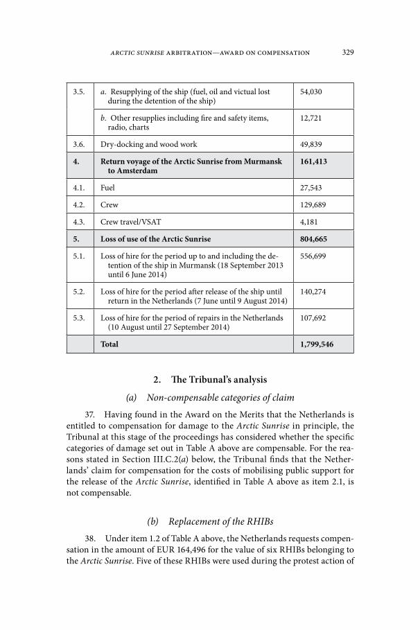
Arctic Sunrise Arbitration—Award on compensation 329
3.5. a. Resupplying of the ship (fuel, oil and victual lost during the detention of the ship)
54,030
b. Other resupplies including fire and safety items, radio, charts
12,721
3.6. Dry-docking and wood work 49,839
4. Return voyage of the Arctic Sunrise from Murmansk to Amsterdam
161,413
4.1. Fuel 27,543
4.2. Crew 129,689
4.3. Crew travel/VSAT 4,181
5. Loss of use of the Arctic Sunrise 804,665
5.1. Loss of hire for the period up to and including the de-tention of the ship in Murmansk (18 September 2013 until 6 June 2014)
556,699
5.2. Loss of hire for the period after release of the ship until return in the Netherlands (7 June until 9 August 2014)
140,274
5.3. Loss of hire for the period of repairs in the Netherlands (10 August until 27 September 2014)
107,692
Total 1,799,546
2. The Tribunal’s analysis
(a) Non-compensable categories of claim
37. Having found in the Award on the Merits that the Netherlands is entitled to compensation for damage to the Arctic Sunrise in principle, the Tribunal at this stage of the proceedings has considered whether the specific categories of damage set out in Table A above are compensable. For the rea-sons stated in Section III.C.2(a) below, the Tribunal finds that the Nether-lands’ claim for compensation for the costs of mobilising public support for the release of the Arctic Sunrise, identified in Table A above as item 2.1, is not compensable.
(b) Replacement of the RHIBs
38. Under item 1.2 of Table A above, the Netherlands requests compen-sation in the amount of EUR 164,496 for the value of six RHIBs belonging to the Arctic Sunrise. Five of these RHIBs were used during the protest action of
330 the Netherlands/the Russian Federation
18 September 2013. All six were seized by the Russian authorities when the vessel was boarded on 19 September 2013. They were returned on 12 May 2015.
39. The Netherlands arrives at the total value of the claim by subtract-ing the residual value of the returned RHIBs (EUR 87,350) from the cost of their replacement incurred by Greenpeace International (EUR 251,846).12 While noting that the net book value of the RHIBs on 17 September 2013 was EUR 25,395.82, as a result of the practice of Greenpeace International of depre-ciating its RHIBs in five years, the Netherlands asserts that RHIBs continue to be used after five years and that, on 17 September 2013, the six RHIBs of the Arctic Sunrise were “fit for use in a protest action.”13 The Netherlands therefore concludes that the cost of replacement of the RHIBs is the “best estimate for the[ir] fair market value.”14
40. The Tribunal asked its maritime surveying expert, Mr. Larsen, to report on whether the amount claimed by the Netherlands for the replace-ment value of the RHIBs was well-founded and reasonable.15 As noted in the procedural history above, Mr. Larsen sought and received clarifications from the Netherlands in the course of the preparation of his report.
41. The key points of Mr. Larsen’s report are as follows. Mr. Larsen agreed with the Netherlands that the book value of the RHIBs would not reflect their fair market value.16 However, he concluded that the amount claimed by the Netherlands was “not fully supported” and therefore not “well founded”.17 Mr. Larsen stated, inter alia, that, given the evidence of earlier damage and repairs, the condition of the RHIBs on 17 September 2013 could not be con-sidered “good” or “fit for use in a protest action.”18 He also noted that there is evidence of damage having been caused to five of the RHIBs during the protest action of 18 September 2013.19 Further, Mr. Larsen opined that the replace-ment cost of the RHIBs should be “based on a like for like basis,” in respect of “age, specification and condition of each RHIB.”20 He observed that, here, two of the RHIBs, each 18 years old, were replaced by new RHIBs, such that the full reimbursement of the replacement cost would create a financial gain for Greenpeace International.21 Regarding the other RHIBs, Mr. Larsen indicat-ed that the Netherlands did not provide him with the requested specification
12 Fourth Supplemental Pleading, pp. 2–3, paras. 6–7.13 Fourth Supplemental Pleading, pp. 1–2, paras. 1, 4–5.14 Fourth Supplemental Pleading, p. 3, para. 7.15 Terms of Reference of Mr. Allan Larsen, para. 4.1.16 Larsen Report, p. 132, lines 1466–1467.17 Larsen Report, p. 134, lines 1537–1538.18 Larsen Report, p. 131, lines 1435–1436.19 Larsen Report, pp. 87–89.20 Larsen Report, p. 134, lines 1517–1518.21 Larsen Report, p. 134, lines 1499–1500, 1506–1507.

Arctic Sunrise Arbitration—Award on compensation 331
details, making it impossible to determine whether they were replaced on a like for like basis.22
42. In its comments on Mr. Larsen’s report,23 the Netherlands submit-ted that he had exceeded the scope of his assignment by commenting on the lawfulness of the events of 18 September 2013 and dismissing certain facts already established in the Award on the Merits. To the extent that Mr. Lars-en’s conclusions were affected by this dismissal of previously established facts, the Netherlands requested the Tribunal not to take these conclusions into account in its decision.
43. Additionally, the Netherlands argued that the criteria employed by Mr. Larsen in respect of the condition and fitness for use of the RHIBs on 17 September 2013 were “too stringent” and “not in line with marine survey-ing practice.” In the view of the Netherlands, the photo and video evidence of the protest action of 18 September 2013 demonstrates that the RHIBs were fit for use. The Netherlands further argued that it would have been appro-priate for the expert to address the likelihood of possible aggravation of the damage to the RHIBs caused during the protest action as a result of the lack of maintenance during their detention. With respect to the replacement cost of the RHIBs, the Netherlands indicated that it “subscribes to the conclusion that replacement should be on a ‘like for like’ basis,” but asked the Tribunal to take into account that, during the period when the RHIBs were held by the Russian authorities, Greenpeace International was “required to replace the RHIBs in a timely manner in order to be able to continue its operations.” Some RHIBs were replaced by new RHIBs due to the unavailability of adequate replacements on the second-hand market. Finally, the Netherlands argued that Mr. Larsen should have provided an estimate of the fair market value of equiv-alent RHIBs and that, in the absence of such estimate, the Tribunal should award the amount as claimed by the Netherlands.
44. Having carefully reviewed the report of Mr. Larsen and the sub-missions of the Netherlands, as well as the supporting documentation, the Tribunal observes, as an initial matter, that whereas in its claim the Nether-lands submitted that the cost of replacement of the RHIBs was EUR 251,846, this figure was later corrected to EUR 246,070 in a letter dated 17 October 2016 from Greenpeace International, which was provided to the expert by the Neth-erlands in response to a clarification request. Although the Netherlands did not formally amend its request for relief, it appears that the correct figure of its claim for the RHIBs is EUR 158,720 (the replacement cost of EUR 246,070 minus the residual value of the returned RHIBs of EUR 87,350).
45. Further, the Tribunal notes that, insofar as Mr. Larsen may have exceeded the scope of his mandate by commenting on certain issues of fault pertaining to the events of 18 September 2013 or on issues already decided in
22 Larsen Report, p. 133, lines 1502–1504.23 Letter from the Netherlands to the Tribunal dated 31 January 2017.

332 the Netherlands/the Russian Federation
the Award on the Merits, the Tribunal has disregarded such comments. In any event, they are not pertinent to the assessment of the quantum of compensa-tion owed by Russia to the Netherlands in respect of the RHIBs.
46. Extraneous comments aside, Mr. Larsen’s report has confirmed the appropriateness of resorting to replacement cost as an indicator for the fair market value of the RHIBs, while also bringing to light an important weakness of the Netherlands’ claim.
47. In his report, Mr. Larsen made the sound observation that the replacement cost of the RHIBs should be assessed on a like for like basis. The Tribunal agrees with Mr. Larsen in this respect and finds, more specifically, that the replacement cost to which the Netherlands is entitled is that of boats of equivalent age, specification, and condition to the RHIBs of the Arctic Sunrise as they were before Russia’s first breach of its obligations under the Conven-tion—that is, as they were before the boarding, seizure, and detention of the Arctic Sunrise on 19 September 2013.24
48. In comparing the replacement RHIBs with the RHIBs of the Arctic Sunrise, Mr. Larsen opined that at least two older RHIBs were replaced by new-er ones, whereas insufficient information was submitted by the Netherlands to assess whether the other RHIBs of the Arctic Sunrise were replaced with equivalent boats. Mr. Larsen further observed that prior to the protest action of 18 September 2013, the RHIBs of the Arctic Sunrise may not have been in perfect condition. Additionally, it is plain from the materials in the record that some damage was caused to the RHIBs during the action of 18 September 2013.25
49. The Netherlands recognized both that replacement should be on a like for like basis and that in the present case some of the replacement RHIBs were newer than the RHIBs of the Arctic Sunrise.26 Regarding the latter point, the Netherlands explained that new RHIBs had to be acquired due to the una-vailability of adequate replacements on the second-hand market.27 While this may be so, in the view of the Tribunal the explanation proffered by the Neth-erlands fails to address the crux of the issue, namely, that the award of the full amount claimed by the Netherlands would create a windfall. If the Tribunal were to make such an award, the Netherlands would receive monetary com-pensation equivalent to the full replacement value of the RHIBs (minus the residual value of the RHIBs of the Arctic Sunrise), while Greenpeace Interna-tional would also keep the replacement RHIBs themselves, which, based on the Netherlands’ own submission,28 no doubt retain a certain residual value after only a few years of use. This result is not acceptable. The Netherlands is
24 Award on the Merits, paras. 333, 401.25 See Award on the Merits, para. 90. See also Larsen Report, pp. 90–92, Table 10, listing
collisions between the RHIBs on 18 September 2013 based on video evidence in the record.26 Letter from the Netherlands to the Tribunal dated 31 January 2017.27 Letter from the Netherlands to the Tribunal dated 31 January 2017.28 For the assertion of the Netherlands that RHIBs continue to be used after five years, see
Fourth Supplemental Pleading, p. 2, para. 5.

Arctic Sunrise Arbitration—Award on compensation 333
entitled to full compensation of the loss directly caused by Russia’s unlawful conduct; it is not, however, entitled to be put in a better position than that in which it would have been absent such unlawful conduct. Accordingly, the Tribunal’s award of damages must reflect the fact that the replacement RHIBs will remain in the possession of Greenpeace International after this Award is rendered.
50. As noted by the Netherlands, Mr. Larsen has not quantified the changes that should be made to the claim submitted by the Netherlands to account for the deficiencies in its methodology. It does not follow, however, contrary to the submission of the Netherlands, that the claim should be grant-ed as made. Mr. Larsen was only asked to opine on whether the claim is reason-able. In contrast, it was for the Netherlands to prove that its claim is reasonable and well founded.
51. In light of the information provided by the Netherlands and the expert’s report, the Tribunal considers that the Netherlands is entitled to com-pensation for the costs arising from the seizure of the RHIBs of the Arctic Sun-rise, but that the amount claimed is disproportionate. In the absence of precise information regarding the residual value of the replacement RHIBs and given the circumstances of the case, the Tribunal finds that it is reasonable to award 50 percent of the amount claimed (as identified in paragraph 44 above).
(c) Categories of claim audited by WEA Accountants
52. In support of the claims identified in Table A above as items 1, 2.1, 2.2, 2.5, 3.1–3.4, 3.5(b), 3.6, and 4.3 (as well as certain other claims addressed in Section III.C.2(c) below), the Netherlands submitted two costs overviews audited by an independent accounting firm, WEA Noord-Holland Account-ants (“WEA Accountants”).29
53. These overviews set forth amounts for broadly identified categories of costs, but did not include an itemized list of costs or supporting documen-tation. Additionally, the categories in the costs overviews were different from those in the Greenpeace Claim Statement (and reproduced in Table A above).
54. In view of the format of the Netherlands’ submission, the Tribu-nal requested its accounting expert, Mr. Potter, to “review the costs overviews prepared by WEA Accountants … and issue a report on whether the amounts claimed are, in the Expert’s opinion, reasonably based.”30 The Tribunal spec-ified that “a reasonable approach would be for the Expert to limit his review to the items with values exceeding EUR 1,000.”31 The Tribunal also requested the Netherlands to provide the expert with “an itemized list and supporting
29 See Greenpeace Claim Statement (Annex N-48), appendices 1 and 2.30 Terms of Reference of Mr. Iain Potter, para. 4.1.31 Letter from the Tribunal to the Parties dated 2 December 2016.
334 the Netherlands/the Russian Federation
documentation for all the amounts claimed in the costs overviews.”32 As noted in the procedural history above, while preparing his report, the expert sought and received further clarifications from the Netherlands.
55. In his report, Mr. Potter first categorized the transactions with values exceeding EUR 1,000 that were listed in the costs overviews prepared by WEA Accountants as “supported”, “unsupported”, and “uncertain”, based on the documentation made available to him.33 He then determined what percentage of transactions set forth in each costs overview was supported, unsupported, or uncertain,34 and applied these percentages to transactions with values below EUR 1,000.35 In the first of the two costs overviews, Mr. Potter also identified a number of transactions involving expense claims for which he was unable to reconcile the amounts shown on the itemised list submitted by the Netherlands and the supporting documentation. Noting that it “would likely be time-con-suming to investigate these individually and seek Greenpeace’s assistance with reconciling each one,” Mr. Potter assumed that “these transactions [were] likely to be supported to the same extent as the others which [he had] reviewed” and applied the percentages of supported, uncertain, and unsupported transactions in the same manner as for transactions with values below EUR 1,000.36 Having done so, Mr. Potter arrived at total figures for transactions that he considered (i) supported and hence reasonably based; (ii) unsupported and therefore not reasonably based; and (iii) uncertain, in the sense that he could not formulate an opinion on them without additional information from the Netherlands.37 Overall, expressed in percentage, Mr. Potter’s conclusion was that 94.5 percent of the costs claimed on the basis of the overviews prepared by WEA Account-ants were supported and therefore reasonably based.38
56. In its comments on Mr. Potter’s report,39 the Netherlands sought to justify some of the transactions that he had designated as “uncertain”, for a total value of EUR 94,563.92. Specifically, the Netherlands submitted that the VAT charges questioned by Mr. Potter represent a “genuine unrecoverable cost” for Greenpeace International because it is registered in the Netherlands as a charitable organization and is not entitled to reimbursement of VAT or reverse charges. In respect of amounts claimed for hotel accommodation that were supported only by template invoices, the Netherlands explained that “due to the circumstances at the time no individual invoices could be collected,” such that the costs “were collected in advance and approved by the Deputy
32 Terms of Reference of Mr. Iain Potter, para. 4.2.33 Potter Report, Sections 3 and 4.34 Mr. Potter determined that 94 and 95 percent of transactions were supported in the first
and second costs overviews, respectively. Potter Report, paras. 3.35, 3.36, 4.8.35 Potter Report, paras. 3.36, 4.8.36 Potter Report, paras. 3.34, 3.35.37 Potter Report, para. 6.6.38 See Potter Report, para. 6.5.39 Letter from the Netherlands to the Tribunal dated 17 February 2017.

Arctic Sunrise Arbitration—Award on compensation 335
Programme Director of Greenpeace.” In support, the Netherlands submitted a copy of an e-mail containing this approval. Finally, the Netherlands drew the attention of the Tribunal to two invoices in the record supporting another transaction identified as uncertain by Mr. Potter.
57. Having carefully reviewed Mr. Potter’s report, the Tribunal is satis-fied that it may be used as a basis for the Tribunal’s determination regarding the categories of costs supported by the overviews of WEA Accountants. The expert fulfilled his mandate of verifying the costs overviews, in the process clearly describing his methodology, as well as any areas of doubt arising from the lack of supporting documentation. In his approach to transactions with values below EUR 1,000 and unreconciled expense claims, he struck a rea-sonable balance taking account of his mandate to verify the claims and the time and cost involved in such verification. Accordingly, the Tribunal accepts Mr. Potter’s methodology. The Tribunal also notes that the Netherlands did not object to or make any comment on Mr. Potter’s methodology.
58. At the same time, the Tribunal is unable to directly adopt the specif-ic percentage of supported claims arrived at by Mr. Potter, because the Neth-erlands has provided additional explanations and supporting documentation since the filing of his report. On the basis of these additional explanations and documents, the Tribunal concludes that transactions in the total amount of EUR 94,563.92 should be moved from the expert’s “uncertain” category to his “supported” category.
59. Having thus re-categorized certain transactions and applying Mr. Potter’s methodology, the Tribunal has recalculated the percentage of sup-ported transactions with values exceeding EUR 1,000, arriving at the figures of 98.3 and 99.7 percent in the first and second costs overviews prepared by WEA Accountants, respectively.40 Once these percentages are applied to trans-actions with values below EUR 1,000 as well as to unreconciled expense claims, it emerges that, overall, 98.6 percent of the costs claimed by the Netherlands on the basis of the costs overviews prepared by WEA Accountants are supported.41
60. Accordingly, the Tribunal will apply this percentage (98.6) to each category of claim supported by the costs overviews that it considers compen-sable in principle, in order to obtain the amount of compensation to which the Netherlands is entitled.
61. Of the categories of claim set out in Table A that are supported by the costs overviews, the Tribunal considers that items 1.1, 1.3–1.4, 2.2, 2.5, 3.1–3.4, 3.5(b), 3.6, and 4.3 are in principle compensable as elements of damage to the Arctic Sunrise. As stated in paragraphs 37 and 51 above, the Tribunal considers that the claim under item 2.1 of Table A is not compensable and that only 50 percent of the claim identified under item 1.2 is compensable.
40 For the basis of this calculation, see Potter Report, paras. 3.35 and 4.8.41 For the basis of this calculation, see Potter Report, paras. 3.35, 3.36, 4.8, 6.3, 6.4, and 6.5.

336 the Netherlands/the Russian Federation
62. The total amount of the compensable items is therefore EUR 428.301,42 which, multiplied by 98.6 percent, yields EUR 422,304.79 as the amount of compensation owed by Russia to the Netherlands for the part of the damage to the Arctic Sunrise that is claimed on the basis of the costs overviews prepared by WEA Accountants (items 1, 2.1, 2.2, 2.5, 3.1–3.4, 3.5(b), 3.6, and 4.3 of Table A above).
(d) Other categories of claim
63. In support of the remaining claims, identified in Table A above as items 2.3, 2.4, 3.5(a), 4.1, 4.2, and 5, the Netherlands submitted detailed sup-porting documentation.
64. With respect to item 4, the Tribunal asked the Netherlands to explain whether there is a difference between the amount claimed as the cost of the return voyage of the Arctic Sunrise from Murmansk to Amsterdam and the costs that would have been incurred for the return voyage of the Arctic Sunrise from the Prirazlomnaya to Amsterdam had the vessel not been board-ed and detained by the Russian authorities.43 The Netherlands replied that “a difference is made between a regular onward or return voyage of the Arctic Sunrise, and th[is] particular return voyage.”44 According to the Netherlands, a Greenpeace ship manager will seek to ensure that each voyage serves a busi-ness purpose and the return costs incurred during a voyage serving a business purpose will be attributed to that particular purpose. However, in the present case, “due to the damages inflicted to the Arctic Sunrise during boarding and detention, it was unfit for any normal business activity and the entire voy-age was undertaken solely for the purpose of a return to dock for repairs.”45 Accordingly, “[t]he costs of the return voyage could … not be attributed, or partly attributed, to another business purpose.”46
65. With respect to item 5, in response to a question from the Tribu-nal,47 the Netherlands explained that it should be compensated for the loss of hire of the Arctic Sunrise for the period following its return to Amsterdam on 9 August 2014, because at the time the vessel was “not fit for service” and had to remain at the dock for repairs until 27 September 2014.48
42 EUR 26,889 (item 1.1) + (0.5 * EUR 158,720 (item 1.2, as corrected in para. 44 above)) + EUR 2,386 (item 1.3) + EUR 75,266 (item 1.4) + EUR 96,558 (item 2.2) + EUR 338 (item 2.5) + EUR 17,589 (item 3.1) + EUR 32,215 (item 3.2) + EUR 12,097 (item 3.3) + EUR 18,862 (item 3.4) + EUR 12,721 (items 3.5(b)) + EUR 49,839 (item 3.6) + EUR 4,181 (item 4.3).
43 Tribunal’s Questions, Question 3.44 Fourth Supplemental Pleading, p. 4, para. 1.45 Fourth Supplemental Pleading, p. 4, para. 2.46 Fourth Supplemental Pleading, p. 4, para. 2.47 Tribunal’s Questions, Question 5.48 Fourth Supplemental Pleading, p. 5. See also p. 10.

Arctic Sunrise Arbitration—Award on compensation 337
66. On the basis of these explanations and having carefully reviewed the supporting documentation, the Tribunal finds that the categories of claims identified in Table A above as items 2.3, 2.4, 3.5(a), 4.1, 4.2, and 5 are compen-sable in principle.
67. At the same time, the Tribunal’s review of the documentation shows that small adjustments must be made to the amounts claimed. With respect to the amounts claimed under items 2.4 and 5.1, the Netherlands calculated costs arising from crew salaries and the loss of hire of the Arctic Sunrise start-ing from 18 September 2013.49 However, in the view of the Tribunal, the only costs that may be compensated are those incurred after Russia first breached the Convention by boarding, seizing, and detaining the Arctic Sunrise, start-ing from 19 September 2013. Accordingly, the amount claimed under item 2.4 must be reduced by EUR 2,071.9550 and the amount claimed under item 5.1, by EUR 2,024.66.51 A further downward adjustment of EUR 295 must be made to item 5.3 to correct for a minor mathematical error.52
68. Having made the adjustments described in the preceding paragraph, the Tribunal concludes that the amount of compensation owed by Russia to the Netherlands for the part of the damage to the Arctic Sunrise claimed under items 2.3, 2.4, 3.5(a), 4.1, 4.2, and 5 of Table A above is EUR 1,272,821.39.53
(e) Conclusion69. In light of the conclusions set out at paragraphs 62 and 68 above, the
Tribunal finds that Russia owes the Netherlands EUR 1,695,126.18 in compen-sation for damage to the Arctic Sunrise.
B. Non-Material Damage to the Arctic 301. The Netherlands’ claim
70. In its Award on the Merits, the Tribunal found that the Netherlands is entitled to compensation for “non-material damage to the Arctic 30 for their wrongful arrest, prosecution, and detention in the Russian Federation.”54
49 Greenpeace Claim Statement (Annex N-48), Appendix 6.1; Fourth Supplemental Plead-ing, p. 9.
50 For the basis of this calculation, see Greenpeace Claim Statement (Annex N-48), Appen-dix 6.1, p. 2.
51 For the basis of this calculation, see Fourth Supplemental Pleading, p. 9.52 In calculating the loss of hire of the Arctic Sunrise for the period from 10 August
until 27 September 2014, the Netherlands carries out the following calculation: 49 days * EUR 800,000/365 days. It arrives at a total of EUR 107,692, instead of EUR 107,397. Fourth Sup-plemental Pleading, p. 10.
53 EUR 62,723 (item 2.3) + (EUR 198,563 – EUR 2,071.95) (item 2.4) + EUR 54,030 (item 3.5(a)) + EUR 27,543 (item 4.1) + EUR 129,689 (item 4.2) + (EUR 804,665 – EUR 2,024.66 – EUR 295) (item 5).
54 Award on the Merits, para. 401(F)(2).

338 the Netherlands/the Russian Federation
71. In respect of this head of damages, the Netherlands requests com-pensation at a rate of EUR 1,000 per person per day of detention. Submit-ting that the Arctic 30 were wrongfully detained for a combined period of 1719 days, it claims compensation in a total amount of EUR 1,719,000.55
72. Without explicitly stating so, the Netherlands appears to calculate the duration of detention from the various dates on which the Arctic 30 were remanded into custody by court order (26, 27, or 29 September 2013) to the dates of their release on bail (between 20 November and 2 December 2013).56
2. The Tribunal’s analysis73. With respect to the award of non-material damages, the Netherlands
refers the Tribunal to two cases, namely the ITLOS judgment in M/V “SAIGA” (No. 2) and the decision of the International Court of Justice (“ICJ”) in Ahmadou Sadio Diallo.57 Specifically, the Netherlands submits that its claim for non-mate-rial damages in the amount of EUR 1,000 per person per day of wrongful deten-tion is “comparable” to the daily sum of USD 1,180 granted in the Diallo case.58
74. The Tribunal is mindful of Judge Greenwood’s comments in his Dec-laration in the Diallo case. In that case, Judge Greenwood noted that a tribunal seized of the task of assessing non-material damages ought not merely select an arbitrary figure but apply principles that are “capable of being applied in a consistent and coherent manner, so that the amount awarded can be regarded as just, not merely by reference to the facts of [the] case, but by comparison with other cases.”59 This Tribunal also considers it proper to compare the facts of the present case with the cases cited by the Netherlands and other relevant cases where non-material damages have been awarded for injuries of a similar nature.
75. Taking the Diallo case as a starting point, the Tribunal observes that the ICJ awarded USD 85,000 to Mr. Diallo as compensation for non-material damages. The Netherlands arrives at the sum of USD 1,180 per day as its com-parator by dividing the total amount of compensation awarded to Mr. Diallo for non-material damages (i.e., USD 85,000) by the number of days Mr. Diallo was held in detention (i.e., 72). However, such a calculation ignores an impor-tant element of the Diallo case. In arriving at the sum awarded for non-mate-rial damages, the ICJ not only took the length of Mr. Diallo’s detention into
55 Updated Pleading, para. 7; Supplementary Submission, para. 51, referring to Greenpeace International Statement of Facts, Appendix 29.
56 See Greenpeace International Statement of Facts, Appendix 29; Award on the Merits, paras. 109, 126, 128.
57 Supplementary Submission, para. 51, referring to M/V “SAIGA” (No. 2) (Saint Vincent and the Grenadines v. Guinea), Judgment of 1 July 1999, ITLOS Reports 1999, p. 10; Ahmadou Sadio Diallo (Republic of Guinea v. Democratic Republic of the Congo), Compensation, Judgment of 19 June 2012, ICJ Reports 2012, p. 324.
58 Supplementary Submission, para. 51.59 Ahmadou Sadio Diallo (Republic of Guinea v. Democratic Republic of the Congo), Com-
pensation, Declaration of Judge Greenwood, ICJ Reports 2012, p. 391, para. 7.

Arctic Sunrise Arbitration—Award on compensation 339
account, but also considered the significant psychological suffering and loss of reputation caused by the Congo’s wrongful conduct, as well as the fact that following his detention Mr. Diallo was expelled from the Congo despite having lived there for over 30 years.60
76. In this respect, the circumstances of the Diallo case are more extreme than the circumstances in the present case where the members of the Arctic 30 were detained for approximately two months each but later released and granted amnesty by the Russian authorities. Those members of the Arc-tic 30 possessing Russian nationality were not expelled from Russia. There is also no suggestion that they suffered a loss of reputation. At most, the Arctic 30 can be said to have been held in conditions that were, to use the words of one of their Russian lawyers who observed the situation first-hand, “not optimal”.61 In this respect the Tribunal accepts the witness testimony that the Arctic 30 were:
generally confined to cold and unsanitary cells for 23 hours per day, the remaining hour consisting of solitary exercise in a small concrete box. Most [were] unable to speak to their families. Requests for telephone calls [were] not granted until several weeks later. The members of the [Arctic 30 were] held separately from one another; some [were] alone, others share[d] their cell with Russian inmates, but communication [was] often difficult due to lack of a common language.62
77. Taking these circumstances into account, the Tribunal considers the injury suffered by Mr. Diallo to be of a higher order than the injury suf-fered by the members of the Arctic 30. Accordingly, the Tribunal considers the compensation awarded in the Diallo case as an upper limit, rather than a direct comparator, on the compensation to be awarded in this case. In fact, Judge Greenwood in his Declaration noted that even the Diallo case:
is very far from being one of the gravest cases of human rights viola-tions. If US$85,000 is an appropriate sum to compensate for Mr. Diallo’s moral damage, the sum which is required in a case where, for example, a person has been tortured or forced to witness the murder of family members would have to be several magnitudes higher.63
78. The Tribunal does note, however, that the non-Russian nationals among the Arctic 30 were not granted exit visas until the end of December 2013, thereby preventing them from leaving Russia for an additional month following their release from prison.64 The Tribunal recalls its earlier finding that through
60 Ahmadou Sadio Diallo (Republic of Guinea v. Democratic Republic of the Congo), Com-pensation, Judgment of 19 June 2012, ICJ Reports 2012, p. 324, para. 21.
61 Hearing Tr., 10 February 2015 at 66 (examination of Mr. Andrey Suchkov).62 Greenpeace International Statement of Facts, para. 76, as confirmed by the witness state-
ments of Mr. Peter Henry Wilcox, Mr. Dimitri Litvinov, Mr. Frank Hewetson, Mr. Philip Edward Ball, Ms. Sini Annuka Saarela, and Mr. Andrey Suchkov.
63 Ahmadou Sadio Diallo (Republic of Guinea v. Democratic Republic of the Congo), Com-pensation, Declaration of Judge Greenwood, ICJ Reports 2012, p. 391, para. 11.
64 See Greenpeace International Statement of Facts, Appendix 29; Award on the Merits, paras. 132–133.

340 the Netherlands/the Russian Federation
this delay Russia breached the part of the ITLOS Order requiring it to promptly “ensure that … all persons who have been detained are allowed to leave the territory and maritime areas under the jurisdiction of the Russian Federation” following the posting of a bank guarantee by the Netherlands on 2 December 2013.65 The Tribunal considers the impairment of the Arctic 30’s ability to leave Russian territory in violation of the ITLOS Order to be an aggravating factor in determining Russia’s liability for non-material damages in this case.
79. In the second case to which the Netherlands refers, M/V “SAIGA” (No. 2), Guinea detained the vessel SAIGA, its master, 21 members of crew, and three painters who were on board the vessel. The master of the vessel was detained for approximately 123 days while the other members of crew and the painters were detained for different periods ranging from 20 to 123 days.66 ITLOS awarded USD 17,750 for the detention of the master (equating to USD 144 per day) and USD 76,000 for the entire period of detention of the crew and painters.67 The Tribunal observes that no reasons were given for the basis on which the amount awarded was calculated and that the outcome is different from that of the Diallo case.
80. In addition to the cases cited by the Netherlands, the Tribunal has considered other jurisprudence, including, in particular, decisions of the Euro-pean Court of Human Rights (“ECtHR”) dealing with non-material damage for wrongful detention in the Russian Federation. In these cases also, the sums awarded vary significantly.
81. For example, in Frumkin v. Russia, a case dealing with the arbitrary arrest and detention of the applicant in Russia for approximately 16.5 days following the dispersal of a political rally, the ECtHR awarded the applicant EUR 25,000 (or EUR 1,515 per day of detention).68 By comparison, in Chukayev v. Russia, the applicant was detained for approximately 498 days in what the ECtHR considered to be inhumane and degrading conditions on remand and was only awarded EUR 9,800 (or EUR 20 per day of detention).69
82. The different outcomes reached by the ICJ, ITLOS, and the ECtHR suggest that there is no identifiable consistent practice among international courts and tribunals in respect of the calculation of the award of non-material damages for wrongful detention, certainly not one that could be mechanically applied to any given case.
83. Nevertheless, as noted by the umpire in the Lusitania cases before the Mixed Claims Commission (United States/Germany), non-material injuries “are
65 Award on the Merits, paras. 349–350.66 M/V “SAIGA” (No. 2) (Saint Vincent and the Grenadines v. Guinea), Judgment of 1 July
1999, ITLOS Reports 1999, p. 10, para. 33.67 M/V “SAIGA” (No. 2) (Saint Vincent and the Grenadines v. Guinea), Judgment of 1 July
1999, ITLOS Reports 1999, p. 10, Annex.68 Frumkin v. Russia (Application No. 74568/12), ECtHR, Judgment of 5 January 2016.69 Chukayev v. Russia (Application No. 36814/06), ECtHR, Judgment of 5 November 2015,
para. 145.

Arctic Sunrise Arbitration—Award on compensation 341
very real, and the mere fact that they are difficult to measure or estimate by mon-ey standards makes them none the less real and affords no reason why the injured person should not be compensated therefore as compensatory damages.”70
84. Having said that, one consistent characteristic of the cases referred to above is that none of the ICJ, ITLOS or ECtHR decided to award non-ma-terial damages on the basis of a per diem calculation for days in detention. Rather, it was deemed appropriate in each of those cases to award a lump sum having taken into account all the circumstances of the case. For example, the Tribunal in M/V SAIGA (No. 2) awarded a single lump sum for the detention of the entire crew and painters whose individual lengths of detention varied from 20 to 123 days.71 This Tribunal does not propose to deviate from the practice of awarding a lump sum, rather than a per diem amount, in its award of compensation for non-material damages.
85. Having previously determined that the circumstances of the present case entitle the Netherlands to the award of non-material damages in relation to the arrest, detention, and prosecution of those on board the Arctic Sunrise, and bearing in mind the facts of this case, including the aggravating factor of Russia’s non-compliance with the ITLOS Order, the Tribunal finds that an award of non-material damages in a total amount of EUR 600,000 is appro-priate in this case.
86. Finally, the Tribunal notes that while the Arctic 30 have filed indi-vidual applications in the ECtHR, asking for a finding that their apprehension and detention by the Russian authorities constitutes a violation of their rights under Articles 5 and 10 of the European Convention on Human Rights and Fundamental Freedoms,72 the Netherlands has informed the Tribunal that those applications remain pending.73 The Tribunal need therefore not consider the possibility of double compensation.
C. Damage Resulting from the Measures Taken by Russia against the Arctic 30
1. The Netherlands’ claim87. In its Award on the Merits, the Tribunal found that the Netherlands
is entitled to compensation for “damage resulting from the measures taken by the Russian Federation against the Arctic 30, including the costs of bail paid as security for their release from custody, expenses incurred during their deten-tion in the Russian Federation, and costs in respect of the persons detained
70 Opinion in the Lusitania cases, 1 November 1923, United Nations, Reports of Interna-tional Arbitral Awards Vol. VII, p. 32, at p. 40.
71 M/V “SAIGA” (No. 2) (Saint Vincent and the Grenadines v. Guinea), Judgment of 1 July 1999, ITLOS Reports 1999, p. 10, para. 33.
72 Award on the Merits, para. 134.73 Fourth Supplemental Pleading, p. 12.

342 the Netherlands/the Russian Federation
between their release from prison and their departure from the Russian Fed-eration.”74 The Tribunal also ordered Russia to compensate the Netherlands for the value of all objects belonging to the Arctic 30 that were not returned to the Netherlands by 14 October 2015.75
88. The Netherlands submits that the compensation to which it is enti-tled under this head of damages amounts to a total of EUR 3,998,881,76 com-posed of the following items: 77
Table B
# Category Amount claimed(in EUR)
1. Restitution of personal belongings 5,605 plus lump sum
1.1. Shipping and handling of returned personal items
5,605
1.2. Value of personal items not returned lump sum to be deter-mined by the Tribu-nal at its discretion78
2. Costs of obtaining Russian bail (legal costs; exchange costs)
81,312
3. Costs incurred during the wrongful deten-tion of the Arctic 30
3,365,414
3.1. Salary costs related to emergency response team; relevant share (85%); rest under item 2.4 in Table A above
1,125,191
3.2. Emergency response support: supply of goods and services, including support to detainees
2,240,223
3.2.1. Emergency response support 891,988
74 Award on the Merits, para. 401(F)(3). Reproduced in full at paragraph 7 above.75 Award on the Merits, para. 401(H). Reproduced in full at paragraph 7 above.76 The Netherlands last updated the total amount claimed under this head of damages in its
Updated Pleading (para. 8), in which the total was stated as EUR 4,003,722. However, the amount of one of the items composing this total was revised in the Netherlands’ Fourth Supplemental Pleading (p. 8, para. 1). When this revision is taken into account, the total amount claimed becomes EUR 3,998,881.
77 Updated Pleading, para. 8; Greenpeace Claim Statement (Annex N-48); Fourth Supple-mental Pleading, pp. 6, 8.
78 Fourth Supplemental Pleading, p. 6.

Arctic Sunrise Arbitration—Award on compensation 343
a. Emergency response global 240,547
b. Emergency response support in Murmansk 196,464
c. Support to detainees as necessary in Russia—Murmansk
85,351
d. Mobilisation of public support across the world in countries with Greenpeace pres-ence for the release of the Arctic 30
369,626
3.2.2. Legal costs related to arrest and detention of the Arctic 30
690,916
3.2.3. Costs incurred for Arctic 30 support: contact with, and visit by, next of kin
133,086479
3.2.4. Salary costs having become due during detention
524,233580
4. Costs incurred between the release from prison of the Arctic 30 and their depar-ture from the Russian Federation
EUR 546,550
4.1. Emergency response support in St. Petersburg 196,464
4.2. Support to detainees as necessary in Russia—St. Petersburg
85,351
4.3. Costs of the support team set up to aid Arctic 30 upon release from prison
264,735
Total 3,998,881
2. The Tribunal’s analysis
(a) Non-compensable categories of claim89. Having found in the Award on the Merits that the Netherlands is
entitled to compensation for damage resulting from the measures taken by Russia against the Arctic 30 in principle, the Tribunal at this stage of the pro-ceedings has considered whether the specific categories of damage set out in Table B above are compensable. For the reasons set out below, the Tribunal finds that the categories of damages identified as items 3.2.1(a) and 3.2.1(d) in
79 This item is stated as EUR 133,277 in the Greenpeace Claim Statement (Annex N-48). In its Fourth Supplemental Pleading (p. 6), the Netherlands explains than EUR 191 should be subtracted from this amount.
80 This item, stated as EUR 529,075 in the Greenpeace Claim Statement (Annex N-48), is amended to EUR 524,233 in the Fourth Supplemental Pleading (p. 8, para. 1).

344 the Netherlands/the Russian Federation
Table B above are not compensable and that only 31.6 percent of the amount claimed under item 3.1 is compensable.
90. The Tribunal recalls that only direct damages may be compensated. Thus, Article 31 of the Articles on Responsibility of States for Internationally Wrongful Acts (“Articles on State Responsibility”)81 of the International Law Commission of the United Nations (“ILC”) provides:
1. The responsible State is under an obligation to make full reparation for the injury caused by the internationally wrongful act.2. Injury includes any damage, whether material or moral, caused by the internationally wrongful act of a State.
91. The ILC commentary to the Articles on State Responsibility further explains that Article 31(2) is “used to make clear that the subject matter of reparation is, globally, the injury resulting from and ascribable to the wrong-ful act, rather than any and all consequences flowing from an internationally wrongful act.”82
92. With respect to items 3.1 and 3.2.1 in Table B above, the Tribunal asked the Netherlands to explain precisely what these costs consist of and why it should be compensated for these costs.83 The Netherlands explained that the costs claimed under item 3.1 consist of the “salary costs of the persons who were diverted from their ordinary functions, in order to work on secur-ing the release of the Arctic Sunrise and the Arctic 30, and on supporting the Arctic 30 whilst they were released on bail,”84 including: (i) a core team tasked with coordinating the support effort; (ii) a team prepared to offer psycholog-ical and practical assistance to the Artic 30 and their next of kin upon the release of the Arctic 30 from detention; (iii) a ground support team tasked with making deliveries of necessary items to the Arctic 30 during their detention, liaising with consular staff, attending and reporting back on court hearings, and providing logistical support to the Arctic 30 and their next of kin after the release of the Arctic 30; (iv) a legal team working to secure the release of the Arctic 30 and update their next of kin; and (v) a team assigned to “reaching out to general audiences, politicians, celebrities and other influencers, embassies and the press in order to protest the detention and push for the release of the Arctic 30.”85 According to the Netherlands, this response team was constituted pursuant to “a duty of care [of the ship manager] to take all reasonable steps within its power to support the Arctic 30,” arising from the “Security Princi-
81 “Draft Articles on Responsibility of States for Internationally Wrongful Acts,” ILC Year-book 2001, vol. II(2).
82 “Draft Articles on Responsibility of States for Internationally Wrongful Acts,” ILC Year-book 2001, vol. II(2), art. 31, para. 9.
83 Tribunal’s Questions, Question 13.84 Fourth Supplemental Pleading, p. 10.85 Fourth Supplemental Pleading, pp. 10–11.
Arctic Sunrise Arbitration—Award on compensation 345
ples” adopted by Greenpeace International.86 While the Netherlands did not expressly state so, it appears that item 3.2.1 represents the expenses incurred by the staff whose salary is claimed under item 3.1.
93. Having carefully considered the explanation of the Netherlands, the Tribunal is of the view that a distinction must be drawn between the cost of steps taken by Greenpeace International that were immediately connected to the detention of the Arctic 30, such as the expenses incurred for the emergency support to the Arctic 30 in Murmansk (items 3.2.1(b) and 3.2.1(c) in Table B) and the cost of more remote steps such as global emergency support and the “mobilization of public support across the world in countries with Greenpeace presence for the release of the Arctic 30” (items 3.2.1(a) and 3.2.1(d) in Table B). Nothing in the Respondent’s actions forced Greenpeace International to mobi-lise the significant resources involved in the latter two categories of damages. Accordingly, the Tribunal finds that the latter two categories are too remote to be compensated.
94. Similarly, in light of the explanation provided by the Netherlands, it appears that item 3.1 of Table B above covers both salary costs that arose direct-ly from the Respondent’s wrongful conduct (such as the costs of the ground support team tasked with making deliveries of necessary items to the Arctic 30 during their detention) and salary costs that are too remote to be compensable (such as the costs of the team assigned to “reaching out to general audiences, politicians, celebrities and other influencers, embassies and the press in order to protest the detention and push for the release of the Arctic 30”87). As the Netherlands has not provided a specific breakdown identifying which salary costs correspond to which tasks carried out by the staff of Greenpeace Inter-national, and in view of the close connection between items 3.1 and 3.2.1, the Tribunal considers that it would be reasonable to award compensation for costs claimed under item 3.1 in the same proportion as for item 3.2.1. As the com-pensable parts of item 3.2.1 (items 3.2.1(b) and 3.2.1(c)) constitute 31.6 percent of item 3.2.1, the Tribunal finds that 31.6 percent of item 3.1 is compensable. Additionally, for the reasons explained in paragraph 67 above, a downward adjustment of EUR 11,741 must be made to item 3.1 to exclude salary costs for the period preceding 19 September 2013.88 On this basis, the Tribunal finds that an amount of EUR 351,850.2089 is owed by Russia to the Netherlands under item 3.1 of Table B above.
95. The Tribunal further finds that the costs claimed under item 3.2.3 of Table B above (costs incurred for the Arctic 30 support—contact with, and visit by, next of kin) are not compensable. The Tribunal considers that in incur-
86 Fourth Supplemental Pleading, p. 11, referring to Annex N-50, Appendix 11, “SGC Security Principles of 2005”, para. 3.
87 Fourth Supplemental Pleading, p. 11.88 This calculation is carried out on the basis of the spreadsheet in the Greenpeace Claim
Statement (Annex N-48), Appendix 6.1.89 (1,125,191—11,741) * 0.316.
346 the Netherlands/the Russian Federation
ring these costs Greenpeace International went above and beyond the ordinary level of support an organization may be expected to provide to its employees in similar circumstances, notwithstanding the fact that its commendable reac-tion may have been required under its policies.
(b) Request for a lump sum in compensation for personal objects96. Under item 1.2 of Table B above, the Netherlands requests the Tribu-
nal to award a lump sum to be determined by the Tribunal at its discretion for each member of the Arctic 30 individually in compensation for personal objects seized from the Arctic Sunrise that have not been returned to the Netherlands.
97. In support of this request, the Netherlands provides a list of the objects that were not returned, enumerating items such as phones, laptops, cameras, wires, clothes, cash, and documents.90 The Netherlands explains that “[s]ome of these objects are difficult to replace because of the emotional value they represent and for other objects it is difficult to calculate the appropriate amount of compensation.”91
98. While the Netherlands has not submitted any supporting docu-mentation that would allow the Tribunal to specifically assess the value of individual personal objects, the Tribunal does not doubt that the Arctic 30 had personal belongings with them as they embarked on their voyage on the Arctic Sunrise and that the Respondent’s unlawful conduct caused material injury to the Arctic 30 with respect to their belongings. In such a situation, and in line with the approach adopted by other international courts and tribunals,92 the Tribunal considers it appropriate to award an amount of compensation on an equitable basis.
99. Therefore, in view of the circumstances of the case and upon analy-sis of the list of objects provided by the Netherlands, the Tribunal awards the sum of EUR 5,000 under this head of damages, to be allocated by the Nether-lands among the Arctic 30.93
(c) Categories of claim audited by WEA Accountants100. The claims identified in Table B above as items 1.1, 2, 3.2.1–3.2.3, and
4 were supported by the two costs overviews prepared by WEA Accountants.
90 Greenpeace Claim Statement (Annex N-48), Appendix 10.91 Fourth Supplemental Pleading, p. 5.92 Ahmadou Sadio Diallo (Republic of Guinea v. Democratic Republic of the Congo), Com-
pensation, Judgment, ICJ Reports 2012, p. 324, paras. 32–36; Lupsa v. Romania, ECtHR, Judg-ment of 8 June 2006, paras. 70–72; Chaparro Alvarez and Lapo Iñiguez v. Ecuador, Judgment of 21 November 2007 (Preliminary Objections, Merits, Reparations, and Costs), Inter-American Commission on Human Rights, Series C, No. 170, paras. 240–242.
93 The Tribunal notes that in its assessment of this amount it has disregarded items indicat-ed as belonging to Greenpeace International on the list provided by the Netherlands.
Arctic Sunrise Arbitration—Award on compensation 347
101. As noted at paragraphs 57–60 above, having carefully reviewed the report of its accounting expert, Mr. Potter, and the submissions of the Neth-erlands, the Tribunal determined that 98.6 percent of the costs claimed by the Netherlands on the basis of the costs overviews prepared by WEA Accountants are supported. The Tribunal further stated that it would apply this percentage to each category of claim supported by the costs overviews that it considers compensable in principle, in order to obtain the amount of compensation to which the Netherlands is entitled.
102. Of the categories of claim set out in Table B that are supported by the costs overviews, the Tribunal considers that items 1.1, 2, 3.2.1(b), 3.2.1(c), 3.2.2, and 4 are compensable in principle as elements of damage resulting from the measures taken by Russia against the Arctic 30. As stated in paragraphs 93 and 95 above, the Tribunal considers that the claims under items 3.2.1(a), 3.2.1(d), and 3.2.3 of Table B are not compensable.
103. The total amount of the compensable items is therefore EUR 1,606,198,94 which, multiplied by 98.6 percent, yields EUR 1,583,711.23 as the amount of compensation owed by Russia to the Netherlands for the part of the damage resulting from the measures taken by Russia against the Arctic 30 that is claimed on the basis of the costs overviews prepared by WEA Accountants.
(d) Other categories of claim104. In support of the remaining claim identified in Table B above as
item 3.2.4 (salary costs of Arctic 30 having become due during their detention), the Netherlands submitted supporting documentation, which was carefully reviewed by the Tribunal.
105. In the view of the Tribunal, this category of claim is compensa-ble in principle. However, as with certain categories of claim discussed in paragraph 67 above, a downward adjustment of EUR 2,859 must be made to exclude salary costs for the period preceding 19 September 2013.95
106. Having made this adjustment, the Tribunal concludes that the amount of compensation owed by Russia to the Netherlands for the part of the damage resulting from the measures taken by Russia against the Arctic 30 claimed under item 3.2.4 of Table B is EUR 521,374.
(e) Conclusion107. In light of the conclusions set out at paragraphs 94, 99, 103 and 106
above, the Tribunal finds that Russia owes the Netherlands EUR 2,461,935.43
94 EUR 5,605 (item 1.1) + EUR 81,312 (item 2) + EUR 196,464 (item 3.2.1(b)) + EUR 85,351 (item 3.2.1(c)) + EUR 690,916 (item 3.2.2) + EUR 546,550 (item 4).
95 This calculation is carried out on the basis of the spreadsheet in the Greenpeace Claim Statement (Annex N-48), Appendix 6.1, p. 2.

348 the Netherlands/the Russian Federation
in compensation for damage resulting from the measures taken by Russia against the Arctic 30.
D. Costs Incurred for the Issuance of a Bank Guarantee108. In its Award on the Merits, the Tribunal found that the Nether-
lands is entitled to compensation for “the costs incurred by the Netherlands for the issuance of the bank guarantee to the Russian Federation pursuant to the ITLOS Order.”96
109. Under this head of damages, the Netherlands requests compensa-tion in the amount of EUR 13,500, corresponding to the commission charged by the Royal Bank of Scotland for the issuance of the bank guarantee.97 In support, the Netherlands submits proof of the relevant bank transfer.98
110. In view of its previous findings in the Award on the Merits and the filing of supporting documentation by the Netherlands, the Tribunal finds that the Respondent owes the Netherlands compensation under this head of damages in the requested amount of EUR 13,500.
IV. Deposits for the Costs of Arbitration111. In the Award on the Merits, having decided that the expenses of
the Tribunal should be borne by the Parties in equal shares, the Tribunal ordered the Russian Federation “immediately to reimburse the Netherlands the amounts of Russia’s share of the deposits paid by the Netherlands.”99 When the Award on the Merits was issued, the total amount of Russia’s share of the deposits paid by the Netherlands was EUR 475,000.
112. Since then, the Netherlands has paid a further amount of EUR 150,000 in substitution for Russia’s share of a supplementary deposit requested by the Tribunal. For the avoidance of doubt, the Tribunal hereby confirms that the Russian Federation is under an obligation to reimburse the Netherlands the amounts of its share of all deposits paid by the Netherlands as at the date of issuance of this Award, minus half of any amount returned by the Registry to the Netherlands after the Award’s issuance.
113. The deposit has covered the fees and expenses of members of the Tribunal, Registry, and experts appointed to assist the Tribunal, as well as all other expenses, including for hearings and meetings, information technology support, catering, court reporters, deposit administration, archiving, transla-tions, couriers, and communications. In accordance with Article 33(4) of the Rules of Procedure, the Registry will “render an accounting to the Parties of
96 Award on the Merits, para. 401(F)(4). Reproduced in full at paragraph 7 above.97 Updated Pleading, para. 9; Supplementary Submission, para. 33.98 Annex N-43, Proof of Payment, Royal Bank of Scotland.99 Award on the Merits, para. 401(I). Reproduced in full at paragraph 7 above.

Arctic Sunrise Arbitration—Award on compensation 349
the deposits received and return any unexpended balance to the Parties” after the issuance of this Award.
V. Interest114. In the Award on the Merits, the Tribunal found that the Nether-
lands is entitled to interest on all amounts referred to under the heads of dam-ages discussed in Section III above, as well as on all amounts owed by Russia to the Netherlands in reimbursement of Russia’s share of the deposits paid by the Netherlands.100 The Tribunal reserved its decision on the appropriate rate of interest and the method for calculating interest to a later phase of the proceed-ings.101 Below, the Tribunal first summarizes the Netherlands’ submissions on the remaining questions, before setting out its own conclusions.
1. The Netherlands’ claim
115. The Netherlands submits that the applicable rate of interest “should be based on the average annual Euro LIBOR (London Interbank Offered Rate) interest rate.”102 With respect to the amounts to be awarded for (i) damage to the Arctic Sunrise; (ii) non-material damage to the Arctic 30; and (iii) damage resulting from the measures taken by Russia against the Arctic 30, the Nether-lands requests a mark-up of the LIBOR rate of 10% to “reflect the interest rates applied to private and commercial borrowing.”103 With respect to the costs of the issuance of a bank guarantee and the payment of Russia’s share of deposits in this arbitration, the Netherlands claims the LIBOR rate without any mark-up.104
116. With respect to the start date for the calculation of interest, the Netherlands submits that the general rule is that a right to an award of inter-est exists from the moment of the occurrence of the loss, but notes that “the complexities of the present case, such as the variety of heads of damage and the protracted course of events between the initial internationally wrongful conduct of the Russian Federation up and until the return of the Arctic Sunrise to Amsterdam and the restitution of objects, may be reasons for the Tribunal to find” that interest in the present case should be payable from a later date.105 In this respect, the Netherlands submits the following dates are relevant:
— For the heads of damage related to the Arctic Sunrise, the date of the boarding of the ship and the date of the resumption of the use of the ship for operations;
100 Award on the Merits, para. 401(G). Reproduced in full at paragraph 7 above.101 Award on the Merits, paras. 397, 401(L).102 Updated Pleading, para. 12.103 Updated Pleading, para. 12; Supplementary Submission, para. 54.104 Updated Pleading, paras. 12, 13.105 Fourth Supplemental Pleading, p. 13, para. 2.
350 the Netherlands/the Russian Federation
— For the heads of damage related to the persons on board the Arc-tic Sunrise, the date of their detention on board the Arctic Sunrise and the date of their departure from the Russian Federation;
— For the heads of damage related to the payments the Nether-lands made on behalf of the Russian Federation, the date of payment of each deposit.106
117. The Netherlands concludes that:interest should be payable no later than the date on which the Tribunal will issue its award on the quantum of compensation or the date of the Award on the Merits, 14 August 2015, for interest on the payments the Netherlands made on behalf of the Russian Federation in the first stag-es of these proceedings, but defers to the expertise of the Tribunal to determine, on the basis of international law, that the interest for any or all heads of damages should be payable from an earlier date.107
2. The Tribunal’s analysis118. Neither the Convention nor the ILC Articles on State Responsibil-
ity provide specific rules regarding how interest should be determined. More-over, as is noted in the ILC commentary on the Articles on State Responsibil-ity, there is no uniform approach in the practice of international courts and tribunals.108 Thus, as is well established, the Tribunal has a wide margin of discretion to determine questions of interest.109
119. In the exercise of its discretion in this case, the Tribunal is guided by the principle that the injured State is entitled to such interest as will ensure full reparation for the injury it has suffered as a result of the internationally wrongful measures of the injuring State.110
120. Specifically, the Tribunal must determine the following four mat-ters: (i) whether the same rate of interest should apply to the claims for material and non-material damages; (ii) at what rate (or rates) interest should be cal-culated; (iii) whether simple or compound interest ought to be awarded; and (iv) the date (or dates) from which interest begins to accrue.
121. First, the Tribunal determines that different rates of interest should apply to the sums awarded for non-material damage suffered by the Arctic 30
106 Fourth Supplemental Pleading, p. 13, para. 2.107 Fourth Supplemental Pleading, p. 13, para. 3.108 “Draft Articles on Responsibility of States for Internationally Wrongful Acts,” ILC
Yearbook 2001, vol. II(2), art. 38, para. 10.109 See e.g. The Islamic Republic of Iran v. The United States of America, Iran-U.S. C.T.R.,
vol. 16, p. 285, at p. 290 (1987).110 See “Draft Articles on Responsibility of States for Internationally Wrongful Acts’, ILC
Yearbook 2001, vol. II(2), art. 38(1): “Interest on any principal sum due … shall be payable when necessary in order to ensure full reparation. The interest rate and mode of calculation shall be set so as to achieve that result.”
Arctic Sunrise Arbitration—Award on compensation 351
(as to which, see Section III.B above) and the sums awarded for material dam-age suffered by the Arctic Sunrise, its owner, charter, and operator, and the Arctic 30 (as to which, see Sections III.A and III.C above). This matter is one toward which different approaches have been taken in the case law. Of the two cases addressing non-material damages cited by the Netherlands, one (Diallo) features the application of the same rate of interest for both material and non-material damages, whereas the other (M/V Saiga (No. 2)) includes an award of different rates for different heads of damage.111 As in M/V Sai-ga (No. 2), the Tribunal considers that a distinction must be made between different types of damages. The amounts awarded for non-material damages constitute a monetary estimate of the value of non-financial losses, whereas the material damages addressed in Sections III.A and III.C above represent expenses actually incurred. Accordingly, the rate to be applied in respect of these material damages ought to be higher than that applied to the Tribunal’s award of non-material damages.
122. Second, the Tribunal determines that the interest rate applicable to the material damages addressed in Sections III.A and III.C above, under the headings of damage to the Arctic Sunrise and damage resulting from the meas-ures taken by Russia against the Arctic 30, shall be the Euro LIBOR annual rate plus six percent. This rate is appropriate in light of the commercial conditions prevailing in the countries where the expenses were incurred and given that the expenses were for the most part incurred by Greenpeace International, a private foundation that borrows money at ordinary commercial rates.
123. Further, the Tribunal determines that the interest rate applicable to non-material damages shall be the Euro LIBOR annual rate plus three percent. In this respect, the Tribunal takes guidance from M/V Saiga (No. 2), a factually comparable case where a rate of three percent was adopted for non-material damages.112 Given the current Euro LIBOR annual rate, the rate selected by this Tribunal is similar to the rate applied in that case.
124. Additionally, the Tribunal determines that the interest rate appli-cable to the award of costs incurred by the Netherlands, namely the costs of issuance of a bank guarantee and the payment of Russia’s share of arbitration costs, shall be the Euro LIBOR annual rate (without mark-up).
125. Third, the Tribunal determines that simple interest is to be award-ed in this case. The Netherlands has not requested compounded interest.
126. Finally, the Tribunal determines that interest on all heads of dam-age shall accrue from the date of the Award on the Merits, that is, starting on 14 August 2015, save that interest on Russia’s share of arbitration deposits paid
111 Ahmadou Sadio Diallo (Republic of Guinea v. Democratic Republic of the Congo), Com-pensation, Judgment of 19 June 2012, ICJ Reports 2012, p. 324, para. 56; M/V “SAIGA” (No. 2) (Saint Vincent and the Grenadines v. Guinea), Judgment of 1 July 1999, ITLOS Reports 1999, p. 10, para. 175.
112 M/V “SAIGA” (No. 2) (Saint Vincent and the Grenadines v. Guinea), Judgment of 1 July 1999, ITLOS Reports 1999, p. 10, para. 175.

352 the Netherlands/the Russian Federation
by the Netherlands shall accrue from the dates on which those payments were made by the Netherlands, which are as follows: i. 15 May 2014 for the first payment in the amount of EUR 150,000; ii. 27 March 2015 for the second payment in the amount of
EUR 150,000; iii. 22 April 2015 for the third payment in the amount of
EUR 175,000; and iv. 2 November 2015 for the fourth payment in the amount of
EUR 150,000.127. The Tribunal considers that it is fair and reasonable to award inter-
est in the present case from the date on which the losses occurred, as sug-gested by the Netherlands. As the Netherlands has itself noted, however, “the complexities of the present case, such as the variety of heads of damage and the protracted course of events between the initial internationally wrongful conduct of the Russian Federation up and until the return of the Arctic Sunrise to Amsterdam and the restitution of the objects” make it difficult to identify the dates on which the various losses occurred.113 In fact, the Netherlands has not sought to identify those specific dates. In view of these circumstances, the Tribunal considers that the date of the Award on the Merits constitutes an appropriate proxy. The start dates for the accrual of interest on Russia’s share of arbitration deposits paid by the Netherlands are treated differently because those dates are known to the Tribunal.
VI. Decision128. For the above reasons, the Tribunal unanimously decides that the
Russian Federation shall pay to the Netherlands the following amounts:A. EUR 1,695,126.18 as compensation for damage to the Arctic Sun-rise, with interest on this amount at the Euro LIBOR annual rate plus six percent, from 14 August 2015 to the date of effective payment;B. EUR 600,000 as compensation for non-material damage to the Arctic 30 for their wrongful arrest, prosecution, and detention in the Russian Federation, with interest on this amount at the Euro LIBOR annual rate plus three percent, from 14 August 2015 to the date of effective payment;C. EUR 2,461,935.43 as compensation for damage resulting from the measures taken by the Russian Federation against the Arctic 30, with interest on this amount at the Euro LIBOR annual rate plus six percent, from 14 August 2015 to the date of effective payment;D. EUR 13,500 as compensation for the costs incurred by the Netherlands for the issuance of the bank guarantee to the Rus-sian Federation pursuant to the ITLOS Order, with interest on this
113 Fourth Supplemental Pleading, p. 13, para. 2.
Arctic Sunrise Arbitration—Award on compensation 353
amount at the Euro LIBOR annual rate, from 14 August 2015 to the date of effective payment;E. EUR 150,000 as reimbursement of the first part of Russia’s share of the deposits paid by the Netherlands, with interest on this amount at the Euro LIBOR annual rate, from 15 May 2014 to the date of effective payment;F. EUR 150,000 as reimbursement of the second part of Russia’s share of the deposits paid by the Netherlands, with interest on this amount at the Euro LIBOR annual rate, from 27 March 2015 to the date of effective payment;G. EUR 175,000 as reimbursement of the third part of Russia’s share of the deposits paid by the Netherlands, with interest on this amount at the Euro LIBOR annual rate, from 22 April 2015 to the date of effective payment; andH. EUR 150,000, minus half of any amount returned by the Regis-try to the Netherlands after the Award’s issuance, as reimbursement of the fourth part of Russia’s share of the deposits paid by the Neth-erlands, with interest on this amount at the Euro LIBOR annual rate, from 2 November 2015 to the date of effective payment.
Dated: 10 July 2017
[Signed] Professor Alfred H.A. Soons, Arbitrator
[Signed] Dr. Alberto Székely, Arbitrator
[Signed] Mr. Henry Burmester, Arbitrator
[Signed] Professor Janusz Symonides, Arbitrator
[Signed] Judge Thomas A. Mensah, President of the Tribunal
[Signed] Ms. Evgeniya Goriatcheva, Registrar

United Nations publication
ISBN 978-92-1-130381-0