volume-ii (part 1): environmental management plandocuments.worldbank.org/curated/en/...morth...
TRANSCRIPT

ROADS AND BUILDINGS DEPARTMENT GOVERNMENT OF GUJARAT
L E A A s s o c i a t e s S o u t h A s i a P v t . L t d . L E A d e r s h i p i n e n g i n e e r i n g & p l a n n i n g s o l u t i o n s
May 2013
Volume-II (Part 1): Environmental Management Plan
(DHANDHUKA – PALIYAD)
Pub
lic D
iscl
osur
e A
utho
rized
Pub
lic D
iscl
osur
e A
utho
rized
Pub
lic D
iscl
osur
e A
utho
rized
Pub
lic D
iscl
osur
e A
utho
rized
Pub
lic D
iscl
osur
e A
utho
rized
Pub
lic D
iscl
osur
e A
utho
rized
Pub
lic D
iscl
osur
e A
utho
rized
Pub
lic D
iscl
osur
e A
utho
rized
Pub
lic D
iscl
osur
e A
utho
rized
Pub
lic D
iscl
osur
e A
utho
rized
Pub
lic D
iscl
osur
e A
utho
rized
Pub
lic D
iscl
osur
e A
utho
rized

Project Preparatory Works Consultancy Services for G u j a r a t S t a t e H i g h w a y P r o j e c t - I I
Roads & Buildings Department, GoG
LASA-India DPR: Dhandhuka-Paliyad i
VOLUME-II [Part-1]
ENVIRONMENT MANAGEMENT PLAN
CONTENTS 1. INTRODUCTION ....................................................................................................................... 3
1.1 CONTEXT FOR THE EMP ............................................................................................ 3 1.2 PROJECT ROAD ............................................................................................................ 3 1.3 CLEARANCE REQUIREMENTS .................................................................................. 3 1.4 PROPOSED IMPROVEMENTS FOR MAINTENANCE ................................................ 4 1.5 ROAD FURNITURES AND SAFETY MEASURES ....................................................... 8
2. CORRIDOR CHARACTERISTICS ........................................................................................ 10
3. PROJECT CORRIDOR - BASELINE ..................................................................................... 11 3.1 ENVIRONMENTAL AND SOCIAL INVENTORY ...................................................... 11 3.2 STAKEHOLDER CONSULTATIONS ......................................................................... 11
4. ENVIRONMENTAL MANAGEMENT PLAN........................................................................ 13
5. IMPLEMENTATION ARRANGEMENTS ............................................................................. 17 5.1 INSTITUTIONAL SETUP ............................................................................................ 17 5.2 ENVIRONEMTNAL MONITORING PLAN ................................................................ 17 5.3 REPORTING SYSTEM ................................................................................................ 20 5.4 ENVIRONMENTAL MANAGEMENT BUDGET ........................................................ 20
List of Tables Table 1.1: Applicable Clearances – Dhandhuka - Paliyad .......................................................................... 4 Table 1.2: Pedestrian Crossing .................................................................................................................. 8 Table 1.3: Rumble Strip location ............................................................................................................... 8 Table 1.4: Crash Barrier ............................................................................................................................ 8 Table 1.5: Abstract of Improvement Proposal ............................................................................................ 9 Table 2.1: Dhandhuka – Paliyad Corridor Profile .................................................................................... 10 Table 3.1: Dhandhuka – Paliyad Corridor Environmental and Social Inventory ........................................ 11 Table 3.2: Stakeholders Consultations (Focus Group Discussion) ............................................................ 12 Table 4.1: Environmental Management Plan ........................................................................................... 13 Table 5.1: Institutional Responsibilities ................................................................................................... 17 Table 5.2: Environmental Monitoring Indicators ..................................................................................... 18 Table 5.3: Environmental Monitoring Plan .............................................................................................. 19 Table 5.4: Summary details of Reporting ................................................................................................ 20
List of Figures Figure 1-1: Dhandhuka – Paliyad (SH-01) Corridor Map ........................................................................... 3 Figure 1.2: Typical Cross Section.............................................................................................................. 7
List of Appendices Appendix 1: Inventory of Environmental and Social Features
Appendix 2: Environmental Monitoring Formats
Appendix 3: Contractor’s Checklist on Environmental and Social Issues
Appendix 4: Bill of Quantities (BOQ)

Project Preparatory Works Consultancy Services for G u j a r a t S t a t e H i g h w a y P r o j e c t - I I
Roads & Buildings Department, GoG
LASA-India DPR: Dhandhuka-Paliyad ii
List of Abbreviations
BOQ Bill of Quantity
EIA Environmental Impact Assessment
EMP Environmental Management Plan
CoI Corridor of Impact
CO Carbon monoxide
CPR’s Common Property Resources
GPCB Gujarat Pollution Control Board
GSHP-II Gujarat State Highways Project – II GoG Government of Gujarat
LASA LEA Associates South Asia Pvt. Ltd.
LHS Left Hand Side
MoRTH Ministry of Road Transport and Highways
NOC No Objection Certificate
NOX Nitrates of Oxygen
NH3 Ammonia
NGO Non-Government Organisation
PIU Project Implementation Unit
Pb Lead
O3 Ozone R&BD Roads and Buildings Department
RPF Resettlement Policy Framework
RoW Right of Way
RAP Resettlement Action Plan
RPM Respiratory Particle Matter
RHS Right Hand Side
SC Supervision consultant
SO2 Sulfur di oxide
SPM Suspended Particle Matter

LASA-India DPR: Dhandhuka-Paliyad 3
1. INTRODUCTION
1.1 CONTEXT FOR THE EMP
1. This Environmental Management plan (EMP) has been prepared to guide the State
Roads Project (SRP) division of the R&BD to address the limited environmental and social
impacts likely due to the maintenance operations, at the various stages of project preparation,
implementation and maintenance of the Dhandhuka – Paliyad maintenance corridor. The
Environmental Management Plan (EMP) is prepared in-line with Environmental and Social
Management Framework (ESMF).
1.2 PROJECT ROAD
2. The corridor (SH-01) starts from Dhandhuka at km 104+800 and ends at km 151+200
at Paliyad, which is 46km long. The corridor runs through plain terrain consisting of clayey
soil. The carriageway (CW) width measures to be 6.1m between km 104+800 and km
131+000 while the same is 7.0m between km 131+000 and km 151+200. A small stretch of 3
km while approaching Paliyad limit, is 4 lane with median. The available Right of Way
(RoW) is 30m.
Figure 1-1: Dhandhuka – Paliyad (SH-01) Corridor Map
1.3 CLEARANCE REQUIREMENTS
3. The clearances to be obtained are presented in the Table 1.1.

Project Preparatory Works Consultancy Services for
G u j a r a t S t a t e H i g h w a y P r o j e c t - I I Roads & Buildings Department, GoG
LASA-India DPR: Dhandhuka-Paliyad 4
Table 1.1: Applicable Clearances – Dhandhuka - Paliyad
Sl.
No Clearances Acts
Approving
Agency
Applicability
to the Project
1Indicative
Time
Frame
Responsibility
Execution Supervision
PROJECT PREPARATION STAGE
1 No Objection
Certificate (NOC)/
Consent to Establish
Water (Prevention and
Control of Pollution) Act
1974, Air (Prevention and
Control of Pollution) Act
1981
Gujarat
Pollution
Control Board
Applicable 3-6
months
EE, SRP
Division
PROJECT IMPLEMENTATION STAGE
2 Permission for
Withdrawal of
Surface Water from
Rivers, Nala, Water
harvesting structure/
Reservoirs/ Ponds/
Irrigation canals
Gujarat Water Supply and
Sewerage Board Act,
1978
Gujarat Water
Supply and
Sewerage Board
Applicable (If
the contractor is
extracting the
surface water)
3 months Contractor EE, SRP
Division
3 Permission for Sand
Mining from river
bed
Mines and Minerals
(Development and
Regulation) Act, 1957
Commissioner
of geology and
mining, GoG
Applicable 2 month Contractor EE, SRP
Division
4 Hot mix plant,
Crushers, Cement
Batching Plant
Air (Prevention and
Control of Pollution) Act.
1981
Gujarat
Pollution
Control Board
Applicable 3 months Contractor EE, SRP
Division
5 Storage of Hazardous
Chemicals
Hazardous Waste
(Management and
Handling) Rules 1989 and
Manufacturing Storage and
Import of Hazardous
Chemicals Rules 1989
Gujarat
Pollution
Control Board
Applicable 3 months Contractor EE, SRP
Division
6 Disposal of
Hazardous Waste
Hazardous Waste
(Management and
Handling) Rules 1989
Gujarat
Pollution
Control Board
Applicable 2 months Contractor EE, SRP
Division
7 Disposal of
Construction Waste
and liquid effluent
from Labour camps
Water (Prevention and
Control of Pollution) Act
1974
Gujarat
Pollution
Control Board
Applicable 2 months Contractor EE, SRP
Division
8 Certificate of
Pollution Under
Control
Central Motor Vehicles
Act 1988
Transport
Department
(GoG)
Applicable 1 Month Contractor EE, SRP
Division
9 Employing the
Labour
Executing Agency of
Building and other
construction act, 1996
Labour&
Employment
Department,
GoG
Applicable 1 Week Contractor EE, SRP
Division
10 Registration of
Workers
Labour welfare Acts. Labour&
Employment
Department,
GoG
Applicable 1 Month Contractor EE, SRP
Division
Source: Acts, Rules and Regulation from Central and State Government
1.4 PROPOSED IMPROVEMENTS FOR MAINTENANCE
1. The maintenance of the project corridor focuses primarily on thin resurfacing, shape
correction, shoulder repairs and drainage, with some potential for inclusion of modest
structural overlay. The proposed cross sections for various stretches along the project corridor
are presented in the Figure 1.2. provided in Volume III.
1 The right of permission vests with the Competent Authority

Project Preparatory Works Consultancy Services for G u j a r a t S t a t e H i g h w a y P r o j e c t - I I
Roads & Buildings Department, GoG
LASA-India DPR: Dhandhuka-Paliyad 5
TYPICAL CROSS SECTION TYPE - A
TYPICAL CROSS SECTION TYPE - B
TYPICAL CROSS SECTION TYPE - C

Project Preparatory Works Consultancy Services for G u j a r a t S t a t e H i g h w a y P r o j e c t - I I
Roads & Buildings Department, GoG
LASA-India DPR: Dhandhuka-Paliyad 6
TYPICAL CROSS SECTION TYPE - D
TYPICAL CROSS SECTION WITH NEW PAVEMENT TYPE -E

Project Preparatory Works Consultancy Services for G u j a r a t S t a t e H i g h w a y P r o j e c t - I I
Roads & Buildings Department, GoG
LASA-India DPR: Dhandhuka-Paliyad 7
TYPICAL CROSS SECTION TYPE - F
TYPICAL CROSS SECTION WITH NEW PAVEMENT TYPE - G
Figure 1.2: Typical Cross Section
Project Preparatory Works Consultancy Services for G u j a r a t S t a t e H i g h w a y P r o j e c t - I I
Roads & Buildings Department, GoG
LASA-India DPR: Dhandhuka-Paliyad 8
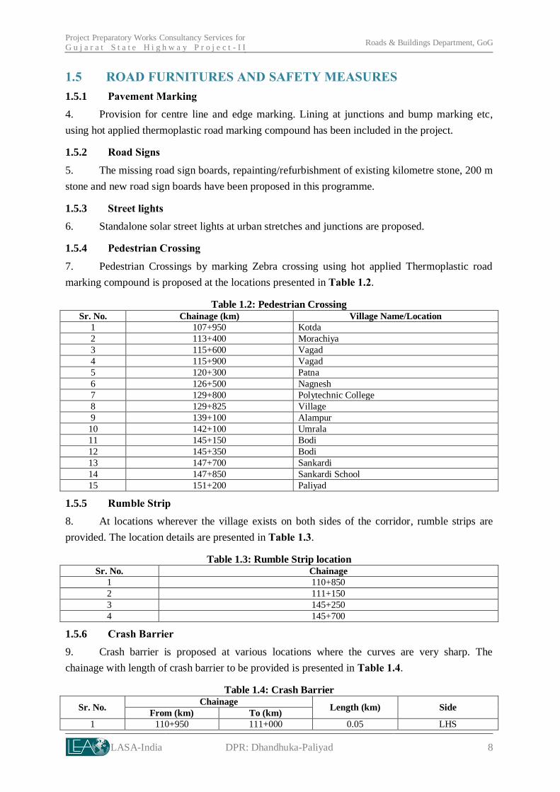
1.5 ROAD FURNITURES AND SAFETY MEASURES
1.5.1 Pavement Marking
4. Provision for centre line and edge marking. Lining at junctions and bump marking etc,
using hot applied thermoplastic road marking compound has been included in the project.
1.5.2 Road Signs
5. The missing road sign boards, repainting/refurbishment of existing kilometre stone, 200 m
stone and new road sign boards have been proposed in this programme.
1.5.3 Street lights
6. Standalone solar street lights at urban stretches and junctions are proposed.
1.5.4 Pedestrian Crossing
7. Pedestrian Crossings by marking Zebra crossing using hot applied Thermoplastic road
marking compound is proposed at the locations presented in Table 1.2.
Table 1.2: Pedestrian Crossing Sr. No. Chainage (km) Village Name/Location
1 107+950 Kotda
2 113+400 Morachiya
3 115+600 Vagad
4 115+900 Vagad
5 120+300 Patna
6 126+500 Nagnesh
7 129+800 Polytechnic College
8 129+825 Village
9 139+100 Alampur
10 142+100 Umrala
11 145+150 Bodi
12 145+350 Bodi
13 147+700 Sankardi
14 147+850 Sankardi School
15 151+200 Paliyad
1.5.5 Rumble Strip
8. At locations wherever the village exists on both sides of the corridor, rumble strips are
provided. The location details are presented in Table 1.3.
Table 1.3: Rumble Strip location Sr. No. Chainage
1 110+850
2 111+150
3 145+250
4 145+700
1.5.6 Crash Barrier
9. Crash barrier is proposed at various locations where the curves are very sharp. The
chainage with length of crash barrier to be provided is presented in Table 1.4.
Table 1.4: Crash Barrier
Sr. No. Chainage
Length (km) Side From (km) To (km)
1 110+950 111+000 0.05 LHS

Project Preparatory Works Consultancy Services for G u j a r a t S t a t e H i g h w a y P r o j e c t - I I
Roads & Buildings Department, GoG
LASA-India DPR: Dhandhuka-Paliyad 9
Sr. No. Chainage
Length (km) Side From (km) To (km)
2 114+500 114+550 0.05 RHS
3 117+550 117+600 0.05 RHS & LHS
4 123+080 123+180 0.10 RHS & LHS
5 124+600 124+750 0.15 RHS & LHS
6 126+100 126+180 0.08 RHS & LHS
7 131+400 131+500 0.10 RHS & LHS
8 141+700 141+800 0.10 RHS & LHS
9 144+000 144+050 0.05 RHS & LHS
10 148+100 148+500 0.40 RHS & LHS
11 150+180 150+300 0.12 RHS & LHS
1.5.7 Tree Guard
10. Tree guard rails are proposed at locations where the tree is near to edge of the corridor
(within 0.1m to 1.5m).
1.5.8 IMPROVEMENT PROPOSAL FOR STRUCTURES
11. Table 1.5 summarizes the improvement proposals for structures in the project.
Table 1.5: Abstract of Improvement Proposal Type of
Structure Retain Repair
Additional
Culvert
Replaced By New Construction Total
Pipe Slab. Box Minor Bridge
Pipe 0 6 2 1 0 0 0 9
Slab 0 5 0 0 15 0 20
Minor Bridge 3 3 0 0 0 21 27

LASA-India DPR: Dhandhuka-Paliyad 10
2. CORRIDOR CHARACTERISTICS
12. The corridor traverses through 2 districts of Ahmedabad and Bhavnagar covering
Dhandhuka, Ranpur and Botad Taluka. For the entire length of 46 km, 17 census villages and
1 town Dhandhuka abuts the project corridor. Total population of these villages and town as
per census 2001 was 80,009. The villages along the corridor are Sakardi, Paliyad, Ranpur,
Umrad and Paliyad. The salient features of the corridor are presented in Table 2.1.
Table 2.1: Dhandhuka – Paliyad Corridor Profile 1 Name of Road : Dhandhuka - Paliyad , SH - 01
2 District : Ahmedabad
3 Corridor Length : 46.40 km (Ch. 104+800 to 151+200)
4 Terrain : Plain
5
RoW
Existing : 30 m
Proposed : 30 m
6
CW Configuration
Existing : Two Lane
Proposed : Maintenance (MN)
7 CD Structures
Bridges : Particulars Major Bridges Minor Bridges
No. of existing
Bridges 0 26
Culverts : Particulars Slab HP Box Others Total
No. of
existing
culverts
20 - 1 7 28
8 Forests / environmentally
sensitive areas
: NPF area within RoW

LASA-India DPR: Dhandhuka-Paliyad 11
3. PROJECT CORRIDOR - BASELINE
3.1 ENVIRONMENTAL AND SOCIAL INVENTORY
13. Formats for collecting baseline environmental and social information were prepared
and the inventory survey was carried out. The formats were framed to capture various key
environmental features like (i) land use across the corridor (ii) Avenue trees (iii) Water bodies
(including ponds, wells, river crossing, canal crossing, irrigation tanks, lakes etc.) (iv) Forest
land (including sanctuaries, national parks, reserve forest and protected forests), (v)
archeologically important locations/ structures.
14. The formats were framed to capture various key social features like (i) Religious –
temple /dargah/ church and its importance (including festival seasons and other functions) (ii)
Shrines within RoW and its importance (iii) Market areas (including type of market, nature
of goods sold, volume of visitors, any issues, related to parking, wastes etc.), (iv) Educational
institutions (including number of students, any safety issues), (v) Health institutions
(including capacity for treatment), (vi) Crematorium / burial ground etc.
15. The filled in formats of the project corridor are enclosed in the Appendix– 1. The
analysis from the collected information is summarized in the following Table 3.1.
Table 3.1: Dhandhuka – Paliyad Corridor Environmental and Social Inventory
Sl.no Environmental and
Social Features Observations from the Inventory
1 Trees within existing RoW
Approximately 600 avenue trees, all the trees within RoW are
saved.
2
Religious Structures
Within RoW
: 1 Temple
3 Dargah
11 Shrines
3
River crossings : River crossings –0
Canal crossings – 1
Drains – 45
4 Water bodies / ponds : 1 Pond (115+600)
5 Sensitive receptors : 1 School within RoW
6 Transshipment areas/truck
parking locations
: 2 Truck Parking areas at Dhandhuka (104+800), Nagnesh
(LHS) and Bodiya (RHS) 126+600
7
Other features / issues if
any
: Quarry site (127+800), Gas Pipe Line (107+800), Industrial
area at:
Village Kotda (106+800 to 107+600),
Village Nagnesh, Bodiya (127+200 to 129+800)
16. Being a maintenance corridor, the proposed project interventions do not have any
impact on the social structures/ communities. However, the view from the public with respect
to the project has been documented during the stakeholder consultations. The outcome of the
consultation also provides key input to the project for various sensitive issues like road safety,
providing additional drains for low-lying areas, raising road levels / embankments etc.
3.2 STAKEHOLDER CONSULTATIONS
17. As part of the Environmental Impact Assessment, consultations were held along the
project corridor. The issues discussed and outcome of the consultations is summarized in
Table 3.2.

Project Preparatory Works Consultancy Services for G u j a r a t S t a t e H i g h w a y P r o j e c t - I I
Roads & Buildings Department, GoG
LASA-India DPR: Dhandhuka-Paliyad 12
Table 3.2: Stakeholders Consultations (Focus Group Discussion)
Location Key Outcomes Integration into Project Design and
Action Plan
Catholic Church School
(km 105+500)
Date: 16th Nov 2011
Number of Persons: 6
Stakeholders (school staff
and villagers)
Road safety measures should
be provided near the school
Noise barriers should be
provided to reduce the noise
levels near the school.
Water logging reported during
monsoon season alongside the
school. Proper drainage should be provided to drain
out storm water.
Warning signboards will be given
near the school location
The monitoring results for the
noise levels indicates that the noise
barriers near the school is not
necessary
Provision of drains included in the
road design.
FulpeerDargah (km
110+900)
Date: 16th Nov 2011
No. of Persons: 16
Participants (local villagers)
Inadequate drainage system
leading to water logging
problem near Dargah location
Road safety measures should
be provided at the curve
location near to Dargah.
Road safety measures should
be provided near primary-
school location.
Provision of drains included in the
road design.
Speed restriction measure adopted
in whole village to provide safety
to road users
Cautionary sign boards will be
provided near school and curve
locations.
Ambaji temple (km
131+000)
Date: 16th Nov 2011
No. of Persons: 7
Participants (local villagers)
Road safety measures should
be provided near the Temple,
near the Railway under
Bridge (RUB) and also near
the educational institution
(Polytechnic Institute).
Cautionary signboards will be
provided at respective locations.
Zebra Crossing included as road
safety measure for pedestrian
traffic
Bodi village Junction (km
145+300)
Date: 16th Nov 2011
No. of Persons:10
Participants (local villagers)
Road safety measures should
be provided along the
residential settlements on both
sides and near primary school.
Speed limit signs will be provided
near respective locations.
Zebra Crossing included as road
safety measure for pedestrian
traffic
Safety measures integrated into the design Location
Pedestrian Crossing
Kotda (107+950), Morachiya(113+400), Vagad
(115+600), Vagad (115+900), Patna (120+300), Nagnesh (126+500), Polytechnic College (129+800), Alampur
(139+100), Umrala (142+100), Bodi (145+150), Bodi
(145+350), Sankardi (147+700), Sankardi School
(147+850) and Paliyad (151+200)
Rumble Strip Ch 110+850, 111+150, 145+250 and 145+700

LASA-India DPR: Dhandhuka-Paliyad 13
4. ENVIRONMENTAL MANAGEMENT PLAN
18. A description of the various management measures during various stages of the project is provided in Table 4.1.
Table 4.1: Environmental Management Plan Sl.
No.
Environmental
Issue Activity Mitigation Measures Location
Implementing
Agency
Supervising &
Monitoring
Agency
Pre-Construction Phase
PC.1 Statutory
clearance
Utility
Relocation &
Consent to
Establish
Obtain NoC from the concerned agencies for shifting utilities.
Obtain Consent from competent authorities (Gujarat Pollution
Control Board (GPCB)), for ‘Consent to Establish’ under Water
(Prevention and Control of Pollution) Act, 1974, Air
(Prevention and Control of Pollution) Act, 1981).
If any conditions are laid down by the concerned /competent
authority, the same shall be integrated in the Bid Document.
Corridor of Impact EE, SRP -
Construction Phase
C.1 Air Pollution
Construction
plants, equipment
and vehicles
All vehicles used by the Contractor shall have copies of
currently valid Pollution under Control (PUC) Certificates as
per the requirement of the Gujarat Motor Vehicles Department
for the duration of the Contract.
The contractor shall obtain Consent-to-Operate under Air and
Water Acts from the Gujarat Pollution Control (GPCB) and
follow the conditions stipulated in the NoC (consent to
establish and Operate) by the GPCB
Other measures to be factored in selection of location
1.0 km away from settlement, school, hospital on downwind directions
300m from any archaeological site
10 km from environmental sensitive areas i.e. national park,
sanctuary
500m from water bodies (rivers, streams, lakes and ponds)
away from agricultural land
preference to barren land
Settlements location:
Dhandhulka (104+000)
Gunjar (110+800),
Ranpur (131+200),
Bodi (145+600)
Sensitive locations
Schools (105+200, 111+000, 147+400)
3 Darga (110+800,
120+400, 121+200)
Hospital (115+800)
College (129+800)
Contractor
EE, SRP
&Third party
TA&QA
Dust during earth
works or from
spoil dumps
Maintaining adequate moisture at surface of any earthwork
layer completed or non-completed to avoid dust emission. Contractor
EE, SRP
&Third party
TA&QA
Storage of Proper stockpiling and sprinkling of water as necessary. Contractor EE, SRP

Project Preparatory Works Consultancy Services for G u j a r a t S t a t e H i g h w a y P r o j e c t - I I
Roads & Buildings Department, GoG
LASA-India DPR: Dhandhuka-Paliyad 14
Sl.
No.
Environmental
Issue Activity Mitigation Measures Location
Implementing
Agency
Supervising &
Monitoring
Agency
maintenance
materials
&Third party
TA&QA
C.2 Water Pollution
Clearing of
waterways of
cross drainage works including
bridges and
clearing of
longitudinal side
drains
Clearance of waterway will be undertaken before onset of
monsoon.
Debris generated due to clearing of longitudinal side drains and
waterways of cross drainage will be stored above high flood
level and away from waterway, and reused on embankment
slope or disposed at designated areas2. Surface water sources/
drains/ Nalahs/ Ponds
etc. at
108+020, 108+850,
109+350, 111+850,
115+300, 116+500,
117+200, 118+150,
119+700, 121+200,
125+550, 130+005,
131+100, 131+500,
132+600, 134+350, 134+600, 136+400,
138+500, 139+100,
139+600, 140+100,
140+500, 143+500,
146+500, 148+250,
149+800.
Pond at Ch115+600
Contractor EE, SRP &Third party
TA&QA
Construction
vehicles Avoiding cleaning / washing of construction vehicle in any
water body Contractor
EE, SRP
&Third party
TA&QA
Construction camp
and workers’
camp
Minimum distance of 500m from water bodies ( river, stream,
lake and ponds)
Locate facilities in areas not affected by flooding and clear of
any natural or storm water courses.
The ground should have gentle slope to allow free drainage of
the site.
Vehicle parking areas, warehouses and work shop locations
must have impervious flooring to prevent seepage of any leaked
oil & grease into the ground. The area should be covered with a
roof to prevent the entry of rainwater.
Degreasing can also be carried out using mechanical spray type
degreaser, with complete recycle using an enclosure with
nozzles and two sieves, coarse above and fine below, may be
used.
All the waste oil collected, from skimming of the oil trap as
well as from the drip pans, or the mechanical degreaser shall be
stored in accordance with the Environment Protection (Storage and Disposal of Hazardous Wastes) Rules, 1989. For this
Contractor
EE, SRP
&Third party
TA&QA
2Designated areas are to be identified and finalized by Contractor in consultation with EE, SRP.

Project Preparatory Works Consultancy Services for G u j a r a t S t a t e H i g h w a y P r o j e c t - I I
Roads & Buildings Department, GoG
LASA-India DPR: Dhandhuka-Paliyad 15
Sl.
No.
Environmental
Issue Activity Mitigation Measures Location
Implementing
Agency
Supervising &
Monitoring
Agency
purpose, metallic drums should be used.
C.3 Noise Pollution and Vibration
Vehicles and
Construction machinery
All plants and equipment used in construction shall strictly
conform to the CPCB noise standards
Noisy construction activities (such as crushing, concrete mixing, batching etc.) within 150m of the nearest habitation/
education institutes/health centres (silence zones) shall be
stopped during the night time 9.00pm to 6.00pm.
Construction site/camp
and
Sensitive locations: Schools (105+200,
111+000, 147+400)
Hospital (115+800)
College (129+800)
Contractor
EE, SRP
&Third party TA&QA
C.4 Land Pollution
Spillage from
plant and
equipment at
construction camp
Providing impervious platform and oil & grease trap for
collection of spillage from construction equipment vehicle
maintenance platform
Collection of oil and lubes drips in container during repairing
construction equipment vehicles
Providing impervious platform and collection tank for spillage
of liquid fuel and lubes at storage area
Providing impervious base at bitumen and emulsion storage area and regular clearing of any bitumen spillage for
controlled disposal
Construction site/camp Contractor
EE, SRP
&Third party
TA&QA
Domestic solid
waste and liquid
waste generated at
camp
Collecting organic waste at separate bins and disposing of in a
pit at designated area/s
Collecting inorganic wastes in separate bins and storing them
in a secure area within the camp location, and disposal of the
same in the nearest municipal solid waste site.
Construction & labour
camps Contractor
EE, SRP
&Third party
TA&QA
Temporary use of
lands, including
construction sites,
construction
camps, and
borrow areas.
Identify and finalize all lands to be temporarily used in the
project in consultation with the EE SRP after entering into a
written agreement with the land owners for rehabilitation of
the land parcel prior to handing over.
Avoid locating borrow area close to any road (maintain at least
30m distance from CoI and 10 m from toe of embankment, whichever is more);
Rehabilitation within agreed timeframe before handing over to
the landowner
Construction sites/
camps/ borrow areas Contractor
EE, SRP
&Third party
TA&QA
C.5 Occupational
health and safety
Exposure to high
noise level and Water supply, sanitation, drainage and medical health facilities
at campsite Construction site/camp Contractor
EE, SRP
&Third party

Project Preparatory Works Consultancy Services for G u j a r a t S t a t e H i g h w a y P r o j e c t - I I
Roads & Buildings Department, GoG
LASA-India DPR: Dhandhuka-Paliyad 16
Sl.
No.
Environmental
Issue Activity Mitigation Measures Location
Implementing
Agency
Supervising &
Monitoring
Agency
of workers inadequate
facilities including
supply of potable
water and
sanitation facilities
Providing and using PPEs(Personal Protective Equipments)
Using working reverse horn for all construction equipment and
vehicles
Providing earth link circuit breaker (ELCB) for all electrical connections
Maintaining first aid at construction sites
TA&QA
C.6 Accidents and
safety
Arrangement of
traffic during
construction
Providing and maintaining traffic management comprising
diversion; warning, guiding and regulatory signage;
channelisers and delineators; lighting, flagmen; dust control
system etc. as specified in the contract
Dhandhuka, km
104+800 (Intersection)
Ranpur, km 131+000
(Y Junction)
Paliyad, km 151+200
(Intersection)
Contractor
EE, SRP
&Third party
TA&QA
C.7
HIV/ AIDS
Prevention
Measures
The Contractor shall implement the following measures
towards ensuring HIV/AIDS prevention during the entire
contract period
(i) conduct awareness campaign including dissemination of
IEC materials on HIV/AIDS for all construction personnel (including labourers, supervisors, engineers and consultants)
on HIV/AIDS/STDs within two months of mobilization and
once a year subsequently during the contract period;
(ii) conduct semi-annual health check-up of all construction
personnel including testing for STDs;
(iii) erect and maintain hoardings/ information signages on
HIV/AIDS prevention at the construction sites, labour camps
and at established truck parking locations;
(iv) install condom vending machines at the labour camps,
including replenishment of supplies.
Construction & labor
camps
Contractor Contractor
under the
supervision of
the EE, SRP

LASA-India DPR: Dhandhuka-Paliyad 17
5. IMPLEMENTATION ARRANGEMENTS
5.1 INSTITUTIONAL SETUP
19. During implementation of project EE, SRP Division and Contractor will be
responsible for ensuring that the environmental commitments made to regulatory agencies,
lending agencies and other stakeholders during the EIA process are met. The responsibility
mechanism is presented in Table 5.1.
Table 5.1: Institutional Responsibilities
System Designation Responsibilities
Implementing/
Monitoring
Agency
EE, SRP
Division
Overall responsible for EMP implementation
Reporting to various stakeholders (World Bank, Regulatory bodies) on status
of EMP implementation
Responsible for obtaining Regulatory Clearances (if any)
Review of the progress made by contractors
Conducting periodic field inspection of EMP implementation
Maintaining progress reports on EMP implementation
Environmental and R&R Specialist, PIU
Assist the SRP division in the implementation of the EMP provisions
Provide guidance to the SRP division on implementation of EMP provisions
Carry out periodic field visits and ensure compliance with the EMP
provisions
Assist the SRP division in the compilation of the monitoring reports and
progress reports on EMP implementation
Contractor Environmental
Engineer of Contractor
Responsible for ensuring the implementation of EMP as per provision in the
document.
Reporting to Implementing / monitoring agency
Discussing various environmental/social issues and environmental/social
mitigation and monitoring actions with all concerned directly or indirectly
Conducting periodic environmental and safety training for contractor’s
engineers, supervisors and workers along with sensitization on social issues
that may be arising during the construction stage of the project
To carry out environmental monitoring and control activities including
pollution monitoring; and
Conducting awareness campaign for all construction personnel (including labourers, supervisors and engineers) about HIV/AIDS/STDs in the construction and labour camps.
Facilitating the medical testing/ routine check-up for labours as suggested in
the EMP
Preparing and submitting monthly reports to Implementing agency (EE, SRP
Division) on status of implementation safeguard measures
TA/QA
consultants
Environment
and Social expert
Carry out periodic audit of the effective implementation of EMP provisions
Provide course correction / improvement measures to the SRP division on
enhancing the implementation effectiveness of EMP provisions
Carry out capacity building of the SRP division officers on the EMP
implementation.
5.2 ENVIRONEMTNAL MONITORING PLAN
20. The environmental monitoring plan is prepared based on the environmental
monitoring indicators as shown in Table 5.2.

Project Preparatory Works Consultancy Services for G u j a r a t S t a t e H i g h w a y P r o j e c t - I I
Roads & Buildings Department, GoG
LASA-India DPR: Dhandhuka-Paliyad 18
Table 5.2: Environmental Monitoring Indicators
Sr.
No.
Indicator Details Stage Responsibility
A Environmental Condition Indicators and Monitoring Plan
1 Air Quality
The parameters to be monitored,
frequency and duration of monitoring shall be as per the Monitoring Plan prepared (Refer Table 5.3)
Pre-Construction
Contractor under the
supervision of EE,SRP & TA&QA
Post Construction
(DLP)
End of
Maintenance period
2 Noise Levels Pre-Construction
Contractor under the supervision of EE,SRP & TA&QA
Post Construction
(DLP)
End of
Maintenance period
B Environmental Management Indicators and Monitoring Plan
1 Construction Camps
Occupational health & Safety of workers and construction camp management
(including pollution control at construction camp)
Pre-construction
Contractor under the
supervision of EE,SRP & TA&QA
2 Borrow Areas Identification of borrow area in
accordance with permission from the landowners, sensitivity etc.
Pre-construction Contractor under the
supervision of EE,SRP & TA&QA
3 Construction and
Labour Camps
Infrastructure provisions at camps,
provision of PPE to workers, health facilities at camps including implementation of HIV/ AIDS Prevention Measures
Construction
Contractor under the
supervision of EE,SRP & TA&QA
4 Rehabilitation of Borrow Areas
Engineer will undertake site visits to determine how many borrow areas have been rehabilitated in line with the landowner’s request and to their full satisfaction.
Construction Contractor under the supervision of EE,SRP & TA&QA
21. For each of the environmental monitoring indicator, the monitoring plan specifies the
parameters to be monitored, location of the monitoring sites, frequency and duration of
monitoring. The monitoring plan also specifies the applicable standards, implementation and
supervising responsibilities. The monitoring plan for the environmental condition indicators
of the project in construction and operation stages are presented in Table 5.3.

Project Preparatory Works Consultancy Services for G u j a r a t S t a t e H i g h w a y P r o j e c t - I I
Roads & Buildings Department, GoG
LASA-India DPR: Dhandhuka-Paliyad 19
Table 5.3: Environmental Monitoring Plan Attribute Project Stage Parameter Special Guidance Standards Frequency Duration Location Implementation
Air
Pre-Construction
SO2, NOx, PM10, PM2.5, CO
High volume sampler to be located 50m from the road in the Downwind direction. Use method specified by CPCB for analysis
Air (prevention and Control of Pollution) Rules, CPCB, 2009
One season (before monsoon)
24 hours Sampling
As suggested by the Engineer
Contractor under the supervision of EE,SRP &
TA&QA
Post Construction (DLP)
End of Maintenance period
Noise
Pre-Construction
Noise levels on dB (A) scale
Equivalent noise levels using an
integrated noise level meter kept at a distance of 15 from edge of pavement Equivalent noise levels using an integrated noise level meter kept at a distance of 15 from edge of pavement
MoEF Noise Rules, 2000
One season (before monsoon)
Leq in dB(A) of day time and night time
As suggested by the Engineer
Post Construction (DLP)
End of Maintenance
Borrow
area Construction As per Guidelines Visual Observation - Once in a month - Borrow area location
HIV/
AIDS
Prevention
Measures
Construction
Awareness campaign
- - Annual -
Construction and Labour Camp sites
Contractor under
the supervision of the Engineer/ EMU
IEC materials distribution
Quarterly
Condom Distribution
Once a month

Project Preparatory Works Consultancy Services for G u j a r a t S t a t e H i g h w a y P r o j e c t - I I
Roads & Buildings Department, GoG
LASA-India DPR: Dhandhuka-Paliyad 20
5.3 REPORTING SYSTEM
22. The contractor will operate the reporting system for environmental condition and
environmental management indicators (Table 5.2). The Contractor will report to the EE, SRP
Division on the progress of the implementation of environmental conditions and management
measures as per the EMP. The reporting formats are in the Appendix -2 and Contractor’s
Checklist is enclosed in the Appendix-3. The summary of reporting is given in the Table 5.4.
Table 5.4: Summary details of Reporting
Format
No. Item Stage
Contractor EE, SRP Division &
TA&QA
Implementation &
Reporting to EE, SRP
Division
Oversee
/ Field Compliance
Monitoring
EM 1 Identification of Disposal Locations
Pre-Construction One Time One Time
EM 2 Setting up of Construction Camp
Pre-Construction One Time One Time
EM 3 Borrow Area Identification Pre-Construction One Time One Time
EM 4 Top Soil Monitoring Construction Quarterly Quarterly
EM 5 Status Regarding Rehabilitation of Borrow Areas
Construction - Half Yearly
EC 1 Pollution Monitoring
Pre-Construction As Per Monitoring
Plan Quarterly
Post Construction (DLP)
End of Maintenance
23. The contractor shall take all reasonable steps to protect the environment on and off
the Site and to avoid damage or nuisance to persons or to property of the public or others
resulting from pollution, noise or other causes arising as a consequence of his methods of
operation.
5.3.1 Clause for Nonconformity to EMP - Protection of the Environment
24. The Contractor shall implement all mitigation measures for which responsibility is
assigned to him as stipulated in the EMP Report. Any lapse in implementing the same will
attract the damage clause as detailed below:
1. All lapse in obtaining clearances / permissions under statutory regulations and violations of
any regulations with regard to eco-sensitive areas shall be treated as a major lapse.
2. Any complaints of public, within the scope of the Contractor, formally registered with the
CSC, R & BD or with the GoG and communicated to the Contractor, which is not properly
addressed within the time period intimated by the CSC / R & BD, GoG shall be treated as a
major lapse.
3. Non-conformity to any of the mitigation measures stipulated in the EMP Report (other than
stated above) shall be considered as a minor lapse.
4. On observing any lapses, CSC shall issue a notice to the Contractor, to rectify the same.

Project Preparatory Works Consultancy Services for G u j a r a t S t a t e H i g h w a y P r o j e c t - I I
Roads & Buildings Department, GoG
LASA-India DPR: Dhandhuka-Paliyad 21
5. Any minor lapse for which notice was issued and not rectified, first and second reminders
shall be given after ten days from the original notice date and first reminder date respectively.
Any minor lapse, which is not rectified, shall be treated as a major lapse from the date of
issuing the second reminder.
6. If a major lapse is not rectified upon receiving the notice CSC shall invoke reduction, in the
subsequent interim payment certificate.
7. For major lapses, 10% of the interim payment certificate will be withheld, subject to a
maximum limit of about 0.5% of the contract value.
8. If the lapse is not rectified within one month after withholding the payment, the amount
withheld shall be forfeited.
5.4 ENVIRONMENTAL MANAGEMENT BUDGET
25. Budgetary estimates for environmental management in the project include all items
envisaged as part of the EMP. The environment budget includes provisions for various
environmental management measures and the environmental monitoring costs. Budgetary
provisions for the project are presented in Table 5.5. The Bill of quantities is given in
Appendix-4.
Table 5.5: Budgetary Provisions for Environmental Management Measures S. No. Item Unit Rate (in INR) Quantity Cost (in INR)
A PRE CONSTRUCTION
1 Air Quality
1.1
Monitoring of Air Quality at
Sensitive Locations
No. of
Samples 7500 5 37,500.00
1.2 Noise Levels
1.2.1
Monitoring of Noise Levels at
Sensitive Locations
No. of
Samples 3000 5 15,000.00
B CONSTRUCTION
1 HIV/ AIDS Prevention measures
1.1 IEC materials - printing, publishing 3000 12 36,000.00
1.2 Healthcare clinic 30000 4 120000.00
1.3 Condom vending machines 15000 1 15000.00
1.4 condom supplies 3000 12 36000.00
1.5 Signages and hoardings 15000 5 75000.00
C POST CONSTRUCTION (During DL Period)
1 Air Quality
1.1
Monitoring of Air Quality at
Sensitive Locations
No. of
Samples 7500 5 37,500.00
2 Noise Levels
2.1
Monitoring of Noise Levels at
Sensitive Locations
No. of
Samples 3000 5 15,000.00
C END OF MAINTENANCE PERIOD (During Maintenance Period)
1
Monitoring of Air Quality at
Sensitive Locations
No. of
Samples 7500 5 37,500.00
2
Monitoring of Noise Levels at
Sensitive Locations
No. of
Samples 3000 5 15,000.00
Total
439,500.00
Grand Total INR. (with 3% contingency)
452,685.00

A-1
Appendix – 1: Inventory of Environmental and Social Features1
Corridor name: Dhandhuka – Paliyad (SH-1) Corridor
Sr.
No
Chainage
(Km)
Urban (U)
/Rural (R)
Location
(Left/Right)
Name of Property
Distance from center of
Carriage Way Area
(approx.)
in sq.m
Remarks :
Age of Structure/ Whether any annual fairs/
Students strength BW Structure
1 104+800 U R Truck Parking 10
3 105+500 U L School 18 22 2200 Student strength- 505
4 107+500 U L Shrine 8.5 0.6 3 years
5 108+800 R R Shrine 11.5 0.4 5 years
6 110+800 U R Dargah 5 6 75.0 20 years
7 111+00 R L Shrine 6 0.9
8 111+100 R L Gunjar School 17 1050 student strength- 260
9 115+600 R R Pond 9.5 Length along the road - 95m
10 115+600 R R Shrine 6.2 0.6
11 115+900 R R Hospital Govt. 17.3 25
13 120+500 R L Dargah 20 25 30 years
14 121+300 R R Dargah 9 16 2000 12 years
15 126+600 R R Truck Parking
16 127+400 R L Shrine 8 0.64
17 129+800 R L School 25 50 1800
18 129+800 R L College (Polytechnic) 19 21 1800 Student strength- 2000
20 130+900 R R Temple (Ambaji) 20 27 2200 15 years old structure, nearly 1,300 people gathers in the month of november -december.
21 131+100 U R Muslim Graveyard 16
24 135+700 R R Shrine 4.8 1
25 138+900 R R Shrine 10.5 0.36
26 140+600 R R Shrine 13 0.36
27 141+200 R L Shrine 6 0.64
28 145+700 R R Temple (Sitaram Mah) 6 8 144 16 years old structure, nearly 10,000 people gathers in the month of february for annual fairs
29 145+700 R R Shrine 6
30 147+100 R L Shakardi Primary School
13 Student strength-120
31 147+500 R L Gitanjali School 10 50 Student strength- 200
32 149+100 R L Cattle crossing
33 149+600 R L Shrine 6.5 0.16 7 years
34 149+700 R L Dargah 7 4 10 years
1 Inventory of social and environment features comprises the details of structures, water bodies, ponds etc. within RoW

A-2
Inventory of Landuse and Trees
Corridor name: Dhandhuka – Paliyad (SH-1) Corridor
LandUse1
Left Side Chainage Right Side
Gri
th (
m)
(Avg d
ia)
Sp
aci
ng (
m)
Dis
t. o
f 3rd
row
from
C/L
(m)(
ab
ove
7.5
m)
Dis
t. o
f 2n
d r
ow
from
C/L
(m
) (4
.5-
7.5
m)
Dis
t. O
f 1st
row
from
C/L
(m
) 4.5
No. of
Row
s
From To
No. of
Row
s
Dis
t. O
f 1st
row
from
C/L
(m
) 4.5
Dis
t. O
f 2 n
d r
ow
from
C/L
(m
) 4.5
-
7.5
Dis
t. O
f 3rd
row
from
C/L
(m
)
ab
ove
7.5
m
Sp
aci
ng (
m)
Gri
th (
m)
(Avg d
ia)
Nam
e of
tree
spec
ies
alo
ng t
he
corr
idor
Left Right
3 6 1 104+800 105+000
Ch 104.8- Ch106.8- Peepul, Baad
3 2 0.9 40 9 1 105+000 115+200 1 7 8 30 0.9
4 2 115+200 105+400
8 2 0.9 22 8 1 105+400 105+600
8 4 0.9 24 12 1 105+600 105+800 1 12 40 0.6
2 2 0.6 35 10 1 105+800 106+000 1 7 25 0.6
1 1 0.9 30 9 1 106+000 106+200 1 9 25 0.9
1 1 1.2 20 8 1 106+200 106+400 1 7 20 1.2
5 1 1.3 30 6 1 106+400 106+600 1 9 30 4
1 1 106+600 106+800
1,5 1 20 7 1 106+800 107+000
Ch 106.8- Ch108.8- Peepul, Neem
5 5 107+000 107+200
5 5 0.9 60 8 1 107+200 107+400 1 8 80 0.9
5 5 0.9 80 9 1 107+400 107+600 1 8 80 0.6
1 1 0.9 80 9 1 107+600 107+800 1 9 100 0.6
1 1 107+800 108+000
1 2 108+000 108+200
1 4 108+200 108+400
1 1 108+400 108+600 1 8 140 0.6
1 1 108+600 108+800
1 1 108+800 109+000 1 8 100 0.9
Ch 108.8- Ch110.8 - Neem, Khijda
1 1 109+000 109+200
1 1 109+200 109+400
3 1 109+400 109+600
1 1 0.6 80 8 1 109+600 109+800
1 1 0.6 50 9 1 109+800 110+000 1 10 40 0.9
1 1 0.6 30 9 1 110+000 110+200
1 1 0.6 40 8 1 110+200 110+400
1 1 110+400 110+600
2 2 0.6 80 9 1 110+600 110+800 1 14 40 0.9

A-3
LandUse1
Left Side Chainage Right Side
Gri
th (
m)
(Avg d
ia)
Sp
aci
ng (
m)
Dis
t. o
f 3rd
ro
w
from
C/L
(m)(
ab
ove
7.5
m)
Dis
t. o
f 2n
d r
ow
from
C/L
(m
) (4
.5-
7.5
m)
Dis
t. O
f 1st
row
from
C/L
(m
) 4.5
No. of
Row
s
From To
No. of
Row
s
Dis
t. O
f 1st
row
from
C/L
(m
) 4.5
Dis
t. O
f 2 n
d r
ow
from
C/L
(m
) 4.5
-
7.5
Dis
t. O
f 3rd
ro
w
from
C/L
(m
)
ab
ove
7.5
m
Sp
aci
ng (
m)
Gri
th (
m)
(Avg d
ia)
Nam
e of
tree
spec
ies
alo
ng t
he
corr
idor
Left Right
4 2 0.6 100 10 1 110+800 111+000 1 8 25 1.2
Ch 110.8- Ch112.8- Neem, Peepul, Khijda
2 1 111+000 111+200
4 1 111+200 111+400
1 1 111+400 111+600
1 1 111+600 111+800
1 1 0.9 30 9 1 111+800 112+000 1 9 30 0.9
1 1 0.6 70 11 1 112+000 112+200 1 9 35 0.9
1 1 1 112+200 112+400
1 1 0.3 30 9 1 112+400 112+600 1 8 20 0.3
1 1 0.3 40 9 1 112+600 112+800 1 8 30 0.6
1 1 0.6 35 9 1 112+800 113+000
Ch 112.8- Ch114.8-
Neem, Khijda
1 1 0.6 100 8 1 113+000 113+200 1 8 100 0.3
1 1 0.9 40 9 1 113+200 113+400 1 8 50 0.3
1 1 0.6 40 10 1 113+400 113+600 1 9 80 0.3
1 1 . 70 10 1 113+600 113+800 1 12 100 0.3
1 1 0.6 40 10 1 113+800 114+000 1 10 50 0.3
1 1 114+000 114+200
1 1 0.3 50 11 1 114+200 114+400 1 8 70 0.3
1 1 0.6 40 1 114+400 114+600 1 9 50 0.3
1 1 114+600 114+800
1 1 0.3 100 8 1 114+800 115+000
Ch 114.8- Ch 116.8- Khijda
3 1 115+000 115+200
1 2 115+200 115+400
3 1 115+400 115+600
1 2 115+600 115+800 1 10 50 0.6
1 2 115+800 116+000
1 1 116+000 116+200
1 1 0.3 60 9 1 116+200 116+400 1 7 65 0.6
1 1 116+400 116+600
1 1 0.3 60 9 1 116+600 116+800 1 6 60 0.6
1 1 0.6 60 10 1 116+800 117+000 1 8 50 0.6 Ch 116.8- Ch 118.8- Babul, Khijda
1 1 0.3 50 6 1 117+000 117+200 1 6 50 0.3
1 1 0.6 40 9 1 117+200 117+400 1 9 40 0.3
1 1 0.3 65 9 1 117+400 117+600 1 7 70 0.3

A-4
LandUse1
Left Side Chainage Right Side
Gri
th (
m)
(Avg d
ia)
Sp
aci
ng (
m)
Dis
t. o
f 3rd
ro
w
from
C/L
(m)(
ab
ove
7.5
m)
Dis
t. o
f 2n
d r
ow
from
C/L
(m
) (4
.5-
7.5
m)
Dis
t. O
f 1st
row
from
C/L
(m
) 4.5
No. of
Row
s
From To
No. of
Row
s
Dis
t. O
f 1st
row
from
C/L
(m
) 4.5
Dis
t. O
f 2 n
d r
ow
from
C/L
(m
) 4.5
-
7.5
Dis
t. O
f 3rd
ro
w
from
C/L
(m
)
ab
ove
7.5
m
Sp
aci
ng (
m)
Gri
th (
m)
(Avg d
ia)
Nam
e of
tree
spec
ies
alo
ng t
he
corr
idor
Left Right
1 1 0.3 30 6 1 117+600 117+800 1 7 30 0.3
1 1 0.6 30 7 1 117+800 118+000 1 9 35 0.6
1 1 0.3 60 8 1 118+000 118+200 1 7 50 0.3
1 1 0.6 40 8 2 118+200 118+400
1 1 118+400 118+600
1 1 0.3 60 8 1 118+600 118+800 1 5.5 60 0.3
1 1 0.6 70 9 1 118+800 119+000 1 5.5 80 0.6
Ch 118.8- Ch 120.8- Babul, Khijda
1 1 0.6 50 1 119+000 119+200 1 4.5 50 0.6
1 1 0.3 100 7 1 119+200 119+400
1 1 119+400 119+600 1 4.5 200 0.6
1 1 119+600 119+800
1 2 119+800 120+000
1 2 120+000 120+200
1 1 120+200 120+400
1 1 120+400 120+600
1 1 120+600 120+800
1 1 120+800 121+000
Ch 120.8- Ch122.8- Babul,
Khijda, Neem
1 1 121+000 121+200
1 1 121+200 121+400 1 9 30 0.9
1 1 121+400 121+600
1 1 121+600 121+800
1 1 121+800 122+000
1 1 0.3 65 8 1 122+000 122+200
1 1 0.3 40 8 1 122+200 122+400 1 9 60 0.3
1 1 0.3 35 8 1 122+400 122+600 1 9 65 0.3
1 1 0.9 40 8 1 122+600 122+800
1 1 0.2 30 1 122+800 123+000 1 6 40 0.6
Ch 122.8- Ch 124.8- Imli, Khijda
1 1 1 50 1 123+000 123+200 1 6 60 0.6
1 1 1.2 40 1 123+200 123+400 1 4.5 40 1.2
1 1 1.2 40 1 123+400 123+600 1 4.5 60 1.2
1 1 0.9 50 1 123+600 123+800 1 4.5 60 0.9
1 1 0.9 60 1 123+800 124+000 1 4.5 6 0.9
1 1 0.9 60 6 1 124+000 124+200 1 5 70 0.9
1 1 124+200 124+400 1 4 70 0.6

A-5
LandUse1
Left Side Chainage Right Side
Gri
th (
m)
(Avg d
ia)
Sp
aci
ng (
m)
Dis
t. o
f 3rd
ro
w
from
C/L
(m)(
ab
ove
7.5
m)
Dis
t. o
f 2n
d r
ow
from
C/L
(m
) (4
.5-
7.5
m)
Dis
t. O
f 1st
row
from
C/L
(m
) 4.5
No. of
Row
s
From To
No. of
Row
s
Dis
t. O
f 1st
row
from
C/L
(m
) 4.5
Dis
t. O
f 2 n
d r
ow
from
C/L
(m
) 4.5
-
7.5
Dis
t. O
f 3rd
ro
w
from
C/L
(m
)
ab
ove
7.5
m
Sp
aci
ng (
m)
Gri
th (
m)
(Avg d
ia)
Nam
e of
tree
spec
ies
alo
ng t
he
corr
idor
Left Right
1 1 124+400 124+600
1 1 0.6 45 6 1 124+600 124+800 1 5 40 1.2
1 1 124+800 125+000 1 5 60 0.9
Ch 124.8- Ch 126.8- Imli, Neem
1 1 0.6 60 7 1 125+000 125+200 1 4.5 45 0.6
1 1 0.3 60 9 1 125+200 125+400 1 4.5 50 0.6
1 1 0.1 40 10 1 125+400 125+600
1 1 0.2 40 10 1 125+600 125+800
1 1 0.3 50 7 1 125+800 126+000 1 5 40 0.6
1 1 0.3 80 12 1 126+000 126+200 1 5 60 0.9
1 1 126+200 126+400 1 5.5 50 0.6
1 1 126+400 126+600 1 8 65 0.6
1 1 0.6 90 8 1 126+600 126+800 1 9 90 0.6
3 6 126+800 127+000
Ch 126.8- Ch 128.8-
Peepul
1 5 127+000 127+200 1 7 80 0.9
1 5 127+200 127+400
5 5 127+400 127+600
1 5 1 127+600 127+800
1 5 0.6 30 6 1 127+800 128+000 1 8 35 0.6
1 5 0.6 40 1 128+000 128+200
1 5 0.6 50 1 128+200 128+400 1 4.5 80 0.6
1 5 0.6 70 6 1 128+400 128+600
1 5 128+600 128+800
2 5 128+800 129+000
Ch 128.8- Ch 130.8- Peepul, Imli
1 5 129+000 129+200 1 4.5 80 0.9
1 5 0.3 65 1 129+200 129+400
1 5 0.6 60 8 1 129+400 129+600
1 5 129+600 129+800
2 6 129+800 130+000
5 6 130+000 130+200
3 3 0.6 80 6 1 130+200 130+400
1 4 130+400 130+600
3 2 130+600 130+800
6 6 130+800 131+000 Ch 130.8- Ch 132.8- 3 6 131+000 131+200

A-6
LandUse1
Left Side Chainage Right Side
Gri
th (
m)
(Avg d
ia)
Sp
aci
ng (
m)
Dis
t. o
f 3rd
ro
w
from
C/L
(m)(
ab
ove
7.5
m)
Dis
t. o
f 2n
d r
ow
from
C/L
(m
) (4
.5-
7.5
m)
Dis
t. O
f 1st
row
from
C/L
(m
) 4.5
No. of
Row
s
From To
No. of
Row
s
Dis
t. O
f 1st
row
from
C/L
(m
) 4.5
Dis
t. O
f 2 n
d r
ow
from
C/L
(m
) 4.5
-
7.5
Dis
t. O
f 3rd
ro
w
from
C/L
(m
)
ab
ove
7.5
m
Sp
aci
ng (
m)
Gri
th (
m)
(Avg d
ia)
Nam
e of
tree
spec
ies
alo
ng t
he
corr
idor
Left Right
6 6 131+200 131+400 Neem, Peepul 5 3 131+400 131+600
1 1 131+600 131+800
1 1 131+800 132+000 1 7 60 0.3
1 1 132+000 132+200
1 1 0.6 35 7.5 1 132+200 132+400 1 6 30 0.6
1 1 132+400 132+600 1 6 60 0.6
1 1 132+600 132+800
1 1 0.6 35 8 1 132+800 133+000 1 8 20 0.6
Ch 132.8-
Ch 134.8- Peepul
1 1 0.6 30 8 1 133+000 133+200 1 8 25 0.3
1 1 0.9 20 9 1 133+200 133+400 1 7 35 0.6
1 1 0.6 30 10 1 133+400 133+600 1 6 25 0.9
1 1 0.6 35 8 1 133+600 133+800 1 6 30 0.9
1 1 0.6 60 8 1 133+800 134+000 1 6 100 0.6
1 1 0.3 35 7 1 134+000 134+200 1 5.5 20 0.9
1 1 134+200 134+400
1 6 134+400 134+600
1 6 134+600 134+800
1 1 134+800 135+000
Ch 134.8- Ch 136.8- Peepul. Babul
6 6 135+000 135+200
1 1 135+200 135+400
1 1 135+400 135+600
1 1 0.6 80 6.5 1 135+600 135+800
1 1 0.3 80 9 1 135+800 136+000
1 1 136+000 136+200
1 1 0.3 100 9 1 136+200 136+400
1 1 136+400 136+600
1 1 136+600 136+800
1 1 136+800 137+000
Ch 136.8- Ch 138.8- Neem, Babul
1 1 137+000 137+200
1 1 137+200 137+400
1 1 137+400 137+600
1 1 137+600 137+800
1 1 137+800 138+000

A-7
LandUse1
Left Side Chainage Right Side
Gri
th (
m)
(Avg d
ia)
Sp
aci
ng (
m)
Dis
t. o
f 3rd
ro
w
from
C/L
(m)(
ab
ove
7.5
m)
Dis
t. o
f 2n
d r
ow
from
C/L
(m
) (4
.5-
7.5
m)
Dis
t. O
f 1st
row
from
C/L
(m
) 4.5
No. of
Row
s
From To
No. of
Row
s
Dis
t. O
f 1st
row
from
C/L
(m
) 4.5
Dis
t. O
f 2 n
d r
ow
from
C/L
(m
) 4.5
-
7.5
Dis
t. O
f 3rd
ro
w
from
C/L
(m
)
ab
ove
7.5
m
Sp
aci
ng (
m)
Gri
th (
m)
(Avg d
ia)
Nam
e of
tree
spec
ies
alo
ng t
he
corr
idor
Left Right
1 1 138+000 138+200
1 1 138+200 138+400
1 1 138+400 138+600
1 1 138+600 138+800
1 1 138+800 139+000
Ch 138.8- Ch 140.8- Babul
1 1 139+000 139+200
1 1 139+200 139+400
1 1 139+400 139+600
1 1 139+600 139+800
1 1 139+800 140+000
1 1 140+000 140+200
6 6 140+200 140+400
6 6 140+400 140+600
6 6 140+600 140+800
1 1 140+800 141+000
Ch 140.8- Ch 42.8- Babul,
Neem
5 5 141+000 141+200
5 3 141+200 141+400
1 1 141+400 141+600
1 1 141+600 141+800
1 1 141+800 142+000
1 1 142+000 142+200
1 1 142+200 142+400
1 1 142+400 142+600
1 1 142+600 142+800
1 1 142+800 143+000
Ch 142.8- Ch 144.8- Imli
1 1 143+000 143+200
1 1 143+200 143+400
1 1 143+400 143+600
1 1 143+600 143+800
1 1 143+800 144+000
1 1 144+000 144+200 1 8 60 0.3
1 1 144+200 144+400
1 1 144+400 144+600
1 1 144+600 144+800

A-8
LandUse1
Left Side Chainage Right Side
Gri
th (
m)
(Avg d
ia)
Sp
aci
ng (
m)
Dis
t. o
f 3rd
ro
w
from
C/L
(m)(
ab
ove
7.5
m)
Dis
t. o
f 2n
d r
ow
from
C/L
(m
) (4
.5-
7.5
m)
Dis
t. O
f 1st
row
from
C/L
(m
) 4.5
No. of
Row
s
From To
No. of
Row
s
Dis
t. O
f 1st
row
from
C/L
(m
) 4.5
Dis
t. O
f 2 n
d r
ow
from
C/L
(m
) 4.5
-
7.5
Dis
t. O
f 3rd
ro
w
from
C/L
(m
)
ab
ove
7.5
m
Sp
aci
ng (
m)
Gri
th (
m)
(Avg d
ia)
Nam
e of
tree
spec
ies
alo
ng t
he
corr
idor
Left Right
2 2 144+800 145+000 Ch 144.8- Ch146.8- Babul, Imli, Peepul
2 2 145+000 145+200
2 2 145+200 145+400
2 2 145+400 145+600
3 1 145+600 145+800
1 1 145+800 146+000
1 1 146+000 146+200
1 1 146+200 146+400
1 1 146+400 146+600
1 1 146+600 146+800
1 1 146+800 147+000
1 1 147+000 147+200
1 1 147+200 147+400
1 1 147+400 147+600 No Trees
1 1 147+600 147+800 No Trees
1 6 147+800 148+000 No Trees
1 6 148+000 148+200 No Trees
1 6 148+200 148+400 No Trees
1 6 148+400 148+600 No Trees
1 6 148+600 148+800 No Trees
1 1 148+800 149+000 No Trees
1 6 149+000 149+200 No Trees
6 6 149+200 149+400 No Trees
6 6 149+400 149+600 No Trees
1 1 149+600 149+800 No Trees
1 1 149+800 150+000 No Trees
1 6 150+000 150+200 No Trees
6 6 150+200 150+400 No Trees
2 1 150+400 150+600 No Trees
1 1 150+600 150+800 No Trees
3 3 150+800 151+000 No Trees
3 3 151+000 151+200 No Trees
3 3 151+200 151+400 No Trees
3 3 151+400 151+600 No Trees

A-9
LandUse1
Left Side Chainage Right Side
Gri
th (
m)
(Avg d
ia)
Sp
aci
ng (
m)
Dis
t. o
f 3rd
ro
w
from
C/L
(m)(
ab
ove
7.5
m)
Dis
t. o
f 2n
d r
ow
from
C/L
(m
) (4
.5-
7.5
m)
Dis
t. O
f 1st
row
from
C/L
(m
) 4.5
No. of
Row
s
From To
No. of
Row
s
Dis
t. O
f 1st
row
from
C/L
(m
) 4.5
Dis
t. O
f 2 n
d r
ow
from
C/L
(m
) 4.5
-
7.5
Dis
t. O
f 3rd
ro
w
from
C/L
(m
)
ab
ove
7.5
m
Sp
aci
ng (
m)
Gri
th (
m)
(Avg d
ia)
Nam
e of
tree
spec
ies
alo
ng t
he
corr
idor
Left Right
3 3 151+600 151+800 No Trees
3 3 151+800 152+000 No Trees
3 3 152+000 152+200 No Trees
No Trees
No Trees
No Trees
LandUse:1. Agriculture 2. Residential 3. Commercial 4. Residential and commercial 5. Industrial 6. Barren 7. Plantation 8. Other - specify
Water Body: P-Pond; L- Lake; R-River; S-Stream
Forest: RF-Reserve Forest, PF-Protected Forest

A-10
Inventory of Common property resources
Corridor name: Dhandhuka – Paliyad (SH-1) Corridor
Structure
ID Chainage (Km)
Location
(Left/Right) Name of Property
Distance from
center of CW (m) Area
(apporx) in
meter
Remarks
BW Structure Age of Structure, Whether any annual fairs
1 104+800 L Commercial encroachment 10 25.0 25m long , Total 7 Shops
2 104+800 R Water pipe 6
3 105+100 R Water pipe 7
4 105+200 R Water pipe 7
5 107+800 L Gas Pipeline 9
6 107+900 R Bus Stop 12 15.0
7 107+900 L Bus Stop 10 20.0
9 109+800 R Well 15 Parapet wall length 5m
10 110+500 R Commercial encroachment 5 18m long , Total 3 Shops
11 113+300 R Bus Stop 10 27.0
12 115+500 R Bus Stop 9 27.0
13 117+900 R Well 5.5 Parapet wall length 2m
14 126+600 R Bus Stop 9 66.5
17 130+600 R Bus Stop 14 31.5
19 132+500 L Sewage Tank 15 In use by Local People, Length- 10
20 132+600 L Water pipe 15
21 134+900 R Bus Stop 9 24.0
22 142+100 R Bus Stop 9 22.5
23 143+100 L Well 15 Parapet wall length 2m
24 145+200 R Bus Stop 15 38.5
25 145+200 L Urinal structure (P.A) 9
26 145+800 R Urinal structure (P.A) 11
27 147+200 R Bus Stop 10 27.0
28 147+800 R Well 8 Parapet wall length 2m
29 151+200 L Urinal structure (P.A) 10
Water body – pond, lake etc. what is the water body, what is the use, whether community use them,
Canal /river crossing – what canal / river
Religious – temple /dargah/ church – what is the church, age of the structure, any special festivals
Shrines – record shirines within the RoW
Market – weekly markets, nature of goods sold, volume of visitors, any issues, related to parking, wastes etc.
Educational institutions – number of students, any issues of safety
Health institutions – no of beds, any issues
Crematorium / burial ground

A-11
Appendix – 2: Environmental Monitoring Formats
Format EM 1: Selection of disposal site locations
From
________ To _____
(Give chainage and nearest settlements from both ends)
Criteria on which information for each site is to be collected Site 1 Site 2 Site 3 Site 4
Area covered (m2)
Total Material that can be dumped within the site (m3)
Depth to which disposal is feasible (m)
Distance of nearest watercourse (m)
Nearest Settlement (m)
Date/s of Community Consultation/s
Whether the community is agreeable to siting of dumping site (Y/N)
Proposed future use of the Site
Selected Site (tick any one column only) Certified that the above information is correct to the best of my knowledge and belief.
Contractor
Signed: Date:
Name & Designation:
Recommendation on the suitability of the site
Decision Taken (tick one): Approved/Not Approved
EE, SRP Division
Signed: Date:
Name and Designation of Deciding Authority
Enclosures
(Tick as appropriate)
1 Maps of each location
2 Photographs
a Each disposal location
b Each community consultation

A-12
Format EM 2: Construction Camp and Storage Area
Construction Stage: Report - Date____ Month______ Year______
(Site Layout of Construction camp and working drawings of dwelling units with allied facilities to be attached with format) Format to be submitted before target date (decided by PIU) of establishing camps
Location of Camp (km______ )
Sl. No Item Unit Details Remarks
1 Detail of item camp
a Size of Camp mxm
b Area of Camp sq.m
c Distance from Nearest Settlement
d Distance from Nearest Water Source Type/Size/Capacity/Present
Use/Ownership
e Date of camp being operational dd/mm/yy
f Present land use
g No other trees with girth > 0.3m.
h Details of Storage area(Availability of impervious
surface)
mxm
i Availability of separate waste disposal from
storage area
cum
j Quantity of Topsoil removed cum
k Detail of storage of topsoil
2 Details of workforce
a Total No of Labourers nos
b Total no of Male Workers nos
c No of Male Workers below 18 years of age nos
d Total No of Female Workers nos
e No of Female workers below 18 years of age nos
f No of children nos
3 Details of dwelling units
a No of dwellings/huts nos
b Minimum Size of Dwelling mxm
c No of openings per dwelling nos
d Minimum size of opening mxm
e Walls specifications
f Roofing specifications
g Flooring specifications
h Drinking Water Tank specifications
i Capacity of Drinking water Tank cum
j Size of Drinking Water Tank mxmxm
k Total no of WC nos
l No of Wcs for female workers nos
m Minimum Size of WC mxm
n Total No of Bathrooms for female workers nos
o Size of septic tank for WC/Baths mxmxm
p Capacity of Water Tank for WCs/ Bathrooms and general purpose
q Fencing around camp Y/N
4 Details of facilities
a Availability of security guard 24 hrs a day Yes/No
b Details of First Aid Facility Yes/No
c Availability of Day Care Centre Yes/No
d Availability of dust bins (capacity 60 ltr) nos
Certified that the furnished information is correct the quality of work is as per god practice and all relevant information as
required is attached
Contractor
EE, SRP Division

A-13
Format EM 3: Reporting for Borrow Areas
Construction Stage Report: Date ____ Month________ Year_________ Site Layout of Borrow Area and Proposed Borrow
Area Redevelopment Plan to be attached with format Format to be submitted before target date as (decided by PIU) for establishing Borrow Areas Borrow Area No. BA______________
Location of Borrow Area (Km______)
Sl. No Item Unit Details Remarks by CSC, if any
1 Details of Borrow Area
a Date of Borrow Area becoming operational
dd/mm/yy
b Current Landuse
c Distance from Nearest Settlement Km
d No of settlements within 200m of Haul Road No.
e No of settlements within 500m of Borrow Area No.
f Total Capacity cum
g No of Trees with girth more than 0.3 m No.
h Length of Haul Road km
i Width of Haul road m
j Type of Haul Road metal/dirt
k Size of Borrow Area sqkm
l Area of Borrow Area km x km
m Quantity Available cum
n Distance of Nearest Water Source Type/Size/Capacity/Present Use/Ownership
o Quantity of top soil removed cum
p Detail of storage of topsoil
q Daily/occasional use of the Borrow Area by the
community, if any
-
r Probable reuse of Borrow pit-ask community -
s Drainage channels/slope/characteristics of the area
-
2 Enhancement Elements
a Quantity of top soil removed sq.m
b Detail of storage of topsoil sq.m
c Adjoining land use/Natural elements
d Nearby catchment for storing water
e Erosion Control Programme
f Preventive measures for
i Leaching
ii Mosquito Breeding
iii Water run-off/contamination
iv Any other environmental degradation
3 Details of workforce
a Total No of Labourers No.
b Total no of Male Workers No.
c No of Male Workers below 18 years of age No.
d Total No of Female Workers No.
e No of Female workers below 18 years of age No.
4 Details of redevelopment, Plan to be enclosed
Certified that the furnished information is correct the quality of work is as per good practice and all relevant information as required is attached
Contractor
EE, SRP Division

A-14
EM 4: Topsoil Conservation Monitoring
Contract _________
Report No. _______
Date_______
Location
(Chainage)
Original
Use of
Topsoil
removed
Measures for
preventing
spillage of topsoil
on Haul Roads
(Earthen/
Metalled)
Present
Method
of
Storage
Anticipated
period of
Storage
(Months)
Distance
of nearest
Water
course
(m)
Present
Slope of
Pile
(V: H)
Whether
silt fencing
provided?
Is any
other
covering /
measure
provided?
If yes, what
is it?
Improvements
required
Extent of
Compliance
as on date of
report
Certified that the above is true.
Signed________________________________
(Contractor)
Verified
Signed_________________________________
(EE, SRP Division)

15
Format EM 5: Redevelopment of Borrow Areas
Construction Stage: Report: Date ____ Month_______ Year______
To be monitored by EE, SRP Division during construction period
Details of remarks to be appended wherever necessary.
Sl.
No Activity Particulars
Drawbacks Identified Improvements Required
Construction Financial Others (Ask
Community) Technical Financial
Remarks/
Suggestions
1 Details of Borrow area and Surrounding Land use
2 End use of the borrow area
3 Whether rehabilitation has been carried out in line with owners request
4 Erosion Control Measures
5 Number of trees planted
6 Reuse of topsoil
7
Preventive measures taken for -Mosquito Breeding -Water runoff/
contamination -Other Environmental Degradation
8 Any problems faced by owner
9 Any problems faced by the local community
10 If it has been developed as a fish pond,
a Details of available catchment for storing water
b Economic Benefits
11 If it has been developed as
an orchard
a Details of suitability of soil and water.
b Type of Plantation
c Economic Benefits/Utility
12 Any Other End use
a Particulars
b Economic Benefits/Utility
Contractor
EE, SRP Division

16
Format EC1: Target Sheet for Pollution Monitoring for Pre-Construction/
Post Construction (DLP)/ End of Maintenance Period
Construction Stage: Report - Date_______ Month______ Year______
( Locations at which monitoring to be conducted as per EMP)
Sl. No Chainage Details of
Location
Duration of
Monitoring
Instruments
Used
Completion Target
Reason for
Delay if any Target
Date
Date of
Completion if
task completed
Air Monitoring
1
2
3
4
5
Noise Monitoring
1
2
3
4
5
Certified that the Pollution Monitoring has been conducted
Contractor
EE, SRP Division

17
Appendix – 3: Contractor’s Checklist on Environmental and Social Issues
Project Name: _______________________ Contract /Road No._________________
Contractor Details: ________________________________________________
Project Description:________________________________________________
Questions Response (see note at
the end of the
checklist)
Activities
1. List the activities you will be undertaking during the works such as rock breaking,
blasting, laying asphalt, establishing camp and plants etc.
Responsibilities
2. Do you have any qualified/experienced person on environmental management? If not,
how are you going to manage the environment and Social aspects?
Materials
3. What base materials will you transport to the site such as stone, soil, diesel, lubricant?
4. Where will you source these materials from (non-manufactured material such as sand,
soil and stone)?
5. Where will you store these materials?
6. How will you ensure materials brought to site will be stored and handled with care to
avoid contamination of soil and water, reduce dust, and minimize disruption of traffic,
not impairing public safety?
Emissions to water, soil and air (Pollutants)
7. How will you ensure that any construction materials and works will:
Not restrict access to properties and carriageways.
Not damage existing trees.
Be protected from rain to reduce the loss of soil and materials washing down roads
and entering drains and waterways.
Be stored to reduce leaks (such as Diesel) into the soil or waterways.

18
Questions Response (see note at
the end of the
checklist)
Not generate dust or cause nuisance air emissions.
8. How will you ensure proper drainage from the works so that water does not pond and
become a hazard to health?
9. How will you reduce sediment from the construction activities?
Fauna and Flora
10. No trees shall be felled as part of Construction/ Maintenance activity. How will you
protect existing trees from construction activities?
Waste Management
11. How do you plan to store and dispose of:
Construction debris?
Workers refuse and effluent?
General litter?
Noise and Vibration
14. Will you be using any noisy equipment that may cause nuisance?
15. Are your works close to a school, or hospital or other place where people may be
affected by noise?
16. What will you do to reduce noise and vibration impacts?
17. What will be your working hours?
Construction Camp / Workers’ Camp
18. Where you are planning to set up construction and workers camp?
19. Does it meet the stipulated siting criteria?
20. How you are going to control pollution from contraction plan and equipment?
21. What facilities you will provide at camp for workers?
Community, Awareness, Consultation, Co-ordination
22.
How will you keep owners and occupants of shops and residences and other people of
the adjoining villages and road users, who are affected, informed about the works?
23. How will you ensure all the sub-contractors, supervisor and others on the site, are
aware of these environmental and social aspects?

19
Questions Response (see note at
the end of the
checklist)
24. How will you co-ordinate with utility works (such as electricity, telephone, cable)?
25. Can you satisfy the special regulations or environmental conditions identified in the
contract for this project?
26. Have you attended any training course on environment, health and safety for similar
construction project?
Safety
27. What activities could cause harm to people or property?
28. How will you reduce the risk of impact on people or their property?
29. How will you reduce potential injury to your workers and subcontractors?
Prepared by: _____________________________ Date _________________
Approved by: ______________________________ Date _________________
Agreed Comments: ___
Note:
The Contractor shall fill this Checklist road-wise based on ESMF and Contract stipulation.
This checklist shall serve as Contractor’s road specific environmental management plan and serves as basis for
subsequent implementation of the safeguard measures by the Contractor and monitoring the same by the EE, SRP
Division.
This checklist should be filled up during initial road inventory by the Contractor i.e. before any physical works
start.

20
APPENDIX - 4: Bill of Quantities (BoQ)
10.00
Implementation of Environmental Management
Action Plan to be executed under Civil Works
Contract
Estimated
Quantity
Unit
Rate
(Rs.)
Amount
(Rs.)
10.10
Periodic air quality monitoring during construction
stage at construction camp sites, bitumen hot mix
plants, crusher plants (if specifically established for
Project), at major settlement areas along project
road. The parameters to be monitored are PM10,
PM2.5, SO2, NOx and CO, Lead. Each
monitoring schedule shall be over a duration of 24
hours (in 8 hour shifts) for three seasons per year.
(as per the Environmental monitoring plan refered in
the EMP)
Nr
Pre
Construction
5 7500
37,500.00
Post
Construction
5 7500
37,500.00
End of
Maintenance
5 7500
37,500.00
10.13
Noise quality monitoring at specified silent
receptors along Project Road, at construction camp
sites, bitumen hot mix plants, crusher plants(if
specifically established for Project), and at major
settlement areas along project road. – Each
monitoring schedule shall be over a duration of
12hours (6Am to 6PM) for three seasons per year. (as per the Environmental monitoring plan refered in
the EMP)The monitoring shall be carried out in
accordance with CPCB norms at locations given .
Nr
Pre
Construction
5 3000
15,000.00
Post
Construction
5 3000
15,000.00
End of
Maintenance
5 3000
15,000.00
10.19 HIV/ AIDS Prevention measures
IEC materials - printing, publishing 12 3000 36000
Healthcare clinic 4 30000 120000
Condom vending machines 1 15000 15000
condom supplies 12 3000 36000
Signages and hoardings 5 15000 75000
Total Implementation of Environmental
Management Action Plan to be executed under
Civil Works Contract carried to Grand
Summary
4,39,500.00
Grand Total INR. (Environmental Budget
Exclusive of Cost of Measures Included Under
Good Engineering Practices, with 3%
contingency)
4,52,685.00