vol. 32, no.5 may - oregon department of geology and ... · breccias which, on the basis of...
TRANSCRIPT
Vol. 32, No.5 May 1970
SfAlE OF OREGON DEPARTMDIT OF GEOlOGY AND MlNIRAlINOUSTRlES


State of Oregon Department of Geology and Mineral Industries 1069 State Offi ce BI dg. Portland Oregon 97201
The ORE BIN Volume 32, No.5 May 1970
WESTERN CASCADES VOLCANIC SERIES, SOUTH UMPQUA FALLS REGION, OREGON
By M. Allan Kays*
This report summarizes results of geologic mapping in the South Umpqua Falls region of the Western Cascade Range in Douglas County, southwestern Oregon (plate 1). Rocks of the Western Cascades range in age from late Eocene to late Miocene and consist of deformed and partially altered flows, pyroclastic rocks, and interlayered sedimentary rocks (Peck and others, 1964). In the area of this investigation, Tertiary units include the Colestin Formation of late Eocene age, the Little Butte Volcanic Series of Oligocene and early Miocene age, and the Sardine Formation of possible middle and late Miocene age. It is notable that older Tertiary rocks, present both to the north and to the south, are absent beneath the rocks of the Colestin Formation in this region. In the vicinity of Tiller, west of the mapped area, preTertiary plutonic and metamorphic rocks form the basement and are overlain with profound unconformity by strata of the Colestin Formation. Rocks of the Western Cascade Range are capped to the east by younger volcanic rocks of the High Cascade Range.
Location and Accessibility
Figure 1, on the following page, shows the location of the South Umpqua Falls region and some of the access roads and major features. Because of increased timber cutting, access into the area improves with each year; the number of roads has probably doubled since mapping was begun in 1966. The major access to the area is a hard-surfaced road leading from Tiller, Oregon; it is mai ntai ned throughout the year by the U. S. Forest Servi ce. This road parallels the South Umpqua River for a distance of about 21 miles, ending about one mile west of South Umpqua Falls Guard Station. A graveled road continues along the South Umpqua River and splits eventually into two branches paralleling Castle Rock and Black Rock Forks of the South Umpqua; these roads make a complete loop beginning and ending near Camp
* Department of Geology, University of Oregon, Eugene, Oregon.
81

Figure 1. Index map of the Umpqua Falls region show ing outline of geo logically mapped area of plote 1.

Comfort. Another graveled branch road follows Buckeye Creek to Acker Rock Lookout and beyond to Grasshopper Mountain. The other major access parallels Jackson Creek, which bounds the southern part of the mapped area. Less reliable roads provide access to logging units throughout the area.
Stratigraphy
General statement
The sequence of volcanic and interstratified sedimentary rocks is subdivided with some modifications according to the criteria of Peck and others (1964). Although deformed, the rocks occur in generally eastward-dipping and gently overlapping sequence trending north. The lowermost unit, the Colestin Formation, is largely andesitic in composition, and consists of flow breccias, conglomerates, and marine graywackes in the lower part, and volcanic flows and interstratified tuffs in the upper part. It has a total thickness which may exceed 2000 feet and is overlapped with some angular discordance by rocks of the Little Butte Volcanic Series. Rocks of the Little Butte consist of a basal welded tuff which grades upward to tuffs and tuff breccias and other alternating welded units. The ash-flow tuffs, generally rhyodacitic, are intruded in places by small, dome-like massesof similar composition which apparently broke the surface. The domes are considered, genetically at least, to form a part of the Little Butte Volcanic Series. The predominantly pyroclastic rocks of the Little Butte have a total thickness of about 5000 feet, and are overlain with only mild angular discordance by dacitic and andesitic flows of the Sardine Formation. In addition, andesitic flows become increasingly abundant upward in the column and the whole sequence thickens eastward; the platy dacitic and andesitic flows are overlain by a series of thick, highly porphyritic, vesicular to dense, black to dark gray andesites and basaltic andesites which constitute the upper part of the Sardine Formation in this report. The formation has a thickness of at least 2000 feet.
Colestin Formation
Of the three Tertiary units, the Colestin Formation was studied in least detail. Observations in this region, however, compare very favorably with descriptions in the type locality south of Ashland in that the lower part consists of predominantly bedded sedimentary units and stratified ash overlain by a thick series of massive ash-flow tuffs (Wells, 1956). Unlike the type locality, the contribution of pre-Tertiary metamorphic and plutonic detritus to the sediments in the basal part of the formation is locally quite high. Only the upper part of the section is present, however, in the mapped area of plate 1. The following discussion refers to the regional character of the Colestin Formation mainly to the west of the mapped area.
83

GENERALIZED COMPOSITE SECTION
Sardine Formation
Upper
Lower
Little Butte Volcanic Series
5
4
3
2
1
Colestin Formation
Figure 2. Generalized composite section of the major units in the South Umpqua Falls region. See explanation opposite.
84

EXPLANATION
SARDINE FORMATION:
~, composed largely of black, glassy, highly porphyritic and locally vesicular hypersthene andesite. Contains vitric tuff units of indeterminate extent intercalated with the andesites.
Lower, consists largely of gray to reddish brown, flow-banded dacite. The rock is generally aphanitic but may be locally highly porphyritic. The dacite grades laterally to or interfingers with flows of blocky, dark gray andesite; intercalated tuff units occur locally. Blocky, black, aphanitic, columnar-jointed basalt occurs at the base of the section in some places.
LITTLE BUTTE VOLCANIC SERIES:
5, best exemplified by exposures on and in the vicinity of Quartz Mountain and continues down to an elevation of about 4300 feet. The basal part is purplish pink, platy rhyodacite-dacite welded tuff but could be in part a flow unit; contains elongate feldspar phenocrysts, 1 mm. or less, and is highly jointed with one set parallel to layering. Becomes increasingly silicified toward Quartz Mountain where the rock is a white, fine, sugary-textured "quartzite." Within the silicified mass find relict red tuff breccia as unaltered or partially altered fragments or patches. The degree of fracturing and brecc iation also seems to increase toward Quartz Mountain.
4, begins with a rhyodacite flow or welded tuff which is highly silicified and locally sheared and brecciated. Throughout, the unit consists of alternating dense welded layers and nonwelded tuff breccia; the alternating types may also be gradational laterally. The sequence is cut by diabase sills and dikes. The welded tuffs are folded on a local scale due to viscous drag and contain abundant ramp structures.
3, sequence begins with basal welded rhyodacite unit and continues upward for 400 feet with alternating thin (6" to 8") welded layers and nonwelded layers. Welded units tend to be somewhat porphyritic with aligned feldspars and also contain flattened ash fragments. Less densely welded layers are coarser grained and somewhat vesicular. Densely welded layers may form prominent ridge cappings.
2, stratified tuff sequence; basal member is in part water-laid tuffaceous sandstone and si I tstone, generally massive, but showing graded beddi ng; contains layers of mudstone 6" thick. The sequence grades laterally and upward to graded ash-fall tuff. Becomes massive, coarse, and poorly sorted ash flow with local welded layers near the top.
1, the basal unit is densely welded rhyodacite ash-flow tuff, approximately 250 feet thick. The rock is both flow banded and color banded; color banding is purplish gray to pink. Flattened pumice shards and glass shards occur wrapped around elongate feldspar phenocrysts. Ramp structures are observed near the top of the basal welded zone. The unit becomes less densely welded upward and contains coarse lithic and ash fragments in the upper 100 feet.
COLESTIN FORMATION:
See text discussion. 85
In its lower part the Colestin Formation consists of massive to wellbedded tuffaceous sandstone and, locally, at its base consists of conglomeratic layers with fragmental pre-Tertiary material. The areal extent and lateral continuity of the conglomeratic layers is as yet undetermined. Upward in the section, greenish-gray massive lapilli tuff and agglomerates are interstratified with the sediments; coarse andesitic lithic fragments may be abundant in a matrix of altered ash. Carbonized wood fragments and logs are locally abundant in the tuffaceous rocks.
An erosional unconformity separates the lower, predominantly bedded sedimentary unit from the overlying thick series of massive ash-flow tuffs. Basaltic to dacitic flows are observed interbedded with the ash-flow tuffs and both rock types may be highly altered. Fractures in the highly brecciated flows are filled with zeolites, whereas ash fragments in the tuffs are altered to olive-green montmorillonite and/or celadonite (Peck and others, 1964). Bedded ash-flow tuffs and interbedded volcanic-lithic sandstones overlie the massive ash-flow tuffs and are in some cases distinguished with difficulty from parts of the overlying Little Butte Volcanic Series.
Little Butte Volcanic Series
The term Little Butte is restricted in this paper to the thick sequence of predominantly pyroclastic rhyodacites* and subordinate flows. This is a departure from the subdivision of stratigraphic units according to Peck and others (1964) and is justified on the basis of mapping in several critical areas. Mapping shows that the dacitic flows included in the upper part of the Little Butte Volcanic Series by Peck should be included within the basal part of the Sardine Formation. The basis for this subdivision is considered in greater detail in the next section.
Rhyodacitic pyroclastic rocks of the Little Butte Volcanic Series consist mainly of vitric lapilli ash flows. In this area, the series may be subdivided into five separate units (figure 2). Four consist of welded and nonwelded zones, and in all four the basal parts are densely welded, crystal-rich, ash-flow tuff. In the lowermost unit the extent of welding appears to diminish upward as grain size coarsens to reddish ash-flow tuff breccia (figure 3). In the other three, dense welded zones, 6 to 8 inches thick, alternate with less densely welded to vesicular ash flows (figures 4 and 5); the proportion of welded to nonwelded material appears to diminish upward in each. The lowermost welded to nonwelded unit is separated from the upper three by a thick, stratified to massive, nonwelded ash-flow sequence which is in part water-laid and contains tuffaceous sandstones, siltstones, and
* Rhyodacite is used here as a field term for pale, reddish tuffs and tuff breccias which, on the basis of petrographic analysis, include dacite to quartz latite (Williams, Turner, and Gilbert, p. 126, 1954).
86
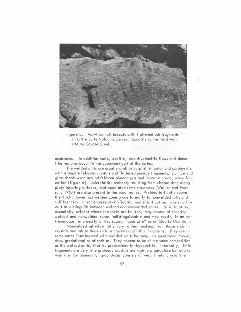
Figure 3. Ash-flow tuff breccia with flattened ash frogmenh in little Butte Volcanic Series. locality is the third weir site on Coyote Creek.
mudstones. In add ition basic, docitic, and rhyodacitic flows and domelike features occur in the uppermost part of the series .
The welded units are usually pink to purplish in color and porphyritic, with elongate feldspar crystals and flattened pumice fragments; pumice and glass shards wrap around feldspar phenocrysts and import a crude, wavy lineation (figure 6). Microfolds, probably resulting from viscous drag along platy layering surfaces, and associated romp structures (Wa lker and Swanson, 1968) are a lso present in the basal zones. Welded tuff units above the thick, lowermost welded zone grade laterally to nonwelded tuffs and tuff breccias. In some cases devitrification and silicifica tion make it difficult to distinguish between welded and nonwelded zones. Silicification, especially evident where the rocks are faulted, may render alternating welded and nonwelded zones indist inguishable and may result, in an extreme case, in a nearly white, sugary "quartz ite " as an Quartz Mountain .
Nonwelded ash - flow tuffs vary in their makeup from those rich in crystals and ash to those rich in crystals and lithic fragments. They are in some cases inter layered with welded units but may, as mentioned above, show gradational relationships. They appear to be of the some composition as the welded units, that is, predominantly rhyodac itic . Internally, lithic fragments are very fine grained, crystals ore mainly plagioclase but quartz may also be abundant; ground moss consists of very finely crystalline
87

T 28 S w
o ~miles B '------'
t7n
~ § -[;ill ~
CJJ
f
Upper Sardine Formation
Lower flowl tuth
Little Butte Volcanic Series
Colestln Formation
Post-andesite basalt f Colestin
andesite rhyadaclte
zones of alteration
landslide
contact
-~-- fault
- }-- fold aXIs (synclinal)
I" I" strike a dip; JOints - flow layerino
o 2 mil .. .... ' ~ ......... "'""-, -~-" Scol.
. , "~~"~"~" .
Plate 1. Geologic map of the South Umpqua Falls region, with index showing location of the map area . Shown also in the index are traces of axial planes of folds, taken in part from Peck and others {1964} .
88 89

Figure 4.
layeri ng in alternat ing we lded and nonwelded ash-flow tuff of Little Butte Vo lcanic Series. l ocality is ridge crest south af Quartz Moun ta in at an elevation of about 4400 feet.
Figure 5. ------l.~
Vesicular vitric ashflow tuff of the Little Butte Volcanic Ser ies; outcrop width approx imately 2 feet. local ity is along Buckeye Creek, just south of Jade Camp.

quartz-feldspar (potash-rich) or the material from which it has devitrified, that is, glass shards and ash fragments with abundant, finely divided iron oxides.
A series of flows and domes is found to overlie and to intrude compositionally similar tuffaceous rocks in the vicinity of Acker Rock (plate 1). The flows consist of thin (up to about 2 inches), platy, crystal-rich layers which grade to or interfinger with crystal-vitric, lapilli ash-flow tuff. One dome-like feature which underlies Acker Rock Lookout appears horizontally layered with a prominent sag toward the center similar to a small laccolithic intrusion (figure 7).
Sardine Formation
As pointed out by Thayer (1936), andesitic lavas are abundant in the Sardine Formation; perhaps a dozen vents of these flows and associated pyroclastics have been identified by Peck and others (1964). Two vents marked by andesitic plugs have been identified by Peck, one on Hershberger Mountain and the other on Rabbit Ears to the south and east of the area of this investigation. Peck also envisages a belt of volcanoes forming a northtrending mountain chain along the eastern margin of the Western Cascade Range; that flows and pyroclastic debris erupted subaerially over a surface of considerable rei ief is well established.
In the area of this report, Sardine flows unconformably overlie pyroclastic rocks of the Little Butte Volcanic Series. Two subdivisions have been made: an upper series which consists of layered hypersthene andesites; a lower series which includes flows of basalt, dacite-andesite, and subordinate pyroclastic deposits. The upper series is uniformly layered and appears to have erupted over a surface of moderate relief. The lower series is lithologically variable and erupted over a surface of considerable relief, filling great topographic irregularities cut in Little Butte and Colestin terrain. Mapping shows that dacitic flows of the lower series, nearly conformable with underlying rhyodacite tuffs of the Little Butte in certain areas, also overlap units of the Colestin Formation in the upper reaches of Zinc Creek in the southwesternmost part of the area. Although these dacitic flows may be compositionally similar to underlying ash-flow tuffs and tuff breccias of the Little Butte, they are interlayered with andesitic flows mapped by Peck and others (1964) as Sardine Formation. These same andesitic flows become increasingly abundant upward in the column and the whole sequence thickens eastward. For this reason, dacitic flows at the base of the sequence are considered Sardine Formation in th is paper (see figure 2).
Unlike older units, volcanic features are, in some places, readily recognizable within the Sardine Formation; glassy fissure flows can be traced to denser, finely crystalline plug-like masses of the vent phase. Locally, knobby, globular, and rubbly mound-shaped accumulations of dacitic and andesitic rocks are suggestive of spatter cones. Dacitic flows are observed
91

Figure 6. Photomicrograph, crystal-welded-tuffwith flattened glass shards in Little Butte Volcanic Series. Short field diameter is 2 mm.; plain light.
Figure 7. Acker Rack dome as viewed fram the sauth. Note the apparent flow layering and its inward dip ar sag .
92

to become rubbly and grade laterally to breccia which may in certain places be laharic. Basaltic to andesitic dikes and sills are in some places traceable to flows; other isolated intrusions within the underlying Little Butte may may represent fissures of eroded Sardine flows.
Structure
Structural data obtained during mapping indicate that the degree of angular discordance between eastward-dipping, north-trending Tertiary formations decreases upward. Rocks of the Colestin Formation rest with profound angular unconformity upon pre-Tertiary plutonic and metamorphic rocks. Pyroclastic rocks of the Little Butte Volcanic Series rest with angular discordance of as much as 20° upon rocks of the Colestin Formation near their mutual contact in the w~tern part of the area. Between Dumont and Boulder Creeks, for example, rocks of the Colestin Formation dip 35° eastward, whereas the immediately overlapping strata of the Little Butte dip only 15° in the same direction. There are certain cases, however, where the discordance is only apparent and is caused by post-Little Butte faulting. Although flows of the Sardine Formation cover extensive topographic irregularities cut in Little Butte and Colestin rocks, elsewhere their angular discordance with Little Butte rocks probably does not exceed 5° .
Structurally, the area of this investigation is situated just to the south of the hinge-area where predominantly northeast-trending regional foldaxes and faults swing north and northwest (plate 1). Structure contours on top of rocks of Eocene age (Peck and others, fig. 27, p. 42, 1964) show similar trends but with the reversal shifted south and passing through the mapped area. Folds and faults of strong northwest trend predominate in this area and appear to be superimposed on the general north-to-northeast trend of the range. One broad synclinal fold of strong northwest trend is traceable for a distance of at least 5 miles in Little Butte strata and may continue for another 4 miles, buried in part beneath relatively undeformed dacitic and andesitic lavas of the overlying Sardine Formation. Note as well that in the western part of the area folds and faults are generally of the same trend; there is a suggestion that vertical movement along steeply dipping northwest-trending fault planes and development of folds were complementary. Note too, that the Colestin-Little Butte contact is in several ptaces a fault contact. Minor folds and faults in relatively incompetent sedimentary and volcaniclastic strata of the Little Butte may have developed, in part, because of differential compaction; such folds and faults may simply reflect topographic irregularities in the more competent strata of the underlying Colestin Formation.
Ac know I edgmen ts
I should like to acknowledge all who helped in many ways during the
93

investigation. Of special mention is the financial support of the U. S. Forest Service, Pacific Northwest Forest and Range Experiment Station. The Oregon Department of Geology and Mineral Industries also contributed toward field expenses. The writer's wife, Dorothy, served as chief cook and bottle washer while the field work was in progress and his sons, David and Timothy, proved to be able field companions on numerous occasions.
References Cited
Peck, D. L., and others, 1964, Geology of the central and northern parts of the Western Cascade Range in Oregon: U.S. Geol. Survey Prof. Paper 449,56 p., with map, scale 1:250,000.
Thayer, T. P., 1936, Structure of the North Santiam River section of the Cascade Mountains in Oregon: Jour. Geology, v. 44, no. 6, p. 701-716.
Wal ker, G. W., and Swanson, D. A., 1968, Laminar flowage in a PI iocene soda rhyolite ash-flow tuff, Lake and Harney Counties, Oregon: U.S. Geol. Survey Prof. Paper 600B, p. 37-47.
Wells, F. G., 1956, Geology of the Medford quadrangle, Oregon-California: U.S. Geol. Survey Quad. Map GQ-89, scale 1:96,000.
Williams, H., Turner, F. J., and Gilbert, C. M., 1954, Petrography -an introduction to the study of rocks in thin sections: San Francisco, W. H. Freeman & Co., 406 p.
* * * * *
GEOLOGIC TIME CHART REVISED
A new, up-dated version of the Department's Geologic Time Scale is just off the press and is available free of charge. It incorporates new radiocarbon and potassium-argon dating for the stratigraphic divisions.
The old version of the time chart, prepared in 1961, has been reprinted so many times that we have lost count. Probably 10 or 15 thousand copies have been given out in letters and over the counter.
Like the old chart, the new version is printed on both sides of an 8~by 11-inch sheet. On one side is the Geologic Time Chart for the United States, listing the stratigraphic divisions, estimated ages of time boundaries, and dominant life through the ages. On the reverse side is a Generalized Time Chart for Oregon, outlining the principal geologic events from Devonian time to the present. Also delineated on the chart is the most recent information on what are the oldest rocks in Oregon, in North America, and in the world, as well as the age of the oldest known fossil. Information for the time charts has been adapted from the U.S. Geological Survey and from oth er sources.
* * * * *
94
CENTRAL OREGON GEOLOGIC MAP PUBLISHED
"Reconnaissance geologic map of the east half of the Bend quadrangle, Crook, Wheeler, Jefferson, Wasco, and Deschutes Counties, Oregon," has been publ ished by the U. S. Geological Survey as Misc. Invest. Map 1-568. The author is Donald A. Swanson.
First issued in 1968 as an open-file report, this map is now in revised form and in full color, at a scale of 1 inch equalling about 4 miles. The map, cross sections, explanation, and other data are printed on a sheet 30
by 40 inches. The area covered by this map extends from 440 to 450 lat. and 1200 to 121 0 long., encompassing sixteen 15-minute quadrangles and including the towns of Prineville, Mitchell, Fossil, and Antelope. In this broad, anticlinal region are exposed Cretaceous and pre-Cretaceous rocks, Clarno and John Day Formations, Columbia River Basalt, and younger Cenozoic volcanic and sedimentary rocks. Over the years, a number of geologists have mapped portions of the region, and some of their work was used by the author in prepari ng the present map.
Map 1-568 is for sale by the U. S. Geological Survey, Federal Center, Denver, Colo. 80225. The price is $1.00.
* * * * *
QUADRANGLE MAPS WITHOUT CONTOURS AVAILABLE
The U.S. Geological Survey is running a special printing of certain of the topographic quadrangle maps without the contours and woodland areasshown. Such a map is particularly useful in situations where only the roads, towns, and other planimetric features are needed. In order to know which of the Oregon quadrangles are issued in this form, request a free copy of the latest "Index to Topographic Maps of Oregon" from U. S. Geological Survey, Federal Center, Denver, Colo. 80225. Maps without the contours are indicated on the index by a special symbol.
* * * * *
ARCHAEOLOGY BIBLIOGRAPHY COMPI LED
"A bibliographic guide to the archaeology of Oregon and adjacent regions," by LeRoy Johnson, Jr., and David L. Cole, has been published by the Museum of Natural History, University of Oregon, Eugene 97403. The bibliography has been issued as a Special Publication and is available from the Museum for $2.00. It contains a list of 447 references which are keyed to a subject guide and area map.
* * * * * 95

IT'S NOW OR NEVER FOR SOME DEPARTMENT BULLETINS
The Department's bulletins go out of print all too quickly, mainly because only a limited number (1 to 2 thousand) can be issued. Many of these outof-print items are in great demand. Although the Department would like to be able to reprint them, the process is too much of a drain on its meager publications budget, which is allocated instead for the publishing of current investigations on geology and mineral resources in the State.
Some of the bulletins that will soon be out of print are listed below. In most instances the supply is quite low, and so persons wishing copies should place their orders as soon as possible before the stock is exhausted.
Bulletin 26: Soil - its origin, destruction, and preservation; by W. H. Twenhofel (1944),47 p., 30 photos _____ Price 45 cents
Bulletin 35 (revised edition): Geology of the Dallas and Valsetz quadrangles, Oregon; by E. M. Baldwin (1963) (includes colored geologic map) 56 p., illus.- __________ Price $3.00
Bulletin 36: Papers on foraminifera of the Tertiary of western Washi ngton and Oregon; by Cushman, Stewart, and Stewart Vol. I. (1946) (includes photographic plates) 119 p. _ Price $1.00 Vol. II. (1949) (includes photographic plates) 208 p. __ Price $1.25
Bulletin 37: Geology of the Albany quadrangle, Oregon; by loS. Allison (includes colored geologic map) (1953) 18 p. Price $.75
Bulletin 46: Ferruginous bauxite deposits in the Salem Hills, Marion County, Oregon; by R. E. Corcoran and F. W. Libbey (1956) 53 p., photo, geologic map- - - - - - ______ Price $1.25
Bulletin 49: Lode mines of the central part of the Granite Mining District, Grant County, Oregon; by G.S. Koch, Jr. (1959) 49 p., photos, mine maps _______________ Price $1.00
Bulletin 52: Chromite in southwestern Oregon; by Len Ramp (1961) 169 p., photos, mine maps, geologic maps ________ Price $3.50
Bulletin 58: Geology of the Suplee-Izee area, Crook, Grant, and Harney Counties, Oregon; by W. R. Dickinson and L. W. Vigrass (1965) (includes colored geologic maps) 109 p., photos, checklists of fossils __________________ Price $5.00
Two supplements to the Bibliography of Oregon Geology and Mineral Resources are still in print:
Bulleti n 33: Supplement for the period 1936-1945 _______ Price $1 .00 Bulletin 53: Supplement for the period 1951-1955 _______ ..Price $1.50
* * * * *
96

AVAILABlE puBLICATIONS
(PI ... Incl",de remittance wIth order. PostGge free . All fIOl. ere Anol and no material b retlJmoble . Upon request, 0 complete lI.t of tne Deprnment's pubitcottOl'l$, IneludifIQ those no longer in print, will he moTted.)
BULLETINS
2. ProoriIIs report on Coot; Bay coal Reid, 1938: Ubbey • • • • • • • S. FeasibtUty of ateel plant In low .. Columbfo IUver oreo, 1eY.194O; Miller
26. Soli. Its ortgln, dt:stNctlon, preteI'YOtlon, 1944: Twenhof.l . • . • • 33. B1bI~ (1st supplement) of geology ond mlnerall'CllOYf'Ce$ of Oregon,
19.41:· Allen . • • • • • • • • • • • • • • • • • 35. Gootow of Dclilos and Voisel% quodI'qlas, Oregon,I'8V. 1963: Baldwin 36. Vol. t. five papws on western Oregon Tertiary fotomInIfero. 1947:
CUIItman., Stewart. 0IId S'-ort • • • • • • • • • • • • Vol. 2. Two pGPm on fotominifero by Culhmon, Stewort, and ShHlort, ond
one paper on mollU:tC:Q (Inc! mlc:rofaIna by Stewart and Stewcri. 1949 37. Geology ohhe Albmy quodronole. ONgOn, 1953: Alltton • • • • • 46 . Farruginow bowIito deposJb. .. SCllem HIIII~ Marlon County. Oregon, 1956;
CorcOf'Oll and ~ • • • • • • • • • • • • • • 49. lode .lnas, GrCInIte mini", dls!'. ~ Grant County, Ore. , 1959: Kodt. .52. Chromlto In SOIJtbwestern Oregon, 196h Ramp • • • • • • • • 53. BiblIography (3i'd suppl .... n.t) of the geology and mineroll'eSO\lf'C$l of
Oregon, 1902: Steere and Owen • • • • • • • • • • 56. FourtoIInth blenniolreport of the SkIte Geologfl", 1963006.4 • • • • 57. Lumr Geo~ical Freid COnfer_ 9'l1de book, 1965: Peterson ard
Grdt. edrfOrs • • • • • • • • • • • • • • • • • 58. GeolOgy of tne Su,te&-lzee:.area, ar.son, T965r Dicki...on and Vigrass • 60. Eng''""'"'''' seology of the Tualatltl Volley region, Oregon, 1967:
Schlldeer and Deaaon . • • • • • • • • • • • 62. And.lto Conference Guidebook, 1968: Dole, editor • • • • 63. SfxtMnJh Btenatal Repa!t of the State GeoIoattt, 1966-68 64. Mineral and water 1'8IOW'C. of Oregon, 1969 • • • • • • 65. Proc.edings af the And.Ite Conference, 1969l McBtmey, editor
66. R~ ~ and mInerOI resources, _fern Klamath County .. western Lake CoUnty, ClfIfIGOn, 197O! ~ & Mcintyre
GEOLOGIC MAPS
Geologic: map of Oregon 02.M x 9"), 196~ Walker Gnd KII'ISJ • • • • • • I'felknlnary oeologic map of Sv ... quodrongl., 1941. Pardee and others • • Geolog1e mop of Albany quadrongI., Oreaon, 1953l Allrson (alsa in Sull. 37) • GaotOgic IIlCIp: of GolTce quadrongle, Oregan, 1953; Well. and Wollatr • • • Geotogfc.map of l..ebonon ql.lOclrGngf., Oregon, 19S6! Allban CIfICI Felb. . • • Geologic map of a.nd quadrangle, and recGMaJssmce geologic tnap of '*'trol
portIon, Htgh Coseade Mounted"" Oregon,1957: WillIams • • GMS-l: GeoIoQic map of the SpGI'tc quadrangle, Otegon, 1962: Prortkct • • GMS-2: GJo)ogtc map, Mitchell 1I!JtHI quod., Oregon, 1962: Corcoran e' 01. GMS-3! PreUmlnary~cmap, IbkeequQd., Oregon, 1967: f'Iooatka •• GeologIc map Of Oregan west of 121st merldlarn (over the eountar) • • • •
folded In envelope, 52.IS; rotted fn map tube, $2.50 • • • • Gravity mapI of Oregon, onshore and ofWIOre, 19411 [Sold only Tn set]: flot •
folded: In erwelQPO, S2.25; roIlec:I In map tube, $2 .50 • [Continued on bac:k eovw]
$ 0.\5 0.40 0." 1.00 3.00
1.00
1.25 0.75
1.25 1.00 3."
I." " .. 3." 5.00
5.00 3." ., .. I. .. 2.00
3.75
0.25 0.40 0." 1.00 0.75
1.00 I." 1.50 I. .. 2.00
2.00

!he ORE liN 1069 State Office Bldg •• Portland, 0Ng0n 97201 The Ore Bin POSTMASTER: htum poItC:Ige gucl'an .....
A".II.bl. Publlcotlon., C.nllnued:
SHORT ......
2. tncbtrkll aIumI_, oi!rl_aney, If*- MDb •••••• 18 ltodIoactl.,. . neraI ..... pi I P' loo .. hovld Icnow (2nd NY.), I~
Wid .. and Schar.- • • • • • • • • • • •• • 19. .Ick and tUllntIusIry In Or .... 1m Allen and MDIon. • • 20. 01_ fro. Or-.on voIc.tIc ,I •• 1950: .JacobI. • • • • • 21. Lltlhtw"Fi ...... IncMtry In Oregon, 1951· Malon . • • • 23. 0Ng0n lOng .... ,.., Jefhnon County, 1'fIQ lMey and Corcoran. 24. The AI ..... iNne, JoMphlne County, 0Nrg0n, ."71 Uw.y • •
MISCELLANEOUS 'APUS
.s 0.10
0.30 0.20 0.20 0.25 1.00 2.00
1. o.c:rlptlofa of _ 0,.... rocb .... fill,..., 1950: Dol.... . . . 0.40 2. K.ytoOragonIlll ........... nap.1951 Mc.on • • • • • • • 0.15
0Nt0n MlrwraI.,.. map (22" x 34"), NY. 1958 (In M.P.2 far key). 0.30 3. Fach about to.It. CNsdnll), 1953 . • • • • • • • • • • • 0.35 .f. RuI .... reguJatl_ for ~ of oU and noIvrGI .. (rev. '''2) 1.00 5. er.n .. gold plac .. t.lntI). 19$4. • • • • • • • • •• 0.25 6. OIl_ .. ..,toraKon In Chgon, NY. 1965: 5tew.t arid ~ • 1.50 1 .... ......, of'" on ClNgDn .... , 1959: Schhct.r. • • • 0.50 1. (SuppI._II)lIbIfcvaphyof ..... , 1959toDK.31, 1965: ....... .. 0.50 8. AvCIIiGIH ........... 01 ofl & .. ..,ao.oIloft In Ongon, NY. '63: Newton. 0.50
11. A calrectf ... of «tiel. on IMteorita, I. (Npr""', "".0. liN) 1.00 12. .... to ,.. ...... .-1ogIc ...... ,.1" Cretan. 1_ c:oreo.-. . . . Free
MlSC£UAN£OUS fUIUCATIONS
Onrton .. leWl .. kIcaIIltf ... (22" x 34-), 1946 • • • • LanIIor .. 01 ar.,on: • phyIla",.lIc .ac.tch Or- x 22"), lM1 .... 10 tapD",ophlc...,rna In 0Npn, 1968 • GIIoIotI1c tf .... d!ort for 0Np, 1"1. • • • • • • • •
OIL ... GAS INVESTIGATIONS SEllES
1. Petrol.,... aeoI. of .... weltwn Snab...,., balin, ONgoft-kWto, 1963.
0.30 0.25 .... ....
"""tan ... earcor... • • . . • • . . . • . . .• 2.50 2. w.un.c. ..... of'" low .. c:oaua.I ... WI ............. , Ongon.
19'69: Nwlol'l . • • • • • • • • • • • • • • •• 2.50