virginia frog and toad survey training manual
TRANSCRIPT

VIRGINIA FROG AND TOAD SURVEY
TRAINING MANUAL
Photo by John White
Virginia Department of Game and Inland Fisheries

North American Amphibian Monitoring Program

Virginia Frog and Toad Survey
TRAINING MANUAL
Virginia Department of Game and Inland Fisheries Wildlife Diversity Division
Nongame & Endangered Wildlife Program
Funding assistance from U.S. Environmental Protection Agency (EPA) Regional Environmental Monitoring and Assessment Program (R-EMAP)
January 2002 Prepared by: Mary Keith Garrett, NAAMP Assistant State Coordinator Edited in 2006 by: John (J.D.) Kleopfer Virginia Department of Game and Inland Fisheries P.O. Box 267 Barhamsville, Va. 23011 (804) 843-5967, email: [email protected]

Table of Contents
Introduction………………………………………………………….. 1
Preface and Inventory of Package………………………………... 2
Common Names of Virginia’s Frogs and Toads ………………... 3
Table 1. Common Names………………………………………….. 4
Physiographic Regions of Virginia………………………………… 5
Map 1. Physiographic Regions……………………………………. 6
Where To Find Them Discussion…………………………………. 7
Table 2. Where To Find Them…………………………………….. 8
Species List Form Discussion……………………………………... 9
Form 1. Species List………………………………………………... 10
Preparing For the Field…………………………………………….. 11
Site Description Form Instructions………………………………… 12
Form 2. Site Description……………………………………………. 14
Survey Protocols……………………………………………………. 15

INTRODUCTION
Why study frogs and toads? Observers around the world have become concerned about the population declines and mutations of a number amphibian species. Scientists have established that habitat loss, exposure to contaminants, ultraviolet radiation, introduced species, parasites and fungal diseases are some of the factors identified as influencing amphibian declines. When long-term standardized monitoring data are collected, the pattern of anuran stability or decline can be established. If a decline is observed, we can focus our resources on the causes and work to reverse them. Amphibians are especially vulnerable to environmental quality due to their highly permeable skin that allows for both breathing and drinking. Most other terrestrial vertebrates have a protective, impermeable skin. Due to this vulnerability, amphibians can function as an “early warning system” or indicator of inhospitable changes in their immediate habitat. Frogs and toads were chosen as the study species because they vocalize during breeding season. An observer is able to determine the species by their call and get an index of how many are present by the number of calls of the same species heard at the same time.
What is the State of Virginia doing? Virginia has twenty-five species of frogs and toads throughout the diverse habitats from coastal plain to high mountains. It is important that we establish the current species distribution and relative abundance of our anuran resources so we might monitor their changes in the future. The Wildlife Diversity Division of the Virginia Department of Game and Inland Fisheries (VGDIF) participated in the 3-year pilot program with the North American Amphibian Monitoring Program (NAAMP). We have completed the pilot programs to establish final protocols and have begun data entry into the international database system. Our pilot volunteers have done a wonderful job! We became fully operational in year 2002 with enough volunteers for the 50 NAAMP randomly chosen sites and an additional 50 semi-random sites that insured full coverage for the state. The outstanding response of Virginia’s citizens to volunteer for the frog and toad monitoring program has insured its success. In the following pages you will review all the instructions for establishing your routes and sites, completing your site description forms and maps, conducting your surveys under the proper conditions, recording your data, and reporting your results. We look forward to an extraordinary year! Thank you for your time and commitment.
Preface
You are now part of an international monitoring program designed to watch for trends in anuran populations. The data you collect from your route will be entered into the master North American Amphibian Monitoring Program (NAAMP) database and can be accessed by amphibian specialists around the world as well as interested citizens like yourself. It will take years of data to confirm trends and we hope you will be able to continue your route for a number of years. So now you have it, this manual and a package of many things to be returned and used during your monitoring.
Inventory of Your Start-up Package Items for You to Keep: 1. One book; Atlas of Amphibians & Reptiles in Virginia (Atlas) by Joseph C. Mitchell and
Karen K. Reay, to determine which frogs have been found in your vicinity 2. One cassette tape: The Calls of Virginia’s Frogs, Voices of the Night: The calls of the
Frogs and Toads of Eastern North America, produced by The Library of Natural Sounds, Cornell Laboratory of Ornithology, 1996.
3. One copy of a map of your route with start point indicated 4. One Fahrenheit thermometer to check temperature at each stop during survey 5. One reflective vest, to be worn when conducting surveys 6. One letter serving as explanation of your activities…just in case the authorities should
question why you are parking on the side of the road 7. One VOLUNTEER poster to put on your dashboard when you leave your vehicle during
survey Items for You to Return:
Upon completion of surveys 1. Completed Site Description Forms. Make copies for your files and return originals. 2. Completed data forms of your actual surveys. You will make copies for your files and
return the originals. 3. One copy of your route map with your chosen listening sites indicated.
Common Names Virginia’s Frogs & Toads
Common names have been a source of confusion for many years. A national naming convention has now established the specific common name for each species. The list in Table 1, titled “Common Names of Virginia’s Frogs and Toads” constitutes the corrected common names. When doing research, confirm the scientific name since these common names may refer to a different species in a different part of the country or a different species in older literature. Additional confusion is found with the sub-species. The taxonomists are still arguing the status of many of them and in their efforts to separate the sub-species; qualifiers have been added to the common names. Examples of these qualifying names found in Virginia’s frogs and toads are “Eastern, Southern, and Northern”. NAAMP has decided not to incorporate the sup-species as they are usually geographically separated and more importantly, their calls are too similar to distinguish. This list in Table 1 is the current “official” list that is to be used when recording data for your route surveys.
It is important that you correct the common names in your Atlas of Amphibians & Reptiles in Virginia book. Eastern Cricket Frog, Acris crepitans on page 27 is now Northern Cricket Frog Coastal Plain Cricket Frog, Acris gryllus on page 27 is now Southern Cricket Frog Eastern American Toad, Bufo Americanus on page 28 is now American Toad Southern Green Frog, Rana clamitans on page 36 is now Green Frog Northern Spring Peeper, Pseudacris crucifer on page 34 is now Spring Peeper You may abbreviate the names but it is most important that you retain the first letters to insure that the proper species is recorded and that you can find it in the alphabetical listings in the master database. The Cricket Frog can be E cricket frog, CP cricket frog or Unk cricket frog. The Bullfrog will be listed in the national database Alphabetically under the “A’s” for American…you should record this species as “A Bullfrog” The Green frog is easily confused with the Green treefrog on your data sheets. Review your entire list for appropriate abbreviations if you choose to use them.
Physiographic Regions of Virginia With NAAMP Assigned Route Numbers and Locations
The 2006 Frog and Toad Route Map (www.dgif.virginia.gov/wildlife/frogsurvey) illustrates Virginia’s physiographic regions that are part of the entire North American continent map prepared by NAAMP. You will notice that it is different than the one published in the Atlas. Locally, it appears that our frogs don’t pay much attention to any of these lines. The importance can be seen when analyzing data on a much broader scale than our single state of Virginia. When the entire East Coast is reviewed for the species composition and relative densities of the frogs and toads, the physiographic regions can help establish the species’ preferences or tolerances for such parameters as temperature, altitude, annual rainfall, etc. This information is encoded with the physiographic boundaries in the master database and will be used when analysis is conducted. NAAMP Assigned Route Numbers Routes have been randomly generated throughout North America. The routes shown on the 2006 Frog and Toad Route Map are a specific 50 points within the stratified block design from the national grid produced by NAAMP. Those routes assigned by counties will receive their NAAMP route numbers after the sites have been established. They will be looked at as a modified random set in addition to the previously established grid. Each set of data will be analyzed using different statistical bases. Find Your Route Starting Point (2006 Frog and Toad Route Map) and Know Your Physiographic Region Number Your route starting point is used to determine which sampling windows (dates and conditions) you will use to conduct your surveys. Window #1 includes Physiographic regions 1 and 2. They have earlier start dates than Window # 2, which is Physiographic region 3, because of colder temperatures. If your route falls between the break for the two windows, choose the one in which your starting point falls (where your route begins) and include it on your species list form.

Virginia Frog and Toad Survey
FIELD INSTRUCTIONS AND INFORMATION
Photo by Bob Greenlee
READY TO RIBBIT!
Virginia Department of Game and Inland Fisheries

Preparing for the Field
Two types of routes are assigned; 1) the NAAMP numbered and named routes with starting points and full maps attached and 2) Starting points randomly assigned within each county (The volunteer will provide the maps when route is established). With the exception of the maps, all protocols are exactly the same for both route assignments. Review the Site Description Form and Instructions on the next page Study your maps or the roads associated with your starting points Things to remember • You will locate 10 sites spaced no closer than 0.5 mile apart. (as the crow flies) • Each site will be geographically sequential.(site 2 will follow 1,etc on the route) • You will try to locate a variety of wetland habitats along your route • You will avoid noisy locations; hi-traffic areas, dogs, fast moving water, livestock • You will avoid dangerous parking areas • You will avoid private property without proper written permission • You will introduce yourself to the neighbors and explain your activities (they will stop to see
if you need help at night) You will establish your route and all stops during the daytime, however you will find that trying to follow your route at night is very difficult. Many volunteers conduct a practice run before actual data collection. You can become secure in finding each site and practice identifying the calls. Study your Beaufort Wind Codes and Sky Codes (found in following pages) and practice establishing conditions. Listen to your frog calls. Many volunteers make their own tapes of frogs and toads found in their regions and test themselves without narration.
Instructions for Completing Site Description Form Use sharp pencils…do not use ink. Observer: That’s you…the one who goes into the field and actually does the listening Route #: The number that was attached to the route your chose or as assigned by the State Coordinator if you selected a route not previously established. Route name & County/City: The State Coordinator has named Each Route as well as numbered. Insert the route name then the county or city that your route starts in. Use the largest governmental unit at your starting point: if you start a route near Richmond, you would put in Henrico County. If you start a route near Virginia Beach, you would put in Virginia Beach because no county is associated with that region. Date: The date that you complete the form Site #: You will locate a total of ten sites. Sites will be geographically sequential. Your first site will start at your assigned point (or as near as noise levels and habitat will allow). The next site will be # 2 as you move through your route, do not place them out of order and do not back up on your route to install another site. If you want to add a location in the middle of previously described sites, change the site numbers so that you will drive from 1 to 2… sequentially through all 10 sites. Name of Road/Hwy #: Write in both road designations when possible i.e. Marsh Rd, Hwy # 642 Nearest intersection: NSEW: Circle the direction of the nearest intersection from the site you are describing. In the line below, write in the name of the intersecting road. Distance in tenths: How far is the nearest intersection from your site? Watch your car odometer and write in the distance in tenths of miles. Distance to next site: With vehicle odometer, calculate the distance to the nearest 10th of a mile to the next site. Latitude and Longitude: If you have access to a Geographic Positioning System (GPS) unit of your own or borrowed, take a reading at your site. If a GPS is not available to you, you can get a good estimate from most of the newest road maps or a USGS Quadrangle for your area. Circle which method you used to derived your lat/long. (GPS or estimate). If neither method is available to you, your State Coordinator will complete this information.

Site form instructions, page 2 Inside the Black Box Land use: What we are looking for are any activities in the surrounding area that may impact the limited, specific habitat of the frogs and toads. You may have a natural stream running through pastureland…you would circle GRAZED. You may have a large irrigation pond inside cropland…you would circle CROPS. You may have a depression in a relatively undisturbed rocky slope…you would circle NATURAL. If you had a temporary stream running through a ribbon of bottomland forest, surrounded by houses…you would circle FORESTED with a note after OTHER stating the residential use around the forested waterway. Habitat: Where might your frogs and toads hang out? Feeding, cover and reproductive sites are encompassed in a limited area. Water is a critical element in reproduction…even the temporary ponds after ice melt or heavy rainstorms. The next four lines describe different types of water, its longevity and its movement. You will circle more than one element, i.e.: you may have a SEASONAL, QUIETLY MOVING CREEK channeling through a SWAMP. Make additional NOTES below to insure third party understanding. Dominant vegetation: The vegetation provides the location for feeding and cover. Review the area that may serve as the reproductive site and the immediate vicinity. Is there any vegetation associated with the water? If so, is it aquatic, staying below the surface of the water SUBMERGENT, or does it grow on top of or through the surface of the water, EMERGENT. Identify the two or three dominant species of plants to the best of your ability in each of the three groups; herbaceous, shrub and tree layers. The diameter of the trees will indicate their age and the last time they were removed (by natural flooding, fire or timbering) Ground surface cover: This is one more parameter of the anuran’s habitat. You may have a wet meadow with STANDING WATER or a swamp run with SILT, maybe a depression in BEDROCK. Describe your site using the stated options and add notes as needed under OTHER. Make a copy of completed forms for your records. Return the originals with your maps (marked with site numbers) and surveys…no later than August 1st. Note: Some tiny modifications were made to this form after the ones printed for your package. Please review the copy in this training manual. It is the corrected copy. Add any missing information on the forms you return.

Survey Protocols
Route Creation Routes have been generated by either a stratified random block design established by NAAMP or semi-random blocks by VDGIF Wildlife Diversity Division for the purposes of completing state coverage. You will find your route assignment maps enclosed All of these routes will be entered into the international database. It is important that all protocols for site placement are followed with great precision. Placement of Sites Along Routes You have a new route that has never been run. The starting point has been randomly selected by computer and now you must establish 10 stops. The listening sites need to be set along your route during a late winter/early spring day to locate potential amphibian breeding areas that are within 200 meters of the road.
If the starting point is a potential amphibian-breeding site, then, that is Stop # 1. If not, then travel along the marked roads (or roads in your county) until a potential breeding site is found, this would be Stop # 1. Complete your site form for site #1 and mark your map. To find Stop # 2, look at your car odometer and travel 0.5 miles. After traveling 0.5 miles begin looking for the next appropriate potential breeding site (which could actually be right there at this point); that becomes Stop # 2. Continue until all 10 stops are in place, fully described on your site forms, and accurately marked on the map.
Watch corners, curves and switchbacks in the roads…you may have traveled ½ mile on your car odometer but only be 0.3 of a mile from the previous site as the crow flies. Have a scale or measuring device with you to insure that the minimum distance is maintained across country.
Complete all forms in sharp pencil…do NOT use ink
These sites will be “cast in stone!”, entered into the national computer database and will be followed by you or your successor for many years to come. An extreme safety consideration is the only reason a site would be relocated. (See the section on Stop Inaccessibility, Relocation and Retirement)
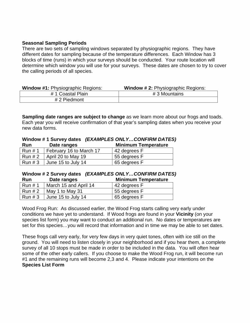
Seasonal Sampling Periods There are two sets of sampling windows separated by physiographic regions. They have different dates for sampling because of the temperature differences. Each Window has 3 blocks of time (runs) in which your surveys should be conducted. Your route location will determine which window you will use for your surveys. These dates are chosen to try to cover the calling periods of all species. Window #1: Physiographic Regions: Window # 2: Physiographic Regions:
# 1 Coastal Plain # 3 Mountains # 2 Piedmont
Sampling date ranges are subject to change as we learn more about our frogs and toads. Each year you will receive confirmation of that year’s sampling dates when you receive your new data forms. Window # 1 Survey dates (EXAMPLES ONLY…CONFIRM DATES) Run Date ranges Minimum Temperature Run # 1 February 16 to March 17 42 degrees F Run # 2 April 20 to May 19 55 degrees F Run # 3 June 15 to July 14 65 degrees F Window # 2 Survey dates (EXAMPLES ONLY…CONFIRM DATES) Run Date ranges Minimum Temperature Run # 1 March 15 and April 14 42 degrees F Run # 2 May 1 to May 31 55 degrees F Run # 3 June 15 to July 14 65 degrees F Wood Frog Run: As discussed earlier, the Wood Frog starts calling very early under conditions we have yet to understand. If Wood frogs are found in your Vicinity (on your species list form) you may want to conduct an additional run. No dates or temperatures are set for this species…you will record that information and in time we may be able to set dates. These frogs call very early, for very few days in very quiet tones, often with ice still on the ground. You will need to listen closely in your neighborhood and if you hear them, a complete survey of all 10 stops must be made in order to be included in the data. You will often hear some of the other early callers. If you choose to make the Wood Frog run, it will become run #1 and the remaining runs will become 2,3 and 4. Please indicate your intentions on the Species List Form
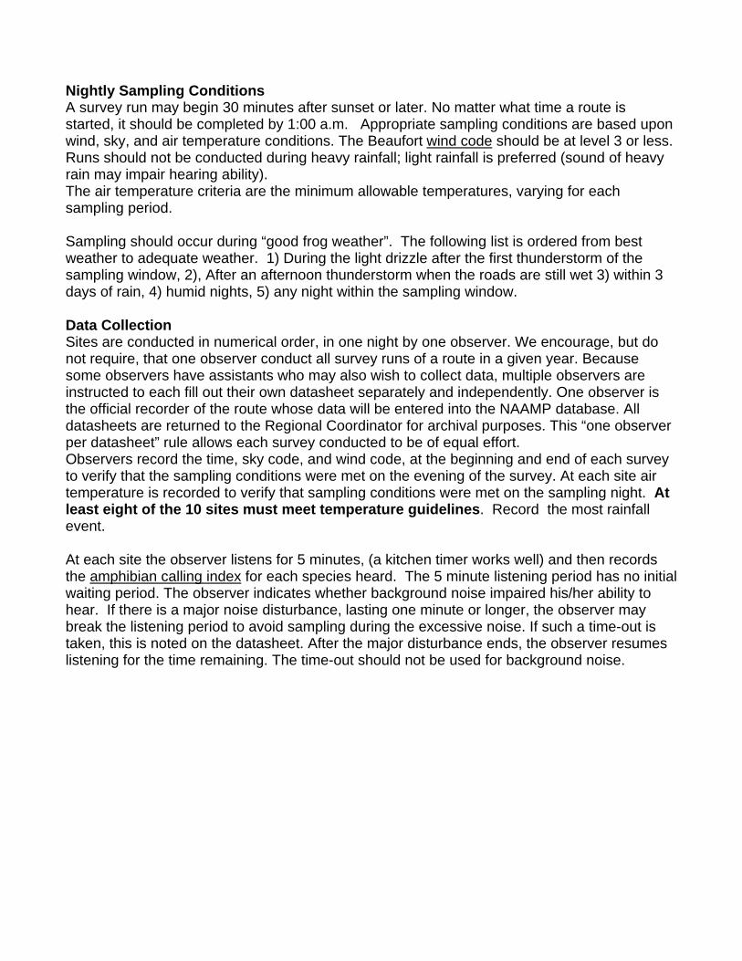
Nightly Sampling Conditions A survey run may begin 30 minutes after sunset or later. No matter what time a route is started, it should be completed by 1:00 a.m. Appropriate sampling conditions are based upon wind, sky, and air temperature conditions. The Beaufort wind code should be at level 3 or less. Runs should not be conducted during heavy rainfall; light rainfall is preferred (sound of heavy rain may impair hearing ability). The air temperature criteria are the minimum allowable temperatures, varying for each sampling period. Sampling should occur during “good frog weather”. The following list is ordered from best weather to adequate weather. 1) During the light drizzle after the first thunderstorm of the sampling window, 2), After an afternoon thunderstorm when the roads are still wet 3) within 3 days of rain, 4) humid nights, 5) any night within the sampling window. Data Collection Sites are conducted in numerical order, in one night by one observer. We encourage, but do not require, that one observer conduct all survey runs of a route in a given year. Because some observers have assistants who may also wish to collect data, multiple observers are instructed to each fill out their own datasheet separately and independently. One observer is the official recorder of the route whose data will be entered into the NAAMP database. All datasheets are returned to the Regional Coordinator for archival purposes. This “one observer per datasheet” rule allows each survey conducted to be of equal effort. Observers record the time, sky code, and wind code, at the beginning and end of each survey to verify that the sampling conditions were met on the evening of the survey. At each site air temperature is recorded to verify that sampling conditions were met on the sampling night. At least eight of the 10 sites must meet temperature guidelines. Record the most rainfall event. At each site the observer listens for 5 minutes, (a kitchen timer works well) and then records the amphibian calling index for each species heard. The 5 minute listening period has no initial waiting period. The observer indicates whether background noise impaired his/her ability to hear. If there is a major noise disturbance, lasting one minute or longer, the observer may break the listening period to avoid sampling during the excessive noise. If such a time-out is taken, this is noted on the datasheet. After the major disturbance ends, the observer resumes listening for the time remaining. The time-out should not be used for background noise.
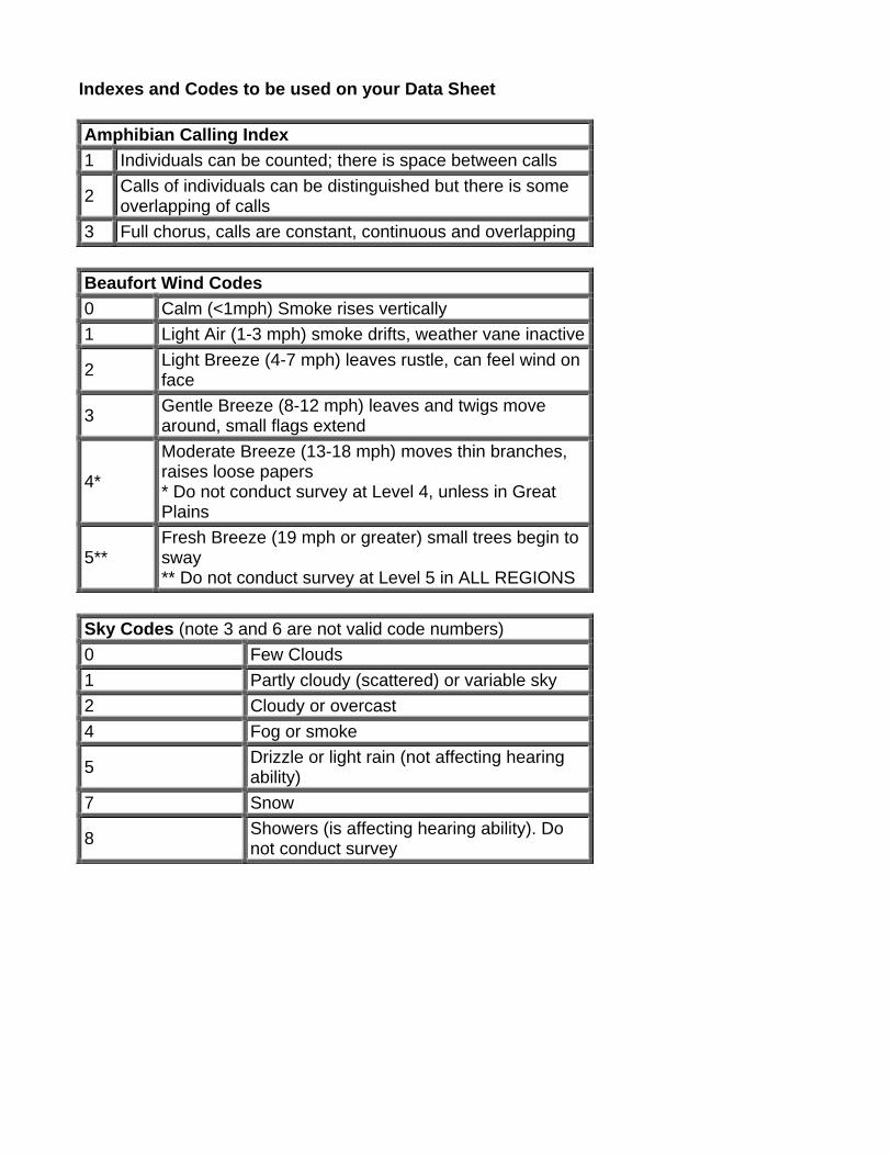
Indexes and Codes to be used on your Data Sheet Amphibian Calling Index 1 Individuals can be counted; there is space between calls
2 Calls of individuals can be distinguished but there is some overlapping of calls
3 Full chorus, calls are constant, continuous and overlapping Beaufort Wind Codes 0 Calm (<1mph) Smoke rises vertically 1 Light Air (1-3 mph) smoke drifts, weather vane inactive
2 Light Breeze (4-7 mph) leaves rustle, can feel wind on face
3 Gentle Breeze (8-12 mph) leaves and twigs move around, small flags extend
4*
Moderate Breeze (13-18 mph) moves thin branches, raises loose papers * Do not conduct survey at Level 4, unless in Great Plains
5** Fresh Breeze (19 mph or greater) small trees begin to sway ** Do not conduct survey at Level 5 in ALL REGIONS
Sky Codes (note 3 and 6 are not valid code numbers) 0 Few Clouds 1 Partly cloudy (scattered) or variable sky 2 Cloudy or overcast 4 Fog or smoke
5 Drizzle or light rain (not affecting hearing ability)
7 Snow
8 Showers (is affecting hearing ability). Do not conduct survey
Site Inaccessibility, Site Relocation, and Site Retirement
1. Site Inaccessibility: Temporary site inaccessibility may occur for some transient reason (i.e. traffic accident blocks road access).
a. If only one site will be missed, then route can be considered complete. The observer should write on the datasheet which site was missed and note why in the Additional Notes section. When entering the data into the database, mark the checkbox indicating which site was missed.
b. If more than one site would be missed, the route should be re-run on another night.
2. Site Relocation: Site relocation can occur when a site needs to be shifted to a new location, after you have established and described your sites (groundtruthing). Site relocations should be a rare event.
a. Site relocation should only occur for safety reasons (i.e. route was safe before, or appeared to be, but perhaps a homeowner fired a gun in the air as warning to observer).
b. Sites should NOT be relocated because of habitat loss or lack of calling amphibians at the site.
c. To relocate (for safety reasons) a site, the Regional Coordinator should use their best judgment on when it is necessary and where to relocate. If it can be moved a short distance away, not impacting the 0.5 mile apart rule this is preferable. If that is not possible, then relocate by creating a new site at the end of the route and renumbering all the sites. Keep a written record of when, why, and how a site relocation occurred. If time permits we will build into the database a checkbox or someway to indicate that a route has had some post-groundtruthing alteration. When data are analyzed all the sites of a route are considered one unit (the route), so it is okay that the individual sites are renumbered.
3. Site Retirement: Once the route has been groundtruthed and listening stations established, these locations are permanent and locations may not be changed unless a safety issue arises. If habitat destruction occurs at a listening station, and a local extinction of amphibians occurs, this is important information. To document habitat destruction the location should be surveyed for three seasons beyond the destruction date. After three seasons of non-activity, the listening station may be retired, and null data will be assumed for this site. A listening station cannot be retired merely because the wetlands are uninhabited by anurans. Retired sites should be visited periodically to verify that no suitable habitat exists, but 3 runs and five minutes of listening is no longer required.
Data Entry For those of you that have access to a computer, data entry instructions will be provided later this summer. In all cases, the original data forms will be returned to the State Coordinator for archival storage.