vinalhaven - umaine.edu · article from the working waterfront written by phil crossman january 20,...
TRANSCRIPT
Vinalhaven
This presentation was prepared for Vinalhaven under award CZM NA16NOS4190118 to the Maine Coastal Program from the National Oceanic and Atmospheric Administration, U.S. Department of Commerce. The statements, findings, conclusions, and recommendations are those of the author(s) and do not necessarily reflect the views of the National Oceanic and Atmospheric Administration or the Department of Commerce.
Facing the Facts, Planning for Resilience

Presentation Overview
• Island Overview
• SLR Committee
• Vulnerability Study
• Design and Resiliency Team
• Next Steps

Island Overview
• 1,200 Year-round, estimated 5,000 during peak summer
• Lobster Economy - Top 3 port for landings (value), over 10%
•
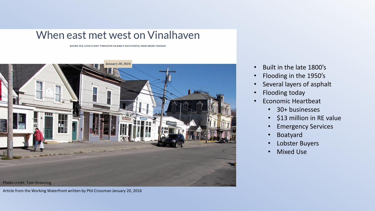
• Built in the late 1800’s• Flooding in the 1950’s• Several layers of asphalt• Flooding today• Economic Heartbeat
• 30+ businesses• $13 million in RE value• Emergency Services• Boatyard• Lobster Buyers• Mixed Use
Photo credit: Tom Groening
Article from the Working Waterfront written by Phil Crossman January 20, 2016

SLR Committee
• To assess and understand the threats posed by SLR, storm surge, and other flooding events and inform Vinalhaven about the actions necessary to become more resilient.

Broad Impacts
• Economy
• Emergency Preparedness
• Social
• Land Use
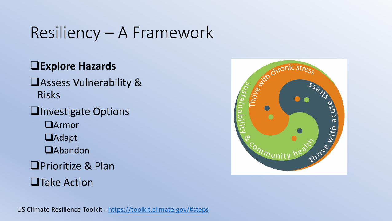
Resiliency – A Framework
Explore Hazards
Assess Vulnerability & Risks
Investigate OptionsArmor
Adapt
Abandon
Prioritize & Plan
Take Action
US Climate Resilience Toolkit - https://toolkit.climate.gov/#steps

Coastal Flooding Threats• Nuisance Flooding
• King Tides
• Nov 2016 +7.6 ft
• Storm Tides• Feb 1978 Storm of Record +9.7 ft
• FEMA Zones AE 10 and VE 13
• Sea Level Rise• Pushing high (King) tides higher
• Projections for future sea level rise

Sea Level RiseMeasured mean sea level at Bar Harbor
and Projections for Future
Source: https://tidesandcurrents.noaa.gov/publications/techrpt83_Global_and_Regional_SLR_Scenarios_for_the_US_final.pdf

Coastal Flooding
Issues

Maine Geological SurveyCoastal Hazards
Sea Level Rise and Storm Surge
• Highest Annual Tide (HAT)• Regulatory Boundary for
Shoreland Zoning Act
• HAT is about the same as the Nov 2016 King Tide
• State maps show HAT plus sea level rise
• Consider elevation transect across Main Street
HAT+2 ft

Nuisance Flooding
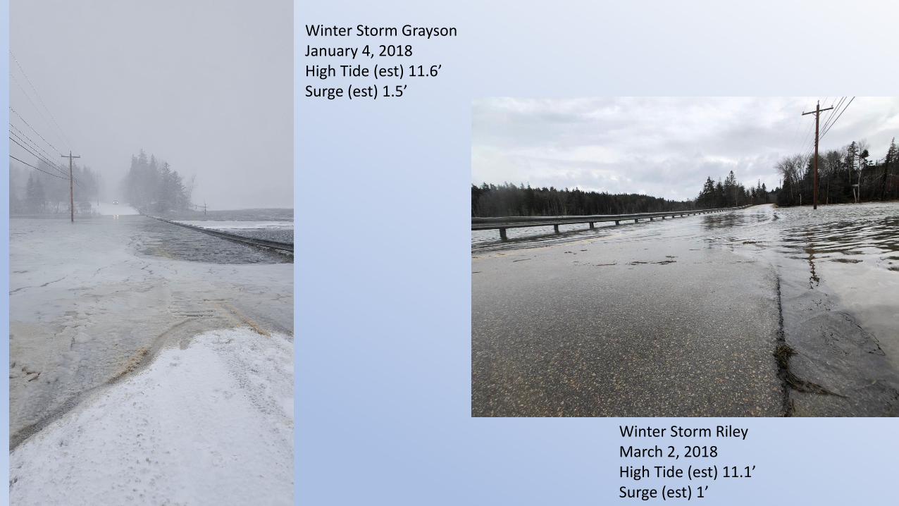
Winter Storm GraysonJanuary 4, 2018High Tide (est) 11.6’Surge (est) 1.5’
Winter Storm RileyMarch 2, 2018High Tide (est) 11.1’Surge (est) 1’

Resiliency – A Framework
✓Explore Hazards
Assess Vulnerability & Risks
Investigate OptionsArmor
Adapt
Abandon
Prioritize & Plan
Take Action

Ransom Engineering
Study
100-year Storm Surge and Waves
Town should consider map amendment or change
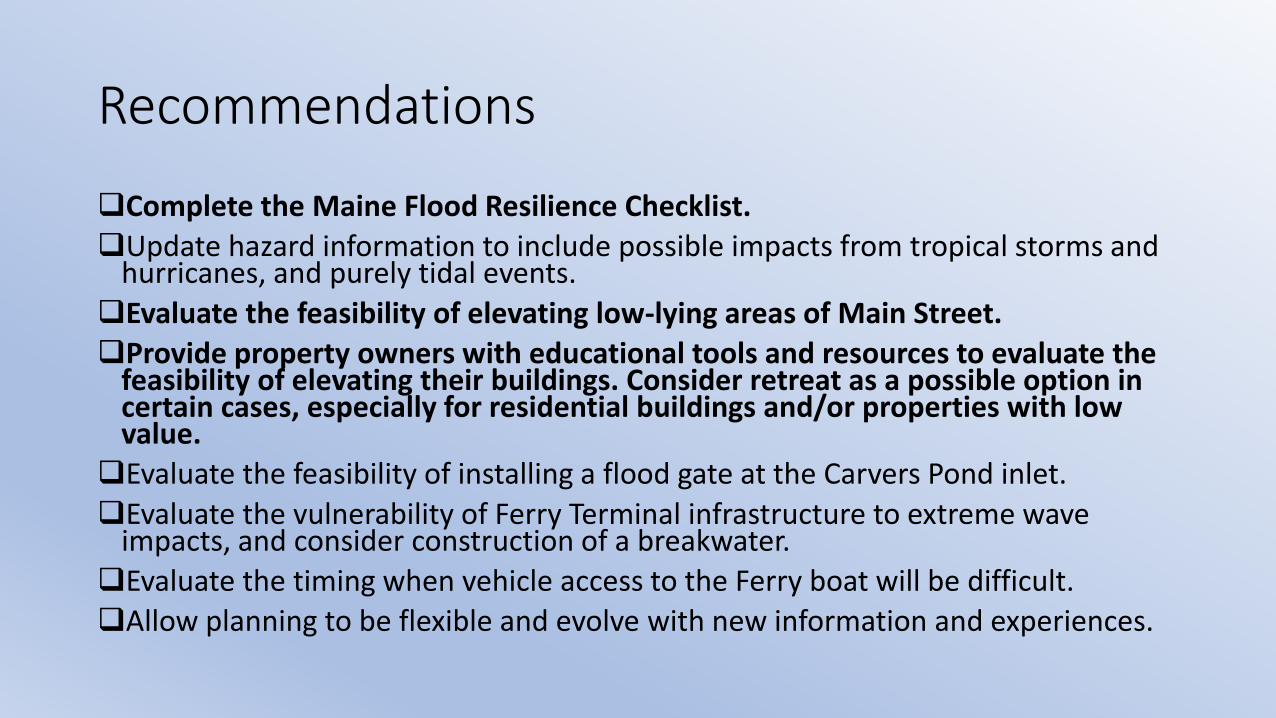
Recommendations
Complete the Maine Flood Resilience Checklist.
Update hazard information to include possible impacts from tropical storms and hurricanes, and purely tidal events.
Evaluate the feasibility of elevating low-lying areas of Main Street.
Provide property owners with educational tools and resources to evaluate the feasibility of elevating their buildings. Consider retreat as a possible option in certain cases, especially for residential buildings and/or properties with low value.
Evaluate the feasibility of installing a flood gate at the Carvers Pond inlet.
Evaluate the vulnerability of Ferry Terminal infrastructure to extreme wave impacts, and consider construction of a breakwater.
Evaluate the timing when vehicle access to the Ferry boat will be difficult.
Allow planning to be flexible and evolve with new information and experiences.

So, how long until we need to react?

• Current 100-YR Storm
• 1 Foot SLR
• 2 Foot SLR
• 3 Foot SLR
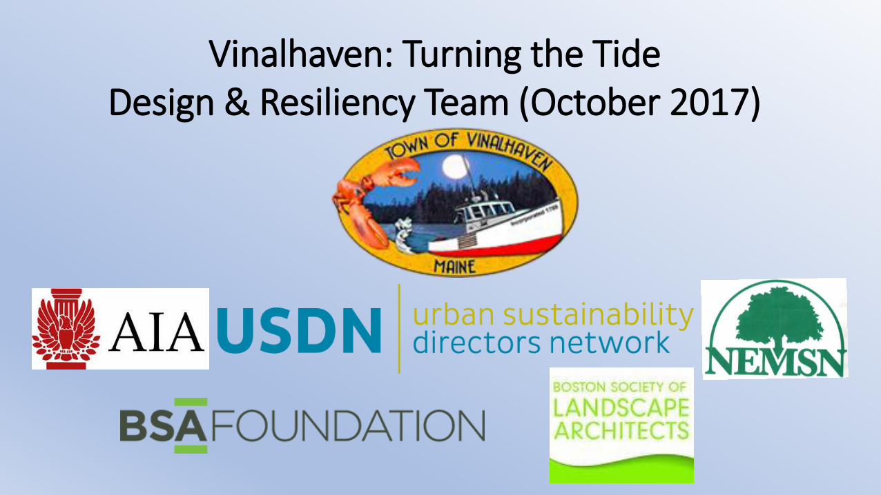
Vinalhaven: Turning the TideDesign & Resiliency Team (October 2017)

Design and Resiliency Team (DART)
• Wayne Feiden, FAICP, Director of Planning & Sustainability, Northampton, MA
• Cori Burbach, Assistant City Manager, City of Dubuque, Iowa
• Michael Davis, FAIA LEED AP, Bergmeyer Associates; Boston Civic Design Commission
• Peter Flinker, ASLA AICP, Principal, Flinker and Dodson
• David Kriebel, PhD, PE, Professor of Coastal and Ocean Engineering, US Naval Academy
• Joel Mills, Senior Director, Communities by Design, AIA
• Erin Simmons, Senior Director, Design Assistance, AIA
• Binh Minh Hoang (Vietnam) & Idfi Septiani (Indonesia), YSEALI

Resiliencynoun
• 1. the power or ability to return to the original form, position, etc., after being bent, compressed, or stretched; elasticity.
• 2. ability to recover readily from illness, depression, adversity, or the like; buoyancy.
• “Resiliency is more than just strengthening our buildings and other infrastructure, its making sure that our citizens have the proper tools and skill sets to reduce the impact of future disasters.” – FEMA, March 2018
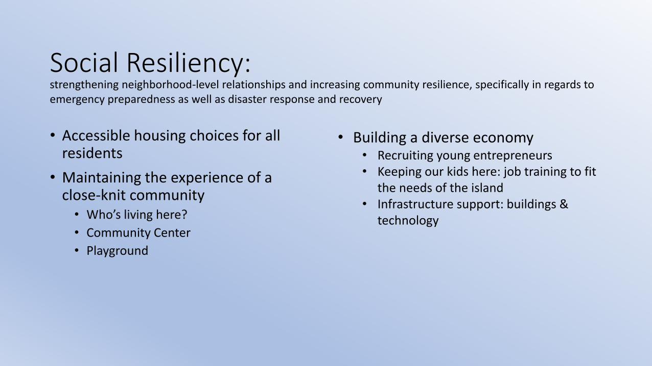
Social Resiliency:
• Accessible housing choices for all residents
• Maintaining the experience of a close-knit community• Who’s living here?
• Community Center
• Playground
strengthening neighborhood-level relationships and increasing community resilience, specifically in regards to emergency preparedness as well as disaster response and recovery
• Building a diverse economy• Recruiting young entrepreneurs• Keeping our kids here: job training to fit
the needs of the island• Infrastructure support: buildings &
technology

Resiliency – A Framework
✓Explore Hazards
✓Assess Vulnerability & Risks
Investigate OptionsArmor
Adapt
Abandon
Prioritize & Plan
Take Action

Response to Coastal Flooding
Armor, Adapt, or AbandonConsider Town’s Positives and Negatives
Positives• No ground subsidence• Low historic rate of SLR• Storm surge elevation relatively low • Large % of harbor shoreline is wharf
with parking• Buildings are light wood frame• Single road• Stormwater can drain two directions
Negatives• Porous grout and granite block • Sluice structure connecting Carvers Pond• Downtown is a peninsula• Large % of Pond shoreline is privately
owned• Wood frame buildings limit floodproofing
options

Armoring Option: Floodwall
• Widely used in other locations
• Difficult (not impossible) in Vinalhaven• Porous grout
• Peninsula shoreline relative to land area
• Limited space and private property
• Difficult near sluice structure
• May need flood gates at sluice
• Low wall could reduce wave action from harbor during storms

Adaptation Option:Dry Floodproofing
• Can be low cost• Would work for low flood levels and wave effects• Would work if Pond level not a high as harbor level• Difficult with light wood frame buildings
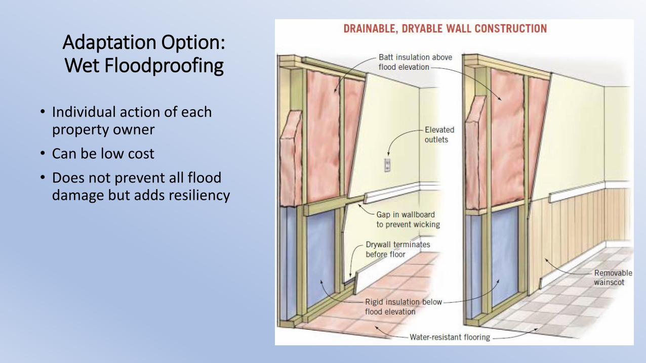
• Individual action of each property owner
• Can be low cost
• Does not prevent all flood damage but adds resiliency
Adaptation Option:Wet Floodproofing

Adaptation Option:Raise Roads (and Wharfs)
• Appears to be an appropriate action for Town
• Being done in other locations
• Cost effective public works approach to resiliency
• Best done as part of overall revitalization or life cycle upgrade

Adaptation Option:Raise Buildings
• Appears to be an appropriate action
• Being done in other locations
• Action for property owner, unless Town can coordinate
• Cost effective, especially with reduction in FEMA flood insurance

Resiliency – A Framework
✓Explore Hazards
✓Assess Vulnerability & Risks
✓Investigate Options✓Armor
✓Adapt
✓Abandon
Prioritize & Plan
Take Action

Improving Resiliency to Coastal Flooding• Near term (to 2050):
• Elevate road and sidewalks • Prevent nuisance flooding with 1 ft SLR scenario• Need to evaluate stormwater and sewer
• Encourage prudent wet or dry floodproofing measures
• Long term (to 2100):• Consider long term plan to raise wharf
elevations • Consider modifying sluice structure• Consider long term plan to raise buildings
• First floor above future FEMA base flood elevation
• Take advantage of life cycle replacement and upgrades

Resiliency – A Framework
✓Explore Hazards
✓Assess Vulnerability & Risks
✓Investigate Options✓Armor
✓Adapt
✓Abandon
✓Prioritize & Plan
Take Action

• Community Resiliency Checklist
• Benchmarking
• Community Input
• Cost Benefit Analysis
• Funding Opportunities

Thank You
Andrew Dorr
Town Manager, Vinalhaven
207-863-2042
https://www.townofvinalhaven.org/sea-level-rise-committee