village of rivanna master plan adopted 5-12-10
TRANSCRIPT


Village of Rivanna Master Plan Adopted 5-12-10 Page 2 Amended June 10, 2015 BACK TO TOP
Page Intentionally Left Blank

Village of Rivanna Master Plan Adopted 5-12-10 Page 3 Amended June 10, 2015 BACK TO TOP
Village of Rivanna Master Plan
Contents
Executive Summary………………………………………………...….....5
Chapter 1 Introduction …………………………………………………. .9
Chapter 2 Vision & Guiding Principles ……………………….…..….13
Chapter 3 Existing Conditions …………………………………….…...15
Chapter 4 Future Land Use and Transportation ………….………….25
Chapter 5 Implementation…..…………………………………………..43
Maps
Environmental Features ................................................................ ..17
Historical Resources ....................................................................... 19
Future Land Use Plan ..................................................................... 31
Future Land Use Detail ................................................................... 33
Parks and Green Systems Plan ...................................................... 41
Please click on the above title to take you to the page you want or scroll down to view the whole Village of Rivanna Master Plan.

Village of Rivanna Master Plan Adopted 5-12-10 Page 4 Amended June 10, 2015 BACK TO TOP
Page Intentionally Left Blank

Village of Rivanna Master Plan Adopted 5-12-10 Page 5 Amended June 10, 2015 BACK TO TOP
Executive Summary
Vision Developed by citizens within the Village, the vision for the Village of Rivanna is for a distinct small community surrounded by rural Albemarle. Medium and low density residential neighborhoods will have easy access to the Village Center through multiple modes of travel. The community will preserve historic features, provide open spaces for recreation, and focus commercial activity within the Village Center. The Village of Rivanna Master Plan is intended to provide guidance on where and how new residential and nonresidential uses should develop in the Village of Rivanna Development Area. It is further intended to make recommendations on the future of US 250 East across the northern boundary of the Development Area. Finally, its purpose is to guide the timing of new development in the Village. The key recommendations of this Master Plan are: Residential Uses and Mixture of Housing Types
Residential uses will be the most prominent use in this Development Area.
A mix of housing types will be provided with the greatest variety of types being in the Village Center.
Density will radiate from the Village Center with the lowest densities at the edges of the Development Area.
Existing neighborhoods of the Glenmore development, Running Deer, and the Magruder subdivision are expected to retain their low-density character.
The Glenmore development is expected to remain unchanged, except for orderly future expansion of additions approved through rezonings.
Developed land on the east side of Carroll Creek is not expected to change in character, as it provides for a transition to the Rural Areas.
Future residential development between the Village Center and Carroll Creek will transition from the highest density near the Center to no more than 3 units per acre near Carroll Creek. Density near the Village Center adjacent to the proposed park can be higher if it is compensated for with lower density closer to Carroll Creek.
Future development is expected to be at a size and scale compatible with existing neighborhoods within the Village of Rivanna.
Future residential development should only be approved if and when transportation improvements to US 250 have been made and sufficient sewer capacity is in place to support that development.

Village of Rivanna Master Plan Adopted 5-12-10 Page 6 Amended June 10, 2015 BACK TO TOP
Mixed-Use Center
The only commercial uses allowed in the Village are to be located in the Village Center. Inclusive of the Fire Station, this area should not have more than 125,000 square feet of non-residential uses.
Historic and Environmental Resources
Historic resources should be preserved within the Village including Glenmore Manor and its Dependencies along the Rivanna River.
Development inside the Village should respect historic resources outside of the Village.
Developers should coordinate with Monticello to prevent negative impacts on the Monticello viewshed.
Parks and Green Systems
A naturalistic landscape buffer approximately 50 feet in depth should remain or be provided across the southern frontage of US 250 to screen development in the Village from US 250.
A Rivanna greenway trail will be provided along the Rivanna River.
A community park will be developed within the Village Center to serve the Development Area and the eastern part of the County.
Centralized amenities such as pocket parks and neighborhood greens should be expected with new development.
Floodplains, wetlands, stream valleys, and slopes should be preserved and enhanced as important features of the Village.
Open space in existing neighborhoods should be preserved. Transportation
Regional transportation improvements should include interchange improvements at I-64 and US 250; six-lanes on US 250 from Free Bridge to the I-64 interchange; four-lanes on US 250 from the US 250/I-64 interchange to Route 729 (Milton Road) and, possibly, Glenmore Way; intersection improvements at US 250 and Route 729 (Milton Road); bridge improvement or replacement over railroad at Route 22 (Louisa Road); and addition of eastbound left turn and westbound right turn lanes on US 250 at Route 616 (Black Cat Road)
Only two additional points of access from US 250 into the Village should be provided. These additional access points are Hacktown Road and at or near Breezy Hill Lane.
A signal or roundabout at Hacktown Road should be provided when warrants are met.
Except for the area near Ashton Road, no additional development should be added to the Glenmore development without a second entrance.

Village of Rivanna Master Plan Adopted 5-12-10 Page 7 Amended June 10, 2015 BACK TO TOP
Consideration should be given to replacing the proffered signal at Glenmore Way with a roundabout.
Paths
A pedestrian crossing should be provided over Carroll Creek to link the residential area of Running Deer Drive to the Village Center. Development in this area should not preclude a future vehicular crossing, if viewed as desirable in the future.
Pedestrian connections to the Glenmore development and other nearby residential developments from the Village Center should be made.
A hard-surfaced pedestrian path should be provided across the frontage of the Development Area which abuts US 250 to connect Glenmore Way with Running Deer and all intervening streets.
Transit
Transit should be provided to the Village of Rivanna when and where feasible.
New development should be transit-ready. Timing of Development
Approval of future development proposals should occur simultaneously with or follow provision of adequate infrastructure.
Approval of future development should be monitored in conjunction with improvements to US 250 and available sewer capacity so that approval of new units or uses does not exceed capacity of the sewage treatment plant or the road system.

Village of Rivanna Master Plan Adopted 5-12-10 Page 8 Amended June 10, 2015 BACK TO TOP
Page Intentionally Left Blank

Village of Rivanna Master Plan Adopted 5-12-10 Page 9 Amended June 10, 2015 BACK TO TOP
Chapter 1 Introduction
Area Included in this Master Plan The Village of Rivanna is located east of the City of Charlottesville and south of US 250 East. The Development Area is formed by the Rivanna River to the southwest, US 250 to the north, an unnamed stream east of Camp Branch forms the western
boundary, and the drainage area for Carroll Creek/Route 808 (Running Deer Drive) forms the eastern boundary.
As part of the development of the plan a larger area was studied, which included additional territory to the east, to the north and to the west. The larger area was studied to see if any conditions had changed since adoption of the prior land use plan for the area. It was also studied to assess the impacts of the Development Area on the adjacent Rural Area fringe. If conditions had changed, boundary area expansions would be considered. As no significant conditions had changed, no boundary expansions were recommended with the adoption of the Master Plan. The Rural Areas outside of the Village are to remain rural, including the areas between US 250 and Interstate 64. No expansion of the Development Area east of Running Deer Drive is to occur. Purpose of the Plan The plan is intended to provide guidance on where and how new residential and nonresidential uses should develop. It is further intended to make recommendations on the future of US 250 East across the northern boundary of the Development Area. Finally, its purpose is to guide the timing of public investments and of new development in the Village.
I-64
US 250
Glenmore Way
Rivanna
River
Village of Rivanna
Running Deer Dr.
Albemarle County with Village in context

Village of Rivanna Master Plan Adopted 5-12-10 Page 10 Amended June 10, 2015 BACK TO TOP
Planning in Albemarle County’s Development Areas Albemarle County has a long-standing goal of directing development into designated Development Areas. To further County growth management goals, the current Development Area concept remains a critical planning component. The Land Use Plan of the Comprehensive Plan, including the Neighborhood Model, presents mechanisms that provide the best opportunity for the County to achieve the goals of having compact livable development in designated Development Areas and keeping the Rural Areas rural. The Comprehensive Plan establishes three types of Development Areas: Urban Areas (Neighborhoods 1 – 7), Communities (Crozet, Hollymead, and Piney Mountain) and Villages (the Village of Rivanna). Villages provide for a specialized opportunity to accommodate growth. Villages are places that combine the feeling of "country living" with the amenities of a Development Area. Villages consist of a variety of housing types including single-family, two-family, and townhouse units, with a gross density not to exceed 6 dwellings per acre. They are to be served by a Village Center of mixed service and residential uses at a neighborhood scale. They are also to be served by public water and sewer and provide public facilities that support the Village and the immediate surrounding Rural Area. Villages should reflect the principles of The Neighborhood Model. The Neighborhood Model is a County policy and a component of the Comprehensive Plan. The purpose of the Neighborhood Model is to create places, following twelve principles:
1. Pedestrian orientation 2. Neighborhood friendly streets and paths 3. Interconnected streets and transportation networks 4. Parks and open space 5. Neighborhood centers 6. Building and spaces of human scale 7. Relegated parking 8. Mixture of uses 9. Mixture of housing types and affordability 10. Redevelopment 11. Site planning that respects terrain 12. Clear boundaries with Rural Areas
Development proposals to introduce mixed use development and add density to the Village in keeping with the Comprehensive Plan goals raised concerns within the community. As a result, the master plan process was applied to the Village to guide future development.

Village of Rivanna Master Plan Adopted 5-12-10 Page 11 Amended June 10, 2015 BACK TO TOP
The Village of Rivanna as a Development Area The County’s designated Development Areas originally were established in 1971. Since that time, most of those areas have been reduced in size. Some Development Areas were eliminated and one was created -- the Village of Rivanna. The Village was approved as a Development Area on December 13, 1989, after application was made by a private developer and studied by the Planning Commission and Board of Supervisors. The area designated for the Village is exactly the same as in this Master Plan. Expected density was one unit per 1.3 acres. In 1996, the County’s Land Use Plan changed the density to match the desired minimum residential density for all Development Areas, which was 3 – 6 units per acre. The 1996 Land Use Plan showed density in this area at 3 – 6 units per acre for neighborhood density residential uses. In May of 2002, after application by a private developer and study by the Planning Commission and Board of Supervisors, the Land Use Plan for the Village was changed to allow for a mixed use center. Residential density for the Village did not change; however, the plan added a provision for non-residential uses, mostly in small commercial, office, retail, and restaurant/inn uses.
Planning Process and Public Involvement In 2005, citizens of the Village requested that the County’s next Master Plan be developed for the Village of Rivanna. The Board of Supervisors approved this request and the master planning process for the Village began in July 2007. As with all Master Plans, the process began with a Citizens Planning Academy. The objective of the Academy was to provide Albemarle citizens with the opportunity to understand the County’s growth management policy and the planning process. The first community workshop on the Village of Rivanna Master Plan was held on July 30, 2007. The purpose of this workshop was to begin to develop a vision for the Village of Rivanna Master Plan and to identify the important elements of the Plan. Around 100 participants attended the public workshop. All participants were asked to identify three key issues they felt were important to the Village of Rivanna Master Plan Vision. Through small group exercises, citizens were given the opportunity to express themselves and hear what others had to say. The following points represent the main ideas expressed at the meeting.
Preserve historic structures and the rural character of area
Improve the ability of residents to access US 250 and surrounding corridors and destinations
Increase the walkability of the Development Area
Develop new ways to get around and enhance existing ones
Maintain public safety

Village of Rivanna Master Plan Adopted 5-12-10 Page 12 Amended June 10, 2015 BACK TO TOP
Install necessary water, sewer, and transportation infrastructure before constructing additional development in the Development Area
Protect environmental resources
Maintain the rural character of US 250
Develop Rivanna Village at a neighborhood scale and a sense of character
Manage the location and style of commercial development
Create a “soft boundary” in edge neighborhoods, including Running Deer The Stakeholders Work Group met between November 2007 and June 2008 to advise County staff and the Master Plan consultant on how best to improve community engagement. They continued to provide guidance to the Planning Commission after that period. Public workshops were held on January 30, 2008, February 11, 2008, and March 3, 2008, to focus on the vision, land use, and transportation. At the fourth public workshop, held on November 19, 2008, work-to-date was reviewed, including the vision and guiding principles. At that workshop, participants also reviewed and chose the preferred future land use arrangement. The Future Land Use Map in this Master Plan is a refinement of the preferred alternative that was chosen by the public.

Village of Rivanna Master Plan Adopted 5-12-10 Page 13 Amended June 10, 2015 BACK TO TOP
Chapter 2 Vision & Guiding Principles
Introduction
The visioning process was the first step toward recognizing the community’s desires for the Village of Rivanna. The vision has set the direction for the Village of Rivanna Master Plan. It builds on existing planning work and County policy, such as the Neighborhood Model. Residents and property owners developed the vision as well as the seven guiding principles, which capture what is most important for a high quality of life in the Village.
Vision
The Village of Rivanna will be a distinct small community surrounded by rural Albemarle. Medium and low-density residential neighborhoods will have easy access to the Village Center through multiple modes of travel. The community will preserve historic features, provide open spaces for recreation, and focus commercial activity within the Village Center.

Village of Rivanna Master Plan Adopted 5-12-10 Page 14 Amended June 10, 2015 BACK TO TOP
1. The density, design, and character of existing residential neighborhoods will be
protected as the Village of Rivanna further develops.
2. The size and scale of new development will be compatible with existing
neighborhoods within the Village of Rivanna.
3. The Village of Rivanna will integrate the natural landscape and incorporate
designs that complement the area’s rural ambiance. Development along the
boundaries of the Village of Rivanna will be sensitive to adjacent Rural Areas.
4. The Village of Rivanna will concentrate commercial uses in a pedestrian-
friendly Village Center where commercial and public services are at an
appropriate scale for meeting the community’s common needs.
5. Street connections to and pedestrian paths between residential areas and the
Village Center, and between the Village of Rivanna and larger community, will
be sensitive to existing development. Options for different types of travel will be
provided, including driving, walking, cycling, and public transit. Street designs
will promote good driver behavior and be appropriately sized for the volume
and speed of traffic.
6. Historic sites in the Village of Rivanna and surrounding area, including
Glenmore Manor, the Hacktown community, Clifton Inn, and Stump Island, will
be respected.
7. Water, sewer, and streets will keep pace with changes and growth that occur
within the Village of Rivanna.
8. Public and private common space, parks, and sports fields will be provided and located to foster a vibrant community

Village of Rivanna Master Plan Adopted 5-12-10 Page 15 Amended June 10, 2015 BACK TO TOP
Chapter 3 Existing Conditions
Introduction This chapter of the Master Plan provides a snapshot of the natural and built environment in the Development Area and adjacent study area. It examines the existing demographics and the demographic trends. Existing land uses, the transportation network, and current and planned infrastructure are discussed as well.
Natural, Scenic and Historic Assets The Village of Rivanna lies within the Rivanna River watershed. The Rivanna River is the largest tributary of the James River, flowing into the James at the Town of Columbia in Fluvanna County. The Rivanna River has important historical, recreational and natural significance and is a key resource for water and wastewater management. The Rivanna River offers recreational opportunities, such as boating and fishing. There are County plans for a greenway trail along the Rivanna River. The Rivanna River and its tributaries, particularly Carroll Creek, are home to a variety of wildlife. In 1975, the Rivanna River was designated a state scenic river from the Woolen Mills area south of Pantops to its confluence with the James River. Virginia’s scenic rivers program is set up to identify, designate, and help protect rivers and streams that have outstanding scenic, recreational, and natural characteristics of statewide significance. In 2009, the Virginia Scenic River designation was extended upstream to the South Fork Rivanna River Reservoir dam. Within the Development Area, the Rivanna River is the most prominent environmental feature. It has a significant floodplain and associated wetlands. Carroll Creek, as well as another tributary to the Rivanna River near Milton Heights, flow into the Rivanna River. There are many smaller streams that also feed into the Rivanna River within this Development Area. These streams have steep and shallow valleys, and some also have associated floodplains and wetlands. The Rivanna River has also played an important role in the history of the area. Used for navigation, it allowed for economic growth of the communities of Shadwell and Milton. Thomas Jefferson had grist mill on the Rivanna, and he helped to develop sluices, locks, and dams to help with navigation to his mill in the late 18th and early 19th centuries. Ruins of a series of canals, dams, and locks exist along the Rivanna in and near the Village. A full description of the series of locks and dams is provided in the 1995 report, “From the Monacans to Monticello and Beyond: Prehistoric and Historic Contexts for Albemarle County, Virginia,” provided by Garrow and Associates, Inc.

Village of Rivanna Master Plan Adopted 5-12-10 Page 16 Amended June 10, 2015 BACK TO TOP
Page Intentionally Left Blank

Village of Rivanna Master Plan Adopted 5-12-10 Page 17 Amended June 10, 2015 BACK TO TOP
Environmental Features Map

Village of Rivanna Master Plan Adopted 5-12-10 Page 18 Amended June 10, 2015 BACK TO TOP
Page Intentionally Left Blank

Village of Rivanna Master Plan Adopted 5-12-10 Page 19 Amended June 10, 2015 BACK TO TOP
The most significant historical resource in Albemarle County is Thomas Jefferson’s home, Monticello. Monticello was constructed between 1770 and 1809 and is located on Route 53 southwest of the Village of Rivanna. Jefferson owned 5000 acres of land that included Monticello and portions of his holdings are to the south and west of the Village. Protecting Monticello is an important theme throughout the County’s Comprehensive Plan and is referenced in the Historic Preservation Plan, the Mountain Protection Plan, and the Open Space Plan. It is a National Historic Landmark and the only home in America on the World Heritage List. Monticello’s elevated location provides broad vistas which the Thomas Jefferson Foundation and the County seek to protect, although there are no formal County requirements to address the Monticello viewshed. County staff works informally with Monticello staff to encourage viewshed protection.
There are other significant historical sites within or in close proximity to the Village of Rivanna. The Glenmore Manor and its Dependencies, which lie within the Glenmore development, were built beginning circa 1750 with extensive additions thereafter. The pre-Revolutionary Glenmore Manor originally was one room with a basement hearth built of stone with mud mortar. Historically, much of the agrarian activity in the area occurred on the Glenmore plantation. Like other Piedmont plantations, Glenmore Manor and its Dependencies date back to a land grant of George II in 1732.

Village of Rivanna Master Plan Adopted 5-12-10 Page 20 Amended June 10, 2015 BACK TO TOP
The Clifton estate, located east of the Development Area, was part of a 3,000 acre grant belonging to Peter Jefferson. Approximately 350 acres of the estate was passed on to Thomas Jefferson’s daughter and her husband Thomas Mann Randolph. Today Clifton is a five-bedroom country inn with three historic Dependencies, used as additional guest accommodations. Significant areas nearby include the Southwest Mountains Rural Historic District, the Southern Albemarle Historic District, and a property to the east of Running Deer Drive which has a conservation easement. The Southwest Mountains Rural Historic District is listed on the state and national registers. It is a 31,000-acre historic district designated by the National Park Service for cultural, architectural, and landscape features of the state and nation. The Southern Albemarle Rural Historic District is also listed on the state and national registers. It includes over 83,000 acres. The conservation easement to the east of the Village covers 466 acres and is held by the Virginia Outdoors Foundation.
Demographics
Over the past decade, growth in the Village of Rivanna has been steady, with almost all new permits being issued in the Glenmore development. The Glenmore development has potential for 966 units and, as of March 2009, had 686 dwellings. Based on March 2009 estimates, there are 761 dwellings in the entire Village of Rivanna with an estimated population of between 1617 and 1918 residents. The table below shows growth since the Village of Rivanna Development Area was established.
Residential Units and Population Growth
Year Units Population
1990 75 211
2000 502 1,355
2009 761 1,617 – 1918 Source: 1990 and 2000 population from U.S. Census; 2009 estimate from Albemarle County Geographic Data Services
Since 2007, up to 804 additional dwelling units were approved. Once occupied, these units will likely bring between 1338 and 2026 new residents. The total of existing and approved units ranges from 1392 to 1565. The total future population in existing and approved units ranges from 2955 to 3483.

Village of Rivanna Master Plan Adopted 5-12-10 Page 21 Amended June 10, 2015 BACK TO TOP
Existing Land Use
Uses within the Development Area are mostly residential; however, there are several non-residential uses both inside the Development Area and nearby. Some of these uses are area churches, the East Rivanna Volunteer Fire Company (ERVFC), Stone Robinson Elementary School, the Moose Lodge, the American Legion Hall, Keswick Hall, the Clifton Inn, the Luck Stone Quarry, and the Glenmore Country Club/Golf Course. The Village of Rivanna is located approximately four miles from the closest major shopping center and other commercial areas on Pantops Mountain. The Development Area is approximately 2.7 square miles. The largest part of the Development Area is the Glenmore development. Low density residential development is the primary land use in this Development Area. Areas with development potential are represented in the figure to the right as tracts A, B, and C. There are approximately 233 acres of land which could be developed or further developed in the Village. Area A has 94 acres, Area B has 115 acres, and Area C has 24 acres. As mentioned earlier in the Plan, the Village was designated for development in late 1989. Approximately 85% of the land in the Village has been developed or approved for development. Although rapid growth has occurred over the last twenty years, further development is limited by existing zoning. The existing zoning would allow for 631 – 804 additional units, as well as a small amount of retail, office, and service uses. Except for the Village Center and the Glenmore development, the zoning on the remaining properties in the Village is zoned Rural Area (RA), which has a density of 1 unit per 21 acres, where development rights have been already used.
Existing Community Facilities Water and Sewer Water comes from the South Fork Rivanna Reservoir and the Sugar Hollow Reservoir. Water treatment takes place at the South Rivanna and Observatory Water Treatment Plants. A waterline along US 250 from Pantops is sized adequately to serve the entire Village. Wastewater treatment is provided at the Glenmore development sewage treatment plant on Carroll Creek. Capacity of the facility, including an upgrade to be provided by a private developer, is 381,000 gallons per day. At present, average daily usage is approximately 120,000 gallons per day. The sewage
Running Deer Dr.
Glenmore Way
Hacktown Road
Carroll Creek
US 250

Village of Rivanna Master Plan Adopted 5-12-10 Page 22 Amended June 10, 2015 BACK TO TOP
treatment plant with the upgrade has the capacity to serve the Village Center as well as undeveloped properties approved within the Glenmore development. Schools The area is served by the Stone Robinson Elementary School, which is located nearby. Students then matriculate to Burley Middle School and Monticello High School. There are no public schools located within the Village. Parks The Glenmore development has private recreational facilities for Glenmore residents. These facilities include a golf course, swimming pool, tennis courts, practice soccer field, and equestrian center. A new public park has been planned for the Village Center. It will be an 18 acre park with amenities such as tennis courts, play areas, restrooms, trails, and shelters. It will incorporate a quarry as a feature of the park, if possible. Outside of the Village, there is a public boat access to the Rivanna River at the Route 729 bridge. A public greenway is planned along the Rivanna River in the Village. Police Police service is provided by the County from the Albemarle County Office Building on 5th Street south of Charlottesville. A room at the East Rivanna Volunteer Fire Company provides an onsite office for police use when needed. Police officers work on a sector/beat system and the Village of Rivanna is included as part of the Rural Area’s patrol program. Response times meet the standards for the Rural Areas, which is to respond on first priority items within ten minutes of the call. The County’s Community Facilities Plan calls for a response time of five minutes or less to all emergency calls in the Development Areas. Fire and Rescue The East Rivanna Volunteer Fire Company operates a joint County/Volunteer fire station near the Glenmore development entrance. The facility serves the fire and rescue needs of the Village of Rivanna and the eastern part of the County. The facility is also used by the community for civic events and fund-raising activities. Currently response times do not meet standards. Library Public library services are provided to the County by the Jefferson-Madison Regional Library System. Members of this regional system include Albemarle, Greene, Louisa, and Nelson counties and the City of Charlottesville. The Downtown Charlottesville branch is the closest branch to the Village. State

Village of Rivanna Master Plan Adopted 5-12-10 Page 23 Amended June 10, 2015 BACK TO TOP
standards for library service suggest 0.6 square feet of building space per resident. The County, as a whole, exceeds this requirement and provides approximately 0.7 square feet of building space per resident. As a general target, library facilities should be provided at a rate of one for every 20,000 residents. Desirable travel time to the library facility for 75 percent of the service area should be ten minutes for Development Area residents and twenty minutes for Rural Area residents. Although 75 percent of the users of the Downtown Charlottesville branch of the library are covered in the ten minute travel time, travel time to the Village exceeds ten minutes. Recycling Several trash haulers in the County offer curbside recycling to the residents of the Glenmore community who wish to pay for these services. Recycling centers are located throughout the County.
Existing Transportation Network Streets and Roads The Village of Rivanna is served by a network of private and public streets. The Glenmore development is served by an extensive internal private road system with an entry/exit gate at Glenmore Way, which intersects with US 250. Forming most of the eastern boundary of the Development Area, Running Deer Drive (Route 808) is a public road accessed directly off of US 250. There are also private accessways which serve rural style development within the Development Areas. When developed, Rivanna Village at Glenmore will have a network of internal roads connecting to development within the Village and to US 250. US 250 serves the Village of Rivanna for trips outside the village. Destinations include Pantops, the City of Charlottesville and Zion Crossroads. As the following table shows, US 250 traffic is heaviest from the eastern City line to Route 20. Traffic volume decreases on US 250 east of Shadwell with an annual average daily traffic count of approximately 5,500 vehicles from Route 22 to the Fluvanna County line.
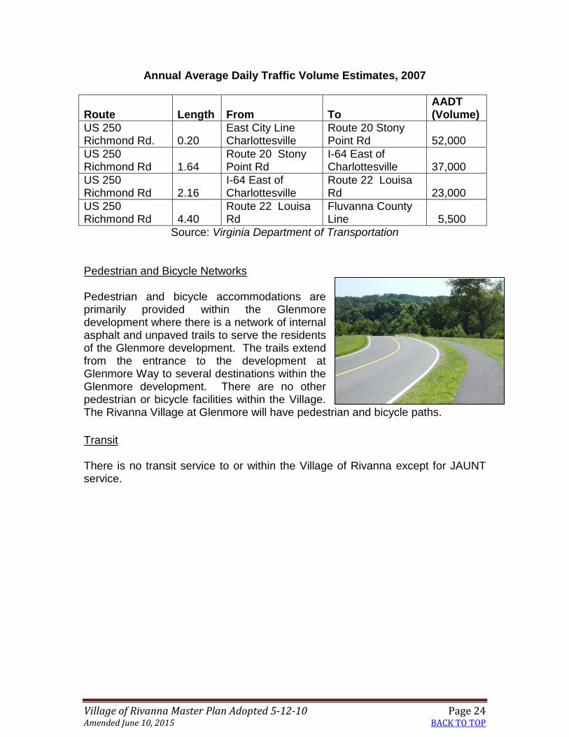
Village of Rivanna Master Plan Adopted 5-12-10 Page 24 Amended June 10, 2015 BACK TO TOP
Annual Average Daily Traffic Volume Estimates, 2007
Route Length From To
AADT (Volume)
US 250 Richmond Rd. 0.20
East City Line Charlottesville
Route 20 Stony Point Rd 52,000
US 250 Richmond Rd 1.64
Route 20 Stony Point Rd
I-64 East of Charlottesville 37,000
US 250 Richmond Rd 2.16
I-64 East of Charlottesville
Route 22 Louisa Rd 23,000
US 250 Richmond Rd 4.40
Route 22 Louisa Rd
Fluvanna County Line 5,500
Source: Virginia Department of Transportation Pedestrian and Bicycle Networks Pedestrian and bicycle accommodations are primarily provided within the Glenmore development where there is a network of internal asphalt and unpaved trails to serve the residents of the Glenmore development. The trails extend from the entrance to the development at Glenmore Way to several destinations within the Glenmore development. There are no other pedestrian or bicycle facilities within the Village. The Rivanna Village at Glenmore will have pedestrian and bicycle paths.
Transit There is no transit service to or within the Village of Rivanna except for JAUNT service.

Village of Rivanna Master Plan Adopted 5-12-10 Page 25 Amended June 10, 2015 BACK TO TOP
Chapter 4 Future Land Use and Transportation
Maps The Future Land Use Map and the Future Land Use Map Detail identify the land use designations, the standards regarding uses, the recommended densities and the Village Center. The Transportation Map details the transportation network and makes recommendations for its improvement. A multimodal approach is taken so all modes of travel – vehicular, pedestrian, bicycle, and transit are incorporated. Based on traffic projections, improvements to the transportation network are recommended. The Parks and Green Systems Map identifies existing and recommended parks, open space, and greenways. In addition, the Village of Rivanna Master Plan recommends the preservation and protection of historical and cultural resources.
Future Land Use Proposed land uses are shown on the Future Land Use Map on page 24. The Future Land Use Map reflects an expectation that the density, design, and character of existing residential neighborhoods in the Village of Rivanna will be retained as the Village of Rivanna develops further. A single Village Center will be one of the two focal points for the Village. The other focal point is the recreational area of the Glenmore development, which includes the swimming pools, tennis courts, and golf course. Residential Areas The following recommendations are made for residential areas in the Village:
As shown on the Future Land Use Map, residential uses will be the most prominent use in this Development Area.
A mix of housing types will be provided with the greatest variety of types located in the Village Center. Density will radiate from the Village Center with the lowest densities at the edges of the Development Area.
The existing neighborhoods of the Glenmore development, Running Deer, and the Magruder subdivision are expected to retain their low-density character.
The Glenmore development is expected to remain unchanged, except for orderly future expansion of approved additions.
Developed land on the east side of Carroll Creek is not expected to change in character, as it provides for a transition to the Rural Areas.
Village of Rivanna Master Plan Adopted 5-12-10 Page 26 Amended June 10, 2015 BACK TO TOP
Future residential development between the Village Center and Carroll Creek will transition from the highest density near the Center to no more than 3 units per acre near Carroll Creek. Density near the Village Center adjacent to the proposed park can be higher if it is compensated for with lower density closer to Carroll Creek. Such development should only be approved if and when adequate infrastructure is in place.
Future development is expected to be at a size and scale compatible with existing neighborhoods within the Village of Rivanna.
The expected number of new dwellings, in addition to units approved at the time of adoption of this Master Plan, is between 300 and 400 units. In order to maintain this number of new dwellings, if higher density development is focused in the area adjacent to the Village Center (Rivanna Village at Glenmore), then a proportionately lower density in remaining areas must occur.
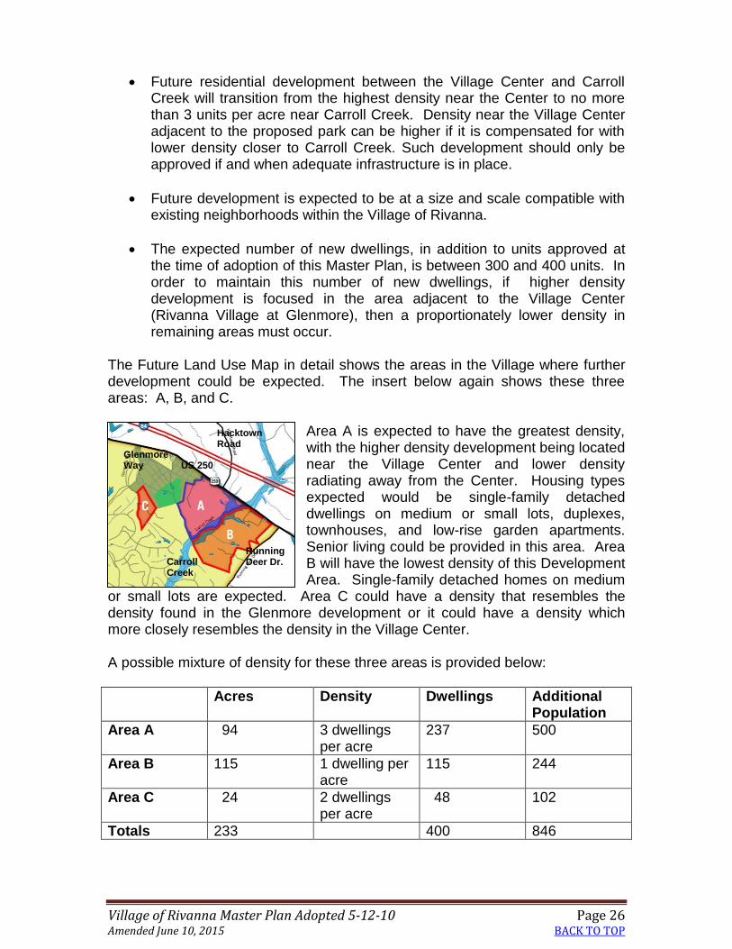
The Future Land Use Map in detail shows the areas in the Village where further development could be expected. The insert below again shows these three areas: A, B, and C.
Area A is expected to have the greatest density, with the higher density development being located near the Village Center and lower density radiating away from the Center. Housing types expected would be single-family detached dwellings on medium or small lots, duplexes, townhouses, and low-rise garden apartments. Senior living could be provided in this area. Area B will have the lowest density of this Development Area. Single-family detached homes on medium
or small lots are expected. Area C could have a density that resembles the density found in the Glenmore development or it could have a density which more closely resembles the density in the Village Center. A possible mixture of density for these three areas is provided below:
Acres Density Dwellings Additional Population
Area A 94 3 dwellings per acre
237 500
Area B 115 1 dwelling per acre
115 244
Area C 24 2 dwellings per acre
48 102
Totals 233 400 846
Hacktown Road
Glenmore Way US 250
Carroll Creek
Running Deer Dr.

Village of Rivanna Master Plan Adopted 5-12-10 Page 27 Amended June 10, 2015 BACK TO TOP
Different mixtures and densities could take place in the future. Availability of utilities as well as the timing of improvements on US 250 will affect the future rate of growth in the Village. The capacity for full development of the Village would allow for a total of 1700 – 2000 units (including existing and approved development) which represents a population of between 3604 and 4240 persons.
Density Illustrated The Village currently has only single-family detached housing, but a variety of housing types is expected. The images below, beginning with most dense to least dense represent the possible ways in which development could occur, radiating from most dense near the Village Center to least dense near Running Deer Drive.
Parkside Village Townhouses – Crozet Parkside Village homes – Crozet
The illustration on the left shows townhouses at 9 dwellings per acre; however, half of the site has been preserved as open space. The illustration on the right shows dwellings at 4 dwellings per acre. One quarter of the site was preserved as open space. The image on the left in the Glenmore development typifies homes at a density of two dwellings per acre. The image on the right represents a subdivision built at less than two dwellings per acre on small lots facing a street with sidewalks.

Village of Rivanna Master Plan Adopted 5-12-10 Page 28 Amended June 10, 2015 BACK TO TOP
The Village Center The Village Center (approved in 2007 as the Rivanna Village at Glenmore) will have a mixture of residential and non-residential uses. Other characteristics include:
Neo-traditional streets characterized by narrow widths, on-street parking, curb, gutter, sidewalks, and street trees.
A "main street" with retail and office buildings.
Street connections to Glenmore Way, US 250 East, and properties to the south and east of the Village Center.
A variety of housing types that provide opportunities for all age groups, including senior housing and housing for all socioeconomic levels, to live in the Village of Rivanna.
Non-residential uses, mostly in small commercial, office, retail and restaurant/inn uses. Total square footage should not exceed 125,000 for retail, office, and institutional uses, including the East Rivanna Volunteer Fire Company. Automobile repair and self-storage areas are not considered appropriate uses for the Village.
Design at a pedestrian scale that reflects the architectural tradition of Williamsburg and other historic towns in Virginia.
A well-integrated pedestrian system, including sidewalks and paths.
A variety of park and recreational amenities, including open space appropriate to the residential needs of the Village.
Development in a manner that is sensitive to its location within Monticello’s viewshed, in accordance with the Monticello Viewshed Guidelines for Developers.
Minimization of adverse impacts on residential properties adjoining the Village Center by preserving mature vegetation, having residences abut adjoining residential properties; using buffers, screening and berming; and using wide buffer strips.
Shared parking.

Village of Rivanna Master Plan Adopted 5-12-10 Page 29 Amended June 10, 2015 BACK TO TOP
Historic Sites Historic sites both inside and outside the Village are affected by development of the Village. Care should be taken with new development that the size, scale, and visibility of new development complement surrounding sites. The following recommendations are made:
Historic resources should be preserved within the Village, especially the Glenmore Manor and its Dependencies along the Rivanna River.
Development inside the Village should respect historic resources outside of the Village.
Developers should coordinate with Monticello to prevent negative impacts on the Monticello viewshed.

Village of Rivanna Master Plan Adopted 5-12-10 Page 30 Amended June 10, 2015 BACK TO TOP
Page Intentionally Left Blank

Village of Rivanna Master Plan Adopted 5-12-10 Page 31 Amended June 10, 2015 BACK TO TOP

Village of Rivanna Master Plan Adopted 5-12-10 Page 32 Amended June 10, 2015 BACK TO TOP
Page Intentionally Left Blank

Village of Rivanna Master Plan Adopted 5-12-10 Page 33 Amended June 10, 2015 BACK TO TOP
Future Land Use Plan Detail Map 1

Village of Rivanna Master Plan Adopted 5-12-10 Page 34 Amended June 10, 2015 BACK TO TOP
Page Intentionally Left Blank

Village of Rivanna Master Plan Adopted 5-12-10 Page 35 Amended June 10, 2015 BACK TO TOP
Future Land Use Plan Detail Map 2

Village of Rivanna Master Plan Adopted 5-12-10 Page 36 Amended June 10, 2015 BACK TO TOP
Page Intentionally Left Blank

Village of Rivanna Master Plan Adopted 5-12-10 Page 37 Amended June 10, 2015 BACK TO TOP
Future Transportation Framework
The future transportation network is divided into three sections: vehicular, transit and pedestrian/bicycle. While vehicular travel is the dominant means of transportation, transit service and accommodations for pedestrians and cyclists are included with this plan. Vehicular Travel As included in the prior chapter, US 250 East is a state highway which extends from Richmond to West Virginia. It is the northern boundary of the Village of Rivanna Development Area. As a regional thoroughfare, it serves a much greater area than the Village of Rivanna. It is a major commuter route between Louisa and Fluvanna counties and the City of Charlottesville. Because of its function in the larger network, traffic from the Village is only a small portion of the overall volume. Traffic on US 250 East overall is expected to grow significantly in the next 25 years as a result of growth east of Albemarle County and other growth in the Charlottesville-Albemarle area. Projections provided by the Virginia Department of Transportation are:
2007 and Projected 2035 Average Annual Daily Traffic
Route Length From To
AADT Volume
2007
AADT Projected
2035
US 250 Richmond
Rd. 0.20 East City Line Charlottesville
SR 20 Stony Point Rd 52,000
78,747
US 250 Richmond
Rd 1.64 SR 20 Stony
Point Rd I-64 East of
Charlottesville 37,000
79,384
US 250 Richmond
Rd 2.16 I-64 East of
Charlottesville SR 22 Louisa
Rd 23,000
42,185
US 250 Richmond
Rd 4.40 SR 22 Louisa
Rd Fluvanna
County Line 5,500
24,400
Source: Virginia Department of Transportation

Village of Rivanna Master Plan Adopted 5-12-10 Page 38 Amended June 10, 2015 BACK TO TOP
To deal with the additional traffic, several recommendations which affect the regional nature of US 250 East are:
Interchange improvements at I-64 and US 250 East
Six-lane US 250 from Free Bridge east to the I-64 interchange
Four-lane US 250 from the US 250/I-64 interchange to Route 729 (Milton Road) and, possibly, Glenmore Way
Intersection improvements at US 250 and Route 729 (Milton Road)
Bridge improvement or replacement over railroad at Route 22 (Louisa Road)
Addition of eastbound left turn and westbound right turn lanes on US 250 at Route 616 (Black Cat Road)
Recommended Characteristics of US 250 East The following recommendations relate to the character of the improvements on US 250 East as they affect the Village of Rivanna. Four-lane Section
US 250 should be a 4 lane rural section road from the US 250/I-64 Shadwell interchange to Route 729 (Milton Road) and, possibly, Glenmore Way. This road section should include a median and a walking/bicycling path on the south side of US 250.
Two-lane Section
US 250 should be a two lane rural section of road from Route 729 (Milton Road) or Glenmore Way eastward to Route 616 (Black Cat Road). Left turn lanes may be needed to accommodate existing entrances. This road section should include a walking/bicycling path on the south side of US 250.
Walking/
biking path Travel lanes Median Travel lanes Shoulder and
ditch

Village of Rivanna Master Plan Adopted 5-12-10 Page 39 Amended June 10, 2015 BACK TO TOP
The road may have a median separation or not, as illustrated in the next two images. Also, a naturalistic buffer should be established along the south side of US 250, so the commercial uses in the Village Center are not visible from US 250.
Other Recommendations for Vehicular Transportation in Village
Additional points of access from US 250 into the Development Area should be limited to Route 744 (Hacktown Road) and at or near Breezy Hill Lane. The intersection with Route 744 (Hacktown Road) may require a roundabout or signal when warrants are met.
Except for the area around Ashton Road, no additional development should be added to the Glenmore development unless it includes a second entrance.
For the long term, consideration should be given to replacing the proffered signal light at Glenmore Way with a roundabout for improved traffic flow.
A Park and Ride lot should be established within the Village. Pedestrian and Bicycle Network
A bicycle/pedestrian crossing over Carroll Creek should be provided to link new residential development and the residential area of Running Deer to the Village Center.
Route 250 with median
Route 250 without median
Walking/
biking path
Walking/
biking path
Median
Travel lanes
Travel
lane
Travel
lane
Shoulder and
ditch
Shoulder and
ditch

Village of Rivanna Master Plan Adopted 5-12-10 Page 40 Amended June 10, 2015 BACK TO TOP
Pedestrian connections to the Village Center should be established, linking the Glenmore development and nearby residential development to the Village Center.
A hard-surface pedestrian/bicycle path should be provided across the frontage of the Development Area, abutting US 250 between US 250 and the landscape buffer. Such a path would connect Glenmore Way with Running Deer and all intervening streets
Transit Service
Fixed-route transit service should be provided to the Village of Rivanna when ridership levels can support transit.
New development should be in a transit-ready design.
Parks and Green Systems
The Guiding Principles for the Village of Rivanna emphasize integration of the natural landscape and provision of public and private common space, parks, and sports fields located to foster a vibrant community. These principles are reflected in the following Parks and Green Systems map. It is especially important that the Rivanna River corridor be protected and be available to the public. In addition to the need for park amenities in future developments, a new public park is expected as part of the Rivanna Village at Glenmore development. The following recommendations are made for parks and green systems:
Ensure that the Rivanna River Corridor, Carroll Creek, and tributaries to both waterways are protected by preserving floodplains, critical slopes, and riparian buffers adjacent to these resources.
The Rivanna River greenway trail, which will follow the northern side of the river and ultimately become part of a larger Rivanna River trail system, should be developed.
The Glenmore golf course, the equestrian center, the series of trails and paths throughout the development, and other Glenmore open space are important features of the Glenmore community. These features should continue to provide recreational and aesthetic amenities to that development.
Centralized amenities such as pocket parks and neighborhood greens are expected with new development.
Ensure development of the public park in the Village Center.
Open spaces in existing neighborhoods should be preserved.

Village of Rivanna Master Plan Adopted 5-12-10 Page 41 Amended June 10, 2015 BACK TO TOP
Parks and Green Systems Plan

Village of Rivanna Master Plan Adopted 5-12-10 Page 42 Amended June 10, 2015 BACK TO TOP
Page Intentionally Left Blank

Village of Rivanna Master Plan Adopted 5-12-10 Page 43 Amended June 10, 2015 BACK TO TOP
Chapter 5 Implementation
The implementation initiatives of the Village of Rivanna Master Plan have been organized based on priority needs identified by residents and stakeholders during the Master Plan process (Table below). Implementation of these initiatives will take place in several different forms: through County capital expenditures, as part of land use decisions, with private sector investment, by community initiatives, and through programs and services provided by the County. The County’s Capital Improvements Program (CIP) is based on a two-year financial cycle. The CIP represents the County’s funding policy, including funding level, timing and sources associated with specific improvements. The actual programming of projects in the CIP will be based on priority needs and the availability of funding from the sources anticipated in this section. Service standards have been established in the County’s Community Facilities Plan. As in all Development Areas, with rezonings for new development, community services and facilities are always evaluated to determine the adequacy of service and impacts of the proposed development in relation to the service standards. Population Capacity and Future Rezonings Additional development in the Village currently is limited by Rural Areas zoning on most undeveloped parcels and the capacity of the sewage treatment plant which was installed for the Village. Although the treatment plant is currently operating at a little more than a third of its capacity, dwelling units which have already been approved plus the non-residential uses in the Village Center will use much of the remaining capacity. The actual number of additional units which may be approved for development in the future depends on the capacity of the sewage treatment plant. An additional 300 to 400 new units may be possible, if water and sewer usage in the Glenmore development continues at the same usage. Monitoring of available capacity is essential for any future development. If in the future, the Board of Supervisors decides that additional capacity is needed in this Development Area, then major upgrades will be needed for the sewage treatment facility. In addition to sewer limitations, approval of any development by rezoning will be predicated on the completion of a number of transportation improvements, which are identified in the tables in this chapter. These improvements are needed to improve the volume to capacity ratio of US 250 between Route 22 (Louisa Road) and the City of Charlottesville. Transportation Addressing traffic issues on US 250 is the highest priority for the Village of Rivanna. Several regional projects identified in the next few pages are necessary to address future growth in a larger area, but also affect the Village of Rivanna. It is essential that all of the US 250 improvements be constructed before new development occurs in the Village.

Village of Rivanna Master Plan Adopted 5-12-10 Page 44 Amended June 10, 2015 BACK TO TOP
Community Facilities Water and Sewer Because of limitations of the sewage treatment plant, monitoring of all new development is essential to ensure that adequate capacity exists to serve existing and new homes, the Glenmore Country Club, and the additional businesses expected in the Village. Monitoring of water availability is always necessary in Albemarle County. Although it is adequate at present, additional water storage may be necessary to serve the Village in coming years. A 600,000 gallon ground storage water tank, pump station, and associated water mains will be constructed in the southeastern portion of the 6 acre parcel located at the end of Streamer Drive that is owned jointly by the East Rivanna Volunteer Fire Company and Albemarle County. The location of the water tank is shown below with this symbol:
Schools At present, schools which serve the Village are operating below capacity. Stone Robinson is at 76% capacity, Burley Middle is at 67% capacity, and Monticello High is at 90% capacity. Monitoring of enrollment, which occurs regularly by the Schools Division of Albemarle County, should be continued to ensure that the schools meet County standards and do not become overcrowded.

Village of Rivanna Master Plan Adopted 5-12-10 Page 45 Amended June 10, 2015 BACK TO TOP
Parks and Greenways Public parks and greenways are expected to be built in the Village over the next several years. The community park in the Village Center will be constructed by the developer of Rivanna Village at Glenmore. After greenway dedication from the developer of the Glenmore development occurs, County trail-building can begin. Other trails connecting different parts of the Village are expected with new development. Police Police service is provided on a sector/beat system to the Rural Areas standard. Response times should be improved to meet urban service standards. Monitoring of response times should continue in order to ensure adequate police protection to the Village. Fire and Rescue As identified previously, fire and rescue response times do not meet County standards of four minutes or less. The County and the East Rivanna Fire and Rescue Company should work to improve response times to the Glenmore development as well as new and existing homes in the rest of the Village. Library At present library service for the Village of Rivanna meets County standards for building space and number of libraries per capita. The Village is part of the 25 percent of the service area which must travel greater than ten minutes to get to the library. With growth in the rest of the County, the Jefferson-Madison Regional Library Board and County staff will continue to regularly monitor growth trends and service needs within the eastern part of Albemarle County. This area includes Pantops and the Village of Rivanna. A future library is planned for the urban neighborhoods south of Charlottesville to be built within the next ten years. This library will also be accessible to residents of the Village. While the Regional Library Board is not expected to provide a library in the Village of Rivanna, other methods of providing service in the Village could be considered, such as increased bookmobile service and kiosks. Recycling Curbside recycling exists in the Glenmore development, which is paid for by the homeowners. Recycling options outside of the Glenmore development will be explored during the Rivanna Water and Sewer Authority’s Waste Management Plan update.

Village of Rivanna Master Plan Adopted 5-12-10 Page 46 Amended June 10, 2015 BACK TO TOP
Historic Resources As assets to the County, historic resources in and near the Village should be protected and preserved. To educate residents and visitors on the historic assets of this part of the County, interpretive areas could be designed and put in place. New development and redevelopment along US 250 East should be designed in a manner that is sensitive to its location within Monticello’s viewshed and along a designated Entrance Corridor roadway. The County’s voluntary guidelines for protection of the Monticello viewshed should be followed. Village of Rivanna Community Advisory Council (VORCAC) As with other master-planned Development Areas, the County’s Board of Supervisors will establish the Village of Rivanna Community Advisory Council (VORCAC) to work with Staff to monitor the implementation of the Village of Rivanna Master Plan. The form and composition of the RCAC will be determined after adoption of the plan. Implementation Plan The Implementation Plan below outlines the various projects necessary to achieve the vision for the Village of Rivanna. Transportation improvements recommended affect not only the Village, but other parts of eastern Albemarle County. Public road projects are the responsibility of the Virginia Department of Transportation (VDOT). The County will take the lead in initiating non-public road projects and coordinating with other entities and agencies. The County may need to partner with VDOT on some road improvement projects. In some instances, initiatives will be joint projects and the project manager would not necessarily be the County. However, a point person from the County will always be assigned to the project. The table below indicates who would be anticipated as the project lead and then where necessary, who would be the liaison from the County if the County is not the lead. The projects needed to implement the plan are as follows:

Village of Rivanna Master Plan Adopted 5-12-10 Page 47 Amended June 10, 2015
Village of Rivanna Implementation Projects Implementation Strategy
Estimated Cost/Funding
Responsible Department/ Division
Issues to Be Addressed Actions Required
Milestones Timing Short-term (FY08 to FY12)
Mid-term (FY13 to FY17)
Long-term (FY18 and out)
TRANSPORTATION
US 250 East
I-64 at Shadwell Interchange improvements – Regional – outside of Village
$3.14 million
VDOT and developer contributions
■ Install dual left-turn lanes on
southbound exit ramps onto US 250
■ Design ■ Construct
Short-term
Four-lane from Shadwell Interchange to Milton Road or Glenmore Way entrance – Regional – outside of Village
$12 million
VDOT
■ Provide capacity/maintain
adequate level of service ■ Design sensitivity towards historic
setting, EC, adjacent historic properties and easements
■ Design for road sections ■ Construct
Design – mid-term Construction – mid to long term; construction with or after improvement to US 250 in Pantops
Intersection improvements/optimize signal timing at intersection of US 250 and Route 729 (N. Milton Road) - Regional – outside of Village
$850,000
VDOT
■ Improve capacity and functionality
of intersection ■ Additional turn lanes on Route 729 ■ Lengthen turn lanes of Route 729
■ Design ■ Construct ■ Coordinate with bridge
improvement project
Coordinate with bridge over railroad at Route 22 – short or mid-term
Bridge over railroad at Route 22 to solve short-term safety - Regional – outside of Village
TBD
VDOT
■ Address deteriorating condition of
bridge ■ Design/construct to ultimate future
need ■ Accommodate pedestrians and
bikes
■ Complete design ■ Construct
Short-term

Village of Rivanna Master Plan Adopted 5-12-10 Page 48 Amended June 10, 2015
Implementation Strategy
Estimated Cost/Funding
Responsible Department/ Division
Issues to Be Addressed Actions Required
Milestones Timing Short-term (FY08 to FY12)
Mid-term (FY13 to FY17)
Long-term (FY18 and out)
Four-lane from Black Cat Road Route 616 to County Line Regional – outside of Village
$450,000 VDOT ■ Provide capacity/maintain adequate level of service
■ Design for road sections ■ Construct
Design – mid-term Construction – mid to long term; construction with or after improvement to US 250 in Pantops
Possible replacement of traffic signal at Glenmore Way and US 250 with roundabout
$350,000
VDOT
■ Evaluate function/capacity benefit
of roundabout over signal
■ Periodic monitoring and evaluation
of intersection
Long - term
“Regional” Transit- Express Bus (Fluvanna Co. to City on US 250) - Regional – but includes Village
Capital: $305,000 to $575,000 Operation: $200,000 to $400,000/yr
County/CTS/possibly JAUNT or future Transit Authority or equivalent organization
■ Provide alternatives to auto travel,
reduce future auto trips on Rt 250
■ Establish RTA or an equivalent
planning/management organization ■ Implement service
Short term – establish regional planning/management process Short to Mid term priority (w/in next 5-10 years), next regional transit plan update. Long-term Implementation (after 2017) depending on study results.
PARKS AND GREEN SYSTEMS
Rivanna River Greenway completion Cultural-Natural Heritage Sites/Boat Launch/complete trails – Regional
$50,000
Parks and Rec/Planning
■ Provide passive recreation
opportunity & alternate pedestrian-bike route.
■ Interpret cultural and natural sites
■ Easements/Fee obtained ■ Complete Trail Construction
Short and mid-term timeframe. Ongoing planning/ acquisition/construction throughout length of corridor in strategic locations
Upgrade to Rivanna River
TBD
County/private
■ Upgrade existing river access point
■ Acquire additional land or
Mid-term

Village of Rivanna Master Plan Adopted 5-12-10 Page 49 Amended June 10, 2015
Implementation Strategy
Estimated Cost/Funding
Responsible Department/ Division
Issues to Be Addressed Actions Required
Milestones Timing Short-term (FY08 to FY12)
Mid-term (FY13 to FY17)
Long-term (FY18 and out)
Access Point (Route 729 – Milton) – Regional
developer contributions
along old road r.o.w. at Route 729 bridge
■ Provide additional parking ■ Construct shelter and trail to river
easements ■ Construction
Neighborhood Trails Connect Running Deer neighborhood to Village Center
Not known at this time
Private developer contributions with rezonings Parks & Rec./Planning/ neighborhood assoc.’s
■ P & R/ Village of Rivanna’s planner
to coordinate assistance to neighborhoods to construct trails
■ Connections made between
neighborhoods and to greenway/public lands
Ongoing, initiative; trails may be public or private
Community Park
Private development/ Planning/Parks & Rec.
■ Stormwater management and
retention of quarry ■ P&R/ Village of Rivanna’s planner
to coordinate assistance in completion of plan
■ Intended to be publicly
owned/maintained
In conjunction with first phase of Rivanna Village at the Glenmore development
LAND USE & DESIGN
Residential density near Village Center
Private developers, Village of Rivanna Planner/ PC/BOS
■ Monitor capacity of sewage
treatment plant. No additional units unless sewer capacity is available.
■ No additional units in Village until
transportation improvements are made.
Short and mid-term
COMMUNITY FACILITIES & SERVICES

Village of Rivanna Master Plan Adopted 5-12-10 Page 50 Amended June 10, 2015
Implementation Strategy
Estimated Cost/Funding
Responsible Department/ Division
Issues to Be Addressed Actions Required
Milestones Timing Short-term (FY08 to FY12)
Mid-term (FY13 to FY17)
Long-term (FY18 and out)
Recycling Programs
$250,000-$500,000 – to be determined on revised regional solid waste plan
RSWA/County (General Services, Planning)
■ Provide convenient drop center.
RSWA Solid Waste Mgt Plan ■ Review may indicate different
approach to recycle (curbside may be considered)
■ Review w/ RSWA during update of
Solid Waste Plan. Funding requested in CIP.
■ Construction
Dependent on implementation recommendations of Solid Waste plan as recommended in adopted plan
Fire/Rescue Service – monitor needs – region is served by ERVFC
Village of Rivanna Planner/Fire&Rescue/ Facilities staff
■ Improve response times ■ Monitor need for ambulance
service from ERVFC station
■ Evaluate facility needs w/ yearly
long range planning process
Ongoing yearly evaluation of growth in eastern part of County and facility needs.
Police Service – monitor needs
Village of Rivanna Planner/Police, Facilities staff
■ Improve response times to meet
Development Area standards ■ Evaluate future facility/service
needs
■ Evaluate facility needs ■ Monitor needs for satellite office for
beat officer located in fire station
Ongoing yearly evaluation of population growth and facility needs.
Library Service – monitor needs
Village of Rivanna Planner/JMRL Board, Facilities staff
■ Continue to consider facility needs
w/ long range planning process of the JMRL Board.
■ Evaluate facility needs
Ongoing yearly evaluation of growth in eastern part of County and facility needs.
Schools -- monitor needs
Village of Rivanna Planner/Dept of Ed., Facilities staff
■ Continue to consider facility needs
w/ long range Planning Committee.
■ Evaluate facility needs
Ongoing yearly evaluation of school growth and facility needs with long range Planning Committee.
Historic/Cultural Resources programs Interpretation Opportunities
not known at this time
Village of Rivanna Planner/Historic Pres Comm./community
■ Evaluate opportunities for
interpretation of area history
■ Investigate support to provide
locate history interpretation at local institutions
Short to mid-term