village assessment survey county atlasiomsouthsudan.org/tracking/sites/default/publicfiles/...the...
TRANSCRIPT
Village Assessment Survey
COUNTY ATLAS
2013
Warrap State
Gogrial West County

Four (4) Counties Assessed
Map
In
dex
Village Assessment Survey
Planning Map and Dashboard..…………Page 1
General Section…………...……...Page 2 - 5
Main Ethnicities and Languages.………...Page 2
Infrastructure and Services……...............Page 3
Land Ownership and Settlement Type ….Page 4
Returnee Land Allocation Status..……...Page 5
Livelihood Section…………..…...Page 6 - 9
Major Livelihood Practices..…………...Page 6
Major Food Crops Grown...…………..Page 7
Major Problem Affecting Farming……..Page 8
Major Livelihood Shocks……….............Page 9
Health Section………..………..Page 10 - 13
Access to Health Facilities……………Page 10
Health Facility & Services Offered...Page 11& 12
Health Awareness Programmes………Page 13
WASH Section…………..………...Page 14 - 20
Natural Source of Water……...……….…..Page 14
Water Point and Physical Accessibility….…Page 15
Water Management & Conflict....….………Page 16
WASH Education...….……………….…….Page 17
Latrine Type and Use...………....………….Page 18
Education Section………….……...Page 19 - 22
Access to Education Facilities...……………Page 19
Level of Edu. & Medium of Instruction...…..Page 20
Teacher to Student Ratio...……………….Page 21
Primary School Facilities...…………………Page 22
Protection Section…………..…….Page 23 - 25
Presence of Rule of Law Institutions...…….Page 23
External Threats, Violations & Risks...……..Page 24
Internal Threats, Violations & Risks...……...Page 25
The Village Assessment Survey (VAS) has been used by IOM since 2007 and is a comprehensive
data source for South Sudan that provides detailed information on access to basic services, infra-
structure and other key indicators essential to informing the development of efficient reintegra-
tion programmes. The most recent VAS represents IOM’s largest effort to date encompassing 30
priority counties comprising of 871 bomas, 197 payams, 468 health facilities, and 1,277 primary
schools. There was a particular emphasis on assessing payams outside state capitals, where com-
paratively fewer comprehensive assessments have been carried out. IOM conducted the assess-
ment in priority counties where an estimated 72% of the returnee population (based on esti-
mates as of 2012) has resettled.
The county atlas provides spatial data at the boma level and should be used in conjunction with
the VAS county profile.
INTERNATIONAL ORGANIZATION FOR MIGRATION
New Industrial Area ● Northern Bari ● Juba ● South Sudan
Email: [email protected] | Web: http://southsudan.iom.int
Established in 1951, IOM is the principal inter governmental organization in the field of migration and works closely with governmental, intergovernmental and non-governmental partners. With 149 member states, a further 12 states holding observer status and offices in over 100 countries,
IOM works to help ensure the orderly and humane management of migration, to promote international cooperation on migration issues, to assist in the search for practical solutions to migration problems and to provide humanitarian assistance to migrants in need, including refugees and inter-
nally displaced people
This map product is for planning purposes only. The names and boundaries on this
map product/atlas do not imply official endorsement or acceptance by the Govern-
ment of Republic of South Sudan or IOM. IOM cannot guarantee that this map is
error free and therefore will not accept liability for consequential and indirect dam-
ages arising from the use of this map product. DIS
CLA
IMER
O
VERV
IEW
MA
P
Page Numbers preceded by reflect data sourced from the Boma Questionnaire, while page numbers preceded by present information sourced
from the respective Technical Questionnaire.
Please refer to the accompanying digital atlas for more detailed information of the map
product. Maps are also available at http://southsudan.iom.int/reports/VAS or scan the QR
code below to go directly to the web page.
99
99
99
9
9
9
9
9
9
9
9
99
9
9
9
9
99
9
99
9
9
9
Aweil South( Northern Bahr
el Ghazal )
Aweil Centre( Northern Bahr
el Ghazal )
Aweil West( Northern Bahr
el Ghazal )
Aweil North( Northern
Bahr el Ghazal )
Aweil East( Northern Bahr
el Ghazal )
Mayom( Unity )
Tonj East( Warrap )
Tonj North( Warrap )
Gogrial East( Warrap )
Twic( Warrap )
Wau( Western Bahr
el Ghazal )
Jur River( Western Bahr
el Ghazal )
Kuajok
Aweil
Ngap-athianAtongar
Kolagany
Majok-amal
Keen
Malual-awienAmeeth
Ageem
Marol
RoumKurwechMalual-agurpiny
AmothAlekAkeeth
War-kuel
AtukuelMakuei
Angany Lur
MayomAchel
Makuach
Wun-kier
AdhethJookrol
Majok
AkopKak-akotMaker
Keet
WunkiirMachar-kuiel
Padual
Rum-ayook DongRup
AgookDong
Wun Chum
PankiecKotjuac
MatuongLuol
RupadiejokMading
AnguiMuoraruor
Toktong
Bullic
Mayol
Ayen
Mangar
Wunachier
GumelMathiang
Lukluk
Titcok
Riangnhom
GierVillage
ManyielNhom
Reei
GuouLilAngui
Roor Wol
AropNhom
Wunkuel Dit AyigakMayen
MalekKuei
Bay Nhom
LilthokWuncuei
Maker
MalekAgal
LangAgal
Thonydor
AnyienyDit
MaperAgalBelic
Adutbr
MajakBulic
Makuei
Ajacja
TitAthiang
Abuth
Mading
Awiic
Aleek
Makeer
Mabil AkoukerRub Diar
RangAlueth
Madol
ManyangRual Apath
Ameth
MajokBol
PanlietKuec
MabiorKot
Tong-lual Adeer
Anguoth
MalekTuieng
MalekCien
RiengAlei
Pakor
WunriangKuel
Mangol
Awutiip
AngotThur-
Akoon
Luethwel
AkuacWol
BullicRanypriny
Gaal
Jok-ngar
Thur-akotAlueth
MajookAwan
Mangok
Mading
AchuolGuon
AyuangPeeth
MalualTiit Madhol
Genajomo
KaricMabiorDeng
MabiorAtuot
Agook
Amothok
Wunajook
Angot
Pandit
Ngap AthianAmeeth
Malual-BullAtukuel
MankuchMalek Ngok
Makuach
Maper
Alueth
Nyok Thiang
Mandeng
Maluil Ajak
Angui
Luk LukWunkuel thii
Wunkuel dit
Warkou
Malek Agal
Rup
Ayien
Mabil
Ameth
Adeer
AnguothKuel
Malual Anquei But
Monyjoch
Dong
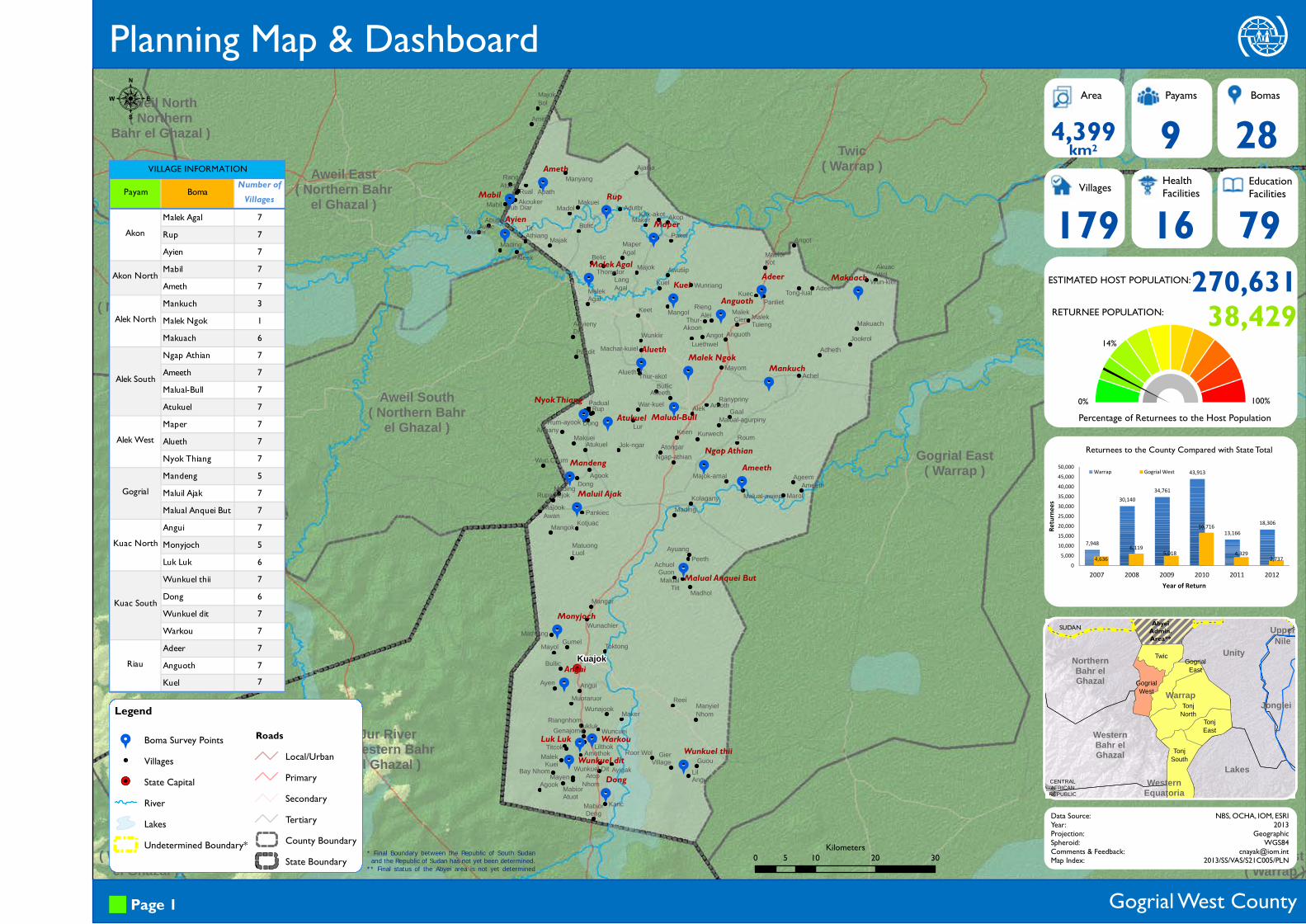
Planning Map & Dashboard
TonjSouth
TonjEast
TonjNorth
GogrialEast
GogrialWest
Twic
Lakes
UpperNile
WesternBahr elGhazal
UnityNorthernBahr elGhazal
JongleiWarrap
WesternEquatoria
CENTRALAFRICAN
REPUBLIC
Area Payams Bomas
Villages HealthFacilities
EducationFacilities
Data Source:Year:Projection:Spheroid:Comments & Feedback:Map Index:
NBS, OCHA, IOM, ESRI2013
GeographicWGS84
[email protected]/SS/VAS/S21C005/PLN
km2 9 28179 16 79
4,399
Returnees to the County Compared with State Total
270,631ESTIMATED HOST POPULATION:
RETURNEE POPULATION: 38,429
Percentage of Returnees to the Host Population0% 100%
Legend
9 Boma Survey PointsVillages
&( State CapitalRiverLakesUndetermined Boundary*
RoadsLocal/UrbanPrimarySecondaryTertiaryCounty BoundaryState Boundary
Gogrial West County Page 1
14%
* Final Boundary between the Republic of South Sudan and the Republic of Sudan has not yet been determined.** Final status of the Abyei area is not yet determined
AbyeiAdmin.Area**
SUDAN
0 10 20 305Kilometers
:
7,948
30,14034,761
43,913
13,16618,306
4,6366,119 5,018
16,716
4,329 2,7370
5,00010,00015,00020,00025,00030,00035,00040,00045,00050,000
2007 2008 2009 2010 2011 2012
Retur
nees
Year of Return
Warrap Gogrial West
Payam Boma Number of Villages
Malek Agal 7Rup 7Ayien 7Mabil 7Ameth 7Mankuch 3Malek Ngok 1Makuach 6Ngap Athian 7Ameeth 7Malual-Bull 7Atukuel 7Maper 7Alueth 7Nyok Thiang 7Mandeng 5Maluil Ajak 7Malual Anquei But 7Angui 7Monyjoch 5Luk Luk 6Wunkuel thii 7Dong 6Wunkuel dit 7Warkou 7Adeer 7Anguoth 7Kuel 7
Gogrial
Kuac North
Kuac South
Riau
VILLAGE INFORMATION
Akon
Akon North
Alek North
Alek South
Alek West
Aweil South( Northern Bahr
el Ghazal )
Aweil Centre( Northern Bahr
el Ghazal )
Aweil West( Northern Bahr
el Ghazal )
Aweil North( Northern Bahr
el Ghazal )Aweil East
( Northern Bahrel Ghazal )
Mayom( Unity )
Tonj East( Warrap )
Tonj North( Warrap )
Gogrial East( Warrap )
Twic( Warrap )
Wau( Western Bahr
el Ghazal )
Jur River( Western Bahr
el Ghazal )
NgapAthian
Ameeth
Malual-BullAtukuel
Mankuch
MalekNgok
Makuach
Alueth
NyokThiang
Mandeng
MaluilAjak
Angui
Luk Luk WunkuelthiiWunkuel
dit
Warkou
MalekAgal
Rup
Ayien
MabilAmeth
Adeer
AnguothKuel
MalualAnquei
But
Monyjoch
Dong
Maper
..
..
..
.
.
.
.
.
.
.
..
.
.
.
.
..
.
..
.
.
.
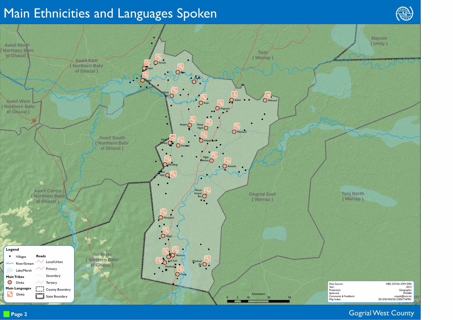
VillagesRiver/StreamLake/Marsh
Main TribesDinka
RoadsLocal/UrbanPrimarySecondaryTertiaryCounty BoundaryState Boundary
Main Ethnicities and Languages Spoken
Gogrial West County
.
Main LanguagesDinka
Legend
Page 2
Data Source:Year:Projection:Spheroid:Comments & Feedback:Map Index:
NBS, OCHA, IOM, ESRI2013
GeographicWGS84
[email protected]/SS/VAS/S21C005/THM010 10 20 305
Kilometers

99
99
99
9
9
9
9
9
9
9
9
99
9
9
9
9
99
9
99
9
9
9
99
99
99
9
9
9
9
9
9
9
99
9
9
9
9
99
9
99
9
9
9
9
Aweil South( Northern Bahr
el Ghazal )
Aweil Centre( Northern Bahr
el Ghazal )
Aweil West( Northern Bahr
el Ghazal )
Aweil North( Northern
Bahr el Ghazal )
Aweil East( Northern Bahr
el Ghazal )
Mayom( Unity )
Tonj North( Warrap )
Gogrial East( Warrap )
Twic( Warrap )
Wau( Western Bahr
el Ghazal )
Jur River( Western
Bahr el Ghazal )
Ngap AthianAmeeth
Malual-BullAtukuel
MankuchMalek Ngok
Makuach
Maper
Alueth
Nyok Thiang
MandengMaluil Ajak
Angui
Luk Luk
Wunkuel thiiWunkuel ditWarkou
Malek Agal
RupAyienMabil
Ameth
AdeerAnguothKuel
Malual Anquei But
Monyjoch
Dong
r E 4 B W
r E 4
r E Wr E W
E O 4 B
E B
r E B
r E
r E B W
E 4 W
r E 4 B
r E 4 B W
r E Br E WE 4 W
r E O 4 W
E 4 B
r E O 4 B W Nr E 4 B
r E 4 Br E 4 B
r E W
r E 4 B W
@ E B
r EE 4
r E O 4 B W N
r E 4 B
Boma Survey Points9 Bomas with Infrastructure
9 Bomas without InfrastructureVillages
RoadsLocal/UrbanPrimarySecondaryTertiary
River/StreamLake/MarshCounty BoundaryState Boundary
Gogrial West County
Legend
Infrastructure Police Station Orphanage Boma
MarketPublic
TransportMobile
CoverageReligious
Est. Roads Bridges
Number of Bomas 21 1 28 4 17 17 13 2
Satisfaction Level 10% 0 11% 25% 12% 6% 31% 100%
B W NGogrial West r @ E O 4
Infrastructure and Services
Page 3
Data Source:Year:Projection:Spheroid:Comments & Feedback:Map Index:
NBS, OCHA, IOM, ESRI2013
GeographicWGS84
[email protected]/SS/VAS/S21C005/THM020 10 20 305
Kilometers
99
99
99
9
9
9
9
9
9
9
9
99
9
9
9
9
99
9
99
9
9
9
Aweil South( Northern Bahr
el Ghazal )
Aweil Centre( Northern Bahr
el Ghazal )
Aweil West( Northern Bahr
el Ghazal )
Aweil North( Northern Bahr
el Ghazal )Aweil East
( Northern Bahrel Ghazal )
Mayom( Unity )
Tonj East( Warrap )
Tonj North( Warrap )
Gogrial East( Warrap )
Twic( Warrap )
Wau( Western Bahr
el Ghazal )
Jur River( Western Bahr
el Ghazal )
Ngap Athian
Ameeth
Malual-BullAtukuel
MankuchMalek Ngok
Makuach
Maper
Alueth
Nyok Thiang
Mandeng
Maluil Ajak
Angui
Luk Luk
Wunkuel thiiWunkuel ditWarkou
Malek Agal
RupAyien
MabilAmeth
AdeerAnguoth
Kuel
Malual Anquei But
Monyjoch
Dong
$>
$>$>
$>
>d
>d
>d
d
d
>d
>d
$ d >d
>>d>d
>d
>d
>d
d
d
>d
>d
>d$ > d
>d
d
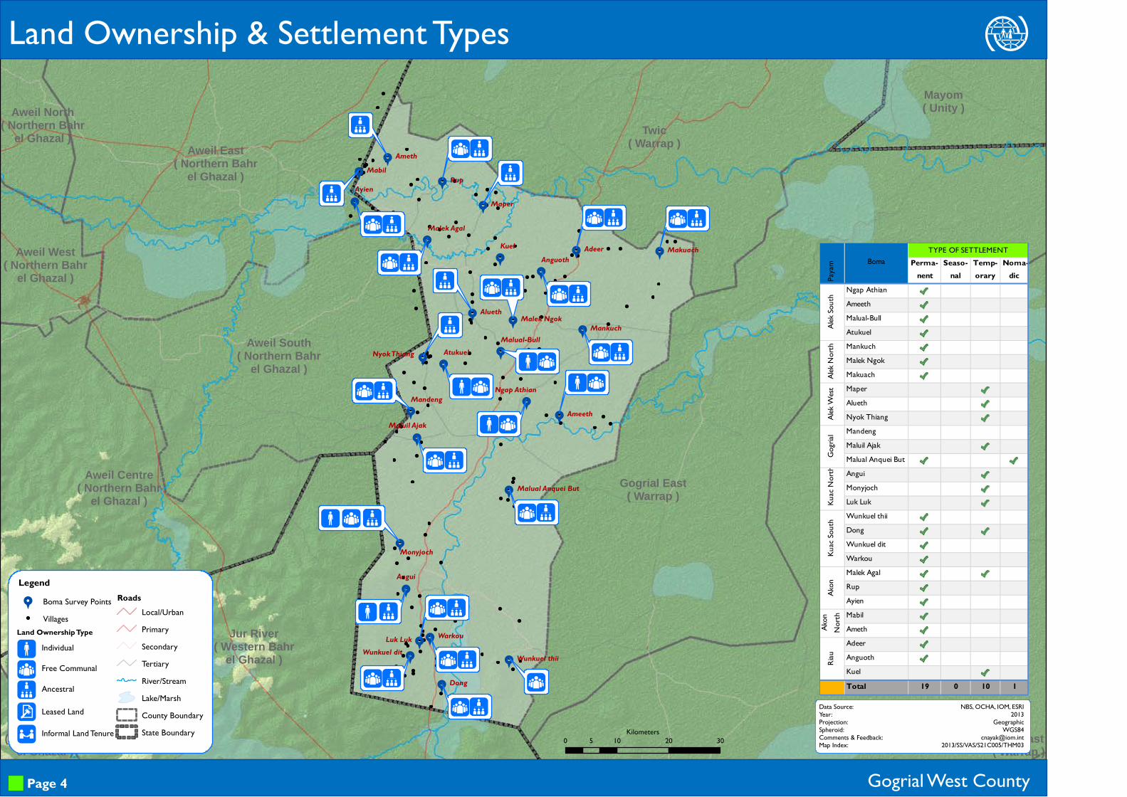
Legend9 Boma Survey Points
Villages
RoadsLocal/UrbanPrimarySecondaryTertiaryRiver/StreamLake/MarshCounty BoundaryState Boundary
Land Ownership & Settlement Types
Gogrial West County
$>d\
Individual
Free Communal
Ancestral
Leased Land
Land Ownership Type
/ Informal Land Tenure
Page 4
Data Source:Year:Projection:Spheroid:Comments & Feedback:Map Index:
NBS, OCHA, IOM, ESRI2013
GeographicWGS84
[email protected]/SS/VAS/S21C005/THM030 10 20 305
Kilometers
Perma-nent
Seaso-nal
Temp-orary
Noma-dic
Ngap AthianAmeethMalual-BullAtukuelMankuchMalek NgokMakuachMaperAluethNyok ThiangMandengMaluil AjakMalual Anquei ButAnguiMonyjochLuk LukWunkuel thiiDongWunkuel ditWarkouMalek AgalRupAyienMabilAmethAdeerAnguothKuelTotal 19 0 10 1
Riau
Payam
BomaTYPE OF SETTLEMENT
Alek S
outh
Alek N
orth
Alek W
estGo
grial
Kuac
North
Kuac
South
Akon
Akon
No
rth

Aweil South( Northern Bahr
el Ghazal )
Aweil Centre( Northern Bahr
el Ghazal )
Aweil West( Northern Bahr
el Ghazal )
Aweil North( Northern Bahr
el Ghazal )Aweil East
( Northern Bahrel Ghazal )
Mayom( Unity )
Tonj East( Warrap )
Tonj North( Warrap )
Gogrial East( Warrap )
Twic( Warrap )
Wau( Western Bahr
el Ghazal )
Jur River( Western Bahr
el Ghazal )
Ngap AthianAmeeth
Malual-BullAtukuel
MankuchMalek Ngok
Makuach
Maper
Alueth
Nyok Thiang
Mandeng
Maluil Ajak
Angui
Luk Luk
Wunkuel thiiWunkuel dit
Warkou
Malek Agal
Rup
Ayien
MabilAmeth
Adeer
AnguothKuel
Malual Anquei But
Monyjoch
Dong
LegendLand Allocation Status by Boma
YesNot specifiedNoVillagesRiver/StreamLake/Marsh
RoadsLocal/UrbanPrimarySecondaryTertiaryCounty BoundaryState Boundary
Returnee Land Allocation Status
Gogrial West County Page 5
Data Source:Year:Projection:Spheroid:Comments & Feedback:Map Index:
NBS, OCHA, IOM, ESRI2013
GeographicWGS84
[email protected]/SS/VAS/S21C005/THM040 10 20 305
Kilometers
99
99
99
9
9
9
9
9
9
9
9
999
9
9
9
99
9
99
9
9
9
99
99
99
9
9
9
9
9
9
9
999
9
9
9
99
9
99
9
9
9
9
Aweil South( Northern Bahr
el Ghazal )
Aweil Centre( Northern Bahr
el Ghazal )
Aweil West( Northern Bahr
el Ghazal )
Aweil North( Northern Bahr
el Ghazal )Aweil East
( Northern Bahrel Ghazal )
Mayom( Unity )
Tonj East( Warrap )
Tonj North( Warrap )
Gogrial East( Warrap )
Twic( Warrap )
Wau( Western Bahr
el Ghazal )
Jur River( Western Bahr
el Ghazal )
Ngap Athian
Ameeth
Malual-Bull
Atukuel
MankuchMalek Ngok
Makuach
Maper
Alueth
Nyok Thiang
Mandeng
Maluil Ajak
Angui
Luk LukWunkuel thii
Wunkuel dit
Warkou
Malek Agal
RupAyien
Mabil Ameth
Adeer
AnguothKuel
Malual Anquei But
Monyjoch
Dong
l U F
l U o Fl U Fl U F
l U F
l U o F
o
l U F
l U o F
l U o F
l U F
l U o F
l U o F
l U o F
l U o
l U o F
l U o F
l U F
l U o F
l U o F
l U F
l U o F
l U o
LegendBoma Survey Points9 Reported
9 Not Reported Villages
River/StreamLake/Marsh
RoadsLocal/UrbanPrimarySecondaryTertiaryCounty BoundaryState Boundary
Gogrial West County
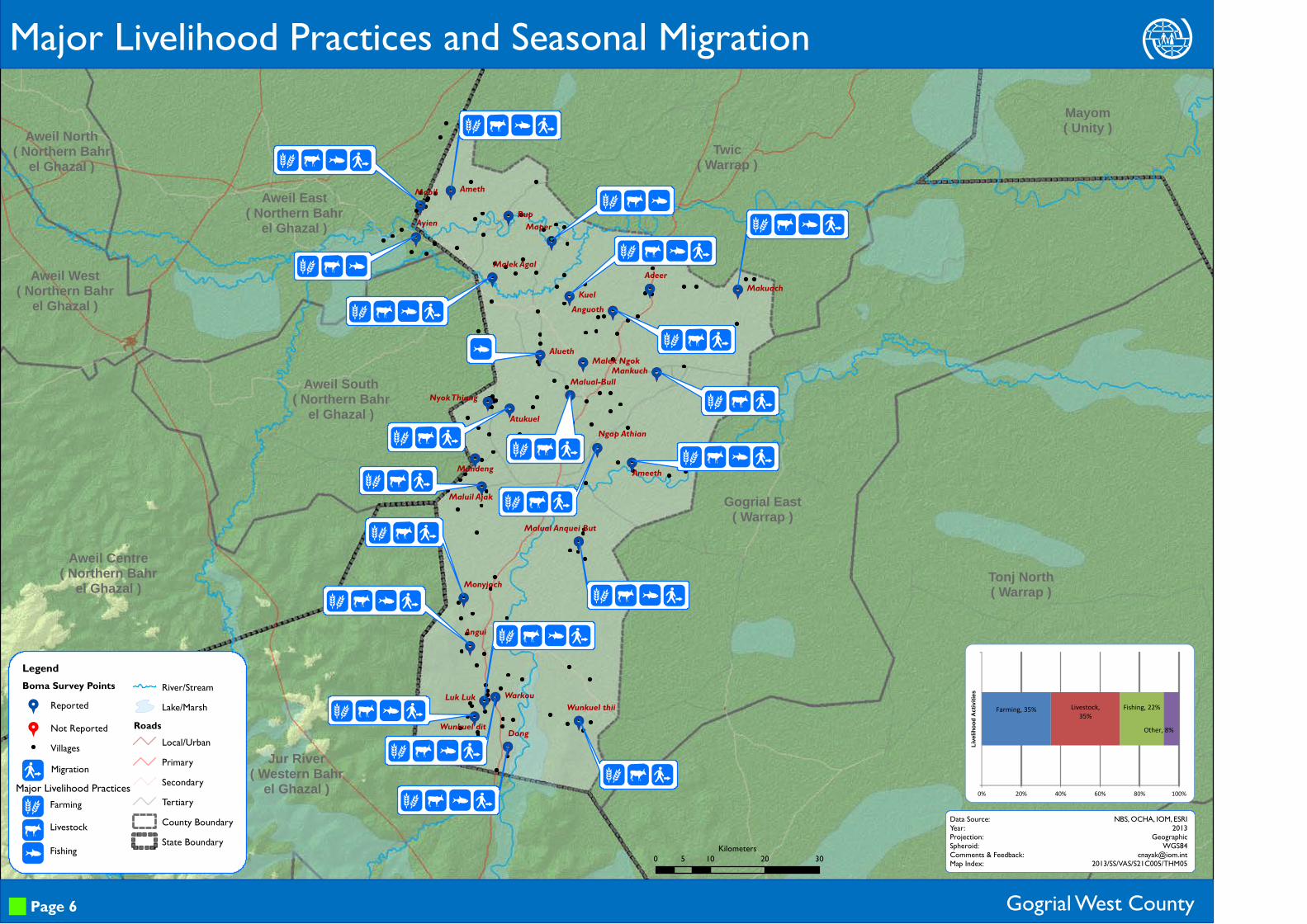
lUo
FarmingLivestock
Fishing
Major Livelihood Practices and Seasonal Migration
F Migration
Page 6
Data Source:Year:Projection:Spheroid:Comments & Feedback:Map Index:
NBS, OCHA, IOM, ESRI2013
GeographicWGS84
[email protected]/SS/VAS/S21C005/THM05
Major Livelihood Practices
0 10 20 305Kilometers
Farming, 35% Livestock, 35%
Fishing, 22%
Other, 8%
0% 20% 40% 60% 80% 100%
Liveli
hood
Acti
vities

99
99
99
9
9
9
9
9
9
9
9
99
9
9
9
9
99
9
99
9
9
9
99
99
99
9
9
9
9
9
9
9
99
9
9
9
9
99
9
99
9
9
9
9
Aweil South( Northern Bahr
el Ghazal )
Aweil Centre( Northern Bahr
el Ghazal )
Aweil West( Northern Bahr
el Ghazal )
Aweil North( Northern Bahr
el Ghazal )Aweil East
( Northern Bahrel Ghazal )
Mayom( Unity )
Tonj East( Warrap )
Tonj North( Warrap )
Gogrial East( Warrap )
Twic( Warrap )
Wau( Western Bahr
el Ghazal )
Jur River( Western Bahr
el Ghazal )
Ngap Athian
Ameeth
Malual-BullAtukuel
MankuchMalek Ngok
Makuach
Maper
Alueth
Nyok Thiang
Mandeng
Maluil Ajak
Angui
Luk Luk
Wunkuel thiiWunkuel dit
Warkou
Malek Agal
RupAyienMabil
Ameth
AdeerAnguothKuel
Malual Anquei But
Monyjoch
Dong
l s tn l l s t n l
l s t n ll s tn l
l s t n l
s t n
l s t n
l s tn n l
s t n
l s t
l s t n n l s tn n
s t ns t n
s t n
l s t n n
l st n
l s n
l s tn l
l s n
l t n
l s n l
l s t n n
s t n
l s t n n
s n
l s t n nl s
LegendBoma Survey Points9 Food Crops Reported
9 No Food Crops ReportedVillagesRiver/StreamLake/Marsh
RoadsLocal/UrbanPrimarySecondaryTertiaryCounty BoundaryState Boundary
Gogrial West County
lstnnlsE
MaizeSorghum
SesameGroundnuts
Vegetables
Millet
CassavaRice
Major Food Crops Grown
Page 7
Data Source:Year:Projection:Spheroid:Comments & Feedback:Map Index:
NBS, OCHA, IOM, ESRI2013
GeographicWGS84
[email protected]/SS/VAS/S21C005/THM06
Major Food Crops
0 10 20 305Kilometers
Maize, 20
Sorghum, 26
Sesame, 23
Groundnut, 25
Vegetable, 8
Millet, 9
Cassava, 1
0 5 10 15 20 25 30Maize
Sorghum
Sesame
Groundnut
Vegetable
Millet
Cassava
Rice
Number of Bomas
Major Food Crops Grown in the County
99
99
99
9
9
9
9
9
9
9
9
99
9
9
9
9
99
9
99
9
9
9
Aweil South( Northern Bahr
el Ghazal )
Aweil Centre( Northern Bahr
el Ghazal )
Aweil West( Northern Bahr
el Ghazal )
Aweil North( Northern Bahr
el Ghazal )Aweil East
( Northern Bahrel Ghazal )
Mayom( Unity )
Tonj East( Warrap )
Tonj North( Warrap )
Gogrial East( Warrap )
Twic( Warrap )
Wau( Western Bahr
el Ghazal )
Jur River( Western Bahr
el Ghazal )
Ngap AthianAmeeth
Malual-BullAtukuel
MankuchMalek Ngok
Makuach
Maper
Alueth
Nyok Thiang
MandengMaluil Ajak
Angui
Luk Luk
Wunkuel thiiWunkuel dit
Warkou
Malek Agal
RupAyien
MabilAmeth
AdeerAnguothKuel
Malual Anquei But
Monyjoch
Dong
n C u n C u
n C un C + u
n C u
n C u
n C u
n un + u
n C + u
n C u
n C +
n C u
n C + u
n C + u
n C +D u
n C u
n C un C u
n C un
n C+ u
n C u
n + u
C un C u
n C + u
C u
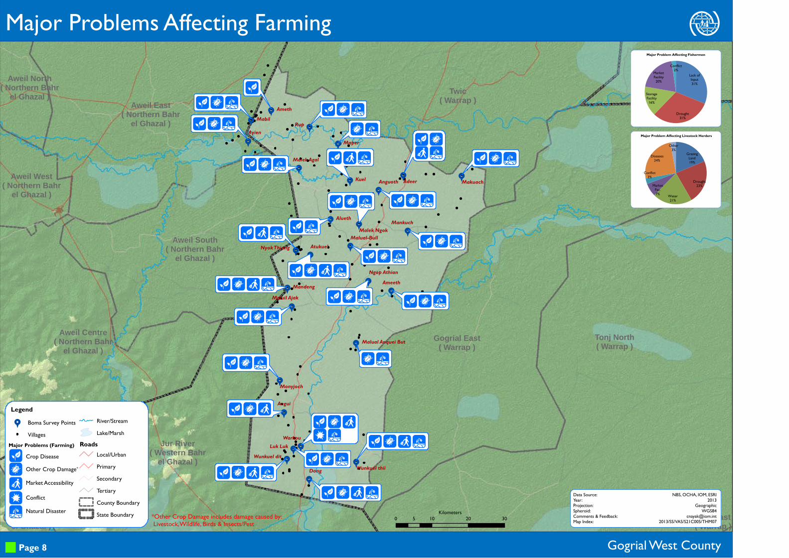
Legend9 Boma Survey Points
VillagesRiver/StreamLake/Marsh
RoadsLocal/UrbanPrimarySecondaryTertiaryCounty BoundaryState Boundary
Major Problems Affecting Farming
Gogrial West County
nC+Du
Crop DiseaseOther Crop Damage*
Market Accessibility
ConflictNatural Disaster
Page 8
Data Source:Year:Projection:Spheroid:Comments & Feedback:Map Index:
NBS, OCHA, IOM, ESRI2013
GeographicWGS84
[email protected]/SS/VAS/S21C005/THM07
Major Problems (Farming)
*Other Crop Damage includes damage caused by: Livestock, Wildlife, Birds & Insects/Pest 0 10 20 305
Kilometers
Lack of Input31%
Drought31%
Storage Facility16%
Market Facility20%
Conflict2%
Major Problem Affecting Fishermen
Grazing Land19%
Drought23%
Water21%
Market Fac.7%
Conflict3%
Diseases24%
Other3%
Major Problem Affecting Livestock Herders
Aweil South( Northern Bahr
el Ghazal )
Aweil Centre( Northern
Bahr el Ghazal )
Aweil West( Northern
Bahr el Ghazal )
Aweil North( Northern Bahr
el Ghazal ) Aweil East( Northern Bahr
el Ghazal )
Mayom( Unity )
Tonj North( Warrap )
Gogrial East( Warrap )
Twic( Warrap )
Wau( Western Bahr
el Ghazal )
Jur River( Western Bahr
el Ghazal )
Ngap Athian
Ameeth
Malual-Bull
Atukuel
MankuchMalek Ngok
Makuach
Maper
Alueth
Nyok Thiang
Mandeng
Maluil Ajak
Angui
Luk LukWunkuel thiiWunkuel dit
Warkou
Malek Agal
Rup
Ayien
MabilAmeth
AdeerAnguoth
Kuel
Malual Anquei But
Monyjoch
Dong
U nu w n
u w nu w n
u w I
U
u U
u U
u U n I
u U w n
u U w n I
u U nU w
u w n
z w
u z Uw n
u zU n
u U n
z U n I D
u z U w n Iu U w n I
u U I
u U n I
n I D
U n
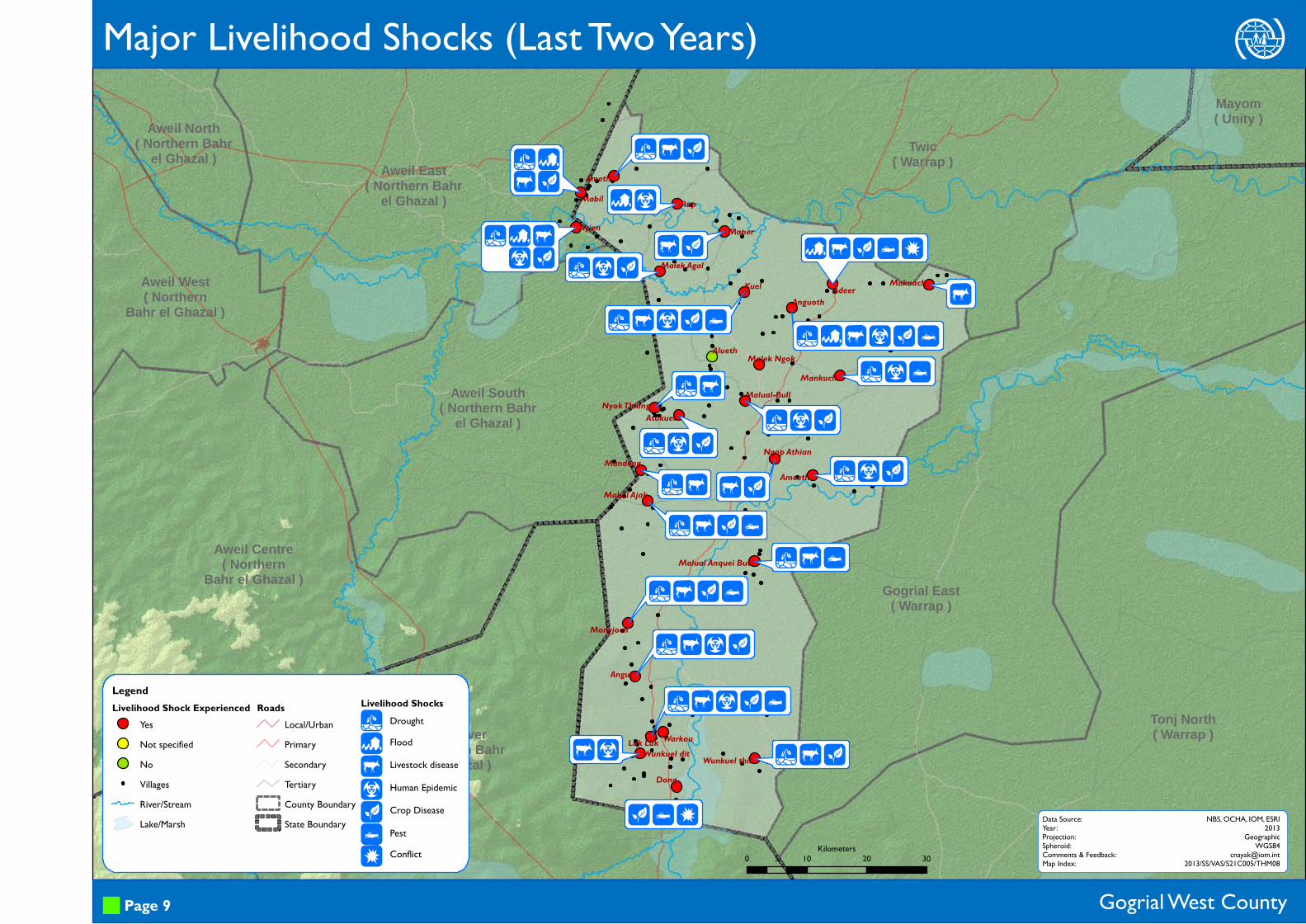
LegendLivelihood Shock Experienced
YesNot specifiedNoVillagesRiver/StreamLake/Marsh
RoadsLocal/UrbanPrimarySecondaryTertiaryCounty BoundaryState Boundary
Major Livelihood Shocks (Last Two Years)
Gogrial West County
uzUwnID
DroughtFloodLivestock diseaseHuman EpidemicCrop Disease
PestConflict
Page 9
Data Source:Year:Projection:Spheroid:Comments & Feedback:Map Index:
NBS, OCHA, IOM, ESRI2013
GeographicWGS84
[email protected]/SS/VAS/S21C005/THM08
Livelihood Shocks
0 10 20 305Kilometers

Aweil South( Northern Bahr
el Ghazal )
Aweil Centre( Northern Bahr
el Ghazal )
Aweil West( Northern Bahr
el Ghazal )
Aweil North( Northern Bahr
el Ghazal )Aweil East
( Northern Bahrel Ghazal )
Mayom( Unity )
Tonj East( Warrap )
Tonj North( Warrap )
Gogrial East( Warrap )
Twic( Warrap )
Wau( Western Bahr
el Ghazal )
Jur River( Western Bahr
el Ghazal )
Ngap AthianAmeeth
Malual-Bull
Atukuel
MankuchMalek Ngok
Makuach
Maper
Alueth
Nyok Thiang
Mandeng
Maluil Ajak
Angui
Luk Luk
Wunkuel thiiWunkuel dit
Warkou
Malek Agal
Rup
Ayien
Mabil Ameth
Adeer
Anguoth
Kuel
Malual Anquei But
Monyjoch
Dong
xx
x
x
w
x
x
x
xx
w
x
wx
x
x
Legend9 Boma Survey Points
VillagesAccess to Health Facility
Easy
Medium
DifficultRiver/StreamLake/Marsh
RoadsLocal/UrbanPrimarySecondaryTertiaryCounty BoundaryState Boundary
Access to Health Facilities
Gogrial West County
zwx
HospitalPHCCPHCU
Page 10
Data Source:Year:Projection:Spheroid:Comments & Feedback:Map Index:
NBS, OCHA, IOM, ESRI2013
GeographicWGS84
[email protected]/SS/VAS/S21C005/THM09
PHCC: Primary Health Care CentrePHCU: Primary Health Care Unit
Type of Health Facility
f Others
0 10 20 305Kilometers
Health facilities shown in RED are in open air or with temporary structures.
Payam Bomas Bomas with Health Facility Hospitals PHCC PHCU Others
Alek South 4 2 0 0 2 0Alek North 3 0 0 0 0 0Alek West 3 2 0 0 3 0Gogrial 3 3 0 1 2 0Kuac North 3 1 0 0 1 0Kuac South 4 2 0 0 2 0Akon 3 1 0 1 0 0Akon North 2 1 0 0 1 0Riau 3 2 0 1 2 0
HEALTH FACILITY INFORMATION

99
99
99
9
9
9
9
9
9
9
9
99
9
9
9
9
99
9
99
9
9
9
Aweil South( Northern Bahr
el Ghazal )
Aweil Centre( Northern Bahr
el Ghazal )
Aweil West( Northern Bahr
el Ghazal )
Aweil North( Northern Bahr
el Ghazal )
Aweil East( Northern Bahr
el Ghazal )
Mayom( Unity )
Tonj North( Warrap )
Gogrial East( Warrap )
Twic( Warrap )
Wau( Western Bahr
el Ghazal )
Jur River( Western Bahr
el Ghazal )
Ngap AthianAmeeth
Malual-Bull
Atukuel
MankuchMalek Ngok
Makuach
Maper
Alueth
Nyok Thiang
Mandeng
Maluil Ajak
Angui
Luk Luk
Wunkuel thiiWunkuel dit
Warkou
Malek Agal
Rup
Ayien
Mabil Ameth
Adeer
Anguoth
Kuel
Malual Anquei But
Monyjoch
Dong
A & L h
>
>
>A & L h
>&
>
>
>>&
>A & h /
>
>A &
>
>
Legend9 Boma Survey Points
VillagesHealth Facilities
Services ReportedNo Services Reported
River/StreamLake/Marsh
RoadsLocal/UrbanPrimarySecondaryTertiaryCounty BoundaryState Boundary
Gogrial West County
Health Facilities and Services Offered
Page 11
Data Source:Year:Projection:Spheroid:Comments & Feedback:Map Index:
NBS, OCHA, IOM, ESRI2013
GeographicWGS84
[email protected]/SS/VAS/S21C005/THM100 10 20 305
Kilometers
>A&Lh/
Out Patient
In PatientMaternity Ward
Laboratory
Feeding CentrePsycho-Social Support
Services Offered
Please refer to the next map for more services

99
99
99
9
9
9
9
9
9
9
9
99
9
9
9
9
99
9
99
9
9
9
Aweil South( Northern Bahr
el Ghazal )
Aweil Centre( Northern Bahr
el Ghazal )
Aweil West( Northern Bahr
el Ghazal )
Aweil North( Northern Bahr
el Ghazal )
Aweil East( Northern Bahr
el Ghazal )
Mayom( Unity )
Tonj North( Warrap )
Gogrial East( Warrap )
Twic( Warrap )
Wau( Western Bahr
el Ghazal )
Jur River( Western Bahr
el Ghazal )
Ngap AthianAmeeth
Malual-Bull
Atukuel
Mankuch
Malek Ngok
Makuach
Maper
Alueth
Nyok Thiang
Mandeng
Maluil Ajak
Angui
Luk Luk
Wunkuel thiiWunkuel dit
Warkou
Malek Agal
Rup
Ayien
MabilAmeth
Adeer
AnguothKuel
Malual Anquei But
Monyjoch
Dong
x h L [ e
h L [
L D
L e
x h L D e
x L [ e
x L D
x h L [ e
x L [
x h L [ e
x h D [ e
x L e
x [ e
h [
h [
Legend9 Boma Survey Points
VillagesHealth Facilities
Services ReportedNo Services Reported
River/StreamLake/Marsh
RoadsLocal/UrbanPrimarySecondaryTertiaryCounty BoundaryState Boundary
Gogrial West County
Health Facilities and Services Offered (Continued)
Page 12
Data Source:Year:Projection:Spheroid:Comments & Feedback:Map Index:
NBS, OCHA, IOM, ESRI2013
GeographicWGS84
[email protected]/SS/VAS/S21C005/THM100 10 20 305
Kilometers
xhLD[e
Drug Dispensary
Epidemiological Data
ImmunizationVehicles for Referral
Paid ServiceHealth Education
Services Offered

99
99
99
9
9
9
9
9
9
9
9
99
9
9
9
9
99
9
99
9
9
9
Aweil South( Northern Bahr
el Ghazal )
Aweil Centre( Northern Bahr
el Ghazal )
Aweil West( Northern Bahr
el Ghazal )
Aweil North( Northern Bahr
el Ghazal )Aweil East
( Northern Bahrel Ghazal )
Mayom( Unity )
Tonj East( Warrap )
Tonj North( Warrap )
Gogrial East( Warrap )
Twic( Warrap )
Wau( Western Bahr
el Ghazal )
Jur River( Western Bahr
el Ghazal )
Ngap AthianAmeeth
Malual-BullAtukuel
MankuchMalek Ngok
Makuach
Maper
Alueth
Nyok Thiang
Mandeng
Maluil Ajak
Angui
Luk Luk
Wunkuel thiiWunkuel dit
Warkou
Malek Agal
RupAyien
Mabil Ameth
Adeer
Anguoth
Kuel
Malual Anquei But
Monyjoch
Dong
LL
LL
L ee
L e
L
L e
L
L
L e
L eL
L L e
L e
L e
L
L
L e
LL
L
L e
L e
L e
Legend9 Boma Survey Points
VillagesRiver/StreamLake/Marsh
RoadsLocal/UrbanPrimarySecondaryTertiaryCounty BoundaryState Boundary
Health Awareness Programmes (Boma Perspective)
Gogrial West County Page 13
Data Source:Year:Projection:Spheroid:Comments & Feedback:Map Index:
NBS, OCHA, IOM, ESRI2013
GeographicWGS84
[email protected]/SS/VAS/S21C005/THM11
Le
Health Awareness Prog.ImmunizationHIV/AIDS EducationHealth Education STID: Sexually Transmitted Infectious Diseases
OTD: Other Transmitted Diseases 0 10 20 305Kilometers
Payam Boma
Hygie
neCh
ild
Nutri
tion
Fam
ily
Plann
ingRe
prod
uctiv
e He
alth
STID
OTD
Ngap AthianAmeethMalual-BullAtukuelMankuchMalek NgokMakuachMaperAluethNyok ThiangMandengMaluil AjakMalual Anquei ButAnguiMonyjochLuk LukWunkuel thiiDongWunkuel ditWarkouMalek AgalRupAyienMabilAmethAdeerAnguothKuelTotal 13 4 1 0 1 1
Kuac
South
Akon
Akon
No
rthRia
u
HEALTH EDUCATION TOPICS
Alek S
outh
Alek N
orth
Alek W
estGo
grial
Kuac
North
99
99
99
9
9
9
9
9
9
9
9
99
9
9
9
9
99
9
99
9
9
9
Aweil South( Northern Bahr
el Ghazal )
Aweil Centre( Northern Bahr
el Ghazal )
Aweil West( Northern Bahr
el Ghazal )
Aweil North( Northern Bahr
el Ghazal )Aweil East
( Northern Bahrel Ghazal )
Mayom( Unity )
Tonj East( Warrap )
Tonj North( Warrap )
Gogrial East( Warrap )
Twic( Warrap )
Wau( Western Bahr
el Ghazal )
Jur River( Western Bahr
el Ghazal )
Ngap Athian
Ameeth
Malual-BullAtukuel
Mankuch
Malek Ngok
Makuach
Maper
Alueth
Nyok Thiang
Mandeng
Maluil Ajak
Angui
Luk Luk Wunkuel thiiWunkuel dit
Warkou
Malek Agal
RupAyien
MabilAmeth
Adeer
AnguothKuel
Malual Anquei But
Monyjoch
Dong
L P
L P
PL
L P
P
L P L P
L P
L P
L P
P
L
L P
P
L P
LL P
L P
Legend9 Boma Survey Points
VillagesRiver/StreamLake/Marsh
RoadsLocal/UrbanPrimarySecondaryTertiaryCounty BoundaryState Boundary
Gogrial West County
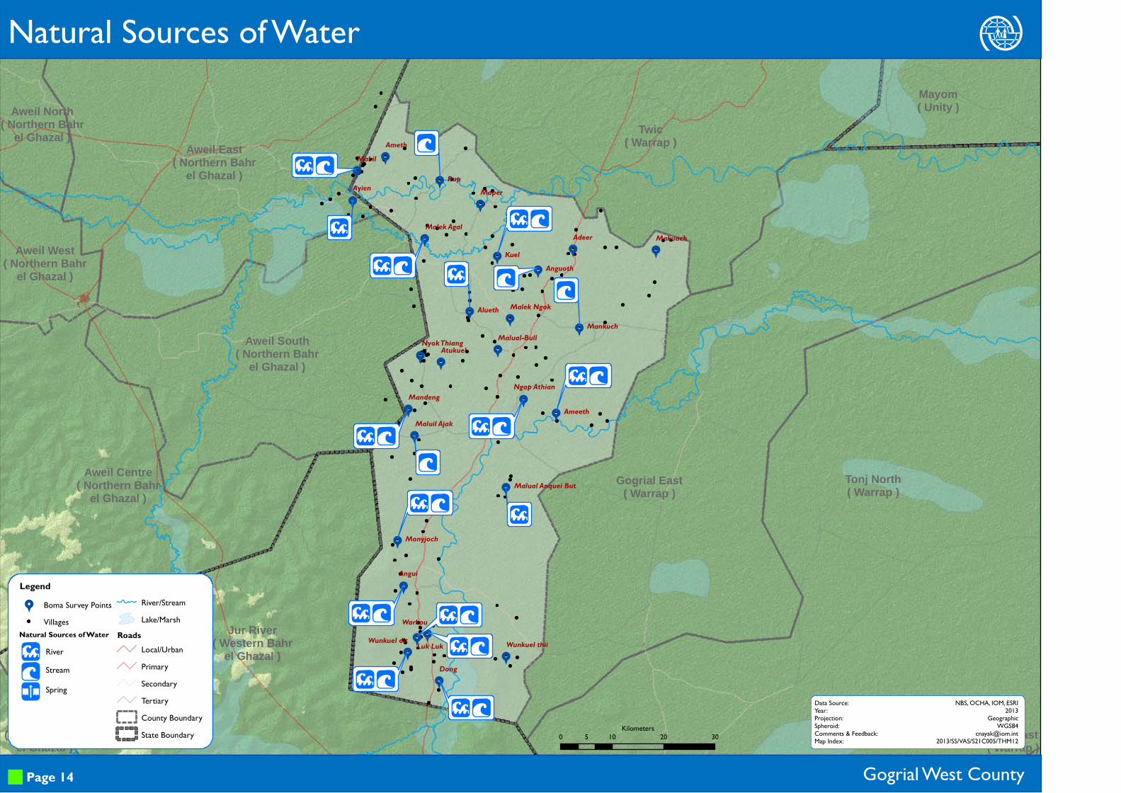
LPU
RiverStream
Spring
Natural Sources of Water
Page 14
Data Source:Year:Projection:Spheroid:Comments & Feedback:Map Index:
NBS, OCHA, IOM, ESRI2013
GeographicWGS84
[email protected]/SS/VAS/S21C005/THM12
Natural Sources of Water
0 10 20 305Kilometers

Aweil South( Northern Bahr
el Ghazal )
Aweil Centre( Northern Bahr
el Ghazal )
Aweil West( Northern Bahr
el Ghazal )
Aweil North( Northern Bahr
el Ghazal )Aweil East
( Northern Bahrel Ghazal )
Mayom( Unity )
Tonj East( Warrap )
Tonj North( Warrap )
Gogrial East( Warrap )
Twic( Warrap )
Wau( Western Bahr
el Ghazal )
Jur River( Western Bahr
el Ghazal )
Ngap AthianAmeeth
Malual-BullAtukuel
MankuchMalek Ngok
Makuach
Maper
Alueth
Nyok Thiang
Mandeng
Maluil Ajak
Angui
Luk LukWunkuel thiiWunkuel dit
Warkou
Malek Agal
Rup
Ayien
MabilAmeth
Adeer
Anguoth
Kuel
Malual Anquei But
Monyjoch
Dong
M
MM X
MM
M
M
M
M
MMM M X
M
M X
M
MM
M X
MM
M
M
M
Legend9 Boma Survey Points
VillagesAccess to Water Source
Easy
Medium
DifficultRiver/Stream
Lake/MarshRoads
Local/UrbanPrimarySecondaryTertiaryCounty BoundaryState Boundary
Gogrial West County
Hom
Water Points and Physical Accessibility
UMXkY
Borehole
HafirTap
Water Tanker
Page 15
Data Source:Year:Projection:Spheroid:Comments & Feedback:Map Index:
NBS, OCHA, IOM, ESRI2013
GeographicWGS84
[email protected]/SS/VAS/S21C005/THM13
Sources of Water
0 10 20 305Kilometers
99
99
99
9
9
9
9
9
9
9
9
99
9
9
9
9
99
9
99
9
9
9
Aweil South( Northern Bahr
el Ghazal )
Aweil Centre( Northern Bahr
el Ghazal )
Aweil West( Northern Bahr
el Ghazal )
Aweil North( Northern Bahr
el Ghazal )Aweil East
( Northern Bahrel Ghazal )
Mayom( Unity )
Tonj East( Warrap )
Tonj North( Warrap )
Gogrial East( Warrap )
Twic( Warrap )
Wau( Western Bahr
el Ghazal )
Jur River( Western Bahr
el Ghazal )
Ngap Athian
Ameeth
Malual-BullAtukuel
Mankuch
Malek Ngok
Makuach
Maper
Alueth
Nyok Thiang
Mandeng
Maluil Ajak
Angui
Luk Luk
Wunkuel thiiWunkuel ditWarkou
Malek Agal
Rup
Ayien
MabilAmeth
Adeer
AnguothKuel
Malual Anquei But
Monyjoch
Dong
>D
>D
>D
>D
>D>
>
>D
>
>
>
>D
D
>
>
>>
>[ D
>
>
Legend9 Boma Survey Points
VillagesRiver/StreamLake/Marsh
RoadsLocal/UrbanPrimarySecondaryTertiaryCounty BoundaryState Boundary
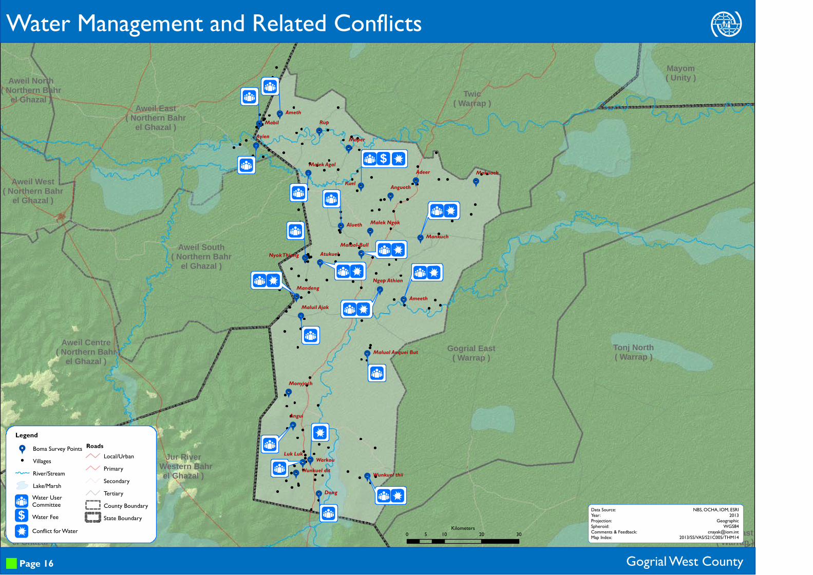
Water Management and Related Conflicts
Gogrial West County
>[D
Water User CommitteeWater FeeConflict for Water
Page 16
Data Source:Year:Projection:Spheroid:Comments & Feedback:Map Index:
NBS, OCHA, IOM, ESRI2013
GeographicWGS84
[email protected]/SS/VAS/S21C005/THM140 10 20 305
Kilometers
99
99
99
9
9
9
9
9
9
9
9
99
9
9
9
9
99
9
99
9
9
9
Aweil South( Northern Bahr
el Ghazal )
Aweil Centre( Northern Bahr
el Ghazal )
Aweil West( Northern Bahr
el Ghazal )
Aweil North( Northern Bahr
el Ghazal )Aweil East
( Northern Bahrel Ghazal )
Mayom( Unity )
Tonj East( Warrap )
Tonj North( Warrap )
Gogrial East( Warrap )
Twic( Warrap )
Wau( Western Bahr
el Ghazal )
Jur River( Western Bahr
el Ghazal )
Ngap AthianAmeeth
Malual-BullAtukuel
Mankuch
Malek Ngok
Makuach
Maper
Alueth
Nyok Thiang
Mandeng
Maluil Ajak
Angui
Luk LukWunkuel thii
Wunkuel dit
Warkou
Malek Agal
RupAyien
Mabil Ameth
Adeer
AnguothKuel
Malual Anquei But
Monyjoch
Dong
P S
S
R P S
R P SR P S
S
P S
R P S
R P S
R P S
R P S
Legend9 Boma Survey Points
VillagesRiver/StreamLake/Marsh
RoadsLocal/UrbanPrimarySecondaryTertiaryCounty BoundaryState Boundary
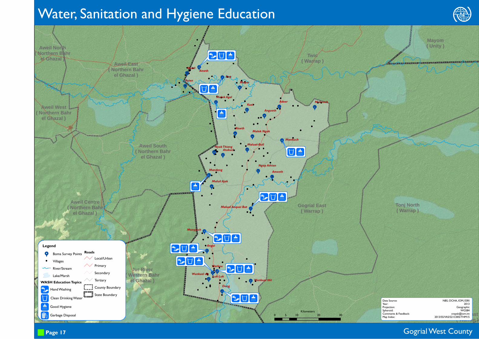
Water, Sanitation and Hygiene Education
Gogrial West County
RPST
Hand Washing
Clean Drinking Water
Good Hygiene
Garbage Disposal
Page 17
Data Source:Year:Projection:Spheroid:Comments & Feedback:Map Index:
NBS, OCHA, IOM, ESRI2013
GeographicWGS84
[email protected]/SS/VAS/S21C005/THM15
WASH Education Topics
0 10 20 305Kilometers

Aweil South( Northern Bahr
el Ghazal )
Aweil Centre( Northern Bahr
el Ghazal )
Aweil West( Northern Bahr
el Ghazal )
Aweil North( Northern Bahr
el Ghazal )Aweil East
( Northern Bahrel Ghazal )
Mayom( Unity )
Tonj East( Warrap )
Tonj North( Warrap )
Gogrial East( Warrap )
Twic( Warrap )
Wau( Western Bahr
el Ghazal )
Jur River( Western Bahr
el Ghazal )
Ngap AthianAmeeth
Malual-BullAtukuel
MankuchMalek Ngok
Makuach
Maper
Alueth
Nyok Thiang
Mandeng
Maluil Ajak
Angui
Luk Luk
Wunkuel thiiWunkuel dit
Warkou
Malek Agal
Rup
Ayien
MabilAmeth
Adeer
AnguothKuel
Malual Anquei But
Monyjoch
Dong
N
N
O Ó
N
N
N Ó
LegendPresence of Latrine & Use
Not PresentPresent & Not usedPresent & Not SpecifiedPresent & UsedVillages
River/StreamLake/Marsh
RoadsLocal/UrbanPrimarySecondaryTertiaryCounty BoundaryState Boundary
Latrine Types and Use
Gogrial West County
NOÓ
Public Latrines
Private Latrines
Open Air
Page 18
Data Source:Year:Projection:Spheroid:Comments & Feedback:Map Index:
NBS, OCHA, IOM, ESRI2013
GeographicWGS84
[email protected]/SS/VAS/S21C005/THM160 10 20 305
Kilometers
Aweil South( Northern Bahr
el Ghazal )
Aweil Centre( Northern Bahr
el Ghazal )
Aweil West( Northern Bahr
el Ghazal )
Aweil North( Northern Bahr
el Ghazal )Aweil East
( Northern Bahrel Ghazal )
Mayom( Unity )
Tonj East( Warrap )
Tonj North( Warrap )
Gogrial East( Warrap )
Twic( Warrap )
Wau( Western Bahr
el Ghazal )
Jur River( Western Bahr
el Ghazal )
Ngap AthianAmeeth
Malual-BullAtukuel
MankuchMalek Ngok
Makuach
Maper
Alueth
Nyok Thiang
Mandeng
Maluil Ajak
Angui
Luk Luk
Wunkuel thiiWunkuel dit
Warkou
Malek Agal
Rup
Ayien
MabilAmeth
Adeer
AnguothKuel
Malual Anquei But
Monyjoch
Dong
Legend
H Education facility
9 Boma Survey PointsVillages
Acces to Education facilityEasy
Medium
Difficult
River/StreamLake/Marsh
RoadsLocal/UrbanPrimarySecondaryTertiaryCounty BoundaryState Boundary
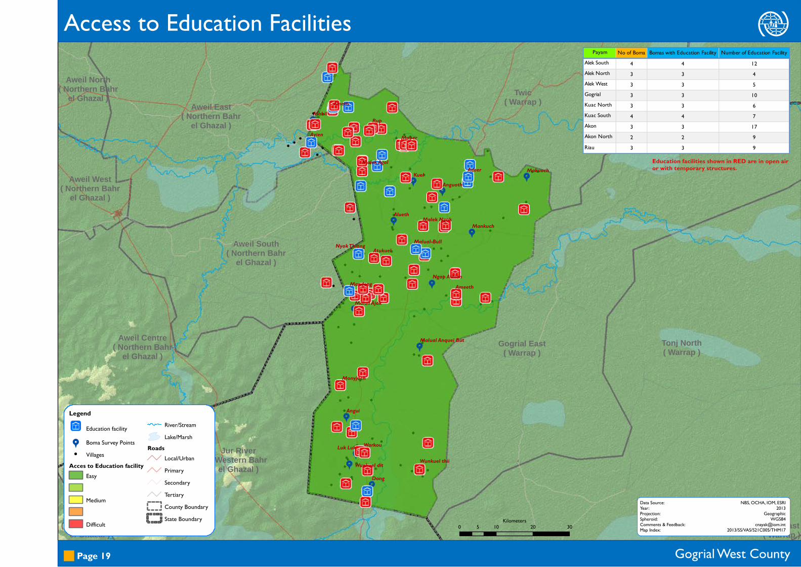
Access to Education Facilities
Gogrial West County Page 19
Data Source:Year:Projection:Spheroid:Comments & Feedback:Map Index:
NBS, OCHA, IOM, ESRI2013
GeographicWGS84
[email protected]/SS/VAS/S21C005/THM170 10 20 305
Kilometers
Payam No of Boma Bomas with Education Facility Number of Education FacilityAlek South 4 4 12Alek North 3 3 4Alek West 3 3 5Gogrial 3 3 10Kuac North 3 3 6Kuac South 4 4 7Akon 3 3 17Akon North 2 2 9Riau 3 3 9
Education facilities shown in RED are in open air or with temporary structures.
99
99
99
9
9
9
9
9
9
9
9
999
9
9
9
99
9
99
9
9
9
!6!6!8
!8!6!4
!6!8!8!6
!8 !6
!5!8!4!6
!6!6!4
!8
!8
!5 !4!6 !8!6 !6!4!8
!8
!7
!8!3 !5
!3!6
!8!8
!6
!6!8!6!6!7
!6!6!6 !8
!8!8!8
!7!5!4
!5!6!5!4
!4
!6!8!6!6
!5
!6 !4!8!5
!7!7
!8 !6!8!!
!8
!4
!6
!5!5
Aweil South( Northern Bahr
el Ghazal )
Aweil Centre( Northern
Bahr el Ghazal )
Aweil West( Northern Bahr
el Ghazal )
Aweil North( Northern Bahr
el Ghazal ) Aweil East( Northern
Bahr el Ghazal )
Mayom( Unity )
Tonj East( Warrap )
Tonj North( Warrap )Gogrial East
( Warrap )
Twic( Warrap )
Wau( Western Bahr
el Ghazal )
Jur River( Western Bahr
el Ghazal )
Ngap AthianAmeeth
Malual-Bull
Atukuel
Mankuch
Malek Ngok
Makuach
Maper
Alueth
Nyok Thiang
Mandeng
Maluil Ajak
Angui
Luk LukWunkuel thii
Wunkuel dit
Warkou
Malek Agal
Rup
Ayien
MabilAmeth
Adeer
Anguoth
Kuel
Malual Anquei But
Monyjoch
Dong
. .
. .
. .
.
. .. .
.
.. .
. .
. .
. .
. .
. .
. .
. .. .
. .
. .
. .
. . .
. . .. .
. .
. .
. .
. .
. .
. . . .
. .. .
. .
. .
. .
. .
. .
Legend9 Boma Survey Points
VillagesLevel Of Education!3 Highest standard taught!! Not specified
River/StreamLake/Marsh
RoadsLocal/UrbanPrimarySecondaryTertiaryCounty BoundaryState Boundary
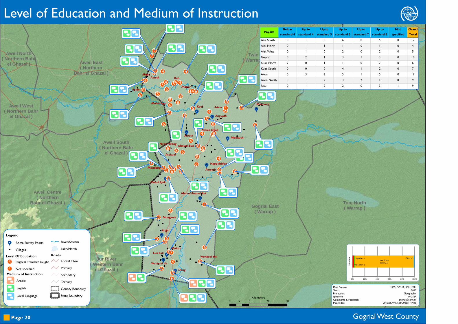
Level of Education and Medium of Instruction
Gogrial West County
.
.
.
ArabicEnglishLocal Language
Page 20
Data Source:Year:Projection:Spheroid:Comments & Feedback:Map Index:
NBS, OCHA, IOM, ESRI2013
GeographicWGS84
[email protected]/SS/VAS/S21C005/THM18
Medium of Instruction
0 10 20 305Kilometers
Old Sudan, 2
Ugandan, 1 New South Sudan, 77
Others, 1
0% 20% 40% 60% 80% 100%
Curric
ulum
Payam Below standard 4
Up to standard 4
Up to standard 5
Up to standard 6
Up to standard 7
Up to standard 8
Not specified
Grand Total
Alek South 0 1 0 6 0 5 0 12Alek North 0 1 1 1 0 1 0 4Alek West 0 1 0 2 0 2 0 5Gogrial 0 2 1 3 1 3 0 10Kuac North 2 0 1 1 0 2 0 6Kuac South 0 0 0 4 1 2 0 7Akon 0 3 3 5 1 5 0 17Akon North 0 1 2 3 2 1 0 9Riau 0 1 2 2 0 3 1 9

99
99
99
9
9
9
9
9
9
9
9
99
9
9
9
9
99
9
99
9
9
9
Aweil South( Northern Bahr
el Ghazal )
Aweil Centre( Northern Bahr
el Ghazal )
Aweil West( Northern Bahr
el Ghazal )
Aweil North( Northern Bahr
el Ghazal )Aweil East
( Northern Bahrel Ghazal )
Mayom( Unity )
Tonj East( Warrap )
Tonj North( Warrap )
Gogrial East( Warrap )
Twic( Warrap )
Wau( Western Bahr
el Ghazal )
Jur River( Western Bahr
el Ghazal )
Ngap Athian
Ameeth
Malual-Bull
Atukuel
MankuchMalek Ngok
Makuach
Maper
Alueth
Nyok Thiang
Mandeng
Maluil Ajak
Angui
Luk LukWunkuel thiiWunkuel dit
Warkou
Malek Agal
Rup
Ayien
Mabil Ameth
Adeer
Anguoth
Kuel
Malual Anquei But
Monyjoch
Dong
Legend9 Boma Survey Points
VillagesTeacher to Student Ratio
1 Teacher per 50 Students1 Teacher per 25 Students
1 Teacher per 10 Students
1 Teacher per 5 StudentsRiver/StreamLake/Marsh
RoadsLocal/UrbanPrimarySecondaryTertiaryCounty BoundaryState Boundary
Teacher to Student Ratio
Gogrial West County Page 21
Data Source:Year:Projection:Spheroid:Comments & Feedback:Map Index:
NBS, OCHA, IOM, ESRI2013
GeographicWGS84
[email protected]/SS/VAS/S21C005/THM190 10 20 305
Kilometers
Male59690%
Female66
10%
Male-Female Teachers in Primary Schools

99
99
99
9
9
9
9
9
9
9
9
99
9
9
9
9
99
9
99
9
9
9
Aweil South( Northern
Bahr el Ghazal )
Aweil Centre( Northern Bahr
el Ghazal )
Aweil West( Northern Bahr
el Ghazal )
Aweil North( Northern Bahr
el Ghazal )Aweil East
( Northern Bahrel Ghazal )
Mayom( Unity )
Tonj East( Warrap )
Tonj North( Warrap )
GogrialEast
( Warrap )
Twic( Warrap )
Wau( Western Bahrel Ghazal )
Jur River( Western Bahr
el Ghazal )
NgapAthian
Ameeth
Malual-BullAtukuel
MankuchMalekNgok
Makuach
Maper
Alueth
NyokThiang
MandengMaluil
Ajak
Angui
Luk Luk WunkuelthiiWunkuel
dit
Warkou
MalekAgal
Rup
Ayien
Mabil Ameth
Adeer
Anguoth
Kuel
MalualAnquei But
Monyjoch
Dong
(
(
((
(
W Q (
(
(
(
(
W (
(
Q (
(
(
W Q ( (
Q (
(
Q ( W Q (
W Q (
(
(
W Q (
(
Q (
W Q (
Q (
((
(
Q (
W (
(
W (W (
W Q W (
Q (
(
W Q (
(
Q (
(
Legend9 Boma Survey Points
VillagesEducation FacilityRiver/StreamLake/Marsh
RoadsLocal/UrbanPrimarySecondaryTertiary
County BoundaryState Boundary
Primary School Facilities
Gogrial West County
W*Qy
Separate Toilets for Boys & GirlsEnrollment of Personswith DisabilitiesPotable Water
Play AreaFirst-Aid Equipment
(Parent-Teacher Association
Page 22
Data Source:Year:Projection:Spheroid:Comments & Feedback:Map Index:
NBS, OCHA, IOM, ESRI2013
GeographicWGS84
[email protected]/SS/VAS/S21C005/THM20
Facilities offered
0 10 20 305Kilometers

99
99
99
9
9
9
9
9
9
9
9
99
9
9
9
9
99
9
99
9
9
9
Aweil South( Northern Bahr
el Ghazal )
Aweil Centre( Northern Bahr
el Ghazal )
Aweil West( Northern Bahr
el Ghazal )
Aweil North( Northern Bahr
el Ghazal )Aweil East
( Northern Bahrel Ghazal )
Mayom( Unity )
Tonj East( Warrap )
Tonj North( Warrap )
Gogrial East( Warrap )
Twic( Warrap )
Wau( Western Bahr
el Ghazal )
Jur River( Western Bahr
el Ghazal )
Ngap Athian
Ameeth
Malual-BullAtukuel
MankuchMalek Ngok
Makuach
Maper
Alueth
Nyok Thiang
MandengMaluil Ajak
Angui
Luk LukWunkuel thii
Wunkuel dit
Warkou
Malek Agal
RupAyien
Mabil Ameth
AdeerAnguothKuel
Malual Anquei But
Monyjoch
Dong
( r
( r
( r
( r q
( r(
(
r
( r
(
( r
( r
( r ( r
(
( r
(
( r( r
( r
( r
(
( r
( r
( r(
( r
Legend9 Boma Survey Points
VillagesRiver/StreamLake/Marsh
RoadsLocal/UrbanPrimarySecondaryTertiaryCounty BoundaryState Boundary
Presence of Rule of Law Institutions
Gogrial West County
(rq
Boma Court
Police Station
Judicial Court
Page 23
Data Source:Year:Projection:Spheroid:Comments & Feedback:Map Index:
NBS, OCHA, IOM, ESRI2013
GeographicWGS84
[email protected]/SS/VAS/S21C005/THM210 10 20 305
Kilometers
99
99
99
9
9
9
9
9
9
9
9
99
9
9
9
9
99
9
99
9
9
9
Aweil South( Northern Bahr
el Ghazal )
Aweil Centre( Northern Bahr
el Ghazal )
Aweil West( Northern Bahr
el Ghazal )
Aweil North( Northern Bahr
el Ghazal )Aweil East
( Northern Bahrel Ghazal )
Mayom( Unity )
Tonj East( Warrap )
Tonj North( Warrap )
Gogrial East( Warrap )
Twic( Warrap )
Wau( Western Bahr
el Ghazal )
Jur River( Western Bahr
el Ghazal )
Ngap Athian
Ameeth
Malual-BullAtukuel
MankuchMalek Ngok
Makuach
Maper
Alueth
Nyok Thiang
MandengMaluil Ajak
Angui
Luk Luk
Wunkuel thiiWunkuel dit
Warkou
Malek Agal
RupAyien
Mabil Ameth
AdeerAnguothKuel
Malual Anquei But
Monyjoch
Dong
u zh w
u z h
u zh w
u z h
u h w
u h w
u h w
D uz hu z h w
u h w
u h w
u wu h
D u h
u h w
u zh w
u h w
u z h w
u z h w
D u zh w
D uz h
D u h
u z h w
u h w
u wu h
z h
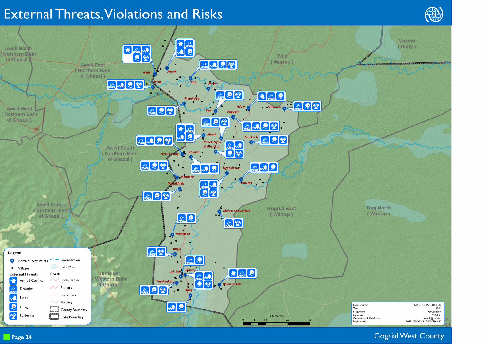
Legend9 Boma Survey Points
VillagesRiver/StreamLake/Marsh
RoadsLocal/UrbanPrimarySecondaryTertiaryCounty BoundaryState Boundary
Gogrial West County
Duzhw
Armed ConflictDrought
Flood
HungerEpidemics
External Threats, Violations and Risks
Page 24
Data Source:Year:Projection:Spheroid:Comments & Feedback:Map Index:
NBS, OCHA, IOM, ESRI2013
GeographicWGS84
[email protected]/SS/VAS/S21C005/THM22
External Threats
0 10 20 305Kilometers

99
99
99
9
9
9
9
9
9
9
9
99
9
9
9
9
99
9
99
9
9
9
Aweil South( Northern Bahr
el Ghazal )
Aweil Centre( Northern Bahr
el Ghazal )
Aweil West( Northern Bahr
el Ghazal )
Aweil North( Northern Bahr
el Ghazal )Aweil East
( Northern Bahrel Ghazal )
Mayom( Unity )
Tonj East( Warrap )
Tonj North( Warrap )
Gogrial East( Warrap )
Twic( Warrap )
Wau( Western Bahr
el Ghazal )
Jur River( Western Bahr
el Ghazal )
Ngap AthianAmeeth
Malual-BullAtukuel
MankuchMalek Ngok
Makuach
Maper
Alueth
Nyok Thiang
Mandeng
Maluil Ajak
Angui
Luk Luk
Wunkuel thiiWunkuel dit
Warkou
Malek Agal
RupAyien
MabilAmeth
AdeerAnguothKuel
Malual Anquei But
Monyjoch
Dong
D %I U
D % I U
D % I UD %I U
I U
I U
I U
$ I U
W I U
I U
W I
I UI U
I U
I U
% WI U
I UI U
D W ID $ % W U
W I U
I U
W I U
ID I U
D I U
Legend9 Boma Survey Points
VillagesRiver/StreamLake/Marsh
RoadsLocal/UrbanPrimarySecondaryTertiaryCounty BoundaryState Boundary
Gogrial West County
D$%WIU
Local Conflict
Domestic Violence
SGBV*Seasonal Road Access
Crop DiseaseLivestock Disease
Internal Threats, Violations and Risks
Page 25
Data Source:Year:Projection:Spheroid:Comments & Feedback:Map Index:
NBS, OCHA, IOM, ESRI2013
GeographicWGS84
[email protected]/SS/VAS/S21C005/THM23
Internal Threats
*SGBV: Sexual and Gender Based Violence 0 10 20 305Kilometers

This page is intentionally left blank