viirs (visible/infrared imaging radiometer suite) on suomi ...€¦ · national polar-orbiting...
TRANSCRIPT
1/32
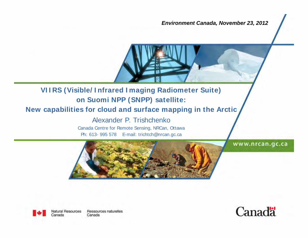
VIIRS (Visible/Infrared Imaging Radiometer Suite) on Suomi NPP (SNPP) satellite:
New capabilities for cloud and surface mapping in the ArcticAlexander P. Trishchenko
Canada Centre for Remote Sensing, NRCan, OttawaPh: 613- 995 578 E-mail: [email protected]
Environment Canada, November 23, 2012
2/32
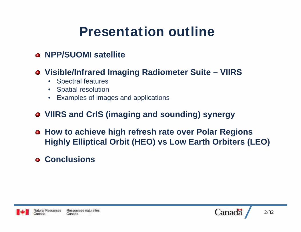
Presentation outline
NPP/SUOMI satellite
Visible/Infrared Imaging Radiometer Suite – VIIRS• Spectral features• Spatial resolution• Examples of images and applications
VIIRS and CrIS (imaging and sounding) synergy
How to achieve high refresh rate over Polar Regions Highly Elliptical Orbit (HEO) vs Low Earth Orbiters (LEO)
Conclusions
3/32
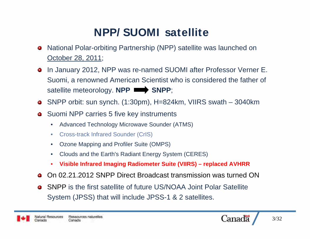
NPP/SUOMI satelliteNational Polar-orbiting Partnership (NPP) satellite was launched on October 28, 2011;
In January 2012, NPP was re-named SUOMI after Professor Verner E. Suomi, a renowned American Scientist who is considered the father of satellite meteorology. NPP SNPP;
SNPP orbit: sun synch. (1:30pm), H=824km, VIIRS swath – 3040km
Suomi NPP carries 5 five key instruments• Advanced Technology Microwave Sounder (ATMS)
• Cross-track Infrared Sounder (CrIS)
• Ozone Mapping and Profiler Suite (OMPS)
• Clouds and the Earth's Radiant Energy System (CERES)
• Visible Infrared Imaging Radiometer Suite (VIIRS) – replaced AVHRR
On 02.21.2012 SNPP Direct Broadcast transmission was turned ON
SNPP is the first satellite of future US/NOAA Joint Polar Satellite System (JPSS) that will include JPSS-1 & 2 satellites.
4/32
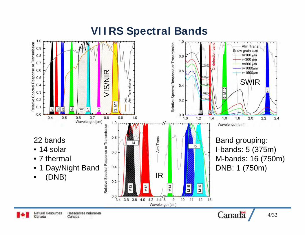
VIIRS Spectral Bands
VIS
/NIR
SWIR
IR
22 bands• 14 solar• 7 thermal• 1 Day/Night Band• (DNB)
Band grouping:I-bands: 5 (375m)M-bands: 16 (750m)DNB: 1 (750m)
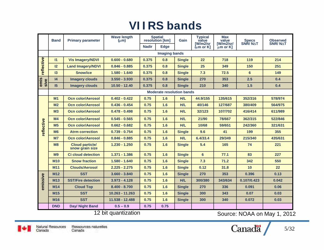
5/32
VIIRS bands
0.030.072340300Single1.60.7511.538 - 12.488SSTM16
Moderate resolution bands
Imaging bands
0.750.750.5 – 0.9Day/ Night BandDND
0.030.07343300Single1.60.7510.263 - 11.263SSTM15
0.060.091336270Single1.60.758.400 - 8.700Cloud TopM14
0.0420.107/0.423343/634300/380H/L1.60.753.973 - 4.128SST/Fire detectionM13
0.130.396353270Single1.60.753.660 - 3.840SSTM12
221031.80.12Single1.60.752.225 - 2.275Clouds/AerosolM11
55034271.27.3Single1.60.751.580 - 1.640Snow fractionM10
2278377.16Single1.60.751.371 - 1.386Ci cloud detectionM9
221741655.4Single1.60.751.230 - 1.250Cloud particle/ snow grain size
M8
435/631215/34029/3496.4/33.4H/L1.60.750.846 - 0.885Ocn color/AerosolM7
355199419.6Single1.60.750.739 - 0.754Atrm correctionM6
321/631242/36059/65110/68H/L1.60.750.662 - 0.682Ocn color/AerosolM5
522/846362/31578/66721/90H/L1.60.750.545 - 0.565Ocn color/AerosolM4
611/989416/414107/70232/123H/L1.60.750.478 - 0.498Ocn color/AerosolM3
564/975380/409127/68740/146H/L1.60.750.436 - 0.454Ocn color/AerosolM2
578/974352/316135/61544.9/155H/L1.60.750.402 - 0.422Ocn color/AerosolM1
0.41.5340210Single0.80.37510.50 - 12.40Imagery cloudsI5
0.42.5353270Single0.80.3753.550 - 3.930Imagery cloudsI4
149672.57.3Single0.80.3751.580 - 1.640Snow/iceI3
25115034925Single0.80.3750.846 - 0.885Land Imagery/NDVII2
21411971822Single0.80.3750.600 - 0.680Vis Imagery/NDVII1
ObservedSNR/ NT
SpecsSNR/ NT
Max value
[W/m2/sr/m or K]
Typical value
[W/m2/sr/m or K]
GainEdgeNadir
Wave length (m)Primary parameterBand
Spatial resolution [km]
refle
ctiv
eem
issi
vere
flect
ive
emis
sive
Source: NOAA on May 1, 201212 bit quantization
6/32
VIIRS products and formatsAll VIIRS files are in HDF5 format (http://www.hdfgroup.org/HDF5/). Generally, no reprocessing after processing system updates, except possibly CDR – climate data recordsData types:
• RDR – Raw Data Records• SDR – Sensor Data Records - L1B analog• EDR – Environmental Data Records – products or enhanced imagery (level 2)
Data availability:• NOAA CLASS archive for VIIRS
http://www.class.ncdc.noaa.gov/saa/products/search?sub_id=0&datatype_family=VIIRS&submit.x=32&submit.y=8
• List of publicly released products for SNPP sensorshttp://www.class.ncdc.noaa.gov/release/data_available/npp/npp_public_data_table.htm
• SNPP ftp-rolling archive (90-days) at NOAA ftp://ftp-npp.class.ngdc.noaa.gov/• Near-real time ftp-access from U of Wisconsin/SSEC (Madison, USA)
ftp://ftp.ssec.wisc.edu/pub/eosdb/npp/
VIIRS SDR products:• GMODO, GIMGO – geolocation files (ellipsoid) –M-bands MO, I-bands IM• GMTCO, GITCO - geolocation files (Terrain COrrected) M- and I bands• SVM[01-16], SVI[01-05] – imagery for corresponding M- and I –bands
VIIRS EDR products• Currently limited to enhanced imagery, intermediate cloud mask and fire products
7/32
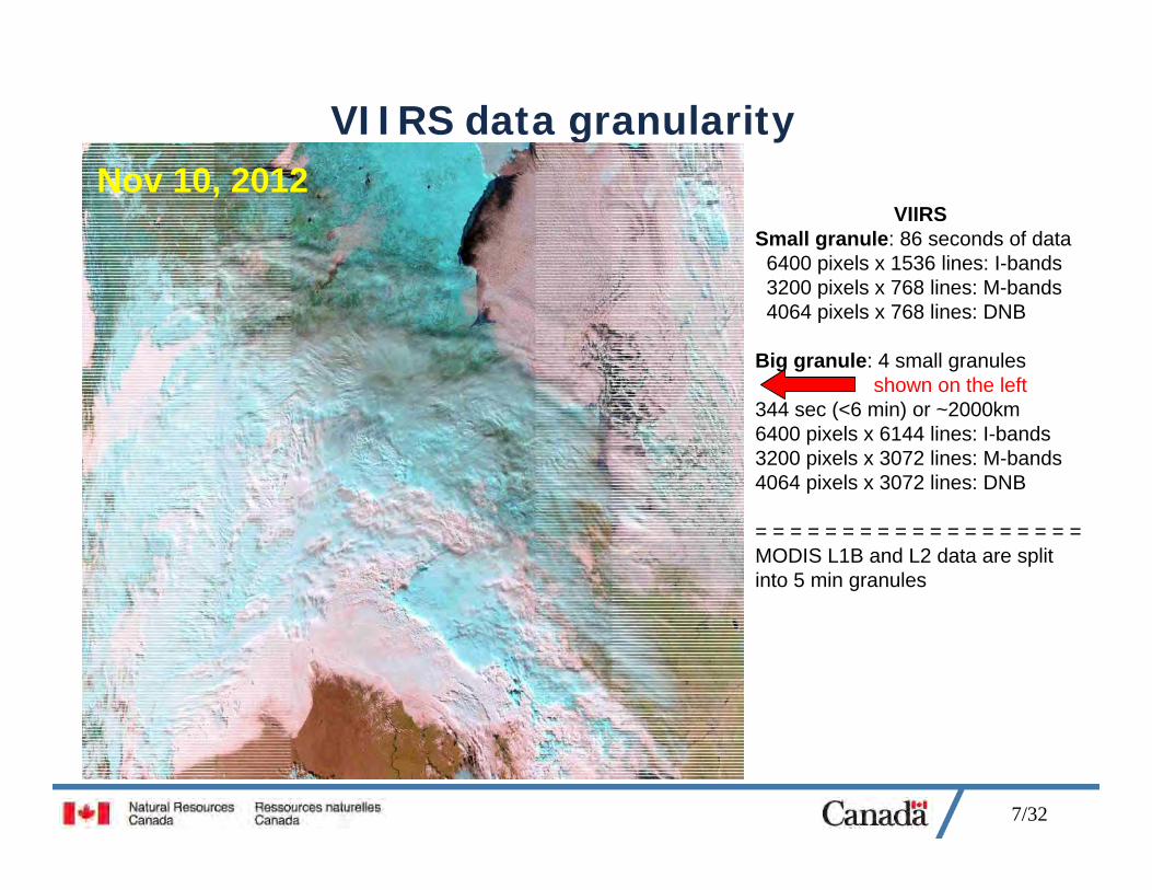
VIIRS data granularity
VIIRSSmall granule: 86 seconds of data6400 pixels x 1536 lines: I-bands3200 pixels x 768 lines: M-bands4064 pixels x 768 lines: DNB
Big granule: 4 small granulesshown on the left
344 sec (<6 min) or ~2000km6400 pixels x 6144 lines: I-bands3200 pixels x 3072 lines: M-bands 4064 pixels x 3072 lines: DNB
= = = = = = = = = = = = = = = = = = =MODIS L1B and L2 data are split into 5 min granules
Nov 10, 2012
8/32
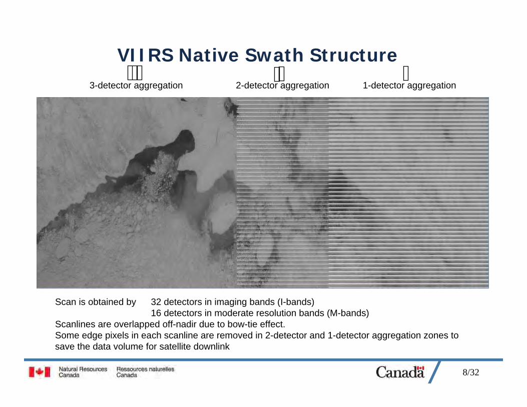
VIIRS Native Swath Structure3-detector aggregation 2-detector aggregation 1-detector aggregation
Scan is obtained by 32 detectors in imaging bands (I-bands)16 detectors in moderate resolution bands (M-bands)
Scanlines are overlapped off-nadir due to bow-tie effect. Some edge pixels in each scanline are removed in 2-detector and 1-detector aggregation zones to save the data volume for satellite downlink
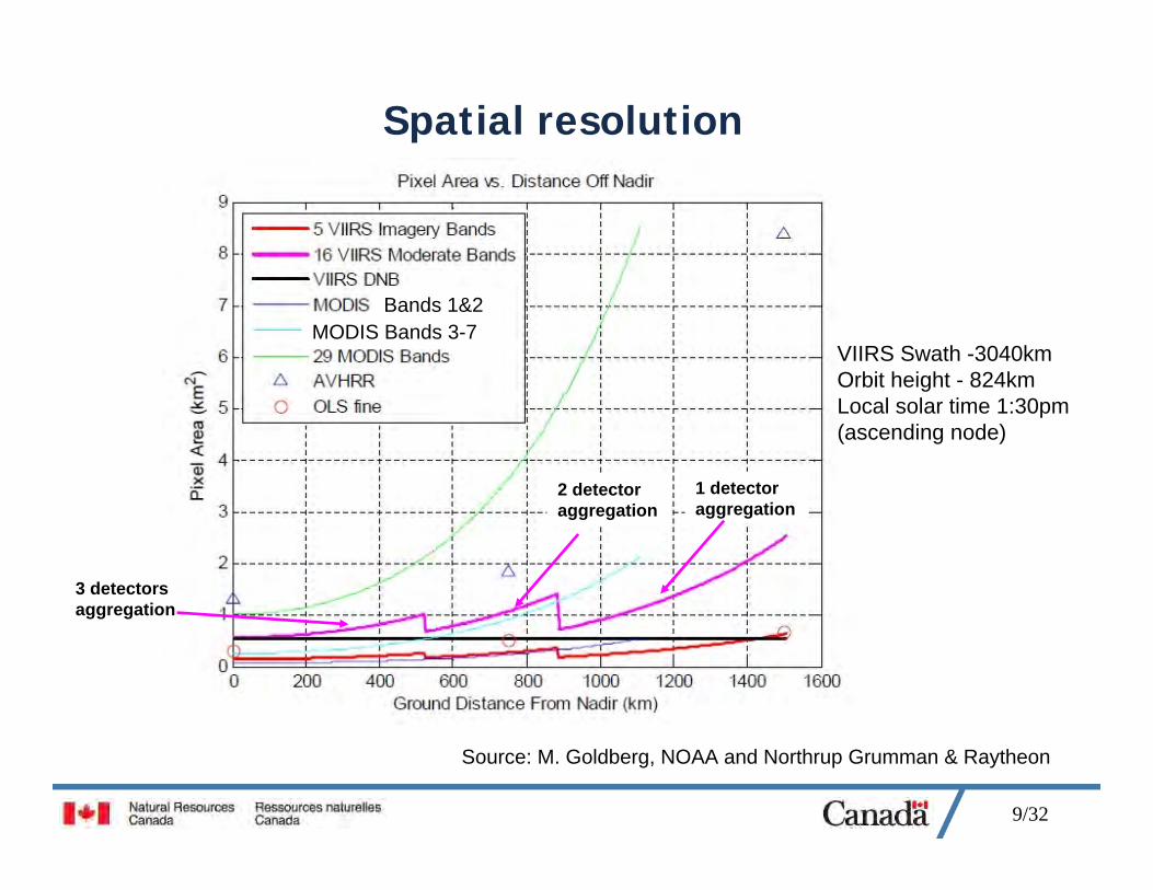
9/32
Spatial resolution
Source: M. Goldberg, NOAA and Northrup Grumman & Raytheon
Bands 1&2MODIS Bands 3-7
3 detectors aggregation
2 detector aggregation
1 detectoraggregation
VIIRS Swath -3040kmOrbit height - 824kmLocal solar time 1:30pm(ascending node)
10/32
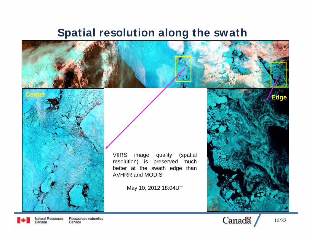
Spatial resolution along the swath
VIIRS image quality (spatial resolution) is preserved much better at the swath edge than AVHRR and MODIS
May 10, 2012 18:04UT
EdgeCenterCenter
11/32
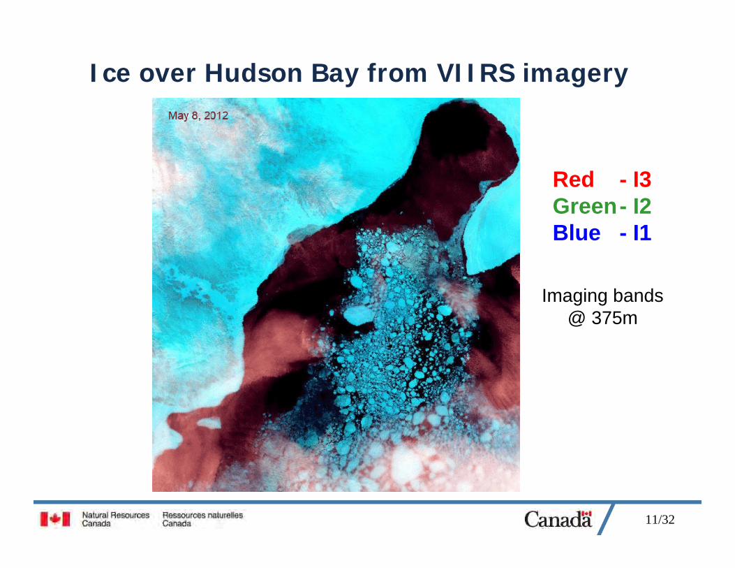
Ice over Hudson Bay from VIIRS imagery
Red - I3Green- I2Blue - I1
Imaging bands@ 375m
12/32
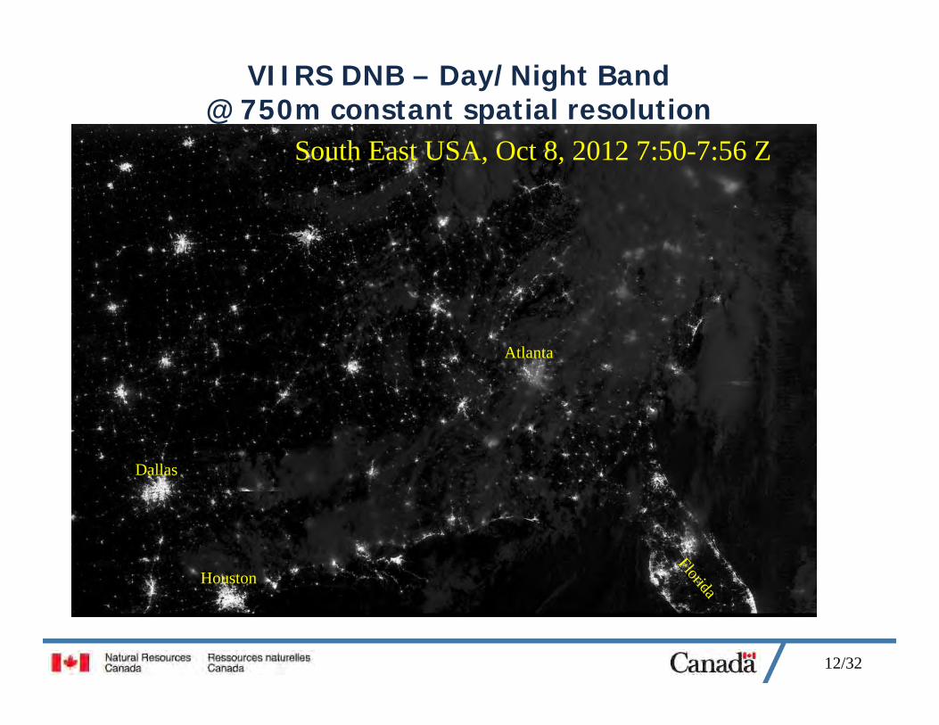
VIIRS DNB – Day/Night Band @ 750m constant spatial resolution
South East USA, Oct 8, 2012 7:50-7:56 Z
Houston
Dallas
Atlanta
Florida
13/32
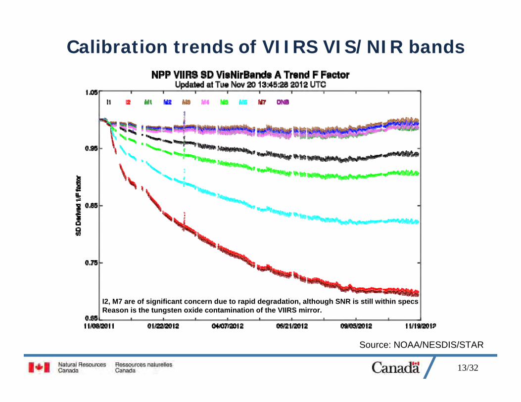
Calibration trends of VIIRS VIS/NIR bands
Source: NOAA/NESDIS/STAR
I2, M7 are of significant concern due to rapid degradation, although SNR is still within specsReason is the tungsten oxide contamination of the VIIRS mirror.
14/32
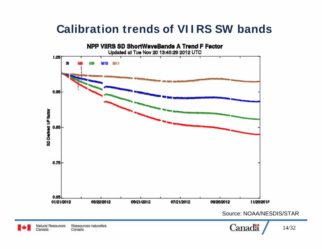
Calibration trends of VIIRS SW bands
Source: NOAA/NESDIS/STAR
15/32
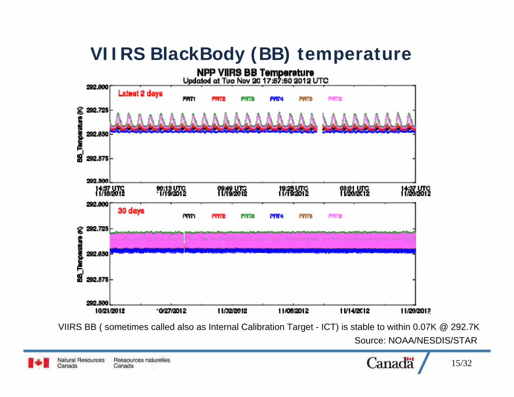
VIIRS BlackBody (BB) temperature
Source: NOAA/NESDIS/STARVIIRS BB ( sometimes called also as Internal Calibration Target - ICT) is stable to within 0.07K @ 292.7K

16/32
Noise (Digital Numbers – DN) in VIIRS Thermal Bands M14, 15 and 16
Source: NOAA/NESDIS/STAR
17/32
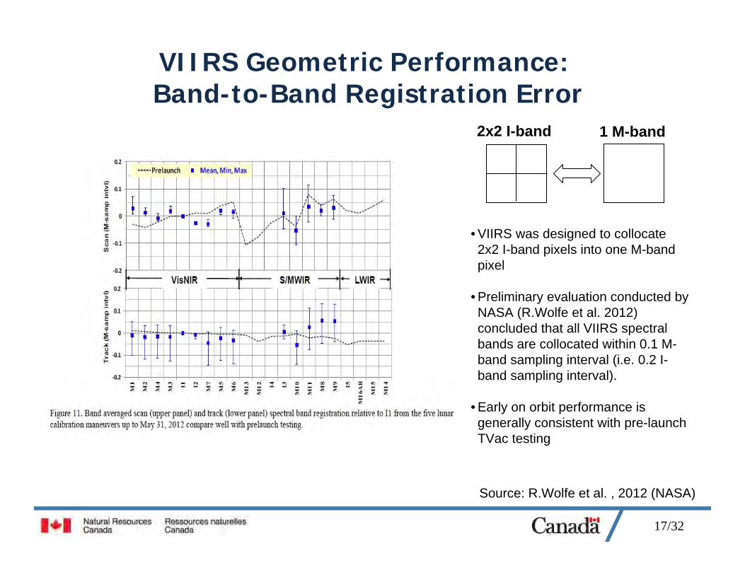
VIIRS Geometric Performance:Band-to-Band Registration Error
Source: R.Wolfe et al. , 2012 (NASA)
• VIIRS was designed to collocate 2x2 I-band pixels into one M-band pixel
• Preliminary evaluation conducted by NASA (R.Wolfe et al. 2012) concluded that all VIIRS spectral bands are collocated within 0.1 M-band sampling interval (i.e. 0.2 I-band sampling interval).
• Early on orbit performance is generally consistent with pre-launch TVac testing
2x2 I-band 1 M-band

18/32
VIIRS Geometric Performance:Absolute Geolocation Error
Source: R.Wolfe et al. , 2012 (NASA)
• VIIRS geolocation results are very good
• NASA VIIRS geolocation team is working to further improve accuracy by implementing more precise parameterization
19/32
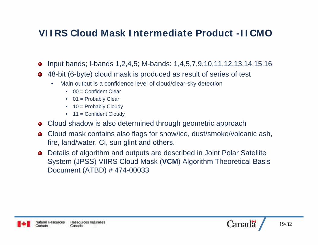
VIIRS Cloud Mask Intermediate Product -IICMO
Input bands; I-bands 1,2,4,5; M-bands: 1,4,5,7,9,10,11,12,13,14,15,1648-bit (6-byte) cloud mask is produced as result of series of test
• Main output is a confidence level of cloud/clear-sky detection• 00 = Confident Clear• 01 = Probably Clear• 10 = Probably Cloudy• 11 = Confident Cloudy
Cloud shadow is also determined through geometric approachCloud mask contains also flags for snow/ice, dust/smoke/volcanic ash, fire, land/water, Ci, sun glint and others.Details of algorithm and outputs are described in Joint Polar Satellite System (JPSS) VIIRS Cloud Mask (VCM) Algorithm Theoretical Basis Document (ATBD) # 474-00033

20/32
Clouds over low density vegetationSouthern US. Nov 10, 2012
Bright surface decreases the quality of cloud detection in the VIIRS Cloud Mask Intermediate Product IICMO_npp
21/32
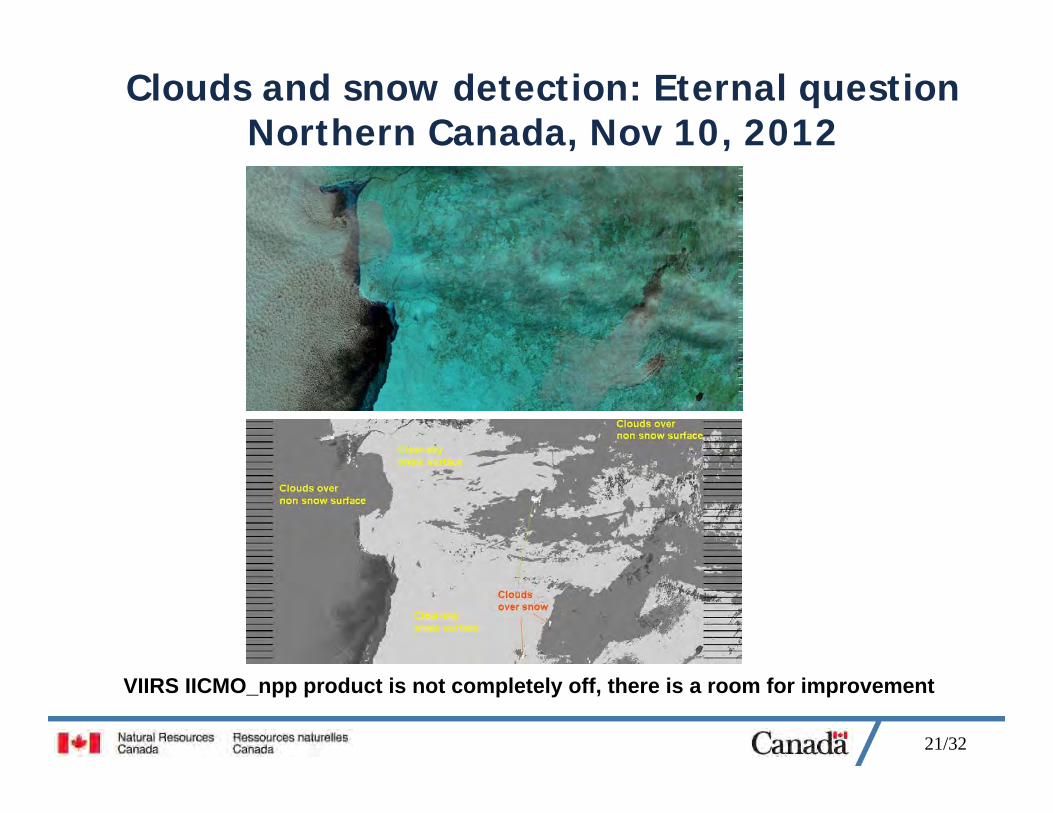
Clouds and snow detection: Eternal questionNorthern Canada, Nov 10, 2012
VIIRS IICMO_npp product is not completely off, there is a room for improvement
22/32
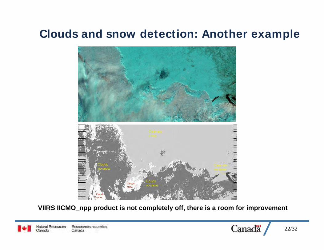
Clouds and snow detection: Another example
VIIRS IICMO_npp product is not completely off, there is a room for improvement
23/32
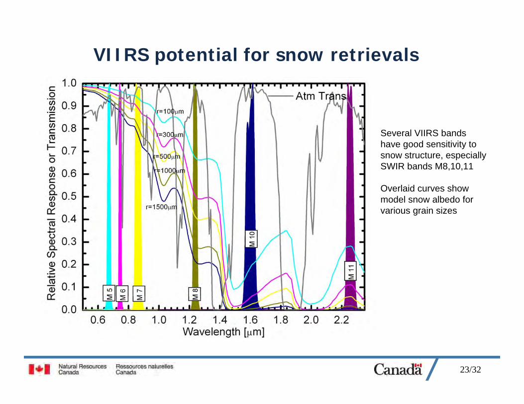
VIIRS potential for snow retrievals
Several VIIRS bands have good sensitivity to snow structure, especially SWIR bands M8,10,11
Overlaid curves show model snow albedo for various grain sizes
24/32
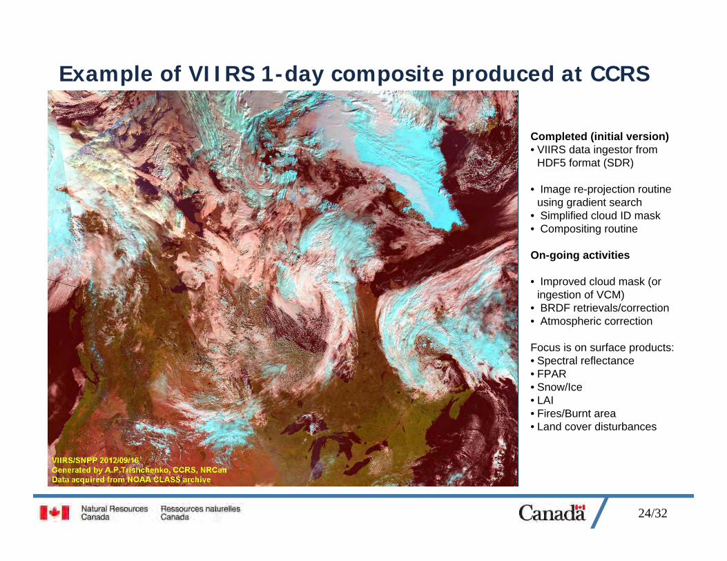
Example of VIIRS 1-day composite produced at CCRS
Completed (initial version)• VIIRS data ingestor from
HDF5 format (SDR)
• Image re-projection routine using gradient search
• Simplified cloud ID mask• Compositing routine
On-going activities
• Improved cloud mask (or ingestion of VCM)
• BRDF retrievals/correction• Atmospheric correction
Focus is on surface products:• Spectral reflectance• FPAR• Snow/Ice• LAI• Fires/Burnt area• Land cover disturbances
25/32
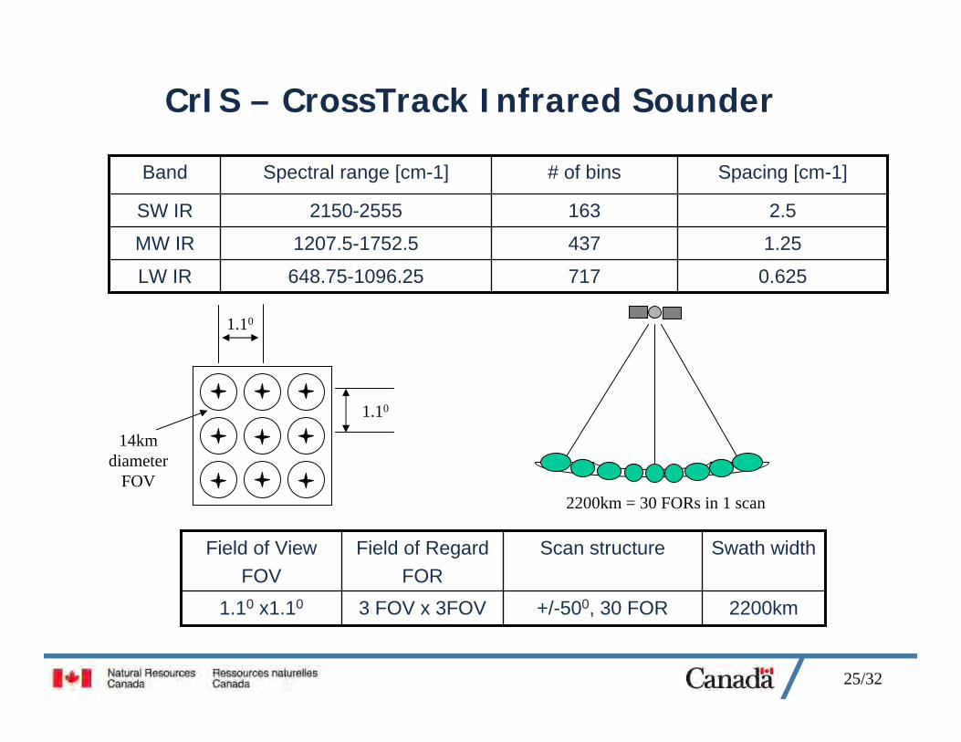
CrIS – CrossTrack Infrared Sounder
717
437
163
# of bins
0.625648.75-1096.25LW IR
1.251207.5-1752.5MW IR
2.52150-2555SW IR
Spacing [cm-1]Spectral range [cm-1]Band
2200km+/-500, 30 FOR3 FOV x 3FOV1.10 x1.10
Swath widthScan structureField of RegardFOR
Field of View FOV
1.10
1.10
14kmdiameter
FOV2200km = 30 FORs in 1 scan
26/32
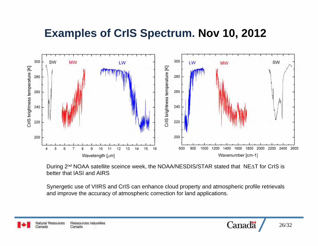
Examples of CrIS Spectrum. Nov 10, 2012
During 2nd NOAA satellite sceince week, the NOAA/NESDIS/STAR stated that NET for CrIS is better that IASI and AIRS
Synergetic use of VIIRS and CrIS can enhance cloud property and atmospheric profile retrievals and improve the accuracy of atmospheric correction for land applications.
27/32
Can a LEO system achieve the final goal: Observe weather at any time over the Polar Regions ?The key atmospheric applications include a number dynamic phenomena
• Atmospheric Motion Vector (AMV) retrievals• Ice/snow monitoring• Volcanic ash, smoke and aerosol dynamics• Atmospheric stability indices and aircraft icing threat• Radiative fluxes and surface albedo• Forest fire monitoring
Typical GEO refresh rate for next generation systems:• 1-min for local rapid scan• 5-min to regional rapid scan• 15-min for entire Earth disc
Motion vectors are normally retrieved from image triplets=> 10-15 min refresh rate is optimalTherefore, continuous observations of a GEO type are required over the Polar Regions!
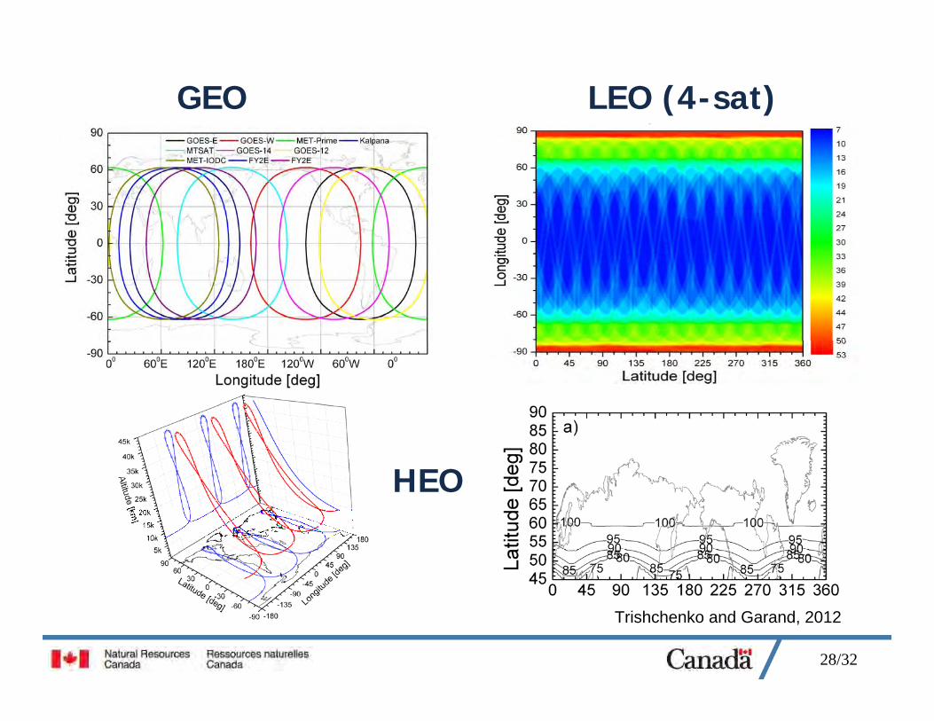
28/32
GEO LEO (4-sat)
HEO
Trishchenko and Garand, 2012
29/32
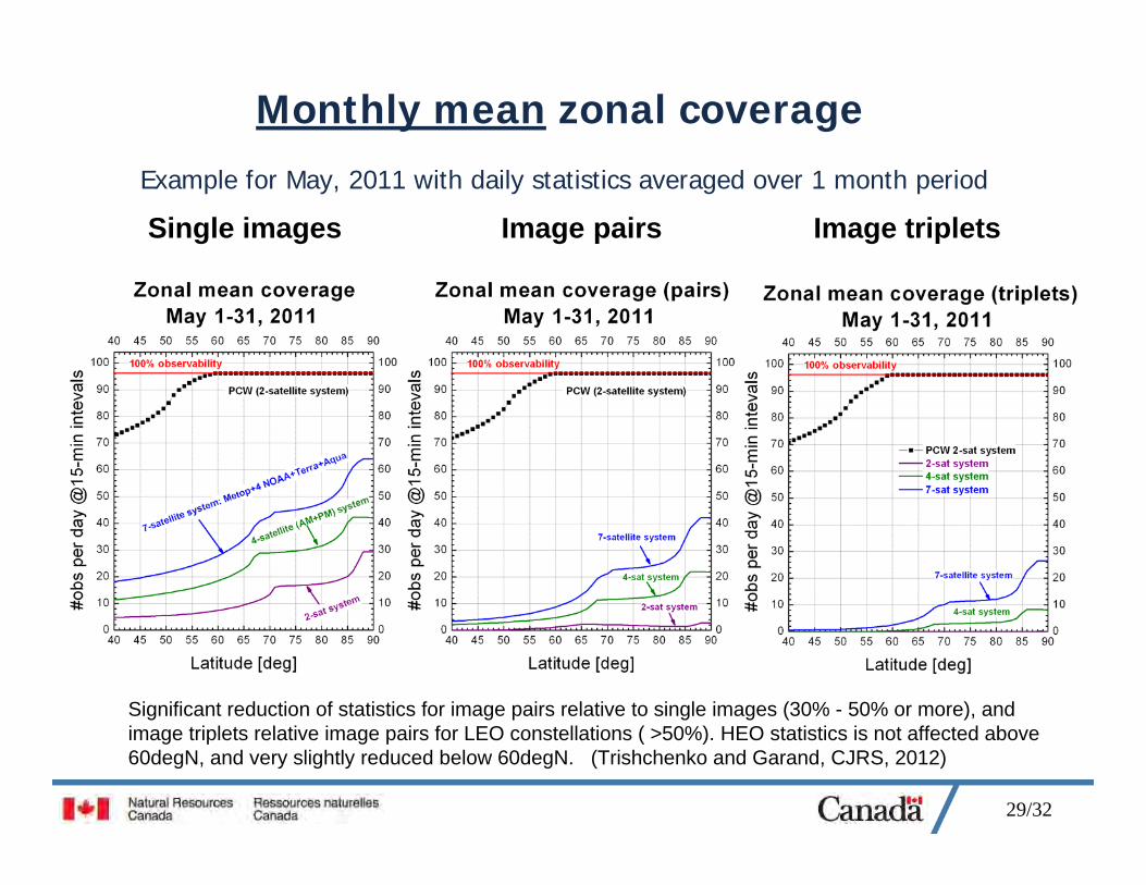
Monthly mean zonal coverage
Example for May, 2011 with daily statistics averaged over 1 month period
Single images Image pairs Image triplets
Significant reduction of statistics for image pairs relative to single images (30% - 50% or more), and image triplets relative image pairs for LEO constellations ( >50%). HEO statistics is not affected above 60degN, and very slightly reduced below 60degN. (Trishchenko and Garand, CJRS, 2012)
30/32
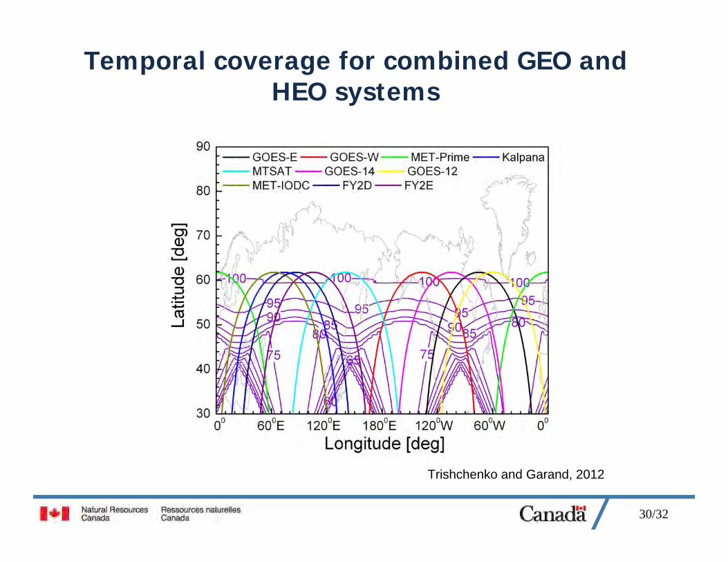
Temporal coverage for combined GEO and HEO systems
Trishchenko and Garand, 2012
31/32
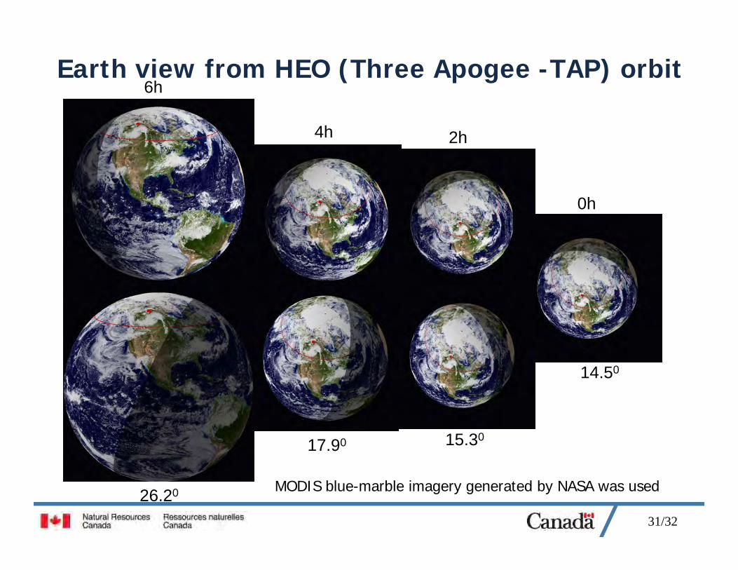
Earth view from HEO (Three Apogee -TAP) orbit
MODIS blue-marble imagery generated by NASA was used
0h
2h4h
6h
14.50
15.3017.90
26.20
32/32
ConclusionsVIIRS (Visible/Infrared Imaging Radiometer Suite) on NPP/Suomi satellite opens a new era in operational meteorological satellite imaging
Data is becoming operational right now
VIIRS has great potential for cloud and surface mapping in the Arctic
VIIRS has wide swath (3040km) and high-quality imagery with less degradation of spatial resolution at large Viewing Zenith Angle than MODIS and AVHRR
To observe weather at any point and any time over the Polar Region one need to have 2 satellites on HEO orbit.
GEO+HEO = Continuous Weather Observations from Space
We would be happy collaborate with EC/CMC to share our tools, methods and experience with VIIRS
AcknowledgementsVIIRS data were acquired from the NOAA CLASS and the Space Science and Engineering Center (SSEC) University of Wisconsin-Madison
VIIRS calibration results were acquired from Satellite Integrated Calibration / Validation System (ICVS) developed by the NOAA/NESDIS/STAR
VIIRS geolocation accuracy assessment was provided by Robert Wolfe, NASA