vibrant communities in a robust region centralina council of governments
TRANSCRIPT

Vibrant Communities in a Robust Region
Centralina Council of Governments


3
Challenges We Face Today
Our region’s rapid growth over the last decade made it the fastest growing of all U.S. regions with more than 1 million people.
Our population is expected to continue to grow by 50 percent in the next two decades and double within four decades.
It will be important to match growth with good quality jobs, necessary transportation, quality housing that is affordable, clean water, improved air quality and other social and physical infrastructure.
For the sake of our children and grandchildren, we need to ensure we have vibrant communities that benefit from being party of a healthy, robust region.
3

4
Our Regional Geography
Two-State Region includes:
• 14 Counties with about 2.43 million population (NC 2.06 million; SC .37 million)
• More than 100 municipalities
4

Why is Regional Cooperation Important?Growing economy and jobs to match population growth
is critical and regions without growth framework cannot compete effectively for major new developments
Planning appropriately for dramatic growth within the region while maintaining community character
Meeting infrastructure needs – sewer, transportation – while controlling cost of government
Unemployment; need for jobs and housing that attract/retain young people
Difficulty attracting businesses, need for worker training
Sharing limited water resources
Lack of regional information and tools for decision-making
5

Working Together on Solutions — “CONNECT Our Future”
Working together to grow jobs and the economy, improve quality of life, control cost of government
Engages local governments, other public and private partners, and local residents across the 14-county grant area
Extensive community engagement and built on identified needs, existing plans and strategies
Funded by a $4.9 million HUD Sustainable Communities Grant and $3 million committed local in-kind match; three-year process
Based on the Region’s “CONNECT” Vision (2008)
6

Kansas City region identified more than $2.5 billion in infrastructure savings (pop. 1.92 million)
Salt Lake City region identified more than $4.5 billion in infrastructure savings (pop. 1.57 million)
Chattanooga region (pop. 336,463) and Knoxville region (pop. 558,696) revitalized urban cores
Sacramento’s infrastructure growth scenario would save $9.4 billion over a 50 year period (pop. 2.32 million)
Birmingham region developed more affordable housing (pop. 1.12 million)
Most regions reduce growth in vehicles miles
More effective use of limited federal dollars
Collaborating to Solve Challenges —
Benefits Realized by Other Regions
7

CONNECT Our Future – The Project and Process
88

It is a guide for how we agree to grow as a region and how we use resources to ensure we match growth with good quality jobs, housing and infrastructure.
It is a toolkit for local governments to use in addressing shared problems that includes recommended, non-binding strategies and policies.
It is developed through extensive community engagement, and will have broad regional support.
The adoption of policies and strategies by individual communities will be voluntary.
What is a Regional Framework?
9

Who is Involved in “CONNECT Our Future?”
More than 100 local governments, private businesses, educational institutions, non-profits and others interested
30+ Communities and 20+ others (MPO, RPO, Private, non-profits etc) have signed the Consortium Agreements and appointed elected/staff to serve as decision-making body
Elected Official are the Champions of the Process and are leading the effort
10

How will the work get done?
11
Consortium Work Teams• Develop technical
content for Regional Growth Framework
• Provide overall project support
Consortium Forums• Program (staff) Forum
integrates Team work
• Policy (elected) Forum addresses policy implications
COGs• Advise on
recommendations for local government

12
CONNECT Our Future – 3 Year Process

Scenario Planning 101
1313

Scenario Planning – What is it?
Role in the Project:
14
Community-Based Regional Initiative:
Scenario planning will be used throughout the project to test regional goals and community values, as well as explore alternatives for growth, development, and investments in the region.
• Roles of CCOG / CRCOG as project enablers
• Roles & expertise of each state, regional, and local government agency in the scenario planning process
• Validate the planning process
• Better balance conflict & collaboration
• Regional vision, local implementation

Prepare for Growth
How big do we want to be?
Where do we want to grow?
Are we growing sustainably?
Can we pay for growth?
Are we still proud of where we live?
15

16
Prepare for Growth
Community Work SessionsULI Realty Check Consensus-Building
GrowthBrainstorming Session
General Growth Themes
Pop. & Emp. Centers
Hot Spots for Growth
Scenario Planning Initiative
CharacterHow do we want to grow
as a community?
Influenced by Community Plans / Citizen Vision
Build AlternativeGrowth Scenarios
EvaluateGrowth Scenario Report
Card
Public Feedback & Polling

Scenario Planning – Our Software Engine
17
18
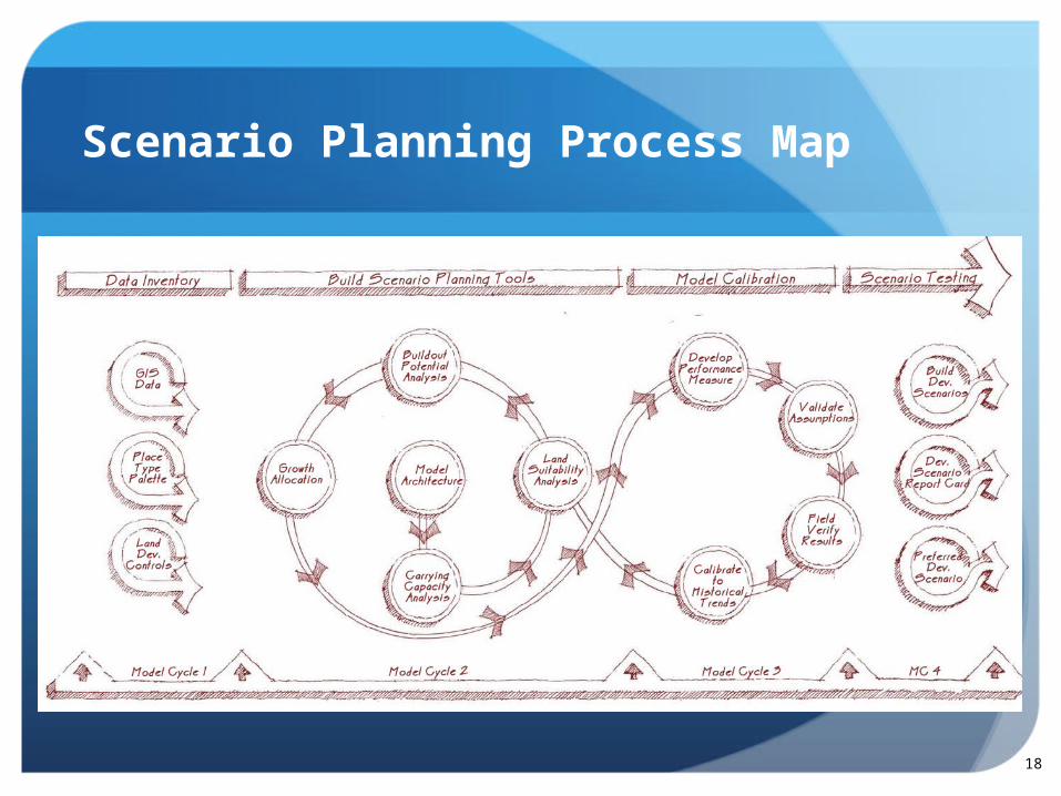
Scenario Planning Process Map

19
Bottom-Up Approach
The original, undeveloped parcel showing physical or policy conditions present on the land.
A composite map aggregates all of the physical or policy conditions affecting the parcel into a single development constraints layer, which is used to avoid double counting in subsequent steps of the modeling process.
The developable area of a parcel represents land remaining for development after the removal of assumed development constraints.
A site efficiency factor is applied the parcel to remove a percentage of land that would theoretically be dedicated to on-site infrastructure (e.g., internal streets, storm water management, etc).
The buildable area for the parcel represents land available for development after the removal of site constraints and application of a site efficiency factor. This would be similar to theoretically subdividing lots within the larger parcel.
The zoning footprint on a lot would be some shape and size smaller than the lot itself to account for yard setbacks, maximum lot coverage, watershed protection rules (if applicable), etc. associated with the location of the parcel and the specific place type category assigned to it.
The zoning envelope for the lot represents the three dimensional space available for constructing one or more buildings. It is affected by maximum floor area ratio, building height, etc. assigned to the specific place type category.
A building envelope represents the gross floor area for one or more buildings on the lot after the application of parking requirements and/or the removal of common space associated with the building or buildings (e.g., public plazas, outdoor seating, etc.). Information for parking requirements and/or common space dedication is tied to the specific place type category.
The development yield for each parcel in the model is calculated based on the preceding steps. These rules and factors should theoretically approximate a site plan or development program for the parcel that would be feasible based on the specific place type category and previous development patterns and intensities observed in the study area.

20
Measuring the Trade-Offs

Get It Right for Your Community
Development Status Assignments
Place Type Assignments
General Development Lookup Table
Committed Development Inventory
Service Delivery Rates & Equations
Calibration Activities
21

Get It Right for Your Community
22

Constant Contact Strategy
Project technical team
Blueprinting Workgroup
Other workgroups / sub-workgroups
Focus group meetings
Sub-region coordination activities
Lots of e-mails
Even more telephone calls
23

Moving Beyond CONNECT Our Future
Capacity building initiative
Database management tool
Evaluate local decision / regional impacts
Start stretching the model
Next project?
24
CommunityViz Models / Training:

Moving Beyond CONNECT Our Future
Land suitability analysis
Comprehensive plan update
Water resource plans
Development policy testing
Fiscal impact analysis
Site development performance
visualization
25
Some Popular Software Applications:

Your Involvement
2626

Your Involvement
Provide input through your consortium representatives
Provide GIS data layers, plans, zoning ordinances, growth policies, etc.
Help us build a scenario planning model
Advertise and participate in open house meetings throughout project
Choose the tools and strategies that work for your community
Serve as quality control for our work
27
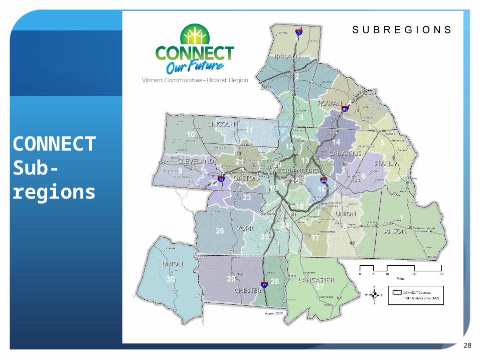
CONNECT Sub-regions
28
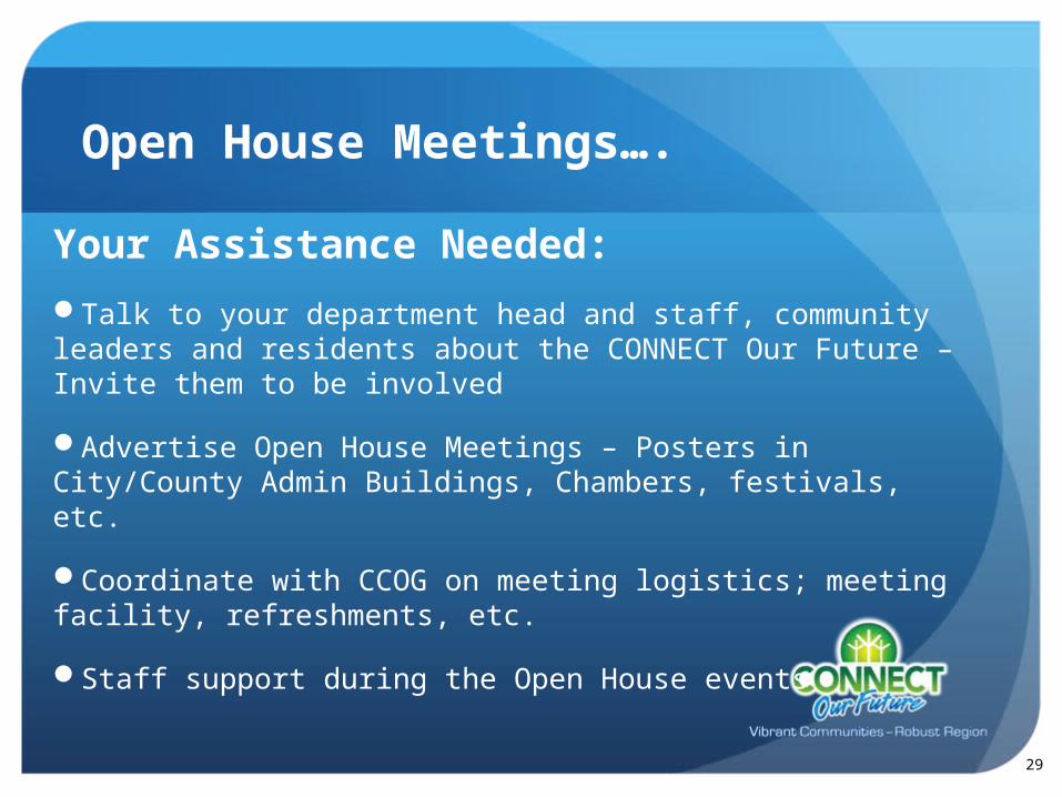
Open House Meetings….
Your Assistance Needed:
Talk to your department head and staff, community leaders and residents about the CONNECT Our Future – Invite them to be involved
Advertise Open House Meetings – Posters in City/County Admin Buildings, Chambers, festivals, etc.
Coordinate with CCOG on meeting logistics; meeting facility, refreshments, etc.
Staff support during the Open House events
29

Project Communication Tools
Monthly project updates to be sent through e-newsletter
Advance notice and communication about the Open Houses and other Public Engagement events in your area
Information available on website www.connectourfuture.org
Like and follow us on Social Media like Facebook and Twitter
30

This is YOUR process and it is focused on finding solutions to the challenges communities share in the 14-county region.
It will only be successful if cities, counties, businesses, educators, non-profits and others work together on strategies for our future.
Get Involved!
31
Questions or Comments?
3232
Website: www.connectourfuture.orgFollow us on